US7126527B1 - Method and apparatus for mobile device location via a network based local area augmentation system - Google Patents
Method and apparatus for mobile device location via a network based local area augmentation systemDownload PDFInfo
- Publication number
- US7126527B1 US7126527B1US09/603,451US60345100AUS7126527B1US 7126527 B1US7126527 B1US 7126527B1US 60345100 AUS60345100 AUS 60345100AUS 7126527 B1US7126527 B1US 7126527B1
- Authority
- US
- United States
- Prior art keywords
- base station
- information
- module
- location information
- location
- Prior art date
- Legal status (The legal status is an assumption and is not a legal conclusion. Google has not performed a legal analysis and makes no representation as to the accuracy of the status listed.)
- Expired - Lifetime, expires
Links
- 230000003416augmentationEffects0.000titleabstractdescription25
- 238000000034methodMethods0.000titleabstractdescription21
- 238000012937correctionMethods0.000claimsabstractdescription109
- 238000004364calculation methodMethods0.000claimsabstractdescription62
- 230000001413cellular effectEffects0.000claimsdescription31
- 238000004891communicationMethods0.000claimsdescription23
- 230000005540biological transmissionEffects0.000claimsdescription14
- 238000005259measurementMethods0.000claimsdescription10
- 238000012544monitoring processMethods0.000claimsdescription9
- 230000010354integrationEffects0.000claimsdescription7
- 230000010267cellular communicationEffects0.000claimsdescription4
- 230000006870functionEffects0.000description7
- 238000005516engineering processMethods0.000description6
- 230000007246mechanismEffects0.000description4
- 238000010295mobile communicationMethods0.000description4
- 238000012545processingMethods0.000description4
- 238000013459approachMethods0.000description3
- 230000003044adaptive effectEffects0.000description2
- 230000008901benefitEffects0.000description2
- 230000008569processEffects0.000description2
- 238000012546transferMethods0.000description2
- 238000010276constructionMethods0.000description1
- 230000008878couplingEffects0.000description1
- 238000010168coupling processMethods0.000description1
- 238000005859coupling reactionMethods0.000description1
- 238000010586diagramMethods0.000description1
- 230000000694effectsEffects0.000description1
- 230000005055memory storageEffects0.000description1
- 238000012986modificationMethods0.000description1
- 230000004048modificationEffects0.000description1
- 230000001151other effectEffects0.000description1
- 238000000053physical methodMethods0.000description1
- 230000008054signal transmissionEffects0.000description1
- 238000000638solvent extractionMethods0.000description1
- 230000000153supplemental effectEffects0.000description1
Images


Classifications
- G—PHYSICS
- G01—MEASURING; TESTING
- G01S—RADIO DIRECTION-FINDING; RADIO NAVIGATION; DETERMINING DISTANCE OR VELOCITY BY USE OF RADIO WAVES; LOCATING OR PRESENCE-DETECTING BY USE OF THE REFLECTION OR RERADIATION OF RADIO WAVES; ANALOGOUS ARRANGEMENTS USING OTHER WAVES
- G01S19/00—Satellite radio beacon positioning systems; Determining position, velocity or attitude using signals transmitted by such systems
- G01S19/01—Satellite radio beacon positioning systems transmitting time-stamped messages, e.g. GPS [Global Positioning System], GLONASS [Global Orbiting Navigation Satellite System] or GALILEO
- G01S19/03—Cooperating elements; Interaction or communication between different cooperating elements or between cooperating elements and receivers
- G01S19/07—Cooperating elements; Interaction or communication between different cooperating elements or between cooperating elements and receivers providing data for correcting measured positioning data, e.g. DGPS [differential GPS] or ionosphere corrections
- G—PHYSICS
- G01—MEASURING; TESTING
- G01S—RADIO DIRECTION-FINDING; RADIO NAVIGATION; DETERMINING DISTANCE OR VELOCITY BY USE OF RADIO WAVES; LOCATING OR PRESENCE-DETECTING BY USE OF THE REFLECTION OR RERADIATION OF RADIO WAVES; ANALOGOUS ARRANGEMENTS USING OTHER WAVES
- G01S19/00—Satellite radio beacon positioning systems; Determining position, velocity or attitude using signals transmitted by such systems
- G01S19/01—Satellite radio beacon positioning systems transmitting time-stamped messages, e.g. GPS [Global Positioning System], GLONASS [Global Orbiting Navigation Satellite System] or GALILEO
- G01S19/03—Cooperating elements; Interaction or communication between different cooperating elements or between cooperating elements and receivers
- G01S19/04—Cooperating elements; Interaction or communication between different cooperating elements or between cooperating elements and receivers providing carrier phase data
- G—PHYSICS
- G01—MEASURING; TESTING
- G01S—RADIO DIRECTION-FINDING; RADIO NAVIGATION; DETERMINING DISTANCE OR VELOCITY BY USE OF RADIO WAVES; LOCATING OR PRESENCE-DETECTING BY USE OF THE REFLECTION OR RERADIATION OF RADIO WAVES; ANALOGOUS ARRANGEMENTS USING OTHER WAVES
- G01S19/00—Satellite radio beacon positioning systems; Determining position, velocity or attitude using signals transmitted by such systems
- G01S19/38—Determining a navigation solution using signals transmitted by a satellite radio beacon positioning system
- G01S19/39—Determining a navigation solution using signals transmitted by a satellite radio beacon positioning system the satellite radio beacon positioning system transmitting time-stamped messages, e.g. GPS [Global Positioning System], GLONASS [Global Orbiting Navigation Satellite System] or GALILEO
- G01S19/40—Correcting position, velocity or attitude
- G01S19/41—Differential correction, e.g. DGPS [differential GPS]
- G—PHYSICS
- G01—MEASURING; TESTING
- G01S—RADIO DIRECTION-FINDING; RADIO NAVIGATION; DETERMINING DISTANCE OR VELOCITY BY USE OF RADIO WAVES; LOCATING OR PRESENCE-DETECTING BY USE OF THE REFLECTION OR RERADIATION OF RADIO WAVES; ANALOGOUS ARRANGEMENTS USING OTHER WAVES
- G01S19/00—Satellite radio beacon positioning systems; Determining position, velocity or attitude using signals transmitted by such systems
- G01S19/01—Satellite radio beacon positioning systems transmitting time-stamped messages, e.g. GPS [Global Positioning System], GLONASS [Global Orbiting Navigation Satellite System] or GALILEO
- G01S19/03—Cooperating elements; Interaction or communication between different cooperating elements or between cooperating elements and receivers
- G01S19/05—Cooperating elements; Interaction or communication between different cooperating elements or between cooperating elements and receivers providing aiding data
- G01S19/06—Cooperating elements; Interaction or communication between different cooperating elements or between cooperating elements and receivers providing aiding data employing an initial estimate of the location of the receiver as aiding data or in generating aiding data
Definitions
- the present disclosurepertains to the field of location systems. More particularly, the present disclosure pertains to techniques for providing improved precision location information using a network based local area augmentation system.
- location informationis generated by traditional positioning systems, including a satellite-based positioning system such as the global positioning system (GPS) using NAVSTAR satellites, the Russian GLONASS system, or the European EUTELSAT system, or a land-based positioning system, such as LORAN-C.
- GPSglobal positioning system
- NAVSTAR satellitesthe Russian GLONASS system
- GLONASSthe Russian GLONASS system
- European EUTELSATEuropean EUTELSAT
- LORAN-Cland-based positioning system
- One known technique for providing improved location informationinvolves the use of differential GPS calculations (see, e.g., U.S. Pat. No. 5,913,170).
- Such systemsmay use a single fixed base station in a known location with a GPS receiver to generate correction signals. These correction signals are relayed to the mobile device (e.g., a phone), where they can be used to improve the accuracy of the location information derived by a GPS receiver in the phone.
- the use of a single base-station based correction information computation engine and a single tower's GPS receiver to perform calculationsmay be convenient; however, the accuracy and reliability of such systems may still not be sufficient for applications that benefit from highly precise location information.
- LAASlocal area augmentation system
- GBASground based augmentation system
- Such systemsemploy multiple ground receivers or beacons in fixed locations aligned along a runway. These receivers each individually transmit correction information to the GPS receiver in the airplane, which performs computations including all the information from the multiple receivers.
- This type of arrangementmay be impractical for cellular phone and other consumer-oriented location devices because additional radio frequency receivers are needed to receive information from the runway beacons and because the multiple beacons each provide data requiring substantial additional computations at the GPS receiver.
- Such complicated processingmay disadvantageously burden the processing resources and/or the power (e.g., battery) resources of a mobile device.
- wide deployment of many such beacons solely for the purpose of a positioning systemwould be a costly undertaking.
- WAASwide area augmentation system
- the WAASalso provides supplemental correction data in order to establish better locations.
- One such systemis being deployed with a limited set of antenna stations (currently 25) being deployed throughout the United States. This system, however, also relies on radio-frequency transmission of correction information.
- correction data from single, widely spaced antennasmay not provide sufficiently accurate correction information to allow sufficiently precise location calculations to be performed for some applications.
- FIG. 1illustrates a network based local area augmentation system and options for placement of various component parts in different embodiments of such a system.
- FIG. 2illustrates one embodiment of a technique of providing location information and localized services based on that location information.
- FIG. 3 aillustrates operations performed by one embodiment of a correction information calculation module.
- FIG. 3 billustrates one embodiment of a correction information calculation module.
- FIG. 4illustrates operations performed by one embodiment of a station selection module.
- FIG. 5illustrates several techniques that may be employed to charge for location information or location based services.
- FIG. 6illustrates one embodiment of a network based local area augmentation system that has separate entities or at least components that provide cellular services, location services, and Internet services.
- FIG. 7illustrates one embodiment of a link module that links a base station and positioning receiver to a service provider.
- FIG. 8illustrates another embodiment of a link module that links a base station and positioning receiver to a service provider or more directly to a network.
- FIG. 9illustrates an embodiment of a network based local area augmentation system in which the correction information calculation module is included in a mobile switching center.
- FIG. 10illustrates an embodiment of a network based local area augmentation system in which a unified service provider provides correction information calculation facilities as well as localized data services.
- FIG. 11illustrates an embodiment of a network based local area augmentation system in which separate application or content providers receive location information from a location provider and provide localized services to users via the service provider for the user.
- FIG. 12illustrates an embodiment of a network based local area augmentation system in which an Internet service provider provides correction information facilities as well as localized data services.
- FIG. 13illustrates an embodiment of a network based local area augmentation system server.
- a disclosed network based local area augmentation systemmay advantageously provide a practical and scalable implementation for calculating accurate and reliable location information for a variety of mobile devices. Due to the practical and scalable nature of some embodiments, wide deployment may be effectively undertaken. Due to the high reliability and accuracy, new localized data services may be provided and existing services enhanced. Additionally, new service models involving charging various “customers” or users for location information or location based services may be employed using the disclosed techniques.
- FIG. 1illustrates a generalized network based local area augmentation system.
- the system of FIG. 1utilizes an nLAAS server 100 in conjunction with a set of networked positioning receivers 130 - 1 to 130 -N located at various cellular base stations 135 - 1 to 135 -N (which are at known locations) to calculate correction information.
- the correction informationhelps improve the accuracy and reliability of a computation of the location of a mobile device 150 .
- the use of cellular base stations in this approachhas several advantages. Current cellular base stations positioned in relatively close proximity (e.g., within every few miles or less in some urban areas) in comparison to other augmentation systems such as WAAS (e.g., less than 100 in the entire country).
- WAASe.g., less than 100 in the entire country.
- Prior art systems that employ multiple remote receivers to generate correction informationare not designed to be scalable to receive location information from multiple receivers spread over a large area. Rather, aircraft landing systems are limited to radio communications with runway beacons. Additionally, such systems rely on substantial space and computing power being available on board the aircraft.
- the aircraft equipmentincludes separate radio receivers to receive individual information transmissions from the beacons, with the information from all of the various beacons being processed on board the aircraft. Furthermore, such systems do not utilize a networked server or other networked machine to calculate correction information from dynamically determined sets of receivers.
- an nLAAS arrangementsuch as that shown in FIG. 1 provides for transmission of nLAAS information from a variety of sources (e.g., the various base stations) over a network 127 , which may be a pre-existing network such as the Internet.
- a network 127which may be a pre-existing network such as the Internet.
- correction information calculationscan be performed at any of the variety of convenient locations so long as access to the network is available.
- computations for mobile devicesare performed by networked servers.
- precise location calculationsmay also be performed in any of a variety of convenient locations, again potentially offloading computations from mobile devices.
- the correction information and/or precise location informationmay then advantageously be transmitted through existing channels to reach the appropriate service provider(s) and/or the mobile device 150 .
- the correction informationmay be transmitted via the network to a service provider and may then be transmitted via existing data channels used in cellular communication with the mobile devices.
- a network based LAASadvantageously allows LAAS information to be easily routed and for computations to be performed in convenient locations.
- network based LAAS techniquesmay utilize existing cellular infrastructure reduce overall deployment costs.
- Cellular base stationsprovide not only a housing for a positioning system receiver at each location, but also may already include positioning receivers that are used for synchronization purposes.
- existing data channelsmay be used to communicate with the mobile device.
- a network based LAAS techniquemay advantageously leverage existing cellular infrastructure components.
- the mobile device 150has a roving location (RL).
- the mobile device 150is in communication with a set of satellites 180 - 1 through 180 -N as indicated by dashed lines 172 and 174 .
- a location information receiver 160receives location information signals from the satellites 180 - 1 to 180 -N through an antenna 170 .
- the mobile device 150communicates with at least four satellites in order to accurately resolve its location.
- Stand-alone GPS receiversare known technologies to those in the art and are currently found in cars, mobile phones as well as numerous other devices.
- the mobile device 150is also in communication with the base station 135 - 2 as indicated by dashed line 177 .
- the mobile device 150includes an antenna 175 coupled to a cellular communications receiver (CCR) 165 .
- CCRcellular communications receiver
- Any known or otherwise available and appropriate wireless communication technologycan be used for communication between the mobile device 150 and the base station 135 - 2 .
- the mobile device 150communicates with different base stations depending on its location and its proximity to the various base stations in the area.
- the mobile devicemay be a phone, a personal digital assistant, a vehicle, a vehicular tracking device, or any other movable device with a power supply mechanism to allow operation of electronic components.
- a precise location calculation module 155is included within the mobile device 150 .
- a precise location calculation module 110is not included in the nLAAS server 100 . Operations for one embodiment of such a system are shown in FIG. 2 , and components of FIG. 1 will be discussed with reference to these operations.
- location information at the base stations 135 - 1 through 135 -Nis measured by the corresponding ones of the positioning receivers 130 - 1 through 130 -N at that base station.
- Each base stationhas a known location, so a known location and a measured location is available.
- the measured locationmay be the result of a geological survey or other physical measurement techniques or may be the result of location readings such as readings with highly precise equipment or readings averaged over a long period of time.
- base station 135 - 1has a known location (KL 1 ) and a measured location (ML 2 ).
- base station 135 - 2has known location (KL 2 ) and measured location (ML 2 )
- base station 135 -N- 1has known location (KL N-1 ) and a measured location (ML N-1 )
- base station 135 -Nhas a known location (KL N ) and a measured location (ML N ).
- all “base stations”may be cellular communication system base stations; however, other embodiments may include base stations dedicated to positioning or may use other structures.
- location informationis converted into a transmittable format.
- a link 125 - 1 at base station 135 - 1transmits the location information to the network 127 .
- Thismay be accomplished using a variety of mechanisms. For example, some current cellular base stations communicate with switching centers via land-based communication lines such as T1 lines. Location information may be modulated such that it can be communicated over such a communication line. Alternatively, the location information may be simply converted into a format that equipment at the base station can receive and transmit along with the transmissions received from mobile devices. In any case, the link 125 - 1 communicates location information to the network 127 .
- a link 125 - 2links the base station 135 - 2 to the network 127
- a link 125 -N- 1links the base station 135 -N- 1 to the network 127
- a link 125 -Nlinks the base station 135 -N to the network 127 .
- the measured base station location information from the different base stationsis provided to the nLAAS server 100 as indicated in block 210 .
- the links from the base stationsmay themselves direct the appropriate traffic to the server 100 to accomplish this transmission of information.
- intermediate entities or machinesmay receive and/or repackage or convert such information before it is transmitted to the network 127 and the server 100 .
- an initial estimate of the location (RL) of the mobile device 150is provided.
- This initial estimatemay be provided by a variety of mechanisms. For example, a default may be chosen based on the area code of the phone. Alternately, the location may be chosen based on the location of the base station which is presently communicating with the mobile device 150 . For example, in the embodiment shown in FIG. 1 , a location based on the known location of base station 135 - 2 may be chosen. Alternatively, the location information receiver 160 in the mobile device 150 may provide a coarse measurement of the location of the mobile device 150 . Other known or otherwise available techniques may be employed to establish an initial estimate of the location of the mobile device 150 .
- a subset of the base stations 135 - 1 to 135 -Nare chosen to provide an accurate computation of correction information for the mobile device 150 .
- This computationmay be performed by a station selection module 115 in the nLAAS server 100 .
- correction informationmay be computed by a correction information calculation module (CICM) 120 as indicated in block 225 .
- the nLAAS serverreceives measured and known locations from the base stations M 1-N and either receives or has the known locations KL 1-N . The measured locations of the selected base stations are used by the correction information calculation module 120 in computing the correction factors.
- one or both of psuedorange and/or carrier-phase correctionsare generated by the correction information calculation module 120 .
- other informationmay be transmitted and used.
- satellite ephemeris informationmay be transmitted for receiver cold start.
- Other satellite informationsuch as almanac data may also be transmitted
- the correction information calculation module 120outputs the correction information, as indicated by a dashed line so labeled in FIG. 1 . In one embodiment, this information is ultimately transmitted to the mobile device 150 where the precise location calculation module 155 incorporates the correction information to make a more precise computation of the location of the mobile device (block 230 ).
- the correction informationmay be transmitted to the mobile device by a variety of known or otherwise available mechanisms as well as those described herein. The correction information may be transmitted partially via the network to the link 125 - 2 or via one or more service providers before the link 125 - 2 and the base station 135 - 2 are reached.
- the precise location informationmay also be transmitted to the mobile device; however, the precise location information may not actually be needed by the mobile device in other embodiments. Rather, it may be desirable to provide location-specific information to the mobile device or to various applications (e.g., fleet or personal tracking applications). Thus, in order to provide such applications, the precise location information may be transmitted to a localized data services module (LDSM) 105 .
- the LDSM 105then may provide a variety of localized services based on the location of the device as indicated in block 235 .
- Localized marketing servicesmay provide advertisements for goods or services in the locale of the mobile device and/or may provide incentives for purchases or other transactions in the area.
- Localized billing for phone usageis another possibility. Localized billing for phone services involves charging different rates for usage based on small scale locale changes (e.g., making it cheap to continue to use your cellular phone while in your own home so that you do not use the land line).
- FIG. 3 aillustrates operations performed by a correction information calculation module in one embodiment.
- location information communicationsproviding psuedorange values are received from the base stations at their known locations. Only a subset of the total group of base stations is used (based on the location of the mobile device 150 ) as indicated in block 310 . This subset selection may occur at various times and/or repeatedly, and the operations shown in this and other diagrams may not be illustrated in a sequential order for all embodiments. It is also worth noting that not every cellular base station may need to have a positioning receiver to provide sufficiently precise correction information.
- the set of base stations with positioning receiversmay be a subset of the total set of base stations and the subset of base stations used in a particular computation may be a subset of the set of base stations with positioning system receivers.
- psuedorange and/or carrier-phase correction valuesare computed as a function of the known locations of the base stations and the location information received for the selected set of base stations.
- LAAS techniquesmay be used to perform these calculations in a manner understood by those of skill in the art.
- other techniquesmay be used to calculate and compensate for localized distortions or localized phenomena that may influence the accuracy of the particular positioning system being used.
- the correction information calculation module 120includes an integrity monitoring module (IMM) 350 and a measurements integration module (MIM) 360 .
- the integrity monitoring modulehelps ensure the integrity of correction information generated by the correction information calculation module 120 by monitoring the quality of data input to the correction information calculation module 120 .
- the integrity monitoring module 350detects and excludes data that reflects a failure of some sort on the part of one of the reference receivers at a base station (or the transmission facilities between the receiver and the correction information calculation module).
- the integrity monitoring module 350may detect reference receiver failure due to a variety of causes, including cycle slip and code multipath errors.
- the measurements integration module 360stochastically integrates the individual reference measurements to compute the final correction information.
- Base station reference measurementsmay be filtered by the integrity monitoring module as described above prior to reaching the measurements integration module 360 to eliminate suspect location information.
- the measurements integration module 360provides adaptive integration of LAAS pseudo-range and carrier-phase reference measurements to generate correction information for transmission to the precise location calculation module. Such adaptive computation capabilities may help provide a robust location solution amenable to the demands of varying terrain and continuously changing locations of mobile devices.
- the correction information calculation module 120provides the psuedorange and/or carrier-phase correction values to the precise location calculation module.
- the precise location calculation module 155may be included in the mobile device 150 . In such a case, providing the correction information involves transmitting that information to the mobile device 150 .
- the precise location calculation module 110is included remotely from the mobile device 150 .
- the precise location calculation module 110may be included in the nLAAS server 100 , but may also be included at other locations, such as at switching centers, base stations, service providers, or other convenient locations. In these cases, the provision of correction information may involve an exchange between routines or computer systems.
- FIG. 4illustrates operations performed by one embodiment of the station selection module 115 .
- a coarse mobile device locationmay be computed or otherwise obtained according to various techniques previously discussed.
- an initial set of base stations for the LAAS computationare selected based on the coarse location.
- the station selection modulemay select a number and a set of base stations depending on a variety of criteria. For example, the set of base stations selected may depend on factors such as the distances between the stations, the terrain on which stations are located, the density of stations in the proximity of the user, empirically determined advantageous sets of stations for certain locations or areas, or by other known or available techniques.
- the station selection modulemay also select only base stations that are in view of or using the same set of satellites as the mobile device for which the correction information is being calculated. Measured locations for the base stations are received as indicated in block 420 .
- a more precise location for the mobile device 150is computed using the initial set of base stations. Once this more precise location is determined, a new set of base stations may be selected if the more precise location indicates a better match with a different set of base stations (block 440 ).
- the station selection modulemay be continuously or periodically activated in view of the fact that mobile devices are likely to move into new locations in which the different set of base stations would produce more precise results. Thus, the operations shown in FIG. 4 may be regularly or continuously repeated.
- a location provider or a location service providerhas valuable information that the cellular service provider or an application service provider does not have.
- the owner of the nLAAS server 100has access to at least correction information and may have access to precise location information if the precise location calculation module 110 is included in the server 100 .
- this location service providermay wish to undertake the business model of charging other users and/or service providers for location information.
- correction informationis computed. This correction information is transmitted to the precise location calculation module (wherever it may be) as indicated in block 510 .
- Users or service providersmay be charged for location information (i.e., either the correction information or the precise location information) on a per use or amount-of-time basis as indicated in block 520 .
- users and/or service providersmay be charged a flat fee for unlimited location information as indicated in block 530 .
- Another alternative, indicated in block 540is to charge application providers for location data. The application providers may also be charged a per use, per user, or flat fee basis. A combination of these approaches may also be used, potentially deriving revenue from multiple sources. Additionally, in other embodiments, other service providers may calculate location information and charge according to this or other models.
- FIG. 6illustrates one embodiment of a network based local area augmentation system that has separate entities or at least components that provide cellular services, location services, and Internet services.
- a set of mobile switching center and interworking function (MSC/IW) unitsprovide local area augmentation system information on a network 615 .
- An nLAAS server 605is also coupled to the network 615 .
- the Internetis used for these communications.
- private networks, or a variety of other communications meansmay be used so long as the nLAAS server has access to the networked base stations via a network interface.
- the nLAAS server 605 of FIG. 6includes a correction information calculation module 609 and a station selection module 607 analogous to those previously described with respect to FIG. 1 .
- the nLAAS server 605provides correction information to an Internet or data services provider 600 . This information may be provided to the service provider 600 via the Internet or other communication means.
- the service providerprovides correction information to the MSC/IW 610 .
- the correction informationis passed on to a cellular link (CL) 630 - 2 to a base station 640 - 2 and via wireless transmission to a mobile device 650 .
- the mobile device 650computes precise location information and returns this information through the cellular link 630 - 2 and the MSC/IW 610 to the service provider 600 .
- the service provider 600may then provide localized data services through the mobile device 650 . The same path for communication of data may be used for the localized data services as is used for the transmission of the correction information.
- the system shown in FIG. 6includes other base stations 640 - 1 , 640 -N- 1 , and 640 -N.
- Each base stationhas a positioning system receiver (e.g., a GPS receiver), respectively 645 - 1 through 645 -N.
- GPS receiversmay be included at base stations for synchronization purposes. In other embodiments, GPS receivers may be added to the base station.
- Each base stationincludes a location link in this embodiment, respectively labeled 625 - 1 through 625 -N.
- This location linktakes the location information determined by the positioning system receivers 645 - 1 through 645 -N and transmits this information to the nLAAS server 605 by converting the location information into a format that is accepted by and/or already transmitted by the cellular links 630 - 1 through 630 -N.
- Some of the base stationse.g., 640 -N- 1 and 640 -N
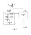
- FIG. 7illustrates one embodiment of the location links and cellular links discussed with respect to FIG. 6 .
- a base station 770has a GPS receiver 765 that is coupled by a location link 710 to a cellular link 780 .
- the cellular link 780conveys cellular phone calls and associated information to the service provider (perhaps via a switching center).
- the GPS location information from the GPS receiver 765is processed by the location link 710 , which may be a general purpose computing device or module or may be a specialized dedicated device for the purpose of translating GPS location information into a format usable by the cellular link 780 .
- the location link 710includes an I/O interface 740 which receives GPS location information from the GPS receiver 765 .
- a modem 750modulates this information and it is passed along via the cellular link 780 as would be a telephone call.
- the location linkalso includes a processor 720 , a memory 760 , and a bridge 730 coupling the various components together.
- the memorycontains programs executed by the processor to process the GPS location information received by the I/O interface.
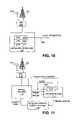
- FIG. 8illustrates other embodiments of the location link and the cellular link.
- a GPS receiver 840again receives GPS location information for a base station 850 .
- the location link 810includes a processing system 830 that receives the GPS information and provides that information to a network interface 820 .
- the network interface 820may itself transmit the location information in network format to a switching center or to a service provider. For example, if a base station itself is connected to the Internet or another network, then location information may be directly transmitted over the network to the correction information calculation module.
- the network interfacemay transfer location information in a format accepted by a voice and/or data link 860 in a cellular link 870 .
- the voice data link 860may be a component that receives voice/data from RF wireless communication equipment and relays that voice/data information. Such equipment may have an additional input which may be used to transmit additional streams of data, and the location information may be provided to this additional input.
- an optional hub 880may need to be added to insert the additional location information into the steam of voice/data being transmitted via the cellular link 870 .
- the various linking structuresmay be a result of adding location services to systems that were not originally designed with such location services in mind. As cellular systems evolve, some such links may no longer be necessary. Thus, in some embodiments, (e.g., see FIGS. 1 and 6 ) the link may be a unified link.
- the GPS receivermay output information packets that are directly transmittable on to the service provider, a switching center, or directly over the network to a computer that executes the appropriate correction information calculation module.
- FIG. 9illustrates an embodiment of a network based local area augmentation system in which the correction information calculation module is included in a mobile switching center (MSC).
- base stations 925 - 1 through 925 -Neach have a positioning system receiver that transmits location information to one of a set of mobile switching centers 910 and 930 .
- Each mobile switching centeris coupled to a network 935 , and nLAAS information is communicated over the network via network interfaces.
- the mobile switching center 910includes a network interface 920 and additionally includes a correction information calculation module 915 .
- correction informationmay be calculated at one of the switching centers, obviating the need for a separately located or arranged machine to perform correction information calculations.
- An Internet or data services provider 900may receive location information from the MSC 910 and responsively provide localized data services.
- FIG. 10illustrates an embodiment of a network based local area augmentation system in which a unified service provider provides correction information calculation facilities as well as localized data services.
- a base station 1065 having a positioning system receiver 1060is linked by a link 1050 to a unified service provider 1000 .
- the unified service provider 1000provides a correction information calculation module (CICM) 1030 , a station selection module (SSM) 1020 , and a localized data services module (LDSM) 1010 .
- the correction information calculation moduleis coupled to a network 1040 to receive nLAAS information from other networked base stations (not shown).
- This embodimentadvantageously centralizes the location calculations with their associated services, thereby potentially reducing the numbers and layers of communications and likely the latencies involved in providing the localized services.
- This embodimentis a likely implementation for cellular service providers who are also Internet or data service providers.
- FIG. 11illustrates an embodiment of a network based local area augmentation system in which separate application or content providers receive location information from a location provider and provide localized services to users via the service provider.
- a base station 1145 and associated positioning system receiver 1140transmit information to a service provider 1100 via a link 1130 .
- a location provider 1110includes a correction information calculation module 1115 that is used to compute correction information from the nLAAS information received from the base station 1145 and various other networked base stations (not shown) via a network 1125 . Additionally, the location provider may utilize coarse location information received from the service provider to determine the proper set of base stations to use in the computation of the correction information.
- Precise location informationmay be computed by the location provider 1110 or may be computed by the mobile device and transferred to the location provider through the service provider 1100 as shown.
- An application provider or content provider 1120receives precision location information from the location provider 1110 and provides localized data services to a mobile device/user via the service provider 1100 .
- FIG. 12illustrates an embodiment of a network based local area augmentation system in which an Internet service provider provides correction information facilities as well as localized data services.
- a base station 1260 and an associated positioning system receivercommunicate 1255 with a mobile switching center/interworking function (MSC/IWF) 1240 via a link 1250 .
- the MSC/IWF 1240transfers calls to the phone system and processes data requests by sending them to an Internet service provider (ISP) 1200 .
- ISP 1200provides a correction information calculation module (CICM) 1230 , a station selection module (SSM) 1220 , and a localized data services module (LSDM) 1210 .
- CICMcorrection information calculation module
- SSMstation selection module
- LSDMlocalized data services module
- Correction informationis computed by nLAAS information computed from a number of base stations similar to base station 1260 that all communicate to a network 1270 via a network interface such as network interface 1240 at their respective MSC/IWFs.
- the arrangement of FIG. 12consolidates location calculation facilities with the ISP in an environment where the ISP is not also a cellular phone service provider.
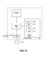
- FIG. 13illustrates an embodiment of a network based local area augmentation system server.
- the various functions discussedmay be performed by a single machine.
- the various functionsmay be distributed to several machines.
- single functionsmay be performed across multiple machine and/or split in a variety of manners as appropriate for the particular arrangement.
- the embodiment of an nLAAS server 1300 shown in FIG. 13includes a bridge 1315 which couples a processor 1310 to a memory 1340 and an I/O interface 1320 .
- the memorycontains, among other things, the various modules that may be executed by the nLAAS server 1300 .
- the nLAAS server 1300includes a correction information calculation module (CICM) 1360 , a station selection module (SSM) 1355 and optionally may include a localized data services module (LDSM) 1350 and a precise location calculation module (PLCM) 1345 .
- these modulesare software modules.
- the modulesmay be software, hardware, firmware, or any combination of these or other technologies that may implement the desired functions.
- the memory 1340stores location information after it is received for processing by the processor 1310 .
- the I/O interface 1320may receive the software modules (for example, if newly programmed on the machine or updated to a later revision).
- a machine readable mediummay be used to transmit the software.
- Machine readable mediumsare any mediums that can store, at least temporarily, information for reading by a machine interface. This may include signal transmissions 1325 (via wire, optics, or air) and/or physical storage media 1330 such as various types of disk and memory storage devices.
- the nLAAS server 1300executes the appropriate modules as described herein to implement the functionality appropriate for the particular embodiment.
Landscapes
- Engineering & Computer Science (AREA)
- Radar, Positioning & Navigation (AREA)
- Remote Sensing (AREA)
- Computer Networks & Wireless Communication (AREA)
- Physics & Mathematics (AREA)
- General Physics & Mathematics (AREA)
- Mobile Radio Communication Systems (AREA)
Abstract
Description
1. Field
The present disclosure pertains to the field of location systems. More particularly, the present disclosure pertains to techniques for providing improved precision location information using a network based local area augmentation system.
2. Description of Related Art
Mobile communication technologies have recently enjoyed substantial growth and are likely to continue to experience increasing growth and acceptance in the near future. Currently, many cars, trucks, airplanes, boats, and other vehicles are equipped with devices that allow convenient and reliable mobile communication through a network of satellite-based or land-based transceivers. Advances in this technology have also led to widespread use of hand-held, portable mobile communications devices.
Many customers of mobile communications systems also find desirable an accurate determination of their location. Such information may be reported to a remote location to provide various location-based services. For example, a cellular telephone in a vehicle or carried by a person offers a convenient communication link to report location information. Services such as directions or the location of nearby facilities of a desired type may be provided based on the location information relayed. In current systems, location information is generated by traditional positioning systems, including a satellite-based positioning system such as the global positioning system (GPS) using NAVSTAR satellites, the Russian GLONASS system, or the European EUTELSAT system, or a land-based positioning system, such as LORAN-C. These approaches, however, may not be suitable for particular applications that require highly accurate and/or reliable location information.
One known technique for providing improved location information involves the use of differential GPS calculations (see, e.g., U.S. Pat. No. 5,913,170). Such systems may use a single fixed base station in a known location with a GPS receiver to generate correction signals. These correction signals are relayed to the mobile device (e.g., a phone), where they can be used to improve the accuracy of the location information derived by a GPS receiver in the phone. The use of a single base-station based correction information computation engine and a single tower's GPS receiver to perform calculations may be convenient; however, the accuracy and reliability of such systems may still not be sufficient for applications that benefit from highly precise location information.
Some other prior art systems utilize various fields of antennas or receivers to generate correction information. For example, a local area augmentation system (LAAS), also known as a ground based augmentation system (GBAS), may be used in airplane navigation and landing systems (see, e.g., U.S. Pat. No. 6,067,484). Such systems employ multiple ground receivers or beacons in fixed locations aligned along a runway. These receivers each individually transmit correction information to the GPS receiver in the airplane, which performs computations including all the information from the multiple receivers. This type of arrangement may be impractical for cellular phone and other consumer-oriented location devices because additional radio frequency receivers are needed to receive information from the runway beacons and because the multiple beacons each provide data requiring substantial additional computations at the GPS receiver. Such complicated processing may disadvantageously burden the processing resources and/or the power (e.g., battery) resources of a mobile device. Moreover, wide deployment of many such beacons solely for the purpose of a positioning system would be a costly undertaking.
Additionally, one other prior art location technique is a wide area augmentation system (WAAS). The WAAS also provides supplemental correction data in order to establish better locations. One such system is being deployed with a limited set of antenna stations (currently 25) being deployed throughout the United States. This system, however, also relies on radio-frequency transmission of correction information. Moreover, correction data from single, widely spaced antennas may not provide sufficiently accurate correction information to allow sufficiently precise location calculations to be performed for some applications.
The present invention is illustrated by way of example and not limited by the figures of the accompanying drawings.
The following description provides techniques for mobile device location using a network based local area augmentation system. In the following description, numerous specific details such as particular positioning systems, types of location calculation correction information, techniques for transmitting information, and functionality partitioning choices are set forth in order to provide a more thorough understanding of the present invention. It will be appreciated, however, by one skilled in the art that the invention may be practiced without such specific details.
A disclosed network based local area augmentation system (nLAAS) may advantageously provide a practical and scalable implementation for calculating accurate and reliable location information for a variety of mobile devices. Due to the practical and scalable nature of some embodiments, wide deployment may be effectively undertaken. Due to the high reliability and accuracy, new localized data services may be provided and existing services enhanced. Additionally, new service models involving charging various “customers” or users for location information or location based services may be employed using the disclosed techniques.
Prior art systems that employ multiple remote receivers to generate correction information (e.g., aircraft landing systems) are not designed to be scalable to receive location information from multiple receivers spread over a large area. Rather, aircraft landing systems are limited to radio communications with runway beacons. Additionally, such systems rely on substantial space and computing power being available on board the aircraft. The aircraft equipment includes separate radio receivers to receive individual information transmissions from the beacons, with the information from all of the various beacons being processed on board the aircraft. Furthermore, such systems do not utilize a networked server or other networked machine to calculate correction information from dynamically determined sets of receivers.
In contrast, an nLAAS arrangement such as that shown inFIG. 1 provides for transmission of nLAAS information from a variety of sources (e.g., the various base stations) over anetwork 127, which may be a pre-existing network such as the Internet. As a result, correction information calculations can be performed at any of the variety of convenient locations so long as access to the network is available. In some embodiments, therefore, computations for mobile devices are performed by networked servers. Additionally, precise location calculations may also be performed in any of a variety of convenient locations, again potentially offloading computations from mobile devices. The correction information and/or precise location information may then advantageously be transmitted through existing channels to reach the appropriate service provider(s) and/or themobile device 150. For example, the correction information may be transmitted via the network to a service provider and may then be transmitted via existing data channels used in cellular communication with the mobile devices. Thus, the use of a network based LAAS advantageously allows LAAS information to be easily routed and for computations to be performed in convenient locations.
Additionally, network based LAAS techniques may utilize existing cellular infrastructure reduce overall deployment costs. Cellular base stations provide not only a housing for a positioning system receiver at each location, but also may already include positioning receivers that are used for synchronization purposes. Moreover, existing data channels may be used to communicate with the mobile device. Thus, a network based LAAS technique may advantageously leverage existing cellular infrastructure components.
Turning to the details of the system shown inFIG. 1 , themobile device 150 has a roving location (RL). Themobile device 150 is in communication with a set of satellites180-1 through180-N as indicated by dashedlines location information receiver 160 receives location information signals from the satellites180-1 to180-N through anantenna 170. In an embodiment that communicates with GPS satellites, typically themobile device 150 communicates with at least four satellites in order to accurately resolve its location. Stand-alone GPS receivers are known technologies to those in the art and are currently found in cars, mobile phones as well as numerous other devices.
Themobile device 150 is also in communication with the base station135-2 as indicated by dashedline 177. Themobile device 150 includes an antenna175 coupled to a cellular communications receiver (CCR)165. Any known or otherwise available and appropriate wireless communication technology can be used for communication between themobile device 150 and the base station135-2. Notably, themobile device 150 communicates with different base stations depending on its location and its proximity to the various base stations in the area. The mobile device may be a phone, a personal digital assistant, a vehicle, a vehicular tracking device, or any other movable device with a power supply mechanism to allow operation of electronic components.
In one embodiment, a preciselocation calculation module 155 is included within themobile device 150. In this embodiment, typically, a preciselocation calculation module 110 is not included in thenLAAS server 100. Operations for one embodiment of such a system are shown inFIG. 2 , and components ofFIG. 1 will be discussed with reference to these operations.
Inblock 200, location information at the base stations135-1 through135-N is measured by the corresponding ones of the positioning receivers130-1 through130-N at that base station. Each base station has a known location, so a known location and a measured location is available. The measured location may be the result of a geological survey or other physical measurement techniques or may be the result of location readings such as readings with highly precise equipment or readings averaged over a long period of time. As indicated inFIG. 1 , base station135-1 has a known location (KL1) and a measured location (ML2). Likewise, base station135-2 has known location (KL2) and measured location (ML2), base station135-N-1 has known location (KLN-1) and a measured location (MLN-1), and base station135-N has a known location (KLN) and a measured location (MLN). In some embodiments, all “base stations” may be cellular communication system base stations; however, other embodiments may include base stations dedicated to positioning or may use other structures.
Inblock 205, location information is converted into a transmittable format. For example, a link125-1 at base station135-1 transmits the location information to thenetwork 127. This may be accomplished using a variety of mechanisms. For example, some current cellular base stations communicate with switching centers via land-based communication lines such as T1 lines. Location information may be modulated such that it can be communicated over such a communication line. Alternatively, the location information may be simply converted into a format that equipment at the base station can receive and transmit along with the transmissions received from mobile devices. In any case, the link125-1 communicates location information to thenetwork 127. Similarly, a link125-2 links the base station135-2 to thenetwork 127, a link125-N-1 links the base station135-N-1 to thenetwork 127, and a link125-N links the base station135-N to thenetwork 127.
The measured base station location information from the different base stations is provided to thenLAAS server 100 as indicated inblock 210. In some embodiments, the links from the base stations may themselves direct the appropriate traffic to theserver 100 to accomplish this transmission of information. In other embodiments, intermediate entities or machines may receive and/or repackage or convert such information before it is transmitted to thenetwork 127 and theserver 100.
As indicated inblock 215, an initial estimate of the location (RL) of themobile device 150 is provided. This initial estimate may be provided by a variety of mechanisms. For example, a default may be chosen based on the area code of the phone. Alternately, the location may be chosen based on the location of the base station which is presently communicating with themobile device 150. For example, in the embodiment shown inFIG. 1 , a location based on the known location of base station135-2 may be chosen. Alternatively, thelocation information receiver 160 in themobile device 150 may provide a coarse measurement of the location of themobile device 150. Other known or otherwise available techniques may be employed to establish an initial estimate of the location of themobile device 150.
As indicated inblock 220, a subset of the base stations135-1 to135-N are chosen to provide an accurate computation of correction information for themobile device 150. This computation may be performed by astation selection module 115 in thenLAAS server 100. Once a subset of the total set of base stations is chosen, correction information may be computed by a correction information calculation module (CICM)120 as indicated inblock 225. The nLAAS server receives measured and known locations from the base stations M1-Nand either receives or has the known locations KL1-N. The measured locations of the selected base stations are used by the correctioninformation calculation module 120 in computing the correction factors. In various embodiments, one or both of psuedorange and/or carrier-phase corrections are generated by the correctioninformation calculation module 120. In other embodiments, other information may be transmitted and used. For example, satellite ephemeris information may be transmitted for receiver cold start. Other satellite information such as almanac data may also be transmitted
The correctioninformation calculation module 120 outputs the correction information, as indicated by a dashed line so labeled inFIG. 1 . In one embodiment, this information is ultimately transmitted to themobile device 150 where the preciselocation calculation module 155 incorporates the correction information to make a more precise computation of the location of the mobile device (block230). The correction information may be transmitted to the mobile device by a variety of known or otherwise available mechanisms as well as those described herein. The correction information may be transmitted partially via the network to the link125-2 or via one or more service providers before the link125-2 and the base station135-2 are reached.
In some embodiments, the precise location information may also be transmitted to the mobile device; however, the precise location information may not actually be needed by the mobile device in other embodiments. Rather, it may be desirable to provide location-specific information to the mobile device or to various applications (e.g., fleet or personal tracking applications). Thus, in order to provide such applications, the precise location information may be transmitted to a localized data services module (LDSM)105. TheLDSM 105 then may provide a variety of localized services based on the location of the device as indicated inblock 235.
A great variety of such services may be available, but some examples may include personal or vehicle navigation, localized marketing or services applications, fleet tracking, enhanced 911 services, telematics, etc. Localized marketing services may provide advertisements for goods or services in the locale of the mobile device and/or may provide incentives for purchases or other transactions in the area. Localized billing for phone usage is another possibility. Localized billing for phone services involves charging different rates for usage based on small scale locale changes (e.g., making it cheap to continue to use your cellular phone while in your own home so that you do not use the land line).
Next, as indicated inblock 320, psuedorange and/or carrier-phase correction values are computed as a function of the known locations of the base stations and the location information received for the selected set of base stations. Known or otherwise available LAAS techniques may be used to perform these calculations in a manner understood by those of skill in the art. Alternatively, other techniques may be used to calculate and compensate for localized distortions or localized phenomena that may influence the accuracy of the particular positioning system being used.
In one embodiment, shown inFIG. 3 b, the correctioninformation calculation module 120 includes an integrity monitoring module (IMM)350 and a measurements integration module (MIM)360. The integrity monitoring module helps ensure the integrity of correction information generated by the correctioninformation calculation module 120 by monitoring the quality of data input to the correctioninformation calculation module 120. Thus, theintegrity monitoring module 350 detects and excludes data that reflects a failure of some sort on the part of one of the reference receivers at a base station (or the transmission facilities between the receiver and the correction information calculation module). Theintegrity monitoring module 350 may detect reference receiver failure due to a variety of causes, including cycle slip and code multipath errors.
Themeasurements integration module 360 stochastically integrates the individual reference measurements to compute the final correction information. Base station reference measurements may be filtered by the integrity monitoring module as described above prior to reaching themeasurements integration module 360 to eliminate suspect location information. In some embodiments, themeasurements integration module 360 provides adaptive integration of LAAS pseudo-range and carrier-phase reference measurements to generate correction information for transmission to the precise location calculation module. Such adaptive computation capabilities may help provide a robust location solution amenable to the demands of varying terrain and continuously changing locations of mobile devices.
Referring back toFIG. 3 a, as indicated in block330, the correctioninformation calculation module 120 provides the psuedorange and/or carrier-phase correction values to the precise location calculation module. As previously discussed with respect to one embodiment of the system inFIG. 1 , the preciselocation calculation module 155 may be included in themobile device 150. In such a case, providing the correction information involves transmitting that information to themobile device 150. In another embodiment of the system ofFIG. 1 , the preciselocation calculation module 110 is included remotely from themobile device 150. The preciselocation calculation module 110 may be included in thenLAAS server 100, but may also be included at other locations, such as at switching centers, base stations, service providers, or other convenient locations. In these cases, the provision of correction information may involve an exchange between routines or computer systems.
As indicated inblock 430, a more precise location for themobile device 150 is computed using the initial set of base stations. Once this more precise location is determined, a new set of base stations may be selected if the more precise location indicates a better match with a different set of base stations (block440). The station selection module may be continuously or periodically activated in view of the fact that mobile devices are likely to move into new locations in which the different set of base stations would produce more precise results. Thus, the operations shown inFIG. 4 may be regularly or continuously repeated.
In view of the fact that remote and networked devices (remote from the mobile device and likely from the base station) are used to compute location information, one possible scenario is that a location provider or a location service provider has valuable information that the cellular service provider or an application service provider does not have. For example, in the system ofFIG. 1 , the owner of thenLAAS server 100 has access to at least correction information and may have access to precise location information if the preciselocation calculation module 110 is included in theserver 100. Thus, this location service provider may wish to undertake the business model of charging other users and/or service providers for location information.
Several possible embodiments of such a business model are shown inFIG. 5 . As indicated inblock 500, correction information is computed. This correction information is transmitted to the precise location calculation module (wherever it may be) as indicated inblock 510. Users or service providers may be charged for location information (i.e., either the correction information or the precise location information) on a per use or amount-of-time basis as indicated inblock 520. Alternatively, users and/or service providers may be charged a flat fee for unlimited location information as indicated inblock 530. Another alternative, indicated inblock 540, is to charge application providers for location data. The application providers may also be charged a per use, per user, or flat fee basis. A combination of these approaches may also be used, potentially deriving revenue from multiple sources. Additionally, in other embodiments, other service providers may calculate location information and charge according to this or other models.
ThenLAAS server 605 ofFIG. 6 includes a correctioninformation calculation module 609 and astation selection module 607 analogous to those previously described with respect toFIG. 1 . ThenLAAS server 605 provides correction information to an Internet ordata services provider 600. This information may be provided to theservice provider 600 via the Internet or other communication means. The service provider provides correction information to the MSC/IW610. The correction information is passed on to a cellular link (CL)630-2 to a base station640-2 and via wireless transmission to amobile device 650. Themobile device 650 computes precise location information and returns this information through the cellular link630-2 and the MSC/IW610 to theservice provider 600. Theservice provider 600 may then provide localized data services through themobile device 650. The same path for communication of data may be used for the localized data services as is used for the transmission of the correction information.
Similarly to the system discussed with respect toFIG. 1 , the system shown inFIG. 6 includes other base stations640-1,640-N-1, and640-N. Each base station has a positioning system receiver (e.g., a GPS receiver), respectively645-1 through645-N. In some embodiments (e.g., CDMA cellular phone systems), GPS receivers may be included at base stations for synchronization purposes. In other embodiments, GPS receivers may be added to the base station. Each base station includes a location link in this embodiment, respectively labeled625-1 through625-N. This location link takes the location information determined by the positioning system receivers645-1 through645-N and transmits this information to thenLAAS server 605 by converting the location information into a format that is accepted by and/or already transmitted by the cellular links630-1 through630-N. Some of the base stations (e.g.,640-N-1 and640-N) may interface to thenetwork 615 through other MSC/IWF 620. In this manner, the system may be scaled to allow nLAAS information to be gathered at many base stations through many MSC/IWFs.
In the illustrated embodiment, thelocation link 710 includes an I/O interface 740 which receives GPS location information from theGPS receiver 765. Amodem 750 modulates this information and it is passed along via thecellular link 780 as would be a telephone call. The location link also includes aprocessor 720, amemory 760, and abridge 730 coupling the various components together. The memory contains programs executed by the processor to process the GPS location information received by the I/O interface.
In other embodiments, the network interface may transfer location information in a format accepted by a voice and/ordata link 860 in acellular link 870. In some embodiments, the voice data link860 may be a component that receives voice/data from RF wireless communication equipment and relays that voice/data information. Such equipment may have an additional input which may be used to transmit additional streams of data, and the location information may be provided to this additional input. In other cases, anoptional hub 880 may need to be added to insert the additional location information into the steam of voice/data being transmitted via thecellular link 870.
Notably, the various linking structures may be a result of adding location services to systems that were not originally designed with such location services in mind. As cellular systems evolve, some such links may no longer be necessary. Thus, in some embodiments, (e.g., seeFIGS. 1 and 6 ) the link may be a unified link. In such embodiments, the GPS receiver may output information packets that are directly transmittable on to the service provider, a switching center, or directly over the network to a computer that executes the appropriate correction information calculation module.
The embodiment of annLAAS server 1300 shown inFIG. 13 includes abridge 1315 which couples aprocessor 1310 to amemory 1340 and an I/O interface 1320. The memory contains, among other things, the various modules that may be executed by thenLAAS server 1300. In the embodiment shown, thenLAAS server 1300 includes a correction information calculation module (CICM)1360, a station selection module (SSM)1355 and optionally may include a localized data services module (LDSM)1350 and a precise location calculation module (PLCM)1345. In this embodiment, these modules are software modules. In other embodiments, the modules may be software, hardware, firmware, or any combination of these or other technologies that may implement the desired functions. Thememory 1340 stores location information after it is received for processing by theprocessor 1310.
The I/O interface 1320 may receive the software modules (for example, if newly programmed on the machine or updated to a later revision). Thus, a machine readable medium may be used to transmit the software. Machine readable mediums are any mediums that can store, at least temporarily, information for reading by a machine interface. This may include signal transmissions1325 (via wire, optics, or air) and/orphysical storage media 1330 such as various types of disk and memory storage devices. ThenLAAS server 1300 executes the appropriate modules as described herein to implement the functionality appropriate for the particular embodiment.
Thus, techniques for mobile device location using a network based local area augmentation system is disclosed. While certain exemplary embodiments have been described and shown in the accompanying drawings, it is to be understood that such embodiments are merely illustrative of and not restrictive on the broad invention, and that this invention not be limited to the specific constructions and arrangements shown and described, since various other modifications may occur to those ordinarily skilled in the art upon studying this disclosure.
Claims (26)
1. A system comprising:
a plurality of base stations, each base station comprising:
a positioning receiver to generate base station location information, each positioning receiver having a known location, and
a link to a network to transmit said base station location information;
a station selection module to select a subset of the plurality of base stations based at least in part on each base station of the subset utilizing a set of satellites that is also utilized by a mobile device; and
a correction information calculation module coupled to the network to receive base station location information from each base station of the subset via the network, the correction information calculation module to calculate correction information as a function of the received base station location information and the known location for each base stations of the subset, wherein the correction information calculation module includes:
an integrity monitoring module to monitor the received base station location information and to prevent received base station location information that has been corrupted from being used by the correction information calculation module, and
a measurements integration module to stochastically integrate non-corrupted base station location information to derive said correction information.
2. The system ofclaim 1 wherein said station selection module selects an updated subset of the plurality of base stations, which may or may not differ from the subset, based on a location of the mobile device computed using a correction information computed using the subset.
3. The system ofclaim 1 wherein the received base station location information that has been corrupted comprises base station location information that has been corrupted by cycle slip and code multipath errors.
4. The system ofclaim 1 wherein each link comprises a first network interface to receive base station location information from a positioning receiver at a base station and to generate a first set of signals for transmission of said base station location information from said positioning receiver.
5. The system ofclaim 4 wherein said first network interface packetizes said base station location data for network communication to said correction information calculation module.
6. The system ofclaim 4 wherein said first network interface comprises a telephony communications interface, the apparatus further comprising:
a second link to receive said first set of signals via one or more signal lines from the base station and to extract said base station location data;
a second network interface to receive said base station location data from said second link and to generate a second set of signals for transmission of said base station location data to the correction information calculation module via the network.
7. The system ofclaim 1 wherein said link comprises a modem to modulate base station location information from a positioning receiver into a modulated signal for transmission over a telecommunications link.
8. The system ofclaim 7 further comprising:
a second link to receive said modulated signal from said telecommunications link and to extract said base station location information;
a network interface to receive said base station location information from said second link and to generate a second set of signals for transmission to the correction information calculation module via the network.
9. The system ofclaim 1 further comprising:
a receiver module to communicate with a positioning system to determine preliminary position-related information; and
a precise location calculation module to calculate a receiver location from said correction information and said preliminary position-related information.
10. The system ofclaim 9 wherein said precise location calculation module and said receiver module are included in a roving receiver device, wherein said roving receiver device receives said correction information from said correction information calculation module via a message on the network that is converted to a wireless transmission from one of said plurality of base stations to said receiver module.
11. The system ofclaim 10 wherein said preliminary position-related information comprises a set of psuedoranges.
12. The system ofclaim 10 wherein said correction information comprises one or more of LAAS-based pseudorange corrections and LAAS-based carrier-phase corrections.
13. The system ofclaim 9 wherein said precise location calculation module is located remotely from said receiver module, wherein said receiver module transmits said preliminary position-related information via a wireless message that is converted to a message that is transmitted on the network to said precise location calculation module.
14. An system comprising:
a plurality of cellular communications base stations, each base station comprising:
a positioning receiver to generate base station location information, each positioning receiver having a known location;
a link to a network to transmit said base station location information;
a first module coupled to the network to receive base station location information from each of the plurality of base stations via the network, the first module to calculate correction information as a function of the received base station location information and the known location for all of the plurality of base stations;
a second module to select location information from a selected subset of said plurality of base stations and to omit location information from an omitted subset of said plurality of base stations from computation of said correction information, wherein the second module selects the subset of base stations based at least in part on each of the subset of base stations utilizing a set of satellites that is also utilized by a receiver for which a set of correction information is being computed;
a third module to communicate with a positioning system to determine preliminary position-related information; and
a fourth module to calculate the receiver location from said correction information and said preliminary position-related information;
wherein the first module includes:
a fifth module to monitor the received base station location information and to prevent received base station location information that has been corrupted from being used by the first module, and
a sixth module to stochastically integrate non-corrupted base station location information to derive said correction information.
15. The system ofclaim 14 wherein the network is the Internet and wherein said first module and said second module are programs executed by a server connected to the Internet.
16. The system ofclaim 15 wherein the third module, the fourth module, the fifth module, and the sixth module are programs executed by the server connected to the Internet.
17. An apparatus comprising:
a network interface to receive base station location information from a plurality of base stations from a network;
an integrity monitoring module to monitor the received base station location information and to discard received base station location information that has been corrupted;
a correction information calculation module to compute a correction information for a mobile device as a function of non-discarded base station location information received from the base stations, wherein the correction information calculation module includes a measurements integration module to stochastically integrate non-discarded base station location information to derive said correction information;
a station selection module to select a subset of the base stations based at least in part on each base station of the subset utilizing a set of satellites that is also utilized by the mobile device; and
a localized data services module to provide localized information based on a location computed using said correction information.
18. The apparatus ofclaim 17 further comprising:
a data link to receive location information for the mobile device.
19. The apparatus ofclaim 18 wherein said data link comprises a link to an Internet service provider.
20. The apparatus ofclaim 18 wherein said data link comprises a link to a cellular phone service provider.
21. The apparatus ofclaim 17 , wherein the localized data services module performs one or more services selected from the group consisting of personal navigation, vehicle navigation, localized marketing applications, localized services applications, fleet tracking, enhanced 911 services, telematics, localized advertisements for goods, localized advertisements for services, localized purchase incentives, and localized billing for phone services.
22. The apparatus ofclaim 21 wherein said received base station location information that has been corrupted comprises received base station location information that has been corrupted by cycle slip and multipath errors.
23. An article comprising a machine readable medium storing instructions that, if executed by a machine, cause the machine to perform a set of operations comprising:
storing a plurality of location information communications from a plurality of base stations received via a network;
monitoring the plurality of received location information communications and discarding any location information communications that have been corrupted;
selecting a subset of the non-discarded plurality of location information communications, wherein the subset is selected based at least in part on which of the plurality of base stations is utilizing a set of satellites that is also being utilized by a mobile device for which a correction information is being computed;
computing the correction information for the mobile device as a function of contents of the subset of said plurality of location information communications and known locations of said plurality of base stations; and
stochastically integrating the subset of said plurality of location information communications to derive said correction information.
24. The article ofclaim 23 wherein the set of operations further comprises:
selecting said subset based on a location of said mobile device.
25. The article ofclaim 24 wherein the set of operations further comprises:
computing a second subset based on a precise location determined by a precise location computation;
computing a precise location as a function of said correction information and coarse location information determined by said mobile device.
26. The article ofclaim 24 wherein the set of operations further comprises:
providing location specific data based on a location computed using said correction information.
Priority Applications (1)
| Application Number | Priority Date | Filing Date | Title |
|---|---|---|---|
| US09/603,451US7126527B1 (en) | 2000-06-23 | 2000-06-23 | Method and apparatus for mobile device location via a network based local area augmentation system |
Applications Claiming Priority (1)
| Application Number | Priority Date | Filing Date | Title |
|---|---|---|---|
| US09/603,451US7126527B1 (en) | 2000-06-23 | 2000-06-23 | Method and apparatus for mobile device location via a network based local area augmentation system |
Publications (1)
| Publication Number | Publication Date |
|---|---|
| US7126527B1true US7126527B1 (en) | 2006-10-24 |
Family
ID=37110575
Family Applications (1)
| Application Number | Title | Priority Date | Filing Date |
|---|---|---|---|
| US09/603,451Expired - LifetimeUS7126527B1 (en) | 2000-06-23 | 2000-06-23 | Method and apparatus for mobile device location via a network based local area augmentation system |
Country Status (1)
| Country | Link |
|---|---|
| US (1) | US7126527B1 (en) |
Cited By (25)
| Publication number | Priority date | Publication date | Assignee | Title |
|---|---|---|---|---|
| US20050280576A1 (en)* | 2003-12-17 | 2005-12-22 | Yaron Shemesh | Subscriber unit, a cellular communication system and a method for determining a location therefor |
| US20070192409A1 (en)* | 2002-07-23 | 2007-08-16 | Amir Kleinstern | Advertising based on location behavior |
| WO2009056363A1 (en)* | 2007-10-29 | 2009-05-07 | Trimble Navigation Limited | Position determination with reference data outage |
| US8050686B1 (en)* | 2000-08-29 | 2011-11-01 | Motorola Mobility, Inc. | Method of enabling low tier location applications |
| RU2454000C1 (en)* | 2011-05-30 | 2012-06-20 | Закрытое акционерное общество "ИРКОС" | Method of determining base station location |
| US8237609B2 (en) | 2009-02-22 | 2012-08-07 | Trimble Navigation Limited | GNSS position coasting |
| CN103278836A (en)* | 2013-05-31 | 2013-09-04 | 中国科学院光电研究院 | Aircraft positioning method based on two-forwarding system |
| WO2013158560A3 (en)* | 2012-04-17 | 2013-12-12 | Nextnav, Llc | System and method for estimating receiver position using timing data associated with reference locations |
| US8773303B2 (en) | 2007-06-22 | 2014-07-08 | Trimble Navigation Limited | Position tracking device and method |
| US20140259058A1 (en)* | 2000-09-12 | 2014-09-11 | Syndicast Corporation | System for transmitting syndicated programs over the internet |
| US8874398B2 (en) | 2010-11-12 | 2014-10-28 | Nextnav, Llc | Wide area positioning system |
| US8917209B2 (en) | 2009-09-10 | 2014-12-23 | Nextnav, Llc | Coding in a wide area positioning system (WAPS) |
| WO2014179224A3 (en)* | 2013-05-02 | 2015-01-29 | Qualcomm Incorporated | Obfuscating the locations of access points and femtocells |
| US20150098460A1 (en)* | 2013-10-09 | 2015-04-09 | Mediatek Singapore Pte. Ltd. | Group Based Location Service in Wireless Local Area Networks |
| US9035829B2 (en) | 2008-09-10 | 2015-05-19 | Nextnav, Llc | Wide area positioning systems and methods |
| US9176217B2 (en) | 2011-08-02 | 2015-11-03 | Nextnav, Llc | Cell organization and transmission schemes in a wide area positioning system (WAPS) |
| US9247392B2 (en) | 2012-06-05 | 2016-01-26 | Nextnav, Llc | Systems and methods for location positioning of user device |
| US9286490B2 (en) | 2013-09-10 | 2016-03-15 | Nextnav, Llc | Systems and methods for providing conditional access to transmitted information |
| US9291712B2 (en) | 2009-09-10 | 2016-03-22 | Nextnav, Llc | Cell organization and transmission schemes in a wide area positioning system (WAPS) |
| US9322918B2 (en) | 2009-02-22 | 2016-04-26 | Trimble Navigation Limited | GNSS surveying methods and apparatus |
| US9372266B2 (en) | 2009-09-10 | 2016-06-21 | Nextnav, Llc | Cell organization and transmission schemes in a wide area positioning system (WAPS) |
| US9390279B2 (en) | 2012-09-11 | 2016-07-12 | Nextnav, Llc | Systems and methods for providing conditional access to transmitted information |
| US9408024B2 (en) | 2008-09-10 | 2016-08-02 | Nextnav, Llc | Wide area positioning system |
| EP3246730A1 (en)* | 2016-05-19 | 2017-11-22 | Deutsche Telekom AG | Method to increase positioning accuracy of global navigation satellite systems by integration of correction service with a mobile communication network |
| US10448209B2 (en) | 2001-10-04 | 2019-10-15 | Traxcell Technologies Llc | Wireless network and method with communications error trend analysis |
Citations (35)
| Publication number | Priority date | Publication date | Assignee | Title |
|---|---|---|---|---|
| US5225842A (en) | 1991-05-09 | 1993-07-06 | Navsys Corporation | Vehicle tracking system employing global positioning system (gps) satellites |
| JPH063431A (en)* | 1992-06-17 | 1994-01-11 | Sharp Corp | Differential gps position measuring system |
| US5587715A (en)* | 1993-03-19 | 1996-12-24 | Gps Mobile, Inc. | Method and apparatus for tracking a moving object |
| US5617100A (en)* | 1994-04-07 | 1997-04-01 | Matsushita Electric Industrial Co., Ltd. | Accurate position measuring system |
| US5621646A (en)* | 1995-01-17 | 1997-04-15 | Stanford University | Wide area differential GPS reference system and method |
| US5638077A (en)* | 1995-05-04 | 1997-06-10 | Rockwell International Corporation | Differential GPS for fleet base stations with vector processing mechanization |
| US5764184A (en)* | 1997-03-10 | 1998-06-09 | Deere & Company | Method and system for post-processing differential global positioning system satellite positional data |
| US5781156A (en) | 1995-10-09 | 1998-07-14 | Snaptrack, Inc. | GPS receiver and method for processing GPS signals |
| US5812087A (en) | 1997-02-03 | 1998-09-22 | Snaptrack, Inc. | Method and apparatus for satellite positioning system based time measurement |
| US5825327A (en) | 1996-03-08 | 1998-10-20 | Snaptrack, Inc. | GPS receivers and garments containing GPS receivers and methods for using these GPS receivers |
| US5831574A (en) | 1996-03-08 | 1998-11-03 | Snaptrack, Inc. | Method and apparatus for determining the location of an object which may have an obstructed view of the sky |
| US5841396A (en) | 1996-03-08 | 1998-11-24 | Snaptrack, Inc. | GPS receiver utilizing a communication link |
| US5884220A (en) | 1996-07-16 | 1999-03-16 | Trimble Navigation Limited | Method and apparatus to improve overall performance of a DGPS receiver |
| US5884214A (en) | 1996-09-06 | 1999-03-16 | Snaptrack, Inc. | GPS receiver and method for processing GPS signals |
| US5890068A (en) | 1996-10-03 | 1999-03-30 | Cell-Loc Inc. | Wireless location system |
| US5899957A (en)* | 1994-01-03 | 1999-05-04 | Trimble Navigation, Ltd. | Carrier phase differential GPS corrections network |
| US5913170A (en) | 1994-11-16 | 1999-06-15 | Highwaymaster Communications, Inc. | Locating system and method using a mobile communications network |
| US5926133A (en) | 1997-07-21 | 1999-07-20 | Denso Corporation | Differentially corrected position location system and method for mobile communication networks |
| US5945944A (en) | 1996-03-08 | 1999-08-31 | Snaptrack, Inc. | Method and apparatus for determining time for GPS receivers |
| US5959577A (en) | 1997-08-28 | 1999-09-28 | Vectorlink, Inc. | Method and structure for distribution of travel information using network |
| US5983161A (en) | 1993-08-11 | 1999-11-09 | Lemelson; Jerome H. | GPS vehicle collision avoidance warning and control system and method |
| US5987377A (en) | 1995-02-10 | 1999-11-16 | Highwaymaster Communications, Inc. | Method and apparatus for determining expected time of arrival |
| US5999124A (en) | 1998-04-22 | 1999-12-07 | Snaptrack, Inc, | Satellite positioning system augmentation with wireless communication signals |
| US6002363A (en) | 1996-03-08 | 1999-12-14 | Snaptrack, Inc. | Combined GPS positioning system and communications system utilizing shared circuitry |
| US6016119A (en) | 1995-10-09 | 2000-01-18 | Snaptrack, Inc. | Method and apparatus for determining the location of an object which may have an obstructed view of the sky |
| US6058338A (en) | 1999-02-12 | 2000-05-02 | Qualcomm Incorporated | Method and apparatus for efficient GPS assistance in a communication system |
| US6061018A (en) | 1998-05-05 | 2000-05-09 | Snaptrack, Inc. | Method and system for using altitude information in a satellite positioning system |
| US6064339A (en) | 1997-01-08 | 2000-05-16 | Us Wireless Corporation | Subspace signature matching for location ambiguity resolution in wireless communication systems |
| US6067045A (en) | 1998-09-01 | 2000-05-23 | Hughes Electronics Corporation | Communication network initialization apparatus and method for fast GPS-based positioning |
| US6067046A (en) | 1997-04-15 | 2000-05-23 | Trimble Navigation Limited | Handheld surveying device and method |
| US6067484A (en) | 1998-03-23 | 2000-05-23 | Airsys Atm, Inc. | Differential GPS landing system |
| US6070078A (en) | 1997-10-15 | 2000-05-30 | Ericsson Inc. | Reduced global positioning system receiver code shift search space for a cellular telephone system |
| US6107960A (en) | 1998-01-20 | 2000-08-22 | Snaptrack, Inc. | Reducing cross-interference in a combined GPS receiver and communication system |
| US6215441B1 (en)* | 1997-04-15 | 2001-04-10 | Snaptrack, Inc. | Satellite positioning reference system and method |
| US6229478B1 (en)* | 1998-11-05 | 2001-05-08 | Trimble Navigation Limited | Near-real time DGPS network and server system |
- 2000
- 2000-06-23USUS09/603,451patent/US7126527B1/ennot_activeExpired - Lifetime
Patent Citations (38)
| Publication number | Priority date | Publication date | Assignee | Title |
|---|---|---|---|---|
| US5225842A (en) | 1991-05-09 | 1993-07-06 | Navsys Corporation | Vehicle tracking system employing global positioning system (gps) satellites |
| JPH063431A (en)* | 1992-06-17 | 1994-01-11 | Sharp Corp | Differential gps position measuring system |
| US5587715A (en)* | 1993-03-19 | 1996-12-24 | Gps Mobile, Inc. | Method and apparatus for tracking a moving object |
| US5983161A (en) | 1993-08-11 | 1999-11-09 | Lemelson; Jerome H. | GPS vehicle collision avoidance warning and control system and method |
| US5899957A (en)* | 1994-01-03 | 1999-05-04 | Trimble Navigation, Ltd. | Carrier phase differential GPS corrections network |
| US5617100A (en)* | 1994-04-07 | 1997-04-01 | Matsushita Electric Industrial Co., Ltd. | Accurate position measuring system |
| US5913170A (en) | 1994-11-16 | 1999-06-15 | Highwaymaster Communications, Inc. | Locating system and method using a mobile communications network |
| US5621646A (en)* | 1995-01-17 | 1997-04-15 | Stanford University | Wide area differential GPS reference system and method |
| US5987377A (en) | 1995-02-10 | 1999-11-16 | Highwaymaster Communications, Inc. | Method and apparatus for determining expected time of arrival |
| US5638077A (en)* | 1995-05-04 | 1997-06-10 | Rockwell International Corporation | Differential GPS for fleet base stations with vector processing mechanization |
| US5781156A (en) | 1995-10-09 | 1998-07-14 | Snaptrack, Inc. | GPS receiver and method for processing GPS signals |
| US6064336A (en) | 1995-10-09 | 2000-05-16 | Snaptrack, Inc. | GPS receiver utilizing a communication link |
| US5874914A (en) | 1995-10-09 | 1999-02-23 | Snaptrack, Inc. | GPS receiver utilizing a communication link |
| US6016119A (en) | 1995-10-09 | 2000-01-18 | Snaptrack, Inc. | Method and apparatus for determining the location of an object which may have an obstructed view of the sky |
| US5841396A (en) | 1996-03-08 | 1998-11-24 | Snaptrack, Inc. | GPS receiver utilizing a communication link |
| US5831574A (en) | 1996-03-08 | 1998-11-03 | Snaptrack, Inc. | Method and apparatus for determining the location of an object which may have an obstructed view of the sky |
| US5825327A (en) | 1996-03-08 | 1998-10-20 | Snaptrack, Inc. | GPS receivers and garments containing GPS receivers and methods for using these GPS receivers |
| US5945944A (en) | 1996-03-08 | 1999-08-31 | Snaptrack, Inc. | Method and apparatus for determining time for GPS receivers |
| US6002363A (en) | 1996-03-08 | 1999-12-14 | Snaptrack, Inc. | Combined GPS positioning system and communications system utilizing shared circuitry |
| US5884220A (en) | 1996-07-16 | 1999-03-16 | Trimble Navigation Limited | Method and apparatus to improve overall performance of a DGPS receiver |
| US5884214A (en) | 1996-09-06 | 1999-03-16 | Snaptrack, Inc. | GPS receiver and method for processing GPS signals |
| US5890068A (en) | 1996-10-03 | 1999-03-30 | Cell-Loc Inc. | Wireless location system |
| US6064339A (en) | 1997-01-08 | 2000-05-16 | Us Wireless Corporation | Subspace signature matching for location ambiguity resolution in wireless communication systems |
| US5812087A (en) | 1997-02-03 | 1998-09-22 | Snaptrack, Inc. | Method and apparatus for satellite positioning system based time measurement |
| US6052081A (en) | 1997-02-03 | 2000-04-18 | Snaptrack, Inc. | Method and apparatus for satellite positioning system based time measurement |
| US5764184A (en)* | 1997-03-10 | 1998-06-09 | Deere & Company | Method and system for post-processing differential global positioning system satellite positional data |
| US6067046A (en) | 1997-04-15 | 2000-05-23 | Trimble Navigation Limited | Handheld surveying device and method |
| US6215441B1 (en)* | 1997-04-15 | 2001-04-10 | Snaptrack, Inc. | Satellite positioning reference system and method |
| US5926133A (en) | 1997-07-21 | 1999-07-20 | Denso Corporation | Differentially corrected position location system and method for mobile communication networks |
| US5959577A (en) | 1997-08-28 | 1999-09-28 | Vectorlink, Inc. | Method and structure for distribution of travel information using network |
| US6070078A (en) | 1997-10-15 | 2000-05-30 | Ericsson Inc. | Reduced global positioning system receiver code shift search space for a cellular telephone system |
| US6107960A (en) | 1998-01-20 | 2000-08-22 | Snaptrack, Inc. | Reducing cross-interference in a combined GPS receiver and communication system |
| US6067484A (en) | 1998-03-23 | 2000-05-23 | Airsys Atm, Inc. | Differential GPS landing system |
| US5999124A (en) | 1998-04-22 | 1999-12-07 | Snaptrack, Inc, | Satellite positioning system augmentation with wireless communication signals |
| US6061018A (en) | 1998-05-05 | 2000-05-09 | Snaptrack, Inc. | Method and system for using altitude information in a satellite positioning system |
| US6067045A (en) | 1998-09-01 | 2000-05-23 | Hughes Electronics Corporation | Communication network initialization apparatus and method for fast GPS-based positioning |
| US6229478B1 (en)* | 1998-11-05 | 2001-05-08 | Trimble Navigation Limited | Near-real time DGPS network and server system |
| US6058338A (en) | 1999-02-12 | 2000-05-02 | Qualcomm Incorporated | Method and apparatus for efficient GPS assistance in a communication system |
Non-Patent Citations (15)
| Title |
|---|
| Batchelor et al, "Design Features of D-GNSS Reference Stations" 5th International Conf. on Satellite Systems for Mobile Communications and Navigation, May 1996, pp. 1-6.* |
| Boris Pervan, et al., "Flight Test Evaluation of a Prototype Local Area Augmentation System Architecture", Proceedings of ION GPS-97, Kansas City, MO., Sep. 1997. |
| Boris S. Pervan, et al., "Development, Implementation, and Testing of a Prototype LAAS Architecture", Presented at GNSS-97 in Munich, Germany, Apr. 1997. |
| Dan Hanlon, "FAA Satellite Navigation Program", Civil GPS Service Interface Committee 33rd Meeting, Mar. 16, 1999. |
| David Lawrence, et al., "Performance Evaluation of On-Airport Local Area Augmentation System Architectures", Proceedings of ION GPS-96, Kansa City, MO., Sep. 17-20, 1996. |
| H. Stewart, et al., "Precision Landing Tests with Improved Integrity Beacon Pseudolites", Proceedings of ION GPS-95, Palm Springs, CA., Sep. 1995. |
| Holly Baker, "FAA and Industry Partners Advance New Satellite Technology", FAA William J. Hughes Technical Center News, Nov. 1, 1999, pp. 1-2, URL http://www.tc.faa.gov/act006/News/November99.htm. |
| John Warburton, et al., "Integration and Testing of a Wide-Band Airport Pseudolite", FAA William J. Hughes Technical Center, ACT-360, Proceedings of ION GPS-99, Sep. 14-17, 1999. |
| Kee et al, "Wide Area Differential GPS (WADGPS): Future Navigation System" IEEE Transactions on Aerospace and Electronic Systems, Apr. 1996, pp. 795-808.* |
| Mark Moeglein and Norman Krasner, "An Introduction to SnapTrack Server-Aided GPS Technology". |
| Ray Swider, "LAAS Local Area Augmentation System", CGSIC Update, Sep. 14, 1998. |
| Sam Pullen, et al., "A Comprehensive Integrity Verification Architecture for On-Airport LAAS Category III Precsion Landing", Proceedings of ION GPS-96, Kansas City, MO., Sep. 17-20, 1996. |
| Samuel P. Pullen, et al., "A New Method for Coverage Prediction for the Wide Area Augmentation System (WAAS)", Department of Aeronautics and Astronautics Stanford University, pp. 1-13. |
| Steve Hodges, FAA Satellite Navigation Programs (WAAS/LAAS Update), Civil GPS Service Interface Committee (CGSIC) Meeting, FAA GPS Product Team AND-730, Mar. 28, 2000, pp. 1-12. |
| T. Walter, et al., Flight Trials for the Wide-Area Augmentation System (WAAS), Stanford University, Sep. 23, 1994. |
Cited By (46)
| Publication number | Priority date | Publication date | Assignee | Title |
|---|---|---|---|---|
| US8050686B1 (en)* | 2000-08-29 | 2011-11-01 | Motorola Mobility, Inc. | Method of enabling low tier location applications |
| US20140259058A1 (en)* | 2000-09-12 | 2014-09-11 | Syndicast Corporation | System for transmitting syndicated programs over the internet |
| US10820147B2 (en) | 2001-10-04 | 2020-10-27 | Traxcell Technologies, LLC | Mobile wireless device providing off-line and on-line geographic navigation information |
| US10448209B2 (en) | 2001-10-04 | 2019-10-15 | Traxcell Technologies Llc | Wireless network and method with communications error trend analysis |
| US10701517B1 (en) | 2001-10-04 | 2020-06-30 | Traxcell Technologies Llc | Wireless network and method for suggesting corrective action based on performance and controlling access to location information |
| US10743135B2 (en) | 2001-10-04 | 2020-08-11 | Traxcell Technologies, LLC | Wireless network and method for suggesting corrective action in response to detecting communications errors |
| US11445328B2 (en) | 2001-10-04 | 2022-09-13 | Traxcell Technologies, LLC | Wireless network and method for suggesting corrective action and restricting communications in response to detecting communications errors |
| US20070192409A1 (en)* | 2002-07-23 | 2007-08-16 | Amir Kleinstern | Advertising based on location behavior |
| US20050280576A1 (en)* | 2003-12-17 | 2005-12-22 | Yaron Shemesh | Subscriber unit, a cellular communication system and a method for determining a location therefor |
| US8773303B2 (en) | 2007-06-22 | 2014-07-08 | Trimble Navigation Limited | Position tracking device and method |
| WO2009056363A1 (en)* | 2007-10-29 | 2009-05-07 | Trimble Navigation Limited | Position determination with reference data outage |
| US9035829B2 (en) | 2008-09-10 | 2015-05-19 | Nextnav, Llc | Wide area positioning systems and methods |
| US9408024B2 (en) | 2008-09-10 | 2016-08-02 | Nextnav, Llc | Wide area positioning system |
| US11705936B2 (en) | 2008-09-10 | 2023-07-18 | Nextnav, Llc | Wide area positioning system |
| US11115078B2 (en) | 2008-09-10 | 2021-09-07 | Nextnav, Llc | Wide area positioning system |
| US12289131B2 (en) | 2008-09-10 | 2025-04-29 | Nextnav, Llc | Wide area positioning system |
| US9322918B2 (en) | 2009-02-22 | 2016-04-26 | Trimble Navigation Limited | GNSS surveying methods and apparatus |
| US8400351B2 (en) | 2009-02-22 | 2013-03-19 | Trimble Navigation Limited | GNSS moving base positioning |
| US8237609B2 (en) | 2009-02-22 | 2012-08-07 | Trimble Navigation Limited | GNSS position coasting |
| US9291712B2 (en) | 2009-09-10 | 2016-03-22 | Nextnav, Llc | Cell organization and transmission schemes in a wide area positioning system (WAPS) |
| US11650330B2 (en) | 2009-09-10 | 2023-05-16 | Nextnav, Llc | Coding in a positioning system |
| US9057606B2 (en) | 2009-09-10 | 2015-06-16 | Nextnav, Llc | Wide area positioning system |
| US8917209B2 (en) | 2009-09-10 | 2014-12-23 | Nextnav, Llc | Coding in a wide area positioning system (WAPS) |
| US9372266B2 (en) | 2009-09-10 | 2016-06-21 | Nextnav, Llc | Cell organization and transmission schemes in a wide area positioning system (WAPS) |
| US9119165B2 (en) | 2009-09-10 | 2015-08-25 | Nextnav, Llc | Coding in a wide area positioning system (WAPS) |
| US8874398B2 (en) | 2010-11-12 | 2014-10-28 | Nextnav, Llc | Wide area positioning system |
| RU2454000C1 (en)* | 2011-05-30 | 2012-06-20 | Закрытое акционерное общество "ИРКОС" | Method of determining base station location |
| US11047991B2 (en) | 2011-06-28 | 2021-06-29 | Nextnav, Llc | Coding in a positioning system |
| US9176217B2 (en) | 2011-08-02 | 2015-11-03 | Nextnav, Llc | Cell organization and transmission schemes in a wide area positioning system (WAPS) |
| WO2013158560A3 (en)* | 2012-04-17 | 2013-12-12 | Nextnav, Llc | System and method for estimating receiver position using timing data associated with reference locations |
| US9247392B2 (en) | 2012-06-05 | 2016-01-26 | Nextnav, Llc | Systems and methods for location positioning of user device |
| US9390279B2 (en) | 2012-09-11 | 2016-07-12 | Nextnav, Llc | Systems and methods for providing conditional access to transmitted information |
| CN105144808B (en)* | 2013-05-02 | 2018-11-02 | 高通股份有限公司 | Methods for location determination and device, mobile device and computer-readable media |
| US10121014B2 (en) | 2013-05-02 | 2018-11-06 | Qualcomm Incorporated | Obfuscating the locations of access points and femtocells |
| US9836613B2 (en) | 2013-05-02 | 2017-12-05 | Qualcomm Incorporated | Obfuscating the locations of access points and femtocells |
| KR101852899B1 (en) | 2013-05-02 | 2018-04-27 | 퀄컴 인코포레이티드 | Obfuscating the locations of access points and femtocells |
| WO2014179224A3 (en)* | 2013-05-02 | 2015-01-29 | Qualcomm Incorporated | Obfuscating the locations of access points and femtocells |
| CN105144808A (en)* | 2013-05-02 | 2015-12-09 | 高通股份有限公司 | Obfuscating the locations of access points and femtocells |
| CN103278836A (en)* | 2013-05-31 | 2013-09-04 | 中国科学院光电研究院 | Aircraft positioning method based on two-forwarding system |
| US9286490B2 (en) | 2013-09-10 | 2016-03-15 | Nextnav, Llc | Systems and methods for providing conditional access to transmitted information |
| US20150098460A1 (en)* | 2013-10-09 | 2015-04-09 | Mediatek Singapore Pte. Ltd. | Group Based Location Service in Wireless Local Area Networks |
| US9775007B2 (en)* | 2013-10-09 | 2017-09-26 | Mediatek Singapore Pte. Ltd. | Group based location service in wireless local area networks |
| WO2015054440A1 (en)* | 2013-10-09 | 2015-04-16 | Mediatek Inc. | Group based location service in wireless local area networks |
| US20170336512A1 (en)* | 2016-05-19 | 2017-11-23 | Deutsche Telekom Ag | Method to increase positioning accuracy of global navigation satellite systems by integration of correction service with a mobile communication network |
| US10838069B2 (en)* | 2016-05-19 | 2020-11-17 | Deutsche Telekom Ag | Method to increase positioning accuracy of global navigation satellite systems by integration of correction service with a mobile communication network |
| EP3246730A1 (en)* | 2016-05-19 | 2017-11-22 | Deutsche Telekom AG | Method to increase positioning accuracy of global navigation satellite systems by integration of correction service with a mobile communication network |
Similar Documents
| Publication | Publication Date | Title |
|---|---|---|
| US7126527B1 (en) | Method and apparatus for mobile device location via a network based local area augmentation system | |
| US6215441B1 (en) | Satellite positioning reference system and method | |
| CN1224846C (en) | Satellite Positioning System Expansion Using Wireless Communication Signals | |
| US6618671B2 (en) | Method of determining the position of a mobile unit | |
| Landau et al. | Virtual reference station systems | |
| US20020024461A1 (en) | Satellite positioning reference system and method | |
| JP4701160B2 (en) | Determine the location of mobile communication terminals using navigation data from various sources | |
| KR100583010B1 (en) | How to determine the location of the GPS receiver using the estimated reference time | |
| CA2331709C (en) | Method and system for using altitude information in a satellite positioning system | |
| US6560536B1 (en) | System and method for rapid telepositioning | |
| US20160381218A1 (en) | Systems and methods for ip and voip device location determination | |
| CN110187364A (en) | A kind of low rail navigation enhancing is accurate to correct data generation, upper injection system and method | |
| MXPA01001512A (en) | Method and apparatus for acquiring satellite positioning system signals. | |
| CN115616615A (en) | A low-cost single-frequency GNSS receiver precision positioning method enhanced by PPP-B2b | |
| US6366762B1 (en) | System and method for measuring round trip delay on the paging and access channels | |
| CN109901196A (en) | Method for transmitting multi-frequency GNSS data and RTS data using Beidou short message | |
| CN101950023A (en) | Quick high-precision GPS positioning terminal for acquiring auxiliary information from cellular network by utilizing mobile phone | |
| Rizos et al. | Development of SydNET permanent real-time GPS network | |
| AU2004200563B2 (en) | Satellite positioning reference system and method | |
| AU2003246306B2 (en) | Satellite positioning reference system and method | |
| HK1033181A1 (en) | Reduced global positioning system receiver code shift search space for a cellular telephone system | |
| HK1033181B (en) | Reduced global positioning system receiver code shift search space for a cellular telephone system |
Legal Events
| Date | Code | Title | Description |
|---|---|---|---|
| AS | Assignment | Owner name:INTEL CORPORATION, CALIFORNIA Free format text:ASSIGNMENT OF ASSIGNORS INTEREST;ASSIGNOR:BAJIKAR, SUNDEEP;REEL/FRAME:010925/0252 Effective date:20000620 | |
| STCF | Information on status: patent grant | Free format text:PATENTED CASE | |
| FPAY | Fee payment | Year of fee payment:4 | |
| FEPP | Fee payment procedure | Free format text:PAYOR NUMBER ASSIGNED (ORIGINAL EVENT CODE: ASPN); ENTITY STATUS OF PATENT OWNER: LARGE ENTITY | |
| AS | Assignment | Owner name:SONY CORPORATION OF AMERICA, NEW YORK Free format text:ASSIGNMENT OF ASSIGNORS INTEREST;ASSIGNOR:INTEL CORPORATION;REEL/FRAME:032893/0199 Effective date:20140402 | |
| FPAY | Fee payment | Year of fee payment:8 | |
| SULP | Surcharge for late payment | Year of fee payment:7 | |
| MAFP | Maintenance fee payment | Free format text:PAYMENT OF MAINTENANCE FEE, 12TH YEAR, LARGE ENTITY (ORIGINAL EVENT CODE: M1553) Year of fee payment:12 |