US7124023B2 - Traffic flow data collection agents - Google Patents
Traffic flow data collection agentsDownload PDFInfo
- Publication number
- US7124023B2 US7124023B2US10/734,428US73442803AUS7124023B2US 7124023 B2US7124023 B2US 7124023B2US 73442803 AUS73442803 AUS 73442803AUS 7124023 B2US7124023 B2US 7124023B2
- Authority
- US
- United States
- Prior art keywords
- route
- vehicle
- speed
- receiving
- fastest
- Prior art date
- Legal status (The legal status is an assumption and is not a legal conclusion. Google has not performed a legal analysis and makes no representation as to the accuracy of the status listed.)
- Expired - Lifetime, expires
Links
- 238000013480data collectionMethods0.000titleabstractdescription4
- 238000012545processingMethods0.000claimsabstractdescription33
- 238000000034methodMethods0.000claimsabstractdescription21
- 230000005540biological transmissionEffects0.000claimsdescription18
- 230000008569processEffects0.000claimsdescription4
- 238000012544monitoring processMethods0.000claims2
- 238000004891communicationMethods0.000description13
- 230000007246mechanismEffects0.000description5
- 230000000737periodic effectEffects0.000description3
- 230000001413cellular effectEffects0.000description2
- 230000009977dual effectEffects0.000description2
- 206010039203Road traffic accidentDiseases0.000description1
- 230000004075alterationEffects0.000description1
- 230000008901benefitEffects0.000description1
- 239000003795chemical substances by applicationSubstances0.000description1
- 238000010276constructionMethods0.000description1
- 238000012986modificationMethods0.000description1
- 230000004048modificationEffects0.000description1
- 239000004065semiconductorSubstances0.000description1
- 230000003068static effectEffects0.000description1
- 230000001360synchronised effectEffects0.000description1
- 238000012546transferMethods0.000description1
Images


Classifications
- G—PHYSICS
- G08—SIGNALLING
- G08G—TRAFFIC CONTROL SYSTEMS
- G08G1/00—Traffic control systems for road vehicles
- G08G1/09—Arrangements for giving variable traffic instructions
- G08G1/0962—Arrangements for giving variable traffic instructions having an indicator mounted inside the vehicle, e.g. giving voice messages
- G08G1/0968—Systems involving transmission of navigation instructions to the vehicle
- G08G1/096805—Systems involving transmission of navigation instructions to the vehicle where the transmitted instructions are used to compute a route
- G08G1/096811—Systems involving transmission of navigation instructions to the vehicle where the transmitted instructions are used to compute a route where the route is computed offboard
- G—PHYSICS
- G01—MEASURING; TESTING
- G01C—MEASURING DISTANCES, LEVELS OR BEARINGS; SURVEYING; NAVIGATION; GYROSCOPIC INSTRUMENTS; PHOTOGRAMMETRY OR VIDEOGRAMMETRY
- G01C21/00—Navigation; Navigational instruments not provided for in groups G01C1/00 - G01C19/00
- G01C21/26—Navigation; Navigational instruments not provided for in groups G01C1/00 - G01C19/00 specially adapted for navigation in a road network
- G01C21/34—Route searching; Route guidance
- G01C21/3407—Route searching; Route guidance specially adapted for specific applications
- G01C21/3415—Dynamic re-routing, e.g. recalculating the route when the user deviates from calculated route or after detecting real-time traffic data or accidents
- G—PHYSICS
- G01—MEASURING; TESTING
- G01C—MEASURING DISTANCES, LEVELS OR BEARINGS; SURVEYING; NAVIGATION; GYROSCOPIC INSTRUMENTS; PHOTOGRAMMETRY OR VIDEOGRAMMETRY
- G01C21/00—Navigation; Navigational instruments not provided for in groups G01C1/00 - G01C19/00
- G01C21/26—Navigation; Navigational instruments not provided for in groups G01C1/00 - G01C19/00 specially adapted for navigation in a road network
- G01C21/34—Route searching; Route guidance
- G01C21/3453—Special cost functions, i.e. other than distance or default speed limit of road segments
- G01C21/3492—Special cost functions, i.e. other than distance or default speed limit of road segments employing speed data or traffic data, e.g. real-time or historical
- G—PHYSICS
- G08—SIGNALLING
- G08G—TRAFFIC CONTROL SYSTEMS
- G08G1/00—Traffic control systems for road vehicles
- G08G1/01—Detecting movement of traffic to be counted or controlled
- G08G1/0104—Measuring and analyzing of parameters relative to traffic conditions
- G—PHYSICS
- G08—SIGNALLING
- G08G—TRAFFIC CONTROL SYSTEMS
- G08G1/00—Traffic control systems for road vehicles
- G08G1/09—Arrangements for giving variable traffic instructions
- G08G1/0962—Arrangements for giving variable traffic instructions having an indicator mounted inside the vehicle, e.g. giving voice messages
- G08G1/0968—Systems involving transmission of navigation instructions to the vehicle
- G08G1/096805—Systems involving transmission of navigation instructions to the vehicle where the transmitted instructions are used to compute a route
- G08G1/096827—Systems involving transmission of navigation instructions to the vehicle where the transmitted instructions are used to compute a route where the route is computed onboard
- G—PHYSICS
- G08—SIGNALLING
- G08G—TRAFFIC CONTROL SYSTEMS
- G08G1/00—Traffic control systems for road vehicles
- G08G1/09—Arrangements for giving variable traffic instructions
- G08G1/0962—Arrangements for giving variable traffic instructions having an indicator mounted inside the vehicle, e.g. giving voice messages
- G08G1/0968—Systems involving transmission of navigation instructions to the vehicle
- G08G1/096833—Systems involving transmission of navigation instructions to the vehicle where different aspects are considered when computing the route
- G08G1/096838—Systems involving transmission of navigation instructions to the vehicle where different aspects are considered when computing the route where the user preferences are taken into account or the user selects one route out of a plurality
- G—PHYSICS
- G08—SIGNALLING
- G08G—TRAFFIC CONTROL SYSTEMS
- G08G1/00—Traffic control systems for road vehicles
- G08G1/09—Arrangements for giving variable traffic instructions
- G08G1/0962—Arrangements for giving variable traffic instructions having an indicator mounted inside the vehicle, e.g. giving voice messages
- G08G1/0968—Systems involving transmission of navigation instructions to the vehicle
- G08G1/096833—Systems involving transmission of navigation instructions to the vehicle where different aspects are considered when computing the route
- G08G1/096844—Systems involving transmission of navigation instructions to the vehicle where different aspects are considered when computing the route where the complete route is dynamically recomputed based on new data
Definitions
- Modern navigational systemshave become a popular option in new automobiles.
- a driver or a passengerinputs a desired destination.
- a sensorsuch as a global positioning system (GPS) sensor, then determines the location of the automobile.
- GPSglobal positioning system
- a navigation system processoruses the driver input and the sensor output to compute a route from the location to the destination. The route is typically the most direct route available using freeways.
- a storage devicesuch as a compact disk, a DVD, a hard drive, a non-volatile semiconductor memory or other equivalent storage mechanism typically provides a map of many available routes to the navigation system.
- the storage mechanismmay be updated every few months, or every few years to account for new roads being built, road closures and other changes due to construction. However no mechanism is provided to easily determine short term changes that occur in days, hours or even minutes. Such changes that may include accidents, traffic jams or roadwork can easily make a particular route more or less desirable.
- a navigation systemthat incorporates continuously updated data into designing a driving route is described.
- the navigation systemreceives destination information from a driver.
- the navigational systemalso includes a sensor to determine the location of the vehicle.
- a receiverreceives updated traffic information, the updated traffic information and uses the updated traffic information to generate a preferred route.
- FIG. 1is an overview of the network to provide real time traffic data to a navigation system.
- FIG. 2is a flowchart that describes operation of the network.
- FIG. 3is a flowchart that describes operation of the Navigation system.
- FIG. 4is a schematic illustrating the components of the navigation system.
- a navigation systemthat takes into account real time traffic conditions is described.
- “real time”means that the data is updated frequently enough to take into account traffic accidents, and rush hour slowing, thus the data is not necessarily updated immediately or even continuously.
- the navigation systemuses information collected from a plurality of data collectors, typically other “informer” vehicles traveling on roads.
- a processing pointsummarizes data from the informer vehicles and distributes the data to a navigation system in a receiver vehicle.
- the navigation systemuses the traffic data to identify a quickest route from a current position to a destination position.
- FIG. 1shows one system to collect speed data.
- a plurality of informer vehicles 104 , 108 , 112are located around a city 116 .
- the location of each informer vehiclemay be determined using a GPS system.
- Each vehiclecommunicates its location and speed to a central processing point 120 (or station).
- a central processing pointis described as the receiving point for signals from informer vehicles, and also as the processor of information, an alternate embodiment uses direct communication between the informer vehicles and the receiving vehicle 144 .
- direct communicationis used between the informer vehicles 104 , 108 , 112 and the receiving vehicle, much of the electronics that will be described in central processing point 120 is incorporated into receiving vehicle 144 .
- a speed sensing systemthat is also coupled to a speedometer determines the informer vehicle speed.
- processors at the processing pointdetermine the informer vehicle speed by tracking the informer vehicle using a periodic stream of informer vehicle locations. From the vehicle's changing position, the speed of the vehicle may be computed.
- receiving vehicle 144also serves as an informing vehicle.
- a GPS system integral to a navigation system to provide traffic informationallows the Navigation system GPS system to have dual uses. First, the GPS navigation system determines current vehicle location during navigation. Secondly, the GPS system provides transmission data that identifies the current location of the vehicle and directly or indirectly provides speed data. Although use of the navigation system GPS for informing vehicles is not required, using the navigation system GPS for the dual purpose reduces costs.
- a processing system 124sorts through the data and determines the speed of vehicles at various points along each route 128 , 132 , 136 .
- One method of computing the maximum speed at points along each routeinvolves selecting the fastest moving vehicle within a predetermined distance of a point. Selecting the fastest vehicle avoids data which may result from slow drivers, traffic lights, and other aberrations in the data. In areas with special lanes such as toll lanes and carpool lanes which allow movement faster than the general flow of traffic; the system may take a median speed or a speed of the 25 th percentile vehicle (the 25 th fastest vehicle out of 100 vehicles) or another preselected cut off point.
- a transmitter 140transmits the data needed to determine the maximum speed of vehicles on each route to receiving vehicle 144 .
- the route speedsmay be determined at processing point 120 prior to transmission.
- the navigation system in receiving vehicle 144determines the route speed using raw data received from transmitter 140 .
- Receiving vehicle 144includes a navigation system 148 that receives the transmitted real time data.
- a receiving vehicle battery 150 or generatorpowers a navigation system 148 .
- Navigation system 148combines the real time transmitted data with possible routes retrieved from a memory 152 .
- Memory 152stores the possible routes or “map” of the general geographic area.
- Memory 152is typically a hard drive, DVD or CD drive, ROM or other equivalent media for storing large amounts of data.
- Navigation system 148includes a processor 151 that selects possible routes from memory and combines the selected routes with real time data indicating the speed at various points on the selected routes. Using the data, the processor computes a fastest route between a current location 152 and a desired destination point 156 .
- fastest routeis not necessarily the absolute fastest route, but instead is the preferred route and relatively the quickest route given limitations set by the driver and the system programmers. Such driver limitations may include but is not limited to: favoring or avoiding freeways, taking or avoiding car pool lanes, and other such instructions.
- Receiving vehicle 144provides the selected route as an option to a driver. The driver may then pick either the fastest route or one of the alternate selected routes.
- FIG. 2is a flow chart that shows operation of the overall system.
- an informing vehicledetermines its position at time x. Determination of position may be done by a variety of techniques, but the simplest technique is via a GPS system that uses a series of satellite transmissions to compute the informing vehicle position at time x.
- a transmittertransmits the informing vehicle position at time x to the processing station.
- the informing vehicledetermines when to transmit a second position.
- the informing vehicletransmits the second position data and in some embodiments, the informing vehicle speed in block 216 .
- the vehicleshould travel a sufficient distance such that inaccuracies of a GPS system (typically 10 feet) are not significant.
- the time interval “t” between transmissionsshould also be long enough that the amount of transmissions received by the processing station is not overwhelming. However, the time interval between transmissions should not be so long that many miles are traveled before a second transmission. Long time intervals between transmissions may render an average speed meaningless in determining the speed of the informing vehicle at a point.
- the informing vehiclemay adjust the frequency of transmissions to match the distance covered. Adjusting the frequency of transmission according to the distance traveled avoids overloading the central processing point with multiple transmissions from a parked, idling or stopped informing vehicle. In one embodiment, the informing vehicle computes the distance covered and transmits the data to the processing system 124 .
- the central processing pointperiodically prompt the incoming vehicle for new position data in a polling arrangement.
- processing point requestshelps prevent overload of the processing point.
- such a systemalso relies on two way communications. Thus, informing vehicle would have to be designed to receive the prompt signals.
- either the central processing point or the receiving vehicleprocesses raw data to determine the informing vehicle's vehicle speed.
- the central processing pointdetermines the informing vehicle speed in block 220 .
- the datais added to an updated real time database in block 224 .
- the central processing pointprocesses the database data to determine approximate route speeds. Statistical measures including but not limited to computing mean speed or median speed, may be used to determine the real time route speed. In block 228 , central processing point uses known parameters to adjust the computed real time route speed. For example, adjustments may be made after determining which cars are in a carpool lane and which cars not in the carpool lane. On side streets, measures may also be applied to eliminate cars that are idling. Typically, such tweaking may be done by eliminating data that deviates from a substantial average.
- the processing pointdetermines a statistical average or median speed at each point accounting for all relevant data. This average or median speed is stored in a database for transfer to a receiving car when a receiving car requests data for the corresponding route.
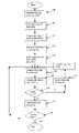
- FIG. 3is a flowchart that illustrates navigation system operation.
- a GPS systemdetermines a current location of the navigation system.
- a driverinputs a desired destination. The driver input may be received via keyboard, voice input, touchpad, or other methods known to those of skill in the art.
- the navigation systemcomputes a plurality of routes from the current location to the desired destination.
- the plurality of routesmay include various driver selectable instructions, including instructions to favor or avoid freeways, to select a shortest route or a fastest route, to use or avoid tolls, to use or avoid carpool lanes, etc.
- the navigation systemintegrates real time information into the route computation.
- the navigation systemprompts the central processing point for information on vehicle speeds along the routes between the current location and the destination.
- the navigation systemreceives the requested data from the central processing point.
- the received datamay include statistical computations of vehicle speeds along various points in the route between the current location and the destination.
- the transmissionmay include primarily raw data forwarded from the informing vehicles, or a summarized or compressed version of the raw data.
- the navigation systemAfter receiving or determining the approximate speeds along each route, the navigation system computes, in block 324 , the time to the destination using each route. Multiplying the distance traveled along each route with the speed of informing vehicles along each route generates a good estimate of travel time. More sophisticated systems may use large quantities of data to compute the speed along the route at periodic points, such as taking speeds at periodic distances, such as every hundred feet, and integrating the information over the relevant distances.
- the navigation systemcommunicates the fastest computed route to the driver in block 328 .
- the drivermay elect to accept the route, to reject the route or to accept only portions of the route in block 332 . If the driver decides in block 334 to make changes to the route, the navigation system receives the additional input from the driver in block 336 and computes a new route using the limitations imposed by the driver. When the driver accepts the route in block 334 , the navigation system instructs the driver on how to proceed along the selected route.
- the fastest computed routemay not remain the fastest computed route while the vehicle is en-route to the destination. Accidents that occur while traveling along the selected route may result in substantial slowing along the selected route.
- the navigation systemcontinues to periodically request and/or receive real time traffic data from the central processing point in block 340 .
- the navigation systemalso continues to compute the fastest route to the destination from the changing current position. If a faster route appears, possibly due to a slow down along the current route or a clearing along a previously clogged route, the navigation system may offer the driver the option of adjusting the route to take advantage of the faster route.
- FIG. 4is an image of a typical navigation system that integrates the received real time data with navigational software to determine a fastest route.
- the navigation system of FIG. 4is also configured to serve as a data collection system in an informing car that provides real time traffic data to the central processing point.
- a power supply 404powers navigation system 400 .
- Power supply 404may be an automobile battery or an automobile generator.
- Navigation system 400also includes a GPS system 408 for determining the current location of the vehicle 412 from a plurality of satellites.
- An input device 416such as a touchpad, keyboard or speech recognition system is integrated into the navigation system.
- Input device 416receives destination information from a driver.
- Processor 420uses current destination from the GPS system 408 and destination information from input device 416 along with map data stored on a storage device 424 to compute potential routes.
- a transmitter and receiver 428 including an antenna 432communicates with a central processing point to request real time traffic information along specific routes. In an alternate embodiment, no request is made. Instead receiver 428 receives a continuous broadcast of all real time traffic data related to a large geographic area and filters the data to obtain relevant data.
- the technique of communication and/or broadcastmay vary, but typically involves a Federal Communication Commission approved technique.
- the communication by transmitter and receiver 428may be synchronous or asynchronous. In one embodiment, communications utilize a cellular network used for cellular telephone communications. In another embodiment, a broadcast similar to a radio broadcast is used.
- the vehiclemay communicate with the tower or directly with informer vehicles using accepted protocols, including internet protocols, while passing though the hotspot coverage area.
- accepted protocolsincluding internet protocols
- the datamay then be buffered in a navigation system memory for use in route computations.
- the informer vehicle informationis buffered.
- a memory buffersuch as RAM, a hard drive, or other storage mechanism stores GPS data, the time associated with each GPS data point and sometimes associated speed data.
- the navigation systemtransmits the data in storage when the navigation system reaches an area that enables communications.
- the navigation systemdownloads informer vehicle GPS data or a summarized version of the data into a memory buffer such as RAM, a hard drive, or other storage mechanism stores when the navigation system is in an area that enables communications.
- a processor 420processes the real time traffic information to generate a fastest route.
- the fastest routeis displayed on an output device 436 which typically includes a screen and possibly a speaker to provide voice instructions.
- navigation system 400also serves as a data collection agent in an informing vehicle.
- the navigation systemmay be coupled to speed sensing electronics 440 which may include a speedometer.
- speed sensing electronics 440may include a speedometer.
- navigation system 400transmits speed data from speed sensing electronics 440 along with current position information obtained from GPS system 408 to provide the speed of the vehicle.
- the navigation system 400is not coupled to the speed sensing electronics. Instead, the navigation system 400 upon request, or at predetermined intervals, transmits position information to the central processing point and allows the processing point or the receiving vehicle to compute a speed.
Landscapes
- Engineering & Computer Science (AREA)
- Radar, Positioning & Navigation (AREA)
- Remote Sensing (AREA)
- Physics & Mathematics (AREA)
- General Physics & Mathematics (AREA)
- Automation & Control Theory (AREA)
- Mathematical Physics (AREA)
- Chemical & Material Sciences (AREA)
- Analytical Chemistry (AREA)
- Navigation (AREA)
- Traffic Control Systems (AREA)
Abstract
Description
Claims (12)
Priority Applications (1)
| Application Number | Priority Date | Filing Date | Title |
|---|---|---|---|
| US10/734,428US7124023B2 (en) | 2003-12-12 | 2003-12-12 | Traffic flow data collection agents |
Applications Claiming Priority (1)
| Application Number | Priority Date | Filing Date | Title |
|---|---|---|---|
| US10/734,428US7124023B2 (en) | 2003-12-12 | 2003-12-12 | Traffic flow data collection agents |
Publications (2)
| Publication Number | Publication Date |
|---|---|
| US20050131628A1 US20050131628A1 (en) | 2005-06-16 |
| US7124023B2true US7124023B2 (en) | 2006-10-17 |
Family
ID=34653362
Family Applications (1)
| Application Number | Title | Priority Date | Filing Date |
|---|---|---|---|
| US10/734,428Expired - LifetimeUS7124023B2 (en) | 2003-12-12 | 2003-12-12 | Traffic flow data collection agents |
Country Status (1)
| Country | Link |
|---|---|
| US (1) | US7124023B2 (en) |
Cited By (10)
| Publication number | Priority date | Publication date | Assignee | Title |
|---|---|---|---|---|
| US20060187889A1 (en)* | 2005-02-19 | 2006-08-24 | Mr. Chand Mehta | System to mine information from data generated by Location Enabled Devices |
| US20090070024A1 (en)* | 2007-09-07 | 2009-03-12 | International Business Machines Corporation | Gps traffic load balancing system congestion prevention |
| US20100292916A1 (en)* | 2009-05-13 | 2010-11-18 | Honda Motor Co., Ltd. | Navigation System For a Motor Vehicle |
| US20110238286A1 (en)* | 2010-03-25 | 2011-09-29 | Gm Global Technology Operations, Inc. | Location and mobile-adaptation of wireless access-points using map-based navigation |
| US8046162B2 (en)* | 2005-11-04 | 2011-10-25 | Honda Motor Co., Ltd. | Data broadcast method for traffic information |
| US8099236B2 (en) | 2010-06-18 | 2012-01-17 | Olson Dwight C | GPS navigator |
| US8452771B2 (en) | 2011-01-03 | 2013-05-28 | Honda Motor Co., Ltd. | Method for differentiating traffic data obtained from probe vehicles |
| CN103348392A (en)* | 2010-12-31 | 2013-10-09 | 通腾比利时公司 | Navigation method and system |
| US8583367B2 (en) | 2011-01-07 | 2013-11-12 | Honda Motor Co., Ltd. | System and method for displaying a route based on a vehicle state |
| US9659496B2 (en) | 2015-02-10 | 2017-05-23 | Ridar Systems LLC | Proximity awareness system for motor vehicles |
Families Citing this family (26)
| Publication number | Priority date | Publication date | Assignee | Title |
|---|---|---|---|---|
| US7366606B2 (en) | 2004-04-06 | 2008-04-29 | Honda Motor Co., Ltd. | Method for refining traffic flow data |
| US7222018B2 (en) | 2004-04-06 | 2007-05-22 | Honda Motor Co., Ltd. | Bandwidth and memory conserving methods for a vehicle navigation system |
| US7289904B2 (en) | 2004-04-06 | 2007-10-30 | Honda Motor Co., Ltd. | Vehicle navigation system and methods for incorporating user preferences into same |
| US7319931B2 (en)* | 2004-04-06 | 2008-01-15 | Honda Motor Co., Ltd. | Methods for filtering and providing traffic information |
| US7123189B2 (en)* | 2004-05-13 | 2006-10-17 | Bushnell Performance Optics | Apparatus and method for allowing user to track path of travel over extended period of time |
| JP4574244B2 (en)* | 2004-06-25 | 2010-11-04 | クラリオン株式会社 | Navigation device and route search method |
| TWI258719B (en)* | 2005-05-02 | 2006-07-21 | Mitac Int Corp | Driving route planning system and method |
| US7698061B2 (en) | 2005-09-23 | 2010-04-13 | Scenera Technologies, Llc | System and method for selecting and presenting a route to a user |
| US7702456B2 (en) | 2006-04-14 | 2010-04-20 | Scenera Technologies, Llc | System and method for presenting a computed route |
| US20080177460A1 (en)* | 2007-01-10 | 2008-07-24 | Adrian Blackwood | Navigation device and method for enhancing traffic data |
| KR101467557B1 (en)* | 2007-05-02 | 2014-12-10 | 엘지전자 주식회사 | Select a driving route |
| US7668653B2 (en) | 2007-05-31 | 2010-02-23 | Honda Motor Co., Ltd. | System and method for selectively filtering and providing event program information |
| WO2009003241A1 (en)* | 2007-07-04 | 2009-01-08 | Innovation Science Pty Ltd | Visit feasibility using scheduled transport within a network of connected nodes |
| US8660794B2 (en)* | 2007-07-13 | 2014-02-25 | Dash Navigation, Inc. | System and method for providing shared information about traveled road segments |
| CA2691952C (en) | 2007-07-13 | 2019-09-17 | Dash Navigation, Inc. | System and method for sharing user-identified routes |
| US20120047087A1 (en) | 2009-03-25 | 2012-02-23 | Waldeck Technology Llc | Smart encounters |
| US20100256903A1 (en)* | 2009-04-01 | 2010-10-07 | General Motors Corporation | Vehicle telematics communication for generating road routing informatiion |
| WO2010129000A1 (en)* | 2009-05-04 | 2010-11-11 | Tele Atlas North America Inc. | Navigation device & method |
| CN101634569B (en)* | 2009-09-01 | 2011-12-28 | 中兴通讯股份有限公司 | Method and device for determining driving routes by driving time |
| JP5896715B2 (en)* | 2011-12-14 | 2016-03-30 | 三菱重工業株式会社 | Traffic flow simulator, moving route calculation method and program thereof |
| WO2013094865A1 (en)* | 2011-12-18 | 2013-06-27 | 엘지전자 주식회사 | Method for calculating paths, method for obtaining paths as well as terminal for same |
| US20140012494A1 (en)* | 2012-07-06 | 2014-01-09 | International Business Machines Corporation | Collaborative gps tracking |
| CN103017783B (en)* | 2012-12-05 | 2016-06-01 | 中兴通讯股份有限公司 | Navigation method and system, map data management high in the clouds and data-updating method thereof |
| US20140279707A1 (en)* | 2013-03-15 | 2014-09-18 | CAA South Central Ontario | System and method for vehicle data analysis |
| US10627248B2 (en) | 2016-09-21 | 2020-04-21 | Apple Inc. | Cognitive load routing metric for vehicle guidance |
| US20200124435A1 (en)* | 2018-10-17 | 2020-04-23 | Toyota Motor North America, Inc. | Distributed route determination system |
Citations (10)
| Publication number | Priority date | Publication date | Assignee | Title |
|---|---|---|---|---|
| US5919246A (en)* | 1994-10-07 | 1999-07-06 | Mannesmann Aktiengesellschaft | Target input for navigation system |
| US6351709B2 (en)* | 1998-12-02 | 2002-02-26 | Lear Automotive Dearborn, Inc. | Vehicle navigation system with route updating feature |
| US6480783B1 (en)* | 2000-03-17 | 2002-11-12 | Makor Issues And Rights Ltd. | Real time vehicle guidance and forecasting system under traffic jam conditions |
| US20030171094A1 (en)* | 2002-03-06 | 2003-09-11 | Takeo Kawai | Downloading server and mobile station using local-area wireless communication |
| US6754580B1 (en)* | 1999-09-21 | 2004-06-22 | Benny Ask | System for guiding vehicles |
| US6785606B2 (en)* | 1999-04-19 | 2004-08-31 | Dekock Bruce W. | System for providing traffic information |
| US20040239568A1 (en)* | 2003-04-11 | 2004-12-02 | Takeshi Masutani | Multiple antenna |
| US6853915B2 (en)* | 2000-09-12 | 2005-02-08 | Harman Becker Automotive Systems Gmbh | Motor vehicle navigation system that receives route information from a central unit |
| US6862542B2 (en)* | 2002-01-17 | 2005-03-01 | Charlotte-Mecklenburg Hospital | Erythema measuring device |
| US20060007022A1 (en)* | 2002-10-01 | 2006-01-12 | Xanavi Informatics Corporation | Geographic data transmitting method, information delivering apparatus and information terminal |
- 2003
- 2003-12-12USUS10/734,428patent/US7124023B2/ennot_activeExpired - Lifetime
Patent Citations (10)
| Publication number | Priority date | Publication date | Assignee | Title |
|---|---|---|---|---|
| US5919246A (en)* | 1994-10-07 | 1999-07-06 | Mannesmann Aktiengesellschaft | Target input for navigation system |
| US6351709B2 (en)* | 1998-12-02 | 2002-02-26 | Lear Automotive Dearborn, Inc. | Vehicle navigation system with route updating feature |
| US6785606B2 (en)* | 1999-04-19 | 2004-08-31 | Dekock Bruce W. | System for providing traffic information |
| US6754580B1 (en)* | 1999-09-21 | 2004-06-22 | Benny Ask | System for guiding vehicles |
| US6480783B1 (en)* | 2000-03-17 | 2002-11-12 | Makor Issues And Rights Ltd. | Real time vehicle guidance and forecasting system under traffic jam conditions |
| US6853915B2 (en)* | 2000-09-12 | 2005-02-08 | Harman Becker Automotive Systems Gmbh | Motor vehicle navigation system that receives route information from a central unit |
| US6862542B2 (en)* | 2002-01-17 | 2005-03-01 | Charlotte-Mecklenburg Hospital | Erythema measuring device |
| US20030171094A1 (en)* | 2002-03-06 | 2003-09-11 | Takeo Kawai | Downloading server and mobile station using local-area wireless communication |
| US20060007022A1 (en)* | 2002-10-01 | 2006-01-12 | Xanavi Informatics Corporation | Geographic data transmitting method, information delivering apparatus and information terminal |
| US20040239568A1 (en)* | 2003-04-11 | 2004-12-02 | Takeshi Masutani | Multiple antenna |
Cited By (15)
| Publication number | Priority date | Publication date | Assignee | Title |
|---|---|---|---|---|
| US20060187889A1 (en)* | 2005-02-19 | 2006-08-24 | Mr. Chand Mehta | System to mine information from data generated by Location Enabled Devices |
| US8046162B2 (en)* | 2005-11-04 | 2011-10-25 | Honda Motor Co., Ltd. | Data broadcast method for traffic information |
| US20090070024A1 (en)* | 2007-09-07 | 2009-03-12 | International Business Machines Corporation | Gps traffic load balancing system congestion prevention |
| US20100292916A1 (en)* | 2009-05-13 | 2010-11-18 | Honda Motor Co., Ltd. | Navigation System For a Motor Vehicle |
| US8346478B2 (en) | 2010-03-25 | 2013-01-01 | GM Global Technology Operations LLC | Location and mobile-adaptation of wireless access-points using map-based navigation |
| US20110238286A1 (en)* | 2010-03-25 | 2011-09-29 | Gm Global Technology Operations, Inc. | Location and mobile-adaptation of wireless access-points using map-based navigation |
| US8099236B2 (en) | 2010-06-18 | 2012-01-17 | Olson Dwight C | GPS navigator |
| US8521421B2 (en) | 2010-06-18 | 2013-08-27 | Dwight C. Olson | GPS navigator |
| CN103348392A (en)* | 2010-12-31 | 2013-10-09 | 通腾比利时公司 | Navigation method and system |
| US20130275033A1 (en)* | 2010-12-31 | 2013-10-17 | Edwin Bastiaensen | Navigation methods and systems |
| US9709406B2 (en)* | 2010-12-31 | 2017-07-18 | Tomtom Navigation B.V. | Navigation methods and systems |
| US8452771B2 (en) | 2011-01-03 | 2013-05-28 | Honda Motor Co., Ltd. | Method for differentiating traffic data obtained from probe vehicles |
| US8583367B2 (en) | 2011-01-07 | 2013-11-12 | Honda Motor Co., Ltd. | System and method for displaying a route based on a vehicle state |
| US9659496B2 (en) | 2015-02-10 | 2017-05-23 | Ridar Systems LLC | Proximity awareness system for motor vehicles |
| US10169991B2 (en) | 2015-02-10 | 2019-01-01 | Ridar Systems LLC | Proximity awareness system for motor vehicles |
Also Published As
| Publication number | Publication date |
|---|---|
| US20050131628A1 (en) | 2005-06-16 |
Similar Documents
| Publication | Publication Date | Title |
|---|---|---|
| US7124023B2 (en) | Traffic flow data collection agents | |
| US7406382B2 (en) | System for determining weather information and providing ambient parameter data | |
| US7818204B2 (en) | Traffic control system with road tariff depending on the congestion level | |
| JP5302224B2 (en) | Navigation device that supports management of road traffic congestion | |
| EP2051223A1 (en) | Vehicle dynamic navigation system and method | |
| JP4538895B2 (en) | Route setting device and navigation device | |
| CN102479394A (en) | Toll information communication system, traffic information receiving route selection system and method | |
| JP3875941B2 (en) | Vehicle travel support device and method for providing vehicle travel support service | |
| US20100023256A1 (en) | Process for Automatically Determining a Bypass Route | |
| JP5464035B2 (en) | Car navigation system | |
| JP5472039B2 (en) | Guidance information providing system | |
| JP2003344074A (en) | Information provision system | |
| JPH09292250A (en) | Route search device and recommended route service system | |
| JP2005165388A (en) | Driving information communication method and in-vehicle navigation device in road traffic information management system | |
| JP7298353B2 (en) | Information provision device | |
| JP2001307276A (en) | Traffic information system, base station for traffic information system and traffic information providing method | |
| JP5585285B2 (en) | Route search device, route search method, and computer program | |
| JP2002298293A (en) | Road traffic information providing device and road traffic information providing method | |
| JP2000146602A (en) | Vehicle navigation device and road traffic information system using the same | |
| JP5527091B2 (en) | Route search device, route search method, and computer program | |
| JP3225954B2 (en) | Navigation method, device and system | |
| JP2009129190A (en) | Vehicle information processing apparatus and traffic information collection and provision system | |
| JP2007114044A (en) | Traffic information providing / receiving system and method, traffic information providing device, and vehicle traffic information receiving device | |
| JPH11219498A (en) | Mobile station device, base station device, mobile information system, and mobile information generation method | |
| HK1136867A (en) | Navigation device assisting road traffic congestion management |
Legal Events
| Date | Code | Title | Description |
|---|---|---|---|
| AS | Assignment | Owner name:PALO ALTO RESEARCH CENTER, INCORPORATED, CALIFORNI Free format text:ASSIGNMENT OF ASSIGNORS INTEREST;ASSIGNOR:PEETERS, ERIC;REEL/FRAME:014811/0997 Effective date:20031212 | |
| STCF | Information on status: patent grant | Free format text:PATENTED CASE | |
| FPAY | Fee payment | Year of fee payment:4 | |
| FPAY | Fee payment | Year of fee payment:8 | |
| MAFP | Maintenance fee payment | Free format text:PAYMENT OF MAINTENANCE FEE, 12TH YEAR, LARGE ENTITY (ORIGINAL EVENT CODE: M1553) Year of fee payment:12 | |
| AS | Assignment | Owner name:XEROX CORPORATION, CONNECTICUT Free format text:ASSIGNMENT OF ASSIGNORS INTEREST;ASSIGNOR:PALO ALTO RESEARCH CENTER INCORPORATED;REEL/FRAME:064038/0001 Effective date:20230416 | |
| AS | Assignment | Owner name:CITIBANK, N.A., AS COLLATERAL AGENT, NEW YORK Free format text:SECURITY INTEREST;ASSIGNOR:XEROX CORPORATION;REEL/FRAME:064760/0389 Effective date:20230621 | |
| AS | Assignment | Owner name:XEROX CORPORATION, CONNECTICUT Free format text:CORRECTIVE ASSIGNMENT TO CORRECT THE REMOVAL OF US PATENTS 9356603, 10026651, 10626048 AND INCLUSION OF US PATENT 7167871 PREVIOUSLY RECORDED ON REEL 064038 FRAME 0001. ASSIGNOR(S) HEREBY CONFIRMS THE ASSIGNMENT;ASSIGNOR:PALO ALTO RESEARCH CENTER INCORPORATED;REEL/FRAME:064161/0001 Effective date:20230416 | |
| AS | Assignment | Owner name:JEFFERIES FINANCE LLC, AS COLLATERAL AGENT, NEW YORK Free format text:SECURITY INTEREST;ASSIGNOR:XEROX CORPORATION;REEL/FRAME:065628/0019 Effective date:20231117 | |
| AS | Assignment | Owner name:XEROX CORPORATION, CONNECTICUT Free format text:TERMINATION AND RELEASE OF SECURITY INTEREST IN PATENTS RECORDED AT RF 064760/0389;ASSIGNOR:CITIBANK, N.A., AS COLLATERAL AGENT;REEL/FRAME:068261/0001 Effective date:20240206 Owner name:CITIBANK, N.A., AS COLLATERAL AGENT, NEW YORK Free format text:SECURITY INTEREST;ASSIGNOR:XEROX CORPORATION;REEL/FRAME:066741/0001 Effective date:20240206 |