US7095368B1 - Method and apparatus for combining measurements and determining clock offsets between different satellite positioning systems - Google Patents
Method and apparatus for combining measurements and determining clock offsets between different satellite positioning systemsDownload PDFInfo
- Publication number
- US7095368B1 US7095368B1US11/083,541US8354105AUS7095368B1US 7095368 B1US7095368 B1US 7095368B1US 8354105 AUS8354105 AUS 8354105AUS 7095368 B1US7095368 B1US 7095368B1
- Authority
- US
- United States
- Prior art keywords
- satellite
- time
- pseudorange
- navigation system
- satellite navigation
- Prior art date
- Legal status (The legal status is an assumption and is not a legal conclusion. Google has not performed a legal analysis and makes no representation as to the accuracy of the status listed.)
- Expired - Lifetime
Links
Images


Classifications
- G—PHYSICS
- G01—MEASURING; TESTING
- G01S—RADIO DIRECTION-FINDING; RADIO NAVIGATION; DETERMINING DISTANCE OR VELOCITY BY USE OF RADIO WAVES; LOCATING OR PRESENCE-DETECTING BY USE OF THE REFLECTION OR RERADIATION OF RADIO WAVES; ANALOGOUS ARRANGEMENTS USING OTHER WAVES
- G01S19/00—Satellite radio beacon positioning systems; Determining position, velocity or attitude using signals transmitted by such systems
- G01S19/01—Satellite radio beacon positioning systems transmitting time-stamped messages, e.g. GPS [Global Positioning System], GLONASS [Global Orbiting Navigation Satellite System] or GALILEO
- G01S19/13—Receivers
- G01S19/33—Multimode operation in different systems which transmit time stamped messages, e.g. GPS/GLONASS
- G—PHYSICS
- G01—MEASURING; TESTING
- G01S—RADIO DIRECTION-FINDING; RADIO NAVIGATION; DETERMINING DISTANCE OR VELOCITY BY USE OF RADIO WAVES; LOCATING OR PRESENCE-DETECTING BY USE OF THE REFLECTION OR RERADIATION OF RADIO WAVES; ANALOGOUS ARRANGEMENTS USING OTHER WAVES
- G01S5/00—Position-fixing by co-ordinating two or more direction or position line determinations; Position-fixing by co-ordinating two or more distance determinations
- G01S5/02—Position-fixing by co-ordinating two or more direction or position line determinations; Position-fixing by co-ordinating two or more distance determinations using radio waves
- G01S5/14—Determining absolute distances from a plurality of spaced points of known location
- G—PHYSICS
- G01—MEASURING; TESTING
- G01S—RADIO DIRECTION-FINDING; RADIO NAVIGATION; DETERMINING DISTANCE OR VELOCITY BY USE OF RADIO WAVES; LOCATING OR PRESENCE-DETECTING BY USE OF THE REFLECTION OR RERADIATION OF RADIO WAVES; ANALOGOUS ARRANGEMENTS USING OTHER WAVES
- G01S19/00—Satellite radio beacon positioning systems; Determining position, velocity or attitude using signals transmitted by such systems
- G01S19/01—Satellite radio beacon positioning systems transmitting time-stamped messages, e.g. GPS [Global Positioning System], GLONASS [Global Orbiting Navigation Satellite System] or GALILEO
- G01S19/13—Receivers
- G01S19/23—Testing, monitoring, correcting or calibrating of receiver elements
- G—PHYSICS
- G01—MEASURING; TESTING
- G01S—RADIO DIRECTION-FINDING; RADIO NAVIGATION; DETERMINING DISTANCE OR VELOCITY BY USE OF RADIO WAVES; LOCATING OR PRESENCE-DETECTING BY USE OF THE REFLECTION OR RERADIATION OF RADIO WAVES; ANALOGOUS ARRANGEMENTS USING OTHER WAVES
- G01S19/00—Satellite radio beacon positioning systems; Determining position, velocity or attitude using signals transmitted by such systems
- G01S19/38—Determining a navigation solution using signals transmitted by a satellite radio beacon positioning system
- G01S19/39—Determining a navigation solution using signals transmitted by a satellite radio beacon positioning system the satellite radio beacon positioning system transmitting time-stamped messages, e.g. GPS [Global Positioning System], GLONASS [Global Orbiting Navigation Satellite System] or GALILEO
- G01S19/42—Determining position
- G01S19/421—Determining position by combining or switching between position solutions or signals derived from different satellite radio beacon positioning systems; by combining or switching between position solutions or signals derived from different modes of operation in a single system
- G01S19/425—Determining position by combining or switching between position solutions or signals derived from different satellite radio beacon positioning systems; by combining or switching between position solutions or signals derived from different modes of operation in a single system by combining or switching between signals derived from different satellite radio beacon positioning systems
Definitions
- the present inventionrelates to satellite positioning systems and, more particularly, to a method and apparatus for combining measurements and determining clock offsets between different satellite positioning systems.
- Satellite Positioning System (SPS) receiversuse measurements from several satellites to compute position. SPS receivers normally determine their position by computing time delays between transmission and reception of signals transmitted from satellites and received by the receiver on or near the surface of the earth. The time delays multiplied by the speed of light provide the distance from the receiver to each of the satellites that are in view of the receiver.
- Exemplary satellite positioning systemsinclude the Global Positioning System (GPS), the European GALILEO system, and the Russian GLONASS system.
- each signal available for commercial useutilizes a direct sequence spreading signal defined by a unique pseudo-random noise (PN) code (referred to as the coarse acquisition (C/A) code) having a 1.023 MHz spread rate.
- PNpseudo-random noise
- Each PN codebi-phase modulates a 1575.42 MHz carrier signal (referred to as the L1 carrier) and uniquely identifies a particular satellite.
- the PN code sequence lengthis 1023 chips, corresponding to a one millisecond time period. One cycle of 1023 chips is called a PN frame or epoch.
- GPS receiversdetermine the time delays between transmission and reception of the signals by comparing time shifts between the received PN code signal sequence and internally generated PN signal sequences. These measured time delays are referred to as “sub-millisecond pseudoranges,” since they are known modulo the 1 millisecond PN frame boundaries. By resolving the integer number of milliseconds associated with each delay to each satellite, then one has true, unambiguous, pseudoranges. A set of four pseudoranges together with knowledge of absolute times of transmission of the GPS signals and satellite positions in relation to these absolute times is sufficient to solve for the position of the GPS receiver. The absolute times of transmission (or reception) are needed in order to determine the positions of the GPS satellites at the times of transmission and hence to compute the position of the GPS receiver.
- each of the GPS satellitesbroadcasts a model of satellite orbit and clock data known as the satellite navigation message.
- the satellite navigation messageis a 50 bit-per-second (bps) data stream that is modulo-2 added to the PN code with bit boundaries aligned with the beginning of a PN frame. There are exactly 20 PN frames per data bit period (20 milliseconds).
- the satellite navigation messageincludes satellite-positioning data, known as “ephemeris” data, which identifies the satellites and their orbits, as well as absolute time information (also referred to herein as “GPS system time”) associated with the satellite signal.
- the GPS system time informationis in the form of a second of the week signal, referred to as time-of-week (TOW). This absolute time signal allows the receiver to unambiguously determine a time tag for when each received signal was transmitted by each satellite.
- TOWtime-of-week
- GPS satellitesmove at approximately 3.9 km/s, and thus the range of the satellite, observed from the earth, changes at a rate of at most ⁇ 800 m/s.
- Absolute timing errorsresult in range errors of up to 0.8 m for each millisecond of timing error. These range errors produce a similarly sized error in the GPS receiver position.
- absolute time accuracy of 10 msis sufficient for position accuracy of approximately 10 m. Absolute timing errors of much more than 10 ms will result in large position errors, and so typical GPS receivers have required absolute time to approximately 10 milliseconds accuracy or better.
- Another time parameter closely associated with GPS positioningis the sub-millisecond offset in the time reference used to measure the sub-millisecond pseudorange. This offset affects all the measurements equally, and for this reason it is known as the “common mode error”.
- the common mode errorshould not be confused with the absolute time error. As discussed above, an absolute time error of 1 millisecond leads to range errors of up to 0.8 meters while an absolute time error of 1 microsecond would cause an almost unobservable range error of less than 1 millimeter. A common mode error of 1 microsecond, however, results in a pseudorange error of 1 microsecond multiplied by the speed of light (i.e., 300 meters). Common mode errors have a large effect on pseudorange computations, and it is, in practice, very difficult to calibrate the common mode error. As such, traditional GPS receivers treat the common mode error as an unknown that must be solved for, along with position, once a sufficient number of pseudoranges have been measured at a particular receiver.
- Satellite positioning systemssuch as GALILEO and GLONASS employ signal structures similar to GPS and may be used to locate position of a receiver in a similar manner.
- a receivermay not be able to receive and process a sufficient number of GPS signals to locate position due to low signal strengths.
- Such other satellite positioning systemstypically operate using a different time reference than that employed by GPS. For example, GPS system time is steered towards International Atomic Time (TAI) minus 19 seconds with an accuracy of approximately 20 nanoseconds, whereas GALILEO system time is steered towards TAI with an offset of less than 33 nanoseconds.
- TAIInternational Atomic Time
- At least one first pseudorange between a satellite signal receiver and at least one satellite of the first satellite navigation systemis measured.
- At least one second pseudorange between the satellite signal receiver and at least one satellite of the second satellite navigation systemis measured.
- a difference between a first time reference frame of the first satellite navigation system and a second time reference frame of the second satellite navigation systemis obtained.
- the at least one first pseudorange and the at least one second pseudorangeare combined using the difference in time references.
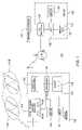
- FIG. 1is a block diagram depicting an exemplary embodiment of a position location system
- FIG. 2is a flow diagram depicting an exemplary embodiment of a method for locating position in accordance with the invention.
- FIG. 3is a flow diagram depicting an exemplary embodiment of a method for computing a time reference difference and position/time-of-day in accordance with the invention.
- a method and apparatus for combining measurements from multiple satellite navigation systemsis described.
- Those skilled in the artwill appreciate that the invention may be used with various types of mobile or wireless devices that are “location-enabled,” such as cellular telephones, pagers, laptop computers, personal digital assistants (PDAs), and like type wireless devices known in the art.
- a location-enabled mobile-deviceis facilitated-by-including in the device the capability of processing satellite positioning system (SPS) satellite signals.
- SPSsatellite positioning system
- FIG. 1is a block diagram depicting an exemplary embodiment of a position location system 100 .
- the system 100comprises a mobile receiver 102 in communication with a server 108 via a wireless communication network 110 .
- the server 108may be disposed in a serving mobile location center (SMLC) of the wireless communication network 110 .
- the wireless communication network 110may comprise a cellular communication network having a plurality of base stations or cell sites.
- the mobile receiver 102obtains satellite measurement data with respect to a plurality of satellites 112 (e.g., pseudoranges, Doppler measurements).
- the plurality of satellites 112is selected from satellites of a first satellite navigation system 111 A (e.g., GPS) and satellites of a second satellite navigation system 111 B (e.g., GALILEO).
- the server 108obtains satellite trajectory data for the satellites 112 (e.g., orbit model information, such as satellite ephemeris information).
- Position information for the mobile receiver 102is computed using the satellite measurement data and the satellite trajectory data.
- the mobile receiver 102illustratively comprises satellite signal receiver circuitry 104 , a wireless transceiver 106 , a processor 122 , support circuits 124 , a memory 120 , and a clock circuit 121 .
- the satellite signal receiver circuitry 104comprises circuitry 105 A configured to process satellite signals from the satellite navigation system 111 A, and circuitry 105 B configured to process satellite signals from the satellite navigation system 111 B.
- the circuitry 105 A and the circuitry 105 Bmay comprise two separate satellite signal receivers, one for receiving signals from the satellite navigation system 111 A (e.g., GPS), and the other for receiving signals from the satellite navigation system 111 B (e.g., GALILEO).
- a portion of the satellite signal receiver circuitry 104may be shared among the circuitry 105 A and the circuitry 105 B (e.g., shared front-end circuitry).
- the satellite signal receiver circuitry 104is configured to receive satellite signals from the satellites 112 using at least one antenna 116 .
- the circuitry 105 A and the circuitry 105 Bmay comprise conventional circuitry for receiving and processing signals from the first and second satellite navigation systems 111 A and 111 B, respectively (e.g., GPS circuits, GALILEO circuits, GLONASS circuits). Circuitry for receiving and processing satellite positioning system signals is described in commonly-assigned U.S. Pat. No. 6,453,237, issued Sep. 17, 2002, which is incorporated by reference herein in its entirety.
- the wireless transceiver 106receives a wireless signal from the wireless communication network 110 via an antenna 118 .
- the satellite signal receiver circuitry 104 and the wireless transceiver 106may be controlled by the processor 122 .
- the clock circuit 121may be used to track time-of-day and may comprise, for example, a real-time clock.
- the processor 122may comprise a microprocessor, instruction-set processor (e.g., a microcontroller), or like type processing element known in the art.
- the processor 122is coupled to the memory 120 and the support circuits 124 .
- the memory 120may be random access memory, read only memory, removable storage, hard disk storage, or any combination of such memory devices.
- the support circuits 124include conventional cache, power supplies, clock circuits, data registers, I/O interfaces, and the like to facilitate operation of the mobile receiver 102 .
- the processes and methods described hereinmay be implemented using software 138 stored in the memory 120 for execution by the processor 122 .
- the mobile receiver 102may implement such processes and methods in hardware or a combination of software and hardware, including any number of processors independently executing various programs and dedicated hardware, such as application specific integrated circuits (ASICs), field programmable gate arrays (FPGAs), and the like.
- ASICsapplication specific integrated circuits
- FPGAsfield programmable gate arrays
- the server 108illustratively comprises an input/output (I/O) interface 128 , a central processing unit (CPU) 126 , support circuits 130 , and a memory 134 .
- the CPU 126is coupled to the memory 134 and the support circuits 130 .
- the memory 134may be random access memory, read only memory, removable storage, hard disk storage, or any combination of such memory devices.
- the support circuits 130include conventional cache, power supplies, clock circuits, data registers, I/O interfaces, and the like to facilitate operation of the server 108 .
- the processes and methods described hereinmay be implemented using software 132 stored in the memory 134 for execution by the CPU 126 .
- the server 108may implement such processes and methods in hardware or a combination of software and hardware, including any number of processors independently executing various programs and dedicated hardware, such as ASICs, FPGAs, and the like.
- the I/O interface 128is configured to receive data, such as satellite measurement data collected by the mobile receiver 102 , from the wireless network 110 .
- the I/O interface 128is configured to receive satellite trajectory data, such as ephemeris for the satellites 112 , from an external source, such as a network of tracking stations (e.g., reference network 114 ).
- the reference network 114may include several tracking stations that collect satellite navigation data from all the satellites of one or more satellite navigation systems, or a few tracking stations, or a single tracking station that only collects satellite navigation data for a particular region of the world.
- An exemplary system for collecting and distributing ephemerisis described in commonly-assigned U.S. Pat. No. 6,411,892, issued Jun. 25, 2002, which is incorporated by reference herein in its entirety.
- the mobile receiver 102receives assistance data from the server 108 .
- the assistance datamay include acquisition assistance data (e.g., a set of expected pseudoranges from an assumed position of the mobile receiver 102 to the satellites 112 ) and/or satellite trajectory data (e.g., ephemeris data or some other type of satellite orbit model).
- acquisition assistance datae.g., a set of expected pseudoranges from an assumed position of the mobile receiver 102 to the satellites 112
- satellite trajectory datae.g., ephemeris data or some other type of satellite orbit model
- the mobile receiver 102may request and receive acquisition assistance data from the server 108 and send satellite measurement data to the server 108 along with a time-tag.
- the server 108locates position of the mobile receiver 102 (referred to as the mobile station assisted or “MS-assisted” configuration).
- the server 108may send satellite trajectory data to the mobile receiver 102 , and the mobile receiver 102 may locate its own position (referred to as the mobile station based or “MS-based” configuration). In another embodiment, the mobile receiver 102 may locate its own position without receiving assistance data from the server 108 by decoding satellite navigation messages from the satellite signals (referred to as the autonomous configuration).
- FIG. 2is a flow diagram depicting an exemplary embodiment of a method 200 for locating position in accordance with the invention. Aspects of the method 200 may be understood with reference to the position location system 100 of FIG. 1 .
- the method 200begins at step 202 .
- one or more first pseudorangesare measured to satellites of a first satellite navigation system 111 A.
- one or more second pseudorangesare measured to satellites of a second satellite navigation system 111 B.
- pseudorangesmay be measured to both GPS satellites and GALILEO satellites.
- the number of total pseudoranges measureddepends on the number of independent variables that are computed using the pseudorange data (e.g., four pseudoranges to compute four variables).
- position of the mobile receiver 102is computed by the server 108 .
- the first and second pseudorangesmay be sent from the mobile receiver 102 to the server 108 .
- a difference in time references between the first and second satellite navigation systemsis obtained.
- the first and second pseudorangesare combined using the time reference difference obtained at step 208 . That is, a process is performed that allows the first and second pseudoranges measured with respect to different satellite navigation systems to be used together to compute position and/or time.
- position of the mobile receiver 102 and/or time of dayis/are computed using the combined first and second pseudoranges.
- Various embodiments for combining the first and second pseudoranges, obtaining a time reference difference between the two satellite systems, and computing positionare described below with respect to FIG. 3 .
- Steps 208 , 209 , and 210may be performed by either the server 108 (e.g., in an MS-Assisted configuration) or by the mobile receiver 102 (e.g., in an MS-Based or Autonomous configuration).
- the method 200ends at step 212 .
- the time reference difference and position/time-of-daymay be computed using a mathematical model.
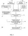
- FIG. 3is a flow diagram depicting an exemplary embodiment of method 300 for computing a time reference difference and position/time-of-day in accordance with the invention.
- an estimated time-of-reception of signals from the satellites 112is provided (“time-of-day estimate”).
- time-of-day estimatemay be provided by the clock circuit 121 or by the server 108 .
- the pseudoranges and ephemeris for the satellites 112are provided.
- an estimated position of the mobile receiver 102is provided.
- An estimated position of the mobile receiver 102may be obtained using various position estimation techniques known in the art, including use of transitions between base stations of the wireless communication network 110 , use of a last known location of the mobile receiver 102 , use of a location of a base station of the wireless communication network 110 in communication with the mobile receiver 102 , use of a location of the wireless communication network 110 as identified by a network ID, or use of a location of a cell site of the wireless communication network 110 in which the mobile receiver 102 is operating as identified by a cell ID.
- expected pseudorangesare formed.
- the expected pseudorangesare the pseudoranges that would be measured if all of the a-priori parameters (position estimate and time estimates) were in fact the actual values of these parameters.
- pseudorange residualsare formed by differencing the pseudoranges provided at step 304 and the expected pseudoranges formed at step 310 .
- a mathematical modelis formed that relates the pseudorange residuals to updates of position and time variables.
- a mathematical modelmay be used that relates a residual difference between the measured pseudoranges and the expected pseudoranges to updates of position (e.g., x, y, and z position) and time.
- the time updatesinclude a common-mode bias for the first satellite navigation system 111 A (t cA ), a common-mode bias for the second satellite navigation system 111 B (t cB ), and a time-of-day error (t s ).
- the mathematical modelmay be defined as follows:
- uis a vector of pseudorange residuals (the difference between the expected pseudoranges and the actual pseudoranges); u A are the pseudorange residuals for satellite system A (e.g. GPS), and u B are the pseudorange residuals for satellite system B (e.g. GALILEO).
- the 6-element vector on the rightcontains the state variables x,y,z (position updates to the initial position), t CA and t CB , updates to the correlator clock bias estimates, for satellite systems A and B respectively, and t s the update to the time of day error.
- the two rows subscripted A and B in the above H matrixare themselves sub-matrices, each containing as many rows as u A or u B respectively.
- the i'th row of the “A” sub-matrixis:
- the H-matrix entriesmay be computed using the ephemeris data.
- Initial values for the x, y, z, t CA , t CB and t s updatesmay be obtained from the position estimate and the time-of-day estimate.
- the common-mode bias updatesmay be assumed to be zero initially.
- the time updatesinclude a common-mode bias for one of the satellite navigation systems 111 A and 111 B, for example A (tCA), a delta common-mode bias (t CA ) equal to t CB ⁇ t CA , and a time-of-day error (t s ).
- the delta common-mode biasrelates to the difference between the common-mode biases between the two satellite systems 111 A and 111 B.
- the mathematical modelmay be defined as follows:
- uis a vector of pseudorange residuals (the difference between the expected pseudoranges and the actual pseudoranges); and the H matrix is similar to that described above, but for the change of variable t CB to t C ⁇
- the H-matrix entriesmay be computed using the ephemeris data.
- Initial values for the x, y, z, and t s updatesmay be obtained from the position estimate and the time-of-day estimate.
- the common-mode bias update and the delta common-mode bias updatemay be assumed to be zero initially.
- time-free mathematical modelshave been described with respect to updates for x, y, and z, those skilled in the art will appreciate that the mathematical model may be formed with fewer position variables (e.g., only an x and y position). In addition, the mathematical model may be implemented to update any subset of the updates, as is described in commonly-assigned U.S. Pat. No. 6,734,821, issued May 11, 2004, which is incorporated by reference herein in its entirety.
- the position and time updatesare solved.
- the mathematical model formed at step 314may be iterated to refine the position and time updates.
- the position and time updatesmay be added to the position estimate and the time-of-day estimate to determine a position for the mobile receiver 102 and/or time-of-day.
- the time reference differenceis obtained at step 208 from a reference station (e.g., the reference network 114 ).
- a reference stationmay process satellite signals from satellites in each of the satellite navigation systems 111 A and 111 B and may solve for the time reference difference.
- the computed time reference differencemay be transmitted to the server 108 and may be provided to the mobile receiver 102 within assistance data.
- one or both of the satellite navigation systems 111 A and 111 Bmay be configured to broadcast the time reference difference.
- a reference stationmay then decode the time reference difference from the satellite signals.
- the decoded time reference differencemay be transmitted to the server 108 and may be provided to the mobile receiver 102 within assistance data.
- the pseudoranges from one of the satellite systems 111 A and 111 Bmay be converted to the time reference of the other of the satellite systems 111 A and 111 B.
- position of the mobile receiver 102may be computed using a navigation model in a well-known manner. Notably, in the general satellite navigation problem, there are nine unknowns:
- the time reference difference obtained from the reference stationmay be used as an initial value for a common-mode bias or a delta common-mode bias variable in one of the time-free mathematical models described above.
- an estimate of the time reference differencemay be provided. The estimate of the time reference difference may be used to initialize one of the common-mode bias updates or the delta common-mode bias update in the mathematical model formed at step 314 .
- pseudorangesare measured to satellites in two different satellite navigation systems (e.g., GPS and GALILEO).
- the pseudorange measurementsare “combined” by accounting for the difference in time references between the two satellite navigation systems.
- the time reference differencemay be solved for using a time-free mathematical model, may be measured by processing satellite signals at a reference station, or may be decoded from the satellite signals at a reference station if one or both of the systems are configured to broadcast such difference.
- the inventionhas been described with respect to combining measurements from two satellite navigation systems. Those skilled in the art will appreciate that the invention may be adapted to combine measurements from a plurality of satellite navigation systems in general.
- the time-free mathematical models described abovemay be modified to include additional common-mode bias updates or additional delta common-mode bias updates to account for the additional satellite navigation systems to which measurements were made.
- the reference stationmay measure or decode more than one time reference difference.
Landscapes
- Engineering & Computer Science (AREA)
- Radar, Positioning & Navigation (AREA)
- Remote Sensing (AREA)
- Physics & Mathematics (AREA)
- General Physics & Mathematics (AREA)
- Computer Networks & Wireless Communication (AREA)
- Position Fixing By Use Of Radio Waves (AREA)
Abstract
Description
- [∂ρAI/∂x ∂ρAi/∂yP∂ρAi/∂z C 0−{dot over (ρ)}Ai],
where the first three terms make the well-known line-of-sight vector for satellite I, of system A. The 4thterm is a constant (the speed of light), the fifth term is zero, and the sixth term is the relative satellite velocity. The i'th row of the “B” sub-matrix is: - [∂ρBi/∂x ∂ρBi/∂y ∂ρBi/∂z 0 c −{dot over (ρ)}Bi],
similar to the rows of the “A” sub-matrix, but for the 4thand 5thterms, which show the appropriate relationship of the measurements to the variables tCAand tCB.
- [∂ρAI/∂x ∂ρAi/∂yP∂ρAi/∂z C 0−{dot over (ρ)}Ai],
- Three position unknowns: x, y, z;
- Three velocity unknowns: {dot over (x)}, {dot over (y)}, ż;
- Three clock unknowns: tc, ts, fc;
where x, y, z represent the Cartesian coordinates of the mobile receiver, x, y, z represent the velocities associated with each respective x, y, z coordinate, tcis the common mode timing error (usually a sub-millisecond value), tsis the absolute time tag error, and fcis the frequency error in a local oscillator within the satellitesignal receiver circuitry 104 of themobile device 102. One or more of the variables may be known or estimated based on a-priori information (e.g., tsmay be known if themobile device 110 is calibrated to precise GPS time). One or more of the unknown variables may be solved for using the pseudoranges in a well-known manner.
Claims (20)
Priority Applications (11)
| Application Number | Priority Date | Filing Date | Title |
|---|---|---|---|
| US11/083,541US7095368B1 (en) | 2005-03-18 | 2005-03-18 | Method and apparatus for combining measurements and determining clock offsets between different satellite positioning systems |
| HK10101220.8AHK1137514B (en) | 2005-03-18 | 2006-03-17 | Combining measurements and determining clock offsets |
| CN2006800086701ACN101600970B (en) | 2005-03-18 | 2006-03-17 | Combine measurements and determine clock skew |
| PCT/US2006/010028WO2007086894A2 (en) | 2005-03-18 | 2006-03-17 | Combining measurements and determining clock offsets |
| EP06849735AEP1864152B1 (en) | 2005-03-18 | 2006-03-17 | Method and apparatus for combining measurements and determining clock offsets between different satellite positioning systems |
| KR1020077023797AKR100958091B1 (en) | 2005-03-18 | 2006-03-17 | Method and apparatus for combining measurements and determining clock offsets between different satellite positioning systems |
| US11/428,218US7592950B2 (en) | 2005-03-18 | 2006-06-30 | Method and apparatus for combining measurements and determining clock offsets between different satellite positioning systems |
| US11/642,267US7489269B2 (en) | 2005-03-18 | 2006-12-20 | Method and apparatus for combining measurements and determining clock offsets between different global navigation satellite systems |
| US12/350,006US8054222B2 (en) | 2005-03-18 | 2009-01-07 | Method and apparatus for combining measurements and determining clock offsets between different global navigation satellite systems |
| US12/540,563US8248299B2 (en) | 2005-03-18 | 2009-08-13 | Method and apparatus for combining measurements and determining clock offsets between different satellite positioning systems |
| US13/540,281US8902104B2 (en) | 2005-03-18 | 2012-07-02 | Method and apparatus for combining measurements and determining clock offsets between different satellite positioning systems |
Applications Claiming Priority (1)
| Application Number | Priority Date | Filing Date | Title |
|---|---|---|---|
| US11/083,541US7095368B1 (en) | 2005-03-18 | 2005-03-18 | Method and apparatus for combining measurements and determining clock offsets between different satellite positioning systems |
Related Child Applications (1)
| Application Number | Title | Priority Date | Filing Date |
|---|---|---|---|
| US11/428,218ContinuationUS7592950B2 (en) | 2005-03-18 | 2006-06-30 | Method and apparatus for combining measurements and determining clock offsets between different satellite positioning systems |
Publications (1)
| Publication Number | Publication Date |
|---|---|
| US7095368B1true US7095368B1 (en) | 2006-08-22 |
Family
ID=36821730
Family Applications (4)
| Application Number | Title | Priority Date | Filing Date |
|---|---|---|---|
| US11/083,541Expired - LifetimeUS7095368B1 (en) | 2005-03-18 | 2005-03-18 | Method and apparatus for combining measurements and determining clock offsets between different satellite positioning systems |
| US11/428,218Active2026-01-08US7592950B2 (en) | 2005-03-18 | 2006-06-30 | Method and apparatus for combining measurements and determining clock offsets between different satellite positioning systems |
| US12/540,563Expired - LifetimeUS8248299B2 (en) | 2005-03-18 | 2009-08-13 | Method and apparatus for combining measurements and determining clock offsets between different satellite positioning systems |
| US13/540,281Expired - LifetimeUS8902104B2 (en) | 2005-03-18 | 2012-07-02 | Method and apparatus for combining measurements and determining clock offsets between different satellite positioning systems |
Family Applications After (3)
| Application Number | Title | Priority Date | Filing Date |
|---|---|---|---|
| US11/428,218Active2026-01-08US7592950B2 (en) | 2005-03-18 | 2006-06-30 | Method and apparatus for combining measurements and determining clock offsets between different satellite positioning systems |
| US12/540,563Expired - LifetimeUS8248299B2 (en) | 2005-03-18 | 2009-08-13 | Method and apparatus for combining measurements and determining clock offsets between different satellite positioning systems |
| US13/540,281Expired - LifetimeUS8902104B2 (en) | 2005-03-18 | 2012-07-02 | Method and apparatus for combining measurements and determining clock offsets between different satellite positioning systems |
Country Status (5)
| Country | Link |
|---|---|
| US (4) | US7095368B1 (en) |
| EP (1) | EP1864152B1 (en) |
| KR (1) | KR100958091B1 (en) |
| CN (1) | CN101600970B (en) |
| WO (1) | WO2007086894A2 (en) |
Cited By (43)
| Publication number | Priority date | Publication date | Assignee | Title |
|---|---|---|---|---|
| US20050253754A1 (en)* | 2004-05-14 | 2005-11-17 | Seiko Epson Corporation | Terminal apparatus, positioning method, control program for terminal apparatus, and computer readable recording medium having recorded therein control program for terminal apparatus |
| US20060232473A1 (en)* | 2005-04-19 | 2006-10-19 | Seibert Cristina A | Method for leveraging diversity for enhanced location determination |
| US20060267835A1 (en)* | 2005-05-25 | 2006-11-30 | Seiko Epson Corporation | Positioning system, information supply apparatus, terminal apparatus, control method of terminal apparatus, control program for terminal apparatus and computer readable recording medium for storing control program for terminal apparatus |
| US20060290566A1 (en)* | 2005-06-13 | 2006-12-28 | Nokia Corporation | Supporting an assisted satellite based positioning |
| US20070085732A1 (en)* | 2005-03-18 | 2007-04-19 | Global Locate, Inc. | Method and Apparatus for Combining Measurements and Determining Clock Offsets Between Different Satellite Positioning Systems |
| US20070236387A1 (en)* | 2005-12-29 | 2007-10-11 | Alcatel Lucent | Method of optimization of processing of location data in the presence of a plurality of satellite positioning constellations |
| US20070275658A1 (en)* | 2006-01-10 | 2007-11-29 | Peter Gaal | Global navigation satellite system |
| US20080088506A1 (en)* | 2006-03-15 | 2008-04-17 | Qualcomm Incorporated | Global navigation satellite system |
| US20080183384A1 (en)* | 2006-01-05 | 2008-07-31 | Peter Gaal | Global Navigation Satellite System |
| EP2003467A1 (en)* | 2007-06-13 | 2008-12-17 | Astrium GmbH | Integrated positioning solution for global navigation satellite systems |
| US20090009386A1 (en)* | 2005-03-18 | 2009-01-08 | Van Diggelen Frank | Method and apparatus for combining measurements and determining clock offsets between different global navigation satellite systems |
| US20090083100A1 (en)* | 2007-09-26 | 2009-03-26 | Darby Jr George Derrick | Collision avoidance |
| US20090106535A1 (en)* | 2007-10-17 | 2009-04-23 | Chun-Nan Chen | Shared processor architecture applied to functional stages configured in a receiver system for processing signals from different transmitter systems and method thereof |
| GB2456150A (en)* | 2008-01-03 | 2009-07-08 | Samsung Electronics Co Ltd | A transmitter providing a signal indicating a time difference between respective reference clocks of a first and second global navigation satellite system |
| US20090179792A1 (en)* | 2008-01-14 | 2009-07-16 | Benjamin William Remondi | Conveying orbit information via ambiguous position information |
| US20090179793A1 (en)* | 2008-01-14 | 2009-07-16 | Benjamin William Remondi | Nudged broadcast orbit drift correction |
| US20090219204A1 (en)* | 2008-02-29 | 2009-09-03 | Yoo Chang-Sik | Dual mode satellite signal receiver and method thereof |
| US20090256744A1 (en)* | 2008-04-09 | 2009-10-15 | Peter Van Wyck Loomis | circuit for exclusion zone compliance |
| US20090289849A1 (en)* | 2008-05-20 | 2009-11-26 | Motorola, Inc. | Method and apparatus for satellite positioning system time resolution |
| US20100039262A1 (en)* | 2008-08-18 | 2010-02-18 | Cameron John F | Construction equipment component location tracking |
| US20100060516A1 (en)* | 2008-09-05 | 2010-03-11 | Seiko Epson Corporation | Method of determining appropriateness of satellite orbit modeling, method of providing long-term predicted orbit data, and device for determining appropriateness of satellite orbit modeling |
| US20100214166A1 (en)* | 2008-01-14 | 2010-08-26 | Remondi Benjamin | Double-nudged broadcast orbit drift correction |
| US20100283681A1 (en)* | 2008-01-07 | 2010-11-11 | Benjamin William Remondi | Autonomous projection of global navigation satellite orbits |
| US7911379B2 (en) | 2008-08-18 | 2011-03-22 | Trimble Navigation Limited | Construction equipment component location tracking |
| US20110081020A1 (en)* | 2008-04-09 | 2011-04-07 | Peter Van Wyck Loomis | Terrestial-signal based exclusion zone compliance |
| US20110102253A1 (en)* | 2009-11-04 | 2011-05-05 | Qualcomm Incorporated | Methods and apparatuses for estimating time relationship information between navigation systems |
| GB2475410A (en)* | 2009-11-17 | 2011-05-18 | Samsung Electronics Co Ltd | Processing signals from satellites in two GNSS emitted at different times to estimate receiver position |
| US8103438B2 (en) | 2007-09-26 | 2012-01-24 | Trimble Navigation Limited | Method and system for automatically directing traffic on a site |
| US8224518B2 (en) | 2008-08-18 | 2012-07-17 | Trimble Navigation Limited | Automated recordation of crane inspection activity |
| GB2487347A (en)* | 2011-01-05 | 2012-07-25 | Cambridge Silicon Radio Ltd | Reference satellite |
| EP2482099A1 (en)* | 2006-08-23 | 2012-08-01 | Qualcomm Incorporated | System and method for reducing ambiguities in received SPS signals |
| GB2499273A (en)* | 2012-02-08 | 2013-08-14 | Samsung Electronics Co Ltd | Receiving positioning signals at different frequencies and obtaining information about the time taken to switch a receiver between the frequencies |
| EP2645129A1 (en)* | 2012-03-31 | 2013-10-02 | O2 Micro, Inc. | Method and system for navigation |
| US8554246B2 (en) | 2011-11-21 | 2013-10-08 | Trueposition, Inc. | Combination of multiple baselines for location estimation |
| US9030355B2 (en) | 2011-01-05 | 2015-05-12 | Cambridge Silicon Radio Limited | Location fix from unknown position |
| US9086479B2 (en) | 2011-01-05 | 2015-07-21 | Cambridge Silicon Radio Limited | Convergence zone |
| US20150268354A1 (en)* | 2014-03-21 | 2015-09-24 | Thales | Geopositioning method with trust index, and associated terminal |
| US9156167B2 (en) | 2007-05-15 | 2015-10-13 | Trimble Navigation Limited | Determining an autonomous position of a point of interest on a lifting device |
| US9158002B2 (en) | 2011-01-05 | 2015-10-13 | Qualcomm Incorporated | Satellite subset selection |
| US9322922B2 (en) | 2011-01-05 | 2016-04-26 | Qualcomm Technologies International, Ltd. | Determining position of a GNSS receiver using fractional signalling event period times |
| US9846239B2 (en) | 2012-12-04 | 2017-12-19 | Samsung Electronics Co., Ltd | GNSS receiver and calculating method for pseudo-range and position determination thereof |
| CN112526574A (en)* | 2020-11-30 | 2021-03-19 | 中国电子科技集团公司第五十四研究所 | Satellite positioning method and device |
| US20230059402A1 (en)* | 2021-08-19 | 2023-02-23 | Here Global B.V. | Method, apparatus, and system for providing increased accuracy for a positioning receiver in a multipath signal environment |
Families Citing this family (17)
| Publication number | Priority date | Publication date | Assignee | Title |
|---|---|---|---|---|
| KR101217939B1 (en) | 2006-08-01 | 2013-01-02 | 퀄컴 인코포레이티드 | System and/or method for providing information updates to a location server |
| US8436768B2 (en) | 2008-12-30 | 2013-05-07 | Trueposition, Inc. | Diversity time and frequency location receiver |
| US8138975B2 (en) | 2008-12-30 | 2012-03-20 | Trueposition, Inc. | Interference detection, characterization and location in a wireless communications or broadcast system |
| CN101963668A (en)* | 2010-08-19 | 2011-02-02 | 北京华力创通科技股份有限公司 | Method for realizing real-time closed-loop synchronization control by simulating satellite navigation signal |
| CN103135116B (en)* | 2013-01-28 | 2015-07-22 | 北京邮电大学 | Method and device produced by satellite simulating signal |
| JP2014186032A (en)* | 2013-03-20 | 2014-10-02 | O2 Micro Inc | Module, device and method for positioning |
| CN104101886B (en)* | 2013-04-10 | 2016-12-28 | 和芯星通科技(北京)有限公司 | The receiver of a kind of satellite navigation signals and auxiliary code stripping means |
| CN103308932B (en)* | 2013-05-28 | 2015-04-29 | 中国电子科技集团公司第三十八研究所 | Monolithic multimode navigation chip based on broadband radio frequency direct technology |
| CN104297765B (en)* | 2014-09-25 | 2017-04-26 | 上海欧科微航天科技有限公司 | Ground terminal simulator used for low-orbit satellite synchronous communication system |
| CN105158778B (en)* | 2015-09-02 | 2017-08-08 | 上海海积信息科技股份有限公司 | Multisystem combined implementation carrier phase difference fault satellites elimination method and its system |
| US20180088243A1 (en)* | 2016-09-27 | 2018-03-29 | Marvell World Trade Ltd. | Receiver and method for operation with different satellite navigation systems |
| WO2018102146A1 (en) | 2016-12-01 | 2018-06-07 | Google Llc | Methods and systems for location determination |
| US12140686B2 (en) | 2019-03-01 | 2024-11-12 | Google Llc | Determining velocity using a reflected positioning signal |
| CN110289903B (en)* | 2019-06-26 | 2020-04-14 | 清华大学 | A satellite network autonomous time synchronization method and system based on link measurement |
| EP3997485B1 (en) | 2019-07-08 | 2025-09-03 | Google LLC | Enhancing sensitivity to reflected gnss signals |
| EP4268565B1 (en)* | 2022-04-28 | 2024-04-17 | Husqvarna AB | Improved navigation for a robotic work tool system |
| US12292513B2 (en)* | 2022-09-12 | 2025-05-06 | Qualcomm Incorporated | Cross-frequency correction for precise positioning |
Citations (5)
| Publication number | Priority date | Publication date | Assignee | Title |
|---|---|---|---|---|
| US5523763A (en)* | 1994-07-19 | 1996-06-04 | Trimble Navigation | System and method for compact storage and transmission of position and residual information usable in differential global positioning |
| US6215442B1 (en)* | 1997-02-03 | 2001-04-10 | Snaptrack, Inc. | Method and apparatus for determining time in a satellite positioning system |
| US6430416B1 (en)* | 1999-11-15 | 2002-08-06 | Trimble Navigation Limited | Hybrid radio location system using a combination of satellite pseudoranges and radio pseudoranges |
| US20030085841A1 (en)* | 2001-06-21 | 2003-05-08 | Spilker James J. | Position location using broadcast television signals and mobile telephone signals |
| US6944540B2 (en)* | 2002-03-28 | 2005-09-13 | Motorola, Inc. | Time determination in satellite positioning system receivers and methods therefor |
Family Cites Families (4)
| Publication number | Priority date | Publication date | Assignee | Title |
|---|---|---|---|---|
| US6417801B1 (en) | 2000-11-17 | 2002-07-09 | Global Locate, Inc. | Method and apparatus for time-free processing of GPS signals |
| US6473694B1 (en)* | 2001-04-06 | 2002-10-29 | Nokia Corporation | Method, apparatus and system for estimating user position with a satellite positioning system in poor signal conditions |
| US7489269B2 (en)* | 2005-03-18 | 2009-02-10 | Broadcom Corporation | Method and apparatus for combining measurements and determining clock offsets between different global navigation satellite systems |
| US7095368B1 (en)* | 2005-03-18 | 2006-08-22 | Global Locate, Inc. | Method and apparatus for combining measurements and determining clock offsets between different satellite positioning systems |
- 2005
- 2005-03-18USUS11/083,541patent/US7095368B1/ennot_activeExpired - Lifetime
- 2006
- 2006-03-17EPEP06849735Apatent/EP1864152B1/enactiveActive
- 2006-03-17CNCN2006800086701Apatent/CN101600970B/ennot_activeExpired - Fee Related
- 2006-03-17WOPCT/US2006/010028patent/WO2007086894A2/enactiveApplication Filing
- 2006-03-17KRKR1020077023797Apatent/KR100958091B1/ennot_activeExpired - Fee Related
- 2006-06-30USUS11/428,218patent/US7592950B2/enactiveActive
- 2009
- 2009-08-13USUS12/540,563patent/US8248299B2/ennot_activeExpired - Lifetime
- 2012
- 2012-07-02USUS13/540,281patent/US8902104B2/ennot_activeExpired - Lifetime
Patent Citations (5)
| Publication number | Priority date | Publication date | Assignee | Title |
|---|---|---|---|---|
| US5523763A (en)* | 1994-07-19 | 1996-06-04 | Trimble Navigation | System and method for compact storage and transmission of position and residual information usable in differential global positioning |
| US6215442B1 (en)* | 1997-02-03 | 2001-04-10 | Snaptrack, Inc. | Method and apparatus for determining time in a satellite positioning system |
| US6430416B1 (en)* | 1999-11-15 | 2002-08-06 | Trimble Navigation Limited | Hybrid radio location system using a combination of satellite pseudoranges and radio pseudoranges |
| US20030085841A1 (en)* | 2001-06-21 | 2003-05-08 | Spilker James J. | Position location using broadcast television signals and mobile telephone signals |
| US6944540B2 (en)* | 2002-03-28 | 2005-09-13 | Motorola, Inc. | Time determination in satellite positioning system receivers and methods therefor |
Cited By (103)
| Publication number | Priority date | Publication date | Assignee | Title |
|---|---|---|---|---|
| US20090195452A1 (en)* | 2004-05-14 | 2009-08-06 | Seiko Epson Corporation | Terminal apparatus, positioning method, control program for terminal apparatus, and computer readable recording medium having recorded therein control program for terminal apparatus |
| US7812764B2 (en) | 2004-05-14 | 2010-10-12 | Seiko Epson Corporation | Terminal apparatus, positioning method, control program for terminal apparatus, and computer readable recording medium having recorded therein control program for terminal apparatus |
| US20050253754A1 (en)* | 2004-05-14 | 2005-11-17 | Seiko Epson Corporation | Terminal apparatus, positioning method, control program for terminal apparatus, and computer readable recording medium having recorded therein control program for terminal apparatus |
| US7535418B2 (en)* | 2004-05-14 | 2009-05-19 | Seiko Epson Corporation | Terminal apparatus, positioning method, control program for terminal apparatus, and computer readable recording medium having recorded therein control program for terminal apparatus |
| US7592950B2 (en)* | 2005-03-18 | 2009-09-22 | Global Locate, Inc. | Method and apparatus for combining measurements and determining clock offsets between different satellite positioning systems |
| US20090219203A1 (en)* | 2005-03-18 | 2009-09-03 | Van Diggelen Frank | Method and apparatus for combining measurements and determining clock offsets between different global navigation satellite systems |
| US20070085732A1 (en)* | 2005-03-18 | 2007-04-19 | Global Locate, Inc. | Method and Apparatus for Combining Measurements and Determining Clock Offsets Between Different Satellite Positioning Systems |
| US20100103039A1 (en)* | 2005-03-18 | 2010-04-29 | Van Diggelen Frank | Method and apparatus for combining measurements and determining clock offsets between different satellite positioning systems |
| US8054222B2 (en)* | 2005-03-18 | 2011-11-08 | Broadcom Corporation | Method and apparatus for combining measurements and determining clock offsets between different global navigation satellite systems |
| US8902104B2 (en) | 2005-03-18 | 2014-12-02 | Global Locate, Inc. | Method and apparatus for combining measurements and determining clock offsets between different satellite positioning systems |
| US20090009386A1 (en)* | 2005-03-18 | 2009-01-08 | Van Diggelen Frank | Method and apparatus for combining measurements and determining clock offsets between different global navigation satellite systems |
| US7489269B2 (en)* | 2005-03-18 | 2009-02-10 | Broadcom Corporation | Method and apparatus for combining measurements and determining clock offsets between different global navigation satellite systems |
| US8248299B2 (en) | 2005-03-18 | 2012-08-21 | Broadcom Corporation | Method and apparatus for combining measurements and determining clock offsets between different satellite positioning systems |
| US8436773B2 (en)* | 2005-04-19 | 2013-05-07 | Qualcomm Incorporated | Method for leveraging diversity for enhanced location determination |
| US20060232473A1 (en)* | 2005-04-19 | 2006-10-19 | Seibert Cristina A | Method for leveraging diversity for enhanced location determination |
| US20060267835A1 (en)* | 2005-05-25 | 2006-11-30 | Seiko Epson Corporation | Positioning system, information supply apparatus, terminal apparatus, control method of terminal apparatus, control program for terminal apparatus and computer readable recording medium for storing control program for terminal apparatus |
| US7551125B2 (en)* | 2005-05-25 | 2009-06-23 | Seiko Epson Corporation | Positioning system, information supply apparatus, terminal apparatus, control method of terminal apparatus, control program for terminal apparatus and computer readable recording medium for storing control program for terminal apparatus |
| US8077084B2 (en)* | 2005-06-13 | 2011-12-13 | Nokia Coporation | Supporting an assisted satellite based positioning |
| US20060290566A1 (en)* | 2005-06-13 | 2006-12-28 | Nokia Corporation | Supporting an assisted satellite based positioning |
| US8878723B2 (en) | 2005-06-13 | 2014-11-04 | Nokia Corporation | Supporting an assisted satellite based positioning |
| US20070236387A1 (en)* | 2005-12-29 | 2007-10-11 | Alcatel Lucent | Method of optimization of processing of location data in the presence of a plurality of satellite positioning constellations |
| US7646338B2 (en)* | 2005-12-29 | 2010-01-12 | Alcatel Lucent | Method of optimization of processing of location data in the presence of a plurality of satellite positioning constellations |
| US20080183384A1 (en)* | 2006-01-05 | 2008-07-31 | Peter Gaal | Global Navigation Satellite System |
| US7893869B2 (en)* | 2006-01-05 | 2011-02-22 | Qualcomm Incorporated | Global navigation satellite system |
| US20070275658A1 (en)* | 2006-01-10 | 2007-11-29 | Peter Gaal | Global navigation satellite system |
| US20110187589A1 (en)* | 2006-01-10 | 2011-08-04 | Qualcomm Incorporated | Global navigation satellite system |
| US8334807B2 (en) | 2006-01-10 | 2012-12-18 | Qualcomm Incorporated | Global navigation satellite system |
| US7768449B2 (en) | 2006-01-10 | 2010-08-03 | Qualcomm Incorporated | Global navigation satellite system |
| US20100231447A1 (en)* | 2006-03-15 | 2010-09-16 | Qualcomm Incorporated | Global navigation satellite system |
| CN101449177B (en)* | 2006-03-15 | 2012-10-03 | 高通股份有限公司 | Global navigation satellite system |
| US7683831B2 (en)* | 2006-03-15 | 2010-03-23 | Qualcomm Incorporated | Global navigation satellite system |
| US20080088506A1 (en)* | 2006-03-15 | 2008-04-17 | Qualcomm Incorporated | Global navigation satellite system |
| EP2482099A1 (en)* | 2006-08-23 | 2012-08-01 | Qualcomm Incorporated | System and method for reducing ambiguities in received SPS signals |
| EP2485068A1 (en)* | 2006-08-23 | 2012-08-08 | Qualcomm Incorporated | System and method for reducing ambiguities in received sps signals |
| US20110187593A1 (en)* | 2007-01-10 | 2011-08-04 | Qualcomm Incorporated | Global Navigation Satellite System |
| US8723726B2 (en) | 2007-01-10 | 2014-05-13 | Qualcomm Incorporated | Global navigation satellite system |
| US9156167B2 (en) | 2007-05-15 | 2015-10-13 | Trimble Navigation Limited | Determining an autonomous position of a point of interest on a lifting device |
| EP2003467A1 (en)* | 2007-06-13 | 2008-12-17 | Astrium GmbH | Integrated positioning solution for global navigation satellite systems |
| US10416310B2 (en) | 2007-06-13 | 2019-09-17 | Airbus Defence and Space GmbH | Integrated positioning solution for global navigation satellite systems |
| US20090322602A1 (en)* | 2007-06-13 | 2009-12-31 | Astrium Gmbh | Integrated positioning solution for global navigation satellite systems |
| CN101755222B (en)* | 2007-07-19 | 2013-11-13 | 高通股份有限公司 | Global navigation satellite system |
| JP2010533862A (en)* | 2007-07-19 | 2010-10-28 | クゥアルコム・インコーポレイテッド | Global navigation satellite system |
| JP2012230111A (en)* | 2007-07-19 | 2012-11-22 | Qualcomm Inc | Global navigation satellite system |
| US20090083100A1 (en)* | 2007-09-26 | 2009-03-26 | Darby Jr George Derrick | Collision avoidance |
| US8239125B2 (en) | 2007-09-26 | 2012-08-07 | Trimble Navigation Limited | Method and system for automatically directing traffic on a site |
| US8144000B2 (en) | 2007-09-26 | 2012-03-27 | Trimble Navigation Limited | Collision avoidance |
| US8103438B2 (en) | 2007-09-26 | 2012-01-24 | Trimble Navigation Limited | Method and system for automatically directing traffic on a site |
| US8284820B2 (en) | 2007-10-17 | 2012-10-09 | Mediatek Inc. | Shared processor architecture applied to functional stages configured in a receiver system for processing signals from different transmitter systems and method thereof |
| US20090106535A1 (en)* | 2007-10-17 | 2009-04-23 | Chun-Nan Chen | Shared processor architecture applied to functional stages configured in a receiver system for processing signals from different transmitter systems and method thereof |
| GB2456150A (en)* | 2008-01-03 | 2009-07-08 | Samsung Electronics Co Ltd | A transmitter providing a signal indicating a time difference between respective reference clocks of a first and second global navigation satellite system |
| GB2456150B (en)* | 2008-01-03 | 2010-04-07 | Samsung Electronics Co Ltd | Location system and method |
| US20100283681A1 (en)* | 2008-01-07 | 2010-11-11 | Benjamin William Remondi | Autonomous projection of global navigation satellite orbits |
| US8081108B2 (en) | 2008-01-07 | 2011-12-20 | Trimble Navigation Limited | Autonomous projection of global navigation satellite orbits |
| US20090179793A1 (en)* | 2008-01-14 | 2009-07-16 | Benjamin William Remondi | Nudged broadcast orbit drift correction |
| US20090179792A1 (en)* | 2008-01-14 | 2009-07-16 | Benjamin William Remondi | Conveying orbit information via ambiguous position information |
| US7737887B2 (en) | 2008-01-14 | 2010-06-15 | Trimble Navigation Limited | Nudged broadcast orbit drift correction |
| US7737888B2 (en) | 2008-01-14 | 2010-06-15 | Trimble Navigation Limited | Conveying orbit information via ambiguous position information |
| US20100214166A1 (en)* | 2008-01-14 | 2010-08-26 | Remondi Benjamin | Double-nudged broadcast orbit drift correction |
| US8264404B2 (en) | 2008-01-14 | 2012-09-11 | Trimble Navigation Limited | Double-nudged broadcast orbit drift correction |
| US20090219204A1 (en)* | 2008-02-29 | 2009-09-03 | Yoo Chang-Sik | Dual mode satellite signal receiver and method thereof |
| US8184048B2 (en)* | 2008-02-29 | 2012-05-22 | Core Logic, Inc. | Dual mode satellite signal receiver and method thereof |
| US20110081020A1 (en)* | 2008-04-09 | 2011-04-07 | Peter Van Wyck Loomis | Terrestial-signal based exclusion zone compliance |
| US20090256744A1 (en)* | 2008-04-09 | 2009-10-15 | Peter Van Wyck Loomis | circuit for exclusion zone compliance |
| US8054181B2 (en) | 2008-04-09 | 2011-11-08 | Trimble Navigation Limited | Terrestial-signal based exclusion zone compliance |
| US7898409B2 (en) | 2008-04-09 | 2011-03-01 | Trimble Navigation Limited | Circuit for exclusion zone compliance |
| RU2461846C2 (en)* | 2008-05-20 | 2012-09-20 | Моторола Мобилити, Инк. | Method and device for temporary permission to satellite system to determine location |
| US7932859B2 (en)* | 2008-05-20 | 2011-04-26 | Motorola Mobility, Inc. | Method and apparatus for satellite positioning system time resolution |
| CN102084265A (en)* | 2008-05-20 | 2011-06-01 | 摩托罗拉移动公司 | Method and apparatus for satellite positioning system time resolution |
| US20090289849A1 (en)* | 2008-05-20 | 2009-11-26 | Motorola, Inc. | Method and apparatus for satellite positioning system time resolution |
| WO2009142981A1 (en) | 2008-05-20 | 2009-11-26 | Motorola, Inc. | Method and apparatus for satellite positioning system time resolution |
| US7911379B2 (en) | 2008-08-18 | 2011-03-22 | Trimble Navigation Limited | Construction equipment component location tracking |
| US8514058B2 (en) | 2008-08-18 | 2013-08-20 | Trimble Navigation Limited | Construction equipment component location tracking |
| US8224518B2 (en) | 2008-08-18 | 2012-07-17 | Trimble Navigation Limited | Automated recordation of crane inspection activity |
| US20100039262A1 (en)* | 2008-08-18 | 2010-02-18 | Cameron John F | Construction equipment component location tracking |
| US9026365B2 (en) | 2008-09-05 | 2015-05-05 | Seiko Epson Corporation | Method of determining appropriateness of satellite orbit modeling, method of providing long-term predicted orbit data, and device for determining appropriateness of satellite orbit modeling |
| US8155875B2 (en)* | 2008-09-05 | 2012-04-10 | Seiko Epson Corporation | Method of determining appropriateness of satellite orbit modeling, method of providing long-term predicted orbit data, and device for determining appropriateness of satellite orbit modeling |
| US20100060516A1 (en)* | 2008-09-05 | 2010-03-11 | Seiko Epson Corporation | Method of determining appropriateness of satellite orbit modeling, method of providing long-term predicted orbit data, and device for determining appropriateness of satellite orbit modeling |
| WO2011056876A3 (en)* | 2009-11-04 | 2011-06-30 | Qualcomm Incorporated | Methods and apparatuses for estimating time relationship information between navigation systems |
| US9244176B2 (en) | 2009-11-04 | 2016-01-26 | Qualcomm Incorporated | Methods and apparatuses for estimating time relationship information between navigation systems |
| US20110102253A1 (en)* | 2009-11-04 | 2011-05-05 | Qualcomm Incorporated | Methods and apparatuses for estimating time relationship information between navigation systems |
| CN102597804A (en)* | 2009-11-04 | 2012-07-18 | 高通股份有限公司 | Method and apparatus for estimating temporal relationship information between navigation systems |
| CN102597804B (en)* | 2009-11-04 | 2015-11-25 | 高通股份有限公司 | Method and apparatus for estimating temporal relationship information between navigation systems |
| KR101392107B1 (en) | 2009-11-04 | 2014-05-07 | 퀄컴 인코포레이티드 | Methods and apparatuses for estimating time relationship information between navigation systems |
| GB2475675A (en)* | 2009-11-17 | 2011-06-01 | Samsung Electronics Co Ltd | Navigation receiver operable with multiple navigation systems |
| GB2475410A (en)* | 2009-11-17 | 2011-05-18 | Samsung Electronics Co Ltd | Processing signals from satellites in two GNSS emitted at different times to estimate receiver position |
| US9322922B2 (en) | 2011-01-05 | 2016-04-26 | Qualcomm Technologies International, Ltd. | Determining position of a GNSS receiver using fractional signalling event period times |
| GB2487347A (en)* | 2011-01-05 | 2012-07-25 | Cambridge Silicon Radio Ltd | Reference satellite |
| US9030355B2 (en) | 2011-01-05 | 2015-05-12 | Cambridge Silicon Radio Limited | Location fix from unknown position |
| US9086479B2 (en) | 2011-01-05 | 2015-07-21 | Cambridge Silicon Radio Limited | Convergence zone |
| US9158002B2 (en) | 2011-01-05 | 2015-10-13 | Qualcomm Incorporated | Satellite subset selection |
| US8554246B2 (en) | 2011-11-21 | 2013-10-08 | Trueposition, Inc. | Combination of multiple baselines for location estimation |
| US9279886B2 (en) | 2012-02-08 | 2016-03-08 | Samsung Electronics Co., Ltd | Receiving positioning signals at different frequencies |
| GB2499273B (en)* | 2012-02-08 | 2014-08-06 | Samsung Electronics Co Ltd | Receiving positioning signals at different frequencies |
| GB2499273A (en)* | 2012-02-08 | 2013-08-14 | Samsung Electronics Co Ltd | Receiving positioning signals at different frequencies and obtaining information about the time taken to switch a receiver between the frequencies |
| KR20130091676A (en)* | 2012-02-08 | 2013-08-19 | 삼성전자주식회사 | Receiver and method for receiving positioning signals in receiver |
| EP2626724A1 (en)* | 2012-02-08 | 2013-08-14 | Samsung Electronics Co., Ltd | Receiving positioning signals at different frequencies |
| EP2645129A1 (en)* | 2012-03-31 | 2013-10-02 | O2 Micro, Inc. | Method and system for navigation |
| US9846239B2 (en) | 2012-12-04 | 2017-12-19 | Samsung Electronics Co., Ltd | GNSS receiver and calculating method for pseudo-range and position determination thereof |
| KR20150110398A (en)* | 2014-03-21 | 2015-10-02 | 탈레스 | Geopositioning method with trust index, and associated terminal |
| US20150268354A1 (en)* | 2014-03-21 | 2015-09-24 | Thales | Geopositioning method with trust index, and associated terminal |
| US9989651B2 (en)* | 2014-03-21 | 2018-06-05 | Thales | Geopositioning method with trust index, and associated terminal |
| CN112526574A (en)* | 2020-11-30 | 2021-03-19 | 中国电子科技集团公司第五十四研究所 | Satellite positioning method and device |
| US20230059402A1 (en)* | 2021-08-19 | 2023-02-23 | Here Global B.V. | Method, apparatus, and system for providing increased accuracy for a positioning receiver in a multipath signal environment |
Also Published As
| Publication number | Publication date |
|---|---|
| CN101600970A (en) | 2009-12-09 |
| EP1864152B1 (en) | 2012-02-22 |
| US20120268320A1 (en) | 2012-10-25 |
| KR100958091B1 (en) | 2010-05-14 |
| WO2007086894A3 (en) | 2009-04-09 |
| US7592950B2 (en) | 2009-09-22 |
| US20100103039A1 (en) | 2010-04-29 |
| WO2007086894A2 (en) | 2007-08-02 |
| EP1864152A2 (en) | 2007-12-12 |
| EP1864152A4 (en) | 2009-11-25 |
| KR20070114321A (en) | 2007-11-30 |
| CN101600970B (en) | 2012-01-11 |
| HK1137514A1 (en) | 2010-07-30 |
| US8902104B2 (en) | 2014-12-02 |
| US8248299B2 (en) | 2012-08-21 |
| US20070085732A1 (en) | 2007-04-19 |
Similar Documents
| Publication | Publication Date | Title |
|---|---|---|
| US7095368B1 (en) | Method and apparatus for combining measurements and determining clock offsets between different satellite positioning systems | |
| US8054222B2 (en) | Method and apparatus for combining measurements and determining clock offsets between different global navigation satellite systems | |
| US8581779B2 (en) | Method and apparatus for validating a position in a satellite positioning system using range-rate measurements | |
| US7940214B2 (en) | Method and apparatus for determining absolute time-of-day in a mobile-assisted satellite positioning system | |
| US6975266B2 (en) | Method and apparatus for locating position of a satellite signal receiver | |
| US7987048B2 (en) | Method and apparatus for computing position using instantaneous doppler measurements from satellites | |
| US9020756B2 (en) | Method and apparatus for processing satellite positioning system signals | |
| US7327310B2 (en) | Method and apparatus for managing time in a satellite positioning system | |
| US6958726B1 (en) | Method and apparatus for adjusting acquisition assistance data received by a mobile receiver from a server | |
| US7656350B2 (en) | Method and apparatus for processing a satellite positioning system signal using a cellular acquisition signal | |
| HK1137514B (en) | Combining measurements and determining clock offsets |
Legal Events
| Date | Code | Title | Description |
|---|---|---|---|
| AS | Assignment | Owner name:GLOBAL LOCATE, INC., CALIFORNIA Free format text:ASSIGNMENT OF ASSIGNORS INTEREST;ASSIGNOR:VAN DIGGELEN, MR. FRANK;REEL/FRAME:017568/0533 Effective date:20060426 | |
| STCF | Information on status: patent grant | Free format text:PATENTED CASE | |
| CC | Certificate of correction | ||
| FPAY | Fee payment | Year of fee payment:4 | |
| FPAY | Fee payment | Year of fee payment:8 | |
| AS | Assignment | Owner name:BROADCOM CORPORATION, CALIFORNIA Free format text:ASSIGNMENT OF ASSIGNORS INTEREST;ASSIGNOR:GLOBAL LOCATE, INC.;REEL/FRAME:036617/0654 Effective date:20150908 | |
| AS | Assignment | Owner name:BANK OF AMERICA, N.A., AS COLLATERAL AGENT, NORTH CAROLINA Free format text:PATENT SECURITY AGREEMENT;ASSIGNOR:BROADCOM CORPORATION;REEL/FRAME:037806/0001 Effective date:20160201 Owner name:BANK OF AMERICA, N.A., AS COLLATERAL AGENT, NORTH Free format text:PATENT SECURITY AGREEMENT;ASSIGNOR:BROADCOM CORPORATION;REEL/FRAME:037806/0001 Effective date:20160201 | |
| AS | Assignment | Owner name:AVAGO TECHNOLOGIES GENERAL IP (SINGAPORE) PTE. LTD., SINGAPORE Free format text:ASSIGNMENT OF ASSIGNORS INTEREST;ASSIGNOR:BROADCOM CORPORATION;REEL/FRAME:041706/0001 Effective date:20170120 Owner name:AVAGO TECHNOLOGIES GENERAL IP (SINGAPORE) PTE. LTD Free format text:ASSIGNMENT OF ASSIGNORS INTEREST;ASSIGNOR:BROADCOM CORPORATION;REEL/FRAME:041706/0001 Effective date:20170120 | |
| AS | Assignment | Owner name:BROADCOM CORPORATION, CALIFORNIA Free format text:TERMINATION AND RELEASE OF SECURITY INTEREST IN PATENTS;ASSIGNOR:BANK OF AMERICA, N.A., AS COLLATERAL AGENT;REEL/FRAME:041712/0001 Effective date:20170119 | |
| MAFP | Maintenance fee payment | Free format text:PAYMENT OF MAINTENANCE FEE, 12TH YEAR, LARGE ENTITY (ORIGINAL EVENT CODE: M1553) Year of fee payment:12 | |
| AS | Assignment | Owner name:BROADCOM CORPORATION, CALIFORNIA Free format text:ASSIGNMENT OF ASSIGNORS INTEREST;ASSIGNOR:AVAGO TECHNOLOGIES GENERAL IP (SINGAPORE) PTE. LTD.;REEL/FRAME:046699/0428 Effective date:20180823 |