US6973384B2 - Automated location-intelligent traffic notification service systems and methods - Google Patents
Automated location-intelligent traffic notification service systems and methodsDownload PDFInfo
- Publication number
- US6973384B2 US6973384B2US10/677,417US67741703AUS6973384B2US 6973384 B2US6973384 B2US 6973384B2US 67741703 AUS67741703 AUS 67741703AUS 6973384 B2US6973384 B2US 6973384B2
- Authority
- US
- United States
- Prior art keywords
- subscriber
- traffic
- location
- travel
- information
- Prior art date
- Legal status (The legal status is an assumption and is not a legal conclusion. Google has not performed a legal analysis and makes no representation as to the accuracy of the status listed.)
- Expired - Lifetime, expires
Links
Images


Classifications
- G—PHYSICS
- G01—MEASURING; TESTING
- G01C—MEASURING DISTANCES, LEVELS OR BEARINGS; SURVEYING; NAVIGATION; GYROSCOPIC INSTRUMENTS; PHOTOGRAMMETRY OR VIDEOGRAMMETRY
- G01C21/00—Navigation; Navigational instruments not provided for in groups G01C1/00 - G01C19/00
- G01C21/26—Navigation; Navigational instruments not provided for in groups G01C1/00 - G01C19/00 specially adapted for navigation in a road network
- G01C21/34—Route searching; Route guidance
- G01C21/3407—Route searching; Route guidance specially adapted for specific applications
- G01C21/3415—Dynamic re-routing, e.g. recalculating the route when the user deviates from calculated route or after detecting real-time traffic data or accidents
- H—ELECTRICITY
- H04—ELECTRIC COMMUNICATION TECHNIQUE
- H04W—WIRELESS COMMUNICATION NETWORKS
- H04W4/00—Services specially adapted for wireless communication networks; Facilities therefor
- H04W4/02—Services making use of location information
- G—PHYSICS
- G01—MEASURING; TESTING
- G01C—MEASURING DISTANCES, LEVELS OR BEARINGS; SURVEYING; NAVIGATION; GYROSCOPIC INSTRUMENTS; PHOTOGRAMMETRY OR VIDEOGRAMMETRY
- G01C21/00—Navigation; Navigational instruments not provided for in groups G01C1/00 - G01C19/00
- G01C21/26—Navigation; Navigational instruments not provided for in groups G01C1/00 - G01C19/00 specially adapted for navigation in a road network
- G01C21/34—Route searching; Route guidance
- G01C21/3453—Special cost functions, i.e. other than distance or default speed limit of road segments
- G01C21/3492—Special cost functions, i.e. other than distance or default speed limit of road segments employing speed data or traffic data, e.g. real-time or historical
- G—PHYSICS
- G01—MEASURING; TESTING
- G01C—MEASURING DISTANCES, LEVELS OR BEARINGS; SURVEYING; NAVIGATION; GYROSCOPIC INSTRUMENTS; PHOTOGRAMMETRY OR VIDEOGRAMMETRY
- G01C21/00—Navigation; Navigational instruments not provided for in groups G01C1/00 - G01C19/00
- G01C21/26—Navigation; Navigational instruments not provided for in groups G01C1/00 - G01C19/00 specially adapted for navigation in a road network
- G01C21/34—Route searching; Route guidance
- G01C21/36—Input/output arrangements for on-board computers
- G01C21/3691—Retrieval, searching and output of information related to real-time traffic, weather, or environmental conditions
- G—PHYSICS
- G08—SIGNALLING
- G08G—TRAFFIC CONTROL SYSTEMS
- G08G1/00—Traffic control systems for road vehicles
- G08G1/09—Arrangements for giving variable traffic instructions
- G08G1/0962—Arrangements for giving variable traffic instructions having an indicator mounted inside the vehicle, e.g. giving voice messages
- G08G1/0967—Systems involving transmission of highway information, e.g. weather, speed limits
- G08G1/096708—Systems involving transmission of highway information, e.g. weather, speed limits where the received information might be used to generate an automatic action on the vehicle control
- G08G1/096716—Systems involving transmission of highway information, e.g. weather, speed limits where the received information might be used to generate an automatic action on the vehicle control where the received information does not generate an automatic action on the vehicle control
- G—PHYSICS
- G08—SIGNALLING
- G08G—TRAFFIC CONTROL SYSTEMS
- G08G1/00—Traffic control systems for road vehicles
- G08G1/09—Arrangements for giving variable traffic instructions
- G08G1/0962—Arrangements for giving variable traffic instructions having an indicator mounted inside the vehicle, e.g. giving voice messages
- G08G1/0967—Systems involving transmission of highway information, e.g. weather, speed limits
- G08G1/096733—Systems involving transmission of highway information, e.g. weather, speed limits where a selection of the information might take place
- G08G1/096741—Systems involving transmission of highway information, e.g. weather, speed limits where a selection of the information might take place where the source of the transmitted information selects which information to transmit to each vehicle
- G—PHYSICS
- G08—SIGNALLING
- G08G—TRAFFIC CONTROL SYSTEMS
- G08G1/00—Traffic control systems for road vehicles
- G08G1/09—Arrangements for giving variable traffic instructions
- G08G1/0962—Arrangements for giving variable traffic instructions having an indicator mounted inside the vehicle, e.g. giving voice messages
- G08G1/0967—Systems involving transmission of highway information, e.g. weather, speed limits
- G08G1/096766—Systems involving transmission of highway information, e.g. weather, speed limits where the system is characterised by the origin of the information transmission
- G08G1/096775—Systems involving transmission of highway information, e.g. weather, speed limits where the system is characterised by the origin of the information transmission where the origin of the information is a central station
- G—PHYSICS
- G08—SIGNALLING
- G08G—TRAFFIC CONTROL SYSTEMS
- G08G1/00—Traffic control systems for road vehicles
- G08G1/09—Arrangements for giving variable traffic instructions
- G08G1/0962—Arrangements for giving variable traffic instructions having an indicator mounted inside the vehicle, e.g. giving voice messages
- G08G1/0968—Systems involving transmission of navigation instructions to the vehicle
- G08G1/096805—Systems involving transmission of navigation instructions to the vehicle where the transmitted instructions are used to compute a route
- G08G1/096811—Systems involving transmission of navigation instructions to the vehicle where the transmitted instructions are used to compute a route where the route is computed offboard
- G—PHYSICS
- G08—SIGNALLING
- G08G—TRAFFIC CONTROL SYSTEMS
- G08G1/00—Traffic control systems for road vehicles
- G08G1/09—Arrangements for giving variable traffic instructions
- G08G1/0962—Arrangements for giving variable traffic instructions having an indicator mounted inside the vehicle, e.g. giving voice messages
- G08G1/0968—Systems involving transmission of navigation instructions to the vehicle
- G08G1/096833—Systems involving transmission of navigation instructions to the vehicle where different aspects are considered when computing the route
- G08G1/096844—Systems involving transmission of navigation instructions to the vehicle where different aspects are considered when computing the route where the complete route is dynamically recomputed based on new data
- H—ELECTRICITY
- H04—ELECTRIC COMMUNICATION TECHNIQUE
- H04L—TRANSMISSION OF DIGITAL INFORMATION, e.g. TELEGRAPHIC COMMUNICATION
- H04L51/00—User-to-user messaging in packet-switching networks, transmitted according to store-and-forward or real-time protocols, e.g. e-mail
- H04L51/21—Monitoring or handling of messages
- H04L51/214—Monitoring or handling of messages using selective forwarding
- G—PHYSICS
- G06—COMPUTING OR CALCULATING; COUNTING
- G06F—ELECTRIC DIGITAL DATA PROCESSING
- G06F16/00—Information retrieval; Database structures therefor; File system structures therefor
- G06F16/90—Details of database functions independent of the retrieved data types
- G—PHYSICS
- G08—SIGNALLING
- G08G—TRAFFIC CONTROL SYSTEMS
- G08G1/00—Traffic control systems for road vehicles
- G08G1/09—Arrangements for giving variable traffic instructions
- G08G1/0962—Arrangements for giving variable traffic instructions having an indicator mounted inside the vehicle, e.g. giving voice messages
- G08G1/0968—Systems involving transmission of navigation instructions to the vehicle
- H—ELECTRICITY
- H04—ELECTRIC COMMUNICATION TECHNIQUE
- H04L—TRANSMISSION OF DIGITAL INFORMATION, e.g. TELEGRAPHIC COMMUNICATION
- H04L51/00—User-to-user messaging in packet-switching networks, transmitted according to store-and-forward or real-time protocols, e.g. e-mail
- H04L51/21—Monitoring or handling of messages
- H04L51/226—Delivery according to priorities
Definitions
- the present inventionrelates to automotive traffic tracking systems, and more particularly, to a system for providing automotive traffic reports.
- Traffic.com, Inc.(available at traffic.com) operates a web site for providing traffic information for several major routes in certain metropolitan areas.
- the web siteprovides color-coded maps that illustrate the traffic conditions along several major roadways in certain metropolitan areas.
- Using a “keyroute summary,” the web sitealso indicates, for several major routes, the average speed of traffic and whether there are any traffic advisories on the routes.
- a web site operated by The Washington Post(available at washingtonpost.com), allows a user to select or “click on” one of several roadways on a map of the Washington, D.C. metropolitan area and receive a short written report concerning traffic conditions for the selected roadway.
- the present inventionrelates to methods and systems for providing traffic conditions to users/drivers that are subscribers of a traffic advisory service.
- driveris used to describe a user of a traffic notification system and includes subscribers or designees desiring traffic information typically located in a vehicle whether a “driver” or a “passenger.”
- hemay be used with respect to certain descriptions to identify a user and is not meant to be gender specific.
- Certain embodimentsare directed toward a traffic notification system that includes: (a) a location determination system that is configured to determine a geographic location of a subscriber; and (b) an automated traffic notification system that is configured to automatically transmit a traffic notification message that is based on the geographic location of the subscriber to a wireless terminal that is associated with the subscriber.
- the location determination systemmay be configured to automatically obtain a plurality of location readings while the subscriber is in transit to automatically monitor the location of the subscriber over a desired monitoring period.
- the driverpre-configures a traffic predicting system by providing information identifying the driver's preferred routes for reaching a destination, and the typical range of times when the driver is commuting.
- the information stored in the databaseis associated with the driver's wireless telephone number.
- This embodimentcan determine which route the driver is on and use a Short Messaging Service (SMS) to provide short messages via the driver's associated wireless telephone during the range of times when the driver is commuting or otherwise en route, to advise the driver which of the preferred routes to choose, alert of adverse traffic conditions, and/or advise whether to divert to a different travel route.
- SMSShort Messaging Service
- Certain embodiments of the present inventionare directed to automated location-intelligent traffic notification systems.
- the systemsinclude: (a) a subscriber database configured with subscriber specific data from a plurality of subscribers; (b) a traffic notification server in communication with the subscriber database; (c) a location determination system in communication with the traffic notification server, the location determination system configured to determine a geographic location of a subscriber during at least one time period of interest; and (d) a traffic monitoring system for providing traffic information for routes, streets, roadways and/or travel paths in at least one geographic region.
- the traffic notification serverreceives traffic condition data for a route, street, roadway and/or travel path in the at least one geographic region from the traffic monitoring system, identifies a subscriber that may be affected by the traffic condition using the determined geographic location of the subscriber and data from the subscriber database, and then automatically transmits a traffic notification message to the identified subscriber.
- Embodiments of the present inventionprovide a method for providing traffic congestion information from a traffic database to a subscriber over a wireless network at a predetermined time. After determining that a subscriber requested traffic information at a present time, an indication of the traffic information requested by the subscriber is retrieved from a subscriber database. The requested traffic information is then retrieved from a traffic database. A short text message is then transmitted to the subscriber's wireless telephone providing requested traffic information.
- a subscriber databaseconfigured with subscriber specific data from a plurality of subscribers
- a traffic notification serverin communication with the subscriber database
- means for monitoring trafficfor obtaining traffic condition information for routes, streets, roadways and/or travel paths in at least one geographic region
- the traffic notification serverreceives the obtained traffic condition information, identifies a subscriber that may be affected by the traffic condition using the determined geographic location of the subscriber, and then automatically transmits a traffic notification to the identified subscriber.
- Still other embodimentsare directed to methods for providing traffic information to a subscriber over a wireless network.
- the methodscan include: (a) providing a subscriber database of information corresponding to a plurality of subscribers; (b) monitoring geographic locations of a respective subscriber while the subscriber is in transit; (c) identifying relevant traffic conditions by correlating traffic conditions in a particular location to a respective subscriber's monitored geographic location; and (d) automatically relaying a wireless traffic notification message to the subscriber if the subscriber is identified as affected by a traffic condition based on the monitoring and identifying steps.
- Other methodsinclude: (a) providing a subscriber database of information corresponding to a plurality of subscribers; (b) determining when an adverse traffic condition exists in a subscriber's travel route; (c) assessing the current geographic location of the subscriber and the subscriber's destination when the adverse condition is determined to evaluate whether the adverse traffic condition is likely to affect the subscriber; and (d) automatically relaying a wireless traffic notification message to the subscriber about the adverse traffic condition if the subscriber is identified as likely to be affected by the adverse traffic condition based on the assessing step.
- Other embodimentsprovide methods for providing traffic information from a traffic database to a subscriber over a wireless network during a desired monitoring interval or period.
- the methodsinclude: (a) evaluating whether a subscriber requests to receive traffic information at a present time from a subscriber database; (b) dynamically determining a geographic location of the subscriber using a terrestrial and/or celestial based geographic location determination system; (c) retrieving traffic information for a particular geographic area and/or travel zone corresponding to a travel path of the subscriber and the determined geographic location of the subscriber; and (d) automatically transmitting a short text message to a subscriber's wireless communication device.
- the relevant traffic information customized to the subscriber's travel pathis reported to the subscriber in the short text message while the subscriber is in transit.
- Still other embodimentsare directed to methods for providing automated location-intelligent traffic notifications.
- the methodsinclude: (a) providing a subscriber database configured with subscriber specific data from a plurality of subscribers; (b) determining a geographic location of a subscriber a plurality of times during at least one time period of interest and storing the geographic location data in the subscriber database during a monitoring period; (c) monitoring the geographic location of the subscriber during the monitoring period based on the geographic location data and the subscriber's direction of travel; (d) providing substantially current traffic information for routes, streets, roadways and/or travel paths in at least one geographic region; (e) evaluating when there is a change in a traffic condition a route, street, roadway and/or travel path in the at least one geographic region; (f) identifying a subscriber that may be affected by the change in the traffic condition using the determined geographic location of the subscriber and data from the subscriber database; and then (g) automatically transmitting a traffic notification message to the identified subscriber to thereby provide updated relevant traffic information to
- Embodiments of the present inventionare directed to methods for providing traffic congestion information from a traffic database to a subscriber over a wireless network.
- a telephone callis received from a subscriber's wireless telephone.
- the telephone directory number of the wireless telephoneis detected, and it is determined whether the call is from a subscriber, and if so, where the subscriber is located and his direction of travel and/or the likely street or roadway the driver is on and/or approaching.
- Embodiments of the present inventioncan provide a method for providing traffic congestion information from a traffic database to a subscriber over a wireless network.
- a telephone callcan be received from a subscriber's wireless telephone.
- the telephone directory number of the wireless telephoneis detected, and it is determined whether the call is from a subscriber. If the call is from a subscriber, the subscriber's present and intended destination locations, the desired traffic monitoring period, and the driver's location are evaluated.
- Relevant traffic information stored in the traffic database and/or traffic congestion information for the portion of the roadway that the driver is on and/or approaching in a projected travel window or boundaryis retrieved based upon information maintained in the traffic database.
- the subscribercan pre-configure the subscriber database by performing the steps of entering a wireless directory telephone number, selecting a portion of a roadway or travel route and monitoring period, designating a commuting travel route or an irregular travel event, and the like.
- An audio and/or text preview of road conditions during a desired intervalcan be relayed to the user (such as via SMS or text, audio or other suitable messaging system) over a wireless communication modality.
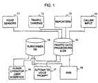
- FIG. 1is a schematic diagram of an exemplary traffic reporting system according to the present invention.
- FIG. 2is an exemplary flow diagram according to the present invention, in which the shortest route between two locations is selected from a plurality of routes according to information stored in a traffic database.
- FIG. 3is an exemplary graphical representation of possible routes as selected by a driver between two locations for a graphical user interface for the traffic reporting system in FIG. 1 .
- FIG. 4is a list of streets and distances for each possible route illustrated in FIG. 3 .
- FIG. 5illustrates a calculation of the shortest route between two locations among the routes illustrated in FIG. 3 .
- FIG. 6is a flow diagram illustrating a method for receiving traffic information via a human operator intermediary, according to the first embodiment of the present invention.
- FIG. 7provides an exemplary map illustrating differences in traffic conditions between two possible routes to the same destination that can be reported to drivers via the first embodiment of the present invention.
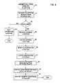
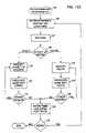
- FIG. 8is a flow diagram illustrating the steps for pre-configuring a traffic predicting system according to a second embodiment of the present invention.
- FIGS. 9A–9Care a series of exemplary screen shots for pre-configuring the traffic predicting system by identifying routes in accordance with the flow diagram of FIG. 8 .
- FIGS. 10A–10Bare a series of exemplary screen shots for pre-configuring the traffic predicting system by identifying streets in accordance with the flow diagram of FIG. 8 .
- FIG. 11is a flow diagram illustrating the steps for accessing traffic information using an automated system according to the second embodiment of the present invention.
- FIG. 12Ais a flow diagram of operations that can be used to carry out embodiments of the present invention.
- FIG. 12Bis a flow diagram illustrating the steps for pre-configuring a traffic predicting system in a first exemplary implementation of a third embodiment of the present invention.
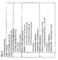
- FIG. 13is an exemplary illustration of information stored in the subscriber database in FIG. 1 , after a subscriber pre-configures the traffic predicting system according to FIGS. 12A and/or 12 B.
- FIG. 14is an exemplary map illustrating present and intended destination locations of two fictitious subscribers and certain traffic advisories that may affect the subscribers' commutes.
- FIG. 15is a schematic of a scheduling database that is accessed by the traffic data processors 10 in FIG. 1 to schedule the transmission of text messages to subscribers' wireless devices, in accordance with the third embodiment of the present invention.
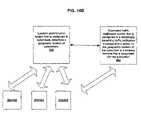
- FIG. 16Ais a diagram of exemplary components of automated location-intelligent traffic notification systems and methods according to embodiments of the present invention.
- FIG. 16Bis a schematic illustration of a location intellinent traffic notification system accordinR to embodiments of the present invention.
- FIG. 17Ais a diagram of a prior art terrestrial based communication system.
- FIG. 17Bis a diagram of a prior art celestial based communication system.
- FIG. 17Cis a diagram of an automated traffic-location intelligent system that uses a global positioning system.
- FIGS. 18–21are flow charts of operations of methods, systems and/or computer program products that can be performed according to embodiments of the present invention.
- the methods and systems described hereinprovide for allowing users to access a database containing information pertaining to traffic conditions.
- a drivercan receive traffic conditions potentially affecting the driver's particular commute, just prior to (or during) the time at which the driver chooses between one or more routes or paths for the commute.
- Several embodimentsare disclosed in accordance with the present invention by which the driver can easily receive timely traffic information from the system via the driver's wireless communications device, such as a wireless telephone.
- the present inventionmay be embodied as a system, method, data processing system, and/or computer program product. Accordingly, the present invention may combine software and hardware aspects, which may all generally be referred to herein as a “circuit.” Furthermore, the present invention may take the form of a computer program product on a computer-usable storage medium having computer-usable program code means embodied in the medium. Any suitable computer readable medium may be utilized including hard disks, CD-ROMs, optical storage devices, a transmission media such as those supporting the Internet or an intranet, or magnetic storage devices.
- Computer program code for carrying out operations of the present inventionmay be written in an object oriented programming language such as, but not limited to, Java®, Smalltalk or C++. However, the computer program code for carrying out operations of the present invention may also be written in conventional procedural programming languages, such as the “C” programming language.
- the program codemay execute entirely on a computer associated with the parking lot system, as a stand-alone software package, partly on the parking lot system computer(s), partly on a user's computer and partly on a remote computer or entirely on the remote computer.
- the remote computermay be connected to the parking lot and/or user's computer through a local area network (LAN) or a wide area network (WAN), or the connection may be made to an external computer (for example, through the Internet using an Internet Service Provider).
- LANlocal area network
- WANwide area network
- These computer program instructionsmay also be stored in a computer-readable memory that can direct a computer or other programmable data processing apparatus to function in a particular manner, such that the instructions stored in the computer-readable memory produce an article of manufacture including instruction means which implement the function specified in the flowchart and/or block diagram block or blocks.
- the computer program instructionsmay also be loaded onto a computer or other programmable data processing apparatus to cause a series of operational steps to be performed on the computer or other programmable apparatus to produce a computer implemented process such that the instructions which execute on the computer or other programmable apparatus provide steps for implementing the functions specified in the flowchart and/or block diagram block or blocks.
- FIG. 1is a schematic diagram of a traffic condition reporting system according to the present invention for providing traffic conditions to a driver.
- Traffic data processors and databases 10receive and maintain traffic data for certain roads and highways in or nearby one or more metropolitan areas.
- the traffic informationcan be sorted and organized in the database according to geographic regions and/or particular stretches along a road (e.g., “Lincoln Drive between 1st and 5th Streets”), although the information may instead be organized differently without departing from the scope of the invention.
- the databasemay store one or more fields of traffic information, such as an average speed of traffic (e.g., “20 mph”), advisories of traffic conditions (e.g., “all lanes open” or “traffic accident”), a code indicating the “drivability” of the road (e.g., a rating of 1–5, where 5 indicates that traffic is flowing smoothly), or a code indicating the “drivability” of the road in comparison with the typical traffic conditions on the road at that time (e.g., a numerical rating of 1–5, where 5 indicates a typical or “normal” traffic pattern for the road for that particular time such as morning or evening commute periods).
- traffic informationsuch as an average speed of traffic (e.g., “20 mph”), advisories of traffic conditions (e.g., “all lanes open” or “traffic accident”), a code indicating the “drivability” of the road (e.g., a rating of 1–5, where 5 indicates that traffic is flowing smoothly), or a code indicating the “drivability
- Other such types of informationmay include the number of traffic lights within the given stretch of road, and for each traffic light, the number of traffic light cycles until a car can pass through the intersection.
- Traffic information in the traffic databasemay be received from one or more of several possible sources.
- the traffic databasemay collect traffic information from road sensors 11 installed along particular roadways. This information may be reported through direct wireline communications, or through a wireless communications system. Road sensors can detect and report the average speed of traffic at a given location to the traffic database 10 . The speed of traffic information may then be processed in traffic processor 10 to determine whether there is a traffic advisory or to calculate the “drivability” as explained above.
- Traffic informationmay also be input to the traffic database in response to images transmitted from traffic cameras 12 along particular roadways.
- a traffic database operatorcan monitor the output from traffic cameras and determine the speed of traffic, traffic advisories, or the “drivability” along the road based upon a qualitative determination of the traffic being monitored.
- the traffic database operatormay receive information from traffic reporters 13 (e.g., helicopter traffic reporting services), and populate the traffic database according to reporters' subjective opinions. Although it may be less reliable, many radio traffic-reporting services rely upon wireless telephone caller input 14 for relevant traffic information.
- the traffic database operatore.g., to receive a discount on traffic reporting service
- Other input channelscan also be used, such as for example, State Highway or Public Safety Departments, State Department of Transportation travel alerts (which traffic information can be typically posted to local radiochannels (AM or FM station) or overhead information displays).
- a subscriber database 15can be configured to maintain account information for each user seeking information from the traffic database 10 .
- Subscriber database 15may simply maintain a list of cellular telephone numbers for each current subscriber.
- the databasemay also maintain additional information, such as the date and time that the user placed a call to access the traffic database, the format by which the user wishes to receive traffic information, and the streets and directions for certain routes that are often traveled by the subscriber.
- a drivercan call an administrative telephone number and contact a human operator via interface 16 , who accesses a computerized traffic database and determines the most efficient route for the driver to take in response to the driver's request.
- a driverpre-configures a traffic reporting system by first providing information to a database concerning the driver's typical destinations and the driver's preferred routes for reaching these destinations. While en route, the driver can then call an administrative telephone number with a wireless telephone, and interact with a voice-automated system 17 to describe the driver's intended destination and to receive a short audio message reporting the shortest route.
- the driveralso pre-configures the traffic reporting system by providing information identifying the driver's preferred routes for reaching a destination, and the typical range of times when the driver is commuting. While driving, short text messages 18 are provided over the display of the driver's associated wireless telephone during the range of times when the driver is commuting, to advise the driver which of the preferred routes to choose.
- FIG. 2provides an exemplary flow diagram in which a shortest route between two locations is determined from a plurality of routes by referring to information stored in traffic database 10 .
- the driver's present and destination locationsare input to a traffic advisory program.
- all potential routes between the two locationscan be determined, in step 21 .
- the systemcan then temporarily select and store a certain number of the most direct routes (e.g., the five (5) most direct routes) in step 22 .
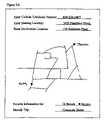
- An example of a graphical representation of the temporarily selected routesis provided in FIG. 3 (all reasonably possible routes would be selected). For each of these selected routes, a list is generated indicating the street-by-street directions (e.g., “(1) Rt.
- step 23N., b/t 1st St. & A St., 3 mi.; (2) A St. W., b/t Rt. 23 & G St., 6 mi.; (3) Fourth St S. b/t A St. & J St., 5 mi, etc.), in step 23 .
- An example of lists for two of the selected routes from FIG. 3is provided in FIG. 4 . As can be seen in FIGS. 3 and 4 , although some routes appear to be more direct, these routes may have more cross streets with traffic lights, or may otherwise have traffic advisories with a reduced drivability rating during the travel period.
- the traffic advisory programcan then determine the shortest (time wise) of the selected routes by retrieving information from the traffic database. For each route, the system performs a database search, in step 24 , and checks for each highway, street, or road in the list to determine if there is any relevant traffic information stored in the database, in step 25 . If there is information in the database, it is retrieved and factored into the calculation for determining the shortest route, in step 26 . For example, if the traffic database indicates that drivers are only traveling at 20 mph on a particular stretch of the road, and the road is ten miles long, then it will probably take the driver a half hour to traverse that part of the route.
- the traffic databasemay store information indicating that there are five traffic lights along the route, and for each light, it may also store the timing cycle (e.g., number of seconds that the light is “green” and number of seconds that it is “red”) and the number of cycles required for a typical driver to pass through the intersection.
- the traffic advisory programcan combine all of this information to determine a length of time for the driver to commute along that route at that particular time. If there is no information in the database, an average speed is presumed, in step 27 , which may be based upon the posted speed limit and the typical rate of speed for the road.
- recent or current police reports as well as weather advisoriescan be used to help define the “drivability” ranking of a particular roadway or path.
- the police reportsmay include crime reports, accidents, planned roadblocks, planned enforcement activities and/or the (average) number speeding tickets given over a desired time interval.
- substantially real-time speeding ticket eventsmay be monitored (such as input by drivers witnessing the event and relaying the information to a data collection site or by monitoring police or public records) and posted to the database to help drivers avoid these roadways as appropriate.
- the traffic advisory programAfter determining that each entry in a list has been checked in the traffic database, in step 28 , the traffic advisory program adds the time for each entry to calculate the total time associated with the route, in step 29 . The traffic advisory program then checks whether there are any other lists to check, in step 30 . Once all lists are checked, a comparison of the calculated commuting times can be made, in step 31 , to determine which route will allow the shortest commute.
- FIG. 5provides an example of the process for determining the shortest route, based upon the routes illustrated in FIG. 4 .
- a total time to travel each stretch of roadis calculated, incorporating delays for traffic advisories and the number of traffic lights.
- it is also possible to factor the timing of each traffic lightwhich may change during different times of the day, and the number of cycles of the traffic light that occur before a typical driver can travel through the intersection.
- To calculate the estimated time required to travel each stretch of roadthe number of miles to be traveled along the road is divided by the estimated speed of traffic along the road, and this result is added to the number of minutes of anticipated delay resulting from the number of traffic lights.
- the estimated speed of trafficis determined by subtracting a traffic advisory “factor” from the average speed of traffic on the road.
- the most time efficient routeis Route “A,” even though other routes are geographically more direct.
- this informationcan be reported in time for the driver to choose a route to avoid congested roads and congested traffic intersections.
- a subscriber to a traffic monitoring serviceindirectly accesses the database through a human operator intermediary 16 .
- the human operatorreceives a traffic question from the user as a spoken request over the user's wireless telephone.
- the operatortypes the request for traffic information into traffic database 10 , receives the information, and reports the information back to the user.
- a human intermediaryis a relatively easy method for a user to access the database to receive traffic information.
- the user's local telephone companymay provide this service in conjunction with “directory assistance,” or the service may be provided by another company that monitors traffic information in the user's metropolitan area.
- FIG. 6is a flow diagram illustrating a method for receiving traffic information via a human operator intermediary.
- a callerdials a telephone number to speak with an operator at a travel advisory service.
- the caller's wireless telephone numberis automatically provided (as a “caller ID”), in step 61 .
- This telephone numberis checked against a list of current subscribers in the subscriber database to determine whether the caller is a current subscriber, in step 62 . If the caller is not a subscriber, an automated message is played, in step 63 , and the call is disconnected.
- the callercan be transferred to a subscription line where a credit card or other form of payment can be relayed, along with other appropriate data and the subscriber added as a new subscriber to the database.
- the subscriberis prompted, either by a human operator or through an automated voice prompt, to provide the subscriber's present location, and the system receives this information in step 64 .
- This informationis entered into a mapping system to locate the subscriber's present location, in step 65 .
- the subscriberis also prompted to provide a destination location and this is received in step 66 and entered into a mapping system to locate the subscriber's intended destination, in step 67 .
- Using speech recognition technologyit is possible to automatically enter this information, if it is provided in a correct format.
- a programcalculates the most time efficient route for the subscriber's commute in step 68 , based upon both traffic conditions and mileage.
- An example of a flow for a traffic advisory programis provided above with reference to FIG. 2 .
- softwarecan be created that displays a roadmap of the relevant section of the metropolitan region and overlays the two or tree shortest possible routes with traffic advisory information for those routes. Based upon this visual description, a human operator may be able to formulate an opinion as to which is the preferred route. This implementation may be particularly useful when the driver is only choosing between two roads (e.g., the highway or the back streets) and only wants to know whether there are any unexpected travel advisories on either of the two roads.
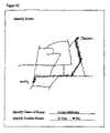
- FIG. 7provides an illustration of an example in which a driver could easily benefit from contacting a human intermediary to receive traffic information.
- the driverwill soon choose whether or not to take a bypass route (“I-270”) to travel to his intended destination (“Rockville Pike”).
- I-270bypass route
- Rockville Pikea bypass route to travel to his intended destination
- an operatorcan recommend against taking the bypass route due to an accident that recently occurred on a road that is along that route or other reduced drivability data.
- a drivercan pre-configure a traffic informational system by first providing information concerning the driver's typical destinations and the driver's preferred routes for reaching these destinations. This information can be entered into a database in accordance with a web-based program or other suitable input method. While en route, the driver can then call an administrative telephone number with a wireless telephone and respond to prompts from a voice-automated system to indicate the driver's intended destination. The automated system then accesses a computerized traffic database and determines which of the driver's preferred routes will allow the driver to reach the destination in the least amount of time. The preferred route can provide as a short audio message on the driver's wireless telephone or other communication device.
- a driveraccesses a web site to subscribe to the traffic monitoring service.
- the web siteenables the driver to pre-configure a subscriber database to provide specific traffic information in response to calls from the subscriber's wireless telephone.
- FIG. 8is a flow diagram illustrating the steps for pre-configuring the traffic predicting system according to the pre-programmed embodiment.
- the web siterequests the driver to first enter a wireless directory telephone number, in step 80 .
- this numbercan be scanned (e.g., by caller-ID) to identify the driver as a subscriber.
- the driver/passengeris also prompted to provide a starting location and a destination location, in step 81 .
- the web siteuses this information to generate a roadmap, in step 82 , which shows the starting and ending locations and the relevant streets by which the driver may choose to travel.
- the drivermay be prompted to enter additional information, such as preferred travel times (both morning and evening).
- the drivercan choose in step 84 to either receive information concerning congestion on particular, identified streets, or a recommendation of one particular route from a plurality of possible routes based upon current traffic conditions. If the driver chooses to receive information pertaining to particular streets, an indication of which streets typically experience congestion and are monitored by the service is provided on the road map. Using the graphical interface, the driver identifies the stretches of particular streets that he wishes to monitor (e.g., I-495 between I-270 and Old Georgetown Rd.) in step 85 . The driver can then associate a code or a name with this stretch of road (e.g., “beltway” or “1”) in step 86 . Although not shown in FIG.
- the systemcan prompt the driver to refrain from re-using a name or code, or the system can perform a check to determine whether a proposed name or code has previously been used by the driver. Instead of typing in a name or code, the driver may also be able to speak the name into a microphone, which is then digitally recorded for use with a speech recognition system.
- the drivercan then choose whether to select another road, in step 87 .
- the driverselects a name or code for the trip (e.g., “commute home” or “1”), in step 88 , and selects whether to pre-configure monitoring for a different trip, in step 89 , and repeat the process.
- a name or code for the tripe.g., “commute home” or “1”
- step 83the driver elects to receive recommendations from the service of which route to take, the driver may identify a preferred route on the map by selecting stretches of road in the user interface, in step 91 . Once the driver identifies the complete route, the driver provides a code or a name for the route (e.g., “highway to work” or “back roads to work”) in step 92 . The user then selects one or more additional routes in step 93 , for the system to compare in determining the quickest route with the minimum traffic.
- a code or a name for the routee.g., “highway to work” or “back roads to work”
- FIGS. 9A–9Ctogether provide an example of how a driver may preconfigure the traffic monitoring service on a web site according to the second embodiment of the invention.
- a road mapis provided of the relevant portion of the metropolitan area that includes the two locations.
- the driverchooses to receive information for the driver's chosen routes.
- FIGS. 9B and 9Cillustrate the process of selecting two routes, named “Along Peachtree” and “Along Midtown,” respectively. The routes can be selected by “touching”, “clicking” and/or “dragging” on visually generated portions of selected streets on a display.
- FIGS. 10A–10Btogether with FIG. 9A , provide another example of how a driver may pre-configure the traffic monitoring service.
- the driverselects two streets to be monitored, named “Third Street” and “Jay Street,” respectively.
- FIG. 11is a flow diagram illustrating the steps for accessing traffic information using an automated system according to the second embodiment of the present invention.
- the wireless directory telephone numberis detected, in step 111 . If the system determines that the caller is not a subscriber, in step 112 , then an automated message is played over the caller's telephone, in step 113 . If the caller is a subscriber, he is then prompted to provide the name or the code number for the trip that is in progress, in step 114 . The subscriber can then press one or more keys on the wireless telephone, or simply speak the name. If the name is spoken, the system attempts to recognize the name using known speech recognition systems. Information pertaining to the subscriber's trips are stored and maintained in the subscriber database.
- step 115the subscriber is prompted to indicate the process of selecting two routes, named “Along Peachtree” and “Along Midtown,” respectively.
- the routesare selected by “clicking” and “dragging” on portions of selected streets.
- FIGS. 10A–10Btogether with FIG. 9A , provide another example of how a driver may pre-configure the traffic monitoring service.
- the driverselects two streets to be monitored, named “Third Street” and “Jay Street,” respectively.
- FIG. 11is a flow diagram illustrating the steps for accessing traffic information using an automated system according to the second embodiment of the present invention.
- the wireless directory telephone numberis detected, in step 111 . If the system determines that the caller is not a subscriber, in step 112 , then an automated message is played over the caller's telephone, in step 113 . If the caller is a subscriber, he is then prompted to provide the name or the code number for the trip that is in progress, in step 114 . The subscriber can then press one or more keys on the wireless telephone, or simply speak the name. If the name is spoken, the system attempts to recognize the name using known speech recognition systems. Information pertaining to the subscriber's trips are stored and maintained in the subscriber database.
- step 115the subscriber is prompted to indicate whether to search for information pertaining to a road or a comparison of one or more routes (e.g., “press ‘1’ for streets, press ‘2’ for routes . . . ). If this response is not recognized, in steps 117 , then the system can continue to prompt the subscriber for the appropriate command.
- step 118the system prompts the user to indicate the street name by either speaking the name or pressing a code for the street name, in step 119 (“press ‘1’ for “Third Street;” press ‘2’ for “Jay Street”).
- the information pertaining to which streets are associated with the subscriberis stored in the subscriber database.
- step 120the information pertaining to the identified street name is retrieved from the traffic database. This information is then reported to the user through a simulated voice (e.g., “caution, Jay Street is running slowing with unusually heavy traffic, we suggest a different route if possible”).
- the subscribermay instead choose to compare the estimated travel times between a plurality of routes that were pre-configured and associated with the identified trip name.
- the systemretrieves information from the traffic database for each street in each route, in step 122 .
- the estimated travel timeis calculated for each leg of the route, and the total travel time for each route is determined in step 123 , in a manner as described with reference to FIG. 2 .
- This informationis then reported to the subscriber through a simulated voice (e.g., “take ‘Along Peachtree,’ it is the fastest route”) in step 124 .
- a subscribercan easily determine whether to take the “Along Peachtree” or “Along Midtown” routes, or to take or avoid either of “Third Street” or “Jay Street.”
- the drivercan pre-configure a traffic (predicting) system (block 141 ) such as by providing information identifying the driver's preferred routes for reaching a frequent destination, and optionally, the typical range of times when the driver is commuting.
- the drivercan pre-configure a traffic predicting system by providing trip-specific data such as anticipated dates of travel, starting and ending locations, planned route, planned breaks or night stops and the like.
- the information stored in the databaseis associated with the driver's wireless telephone number or other unique identifier associated with a subscriber vehicle or wireless communication device (for example, an on-board navigation system such as an ONSTAR system) (block 143 ).
- a subscriber vehicle or wireless communication devicefor example, an on-board navigation system such as an ONSTAR system
- short text and/or audio messagesare provided (such as over the display and/or via the speaker of the driver's associated wireless communication device), which may be a wireless telephone, during the range of times when the driver is commuting or during a desired monitoring interval or time of interest (block 146 ) to advise the driver.
- the advicecan include which of the (preferred) routes to choose, provide periodic updates in traffic conditions, and/or report dynamically occurring traffic events that are in the geographic region of the driver.
- a difference between the Traffic Update or (Short) Messaging Service embodiment and both the human intermediary embodiment and pre-programmed automated embodimentis that the driver can receive requested information and/or updates simply by turning on the driver's wireless device, activating a “function” key or the like on the wireless device, and/or turning “on” a vehicle (the latter typically for vehicle mounted wireless communication devices) which automatically engages the traffic system (block 145 ).
- the interface with the traffic systemcan occur without requiring the driver to make an active input transmission or communication request (without inputting responses to multiple prompts) such as a telephone call to a service number to initiate the request for update or traffic information.
- Traffic informationcan be automatically relayed to the subscriber/driver while a respective subscriber is in transit.
- the interface or active monitoring or access to the traffic systemmay be predicated on whether the driver has indicated this time as being of a desired monitoring period of interest (block 146 ).
- the geographic location of the subscribermay be monitored dynamically over a desired monitoring period (block 148 ) and relevant traffic information provided for a respective subscriber by correlating the current identified geographic location (and or travel direction) to traffic data in that geographic location (i.e, the traffic data can be customized to the substantially real-time location of the subscriber). If the traffic data has not changed since the last update and the subscriber is still within the same geographic location, the update may be withheld or delivered on a less-frequent basis.
- the traffic notificationcan relay the information based on the location of the subscriber (typically in substantially real-time from when the new condition is determined or relayed to the traffic system while the subscriber is in-transit).
- FIG. 12Bis a flow diagram illustrating exemplary steps for pre-configuring the traffic predicting system in a first exemplary implementation of Short Messaging Service embodiments.
- SMSShort Messaging Service
- the “short” messageis typically less than about a paragraph long if textual, and more typically about 1 sentence long and may not be presented in grammatically proper format.
- the short messagecan be less than about 15 seconds in length if audio, and typically less than about 10 seconds in duration.
- the short messagemay be provided as both a text message and an audio message, which is output by the wireless device associated with the subscriber.
- the systemmay be configured to provide additional information upon request if the subscriber so indicates.
- the web siterequests the driver to first enter a wireless telephone number, in step 125 , and a starting location and a destination location, in step 126 .
- the serviceis associated with the driver's wireless network, it is possible that the web site will automatically detect the driver's wireless number upon receiving the driver's name.
- the driverviews a map in step 127 , illustrating the starting and destination locations within the metropolitan area.
- step 128If the driver chooses in step 128 to receive information about a particular street, he identifies the street on the map in step 129 and selects a name for the street in step 130 . In step 131 , the driver then enters the anticipated range of times and day(s) of the week for travel (e.g., weekdays, weekends, or a particular day of the week). If in step 128 , the driver chooses to receive information about which is the most efficient route, he then identifies a route in step 133 , associates a name for the route in step 134 , and repeats the process to enter other alternative routes for comparison. In this implementation, the driver may elect to receive information for other streets or routes in step 135 .
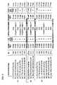
- FIG. 13provides an example of an entry in the subscriber database pertaining to the traffic information that a particular subscriber has requested to receive by pre-configuring the traffic predicting system in accordance with the steps described with reference to FIG. 12B .
- the subscriber databasestores the names of the particular streets and the times that the subscriber expects to be traveling on those streets (e.g., “Hallowell Dr., N., May 10, 2001: 0800”).
- the databasealso stores information pertaining to a plurality of routes between two locations to enable the system to determine the fastest route (e.g., “Along Cherry Valley” versus “Along Highway”) considering the traffic conditions at the requested times (e.g., “8:00 am Weekdays”).
- the subscriber databaseautomatically stores the number of miles for each leg of each route, and associates each street with a code for accessing the traffic database.
- the traffic predicting systemperforms a calculation as illustrated and explained with reference to FIG. 5 to determine the most direct route.
- FIGS. 14 and 15provide an example of how the short messaging service embodiment may be used.
- “Joe” and “Sam”are two fictitious drivers who subscribe to the service and have pre-configured the subscriber database with the following information: “Joe” intends to travel between points A and B at 8:00 am on weekdays (Monday through Friday) and prefers to travel by either taking the “Along Cherry Valley” route or the “Along Highway” route; and “Sam” intends to travel between points C and D at 12:00 pm on weekends, and desires to know the traffic conditions along “Highway” before deciding whether to take “Highway” or “Fox Street.”
- FIG. 14is a map of the region that includes the present and intended destination locations of Joe and Sam, and shows certain traffic advisories that may affect Joe and Sam's commutes.
- FIG. 15is a schematic of a scheduling database that is accessed by the traffic data processors 10 in FIG. 1 to schedule the transmission of text messages to subscribers' wireless devices.
- Joeleaves his home at point A at 7:55 am on Tuesday to begin his commute, and turns his cellular phone “on” while in his car.
- entry number 5 in the scheduling databaseindicates that at 8:00 am on Tuesday, the system is to compare the traffic conditions on two specified routes and report which is the fastest of the two routes to Joe's telephone number at 555-1212. As shown on the map in FIG.
- the systemcan detect that there is an accident that is slowing traffic on “Cherry Valley,” and so the system will recommend that Joe should avoid the route that includes “Cherry Valley.” Therefore, at 8:00 am, a short text message will be displayed on Joe's telephone that reads: “Along Highway,” based upon the name of that route that Joe provided during the pre-configuration of the system.
- the traffic reporting systemtransmits a plurality of short (typically text) messages to the wireless device at the time that the subscriber is beginning his commute, and the wireless device stores the messages that are received. Later, the subscriber can access the stored information by pressing different keys on the keypad of the wireless device.
- the subscriber databasecan be pre-configured to include all of the information as provided in FIG. 13 .
- the subscribercan receive a message pertaining to the traffic conditions for each different street in the route or for routes having negative traffic drivability ratings.
- the subscribercan then toggle through the messages at a safe, appropriate time (e.g., at a red traffic light) when the subscriber desires.
- the series of text messagescan provide directions for the subscriber for the most direct route in light of the current traffic conditions.
- the subscribercan then cycle through the text messages to navigate the route, at a pace that is controlled by the subscriber.
- the text message that is transmitted to the subscriber's wireless devicecan begin with header code that instructs the wireless device where to store (or whether to overwrite) the information in the device's RAM memory.
- Wireless deviceseasily can be designed to parse through the header of a short text message to detect a storage information code.
- the wireless devicecan also be programmable to press a certain button to remove the information from the device (e.g., “Clear”) or alternatively, to save the information in the device's long term memory.
- the traffic reporting systemautomatically reports traffic conditions for particular streets to a subscriber whenever the subscriber is beginning to approach or is in the vicinity of those streets or when a subscriber may otherwise have an interest in the traffic in a geographic region to allow the subscriber to take alternate routes in advance of a problem area. In this manner, it may be unnecessary to store time and date information (preconfigured) in the subscriber database shown in FIG. 13 . Instead, a scheduling database maintains lists of subscriber telephones that are to receive text messages when approaching different cell sites and/or geographic regions. In other words, referring to the map as illustrated in FIG.
- “Joe”may pre-configure the traffic reporting system to receive a traffic report whenever he approaches point “A.” Anytime that Joe is approaching the cell site nearest point “A,” it is likely that Joe is deciding whether to take the “Cherry Valley” bypass or instead travel along the “Highway.” Regardless of the time or day, a short text message can help Joe by telling him if there are any traffic conditions on either road. If traffic is not an issue, Joe may opt to disregard the text message, not activate the traffic service at that use time, or not turn on his wireless device at all.
- the third implementationmay result in unnecessary or unneeded messages, it may be simpler to administer, and may help subscribers learn of unpredictable accidents or road construction that may occur when the subscriber did not expect to encounter any traffic.
- the subscriber's vehicle and/or wireless devicecan include a GPS receiver for allowing the traffic notification system to track or monitor the locations of the vehicle over a monitoring period.
- a traffic reporting systemsends traffic information when the subscriber reaches or approaches a certain geographic location, which can be determined using the GPS receiver.
- the traffic reporting systemcan provide traffic information from the traffic database when the GPS receiver indicates that the driver is in relatively close vicinity to the road, street, or highway affected and/or in question.
- the reporting systemalso can be configured to only provide text messages to alert the driver of a traffic advisory in the geographic region in which the driver is presently located or in a direction that is relevant and ahead of the driver (in the direction of travel).
- the systemcan be configured to automatically obtain a plurality of geographic location readings about the position of the subscriber's vehicle over a desired time interval and the location, speed and/or direction of travel may be determined dynamically in situ. In this mode, it may be unnecessary for the driver to pre-configure a subscriber database with certain trip information.
- FIG. 16Aillustrates an exemplary system architecture for providing an automated and location-intelligent traffic notification system that can dynamically provide substantially real-time traffic conditions based on in situ determined personalized (custom) individual subscriber location data.
- the system 200includes at least one traffic notification server 205 which can be a web server 205 w forming a general computing platform with network connectivity to other components of the system 200 over an IP (internet protocol) network.
- the system 200can also include a subscriber database 15 , a traffic monitoring system 10 , a location determination system 210 , an interactive voice response system 215 and an SMS and/or interactive pager gateways and the like.
- the traffic notification server 205can be operatively associated with and/or include a profile management subsystem 206 that may be implemented using computer programs that are web based to manage the subscriber data or information in a subscriber database 15 .
- the subscriber database 15can include data regarding desired or typical driving routes (frequent and/or trip specific), notification options available for the user and user preference(s), active traffic monitoring schedule(s), and the like.
- the traffic notification server 205may also be in communication with and/or include a notification control subsystem 207 .
- the notification control subsystem 207may be a control application software program that dynamically determines if a notification should be sent to a user/subscriber and how the notification should be sent based on the subscriber's profile as well as substantially real time traffic information that can be transmitted from the traffic monitoring system 10 and the subscriber's geographic location information determined in situ from the location determination system 210 .
- the traffic monitoring system 10may be configured to publish/post or otherwise provide traffic information to a server, such as the traffic notification server 205 .
- the system 10can provide the traffic information in substantially real-time as web pages that may be predefined. Such web pages may also be dynamically generated to incorporate substantially real-time traffic condition data in geographic areas and/or roadways.
- the web pagesmay be Hypertext Markup Language (HTML) common gateway interface (CGI) web pages.
- the web pagesmay also be or include Java scripts, Java applets or the like which may execute at the server 205 w or other processor.
- HTMLHypertext Markup Language
- CGIcommon gateway interface
- Java scriptsJava applets or the like which may execute at the server 205 w or other processor.
- other mechanisms for communicating between a web server and a clientmay also be utilized. For example, other markup languages, such as Wireless Markup Language (WML) or the like, for communicating between the traffic notification server 205 and a prospective user using a wireless communication device having an output (such as
- the automated system 200can be configured to provide outputs to multiple devices for one or more subscribers (each subscriber can receive the traffic notification in one or several ways concurrently).
- the output devicesare illustrated as a local computer 300 (shown as a web based interface), a conventional telephone 301 , and mobile communication devices 302 that may be in a vehicle 303 and/or the vehicle 303 may have an integrated communication system.
- the system 200may employ voice notification to transmit traffic information to a user/subscriber via a voice response system 215 service node controlled by the notification control subsystem 207 .
- the voice response system 215may be interactive with the user's wireless communication device. As is also shown in FIG.
- the short messaging service and/or interactive pager gateway interface 220can be used to transmit customized traffic information from the traffic notification server 205 to a user/subscriber via the (mobile) wireless communication output devices.
- the traffic notification server 200may be configured to directly communicate with the wireless communication devices 302 and/or vehicle 303 integrated communication systems.
- FIG. 16Billustrates the automated traffic notification system 200 is in communication with the location determination system 210 .
- the location determination system 210is configured to determine the location of respective subscribers using the wireless communication device (wireless vehicle integrated device 303 or portable device 302 ).
- the traffic notification system 200is configured to automatically transmit a traffic notification message that is based on the geographic location of the subscriber to a wireless terminal that is associated with the subscriber.
- the location determination system 210can be a terrestrial or a celestial-based system, or combinations thereof.
- the location determination system 210can be configured to determine the geographic location of a subscriber/user (typically carried out in situ, in substantially real-time).
- FIG. 17Aillustrates a conventional terrestrial wireless communication system 320 that may implement conventional wireless communications standards and which may be used to determine location of a user as will be discussed further below.
- the wireless systemmay include one or more wireless mobile terminals (stations) 322 that communicate with a plurality of cells 324 served by base stations 326 and a mobile telephone switching office (MTSO) 328 . Although only three cells 324 are shown in FIG. 17A , a typical cellular radiotelephone network may comprise hundreds of cells, and may include more than one MTSO 328 and may serve thousands of wireless mobile terminals 322 .
- stationswireless mobile terminals
- MTSOmobile telephone switching office
- the cells 324generally serve as nodes in the communication system 320 , from which links are established between wireless mobile stations (terminals) 322 and a MTSO 328 , by way of the base stations 326 servicing the cells 324 .
- Each cell 324will have allocated to it one or more dedicated control channels and one or more traffic channels.
- the control channelis a dedicated channel used for transmitting cell identification and paging information.
- the traffic channelscarry the voice and data information.
- a duplex radio communication link 330may be effectuated between two wireless mobile stations 322 or between a wireless mobile station 322 and a landline telephone user 332 via a public switched telephone network (PSTN) 334 .
- PSTNpublic switched telephone network
- the function of the base station 326is commonly to handle the radio communications between the cell 324 and the wireless mobile terminal 322 . In this capacity, the base station 326 functions chiefly as a relay station for data and voice signals.
- a satellite 342may be employed to perform similar functions to those performed by a conventional terrestrial base station, for example, to serve areas in which population is sparsely distributed or which have rugged topography that tends to make conventional landline telephone or terrestrial cellular telephone infrastructure technically or economically impractical.
- a satellite radiotelephone system 340typically includes one or more satellites 342 that serve as relays or transponders between one or more earth stations 344 and terminals 323 . The satellite conveys radiotelephone communications over duplex links 346 to terminals 323 and an earth station 344 .
- the earth station 344may in turn be connected to the PSTN 334 , allowing communications between satellite radiotelephones, and communications between satellite radio telephones and conventional terrestrial cellular radiotelephones or landline telephones.
- the satellite radiotelephone system 40may utilize a single antenna beam covering the entire area served by the system, or, as shown, the satellite may be designed such that it produces multiple minimally-overlapping beams 348 , each serving distinct geographical coverage areas 50 in the system's service region.
- the coverage areas 350serve a similar function to the cells 324 of the terrestrial cellular system 320 of FIG. 17A .
- such terrestrial or celestial (satellite) communication systemsmay also be used for location determination.
- the cell 324 in which the device residesmay be determined.
- triangulation between base stations 326may also be accomplished, for example, based on the relative signal strength and/or signal delays associated with different base stations 326 .
- wireless networking devicessuch as an IEEE 802.11 wireless network adapter may be provided.
- Such wireless network communicationsmay be carried out as if the monitoring device were connected directly to a network, such as an Internet Protocol (IP) network.
- IPInternet Protocol
- Location determination in such a wireless networkcould also be determined, for example, by determining the wireless access point utilized by the device. Each wireless access point could then be associated with a geographic range of the wireless communications to the wireless access point to determine the location of the monitoring device.
- GPSglobal positioning system
- FIG. 17CGPS is a space-based triangulation system using satellites 352 and computers 358 to measure positions anywhere on the earth. GPS was developed by the United States Department of Defense as a navigational system. The advantages of this navigational system over other land-based systems are that it is not limited in its coverage, it provides continuous 24-hour coverage, regardless of weather conditions, and is highly accurate. While the GPS technology that provides the greatest level of accuracy may have been retained by the government for military use, a relatively accurate service has been made available for civilian use. In operation, a constellation of 24 satellites 352 orbiting the earth, continually emit a GPS radio signal 354 .
- a GPS receiver 356e.g., a radio receiver with a GPS processor, receives the radio signals from the closest satellites and measures the time that the radio signal takes to travel from the GPS satellites to the GPS receiver antenna. By multiplying the travel time by the speed of light, the GPS receiver can calculate a range for each satellite in view. Ephemeris information provided in the satellite radio signal typically describes the satellite's orbit and velocity, thereby generally enabling the GPS processor to calculate the position of the GPS receiver 356 through a process of triangulation.
- the startup of a GPS receivertypically requires the acquisition of a set of navigational parameters from the navigational data signals of four or more GPS satellites. This process of initializing a GPS receiver may often take several minutes. The duration of the GPS positioning process is directly dependent upon how much information the GPS receiver has initially. Most GPS receivers are programmed with almanac data, which coarsely describes the expected satellite positions for up to one year ahead. However, if the GPS receiver does not have some knowledge of its own approximate location, then the GPS receiver cannot find or acquire signals from the visible satellites quickly enough, and, therefore, cannot calculate its position quickly. Furthermore, it should be noted that a higher signal strength may be needed for capturing the C/A Code and the navigation data at start-up than is needed for continued monitoring of an already-acquired signal. It should also be noted that the process of monitoring the GPS signal may be affected by environmental factors. Thus, a GPS signal, which may be easily acquired in the open typically, becomes harder to acquire when a receiver is under foliage, in a vehicle, or in a building.
- GPS and cellular communications techniquesmay be combined to facilitate rapid location determination. Such a combined technique may be beneficial so as to reduce power consumption by reducing the duration that a monitoring system needs to be powered to determine and provide location information.
- the GPS receivermay be integrated into the vehicle and/or into the wireless communication device.
- the particular GPS receiver and/or communication device and/or position determination device utilizedmay depend on the use of the monitoring device. For example, if the device is utilized in a relatively small-predefined geographic area, then a wireless network may be utilized for both communications and positions. However, if the device is to be used or transported over a large geographic area, then a cellular or satellite communication system may be used in combination with a GPS for position determination. Thus, the present invention should not be construed as limited to a particular communication device and/or positioning system.
- the traffic notification server 205can operate over a computer network such as a local area network, a wide area network or a direct connection and may include an intranet (computers connected within a particular organization, company, coalition, or group), an extranet, a Virtual Private Network (VPN), a global computer network such as the Internet, including the World Wide Web, or other such mechanism for allowing a plurality of data processing systems with respective outputs (displays) to communicate.
- a computer networksuch as a local area network, a wide area network or a direct connection and may include an intranet (computers connected within a particular organization, company, coalition, or group), an extranet, a Virtual Private Network (VPN), a global computer network such as the Internet, including the World Wide Web, or other such mechanism for allowing a plurality of data processing systems with respective outputs (displays) to communicate.
- VPNVirtual Private Network
- the system 200includes communication links that allow the traffic notification server 205 to communicate with the desired input and output devices via the computer network.
- Such communications linksmay be provided, for example, by a network interface of a data processing system in communication with a processor.
- Typical network interfacesmay include Ethernet, Token Ring or other such direct connections to a computer network provided, typically, by network interface card (NICs) or may be provided by, for example, a modem, including cable modems, Digital Subscriber Loop (DSL) modems, including ADSL and DSL modems, wireless modems or conventional telephone modems which provide communications to a computer network.
- NICsnetwork interface card
- modemincluding cable modems, Digital Subscriber Loop (DSL) modems, including ADSL and DSL modems, wireless modems or conventional telephone modems which provide communications to a computer network.
- DSLDigital Subscriber Loop
- the automated location-intelligent system 200can provide automated notifications to the driver/subscriber based on in situ determinations of the driver's location as the system 200 can monitor the location of the vehicle and/or subscriber (typically using the wireless device).
- the driverdoes not need to initiate a request for traffic conditions to a service provider to obtain relevant traffic data in a helpful time related manner.
- automatic voice and/or text messagestypically a short message service “SMS” and/or alert signals when urgent geographically relevant traffic events are detected
- SMSshort message service
- alert signalswhen urgent geographically relevant traffic events are detected
- a drivercan input a desired route using a web browser to communicate with the system 200 and input subscriber data into the subscriber database 15 .
- the inputmay include specifying the starting and destination locations and may include an expected schedule or travel period (days, hours, etc . . . ).
- the inputmay be provided as a daily (non-weekend) monitoring period during specific hours or as an event specific (one time input for vacation travel and the like).
- the system 200can generate a preferred driving or directional map based on substantially real time traffic information posted by the traffic monitoring system 10 .
- the drivermay indicate a notification protocol preference, such as a cell phone number or ipager address, email address, and the like, for receiving traffic notices (in transit).
- the drivercan initiate his/her journey in a vehicle, typically using the preferred route provided by the system 200 . However, the driver may override the preferred route and may notify the system 200 that he/she will be traveling along an alternate route.
- the system 200may be configured to “learn” the driver's typical travel routes and store them in the subscriber database. The subscriber may notify the system 200 when a route is to be placed into memory and multiple geographic location determinations can be obtained over the commute to automatically “map” the driver's commute or travel route.
- the “learn” modemay be activated by using predefined function keys or prompts to the system.
- the system 200may determine itself geographically where the subscriber (driver) is and the direction he/she is heading based on a plurality of geographic data determinations obtained dynamically while the subscriber is in transit during a desired monitoring interval. That is, the system 200 can monitor the location of the subscriber and store the geographic data in the subscriber database. The subscriber's speed and direction of travel can be similarly determined using the geographic data.
- the system 200can monitor traffic conditions and notifies and/or posts the information to the traffic notification server 205 in substantially real time or as events are detected.
- the system 200can interrogate the data in the subscriber database 15 and determine which subscribers are likely to be affected by the detected traffic condition.
- the system 200can then confirm that the subscriber is in a geographically relevant position based on the location determination system 210 so as to place the driver at a location in a time and geographically relevant manner. For example, if an event is defined on a particular roadway, and the system determines that the subscriber is already beyond this location, no notification will be sent. In the reverse, if the subscriber is identified as approaching or within a particular distance of a detected driving condition of interest a notification can be transmitted.
- a virtual boundarycan be generated by the system 200 and any incidents occurring within the boundary can be transmitted to the subscriber.
- the virtual boundarywill advance with the movement of the vehicle and the size of the virtual boundary may be dynamically adjustable in transit (typically being longer in the direction of travel along a major roadway and shorter on adjacent sides of the primary travel route) and can depend on the determined speed of the vehicle and the destination, and the like.
- the system 200can be configured to notify the subscriber whenever an adverse traffic event is detected within the virtual boundary.
- the traffic notification server 205then notifies drivers identified by the profile management subsystem 206 and/or location determination system 210 as those that should be notified of the detected condition (typically those identified as being or approaching a geographic region based on the location determination system 210 ).
- the subscriber and/or drivercan dynamically automatically receive relevant, customized traffic data on the driver-s identified notification device when a traffic incident (accident), construction, congestion, or other low-drivability condition is detected in a relevant geographic region in a time-relevant manner.
- the system 200may also provide an alternative route with the notification or allow a driver/user to request same.
- the driver/usermay also respond to the notice with an acknowledgement to allow the system 200 to confirm that the user/driver is still in transit and wishes to receive further traffic updates as they occur.
- wireless communication devicemay include, but is not limited to, a cellular wireless terminal with or without a multi-line display; a Personal Communications System (PCS) terminal that may combine a cellular wireless terminal with data processing, facsimile and data communications capabilities; a PDA that can include a wireless terminal, pager, internet/intranet access, web browser, organizer, calendar and/or a GPS receiver; a two-way wireless communicator (such as the BlackberryTM wireless platform); a vehicle integrated cellular and/or satellite based wireless terminal that may include a GPS receiver; and a conventional laptop and/or palmtop receiver or other appliance that includes a wireless terminal transceiver.
- PCSPersonal Communications System
- Wireless communication devicesmay also be referred to as “pervasive computing” devices and may be mobile terminals.
- the wireless communication deviceincludes an antenna that can be configured to provide resonance for a global positioning system (GPS) and the device can include a GPS receiver. GPS operates at approximately 1,575 MHz.
- GPSglobal positioning system
- embodiments of the present inventioninclude determining the geographic location of a subscriber (block 800 ); and automatically transmitting a traffic notification message that is based on the geographic location of the subscriber to a wireless terminal that is associated with the subscriber (block 803 ).
- FIG. 19illustrates exemplary operations that can be used to provide traffic information to a subscriber over a wireless network.
- the operationsinclude providing a subscriber database of information corresponding to a plurality of subscribers (block 810 ).
- the geographic locations of a respective subscribercan be monitored while the subscriber is in transit (block 812 ).
- Relevant traffic conditionscan be identified by correlating traffic conditions in a particular location to a respective subscriber's monitored geographic location (block 814 ).
- a wireless traffic notification messagecan be automatically relayed to a respective subscriber if the subscriber is identified as affected by a traffic condition (block 816 ).
- FIG. 20illustrates additional operations that can be used to provide traffic information over a wireless network using data from a traffic database to a subscriber during a desired monitoring interval or period.
- the operationsinclude: evaluating whether a subscriber requests to receive traffic information at a present time from a subscriber database (block 840 ); dynamically determining a geographic location of the subscriber using a terrestrial and/or celestial based geographic location determination system (block 842 ); retrieving traffic information for a particular geographic area and/or travel zone corresponding to a travel path of the subscriber and the determined geographic location of the subscriber (block 844 ); and automatically transmitting a short text message to a subscriber's wireless communication device (block 846 ).
- the relevant traffic information that is customized to the subscriber's travel pathmay be reported to the subscriber in a short (such as a text and/or audio) message while the subscriber is in transit.
- FIG. 21illustrates yet other operations that can be used to provide automated location-intelligent traffic notifications.
- the operationsinclude: providing a subscriber database configured with subscriber specific data from a plurality of subscribers (block 850 ); determining a geographic location of a subscriber a plurality of times during at least one time period of interest and storing the geographic location data in the subscriber database during a monitoring period (block 852 ); monitoring the geographic location of the subscriber during the monitoring period based on the geographic location data and the subscriber's direction of travel (block 854 ); providing substantially current traffic information for routes, streets, roadways and/or travel paths in at least one geographic region (block 856 ); evaluating when there is a change in a traffic condition a route, street, roadway and/or travel path in the at least one geographic region (block 858 ); identifying a subscriber that may be affected by the change in the traffic condition using the determined geographic location of the subscriber and data from the subscriber database (block 860 ); and then automatically transmitting a traffic notification message to
Landscapes
- Engineering & Computer Science (AREA)
- Radar, Positioning & Navigation (AREA)
- Remote Sensing (AREA)
- Physics & Mathematics (AREA)
- General Physics & Mathematics (AREA)
- Atmospheric Sciences (AREA)
- Life Sciences & Earth Sciences (AREA)
- Automation & Control Theory (AREA)
- Computer Networks & Wireless Communication (AREA)
- Signal Processing (AREA)
- Mathematical Physics (AREA)
- Environmental & Geological Engineering (AREA)
- Environmental Sciences (AREA)
- Ecology (AREA)
- Biodiversity & Conservation Biology (AREA)
- Navigation (AREA)
- Traffic Control Systems (AREA)
Abstract
Description
Claims (34)
Priority Applications (10)
| Application Number | Priority Date | Filing Date | Title |
|---|---|---|---|
| US10/677,417US6973384B2 (en) | 2001-12-06 | 2003-10-02 | Automated location-intelligent traffic notification service systems and methods |
| US11/209,115US7269505B2 (en) | 2001-12-06 | 2005-08-22 | Automated location-intelligent traffic notification service systems and methods |
| US11/834,728US7430472B2 (en) | 2001-12-06 | 2007-08-07 | Automated location-intelligent traffic notification service systems and methods |
| US12/239,259US7617043B2 (en) | 2001-12-06 | 2008-09-26 | Automated location-intelligent traffic notification service systems and methods |
| US12/570,817US7912642B2 (en) | 2001-12-06 | 2009-09-30 | Automated location-intelligent traffic notification service systems and methods |
| US13/048,508US8296066B2 (en) | 2001-12-06 | 2011-03-15 | Automated location-intelligent traffic notification service systems and methods |
| US13/603,769US8543334B2 (en) | 2001-12-06 | 2012-09-05 | Automated location-intelligent traffic notification service systems and methods |
| US14/033,551US8781738B2 (en) | 2001-12-06 | 2013-09-23 | Automated location-intelligent traffic notification service systems and methods |
| US14/330,787US9310215B2 (en) | 2001-12-06 | 2014-07-14 | Automated location-intelligent traffic notification service systems and methods |
| US15/058,833US9683857B2 (en) | 2001-12-06 | 2016-03-02 | Automated location-intelligent traffic notification service systems and methods |
Applications Claiming Priority (2)
| Application Number | Priority Date | Filing Date | Title |
|---|---|---|---|
| US10/004,500US6741926B1 (en) | 2001-12-06 | 2001-12-06 | Method and system for reporting automotive traffic conditions in response to user-specific requests |
| US10/677,417US6973384B2 (en) | 2001-12-06 | 2003-10-02 | Automated location-intelligent traffic notification service systems and methods |
Related Parent Applications (1)
| Application Number | Title | Priority Date | Filing Date |
|---|---|---|---|
| US10/004,500Continuation-In-PartUS6741926B1 (en) | 2001-12-06 | 2001-12-06 | Method and system for reporting automotive traffic conditions in response to user-specific requests |
Related Child Applications (1)
| Application Number | Title | Priority Date | Filing Date |
|---|---|---|---|
| US11/209,115ContinuationUS7269505B2 (en) | 2001-12-06 | 2005-08-22 | Automated location-intelligent traffic notification service systems and methods |
Publications (2)
| Publication Number | Publication Date |
|---|---|
| US20040068364A1 US20040068364A1 (en) | 2004-04-08 |
| US6973384B2true US6973384B2 (en) | 2005-12-06 |
Family
ID=35506624
Family Applications (10)
| Application Number | Title | Priority Date | Filing Date |
|---|---|---|---|
| US10/677,417Expired - LifetimeUS6973384B2 (en) | 2001-12-06 | 2003-10-02 | Automated location-intelligent traffic notification service systems and methods |
| US11/209,115Expired - LifetimeUS7269505B2 (en) | 2001-12-06 | 2005-08-22 | Automated location-intelligent traffic notification service systems and methods |
| US11/834,728Expired - LifetimeUS7430472B2 (en) | 2001-12-06 | 2007-08-07 | Automated location-intelligent traffic notification service systems and methods |
| US12/239,259Expired - LifetimeUS7617043B2 (en) | 2001-12-06 | 2008-09-26 | Automated location-intelligent traffic notification service systems and methods |
| US12/570,817Expired - Fee RelatedUS7912642B2 (en) | 2001-12-06 | 2009-09-30 | Automated location-intelligent traffic notification service systems and methods |
| US13/048,508Expired - Fee RelatedUS8296066B2 (en) | 2001-12-06 | 2011-03-15 | Automated location-intelligent traffic notification service systems and methods |
| US13/603,769Expired - LifetimeUS8543334B2 (en) | 2001-12-06 | 2012-09-05 | Automated location-intelligent traffic notification service systems and methods |
| US14/033,551Expired - Fee RelatedUS8781738B2 (en) | 2001-12-06 | 2013-09-23 | Automated location-intelligent traffic notification service systems and methods |
| US14/330,787Expired - Fee RelatedUS9310215B2 (en) | 2001-12-06 | 2014-07-14 | Automated location-intelligent traffic notification service systems and methods |
| US15/058,833Expired - Fee RelatedUS9683857B2 (en) | 2001-12-06 | 2016-03-02 | Automated location-intelligent traffic notification service systems and methods |
Family Applications After (9)
| Application Number | Title | Priority Date | Filing Date |
|---|---|---|---|
| US11/209,115Expired - LifetimeUS7269505B2 (en) | 2001-12-06 | 2005-08-22 | Automated location-intelligent traffic notification service systems and methods |
| US11/834,728Expired - LifetimeUS7430472B2 (en) | 2001-12-06 | 2007-08-07 | Automated location-intelligent traffic notification service systems and methods |
| US12/239,259Expired - LifetimeUS7617043B2 (en) | 2001-12-06 | 2008-09-26 | Automated location-intelligent traffic notification service systems and methods |
| US12/570,817Expired - Fee RelatedUS7912642B2 (en) | 2001-12-06 | 2009-09-30 | Automated location-intelligent traffic notification service systems and methods |
| US13/048,508Expired - Fee RelatedUS8296066B2 (en) | 2001-12-06 | 2011-03-15 | Automated location-intelligent traffic notification service systems and methods |
| US13/603,769Expired - LifetimeUS8543334B2 (en) | 2001-12-06 | 2012-09-05 | Automated location-intelligent traffic notification service systems and methods |
| US14/033,551Expired - Fee RelatedUS8781738B2 (en) | 2001-12-06 | 2013-09-23 | Automated location-intelligent traffic notification service systems and methods |
| US14/330,787Expired - Fee RelatedUS9310215B2 (en) | 2001-12-06 | 2014-07-14 | Automated location-intelligent traffic notification service systems and methods |
| US15/058,833Expired - Fee RelatedUS9683857B2 (en) | 2001-12-06 | 2016-03-02 | Automated location-intelligent traffic notification service systems and methods |
Country Status (1)
| Country | Link |
|---|---|
| US (10) | US6973384B2 (en) |
Cited By (56)
| Publication number | Priority date | Publication date | Assignee | Title |
|---|---|---|---|---|
| US20050193008A1 (en)* | 2004-02-27 | 2005-09-01 | Turner Robert W. | Multiple image data source information processing systems and methods |
| US20050222763A1 (en)* | 2004-04-06 | 2005-10-06 | Robert Uyeki | Vehicle navigation system and methods for incorporating user preferences into same |
| US20050222761A1 (en)* | 2004-04-06 | 2005-10-06 | Honda Motor Co.,Ltd. | Bandwidth and memory conserving methods for a vehicle navigation system |
| US20050222750A1 (en)* | 2004-03-30 | 2005-10-06 | Honda Motor Co., Ltd. | Traffic information providing system |
| US20060085501A1 (en)* | 2004-10-20 | 2006-04-20 | Alcatel | Mediation system for browsing Internet applications and non-Internet applications |
| US20060173618A1 (en)* | 2005-02-01 | 2006-08-03 | Mark Eyer | Intelligent travel assistant |
| US20070005228A1 (en)* | 2005-06-30 | 2007-01-04 | Sehat Sutardja | GPS-based traffic monitoring system |
| US20070005227A1 (en)* | 2005-06-30 | 2007-01-04 | Sehat Sutardja | GPS-based traffic monitoring system |
| US20070038360A1 (en)* | 2005-08-12 | 2007-02-15 | Samsung Electronics Co., Ltd. | Traffic alert system and method |
| US20070060174A1 (en)* | 2005-09-15 | 2007-03-15 | Bellsouth Intellectual Property Corporation | Methods, systems, and computer program products for updating message routing profiles |
| US20070063911A1 (en)* | 2003-06-16 | 2007-03-22 | Davidson D | Cellular antenna and systems and methods therefor |
| US20070118284A1 (en)* | 2005-11-23 | 2007-05-24 | Sbc Knowledge Ventures, L.P. | Customized GPS provisioning |
| US20070132635A1 (en)* | 2005-12-14 | 2007-06-14 | Dockemeyer Joseph R Jr | Method for ephemeris assisted global positioning |
| US20070136228A1 (en)* | 2005-12-13 | 2007-06-14 | Petersen Lars H | Systems and methods for check-in processing |
| US20070152844A1 (en)* | 2006-01-03 | 2007-07-05 | Hartley Joel S | Traffic condition monitoring devices and methods |
| US20070168131A1 (en) | 2006-01-19 | 2007-07-19 | Weatherbank, Inc. | Interactive advisory system |
| US20070197217A1 (en)* | 2005-06-30 | 2007-08-23 | Sehat Sutardja | GPS-based traffic monitoring system |
| US20070194940A1 (en)* | 2006-01-21 | 2007-08-23 | Kalpana Valluru | Method and system for communicating travel alerts to mobile devices |
| US20070210938A1 (en)* | 2006-03-08 | 2007-09-13 | William Deurwaarder | Navigation device, server, and method for communicating therebetween |
| US20070299602A1 (en)* | 2006-03-15 | 2007-12-27 | Auxer Gregory A | Rating that represents the status along a specified driving route |
| US7319931B2 (en) | 2004-04-06 | 2008-01-15 | Honda Motor Co., Ltd. | Methods for filtering and providing traffic information |
| US20080059605A1 (en)* | 2006-01-20 | 2008-03-06 | Shaul Shalev | Systems and methods for operating communication processes using a personalized communication web server |
| US7366606B2 (en) | 2004-04-06 | 2008-04-29 | Honda Motor Co., Ltd. | Method for refining traffic flow data |
| US20080262716A1 (en)* | 2007-04-23 | 2008-10-23 | Trafficcast International, Inc | Method and system for a traffic management system based on multiple classes |
| US20090061941A1 (en)* | 2006-03-17 | 2009-03-05 | Steve Clark | Telecommunications antenna monitoring system |
| US20090109020A1 (en)* | 2007-10-29 | 2009-04-30 | At&T Bls Intellectual Property, Inc. | Methods, systems, devices, and computer program products for implementing condition alert services |
| US20090132156A1 (en)* | 2002-10-09 | 2009-05-21 | Dac Remote Investments Llc | Apparatus for Monitoring Traffic |
| US20090176511A1 (en)* | 2008-01-08 | 2009-07-09 | Mobiletraffic Networks, Inc. | Mobile alerting network |
| US20090176512A1 (en)* | 2008-01-08 | 2009-07-09 | James Morrison | Passive traffic alert and communication system |
| US20090209233A1 (en)* | 2008-01-08 | 2009-08-20 | Mobile Traffic Network, Inc. | Mobile alerting network |
| US20090233575A1 (en)* | 2008-01-08 | 2009-09-17 | Mobile Traffic Network, Inc. | Mobile alerting network |
| US20090287401A1 (en)* | 2008-05-19 | 2009-11-19 | Uri Levine | System and method for realtime community information exchange |
| US20090322560A1 (en)* | 2008-06-30 | 2009-12-31 | General Motors Corporation | In-vehicle alert delivery maximizing communications efficiency and subscriber privacy |
| US20100004838A1 (en)* | 2008-07-01 | 2010-01-07 | Sony Corporation | Automatic speed limit adjust for road conditions |
| US7668653B2 (en) | 2007-05-31 | 2010-02-23 | Honda Motor Co., Ltd. | System and method for selectively filtering and providing event program information |
| US20100057336A1 (en)* | 2008-08-27 | 2010-03-04 | Uri Levine | System and method for road map creation |
| US20100114485A1 (en)* | 2008-11-06 | 2010-05-06 | Bhogal Kulvir S | Providing Popular Global Positioning Satelite (GPS) Routes |
| US20110098915A1 (en)* | 2009-10-28 | 2011-04-28 | Israel Disatnik | Device, system, and method of dynamic route guidance |
| US20110173279A1 (en)* | 2003-10-20 | 2011-07-14 | Strategic Design Federation W, Inc. | Method and System for Vehicular Communications and Information Reporting |
| US20120089326A1 (en)* | 2010-10-08 | 2012-04-12 | Thomas Bouve | Selected driver notification of transitory roadtrip events |
| US8527198B2 (en) | 2010-12-23 | 2013-09-03 | Honda Motor Co., Ltd. | Predictive traffic warning and suggestive rerouting system and method |
| US8538458B2 (en) | 2005-04-04 | 2013-09-17 | X One, Inc. | Location sharing and tracking using mobile phones or other wireless devices |
| US8634814B2 (en) | 2007-02-23 | 2014-01-21 | Locator IP, L.P. | Interactive advisory system for prioritizing content |
| US20140156177A1 (en)* | 2012-12-04 | 2014-06-05 | International Business Machines Corporation | Managing vehicles on a road network |
| US20140228987A1 (en)* | 2004-12-17 | 2014-08-14 | Nike, Inc. | Multi-sensor monitoring of athletic performance |
| US8832121B2 (en) | 2005-02-02 | 2014-09-09 | Accuweather, Inc. | Location-based data communications system and method |
| US8909679B2 (en) | 2000-07-24 | 2014-12-09 | Locator Ip, Lp | Interactive advisory system |
| US20150015606A1 (en)* | 2010-11-30 | 2015-01-15 | International Business Machines Corporation | Hazard detection for asset management |
| US9148869B2 (en) | 2013-10-15 | 2015-09-29 | The Toronto-Dominion Bank | Location-based account activity alerts |
| US9175973B2 (en) | 2014-03-26 | 2015-11-03 | Trip Routing Technologies, Llc | Selected driver notification of transitory roadtrip events |
| US20160245660A1 (en)* | 2015-02-23 | 2016-08-25 | Bayerische Motoren Werke Aktiengesellschaft | Vehicle, System and Method for Forwarding Events |
| US9952057B2 (en) | 2007-10-26 | 2018-04-24 | Tomtom Traffic B.V. | Method of processing positioning data |
| US20180188057A1 (en)* | 2017-01-03 | 2018-07-05 | International Business Machines Corporation | Detecting and simulating a moving event for an affected vehicle |
| US10255806B2 (en)* | 2014-08-11 | 2019-04-09 | Denso Corporation | Information-processing system, terminal device, portable terminal device, and non-transitory tangible computer-readable storage medium |
| US11067996B2 (en)* | 2016-09-08 | 2021-07-20 | Siemens Industry Software Inc. | Event-driven region of interest management |
| US11150378B2 (en) | 2005-01-14 | 2021-10-19 | Locator IP, L.P. | Method of outputting weather/environmental information from weather/environmental sensors |
Families Citing this family (310)
| Publication number | Priority date | Publication date | Assignee | Title |
|---|---|---|---|---|
| US6466862B1 (en)* | 1999-04-19 | 2002-10-15 | Bruce DeKock | System for providing traffic information |
| US7127386B2 (en)* | 2002-03-22 | 2006-10-24 | Sun Microsystems, Inc. | Java telematics emulator |
| GB2389679B (en)* | 2002-06-14 | 2005-09-07 | Yeoman Group Plc | Mobile navigation |
| US7574492B2 (en)* | 2002-09-12 | 2009-08-11 | Broadcom Corporation | Optimizing network configuration from established usage patterns of access points |
| US7386590B2 (en)* | 2003-01-03 | 2008-06-10 | Microsoft Corporation | System and method for improved synchronization between a server and a client |
| US7415243B2 (en) | 2003-03-27 | 2008-08-19 | Honda Giken Kogyo Kabushiki Kaisha | System, method and computer program product for receiving data from a satellite radio network |
| US7831199B2 (en)* | 2006-01-03 | 2010-11-09 | Apple Inc. | Media data exchange, transfer or delivery for portable electronic devices |
| US7724716B2 (en) | 2006-06-20 | 2010-05-25 | Apple Inc. | Wireless communication system |
| JP3994937B2 (en)* | 2003-07-29 | 2007-10-24 | アイシン・エィ・ダブリュ株式会社 | Vehicle traffic information notification system and navigation system |
| US8041779B2 (en)* | 2003-12-15 | 2011-10-18 | Honda Motor Co., Ltd. | Method and system for facilitating the exchange of information between a vehicle and a remote location |
| US7849149B2 (en) | 2004-04-06 | 2010-12-07 | Honda Motor Co., Ltd. | Method and system for controlling the exchange of vehicle related messages |
| US7818380B2 (en)* | 2003-12-15 | 2010-10-19 | Honda Motor Co., Ltd. | Method and system for broadcasting safety messages to a vehicle |
| JP4392747B2 (en)* | 2003-12-24 | 2010-01-06 | アイシン・エィ・ダブリュ株式会社 | Navigation system |
| US20070143499A1 (en)* | 2003-12-30 | 2007-06-21 | Ting-Mao Chang | Proximity triggered job scheduling system and method |
| JP2005215876A (en)* | 2004-01-28 | 2005-08-11 | Nec Corp | Passenger location information system, personal digital assistance, and server device |
| US7251495B2 (en)* | 2004-02-04 | 2007-07-31 | Microsoft Corporation | Command based group SMS with mobile message receiver and server |
| US8019535B2 (en)* | 2004-03-25 | 2011-09-13 | Xanavi Informatics Corporation | Traffic information collecting system for navigation device |
| US7308247B2 (en)* | 2004-04-05 | 2007-12-11 | Demetrius Thompson | Cellular telephone safety system |
| US7369573B2 (en)* | 2004-05-13 | 2008-05-06 | Interdigital Technology Corporation | Independent mode selection for forward and reverse links |
| US20130073725A1 (en)* | 2004-06-16 | 2013-03-21 | Unwired Planet, Inc. | System and method for automated content distribution |
| EP2352086A3 (en) | 2004-06-24 | 2011-09-28 | Freestyle Technology Pty Ltd | Client processor device |
| US8606891B2 (en) | 2004-09-10 | 2013-12-10 | Freestyle Technology Pty Ltd | Client processor device for building application files from file fragments for different versions of an application |
| US8453065B2 (en) | 2004-06-25 | 2013-05-28 | Apple Inc. | Preview and installation of user interface elements in a display environment |
| US7518530B2 (en)* | 2004-07-19 | 2009-04-14 | Honda Motor Co., Ltd. | Method and system for broadcasting audio and visual display messages to a vehicle |
| US20060046740A1 (en)* | 2004-09-01 | 2006-03-02 | Johnson Karen L | Technique for providing location-based information concerning products and services through an information assistance service |
| US7439878B2 (en)* | 2004-09-10 | 2008-10-21 | Xanavi Informatics Corporation | Apparatus and method for processing and displaying traffic information in an automotive navigation system |
| US7289039B2 (en)* | 2004-09-10 | 2007-10-30 | Xanavi Informatics Corporation | Apparatus and method for processing and displaying traffic information in an automotive navigation system |
| US7176813B2 (en)* | 2004-09-10 | 2007-02-13 | Xanavi Informatics Corporation | System and method for processing and displaying traffic information in an automotive navigation system |
| US7643788B2 (en)* | 2004-09-22 | 2010-01-05 | Honda Motor Co., Ltd. | Method and system for broadcasting data messages to a vehicle |
| US8244272B2 (en) | 2005-02-22 | 2012-08-14 | Skyhook Wireless, Inc. | Continuous data optimization of moved access points in positioning systems |
| US8369264B2 (en) | 2005-10-28 | 2013-02-05 | Skyhook Wireless, Inc. | Method and system for selecting and providing a relevant subset of Wi-Fi location information to a mobile client device so the client device may estimate its position with efficient utilization of resources |
| US8670922B2 (en)* | 2005-01-19 | 2014-03-11 | Kabushiki Kaisha Kenwood | Guiding route generation device and guiding route generation method |
| CA2654867C (en) | 2005-06-13 | 2018-05-22 | E-Lane Systems Inc. | Vehicle immersive communication system |
| BRPI0612122A2 (en)* | 2005-06-23 | 2010-10-19 | Airsage Inc | method and system for use of cellular data for transport planning and engineering |
| US7949330B2 (en)* | 2005-08-25 | 2011-05-24 | Honda Motor Co., Ltd. | System and method for providing weather warnings and alerts |
| US9799039B2 (en) | 2005-09-01 | 2017-10-24 | Xtone, Inc. | System and method for providing television programming recommendations and for automated tuning and recordation of television programs |
| US9456068B2 (en)* | 2005-09-01 | 2016-09-27 | Xtone, Inc. | System and method for connecting a user to business services |
| US9313307B2 (en)* | 2005-09-01 | 2016-04-12 | Xtone Networks, Inc. | System and method for verifying the identity of a user by voiceprint analysis |
| US9426269B2 (en)* | 2005-09-01 | 2016-08-23 | Xtone Networks, Inc. | System and method for performing certain actions based upon a dialed telephone number |
| US9253301B2 (en)* | 2005-09-01 | 2016-02-02 | Xtone Networks, Inc. | System and method for announcing and routing incoming telephone calls using a distributed voice application execution system architecture |
| US20100166161A1 (en)* | 2005-09-01 | 2010-07-01 | Vishal Dhawan | System and methods for providing voice messaging services |
| AU2006287156A1 (en) | 2005-09-01 | 2007-03-08 | Vishal Dhawan | Voice application network platform |
| US11153425B2 (en)* | 2005-09-01 | 2021-10-19 | Xtone, Inc. | System and method for providing interactive services |
| US11102342B2 (en) | 2005-09-01 | 2021-08-24 | Xtone, Inc. | System and method for displaying the history of a user's interaction with a voice application |
| US8964960B2 (en)* | 2005-09-01 | 2015-02-24 | Xtone Networks, Inc. | System and method for interacting with a user via a variable volume and variable tone audio prompt |
| US20100158217A1 (en) | 2005-09-01 | 2010-06-24 | Vishal Dhawan | System and method for placing telephone calls using a distributed voice application execution system architecture |
| US7698061B2 (en) | 2005-09-23 | 2010-04-13 | Scenera Technologies, Llc | System and method for selecting and presenting a route to a user |
| US8024112B2 (en)* | 2005-09-29 | 2011-09-20 | Microsoft Corporation | Methods for predicting destinations from partial trajectories employing open-and closed-world modeling methods |
| US7804860B2 (en) | 2005-10-05 | 2010-09-28 | Lg Electronics Inc. | Method of processing traffic information and digital broadcast system |
| US7840868B2 (en) | 2005-10-05 | 2010-11-23 | Lg Electronics Inc. | Method of processing traffic information and digital broadcast system |
| US20070082689A1 (en)* | 2005-10-06 | 2007-04-12 | Talty Timothy J | Alert notification network |
| US8275402B2 (en)* | 2005-10-06 | 2012-09-25 | GM Global Technology Operations LLC | Alert notification network |
| US7720581B2 (en)* | 2005-10-11 | 2010-05-18 | Toshiba America Research, Inc. | Monitoring of vehicle conditions utilizing cellular broadcasts |
| US8046162B2 (en)* | 2005-11-04 | 2011-10-25 | Honda Motor Co., Ltd. | Data broadcast method for traffic information |
| US8706159B2 (en)* | 2006-01-03 | 2014-04-22 | Apple Inc. | Media data transfer |
| JP4506988B2 (en)* | 2006-11-20 | 2010-07-21 | 日本電気株式会社 | Automatic update system, automatic update method, and program |
| US8954852B2 (en)* | 2006-02-03 | 2015-02-10 | Sonic Solutions, Llc. | Adaptive intervals in navigating content and/or media |
| US7472169B2 (en)* | 2006-03-15 | 2008-12-30 | Traffic.Com, Inc. | Method of displaying traffic information on a web page |
| US8359151B2 (en)* | 2006-03-15 | 2013-01-22 | Microsoft Corporation | Cconveying traffic congestion data to a user |
| US7702456B2 (en) | 2006-04-14 | 2010-04-20 | Scenera Technologies, Llc | System and method for presenting a computed route |
| US7605720B1 (en)* | 2006-05-03 | 2009-10-20 | The Weather Channel, Inc. | Methods and systems for traffic event priority and reporting |
| US7619507B2 (en)* | 2006-05-17 | 2009-11-17 | Ford Motor Company | System and method for receiving information in a vehicle |
| WO2007147142A2 (en) | 2006-06-16 | 2007-12-21 | Openwave Systems Inc. | Wireless user based notification system |
| US9976865B2 (en) | 2006-07-28 | 2018-05-22 | Ridetones, Inc. | Vehicle communication system with navigation |
| US9031777B2 (en)* | 2006-08-08 | 2015-05-12 | Verizon Patent And Licensing Inc. | Driving directions with selective printing |
| US7570158B2 (en)* | 2006-08-17 | 2009-08-04 | At&T Intellectual Property I, L.P. | Collaborative incident media recording system and related methods |
| US7974771B2 (en) | 2006-09-22 | 2011-07-05 | Nortel Networks Limited | Method and apparatus for enabling commuter groups |
| EP1914514A1 (en)* | 2006-10-18 | 2008-04-23 | Harman Becker Automotive Systems GmbH | Method of operating a navigation system in a vehicle and vehicle navigation system |
| US20080140304A1 (en)* | 2006-10-25 | 2008-06-12 | Cingular Wireless Ii, Llc | Systems and methods for monitoring and/or controlling traffic |
| TWI290619B (en)* | 2006-11-06 | 2007-12-01 | Sin Etke Technology Co Ltd | Vehicle dynamic navigation method and system |
| US8744758B2 (en)* | 2006-12-19 | 2014-06-03 | Verizon Patent And Licensing Inc. | Driving directions printed text scaling |
| CN102467771B (en) | 2010-10-29 | 2014-11-05 | 国际商业机器公司 | System and method for recognizing incidence relation of smart card and mobile telephone |
| KR20080097320A (en)* | 2007-05-01 | 2008-11-05 | 엘지전자 주식회사 | Driving route selection method and terminal |
| US8606512B1 (en) | 2007-05-10 | 2013-12-10 | Allstate Insurance Company | Route risk mitigation |
| US10157422B2 (en) | 2007-05-10 | 2018-12-18 | Allstate Insurance Company | Road segment safety rating |
| US9932033B2 (en) | 2007-05-10 | 2018-04-03 | Allstate Insurance Company | Route risk mitigation |
| US10096038B2 (en) | 2007-05-10 | 2018-10-09 | Allstate Insurance Company | Road segment safety rating system |
| US8285472B2 (en)* | 2007-05-23 | 2012-10-09 | Denso Corporation | Apparatus and program for navigation |
| US20080294337A1 (en)* | 2007-05-23 | 2008-11-27 | Christopher James Dawson | Travel-related information processing system |
| US8332402B2 (en) | 2007-06-28 | 2012-12-11 | Apple Inc. | Location based media items |
| US9109904B2 (en) | 2007-06-28 | 2015-08-18 | Apple Inc. | Integration of map services and user applications in a mobile device |
| US8290513B2 (en) | 2007-06-28 | 2012-10-16 | Apple Inc. | Location-based services |
| US8175802B2 (en) | 2007-06-28 | 2012-05-08 | Apple Inc. | Adaptive route guidance based on preferences |
| US8762056B2 (en) | 2007-06-28 | 2014-06-24 | Apple Inc. | Route reference |
| US8180379B2 (en) | 2007-06-28 | 2012-05-15 | Apple Inc. | Synchronizing mobile and vehicle devices |
| US8108144B2 (en) | 2007-06-28 | 2012-01-31 | Apple Inc. | Location based tracking |
| US8204684B2 (en) | 2007-06-28 | 2012-06-19 | Apple Inc. | Adaptive mobile device navigation |
| US8385946B2 (en) | 2007-06-28 | 2013-02-26 | Apple Inc. | Disfavored route progressions or locations |
| US9066199B2 (en) | 2007-06-28 | 2015-06-23 | Apple Inc. | Location-aware mobile device |
| US8774825B2 (en) | 2007-06-28 | 2014-07-08 | Apple Inc. | Integration of map services with user applications in a mobile device |
| US8275352B2 (en) | 2007-06-28 | 2012-09-25 | Apple Inc. | Location-based emergency information |
| US8311526B2 (en) | 2007-06-28 | 2012-11-13 | Apple Inc. | Location-based categorical information services |
| US8463238B2 (en) | 2007-06-28 | 2013-06-11 | Apple Inc. | Mobile device base station |
| US8626867B2 (en) | 2007-07-27 | 2014-01-07 | Blackberry Limited | Apparatus and methods for operation of a wireless server |
| DE602008004958D1 (en)* | 2007-07-27 | 2011-03-31 | Research In Motion Ltd | Remote control in a wireless communication system |
| US10079912B2 (en) | 2007-07-27 | 2018-09-18 | Blackberry Limited | Wireless communication system installation |
| ATE497670T1 (en) | 2007-07-27 | 2011-02-15 | Research In Motion Ltd | WIRELESS SYSTEMS MANAGEMENT |
| EP2031916B1 (en) | 2007-07-27 | 2011-12-21 | Research In Motion Limited | Administration of policies for wireless devices in a wireless communication system |
| US20090034463A1 (en)* | 2007-07-27 | 2009-02-05 | Research In Motion Limited | Method and system for resource sharing |
| US8352550B2 (en) | 2007-07-27 | 2013-01-08 | Research In Motion Limited | Wireless communication systems |
| ATE547875T1 (en)* | 2007-07-27 | 2012-03-15 | Research In Motion Ltd | INFORMATION EXCHANGE IN WIRELESS SERVERS |
| ATE495622T1 (en) | 2007-07-27 | 2011-01-15 | Research In Motion Ltd | DEVICE AND METHOD FOR COORDINATION OF WIRELESS SYSTEMS |
| US20090055091A1 (en)* | 2007-08-24 | 2009-02-26 | Jeffery Scott Hines | Method, Apparatus, and Computer Program Product for Intelligently Selecting Between the Utilization of Geo-Fencing and Map Matching in a Telematics System |
| US20090070708A1 (en)* | 2007-09-12 | 2009-03-12 | Palm, Inc. | Display of Information of Interest |
| US8127246B2 (en) | 2007-10-01 | 2012-02-28 | Apple Inc. | Varying user interface element based on movement |
| US8099308B2 (en) | 2007-10-02 | 2012-01-17 | Honda Motor Co., Ltd. | Method and system for vehicle service appointments based on diagnostic trouble codes |
| US8983497B2 (en) | 2007-10-04 | 2015-03-17 | Zos Communications, Llc | Method for managing a geo-targeted campaign |
| WO2009046378A1 (en)* | 2007-10-04 | 2009-04-09 | Zos Communications, Llc | Location-based messaging system |
| US8977294B2 (en) | 2007-10-10 | 2015-03-10 | Apple Inc. | Securely locating a device |
| US8355862B2 (en) | 2008-01-06 | 2013-01-15 | Apple Inc. | Graphical user interface for presenting location information |
| US20090233633A1 (en)* | 2008-01-08 | 2009-09-17 | Mobile Traffic Network, Inc. | Mobile alerting network |
| US8452529B2 (en)* | 2008-01-10 | 2013-05-28 | Apple Inc. | Adaptive navigation system for estimating travel times |
| WO2009117820A1 (en) | 2008-03-25 | 2009-10-01 | E-Lane Systems Inc. | Multi-participant, mixed-initiative voice interaction system |
| US8412231B1 (en)* | 2008-04-28 | 2013-04-02 | Open Invention Network, Llc | Providing information to a mobile device based on an event at a geographical location |
| US9250092B2 (en) | 2008-05-12 | 2016-02-02 | Apple Inc. | Map service with network-based query for search |
| US8644843B2 (en) | 2008-05-16 | 2014-02-04 | Apple Inc. | Location determination |
| US8516095B2 (en)* | 2008-05-23 | 2013-08-20 | Research In Motion Limited | Remote administration of mobile wireless devices |
| US8838075B2 (en) | 2008-06-19 | 2014-09-16 | Intelligent Mechatronic Systems Inc. | Communication system with voice mail access and call by spelling functionality |
| US8369867B2 (en) | 2008-06-30 | 2013-02-05 | Apple Inc. | Location sharing |
| US9026095B2 (en)* | 2008-06-30 | 2015-05-05 | Nokia Corporation | Delivery of assistance data for signal reception |
| US9846049B2 (en)* | 2008-07-09 | 2017-12-19 | Microsoft Technology Licensing, Llc | Route prediction |
| US9652023B2 (en) | 2008-07-24 | 2017-05-16 | Intelligent Mechatronic Systems Inc. | Power management system |
| US8171411B1 (en) | 2008-08-18 | 2012-05-01 | National CineMedia LLC | System and method for delivering content in a movie trailer |
| US8326525B2 (en)* | 2008-08-25 | 2012-12-04 | Honda Motor Co., Ltd. | Navigation server |
| US20100057333A1 (en)* | 2008-08-27 | 2010-03-04 | Hankuk University Of Foreign Studies Research And Industry-University Cooperation Foundation | Navigation system |
| US8712429B2 (en)* | 2008-09-11 | 2014-04-29 | At&T Intellectual Property I, L.P. | Managing device functionality during predetermined conditions |
| GB0816862D0 (en)* | 2008-09-16 | 2008-10-22 | Tomtom Int Bv | Method and system for providing services to remote clients |
| US8359643B2 (en) | 2008-09-18 | 2013-01-22 | Apple Inc. | Group formation using anonymous broadcast information |
| US8150611B2 (en)* | 2008-09-30 | 2012-04-03 | International Business Machines Corporation | System and methods for providing predictive traffic information |
| US20100094534A1 (en)* | 2008-10-13 | 2010-04-15 | International Business Machines Corporation | Electronic map routes based on route preferences |
| US8583373B2 (en)* | 2008-11-17 | 2013-11-12 | At&T Services, Inc. | Methods and apparatuses for providing enhanced navigation services |
| US8351912B2 (en)* | 2008-12-12 | 2013-01-08 | Research In Motion Limited | System and method for providing traffic notifications to mobile devices |
| CN102257360A (en)* | 2008-12-30 | 2011-11-23 | 电子地图北美公司 | A method and system for transmitting and/or receiving at least one location reference, enhanced by at least one focusing factor |
| EP2370964B1 (en)* | 2008-12-30 | 2019-08-28 | TomTom Global Content B.V. | A method and system for transmitting and/or receiving at least one location reference, enhanced by at least one focusing factor |
| US8787929B2 (en)* | 2009-02-09 | 2014-07-22 | International Business Machines Corporation | System and methods for providing location information using location based queues |
| US20100208711A1 (en)* | 2009-02-13 | 2010-08-19 | Sony Corporation | System and method for efficiently populating an access point database |
| US8180559B2 (en) | 2009-02-13 | 2012-05-15 | International Business Machines Corporation | System and methods for geoboundary based traffic monitoring using quick tear down boundaries |
| US9407686B2 (en)* | 2009-02-27 | 2016-08-02 | Blackberry Limited | Device to-device transfer |
| US8065361B2 (en)* | 2009-02-27 | 2011-11-22 | Research In Motion Limited | Apparatus and methods using a data hub server with servers to source and access informational content |
| US20120047087A1 (en)* | 2009-03-25 | 2012-02-23 | Waldeck Technology Llc | Smart encounters |
| US8666367B2 (en) | 2009-05-01 | 2014-03-04 | Apple Inc. | Remotely locating and commanding a mobile device |
| US8670748B2 (en) | 2009-05-01 | 2014-03-11 | Apple Inc. | Remotely locating and commanding a mobile device |
| US8660530B2 (en) | 2009-05-01 | 2014-02-25 | Apple Inc. | Remotely receiving and communicating commands to a mobile device for execution by the mobile device |
| WO2010135837A1 (en)* | 2009-05-28 | 2010-12-02 | Intelligent Mechatronic Systems Inc | Communication system with personal information management and remote vehicle monitoring and control features |
| US9667726B2 (en) | 2009-06-27 | 2017-05-30 | Ridetones, Inc. | Vehicle internet radio interface |
| US20110034182A1 (en)* | 2009-08-05 | 2011-02-10 | Oto Technologies, Llc | Geographic messaging using location-identified access points |
| US8233919B2 (en)* | 2009-08-09 | 2012-07-31 | Hntb Holdings Ltd. | Intelligently providing user-specific transportation-related information |
| US10789834B2 (en)* | 2009-11-24 | 2020-09-29 | Verizon Patent And Licensing Inc. | Traffic data distribution in a navigational system |
| US9978272B2 (en) | 2009-11-25 | 2018-05-22 | Ridetones, Inc | Vehicle to vehicle chatting and communication system |
| US9449507B2 (en)* | 2009-11-30 | 2016-09-20 | Intelligent Mechatronic Systems Inc. | Traffic profiling and road conditions-based trip time computing system with localized and cooperative assessment |
| EP3522081A1 (en)* | 2009-12-04 | 2019-08-07 | Uber Technologies, Inc. | System and method for arranging transport amongst parties through use of mobile devices |
| US9230292B2 (en) | 2012-11-08 | 2016-01-05 | Uber Technologies, Inc. | Providing on-demand services through use of portable computing devices |
| CN101799977B (en)* | 2009-12-31 | 2014-06-18 | 马正方 | Intelligent traffic system |
| US9466212B1 (en)* | 2010-01-05 | 2016-10-11 | Sirius Xm Radio Inc. | System and method for improved updating and annunciation of traffic enforcement camera information in a vehicle using a broadcast content delivery service |
| US20110172904A1 (en)* | 2010-01-11 | 2011-07-14 | Sajeewa Dayaratne | Method of utilizing a personal navigation device to predict paths and related personal navigation device |
| US9253605B2 (en) | 2010-03-24 | 2016-02-02 | Skyhook Wireless, Inc. | System and method for resolving multiple location estimate conflicts in a WLAN-positioning system |
| US20110258260A1 (en)* | 2010-04-14 | 2011-10-20 | Tom Isaacson | Method of delivering traffic status updates via a social networking service |
| US8630657B2 (en) | 2010-06-11 | 2014-01-14 | Skyhook Wireless, Inc. | Systems for and methods of determining likelihood of reference point identity duplication in a positioning system |
| US9135624B2 (en)* | 2010-09-23 | 2015-09-15 | Intelligent Mechatronic Systems Inc. | User-centric traffic enquiry and alert system |
| US8606294B2 (en) | 2010-10-05 | 2013-12-10 | Skyhook Wireless, Inc. | Method of and system for estimating temporal demographics of mobile users |
| DE112010005920T5 (en)* | 2010-10-05 | 2013-07-25 | Mitsubishi Electric Corp. | Charge control device |
| KR101144388B1 (en)* | 2010-11-09 | 2012-05-10 | 기아자동차주식회사 | Traffic information providing system and apparatus and method thereof |
| US8589058B2 (en)* | 2010-11-10 | 2013-11-19 | Honda Motor Co., Ltd. | Method of retrieving information for a motor vehicle |
| US8565783B2 (en) | 2010-11-24 | 2013-10-22 | Microsoft Corporation | Path progression matching for indoor positioning systems |
| US9134137B2 (en) | 2010-12-17 | 2015-09-15 | Microsoft Technology Licensing, Llc | Mobile search based on predicted location |
| US9163952B2 (en) | 2011-04-15 | 2015-10-20 | Microsoft Technology Licensing, Llc | Suggestive mapping |
| US20140009309A1 (en)* | 2011-04-18 | 2014-01-09 | Information Logistics, Inc. | Method And System For Streaming Data For Consumption By A User |
| US8972172B2 (en)* | 2011-05-03 | 2015-03-03 | International Business Machines Corporation | Wireless sensor network traffic navigation analytics |
| CN102802117A (en)* | 2011-05-27 | 2012-11-28 | 国际商业机器公司 | Method and equipment for providing position-based traffic information service, and service station |
| US8981995B2 (en) | 2011-06-03 | 2015-03-17 | Microsoft Technology Licensing, Llc. | Low accuracy positional data by detecting improbable samples |
| US20120331561A1 (en) | 2011-06-22 | 2012-12-27 | Broadstone Andrew J | Method of and Systems for Privacy Preserving Mobile Demographic Measurement of Individuals, Groups and Locations Over Time and Space |
| US9470529B2 (en) | 2011-07-14 | 2016-10-18 | Microsoft Technology Licensing, Llc | Activating and deactivating sensors for dead reckoning |
| US9464903B2 (en) | 2011-07-14 | 2016-10-11 | Microsoft Technology Licensing, Llc | Crowd sourcing based on dead reckoning |
| WO2013011379A2 (en)* | 2011-07-19 | 2013-01-24 | King Abdullah University Of Science And Technology | Apparatus, system, and method for roadway monitoring |
| US9087348B2 (en)* | 2011-08-11 | 2015-07-21 | GM Global Technology Operations LLC | Digital content networking |
| US8538686B2 (en) | 2011-09-09 | 2013-09-17 | Microsoft Corporation | Transport-dependent prediction of destinations |
| US10184798B2 (en) | 2011-10-28 | 2019-01-22 | Microsoft Technology Licensing, Llc | Multi-stage dead reckoning for crowd sourcing |
| US9429657B2 (en) | 2011-12-14 | 2016-08-30 | Microsoft Technology Licensing, Llc | Power efficient activation of a device movement sensor module |
| CN103245351A (en)* | 2012-02-07 | 2013-08-14 | 英华达(上海)科技有限公司 | Navigation method capable of elastically adjusting path program and device thereof |
| WO2013123512A1 (en)* | 2012-02-16 | 2013-08-22 | Ims Solutions, Inc. | Traffic portal enquiry and alert system |
| US20130222154A1 (en)* | 2012-02-24 | 2013-08-29 | Research In Motion Limited | System and method for providing traffic notifications |
| US9756571B2 (en) | 2012-02-28 | 2017-09-05 | Microsoft Technology Licensing, Llc | Energy efficient maximization of network connectivity |
| US20140310075A1 (en)* | 2013-04-15 | 2014-10-16 | Flextronics Ap, Llc | Automatic Payment of Fees Based on Vehicle Location and User Detection |
| EP2826030A4 (en)* | 2012-03-16 | 2016-03-02 | Green Owl Solutions Inc | Systems and methods for delivering high relevant travel related content to mobile devices |
| US9047495B2 (en)* | 2012-04-30 | 2015-06-02 | Hewlett-Packard Development Company, L.P. | Identifying impact of a traffic incident on a road network |
| KR101622505B1 (en)* | 2012-05-11 | 2016-05-18 | 인텔 코포레이션 | Determining proximity of user equipment for device-to-device communication |
| US8874103B2 (en) | 2012-05-11 | 2014-10-28 | Intel Corporation | Determining proximity of user equipment for device-to-device communication |
| US20130325940A1 (en)* | 2012-05-29 | 2013-12-05 | Telefonaktiebolaget L M Ericsson (Publ) | Geomessaging Server and Client for Relaying Event Notifications via a VANET |
| CN103490973B (en)* | 2012-06-08 | 2018-04-27 | 北京千橡网景科技发展有限公司 | Method and apparatus for providing information |
| US9426232B1 (en) | 2012-08-21 | 2016-08-23 | Google Inc. | Geo-location based content publishing platform |
| US9817125B2 (en) | 2012-09-07 | 2017-11-14 | Microsoft Technology Licensing, Llc | Estimating and predicting structures proximate to a mobile device |
| EP2754524B1 (en) | 2013-01-15 | 2015-11-25 | Corning Laser Technologies GmbH | Method of and apparatus for laser based processing of flat substrates being wafer or glass element using a laser beam line |
| KR20140100611A (en)* | 2013-02-05 | 2014-08-18 | 한국전자통신연구원 | Operating method of road guiding system and road guiding mtehod of portable device |
| US9286801B2 (en)* | 2013-03-06 | 2016-03-15 | International Business Machines Corporation | Leveraging information for use in a traffic prediction scenario |
| EP2781296B1 (en) | 2013-03-21 | 2020-10-21 | Corning Laser Technologies GmbH | Device and method for cutting out contours from flat substrates using a laser |
| KR101509893B1 (en)* | 2013-06-25 | 2015-04-07 | 현대자동차주식회사 | Apparatus and Method for Communication of Vehicles |
| US10971009B2 (en)* | 2013-06-28 | 2021-04-06 | International Business Machines Corporation | Extracting events and assessing their impact on a transportation network |
| JP2015017949A (en)* | 2013-07-12 | 2015-01-29 | アイシン・エィ・ダブリュ株式会社 | Drive support system, method and program |
| EP2843642A1 (en)* | 2013-08-26 | 2015-03-04 | Aleksandra Kosatka-Pioro | System and method for providing traffic information |
| US9419733B2 (en) | 2013-11-21 | 2016-08-16 | At&T Intellectual Property I, L.P. | Effective broadcasting of emergency messages |
| KR101567151B1 (en) | 2013-12-03 | 2015-11-13 | 현대자동차주식회사 | A route searching method of navigation and the apparatus for this |
| US11556039B2 (en) | 2013-12-17 | 2023-01-17 | Corning Incorporated | Electrochromic coated glass articles and methods for laser processing the same |
| US10293436B2 (en) | 2013-12-17 | 2019-05-21 | Corning Incorporated | Method for rapid laser drilling of holes in glass and products made therefrom |
| US9850160B2 (en) | 2013-12-17 | 2017-12-26 | Corning Incorporated | Laser cutting of display glass compositions |
| US9701563B2 (en) | 2013-12-17 | 2017-07-11 | Corning Incorporated | Laser cut composite glass article and method of cutting |
| US20150165560A1 (en) | 2013-12-17 | 2015-06-18 | Corning Incorporated | Laser processing of slots and holes |
| US9676167B2 (en) | 2013-12-17 | 2017-06-13 | Corning Incorporated | Laser processing of sapphire substrate and related applications |
| US10442719B2 (en) | 2013-12-17 | 2019-10-15 | Corning Incorporated | Edge chamfering methods |
| US9815730B2 (en) | 2013-12-17 | 2017-11-14 | Corning Incorporated | Processing 3D shaped transparent brittle substrate |
| US10096067B1 (en) | 2014-01-24 | 2018-10-09 | Allstate Insurance Company | Reward system related to a vehicle-to-vehicle communication system |
| US9355423B1 (en) | 2014-01-24 | 2016-05-31 | Allstate Insurance Company | Reward system related to a vehicle-to-vehicle communication system |
| US9390451B1 (en) | 2014-01-24 | 2016-07-12 | Allstate Insurance Company | Insurance system related to a vehicle-to-vehicle communication system |
| CN104811900A (en)* | 2014-01-24 | 2015-07-29 | 中国移动通信集团江西有限公司 | Method and system for displaying the historical track of mobile terminal under LBS positioning system |
| SE539156C2 (en)* | 2014-02-18 | 2017-04-18 | Scania Cv Ab | Map structure in a vehicle |
| US10796369B1 (en) | 2014-02-19 | 2020-10-06 | Allstate Insurance Company | Determining a property of an insurance policy based on the level of autonomy of a vehicle |
| US9940676B1 (en) | 2014-02-19 | 2018-04-10 | Allstate Insurance Company | Insurance system for analysis of autonomous driving |
| US10803525B1 (en) | 2014-02-19 | 2020-10-13 | Allstate Insurance Company | Determining a property of an insurance policy based on the autonomous features of a vehicle |
| US10783587B1 (en) | 2014-02-19 | 2020-09-22 | Allstate Insurance Company | Determining a driver score based on the driver's response to autonomous features of a vehicle |
| US10783586B1 (en) | 2014-02-19 | 2020-09-22 | Allstate Insurance Company | Determining a property of an insurance policy based on the density of vehicles |
| CN105917397B (en)* | 2014-02-20 | 2018-11-23 | 爱信艾达株式会社 | Pay attention to guidance system, method |
| US9389630B2 (en) | 2014-02-21 | 2016-07-12 | International Business Machines Corporation | Predictive smart grid re-structuring based on expected load and power generation |
| US10506053B2 (en)* | 2014-03-07 | 2019-12-10 | Comcast Cable Communications, Llc | Location aware security system |
| CN106687419A (en) | 2014-07-08 | 2017-05-17 | 康宁股份有限公司 | Methods and apparatuses for laser processing materials |
| CN208586209U (en) | 2014-07-14 | 2019-03-08 | 康宁股份有限公司 | A system for forming contoured multiple defects in a workpiece |
| JP6788571B2 (en) | 2014-07-14 | 2020-11-25 | コーニング インコーポレイテッド | Interface blocks, systems and methods for cutting transparent substrates within a wavelength range using such interface blocks. |
| KR20170028943A (en)* | 2014-07-14 | 2017-03-14 | 코닝 인코포레이티드 | System for and method of processing transparent materials using laser beam focal lines adjustable in length and diameter |
| EP3169479B1 (en) | 2014-07-14 | 2019-10-02 | Corning Incorporated | Method of and system for arresting incident crack propagation in a transparent material |
| JP6037468B2 (en)* | 2014-11-14 | 2016-12-07 | インターナショナル・ビジネス・マシーンズ・コーポレーションInternational Business Machines Corporation | Method for notifying that moving body is approaching specific area, and server computer and server computer program therefor |
| US10047001B2 (en) | 2014-12-04 | 2018-08-14 | Corning Incorporated | Glass cutting systems and methods using non-diffracting laser beams |
| US11182870B2 (en)* | 2014-12-24 | 2021-11-23 | Mcafee, Llc | System and method for collective and collaborative navigation by a group of individuals |
| CN107406293A (en) | 2015-01-12 | 2017-11-28 | 康宁股份有限公司 | The substrate through heat tempering is cut by laser using Multiphoton Absorbtion method |
| US10249189B1 (en) | 2015-01-26 | 2019-04-02 | State Farm Mutual Automobile Insurance Company | Generating emergency vehicle warnings |
| US9928741B2 (en)* | 2015-02-04 | 2018-03-27 | Here Global B.V. | Traffic adjustment for variable network state |
| US10026506B1 (en) | 2015-02-06 | 2018-07-17 | Brain Trust Innovations I, Llc | System, RFID chip, server and method for capturing vehicle data |
| HUE055461T2 (en) | 2015-03-24 | 2021-11-29 | Corning Inc | Laser cutting and processing of display glass compositions |
| JP2018516215A (en) | 2015-03-27 | 2018-06-21 | コーニング インコーポレイテッド | Gas permeable window and manufacturing method thereof |
| CN104933293A (en)* | 2015-05-22 | 2015-09-23 | 小米科技有限责任公司 | Road information processing method and device |
| DE102015007020A1 (en)* | 2015-06-02 | 2016-12-08 | Audi Ag | Method for operating a vehicle and vehicle |
| JP7082042B2 (en) | 2015-07-10 | 2022-06-07 | コーニング インコーポレイテッド | A method for continuously forming holes in a flexible substrate sheet and related products. |
| US10169986B2 (en)* | 2015-08-24 | 2019-01-01 | International Business Machines Corporation | Integration of personalized traffic information |
| US9761137B2 (en)* | 2015-09-09 | 2017-09-12 | Here Global B.V. | Method and apparatus for providing locally relevant rerouting information |
| US9704398B2 (en) | 2015-09-14 | 2017-07-11 | At&T Intellectual Property I, L.P. | Method and apparatus for enhancing driver situational awareness |
| US10055414B2 (en)* | 2015-11-13 | 2018-08-21 | Google Llc | Access points for maps |
| US10692126B2 (en) | 2015-11-17 | 2020-06-23 | Nio Usa, Inc. | Network-based system for selling and servicing cars |
| US10269075B2 (en) | 2016-02-02 | 2019-04-23 | Allstate Insurance Company | Subjective route risk mapping and mitigation |
| JP6870677B2 (en)* | 2016-04-28 | 2021-05-12 | 日本電気株式会社 | Management system, mobile, management device, speed notification method, management method and program |
| SG11201809797PA (en) | 2016-05-06 | 2018-12-28 | Corning Inc | Laser cutting and removal of contoured shapes from transparent substrates |
| KR20170130727A (en)* | 2016-05-19 | 2017-11-29 | 삼성에스디에스 주식회사 | System and method for measuring position |
| US10410883B2 (en) | 2016-06-01 | 2019-09-10 | Corning Incorporated | Articles and methods of forming vias in substrates |
| US10794679B2 (en) | 2016-06-29 | 2020-10-06 | Corning Incorporated | Method and system for measuring geometric parameters of through holes |
| US20180012197A1 (en) | 2016-07-07 | 2018-01-11 | NextEv USA, Inc. | Battery exchange licensing program based on state of charge of battery pack |
| KR20190035805A (en) | 2016-07-29 | 2019-04-03 | 코닝 인코포레이티드 | Apparatus and method for laser processing |
| US9928734B2 (en) | 2016-08-02 | 2018-03-27 | Nio Usa, Inc. | Vehicle-to-pedestrian communication systems |
| US9769612B1 (en) | 2016-08-18 | 2017-09-19 | Wowza Media Systems, LLC | Streaming at target locations |
| EP3507057A1 (en) | 2016-08-30 | 2019-07-10 | Corning Incorporated | Laser processing of transparent materials |
| US10730783B2 (en) | 2016-09-30 | 2020-08-04 | Corning Incorporated | Apparatuses and methods for laser processing transparent workpieces using non-axisymmetric beam spots |
| EP3529214B1 (en) | 2016-10-24 | 2020-12-23 | Corning Incorporated | Substrate processing station for laser-based machining of sheet-like glass substrates |
| US10752534B2 (en) | 2016-11-01 | 2020-08-25 | Corning Incorporated | Apparatuses and methods for laser processing laminate workpiece stacks |
| US10031523B2 (en) | 2016-11-07 | 2018-07-24 | Nio Usa, Inc. | Method and system for behavioral sharing in autonomous vehicles |
| US10089880B2 (en)* | 2016-11-08 | 2018-10-02 | International Business Machines Corporation | Warning driver of intent of others |
| US10410064B2 (en) | 2016-11-11 | 2019-09-10 | Nio Usa, Inc. | System for tracking and identifying vehicles and pedestrians |
| US10708547B2 (en) | 2016-11-11 | 2020-07-07 | Nio Usa, Inc. | Using vehicle sensor data to monitor environmental and geologic conditions |
| US10694357B2 (en) | 2016-11-11 | 2020-06-23 | Nio Usa, Inc. | Using vehicle sensor data to monitor pedestrian health |
| US10515390B2 (en) | 2016-11-21 | 2019-12-24 | Nio Usa, Inc. | Method and system for data optimization |
| US10249104B2 (en) | 2016-12-06 | 2019-04-02 | Nio Usa, Inc. | Lease observation and event recording |
| US10412034B2 (en)* | 2016-12-22 | 2019-09-10 | Futurewei Technologies, Inc. | Method and device for selecting notification recipient |
| US10074223B2 (en) | 2017-01-13 | 2018-09-11 | Nio Usa, Inc. | Secured vehicle for user use only |
| US9984572B1 (en) | 2017-01-16 | 2018-05-29 | Nio Usa, Inc. | Method and system for sharing parking space availability among autonomous vehicles |
| US10471829B2 (en) | 2017-01-16 | 2019-11-12 | Nio Usa, Inc. | Self-destruct zone and autonomous vehicle navigation |
| US10031521B1 (en) | 2017-01-16 | 2018-07-24 | Nio Usa, Inc. | Method and system for using weather information in operation of autonomous vehicles |
| US10464530B2 (en) | 2017-01-17 | 2019-11-05 | Nio Usa, Inc. | Voice biometric pre-purchase enrollment for autonomous vehicles |
| US10286915B2 (en) | 2017-01-17 | 2019-05-14 | Nio Usa, Inc. | Machine learning for personalized driving |
| US10897469B2 (en) | 2017-02-02 | 2021-01-19 | Nio Usa, Inc. | System and method for firewalls between vehicle networks |
| US10688599B2 (en) | 2017-02-09 | 2020-06-23 | Corning Incorporated | Apparatus and methods for laser processing transparent workpieces using phase shifted focal lines |
| US11078112B2 (en) | 2017-05-25 | 2021-08-03 | Corning Incorporated | Silica-containing substrates with vias having an axially variable sidewall taper and methods for forming the same |
| US10580725B2 (en) | 2017-05-25 | 2020-03-03 | Corning Incorporated | Articles having vias with geometry attributes and methods for fabricating the same |
| US10626040B2 (en) | 2017-06-15 | 2020-04-21 | Corning Incorporated | Articles capable of individual singulation |
| US10234302B2 (en) | 2017-06-27 | 2019-03-19 | Nio Usa, Inc. | Adaptive route and motion planning based on learned external and internal vehicle environment |
| US11209825B2 (en) | 2017-07-01 | 2021-12-28 | International Business Machines Corporation | Moving traffic obstacle detection and avoidance |
| US10369974B2 (en) | 2017-07-14 | 2019-08-06 | Nio Usa, Inc. | Control and coordination of driverless fuel replenishment for autonomous vehicles |
| US10710633B2 (en) | 2017-07-14 | 2020-07-14 | Nio Usa, Inc. | Control of complex parking maneuvers and autonomous fuel replenishment of driverless vehicles |
| US10837790B2 (en) | 2017-08-01 | 2020-11-17 | Nio Usa, Inc. | Productive and accident-free driving modes for a vehicle |
| DE102017118060B4 (en) | 2017-08-09 | 2021-09-02 | Presens Precision Sensing Gmbh | SENSOR ELEMENT AND ITS USE |
| US10635109B2 (en) | 2017-10-17 | 2020-04-28 | Nio Usa, Inc. | Vehicle path-planner monitor and controller |
| US10606274B2 (en) | 2017-10-30 | 2020-03-31 | Nio Usa, Inc. | Visual place recognition based self-localization for autonomous vehicles |
| US10935978B2 (en) | 2017-10-30 | 2021-03-02 | Nio Usa, Inc. | Vehicle self-localization using particle filters and visual odometry |
| US10717412B2 (en) | 2017-11-13 | 2020-07-21 | Nio Usa, Inc. | System and method for controlling a vehicle using secondary access methods |
| US12180108B2 (en) | 2017-12-19 | 2024-12-31 | Corning Incorporated | Methods for etching vias in glass-based articles employing positive charge organic molecules |
| CN108253986A (en)* | 2017-12-29 | 2018-07-06 | 百度在线网络技术(北京)有限公司 | Navigation method, device, device and computer-readable storage medium |
| US10458807B2 (en)* | 2018-02-17 | 2019-10-29 | Iteris, Inc. | Augmented reality system for visualization of traffic information in a transportation environment |
| US11554984B2 (en) | 2018-02-22 | 2023-01-17 | Corning Incorporated | Alkali-free borosilicate glasses with low post-HF etch roughness |
| US10630628B2 (en) | 2018-03-23 | 2020-04-21 | Satori Worldwide, Llc | Systems and methods for managing vehicles |
| US10911542B2 (en) | 2018-03-27 | 2021-02-02 | Toyota Research Institute, Inc. | Systems and methods of incentivized data sharing |
| US11734962B2 (en)* | 2018-05-16 | 2023-08-22 | Christopher Straley | Vehicle messaging system and method of operation thereof |
| CN110519321A (en)* | 2018-05-22 | 2019-11-29 | 视联动力信息技术股份有限公司 | A kind of interactive system, data processing method and data processing platform (DPP) |
| US10369966B1 (en) | 2018-05-23 | 2019-08-06 | Nio Usa, Inc. | Controlling access to a vehicle using wireless access devices |
| CN109003448B (en)* | 2018-08-02 | 2021-07-16 | 北京图森智途科技有限公司 | A method, device and system for navigating an intersection |
| CN108877201B (en)* | 2018-08-03 | 2020-10-27 | 首都经济贸易大学 | Police force resource optimization method based on traffic command index |
| CN109345824A (en)* | 2018-10-12 | 2019-02-15 | 李雨宸 | The Lane determining method and Related product of fault car in highway |
| CN109918588A (en)* | 2019-01-31 | 2019-06-21 | 德联易控科技(北京)有限公司 | Data processing method, device and the electronic equipment that accident is declared |
| US11858517B2 (en)* | 2019-03-07 | 2024-01-02 | The Board Of Regents Of The University Of Texas System | Dynamic groups and attribute-based access control for next-generation smart cars |
| US11068959B1 (en)* | 2019-05-06 | 2021-07-20 | Verizon Media Inc. | Systems and methods for generating recommendations based on online history information and geospatial data |
| US11600174B2 (en) | 2019-07-22 | 2023-03-07 | Pony A1 Inc. | Systems and methods for autonomous road condition reporting |
| US11427207B1 (en)* | 2019-08-29 | 2022-08-30 | United Services Automobile Association (Usaa) | Systems and methods for controlling vehicle systems based on driver assessment |
| US20210065540A1 (en)* | 2019-08-30 | 2021-03-04 | Dane L. Galden | Intelligent Construction Beacon |
| CN112884622B (en)* | 2021-01-08 | 2024-02-02 | 重庆交通大学 | Induction system for time-space balance travel of office workers in peak city |
| WO2023026748A1 (en)* | 2021-08-23 | 2023-03-02 | パナソニックIpマネジメント株式会社 | Information processing device, display terminal, and information processing method |
| WO2023164748A1 (en)* | 2022-03-03 | 2023-09-07 | Forcite Helmet Systems Pty Ltd | A method and system for providing alerts to a user |
| US12019631B1 (en)* | 2022-03-23 | 2024-06-25 | Wells Fargo Bank, N.A. | Systems and methods for reducing computational resource usage in a query-based data access system via a repeated query results repository |
| US12411656B2 (en)* | 2022-10-21 | 2025-09-09 | Allstate Insurance Company | Intelligent voice response systems and methods |
Citations (25)
| Publication number | Priority date | Publication date | Assignee | Title |
|---|---|---|---|---|
| US4812843A (en) | 1987-05-04 | 1989-03-14 | Champion Iii C Paul | Telephone accessible information system |
| US5752186A (en) | 1995-06-07 | 1998-05-12 | Jeman Technologies, Inc. | Access free wireless telephony fulfillment service system |
| US5774827A (en) | 1996-04-03 | 1998-06-30 | Motorola Inc. | Commuter route selection system |
| US5850190A (en)* | 1997-03-06 | 1998-12-15 | Sony Corporation | Traffic information pager |
| US5959577A (en) | 1997-08-28 | 1999-09-28 | Vectorlink, Inc. | Method and structure for distribution of travel information using network |
| US6029069A (en) | 1996-05-28 | 2000-02-22 | Nec Corporation | Navigation system using portable phone and navigation method using the same |
| US6088594A (en) | 1997-11-26 | 2000-07-11 | Ericsson Inc. | System and method for positioning a mobile terminal using a terminal based browser |
| US6199045B1 (en)* | 1996-08-15 | 2001-03-06 | Spatial Adventures, Inc. | Method and apparatus for providing position-related information to mobile recipients |
| US20010001848A1 (en)* | 1998-06-25 | 2001-05-24 | Hidekazu Oshizawa | Vehicle navigation system providing traffic advisories based on traffic information and learned route |
| US6243039B1 (en) | 1998-04-21 | 2001-06-05 | Mci Communications Corporation | Anytime/anywhere child locator system |
| US6253146B1 (en) | 1999-12-06 | 2001-06-26 | At&T Corp. | Network-based traffic congestion notification service |
| US6266615B1 (en) | 1999-09-27 | 2001-07-24 | Televigation, Inc. | Method and system for an interactive and real-time distributed navigation system |
| US6331825B1 (en) | 1994-10-31 | 2001-12-18 | Peoplenet, Inc. | Mobile locator system |
| WO2002001532A1 (en)* | 2000-06-26 | 2002-01-03 | Custom Traffic Pty Ltd | Method and system for providing traffic and related information |
| US6404880B1 (en)* | 1999-12-24 | 2002-06-11 | Alcatel Usa Sourcing, L.P. | Method and apparatus for delivering critical information |
| US6411220B1 (en) | 1999-12-07 | 2002-06-25 | Cue Corporation | Traffic paging system |
| US6456234B1 (en) | 2000-06-07 | 2002-09-24 | William J. Johnson | System and method for proactive content delivery by situation location |
| US6466862B1 (en) | 1999-04-19 | 2002-10-15 | Bruce DeKock | System for providing traffic information |
| US20020152020A1 (en) | 2001-03-28 | 2002-10-17 | Seibel Richard A. | Method and system for dynamic and interactive route finding |
| US6490521B2 (en) | 2000-12-28 | 2002-12-03 | Intel Corporation | Voice-controlled navigation device utilizing wireless data transmission for obtaining maps and real-time overlay information |
| US6496776B1 (en) | 2000-02-29 | 2002-12-17 | Brad W. Blumberg | Position-based information access device and method |
| US6539302B1 (en)* | 2000-09-06 | 2003-03-25 | Navigation Technologies Corporation | Method, system, and article of manufacture for providing notification of traffic conditions |
| US20030060212A1 (en) | 2000-02-28 | 2003-03-27 | Invention Depot, Inc. | Method and system for location tracking |
| US6584401B2 (en) | 2001-11-27 | 2003-06-24 | Hewlett-Packard Development Company, Lp. | Automatic gathering and analysis of data on commute paths |
| US6590507B2 (en)* | 2001-03-05 | 2003-07-08 | Hrl Laboratories, Llc | Method and system for providing personalized traffic alerts |
Family Cites Families (14)
| Publication number | Priority date | Publication date | Assignee | Title |
|---|---|---|---|---|
| US5131020A (en) | 1989-12-29 | 1992-07-14 | Smartroutes Systems Limited Partnership | Method of and system for providing continually updated traffic or other information to telephonically and other communications-linked customers |
| US5745865A (en) | 1995-12-29 | 1998-04-28 | Lsi Logic Corporation | Traffic control system utilizing cellular telephone system |
| US6055566A (en)* | 1998-01-12 | 2000-04-25 | Lextron Systems, Inc. | Customizable media player with online/offline capabilities |
| PT1576561E (en) | 1998-11-23 | 2008-08-22 | Integrated Transp Information | Instantaneous traffic monitoring system |
| US6611687B1 (en)* | 1999-11-15 | 2003-08-26 | Lucent Technologies Inc. | Method and apparatus for a wireless telecommunication system that provides location-based messages |
| US6317684B1 (en)* | 1999-12-22 | 2001-11-13 | At&T Wireless Services Inc. | Method and apparatus for navigation using a portable communication device |
| US6295023B1 (en) | 2000-01-21 | 2001-09-25 | Ericsson Inc. | Methods, mobile stations and systems for acquiring global positioning system timing information |
| US6711408B1 (en)* | 2000-02-05 | 2004-03-23 | Ericsson Inc. | Position assisted handoff within a wireless communications network |
| US6591188B1 (en)* | 2000-11-01 | 2003-07-08 | Navigation Technologies Corp. | Method, system and article of manufacture for identifying regularly traveled routes |
| US20040246147A1 (en) | 2000-12-08 | 2004-12-09 | Von Grabe J. B. | Real time vehicular routing and traffic guidance system |
| JP2002193769A (en) | 2000-12-26 | 2002-07-10 | Dow Corning Toray Silicone Co Ltd | Oxidation hair dye composition |
| JP2003050136A (en)* | 2001-08-07 | 2003-02-21 | Denso Corp | System and program for informing traffic trouble |
| KR100454922B1 (en) | 2001-10-31 | 2004-11-15 | 삼성전자주식회사 | Navigation system for providing a real-time traffic information and method thereof |
| US20060129313A1 (en)* | 2004-12-14 | 2006-06-15 | Becker Craig H | System and method for driving directions based on non-map criteria |
- 2003
- 2003-10-02USUS10/677,417patent/US6973384B2/ennot_activeExpired - Lifetime
- 2005
- 2005-08-22USUS11/209,115patent/US7269505B2/ennot_activeExpired - Lifetime
- 2007
- 2007-08-07USUS11/834,728patent/US7430472B2/ennot_activeExpired - Lifetime
- 2008
- 2008-09-26USUS12/239,259patent/US7617043B2/ennot_activeExpired - Lifetime
- 2009
- 2009-09-30USUS12/570,817patent/US7912642B2/ennot_activeExpired - Fee Related
- 2011
- 2011-03-15USUS13/048,508patent/US8296066B2/ennot_activeExpired - Fee Related
- 2012
- 2012-09-05USUS13/603,769patent/US8543334B2/ennot_activeExpired - Lifetime
- 2013
- 2013-09-23USUS14/033,551patent/US8781738B2/ennot_activeExpired - Fee Related
- 2014
- 2014-07-14USUS14/330,787patent/US9310215B2/ennot_activeExpired - Fee Related
- 2016
- 2016-03-02USUS15/058,833patent/US9683857B2/ennot_activeExpired - Fee Related
Patent Citations (25)
| Publication number | Priority date | Publication date | Assignee | Title |
|---|---|---|---|---|
| US4812843A (en) | 1987-05-04 | 1989-03-14 | Champion Iii C Paul | Telephone accessible information system |
| US6331825B1 (en) | 1994-10-31 | 2001-12-18 | Peoplenet, Inc. | Mobile locator system |
| US5752186A (en) | 1995-06-07 | 1998-05-12 | Jeman Technologies, Inc. | Access free wireless telephony fulfillment service system |
| US5774827A (en) | 1996-04-03 | 1998-06-30 | Motorola Inc. | Commuter route selection system |
| US6029069A (en) | 1996-05-28 | 2000-02-22 | Nec Corporation | Navigation system using portable phone and navigation method using the same |
| US6199045B1 (en)* | 1996-08-15 | 2001-03-06 | Spatial Adventures, Inc. | Method and apparatus for providing position-related information to mobile recipients |
| US5850190A (en)* | 1997-03-06 | 1998-12-15 | Sony Corporation | Traffic information pager |
| US5959577A (en) | 1997-08-28 | 1999-09-28 | Vectorlink, Inc. | Method and structure for distribution of travel information using network |
| US6088594A (en) | 1997-11-26 | 2000-07-11 | Ericsson Inc. | System and method for positioning a mobile terminal using a terminal based browser |
| US6243039B1 (en) | 1998-04-21 | 2001-06-05 | Mci Communications Corporation | Anytime/anywhere child locator system |
| US20010001848A1 (en)* | 1998-06-25 | 2001-05-24 | Hidekazu Oshizawa | Vehicle navigation system providing traffic advisories based on traffic information and learned route |
| US6466862B1 (en) | 1999-04-19 | 2002-10-15 | Bruce DeKock | System for providing traffic information |
| US6266615B1 (en) | 1999-09-27 | 2001-07-24 | Televigation, Inc. | Method and system for an interactive and real-time distributed navigation system |
| US6253146B1 (en) | 1999-12-06 | 2001-06-26 | At&T Corp. | Network-based traffic congestion notification service |
| US6411220B1 (en) | 1999-12-07 | 2002-06-25 | Cue Corporation | Traffic paging system |
| US6404880B1 (en)* | 1999-12-24 | 2002-06-11 | Alcatel Usa Sourcing, L.P. | Method and apparatus for delivering critical information |
| US20030060212A1 (en) | 2000-02-28 | 2003-03-27 | Invention Depot, Inc. | Method and system for location tracking |
| US6496776B1 (en) | 2000-02-29 | 2002-12-17 | Brad W. Blumberg | Position-based information access device and method |
| US6456234B1 (en) | 2000-06-07 | 2002-09-24 | William J. Johnson | System and method for proactive content delivery by situation location |
| WO2002001532A1 (en)* | 2000-06-26 | 2002-01-03 | Custom Traffic Pty Ltd | Method and system for providing traffic and related information |
| US6539302B1 (en)* | 2000-09-06 | 2003-03-25 | Navigation Technologies Corporation | Method, system, and article of manufacture for providing notification of traffic conditions |
| US6490521B2 (en) | 2000-12-28 | 2002-12-03 | Intel Corporation | Voice-controlled navigation device utilizing wireless data transmission for obtaining maps and real-time overlay information |
| US6590507B2 (en)* | 2001-03-05 | 2003-07-08 | Hrl Laboratories, Llc | Method and system for providing personalized traffic alerts |
| US20020152020A1 (en) | 2001-03-28 | 2002-10-17 | Seibel Richard A. | Method and system for dynamic and interactive route finding |
| US6584401B2 (en) | 2001-11-27 | 2003-06-24 | Hewlett-Packard Development Company, Lp. | Automatic gathering and analysis of data on commute paths |
Non-Patent Citations (2)
| Title |
|---|
| URL, www.traffic.com, "Welcome to Traffic.com", 12 Sheets printed Apr. 4, 2001, (C) 2000. |
| URL, www.washingtonpost.com, "Traffic Alerts, SmartRoute Systems' SmarTraveler", 5 Sheets printed Oct. 24, 2003, (C) 2003, date service first offered unknown but for examination purposes is stated to be before the earliest claimed priority date. |
Cited By (172)
| Publication number | Priority date | Publication date | Assignee | Title |
|---|---|---|---|---|
| US9197990B2 (en) | 2000-07-24 | 2015-11-24 | Locator Ip, Lp | Interactive advisory system |
| US9191776B2 (en) | 2000-07-24 | 2015-11-17 | Locator Ip, Lp | Interactive advisory system |
| US9998295B2 (en) | 2000-07-24 | 2018-06-12 | Locator IP, L.P. | Interactive advisory system |
| US11108582B2 (en) | 2000-07-24 | 2021-08-31 | Locator IP, L.P. | Interactive weather advisory system |
| US10411908B2 (en) | 2000-07-24 | 2019-09-10 | Locator IP, L.P. | Interactive advisory system |
| US9668091B2 (en) | 2000-07-24 | 2017-05-30 | Locator IP, L.P. | Interactive weather advisory system |
| US9554246B2 (en) | 2000-07-24 | 2017-01-24 | Locator Ip, Lp | Interactive weather advisory system |
| US10021525B2 (en) | 2000-07-24 | 2018-07-10 | Locator IP, L.P. | Interactive weather advisory system |
| US9204252B2 (en) | 2000-07-24 | 2015-12-01 | Locator IP, L.P. | Interactive advisory system |
| US8909679B2 (en) | 2000-07-24 | 2014-12-09 | Locator Ip, Lp | Interactive advisory system |
| US9661457B2 (en) | 2000-07-24 | 2017-05-23 | Locator Ip, Lp | Interactive advisory system |
| US9560480B2 (en) | 2000-07-24 | 2017-01-31 | Locator Ip, Lp | Interactive advisory system |
| US20090132156A1 (en)* | 2002-10-09 | 2009-05-21 | Dac Remote Investments Llc | Apparatus for Monitoring Traffic |
| US20070063911A1 (en)* | 2003-06-16 | 2007-03-22 | Davidson D | Cellular antenna and systems and methods therefor |
| US8018390B2 (en)* | 2003-06-16 | 2011-09-13 | Andrew Llc | Cellular antenna and systems and methods therefor |
| US20110173279A1 (en)* | 2003-10-20 | 2011-07-14 | Strategic Design Federation W, Inc. | Method and System for Vehicular Communications and Information Reporting |
| US8072349B2 (en)* | 2003-10-20 | 2011-12-06 | Strategic Design Federation W, Inc. | Method and system for vehicular communications and information reporting |
| US7657124B2 (en)* | 2004-02-27 | 2010-02-02 | The Boeing Company | Multiple image data source information processing systems and methods |
| US20050193008A1 (en)* | 2004-02-27 | 2005-09-01 | Turner Robert W. | Multiple image data source information processing systems and methods |
| US7653480B2 (en)* | 2004-03-30 | 2010-01-26 | Honda Motor Co., Ltd. | Traffic information providing system |
| US20050222750A1 (en)* | 2004-03-30 | 2005-10-06 | Honda Motor Co., Ltd. | Traffic information providing system |
| US20050222761A1 (en)* | 2004-04-06 | 2005-10-06 | Honda Motor Co.,Ltd. | Bandwidth and memory conserving methods for a vehicle navigation system |
| US7451042B2 (en)* | 2004-04-06 | 2008-11-11 | Honda Motor Co., Ltd. | Bandwidth and memory conserving methods for a vehicle navigation system |
| US20070219715A1 (en)* | 2004-04-06 | 2007-09-20 | Robert Uyeki | Bandwidth and memory conserving methods for a vehicle navigation system |
| US7289904B2 (en)* | 2004-04-06 | 2007-10-30 | Honda Motor Co., Ltd. | Vehicle navigation system and methods for incorporating user preferences into same |
| US7222018B2 (en)* | 2004-04-06 | 2007-05-22 | Honda Motor Co., Ltd. | Bandwidth and memory conserving methods for a vehicle navigation system |
| US7319931B2 (en) | 2004-04-06 | 2008-01-15 | Honda Motor Co., Ltd. | Methods for filtering and providing traffic information |
| US20050222763A1 (en)* | 2004-04-06 | 2005-10-06 | Robert Uyeki | Vehicle navigation system and methods for incorporating user preferences into same |
| US7366606B2 (en) | 2004-04-06 | 2008-04-29 | Honda Motor Co., Ltd. | Method for refining traffic flow data |
| US20060085501A1 (en)* | 2004-10-20 | 2006-04-20 | Alcatel | Mediation system for browsing Internet applications and non-Internet applications |
| US10668324B2 (en) | 2004-12-17 | 2020-06-02 | Nike, Inc. | Multi-sensor monitoring of athletic performance |
| US20140228987A1 (en)* | 2004-12-17 | 2014-08-14 | Nike, Inc. | Multi-sensor monitoring of athletic performance |
| US10328309B2 (en) | 2004-12-17 | 2019-06-25 | Nike, Inc. | Multi-sensor monitoring of athletic performance |
| US9937381B2 (en) | 2004-12-17 | 2018-04-10 | Nike, Inc. | Multi-sensor monitoring of athletic performance |
| US11071889B2 (en) | 2004-12-17 | 2021-07-27 | Nike, Inc. | Multi-sensor monitoring of athletic performance |
| US9694239B2 (en)* | 2004-12-17 | 2017-07-04 | Nike, Inc. | Multi-sensor monitoring of athletic performance |
| US10022589B2 (en) | 2004-12-17 | 2018-07-17 | Nike, Inc. | Multi-sensor monitoring of athletic performance |
| US11590392B2 (en) | 2004-12-17 | 2023-02-28 | Nike, Inc. | Multi-sensor monitoring of athletic performance |
| US11150378B2 (en) | 2005-01-14 | 2021-10-19 | Locator IP, L.P. | Method of outputting weather/environmental information from weather/environmental sensors |
| US20060173618A1 (en)* | 2005-02-01 | 2006-08-03 | Mark Eyer | Intelligent travel assistant |
| US8832121B2 (en) | 2005-02-02 | 2014-09-09 | Accuweather, Inc. | Location-based data communications system and method |
| US8712441B2 (en) | 2005-04-04 | 2014-04-29 | Xone, Inc. | Methods and systems for temporarily sharing position data between mobile-device users |
| US9031581B1 (en) | 2005-04-04 | 2015-05-12 | X One, Inc. | Apparatus and method for obtaining content on a cellular wireless device based on proximity to other wireless devices |
| US9736618B1 (en) | 2005-04-04 | 2017-08-15 | X One, Inc. | Techniques for sharing relative position between mobile devices |
| US11778415B2 (en) | 2005-04-04 | 2023-10-03 | Xone, Inc. | Location sharing application in association with services provision |
| US9749790B1 (en) | 2005-04-04 | 2017-08-29 | X One, Inc. | Rendez vous management using mobile phones or other mobile devices |
| US9854394B1 (en) | 2005-04-04 | 2017-12-26 | X One, Inc. | Ad hoc location sharing group between first and second cellular wireless devices |
| US9854402B1 (en) | 2005-04-04 | 2017-12-26 | X One, Inc. | Formation of wireless device location sharing group |
| US9883360B1 (en) | 2005-04-04 | 2018-01-30 | X One, Inc. | Rendez vous management using mobile phones or other mobile devices |
| US11356799B2 (en) | 2005-04-04 | 2022-06-07 | X One, Inc. | Fleet location sharing application in association with services provision |
| US9942705B1 (en) | 2005-04-04 | 2018-04-10 | X One, Inc. | Location sharing group for services provision |
| US9967704B1 (en) | 2005-04-04 | 2018-05-08 | X One, Inc. | Location sharing group map management |
| US9185522B1 (en) | 2005-04-04 | 2015-11-10 | X One, Inc. | Apparatus and method to transmit content to a cellular wireless device based on proximity to other wireless devices |
| US10149092B1 (en) | 2005-04-04 | 2018-12-04 | X One, Inc. | Location sharing service between GPS-enabled wireless devices, with shared target location exchange |
| US9167558B2 (en) | 2005-04-04 | 2015-10-20 | X One, Inc. | Methods and systems for sharing position data between subscribers involving multiple wireless providers |
| US9955298B1 (en) | 2005-04-04 | 2018-04-24 | X One, Inc. | Methods, systems and apparatuses for the formation and tracking of location sharing groups |
| US10165059B2 (en) | 2005-04-04 | 2018-12-25 | X One, Inc. | Methods, systems and apparatuses for the formation and tracking of location sharing groups |
| US10200811B1 (en) | 2005-04-04 | 2019-02-05 | X One, Inc. | Map presentation on cellular device showing positions of multiple other wireless device users |
| US10299071B2 (en) | 2005-04-04 | 2019-05-21 | X One, Inc. | Server-implemented methods and systems for sharing location amongst web-enabled cell phones |
| US10313826B2 (en) | 2005-04-04 | 2019-06-04 | X One, Inc. | Location sharing and map support in connection with services request |
| US10750310B2 (en) | 2005-04-04 | 2020-08-18 | X One, Inc. | Temporary location sharing group with event based termination |
| US10341808B2 (en) | 2005-04-04 | 2019-07-02 | X One, Inc. | Location sharing for commercial and proprietary content applications |
| US10341809B2 (en) | 2005-04-04 | 2019-07-02 | X One, Inc. | Location sharing with facilitated meeting point definition |
| US9654921B1 (en) | 2005-04-04 | 2017-05-16 | X One, Inc. | Techniques for sharing position data between first and second devices |
| US8831635B2 (en) | 2005-04-04 | 2014-09-09 | X One, Inc. | Methods and apparatuses for transmission of an alert to multiple devices |
| US8798647B1 (en) | 2005-04-04 | 2014-08-05 | X One, Inc. | Tracking proximity of services provider to services consumer |
| US8798593B2 (en) | 2005-04-04 | 2014-08-05 | X One, Inc. | Location sharing and tracking using mobile phones or other wireless devices |
| US9615204B1 (en) | 2005-04-04 | 2017-04-04 | X One, Inc. | Techniques for communication within closed groups of mobile devices |
| US9584960B1 (en) | 2005-04-04 | 2017-02-28 | X One, Inc. | Rendez vous management using mobile phones or other mobile devices |
| US10856099B2 (en) | 2005-04-04 | 2020-12-01 | X One, Inc. | Application-based two-way tracking and mapping function with selected individuals |
| US8798645B2 (en) | 2005-04-04 | 2014-08-05 | X One, Inc. | Methods and systems for sharing position data and tracing paths between mobile-device users |
| US8750898B2 (en) | 2005-04-04 | 2014-06-10 | X One, Inc. | Methods and systems for annotating target locations |
| US9467832B2 (en) | 2005-04-04 | 2016-10-11 | X One, Inc. | Methods and systems for temporarily sharing position data between mobile-device users |
| US10750311B2 (en) | 2005-04-04 | 2020-08-18 | X One, Inc. | Application-based tracking and mapping function in connection with vehicle-based services provision |
| US10791414B2 (en) | 2005-04-04 | 2020-09-29 | X One, Inc. | Location sharing for commercial and proprietary content applications |
| US8538458B2 (en) | 2005-04-04 | 2013-09-17 | X One, Inc. | Location sharing and tracking using mobile phones or other wireless devices |
| US10750309B2 (en) | 2005-04-04 | 2020-08-18 | X One, Inc. | Ad hoc location sharing group establishment for wireless devices with designated meeting point |
| US9253616B1 (en) | 2005-04-04 | 2016-02-02 | X One, Inc. | Apparatus and method for obtaining content on a cellular wireless device based on proximity |
| US8064931B2 (en) | 2005-06-30 | 2011-11-22 | Marvell World Trade Ltd. | GPS-based traffic monitoring system |
| US20080177467A1 (en)* | 2005-06-30 | 2008-07-24 | Sehat Sutardja | GPS-based traffic monitoring system |
| US20070005228A1 (en)* | 2005-06-30 | 2007-01-04 | Sehat Sutardja | GPS-based traffic monitoring system |
| US20070005227A1 (en)* | 2005-06-30 | 2007-01-04 | Sehat Sutardja | GPS-based traffic monitoring system |
| TWI407392B (en)* | 2005-06-30 | 2013-09-01 | Marvell World Trade Ltd | Gps-based traffic monitoring system |
| US7885758B2 (en) | 2005-06-30 | 2011-02-08 | Marvell World Trade Ltd. | GPS-based traffic monitoring system |
| US9047765B2 (en) | 2005-06-30 | 2015-06-02 | Marvell World Trade Ltd. | GPS-based traffic monitoring system |
| US7885760B2 (en) | 2005-06-30 | 2011-02-08 | Marvell World Trade Ltd. | GPS-based traffic monitoring system |
| US7885759B2 (en) | 2005-06-30 | 2011-02-08 | Marvell World Trade Ltd. | GPS-based traffic monitoring system |
| US20070005226A1 (en)* | 2005-06-30 | 2007-01-04 | Sehat Sutardja | GPS-based traffic monitoring system |
| US20070005225A1 (en)* | 2005-06-30 | 2007-01-04 | Sehat Sutardja | GPS-based traffic monitoring system |
| US7260472B2 (en)* | 2005-06-30 | 2007-08-21 | Marvell World Trade Ltd. | GPS-based traffic monitoring system |
| US20070197217A1 (en)* | 2005-06-30 | 2007-08-23 | Sehat Sutardja | GPS-based traffic monitoring system |
| US7983839B2 (en) | 2005-06-30 | 2011-07-19 | Marvell World Trade Ltd. | GPS-based traffic monitoring system |
| US20080177470A1 (en)* | 2005-06-30 | 2008-07-24 | Sehat Sutardja | GPS-based traffic monitoring system |
| US20070038360A1 (en)* | 2005-08-12 | 2007-02-15 | Samsung Electronics Co., Ltd. | Traffic alert system and method |
| US8594915B2 (en)* | 2005-08-12 | 2013-11-26 | Samsung Electronics Co., Ltd. | Traffic alert system and method |
| US20070060174A1 (en)* | 2005-09-15 | 2007-03-15 | Bellsouth Intellectual Property Corporation | Methods, systems, and computer program products for updating message routing profiles |
| US20070118284A1 (en)* | 2005-11-23 | 2007-05-24 | Sbc Knowledge Ventures, L.P. | Customized GPS provisioning |
| US20070136228A1 (en)* | 2005-12-13 | 2007-06-14 | Petersen Lars H | Systems and methods for check-in processing |
| US7609203B2 (en)* | 2005-12-14 | 2009-10-27 | Delphi Technologies, Inc. | Method for ephemeris assisted global positioning |
| US20070132635A1 (en)* | 2005-12-14 | 2007-06-14 | Dockemeyer Joseph R Jr | Method for ephemeris assisted global positioning |
| US20070152844A1 (en)* | 2006-01-03 | 2007-07-05 | Hartley Joel S | Traffic condition monitoring devices and methods |
| US9094798B2 (en) | 2006-01-19 | 2015-07-28 | Locator IP, L.P. | Interactive advisory system |
| US10362435B2 (en) | 2006-01-19 | 2019-07-23 | Locator IP, L.P. | Interactive advisory system |
| US8229467B2 (en) | 2006-01-19 | 2012-07-24 | Locator IP, L.P. | Interactive advisory system |
| US20070168131A1 (en) | 2006-01-19 | 2007-07-19 | Weatherbank, Inc. | Interactive advisory system |
| US9210541B2 (en) | 2006-01-19 | 2015-12-08 | Locator IP, L.P. | Interactive advisory system |
| US9215554B2 (en) | 2006-01-19 | 2015-12-15 | Locator IP, L.P. | Interactive advisory system |
| US8611927B2 (en) | 2006-01-19 | 2013-12-17 | Locator Ip, Lp | Interactive advisory system |
| US20080059605A1 (en)* | 2006-01-20 | 2008-03-06 | Shaul Shalev | Systems and methods for operating communication processes using a personalized communication web server |
| US20070194940A1 (en)* | 2006-01-21 | 2007-08-23 | Kalpana Valluru | Method and system for communicating travel alerts to mobile devices |
| US20070210938A1 (en)* | 2006-03-08 | 2007-09-13 | William Deurwaarder | Navigation device, server, and method for communicating therebetween |
| US20070299602A1 (en)* | 2006-03-15 | 2007-12-27 | Auxer Gregory A | Rating that represents the status along a specified driving route |
| US20090061941A1 (en)* | 2006-03-17 | 2009-03-05 | Steve Clark | Telecommunications antenna monitoring system |
| US10616708B2 (en) | 2007-02-23 | 2020-04-07 | Locator Ip, Lp | Interactive advisory system for prioritizing content |
| US9237416B2 (en) | 2007-02-23 | 2016-01-12 | Locator IP, L.P. | Interactive advisory system for prioritizing content |
| US8634814B2 (en) | 2007-02-23 | 2014-01-21 | Locator IP, L.P. | Interactive advisory system for prioritizing content |
| US10021514B2 (en) | 2007-02-23 | 2018-07-10 | Locator IP, L.P. | Interactive advisory system for prioritizing content |
| US20080262716A1 (en)* | 2007-04-23 | 2008-10-23 | Trafficcast International, Inc | Method and system for a traffic management system based on multiple classes |
| US20080262710A1 (en)* | 2007-04-23 | 2008-10-23 | Jing Li | Method and system for a traffic management system based on multiple classes |
| US8370053B2 (en) | 2007-04-23 | 2013-02-05 | Trafficcast International, Inc. | Method and system for a traffic management system based on multiple classes |
| US7668653B2 (en) | 2007-05-31 | 2010-02-23 | Honda Motor Co., Ltd. | System and method for selectively filtering and providing event program information |
| US9952057B2 (en) | 2007-10-26 | 2018-04-24 | Tomtom Traffic B.V. | Method of processing positioning data |
| US8682570B2 (en)* | 2007-10-29 | 2014-03-25 | At&T Intellectual Property I, L.P. | Methods, systems, devices, and computer program products for implementing condition alert services |
| US8428856B2 (en)* | 2007-10-29 | 2013-04-23 | At&T Intellectual Property I, L.P. | Methods, systems, devices, and computer program products for implementing condition alert services |
| US20090109020A1 (en)* | 2007-10-29 | 2009-04-30 | At&T Bls Intellectual Property, Inc. | Methods, systems, devices, and computer program products for implementing condition alert services |
| US8126479B2 (en) | 2008-01-08 | 2012-02-28 | Global Alert Network, Inc. | Mobile alerting network |
| US20090209233A1 (en)* | 2008-01-08 | 2009-08-20 | Mobile Traffic Network, Inc. | Mobile alerting network |
| US8099113B2 (en) | 2008-01-08 | 2012-01-17 | Global Alert Network, Inc. | Passive traffic alert and communication system |
| US20100069093A1 (en)* | 2008-01-08 | 2010-03-18 | Mobile Traffic Network, Inc. | Mobile alerting network |
| US8301112B2 (en) | 2008-01-08 | 2012-10-30 | Global Alert Network, Inc. | Mobile alerting network |
| WO2009089246A3 (en)* | 2008-01-08 | 2009-10-08 | Mobile Traffic Network, Inc. | Passive traffic alert and communication system |
| US20090233575A1 (en)* | 2008-01-08 | 2009-09-17 | Mobile Traffic Network, Inc. | Mobile alerting network |
| US8126480B2 (en) | 2008-01-08 | 2012-02-28 | Global Alert Network, Inc. | Mobile alerting network |
| US20090176512A1 (en)* | 2008-01-08 | 2009-07-09 | James Morrison | Passive traffic alert and communication system |
| US20090176511A1 (en)* | 2008-01-08 | 2009-07-09 | Mobiletraffic Networks, Inc. | Mobile alerting network |
| US8306503B2 (en) | 2008-01-08 | 2012-11-06 | Global Alert Network, Inc. | Mobile alerting network |
| US8306555B2 (en) | 2008-01-08 | 2012-11-06 | Global Alert Network, Inc. | Passive traffic alert and communication system |
| US8423048B2 (en) | 2008-01-08 | 2013-04-16 | Global Alert Network, Inc. | Mobile alerting network |
| US8594707B2 (en) | 2008-01-08 | 2013-11-26 | Global Alert Network, Inc. | Mobile alerting network |
| US20090287401A1 (en)* | 2008-05-19 | 2009-11-19 | Uri Levine | System and method for realtime community information exchange |
| US9972208B2 (en) | 2008-05-19 | 2018-05-15 | Google Llc | System and method for realtime community information exchange |
| US9275544B2 (en) | 2008-05-19 | 2016-03-01 | Google Inc. | System and method for realtime community information exchange |
| US8762035B2 (en) | 2008-05-19 | 2014-06-24 | Waze Mobile Ltd. | System and method for realtime community information exchange |
| US20090322560A1 (en)* | 2008-06-30 | 2009-12-31 | General Motors Corporation | In-vehicle alert delivery maximizing communications efficiency and subscriber privacy |
| US20100004838A1 (en)* | 2008-07-01 | 2010-01-07 | Sony Corporation | Automatic speed limit adjust for road conditions |
| US8311734B2 (en)* | 2008-07-01 | 2012-11-13 | Sony Corporation | Automatic speed limit adjust for road conditions |
| US8958979B1 (en) | 2008-08-27 | 2015-02-17 | Google Inc. | System and method for road map creation |
| US20100057336A1 (en)* | 2008-08-27 | 2010-03-04 | Uri Levine | System and method for road map creation |
| US8612136B2 (en) | 2008-08-27 | 2013-12-17 | Waze Mobile Ltd. | System and method for road map creation |
| US20100114485A1 (en)* | 2008-11-06 | 2010-05-06 | Bhogal Kulvir S | Providing Popular Global Positioning Satelite (GPS) Routes |
| US8649970B2 (en)* | 2008-11-06 | 2014-02-11 | International Business Machines Corporation | Providing popular global positioning satellite (GPS) routes |
| US20110098915A1 (en)* | 2009-10-28 | 2011-04-28 | Israel Disatnik | Device, system, and method of dynamic route guidance |
| US9151617B2 (en) | 2010-10-08 | 2015-10-06 | Trip Routing Technologies, Llc | Selected driver notification of transitory roadtrip events |
| US20120089326A1 (en)* | 2010-10-08 | 2012-04-12 | Thomas Bouve | Selected driver notification of transitory roadtrip events |
| US8566026B2 (en)* | 2010-10-08 | 2013-10-22 | Trip Routing Technologies, Inc. | Selected driver notification of transitory roadtrip events |
| US9105084B2 (en)* | 2010-11-30 | 2015-08-11 | International Business Machines Corporation | Hazard detection for asset management |
| US20150015606A1 (en)* | 2010-11-30 | 2015-01-15 | International Business Machines Corporation | Hazard detection for asset management |
| US20150235082A1 (en)* | 2010-11-30 | 2015-08-20 | International Business Machines Corporation | Hazard detection for asset management |
| US9633258B2 (en)* | 2010-11-30 | 2017-04-25 | International Business Machines Corporation | Hazard detection for asset management |
| US8527198B2 (en) | 2010-12-23 | 2013-09-03 | Honda Motor Co., Ltd. | Predictive traffic warning and suggestive rerouting system and method |
| US8914225B2 (en)* | 2012-12-04 | 2014-12-16 | International Business Machines Corporation | Managing vehicles on a road network |
| US20140156176A1 (en)* | 2012-12-04 | 2014-06-05 | International Business Machines Corporation | Managing vehicles on a road network |
| US20140156177A1 (en)* | 2012-12-04 | 2014-06-05 | International Business Machines Corporation | Managing vehicles on a road network |
| US9008952B2 (en)* | 2012-12-04 | 2015-04-14 | International Business Machines Corporation | Managing vehicles on a road network |
| US9148869B2 (en) | 2013-10-15 | 2015-09-29 | The Toronto-Dominion Bank | Location-based account activity alerts |
| US9175973B2 (en) | 2014-03-26 | 2015-11-03 | Trip Routing Technologies, Llc | Selected driver notification of transitory roadtrip events |
| US9677903B2 (en) | 2014-03-26 | 2017-06-13 | Trip Routing Technologies, Llc. | Selected driver notification of transitory roadtrip events |
| US10255806B2 (en)* | 2014-08-11 | 2019-04-09 | Denso Corporation | Information-processing system, terminal device, portable terminal device, and non-transitory tangible computer-readable storage medium |
| US9953528B2 (en)* | 2015-02-23 | 2018-04-24 | Bayerische Motoren Werke Aktiengesellschaft | Vehicle, system and method for forwarding events |
| US20160245660A1 (en)* | 2015-02-23 | 2016-08-25 | Bayerische Motoren Werke Aktiengesellschaft | Vehicle, System and Method for Forwarding Events |
| US11067996B2 (en)* | 2016-09-08 | 2021-07-20 | Siemens Industry Software Inc. | Event-driven region of interest management |
| US20180188057A1 (en)* | 2017-01-03 | 2018-07-05 | International Business Machines Corporation | Detecting and simulating a moving event for an affected vehicle |
Also Published As
| Publication number | Publication date |
|---|---|
| US20070299601A1 (en) | 2007-12-27 |
| US20050288046A1 (en) | 2005-12-29 |
| US7269505B2 (en) | 2007-09-11 |
| US20120330546A1 (en) | 2012-12-27 |
| US7617043B2 (en) | 2009-11-10 |
| US7430472B2 (en) | 2008-09-30 |
| US20110227724A1 (en) | 2011-09-22 |
| US20140330510A1 (en) | 2014-11-06 |
| US20100023246A1 (en) | 2010-01-28 |
| US9310215B2 (en) | 2016-04-12 |
| US8543334B2 (en) | 2013-09-24 |
| US9683857B2 (en) | 2017-06-20 |
| US8296066B2 (en) | 2012-10-23 |
| US20160178385A1 (en) | 2016-06-23 |
| US20140025281A1 (en) | 2014-01-23 |
| US20090118995A1 (en) | 2009-05-07 |
| US7912642B2 (en) | 2011-03-22 |
| US8781738B2 (en) | 2014-07-15 |
| US20040068364A1 (en) | 2004-04-08 |
Similar Documents
| Publication | Publication Date | Title |
|---|---|---|
| US9683857B2 (en) | Automated location-intelligent traffic notification service systems and methods | |
| US6741926B1 (en) | Method and system for reporting automotive traffic conditions in response to user-specific requests | |
| USRE38724E1 (en) | Method and apparatus for providing shortest elapsed time route and tracking information to users | |
| US5845227A (en) | Method and apparatus for providing shortest elapsed time route and tracking information to users | |
| US9640073B2 (en) | Generating visual information associated with traffic | |
| EP1576561B1 (en) | Instantaneous traffic monitoring system | |
| RU2407060C2 (en) | Navigation device for planning time-dependent route | |
| US6594576B2 (en) | Using location data to determine traffic information | |
| US20160334235A1 (en) | Itpa informed traveler program and application | |
| Paracha | FREEWAY TRAVEL TIME ESTIMATION AND APPLICATIONS IN REAL TIME | |
| HK1116907B (en) | Instantaneous traffic monitoring system | |
| HK1110424B (en) | Instantaneous traffic monitoring system |
Legal Events
| Date | Code | Title | Description |
|---|---|---|---|
| AS | Assignment | Owner name:BELLSOUTH INTELLECTUAL PROPERTY CORPORATION, DELAW Free format text:ASSIGNMENT OF ASSIGNORS INTEREST;ASSIGNORS:ZHAO, WEI;MORGAN, LARA F.;GAO, XIAOFENG;AND OTHERS;REEL/FRAME:014578/0128;SIGNING DATES FROM 20030822 TO 20030930 Owner name:BELLSOUTH INTELLECTUAL PROPERTY CORPORATION, DELAW Free format text:ASSIGNMENT OF ASSIGNORS INTEREST;ASSIGNORS:ZHAO, WEI;MORGAN, LARA F.;GAO, XIAOFENG;AND OTHERS;SIGNING DATES FROM 20030822 TO 20030930;REEL/FRAME:014578/0128 | |
| STCF | Information on status: patent grant | Free format text:PATENTED CASE | |
| CC | Certificate of correction | ||
| FPAY | Fee payment | Year of fee payment:4 | |
| FPAY | Fee payment | Year of fee payment:8 | |
| FPAY | Fee payment | Year of fee payment:12 | |
| AS | Assignment | Owner name:AT&T INTELLECTUAL PROPERTY, INC., TEXAS Free format text:CHANGE OF NAME;ASSIGNOR:BELLSOUTH INTELLECTUAL PROPERTY CORPORATION;REEL/FRAME:049970/0051 Effective date:20070427 Owner name:AT&T BLS INTELLECTUAL PROPERTY, INC., DELAWARE Free format text:CHANGE OF NAME;ASSIGNOR:AT&T INTELLECTUAL PROPERTY, INC.;REEL/FRAME:049970/0497 Effective date:20070727 Owner name:AT&T DELAWARE INTELLECTUAL PROPERTY, INC., DELAWAR Free format text:CHANGE OF NAME;ASSIGNOR:AT&T BLS INTELLECTUAL PROPERTY, INC.;REEL/FRAME:049970/0808 Effective date:20071101 Owner name:AT&T INTELLECTUAL PROPERTY I, L.P., GEORGIA Free format text:ASSIGNMENT OF ASSIGNORS INTEREST;ASSIGNOR:AT&T DELAWARE INTELLECTUAL PROPERTY, INC.;REEL/FRAME:049970/0850 Effective date:20190805 | |
| AS | Assignment | Owner name:IP3 2019, SERIES 400 OF ALLIED SECURITY TRUST I, C Free format text:ASSIGNMENT OF ASSIGNORS INTEREST;ASSIGNOR:AT&T INTELLECTUAL PROPERTY I LP;REEL/FRAME:051445/0162 Effective date:20191121 | |
| AS | Assignment | Owner name:ZAMA INNOVATIONS LLC, DELAWARE Free format text:ASSIGNMENT OF ASSIGNORS INTEREST;ASSIGNOR:IP3 2019, SERIES 400 OF ALLIED SECURITY TRUST I;REEL/FRAME:057407/0395 Effective date:20210825 |