US6922546B1 - GPS signal acquisition based on frequency-domain and time-domain processing - Google Patents
GPS signal acquisition based on frequency-domain and time-domain processingDownload PDFInfo
- Publication number
- US6922546B1 US6922546B1US09/564,096US56409600AUS6922546B1US 6922546 B1US6922546 B1US 6922546B1US 56409600 AUS56409600 AUS 56409600AUS 6922546 B1US6922546 B1US 6922546B1
- Authority
- US
- United States
- Prior art keywords
- signal
- satellite
- timing reference
- signals
- gps
- Prior art date
- Legal status (The legal status is an assumption and is not a legal conclusion. Google has not performed a legal analysis and makes no representation as to the accuracy of the status listed.)
- Expired - Lifetime
Links
Images


Classifications
- G—PHYSICS
- G01—MEASURING; TESTING
- G01S—RADIO DIRECTION-FINDING; RADIO NAVIGATION; DETERMINING DISTANCE OR VELOCITY BY USE OF RADIO WAVES; LOCATING OR PRESENCE-DETECTING BY USE OF THE REFLECTION OR RERADIATION OF RADIO WAVES; ANALOGOUS ARRANGEMENTS USING OTHER WAVES
- G01S19/00—Satellite radio beacon positioning systems; Determining position, velocity or attitude using signals transmitted by such systems
- G01S19/01—Satellite radio beacon positioning systems transmitting time-stamped messages, e.g. GPS [Global Positioning System], GLONASS [Global Orbiting Navigation Satellite System] or GALILEO
- G01S19/13—Receivers
- G01S19/24—Acquisition or tracking or demodulation of signals transmitted by the system
- G—PHYSICS
- G01—MEASURING; TESTING
- G01S—RADIO DIRECTION-FINDING; RADIO NAVIGATION; DETERMINING DISTANCE OR VELOCITY BY USE OF RADIO WAVES; LOCATING OR PRESENCE-DETECTING BY USE OF THE REFLECTION OR RERADIATION OF RADIO WAVES; ANALOGOUS ARRANGEMENTS USING OTHER WAVES
- G01S19/00—Satellite radio beacon positioning systems; Determining position, velocity or attitude using signals transmitted by such systems
- G01S19/01—Satellite radio beacon positioning systems transmitting time-stamped messages, e.g. GPS [Global Positioning System], GLONASS [Global Orbiting Navigation Satellite System] or GALILEO
- G01S19/03—Cooperating elements; Interaction or communication between different cooperating elements or between cooperating elements and receivers
- G01S19/05—Cooperating elements; Interaction or communication between different cooperating elements or between cooperating elements and receivers providing aiding data
- G01S19/06—Cooperating elements; Interaction or communication between different cooperating elements or between cooperating elements and receivers providing aiding data employing an initial estimate of the location of the receiver as aiding data or in generating aiding data
- G—PHYSICS
- G01—MEASURING; TESTING
- G01S—RADIO DIRECTION-FINDING; RADIO NAVIGATION; DETERMINING DISTANCE OR VELOCITY BY USE OF RADIO WAVES; LOCATING OR PRESENCE-DETECTING BY USE OF THE REFLECTION OR RERADIATION OF RADIO WAVES; ANALOGOUS ARRANGEMENTS USING OTHER WAVES
- G01S19/00—Satellite radio beacon positioning systems; Determining position, velocity or attitude using signals transmitted by such systems
- G01S19/01—Satellite radio beacon positioning systems transmitting time-stamped messages, e.g. GPS [Global Positioning System], GLONASS [Global Orbiting Navigation Satellite System] or GALILEO
- G01S19/13—Receivers
- G01S19/24—Acquisition or tracking or demodulation of signals transmitted by the system
- G01S19/25—Acquisition or tracking or demodulation of signals transmitted by the system involving aiding data received from a cooperating element, e.g. assisted GPS
- G01S19/254—Acquisition or tracking or demodulation of signals transmitted by the system involving aiding data received from a cooperating element, e.g. assisted GPS relating to Doppler shift of satellite signals
- G—PHYSICS
- G01—MEASURING; TESTING
- G01S—RADIO DIRECTION-FINDING; RADIO NAVIGATION; DETERMINING DISTANCE OR VELOCITY BY USE OF RADIO WAVES; LOCATING OR PRESENCE-DETECTING BY USE OF THE REFLECTION OR RERADIATION OF RADIO WAVES; ANALOGOUS ARRANGEMENTS USING OTHER WAVES
- G01S19/00—Satellite radio beacon positioning systems; Determining position, velocity or attitude using signals transmitted by such systems
- G01S19/01—Satellite radio beacon positioning systems transmitting time-stamped messages, e.g. GPS [Global Positioning System], GLONASS [Global Orbiting Navigation Satellite System] or GALILEO
- G01S19/13—Receivers
- G01S19/24—Acquisition or tracking or demodulation of signals transmitted by the system
- G01S19/25—Acquisition or tracking or demodulation of signals transmitted by the system involving aiding data received from a cooperating element, e.g. assisted GPS
- G01S19/256—Acquisition or tracking or demodulation of signals transmitted by the system involving aiding data received from a cooperating element, e.g. assisted GPS relating to timing, e.g. time of week, code phase, timing offset
- G—PHYSICS
- G01—MEASURING; TESTING
- G01S—RADIO DIRECTION-FINDING; RADIO NAVIGATION; DETERMINING DISTANCE OR VELOCITY BY USE OF RADIO WAVES; LOCATING OR PRESENCE-DETECTING BY USE OF THE REFLECTION OR RERADIATION OF RADIO WAVES; ANALOGOUS ARRANGEMENTS USING OTHER WAVES
- G01S19/00—Satellite radio beacon positioning systems; Determining position, velocity or attitude using signals transmitted by such systems
- G01S19/01—Satellite radio beacon positioning systems transmitting time-stamped messages, e.g. GPS [Global Positioning System], GLONASS [Global Orbiting Navigation Satellite System] or GALILEO
- G01S19/13—Receivers
- G01S19/24—Acquisition or tracking or demodulation of signals transmitted by the system
- G01S19/30—Acquisition or tracking or demodulation of signals transmitted by the system code related
- G—PHYSICS
- G01—MEASURING; TESTING
- G01S—RADIO DIRECTION-FINDING; RADIO NAVIGATION; DETERMINING DISTANCE OR VELOCITY BY USE OF RADIO WAVES; LOCATING OR PRESENCE-DETECTING BY USE OF THE REFLECTION OR RERADIATION OF RADIO WAVES; ANALOGOUS ARRANGEMENTS USING OTHER WAVES
- G01S19/00—Satellite radio beacon positioning systems; Determining position, velocity or attitude using signals transmitted by such systems
- G01S19/01—Satellite radio beacon positioning systems transmitting time-stamped messages, e.g. GPS [Global Positioning System], GLONASS [Global Orbiting Navigation Satellite System] or GALILEO
- G01S19/13—Receivers
- G01S19/23—Testing, monitoring, correcting or calibrating of receiver elements
- G01S19/235—Calibration of receiver components
Definitions
- the present inventionrelates to satellite navigation systems, and, more particularly, to satellite navigation systems employing wireless communications technology to enhance signal-detection sensitivity.
- a satellite navigation systemsuch as the Global Positioning System (GPS)
- GPSGlobal Positioning System
- a satellite navigation systemcomprises a constellation of satellites that transmit GPS signals that can be used by a wireless terminal to determine the wireless terminal's position.
- the orbits of the satellitesare arranged in multiple planes in order that signals can be received from at least four satellites at any position on earth. More typically, signals are received from six or eight satellites at most places on the earth's surface.
- FIG. 1illustrates GPS system 100 of the prior art.
- one or more satellites 101 of a satellite constellationtransmit GPS signals 102 that are received by a wireless terminal 103 .
- the positioning operationis performed by receiving GPS signals 102 from three or more satellites.
- the basic method of determining positionis based on knowing the time difference for each of the satellites.
- the time difference for a satelliteis the time required for a GPS signal 102 initiated at the satellite to be received by wireless terminal 103 .
- a “two-dimensional” positionlatitude and longitude
- Wireless terminal 103typically comprises a GPS receiver 105 for receiving GPS signals 102 via a GPS antenna 107 .
- a measured rangereferred to as a “pseudorange,” is determined between GPS receiver 105 and each of the satellites based upon the corresponding signal propagation time.
- the measured rangeis referred to as the pseudorange, because there is typically a time-offset between the mutually synchronized clocks on the satellites and the local clock within GPS receiver 105 .
- To determine a three-dimensional positionat least four GPS signals are needed to solve for the four unknowns representing the time offset and the three-dimensional position of wireless terminal 103 .
- Each satellitetransmits two spread-spectrum, L-band carrier signals, referred to as the L1 and L2 signals. Two signals are needed if it is desired to eliminate errors that may arise due to refraction of the transmitted signals by the ionosphere.
- the L1 signal from each satelliteis binary-phase shift-key (BPSK)-modulated by two pseudorandom noise (PN) codes in phase quadrature.
- BPSKbinary-phase shift-key
- PNpseudorandom noise
- a pseudorandom noise code sequenceis a series of numbers that is random in the sense that knowledge of which numbers have already been received does not provide assistance in predicting the next received number. Further, using a binary PN code to modulate the phase of a carrier signal produces a suppressed carrier spread-spectrum signal.
- signals corresponding to the known C/A and P codesmay be generated in the same manner as in the satellites.
- the L1 and L2 signals from a given satelliteare demodulated by aligning the phases, i.e., adjusting the timing of the locally generated codes with those received from the satellites.
- the locally generated code replicasare correlated with the received GPS signals until the resultant output signal reaches a peak. Because the time at which each particular bit of the PN code sequence is transmitted from the satellite is defined, the time of receipt of a particular bit can be used as a measure of the range to the satellite.
- CIA and P codesare unique for each satellite, a specific GPS satellite may be identified based on the results of the correlations between the received GPS signals and the locally generated C/A and P code replicas. Methods for generating the C/A and P codes are set forth in various publicly available publications.
- the GPS signalsare intended to be recovered by correlating each incoming signal with a locally generated replica of each code, both the P code and the C/A code.
- the result of such correlationis that the carrier in the GPS signals is totally recovered when the modulating signal is the PN code sequence that matches the P code or the C/A code.
- the locally generated PN codeis adjusted in time to provide an optimum correlation with the incoming signal.
- the correlation outputis then a single narrowband peak centered at the carrier frequency.
- the carrier recovered by correlationprovides the best available signal-to-noise ratio.
- the key to achieving GPS navigational performanceis the processing of one or more GPS signals, each of which carries a coarse acquisition code, to achieve code acquisition of these GPS signals.
- Frequency-domain code acquisition schemesare based on the fast Fourier transformation.
- Time-domain code acquisition schemesare processes that align the incoming GPS code with the local replicated code within one chip or, equivalently about one micro-second, since the chip rate for a GPS C/A code is 1.023 MHz.
- the correlation procedureis typically implemented many times, where each implementation searches one possible code phase at one possible Doppler frequency.
- the Doppler frequency range of the GPS signalis ( ⁇ 5000, +5000) Hz.
- the maximum number of code-phase searching stepsis 2046, while the maximum number of Doppler searching steps is 200.
- For each searching stepone may increase code phase by a half-chip, or one may increase the Doppler frequency by 500 Hz.
- the acquisition timeis proportional to the product of the number of code-phase searching steps and the number of carrier-frequency searching steps.
- the satellite Doppler frequenciesare known or can be predicted, they can be utilized to reduce the signal detection acquisition time for both the time-domain and the frequency-domain approaches.
- the satellite code phases or rangesare known or can be predicted, they may be useful for the time-domain code acquisition schemes provided that the wireless terminal has built a precise timing reference.
- the frequency-domain code acquisition schemehowever does not rely on the satellite code phase information and thus places a heavier computational burden on the wireless terminal than the time-domain code acquisition approach.
- the wireless terminal utilizing a frequency-domain code acquisition schemetakes a longer time to fund its position.
- the proposed schemeis a combination of a time-domain code acquisition scheme and a frequency-domain code acquisition scheme.
- the proposed schemeutilizes a frequency-domain code acquisition technique to detect one GPS signal and to create a precise timing reference, and then utilizes time-domain code acquisition techniques to detect other GPS signals from the same satellite or other satellites faster.
- the proposed schemehas the advantage of being able to be used for any wireless communications system without the requirement of maintaining a precise timing reference in the wireless terminals, and without the requirement of heavy computational resources that are usually needed in systems that utilize frequency-domain code acquisition schemes.
- a wireless GPS information servercommunicating with the wireless terminal via a wireless or land-line link.
- the WGISmaintains information about all satellites in view. This information includes each satellite's navigation data which is modulated onto the corresponding GPS signal.
- the WGISthen utilizes known features of the navigation data stream and the demodulated navigation data to predict one or more code phases (or equivalently the predicted ranges) and one or more Doppler frequencies.
- the serverthen forwards the predicted code phases and the predicted Doppler frequencies to the wireless terminal.
- the wireless terminaldetects at least one GPS signal by a conventional code acquisition technique in the frequency domain.
- the predicted Doppler frequency received from the WGIShelps the detection process by narrowing the frequency search bin.
- the code phase of the GPS signal or the pseudorange from the wireless-terminal to the satelliteis measured.
- the difference between the previously predicted code phase received from the WGIS and the actual measured code phaseis then calculated.
- the difference between the code phasesis then converted into time units based on the known GPS signal frequency. For example, 1023 chips of code phase equals 1 ms of time.
- a precise timing referenceis then established by adjusting the time reference of the wireless terminal by the calculated time units.
- the wireless terminalmay then use the precise timing reference to apply time-domain code acquisition techniques to detect other GPS signals from the same satellite or other satellites in a relatively short time.
- These other GPS signalsmay be previously stored GPS signals or subsequent GPS signals.
- the WGISprovides the wireless terminal with satellite Doppler frequencies having an error less than 50 Hz. As such, the wireless terminal need no longer to try all possible frequency steps in the code acquisition process. The acquisition time is reduced by being proportional to the actual number of code-phase searching steps.
- the WGISprovides the wireless terminal with the satellite's code phase information, and, thus the wireless terminal only needs to search within the possible code phases defined by the timing accuracy. Therefore, the wireless terminal has the advantages of faster code acquisition and lower computational requirements. For example, if the wireless terminal has established a precise local timing reference accurate to the level of a few microseconds, the wireless terminal needs to search GPS signals in only a few code phase chips and thereby wireless terminal may acquire subsequent GPS signals in a relatively short period of time.
- the code phase and Doppler frequency prediction capabilitiesare provided within the wireless terminal.
- the WGISreceives a GPS signal, demodulates the navigation data modulated on the GPS signal, and forwards the demodulated navigation data to the wireless terminal.
- the wireless terminalreceives the demodulated navigation data from the WGIS and predicts a code phase and a Doppler frequency. The remaining steps of detection of a GPS signal in the frequency domain, measurement of an actual code phase, comparison of the predicted code phase and the actual code phase, computation of a difference between both code phases, conversion of the difference between code phases to time units, establishment of a precise timing reference, and detection of other GPS signals in the time domain remain the same as in the first embodiment.
- FIG. 1illustrates a prior art satellite navigation system
- FIG. 2illustrates a wireless satellite navigation system in accordance with an illustrative embodiment of the present invention
- FIG. 3is a block diagram illustrating major components of a wireless GPS information server (WGIS) in accordance with a first implementation of the present invention
- FIG. 4is a block diagram illustrating major components of a wireless terminal in accordance with the first implementation of the present invention
- FIG. 5is a block diagram illustrating major components of a WGIS in accordance with a second implementation of the present invention.
- FIG. 6is a block diagram illustrating major components of a wireless terminal in accordance with the second implementation of the present invention.
- FIG. 7is a flow-chart illustrating various steps involved in the first implementation of the present invention.
- FIG. 8is a flow-chart illustrating various steps involved in the second implementation of the present invention.
- FIG. 2illustrates a wireless satellite navigation system 200 in accordance with an illustrative embodiment of the present invention.
- Wireless satellite navigation system 200comprises a conventional satellite constellation (i.e., a plurality of GPS satellites 101 ), a wireless terminal 203 , and a wireless GPS information server (WGIS) server 205 .
- Satellite constellation 101is preferably the GPS system, which is well known in the art. Those skilled in the art will understand how to implement the present invention in the context of satellite navigation systems other than the GPS system.
- WGIS 205communicates with wireless terminal 203 via a telecommunications link 204 , which may be a wireless link or a land-line link.
- a telecommunications link 204which may be a wireless link or a land-line link.
- One goal of the illustrative embodimentis to create a precise timing reference so that time-domain code-acquisition processing may be applied in systems where wireless terminals do not otherwise maintain precise timing references.
- the signal acquisition and signal processing requirements of wireless terminal 203are reduced by the use of WGIS 205 .
- the tasks of GPS code acquisition and GPS signal processing required for a conventional wireless terminalare divided between wireless terminal 203 and WGIS 205 .
- Partially processed signal informationcan be exchanged back and forth between the two through telecommunications link 204 as needed to achieve a desirable division of processing tasks between wireless terminal 203 and WGIS 205 .
- the GPS signal transmitted by each satellite 101carries the satellite's position data as well as information about clock timing. More specifically, the GPS signal is modulated with digital information in a manner similar to how, for example, a cellular telephone's radio signal is modulated with voice data. Such information can be detected and demodulated by any receiver adapted to do so.
- the position data reconstructed by the receiveris an exact replica of the information modulated onto the signal by the transmitter (except for possible errors due to noise, distortion, etc.) and is the same for all receivers, regardless of their position. This position data shall be referred to as “information about the satellite's ephemeris.”
- ranging informationIn a GPS system, there is also important information in the timing of the GPS signal.
- the transmitting satellitecarefully adjusts the timing of the transmitted GPS signal according to some precise reference, such that the timing of the signal, as received by a wireless terminal, carries information about the distance between the transmitting satellite and the wireless terminal. Such information will be different from one wireless terminal to another wireless terminal, and is only available at the wireless terminal itself. This information shall be referred to as “ranging information.”
- each satellite 101transmits a GPS signal 102 that contains both kinds of information to both wireless terminals 203 and WGIS 205 , some or all of the information about the satellite's ephemeris can be acquired by WGIS 205 even though the ranging information acquired by WGIS 205 is relevant to the position of WGIS 205 and not to the position of wireless terminal 203 .
- WGIS 205may have approximate knowledge of the position of wireless terminal 203 (for example, through knowledge of the cell and sector where a wireless terminal is located). Therefore, WGIS 205 may combine this knowledge with the acquired ranging information and with the satellite's ephemeris information to predict ranging information for wireless terminal 203 (in particular, predict a code phase and a Doppler frequency for wireless terminal 203 ). These predictions, together with the satellite's ephemeris information, are transmitted, via telecommunications link 204 , to wireless terminal 203 to assist wireless terminal 203 in reducing signal acquisition time for other GPS signals.
- wireless terminal 203Because wireless terminal 203 is freed from the task of acquiring some or all of the information about the satellite's ephemeris and is advantageously provided with a prediction of the ranging information, wireless terminal 203 can use the predicted information to create a precise timing reference and then acquire other GPS signals in a relatively short period of time by utilizing time-domain code acquisition techniques.
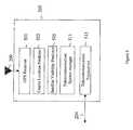
- FIG. 3is a block diagram illustrating major components of WGIS 205 in accordance with a first implementation of the present invention.
- WGIS 205comprises a GPS antenna 209 , a GPS receiver 301 , a coarse location predictor 303 , a satellite visibility predicator 305 , a Doppler predictor 307 , a code-phase predictor 309 , a telecommunication system manager 311 , and a telecommunication transceiver 313 .
- WGIS 205uses its GPS receiver 301 (or alternatively a network of GPS receivers (not shown)) to obtain from each satellite above the horizon both ranging information and information about the satellite's ephemeris, in well-known fashion using the Coarse Acquisition (C/A) code and possibly the Precision (P) code.
- C/ACoarse Acquisition
- PPrecision
- WGIS 205determines from its GPS receiver 301 , among other things: (1) the 50-bps modulated bit stream from each satellite, (2) the identity of satellites that are above the horizon (relative to the terminal), (3) the PN synchronization from each satellite (i.e., the exact timing of the PN code transmitted by each satellite), and (4) the Doppler shift associated with each satellite.
- WGIS 205When WGIS 205 is part of a wireless telecommunications system that partitions a geographic area into a number of tessellated areas called “cells,” WGIS 205 knows which cell wireless terminal 203 is in and, therefore, its location to within a few miles. Telecommunication system manager 311 informs coarse location predictor 303 of the cell in which wireless terminal 203 is located. Coarse location predictor 303 uses the information from telecommunications system manager 311 to predict the latitude and longitude of the location of wireless terminal 203 .
- GPS receiver 301For each GPS signal from a satellite 101 above the horizon, GPS receiver 301 determines the signal's exact time of arrival (i.e., its PN synchronization). GPS receiver 301 demodulates each acquired signal to recover its 50-bps modulated bit stream. Satellite visibility predictor 305 extracts satellite ephemeris information from the received modulated bit streams and estimates which satellites are visible to wireless terminal 203 at its location based on the predicted latitude and longitude generated by coarse location predictor 303 . Doppler predictor 307 predicts a Doppler frequency for wireless terminal 203 based on the predicted latitude and latitude of the wireless terminal. In a similar manner, code-phase predictor 309 predicts a code phase for wireless terminal 203 based on the satellite ephemeris information extracted from the 50-bps modulated bit stream.
- telecommunications transceiver 313transmits to wireless terminal 203 over a telecommunications channel 204 : (1) the predicted code phase, (2) the predicted Doppler frequency, and (3) the demodulated 50-bps modulated bit stream. Collectively, this information is known as “Navigation Message Data.”
- FIG. 4is a block diagram illustrating major components of wireless terminal 203 , which comprises: a GPS antenna 207 , a GPS receiver 401 , a processor 403 , a timing calibrator 405 , and a telecommunication transceiver 407 .
- wireless terminal 203is capable of performing all of the functionality associated with a typical wireless terminal (e.g., a cellular telephone).
- wireless terminalis preferably capable of having bi-directional communication capabilities with WGIS 205 .
- the Navigation Message Data transmitted from WGIS 205is received by wireless terminal 203 via telecommunication transceiver 407 , which passes the Navigation Message Data to processor 403 .
- Wireless terminal 203also receives the direct sequence spread spectrum C/A code signals from the visible satellites via GPS receiver 401 . Wireless terminal 203 then detects one of the GPS signals utilizing a conventional frequency-domain code acquisition technique aided by the satellite Doppler frequency provided by WGIS 205 .
- Processor 403computes the actual code phase associated with the detected GPS signal. Processor 403 then compares the actual code phase to the predicted code phase supplied by WGIS 205 to compute the difference between the actual code phase and the predicted code phase. Processor 405 then converts the difference between the code phases to time units and forwards that information to timing calibrator 405 . Timing calibrator 405 adjusts the timing of a local clock maintained in the wireless terminal by the calculated time units to create a precise timing reference.
- the wireless terminalis then capable of utilizing time-domain code acquisition techniques to detect other GPS signals, which may correspond to the same satellite or different satellites.
- FIG. 5illustrates major components of WGIS 205 , in accordance with a second implementation of the present invention.
- WGIS 205comprises a GPS antenna 209 , a GPS receiver 501 , a coarse location predictor 503 , a satellite visibility predictor 505 , a telecommunication system manager 511 , and a telecommunication transceiver 513 , each of which performs functions analogous to the corresponding components of WGIS 205 in the first implementation of FIG. 3 .
- telecommunication transceiver 513forwards the demodulated 50-bps bit stream and predicted location of the wireless terminal to wireless terminal 203 via telecommunication link 204 .
- FIG. 6illustrates major components of wireless terminal 203 in accordance with the second embodiment of the present invention.
- Wireless terminal 203comprises a GPS antenna 207 , a GPS receiver 601 , a processor 603 , a timing calibrator 605 , a telecommunication transceiver 607 , a Doppler predictor 609 , and a code-phase predictor 611 .
- Telecommunication transceiver 607receives the demodulated 50-bps bit stream and approximate wireless terminal location from WGIS 205 , and predictors 609 and 611 utilize this information to predict a code phase and a Doppler frequency, respectively.
- GPS receiver 601detects a GPS signal utilizing a frequency-domain code acquisition technique and forwards it to processor 603 , which determines an actual code phase.
- Processor 603compares the predicted code phase and the actual code phase to determine the difference between the code phases.
- Processor 603then converts the difference to time units and timing calibrator 605 creates a precise timing reference by adjusting the local clock in the wireless terminal.
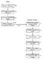
- FIG. 7is a flow-chart illustrating various steps involved in the acquisition of GPS signals in accordance with the first implementation of the present invention corresponding to FIGS. 3-4 .
- the WGISreceives a GPS signal (step 701 ) to determine the satellite's ephemeris information (step 703 ).
- the WGISalso computes an approximate position of the wireless terminal based on its cell and sector (step 705 ).
- the WGISpredicts a code phase and a Doppler frequency for the wireless terminal (step 707 ).
- the WGISthen forwards the predicted code phase and the predicted Doppler frequency to the wireless terminal (step 709 ).
- the wireless terminalreceives the predicted code phase and Doppler frequency and, by its GPS receiver, also detects the GPS signal from the corresponding satellite utilizing a frequency-domain code acquisition technique (step 711 ).
- the predicted Doppler frequencyhelps in the detection of the GPS signal.
- the wireless terminalthen computes an actual code phase associated with the detected GPS signal (step 713 ).
- the wireless terminalcompares the actual code phase and the predicted code phase to find a difference between the code phases (step 715 ).
- the wireless terminalconverts the +code phase difference to time units (step 717 ) and adjusts its timing by the computed time units to create a precise timing reference (step 719 ).
- the wireless terminalis then capable of detecting other GPS signals utilizing time-domain code acquisition techniques (step 721 ).
- the other GPS signalsmay correspond to the same satellite or different satellites.
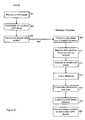
- FIG. 8illustrates the various steps involved in the second implementation of the present invention corresponding to FIGS. 5-6 .
- the WGISreceives a GPS signal (step 801 ) to determine the satellite's ephemeris information (step 803 ).
- the WGISalso computes an approximate position of the wireless terminal (step 805 ).
- the WGISthen forwards the satellite ephemeris and approximate position information to the wireless terminal (step 807 ).
- the wireless terminalutilizes the satellite ephemeris and the approximate position information to predict a code phase and a Doppler frequency (step 809 ).
- the wireless terminalalso detects a GPS signal using a frequency-domain code acquisition technique (step 811 ) and computes an actual code phase (step 813 ).
- Steps 815 - 821 in FIG. 8are similar to steps 715 - 721 in FIG. 7 , where the difference between the actual code phase and the predicted code phase is computed and a precise timing reference is created.
- the wireless terminalis then capable of detecting other GPS signals by utilizing time-domain code acquisition techniques.
- the WGISmay be said to transmit “timing reference assistance information” to the wireless terminal.
- the timing reference assistance informationcomprises a predicted code phase and a predicted Doppler frequency, where the WGIS has generated the predicted code phase and Doppler frequency from the approximate location of the wireless terminal.
- the timing reference assistance informationcomprises the approximate location of the wireless terminal, and the wireless terminal then generates the predicted code phase and Doppler frequency from the approximate location of the wireless terminal.
- One goal of the present inventionis to reduce signal acquisition and signal processing requirements of a conventional wireless terminal so that a wireless terminal in accordance with the present invention can determine its location more quickly and with weaker GPS signals than wireless terminals in the prior art.
Landscapes
- Engineering & Computer Science (AREA)
- Radar, Positioning & Navigation (AREA)
- Remote Sensing (AREA)
- Computer Networks & Wireless Communication (AREA)
- Physics & Mathematics (AREA)
- General Physics & Mathematics (AREA)
- Position Fixing By Use Of Radio Waves (AREA)
Abstract
Description
Claims (28)
Priority Applications (9)
| Application Number | Priority Date | Filing Date | Title |
|---|---|---|---|
| US09/564,096US6922546B1 (en) | 2000-05-03 | 2000-05-03 | GPS signal acquisition based on frequency-domain and time-domain processing |
| CA002340519ACA2340519C (en) | 2000-05-03 | 2001-03-13 | Fast gps signal acquisition in gps systems |
| EP01303678AEP1152255B8 (en) | 2000-05-03 | 2001-04-23 | Fast GPS signal acquisition in GPS systems |
| AT01303678TATE501447T1 (en) | 2000-05-03 | 2001-04-23 | FAST GPS SIGNAL CAPTURE IN A GPS SYSTEM |
| DE60144168TDE60144168D1 (en) | 2000-05-03 | 2001-04-23 | Fast GPS signal acquisition in a GPS system |
| BR0101555-9ABR0101555A (en) | 2000-05-03 | 2001-04-24 | Fast gps signal acquisition in gps systems |
| CN01117214ACN1323991A (en) | 2000-05-03 | 2001-04-25 | Method for quickly catching GPS signal from GPS system |
| JP2001131568AJP4903950B2 (en) | 2000-05-03 | 2001-04-27 | Method for detecting multiple signals from a satellite |
| KR1020010023956AKR100787509B1 (en) | 2000-05-03 | 2001-05-03 | Fast GPS Signal Acquisition in a GPS System |
Applications Claiming Priority (1)
| Application Number | Priority Date | Filing Date | Title |
|---|---|---|---|
| US09/564,096US6922546B1 (en) | 2000-05-03 | 2000-05-03 | GPS signal acquisition based on frequency-domain and time-domain processing |
Publications (1)
| Publication Number | Publication Date |
|---|---|
| US6922546B1true US6922546B1 (en) | 2005-07-26 |
Family
ID=24253134
Family Applications (1)
| Application Number | Title | Priority Date | Filing Date |
|---|---|---|---|
| US09/564,096Expired - LifetimeUS6922546B1 (en) | 2000-05-03 | 2000-05-03 | GPS signal acquisition based on frequency-domain and time-domain processing |
Country Status (9)
| Country | Link |
|---|---|
| US (1) | US6922546B1 (en) |
| EP (1) | EP1152255B8 (en) |
| JP (1) | JP4903950B2 (en) |
| KR (1) | KR100787509B1 (en) |
| CN (1) | CN1323991A (en) |
| AT (1) | ATE501447T1 (en) |
| BR (1) | BR0101555A (en) |
| CA (1) | CA2340519C (en) |
| DE (1) | DE60144168D1 (en) |
Cited By (22)
| Publication number | Priority date | Publication date | Assignee | Title |
|---|---|---|---|---|
| US20030176969A1 (en)* | 2000-07-13 | 2003-09-18 | Diggelen Frank Van | Method and apparatus for locating mobile receivers using a wide area reference network for propagating ephemeris |
| US20050037764A1 (en)* | 2000-12-19 | 2005-02-17 | Eyal Trachtman | Cellular channel allocation scheme with multi-user detection |
| US20080059059A1 (en)* | 2006-05-18 | 2008-03-06 | Cohen Clark E | Generalized high performance navigation system |
| US20080106463A1 (en)* | 2001-06-06 | 2008-05-08 | Diggelen Frank V | Method and apparatus for background decoding of a satellite navigation message to maintain integrity of long term orbit information in a remote receiver |
| US20080123718A1 (en)* | 2005-10-28 | 2008-05-29 | Matsushita Electric Industrial Co., Ltd. | Positioning apparatus and control method thereof |
| US20080186229A1 (en)* | 2001-06-06 | 2008-08-07 | Van Diggelen Frank | Method and Apparatus for Monitoring Satellite-Constellation Configuration To Maintain Integrity of Long-Term-Orbit Information In A Remote Receiver |
| US20080273522A1 (en)* | 2007-05-01 | 2008-11-06 | Tao Luo | Generation and detection of synchronization signal in a wireless communication system |
| US20090153399A1 (en)* | 1999-04-23 | 2009-06-18 | Charles Abraham | Method and apparatus for processing satellite positioning system signals |
| US20090315769A1 (en)* | 2008-05-30 | 2009-12-24 | Whelan David A | Internet hotspots localization using satellite systems |
| US20090315764A1 (en)* | 2008-05-30 | 2009-12-24 | The Boeing Company | Precise absolute time transfer from a satellite system |
| US20100054211A1 (en)* | 2008-08-27 | 2010-03-04 | Qualcomm Incorporated | Frequency domain pn sequence |
| US20100098136A1 (en)* | 2001-05-18 | 2010-04-22 | Charles Abraham | Method and apparatus for performing signal correlation at multiple resolutions to mitigate multipath interference |
| US20100117884A1 (en)* | 2008-11-11 | 2010-05-13 | Qualcomm Incorporated | Method for performing consistency checks for multiple signals received from a transmitter |
| US20100171652A1 (en)* | 2009-01-06 | 2010-07-08 | Gutt Gregory M | Local clock frequency calibration using low earth orbit (leo) satellites |
| US20100302099A1 (en)* | 2008-02-13 | 2010-12-02 | Grossnickle Peter C | System and method for geo-locating a receiver with reduced power consumption |
| US7852264B2 (en) | 2008-04-18 | 2010-12-14 | Honeywell, Spol. S.R.O. | Systems and methods for fast GNSS signals acquisition |
| US8472503B2 (en) | 2003-10-22 | 2013-06-25 | Global Locate, Inc. | Method and apparatus for performing frequency synchronization |
| US8542147B2 (en) | 2008-05-30 | 2013-09-24 | The Boeing Company | Precise absolute time transfer from a satellite system |
| JP2015121548A (en)* | 2003-04-25 | 2015-07-02 | クゥアルコム・インコーポレイテッドQualcomm Incorporated | System and method to obtain signal acquisition assistance data |
| US20200264317A1 (en)* | 2016-03-24 | 2020-08-20 | Focal Point Positioning Limited | Method and system for calibrating a system parameter |
| USRE48176E1 (en) | 2001-07-25 | 2020-08-25 | Avago Technologies International Sales Pte. Limited | Method and apparatus for generating and distributing satellite tracking information in a compact format |
| US11982753B2 (en) | 2017-09-26 | 2024-05-14 | Focal Point Positioning Limited | Method and system for calibrating a system parameter |
Families Citing this family (10)
| Publication number | Priority date | Publication date | Assignee | Title |
|---|---|---|---|---|
| JP2003139841A (en)* | 2001-10-31 | 2003-05-14 | Hitachi Ltd | Mobile terminal with built-in GPS |
| WO2004063761A2 (en)* | 2003-01-09 | 2004-07-29 | Mobile Satellite Ventures Lp | Network-assisted global positioning systems, methods and terminals including doppler shift and code phase estimates |
| US7256733B2 (en)* | 2004-10-21 | 2007-08-14 | Qualcomm Incorporated | Method and system for positioning signal acquisition assistance window evaluation |
| CN101577604B (en)* | 2006-07-20 | 2012-08-22 | 上海高清数字科技产业有限公司 | PN carrier acquisition device and method |
| CN101424731B (en)* | 2007-10-31 | 2011-11-23 | 中国科学院微电子研究所 | Method for quick recapture and positioning under condition of global positioning system receiver signal loss |
| CN101424736B (en)* | 2007-10-31 | 2011-11-23 | 中国科学院微电子研究所 | Method for quick starting and positioning receiver in global positioning system |
| US8237610B2 (en) | 2008-06-13 | 2012-08-07 | Qualcomm Incorporated | Methods and apparatuses for requesting/providing code phase related information associated with various satellite positioning systems in wireless communication networks |
| CN103630916B (en)* | 2013-11-29 | 2017-04-26 | 西安电子科技大学昆山创新研究院 | Code capturing method based on dual-FFT frequency domain filtering |
| JP6768532B2 (en)* | 2017-01-05 | 2020-10-14 | 株式会社日立産機システム | Positioning system and positioning method |
| CN111142132B (en)* | 2018-11-05 | 2022-04-01 | 深圳华大北斗科技股份有限公司 | Receiver pulling method and device, computer equipment and storage medium |
Citations (25)
| Publication number | Priority date | Publication date | Assignee | Title |
|---|---|---|---|---|
| US4445118A (en)* | 1981-05-22 | 1984-04-24 | The United States Of America As Represented By The Administrator Of The National Aeronautics And Space Administration | Navigation system and method |
| US4998111A (en)* | 1989-11-27 | 1991-03-05 | Motorola, Inc. | CPS transform correlation receiver and method |
| US5175557A (en)* | 1991-07-18 | 1992-12-29 | Motorola, Inc. | Two channel global positioning system receiver |
| US5365450A (en) | 1992-12-17 | 1994-11-15 | Stanford Telecommunications, Inc. | Hybrid GPS/data line unit for rapid, precise, and robust position determination |
| US5418538A (en) | 1993-05-21 | 1995-05-23 | Trimble Navigation Limited | Rapid satellite signal acquisition in a satellite positioning system |
| US5559520A (en)* | 1994-09-26 | 1996-09-24 | Lucent Technologies Inc. | Wireless information system for acquiring location related information |
| US5615236A (en)* | 1995-03-29 | 1997-03-25 | Trimble Navigation Limited | Method and apparatus for direct re-acquisition of precision-code after a short power interruption |
| USRE35498E (en)* | 1990-02-28 | 1997-04-29 | U.S. Philips Corporation | Vehicle location system |
| US5663735A (en)* | 1996-05-20 | 1997-09-02 | Trimble Navigation Limited | GPS receiver using a radio signal for improving time to first fix |
| US5798732A (en)* | 1996-09-19 | 1998-08-25 | Trimble Navigation Limited | GPS receiver having a fast time to first fix |
| US5857155A (en)* | 1996-07-10 | 1999-01-05 | Motorola, Inc. | Method and apparatus for geographic based control in a communication system |
| CA2306380A1 (en) | 1997-10-15 | 1999-04-22 | Ericsson, Inc. | Reduced global positioning system receiver code shift search space for a cellular telephone system |
| US6028887A (en)* | 1996-07-12 | 2000-02-22 | General Electric Company | Power efficient receiver |
| WO2000014568A1 (en) | 1998-09-09 | 2000-03-16 | Qualcomm Incorporated | Simplified receiver with rotator for performing position location |
| WO2000021223A2 (en) | 1998-10-06 | 2000-04-13 | Ericsson Inc. | Method and apparatus to communicate auxiliary and location information between cellular telephone network and global positioning system |
| US6075987A (en)* | 1998-02-27 | 2000-06-13 | Ericsson Inc. | Stand alone global positioning system (GPS) and method with high sensitivity |
| US6101178A (en)* | 1997-07-10 | 2000-08-08 | Ksi Inc. | Pseudolite-augmented GPS for locating wireless telephones |
| US6114991A (en)* | 1997-09-11 | 2000-09-05 | Lucent Technologies, Inc. | Auxiliary system for assisting a wireless terminal in determining its position from signals transmitted from a navigation satellite |
| US6121923A (en) | 1999-02-19 | 2000-09-19 | Motorola, Inc. | Fixed site and satellite data-aided GPS signal acquisition method and system |
| US6256475B1 (en)* | 1997-09-11 | 2001-07-03 | Lucent Technologies, Inc. | Telecommunications-assisted satellite positioning system |
| WO2001084080A1 (en) | 2000-04-28 | 2001-11-08 | Sirf Technology, Inc. | Global positioning system tag system |
| US6320536B1 (en)* | 1999-04-26 | 2001-11-20 | Matsushita Electric Industrial Co., Ltd. | GPS receiver |
| US6430415B1 (en)* | 1999-03-29 | 2002-08-06 | Qualcomm Incorporated | Method and apparatus for locating GPS equipped wireless devices operating in analog mode |
| US6538600B1 (en)* | 1998-10-16 | 2003-03-25 | Lucent Technologies Inc. | Wireless assisted GPS using a reference location |
| US6560536B1 (en)* | 1999-07-12 | 2003-05-06 | Eagle-Eye, Inc. | System and method for rapid telepositioning |
Family Cites Families (6)
| Publication number | Priority date | Publication date | Assignee | Title |
|---|---|---|---|---|
| US6208290B1 (en)* | 1996-03-08 | 2001-03-27 | Snaptrack, Inc. | GPS receiver utilizing a communication link |
| US5874914A (en)* | 1995-10-09 | 1999-02-23 | Snaptrack, Inc. | GPS receiver utilizing a communication link |
| US6078284A (en)* | 1996-09-30 | 2000-06-20 | Qualcomm Incorporated | Passive position determination using two low-earth orbit satellites |
| US6169731B1 (en)* | 1998-03-10 | 2001-01-02 | Motorola, Inc. | Method and apparatus for signal acquisition and power control |
| US6327473B1 (en)* | 1998-09-08 | 2001-12-04 | Qualcomm Incorporated | Method and apparatus for increasing the sensitivity of a global positioning satellite receiver |
| GB0009830D0 (en)* | 2000-04-25 | 2000-06-07 | Koninkl Philips Electronics Nv | Time of arrival estimation for positioning systems |
- 2000
- 2000-05-03USUS09/564,096patent/US6922546B1/ennot_activeExpired - Lifetime
- 2001
- 2001-03-13CACA002340519Apatent/CA2340519C/ennot_activeExpired - Fee Related
- 2001-04-23DEDE60144168Tpatent/DE60144168D1/ennot_activeExpired - Lifetime
- 2001-04-23ATAT01303678Tpatent/ATE501447T1/ennot_activeIP Right Cessation
- 2001-04-23EPEP01303678Apatent/EP1152255B8/ennot_activeExpired - Lifetime
- 2001-04-24BRBR0101555-9Apatent/BR0101555A/ennot_activeApplication Discontinuation
- 2001-04-25CNCN01117214Apatent/CN1323991A/enactivePending
- 2001-04-27JPJP2001131568Apatent/JP4903950B2/ennot_activeExpired - Fee Related
- 2001-05-03KRKR1020010023956Apatent/KR100787509B1/ennot_activeExpired - Fee Related
Patent Citations (25)
| Publication number | Priority date | Publication date | Assignee | Title |
|---|---|---|---|---|
| US4445118A (en)* | 1981-05-22 | 1984-04-24 | The United States Of America As Represented By The Administrator Of The National Aeronautics And Space Administration | Navigation system and method |
| US4998111A (en)* | 1989-11-27 | 1991-03-05 | Motorola, Inc. | CPS transform correlation receiver and method |
| USRE35498E (en)* | 1990-02-28 | 1997-04-29 | U.S. Philips Corporation | Vehicle location system |
| US5175557A (en)* | 1991-07-18 | 1992-12-29 | Motorola, Inc. | Two channel global positioning system receiver |
| US5365450A (en) | 1992-12-17 | 1994-11-15 | Stanford Telecommunications, Inc. | Hybrid GPS/data line unit for rapid, precise, and robust position determination |
| US5418538A (en) | 1993-05-21 | 1995-05-23 | Trimble Navigation Limited | Rapid satellite signal acquisition in a satellite positioning system |
| US5559520A (en)* | 1994-09-26 | 1996-09-24 | Lucent Technologies Inc. | Wireless information system for acquiring location related information |
| US5615236A (en)* | 1995-03-29 | 1997-03-25 | Trimble Navigation Limited | Method and apparatus for direct re-acquisition of precision-code after a short power interruption |
| US5663735A (en)* | 1996-05-20 | 1997-09-02 | Trimble Navigation Limited | GPS receiver using a radio signal for improving time to first fix |
| US5857155A (en)* | 1996-07-10 | 1999-01-05 | Motorola, Inc. | Method and apparatus for geographic based control in a communication system |
| US6028887A (en)* | 1996-07-12 | 2000-02-22 | General Electric Company | Power efficient receiver |
| US5798732A (en)* | 1996-09-19 | 1998-08-25 | Trimble Navigation Limited | GPS receiver having a fast time to first fix |
| US6101178A (en)* | 1997-07-10 | 2000-08-08 | Ksi Inc. | Pseudolite-augmented GPS for locating wireless telephones |
| US6256475B1 (en)* | 1997-09-11 | 2001-07-03 | Lucent Technologies, Inc. | Telecommunications-assisted satellite positioning system |
| US6114991A (en)* | 1997-09-11 | 2000-09-05 | Lucent Technologies, Inc. | Auxiliary system for assisting a wireless terminal in determining its position from signals transmitted from a navigation satellite |
| CA2306380A1 (en) | 1997-10-15 | 1999-04-22 | Ericsson, Inc. | Reduced global positioning system receiver code shift search space for a cellular telephone system |
| US6075987A (en)* | 1998-02-27 | 2000-06-13 | Ericsson Inc. | Stand alone global positioning system (GPS) and method with high sensitivity |
| WO2000014568A1 (en) | 1998-09-09 | 2000-03-16 | Qualcomm Incorporated | Simplified receiver with rotator for performing position location |
| WO2000021223A2 (en) | 1998-10-06 | 2000-04-13 | Ericsson Inc. | Method and apparatus to communicate auxiliary and location information between cellular telephone network and global positioning system |
| US6538600B1 (en)* | 1998-10-16 | 2003-03-25 | Lucent Technologies Inc. | Wireless assisted GPS using a reference location |
| US6121923A (en) | 1999-02-19 | 2000-09-19 | Motorola, Inc. | Fixed site and satellite data-aided GPS signal acquisition method and system |
| US6430415B1 (en)* | 1999-03-29 | 2002-08-06 | Qualcomm Incorporated | Method and apparatus for locating GPS equipped wireless devices operating in analog mode |
| US6320536B1 (en)* | 1999-04-26 | 2001-11-20 | Matsushita Electric Industrial Co., Ltd. | GPS receiver |
| US6560536B1 (en)* | 1999-07-12 | 2003-05-06 | Eagle-Eye, Inc. | System and method for rapid telepositioning |
| WO2001084080A1 (en) | 2000-04-28 | 2001-11-08 | Sirf Technology, Inc. | Global positioning system tag system |
Cited By (42)
| Publication number | Priority date | Publication date | Assignee | Title |
|---|---|---|---|---|
| US20090153399A1 (en)* | 1999-04-23 | 2009-06-18 | Charles Abraham | Method and apparatus for processing satellite positioning system signals |
| US20060271293A1 (en)* | 2000-07-13 | 2006-11-30 | Global Locate, Inc. | Method And Apparatus For Locating Mobile Receivers Using A Wide Area Reference Network For Propagating Ephemeris |
| US8930137B2 (en) | 2000-07-13 | 2015-01-06 | Global Locate, Inc. | Method and apparatus for locating mobile receivers using a wide area reference network for propagating ephemeris |
| US9599720B2 (en) | 2000-07-13 | 2017-03-21 | Broadcom Corporation | Method and apparatus for locating mobile receivers using a wide area reference network for propagating ephemeris |
| US20030176969A1 (en)* | 2000-07-13 | 2003-09-18 | Diggelen Frank Van | Method and apparatus for locating mobile receivers using a wide area reference network for propagating ephemeris |
| US20050037764A1 (en)* | 2000-12-19 | 2005-02-17 | Eyal Trachtman | Cellular channel allocation scheme with multi-user detection |
| US7818009B2 (en)* | 2000-12-19 | 2010-10-19 | Inmarsat Global Limited | Cellular channel allocation scheme with multi-user detection |
| US20100098136A1 (en)* | 2001-05-18 | 2010-04-22 | Charles Abraham | Method and apparatus for performing signal correlation at multiple resolutions to mitigate multipath interference |
| US8411726B2 (en) | 2001-05-18 | 2013-04-02 | Global Locate, Inc. | Method and apparatus for performing signal correlation at multiple resolutions to mitigate multipath interference |
| US20080106463A1 (en)* | 2001-06-06 | 2008-05-08 | Diggelen Frank V | Method and apparatus for background decoding of a satellite navigation message to maintain integrity of long term orbit information in a remote receiver |
| US20080186229A1 (en)* | 2001-06-06 | 2008-08-07 | Van Diggelen Frank | Method and Apparatus for Monitoring Satellite-Constellation Configuration To Maintain Integrity of Long-Term-Orbit Information In A Remote Receiver |
| US8212719B2 (en) | 2001-06-06 | 2012-07-03 | Global Locate, Inc. | Method and apparatus for background decoding of a satellite navigation message to maintain integrity of long term orbit information in a remote receiver |
| USRE48176E1 (en) | 2001-07-25 | 2020-08-25 | Avago Technologies International Sales Pte. Limited | Method and apparatus for generating and distributing satellite tracking information in a compact format |
| JP2015121548A (en)* | 2003-04-25 | 2015-07-02 | クゥアルコム・インコーポレイテッドQualcomm Incorporated | System and method to obtain signal acquisition assistance data |
| US8472503B2 (en) | 2003-10-22 | 2013-06-25 | Global Locate, Inc. | Method and apparatus for performing frequency synchronization |
| US8989236B2 (en) | 2003-10-22 | 2015-03-24 | Global Locate, Inc. | Method and apparatus for performing frequency synchronization |
| US20080123718A1 (en)* | 2005-10-28 | 2008-05-29 | Matsushita Electric Industrial Co., Ltd. | Positioning apparatus and control method thereof |
| US20080059059A1 (en)* | 2006-05-18 | 2008-03-06 | Cohen Clark E | Generalized high performance navigation system |
| US8296051B2 (en) | 2006-05-18 | 2012-10-23 | The Boeing Company | Generalized high performance navigation system |
| US8649401B2 (en) | 2007-05-01 | 2014-02-11 | Qualcomm Incorporated | Generation and detection of synchronization signal in a wireless communication system |
| US20080273522A1 (en)* | 2007-05-01 | 2008-11-06 | Tao Luo | Generation and detection of synchronization signal in a wireless communication system |
| US20100302099A1 (en)* | 2008-02-13 | 2010-12-02 | Grossnickle Peter C | System and method for geo-locating a receiver with reduced power consumption |
| US8009086B2 (en) | 2008-02-13 | 2011-08-30 | The United States Of America As Represented By The Secretary Of The Navy | System and method for geo-locating a receiver with reduced power consumption |
| US7852264B2 (en) | 2008-04-18 | 2010-12-14 | Honeywell, Spol. S.R.O. | Systems and methods for fast GNSS signals acquisition |
| US20090315764A1 (en)* | 2008-05-30 | 2009-12-24 | The Boeing Company | Precise absolute time transfer from a satellite system |
| US8179312B2 (en) | 2008-05-30 | 2012-05-15 | The Boeing Company | Precise absolute time transfer from a satellite system |
| US8035558B2 (en) | 2008-05-30 | 2011-10-11 | The Boeing Company | Precise absolute time transfer from a satellite system |
| US20110148701A1 (en)* | 2008-05-30 | 2011-06-23 | The Boeing Company | Precise Absolute Time Transfer From A Satellite System |
| US8542147B2 (en) | 2008-05-30 | 2013-09-24 | The Boeing Company | Precise absolute time transfer from a satellite system |
| US7952518B2 (en) | 2008-05-30 | 2011-05-31 | The Boeing Company | Internet hotspots localization using satellite systems |
| US20090315769A1 (en)* | 2008-05-30 | 2009-12-24 | Whelan David A | Internet hotspots localization using satellite systems |
| US20100054211A1 (en)* | 2008-08-27 | 2010-03-04 | Qualcomm Incorporated | Frequency domain pn sequence |
| US20100117884A1 (en)* | 2008-11-11 | 2010-05-13 | Qualcomm Incorporated | Method for performing consistency checks for multiple signals received from a transmitter |
| US20100171652A1 (en)* | 2009-01-06 | 2010-07-08 | Gutt Gregory M | Local clock frequency calibration using low earth orbit (leo) satellites |
| US7859455B2 (en)* | 2009-01-06 | 2010-12-28 | The Boeing Company | Local clock frequency calibration using low earth orbit (LEO) satellites |
| US20200264317A1 (en)* | 2016-03-24 | 2020-08-20 | Focal Point Positioning Limited | Method and system for calibrating a system parameter |
| US20220350036A9 (en)* | 2016-03-24 | 2022-11-03 | Focal Point Positioning Limited | Method and system for calibrating a system parameter |
| US11808865B2 (en)* | 2016-03-24 | 2023-11-07 | Focal Point Positioning Limited | Method and system for calibrating a system parameter |
| US12135380B2 (en) | 2016-03-24 | 2024-11-05 | Focal Point Positioning Limited | Method and system for calibrating a system parameter |
| US12270920B2 (en) | 2016-03-24 | 2025-04-08 | Focal Point Positioning Limited | Method and system for calibrating a system parameter |
| US12436299B2 (en) | 2016-03-24 | 2025-10-07 | Focal Point Positioning Limited | Method and system for calibrating a system parameter |
| US11982753B2 (en) | 2017-09-26 | 2024-05-14 | Focal Point Positioning Limited | Method and system for calibrating a system parameter |
Also Published As
| Publication number | Publication date |
|---|---|
| CA2340519C (en) | 2005-06-07 |
| JP4903950B2 (en) | 2012-03-28 |
| EP1152255B8 (en) | 2011-05-04 |
| KR100787509B1 (en) | 2007-12-26 |
| BR0101555A (en) | 2002-01-02 |
| CN1323991A (en) | 2001-11-28 |
| ATE501447T1 (en) | 2011-03-15 |
| EP1152255A2 (en) | 2001-11-07 |
| DE60144168D1 (en) | 2011-04-21 |
| EP1152255A3 (en) | 2003-12-03 |
| CA2340519A1 (en) | 2001-11-03 |
| JP2002006023A (en) | 2002-01-09 |
| KR20010100969A (en) | 2001-11-14 |
| EP1152255B1 (en) | 2011-03-09 |
Similar Documents
| Publication | Publication Date | Title |
|---|---|---|
| US6922546B1 (en) | GPS signal acquisition based on frequency-domain and time-domain processing | |
| US6546040B1 (en) | GPS receiver having improved signal acquisition at a low signal to noise ratio | |
| US6285316B1 (en) | Locating a mobile unit using signals from both mobile beacons and stationary beacons | |
| US7579986B2 (en) | Method and system for all-in-view coherent GPS signal PRN codes acquisition and navigation solution determination | |
| KR100616247B1 (en) | Global Positioning System Receiver for Cellular Mobile Phone Systems with Reduced Codeshift Search Space | |
| US6965760B1 (en) | Satellite-based location system employing dynamic integration techniques | |
| US7463979B2 (en) | Method and apparatus for initializing an approximate position in a GPS receiver | |
| US6459405B1 (en) | Satellite-based location system employing knowledge-based sequential signal search strategy | |
| EP1148344A1 (en) | Positioning of a wireless terminal with satellite positioning signals or base station signals | |
| US6611756B1 (en) | Method for predicting navigation information in a global positioning system | |
| FI108171B (en) | Method for performing position determination and electronic device | |
| EP1160582A2 (en) | Method and device for determining the phase of information, and its use in a positioning system | |
| US8254512B2 (en) | Method and apparatus for increasing coherent integration length while receiving a positioning signal | |
| EP1115008B1 (en) | A method for determining reference time error and an electronic device | |
| US8144053B2 (en) | System and method for verifying consistent measurements in performing GPS positioning | |
| US20010004380A1 (en) | Method for synchronizing a receiver, a positioning system, a receiver and an electronic device | |
| US7142878B1 (en) | Method of timing calibration | |
| US6985542B1 (en) | Coherent processing of satellite signals to locate a mobile unit | |
| JP5302902B2 (en) | Method and system for capturing GPS signals and quickly determining the location of a user receiver | |
| US8238411B2 (en) | Acquisition of a code modulated signal | |
| EP1107017A2 (en) | A method of timing calibration | |
| EP1229341B1 (en) | A method for defining the error of reference time and an electronic device | |
| EP2003469B1 (en) | A method for performing positioning and an electronic device | |
| EP1365254A1 (en) | A method of aligning predicted navigation information |
Legal Events
| Date | Code | Title | Description |
|---|---|---|---|
| AS | Assignment | Owner name:LUCENT TEECHNOLOGIES INC., NEW JERSEY Free format text:ASSIGNMENT OF ASSIGNORS INTEREST;ASSIGNORS:DA, REN;VANNUCCI, GIOVANNI;REEL/FRAME:010780/0715 Effective date:20000502 | |
| FEPP | Fee payment procedure | Free format text:PAYOR NUMBER ASSIGNED (ORIGINAL EVENT CODE: ASPN); ENTITY STATUS OF PATENT OWNER: LARGE ENTITY | |
| STCF | Information on status: patent grant | Free format text:PATENTED CASE | |
| FPAY | Fee payment | Year of fee payment:4 | |
| FPAY | Fee payment | Year of fee payment:8 | |
| AS | Assignment | Owner name:CREDIT SUISSE AG, NEW YORK Free format text:SECURITY INTEREST;ASSIGNOR:ALCATEL-LUCENT USA INC.;REEL/FRAME:030510/0627 Effective date:20130130 | |
| AS | Assignment | Owner name:ALCATEL-LUCENT USA INC., NEW JERSEY Free format text:RELEASE BY SECURED PARTY;ASSIGNOR:CREDIT SUISSE AG;REEL/FRAME:033950/0001 Effective date:20140819 | |
| FPAY | Fee payment | Year of fee payment:12 | |
| AS | Assignment | Owner name:ALCATEL-LUCENT USA INC., NEW JERSEY Free format text:MERGER AND CHANGE OF NAME;ASSIGNORS:LUCENT TECHNOLOGIES INC.;ALCATEL USA MARKETING, INC.;ALCATEL USA SOURCING, INC.;AND OTHERS;REEL/FRAME:046313/0453 Effective date:20081101 |