US6898516B2 - Navigation system using corridor maps - Google Patents
Navigation system using corridor mapsDownload PDFInfo
- Publication number
- US6898516B2 US6898516B2US10/426,946US42694603AUS6898516B2US 6898516 B2US6898516 B2US 6898516B2US 42694603 AUS42694603 AUS 42694603AUS 6898516 B2US6898516 B2US 6898516B2
- Authority
- US
- United States
- Prior art keywords
- map
- client device
- route
- user
- server
- Prior art date
- Legal status (The legal status is an assumption and is not a legal conclusion. Google has not performed a legal analysis and makes no representation as to the accuracy of the status listed.)
- Expired - Lifetime, expires
Links
- 238000000034methodMethods0.000claims28
- 230000001413cellular effectEffects0.000claims12
- 238000009877renderingMethods0.000claims11
- 230000004044responseEffects0.000claims5
- 230000001131transforming effectEffects0.000claims4
- 238000013507mappingMethods0.000claims3
- 230000001755vocal effectEffects0.000claims3
Images


Classifications
- G—PHYSICS
- G01—MEASURING; TESTING
- G01C—MEASURING DISTANCES, LEVELS OR BEARINGS; SURVEYING; NAVIGATION; GYROSCOPIC INSTRUMENTS; PHOTOGRAMMETRY OR VIDEOGRAMMETRY
- G01C21/00—Navigation; Navigational instruments not provided for in groups G01C1/00 - G01C19/00
- G01C21/26—Navigation; Navigational instruments not provided for in groups G01C1/00 - G01C19/00 specially adapted for navigation in a road network
- G01C21/34—Route searching; Route guidance
- G01C21/36—Input/output arrangements for on-board computers
- G01C21/3679—Retrieval, searching and output of POI information, e.g. hotels, restaurants, shops, filling stations, parking facilities
- G01C21/3682—Retrieval, searching and output of POI information, e.g. hotels, restaurants, shops, filling stations, parking facilities output of POI information on a road map
- G—PHYSICS
- G01—MEASURING; TESTING
- G01C—MEASURING DISTANCES, LEVELS OR BEARINGS; SURVEYING; NAVIGATION; GYROSCOPIC INSTRUMENTS; PHOTOGRAMMETRY OR VIDEOGRAMMETRY
- G01C21/00—Navigation; Navigational instruments not provided for in groups G01C1/00 - G01C19/00
- G01C21/26—Navigation; Navigational instruments not provided for in groups G01C1/00 - G01C19/00 specially adapted for navigation in a road network
- G01C21/34—Route searching; Route guidance
- G01C21/36—Input/output arrangements for on-board computers
- G01C21/3605—Destination input or retrieval
- G01C21/3611—Destination input or retrieval using character input or menus, e.g. menus of POIs
- G—PHYSICS
- G01—MEASURING; TESTING
- G01C—MEASURING DISTANCES, LEVELS OR BEARINGS; SURVEYING; NAVIGATION; GYROSCOPIC INSTRUMENTS; PHOTOGRAMMETRY OR VIDEOGRAMMETRY
- G01C21/00—Navigation; Navigational instruments not provided for in groups G01C1/00 - G01C19/00
- G01C21/26—Navigation; Navigational instruments not provided for in groups G01C1/00 - G01C19/00 specially adapted for navigation in a road network
- G01C21/34—Route searching; Route guidance
- G01C21/36—Input/output arrangements for on-board computers
- G01C21/3667—Display of a road map
- G—PHYSICS
- G01—MEASURING; TESTING
- G01C—MEASURING DISTANCES, LEVELS OR BEARINGS; SURVEYING; NAVIGATION; GYROSCOPIC INSTRUMENTS; PHOTOGRAMMETRY OR VIDEOGRAMMETRY
- G01C21/00—Navigation; Navigational instruments not provided for in groups G01C1/00 - G01C19/00
- G01C21/26—Navigation; Navigational instruments not provided for in groups G01C1/00 - G01C19/00 specially adapted for navigation in a road network
- G01C21/34—Route searching; Route guidance
- G01C21/36—Input/output arrangements for on-board computers
- G01C21/3679—Retrieval, searching and output of POI information, e.g. hotels, restaurants, shops, filling stations, parking facilities
- G—PHYSICS
- G01—MEASURING; TESTING
- G01C—MEASURING DISTANCES, LEVELS OR BEARINGS; SURVEYING; NAVIGATION; GYROSCOPIC INSTRUMENTS; PHOTOGRAMMETRY OR VIDEOGRAMMETRY
- G01C21/00—Navigation; Navigational instruments not provided for in groups G01C1/00 - G01C19/00
- G01C21/38—Electronic maps specially adapted for navigation; Updating thereof
- G01C21/3885—Transmission of map data to client devices; Reception of map data by client devices
- G01C21/3889—Transmission of selected map data, e.g. depending on route
- G—PHYSICS
- G01—MEASURING; TESTING
- G01C—MEASURING DISTANCES, LEVELS OR BEARINGS; SURVEYING; NAVIGATION; GYROSCOPIC INSTRUMENTS; PHOTOGRAMMETRY OR VIDEOGRAMMETRY
- G01C21/00—Navigation; Navigational instruments not provided for in groups G01C1/00 - G01C19/00
- G01C21/26—Navigation; Navigational instruments not provided for in groups G01C1/00 - G01C19/00 specially adapted for navigation in a road network
- G01C21/28—Navigation; Navigational instruments not provided for in groups G01C1/00 - G01C19/00 specially adapted for navigation in a road network with correlation of data from several navigational instruments
- G01C21/30—Map- or contour-matching
Definitions
- the present inventionrelates to data distribution and display systems and methodologies and more particularly to map data display systems and methodologies.
- GPSGlobal Positioning System
- In-vehicle navigation systemsfall into two general categories: “on-board” systems, in which the map data are stored electronically in the vehicle (typically on optical or magnetic media); and “off-board” systems, in which the map data are furnished by a remote map server. These systems typically use a client program running on a smart cellular telephone or personal digital assistant (PDA) in the vehicle to retrieve information from the server over a wireless link, and to display maps and provide navigation instructions to the driver.
- PDApersonal digital assistant
- Embodiments of the present inventionprovide improved methods and systems for off-board mapping and navigation. These methods and systems permit rich, dynamic information to be downloaded rapidly and efficiently from a mapping server over a low-speed wireless link to a client device, typically a PDA or cellular telephone. Such wireless links are typically characterized by bandwidths below 10 kbps. Novel methods of data processing, on both the server and client sides of the interaction, enable the client to display maps to the user with enhanced speed and clarity, notwithstanding the limited communication bandwidth and display capabilities of the client device.
- map dataare stored on the server and downloaded to the client in the form of vector data.
- the serverdetermines a route from a starting point to a destination specified by the client.
- the starting pointis the client's current position, while the destination is a map location or point of interest specified by the client.
- the route computed by the servercomprises a sequence of route segments, each of which has a respective length and heading angle.
- the serverthen defines a corridor map, made up of a sequence of map segments, each containing one or more of the route segments.
- the zoom level and orientation of each map segmentare determined by the length and heading angle of the respective route segment, so that in general, different segments have different zoom levels and heading angles.
- the map segmentsare downloaded from the server to the client device (in the form of vector data) in succession, as the client travels along the route.
- Constructing and downloading the corridor map in this fashionpresents the user of the client device with a sequence of maps that are easy to understand and follow, while minimizing the computational power and memory required to render the maps on the client device.
- Each segment mapis oriented approximately according to the client's current direction of travel, with a level of detail that corresponds roughly to the complexity of the driving maneuvers currently required.
- a method for displaying a map on a mobile client deviceincluding:
- map dataon a server, the map data defining objects appearing in the map and including vector coordinates of the objects in a predetermined frame of reference;
- downloading the portion of the map dataincludes defining a bounding box corresponding to the area of the map in the rotated frame of reference, and using the bounding box to crop the map data that are to be downloaded to the client device.
- defining the bounding box in the rotated frame of referenceincludes defining a first bounding box
- transforming the vector coordinatesincludes defining a second bounding box that contains the first bounding box in the first frame of reference, and rotating the vector coordinates of the objects in the second bounding box before cropping the map data in the rotated frame of reference.
- downloading the portion of the map dataincludes downloading the templates and the map data over a wireless link.
- the client deviceincludes at least one of a cellular telephone and a personal digital assistant (PDA), which communicates with the server over a cellular telephone network that includes the wireless link.
- PDApersonal digital assistant
- the methodmay also include downloading an applet from the server to the client device over the wireless link, for use by the client device in receiving the map data and rendering the image.
- the objects defined by the map datainclude roads
- the methodincludes finding approximate position coordinates of the user using a location providing device associated with the client device; receiving and correcting the approximate position coordinates in the client device, using the downloaded vector information, so as to determine a location of the user on one of the roads in the map; and displaying a navigation aid on the image of the area of the map based on the determined location.
- a method for displaying a map on a mobile client deviceincluding:
- map dataon a server, the map data including vector information delineating features in the map;
- the routeincluding a sequence of route segments, each route segment having a respective length and heading angle;
- the corridor mapincluding a plurality of map segments, each map segment containing a respective route segment and having a respective zoom level and orientation determined by the length and heading angle of the respective route segment;
- downloading the vector informationincludes downloading the map segments one after another in sequence as the user travels along the route, and defining the corridor map includes defining the map segments so that the map segments downloaded in the sequence include approximately equal amounts of the data.
- defining the corridor mapincludes cropping each of the map segments so as to include within the map segment the features in the map that fall within a predetermined distance of each of the route segments.
- the features included within the map segmentinclude crossroads that intersect the route, and wherein rendering the succession of the images includes, at the client device, detecting a deviation of the user from the route, and responsively to the deviation, displaying a return path to the route on one of the crossroads.
- determining the routeincludes receiving an input at the client device, the input including a string of characters entered by the user; conveying the string from the client device to the server; finding one or more destination names in a database accessed by the server, responsively to an approximate match between the string and the destination names; and returning the one or more destination names to the client device, so as to enable the user to select one of the destination names as the destination.
- determining the routeincludes receiving an input at the client device indicating a type of point of interest sought by a user of the client device; conveying the indicated type of the point of interest from the client device to the server; identifying names of one or more points of interest of the indicated type in a database accessed by the server; and returning the names of the one or more points of interest to the client device, so as to enable the user to select one of the points of interest as the destination.
- determining a location of the user using a location providing device associated with the client device, and rendering the succession of the imagesincludes indicating a location of the user on the map segments.
- the methodmay include, responsively to the location of the user, instructing the user to perform specified maneuvers along the route by at least one of providing verbal directions to the user and displaying maneuver maps on the client device.
- the vector informationincludes vector coordinates of the features in the map in a predetermined frame of reference
- downloading the vector informationincludes determining a heading of travel of the user on at least one of the route segments based on the location of the user; transforming on the server the vector coordinates of the features in at least one of the map segments that contains the at least one of the route segments into a rotated frame of reference, which is approximately aligned with the heading; and downloading to the client device from the server the vector information including the transformed vector coordinates of the features in the at least one of the map segments, so that the client device renders an image of the at least one of the map segments in the rotated frame of reference.
- the features delineated by the map datainclude roads, which include the route segments, and determining the location includes receiving approximate position coordinates from the location providing device, and correcting the approximate position coordinates in the client device using the downloaded vector information, so as to determine the location of the user on one of the roads in one of the map segments.
- the methodincludes receiving at the server, while the user travels along the route, dynamic information regarding a change in travel conditions in a vicinity of the route; submitting a request from the client device to the server for updated information regarding the route, the request specifying, based on the downloaded route and the location of the user, one or more of the route segments not yet traversed by the user; and determining at the server, based on the route segments specified by the client device and on the dynamic information received by the server, a modified route to the destination, wherein defining the corridor map includes modifying the corridor map in response to the modified route.
- apparatus for displaying a map on a mobile client deviceincluding:
- mapping serverwhich is adapted to store map data in the memory, the map data defining objects appearing in the map and including vector coordinates of the objects in a predetermined frame of reference,
- the serverbeing further adapted to receive a request from the client device to provide a map of an area along a route on which a user of the client device is to travel, to determine a heading of travel of the user on the route, to transform the vector coordinates into a rotated frame of reference, which is approximately aligned with the heading, and to download to the client device a portion of the map data corresponding to the area along the route and including the transformed vector coordinates, so as to cause the client device to render, based on the downloaded map data, an image of the area of the map in the rotated frame of reference.
- apparatus for displaying a map on a mobile client deviceincluding:
- mapping serverwhich is adapted to store map data in the memory, the map data including vector information delineating features in the map,
- the serverbeing further adapted to determine a route from a starting point to a destination within an area of the map, the route including a sequence of route segments, each route segment having a respective length and heading angle, and to define a corridor map on the server, the corridor map including a plurality of map segments, each map segment containing a respective route segment and having a respective zoom level and orientation determined by the length and heading angle of the respective route segment, and to download the vector information in the map segments to the client device, so as to cause the client device to render a succession of images of the map segments as a user of the client device travels along the route.
- a computer software productfor displaying a map on a mobile client device, the product including a computer-readable medium in which program instructions are stored, which instructions, when read by a computer, cause the computer to access map data in a memory, the map data defining objects appearing in the map and including vector coordinates of the objects in a predetermined frame of reference,
- the instructionsfurther causing the computer, upon receiving a request from the client device to provide a map of an area along a route on which a user of the client device is to travel, to perform the steps of determining a heading of travel of the user on the route, transforming the vector coordinates into a rotated frame of reference, which is approximately aligned with the heading, and downloading to the client device a portion of the map data corresponding to the area along the route and including the transformed vector coordinates, so as to cause the client device to render, based on the downloaded map data, an image of the area of the map in the rotated frame of reference.
- a computer software productfor displaying a map on a mobile client device, the product including a computer-readable medium in which program instructions are stored, which instructions, when read by a computer, cause the computer to access map data in a memory, the map data including vector information delineating features in the map, and to determine a route from a starting point to a destination within an area of the map, the route including a sequence of route segments, each route segment having a respective length and heading angle, and to define a corridor map on the server, the corridor map including a plurality of map segments, each map segment containing a respective route segment and having a respective zoom level and orientation determined by the length and heading angle of the respective route segment, and to download the vector information in the map segments to the client device, so as to cause the client device to render a succession of images of the map segments as a user of the client device travels along the route.
- a method for displaying a map on a mobile client deviceincluding:
- map dataon a server, the map data including vector information delineating features in the map;
- the corridor mapincluding a plurality of map segments, each map segment containing a respective route segment and including crossroads that intersect the respective route segment;
- apparatus for displaying a map on a mobile client deviceincluding:
- mapping serverwhich is adapted to store map data in the memory, the map data including vector information delineating features in the map,
- the serverbeing further adapted to determine a route from a starting point to a destination within an area of the map, the route including a sequence of route segments, and to define a corridor map on the server, the corridor map including a plurality of map segments, each map segment containing a respective route segment and including crossroads that intersect the respective route segment, and to download the vector information in the map segments to the client device, so as to cause the client device to render a succession of images of the map segments as a user of the client device travels along the route, and upon detecting a deviation of the user from the route, to display a return path to the route on one of the crossroads.
- a computer software productfor displaying a map on a mobile client device, the product including a computer-readable medium in which program instructions are stored, which instructions, when read by a computer, cause the computer to access map data in a memory, the map data including vector information delineating features in the map, and to determine a route from a starting point to a destination within an area of the map, the route including a sequence of route segments, and to define a corridor map on the server, the corridor map including a plurality of map segments, each map segment containing a respective route segment and including crossroads that intersect the respective route segment, and to download the vector information in the map segments to the client device, so as to cause the client device to render a succession of images of the map segments as a user of the client device travels along the route, and upon detecting a deviation of the user from the route, to display a return path to the route on one of the crossroads.
- FIG. 1is a simplified pictorial illustration of a real-time map distribution and display system constructed and operative in accordance with an embodiment of the present invention
- FIG. 2Ais a simplified pictorial illustration of a real-time map distribution and display system constructed and operative in accordance with another embodiment of the present invention
- FIGS. 2B-2Fare schematic representations of screens displayed on a client device in a vehicle, showing maps and directions generated by the system of FIG. 2A , in accordance with an embodiment of the present invention
- FIGS. 3-6are simplified pictorial illustrations of real-time map distribution and display systems constructed and operative in accordance with further embodiments of the present invention.
- FIG. 7is a simplified functional block diagram of a real-time map distribution and display system, in accordance with an embodiment of the present invention.
- FIG. 8Ais a block diagram that schematically shows details of a mapping server, in accordance with an embodiment of the present invention.
- FIG. 8Bis a block diagram that schematically shows details of a mapping client, in accordance with an embodiment of the present invention.
- FIG. 9is a block diagram that schematically illustrates data structures used for storing and rendering map data, in accordance with an embodiment of the present invention.
- FIG. 10Ais a block diagram that schematically illustrates further details of the data structures shown in FIG. 9 , in accordance with an embodiment of the present invention.
- FIG. 10Bis a schematic representation of a computer screen of a template editor, which is used in setting display properties of maps provided by a mapping server, in accordance with an embodiment of the present invention
- FIG. 11is a block diagram that schematically illustrates data structures used by a mapping server in searching for geographical data, in accordance with an embodiment of the present invention
- FIG. 12is a block diagram that schematically illustrates data structures used by a mapping server in providing route data, in accordance with an embodiment of the present invention
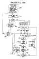
- FIG. 13is a flow chart that schematically illustrates a method for handling map requests submitted to a mapping server, in accordance with an embodiment of the present invention
- FIGS. 14A and 14Bare flow charts that schematically illustrate a method for cropping map data for transmission to a mapping client, in accordance with an embodiment of the present invention
- FIG. 15Ais a flow chart that schematically illustrates a method for searching for alphanumeric map data, in accordance with an embodiment of the present invention
- FIG. 15Bis a schematic representation of a screen displayed on a mobile device for enabling a user to select a destination location, in accordance with an embodiment of the present invention
- FIG. 16is a flow chart that schematically illustrates a method for handing route requests submitted to a mapping server, in accordance with an embodiment of the present invention
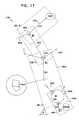
- FIG. 17is a graph that schematically illustrates elements of a route corridor map generated by a mobile device based on map data furnished by a mapping server, in accordance with an embodiment of the present invention
- FIG. 18is a flow chart that schematically illustrates a method for providing map data to accompany routing instructions, in accordance with another embodiment of the present invention.
- FIG. 19Ais a flow chart that schematically illustrates operation of a mapping client, in accordance with an embodiment of the present invention.
- FIGS. 19B-Dare schematic representations of screens displayed on a mobile device for enabling a user to select a destination location, in accordance with an embodiment of the present invention.
- FIG. 20Ais a flow chart that schematically illustrates a method for finding and displaying points of interest on a map, in accordance with an embodiment of the present invention
- FIGS. 20B and 20Care schematic representations of screens displayed on a mobile device for enabling a user to select a point of interest, in accordance with an embodiment of the present invention.
- FIGS. 21A and 21Bare flow charts that schematically illustrate a method for handling map data received by a mapping client from a mapping server, in accordance with an embodiment of the present invention.
- FIG. 1is a simplified pictorial illustration of a real-time map distribution and display system constructed and operative in accordance with an embodiment of the present invention.
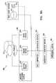
- a driver of a vehicle 100communicates via a wireless communicator, such as a conventional cellular telephone 102 , with a interactive voice response (IVR) processor 104 and through IVR 104 via the Internet with a map server 106 .
- IVRinteractive voice response
- the driverasks directions to the Empire State Building. In real time, preferably within four seconds or less, while driving, the driver receives the requested directions. More preferably, the directions are provided within two seconds, and most preferably, the directions are provided substantially immediately, i.e., within one second. In the illustration, the directions are requested by the driver and provided to the driver orally, typically using speech recognition and speech synthesis tools, as are known in the art. Alternatively or additionally the directions may be requested through a different modality, such as a keyed input to the wireless communicator, which may be sent to server 106 via a text messaging service, such as SMS, or a packet data protocol, such as TCP/IP, as described below. The directions may likewise be provided to telephone 102 by these means or through a different modality, such as a visually sensible map or written instructions. In such case, IVR 104 may be obviated.
- the cellular network of which cellular telephone 102 forms a partprovides a location determination functionality, supplying a location data output to telephone 102 and/or map server 106 by any suitable data pathway.
- a location data outputmay be provided by a GPS receiver or other locating device (not shown in this figure) mounted in the vehicle.
- a usermay also supply location data via cellular telephone 102 .
- driving directionsare provided in real time, enabling a driver of a vehicle to request and receive map information, preferably in the form of driving directions, while driving and without interrupting travel.
- Novel methodsenabling such real-time generation of directions, along with downloading and display of concomitant map data, are described in detail hereinbelow.
- FIG. 2Ais a simplified pictorial illustration of a real-time map distribution and display system constructed and operative in accordance with another embodiment of the present invention.
- a driver of a vehicle 200communicates via a wireless communicator, such as a personal digital assistant (PDA) 202 having cellular telephone functionality or a smart cellular telephone, with a map server 206 .
- PDA 202communicates with server 206 via an IVR processor 204 and/or via the Internet.
- a location data outputis provided by a GPS receiver 208 or other locating device in the vehicle, and the location is transmitted automatically by PDA 202 to server 206 .
- a cellular network with which PDA 202 communicatesmay provide the location data output to server 206 , or the user may supply location data via the PDA.
- the driverasks for current directions and a map showing a route to his workplace, in view of current traffic conditions.
- the driverreceives the requested directions and map showing the currently preferred route. Selection of the route is based on current traffic conditions, which are provided to map server 206 by a traffic server 210 .
- the map servermay receive dynamic input information regarding road conditions and closures, construction, etc., from a number of different sources for use in determining preferred routes.
- the dynamic input informationis provided as a stream of events from traffic server 210 and other information sources, with geocodes identifying the event locations.
- Map server 206receives and sorts the information in order to generate directions to clients such as PDA 202 .
- the map showing the preferred route or routesis then rendered by the PDA on a display 211 by a client program running on the PDA.
- the directions and mapare requested by the driver orally.
- the directions and mapmay be requested through a different modality, such as a keyed input to the wireless communicator, which may be conveyed via SMS or a packet data link.
- the directions and mapmay similarly be provided through any suitable modality, such as a visually sensible map associated with written instructions. In such cases, IVR 204 may be obviated.
- FIGS. 2B-2Fare schematic representations of display 211 , showing maps displayed by the client program running on PDA 202 in the course of a trip in vehicle 200 , in accordance with an embodiment of the present invention.
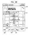
- FIG. 2Bshows a screen 212 displayed at the beginning of the trip.
- a circle 214marks the starting point of the trip, and an icon 216 shows the current position of vehicle 200 .
- PDA 202preferably corrects the position coordinates provided by the receiver to show the true location of vehicle 200 relative to the map displayed on the telephone. The correction is meant to place the vehicle icon on the road on which the vehicle is actually traveling, based on the locations and characteristics of roads on the map and on the computed trajectory of motion of the vehicle over time.
- the route provided by map server 206is marked by highlighting 232 .
- a scale window 218shows the scale of the current map. This scale is preferably determined based on the distance of vehicle 200 from the next turn in the route itinerary.
- a compass arrow 226shows the north direction.
- the map displayed on screen 212is oriented so that the heading of vehicle 200 is roughly aligned with the upward direction on the map.
- map server 206precomputes the zoom factor and orientation of the map segments to be supplied to PDA 202 along the route of travel of vehicle 200 .
- the map orientation and zoommay be selected by the user of PDA 202 .
- the serverthen supplies map data to PDA 202 , typically in vector form, with the proper rotation angle for the expected direction of travel and with the appropriate level of detail for the expected zoom factor (or with alternative orientation and zoom levels selected by the user).
- An anti-aliasing processmay also be applied to smooth the lines appearing in the map, in order to avoid jagged edges and other image artifacts that may appear due to the low resolution of the client display.
- Client devicessuch as PDA 202 are thus able to render the maps rapidly and efficiently, despite the generally low computing power and memory size of such devices, since there is no need for the client device to perform substantial image rotation or zoom computations.
- client devices with enhanced computing powersuch as laptop computers, at least some of the rotation and zoom operations may be performed by the client device.
- Screen 212also includes a number of other navigation aids.
- a trip metershows the relative distance that vehicle 200 has traversed on the current route
- a trip counter 222shows the distance to the destination and the elapsed travel time.
- a navigation window 224shows the next maneuver to be performed along the route and the distance to the intersection at which the maneuver will be required.
- PDA 202monitors this distance as the vehicle progresses, and may use speech synthesis to provide audible instructions to the driver at certain preset distances or time intervals before the vehicle reaches each maneuver location. The PDA is able to determine the appropriate time intervals by monitoring the location and speed of the vehicle.
- a status window 228shows status information, such as the strength of the GPS signal at a GPS receiver used by PDA 202 , and the status of the network connection between PDA 202 and map server 206 . If the GPS signal is lost, the PDA still attempts to extrapolate the position of the vehicle along the route for as long as is reasonable, and to display icon 216 accordingly. Similarly, even when the network connection is lost, the PDA may still provide the user with instructions and map displays, based on the current position of vehicle 200 and on map data that the PDA received earlier from server 206 .
- the PDAcontinues to download the map data, while discarding old data from its memory, so that the PDA can continue displaying maps and navigation instructions continuously for as long as possible in the event of a communication failure.
- the coordinates of the map data to be downloaded and the amount of such data to requestare determined by PDA 202 based on the position and speed of vehicle 200 and the memory capacity of the PDA.
- a menu control 230enables the user of PDA 202 to access menu functions, in order to set preferences and input information, such as route destinations and requests. These functions are described in greater detail hereinbelow.
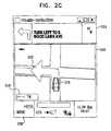
- FIG. 2Cillustrates a maneuver screen 240 that is shown on display 211 as vehicle 200 comes into an intersection in which it is to make its next maneuver along the route supplied by server 206 .
- Screen 240is typically based on a special maneuver map of the intersection, which is prepared in advance by the server and is downloaded to PDA 202 in advance.
- the scale of screen 240is zoomed to high magnification, and the roads entering and leaving the intersection are highlighted for contrast. Other details may be deleted from the maneuver map in order to reduce visual clutter and distractions.
- a highlight arrow 242points the direction of the maneuver that the vehicle is required to make.
- the arrowis preferably drawn by taking the actual sequence of line segments (known as a “polyline”) representing the navigation route, cropping it to fit within the outlines of the intersection, and then adding an arrowhead at its forward end.
- PDA 202zooms into this magnified view automatically when the vehicle is within a certain range of the intersection, and zooms out again immediately after the maneuver is completed.
- the PDAalso uses speech synthesis to provide audible instructions before and during the time the vehicle is in the intersection.
- FIG. 2Dillustrates another screen 250 , which is shown on display 211 after vehicle 200 has made the turn required by screen 240 .
- the map orientationhas been rotated automatically to correspond to the new direction of travel of the vehicle, and the scale has been zoomed out to show both the current vehicle location and the intersection at which the next maneuver is to be made.
- a different zoom levelmay be determined, based on the length of the segment, as well as other parameters supplied by PDA 202 and/or server 206 .
- Icon 216is generated by PDA 202 locally and is superimposed on the map that the PDA renders based on the map data from server 206 .
- FIG. 2Eillustrates a subsequent screen 260 that is shown on display 211 , following the next maneuver along the vehicle route.
- the map directionis again rotated.
- the road on which the vehicle is currently travelingdoes not follow a straight line (as the previous route sections did), but rather comprises a curve.
- the curveis typically represented in the geographical database of server 206 as a polyline, made up of a sequence of line segments of different lengths and orientations.
- the polylineis smoothed for display on screen 260 , based on the zoom factor and resolution of display 211 .
- the rotation angle of the map in screen 260is typically determined by server 206 based on the angle between the next maneuver point on the route and the preceding maneuver point.
- FIG. 2Fillustrates a mapping screen 270 that may be shown on display 211 , in place of the navigation screens shown in FIGS. 2B-2E .
- This mapping view of the routemay be selected by the user of PDA 202 by invoking an appropriate menu item.
- the useris able to select the map zoom and, optionally, the map view area and orientation, using map controls 272 .
- PDA 202locates and scrolls the map so that icon 216 representing the actual position of vehicle 200 remains at the center of the screen.
- FIG. 3is a simplified pictorial illustration of a real-time map distribution and display system constructed and operative in accordance with yet another embodiment of the present invention.
- a driver of a vehicle 300communicates with a map server 306 on the Internet via a wireless communicator such as a personal digital assistant (PDA) having cellular telephone functionality, or a smart cellular telephone 302 .
- PDApersonal digital assistant
- IVRIVR
- a location data outputis provided by a GPS receiver 308 or other locating device mounted in the vehicle, and the location is transmitted automatically by telephone 302 to server 306 .
- the cellular network of which the cellular telephone forms a partmay provide the location data output to server 306 , or the user may supply location data via the cellular telephone.
- the driverwhile driving, either with or without driver initiative, receives, in real time, current driving directions and a map showing a route to his destination in view of changed traffic conditions, including real-time proposed changes to that route.
- telephone 302automatically queries server 306 periodically, to ask for dynamic road conditions, such as traffic along or around the current route, and to receive possible route changes in view of dynamic conditions.
- server 306may track the location of vehicle 300 along its route, and may thus provide dynamic updates to telephone 302 automatically, without waiting for a query from the client.
- the directions and mapare pushed to the driver, wherein graphical icons may be drawn on the map to indicate the recommended route, turn by turn.
- the directions and mapsare provided to the driver within four seconds or less of each query from telephone 302 and are displayed on a display screen of the telephone.
- the directionsmay be provided and updated orally. It is a particular feature of the present invention that driving directions and maps are provided in real time, enabling a driver of a vehicle to receive changes in driving directions and maps without delay.
- FIG. 4is a simplified pictorial illustration of a real-time map distribution and display system constructed and operative in accordance with still another embodiment of the present invention.
- a pedestriancommunicates with a map server 406 on the Internet via a wireless communicator 402 , such as a personal digital assistant (PDA) having cellular telephone functionality, or a smart cellular telephone.
- PDApersonal digital assistant
- the pedestrianrequests directions regarding the location of a point of interest (POI) of a particular type, in this case, a drugstore, either by voice input to communicator 402 or by manual key-in, using a stylus to select or write the type of directions required.
- POIpoint of interest
- the cellular network through which communicator 402 communicates with map server 406may provide a location determination functionality, which supplies location coordinates of the pedestrian to the map server.
- a location data outputmay be provided by a GPS or other locating device associated with or connected to the communicator.
- the pedestrianmay also supply location data via the communicator.
- map server 406locates the nearest POI of the selected type, or several such POIs in proximity to the pedestrian's location. In the latter case, the user may select one of the POIs by input to communicator 402 .
- the serverreturns the location of the selected POI (i.e., of the drugstore, in the present example), along with navigation instructions, which tell the pedestrian how to reach the POI.
- server 406also pushes a map to communicator 402 , showing the location of the POI and the present location of the pedestrian, with arrows pointing the way to the POI.
- the mapin this case may also show pedestrian walkways, as well as features such as bus and subway connections, unlike the driving maps shown in the preceding embodiments. Note also that while driving maps and route computations take driving restrictions, such as one-way streets, into account, there is no need for pedestrian maps to do so.
- FIG. 5is a simplified pictorial illustration of a real-time map distribution and display system constructed and operative in accordance with a further embodiment of the present invention.
- the driver of a vehicle 500communicates via a cellular telephone 502 with a mapping server, as shown in the preceding figures.
- a mapping serverselects the nearest parking lot from its database (taking into account traffic restrictions, as well, such as one-way streets), and returns driving directions to telephone 502 .
- a map showing the location of the specified POImay also be pushed to the display of the telephone.
- FIG. 6is a simplified pictorial illustration of a real-time map distribution and display system constructed and operative in accordance with yet a further embodiment of the present invention.
- a provider of mobile servicessuch as a taxi company
- One driver in a cab 600is shown in the figure, with a mobile communicator 602 for exchanging location data, directions and maps, with Web site 606 via a cellular communication network.
- An IVR 604may be used to enable the driver to interact with the Web site by hands-free voice communications.
- Web site 606receives the current location of cab 600 and of other cabs in the fleet, based either on a GPS in the cab or on location-finding services of the cellular network, and conveys the information to console 608 .
- the dispatcheruses the location information provided by console 608 to locate and select a taxi, such as cab 600 .
- a taxisuch as cab 600 .
- the nearest available taxi to the passenger locationis selected.
- the selectionmay be made automatically by console 608 , based on the passenger location, taxi locations, and other factors, or it may be input manually by the dispatcher.
- Console 608then sends a message via the cellular network to communicator 602 , instructing the driver of cab 600 that he has a pickup to make at a certain location.
- Communicator 602may request navigation instructions from the current location of cab 600 to the pickup location and how to get there.
- a mapping server on Web site 606generates and sends the instructions.
- a map showing the passenger location and the preferred route to the locationmay also be displayed by the communicator. Dynamic information on traffic and other road conditions may be taken into account, as described above, in selecting the route to be taken to the passenger location, as well as the route for conveying the passenger to his destination.
- FIG. 7is a simplified functional block diagram of a real-time map distribution and display system constructed and operative in accordance with an embodiment of the present invention.
- a client-server type of arrangementis provided, wherein a dynamic mapping server 700 communicates with a dynamic map client 702 .
- Server 700typically comprises a general-purpose computer, or a group of computers, with suitable software for carrying out the functions described hereinbelow.
- This softwaremay be provided to the server in electronic form, over a network, for example, or it may alternatively be provided on tangible media, such as CD-ROM.
- Server 700comprises a dynamic content storage subsystem 720 , which receives dynamic content from dynamic content providers 722 .
- dynamic content providersinclude real-time traffic data providers, such as Traffic Master Ltd. of the U.K.; restaurant surveys, such as Zagat; and movie schedule services, such as Time Out of the U.K.
- the dynamic contenttypically changes in real time.
- dynamic traffic dataprovide information on traffic jams at given intersections or on given roads as they occur. Movie and restaurant data are current but clearly do not change as rapidly as does traffic data.
- the dynamic traffic dataare typically supplied by providers 722 via an agreed protocol, such as the Alert C protocol, commercially available from Traffic Master Ltd. of the U.K.
- the restaurant and movie datamay be provided in a conventional XML format or in any other suitable format.
- GIS datasuch as map data
- Map data providersuch as Navigation Technologies Inc. (Chicago, Ill.) or Tele Atlas North America (Menlo Park, Calif.).
- the GIS dataare typically supplied in a relational database format to map management processor 712 , which converts the data to a binary format used by server 700 and stores the converted data in a binary data storage subsystem 714 .
- Subsystems 714 and 720typically comprise high-capacity hard disk drives for storing the static and dynamic data, respectively.
- Map management processor 712is typically operative, inter alia, to receive GIS data in various formats from different GIS data providers and to process the data into a uniform format for storage by storage subsystem 714 .
- GIS data stored in GIS database 710are highly detailed, and the map management processor is operative to generalize this data so as to reduce the bandwidth requirements for transmittal thereof.
- Client devicessuch as the cellular telephones, PDAs and other communicators shown in the preceding figures, use client 702 to communicate with server 700 and provide information to users.
- Client 702typically comprises an applet written in the JavaTM language, but may alternatively comprise other suitable client programs, such as ActiveXTM or C SharpTM clients, and may run on substantially any stationary or portable computer or on any suitable communicator.
- the appletor other client program
- the client programis preferably stored in the memory of the client device, so that the next time the client device connects to the server, it is not necessary to download the program again.
- client 702initiates a new connection with server 700
- the version number of the client programis checked against the latest version of the program held on the server. If there is a new version of the client program on the server, it is downloaded automatically to the client device and replaces the older version held in client memory. Typically, only the classes or other resources that have been changed in the new version need to be downloaded, rather than the entire new version of the client software.
- map data that were downloaded to the clientmay be erased from the client memory, but map rendering templates, as described below, are preferably stored in the client memory for reuse during subsequent connections.
- Client 702typically receives location data from a location providing device 704 , such as a GPS receiver (as shown in the preceding figures) or any other service that provides location coordinates of the device in real time.
- a location providing device 704such as a GPS receiver (as shown in the preceding figures) or any other service that provides location coordinates of the device in real time.
- cellular telephone functionalitiesthat indicate the location of a telephone by triangulation
- voice- and/or data-responsive servicesthat provide location coordinates in response to user-provided information.
- Such user-provided informationmay be spoken or written in any conventional manner.
- dynamic map client 702initiates an authentication handshake with an authentication functionality 730 of server 700 .
- client 702may submit one or more of the following requests to server 700 :
- the client requests and server responsesare typically transmitted over a wireless network, such as a cellular network, with which the client device communicates.
- a wireless networksuch as a cellular network
- the client devicemay communicate with the server through a wireline network, such as the Internet.
- the requests and responsesare typically conveyed using communication protocols known in the art, such as TCP/IP and HTTP.
- a request processor 740handles client requests. For this purpose, processor 740 accesses GIS data from binary data storage subsystem 714 , as well as dynamic information from dynamic content storage subsystem 720 . Processor 740 computes and sends a response to client 702 in real time, typically within 4 sec of receiving the request, and preferably within 2 sec or even 1 sec of the request. The response comprises vector and textual data, including information such as navigation instructions, route polylines and traffic conditions. These data are typically used by client 702 in providing instructions to the user and rendering a map image, using a template or templates that the client has previously received and cached. Additionally or alternatively, processor 740 may generate and download images to client 702 , such as bitmap images.
- FIG. 8Ais a block diagram that schematically shows details of server 700 , in accordance with an embodiment of the present invention.
- the serveris shown here to comprise certain functional blocks. This functional structure, however, does not necessarily correspond to any physical separation of the functions shown in the figure. Rather, the functional blocks shown in the figure correspond to software modules, which may run on the same processor or on separate processors.
- Request processor 740comprises several components:
- server 700may use data from third-party services 810 in servicing client requests.
- search engine 804may access a third-party geocode database 812 in order to determine geocodes (map coordinates) of given cities, streets and other geographical features.
- Route engine 806may use a third-party routing server 814 as an alternative or adjunct to performing its own route computations.
- Third-party services 810may also include dynamic content providers 722 , as shown in FIG. 7 .
- Request processor 740generates map data and routing directions in the form of vectorial data and text labels.
- a data compression and decompression module 820converts the output of processor 740 into a compressed binary form, to minimize the bandwidth consumed by transmission of the data from server 700 to client 702 .
- An encryption and decryption module 822encrypts the data for transmission to client 702 , for purposes of data security. Request messages from client 702 to server 700 are likewise compressed and encrypted, and are decrypted and decompressed by modules 822 and 820 .
- a networking module 824assembles the data into packets for transmission to client 702 , typically TCP/IP packets, and handles the required networking protocol functions, as is known in the art.
- FIG. 8Bis a block diagram that schematically shows details of client 702 , in accordance with an embodiment of the present invention.
- the functional blocks of client 702do not necessarily correspond to any physical division of components within the client device and may simply be implemented as software modules in a program running on a microprocessor in the client device.
- the core mapping and navigation functions of client 702are carried out by a mapping and navigation manager 850 , which submits requests to server 700 and receives responses from the server via a communication interface 852 .
- This interfaceperforms networking, encryption/decryption and compression/decompression functions that are parallel to the comparable server functions described above.
- Manager 850receives vector map data from server 700 , along with text data for map labels, and formats the vector and text data for rendering by a rendering engine 854 .
- the dataare formatted in accordance with templates, as described below, which dictate the visual properties of the map features.
- the templatesare also downloaded from server 700 and are held by manager 850 in a memory 855 .
- Rendering engine 854renders the maps to a display 856 .
- Manager 850controls a user interface 858 , which interacts with the user of client 702 via display 856 and via user-operated input devices (not shown in this figure), such as a keypad or touch screen.
- the user interfacemay also generate audio outputs and/or receive voice inputs from the user.
- Manager 850periodically receives location coordinates of the client device from a location providing device 860 , such as a GPS receiver.
- a map matcher 862processes and corrects the location coordinates in order to register the location of the client correctly with a road on the map that is shown on display 856 .
- the map matchercorrects for inaccuracies in the coordinates received from device 860 .
- the map matchercompares the current location coordinates with readings taken in the recent past, and thus estimates the heading and speed of the vehicle in which the client device is located. This information is compared to the topology of the roads in the vicinity of the client device, along which the vehicle may be traveling, in order to assign a probability score to each possible path that the vehicle may have taken.
- the map matcherselects the most probable path, and then corrects the current location coordinate to the nearest location on the selected path.
- Manager 850receives the corrected coordinates from map matcher 862 . It typically instructs rendering engine 854 to superimpose an icon representing the vehicle (such as icon 216 ) at the corresponding location on the map that is currently shown on display 856 . Since the location and icon are generated locally, within client 702 , the map can be updated efficiently, without any need to refresh the entire map. Updating of the location coordinates and map can thus continue even when communications with server 700 are lost. Furthermore, manager 850 can use the updated location information provided by map matcher 862 to detect navigation errors by the driver of the vehicle and to generate driving instructions to get the vehicle back on route.
- FIG. 9is a block diagram that schematically illustrates data structures used by server 700 in preparing and delivering map data to client 702 , in accordance with an embodiment of the present invention.
- Map data 900are arranged in layers 912 , each layer corresponding to a different type of map feature.
- the layersdefine the shapes and locations of the features, in vectorial form, and typically include textual labels, as well.
- One or more of layers 912may also comprise dynamic data, such as traffic conditions.
- the actual appearance of the map features in maps rendered by client 702is defined by visualization data 910 .
- the visualization datacomprise a template 914 corresponding to each layer 912 .
- the templatesdefine the visual properties associated with the map features in each layer, such as colors, line thickness, and whether or not to display a label for each feature.
- the visual properties defined by the templatesdepend on the zoom level of the map that is to be displayed by client 702 , with different templates provided for different zoom levels. Further aspects of templates 914 are described below.
- server 700holds multiple templates 914 for each layer 912 , and downloads the appropriate templates to client 702 depending on the hardware capabilities of the client and the viewing conditions.
- the collection of templates used to render multiple layers on a given client devicemay be treated as a single multi-template. Since the same templates are used in displaying maps of different geographical areas, client 702 may store the templates in its local memory 855 , so that the templates need be downloaded to the client only once to display multiple different maps.
- Each templateis optimized for different display types and conditions on client 702 , for example:
- FIG. 10Ais a block diagram that schematically shows further details of a data structure 1000 used in preparing and storing a map 1002 on server 700 , in accordance with an embodiment of the present invention.
- Map 1002comprises multiple layers 1004 , as described above, each layer containing data regarding image features in a particular category.
- Each categorymay include features of different types.
- a “roads” layermay comprise sublayers for major highways, secondary highways, main roads, local streets, paths, etc.
- Each layer 1004typically comprises multiple sublayers 1010 , corresponding to different zoom levels at which the objects in the layer are to be displayed.
- the zoom level of each sublayerdetermines the level of detail to be used in representing the features in the sublayer.
- Each sublayer 1010comprises multiple objects 1014 that fall within the category of the corresponding layer.
- Each object 1014is identified by geographical location coordinates, which are typically given in an R-Tree hierarchical index 1012 , which divides the two-dimensional geographical space into a set of hierarchically-nested (and possibly overlapping) boxes, as is known in the art.
- R-Treeis described, for example, by Beckmann et al., in “The R*-Tree: An Efficient and Robust Access Method for Points and Rectangles,” Proceedings of ACM SIGMOD International Conference on Management of Data (1990), pages 322-331, which is incorporated herein by reference.
- Each objectalso comprises descriptive data 1016 , indicating the type of feature that it represents, and a shape 1018 .
- the shape of an objectis typically either a point (for points of interest), a polyline (i.e., a sequence of connected line segments, for features such as roads), or a polygon.
- the visual properties of layers 1004are defined by templates 1006 .
- Multiple templatesare provided for each layer, corresponding to the number of different display types and display modes (such as day/night) that may be used in displaying maps on different client devices, as described above.
- Templates 1006define different properties for different object types 1020 .
- visual properties 1022 that are defined for each object typemay vary depending on the zoom level (i.e., the scale) of the map that is to be displayed.
- the templateprovides multiple sets of visual properties, each corresponding to a different zoom level.
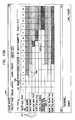
- Table I belowlists a portion of a template for the “roads” category, defining visual properties of nine different road types at seventeen different zoom levels.
- the templateis written in XML and is largely self-explanatory.
- XML labels for each object type and zoom levelindicate whether or not the object is to be displayed in maps shown at this zoom level (depending on the “visible” label), along with width, color, textual labeling and other features.
- the “order” labelindicates Z-order, i.e., how different objects are to be superimposed when they overlap in an image that is rendered on the client device.
- FIG. 10Bis a schematic representation of a computer screen 1040 , which is used in a template editor for creating templates 1006 , in accordance with an embodiment of the present invention.
- the template editortypically runs on a terminal or workstation (not shown) that is linked to server 700 and is used by an operator of the server in setting the attributes of different templates.
- each type of road in the “streets” layer of the templateis represented by a corresponding row 1042 .
- Each column 1044corresponds to a different zoom level.
- Entries 1046 in each rowindicate whether the corresponding type of object is to be visible at each of the different zoom levels and, if so, what color it is to have.
- the operatoruses this screen to change the colors and visibility properties of the different road types.
- Other screens(not shown) allow the operator to change properties such as line width, border width and labeling, for example. Similar screens are available for other categories of objects.
- FIG. 11is a block diagram that schematically illustrates a data structure 1100 used by search engine 804 in serving client search requests, in accordance with an embodiment of the present invention.
- data structure 1100comprises a region/city entry 1102 for each region or city in GIS database 710 .
- Each region or cityis represented by its name and by a bounding box, giving the bounding coordinates of the region or city.
- a regionmay contain child regions (such as counties or cities within a state or country), each of which is represented by its own entry 1102 .
- cities and regionscontain roads, which are represented by street entries 1104 .
- Each streetis made up of one or more segments, which are represented by segment entries 1108 .
- Each segment entryhas the form of a polyline, with a range of house numbers, for use in locating particular addresses on the street.
- Each street entry 1104has a street name and a bounding box that contains all of the segments of the street.
- each streetis cross-indexed to crossroad entries 1106 , which contain the names and coordinates of all the other streets that cross it.
- Search data structure 1100may also contain other types of searchable data, such as postcode entries 1110 .
- POI informationmay be stored in map layers, to be accessed by both map display and search mechanisms.
- POIsmay be searched by city, or within a predefined radius of a given address or location, or within a certain bounding box. The POI search is then typically performed using the R-Tree index.
- FIG. 12is a block diagram that schematically illustrates a data structure 1200 used by routing engine 806 in responding to client route requests, in accordance with an embodiment of the present invention.
- locations in GIS database 710are represented as nodes in a graph.
- Road segmentsform the edges of the graph, connecting the nodes.
- each node entry 1202contains the location of the node and indices of segment entries 1204 connecting to the node.
- Each segment entry 1204contains properties 1206 of the segment, such as restrictions on vehicle weights and types that must be taken into account in generating navigation instructions.
- Each segment entryalso contains pointers to any applicable turn restriction entries 1210 , which indicate for each segment the other segments into which a vehicle is (or is not) permitted to turn from the segment.
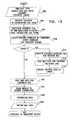
- FIG. 13is a flow chart that schematically illustrates a method used by mapping engine 802 in generating a map for download to client 702 , in accordance with an embodiment of the present invention.
- the mapping enginebegins this process by reading in client parameters, at a parameter input step 1302 .
- the clientmay provide these parameters in a map request message that it sends to server 700 , or the server may read the parameters from its own records.
- the parameterstypically include:
- Mapping engine 802resolves the map location and size into corresponding coordinates and a zoom level within its own map data structure 1000 , at a coordinate resolution step 1304 .
- the map data structureis precomputed for certain particular zoom levels.
- the mapping enginechooses the zoom level that is appropriate for the map size determined at step 1302 .
- the mapping engineuses the coordinates and zoom of the map, calculates a bounding box containing the area of the map to be displayed, at a box computation step 1306 .
- the bounding boxdetermines which objects are to be included in the map that is downloaded to the client.
- the mapping enginealso creates a dynamic template by combining the appropriate static template 1006 with variable visibility information, at a template creation step 1308 .
- variable visibility informationtypically includes, for example, the object type visibility parameters that were input at step 1302 and the visibility properties of the different object types as indicated by the selected static template.
- the dynamic templateis used to filter unnecessary objects out of the map data that are to be transmitted to client 702 , so that only features that are actually going to be displayed by the client are included in the transmitted data.
- mapping engine 802may rotate the map coordinates in advance to the desired orientation. As noted above, pre-rotation of the map reduces the computational burden placed on low-end client devices. Alternatively, if the map rotation is performed by the client device, the pre-rotation steps may be eliminated.
- the mapping enginecomputes a covering bounding box for the rotated map, at a box rotation step 1310 .
- the original bounding box computed at step 1306is rotated to the angle of the map to be displayed (for example, 45° northeast).
- a larger bounding box, oriented straight along the Cartesian axes of the GIS data and containing the original bounding box,is computed.
- This larger bounding boxreferred to as the covering bounding box, is used in cropping the map data to be conveyed to client 702 , at a rotated cropping step 1312 . Details of the cropping process are described hereinbelow.
- the cropped dataare then rotated to the angle of the original bounding box, at a data rotation step 1314 .
- the vector coordinates of the objects to be included in the mapare rotated by an equal and opposite angle to the rotation angle of the original bounding box (so that the true north axis will be tilted 45° to the left in the example noted above).
- the coordinates of the objects in the map in the original GIS frame of referenceare thus transformed into the rotated frame of reference of client display 856 .
- Mapping engine 802next crops the map data to the size of the bounding box calculated at step 1306 , at a cropping step 1316 .
- the larger covering bounding boxis cropped down to the size of the original bounding box in the rotated coordinates. Details of step 1316 are shown in FIGS. 14A and 14B , below.
- the coordinates of the objects remaining in the map data after step 1316are scaled from the native map coordinates (such as GIS latitude and longitude coordinates) to pixel coordinates, corresponding to the pixels on the screen of the client device, at a scaling step 1318 .
- the mapping enginesimplifies the data, to fit the objects to be transmitted to the parameters and limitations of the client display, at a data generalization step 1320 .
- the generalization processremoves redundant objects and reduces the complexity of others, while maintaining the representative integrity of the mapped area. Methods of map generalization are described, for example, in a white paper entitled “Automation of Map Generalization,” published by the Environmental Systems Research Institute (ESRI, Redlands Calif., 1996), which is incorporated herein by reference.
- mapping engine 802In addition to generating the vector map data, as described in the steps above, mapping engine 802 also prepares textual labels to be placed on the map by client 702 at appropriate locations.
- the labelsinclude street labels, which are rotated to appear along the appropriate street lines, as well as labels of polygon objects (such as cities, bodies of water and parks) and POIs, which generally appear on the map in horizontal orientation.
- the map enginedecides which map features to label based on the applicable templates, and then generates the map labels dynamically in their optimal placement. For example, labels of polygon objects may be shifted within the polygon, street labels may be shifted along the street polyline, and POI labels may be moved around the point of interest. Overlap between labels is resolved by shifting the labels or removing low-priority labels if there is insufficient space to display them on the map.
- the map dataare now ready to be transmitted to client 702 , at a map completion step 1322 .
- the mapis transmitted in the form of vector data, representing points, polylines and polygons, in the frame of reference of the map to be rendered on the client device, generalized and simplified to remove all unnecessary detail.
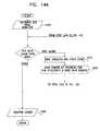
- FIGS. 14A and 14Bare flow charts that schematically illustrate a method for cropping map data, as performed at the above-mentioned step 1316 , in accordance with an embodiment of the present invention.
- Mapping engine 802receives input parameters for use in cropping the map, at a parameter input step 1402 .
- the parametersinclude the area of the bounding box, the zoom level of the map and the template to be used in displaying the map on the client device.
- the cropping procedureis applied to the map data in each of layers 1004 that is to be included in the map, based on R-Tree indices 1012 .
- mapping enginefinds sublayer 1010 that is appropriate for the specified zoom level, at a sublayer selection step 1410 .
- the mapping enginefinds the R-Tree root of the objects in the selected sublayer, at a root cropping step 1412 . It then proceeds up the branches of the R-Tree, and crops all the shapes in the sublayer according to the bounding box, at a shape cropping step 1420 .
- the action taken at step 1420depends on the relation of the bounding box to the current branch, as determined in a bounding step 1422 . If the branch is entirely outside the bounding box, the mapping engine ignores the branch and omits it from the layer output, at a branch elimination step 1424 .
- the mapping enginecollects all shapes associated with this branch and all its child branches, at a branch collection step 1426 , as long as the template indicates that these shapes are to be visible in the map rendered by client 702 . Non-visible shapes are omitted.
- the shape of the corresponding objectis clipped, so that only those portions of the objects in the current sublayer that are within the bounding box are included in the output map data, at a clipping step 1428 .
- the child branches of the overlapping branchare likewise clipped, continuing recursively up the R-Tree to the highest leaves that will be visible in the map, at a child cropping step 1430 .
- the visible shapes of the branch and its childrenare collected for output, at a shape collection step 1432 .
- All the shapes that remain within the bounding box after cropping at step 1420are collected to form the map output data for the current layer, at a layer output step 1434 .
- a similar procedureis applied to the remaining map layers, until all the layers have been completed.
- the collection of all the layers of cropped datais then ready for output, at a cropped data output step 1440 .
- FIGS. 15A and 15Bschematically illustrate a method by which search engine 804 responds to search requests from client 702 , in accordance with an embodiment of the present invention.
- FIG. 15Ais a flow chart that shows the method used to find a city name
- FIG. 15Brepresents a user interface screen 1550 displayed by client 702 for use in searching for a street name. It will be understood that the methods described here are equally applicable to searching not only for street and city names, but also for other geographical features, such as crossroads, geocodes and points of interest.
- a user of the client deviceinputs a city name string and selects search preferences, which are uploaded from client 702 to server 700 at a search input step 1502 .
- the search enginemay begin to search its region/city entries 1102 for names that match a search mask made up of these letters.
- the search enginecan begin to return search results to the user without waiting for the complete city name to be keyed in.
- client 702waits to send the input string input to server 700 until the user has stopped entering characters for a certain time period, generally less than one second, in order to avoid disturbing the user data input process.
- client 702may used search parameters that include the maximum number of search results to be sent by the search engine at any one time (and what to do if the number of matches found exceeds the maximum), and whether approximate string matching should be used in the search. Some or all of these parameters may be set by the user.
- Search engine 804first checks its database for a city name that is a full, exact match to the search mask, at a full name matching step 1504 .
- the searchis typically case-insensitive. If a full, exact match is found, the search engine reports that it has found a single matching city name, at a full match output step 1508 .
- the search enginechecks to determine whether it is to perform exact matching or approximate matching in searching its records, at a flag checking step 1510 . If the approximate match flag is reset, the search engine searches its records for names that contain all the characters in the mask string in the proper sequence, at an exact matching step 1512 . Otherwise, if the approximate match flag is set, the search engine performs the search in a way that allows for key-in errors, at an approximate matching step 1514 . In the approximate matching mode, the search engine finds both names that exactly match the mask string and names that match the search string to within a predetermined error bound. Typically, the error bound allows for one erroneous character. The search order may be chosen so as to favor replacement characters that are frequently confused, such as substitution of different vowels.
- Search engine 804reviews the search results found at step 1512 or 1514 to ascertain whether the total number of search results is less than or equal to the maximum number of results specified at step 1502 , at a list length checking step 1516 . If the number of results is within the maximum limit, the complete list of search results is output to the client, at a full list output step 1518 . Otherwise, the search engine checks the send_if_too_many flag (likewise set at step 1502 ), at a result disposal step 1520 . If this flag is reset, the search engine returns no results, at an empty list return step 1522 . At this stage, the user of the client device may key in one or more additional characters, to narrow the scope of the search, and the search process will resume at step 1502 using the new mask string.
- the search enginefinds at step 1520 that the send_if_too_many flag is set, it simply truncates the list of results it has found at the specified limit, at a list truncation step 1524 .
- Various criteriamay be used to prioritize the results, so that the city names at the top of the list are those with a relatively higher probability of being the actual, correct name that the user is seeking. (For example, names that exactly match the mask string may be placed ahead of names that match only approximately.)
- the truncated listis output to the client device, at a truncated list return step 1526 . Note that following either of steps 1518 and 1526 , the user of the client device may continue to input additional characters, which will prompt the search engine to resume the search with the new mask string at step 1502 .
- FIG. 15Billustrates the use of approximate matching in the context of street name searching.
- the type of search to performis invoked by the user by selecting a search type button 1552 .
- the user in this exampleis searching for streets in the city of Tel Aviv-Yafo, and has keyed in the name “Hado . . . ” in a key-in window 1554 .
- the usermay select an enter button 1555 , causing client 702 to send this string to server 700 and thus initiate the search.
- client 702may transmit the string to the server automatically, typically after the user has keyed in a certain number of letters or a certain amount of time has elapsed since key-in began.
- the search enginereturns names that are an approximate match, for display in a results window 1556 on the client device.
- the usercan select one of these names or may alternatively correct the entry in window 1554 and continue the search.
- the usercan use function buttons 1558 to ask server 700 for navigation directions to the selected street or to provide a map of the area of the street.
- the usermay select navigation type buttons 1560 to determine whether the navigation directions are to generated according to the fastest, shortest or simplest route to the destination.
- FIG. 16is a flow chart that shows the method used by routing engine 806 in responding to route requests submitted by client 702 .
- the route requestspecifies various input data, at a data input step 1602 , which the routing engine needs in order to compute the route.
- These datainclude:
- Routing engine 806converts the starting and destination locations, as well as any interim locations, into coordinates in the frame of reference of map data 1000 , at a coordinate resolution step 1604 .
- the routing engineuses these coordinates in building the route, at a route construction step 1606 .
- Substantially any automatic routing algorithm known in the artmay be used for this purpose, such as the A* algorithm.
- Such algorithmsare described, for example, by Cherkassky et al., in “Shortest Path Algorithms: Theory and Experimental Evaluation,” Technical Report 93-1480, Department of Computer Science, Stanford University (Stanford, Calif., 1993), which is incorporated herein by reference.
- the routetakes into account the preferences specified at step 1602 .
- FIG. 17is a graph that schematically illustrates a route 1730 generated by routing engine 806 , in accordance with an embodiment of the present invention.
- Route 1730has the form of a polyline, comprising a sequence of route segments 1732 , labeled RS 1 , RS 2 , . . . , RS 6 , which connect nodes 1734 along the route, labeled M 1 , M 2 , M 3 .
- Nodes 1734typically correspond to road intersections.
- Route 1730may also comprise an identification of cross streets 1736 that cross the designated route. Other road features and landmarks along the route may be identified, as well, such as a traffic circle 1738 , as shown in the figure, or a slipway.
- routing engine 806next checks the input data to determine whether driving instructions are required and if so, at what level of detail, at an instruction checking step 1610 . If instructions are not required, the routing engine simply computes the route length and estimated time that will be needed to complete it, and outputs the route data, at a polyline output step 1612 . The route is downloaded to client 702 and is typically passed to mapping engine 802 , as well, for generation of a corresponding corridor map, as described below and shown in FIG. 17 . If instructions are requested, the routing engine builds a list of maneuvers that will be required along the route, at an instruction generation step 1614 .
- client 702uses the information in the maneuver list to prepare suitable verbal instructions (for example, “right turn in 300 m,” followed by “right turn in 50 m,” followed by “now turn right”).
- suitable verbal instructionsfor example, “right turn in 300 m,” followed by “right turn in 50 m,” followed by “now turn right”.
- the list of maneuversis downloaded to client 702 along with the route, at an instruction output step 1616 .
- Mapping engine 802generates a corridor map along route 1630 .
- the corridor mapis actually made up of a sequence of segment maps 1640 , labeled GMO- 1 , GM 1 - 2 , GM 2 - 3 and GM 3 -D, which contain segments 1632 of route 1630 and a certain area on either side of the route.
- the scales of the segment mapsvary according to the lengths of the corresponding segments of the route. (This feature of the segment maps is also illustrated in FIGS. 2B-2E .)
- long segments, such as RS 4may be broken into multiple sub-maps 1642 .
- segment maps 1640differ in size in the GIS frame of reference, they comprise roughly equal volumes of data, since smaller maps (such as GMO- 1 ) are typically displayed by client 702 at a higher zoom level and thus show more detail.
- the mapsare downloaded incrementally to client 702 as the client proceeds along route 1630 . Note that some features, in areas of overlap between successive segment maps, may be downloaded twice, which increases the volume of data that must be transmitted to the client, but reduces the computational load on the client.
- FIG. 18is a flow chart that schematically illustrates a method for generating a corridor map along a given route, in accordance with an embodiment of the present invention.
- mapping engine 802receives input parameters defining the corridor, at a data input step 1802 .
- the dataincludes a polyline defining the route that has been computed (at step 1612 or 1616 , for example), as well as the maximum distance (max_distance) to either side of the route that is to be included in segment maps 1740 .
- the max_distance parameterdetermines the aspect ratio of the segment maps.
- Other parametersmay be specified, as well, such as the transport type (car, bicycle or pedestrian), for determining which features to include in the corridor map.
- mapping engine 802For each segment 1732 of the route, mapping engine 802 computes a bounding box by expanding the polyline by max_distance to either side of the route, at a box expansion step 1804 .
- each bounding boxis characterized by certain location coordinates and a zoom level, as well as by an orientation angle ⁇ relative to a reference direction of the map data. The zoom and angle are used, together with template information, in determining which map features are to be displayed in the corridor map, and how the map data corresponding to these features should be processed before downloading to client 702 .
- mapping engine 802searches the R-Tree branches of the street layer of map data 1000 , at a street search step 1806 . As in the method of FIG. 14 , the mapping engine ascertains, for each branch of the R-Tree, whether the branch falls within or intersects the bounding box, at an overlap checking step 1808 . In the case of the corridor map, however, all road segments corresponding to R-Tree branches that fall even partly within the bounding box are collected for inclusion in the segment map, at a segment collection step 1810 . In other words, even if a segment of a road near route 1730 falls only partly within the bounding box, the segment is included in the corridor map.
- Child branches of the branches that fall within or intersect the bounding boxare checked and included, as well, at a child collection step 1812 .
- R-Tree branches falling entirely outside the bounding boxare eliminated from the map, at a branch skipping step 1820 .
- Child branches of these skipped branchesare skipped, as well, at a child skipping step 1822 .
- the mapping engineAfter collecting all road segments to be included in a segment map, the mapping engine accesses segment entries 1204 and turn restriction entries 1210 in routing data structure 1200 , in order to determine the connectivity between the segments, at a routing collection step 1830 .
- This informationmay be used not only in displaying available maneuvers and restrictions on the segment maps, but also in rerouting the client back to route 1730 in the event of a wrong turn. Rerouting of this sort may be performed by client 702 , in order to reduce the need for client-server communication, by applying a simple routing algorithm to the map information held in the client memory.
- Mapping engine 802outputs the map topology data for each route segment, at a topology output step 1832 .
- FIG. 19Ais a flow chart showing key steps in the operational flow of the client, while FIGS. 19B-D show user interface screens that are displayed by the client.
- manager 850reads operational parameters from memory 855 , at a parameter reading step 1902 .
- the parametersare used subsequently in the client interaction with server 700 . They include information such as:
- FIGS. 19B , C and Dschematically illustrates user interface screens presented by client 702 on display 856 , which allow the user to set some of the parameters used by the client.
- FIG. 19Bshows a localization screen 1950 , which allows the user to select a map region 1952 and a map language 1954 , as well as a “skin” 1956 , which defines the “look and feel” of the screen displays without affecting the underlying functionality.
- the user-selected localization parametersare used to inform server 700 of the desired navigation area and language to be used for labels and navigation instructions.
- the map languagemay also be used in selecting a set of phonetic primitives for the specific language selected.
- Server 700may then download the appropriate set of primitives to client 702 , to be held in memory by the client and used in generating audible instructions to the user. Since all map data are stored offboard, on server 700 , the same client can be used substantially anywhere in the world, without purchasing or reloading data.
- FIG. 19Cshows a usability screen 1960 , which allows the user to set display and user interface preferences, such as a map orientation 1962 and distance units 1964 .
- the map orientation selectiondefines whether maps are to rotate as the user navigates along a given route (as shown in FIGS. 2 B- 2 E), or to “slide,” in fixed orientation (as shown in FIG. 2 F).
- a default input method 1966enables the user to select different formats for inputting requested destinations for navigation instructions: by house number, crossroads (such as “corner of Fifth Avenue and 42nd Street”) or a selected POI.
- a default view mode 1968allows the user to select the type of template to be used for map displays, such as a day or night template, as described above. All of these settings can be changed by the user in the course of interacting with client 702 .
- FIG. 19Dshows a functionality screen 1970 , which enables the user to personalize the mode in which navigation instructions are presented by client 702 .
- a default navigation mode 1972allows the user to choose between receiving both maps and verbal instructions, or verbal instructions only (which may be shown on display 856 or played audibly by speech synthesis, as described above).
- the user or manager 850can switch to “maneuvers only” mode in navigation, thereby decreasing the amount of data that must be downloaded to client 702 . This change can affect the cost of the navigation service as well, if usage-based billing is applied.
- Other preferences accessed on screen 1970include a show-car option 1974 , which displays or hides icon 216 , and a default route optimization option 1976 , which was described above.
- An off-route behavior option 1978instructs manager 850 whether when the vehicle takes a wrong turn, client 702 should automatically generate new navigation instructions, or whether it should simply prompt the user to take any necessary action.
- client 702searches for a mapping server 700 with which to communicate, at a server selection step 1904 .
- client 702has a list of available servers (listed by IP address, for example).
- the clientpolls the servers on its list to find the server that is able to give the fastest service. For example, the client may send a handshake request to initiate communications with each server on the list, and then may choose the server that takes the shortest time to respond.
- authentication functionality 730 of servers 700also verifies the username and password supplied by client 702 . If no servers respond to the client within a predetermined timeout limit, the client displays an error message, at an error display step 1906 . The user may ask the client to try again to find a server, at a retry step 1908 . Otherwise, the client program exits.
- client 702After finding and selecting a server, client 702 asks the server to download templates and other global information to be used in processing and displaying maps, at a preliminary download step 1910 .
- the global informationmay include, for example, default object types (DOT) and metrics.
- DOTspecifies which types of objects are to be included in maps downloaded subsequently to the client, and which objects are to be omitted, when the DOT is not overridden by client preferences. Metrics are used in converting between map and display coordinates.
- client 702If client 702 has already saved templates in memory 855 from a previous mapping session, it may simply send server 700 an identification (such as a version number) of the templates that it has in memory.
- the serverneed not resend all of the templates to the client, but may rather download only changes that have been made in the templates, if any.
- the servermay also check the version number of the client software, and may download a new version if the current version is out of date.
- Client 702next prompts the user to select a destination to which the user wishes to navigate or a location whose vicinity the user wishes to view on a map, at a place selection step 1912 .
- the usermay choose to input the destination or other location in the form of a house number, crossroads or POI, as noted above. A process of POI selection is illustrated below, for example, in FIGS. 20A-C .
- the usermay also search the “history” of client 702 to find a destination or other location that has been used in the past.
- the userinputs the place selection (of the chosen type) to client 702 , at a destination input step 1914 . If the user does not input a selected place, the client program exits, at a termination step 1916 .
- manager 850submits a map request to server 700 , at a map request step 1920 .
- the map requestincludes the following fields:
- Server 700prepares and transmits the requested map data to client 702 , as described above with reference to FIG. 13 .
- Manager 850 in client 702receives and handles the map response, at a map handling step 1922 , in order to prepare the map data for rendering. Details of step 1922 are shown below in FIGS. 21A-21B .
- Manager 850passes the processed map data to rendering engine 854 , which renders the map to display 856 , at a map display step 1924 .
- the rendering enginedraws each feature on the map in accordance with the vector data provided by server 700 (as processed by manager 850 at step 1922 ) and using the visual characteristics taken from the appropriate template. Overlapping features are overlaid according to the Z-order specified in the template.
- Text labelsare read out of a label pool provided with the map by server 700 .
- Road labelsare preferably oriented along the angles of the roads to which they apply (as shown in FIGS. 2D and 2E , for example).
- An anti-aliasing processis applied to smooth the lines appearing in the map, in order to avoid jagged edges and other image artifacts that may appear due to the low resolution of display 856 .
- manager 850generates and sends a route request to server 700 , at a route request step 1930 .
- the form of the route requestis similar to that of the map request, as described above at step 1920 , with appropriate changes to identify the type of request and indicate whether or not a map of the route is required.
- Server 700prepares a route response, as illustrated above in FIGS. 16 and 17 .
- manager 850processes the route data, and drives rendering engine 854 and user interface 858 to display the route on display 856 , at a route display step 856 . If the response is accompanied by maps, manager 850 handles the map data in the manner described below with reference to FIGS. 21A-B .
- the mapsare then displayed at step 1924 , as noted above.
- the usermay request changes in the mapping mode, at a mode handling step 1940 .
- the usermay change the zoom or visual parameters or select a “follow-me” mode, may drag the map to move to the sides, or may select a hyperlink embedded in the map to receive further information.
- Manager 850receives these change requests, at a map operation checking step 1942 .
- the managermay also determine, for example, that a display update is required in order to show the current vehicle position, or that the next maneuver map ( FIG. 2C ) or segment map ( FIG. 2D ) along the route corridor should now be displayed.
- Manager 850instructs rendering engine 854 to perform the required operations on the current map or to switch to the next map, at an operation handling step 1944 .
- Client 702cycles through steps 1924 , 1940 , 1942 and 1944 until no further operations are required, typically because the vehicle has reached its destination or the user has finished viewing the current map. The user may then be prompted to choose a new destination or location, at step 1912 .
- FIGS. 20A-Cschematically illustrate a method by which a user of client 702 may select a POI, in accordance with an embodiment of the present invention.
- FIG. 20Ais a flow chart showing the steps in the method itself, which may be invoked by the user at step 1912 in the method of FIG. 19 .
- FIGS. 20B and 20Cshow user interface screens displayed by the client for the purpose of POI selection.
- the useris prompted to input a POI selection option, at an option selection step 2002 .
- the usermay request a list of POIs of a desired type in a particular area of a city or region, or all POIs of the desired type within a given radius of a specified point, or simply all POIs of the desired type within the current map region.
- User interface 858receives the user selection, at a selection input step 2004 .
- Client 702submits a search request to server 700 , at a search request step 2016 , invoking a search process similar to that shown above in FIG. 15 A.
- the usermay also narrow the search field by selecting a region within a city (such as a certain borough or neighborhood) or by selecting a street name, as well as a house number or crossroads on the selected street.
- manager 850checks to determine whether it currently has in memory 855 a map showing the vicinity of interest to the user, at a current map checking step 2032 . If so, this map is presented on display 856 , so as to allow the user to choose a point on the map.
- client 702submits a map request to server 700 , and then receives and displays a default map, showing the general area in which the client is currently located, at a default map display step 2034 .
- the useris prompted to select a point on the displayed map, at a point selection step 2036 .
- the useroperates a mouse, stylus or touch screen to mark a particular location on display 856 .
- the useris also prompted to input a radius (typically in units of miles or kilometers) around the selected point, within which the POI search will take place, at a radius input step 2038 .
- FIG. 20Bschematically shows a POI selection screen 2060 , which is displayed by client 702 for this purpose.
- a category window 2062lists the types of POIs that are available and allows the user to select the POI type from the list.
- Function buttons 2064enable the user to ask server 700 for navigation directions to a selected POI or to provide a map of the area of the POI. In requesting navigation directions, the user may select navigation type buttons 2066 , as described above.
- Client 702conveys the user choices to server 700 in a search request that indicates the type of POI that the user has selected and the geographical area in which the search should be performed.
- the serverreturns a list of relevant POIs, which may be ranked according to their proximity to the location specified by the user.
- Client 702shows this list on display 856 , at a POI list display step 2052 .
- the userselects an entry from the POI list, at an entry selection step 2054 .
- Client 702then proceeds to generate a map of the area of the selected POI and/or navigation instructions leading from the current client location to the POI, as described above with reference to FIG. 19 .
- FIG. 20Cschematically shows a POI selection screen 2070 , which is presented on display 856 at step 2052 .
- the user selected “gas stations” at step 2050 , and names of nearby gas stations 2074are shown in a POI selection window 2072 .
- the POIs in the list provided by server 700may be presented to the user in the form of icons and/or names on a map shown on display 856 .
- FIGS. 21A and 21Bare flow charts that schematically show details of map handling step 1922 , in accordance with an embodiment of the present invention.
- the map response returned by server 700begins with map parameters, which are read in by manager 850 at a parameter reading step 2102 . These parameters typically include the X-Y coordinates of the map rectangle, the height and width of the rectangle, the rotation angle of the map (relative to the geographical north) and the zoom level of the map.
- the map responsealso includes a string pool, which contains, in encoded form, the text to be used in all the labels on the current map.
- Manager 850reads and decodes the string pool from the response, at a string reading step 2104 , and stores the string text in memory 855 . In addition, manager 850 reads from the map response the number of layers of vectorial map data that are to be contained in the response, at a layer number reading step 2106 .
- Manager 850uses the number of layers as an index in looping over all the layers of data contained in the response, at a layer looping step 2110 .
- the managerprocesses the data in each layer until all the layers have been completed.
- manager 850reads the layer identifier, at a layer identification step 2112 . It then reads the number of junctions in the current layer, at a junction number reading step 2114 . (Although each junction is shared by two or more polylines, it is more efficient to download the coordinates of each junction to client 702 only once.
- junctionsmay also be used by client 702 in rerouting computations, if the vehicle deviates from the route provided by server 700 .)
- the number of junctionsis used as an index in looping over all the junctions in the current layer, at a junction looping step 2120 .
- Each junctionhas corresponding X-Y coordinates, but for compactness of representation, the coordinates of each junction may be conveyed from server 700 to client 702 in the form of an offset from the coordinates of the preceding junction in the list.
- manager 850loops over the junction list, it reads the offset and restores the X-Y coordinates of each junction based on the offset, at a junction coordinate computation step 2122 .
- Manager 850next reads the number of object types in the current layer, at a type number reading step 2124 .
- Possible object typesincludes point, polyline, polygon, label, image and circle.
- client 702has a Java class for each of the different object types. This class contains the methods necessary for drawing the corresponding type of object at the coordinates indicated by the map data received from server 700 , using the visual characteristics specified by the appropriate template.
- Manager 850uses the number of object types as an index for looping over the different object types in the current layer, at a type looping step 2130 . For each object type, the manager first reads the type identifier, at a type identification step 2132 . It then reads the appropriate object class for the object type, at a class reading step 2134 . The manager reads the number of objects of the current type, at an object number reading step 2136 , and then reads in the objects themselves, at an object reading step 2140 . For each object read in at this step, manager 850 examines the object parameters to determine whether the object has an index pointing to auxiliary information, such as a descriptive label, tooltip or hyperlink.
- auxiliary informationsuch as a descriptive label, tooltip or hyperlink.
- the manageruses the index to associate the object with the appropriate text in the string pool that was sent by server 700 as a part of the map response.
- the manageralso reads in the object coordinates, such as the coordinates of each vertex in each polyline or polygon, or the center coordinates of circles and images. After all the map objects have been read in and associated with their appropriate classes, the map is rendered to display 856 at step 1924 , as described above.
Landscapes
- Engineering & Computer Science (AREA)
- Radar, Positioning & Navigation (AREA)
- Remote Sensing (AREA)
- Automation & Control Theory (AREA)
- Physics & Mathematics (AREA)
- General Physics & Mathematics (AREA)
- Human Computer Interaction (AREA)
- Navigation (AREA)
- Instructional Devices (AREA)
- Traffic Control Systems (AREA)
- Processing Or Creating Images (AREA)
Abstract
Description
- Map requests.
- Search requests.
- Route requests.
- Topology (road data) requests.
- Requests for ancillary information, such as templates.
In a typical interaction,client 702 requests and then caches the appropriate template fromserver 700. The client may then perform a search, for a city, street, address or point of interest, for example. (The search may use approximate matching of the client query string, as described below, so that the server returns search results while the user is entering the string on the client device.) When the search destination is found,client 702 may request the geocode of the destination and vector data required to show the area of the destination and/or a route to the destination.
- A
mapping engine 802 receives and serves map requests from and on behalf ofclient 702. In other words, in response to a request to provide a map of a given geographical area, with a given zoom level and orientation and certain types of features,engine 802 retrieves the required information fromstorage subsystems client 702 as an adjunct to a search or route request. - A
search engine 804 receives and serves requests from the client to locate a certain geographical feature, such as a city, street, building address or POI. Upon locating the desired feature, the search engine provides the coordinates of the feature toclient 702. The client may then request a map showing the location of the feature and/or navigation instructions to the location. - A
route engine 806 receives and serves requests from the client to provide navigation instructions from a given starting point (typically the current location of the client) to a destination, with possible interim stopping points along the way.
Details of the processes of map generation, searching and route generation are described hereinbelow.
- A
- Different templates may be defined for different types of client displays, such as color or monochrome displays, and different display resolutions. Thus, a cellular telephone with a small monochrome display will receive one set of templates, while a PDA or portable computer with a large color display will receive another.
- Different templates may be used for day and night viewing on the same client device, in order to improve the visibility of the maps as they appear on the display screen in the vehicle and to facilitate navigation.
| TABLE I |
| SAMPLE TEMPLATE LISTING |
| - <TEMPLATE visible=“yes” numObjTypes=“9”> | ||
| - <OBJECT type=“majhwy” name=“majhwy” order=“7” | ||
| visible=“yes” defaultState=“on” hasURL=“no” | ||
| hasAngle=“no” hasVisParam=“no” | ||
| hasColParam=“no” allowFlip=“no”> | ||
| <ZOOM id=“1” visible=“no” isShape=“no” | ||
| isImage=“no” hasLabel=“no” hasTooltip=“no” | ||
| hasDescription=“no” /> | ||
| <ZOOM id=“2” visible=“no” isShape=“no” | ||
| isImage=“no” hasLabel=“no” hasTooltip=“no” | ||
| hasDescription=“no” /> | ||
| <ZOOM id=“3” visible=“no” isShape=“no” | ||
| isImage=“no” hasLabel=“no” hasTooltip=“no” | ||
| hasDescription=“no” /> | ||
| - <ZOOM id=“4” visible=“yes” isShape=“yes” | ||
| isImage=“no” hasLabel=“no” hasTooltip=“no” | ||
| hasDescription=“no”> | ||
| <SHAPE width=“1” color=“F35A56” | ||
| borderWidth=“1” borderColor=“F14B43” | ||
| isDashed=“no” isAnimated=“no” /> | ||
| </ZOOM> | ||
| - <ZOOM id=“5” visible=“yes” isShape=“yes” | ||
| isImage=“no” hasLabel=“no” hasTooltip=“no” | ||
| hasDescription=“no”> | ||
| <SHAPE width=“1” color=“F35A56” | ||
| borderWidth=“1” borderColor=“F14B43” | ||
| isDashed=“no” isAnimated=“no” /> | ||
| </ZOOM> | ||
| - <ZOOM id=“6” visible=“yes” isShape=“yes” | ||
| isImage=“no” hasLabel=“no” hasTooltip=“no” | ||
| hasDescription=“no”> | ||
| <SHAPE width=“1” color=“F35A56” | ||
| borderWidth=“1” borderColor=“F14B43” | ||
| isDashed=“no” isAnimated=“no” /> | ||
| </ZOOM> | ||
| - <ZOOM id=“7” visible=“yes” isShape=“yes” | ||
| isImage=“no” hasLabel=“no” hasTooltip=“no” | ||
| hasDescription=“no”> | ||
| <SHAPE width=“2” color=“F35A56” | ||
| borderWidth=“1” borderColor=“F14B43” | ||
| isDashed=“no” isAnimated=“no” /> | ||
| </ZOOM> | ||
| - <ZOOM id=“8” visible=“yes” isShape=“yes” | ||
| isImage=“no” hasLabel=“no” hasTooltip=“no” | ||
| hasDescription=“no”> | ||
| <SHAPE width=“2” color=“F35A56” | ||
| borderWidth=“1” borderColor=“F14B43” | ||
| isDashed=“no” isAnimated=“no” /> | ||
| </ZOOM> | ||
| - <ZOOM id=“9” visible=“yes” isShape=“yes” | ||
| isImage=“no” hasLabel=“no” hasTooltip=“no” | ||
| hasDescription=“no”> | ||
| <SHAPE width=“2” color=“F35A56” | ||
| borderWidth=“1” borderColor=“F14B43” | ||
| isDashed=“no” isAnimated=“no” /> | ||
| </ZOOM> | ||
| - <ZOOM id=“10” visible=“yes” isShape=“yes” | ||
| isImage=“no” hasLabel=“no” hasTooltip=“no” | ||
| hasDescription=“no”> | ||
| <SHAPE width=“4” color=“F37773” | ||
| borderWidth=“1” borderColor=“F14B43” | ||
| isDashed=“no” isAnimated=“no” /> | ||
| </ZOOM> | ||
| - <ZOOM id=“11” visible=“yes” isShape=“yes” | ||
| isImage=“no” hasLabel=“no” hasTooltip=“no” | ||
| hasDescription=“no”> | ||
| <SHAPE width=“4” color=“F37773” | ||
| borderWidth=“1” borderColor=“F14B43” | ||
| isDashed=“no” isAnimated=“no” /> | ||
| </ZOOM> | ||
| - <ZOOM id=“12” visible=“yes” isShape=“yes” | ||
| isImage=“no” hasLabel=“no” hasTooltip=“no” | ||
| hasDescription=“no”> | ||
| <SHAPE width=“4” color=“F37773” | ||
| borderWidth=“1” borderColor=“F14B43” | ||
| isDashed=“no” isAnimated=“no” /> | ||
| </ZOOM> | ||
| - <ZOOM id=“13” visible=“yes” isShape=“yes” | ||
| isImage=“no” hasLabel=“no” hasTooltip=“no” | ||
| hasDescription=“no”> | ||
| <SHAPE width=“6” color=“F37773” | ||
| borderWidth=“2” borderColor=“F14B43” | ||
| isDashed=“no” isAnimated=“no” /> | ||
| </ZOOM> | ||
| - <ZOOM id=“14” visible=“yes” isShape=“yes” | ||
| isImage=“no” hasLabel=“no” hasTooltip=“no” | ||
| hasDescription=“no”> | ||
| <SHAPE width=“6” color=“F37773” | ||
| borderWidth=“2” borderColor=“F14B43” | ||
| isDashed=“no” isAnimated=“no” /> | ||
| </ZOOM> | ||
| - <ZOOM id=“15” visible=“yes” isShape=“yes” | ||
| isImage=“no” hasLabel=“no” hasTooltip=“no” | ||
| hasDescription=“no”> | ||
| <SHAPE width=“8” color=“F37773” | ||
| borderWidth=“2” borderColor=“F14B43” | ||
| isDashed=“no” isAnimated=“no” /> | ||
| </ZOOM> | ||
| - <ZOOM id=“16” visible=“yes” isShape=“yes” | ||
| isImage=“no” hasLabel=“no” hasTooltip=“no” | ||
| hasDescription=“no”> | ||
| <SHAPE width=“11” color=“F37773” | ||
| borderWidth=“2” borderColor=“F14B43” | ||
| isDashed=“no” isAnimated=“no” /> | ||
| </ZOOM> | ||
| - <ZOOM id=“17” visible=“yes” isShape=“yes” | ||
| isImage=“no” hasLabel=“no” hasTooltip=“no” | ||
| hasDescription=“no”> | ||
| <SHAPE width=“11” color=“F37773” | ||
| borderWidth=“2” borderColor=“F14B43” | ||
| isDashed=“no” isAnimated=“no” /> | ||
| </ZOOM> | ||
| </OBJECT> | ||
| - <OBJECT type=“sechwy” name=“sechwy” order=“6” | ||
| visible=“yes” defaultState=“on” hasURL=“no” | ||
| hasAngle=“no” hasVisParam=“no” | ||
| hasColParam=“no” allowFlip=“no”> | ||
| <ZOOM id=“1” visible=“no” isShape=“no” | ||
| isImage=“no” hasLabel=“no” hasTooltip=“no” | ||
| hasDescription=“no” /> | ||
| . . . | ||
| - <ZOOM id=“6” visible=“yes” isShape=“yes” | ||
| isImage=“no” hasLabel=“no” hasTooltip=“no” | ||
| hasDescription=“no”> | ||
| <SHAPE width=“1” color=“B6B6C7” | ||
| isDashed=“no” isAnimated=“no” /> | ||
| </ZOOM> | ||
| - <ZOOM id=“7” visible=“yes” isShape=“yes” | ||
| isImage=“no” hasLabel=“no” hasTooltip=“no” | ||
| hasDescription=“no”> | ||
| <SHAPE width=“1” color=“B6B0CC” | ||
| borderColor=“9D86C1” isDashed=“no” | ||
| isAnimated=“no” /> | ||
| </ZOOM> | ||
| . . . | ||
| - <ZOOM id=“17” visible=“yes” isShape=“yes” | ||
| isImage=“no” hasLabel=“no” hasTooltip=“no” | ||
| hasDescription=“no”> | ||
| <SHAPE width=“11” color=“B19ECD” | ||
| borderWidth=“1” borderColor=“9D86C1” | ||
| isDashed=“no” isAnimated=“no” /> | ||
| </ZOOM> | ||
| </OBJECT> | ||
| - <OBJECT type=“main_road” name=“main_road” | ||
| order=“5” visible=“yes” defaultState=“on” | ||
| hasURL=“no” hasAngle=“no” hasVisParam=“no” | ||
| hasColParam=“no” allowFlip=“no”> | ||
| <ZOOM id=“1” visible=“no” isShape=“no” | ||
| isImage=“no” hasLabel=“no” hasTooltip=“no” | ||
| hasDescription=“no” /> | ||
| . . . | ||
| - <ZOOM id=“9” visible=“yes” isShape=“yes” | ||
| isImage=“no” hasLabel=“no” hasTooltip=“no” | ||
| hasDescription=“no”> | ||
| <SHAPE width=“2” color=“B47A10” | ||
| isDashed=“no” isAnimated=“no” /> | ||
| </ZOOM> | ||
| - <ZOOM id=“10” visible=“yes” isShape=“yes” | ||
| isImage=“no” hasLabel=“no” hasTooltip=“no” | ||
| hasDescription=“no”> | ||
| <SHAPE width=“1” color=“F0E12B” | ||
| borderWidth=“1” borderColor=“B47A10” | ||
| isDashed=“no” isAnimated=“no” /> | ||
| </ZOOM> | ||
| . . . | ||
| - <ZOOM id=“17” visible=“yes” isShape=“yes” | ||
| isImage=“no” hasLabel=“no” hasTooltip=“no” | ||
| hasDescription=“no”> | ||
| <SHAPE width=“10” color=“F4E264” | ||
| borderWidth=“1” borderColor=“DCC210” | ||
| isDashed=“no” isAnimated=“no” /> | ||
| </ZOOM> | ||
| </OBJECT> | ||
| - <OBJECT type=“street” name=“street_toll” | ||
| order=“3” visible=“yes” defaultState=“on” | ||
| hasURL=“no” hasAngle=“no” hasVisParam=“no” | ||
| hasColParam=“no” allowFlip=“no”> | ||
| . . . | ||
| - <OBJECT type=“street_toll” name=“street” | ||
| order=“2” visible=“yes” defaultState=“on” | ||
| hasURL=“no” hasAngle=“no” hasVisParam=“no” | ||
| hasColParam=“no” allowFlip=“no”> | ||
| . . . | ||
| - <OBJECT type=“pedestrian_path” | ||
| name=“pedestrian_path” order=“1” visible=“yes” | ||
| defaultState=“on” hasURL=“no” hasAngle=“no” | ||
| hasVisParam=“no” hasColParam=“no” | ||
| allowFlip=“no”> | ||
| . . . | ||
| - <OBJECT type=“ferry” order=“0” visible=“yes” | ||
| defaultState=“on” hasURL=“no” hasAngle=“no” | ||
| hasVisParam=“no” hasColParam=“no” | ||
| allowFlip=“no”> | ||
| . . . | ||
| </TEMPLATE> | ||
- Template type, corresponding to the client display properties, such as screen size and color palette, and preferences, such as day or night viewing.
- The size and orientation angle at which the map is to be displayed (as illustrated in
FIGS. 2B-2F , for example). - The map location.
- Object type visibility parameters, indicating the types of objects to be included in the map (for example, which types of points of interest, if any), based on selections made by the user of
client 702 or on default settings.
- Starting location of the client, provided by manual input or automatically, by GPS, for example.
- Destination.
- Any interim locations to be passed along the route.
- Choice of route type (shortest, fastest or simplest).
- Transport type (car, truck, bicycle, pedestrian), which determines the effect that transport and turn restrictions may have on the route.
- Any road types to avoid (for example, toll roads, or routes considered to be insecure).
- Level of detail of verbal instructions (which may be high, medium, low or none).
- Language preference of the user, i.e., the language in which map labels and messages to the user are to be presented.
- A list of available mapping servers.
- The username and password of the user who is operating the client device.
- Other application-specific values.
- A request header, identifying the request type and the client, and listing a request ID along with version and protocol information that is needed by the server in sending the response.
- Identification of templates held by the client.
- Specification of the map location, dimensions and orientation angle.
- Objects to include or exclude from the map. The user may specify, via user interface screens on
display 856, that certain map features are to be shown in map displays or, alternatively, omitted from the displays. These features may include, for example, POIs of various types, names of geographical features, and ancillary information, such as tooltips and hyperlinks, that may be embedded in maps. In the absence of user selections, the default object types (DOT) are used, as described above.
Claims (72)
Priority Applications (1)
| Application Number | Priority Date | Filing Date | Title |
|---|---|---|---|
| US10/426,946US6898516B2 (en) | 2002-04-30 | 2003-04-30 | Navigation system using corridor maps |
Applications Claiming Priority (2)
| Application Number | Priority Date | Filing Date | Title |
|---|---|---|---|
| US37701902P | 2002-04-30 | 2002-04-30 | |
| US10/426,946US6898516B2 (en) | 2002-04-30 | 2003-04-30 | Navigation system using corridor maps |
Publications (2)
| Publication Number | Publication Date |
|---|---|
| US20040030493A1 US20040030493A1 (en) | 2004-02-12 |
| US6898516B2true US6898516B2 (en) | 2005-05-24 |
Family
ID=29401432
Family Applications (4)
| Application Number | Title | Priority Date | Filing Date |
|---|---|---|---|
| US10/426,946Expired - LifetimeUS6898516B2 (en) | 2002-04-30 | 2003-04-30 | Navigation system using corridor maps |
| US10/426,947Expired - LifetimeUS6917878B2 (en) | 2002-04-30 | 2003-04-30 | Dynamic navigation system |
| US10/426,945Expired - LifetimeUS6904360B2 (en) | 2002-04-30 | 2003-04-30 | Template-based map distribution system |
| US10/934,047Expired - Fee RelatedUS7089110B2 (en) | 2002-04-30 | 2004-09-03 | Dynamic navigation system |
Family Applications After (3)
| Application Number | Title | Priority Date | Filing Date |
|---|---|---|---|
| US10/426,947Expired - LifetimeUS6917878B2 (en) | 2002-04-30 | 2003-04-30 | Dynamic navigation system |
| US10/426,945Expired - LifetimeUS6904360B2 (en) | 2002-04-30 | 2003-04-30 | Template-based map distribution system |
| US10/934,047Expired - Fee RelatedUS7089110B2 (en) | 2002-04-30 | 2004-09-03 | Dynamic navigation system |
Country Status (5)
| Country | Link |
|---|---|
| US (4) | US6898516B2 (en) |
| EP (4) | EP1502080B1 (en) |
| AU (3) | AU2003223091A1 (en) |
| ES (1) | ES2425555T3 (en) |
| WO (3) | WO2003093768A1 (en) |
Cited By (88)
| Publication number | Priority date | Publication date | Assignee | Title |
|---|---|---|---|---|
| US20020004720A1 (en)* | 2000-05-02 | 2002-01-10 | Janoska Ian Zvonko | Personal monitoring system |
| US20040004632A1 (en)* | 2002-06-28 | 2004-01-08 | International Business Machines Corporation | Tooltip hyperlinks |
| US20040171389A1 (en)* | 2003-02-28 | 2004-09-02 | Kabushiki Kaisha Toshiba | Method and apparatus for managing information in wireless communications |
| US20050070297A1 (en)* | 2003-09-26 | 2005-03-31 | Rami Caspi | System and method for presence alarming |
| US20050071237A1 (en)* | 2003-09-26 | 2005-03-31 | Rami Caspi | System and method for global positioning system (GPS) based presence |
| US20050282532A1 (en)* | 2004-06-18 | 2005-12-22 | Telmap Ltd. | Mobile device with local server |
| US20060001757A1 (en)* | 2004-07-02 | 2006-01-05 | Fuji Photo Film Co., Ltd. | Map display system and digital camera |
| US20060025923A1 (en)* | 2004-07-28 | 2006-02-02 | Telmap Ltd. | Selective download of corridor map data |
| US20060058949A1 (en)* | 2004-09-10 | 2006-03-16 | Telmap Ltd. | Placement of map labels |
| US20060111836A1 (en)* | 2004-11-24 | 2006-05-25 | Fast Todd H | Navigation guidance cancellation apparatus and methods of canceling navigation guidance |
| US20060116816A1 (en)* | 2004-12-01 | 2006-06-01 | Telenav, Inc. | Systems and methods for providing navigation guidance in pseudo-navigation/automatic direction indicator modes |
| US20060136841A1 (en)* | 2004-12-20 | 2006-06-22 | Siemens Aktiengesellschaft | Entry of data in a data processing system |
| US20060200305A1 (en)* | 2005-03-07 | 2006-09-07 | Networks In Motion, Inc. | Method and system for identifying and defining geofences |
| US20070050378A1 (en)* | 2005-08-31 | 2007-03-01 | Ricoh Company, Ltd. | Pin point searching map document input and output device and pin point searching map document input and output method of the device |
| US20070083557A1 (en)* | 2005-10-11 | 2007-04-12 | Telmap Ltd. | Geometry-based search engine for navigation systems |
| US20070106468A1 (en)* | 2005-11-07 | 2007-05-10 | France Telecom | Product, service and activity based interactive trip mapping system, method, and computer program product |
| US20070233371A1 (en)* | 2006-03-31 | 2007-10-04 | Arne Stoschek | Navigation system for a motor vehicle |
| US20070233363A1 (en)* | 2006-03-31 | 2007-10-04 | Daniel Rosario | Navigation system for a motor vehicle |
| US20070271035A1 (en)* | 2006-05-22 | 2007-11-22 | Arne Stoschek | Navigation system for a motor vehicle, method for operating a navigation system and motor vehicle including a navigation system |
| US20070277100A1 (en)* | 2005-12-07 | 2007-11-29 | Networks In Motion, Inc. | Method and system for a user input solution for a limited telecommunication device |
| US20080039120A1 (en)* | 2006-02-24 | 2008-02-14 | Telmap Ltd. | Visual inputs for navigation |
| US20080065322A1 (en)* | 2006-03-31 | 2008-03-13 | Brian Ng | Motor vehicle and navigation arrangement for a motor vehicle |
| US20080076451A1 (en)* | 2001-08-16 | 2008-03-27 | Networks In Motion, Inc. | Point of interest spatial rating search |
| US20080170679A1 (en)* | 2001-07-17 | 2008-07-17 | Networks In Motion, Inc. | System and method for providing routing, mapping, and relative position information to users of a communication network |
| US20080262727A1 (en)* | 2007-04-19 | 2008-10-23 | Paul Robin Manson | Method and system for administrating GIS data dictionaries |
| US20080258881A1 (en)* | 2007-04-19 | 2008-10-23 | Paul Robin Manson | Method and system for provisioning a java equipped celluar telephone |
| US20080263174A1 (en)* | 2007-04-19 | 2008-10-23 | Paul Robin Manson | Method and system for implementing a GIS data collection network |
| US20080258967A1 (en)* | 2007-04-19 | 2008-10-23 | Paul Robin Manson | Method and system for upgrading a legacy cellular device |
| US20080263097A1 (en)* | 2007-04-19 | 2008-10-23 | Paul Robin Manson | Dual-purpose GIS data system |
| US20080261627A1 (en)* | 2007-04-19 | 2008-10-23 | Paul Robin Manson | Legacy cellular device with upgraded GIS functionality |
| US20090088971A1 (en)* | 2007-07-13 | 2009-04-02 | Robert Currie | System and method of indentifying portions of roads |
| US20090100185A1 (en)* | 2001-09-05 | 2009-04-16 | Networks In Motion, Inc. | Position Identification Method and System |
| US20090104919A1 (en)* | 2007-10-19 | 2009-04-23 | Technigraphics, Inc. | System and methods for establishing a real-time location-based service network |
| US20090125229A1 (en)* | 2007-11-14 | 2009-05-14 | Telmap, Ltd. | Corridor mapping with alternative routes |
| US20090138194A1 (en)* | 2003-06-02 | 2009-05-28 | Pieter Geelen | Personal GPS navigation device |
| US20090157292A1 (en)* | 2007-07-13 | 2009-06-18 | Robert Currie | System and method for providing shared information about traveled road segments |
| US20090203382A1 (en)* | 2003-12-06 | 2009-08-13 | Walter Robert C | System for Interactive Queuing Through Public Communication Networks |
| US20100036605A1 (en)* | 2008-08-07 | 2010-02-11 | Mitac International Corp. | Navigation systems and route planning methods thereof |
| US20100179756A1 (en)* | 2009-01-13 | 2010-07-15 | Yahoo! Inc. | Optimization of map views based on real-time data |
| US20100185471A1 (en)* | 2009-01-16 | 2010-07-22 | Henry Chen | Analyzing voyage efficiencies |
| US20100261486A1 (en)* | 2003-08-08 | 2010-10-14 | Sheha Michael A | Method and system for collecting, synchronizing, and reporting telecommunication call events and work flow related information |
| US20100268460A1 (en)* | 2009-04-15 | 2010-10-21 | Telenav, Inc. | Navigation system with predictive multi-routing and method of operation thereof |
| US7885665B2 (en) | 2003-09-26 | 2011-02-08 | Siemens Enterprise Communications, Inc. | System and method for failsafe presence monitoring |
| US20110071757A1 (en)* | 2009-09-24 | 2011-03-24 | Samsung Electronics Co., Ltd. | Method and apparatus for providing service using a sensor and image recognition in a portable terminal |
| US20110122797A1 (en)* | 2002-04-10 | 2011-05-26 | Sheha Michael A | Method and system for dynamic estimation and predictive route generation |
| US20110125396A1 (en)* | 2004-10-01 | 2011-05-26 | Sheha Michael A | Method and system for enabling an off board navigation solution |
| US20110130960A1 (en)* | 2003-02-14 | 2011-06-02 | Sheha Michael A | Method and system for saving and retrieving spatial related information |
| US20110137551A1 (en)* | 2009-12-07 | 2011-06-09 | Omer Shmuel Peri | System and method for generating alternative routes |
| US8099238B2 (en) | 2007-11-14 | 2012-01-17 | Telecommunication Systems, Inc. | Stateful, double-buffered dynamic navigation voice prompting |
| US8385964B2 (en) | 2005-04-04 | 2013-02-26 | Xone, Inc. | Methods and apparatuses for geospatial-based sharing of information by multiple devices |
| US20130066554A1 (en)* | 2002-12-30 | 2013-03-14 | Facebook, Inc. | Presenting a travel route using more than one presentation style |
| US20130173156A1 (en)* | 2011-12-30 | 2013-07-04 | Nokia Corporation | Apparatus, Method and Computer Program for Displaying Points of Interest |
| US8594866B1 (en) | 2010-04-16 | 2013-11-26 | The Boeing Company | Remote sensing and determination of tactical ship readiness |
| US20140010405A1 (en)* | 2012-07-05 | 2014-01-09 | Verizon Patent And Licensing Inc. | Methods and systems for creating virtual trips from sets of user content items |
| US8634975B2 (en) | 2010-04-16 | 2014-01-21 | The Boeing Company | Vessel performance optimization reporting tool |
| US8649968B2 (en)* | 2004-09-07 | 2014-02-11 | Tierravision, Inc. | System and method of wireless downloads of map and geographic based data to portable computing devices |
| US8666397B2 (en) | 2002-12-13 | 2014-03-04 | Telecommunication Systems, Inc. | Area event handling when current network does not cover target area |
| US8682321B2 (en) | 2011-02-25 | 2014-03-25 | Telecommunication Systems, Inc. | Mobile internet protocol (IP) location |
| US8700308B2 (en) | 2006-03-31 | 2014-04-15 | Volkswagen Ag | Navigation system for a motor vehicle |
| US8831556B2 (en) | 2011-09-30 | 2014-09-09 | Telecommunication Systems, Inc. | Unique global identifier header for minimizing prank emergency 911 calls |
| US8885796B2 (en) | 2006-05-04 | 2014-11-11 | Telecommunications Systems, Inc. | Extended efficient usage of emergency services keys |
| US8930141B2 (en) | 2011-12-30 | 2015-01-06 | Nokia Corporation | Apparatus, method and computer program for displaying points of interest |
| US8930139B2 (en) | 2012-06-21 | 2015-01-06 | Telecommunication Systems, Inc. | Dynamically varied map labeling |
| US20150019125A1 (en)* | 2013-07-15 | 2015-01-15 | Eduard Mazanec | Gps navigation directions display device, system, and process with points of interest |
| US8983047B2 (en) | 2013-03-20 | 2015-03-17 | Telecommunication Systems, Inc. | Index of suspicion determination for communications request |
| US9088614B2 (en) | 2003-12-19 | 2015-07-21 | Telecommunications Systems, Inc. | User plane location services over session initiation protocol (SIP) |
| US9122702B2 (en)* | 2012-10-16 | 2015-09-01 | Nokia Technologies Oy | Method and apparatus for providing location trajectory compression based on map structure |
| US9141975B2 (en) | 2012-09-23 | 2015-09-22 | Intel Corporation | Inferring user risk profile from travel patterns |
| US9157746B2 (en) | 2011-11-16 | 2015-10-13 | The Boeing Company | Vessel routing system |
| US9217644B2 (en) | 2012-01-26 | 2015-12-22 | Telecommunication Systems, Inc. | Natural navigational guidance |
| US9220958B2 (en) | 2002-03-28 | 2015-12-29 | Telecommunications Systems, Inc. | Consequential location derived information |
| US9307372B2 (en) | 2012-03-26 | 2016-04-05 | Telecommunication Systems, Inc. | No responders online |
| US9313638B2 (en) | 2012-08-15 | 2016-04-12 | Telecommunication Systems, Inc. | Device independent caller data access for emergency calls |
| US9400591B2 (en) | 2010-05-21 | 2016-07-26 | Telecommunication Systems, Inc. | Personal wireless navigation system |
| US9408034B2 (en) | 2013-09-09 | 2016-08-02 | Telecommunication Systems, Inc. | Extended area event for network based proximity discovery |
| US9456301B2 (en) | 2012-12-11 | 2016-09-27 | Telecommunication Systems, Inc. | Efficient prisoner tracking |
| US9479897B2 (en) | 2013-10-03 | 2016-10-25 | Telecommunication Systems, Inc. | SUPL-WiFi access point controller location based services for WiFi enabled mobile devices |
| US9516104B2 (en) | 2013-09-11 | 2016-12-06 | Telecommunication Systems, Inc. | Intelligent load balancer enhanced routing |
| US9544260B2 (en) | 2012-03-26 | 2017-01-10 | Telecommunication Systems, Inc. | Rapid assignment dynamic ownership queue |
| US9599717B2 (en) | 2002-03-28 | 2017-03-21 | Telecommunication Systems, Inc. | Wireless telecommunications location based services scheme selection |
| US9842120B1 (en) | 2013-02-15 | 2017-12-12 | United Parcel Service Of America, Inc. | Standardization of addresses and location information |
| US20180136661A1 (en)* | 2016-11-16 | 2018-05-17 | Samsung Electronics Co., Ltd. | Mobile electronic device and navigation method thereof |
| US10175060B2 (en) | 2016-09-06 | 2019-01-08 | Microsoft Technology Licensing, Llc | Translation of verbal directions into a list of maneuvers |
| DE102018127104A1 (en)* | 2018-10-30 | 2020-04-30 | Bayerische Motoren Werke Aktiengesellschaft | Position determination of a vehicle |
| US20220082405A1 (en)* | 2020-03-27 | 2022-03-17 | Wejo Ltd. | System and method for vehicle event data processing for identifying parking areas |
| US11360484B2 (en)* | 2004-07-07 | 2022-06-14 | Irobot Corporation | Celestial navigation system for an autonomous vehicle |
| US11933627B2 (en) | 2018-11-29 | 2024-03-19 | Huawei Technologies Co., Ltd. | High-definition map building method and apparatus |
| US12265393B2 (en) | 2004-07-07 | 2025-04-01 | Irobot Corporation | Celestial navigation system for an autonomous vehicle |
Families Citing this family (533)
| Publication number | Priority date | Publication date | Assignee | Title |
|---|---|---|---|---|
| DE10021171A1 (en)* | 2000-04-29 | 2001-11-15 | Bosch Gmbh Robert | Navigation method and device |
| DE10039663C2 (en)* | 2000-08-14 | 2002-06-13 | Fraunhofer Ges Forschung | Method and device for reproducing information |
| JP2002340596A (en)* | 2001-05-14 | 2002-11-27 | Clarion Co Ltd | Navigation system and method and software for navigation |
| JP3961784B2 (en)* | 2001-06-01 | 2007-08-22 | 株式会社エヌ・ティ・ティ・ドコモ | Positioning device, positioning result correcting method, program, and recording medium |
| US20100241342A1 (en)* | 2009-03-18 | 2010-09-23 | Ford Global Technologies, Llc | Dynamic traffic assessment and reporting |
| US7640098B2 (en)* | 2001-07-31 | 2009-12-29 | Stenbock & Everson, Inc. | Process for generating travel plans on the internet |
| US11341853B2 (en) | 2001-09-11 | 2022-05-24 | Zonar Systems, Inc. | System and method to enhance the utility of vehicle inspection records by including route identification data in each vehicle inspection record |
| US20150170521A1 (en) | 2001-09-11 | 2015-06-18 | Zonar Systems, Inc. | System and method to enhance the utility of vehicle inspection records by including route identification data in each vehicle inspection record |
| BR0308165A (en) | 2002-03-01 | 2005-06-28 | Networks In Motion Inc | Method and apparatus for sending, retrieving and planning relevant location information |
| JP2003269969A (en) | 2002-03-13 | 2003-09-25 | Sony Corp | Navigation device, and spot information display method and program |
| EP1502080B1 (en)* | 2002-04-30 | 2013-05-22 | Telmap Ltd. | Navigation system using corridor maps |
| JP2003344081A (en)* | 2002-05-31 | 2003-12-03 | Fujitsu Ten Ltd | Method for guiding route using network |
| US7103854B2 (en)* | 2002-06-27 | 2006-09-05 | Tele Atlas North America, Inc. | System and method for associating text and graphical views of map information |
| KR100474705B1 (en)* | 2002-06-29 | 2005-03-10 | 삼성전자주식회사 | Method for transmitting and receiving data between mobile station and information center in navigation system |
| JP3722097B2 (en)* | 2002-07-15 | 2005-11-30 | 株式会社デンソー | Image display device |
| JP4020032B2 (en)* | 2002-09-19 | 2007-12-12 | 日産自動車株式会社 | Presentation method of content provision area |
| US7162338B2 (en)* | 2002-12-17 | 2007-01-09 | Evolution Robotics, Inc. | Systems and methods for computing a relative pose for global localization in a visual simultaneous localization and mapping system |
| US7805149B2 (en)* | 2004-01-16 | 2010-09-28 | Adidas Ag | Location-aware fitness training device, methods, and program products that support real-time interactive communication and automated route generation |
| EP1611416B1 (en)* | 2003-02-26 | 2007-05-30 | TomTom International B.V. | Navigation device and method for displaying alternative routes |
| US7912299B2 (en)* | 2004-10-08 | 2011-03-22 | Microsoft Corporation | System and method for efficiently encoding data |
| US7930434B2 (en)* | 2003-03-05 | 2011-04-19 | Microsoft Corporation | System and method for managing communication and/or storage of image data |
| US7254271B2 (en)* | 2003-03-05 | 2007-08-07 | Seadragon Software, Inc. | Method for encoding and serving geospatial or other vector data as images |
| US7133054B2 (en)* | 2004-03-17 | 2006-11-07 | Seadragon Software, Inc. | Methods and apparatus for navigating an image |
| US20040182871A1 (en)* | 2003-03-20 | 2004-09-23 | Whyte Leonard James | Coconut shell basket |
| US7415243B2 (en) | 2003-03-27 | 2008-08-19 | Honda Giken Kogyo Kabushiki Kaisha | System, method and computer program product for receiving data from a satellite radio network |
| JP2004309705A (en)* | 2003-04-04 | 2004-11-04 | Pioneer Electronic Corp | Map information processing apparatus, its system, its method, its program, and recording medium recording the program |
| JP4133570B2 (en)* | 2003-05-15 | 2008-08-13 | アルパイン株式会社 | Navigation device |
| KR100543308B1 (en)* | 2003-05-23 | 2006-01-20 | 주식회사 팬택앤큐리텔 | Location Information Provision Method in WiFi Server or WiFi Wireless Terminal |
| US7425968B2 (en)* | 2003-06-16 | 2008-09-16 | Gelber Theodore J | System and method for labeling maps |
| US6845322B1 (en)* | 2003-07-15 | 2005-01-18 | Televigation, Inc. | Method and system for distributed navigation |
| US7076363B1 (en) | 2003-07-17 | 2006-07-11 | America Online, Inc. | Using route narrative symbols |
| US7620494B1 (en) | 2003-07-17 | 2009-11-17 | Mapquest, Inc. | Using routing symbols to describe a driving maneuver |
| US7308464B2 (en)* | 2003-07-23 | 2007-12-11 | America Online, Inc. | Method and system for rule based indexing of multiple data structures |
| US20050054352A1 (en)* | 2003-09-08 | 2005-03-10 | Gyora Karaizman | Introduction system and method utilizing mobile communicators |
| JP4088237B2 (en)* | 2003-10-23 | 2008-05-21 | 株式会社ナビタイムジャパン | Navigation device, navigation method, navigation program |
| JP2005128801A (en)* | 2003-10-23 | 2005-05-19 | Navitime Japan Co Ltd | Image data transmission and reception system, server, mobile terminal, program, and recording medium |
| US7849149B2 (en) | 2004-04-06 | 2010-12-07 | Honda Motor Co., Ltd. | Method and system for controlling the exchange of vehicle related messages |
| US7818380B2 (en) | 2003-12-15 | 2010-10-19 | Honda Motor Co., Ltd. | Method and system for broadcasting safety messages to a vehicle |
| US8041779B2 (en) | 2003-12-15 | 2011-10-18 | Honda Motor Co., Ltd. | Method and system for facilitating the exchange of information between a vehicle and a remote location |
| US7427024B1 (en) | 2003-12-17 | 2008-09-23 | Gazdzinski Mark J | Chattel management apparatus and methods |
| AU2004308385B2 (en)* | 2003-12-19 | 2010-07-01 | Uber Technologies, Inc. | Geocoding locations near a specified city |
| US7184888B2 (en)* | 2003-12-23 | 2007-02-27 | Honda Motor Co., Ltd. | System and method for transferring navigation information using different coordinate systems |
| US7146271B2 (en)* | 2003-12-23 | 2006-12-05 | Honda Motor Co., Ltd. | System and method for managing navigation information |
| US7027916B2 (en)* | 2003-12-23 | 2006-04-11 | Honda Motor Co., Ltd. | Method of formatting navigation information with varying levels of detail |
| US7263438B2 (en)* | 2003-12-23 | 2007-08-28 | Honda Motor Co., Ltd. | Smart storage and transmission of navigation information |
| US7480561B2 (en)* | 2003-12-23 | 2009-01-20 | Honda Motor Co., Ltd. | Prioritized delivery of navigation information |
| US20050267651A1 (en)* | 2004-01-15 | 2005-12-01 | Guillermo Arango | System and method for knowledge-based emergency response |
| US7133775B2 (en) | 2004-02-17 | 2006-11-07 | Delphi Technologies, Inc. | Previewing points of interest in navigation system |
| GB2411331A (en)* | 2004-02-19 | 2005-08-24 | Trigenix Ltd | Rendering user interface using actor attributes |
| US7395151B2 (en)* | 2004-02-24 | 2008-07-01 | O'neill Dennis M | System and method for knowledge-based emergency response |
| DE102004009463A1 (en)* | 2004-02-27 | 2005-09-15 | Robert Bosch Gmbh | Method for storing map data representing traffic route sections in a navigation system and navigation system |
| US7327349B2 (en)* | 2004-03-02 | 2008-02-05 | Microsoft Corporation | Advanced navigation techniques for portable devices |
| FR2867271A1 (en)* | 2004-03-08 | 2005-09-09 | France Telecom | Terrestrial vehicle guiding process for terrestrial guidance and road navigation system, involves calculating to and fro latency between vehicle and external navigation server, and estimating distance covered by vehicle |
| EP1730471B1 (en) | 2004-03-15 | 2015-07-01 | TomTom International B.V. | Navigation device displaying dynamic travel information |
| CA2559726C (en)* | 2004-03-24 | 2015-10-20 | A9.Com, Inc. | System and method for displaying images in an online directory |
| US7155336B2 (en) | 2004-03-24 | 2006-12-26 | A9.Com, Inc. | System and method for automatically collecting images of objects at geographic locations and displaying same in online directories |
| JP4646538B2 (en) | 2004-03-26 | 2011-03-09 | アルパイン株式会社 | Electronic device having navigation function and night view map display method |
| US7206696B2 (en)* | 2004-05-19 | 2007-04-17 | Honda Motor Co., Ltd. | Method for modifying navigation information |
| US20050228775A1 (en)* | 2004-04-02 | 2005-10-13 | Yahoo! Inc. | Method and apparatus for adaptive personalization of navigation |
| JP4616574B2 (en)* | 2004-04-12 | 2011-01-19 | シャープ株式会社 | Content providing method, content providing system, and content server |
| JP4613511B2 (en)* | 2004-04-22 | 2011-01-19 | アイシン・エィ・ダブリュ株式会社 | Route guidance method and navigation device |
| CN1950674A (en)* | 2004-04-30 | 2007-04-18 | 日本先锋公司 | Point searching device, navigation device, point searching method, point searching program, and information recording medium where the point searching program is recorded |
| JP4436186B2 (en)* | 2004-05-12 | 2010-03-24 | アルパイン株式会社 | Navigation device and map display method |
| US7292936B2 (en)* | 2004-05-19 | 2007-11-06 | Honda Motor Co., Ltd. | System and method for displaying information |
| US20050261829A1 (en)* | 2004-05-19 | 2005-11-24 | Honda Motor Co., Ltd. | System and method for off route processing |
| US20050261824A1 (en)* | 2004-05-19 | 2005-11-24 | Honda Motor Co., Ltd. | System and method for varying content |
| ITBZ20040022A1 (en)* | 2004-05-24 | 2004-08-24 | Sitour Italia S R L | ELECTRONIC INTERACTIVE PANORAMIC DEVICE |
| US20060015467A1 (en)* | 2004-06-04 | 2006-01-19 | David Morken | Internet services quoting system and method |
| US20040233069A1 (en)* | 2004-06-28 | 2004-11-25 | Jogesh Warrior | Method and system for specifying a location using a wireless device |
| US7460872B2 (en)* | 2004-07-06 | 2008-12-02 | International Business Machines Corporation | Method and application for automatic tracking of mobile devices for computer network processor systems |
| DE102004055835A1 (en)* | 2004-07-09 | 2006-02-02 | Volkswagen Ag | Display device for a vehicle and method for displaying information |
| US7518530B2 (en) | 2004-07-19 | 2009-04-14 | Honda Motor Co., Ltd. | Method and system for broadcasting audio and visual display messages to a vehicle |
| US7672778B1 (en)* | 2004-07-20 | 2010-03-02 | Navteq North America, Llc | Navigation system with downloaded map data |
| US7379063B2 (en)* | 2004-07-29 | 2008-05-27 | Raytheon Company | Mapping application for rendering pixel imagery |
| US8046213B2 (en)* | 2004-08-06 | 2011-10-25 | Nuance Communications, Inc. | On demand TTS vocabulary for a telematics system |
| US10645562B2 (en) | 2004-09-21 | 2020-05-05 | Agis Software Development Llc | Method to provide ad hoc and password protected digital and voice networks |
| US8538393B1 (en) | 2004-09-21 | 2013-09-17 | Advanced Ground Information Systems, Inc. | Method to provide ad hoc and password protected digital and voice networks |
| US7643788B2 (en) | 2004-09-22 | 2010-01-05 | Honda Motor Co., Ltd. | Method and system for broadcasting data messages to a vehicle |
| US7480567B2 (en)* | 2004-09-24 | 2009-01-20 | Nokia Corporation | Displaying a map having a close known location |
| US20060074555A1 (en)* | 2004-10-01 | 2006-04-06 | Pryme Advance Corp. | Navigational systems, methods and devices |
| US20060111799A1 (en)* | 2004-10-15 | 2006-05-25 | Tom Eggenberger | Fire risk assessment system |
| US7657368B2 (en)* | 2004-11-08 | 2010-02-02 | General Motors Company | System and method for large route data handling within a telematics communication system |
| DE102004055275A1 (en)* | 2004-11-17 | 2006-05-18 | Robert Bosch Gmbh | Method and system for optimizing the radio transmission of data between a vehicle and an external remote station |
| US7627425B2 (en)* | 2004-11-26 | 2009-12-01 | Microsoft Corporation | Location aware mobile-device software development |
| US20060123344A1 (en)* | 2004-12-07 | 2006-06-08 | Sap Aktiengesellschaft | Systems and methods for providing a presentation framework |
| KR20060064930A (en)* | 2004-12-09 | 2006-06-14 | 엘지전자 주식회사 | Improved navigation system |
| US20060129919A1 (en)* | 2004-12-15 | 2006-06-15 | Kevin Edmundson | Disparate GIS file format management system and method |
| US7162363B2 (en)* | 2004-12-22 | 2007-01-09 | Chinitz Leigh M | Travel route mapping |
| US8045007B2 (en)* | 2004-12-24 | 2011-10-25 | Fujifilm Corporation | Image capturing system and image capturing method |
| US7974962B2 (en) | 2005-01-06 | 2011-07-05 | Aptiv Digital, Inc. | Search engine for a video recorder |
| US8670922B2 (en)* | 2005-01-19 | 2014-03-11 | Kabushiki Kaisha Kenwood | Guiding route generation device and guiding route generation method |
| US9702713B2 (en) | 2005-01-31 | 2017-07-11 | Searete Llc | Map-based guide system and method |
| US8635014B2 (en)* | 2005-03-22 | 2014-01-21 | The Invention Science Fund I, Llc | Map-based guide system and method |
| US20080215435A1 (en)* | 2005-03-22 | 2008-09-04 | Searete Llc, A Limited Liability Corporation Of The State Of Delaware | Map-based guide system and method |
| US9188454B2 (en)* | 2005-03-22 | 2015-11-17 | Invention Science Fund I, Llc | Map-based guide system and method |
| JP2006214965A (en)* | 2005-02-07 | 2006-08-17 | Denso Corp | Navigation device and program for enlarged display of intersection |
| DE102005008395A1 (en)* | 2005-02-24 | 2006-08-31 | Deutsche Telekom Ag | Navigation information delivering method e.g. for users of mobile telecommunication terminal, involves dialing telephone number of navigation value-added service provider from mobile terminal, and transmitting navigation request |
| TWI260176B (en)* | 2005-03-04 | 2006-08-11 | Benq Corp | A mobile positioning unit and positioning method |
| US20060206265A1 (en)* | 2005-03-08 | 2006-09-14 | John Cross | GPS device and method for displaying two locations simultaneously |
| US9092458B1 (en) | 2005-03-08 | 2015-07-28 | Irobot Corporation | System and method for managing search results including graphics |
| NZ538796A (en)* | 2005-03-10 | 2007-05-31 | Brunswick New Technologies Asi | Vehicle location and navigation system |
| US7461345B2 (en)* | 2005-03-11 | 2008-12-02 | Adobe Systems Incorporated | System and method for displaying information using a compass |
| JP4135110B2 (en)* | 2005-03-15 | 2008-08-20 | ソニー株式会社 | Point search device and search method |
| US7308360B2 (en)* | 2005-03-18 | 2007-12-11 | International Business Machines Corporation | Technique for audibly providing driving directions using a mobile telephone |
| US20060218493A1 (en)* | 2005-03-28 | 2006-09-28 | Murray Keith A | Method, system and device for controlling a display |
| US20080285886A1 (en)* | 2005-03-29 | 2008-11-20 | Matthew Emmerson Allen | System For Displaying Images |
| US20060235941A1 (en)* | 2005-03-29 | 2006-10-19 | Microsoft Corporation | System and method for transferring web page data |
| JP2006279859A (en)* | 2005-03-30 | 2006-10-12 | Hitachi Ltd | Mobile body movement actual information provision system, position information collection device, car navigation device, and mobile body movement actual information provision method |
| US7688227B1 (en)* | 2005-03-31 | 2010-03-30 | Verizon Data Services Llc | Dynamic location-based mapping system and method |
| JP4483798B2 (en)* | 2005-04-06 | 2010-06-16 | 株式会社デンソー | Route guidance apparatus and program |
| US20060247850A1 (en)* | 2005-04-18 | 2006-11-02 | Cera Christopher D | Data-driven traffic views with keyroute status |
| US20060253246A1 (en)* | 2005-04-18 | 2006-11-09 | Cera Christopher D | Data-driven combined traffic/weather views |
| US7765055B2 (en)* | 2005-04-18 | 2010-07-27 | Traffic.Com, Inc. | Data-driven traffic views with the view based on a user-selected object of interest |
| US8781736B2 (en)* | 2005-04-18 | 2014-07-15 | Navteq B.V. | Data-driven traffic views with continuous real-time rendering of traffic flow map |
| US8626440B2 (en)* | 2005-04-18 | 2014-01-07 | Navteq B.V. | Data-driven 3D traffic views with the view based on user-selected start and end geographical locations |
| US20060242108A1 (en)* | 2005-04-25 | 2006-10-26 | The Boeing Company | Advanced ground transportation management |
| US7650231B2 (en)* | 2005-04-25 | 2010-01-19 | The Boeing Company | AGTM airborne surveillance |
| US20060241856A1 (en)* | 2005-04-25 | 2006-10-26 | The Boeing Company | Geo-infosphere as applied to dynamic routing system |
| US20060241855A1 (en)* | 2005-04-25 | 2006-10-26 | The Boeing Company | Dynamic routing tool |
| US7454442B2 (en)* | 2005-04-25 | 2008-11-18 | The Boeing Company | Data fusion for advanced ground transportation system |
| US7349768B2 (en)* | 2005-04-25 | 2008-03-25 | The Boeing Company | Evacuation route planning tool |
| WO2006127596A2 (en)* | 2005-05-20 | 2006-11-30 | Hillcrest Laboratories, Inc. | Dynamic hyperlinking approach |
| JP5339667B2 (en)* | 2005-06-10 | 2013-11-13 | キヤノン株式会社 | Information processing apparatus and method |
| US8014942B2 (en)* | 2005-06-15 | 2011-09-06 | Airbiquity, Inc. | Remote destination programming for vehicle navigation |
| US9726513B2 (en) | 2005-06-21 | 2017-08-08 | Nytell Software LLC | Navigation system and method |
| US8670925B2 (en) | 2005-06-21 | 2014-03-11 | Calabrese Holdings L.L.C. | Navigation system and method |
| US7711478B2 (en)* | 2005-06-21 | 2010-05-04 | Mappick Technologies, Llc | Navigation system and method |
| DE102005029594B4 (en)* | 2005-06-23 | 2007-04-05 | Bury Sp.Z.O.O | Navigation system and method for extracting encrypted transmitted information |
| JP4577118B2 (en)* | 2005-06-24 | 2010-11-10 | ブラザー工業株式会社 | Service providing system, client, server and program |
| EP1742175A1 (en)* | 2005-07-07 | 2007-01-10 | Citypreishits AG | Method and apparatus for determining of location based product information |
| US9041744B2 (en)* | 2005-07-14 | 2015-05-26 | Telecommunication Systems, Inc. | Tiled map display on a wireless device |
| TWI317598B (en)* | 2005-07-15 | 2009-11-21 | Mitac Int Corp | Method for auto-updating application program |
| WO2007019021A2 (en)* | 2005-07-20 | 2007-02-15 | Geosim Systems Ltd. | Web enabled three-dimensional visualization |
| US7557736B1 (en)* | 2005-08-31 | 2009-07-07 | Hrl Laboratories, Llc | Handheld virtual overlay system |
| US20070050128A1 (en)* | 2005-08-31 | 2007-03-01 | Garmin Ltd., A Cayman Islands Corporation | Method and system for off-board navigation with a portable device |
| JP2007084197A (en)* | 2005-09-20 | 2007-04-05 | Fuji Xerox Co Ltd | Web carrying device and image forming device |
| US20070067106A1 (en)* | 2005-09-20 | 2007-03-22 | Antoine Lennox B | Streaming geometry using quasi-pyramidal structure |
| JP2007093661A (en)* | 2005-09-27 | 2007-04-12 | Alpine Electronics Inc | Navigation system and map display device |
| US7933897B2 (en) | 2005-10-12 | 2011-04-26 | Google Inc. | Entity display priority in a distributed geographic information system |
| US9002511B1 (en)* | 2005-10-21 | 2015-04-07 | Irobot Corporation | Methods and systems for obstacle detection using structured light |
| US7983949B1 (en) | 2005-10-27 | 2011-07-19 | Google Inc. | System and method for selecting targeted information for serving with a map view |
| US7576754B1 (en) | 2005-10-27 | 2009-08-18 | Google Inc. | System and method for identifying bounds of a geographical area |
| US7595725B1 (en) | 2005-10-27 | 2009-09-29 | Google Inc. | System and method for identifying geographical areas that significantly overlap a map view |
| KR100669250B1 (en)* | 2005-10-31 | 2007-01-16 | 한국전자통신연구원 | Artificial Marker-based Real-time Positioning System and Method |
| US8046162B2 (en) | 2005-11-04 | 2011-10-25 | Honda Motor Co., Ltd. | Data broadcast method for traffic information |
| US7945546B2 (en) | 2005-11-07 | 2011-05-17 | Google Inc. | Local search and mapping for mobile devices |
| DE102005053125A1 (en)* | 2005-11-08 | 2007-05-10 | Bayerische Motoren Werke Ag | Method for updating map data of a navigation system and system for updating map data of a navigation system |
| US20070124306A1 (en)* | 2005-11-09 | 2007-05-31 | Honda Motor Co., Ltd. | Method and system for transmitting data to vehicles over limited data links |
| US20070260628A1 (en)* | 2006-05-02 | 2007-11-08 | Tele Atlas North America, Inc. | System and method for providing a virtual database environment and generating digital map information |
| US7532979B2 (en)* | 2005-11-10 | 2009-05-12 | Tele Atlas North America, Inc. | Method and system for creating universal location referencing objects |
| TW200721759A (en)* | 2005-11-25 | 2007-06-01 | Inventec Appliances Corp | Map transmission system and method |
| US20080167802A1 (en)* | 2005-12-07 | 2008-07-10 | Mototaka Yoshioka | Route information display device and route information display method |
| CN101430210A (en)* | 2005-12-07 | 2009-05-13 | 松下电器产业株式会社 | Route information display device and route information display method |
| KR20070062666A (en)* | 2005-12-13 | 2007-06-18 | 주식회사 현대오토넷 | How to automatically zoom the map of the navigation system |
| WO2007073470A2 (en)* | 2005-12-23 | 2007-06-28 | Perdiem, Llc | System and method for defining an event based on a relationship between an object location and a user-defined zone |
| US8909465B2 (en)* | 2005-12-29 | 2014-12-09 | Mapquest, Inc. | User-controlled alternative routing |
| US20070155411A1 (en)* | 2006-01-04 | 2007-07-05 | James Morrison | Interactive mobile messaging system |
| US20070162537A1 (en)* | 2006-01-11 | 2007-07-12 | Gearworks, Inc. | Common application services framework |
| US7933820B2 (en)* | 2006-01-13 | 2011-04-26 | Data Trace Information Services, Llc | Method and apparatus for compiling data from property title documents |
| US20080312828A1 (en)* | 2006-02-15 | 2008-12-18 | Marsalka Joseph P | System and method for providing directions |
| KR100811467B1 (en)* | 2006-02-23 | 2008-03-07 | 팅크웨어(주) | Real time content providing method and navigation system performing the method |
| US8694680B2 (en)* | 2006-03-01 | 2014-04-08 | Infogin Ltd. | Methods and apparatus for enabling use of web content on various types of devices |
| US7557804B1 (en)* | 2006-03-06 | 2009-07-07 | Adobe Systems Inc. | Methods and apparatus for three-dimensional isographic navigation |
| US20070211171A1 (en)* | 2006-03-09 | 2007-09-13 | Production Resource Group, L.L.C. | Console Lighting Effects |
| EP1840511B1 (en)* | 2006-03-31 | 2016-03-02 | BlackBerry Limited | Methods and apparatus for retrieving and displaying map-related data for visually displayed maps of mobile communication devices |
| US8244279B2 (en)* | 2006-03-31 | 2012-08-14 | Research In Motion Limited | Methods and apparatus for associating mapping functionality and information in contact lists of mobile communication devices |
| US8121610B2 (en)* | 2006-03-31 | 2012-02-21 | Research In Motion Limited | Methods and apparatus for associating mapping functionality and information in contact lists of mobile communication devices |
| DE602006020016D1 (en)* | 2006-03-31 | 2011-03-24 | Research In Motion Ltd | Method and system for distributing cartographic content to mobile communication devices |
| EP1840512B1 (en) | 2006-03-31 | 2013-03-06 | Research In Motion Limited | Method and apparatus for providing map locations in user applications using URL strings |
| US8397171B2 (en)* | 2006-03-31 | 2013-03-12 | Reaearch In Motion Limited | User interface methods and apparatus for controlling the visual display of maps having selectable map elements in mobile communication devices |
| US20070229538A1 (en)* | 2006-03-31 | 2007-10-04 | Research In Motion Limited | Methods and apparatus for dynamically labeling map objects in visually displayed maps of mobile communication devices |
| EP2003641B1 (en)* | 2006-03-31 | 2013-03-06 | Pioneer Corporation | Voice input support device, method thereof, program thereof, recording medium containing the program, and navigation device |
| EP1840513B1 (en) | 2006-03-31 | 2010-03-31 | Research In Motion Limited | Map version control methods and apparatus for updating the use of network-maintained map data sets for mobile communication devices |
| CA2543527A1 (en)* | 2006-04-13 | 2007-10-13 | Tinyview Wireless Media Inc. | System and method of delivering vector based images to mobile devices |
| US20090105936A1 (en)* | 2006-04-20 | 2009-04-23 | Hiroaki Shibasaki | Route guidance apparatus, route guidance method, route guidance program and computer-readable recording medium |
| US20070263590A1 (en)* | 2006-04-25 | 2007-11-15 | Microsoft Corporation | Optimization scheme for routing based on data latency |
| US7616217B2 (en)* | 2006-04-26 | 2009-11-10 | Google Inc. | Dynamic exploration of electronic maps |
| US7761350B1 (en)* | 2006-04-26 | 2010-07-20 | Aol Inc. | Biasing of search result clustering to ensure more effective point of interest (POI) targeting |
| DE112007000809T5 (en)* | 2006-04-26 | 2009-04-30 | Mitsubishi Electric Corp. | navigation device |
| EP2021731A4 (en)* | 2006-05-08 | 2010-07-21 | Telecomm Systems Inc | Location input mistake correction |
| JP4724043B2 (en)* | 2006-05-17 | 2011-07-13 | トヨタ自動車株式会社 | Object recognition device |
| US7821986B2 (en)* | 2006-05-31 | 2010-10-26 | Cisco Technology, Inc. | WLAN infrastructure provided directions and roaming |
| US20080010014A1 (en)* | 2006-06-16 | 2008-01-10 | Navigon Ag | Modular navigation system for media player |
| US8122341B1 (en)* | 2006-06-17 | 2012-02-21 | Google Inc. | Sharing geographical information between users |
| JP2008028993A (en)* | 2006-06-22 | 2008-02-07 | Ricoh Co Ltd | Imaging apparatus, imaging system, recording medium, and program |
| WO2008018786A1 (en)* | 2006-08-11 | 2008-02-14 | Tele Atlas B.V. | System and method for exchanging geospatial data |
| US20080040684A1 (en)* | 2006-08-14 | 2008-02-14 | Richard Crump | Intelligent Pop-Up Window Method and Apparatus |
| US20080040678A1 (en)* | 2006-08-14 | 2008-02-14 | Richard Crump | Interactive Area Guide Method, System and Apparatus |
| US20080046112A1 (en)* | 2006-08-18 | 2008-02-21 | Mayers Scott A | Tracking removal or processing of debris material |
| US7571048B2 (en)* | 2006-08-18 | 2009-08-04 | Google Inc. | Providing routing information based on ambiguous locations |
| US7878392B2 (en)* | 2006-08-18 | 2011-02-01 | Haulpass, Llc | Tracking removal or processing of debris material |
| US8577328B2 (en) | 2006-08-21 | 2013-11-05 | Telecommunication Systems, Inc. | Associating metro street address guide (MSAG) validated addresses with geographic map data |
| US7810823B2 (en)* | 2006-08-23 | 2010-10-12 | Unverferth Manufacturing Co., Inc. | Oscillating steering system for an agricultural implement |
| US20080051989A1 (en)* | 2006-08-25 | 2008-02-28 | Microsoft Corporation | Filtering of data layered on mapping applications |
| US20080051994A1 (en)* | 2006-08-28 | 2008-02-28 | Microsoft Corporation | Representation and display of geographical popularity data |
| GB0616985D0 (en)* | 2006-08-29 | 2006-10-04 | Borealis Tech Ltd | Transistor |
| US8060499B2 (en)* | 2006-09-25 | 2011-11-15 | Nokia Corporation | Simple discovery UI of location aware information |
| DE102006045887B4 (en)* | 2006-09-28 | 2011-02-10 | Siemens Ag | Method for providing coded geographic image data |
| US8682340B2 (en)* | 2006-10-05 | 2014-03-25 | Blackberry Limited | Data retrieval method for location based services on a wireless device |
| US20080086264A1 (en)* | 2006-10-06 | 2008-04-10 | Microsoft Corporation | Popularity based geographical navigation |
| US9020542B2 (en)* | 2006-11-21 | 2015-04-28 | Verizon Patent And Licensing Inc. | Systems and methods for user-initiated location-based services through messaging |
| US7877204B2 (en)* | 2006-11-24 | 2011-01-25 | Qualcomm Incorporated | System and method for sending destination locations to navigation devices |
| US20100070164A1 (en)* | 2006-12-04 | 2010-03-18 | Hiroshi Machino | Navigation apparatus |
| US20080132249A1 (en)* | 2006-12-05 | 2008-06-05 | Palm, Inc. | Local caching of map data based on carrier coverage data |
| US20080140459A1 (en)* | 2006-12-07 | 2008-06-12 | International Business Machines Corporation | Automated solution for loading user-entered navigational data into the navigation system of a rental vehicle |
| JP4992405B2 (en)* | 2006-12-12 | 2012-08-08 | 株式会社デンソー | In-vehicle device operation device |
| JPWO2008075492A1 (en)* | 2006-12-19 | 2010-04-08 | 三菱電機株式会社 | Map display device |
| US7873618B2 (en)* | 2006-12-25 | 2011-01-18 | Fujitsu Ten Limited | Map information distribution system, map information distribution method, and computer-readable recording medium |
| WO2008084575A1 (en)* | 2006-12-28 | 2008-07-17 | Mitsubishi Electric Corporation | Vehicle-mounted voice recognition apparatus |
| TW200826879A (en)* | 2006-12-29 | 2008-07-01 | Innolux Display Corp | Digital photo display |
| US7768395B2 (en) | 2007-01-19 | 2010-08-03 | Gold Steven K | Brand mapping |
| US10168179B2 (en)* | 2007-01-26 | 2019-01-01 | Honeywell International Inc. | Vehicle display system and method with enhanced vision system and synthetic vision system image display |
| US7812717B1 (en)* | 2007-02-02 | 2010-10-12 | Resource Consortium Limited | Situational network |
| KR101322055B1 (en)* | 2007-03-06 | 2013-10-25 | 삼성전자주식회사 | Navigation terminal and method using satellite images |
| KR100875374B1 (en)* | 2007-03-07 | 2008-12-23 | 팅크웨어(주) | Tree structure name retrieval method and its system |
| US7848876B2 (en)* | 2007-03-20 | 2010-12-07 | Ford Motor Company | System and method for determining a vehicle traffic route |
| CN101275854A (en)* | 2007-03-26 | 2008-10-01 | 日电(中国)有限公司 | Method and equipment for updating map data |
| KR100911954B1 (en)* | 2007-03-29 | 2009-08-13 | 에스케이씨앤씨 주식회사 | Intersection route guidance for car navigation |
| US20080249705A1 (en)* | 2007-04-04 | 2008-10-09 | Hitoki Matsuda | Realtime delivery system for updated map data |
| US10281283B2 (en)* | 2007-04-09 | 2019-05-07 | Ian Cummings | Apparatus and methods for reducing data transmission in wireless client-server navigation systems |
| US7860646B2 (en)* | 2007-04-16 | 2010-12-28 | The Boeing Company | Method and apparatus for routing ocean going vessels to avoid treacherous environments |
| US8483947B2 (en)* | 2007-04-25 | 2013-07-09 | Research In Motion Limited | Bitmap array for optimally distributing map data content to wireless communications devices |
| US8116974B2 (en)* | 2007-05-02 | 2012-02-14 | Ian Cummings | Conducting localized searches in a wireless client-server navigation system |
| US7668653B2 (en) | 2007-05-31 | 2010-02-23 | Honda Motor Co., Ltd. | System and method for selectively filtering and providing event program information |
| US8768612B2 (en)* | 2007-06-01 | 2014-07-01 | International Business Machines Corporation | Stream processing based intelligent transport systems |
| JPWO2008152765A1 (en)* | 2007-06-11 | 2010-08-26 | 三菱電機株式会社 | Navigation device |
| US9285228B2 (en)* | 2007-06-14 | 2016-03-15 | Panasonic Automotive Systems Company Of America, Division Of Panasonic Corporation Of North America | Location based point of interest navigation system |
| US8302033B2 (en) | 2007-06-22 | 2012-10-30 | Apple Inc. | Touch screen device, method, and graphical user interface for providing maps, directions, and location-based information |
| JP4366664B2 (en)* | 2007-06-29 | 2009-11-18 | アイシン・エィ・ダブリュ株式会社 | Own vehicle position recognition device and own vehicle position recognition program |
| US8271188B2 (en)* | 2007-06-29 | 2012-09-18 | Octaview Technologies B.V. | Systems and methods for determining location using cellular transition patterns |
| JP5327497B2 (en)* | 2007-07-11 | 2013-10-30 | 日立オートモティブシステムズ株式会社 | Map data distribution system and map data update method |
| DE102007033259A1 (en)* | 2007-07-17 | 2009-01-22 | Continental Automotive Gmbh | Method, device and computer program for operating a satellite-based navigation device |
| US8340897B2 (en)* | 2007-07-31 | 2012-12-25 | Hewlett-Packard Development Company, L.P. | Providing contemporaneous maps to a user at a non-GPS enabled mobile device |
| DE102007038464B4 (en)* | 2007-08-14 | 2010-04-08 | Navigon Ag | Method for operating a device for determining a route for a means of transportation |
| US8019182B1 (en)* | 2007-08-20 | 2011-09-13 | Adobe Systems Incorporated | Digital image modification using pyramid vignettes |
| US7953275B1 (en) | 2007-08-20 | 2011-05-31 | Adobe Systems Incorporated | Image shader for digital image modification |
| KR20090020387A (en)* | 2007-08-23 | 2009-02-26 | 삼성전자주식회사 | Method and device for displaying optimal path of moving object in navigation device |
| US20090055091A1 (en)* | 2007-08-24 | 2009-02-26 | Jeffery Scott Hines | Method, Apparatus, and Computer Program Product for Intelligently Selecting Between the Utilization of Geo-Fencing and Map Matching in a Telematics System |
| WO2009027123A1 (en) | 2007-08-25 | 2009-03-05 | Continental Teves Ag & Co. Ohg | Updating digital cards and position detection |
| US8374782B2 (en)* | 2007-08-29 | 2013-02-12 | Vodafone Group Services Limited | Pre-fetching navigation maps |
| US8751146B2 (en)* | 2007-08-30 | 2014-06-10 | Telenav, Inc. | Navigation system having location based service and temporal management |
| EP2201545A4 (en)* | 2007-09-11 | 2011-01-19 | Telecomm Systems Inc | Wireless device location alerts on battery notification events |
| US8862710B2 (en) | 2007-09-11 | 2014-10-14 | Telecommunication Systems, Inc. | Dynamic configuration of mobile station location services |
| CN101802887B (en)* | 2007-09-13 | 2012-07-11 | 三菱电机株式会社 | Mapping device |
| WO2009033533A1 (en)* | 2007-09-14 | 2009-03-19 | Tomtom International B.V. | Communications apparatus, system and method of providing a user interface |
| US8196050B2 (en)* | 2007-09-17 | 2012-06-05 | Mp 1, Inc. | System and method for embedding a view of a virtual space in a banner ad and enabling user interaction with the virtual space within the banner ad |
| US9968850B2 (en)* | 2007-09-17 | 2018-05-15 | Disney Enterprises, Inc. | System for providing virtual spaces for access by users |
| US20090075761A1 (en)* | 2007-09-18 | 2009-03-19 | Joseph Balardeta | Golf gps device and system |
| US8099308B2 (en) | 2007-10-02 | 2012-01-17 | Honda Motor Co., Ltd. | Method and system for vehicle service appointments based on diagnostic trouble codes |
| US8983497B2 (en) | 2007-10-04 | 2015-03-17 | Zos Communications, Llc | Method for managing a geo-targeted campaign |
| WO2009046378A1 (en)* | 2007-10-04 | 2009-04-09 | Zos Communications, Llc | Location-based messaging system |
| US9532164B2 (en)* | 2007-10-12 | 2016-12-27 | Empire Ip Llc | Mashing mapping content displayed on mobile devices |
| US8050862B2 (en)* | 2007-10-30 | 2011-11-01 | GM Global Technology Operations LLC | Vehicular navigation system for recalling preset map views |
| WO2009061501A1 (en)* | 2007-11-09 | 2009-05-14 | Telecommunication Systems, Inc. | Points-of-interest panning on a displayed map with a persistent search on a wireless phone |
| DE102007058651A1 (en)* | 2007-12-04 | 2009-06-10 | Navigon Ag | Method for operating a navigation device |
| US8994731B2 (en)* | 2007-12-19 | 2015-03-31 | Temporal Llc | Apparatus, system, and method for organizing information by time and place |
| GB0725279D0 (en)* | 2007-12-28 | 2008-02-06 | Trafficmaster Plc | Method and system for identifying user's desired destination in a navigation system |
| WO2009089182A1 (en) | 2008-01-03 | 2009-07-16 | Lubeck Olaf M | Method for requesting transportation services |
| US8327272B2 (en) | 2008-01-06 | 2012-12-04 | Apple Inc. | Portable multifunction device, method, and graphical user interface for viewing and managing electronic calendars |
| EP2078928A1 (en)* | 2008-01-09 | 2009-07-15 | Wayfinder Systems AB | Method and device for presenting information associated to geographical data |
| US8792916B2 (en)* | 2008-01-14 | 2014-07-29 | Blackberry Limited | Dynamic prioritization of label downloads |
| US8206222B2 (en) | 2008-01-29 | 2012-06-26 | Gary Stephen Shuster | Entertainment system for performing human intelligence tasks |
| US8346465B2 (en)* | 2008-02-26 | 2013-01-01 | Apline Electronics, Inc | Method and apparatus for determining and displaying meaningful cross street for navigation system |
| DE102008013493A1 (en)* | 2008-03-10 | 2009-09-17 | Deutsche Telekom Ag | Method for speaking dynamic navigation with statistical traffic data and dynamic selection |
| US8775960B1 (en) | 2008-03-10 | 2014-07-08 | United Services Automobile Association (Usaa) | Systems and methods for geographic mapping and review |
| US9946584B2 (en)* | 2008-03-14 | 2018-04-17 | Northrop Grumman Systems Corporation | Systems and methods for extracting application relevant data from messages |
| US20090244095A1 (en)* | 2008-04-01 | 2009-10-01 | Research In Motion Limited | Run-time label cache for efficient map labeling |
| US20090265340A1 (en)* | 2008-04-07 | 2009-10-22 | Bob Barcklay | Proximity search for point-of-interest names combining inexact string match with an expanding radius search |
| US8428869B2 (en)* | 2008-04-07 | 2013-04-23 | Telecommunication Systems, Inc. | Context enabled address selection |
| US20090281850A1 (en)* | 2008-05-06 | 2009-11-12 | The Boeing Company | Situational Awareness System And Method And Associated User Terminal |
| US8503643B2 (en)* | 2008-05-07 | 2013-08-06 | Verizon Patent And Licensing Inc. | Location- and presence-based media session routing |
| US8046167B2 (en)* | 2008-05-08 | 2011-10-25 | Microsoft Corporation | Navigation with contextual color, texture, and structure cues |
| US8762035B2 (en)* | 2008-05-19 | 2014-06-24 | Waze Mobile Ltd. | System and method for realtime community information exchange |
| US8738291B2 (en)* | 2008-05-21 | 2014-05-27 | Navteq B.V. | Method and system for representing pedestrian crosswalks in a geographic database used by a navigation system |
| US8560730B2 (en)* | 2008-05-30 | 2013-10-15 | At&T Intellectual Property I, L.P. | Transfer of contact data to a navigation device |
| US9403087B2 (en)* | 2008-06-09 | 2016-08-02 | Disney Enterprises, Inc. | System and method of providing access to virtual spaces that are associated with physical analogues in the real world |
| US8066571B2 (en) | 2008-06-09 | 2011-11-29 | Metaplace, Inc. | System and method for enabling characters to be manifested within a plurality of different virtual spaces |
| JP5051010B2 (en)* | 2008-06-11 | 2012-10-17 | アイシン・エィ・ダブリュ株式会社 | Parking lot guidance device, parking lot guidance method and program |
| US9519921B2 (en) | 2008-06-27 | 2016-12-13 | E-Lantis Corporation | GPS and wireless integrated fleet management system and method |
| AU2009265793A1 (en)* | 2008-06-30 | 2010-01-07 | Tomtom International B.V. | A method of resolving a location from encoded data representative thereof |
| US8332535B2 (en)* | 2008-07-09 | 2012-12-11 | International Business Machines Corporation | System and method for providing privacy and limited exposure services for location based services |
| EP2297979A4 (en)* | 2008-07-09 | 2014-06-11 | Autotalks Ltd | RELIABLE BROADCASTING TRANSMISSION IN A VEHICULAR ENVIRONMENT |
| US8909466B2 (en)* | 2008-08-01 | 2014-12-09 | Environmental Systems Research Institute, Inc. | System and method for hybrid off-board navigation |
| US8612136B2 (en) | 2008-08-27 | 2013-12-17 | Waze Mobile Ltd. | System and method for road map creation |
| DE102008046732A1 (en)* | 2008-09-11 | 2010-03-25 | Siemens Aktiengesellschaft | Rescue control system, has control center computer for comparing requirement profile from mobile digital radio mechanism with hospital profiles to provide ordered target list with suitable target hospitals |
| US8621045B2 (en)* | 2008-09-12 | 2013-12-31 | At&T Intellectual Property I, L.P. | Portable communication interface for accessing media content |
| US8594138B2 (en) | 2008-09-15 | 2013-11-26 | Airbiquity Inc. | Methods for in-band signaling through enhanced variable-rate codecs |
| US20100070166A1 (en)* | 2008-09-15 | 2010-03-18 | Verizon Corporate Services Group Inc. | Routing in mapping systems |
| US8798916B2 (en)* | 2008-09-19 | 2014-08-05 | Microsoft Corporation | Location based services with combinatorial data sources |
| CN101686259A (en)* | 2008-09-26 | 2010-03-31 | 深圳富泰宏精密工业有限公司 | System, device and method for querying positioning information |
| US20100082330A1 (en)* | 2008-09-29 | 2010-04-01 | Yahoo! Inc. | Multi-lingual maps |
| US8108138B2 (en)* | 2008-10-02 | 2012-01-31 | The Boeing Company | Optimal vehicle router with energy management system |
| EP2338028A4 (en) | 2008-10-06 | 2012-11-14 | Telecomm Systems Inc | Probabilistic reverse geocoding |
| US8594627B2 (en) | 2008-10-06 | 2013-11-26 | Telecommunications Systems, Inc. | Remotely provisioned wirelessly proxy |
| US9200913B2 (en) | 2008-10-07 | 2015-12-01 | Telecommunication Systems, Inc. | User interface for predictive traffic |
| US9285239B2 (en)* | 2008-10-07 | 2016-03-15 | Telecommunication Systems, Inc. | User interface for content channel HUD (heads-up display) and channel sets for location-based maps |
| EP2344842A4 (en)* | 2008-10-07 | 2012-11-14 | Telecomm Systems Inc | User interface for dynamic user-defined stopovers during guided navigation ("side trips") |
| US20100088018A1 (en)* | 2008-10-08 | 2010-04-08 | Kevin Tsurutome | Glance ahead navigation |
| US9100249B2 (en)* | 2008-10-10 | 2015-08-04 | Metaplace, Inc. | System and method for providing virtual spaces for access by users via the web |
| US8775070B1 (en)* | 2008-10-15 | 2014-07-08 | Intuit Inc. | Method and system for user preference-based route calculation |
| WO2010045717A1 (en)* | 2008-10-20 | 2010-04-29 | Research In Motion Limited | Method and system for rendering of labels |
| US20150160023A1 (en)* | 2008-10-21 | 2015-06-11 | Google Inc. | Personalized Traffic Alerts |
| TW201017122A (en)* | 2008-10-31 | 2010-05-01 | Quantum Digital Comm Technology Corp | Intelligent navigation device and control method thereof |
| US20100121564A1 (en)* | 2008-10-31 | 2010-05-13 | Hitachi Automotive Systems, Ltd. | Remote guide system, remote guide method and remote guide device |
| US8606928B2 (en)* | 2008-11-07 | 2013-12-10 | Rockwell Automation Technologies, Inc. | Diverse network relative addressing resolution |
| US8156068B2 (en)* | 2008-11-13 | 2012-04-10 | Telecommunication Systems, Inc. | Predictive ephemeral points-of-interest (PEPOI) |
| US8799048B2 (en)* | 2008-11-14 | 2014-08-05 | Novell, Inc. | Techniques for visual integration of meeting space in calendar systems |
| US8713437B2 (en)* | 2008-11-17 | 2014-04-29 | Michael Burke | System and method for providing dynamic navigation through a property to a selected destination |
| US8990004B2 (en)* | 2008-12-17 | 2015-03-24 | Telenav, Inc. | Navigation system with query mechanism and method of operation thereof |
| RU2011132131A (en)* | 2008-12-31 | 2013-02-10 | Теле Атлас Норт Америка, Инк. | SYSTEMS AND METHODS FOR PROCESSING INFORMATION RELATED TO THE GEOGRAPHICAL AREA |
| US8587617B2 (en)* | 2009-02-04 | 2013-11-19 | Raytheon Company | Apparatus and method for map zooming |
| TWI402782B (en)* | 2009-03-20 | 2013-07-21 | Taiwan Mobile Comm | Vehicle-dispatching method, vehicle-dispatching system and navigating device used in the same |
| JP5487677B2 (en)* | 2009-03-30 | 2014-05-07 | 富士通株式会社 | POSITION INFORMATION SERVICE DEVICE, METHOD, AND PROGRAM |
| GB0906409D0 (en)* | 2009-04-15 | 2009-05-20 | Ipv Ltd | Metadata browse |
| TW201038918A (en)* | 2009-04-17 | 2010-11-01 | Mitac Int Corp | Navigation apparatus, data processing apparatus, and geographic map data application method |
| US20130066881A1 (en)* | 2009-05-15 | 2013-03-14 | Hyundai Motor Company | Indexing system of spatial information for combined soi object and content |
| US8504285B2 (en)* | 2009-05-15 | 2013-08-06 | Nokia Corporation | Method and apparatus of route determination |
| US8745494B2 (en)* | 2009-05-27 | 2014-06-03 | Zambala Lllp | System and method for control of a simulated object that is associated with a physical location in the real world environment |
| US8303387B2 (en)* | 2009-05-27 | 2012-11-06 | Zambala Lllp | System and method of simulated objects and applications thereof |
| US20100306825A1 (en) | 2009-05-27 | 2010-12-02 | Lucid Ventures, Inc. | System and method for facilitating user interaction with a simulated object associated with a physical location |
| KR101612785B1 (en)* | 2009-06-01 | 2016-04-26 | 엘지전자 주식회사 | Mobile vehicle navigation method and apparatus thereof |
| JP5792424B2 (en) | 2009-07-03 | 2015-10-14 | ソニー株式会社 | MAP INFORMATION DISPLAY DEVICE, MAP INFORMATION DISPLAY METHOD, AND PROGRAM |
| US20110093583A1 (en)* | 2009-10-16 | 2011-04-21 | Apple Inc. | Triggering actions based on changes in a network connection |
| US20110098915A1 (en)* | 2009-10-28 | 2011-04-28 | Israel Disatnik | Device, system, and method of dynamic route guidance |
| JP5388243B2 (en)* | 2009-10-30 | 2014-01-15 | 株式会社Nttドコモ | Management server, population information calculation management server, absent area management method, and population information calculation method |
| US8725407B2 (en)* | 2009-11-09 | 2014-05-13 | United Parcel Service Of America, Inc. | Enhanced location information for points of interest |
| US8239130B1 (en)* | 2009-11-12 | 2012-08-07 | Google Inc. | Enhanced identification of interesting points-of-interest |
| EP3522081A1 (en) | 2009-12-04 | 2019-08-07 | Uber Technologies, Inc. | System and method for arranging transport amongst parties through use of mobile devices |
| US9230292B2 (en) | 2012-11-08 | 2016-01-05 | Uber Technologies, Inc. | Providing on-demand services through use of portable computing devices |
| US8189964B2 (en) | 2009-12-07 | 2012-05-29 | Google Inc. | Matching an approximately located query image against a reference image set |
| US8774527B1 (en) | 2009-12-07 | 2014-07-08 | Google Inc. | Matching an approximately located query image against a reference image set using cellular base station and wireless access point information |
| US8510045B2 (en)* | 2009-12-22 | 2013-08-13 | Steven L. Rueben | Digital maps displaying search-resulting points-of-interest in user delimited regions |
| WO2011081632A1 (en)* | 2009-12-31 | 2011-07-07 | Tele Atlas North America Inc. | Method for converting point address data |
| US8862576B2 (en) | 2010-01-06 | 2014-10-14 | Apple Inc. | Device, method, and graphical user interface for mapping directions between search results |
| CN102053837B (en)* | 2010-01-07 | 2014-03-26 | 董福田 | Collision detection and avoidance method and device for space entity element marking |
| US8699991B2 (en)* | 2010-01-20 | 2014-04-15 | Nokia Corporation | Method and apparatus for customizing map presentations based on mode of transport |
| US9131459B2 (en)* | 2010-02-01 | 2015-09-08 | Qualcomm Incorporated | Mobile station positioning assistance with local mapping data |
| US8508590B2 (en)* | 2010-03-02 | 2013-08-13 | Crown Equipment Limited | Method and apparatus for simulating a physical environment to facilitate vehicle operation and task completion |
| US9792368B1 (en)* | 2010-03-04 | 2017-10-17 | A9.Com, Inc. | Dynamic map synchronization |
| US9299255B2 (en)* | 2010-03-04 | 2016-03-29 | Verizon Telematics Inc. | Method and system for providing location information of a vehicle to a user device |
| US8538577B2 (en)* | 2010-03-05 | 2013-09-17 | Crown Equipment Limited | Method and apparatus for sensing object load engagement, transportation and disengagement by automated vehicles |
| US9697751B2 (en) | 2010-03-09 | 2017-07-04 | Microsoft Technology Licensing, Llc | Interactive representation of clusters of geographical entities |
| EP2365286A1 (en)* | 2010-03-11 | 2011-09-14 | Alcatel- Lucent Shanghai Bell Co., Ltd | Navigation system and method of operating a navigation system |
| US8954265B2 (en) | 2010-04-09 | 2015-02-10 | Tomtom North America, Inc. | Method of resolving a location from data representative thereof |
| US10066948B2 (en) | 2010-06-04 | 2018-09-04 | Nokia Technologies Oy | Method and apparatus for generating map-based snippets |
| US8762041B2 (en)* | 2010-06-21 | 2014-06-24 | Blackberry Limited | Method, device and system for presenting navigational information |
| US20110320114A1 (en)* | 2010-06-28 | 2011-12-29 | Microsoft Corporation | Map Annotation Messaging |
| US8731814B2 (en) | 2010-07-02 | 2014-05-20 | Ford Global Technologies, Llc | Multi-modal navigation system and method |
| US8489641B1 (en)* | 2010-07-08 | 2013-07-16 | Google Inc. | Displaying layers of search results on a map |
| US8319772B2 (en) | 2010-07-23 | 2012-11-27 | Microsoft Corporation | 3D layering of map metadata |
| US9846046B2 (en) | 2010-07-30 | 2017-12-19 | Ford Global Technologies, Llc | Vehicle navigation method and system |
| US8335643B2 (en) | 2010-08-10 | 2012-12-18 | Ford Global Technologies, Llc | Point of interest search, identification, and navigation |
| JP5714853B2 (en)* | 2010-09-08 | 2015-05-07 | 交通情報サービス株式会社 | Road information distribution display system using mobile phone and display program for mobile phone used in road information distribution display system |
| JP5745067B2 (en) | 2010-09-24 | 2015-07-08 | アイロボット・コーポレーション | System and method for VSLAM optimization |
| US8521424B2 (en) | 2010-09-29 | 2013-08-27 | Ford Global Technologies, Llc | Advanced map information delivery, processing and updating |
| US8849552B2 (en) | 2010-09-29 | 2014-09-30 | Ford Global Technologies, Llc | Advanced map information delivery, processing and updating |
| CN102003966A (en)* | 2010-11-16 | 2011-04-06 | 佛山市三水科多盈电子科技有限公司 | Vehicle-mounted push-to-talk voice navigation communication system |
| FR2968111B1 (en)* | 2010-11-30 | 2014-08-29 | Airbus Operations Sas | METHOD AND SYSTEM FOR AIDING THE DRIVING OF AN AIRCRAFT RUNNING ON THE GROUND ON AN AIRPORT DOMAIN. |
| JP2012122776A (en)* | 2010-12-06 | 2012-06-28 | Fujitsu Ten Ltd | In-vehicle device |
| US20130132887A1 (en)* | 2010-12-06 | 2013-05-23 | Uber Technologies, Inc. | Transitioning user interface features for on-demand services through use of portable computing devices |
| US20120157122A1 (en)* | 2010-12-17 | 2012-06-21 | Research In Motion Limited | Mobile communication device for retrieving geospatial data |
| US8483958B2 (en) | 2010-12-20 | 2013-07-09 | Ford Global Technologies, Llc | User configurable onboard navigation system crossroad presentation |
| CN102538794A (en)* | 2010-12-20 | 2012-07-04 | 高德软件有限公司 | Method and device for setting destination, and navigation device and system |
| US8738289B2 (en)* | 2011-01-04 | 2014-05-27 | International Business Machines Corporation | Advanced routing of vehicle fleets |
| WO2012102954A1 (en)* | 2011-01-24 | 2012-08-02 | Olson Dwight C | A gps navigator |
| US9019126B2 (en)* | 2011-03-02 | 2015-04-28 | Mobile Devices Ingenierie | Traffic information system and method |
| US8948794B2 (en)* | 2011-03-14 | 2015-02-03 | Nokia Corporation | Methods and apparatuses for facilitating provision of a map resource |
| WO2012127809A1 (en)* | 2011-03-23 | 2012-09-27 | パナソニック株式会社 | In-vehicle display device |
| US8727056B2 (en) | 2011-04-01 | 2014-05-20 | Navman Wireless North America Ltd. | Systems and methods for generating and using moving violation alerts |
| CN102149103B (en)* | 2011-04-11 | 2013-12-18 | 北京铭润创展科技有限公司 | Network optimizing system and method |
| AU2012243484B2 (en) | 2011-04-11 | 2014-10-30 | Crown Equipment Corporation | Method and apparatus for efficient scheduling for multiple automated non-holonomic vehicles using a coordinated path planner |
| US9261373B2 (en)* | 2011-05-23 | 2016-02-16 | Microsoft Technology Licensing, Llc | Start-of-route map navigation with suppression of off-route feedback |
| US8788203B2 (en) | 2011-05-23 | 2014-07-22 | Microsoft Corporation | User-driven navigation in a map navigation tool |
| US8655588B2 (en) | 2011-05-26 | 2014-02-18 | Crown Equipment Limited | Method and apparatus for providing accurate localization for an industrial vehicle |
| US20140052370A1 (en)* | 2011-05-27 | 2014-02-20 | Mitsubishi Electric Corporation | Mobile-body navigation device and mobile-body navigation system |
| US8548671B2 (en) | 2011-06-06 | 2013-10-01 | Crown Equipment Limited | Method and apparatus for automatically calibrating vehicle parameters |
| US9146133B2 (en) | 2011-06-06 | 2015-09-29 | Honeywell International Inc. | Methods and systems for displaying procedure information on an aircraft display |
| US8594923B2 (en) | 2011-06-14 | 2013-11-26 | Crown Equipment Limited | Method and apparatus for sharing map data associated with automated industrial vehicles |
| US8589012B2 (en)* | 2011-06-14 | 2013-11-19 | Crown Equipment Limited | Method and apparatus for facilitating map data processing for industrial vehicle navigation |
| KR101786737B1 (en)* | 2011-06-22 | 2017-11-15 | 에스케이플래닛 주식회사 | System and method for partial updating of map data based on use's moving path, terminal device and recording medium thereof |
| CN103620346B (en)* | 2011-06-23 | 2015-08-26 | 三菱电机株式会社 | Moving body guider and mobile-body navigation system |
| US9092907B2 (en)* | 2011-06-30 | 2015-07-28 | Google Inc. | Image shader using two-tiered lookup table for implementing style attribute references |
| US9093006B2 (en)* | 2011-06-30 | 2015-07-28 | Google Inc. | Image shader using style attribute references |
| US8688321B2 (en) | 2011-07-11 | 2014-04-01 | Ford Global Technologies, Llc | Traffic density estimation |
| US9087348B2 (en)* | 2011-08-11 | 2015-07-21 | GM Global Technology Operations LLC | Digital content networking |
| US20130044957A1 (en)* | 2011-08-19 | 2013-02-21 | Qualcomm Incorporated | Methods and apparatuses for encoding and/or decoding mapped features in an electronic map of a structure |
| US20140058634A1 (en) | 2012-08-24 | 2014-02-27 | Crown Equipment Limited | Method and apparatus for using unique landmarks to locate industrial vehicles at start-up |
| US9056754B2 (en) | 2011-09-07 | 2015-06-16 | Crown Equipment Limited | Method and apparatus for using pre-positioned objects to localize an industrial vehicle |
| US8681176B1 (en)* | 2011-09-20 | 2014-03-25 | Google Inc. | Rendering a map using style identifiers |
| US8848825B2 (en) | 2011-09-22 | 2014-09-30 | Airbiquity Inc. | Echo cancellation in wireless inband signaling modem |
| US8928691B2 (en) | 2011-09-26 | 2015-01-06 | Google Inc. | Rendering map images using modifications of non-raster map data |
| US8223172B1 (en)* | 2011-09-26 | 2012-07-17 | Google Inc. | Regional map zoom tables |
| US8798840B2 (en) | 2011-09-30 | 2014-08-05 | Irobot Corporation | Adaptive mapping with spatial summaries of sensor data |
| US20130097197A1 (en)* | 2011-10-14 | 2013-04-18 | Nokia Corporation | Method and apparatus for presenting search results in an active user interface element |
| US8896630B1 (en) | 2011-10-24 | 2014-11-25 | Google Inc. | Keeping map labels consistent across multiple zoom levels |
| US8676506B1 (en)* | 2011-11-15 | 2014-03-18 | Google Inc. | Systems and methods for identifying missing signage |
| US9659500B2 (en) | 2011-12-05 | 2017-05-23 | Navman Wireless North America Ltd. | Safety monitoring in systems of mobile assets |
| US8660735B2 (en)* | 2011-12-14 | 2014-02-25 | General Motors Llc | Method of providing information to a vehicle |
| US9430206B2 (en)* | 2011-12-16 | 2016-08-30 | Hsiu-Ping Lin | Systems for downloading location-based application and methods using the same |
| US8838385B2 (en) | 2011-12-20 | 2014-09-16 | Ford Global Technologies, Llc | Method and apparatus for vehicle routing |
| CN102546974A (en)* | 2011-12-28 | 2012-07-04 | 上海博泰悦臻电子设备制造有限公司 | One-key common service system and method |
| FR2988507B1 (en)* | 2012-03-23 | 2014-04-25 | Inst Francais Des Sciences Et Technologies Des Transports De Lamenagement Et Des Reseaux | ASSISTANCE SYSTEM FOR A ROAD VEHICLE |
| US9552129B2 (en)* | 2012-03-23 | 2017-01-24 | Microsoft Technology Licensing, Llc | Interactive visual representation of points of interest data |
| US20130297460A1 (en) | 2012-05-01 | 2013-11-07 | Zambala Lllp | System and method for facilitating transactions of a physical product or real life service via an augmented reality environment |
| US10109255B2 (en)* | 2012-06-05 | 2018-10-23 | Apple Inc. | Method, system and apparatus for dynamically generating map textures |
| US9224218B2 (en)* | 2012-06-05 | 2015-12-29 | Apple Inc. | System and method for loading and rendering curved features in a map |
| USD740832S1 (en)* | 2012-06-06 | 2015-10-13 | Apple Inc. | Display screen or portion thereof with a graphical user interface |
| USD730364S1 (en) | 2012-06-05 | 2015-05-26 | Apple Inc. | Display screen or portion thereof with a graphical user interface |
| USD710370S1 (en)* | 2012-06-05 | 2014-08-05 | Apple Inc. | Display screen or portion thereof with icon |
| USD718783S1 (en)* | 2012-06-05 | 2014-12-02 | Apple Inc. | Display screen or portion thereof with graphical user interface |
| USD719973S1 (en)* | 2012-06-06 | 2014-12-23 | Apple Inc. | Display screen or portion thereof with graphical user interface |
| USD739859S1 (en) | 2012-06-06 | 2015-09-29 | Apple Inc. | Display screen or portion thereof with graphical user interface |
| USD712421S1 (en)* | 2012-06-06 | 2014-09-02 | Apple Inc. | Display screen or portion thereof with graphical user interface |
| JP5888135B2 (en)* | 2012-06-12 | 2016-03-16 | ソニー株式会社 | Wireless communication apparatus, communication system, and information processing method |
| US9286021B2 (en)* | 2012-06-22 | 2016-03-15 | Google Inc. | Displaying map layers in order |
| US8577600B1 (en) | 2012-06-28 | 2013-11-05 | Toyota Motor Engineering & Manufacturing North America, Inc. | Navigation systems and vehicles for providing traffic information pertaining to pre-defined locations of interest |
| CN103530288B (en)* | 2012-07-02 | 2018-05-11 | 腾讯科技(深圳)有限公司 | A kind of test method and device of point of interest distribution |
| CN103593970A (en)* | 2012-08-13 | 2014-02-19 | 鸿富锦精密工业(深圳)有限公司 | Intelligent street lamp, intelligent taxi scheduling server and system |
| US8892360B2 (en)* | 2012-09-13 | 2014-11-18 | Mitac International Corp. | Method of generating a suggested navigation route based on touch input received from a user and related portable electronic device |
| EP2899710B8 (en)* | 2012-09-20 | 2022-12-28 | Toyota Jidosha Kabushiki Kaisha | On-demand vehicle operation management device, on-demand vehicle operation management method, and on-demand vehicle operation management system |
| US9671233B2 (en) | 2012-11-08 | 2017-06-06 | Uber Technologies, Inc. | Dynamically providing position information of a transit object to a computing device |
| JP6148457B2 (en)* | 2012-11-20 | 2017-06-14 | 株式会社東芝 | Charge / discharge management planning system and method |
| US9713963B2 (en) | 2013-02-18 | 2017-07-25 | Ford Global Technologies, Llc | Method and apparatus for route completion likelihood display |
| US9863777B2 (en) | 2013-02-25 | 2018-01-09 | Ford Global Technologies, Llc | Method and apparatus for automatic estimated time of arrival calculation and provision |
| US10229415B2 (en) | 2013-03-05 | 2019-03-12 | Google Llc | Computing devices and methods for identifying geographic areas that satisfy a set of multiple different criteria |
| DE102013004246A1 (en) | 2013-03-12 | 2014-09-18 | Audi Ag | A device associated with a vehicle with spelling means - completion mark |
| US8977479B2 (en) | 2013-03-12 | 2015-03-10 | Ford Global Technologies, Llc | Method and apparatus for determining traffic conditions |
| DE102013004244A1 (en)* | 2013-03-12 | 2014-09-18 | Audi Ag | A device associated with a vehicle with spelling means - erase button and / or list selection button |
| US9047774B2 (en) | 2013-03-12 | 2015-06-02 | Ford Global Technologies, Llc | Method and apparatus for crowd-sourced traffic reporting |
| US9874452B2 (en) | 2013-03-14 | 2018-01-23 | Ford Global Technologies, Llc | Method and apparatus for enhanced driving experience including dynamic POI identification |
| JP6105340B2 (en)* | 2013-03-15 | 2017-03-29 | 株式会社トヨタマップマスター | Display control apparatus and method, computer program for display control, and recording medium recording computer program |
| WO2014145405A2 (en)* | 2013-03-15 | 2014-09-18 | Gaiter Felix R | Three-dimensional layered map |
| WO2014147621A1 (en)* | 2013-03-21 | 2014-09-25 | Zeev Erlich | Aversion of covert pursuit |
| US9824410B1 (en) | 2013-04-29 | 2017-11-21 | Grubhub Holdings Inc. | System, method and apparatus for assessing the accuracy of estimated food delivery time |
| US9396508B2 (en) | 2013-05-15 | 2016-07-19 | Google Inc. | Use of map data difference tiles to iteratively provide map data to a client device |
| CN104346051A (en)* | 2013-07-29 | 2015-02-11 | 联想(北京)有限公司 | Display method, image acqusition method and electronic equipment |
| EP2842529A1 (en)* | 2013-08-30 | 2015-03-04 | GN Store Nord A/S | Audio rendering system categorising geospatial objects |
| US9338603B2 (en)* | 2013-09-30 | 2016-05-10 | Qualcomm Incorporated | Location based brand detection |
| KR102405189B1 (en) | 2013-10-30 | 2022-06-07 | 애플 인크. | Displaying relevant user interface objects |
| JP6073497B2 (en)* | 2013-11-12 | 2017-02-01 | 三菱電機株式会社 | Display control apparatus, information display method, and information display system |
| US9443494B1 (en)* | 2013-12-19 | 2016-09-13 | Amazon Technologies, Inc. | Generating bounding boxes for labels |
| US9189692B2 (en) | 2014-02-14 | 2015-11-17 | GM Global Technology Operations LLC | Methods and systems for detecting driver attention to objects |
| US10230822B2 (en)* | 2014-02-24 | 2019-03-12 | Sony Corporation | Information processing apparatus, information processing method, and program |
| US9718558B2 (en) | 2014-02-26 | 2017-08-01 | Honeywell International Inc. | Pilot centered system and method for decluttering aircraft displays |
| US10692370B2 (en)* | 2014-03-03 | 2020-06-23 | Inrix, Inc. | Traffic obstruction detection |
| US20210009136A1 (en)* | 2014-03-03 | 2021-01-14 | Inrix, Inc. | Presenting geographic search results using location projection and time windows |
| US9565292B2 (en) | 2014-05-28 | 2017-02-07 | Here Global B.V. | Method and apparatus for performing an optimized location based search |
| US10043185B2 (en) | 2014-05-29 | 2018-08-07 | Apple Inc. | User interface for payments |
| US9967401B2 (en) | 2014-05-30 | 2018-05-08 | Apple Inc. | User interface for phone call routing among devices |
| US9537784B2 (en)* | 2014-06-05 | 2017-01-03 | International Business Machines Corporation | Network-specific data downloading to a mobile device |
| US20150373500A1 (en)* | 2014-06-19 | 2015-12-24 | Qualcomm Incorporated | Apparatus and method for multi-hypothesis location testing |
| USD755232S1 (en)* | 2014-06-20 | 2016-05-03 | Google Inc. | Portion of a display screen with icon |
| DE102014009282A1 (en)* | 2014-06-26 | 2015-12-31 | Man Truck & Bus Ag | Method for supporting a driver of a vehicle, in particular a utility vehicle |
| US10339293B2 (en) | 2014-08-15 | 2019-07-02 | Apple Inc. | Authenticated device used to unlock another device |
| WO2016036552A1 (en)* | 2014-09-02 | 2016-03-10 | Apple Inc. | User interactions for a mapping application |
| WO2016036603A1 (en) | 2014-09-02 | 2016-03-10 | Apple Inc. | Reduced size configuration interface |
| KR20160029974A (en)* | 2014-09-05 | 2016-03-16 | 삼성전자주식회사 | Method for sharing information through map service and electronic device for supporting the same |
| CN105430032A (en)* | 2014-09-17 | 2016-03-23 | 阿里巴巴集团控股有限公司 | Method of pushing information by combining geographic position of terminal, and server |
| KR101602268B1 (en)* | 2014-10-23 | 2016-03-10 | 엘지전자 주식회사 | Mobile terminal and control method for the mobile terminal |
| US10007677B1 (en) | 2014-12-04 | 2018-06-26 | Google Llc | System and method for geospatial indexing |
| US10127331B2 (en)* | 2014-12-15 | 2018-11-13 | The Boeing Company | 3D models utilizing 3D markers to indicate engineering requirements |
| USD758390S1 (en)* | 2014-12-30 | 2016-06-07 | Toyota Jidosha Kabushiki Kaisha | Display screen with graphical user interface |
| US20160224973A1 (en) | 2015-02-01 | 2016-08-04 | Apple Inc. | User interface for payments |
| US10026506B1 (en) | 2015-02-06 | 2018-07-17 | Brain Trust Innovations I, Llc | System, RFID chip, server and method for capturing vehicle data |
| US9574896B2 (en) | 2015-02-13 | 2017-02-21 | Apple Inc. | Navigation user interface |
| US11204946B2 (en) | 2015-02-26 | 2021-12-21 | Red Hat, Inc. | Finding objects in a key-based data structure by their approximate location |
| US10216351B2 (en) | 2015-03-08 | 2019-02-26 | Apple Inc. | Device configuration user interface |
| US20160358133A1 (en) | 2015-06-05 | 2016-12-08 | Apple Inc. | User interface for loyalty accounts and private label accounts for a wearable device |
| USD772269S1 (en) | 2015-06-05 | 2016-11-22 | Apple Inc. | Display screen or portion thereof with graphical user interface |
| US9940637B2 (en) | 2015-06-05 | 2018-04-10 | Apple Inc. | User interface for loyalty accounts and private label accounts |
| US9702724B2 (en) | 2015-06-06 | 2017-07-11 | Apple Inc. | Mapping application with transit mode |
| US10514271B2 (en)* | 2015-06-06 | 2019-12-24 | Apple Inc. | Mapping application with transit mode |
| US20160356603A1 (en) | 2015-06-07 | 2016-12-08 | Apple Inc. | Map application with transit navigation mode |
| WO2017024308A1 (en)* | 2015-08-06 | 2017-02-09 | Walc Inc. | Method and system for real-time sensory-based navigation |
| US10169986B2 (en)* | 2015-08-24 | 2019-01-01 | International Business Machines Corporation | Integration of personalized traffic information |
| CN106610295A (en)* | 2015-10-27 | 2017-05-03 | 腾讯科技(深圳)有限公司 | Route navigation method, terminal, server and system |
| US9927951B2 (en)* | 2015-12-21 | 2018-03-27 | Sap Se | Method and system for clustering icons on a map |
| DE102016204522A1 (en)* | 2016-03-18 | 2017-09-21 | Bayerische Motoren Werke Aktiengesellschaft | Method for operating a navigation system |
| US10503820B2 (en)* | 2016-03-28 | 2019-12-10 | Microsoft Technology Licensing, Llc | Map notes |
| MX2017004181A (en)* | 2016-03-29 | 2018-02-09 | Sirius Xm Radio Inc | Traffic data encoding using fixed references. |
| US10663318B2 (en)* | 2016-04-07 | 2020-05-26 | Vizsafe, Inc. | Distributing maps, floor plans and blueprints to users based on their location |
| US10730626B2 (en) | 2016-04-29 | 2020-08-04 | United Parcel Service Of America, Inc. | Methods of photo matching and photo confirmation for parcel pickup and delivery |
| US10726381B2 (en) | 2016-04-29 | 2020-07-28 | United Parcel Service Of America, Inc. | Methods for dispatching unmanned aerial delivery vehicles |
| US10337876B2 (en) | 2016-05-10 | 2019-07-02 | Microsoft Technology Licensing, Llc | Constrained-transportation directions |
| US10386197B2 (en)* | 2016-05-17 | 2019-08-20 | Microsoft Technology Licensing, Llc | Calculating an optimal route based on specified intermediate stops |
| US10621581B2 (en) | 2016-06-11 | 2020-04-14 | Apple Inc. | User interface for transactions |
| CN114693289A (en) | 2016-06-11 | 2022-07-01 | 苹果公司 | User interface for trading |
| AU2017100667A4 (en) | 2016-06-11 | 2017-07-06 | Apple Inc. | Activity and workout updates |
| US10860199B2 (en) | 2016-09-23 | 2020-12-08 | Apple Inc. | Dynamically adjusting touch hysteresis based on contextual data |
| EP3322149B1 (en)* | 2016-11-10 | 2023-09-13 | Tata Consultancy Services Limited | Customized map generation with real time messages and locations from concurrent users |
| US10197413B2 (en) | 2016-11-26 | 2019-02-05 | Thinkware Corporation | Image processing apparatus, image processing method, computer program and computer readable recording medium |
| US11892311B2 (en) | 2016-11-26 | 2024-02-06 | Thinkware Corporation | Image processing apparatus, image processing method, computer program and computer readable recording medium |
| DE102016125319A1 (en)* | 2016-12-22 | 2018-06-28 | Vorwerk & Co. Interholding Gmbh | Method for operating a self-propelled vehicle |
| US10378918B2 (en)* | 2017-01-03 | 2019-08-13 | Microsoft Technology Licensing, Llc | Generating routes from lines based on zoom levels |
| US20180211427A1 (en)* | 2017-01-20 | 2018-07-26 | Microsoft Technology Licensing, Llc | Generating and providing layers for maps |
| US10184802B2 (en)* | 2017-02-08 | 2019-01-22 | Hyundai Motor Company | Projection orientation correction system for vehicle utilizing a projection device |
| US10176717B2 (en) | 2017-04-01 | 2019-01-08 | Pied Parker Inc. | Systems and methods for detecting vehicle movements |
| US10583832B2 (en) | 2017-05-02 | 2020-03-10 | Cnh Industrial America Llc | Obstacle detection system for a work vehicle |
| US10775792B2 (en) | 2017-06-13 | 2020-09-15 | United Parcel Service Of America, Inc. | Autonomously delivering items to corresponding delivery locations proximate a delivery route |
| USD846594S1 (en) | 2017-07-10 | 2019-04-23 | Apple Inc. | Display screen or portion thereof with icon |
| US10203698B1 (en) | 2017-08-10 | 2019-02-12 | GM Global Technology Operations LLC | System and method for providing a map to autonomous vehicles via a cloud-based system |
| CN109489674B (en)* | 2017-09-12 | 2022-02-22 | 腾讯科技(深圳)有限公司 | Method, device and storage medium for determining road section based on position |
| EP3688684B1 (en) | 2017-09-29 | 2025-02-26 | United Parcel Service Of America, Inc. | Predictive parcel damage identification, analysis, and mitigation |
| US10613539B2 (en)* | 2017-10-16 | 2020-04-07 | Ford Global Technologies, Llc | Autonomous vehicle trajectory planning |
| US10759433B2 (en) | 2017-10-16 | 2020-09-01 | Ford Global Technologies, Llc | Vehicle escape |
| CN107976194B (en)* | 2017-11-24 | 2021-12-21 | 北京奇虎科技有限公司 | Environment map adjusting method and device |
| US10921133B2 (en)* | 2017-12-07 | 2021-02-16 | International Business Machines Corporation | Location calibration based on movement path and map objects |
| US10794716B2 (en) | 2017-12-14 | 2020-10-06 | Google Llc | Systems and methods for selecting a POI to associate with a navigation maneuver |
| AU2018395184B2 (en) | 2017-12-31 | 2021-07-29 | Uber Technologies, Inc. | Automatic selection of map detail levels |
| US11359929B2 (en)* | 2017-12-31 | 2022-06-14 | Uber Technologies, Inc. | Automatic selection of map detail levels |
| US11353333B2 (en)* | 2018-09-25 | 2022-06-07 | Google Llc | Dynamic restyling of digital maps |
| WO2020121914A1 (en)* | 2018-12-13 | 2020-06-18 | 菊洋 萬屋 | Vehicle-customer matching system and terminal display device |
| US20210396526A1 (en)* | 2019-02-15 | 2021-12-23 | Lg Electronics Inc. | Vehicular electronic device, operation method of vehicular electronic device, and system |
| US10832439B1 (en)* | 2019-04-19 | 2020-11-10 | Zoox, Inc. | Locating entities in a mapped environment |
| US11392128B1 (en)* | 2019-04-19 | 2022-07-19 | Zoox, Inc. | Vehicle control using directed graphs |
| US11037256B2 (en)* | 2019-04-26 | 2021-06-15 | Mapbox, Inc. | Editing and representing property values for a digital map |
| US11863700B2 (en) | 2019-05-06 | 2024-01-02 | Apple Inc. | Providing user interfaces based on use contexts and managing playback of media |
| USD949159S1 (en) | 2019-06-02 | 2022-04-19 | Apple Inc. | Display screen or portion thereof with graphical user interface |
| JP7476513B2 (en)* | 2019-10-28 | 2024-05-01 | 富士フイルムビジネスイノベーション株式会社 | Information processing device and information processing program |
| US11507786B2 (en)* | 2019-11-04 | 2022-11-22 | FinancialForce.com, Inc. | Dynamic generation of client-specific feature maps |
| WO2021198772A1 (en)* | 2020-03-30 | 2021-10-07 | Mobileye Vision Technologies Ltd. | Navigating a vehicle using an electronic horizon |
| WO2021236684A1 (en) | 2020-05-18 | 2021-11-25 | Apple Inc. | User interfaces for viewing and refining the current location of an electronic device |
| US11314765B2 (en) | 2020-07-09 | 2022-04-26 | Northrop Grumman Systems Corporation | Multistage data sniffer for data extraction |
| JP6976537B1 (en)* | 2020-10-08 | 2021-12-08 | 株式会社Fronteo | Information retrieval device, information retrieval method and information retrieval program |
| US11760379B2 (en)* | 2021-01-11 | 2023-09-19 | Toyota Research Institute, Inc. | Navigating an autonomous vehicle through an intersection |
| USD985606S1 (en)* | 2021-08-23 | 2023-05-09 | Waymo Llc | Display screen or portion thereof with graphical user interface |
| USD985589S1 (en)* | 2021-08-23 | 2023-05-09 | Waymo Llc | Display screen or portion thereof with graphical user interface |
| US12166839B2 (en)* | 2021-10-29 | 2024-12-10 | Snap Inc. | Accessing web-based fragments for display |
| US12100065B2 (en) | 2021-10-29 | 2024-09-24 | Snap Inc. | Adding graphical representation of real-world object |
| FI20227113A1 (en)* | 2022-08-22 | 2024-02-23 | Citynomadi Oy | SAAS EDITOR FOR MAINTAINING THE WAYFINDING FUNCTION OF THE DIGITAL GUIDE MAP WITH QUALITY AND UP-TO-DATE |
| US12190421B2 (en) | 2022-12-20 | 2025-01-07 | The Boeing Company | Map label location adjustment |
| US20240200966A1 (en)* | 2022-12-20 | 2024-06-20 | The Boeing Company | Label location adjustment for multi-layer map |
| US20250124784A1 (en)* | 2023-10-14 | 2025-04-17 | GM Global Technology Operations LLC | Signage monitoring system |
Citations (22)
| Publication number | Priority date | Publication date | Assignee | Title |
|---|---|---|---|---|
| DE19651146A1 (en) | 1996-12-10 | 1998-06-25 | Deutsche Telekom Mobil | Method and arrangement for informing mobile participants |
| EP0875878A2 (en) | 1997-05-01 | 1998-11-04 | Matsushita Electric Industrial Co., Ltd. | Map information providing system |
| US6038559A (en) | 1998-03-16 | 2000-03-14 | Navigation Technologies Corporation | Segment aggregation in a geographic database and methods for use thereof in a navigation application |
| US6107944A (en) | 1994-06-24 | 2000-08-22 | Navigation Technologies Corporation | Electronic navigation system and method |
| WO2001001370A1 (en) | 1999-06-24 | 2001-01-04 | Telia Ab | Map service |
| US6188955B1 (en) | 1998-12-30 | 2001-02-13 | Garmin Corporation | Method and apparatus for storing cartographic route data |
| WO2001027812A2 (en) | 1999-10-12 | 2001-04-19 | Autodesk, Inc. | Geographic maps on a personal digital assistant (pda) and server |
| US6233518B1 (en) | 1998-07-28 | 2001-05-15 | Heung-Soo Lee | Method and system for providing an image vector-based traffic information |
| US6236357B1 (en) | 1999-10-25 | 2001-05-22 | Lucent Technologies Inc. | Automatic vehicle location system and method with reduced bandwidth requirement |
| EP1118837A2 (en) | 2000-01-18 | 2001-07-25 | Navigation Technologies Corporation | Method and system of providing navigation services to portable communication devices |
| US6278939B1 (en) | 2000-07-24 | 2001-08-21 | Navigation Technologies Corp. | Method and system for providing data from a remotely located geographic database for use in navigation system units |
| US6282489B1 (en) | 1993-05-28 | 2001-08-28 | Mapquest.Com, Inc. | Methods and apparatus for displaying a travel route and generating a list of places of interest located near the travel route |
| US6314369B1 (en) | 1998-07-02 | 2001-11-06 | Kabushikikaisha Equos Research | Communications navigation system, and navigation base apparatus and navigation apparatus both used in the navigation system |
| US6320518B2 (en) | 2000-03-01 | 2001-11-20 | Mitsubishi Denshi Kabushiki Kaisha | Map data transmitting apparatus, and computer readable recording medium having computer readable programs stored therein for causing computer to perform map data transmitting method |
| DE10029198A1 (en) | 2000-06-19 | 2001-12-20 | Bosch Gmbh Robert | Selecting map information for navigation device involves starting from defined polygonal course on digital map; selected map information also contains parameter-dependent route corridor |
| US6347278B2 (en) | 1999-06-22 | 2002-02-12 | Mitsubishi Denki Kabushiki Kaisha | Mobile terminal and a server for navigation system |
| EP1186863A2 (en) | 2000-08-04 | 2002-03-13 | Mazda Motor Corporation | System for distributing map information and the like |
| US6381535B1 (en) | 1997-04-08 | 2002-04-30 | Webraska Mobile Technologies | Interactive process for use as a navigational aid and device for its implementation |
| US6462676B1 (en) | 1999-10-29 | 2002-10-08 | Pioneer Corporation | Map displaying apparatus and map displaying method |
| US6493630B2 (en) | 2001-02-16 | 2002-12-10 | Wizeguides.Com Inc. | Bundled map guide |
| US6526284B1 (en) | 1999-11-10 | 2003-02-25 | International Business Machines Corporation | Transmission of geographic information to mobile devices |
| US20030229441A1 (en)* | 2002-04-30 | 2003-12-11 | Telmap Ltd | Dynamic navigation system |
Family Cites Families (5)
| Publication number | Priority date | Publication date | Assignee | Title |
|---|---|---|---|---|
| US643630A (en) | 1899-11-04 | 1900-02-20 | John V Bush | Traction-wheel for vehicles. |
| EP1005627B1 (en)* | 1997-08-19 | 2003-10-29 | Siemens VDO Automotive Corporation | Vehicle information system |
| DE19737256B4 (en) | 1997-08-27 | 2005-02-24 | Robert Bosch Gmbh | Vehicle guidance and guidance system |
| US6163749A (en)* | 1998-06-05 | 2000-12-19 | Navigation Technologies Corp. | Method and system for scrolling a map display in a navigation application |
| US7142205B2 (en) | 2000-03-29 | 2006-11-28 | Autodesk, Inc. | Single gesture map navigation graphical user interface for a personal digital assistant |
- 2003
- 2003-04-29EPEP03720823.8Apatent/EP1502080B1/ennot_activeExpired - Lifetime
- 2003-04-29WOPCT/IL2003/000344patent/WO2003093768A1/ennot_activeApplication Discontinuation
- 2003-04-29WOPCT/IL2003/000346patent/WO2003093765A2/ennot_activeApplication Discontinuation
- 2003-04-29EPEP12158871.9Apatent/EP2463627B1/ennot_activeExpired - Lifetime
- 2003-04-29AUAU2003223091Apatent/AU2003223091A1/ennot_activeAbandoned
- 2003-04-29AUAU2003224396Apatent/AU2003224396A1/ennot_activeAbandoned
- 2003-04-29EPEP03719062Apatent/EP1502079A2/ennot_activeWithdrawn
- 2003-04-29AUAU2003223090Apatent/AU2003223090A1/ennot_activeAbandoned
- 2003-04-29ESES03720823Tpatent/ES2425555T3/ennot_activeExpired - Lifetime
- 2003-04-29WOPCT/IL2003/000345patent/WO2003093767A1/ennot_activeApplication Discontinuation
- 2003-04-29EPEP03719061Apatent/EP1502078A1/ennot_activeWithdrawn
- 2003-04-30USUS10/426,946patent/US6898516B2/ennot_activeExpired - Lifetime
- 2003-04-30USUS10/426,947patent/US6917878B2/ennot_activeExpired - Lifetime
- 2003-04-30USUS10/426,945patent/US6904360B2/ennot_activeExpired - Lifetime
- 2004
- 2004-09-03USUS10/934,047patent/US7089110B2/ennot_activeExpired - Fee Related
Patent Citations (22)
| Publication number | Priority date | Publication date | Assignee | Title |
|---|---|---|---|---|
| US6282489B1 (en) | 1993-05-28 | 2001-08-28 | Mapquest.Com, Inc. | Methods and apparatus for displaying a travel route and generating a list of places of interest located near the travel route |
| US6107944A (en) | 1994-06-24 | 2000-08-22 | Navigation Technologies Corporation | Electronic navigation system and method |
| DE19651146A1 (en) | 1996-12-10 | 1998-06-25 | Deutsche Telekom Mobil | Method and arrangement for informing mobile participants |
| US6381535B1 (en) | 1997-04-08 | 2002-04-30 | Webraska Mobile Technologies | Interactive process for use as a navigational aid and device for its implementation |
| EP0875878A2 (en) | 1997-05-01 | 1998-11-04 | Matsushita Electric Industrial Co., Ltd. | Map information providing system |
| US6038559A (en) | 1998-03-16 | 2000-03-14 | Navigation Technologies Corporation | Segment aggregation in a geographic database and methods for use thereof in a navigation application |
| US6314369B1 (en) | 1998-07-02 | 2001-11-06 | Kabushikikaisha Equos Research | Communications navigation system, and navigation base apparatus and navigation apparatus both used in the navigation system |
| US6233518B1 (en) | 1998-07-28 | 2001-05-15 | Heung-Soo Lee | Method and system for providing an image vector-based traffic information |
| US6188955B1 (en) | 1998-12-30 | 2001-02-13 | Garmin Corporation | Method and apparatus for storing cartographic route data |
| US6347278B2 (en) | 1999-06-22 | 2002-02-12 | Mitsubishi Denki Kabushiki Kaisha | Mobile terminal and a server for navigation system |
| WO2001001370A1 (en) | 1999-06-24 | 2001-01-04 | Telia Ab | Map service |
| WO2001027812A2 (en) | 1999-10-12 | 2001-04-19 | Autodesk, Inc. | Geographic maps on a personal digital assistant (pda) and server |
| US6236357B1 (en) | 1999-10-25 | 2001-05-22 | Lucent Technologies Inc. | Automatic vehicle location system and method with reduced bandwidth requirement |
| US6462676B1 (en) | 1999-10-29 | 2002-10-08 | Pioneer Corporation | Map displaying apparatus and map displaying method |
| US6526284B1 (en) | 1999-11-10 | 2003-02-25 | International Business Machines Corporation | Transmission of geographic information to mobile devices |
| EP1118837A2 (en) | 2000-01-18 | 2001-07-25 | Navigation Technologies Corporation | Method and system of providing navigation services to portable communication devices |
| US6320518B2 (en) | 2000-03-01 | 2001-11-20 | Mitsubishi Denshi Kabushiki Kaisha | Map data transmitting apparatus, and computer readable recording medium having computer readable programs stored therein for causing computer to perform map data transmitting method |
| DE10029198A1 (en) | 2000-06-19 | 2001-12-20 | Bosch Gmbh Robert | Selecting map information for navigation device involves starting from defined polygonal course on digital map; selected map information also contains parameter-dependent route corridor |
| US6278939B1 (en) | 2000-07-24 | 2001-08-21 | Navigation Technologies Corp. | Method and system for providing data from a remotely located geographic database for use in navigation system units |
| EP1186863A2 (en) | 2000-08-04 | 2002-03-13 | Mazda Motor Corporation | System for distributing map information and the like |
| US6493630B2 (en) | 2001-02-16 | 2002-12-10 | Wizeguides.Com Inc. | Bundled map guide |
| US20030229441A1 (en)* | 2002-04-30 | 2003-12-11 | Telmap Ltd | Dynamic navigation system |
Non-Patent Citations (12)
| Title |
|---|
| Automation of Map Generalization, ESRI White Paper Series, May 1996. |
| Beckmann, et al, "The R*-Tree: An Efficient and Robust Access Method for Points and Rectangles", Proceedings of ACM SIGMOD International Conference on Management of Data (1990), pp. 322-331. |
| Cherkassky et al, "Shortest Path Algorithms: Theory and Experimental Evaluation", Technical Report 93-1480, Department of Computer Science, Stanford University, (Stanford, California, 1993). |
| http://www.intelliwhere.com, 2002. |
| http://www.intergraph.com, 2002. |
| http://www.map24.com, 2002. |
| http://www.microsoft.com/mappoint/net, 2003. |
| http://www.wirelessdevent.com, 2001. |
| Ken-ichi Saito, et al, Vector Map Delivery System for Mobile Terminals, Nov. 2001. |
| m-Travel.com, May 10, 2002. |
| Nigel Conolly, "Software for Mobile Mapping", Feature Article-issue 47, 2003. |
| Published U.S. Appl. No.: 2001/0045949. |
Cited By (210)
| Publication number | Priority date | Publication date | Assignee | Title |
|---|---|---|---|---|
| US20020004720A1 (en)* | 2000-05-02 | 2002-01-10 | Janoska Ian Zvonko | Personal monitoring system |
| US8509412B2 (en) | 2001-07-17 | 2013-08-13 | Telecommunication Systems, Inc. | System and method for providing routing, mapping, and relative position information to users of a communication network |
| US20080170679A1 (en)* | 2001-07-17 | 2008-07-17 | Networks In Motion, Inc. | System and method for providing routing, mapping, and relative position information to users of a communication network |
| US8107608B2 (en) | 2001-07-17 | 2012-01-31 | Telecommunication Systems, Inc. | System and method for providing routing, mapping, and relative position information to users of a communication network |
| US8014939B2 (en)* | 2001-08-16 | 2011-09-06 | Telecommunication Systems, Inc. | Point of interest spatial rating search |
| US20080076451A1 (en)* | 2001-08-16 | 2008-03-27 | Networks In Motion, Inc. | Point of interest spatial rating search |
| US8301371B2 (en) | 2001-08-16 | 2012-10-30 | Telecommunication Systems, Inc. | Point of interest spatial rating search method and system |
| US20090100185A1 (en)* | 2001-09-05 | 2009-04-16 | Networks In Motion, Inc. | Position Identification Method and System |
| US8090796B2 (en) | 2001-09-05 | 2012-01-03 | Telecommunication Systems, Inc. | Position identification method and system |
| US9220958B2 (en) | 2002-03-28 | 2015-12-29 | Telecommunications Systems, Inc. | Consequential location derived information |
| US9599717B2 (en) | 2002-03-28 | 2017-03-21 | Telecommunication Systems, Inc. | Wireless telecommunications location based services scheme selection |
| US9354069B2 (en) | 2002-04-10 | 2016-05-31 | Bluestone Ventures, Inc. | Method and system for dynamic estimation and predictive route generation |
| US8577390B2 (en) | 2002-04-10 | 2013-11-05 | Telecommunication Systems, Inc. | Method and system for dynamic estimation and predictive route generation |
| US8095152B2 (en) | 2002-04-10 | 2012-01-10 | Telecommunication Systems, Inc. | Method and system for dynamic estimation and predictive route generation |
| US20110122797A1 (en)* | 2002-04-10 | 2011-05-26 | Sheha Michael A | Method and system for dynamic estimation and predictive route generation |
| US20040004632A1 (en)* | 2002-06-28 | 2004-01-08 | International Business Machines Corporation | Tooltip hyperlinks |
| US8666397B2 (en) | 2002-12-13 | 2014-03-04 | Telecommunication Systems, Inc. | Area event handling when current network does not cover target area |
| US10113880B2 (en)* | 2002-12-30 | 2018-10-30 | Facebook, Inc. | Custom printing of a travel route |
| US20130066554A1 (en)* | 2002-12-30 | 2013-03-14 | Facebook, Inc. | Presenting a travel route using more than one presentation style |
| US8390480B2 (en) | 2003-02-14 | 2013-03-05 | Telecommunication Systems, Inc. | Method and system for saving and retrieving spatial related information |
| US20110130960A1 (en)* | 2003-02-14 | 2011-06-02 | Sheha Michael A | Method and system for saving and retrieving spatial related information |
| US8169343B2 (en) | 2003-02-14 | 2012-05-01 | Telecommunication Systems, Inc. | Method and system for saving and retrieving spatial related information |
| US9217651B2 (en) | 2003-02-14 | 2015-12-22 | Telecommunication Systems, Inc. | Method and system for saving and retrieving spatial related information |
| US8786469B2 (en) | 2003-02-14 | 2014-07-22 | Telecommunications Systems, Inc. | Method and system for saving and retrieving spatial related information |
| US20040171389A1 (en)* | 2003-02-28 | 2004-09-02 | Kabushiki Kaisha Toshiba | Method and apparatus for managing information in wireless communications |
| US8027784B2 (en) | 2003-06-02 | 2011-09-27 | Tomtom International B.V. | Personal GPS navigation device |
| US8423291B2 (en) | 2003-06-02 | 2013-04-16 | Tomtom International B.V. | Personal GPS navigation device |
| US9091546B2 (en) | 2003-06-02 | 2015-07-28 | Tomtom International B.V. | Personal GPS navigation device |
| US9250076B2 (en) | 2003-06-02 | 2016-02-02 | Tomtom International B.V. | Personal GPS navigation device |
| US20090150063A1 (en)* | 2003-06-02 | 2009-06-11 | Pieter Geelen | Personal GPS navigation device |
| US20090150064A1 (en)* | 2003-06-02 | 2009-06-11 | Pieter Geelen | Personal GPS navigation device |
| US7925429B2 (en) | 2003-06-02 | 2011-04-12 | Tomtom International B.V. | Personal GPS navigation device |
| US20090143976A1 (en)* | 2003-06-02 | 2009-06-04 | Pieter Geelen | Personal GPS navigation device |
| US20090138194A1 (en)* | 2003-06-02 | 2009-05-28 | Pieter Geelen | Personal GPS navigation device |
| US20090171561A1 (en)* | 2003-06-02 | 2009-07-02 | Pieter Geelen | Personal GPS navigation device |
| US20100261486A1 (en)* | 2003-08-08 | 2010-10-14 | Sheha Michael A | Method and system for collecting, synchronizing, and reporting telecommunication call events and work flow related information |
| US9344850B2 (en) | 2003-08-08 | 2016-05-17 | Telecommunication Systems, Inc. | Method and system for collecting, synchronizing, and reporting telecommunication call events |
| US20110045868A1 (en)* | 2003-08-08 | 2011-02-24 | Sheha Michael A | Method and system for collecting, synchronizing, and reporting telecommunication call events and work flow related information |
| US7848760B2 (en) | 2003-09-26 | 2010-12-07 | Siemens Enterprise Communications, Inc. | System and method for presence alarming |
| US20050071237A1 (en)* | 2003-09-26 | 2005-03-31 | Rami Caspi | System and method for global positioning system (GPS) based presence |
| US7848761B2 (en)* | 2003-09-26 | 2010-12-07 | Siemens Enterprise Communications, Inc. | System and method for global positioning system (GPS) based presence |
| US7885665B2 (en) | 2003-09-26 | 2011-02-08 | Siemens Enterprise Communications, Inc. | System and method for failsafe presence monitoring |
| US20050070297A1 (en)* | 2003-09-26 | 2005-03-31 | Rami Caspi | System and method for presence alarming |
| US8306044B2 (en)* | 2003-12-06 | 2012-11-06 | Walter Robert C | System for interactive queuing through public communication networks |
| US20090203382A1 (en)* | 2003-12-06 | 2009-08-13 | Walter Robert C | System for Interactive Queuing Through Public Communication Networks |
| US8743895B2 (en) | 2003-12-06 | 2014-06-03 | Robert C. Walter | System for interactive queuing through communication networks |
| US9197992B2 (en) | 2003-12-19 | 2015-11-24 | Telecommunication Systems, Inc. | User plane location services over session initiation protocol (SIP) |
| US9088614B2 (en) | 2003-12-19 | 2015-07-21 | Telecommunications Systems, Inc. | User plane location services over session initiation protocol (SIP) |
| US7568203B2 (en) | 2004-06-18 | 2009-07-28 | Telmap Ltd | Mobile device with local server |
| US20050282532A1 (en)* | 2004-06-18 | 2005-12-22 | Telmap Ltd. | Mobile device with local server |
| US20060001757A1 (en)* | 2004-07-02 | 2006-01-05 | Fuji Photo Film Co., Ltd. | Map display system and digital camera |
| US7408137B2 (en)* | 2004-07-02 | 2008-08-05 | Fujifilm Corporation | Image capture device with a map image generator |
| US12265393B2 (en) | 2004-07-07 | 2025-04-01 | Irobot Corporation | Celestial navigation system for an autonomous vehicle |
| US12298777B2 (en) | 2004-07-07 | 2025-05-13 | Irobot Corporation | Celestial navigation system for an autonomous vehicle |
| US11360484B2 (en)* | 2004-07-07 | 2022-06-14 | Irobot Corporation | Celestial navigation system for an autonomous vehicle |
| US20060025923A1 (en)* | 2004-07-28 | 2006-02-02 | Telmap Ltd. | Selective download of corridor map data |
| US7251561B2 (en)* | 2004-07-28 | 2007-07-31 | Telmap Ltd. | Selective download of corridor map data |
| US8649968B2 (en)* | 2004-09-07 | 2014-02-11 | Tierravision, Inc. | System and method of wireless downloads of map and geographic based data to portable computing devices |
| US9137633B2 (en) | 2004-09-07 | 2015-09-15 | Tierravision, Inc. | System and method of wireless downloads of map and geographic based data to portable computing devices |
| US10244361B1 (en) | 2004-09-07 | 2019-03-26 | Tierravision, Inc. | System and method of wireless downloads of map and geographic based data to portable computing devices |
| US7414637B2 (en)* | 2004-09-10 | 2008-08-19 | Telmap Ltd. | Placement of map labels |
| US20060058949A1 (en)* | 2004-09-10 | 2006-03-16 | Telmap Ltd. | Placement of map labels |
| US20110125396A1 (en)* | 2004-10-01 | 2011-05-26 | Sheha Michael A | Method and system for enabling an off board navigation solution |
| US8090534B2 (en) | 2004-10-01 | 2012-01-03 | Telecommunications Systems, Inc. | Method and system for enabling an off board navigation solution |
| US20060111836A1 (en)* | 2004-11-24 | 2006-05-25 | Fast Todd H | Navigation guidance cancellation apparatus and methods of canceling navigation guidance |
| US7289905B2 (en)* | 2004-11-24 | 2007-10-30 | General Motors Corporation | Navigation guidance cancellation apparatus and methods of canceling navigation guidance |
| US20060116816A1 (en)* | 2004-12-01 | 2006-06-01 | Telenav, Inc. | Systems and methods for providing navigation guidance in pseudo-navigation/automatic direction indicator modes |
| US20060136841A1 (en)* | 2004-12-20 | 2006-06-22 | Siemens Aktiengesellschaft | Entry of data in a data processing system |
| US7746363B2 (en)* | 2004-12-20 | 2010-06-29 | Siemens Aktiengesellschaft | Entry of data in a data processing system |
| US20060200305A1 (en)* | 2005-03-07 | 2006-09-07 | Networks In Motion, Inc. | Method and system for identifying and defining geofences |
| US9137636B2 (en) | 2005-03-07 | 2015-09-15 | Telecommunication Systems, Inc. | Method and system for identifying and defining geofences |
| US8731813B2 (en) | 2005-03-07 | 2014-05-20 | Telecommunication Systems, Inc. | Method and system for identifying and defining geofences |
| US8019532B2 (en) | 2005-03-07 | 2011-09-13 | Telecommunication Systems, Inc. | Method and system for identifying and defining geofences |
| US10750311B2 (en) | 2005-04-04 | 2020-08-18 | X One, Inc. | Application-based tracking and mapping function in connection with vehicle-based services provision |
| US10200811B1 (en) | 2005-04-04 | 2019-02-05 | X One, Inc. | Map presentation on cellular device showing positions of multiple other wireless device users |
| US9654921B1 (en) | 2005-04-04 | 2017-05-16 | X One, Inc. | Techniques for sharing position data between first and second devices |
| US9584960B1 (en) | 2005-04-04 | 2017-02-28 | X One, Inc. | Rendez vous management using mobile phones or other mobile devices |
| US9736618B1 (en) | 2005-04-04 | 2017-08-15 | X One, Inc. | Techniques for sharing relative position between mobile devices |
| US9749790B1 (en) | 2005-04-04 | 2017-08-29 | X One, Inc. | Rendez vous management using mobile phones or other mobile devices |
| US8831635B2 (en) | 2005-04-04 | 2014-09-09 | X One, Inc. | Methods and apparatuses for transmission of an alert to multiple devices |
| US8798647B1 (en) | 2005-04-04 | 2014-08-05 | X One, Inc. | Tracking proximity of services provider to services consumer |
| US9467832B2 (en) | 2005-04-04 | 2016-10-11 | X One, Inc. | Methods and systems for temporarily sharing position data between mobile-device users |
| US11778415B2 (en) | 2005-04-04 | 2023-10-03 | Xone, Inc. | Location sharing application in association with services provision |
| US11356799B2 (en) | 2005-04-04 | 2022-06-07 | X One, Inc. | Fleet location sharing application in association with services provision |
| US9854402B1 (en) | 2005-04-04 | 2017-12-26 | X One, Inc. | Formation of wireless device location sharing group |
| US9854394B1 (en) | 2005-04-04 | 2017-12-26 | X One, Inc. | Ad hoc location sharing group between first and second cellular wireless devices |
| US9031581B1 (en) | 2005-04-04 | 2015-05-12 | X One, Inc. | Apparatus and method for obtaining content on a cellular wireless device based on proximity to other wireless devices |
| US10856099B2 (en) | 2005-04-04 | 2020-12-01 | X One, Inc. | Application-based two-way tracking and mapping function with selected individuals |
| US8385964B2 (en) | 2005-04-04 | 2013-02-26 | Xone, Inc. | Methods and apparatuses for geospatial-based sharing of information by multiple devices |
| US8798645B2 (en) | 2005-04-04 | 2014-08-05 | X One, Inc. | Methods and systems for sharing position data and tracing paths between mobile-device users |
| US8798593B2 (en) | 2005-04-04 | 2014-08-05 | X One, Inc. | Location sharing and tracking using mobile phones or other wireless devices |
| US10165059B2 (en) | 2005-04-04 | 2018-12-25 | X One, Inc. | Methods, systems and apparatuses for the formation and tracking of location sharing groups |
| US9253616B1 (en) | 2005-04-04 | 2016-02-02 | X One, Inc. | Apparatus and method for obtaining content on a cellular wireless device based on proximity |
| US10791414B2 (en) | 2005-04-04 | 2020-09-29 | X One, Inc. | Location sharing for commercial and proprietary content applications |
| US9615204B1 (en) | 2005-04-04 | 2017-04-04 | X One, Inc. | Techniques for communication within closed groups of mobile devices |
| US8538458B2 (en) | 2005-04-04 | 2013-09-17 | X One, Inc. | Location sharing and tracking using mobile phones or other wireless devices |
| US9883360B1 (en) | 2005-04-04 | 2018-01-30 | X One, Inc. | Rendez vous management using mobile phones or other mobile devices |
| US10750310B2 (en) | 2005-04-04 | 2020-08-18 | X One, Inc. | Temporary location sharing group with event based termination |
| US10750309B2 (en) | 2005-04-04 | 2020-08-18 | X One, Inc. | Ad hoc location sharing group establishment for wireless devices with designated meeting point |
| US9942705B1 (en) | 2005-04-04 | 2018-04-10 | X One, Inc. | Location sharing group for services provision |
| US9185522B1 (en) | 2005-04-04 | 2015-11-10 | X One, Inc. | Apparatus and method to transmit content to a cellular wireless device based on proximity to other wireless devices |
| US10341808B2 (en) | 2005-04-04 | 2019-07-02 | X One, Inc. | Location sharing for commercial and proprietary content applications |
| US9167558B2 (en) | 2005-04-04 | 2015-10-20 | X One, Inc. | Methods and systems for sharing position data between subscribers involving multiple wireless providers |
| US10341809B2 (en) | 2005-04-04 | 2019-07-02 | X One, Inc. | Location sharing with facilitated meeting point definition |
| US9955298B1 (en) | 2005-04-04 | 2018-04-24 | X One, Inc. | Methods, systems and apparatuses for the formation and tracking of location sharing groups |
| US10313826B2 (en) | 2005-04-04 | 2019-06-04 | X One, Inc. | Location sharing and map support in connection with services request |
| US8712441B2 (en) | 2005-04-04 | 2014-04-29 | Xone, Inc. | Methods and systems for temporarily sharing position data between mobile-device users |
| US9967704B1 (en) | 2005-04-04 | 2018-05-08 | X One, Inc. | Location sharing group map management |
| US10299071B2 (en) | 2005-04-04 | 2019-05-21 | X One, Inc. | Server-implemented methods and systems for sharing location amongst web-enabled cell phones |
| US10149092B1 (en) | 2005-04-04 | 2018-12-04 | X One, Inc. | Location sharing service between GPS-enabled wireless devices, with shared target location exchange |
| US8750898B2 (en) | 2005-04-04 | 2014-06-10 | X One, Inc. | Methods and systems for annotating target locations |
| US20070050378A1 (en)* | 2005-08-31 | 2007-03-01 | Ricoh Company, Ltd. | Pin point searching map document input and output device and pin point searching map document input and output method of the device |
| US20070083557A1 (en)* | 2005-10-11 | 2007-04-12 | Telmap Ltd. | Geometry-based search engine for navigation systems |
| US7574428B2 (en) | 2005-10-11 | 2009-08-11 | Telmap Ltd | Geometry-based search engine for navigation systems |
| US20070106468A1 (en)* | 2005-11-07 | 2007-05-10 | France Telecom | Product, service and activity based interactive trip mapping system, method, and computer program product |
| US20070277100A1 (en)* | 2005-12-07 | 2007-11-29 | Networks In Motion, Inc. | Method and system for a user input solution for a limited telecommunication device |
| US20080039120A1 (en)* | 2006-02-24 | 2008-02-14 | Telmap Ltd. | Visual inputs for navigation |
| US9478133B2 (en) | 2006-03-31 | 2016-10-25 | Volkswagen Ag | Motor vehicle and navigation arrangement for a motor vehicle |
| US8700308B2 (en) | 2006-03-31 | 2014-04-15 | Volkswagen Ag | Navigation system for a motor vehicle |
| US20070233371A1 (en)* | 2006-03-31 | 2007-10-04 | Arne Stoschek | Navigation system for a motor vehicle |
| US20070233363A1 (en)* | 2006-03-31 | 2007-10-04 | Daniel Rosario | Navigation system for a motor vehicle |
| US20080065322A1 (en)* | 2006-03-31 | 2008-03-13 | Brian Ng | Motor vehicle and navigation arrangement for a motor vehicle |
| US9846051B2 (en) | 2006-03-31 | 2017-12-19 | Volkswagen Ag | Navigation system for a motor vehicle |
| US8554463B2 (en)* | 2006-03-31 | 2013-10-08 | Volkswagen Ag | Navigation system for a motor vehicle |
| US8885796B2 (en) | 2006-05-04 | 2014-11-11 | Telecommunications Systems, Inc. | Extended efficient usage of emergency services keys |
| US9584661B2 (en) | 2006-05-04 | 2017-02-28 | Telecommunication Systems, Inc. | Extended efficient usage of emergency services keys |
| US20070271035A1 (en)* | 2006-05-22 | 2007-11-22 | Arne Stoschek | Navigation system for a motor vehicle, method for operating a navigation system and motor vehicle including a navigation system |
| US9052214B2 (en) | 2006-05-22 | 2015-06-09 | Volkswagen Ag | Navigation system for a motor vehicle, method for operating a navigation system and motor vehicle including a navigation system |
| US20080258881A1 (en)* | 2007-04-19 | 2008-10-23 | Paul Robin Manson | Method and system for provisioning a java equipped celluar telephone |
| US8032152B2 (en)* | 2007-04-19 | 2011-10-04 | Trimble Navigation Limited | Method and system for creating a flexible GIS data collection network |
| US20080263097A1 (en)* | 2007-04-19 | 2008-10-23 | Paul Robin Manson | Dual-purpose GIS data system |
| US20080261627A1 (en)* | 2007-04-19 | 2008-10-23 | Paul Robin Manson | Legacy cellular device with upgraded GIS functionality |
| US20080262734A1 (en)* | 2007-04-19 | 2008-10-23 | Paul Robin Manson | Gis data collection network |
| US8081988B2 (en)* | 2007-04-19 | 2011-12-20 | Trimble Navigation Limited | Method and system for provisioning a java equipped celluar telephone |
| US20080262733A1 (en)* | 2007-04-19 | 2008-10-23 | Paul Robin Manson | Method and system for creating a flexible GIS data collection network |
| US20080262727A1 (en)* | 2007-04-19 | 2008-10-23 | Paul Robin Manson | Method and system for administrating GIS data dictionaries |
| US8081989B2 (en)* | 2007-04-19 | 2011-12-20 | Trimble Navigation Limited | Legacy cellular device with upgraded GIS functionality |
| US8081987B2 (en)* | 2007-04-19 | 2011-12-20 | Trimble Navigation Limited | Method and system for implementing a GIS data collection network |
| US8068848B2 (en)* | 2007-04-19 | 2011-11-29 | Trimble Navigation Limited | Method and system for upgrading a legacy cellular device |
| US8068849B2 (en)* | 2007-04-19 | 2011-11-29 | Trimble Navigation Limited | GIS data collection network |
| US20080263174A1 (en)* | 2007-04-19 | 2008-10-23 | Paul Robin Manson | Method and system for implementing a GIS data collection network |
| US20080258967A1 (en)* | 2007-04-19 | 2008-10-23 | Paul Robin Manson | Method and system for upgrading a legacy cellular device |
| US8095149B2 (en)* | 2007-04-19 | 2012-01-10 | Trimble Navigation Limited | Method and system for administrating GIS data dictionaries |
| US9286322B2 (en)* | 2007-04-19 | 2016-03-15 | Trimble Navigation Limited | Dual-purpose GIS data system |
| US20110010091A1 (en)* | 2007-07-13 | 2011-01-13 | Dash Navigation, Inc. | System and method for identifying portions of roads |
| US7801675B2 (en)* | 2007-07-13 | 2010-09-21 | Dash Navigation, Inc. | System and method of identifying portions of roads |
| US8340898B2 (en) | 2007-07-13 | 2012-12-25 | Dash Navigation, Inc. | System and method for identifying portions of roads |
| US20090157292A1 (en)* | 2007-07-13 | 2009-06-18 | Robert Currie | System and method for providing shared information about traveled road segments |
| US20090088971A1 (en)* | 2007-07-13 | 2009-04-02 | Robert Currie | System and method of indentifying portions of roads |
| US8660794B2 (en)* | 2007-07-13 | 2014-02-25 | Dash Navigation, Inc. | System and method for providing shared information about traveled road segments |
| US7957748B2 (en)* | 2007-10-19 | 2011-06-07 | Technigraphics, Inc. | System and methods for establishing a real-time location-based service network |
| US20090104919A1 (en)* | 2007-10-19 | 2009-04-23 | Technigraphics, Inc. | System and methods for establishing a real-time location-based service network |
| US8521422B2 (en) | 2007-11-14 | 2013-08-27 | Telecommunication Systems, Inc. | Stateful, double-buffered dynamic navigation voice prompting |
| US8224572B2 (en) | 2007-11-14 | 2012-07-17 | Telecommunication Systems, Inc. | Stateful, double-buffered dynamic navigation voice prompting |
| US8099238B2 (en) | 2007-11-14 | 2012-01-17 | Telecommunication Systems, Inc. | Stateful, double-buffered dynamic navigation voice prompting |
| US20090125229A1 (en)* | 2007-11-14 | 2009-05-14 | Telmap, Ltd. | Corridor mapping with alternative routes |
| US20100036605A1 (en)* | 2008-08-07 | 2010-02-11 | Mitac International Corp. | Navigation systems and route planning methods thereof |
| US20100179756A1 (en)* | 2009-01-13 | 2010-07-15 | Yahoo! Inc. | Optimization of map views based on real-time data |
| US10209079B2 (en)* | 2009-01-13 | 2019-02-19 | Excalibur Ip, Llc | Optimization of map views based on real-time data |
| US8935174B2 (en) | 2009-01-16 | 2015-01-13 | The Boeing Company | Analyzing voyage efficiencies |
| US20100185471A1 (en)* | 2009-01-16 | 2010-07-22 | Henry Chen | Analyzing voyage efficiencies |
| US20100268460A1 (en)* | 2009-04-15 | 2010-10-21 | Telenav, Inc. | Navigation system with predictive multi-routing and method of operation thereof |
| US20160349071A1 (en)* | 2009-09-24 | 2016-12-01 | Samsung Electronics Co., Ltd. | Method and apparatus for providing service using a sensor and image recognition in a portable terminal |
| US20110071757A1 (en)* | 2009-09-24 | 2011-03-24 | Samsung Electronics Co., Ltd. | Method and apparatus for providing service using a sensor and image recognition in a portable terminal |
| US9410810B2 (en)* | 2009-09-24 | 2016-08-09 | Samsung Electronics Co., Ltd. | Method and apparatus for providing service using a sensor and image recognition in a portable terminal |
| US9915544B2 (en)* | 2009-09-24 | 2018-03-13 | Samsung Electronics Co., Ltd. | Method and apparatus for providing service using a sensor and image recognition in a portable terminal |
| US10578452B2 (en)* | 2009-09-24 | 2020-03-03 | Samsung Electronics Co., Ltd. | Method and apparatus for providing service using a sensor and image recognition in a portable terminal |
| US10190885B2 (en)* | 2009-09-24 | 2019-01-29 | Samsung Electronics Co., Ltd. | Method and apparatus for providing service using a sensor and image recognition in a portable terminal |
| US20190154458A1 (en)* | 2009-09-24 | 2019-05-23 | Samsung Electronics Co., Ltd. | Method and apparatus for providing service using a sensor and image recognition in a portable terminal |
| US20110137551A1 (en)* | 2009-12-07 | 2011-06-09 | Omer Shmuel Peri | System and method for generating alternative routes |
| US9037397B2 (en) | 2009-12-07 | 2015-05-19 | Intel Corporation | System and method for generating alternative routes |
| US8634975B2 (en) | 2010-04-16 | 2014-01-21 | The Boeing Company | Vessel performance optimization reporting tool |
| US8594866B1 (en) | 2010-04-16 | 2013-11-26 | The Boeing Company | Remote sensing and determination of tactical ship readiness |
| US9400591B2 (en) | 2010-05-21 | 2016-07-26 | Telecommunication Systems, Inc. | Personal wireless navigation system |
| US8682321B2 (en) | 2011-02-25 | 2014-03-25 | Telecommunication Systems, Inc. | Mobile internet protocol (IP) location |
| US9173059B2 (en) | 2011-02-25 | 2015-10-27 | Telecommunication Systems, Inc. | Mobile internet protocol (IP) location |
| US8831556B2 (en) | 2011-09-30 | 2014-09-09 | Telecommunication Systems, Inc. | Unique global identifier header for minimizing prank emergency 911 calls |
| US9401986B2 (en) | 2011-09-30 | 2016-07-26 | Telecommunication Systems, Inc. | Unique global identifier header for minimizing prank emergency 911 calls |
| US9178996B2 (en) | 2011-09-30 | 2015-11-03 | Telecommunication Systems, Inc. | Unique global identifier header for minimizing prank 911 calls |
| US9157746B2 (en) | 2011-11-16 | 2015-10-13 | The Boeing Company | Vessel routing system |
| US8930141B2 (en) | 2011-12-30 | 2015-01-06 | Nokia Corporation | Apparatus, method and computer program for displaying points of interest |
| US20130173156A1 (en)* | 2011-12-30 | 2013-07-04 | Nokia Corporation | Apparatus, Method and Computer Program for Displaying Points of Interest |
| US9217644B2 (en) | 2012-01-26 | 2015-12-22 | Telecommunication Systems, Inc. | Natural navigational guidance |
| US9423266B2 (en) | 2012-01-26 | 2016-08-23 | Telecommunication Systems, Inc. | Navigational lane guidance |
| US9470541B2 (en) | 2012-01-26 | 2016-10-18 | Telecommunication Systems, Inc. | Natural navigational guidance |
| US9307372B2 (en) | 2012-03-26 | 2016-04-05 | Telecommunication Systems, Inc. | No responders online |
| US9544260B2 (en) | 2012-03-26 | 2017-01-10 | Telecommunication Systems, Inc. | Rapid assignment dynamic ownership queue |
| US9304012B2 (en) | 2012-06-21 | 2016-04-05 | Telecommunication Systems, Inc. | Dynamically varied map labeling |
| US8930139B2 (en) | 2012-06-21 | 2015-01-06 | Telecommunication Systems, Inc. | Dynamically varied map labeling |
| US8737691B2 (en)* | 2012-07-05 | 2014-05-27 | Verizon Patent And Licensing Inc. | Methods and systems for creating virtual trips from sets of user content items |
| US20140010405A1 (en)* | 2012-07-05 | 2014-01-09 | Verizon Patent And Licensing Inc. | Methods and systems for creating virtual trips from sets of user content items |
| US9313638B2 (en) | 2012-08-15 | 2016-04-12 | Telecommunication Systems, Inc. | Device independent caller data access for emergency calls |
| US9141975B2 (en) | 2012-09-23 | 2015-09-22 | Intel Corporation | Inferring user risk profile from travel patterns |
| US9122702B2 (en)* | 2012-10-16 | 2015-09-01 | Nokia Technologies Oy | Method and apparatus for providing location trajectory compression based on map structure |
| US9456301B2 (en) | 2012-12-11 | 2016-09-27 | Telecommunication Systems, Inc. | Efficient prisoner tracking |
| US9842120B1 (en) | 2013-02-15 | 2017-12-12 | United Parcel Service Of America, Inc. | Standardization of addresses and location information |
| US10681498B2 (en) | 2013-02-15 | 2020-06-09 | United Parcel Service Of America, Inc. | Standardization of addresses and location information |
| US10191918B1 (en)* | 2013-02-15 | 2019-01-29 | United Parcel Service Of America, Inc. | Concepts for enhanced location information |
| US9936341B1 (en) | 2013-02-15 | 2018-04-03 | United Parcel Service Of America, Inc. | Geographic representations of geographic areas |
| US8983047B2 (en) | 2013-03-20 | 2015-03-17 | Telecommunication Systems, Inc. | Index of suspicion determination for communications request |
| US20150019125A1 (en)* | 2013-07-15 | 2015-01-15 | Eduard Mazanec | Gps navigation directions display device, system, and process with points of interest |
| US9408034B2 (en) | 2013-09-09 | 2016-08-02 | Telecommunication Systems, Inc. | Extended area event for network based proximity discovery |
| US9516104B2 (en) | 2013-09-11 | 2016-12-06 | Telecommunication Systems, Inc. | Intelligent load balancer enhanced routing |
| US9479897B2 (en) | 2013-10-03 | 2016-10-25 | Telecommunication Systems, Inc. | SUPL-WiFi access point controller location based services for WiFi enabled mobile devices |
| US10175060B2 (en) | 2016-09-06 | 2019-01-08 | Microsoft Technology Licensing, Llc | Translation of verbal directions into a list of maneuvers |
| US20180136661A1 (en)* | 2016-11-16 | 2018-05-17 | Samsung Electronics Co., Ltd. | Mobile electronic device and navigation method thereof |
| US10551839B2 (en)* | 2016-11-16 | 2020-02-04 | Samsung Electronics Co., Ltd. | Mobile electronic device and navigation method thereof |
| DE102018127104A1 (en)* | 2018-10-30 | 2020-04-30 | Bayerische Motoren Werke Aktiengesellschaft | Position determination of a vehicle |
| US11933627B2 (en) | 2018-11-29 | 2024-03-19 | Huawei Technologies Co., Ltd. | High-definition map building method and apparatus |
| US20220082405A1 (en)* | 2020-03-27 | 2022-03-17 | Wejo Ltd. | System and method for vehicle event data processing for identifying parking areas |
Also Published As
| Publication number | Publication date |
|---|---|
| EP1502078A1 (en) | 2005-02-02 |
| EP1502080B1 (en) | 2013-05-22 |
| US20050033511A1 (en) | 2005-02-10 |
| EP2463627B1 (en) | 2017-07-19 |
| EP2463627A3 (en) | 2013-10-02 |
| US7089110B2 (en) | 2006-08-08 |
| US20040030493A1 (en) | 2004-02-12 |
| EP1502079A2 (en) | 2005-02-02 |
| AU2003223091A8 (en) | 2003-11-17 |
| EP2463627A2 (en) | 2012-06-13 |
| WO2003093765A3 (en) | 2004-01-29 |
| WO2003093768A1 (en) | 2003-11-13 |
| US6917878B2 (en) | 2005-07-12 |
| AU2003223090A1 (en) | 2003-11-17 |
| WO2003093767A1 (en) | 2003-11-13 |
| WO2003093765A2 (en) | 2003-11-13 |
| AU2003223091A1 (en) | 2003-11-17 |
| EP1502080A1 (en) | 2005-02-02 |
| US20040027258A1 (en) | 2004-02-12 |
| ES2425555T3 (en) | 2013-10-16 |
| US20030229441A1 (en) | 2003-12-11 |
| AU2003224396A1 (en) | 2003-11-17 |
| US6904360B2 (en) | 2005-06-07 |
Similar Documents
| Publication | Publication Date | Title |
|---|---|---|
| US6898516B2 (en) | Navigation system using corridor maps | |
| US11573096B2 (en) | Navigation or mapping apparatus and method | |
| EP3179213B1 (en) | Navigation device and method | |
| US6324467B1 (en) | Information providing system | |
| US8090534B2 (en) | Method and system for enabling an off board navigation solution | |
| US6853912B2 (en) | Display method and apparatus for navigation system | |
| US20040196163A1 (en) | Map information processing device, system thereof, method thereof, program thereof and recording medium storing the program | |
| EP1441197A2 (en) | Device, system, method, and program for map information processing and recording media storing the map information and the processing program | |
| US7451040B2 (en) | Data structure of feature guidance information, recording medium storing feature guidance information, navigation device, navigation system, navigation method, navigation program and recording medium storing the navigation program | |
| JP2001041759A (en) | Information terminal device and route guidance method | |
| JP4246249B1 (en) | Map display system and map distribution server | |
| JP2002206940A (en) | Navigation center device | |
| JP2003194568A (en) | Navigation system and congestion-zone display method | |
| JP2005121445A (en) | Car navigation server device and car navigation device |
Legal Events
| Date | Code | Title | Description |
|---|---|---|---|
| AS | Assignment | Owner name:TELMAP LTD., ISRAEL Free format text:ASSIGNMENT OF ASSIGNORS INTEREST;ASSIGNORS:PECHATNIKOV, MICHAEL;KUPFERMAN, MICHAEL MENACHEM;YADAN, OMRY;AND OTHERS;REEL/FRAME:014413/0363;SIGNING DATES FROM 20030728 TO 20030804 | |
| STCF | Information on status: patent grant | Free format text:PATENTED CASE | |
| FPAY | Fee payment | Year of fee payment:4 | |
| FEPP | Fee payment procedure | Free format text:PAYOR NUMBER ASSIGNED (ORIGINAL EVENT CODE: ASPN); ENTITY STATUS OF PATENT OWNER: LARGE ENTITY | |
| FEPP | Fee payment procedure | Free format text:PAT HOLDER NO LONGER CLAIMS SMALL ENTITY STATUS, ENTITY STATUS SET TO UNDISCOUNTED (ORIGINAL EVENT CODE: STOL); ENTITY STATUS OF PATENT OWNER: LARGE ENTITY | |
| FPAY | Fee payment | Year of fee payment:8 | |
| SULP | Surcharge for late payment | ||
| FEPP | Fee payment procedure | Free format text:PAYER NUMBER DE-ASSIGNED (ORIGINAL EVENT CODE: RMPN); ENTITY STATUS OF PATENT OWNER: LARGE ENTITY Free format text:PAYOR NUMBER ASSIGNED (ORIGINAL EVENT CODE: ASPN); ENTITY STATUS OF PATENT OWNER: LARGE ENTITY | |
| AS | Assignment | Owner name:INTEL CORPORATION, CALIFORNIA Free format text:ASSIGNMENT OF ASSIGNORS INTEREST;ASSIGNOR:TELMAP LTD.;REEL/FRAME:032353/0082 Effective date:20140303 | |
| FEPP | Fee payment procedure | Free format text:PAYER NUMBER DE-ASSIGNED (ORIGINAL EVENT CODE: RMPN); ENTITY STATUS OF PATENT OWNER: LARGE ENTITY Free format text:PAYOR NUMBER ASSIGNED (ORIGINAL EVENT CODE: ASPN); ENTITY STATUS OF PATENT OWNER: LARGE ENTITY | |
| FPAY | Fee payment | Year of fee payment:12 | |
| AS | Assignment | Owner name:TAHOE RESEARCH, LTD., IRELAND Free format text:ASSIGNMENT OF ASSIGNORS INTEREST;ASSIGNOR:INTEL CORPORATION;REEL/FRAME:061175/0176 Effective date:20220718 |