US6850161B1 - Systems and methods for identifying and mapping conduit location - Google Patents
Systems and methods for identifying and mapping conduit locationDownload PDFInfo
- Publication number
- US6850161B1 US6850161B1US09/963,702US96370201AUS6850161B1US 6850161 B1US6850161 B1US 6850161B1US 96370201 AUS96370201 AUS 96370201AUS 6850161 B1US6850161 B1US 6850161B1
- Authority
- US
- United States
- Prior art keywords
- data
- conduit
- underground
- underground object
- messages
- Prior art date
- Legal status (The legal status is an assumption and is not a legal conclusion. Google has not performed a legal analysis and makes no representation as to the accuracy of the status listed.)
- Expired - Fee Related, expires
Links
- 238000000034methodMethods0.000titleclaimsdescription38
- 238000013507mappingMethods0.000titleabstractdescription7
- 238000004891communicationMethods0.000claimsabstractdescription17
- 238000012545processingMethods0.000claimsdescription34
- 238000013500data storageMethods0.000claimsdescription6
- 230000004044responseEffects0.000claims1
- 239000003550markerSubstances0.000description48
- 230000007246mechanismEffects0.000description8
- 230000006870functionEffects0.000description6
- 238000007796conventional methodMethods0.000description5
- 230000005540biological transmissionEffects0.000description4
- 230000008569processEffects0.000description4
- 238000009412basement excavationMethods0.000description3
- 230000003287optical effectEffects0.000description3
- 239000002184metalSubstances0.000description2
- 239000004165Methyl ester of fatty acidsSubstances0.000description1
- 230000003139buffering effectEffects0.000description1
- 238000009933burialMethods0.000description1
- 230000001413cellular effectEffects0.000description1
- 230000001934delayEffects0.000description1
- 230000000977initiatory effectEffects0.000description1
- 238000004519manufacturing processMethods0.000description1
- 239000002923metal particleSubstances0.000description1
- 238000010295mobile communicationMethods0.000description1
- 238000012986modificationMethods0.000description1
- 230000004048modificationEffects0.000description1
- 239000012811non-conductive materialSubstances0.000description1
- 239000003973paintSubstances0.000description1
- 239000002245particleSubstances0.000description1
- 230000008439repair processEffects0.000description1
- 238000005507sprayingMethods0.000description1
Images


Classifications
- G—PHYSICS
- G01—MEASURING; TESTING
- G01V—GEOPHYSICS; GRAVITATIONAL MEASUREMENTS; DETECTING MASSES OR OBJECTS; TAGS
- G01V15/00—Tags attached to, or associated with, an object, in order to enable detection of the object
- E—FIXED CONSTRUCTIONS
- E21—EARTH OR ROCK DRILLING; MINING
- E21B—EARTH OR ROCK DRILLING; OBTAINING OIL, GAS, WATER, SOLUBLE OR MELTABLE MATERIALS OR A SLURRY OF MINERALS FROM WELLS
- E21B47/00—Survey of boreholes or wells
- E21B47/02—Determining slope or direction
- E21B47/022—Determining slope or direction of the borehole, e.g. using geomagnetism
- E21B47/0228—Determining slope or direction of the borehole, e.g. using geomagnetism using electromagnetic energy or detectors therefor
- E21B47/0232—Determining slope or direction of the borehole, e.g. using geomagnetism using electromagnetic energy or detectors therefor at least one of the energy sources or one of the detectors being located on or above the ground surface
- F—MECHANICAL ENGINEERING; LIGHTING; HEATING; WEAPONS; BLASTING
- F16—ENGINEERING ELEMENTS AND UNITS; GENERAL MEASURES FOR PRODUCING AND MAINTAINING EFFECTIVE FUNCTIONING OF MACHINES OR INSTALLATIONS; THERMAL INSULATION IN GENERAL
- F16L—PIPES; JOINTS OR FITTINGS FOR PIPES; SUPPORTS FOR PIPES, CABLES OR PROTECTIVE TUBING; MEANS FOR THERMAL INSULATION IN GENERAL
- F16L1/00—Laying or reclaiming pipes; Repairing or joining pipes on or under water
- F16L1/024—Laying or reclaiming pipes on land, e.g. above the ground
- F16L1/06—Accessories therefor, e.g. anchors
- F16L1/11—Accessories therefor, e.g. anchors for the detection or protection of pipes in the ground
Definitions
- the present inventionrelates generally to subsurface object identification mechanisms and, more particularly, to systems and methods for identifying, locating and mapping subsurface objects.
- Utility companiesoften need to excavate in order to lay new conduits, such as cables, pipes or ducts, or in order to repair existing conduits.
- an excavating utility companymust now generally follow “dig safe” procedures.
- the excavating utilityannounces their digging plans to a central agency.
- This central agencyinspects records that it maintains of the conduits of other utilities that have been buried in the area that is to be excavated.
- the central agencyrelays the planned excavation to any affected utilities.
- These affected utilitiesthen send out people to mark the exact locations of their buried conduits by spraying paint at appropriate locations on the ground.
- the excavating utility companymay begin digging with some assurances that it will not accidentally dig up other utilities' conduits.
- this “dig safe” processcan be both labor-intensive and costly, and can cause delays in excavation projects.
- Systems and methods consistent with the present inventionaddress this need and others by providing mechanisms that can identify, locate and map subsurface objects, such as conduits that may include cables, pipes and ducts, in an efficient and less labor intensive manner.
- Systems and methods consistent with the present inventioncan identify markers, such as Radio Frequency Identifier (RFID) tags or magnetic markers that are affixed to buried or subsurface objects and can determine the geo-location of the identified markers. Marker identification and geo-location data can then be transmitted, via a wireless network, to a central data storage facility, such as a data server, for storage.
- the stored subsurface object datacan be retrieved by interested entities such as utility companies that are excavating a particular geographic area containing one or more subsurface objects.
- a method for mapping an underground objectincludes sensing an underground object, a unique identifier being associated with the sensed underground object; determining a location of the underground object; and transmitting, via a communications network, the unique identifier and determined location to a data storage device.
- a method for identifying and locating an underground objectincludes sensing the underground object, a unique identifier being associated with the sensed underground object, transmitting, via a communications network, a data request comprising the unique identifier to a server, and receiving data associated with the underground object from the server.
- a method of notifying an entity of a request for data relating to an underground objectincludes sensing the underground object, a unique identifier being associated with the sensed underground object; transmitting to a data storage facility, via a communications network, a data request comprising the unique identifier; and notifying the entity of the data request, the notification comprising the unique identifier.
- FIG. 1illustrates an exemplary system for mapping and identifying conduits consistent with the present invention
- FIG. 2illustrates an exemplary operation of the system of FIG. 1 consistent with the present invention
- FIG. 3illustrates an exemplary conduit location recording device/conduit locating device consistent with the present invention
- FIG. 4illustrates exemplary components of a host/Geographic Information System (GIS) server consistent with the present invention
- FIGS. 5 and 7illustrate exemplary databases consistent with the present invention
- FIGS. 6 and 8illustrate exemplary records stored in the databases of FIGS. 5 and 7 , respectively, consistent with the present invention.
- FIGS. 9-12are flowcharts that illustrate exemplary system processing consistent with the present invention.
- Systems and methods consistent with the present inventionprovide mechanisms for identifying, locating and mapping subsurface objects, and storing subsurface object identification and location data in a central database that can be accessed via a wireless communications network.
- Subsurface objectscan be identified, consistent with the present invention, through the use of markers such as RFID tags or magnetic markers, that are affixed to buried or subsurface objects.
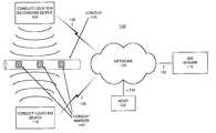
- FIG. 1illustrates an exemplary system 100 , consistent with the present invention, for identifying and mapping conduits.
- System 100may include a conduit location recording device 105 , a conduit locating device 110 , a Geographic Information System (GIS) server 115 , and a host 120 interconnected with a network 125 via wired 130 , wireless 135 , or optical connection links (not shown).
- System 100may further include conduit markers 140 affixed to one or more conduits 145 .
- GISGeographic Information System
- Conduit location recording device 105 and conduit locating device 110may be similarly constructed and may include conventional circuitry for implementing mobile communications.
- Conduit location recording device 105may map geo-locations of conduit markers 140 and may transmit the mapped locations to GIS server 115 via network 125 .
- Conduit locating device 110may identify conduit markers 140 and their corresponding geo-locations, and may transmit the identifiers and geo-locations to GIS server 115 via network 125 .
- GIS server 115may include one or more conventional servers that can communicate with devices 105 and 110 and host 120 via network 125 .
- Host 120may include a conventional computer, such as a desktop, laptop or the like.
- Host 120may be operated by an entity, such as a utility company, desiring to retrieve data associated with a specific conduit or geographic location from database 700 of GIS server 115 , as described in more detail below.
- An owner of a conduitmay also, for example, operate host 120 to update specific data related to that conduit that has been stored in database 700 of GIS server 115 , such as the in-use status of the conduit.
- Network 125can include one or more networks of any type, including a private land mobile network, Public Land Mobile Network (PLMN), Public Switched Telephone Network (PSTN), two-way paging network, satellite communications network, local area network (LAN), metropolitan area network (MAN), wide area network (WAN), Internet, Intranet, or any type of specialized radio-communications network.
- PLMNPublic Land Mobile Network
- PSTNPublic Switched Telephone Network
- LANlocal area network
- MANmetropolitan area network
- WANwide area network
- InternetIntranet
- Intranetor any type of specialized radio-communications network.
- the one or more PLMNsmay further include packet-switched sub-networks, such as, for example, General Packet Radio Service (GPRS), Cellular Digital Packet Data (CDPD), and Mobile IP sub-networks.
- GPRSGeneral Packet Radio Service
- CDPDCellular Digital Packet Data
- Conduit markers 140may include devices that provide conduit identifiers through, for example, magnetic or electromagnetic means.
- Conduit markers 140may include any type of conventional Radio Frequency Identifying (RFID) tags, such as, for example, those disclosed in U.S. Pat. Nos. 6,229,445 and 5,017,415.
- RFID tagsmay include, for example, small metal particles embedded in, or on, an electrically non-conductive material.
- theses particlesmay include metal-coated rods cut to a size that permits them to be used as bipolar antennas matched to a predetermined frequency.
- the metal-coated rodsmay be randomly distributed within the RFID tags such that when a RF signal is applied to the RFID tag, the electromagnetic energy will react with the randomly distributed antennas to produce a unique reflected signature of the RFID tag. Therefore, when the RF signal is applied to the RFID tag, the signature of the reflected portion of the RF signal can be read to uniquely identify the conduit marker 140 .
- Conduit markers 140may, additionally, include any type of conventional magnetic identifying markers, such as, for example, those disclosed in U.S. Pat. Nos. 5,114,517, 5,577,147, or 6,092,558.
- FIG. 2illustrates exemplary operation of system 100 .
- conduit location recording device 105can be carried/transported over an area under which a conduit 145 may be buried.
- Conduit location recording device 105may sense, via magnetic or electromagnetic means, identifiers for conduit markers 140 that may have been affixed to conduit 145 at specified intervals. Conduit location recording device 105 may then determine a geo-location for each sensed conduit marker 140 and transmit the sensed identifier and geo-location for each conduit marker 140 to GIS server 115 .
- Conduit locating device 110similarly, can be carried/transported over an area under which a conduit 145 may be buried. Conduit locating device 110 also may sense, via magnetic or electromagnetic means, identifiers for conduit markers 140 that have been affixed to conduit 145 at specified intervals. Conduit locating device 110 may transmit the sensed identifiers for each conduit marker 140 to GIS server 115 to retrieve previously stored conduit related data, such as, for example, mapped geographical data that indicates the location of a conduit, data indicating the owner of a conduit, and/or data that indicates an in-use status of a conduit.
- conduit related datasuch as, for example, mapped geographical data that indicates the location of a conduit, data indicating the owner of a conduit, and/or data that indicates an in-use status of a conduit.
- FIG. 3illustrates exemplary components of conduit location recording device 105 consistent with the present invention.
- Conduit locating device 110may be similarly configured.
- Conduit location recording device 105may include a communication interface 305 , an antenna 310 , a processing unit 315 , a memory 320 , an output device(s) 325 , an input device(s) 330 , an optional geo-location unit 335 , a marker sensor 340 , and a bus 345 .
- Communication interface 305may connect conduit location recording device 105 to another device or network, such as network 125 .
- communication interface 305may include transceiver circuitry well known to one skilled in the art for transmitting and/or receiving data bursts in a network, such as network 125 , via antenna 310 .
- Processing unit 315may perform all data processing functions for inputting, outputting and processing of data including data buffering and device control functions.
- Memory 320provides permanent, semi-permanent, or temporary working storage of data and instructions for use by processing unit 315 in performing processing functions.
- Memory 320may include large-capacity storage devices, such as magnetic and/or optical recording devices.
- Output device(s) 325may include conventional mechanisms for outputting data in video, audio and/or hard copy format.
- output device(s) 325may include a conventional display for viewing a geographic map and assorted text messages.
- Input device(s) 330may permit entry of data into conduit location recording device 105 .
- Input device(s) 330may include, for example, a keyboard or a mouse.
- Geo-location unit 335may include a conventional device for determining a geolocation of sensed conduit markers 140 .
- geo-location unit 335may include a Global Positioning System (GPS) receiver that can receive GPS signals and determine corresponding geo-locations.
- GPSGlobal Positioning System
- Marker sensor 340may include conventional sensors for identifying conduit markers 140 using one or more properties associated with the markers. Marker sensor 340 may, for example, identify conduit markers 140 through magnetic or electromagnetic properties associated with the markers. Marker sensor 340 may include any type of conventional magnetic and/or electromagnetic sensor, such as any of those disclosed in U.S. Pat. Nos. 6,229,445, 5,017,415, 5,114,517, 5,577,147, 6,092,558, 6,172,609, 5,430,379, or the like.
- Bus 345may interconnect the various components of conduit location recording device 105 and permit them to communicate with one another.
- FIG. 4illustrates exemplary components of GIS server 115 consistent with the present invention.
- Host 120may be similarly configured.
- GIS server 115may include a processing unit 405 , a memory 410 , an input device 415 , an output device 420 , network interface(s) 425 and a bus 430 .
- Processing unit 405may perform all data processing functions for inputting, outputting, and processing of data.
- Memory 410may include Random Access Memory (RAM) that provides temporary working storage of data and instructions for use by processing unit 405 in performing processing functions.
- Memory 410may additionally include Read Only Memory (ROM) that provides permanent or semi-permanent storage of data and instructions for use by processing unit 405 .
- Memory 410can also include large-capacity storage devices, such as a magnetic and/or optical device.
- Input device 415permits entry of data into GIS server 115 and may include a user interface (not shown).
- Output device 420permits the output of data in video, audio, or hard copy format.
- Network interface(s) 425interconnect GIS server 115 with network 125 .
- Bus 430interconnects the various components of GIS server 115 to permit the components to communicate with one another.
- FIG. 5illustrates an exemplary database 500 that may be stored in memory 320 of conduit location recording device 105 or conduit locating device 110 .
- Database 500may include conduit marker data records 505 associated with conduits 145 whose affixed conduit markers 140 have been sensed and their corresponding locations possibly recorded.
- FIG. 6illustrates an exemplary record 600 of conduit marker data records 505 .
- Record 600may include owner identifier data 605 , conduit identifier data 610 , conduit marker identifier data 615 , marker geo-location data 620 , and time stamp data 625 .
- Owner identifier data 605may uniquely identify an entity that owns, operates and/or services the conduit identified by conduit ID 610 .
- Conduit ID data 610may uniquely identify a conduit 145 to which the conduit marker 140 , identified by conduit marker ID 615 , is affixed.
- Conduit marker ID data 615may uniquely identify a particular conduit marker 140 affixed to a conduit 145 .
- Marker geo-location data 620may include a geo-location corresponding to the conduit marker 140 identified by conduit marker ID 615 .
- Time stamp data 625may include a time at which conduit marker ID 615 was sensed by either conduit location recording device 105 or conduit locating device 110 .
- FIG. 7illustrates an exemplary database 700 that may be stored in memory 410 of GIS server 115 .
- Database 700may include GIS conduit data records 705 associated with conduits 145 whose affixed conduit markers 140 have been sensed and their corresponding locations recorded.
- FIG. 8illustrates an exemplary record 800 of GIS conduit data records 705 .
- Record 800may include owner identifier data 605 , conduit identifier data 610 , conduit marker identifier data 615 , marker geo-location data 620 , time stamp data 625 , conduit in-use status data 805 , geo-data 810 and owner contact data 815 .
- Conduit in-use status data 805may identify a use status of the conduit identified by conduit ID 610 .
- the conduit in-use state 805 of a currently operating gas linewould indicate that the gas line was active and in-use.
- Geo-data 810may include map data of the geographic area surrounding the conduit identified by conduit ID 610 .
- Geo-data 810may include other information, such as, for example, the buried depth of the conduit identified by conduit ID 610 .
- Owner contact data 815may identify one or more methods by which the owner or operator of the conduit identified by conduit ID 610 can be contacted.
- owner contact data 815may include a facsimile number, a pager number, an e-mail address, or a telephone number that may be used by GIS server 115 to contact the owner identified by owner ID 605 .
- FIG. 9is a flowchart that illustrates exemplary processing, consistent with the present invention, for determining and recording the location of identified markers affixed to a buried conduit.
- the method exemplified by FIG. 9can be implemented as a sequence of instructions and stored in memory 320 of conduit location recording device 105 for execution by processing unit 315 .
- conduit markers 140may be attached to a conduit 145 [step 905 ].
- Conduit markers 140may be affixed to conduit 145 at regular intervals using manual or automatic mechanisms. For example, machinery that lays conduits may be modified to automatically affix conduit markers 140 to conduit 145 at specified intervals. Alternatively, such markers may be affixed as part of the manufacturing process for the conduit, or at other times prior to actual emplacement of the conduit.
- Conduit location recording device 105may then sense an affixed conduit marker using magnetic and/or electromagnetic mechanisms [step 910 ].
- Conduit location recording device 105may, for example, be carried/transported over a geographic area with the marker sensor 340 in an active state. As conduit location recording device 105 moves over each conduit marker 140 affixed to the conduit 145 , marker sensor 340 senses the unique identifier associated with the conduit marker 140 .
- Geo-location unit 235may then determine a precise geo-location of the sensed conduit marker 140 [step 915 ]. If geo-location unit 335 includes a GPS receiver, for example, geo-location unit 335 can receive GPS signals and determine a geo-location in accordance with conventional techniques. Alternatively, conduit location recording device 105 may determine a geo-location of the sensed conduit marker 140 by requesting conventional “E-911” location services from a Public Land Mobile Network (PLMN). Such services may provide conduit location recording device 105 with a current geo-location. Additionally, conduit location recording device 105 may determine a geo-location of the sensed conduit marker 140 by performing triangulation of special signals transmitted by, for example, AM radio stations. Conduit location recording device 105 may, optionally, time stamp the determined geo-location, indicating the time at which conduit marker 140 was sensed and identified [step 920 ].
- PLMNPublic Land Mobile Network
- Conduit location recording device 105may store a conduit identifier 610 , a conduit owner identifier 605 , a conduit marker identifier 615 , a marker geo-location 620 and time stamp 625 in a record in database 500 [step 925 ].
- Conduit identifier 610 and conduit owner identifier 605may additionally be entered by a device operator via input device(s) 330 or retrieved from memory 320 .
- Conduit location recording device 105may then establish a wireless connection with GIS server 115 via network 125 [step 930 ]. Connection establishment with GIS server 115 may include conventional methods for securing data transmission, such as encryption and authentication.
- conduit location recording device 105 and GIS server 115may implement a conventional Virtual Private Network (VPN) using a security protocol such as IP security (IPSec).
- IP securityIP security
- Such a security protocolmay require user identification, such as, for example, password identification, before a connection may be established between conduit location recording device 105 and GIS server 115 .
- conduit location recording device 105may transmit a message to GIS server 115 that may contain the conduit identifier 610 , conduit owner identifier 605 , conduit marker identifier 615 , marker geo-location 620 , and time stamp 625 [step 935 ].
- GIS server 115may receive the message and store the data contained therein in a record 800 of database 700 for future retrieval [step 940 ].
- the operator of the conduit location recording device 105may repeat this process for each conduit marker 140 .
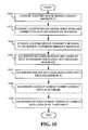
- FIG. 10is a flowchart that illustrates exemplary processing, consistent with the present invention, for locating markers affixed to a buried conduit and retrieving data related to the buried conduit from GIS server 115 .
- the method exemplified by FIG. 10can be implemented as a sequence of instructions and stored in memory 320 of conduit locating device 110 for execution by processing unit 315 .
- Conduit locating device 110may begin processing by sensing a conduit marker's identifier using magnetic and/or electromagnetic mechanisms [step 1005 ]. Conduit locating device 110 may then establish a wireless connection with GIS server 115 via network 125 [step 1010 ]. Connection establishment with GIS server 115 may include conventional methods for securing data transmission, such as encryption and authentication. For example, conduit locating device 10 and GIS server 115 may implement a conventional VPN using a security protocol such as IPSec. Such a security protocol may require user identification, such as, for example, password identification, before a connection may be established between conduit locating device 110 and GIS server 115 .
- IPSecsecurity protocol
- conduit locating device 110may transmit a message to GIS server 115 that may include the sensed marker's identifier (e.g., conduit marker ID 615 ) and a request for conduit data related to the sensed marker's identifier [step 1015 ].
- GIS server 115may receive the message and look up the requested conduit data associated with the received marker identifier in database 700 [step 1020 ].
- the conduit data requestmay include a request for owner ID data 605 , conduit ID data 610 , marker geo-location data 620 , time stamp data 625 , conduit in-use status data 805 , and/or geo-data 810 .
- GIS server 115may reply with a reply message that may include the requested data associated with the received marker identifier [step 1025 ].
- the reply messagemay include, for example, map data that allows an operator to immediately view, via output device(s) 325 , a geographic area map that may further display a trajectory of the conduit corresponding to the sensed marker's identifier (e.g., conduit marker ID 615 ).
- GIS server 115may further, optionally, look up conduit owner contact data (e.g., owner contact data 815 ) in database 700 [step 1030 ]. GIS server 115 may also, optionally, notify the conduit owner of conduit data look-up by a third party using the conduit owner contact data [step 1035 ]. For example, GIS server 115 may look up owner contact data 815 and retrieve an e-mail address at which an owner and/or operator of the conduit corresponding to conduit marker ID 615 can be contacted.
- conduit owner contact datae.g., owner contact data 815
- GIS server 115may also, optionally, notify the conduit owner of conduit data look-up by a third party using the conduit owner contact data [step 1035 ]. For example, GIS server 115 may look up owner contact data 815 and retrieve an e-mail address at which an owner and/or operator of the conduit corresponding to conduit marker ID 615 can be contacted.
- GIS server 115may then automatically send an e-mail to the retrieved e-mail address notifying the owner and/or operator that a third party has requested data regarding the owner/operator's conduit, thus, possibly indicating that the third party may be excavating at the location of the conduit.
- FIG. 11is a flowchart that illustrates exemplary processing, consistent with the present invention, for host retrieval of conduit data from GIS server 115 .
- the method exemplified by FIG. 11can be implemented as a sequence of instructions and stored in memory 410 of host 120 for execution by processing unit 405 .
- host 120may request a connection with GIS server 115 via network 125 [step 1105 ].
- GIS server 115may permit or deny the requested connection using conventional authentication techniques [step 1110 ].
- the connection with GIS server 115may be established using conventional methods for securing data transmission, such as encryption.
- host 120 and GIS server 115may implement a conventional VPN using a security protocol such as IPSec.
- host 120may transmit known data and requested conduit data to GIS server 115 [step 1115 ].
- host 120may transmit known conduit identification data (e.g., conduit ID 610 ) and may request owner ID data 605 , conduit in-use status data 805 and/or geo-data 810 from all records associated with the conduit identification data.
- GIS server 115may look up conduit data in database 700 corresponding to the received known data [step 1120 ].
- GIS server 115may look up all data records related to the known data (e.g., conduit ID 610 ) received from host 120 .
- GIS server 115may then return the requested conduit data to host 120 [step 1125 ].
- FIG. 12is a flowchart that illustrates exemplary processing, consistent with the present invention, for host 120 update of conduit data stored in GIS server 115 .
- the method exemplified by FIG. 12can be implemented as a sequence of instructions and stored in memory 410 of host 120 for execution by processing unit 405 .
- Host 120may begin processing by requesting a connection with GIS server 115 via network 125 [step 1205 ].
- GIS server 115may permit or deny the requested connection using conventional authentication techniques [step 1210 ].
- the connection with GIS server 115may be established using conventional methods for securing data transmission, such as encryption.
- host 120 and GIS server 115may: implement a conventional VPN using a security protocol such as IPSec.
- host 120may transmit updated conduit data to GIS server 115 [step 1215 ].
- host 120may update owner identification data (e.g., owner ID 605 ) and/or owner contact information (e.g., owner contact data 815 ) associated with a particular conduit (e.g., conduit ID 610 ).
- GIS server 115may receive the transmitted data and update appropriate records in database 700 [step 1220 ].
- GIS server 115may then return an update acknowledgment message to host 120 [step 1225 ].
- Systems and methods consistent with the present inventiontherefore, provide mechanisms that can identify, locate and map subsurface objects, such as conduits that may include cables, pipes and ducts.
- Data related to the identified and located subsurface objectscan be transmitted, via a wireless network, to a central data storage facility for storage.
- the stored datacan be subsequently retrieved by interested entities, such as utility companies, that may be considering the excavation of a particular geographic area containing one or more subsurface objects.
- the present inventionmay be used to detect any subsurface object.
- a markermay be affixed to one or more subsurface objects that may then be detected, after burial, in the manner described above.
- the conduit location recording device and the conduit locating devicehave been illustrated and described as separate devices, the functions of both of these devices may be performed by a single device.
Landscapes
- Physics & Mathematics (AREA)
- Engineering & Computer Science (AREA)
- Life Sciences & Earth Sciences (AREA)
- General Life Sciences & Earth Sciences (AREA)
- Geophysics (AREA)
- Geology (AREA)
- Mining & Mineral Resources (AREA)
- General Engineering & Computer Science (AREA)
- Environmental & Geological Engineering (AREA)
- Fluid Mechanics (AREA)
- Electromagnetism (AREA)
- Geochemistry & Mineralogy (AREA)
- Mechanical Engineering (AREA)
- General Physics & Mathematics (AREA)
- Mobile Radio Communication Systems (AREA)
Abstract
Description
Claims (22)
Priority Applications (1)
| Application Number | Priority Date | Filing Date | Title |
|---|---|---|---|
| US09/963,702US6850161B1 (en) | 2000-10-23 | 2001-09-26 | Systems and methods for identifying and mapping conduit location |
Applications Claiming Priority (2)
| Application Number | Priority Date | Filing Date | Title |
|---|---|---|---|
| US24259900P | 2000-10-23 | 2000-10-23 | |
| US09/963,702US6850161B1 (en) | 2000-10-23 | 2001-09-26 | Systems and methods for identifying and mapping conduit location |
Publications (1)
| Publication Number | Publication Date |
|---|---|
| US6850161B1true US6850161B1 (en) | 2005-02-01 |
Family
ID=34082698
Family Applications (1)
| Application Number | Title | Priority Date | Filing Date |
|---|---|---|---|
| US09/963,702Expired - Fee RelatedUS6850161B1 (en) | 2000-10-23 | 2001-09-26 | Systems and methods for identifying and mapping conduit location |
Country Status (1)
| Country | Link |
|---|---|
| US (1) | US6850161B1 (en) |
Cited By (89)
| Publication number | Priority date | Publication date | Assignee | Title |
|---|---|---|---|---|
| US20040113623A1 (en)* | 2000-12-28 | 2004-06-17 | Fabien Belloir | System for detecting optically invisible objects provided with encoding |
| US20050253704A1 (en)* | 2004-05-05 | 2005-11-17 | Trenstar, Inc. | Radio frequency identification asset management system, and computer program product |
| US20050258937A1 (en)* | 2004-05-05 | 2005-11-24 | Trenstar, Inc. | Radio frequency identification asset management system and method |
| US20050258956A1 (en)* | 2004-05-05 | 2005-11-24 | Trenstar, Inc. | Radio frequency identification asset management system and method |
| US20060185885A1 (en)* | 2003-10-29 | 2006-08-24 | Mcmillan T M | Communication cables including colored conductors or fibers and methods for making and using the same |
| US20070219722A1 (en)* | 2006-03-14 | 2007-09-20 | Sawyer Tom Y Jr | System and method for collecting and updating geographical data |
| NL1033485C2 (en)* | 2007-03-05 | 2008-09-17 | Volkerwessels Intellectuele Eigendom Bv | Identification method for locating object forming part of underground infrastructure, e.g. cable, involves measuring distance between ID tag receiving device and position of object in database |
| US20080228294A1 (en)* | 2007-03-13 | 2008-09-18 | Dycom Identity, Llc | Marking system and method with location and/or time tracking |
| US20080245299A1 (en)* | 2007-04-04 | 2008-10-09 | Dycom Identity, Llc | Marking system and method |
| US20080252449A1 (en)* | 2007-04-13 | 2008-10-16 | Claiton Pereira Colvero | Device, system and method for the location and identification of as-built plants of pipes, conduits, cables or hidden objects |
| US20090153321A1 (en)* | 2007-12-18 | 2009-06-18 | Alcatel Lucent | Ascertaining physical routing of cabling interconnects |
| US20090173511A1 (en)* | 2006-08-11 | 2009-07-09 | Superior Essex Communications Lp | Communication cable comprising electrically isolated patches of shielding material |
| US20090202111A1 (en)* | 2008-02-12 | 2009-08-13 | Steven Nielsen | Electronic manifest of underground facility locate marks |
| US20090204238A1 (en)* | 2007-03-13 | 2009-08-13 | Nielsen Steven E | Electronically controlled marking apparatus and methods |
| US20100009657A1 (en)* | 2008-07-09 | 2010-01-14 | International Business Machines Corporation | System and method for providing privacy and limited exposure services for location based services |
| US20100045517A1 (en)* | 2004-07-20 | 2010-02-25 | Global Precision Solutions, Llp | Precision GPS Driven Utility Asset Management and Utility Damage Prevention System and Method |
| US20100086677A1 (en)* | 2008-10-02 | 2010-04-08 | Certusview Technologies, Llc | Methods and apparatus for generating an electronic record of a marking operation based on marking device actuations |
| US20100085701A1 (en)* | 2008-10-02 | 2010-04-08 | Certusview Technologies, Llc | Marking device docking stations having security features and methods of using same |
| US20100088031A1 (en)* | 2008-10-02 | 2010-04-08 | Certusview Technologies, Llc | Methods and apparatus for generating an electronic record of environmental landmarks based on marking device actuations |
| US20100088164A1 (en)* | 2008-10-02 | 2010-04-08 | Certusview Technologies, Llc | Methods and apparatus for analyzing locate and marking operations with respect to facilities maps |
| US20100085185A1 (en)* | 2008-10-02 | 2010-04-08 | Certusview Technologies, Llc | Methods and apparatus for generating electronic records of locate operations |
| US20100109670A1 (en)* | 2006-06-02 | 2010-05-06 | Societe Plymouth Francaise | Detection system suitable for identifying and tracking buried pipes or other bodies buried in the ground or embedded in civil engineering works |
| US20100179963A1 (en)* | 2009-01-13 | 2010-07-15 | John Conner | Method and computer program product for geophysical and geologic data identification, geodetic classification, and organization |
| US20100188088A1 (en)* | 2008-10-02 | 2010-07-29 | Certusview Technologies, Llc | Methods and apparatus for displaying and processing facilities map information and/or other image information on a locate device |
| US20100188216A1 (en)* | 2008-10-02 | 2010-07-29 | Certusview Technologies, Llc | Methods and apparatus for generating alerts on a locate device, based on comparing electronic locate information to facilities map information and/or other image information |
| US20100188245A1 (en)* | 2008-10-02 | 2010-07-29 | Certusview Technologies, Llc | Locate apparatus having enhanced features for underground facility locate operations, and associated methods and systems |
| US20100188215A1 (en)* | 2008-10-02 | 2010-07-29 | Certusview Technologies, Llc | Methods and apparatus for generating alerts on a marking device, based on comparing electronic marking information to facilities map information and/or other image information |
| US20100188407A1 (en)* | 2008-10-02 | 2010-07-29 | Certusview Technologies, Llc | Methods and apparatus for displaying and processing facilities map information and/or other image information on a marking device |
| US20100189312A1 (en)* | 2008-10-02 | 2010-07-29 | Certusview Technologies, Llc | Methods and apparatus for overlaying electronic locate information on facilities map information and/or other image information displayed on a locate device |
| US20100198663A1 (en)* | 2008-10-02 | 2010-08-05 | Certusview Technologies, Llc | Methods and apparatus for overlaying electronic marking information on facilities map information and/or other image information displayed on a marking device |
| US20100205031A1 (en)* | 2009-02-10 | 2010-08-12 | Certusview Technologies, Llc | Methods, apparatus, and systems for exchanging information between excavators and other entities associated with underground facility locate and marking operations |
| US20100228588A1 (en)* | 2009-02-11 | 2010-09-09 | Certusview Technologies, Llc | Management system, and associated methods and apparatus, for providing improved visibility, quality control and audit capability for underground facility locate and/or marking operations |
| US20100245086A1 (en)* | 2008-10-02 | 2010-09-30 | Certusview Technologies, Llc | Marking apparatus configured to detect out-of-tolerance conditions in connection with underground facility marking operations, and associated methods and systems |
| US20100272885A1 (en)* | 2006-08-16 | 2010-10-28 | SeekTech, Inc., a California corporation | Marking Paint Applicator for Portable Locator |
| US20110007076A1 (en)* | 2009-07-07 | 2011-01-13 | Certusview Technologies, Llc | Methods, apparatus and systems for generating searchable electronic records of underground facility locate and/or marking operations |
| US20110045175A1 (en)* | 2009-08-20 | 2011-02-24 | Certusview Technologies, Llc | Methods and marking devices with mechanisms for indicating and/or detecting marking material color |
| US20110060549A1 (en)* | 2009-08-20 | 2011-03-10 | Certusview Technologies, Llc | Methods and apparatus for assessing marking operations based on acceleration information |
| USD634655S1 (en) | 2010-03-01 | 2011-03-22 | Certusview Technologies, Llc | Handle of a marking device |
| USD634657S1 (en) | 2010-03-01 | 2011-03-22 | Certusview Technologies, Llc | Paint holder of a marking device |
| USD634656S1 (en) | 2010-03-01 | 2011-03-22 | Certusview Technologies, Llc | Shaft of a marking device |
| US20110117272A1 (en)* | 2009-08-20 | 2011-05-19 | Certusview Technologies, Llc | Marking device with transmitter for triangulating location during locate operations |
| US20110131081A1 (en)* | 2009-02-10 | 2011-06-02 | Certusview Technologies, Llc | Methods, apparatus, and systems for providing an enhanced positive response in underground facility locate and marking operations |
| US20110147033A1 (en)* | 2006-08-11 | 2011-06-23 | Superior Essex Communications Lp | Communication Cable Comprising Electrically Discontinuous Shield Having Nonmetallic Appearance |
| US20110191058A1 (en)* | 2009-08-11 | 2011-08-04 | Certusview Technologies, Llc | Locating equipment communicatively coupled to or equipped with a mobile/portable device |
| USD643321S1 (en) | 2010-03-01 | 2011-08-16 | Certusview Technologies, Llc | Marking device |
| WO2012015746A1 (en)* | 2010-07-30 | 2012-02-02 | Certusview Technologies, Llc | Methods, apparatus and systems for onsite linking to location-specific electronic records of locate operations |
| US8450606B2 (en) | 2006-08-11 | 2013-05-28 | Superior Essex Communication LP | Communication cable having electrically isolated shield providing enhanced return loss |
| USD684067S1 (en) | 2012-02-15 | 2013-06-11 | Certusview Technologies, Llc | Modular marking device |
| US8473209B2 (en) | 2007-03-13 | 2013-06-25 | Certusview Technologies, Llc | Marking apparatus and marking methods using marking dispenser with machine-readable ID mechanism |
| US8532341B2 (en)* | 2008-02-12 | 2013-09-10 | Certusview Technologies, Llc | Electronically documenting locate operations for underground utilities |
| US8547247B1 (en)* | 2012-07-06 | 2013-10-01 | Alan Haddy | Detecting, locating and tracing of buried assets using distributed processing over communications networks |
| US20130263958A1 (en)* | 2010-11-10 | 2013-10-10 | Ryb S.A. | Polymer Tube Comprising an Identification Sensor, as its Manufacturing Process |
| WO2013169200A1 (en)* | 2012-05-10 | 2013-11-14 | Dellcron Ab | Method for placement of ducts/cables and device for planning placement thereof |
| CN103748318A (en)* | 2011-06-21 | 2014-04-23 | 维米尔制造公司 | Horizontal directional drilling system including sonde position detection using global positioning systems |
| US20140191904A1 (en)* | 2013-01-09 | 2014-07-10 | Baker Hughes Incorporated | System and method to generate three-dimensional mapping of a tubular component layout |
| US20140203947A1 (en)* | 2013-01-20 | 2014-07-24 | Alan Haddy | Storage and recall of buried asset data over communications networks for damage avoidance and mapping |
| US8866637B1 (en) | 2008-01-24 | 2014-10-21 | LDARtools, Inc. | Data collection process for optical leak detection |
| US8902251B2 (en) | 2009-02-10 | 2014-12-02 | Certusview Technologies, Llc | Methods, apparatus and systems for generating limited access files for searchable electronic records of underground facility locate and/or marking operations |
| US8977558B2 (en) | 2010-08-11 | 2015-03-10 | Certusview Technologies, Llc | Methods, apparatus and systems for facilitating generation and assessment of engineering plans |
| US9004004B2 (en) | 2008-07-10 | 2015-04-14 | Certusview Technologies, Llc | Optical sensing methods and apparatus for detecting a color of a marking substance |
| US9013274B2 (en) | 2010-09-22 | 2015-04-21 | 3M Innovative Properties Company | Magnetomechanical markers for marking stationary assets |
| US9251930B1 (en) | 2006-08-11 | 2016-02-02 | Essex Group, Inc. | Segmented shields for use in communication cables |
| US9275776B1 (en) | 2006-08-11 | 2016-03-01 | Essex Group, Inc. | Shielding elements for use in communication cables |
| US9280269B2 (en) | 2008-02-12 | 2016-03-08 | Certusview Technologies, Llc | Electronic manifest of underground facility locate marks |
| US9363935B1 (en) | 2006-08-11 | 2016-06-07 | Superior Essex Communications Lp | Subdivided separation fillers for use in cables |
| US9418266B1 (en)* | 2013-09-26 | 2016-08-16 | Halliburton Energy Services, Inc. | Tracking oilfield assets with a universal identification protocol |
| US9424964B1 (en) | 2013-05-08 | 2016-08-23 | Superior Essex International LP | Shields containing microcuts for use in communications cables |
| WO2016146515A1 (en)* | 2015-03-18 | 2016-09-22 | Gerd Reime | System, method, and computer program for the mobile supply of data of concealed objects |
| US9741470B1 (en) | 2017-03-10 | 2017-08-22 | Superior Essex International LP | Communication cables incorporating separators with longitudinally spaced projections |
| US9821415B2 (en) | 2014-03-28 | 2017-11-21 | Crc-Evans Pipeline International, Inc. | Internal pipeline cooler |
| US9928943B1 (en) | 2016-08-03 | 2018-03-27 | Superior Essex International LP | Communication cables incorporating separator structures |
| US20180128931A1 (en)* | 2013-10-17 | 2018-05-10 | SeeScan, Inc. | Electronic marker devices and systems |
| US10040141B2 (en) | 2013-05-23 | 2018-08-07 | Crc-Evans Pipeline International, Inc. | Laser controlled internal welding machine for a pipeline |
| US10068685B1 (en) | 2016-11-08 | 2018-09-04 | Superior Essex International LP | Communication cables with separators having alternating projections |
| US10102946B1 (en) | 2015-10-09 | 2018-10-16 | Superior Essex International LP | Methods for manufacturing discontinuous shield structures for use in communication cables |
| US10121571B1 (en) | 2016-08-31 | 2018-11-06 | Superior Essex International LP | Communications cables incorporating separator structures |
| US10276281B1 (en) | 2016-11-08 | 2019-04-30 | Superior Essex International LP | Communication cables with twisted tape separators |
| US10438726B1 (en) | 2017-06-16 | 2019-10-08 | Superior Essex International LP | Communication cables incorporating separators with longitudinally spaced radial ridges |
| US10480862B2 (en) | 2013-05-23 | 2019-11-19 | Crc-Evans Pipeline International, Inc. | Systems and methods for use in welding pipe segments of a pipeline |
| US10593502B1 (en) | 2018-08-21 | 2020-03-17 | Superior Essex International LP | Fusible continuous shields for use in communication cables |
| US10589371B2 (en) | 2013-05-23 | 2020-03-17 | Crc-Evans Pipeline International, Inc. | Rotating welding system and methods |
| US10668577B2 (en) | 2016-09-01 | 2020-06-02 | Crc-Evans Pipeline International Inc. | Cooling ring |
| US10695876B2 (en) | 2013-05-23 | 2020-06-30 | Crc-Evans Pipeline International, Inc. | Self-powered welding systems and methods |
| US10714874B1 (en) | 2015-10-09 | 2020-07-14 | Superior Essex International LP | Methods for manufacturing shield structures for use in communication cables |
| US10828715B2 (en) | 2014-08-29 | 2020-11-10 | Crc-Evans Pipeline International, Inc. | System for welding |
| US11458571B2 (en) | 2016-07-01 | 2022-10-04 | Crc-Evans Pipeline International, Inc. | Systems and methods for use in welding pipe segments of a pipeline |
| IT202100019571A1 (en)* | 2021-07-22 | 2023-01-22 | Ekonovigo S R L | SYSTEM AND METHOD OF MAPPING AN ACCESSORY PLACED ON A FLUID TRANSPORT PIPE |
| US11619322B1 (en)* | 2021-08-31 | 2023-04-04 | Jason Russell | Clean-out cap locator |
| US11767934B2 (en) | 2013-05-23 | 2023-09-26 | Crc-Evans Pipeline International, Inc. | Internally welded pipes |
Citations (28)
| Publication number | Priority date | Publication date | Assignee | Title |
|---|---|---|---|---|
| US4652861A (en)* | 1985-06-04 | 1987-03-24 | Gte Sprint Communications Corporation | Method and apparatus for protecting buried optical fiber cable |
| US4767237A (en) | 1986-08-26 | 1988-08-30 | Minnesota Mining And Manufacturing Company | Marking tape with wire conductors and methods for use |
| US5014008A (en) | 1988-06-28 | 1991-05-07 | Radiodetection Limited | System for detecting the location and orientation of a temporarily inaccessible object |
| US5017415A (en) | 1989-09-18 | 1991-05-21 | Minnesota Mining And Manufacturing Company | Self-dispensing spaced electronic markers |
| US5043666A (en) | 1990-04-16 | 1991-08-27 | Metrotech Corporation | Self-calibrating electromagnetic field sensor for locating buried conduits |
| US5114517A (en) | 1989-10-30 | 1992-05-19 | Schonstedt Instrument Company | Methods, apparatus and devices relating to magnetic markers for elongated hidden objects |
| US5116654A (en) | 1989-09-18 | 1992-05-26 | Minnesota Mining And Manufacturing Company | Self-dispensing spaced electronic markers |
| US5173139A (en) | 1989-03-15 | 1992-12-22 | Schonstedt Instrument Company | Method for providing magnetic markers on elongated hidden objects |
| US5206065A (en) | 1989-03-15 | 1993-04-27 | Schonstedt Instrument Company | Methods, apparatus and devices relating to magnetic markers for elongated hidden objects |
| US5296850A (en)* | 1988-12-09 | 1994-03-22 | King Fred N | Apparatus and proceses for mapping the connectivity of communications systems with multiple communications paths |
| US5305411A (en) | 1993-02-26 | 1994-04-19 | At&T Bell Laboratories | Dielectric optical fiber cables which are magnetically locatable |
| US5361029A (en)* | 1990-06-18 | 1994-11-01 | The Charles Machine Works, Inc. | System for locating multiple concealed underground objects |
| US5430379A (en) | 1993-08-27 | 1995-07-04 | Minnesota Mining And Manufacturing Company | Conductor locator adapter for electronic markers |
| US5463838A (en) | 1993-11-09 | 1995-11-07 | Collier; William R. | Methods and apparatus for installing conductor cables in rigid building structures |
| US5532598A (en)* | 1994-05-25 | 1996-07-02 | Westinghouse Electric Corporation | Amorphous metal tagging system for underground structures including elongated particles of amorphous metal embedded in nonmagnetic and nonconductive material |
| US5557258A (en)* | 1995-04-28 | 1996-09-17 | At&T | Method and apparatus for warning of potential harm to an underground utility conveyance |
| US5563583A (en) | 1994-11-23 | 1996-10-08 | International Business Machines Corporation | Multibit magnetic radio frequency tag using micromechanics |
| US5577147A (en) | 1994-03-31 | 1996-11-19 | Lucent Technologies Inc. | Magnetically locatable optical fiber cables containing integrated magnetic marker materials |
| US5635907A (en)* | 1993-08-10 | 1997-06-03 | Bernard; Hermanus A. | Location system |
| US5704189A (en) | 1993-11-09 | 1998-01-06 | Collier; William R. | Methods and apparatus for installing conductor cables in rigid building structures |
| US5720354A (en)* | 1996-01-11 | 1998-02-24 | Vermeer Manufacturing Company | Trenchless underground boring system with boring tool location |
| US5724425A (en)* | 1994-06-10 | 1998-03-03 | Sun Microsystems, Inc. | Method and apparatus for enhancing software security and distributing software |
| US6092558A (en) | 1998-02-19 | 2000-07-25 | Maccario; Floriano A. | Detectability of buried elongated objects such as pipes, ducts and conduits |
| US6176425B1 (en)* | 1998-09-10 | 2001-01-23 | Xerox Corporation | Information management system supporting multiple electronic tags |
| US6229445B1 (en) | 1997-01-13 | 2001-05-08 | Tecsec, Incorporated | RF identification process and apparatus |
| US6377203B1 (en)* | 2000-02-01 | 2002-04-23 | 3M Innovative Properties Company | Collision arbitration method and apparatus for reading multiple radio frequency identification tags |
| US6374746B1 (en)* | 1999-06-21 | 2002-04-23 | Orlo James Fiske | Magnetic levitation transportation system and method |
| US6405135B1 (en)* | 2000-07-18 | 2002-06-11 | John J. Adriany | System for remote detection and notification of subterranean pollutants |
- 2001
- 2001-09-26USUS09/963,702patent/US6850161B1/ennot_activeExpired - Fee Related
Patent Citations (28)
| Publication number | Priority date | Publication date | Assignee | Title |
|---|---|---|---|---|
| US4652861A (en)* | 1985-06-04 | 1987-03-24 | Gte Sprint Communications Corporation | Method and apparatus for protecting buried optical fiber cable |
| US4767237A (en) | 1986-08-26 | 1988-08-30 | Minnesota Mining And Manufacturing Company | Marking tape with wire conductors and methods for use |
| US5014008A (en) | 1988-06-28 | 1991-05-07 | Radiodetection Limited | System for detecting the location and orientation of a temporarily inaccessible object |
| US5296850A (en)* | 1988-12-09 | 1994-03-22 | King Fred N | Apparatus and proceses for mapping the connectivity of communications systems with multiple communications paths |
| US5173139A (en) | 1989-03-15 | 1992-12-22 | Schonstedt Instrument Company | Method for providing magnetic markers on elongated hidden objects |
| US5206065A (en) | 1989-03-15 | 1993-04-27 | Schonstedt Instrument Company | Methods, apparatus and devices relating to magnetic markers for elongated hidden objects |
| US5017415A (en) | 1989-09-18 | 1991-05-21 | Minnesota Mining And Manufacturing Company | Self-dispensing spaced electronic markers |
| US5116654A (en) | 1989-09-18 | 1992-05-26 | Minnesota Mining And Manufacturing Company | Self-dispensing spaced electronic markers |
| US5114517A (en) | 1989-10-30 | 1992-05-19 | Schonstedt Instrument Company | Methods, apparatus and devices relating to magnetic markers for elongated hidden objects |
| US5043666A (en) | 1990-04-16 | 1991-08-27 | Metrotech Corporation | Self-calibrating electromagnetic field sensor for locating buried conduits |
| US5361029A (en)* | 1990-06-18 | 1994-11-01 | The Charles Machine Works, Inc. | System for locating multiple concealed underground objects |
| US5305411A (en) | 1993-02-26 | 1994-04-19 | At&T Bell Laboratories | Dielectric optical fiber cables which are magnetically locatable |
| US5635907A (en)* | 1993-08-10 | 1997-06-03 | Bernard; Hermanus A. | Location system |
| US5430379A (en) | 1993-08-27 | 1995-07-04 | Minnesota Mining And Manufacturing Company | Conductor locator adapter for electronic markers |
| US5463838A (en) | 1993-11-09 | 1995-11-07 | Collier; William R. | Methods and apparatus for installing conductor cables in rigid building structures |
| US5704189A (en) | 1993-11-09 | 1998-01-06 | Collier; William R. | Methods and apparatus for installing conductor cables in rigid building structures |
| US5577147A (en) | 1994-03-31 | 1996-11-19 | Lucent Technologies Inc. | Magnetically locatable optical fiber cables containing integrated magnetic marker materials |
| US5532598A (en)* | 1994-05-25 | 1996-07-02 | Westinghouse Electric Corporation | Amorphous metal tagging system for underground structures including elongated particles of amorphous metal embedded in nonmagnetic and nonconductive material |
| US5724425A (en)* | 1994-06-10 | 1998-03-03 | Sun Microsystems, Inc. | Method and apparatus for enhancing software security and distributing software |
| US5563583A (en) | 1994-11-23 | 1996-10-08 | International Business Machines Corporation | Multibit magnetic radio frequency tag using micromechanics |
| US5557258A (en)* | 1995-04-28 | 1996-09-17 | At&T | Method and apparatus for warning of potential harm to an underground utility conveyance |
| US5720354A (en)* | 1996-01-11 | 1998-02-24 | Vermeer Manufacturing Company | Trenchless underground boring system with boring tool location |
| US6229445B1 (en) | 1997-01-13 | 2001-05-08 | Tecsec, Incorporated | RF identification process and apparatus |
| US6092558A (en) | 1998-02-19 | 2000-07-25 | Maccario; Floriano A. | Detectability of buried elongated objects such as pipes, ducts and conduits |
| US6176425B1 (en)* | 1998-09-10 | 2001-01-23 | Xerox Corporation | Information management system supporting multiple electronic tags |
| US6374746B1 (en)* | 1999-06-21 | 2002-04-23 | Orlo James Fiske | Magnetic levitation transportation system and method |
| US6377203B1 (en)* | 2000-02-01 | 2002-04-23 | 3M Innovative Properties Company | Collision arbitration method and apparatus for reading multiple radio frequency identification tags |
| US6405135B1 (en)* | 2000-07-18 | 2002-06-11 | John J. Adriany | System for remote detection and notification of subterranean pollutants |
Cited By (217)
| Publication number | Priority date | Publication date | Assignee | Title |
|---|---|---|---|---|
| US20040113623A1 (en)* | 2000-12-28 | 2004-06-17 | Fabien Belloir | System for detecting optically invisible objects provided with encoding |
| US20060185885A1 (en)* | 2003-10-29 | 2006-08-24 | Mcmillan T M | Communication cables including colored conductors or fibers and methods for making and using the same |
| US20050253704A1 (en)* | 2004-05-05 | 2005-11-17 | Trenstar, Inc. | Radio frequency identification asset management system, and computer program product |
| US20050258937A1 (en)* | 2004-05-05 | 2005-11-24 | Trenstar, Inc. | Radio frequency identification asset management system and method |
| US20050258956A1 (en)* | 2004-05-05 | 2005-11-24 | Trenstar, Inc. | Radio frequency identification asset management system and method |
| US7633392B2 (en) | 2004-05-05 | 2009-12-15 | General Electric Company | Radio frequency identification asset management system, and computer program product |
| US20090237253A1 (en)* | 2004-05-05 | 2009-09-24 | Trenstar, Inc. | Radio frequency identification asset management system and method |
| US20100141447A1 (en)* | 2004-05-05 | 2010-06-10 | General Electric Company | Radio frequency identification asset management system, and computer program product |
| US7466232B2 (en) | 2004-05-05 | 2008-12-16 | Trenstar Tracking Solutions, Inc. | Radio frequency identification asset management system and method |
| US8125339B2 (en) | 2004-05-05 | 2012-02-28 | General Electric Company | Radio frequency identification asset management system, and computer program product |
| US20100045517A1 (en)* | 2004-07-20 | 2010-02-25 | Global Precision Solutions, Llp | Precision GPS Driven Utility Asset Management and Utility Damage Prevention System and Method |
| US8081112B2 (en)* | 2004-07-20 | 2011-12-20 | Global Precision Solutions, Llp. | System and method for collecting information related to utility assets |
| US8144058B2 (en)* | 2006-03-14 | 2012-03-27 | Global Precision Solutions, Llp. | System and method for collecting and updating geographical data |
| US20070219722A1 (en)* | 2006-03-14 | 2007-09-20 | Sawyer Tom Y Jr | System and method for collecting and updating geographical data |
| US7978129B2 (en)* | 2006-03-14 | 2011-07-12 | Global Precision Solutions, Llp. | System and method for collecting and updating geographical data |
| US20100109670A1 (en)* | 2006-06-02 | 2010-05-06 | Societe Plymouth Francaise | Detection system suitable for identifying and tracking buried pipes or other bodies buried in the ground or embedded in civil engineering works |
| US8492648B2 (en) | 2006-08-11 | 2013-07-23 | Superior Essex Communications Lp | Communication cable comprising electrically discontinuous shield having nonmetallic appearance |
| US8450606B2 (en) | 2006-08-11 | 2013-05-28 | Superior Essex Communication LP | Communication cable having electrically isolated shield providing enhanced return loss |
| US7923641B2 (en) | 2006-08-11 | 2011-04-12 | Superior Essex Communications LLP | Communication cable comprising electrically isolated patches of shielding material |
| US9251930B1 (en) | 2006-08-11 | 2016-02-02 | Essex Group, Inc. | Segmented shields for use in communication cables |
| US20110147033A1 (en)* | 2006-08-11 | 2011-06-23 | Superior Essex Communications Lp | Communication Cable Comprising Electrically Discontinuous Shield Having Nonmetallic Appearance |
| US20110147039A1 (en)* | 2006-08-11 | 2011-06-23 | Superior Essex Communications Lp | Communication Cable Comprising Electrically Discontinuous Shield Having Nonmetallic Appearance |
| US9363935B1 (en) | 2006-08-11 | 2016-06-07 | Superior Essex Communications Lp | Subdivided separation fillers for use in cables |
| US20090173511A1 (en)* | 2006-08-11 | 2009-07-09 | Superior Essex Communications Lp | Communication cable comprising electrically isolated patches of shielding material |
| US8395045B2 (en) | 2006-08-11 | 2013-03-12 | Superior Essex Communications Lp | Communication cable comprising electrically discontinuous shield having nonmetallic appearance |
| US9275776B1 (en) | 2006-08-11 | 2016-03-01 | Essex Group, Inc. | Shielding elements for use in communication cables |
| US20100272885A1 (en)* | 2006-08-16 | 2010-10-28 | SeekTech, Inc., a California corporation | Marking Paint Applicator for Portable Locator |
| NL1033485C2 (en)* | 2007-03-05 | 2008-09-17 | Volkerwessels Intellectuele Eigendom Bv | Identification method for locating object forming part of underground infrastructure, e.g. cable, involves measuring distance between ID tag receiving device and position of object in database |
| US9086277B2 (en) | 2007-03-13 | 2015-07-21 | Certusview Technologies, Llc | Electronically controlled marking apparatus and methods |
| US8700325B2 (en) | 2007-03-13 | 2014-04-15 | Certusview Technologies, Llc | Marking apparatus and methods for creating an electronic record of marking operations |
| US20090208642A1 (en)* | 2007-03-13 | 2009-08-20 | Nielsen Steven E | Marking apparatus and methods for creating an electronic record of marking operations |
| US20080228294A1 (en)* | 2007-03-13 | 2008-09-18 | Dycom Identity, Llc | Marking system and method with location and/or time tracking |
| US8473209B2 (en) | 2007-03-13 | 2013-06-25 | Certusview Technologies, Llc | Marking apparatus and marking methods using marking dispenser with machine-readable ID mechanism |
| US20090204238A1 (en)* | 2007-03-13 | 2009-08-13 | Nielsen Steven E | Electronically controlled marking apparatus and methods |
| US8407001B2 (en) | 2007-03-13 | 2013-03-26 | Certusview Technologies, Llc | Systems and methods for using location data to electronically display dispensing of markers by a marking system or marking tool |
| US20100094553A1 (en)* | 2007-03-13 | 2010-04-15 | Certusview Technologies, Llc | Systems and methods for using location data and/or time data to electronically display dispensing of markers by a marking system or marking tool |
| US8401791B2 (en) | 2007-03-13 | 2013-03-19 | Certusview Technologies, Llc | Methods for evaluating operation of marking apparatus |
| US8478523B2 (en) | 2007-03-13 | 2013-07-02 | Certusview Technologies, Llc | Marking apparatus and methods for creating an electronic record of marking apparatus operations |
| US7640105B2 (en) | 2007-03-13 | 2009-12-29 | Certus View Technologies, LLC | Marking system and method with location and/or time tracking |
| US20090210098A1 (en)* | 2007-03-13 | 2009-08-20 | Nielsen Steven E | Marking apparatus and methods for creating an electronic record of marking apparatus operations |
| US8775077B2 (en) | 2007-03-13 | 2014-07-08 | Certusview Technologies, Llc | Systems and methods for using location data to electronically display dispensing of markers by a marking system or marking tool |
| US8903643B2 (en) | 2007-03-13 | 2014-12-02 | Certusview Technologies, Llc | Hand-held marking apparatus with location tracking system and methods for logging geographic location of same |
| US20090201178A1 (en)* | 2007-03-13 | 2009-08-13 | Nielsen Steven E | Methods for evaluating operation of marking apparatus |
| US8374789B2 (en) | 2007-04-04 | 2013-02-12 | Certusview Technologies, Llc | Systems and methods for using marking information to electronically display dispensing of markers by a marking system or marking tool |
| US20090013928A1 (en)* | 2007-04-04 | 2009-01-15 | Certusview Technologies, Llc | Marking system and method |
| US8386178B2 (en) | 2007-04-04 | 2013-02-26 | Certusview Technologies, Llc | Marking system and method |
| US20100090858A1 (en)* | 2007-04-04 | 2010-04-15 | Certusview Technologies, Llc | Systems and methods for using marking information to electronically display dispensing of markers by a marking system or marking tool |
| US8060304B2 (en) | 2007-04-04 | 2011-11-15 | Certusview Technologies, Llc | Marking system and method |
| US20080245299A1 (en)* | 2007-04-04 | 2008-10-09 | Dycom Identity, Llc | Marking system and method |
| US20080252449A1 (en)* | 2007-04-13 | 2008-10-16 | Claiton Pereira Colvero | Device, system and method for the location and identification of as-built plants of pipes, conduits, cables or hidden objects |
| US7969295B2 (en)* | 2007-04-13 | 2011-06-28 | Claiton Pereira Colvero | Device, system and method for the location and identification of as-built plants of pipes, conduits, cables or hidden objects |
| US20090153321A1 (en)* | 2007-12-18 | 2009-06-18 | Alcatel Lucent | Ascertaining physical routing of cabling interconnects |
| US7696879B2 (en)* | 2007-12-18 | 2010-04-13 | Alcatel Lucent | Ascertaining physical routing of cabling interconnects |
| US8866637B1 (en) | 2008-01-24 | 2014-10-21 | LDARtools, Inc. | Data collection process for optical leak detection |
| US20090202111A1 (en)* | 2008-02-12 | 2009-08-13 | Steven Nielsen | Electronic manifest of underground facility locate marks |
| US20140022272A1 (en)* | 2008-02-12 | 2014-01-23 | Certusview Technologies, Llc | Electronically documenting locate operations for underground utilities |
| US8532341B2 (en)* | 2008-02-12 | 2013-09-10 | Certusview Technologies, Llc | Electronically documenting locate operations for underground utilities |
| US20090202101A1 (en)* | 2008-02-12 | 2009-08-13 | Dycom Technology, Llc | Electronic manifest of underground facility locate marks |
| US8416995B2 (en)* | 2008-02-12 | 2013-04-09 | Certusview Technologies, Llc | Electronic manifest of underground facility locate marks |
| US8532342B2 (en) | 2008-02-12 | 2013-09-10 | Certusview Technologies, Llc | Electronic manifest of underground facility locate marks |
| US8543937B2 (en) | 2008-02-12 | 2013-09-24 | Certusview Technologies, Llc | Methods and apparatus employing a reference grid for generating electronic manifests of underground facility marking operations |
| US8630463B2 (en) | 2008-02-12 | 2014-01-14 | Certusview Technologies, Llc | Searchable electronic records of underground facility locate marking operations |
| US9280269B2 (en) | 2008-02-12 | 2016-03-08 | Certusview Technologies, Llc | Electronic manifest of underground facility locate marks |
| US20090201311A1 (en)* | 2008-02-12 | 2009-08-13 | Steven Nielsen | Electronic manifest of underground facility locate marks |
| US8907978B2 (en) | 2008-02-12 | 2014-12-09 | Certusview Technologies, Llc | Methods, apparatus and systems for generating searchable electronic records of underground facility locate and/or marking operations |
| US9256964B2 (en)* | 2008-02-12 | 2016-02-09 | Certusview Technologies, Llc | Electronically documenting locate operations for underground utilities |
| US9471835B2 (en) | 2008-02-12 | 2016-10-18 | Certusview Technologies, Llc | Electronic manifest of underground facility locate marks |
| US8994749B2 (en) | 2008-02-12 | 2015-03-31 | Certusview Technologies, Llc | Methods, apparatus and systems for generating searchable electronic records of underground facility locate and/or marking operations |
| US9183646B2 (en)* | 2008-02-12 | 2015-11-10 | Certusview Technologies, Llc | Apparatus, systems and methods to generate electronic records of underground facility marking operations performed with GPS-enabled marking devices |
| US20150243054A1 (en)* | 2008-02-12 | 2015-08-27 | Certusview Technologies, Llc | Apparatus, systems and methods to generate electronic records of underground facility marking operations performed with gps-enabled marking devices |
| US20100009657A1 (en)* | 2008-07-09 | 2010-01-14 | International Business Machines Corporation | System and method for providing privacy and limited exposure services for location based services |
| US8966114B2 (en) | 2008-07-09 | 2015-02-24 | Nng Llc | System and method for providing privacy and limited exposure services for location based services |
| US8332535B2 (en)* | 2008-07-09 | 2012-12-11 | International Business Machines Corporation | System and method for providing privacy and limited exposure services for location based services |
| US9004004B2 (en) | 2008-07-10 | 2015-04-14 | Certusview Technologies, Llc | Optical sensing methods and apparatus for detecting a color of a marking substance |
| US8478524B2 (en) | 2008-10-02 | 2013-07-02 | Certusview Technologies, Llc | Methods and apparatus for dispensing marking material in connection with underground facility marking operations based on environmental information and/or operational information |
| US20100088164A1 (en)* | 2008-10-02 | 2010-04-08 | Certusview Technologies, Llc | Methods and apparatus for analyzing locate and marking operations with respect to facilities maps |
| US9542863B2 (en) | 2008-10-02 | 2017-01-10 | Certusview Technologies, Llc | Methods and apparatus for generating output data streams relating to underground utility marking operations |
| US20100086677A1 (en)* | 2008-10-02 | 2010-04-08 | Certusview Technologies, Llc | Methods and apparatus for generating an electronic record of a marking operation based on marking device actuations |
| US20100085701A1 (en)* | 2008-10-02 | 2010-04-08 | Certusview Technologies, Llc | Marking device docking stations having security features and methods of using same |
| US20100088031A1 (en)* | 2008-10-02 | 2010-04-08 | Certusview Technologies, Llc | Methods and apparatus for generating an electronic record of environmental landmarks based on marking device actuations |
| US20110095885A9 (en)* | 2008-10-02 | 2011-04-28 | Certusview Technologies, Llc | Methods and apparatus for generating electronic records of locate operations |
| US20100084532A1 (en)* | 2008-10-02 | 2010-04-08 | Certusview Technologies, Llc | Marking device docking stations having mechanical docking and methods of using same |
| US20100085694A1 (en)* | 2008-10-02 | 2010-04-08 | Certusview Technologies, Llc | Marking device docking stations and methods of using same |
| US8280631B2 (en) | 2008-10-02 | 2012-10-02 | Certusview Technologies, Llc | Methods and apparatus for generating an electronic record of a marking operation based on marking device actuations |
| US9208458B2 (en) | 2008-10-02 | 2015-12-08 | Certusview Technologies, Llc | Methods and apparatus for analyzing locate and marking operations with respect to facilities maps |
| US20100085376A1 (en)* | 2008-10-02 | 2010-04-08 | Certusview Technologies, Llc | Methods and apparatus for displaying an electronic rendering of a marking operation based on an electronic record of marking information |
| US9177403B2 (en) | 2008-10-02 | 2015-11-03 | Certusview Technologies, Llc | Methods and apparatus for overlaying electronic marking information on facilities map information and/or other image information displayed on a marking device |
| US8361543B2 (en) | 2008-10-02 | 2013-01-29 | Certusview Technologies, Llc | Methods and apparatus for displaying an electronic rendering of a marking operation based on an electronic record of marking information |
| US20150253449A1 (en)* | 2008-10-02 | 2015-09-10 | Certusview Technologies, Llc | Methods and apparatus for displaying and processing facilities map information and/or other image information on a locate device |
| US20100085185A1 (en)* | 2008-10-02 | 2010-04-08 | Certusview Technologies, Llc | Methods and apparatus for generating electronic records of locate operations |
| US20100090700A1 (en)* | 2008-10-02 | 2010-04-15 | Certusview Technologies, Llc | Methods and apparatus for displaying an electronic rendering of a locate operation based on an electronic record of locate information |
| US9069094B2 (en) | 2008-10-02 | 2015-06-30 | Certusview Technologies, Llc | Locate transmitter configured to detect out-of-tolerance conditions in connection with underground facility locate operations, and associated methods and systems |
| US8400155B2 (en) | 2008-10-02 | 2013-03-19 | Certusview Technologies, Llc | Methods and apparatus for displaying an electronic rendering of a locate operation based on an electronic record of locate information |
| US9046621B2 (en) | 2008-10-02 | 2015-06-02 | Certusview Technologies, Llc | Locate apparatus configured to detect out-of-tolerance conditions in connection with underground facility locate operations, and associated methods and systems |
| US20100188088A1 (en)* | 2008-10-02 | 2010-07-29 | Certusview Technologies, Llc | Methods and apparatus for displaying and processing facilities map information and/or other image information on a locate device |
| US8965700B2 (en) | 2008-10-02 | 2015-02-24 | Certusview Technologies, Llc | Methods and apparatus for generating an electronic record of environmental landmarks based on marking device actuations |
| US8442766B2 (en) | 2008-10-02 | 2013-05-14 | Certusview Technologies, Llc | Marking apparatus having enhanced features for underground facility marking operations, and associated methods and systems |
| US20100263591A1 (en)* | 2008-10-02 | 2010-10-21 | Certusview Technologies, Llc | Marking apparatus having environmental sensors and operations sensors for underground facility marking operations, and associated methods and systems |
| US8457893B2 (en) | 2008-10-02 | 2013-06-04 | Certusview Technologies, Llc | Methods and apparatus for generating an electronic record of a marking operation including service-related information and/or ticket information |
| US20100188216A1 (en)* | 2008-10-02 | 2010-07-29 | Certusview Technologies, Llc | Methods and apparatus for generating alerts on a locate device, based on comparing electronic locate information to facilities map information and/or other image information |
| US8467969B2 (en) | 2008-10-02 | 2013-06-18 | Certusview Technologies, Llc | Marking apparatus having operational sensors for underground facility marking operations, and associated methods and systems |
| US20100188245A1 (en)* | 2008-10-02 | 2010-07-29 | Certusview Technologies, Llc | Locate apparatus having enhanced features for underground facility locate operations, and associated methods and systems |
| US20100188215A1 (en)* | 2008-10-02 | 2010-07-29 | Certusview Technologies, Llc | Methods and apparatus for generating alerts on a marking device, based on comparing electronic marking information to facilities map information and/or other image information |
| US20130162431A1 (en)* | 2008-10-02 | 2013-06-27 | Steven Nielsen | Methods and apparatus for generating alerts on a locate device, based on comparing electronic locate information to facilities map information and/or other image information |
| US20100262470A1 (en)* | 2008-10-02 | 2010-10-14 | Certusview Technologies, Llc | Methods, apparatus, and systems for analyzing use of a marking device by a technician to perform an underground facility marking operation |
| US8478525B2 (en) | 2008-10-02 | 2013-07-02 | Certusview Technologies, Llc | Methods, apparatus, and systems for analyzing use of a marking device by a technician to perform an underground facility marking operation |
| US8478617B2 (en)* | 2008-10-02 | 2013-07-02 | Certusview Technologies, Llc | Methods and apparatus for generating alerts on a locate device, based on comparing electronic locate information to facilities map information and/or other image information |
| US8476906B2 (en) | 2008-10-02 | 2013-07-02 | Certusview Technologies, Llc | Methods and apparatus for generating electronic records of locate operations |
| US20100188407A1 (en)* | 2008-10-02 | 2010-07-29 | Certusview Technologies, Llc | Methods and apparatus for displaying and processing facilities map information and/or other image information on a marking device |
| US8770140B2 (en) | 2008-10-02 | 2014-07-08 | Certusview Technologies, Llc | Marking apparatus having environmental sensors and operations sensors for underground facility marking operations, and associated methods and systems |
| US20100257029A1 (en)* | 2008-10-02 | 2010-10-07 | Certusview Technologies, Llc | Methods, apparatus, and systems for analyzing use of a locate device by a technician to perform an underground facility locate operation |
| US8510141B2 (en)* | 2008-10-02 | 2013-08-13 | Certusview Technologies, Llc | Methods and apparatus for generating alerts on a marking device, based on comparing electronic marking information to facilities map information and/or other image information |
| US8527308B2 (en)* | 2008-10-02 | 2013-09-03 | Certusview Technologies, Llc | Methods and apparatus for overlaying electronic locate information on facilities map information and/or other image information displayed on a locate device |
| US20100253511A1 (en)* | 2008-10-02 | 2010-10-07 | Certusview Technologies, Llc | Locate apparatus configured to detect out-of-tolerance conditions in connection with underground facility locate operations, and associated methods and systems |
| US20100247754A1 (en)* | 2008-10-02 | 2010-09-30 | Certusview Technologies, Llc | Methods and apparatus for dispensing marking material in connection with underground facility marking operations based on environmental information and/or operational information |
| US20100245086A1 (en)* | 2008-10-02 | 2010-09-30 | Certusview Technologies, Llc | Marking apparatus configured to detect out-of-tolerance conditions in connection with underground facility marking operations, and associated methods and systems |
| US20100189312A1 (en)* | 2008-10-02 | 2010-07-29 | Certusview Technologies, Llc | Methods and apparatus for overlaying electronic locate information on facilities map information and/or other image information displayed on a locate device |
| US8766638B2 (en) | 2008-10-02 | 2014-07-01 | Certusview Technologies, Llc | Locate apparatus with location tracking system for receiving environmental information regarding underground facility marking operations, and associated methods and systems |
| US8749239B2 (en) | 2008-10-02 | 2014-06-10 | Certusview Technologies, Llc | Locate apparatus having enhanced features for underground facility locate operations, and associated methods and systems |
| US8731830B2 (en) | 2008-10-02 | 2014-05-20 | Certusview Technologies, Llc | Marking apparatus for receiving environmental information regarding underground facility marking operations, and associated methods and systems |
| US20100198663A1 (en)* | 2008-10-02 | 2010-08-05 | Certusview Technologies, Llc | Methods and apparatus for overlaying electronic marking information on facilities map information and/or other image information displayed on a marking device |
| US8577707B2 (en)* | 2008-10-02 | 2013-11-05 | Certusview Technologies, Llc | Methods and apparatus for overlaying electronic locate information on facilities map information and/or other image information displayed on a locate device |
| US8583264B2 (en) | 2008-10-02 | 2013-11-12 | Certusview Technologies, Llc | Marking device docking stations and methods of using same |
| US8644965B2 (en) | 2008-10-02 | 2014-02-04 | Certusview Technologies, Llc | Marking device docking stations having security features and methods of using same |
| US8589202B2 (en)* | 2008-10-02 | 2013-11-19 | Certusview Technologies, Llc | Methods and apparatus for displaying and processing facilities map information and/or other image information on a marking device |
| US8589201B2 (en)* | 2008-10-02 | 2013-11-19 | Certusview Technologies, Llc | Methods and apparatus for generating alerts on a locate device, based on comparing electronic locate information to facilities map information and/or other image information |
| US8600526B2 (en) | 2008-10-02 | 2013-12-03 | Certusview Technologies, Llc | Marking device docking stations having mechanical docking and methods of using same |
| US8612148B2 (en) | 2008-10-02 | 2013-12-17 | Certusview Technologies, Llc | Marking apparatus configured to detect out-of-tolerance conditions in connection with underground facility marking operations, and associated methods and systems |
| US20100179963A1 (en)* | 2009-01-13 | 2010-07-15 | John Conner | Method and computer program product for geophysical and geologic data identification, geodetic classification, and organization |
| US8402058B2 (en)* | 2009-01-13 | 2013-03-19 | Ensoco, Inc. | Method and computer program product for geophysical and geologic data identification, geodetic classification, organization, updating, and extracting spatially referenced data records |
| US8484300B2 (en) | 2009-02-10 | 2013-07-09 | Certusview Technologies, Llc | Methods, apparatus and systems for communicating information relating to the performance of underground facility locate and marking operations to excavators and other entities |
| US8468206B2 (en) | 2009-02-10 | 2013-06-18 | Certusview Technologies, Llc | Methods, apparatus and systems for notifying excavators and other entities of the status of in-progress underground facility locate and marking operations |
| US20100268786A1 (en)* | 2009-02-10 | 2010-10-21 | Certusview Technologies, Llc | Methods, apparatus and systems for requesting underground facility locate and marking operations and managing associated notifications |
| US20100205031A1 (en)* | 2009-02-10 | 2010-08-12 | Certusview Technologies, Llc | Methods, apparatus, and systems for exchanging information between excavators and other entities associated with underground facility locate and marking operations |
| US20110131081A1 (en)* | 2009-02-10 | 2011-06-02 | Certusview Technologies, Llc | Methods, apparatus, and systems for providing an enhanced positive response in underground facility locate and marking operations |
| US8572193B2 (en) | 2009-02-10 | 2013-10-29 | Certusview Technologies, Llc | Methods, apparatus, and systems for providing an enhanced positive response in underground facility locate and marking operations |
| US9235821B2 (en) | 2009-02-10 | 2016-01-12 | Certusview Technologies, Llc | Methods, apparatus, and systems for providing an enhanced positive response for underground facility locate and marking operations based on an electronic manifest documenting physical locate marks on ground, pavement or other surface |
| US9773217B2 (en) | 2009-02-10 | 2017-09-26 | Certusview Technologies, Llc | Methods, apparatus, and systems for acquiring an enhanced positive response for underground facility locate and marking operations |
| US8280969B2 (en) | 2009-02-10 | 2012-10-02 | Certusview Technologies, Llc | Methods, apparatus and systems for requesting underground facility locate and marking operations and managing associated notifications |
| US8549084B2 (en) | 2009-02-10 | 2013-10-01 | Certusview Technologies, Llc | Methods, apparatus, and systems for exchanging information between excavators and other entities associated with underground facility locate and marking operations |
| US8902251B2 (en) | 2009-02-10 | 2014-12-02 | Certusview Technologies, Llc | Methods, apparatus and systems for generating limited access files for searchable electronic records of underground facility locate and/or marking operations |
| US8543651B2 (en) | 2009-02-10 | 2013-09-24 | Certusview Technologies, Llc | Methods, apparatus and systems for submitting virtual white line drawings and managing notifications in connection with underground facility locate and marking operations |
| US9646353B2 (en) | 2009-02-10 | 2017-05-09 | Certusview Technologies, Llc | Methods, apparatus, and systems for exchanging information between excavators and other entities associated with underground facility locate and marking operations |
| US20100259414A1 (en)* | 2009-02-10 | 2010-10-14 | Certusview Technologies, Llc | Methods, apparatus and systems for submitting virtual white line drawings and managing notifications in connection with underground facility locate and marking operations |
| US9177280B2 (en) | 2009-02-10 | 2015-11-03 | Certusview Technologies, Llc | Methods, apparatus, and systems for acquiring an enhanced positive response for underground facility locate and marking operations based on an electronic manifest documenting physical locate marks on ground, pavement, or other surface |
| US20100259381A1 (en)* | 2009-02-10 | 2010-10-14 | Certusview Technologies, Llc | Methods, apparatus and systems for notifying excavators and other entities of the status of in-progress underground facility locate and marking operations |
| US8626571B2 (en) | 2009-02-11 | 2014-01-07 | Certusview Technologies, Llc | Management system, and associated methods and apparatus, for dispatching tickets, receiving field information, and performing a quality assessment for underground facility locate and/or marking operations |
| US9185176B2 (en) | 2009-02-11 | 2015-11-10 | Certusview Technologies, Llc | Methods and apparatus for managing locate and/or marking operations |
| US20100318401A1 (en)* | 2009-02-11 | 2010-12-16 | Certusview Technologies, Llc | Methods and apparatus for performing locate and/or marking operations with improved visibility, quality control and audit capability |
| US20100228588A1 (en)* | 2009-02-11 | 2010-09-09 | Certusview Technologies, Llc | Management system, and associated methods and apparatus, for providing improved visibility, quality control and audit capability for underground facility locate and/or marking operations |
| US8731999B2 (en) | 2009-02-11 | 2014-05-20 | Certusview Technologies, Llc | Management system, and associated methods and apparatus, for providing improved visibility, quality control and audit capability for underground facility locate and/or marking operations |
| US8830265B2 (en) | 2009-07-07 | 2014-09-09 | Certusview Technologies, Llc | Methods, apparatus and systems for generating searchable electronic records of underground facility marking operations and assessing aspects of same |
| US20110007076A1 (en)* | 2009-07-07 | 2011-01-13 | Certusview Technologies, Llc | Methods, apparatus and systems for generating searchable electronic records of underground facility locate and/or marking operations |
| US8928693B2 (en) | 2009-07-07 | 2015-01-06 | Certusview Technologies, Llc | Methods, apparatus and systems for generating image-processed searchable electronic records of underground facility locate and/or marking operations |
| US9159107B2 (en) | 2009-07-07 | 2015-10-13 | Certusview Technologies, Llc | Methods, apparatus and systems for generating location-corrected searchable electronic records of underground facility locate and/or marking operations |
| US8907980B2 (en) | 2009-07-07 | 2014-12-09 | Certus View Technologies, LLC | Methods, apparatus and systems for generating searchable electronic records of underground facility locate and/or marking operations |
| US9165331B2 (en) | 2009-07-07 | 2015-10-20 | Certusview Technologies, Llc | Methods, apparatus and systems for generating searchable electronic records of underground facility locate and/or marking operations and assessing aspects of same |
| US8917288B2 (en) | 2009-07-07 | 2014-12-23 | Certusview Technologies, Llc | Methods, apparatus and systems for generating accuracy-annotated searchable electronic records of underground facility locate and/or marking operations |
| US9189821B2 (en) | 2009-07-07 | 2015-11-17 | Certusview Technologies, Llc | Methods, apparatus and systems for generating digital-media-enhanced searchable electronic records of underground facility locate and/or marking operations |
| US8311765B2 (en) | 2009-08-11 | 2012-11-13 | Certusview Technologies, Llc | Locating equipment communicatively coupled to or equipped with a mobile/portable device |
| US20110191058A1 (en)* | 2009-08-11 | 2011-08-04 | Certusview Technologies, Llc | Locating equipment communicatively coupled to or equipped with a mobile/portable device |
| US20110060549A1 (en)* | 2009-08-20 | 2011-03-10 | Certusview Technologies, Llc | Methods and apparatus for assessing marking operations based on acceleration information |
| US8620616B2 (en) | 2009-08-20 | 2013-12-31 | Certusview Technologies, Llc | Methods and apparatus for assessing marking operations based on acceleration information |
| US20110117272A1 (en)* | 2009-08-20 | 2011-05-19 | Certusview Technologies, Llc | Marking device with transmitter for triangulating location during locate operations |
| US20110045175A1 (en)* | 2009-08-20 | 2011-02-24 | Certusview Technologies, Llc | Methods and marking devices with mechanisms for indicating and/or detecting marking material color |
| US9097522B2 (en) | 2009-08-20 | 2015-08-04 | Certusview Technologies, Llc | Methods and marking devices with mechanisms for indicating and/or detecting marking material color |
| US8620572B2 (en) | 2009-08-20 | 2013-12-31 | Certusview Technologies, Llc | Marking device with transmitter for triangulating location during locate operations |
| USD634656S1 (en) | 2010-03-01 | 2011-03-22 | Certusview Technologies, Llc | Shaft of a marking device |
| USD643321S1 (en) | 2010-03-01 | 2011-08-16 | Certusview Technologies, Llc | Marking device |
| USD634655S1 (en) | 2010-03-01 | 2011-03-22 | Certusview Technologies, Llc | Handle of a marking device |
| USD634657S1 (en) | 2010-03-01 | 2011-03-22 | Certusview Technologies, Llc | Paint holder of a marking device |
| US8918898B2 (en)* | 2010-07-30 | 2014-12-23 | Certusview Technologies, Llc | Methods, apparatus and systems for onsite linking to location-specific electronic records of locate operations |
| AU2011282957B2 (en)* | 2010-07-30 | 2015-02-05 | Certusview Technologies, Llc | Methods, apparatus and systems for onsite linking to location-specific electronic records of locate operations |
| US9311614B2 (en)* | 2010-07-30 | 2016-04-12 | Certusview Technologies, Llc | Methods, apparatus and systems for onsite linking to location-specific electronic records of locate operations |
| US20120066506A1 (en)* | 2010-07-30 | 2012-03-15 | Certusview Technologies, Llc | Methods, apparatus and systems for onsite linking to location-specific electronic records of locate operations |
| WO2012015746A1 (en)* | 2010-07-30 | 2012-02-02 | Certusview Technologies, Llc | Methods, apparatus and systems for onsite linking to location-specific electronic records of locate operations |
| US8977558B2 (en) | 2010-08-11 | 2015-03-10 | Certusview Technologies, Llc | Methods, apparatus and systems for facilitating generation and assessment of engineering plans |
| US9013274B2 (en) | 2010-09-22 | 2015-04-21 | 3M Innovative Properties Company | Magnetomechanical markers for marking stationary assets |
| US9638822B2 (en) | 2010-09-22 | 2017-05-02 | 3M Innovative Properties Company | Magnetomechanical markers for marking stationary assets |
| JP2013545046A (en)* | 2010-11-10 | 2013-12-19 | ソシエテ、アノニム、エールイグレックベ | Polymer tube with identification sensor as a manufacturing process |
| US20130263958A1 (en)* | 2010-11-10 | 2013-10-10 | Ryb S.A. | Polymer Tube Comprising an Identification Sensor, as its Manufacturing Process |
| US9038670B2 (en)* | 2010-11-10 | 2015-05-26 | Ryb S.A. | Polymer tube comprising an identification sensor, as its manufacturing process |
| EP2723983A4 (en)* | 2011-06-21 | 2015-08-05 | Vermeer Mfg Co | Horizontal directional drilling system including sonde position detection using global positioning systems |
| CN103748318A (en)* | 2011-06-21 | 2014-04-23 | 维米尔制造公司 | Horizontal directional drilling system including sonde position detection using global positioning systems |
| CN103748318B (en)* | 2011-06-21 | 2017-05-17 | 维米尔制造公司 | Horizontal directional drilling system including sonde position detection using global positioning systems |
| USD684067S1 (en) | 2012-02-15 | 2013-06-11 | Certusview Technologies, Llc | Modular marking device |
| WO2013169200A1 (en)* | 2012-05-10 | 2013-11-14 | Dellcron Ab | Method for placement of ducts/cables and device for planning placement thereof |
| US8547247B1 (en)* | 2012-07-06 | 2013-10-01 | Alan Haddy | Detecting, locating and tracing of buried assets using distributed processing over communications networks |
| US9869749B2 (en)* | 2013-01-09 | 2018-01-16 | Baker Hughes, A Ge Company, Llc | System and method to generate three-dimensional mapping of a tubular component layout |
| US20140191904A1 (en)* | 2013-01-09 | 2014-07-10 | Baker Hughes Incorporated | System and method to generate three-dimensional mapping of a tubular component layout |
| US20140203947A1 (en)* | 2013-01-20 | 2014-07-24 | Alan Haddy | Storage and recall of buried asset data over communications networks for damage avoidance and mapping |
| US9424964B1 (en) | 2013-05-08 | 2016-08-23 | Superior Essex International LP | Shields containing microcuts for use in communications cables |
| US11175099B2 (en) | 2013-05-23 | 2021-11-16 | Crc-Evans Pipeline International, Inc. | Systems and methods for use in welding pipe segments of a pipeline |
| US11767934B2 (en) | 2013-05-23 | 2023-09-26 | Crc-Evans Pipeline International, Inc. | Internally welded pipes |
| US10480862B2 (en) | 2013-05-23 | 2019-11-19 | Crc-Evans Pipeline International, Inc. | Systems and methods for use in welding pipe segments of a pipeline |
| US10040141B2 (en) | 2013-05-23 | 2018-08-07 | Crc-Evans Pipeline International, Inc. | Laser controlled internal welding machine for a pipeline |
| US10695876B2 (en) | 2013-05-23 | 2020-06-30 | Crc-Evans Pipeline International, Inc. | Self-powered welding systems and methods |
| US10589371B2 (en) | 2013-05-23 | 2020-03-17 | Crc-Evans Pipeline International, Inc. | Rotating welding system and methods |
| US9418266B1 (en)* | 2013-09-26 | 2016-08-16 | Halliburton Energy Services, Inc. | Tracking oilfield assets with a universal identification protocol |
| US20180128931A1 (en)* | 2013-10-17 | 2018-05-10 | SeeScan, Inc. | Electronic marker devices and systems |
| US10859727B2 (en)* | 2013-10-17 | 2020-12-08 | SeeScan, Inc. | Electronic marker devices and systems |
| US9821415B2 (en) | 2014-03-28 | 2017-11-21 | Crc-Evans Pipeline International, Inc. | Internal pipeline cooler |
| US10828715B2 (en) | 2014-08-29 | 2020-11-10 | Crc-Evans Pipeline International, Inc. | System for welding |
| WO2016146515A1 (en)* | 2015-03-18 | 2016-09-22 | Gerd Reime | System, method, and computer program for the mobile supply of data of concealed objects |
| US10714874B1 (en) | 2015-10-09 | 2020-07-14 | Superior Essex International LP | Methods for manufacturing shield structures for use in communication cables |
| US10102946B1 (en) | 2015-10-09 | 2018-10-16 | Superior Essex International LP | Methods for manufacturing discontinuous shield structures for use in communication cables |
| US11458571B2 (en) | 2016-07-01 | 2022-10-04 | Crc-Evans Pipeline International, Inc. | Systems and methods for use in welding pipe segments of a pipeline |
| US9928943B1 (en) | 2016-08-03 | 2018-03-27 | Superior Essex International LP | Communication cables incorporating separator structures |
| US10121571B1 (en) | 2016-08-31 | 2018-11-06 | Superior Essex International LP | Communications cables incorporating separator structures |
| US10668577B2 (en) | 2016-09-01 | 2020-06-02 | Crc-Evans Pipeline International Inc. | Cooling ring |
| US10276281B1 (en) | 2016-11-08 | 2019-04-30 | Superior Essex International LP | Communication cables with twisted tape separators |
| US10068685B1 (en) | 2016-11-08 | 2018-09-04 | Superior Essex International LP | Communication cables with separators having alternating projections |
| US9741470B1 (en) | 2017-03-10 | 2017-08-22 | Superior Essex International LP | Communication cables incorporating separators with longitudinally spaced projections |
| US10438726B1 (en) | 2017-06-16 | 2019-10-08 | Superior Essex International LP | Communication cables incorporating separators with longitudinally spaced radial ridges |
| US10593502B1 (en) | 2018-08-21 | 2020-03-17 | Superior Essex International LP | Fusible continuous shields for use in communication cables |
| IT202100019571A1 (en)* | 2021-07-22 | 2023-01-22 | Ekonovigo S R L | SYSTEM AND METHOD OF MAPPING AN ACCESSORY PLACED ON A FLUID TRANSPORT PIPE |
| US11619322B1 (en)* | 2021-08-31 | 2023-04-04 | Jason Russell | Clean-out cap locator |
Similar Documents
| Publication | Publication Date | Title |
|---|---|---|
| US6850161B1 (en) | Systems and methods for identifying and mapping conduit location | |
| US20220322030A1 (en) | Techniques for wireless position determination utilizing a collaborative database | |
| US8565788B2 (en) | Method and system for obtaining location of a mobile device | |
| US20060026020A1 (en) | Ticket and data management | |
| US10417264B2 (en) | Ticket entry systems and methods | |
| US20060282280A1 (en) | Ticket and data management | |
| US7696923B2 (en) | System and method for determining geographic location of wireless computing devices | |
| US7558851B2 (en) | Locating a mobile computing unit | |
| US8805416B2 (en) | Method and system for mobile device selectively reporting of GPS position information to others | |
| US20090319180A1 (en) | Emergency responder geographic information system | |
| US20080171556A1 (en) | Database update systems | |
| CA2292019A1 (en) | Technique for screening work requests | |
| US20130325542A1 (en) | System and method for distribution of utility asset data in a project area | |
| Reddy et al. | Tracking of Automobile Service Centers Using Android Application (Visit Mechanic) | |
| US9759833B2 (en) | Buried asset detection including portable transmitter hookup logging | |
| JP2003344092A (en) | Position information notification device, position information notification system, and position information notification method | |
| JP2002297708A (en) | System for receiving work information | |
| US20140049374A1 (en) | Detection of incursion of proposed excavation zones into buried assets | |
| US20080004805A1 (en) | Method and systems for locating source of computer-originated attack based on GPS equipped computing device | |
| KR20040110911A (en) | Gathering method for management information of a fixture using location information and apparatus thereof | |
| Berisha et al. | SUPERVISION OF THE STOREHOUSES OF EXPLOSIVES IN KOSOVO THROUGH GPS | |
| CN101998240A (en) | Positioning limit method as well as corresponding positioning device and system | |
| Huq et al. | A Telematics Application for Stolen Vehicle Recovery Using On-Device Position Fixing |
Legal Events
| Date | Code | Title | Description |
|---|---|---|---|
| AS | Assignment | Owner name:BBNT SOLUTIONS LLC, MASSACHUSETTS Free format text:ASSIGNMENT OF ASSIGNORS INTEREST;ASSIGNORS:ELLIOTT, BRIG BARNUM;BURCHFIEL, JERRY;REEL/FRAME:012212/0609 Effective date:20010924 | |
| AS | Assignment | Owner name:BBNT SOLUTIONS LLC, MASSACHUSETTS Free format text:JOINT ASSIGNMENT;ASSIGNOR:BBNT SOLUTIONS LLC;REEL/FRAME:014601/0448 Effective date:20040503 Owner name:VERIZON CORPORATE SERVICES GROUP INC., NEW YORK Free format text:JOINT ASSIGNMENT;ASSIGNOR:BBNT SOLUTIONS LLC;REEL/FRAME:014601/0448 Effective date:20040503 Owner name:VERIZON CORPORATE SERVICES GROUP INC.,NEW YORK Free format text:JOINT ASSIGNMENT;ASSIGNOR:BBNT SOLUTIONS LLC;REEL/FRAME:014601/0448 Effective date:20040503 Owner name:BBNT SOLUTIONS LLC,MASSACHUSETTS Free format text:JOINT ASSIGNMENT;ASSIGNOR:BBNT SOLUTIONS LLC;REEL/FRAME:014601/0448 Effective date:20040503 | |
| AS | Assignment | Owner name:BBNT SOLUTIONS LLC, MASSACHUSETTS Free format text:ASSIGNMENT OF ASSIGNORS INTEREST;ASSIGNOR:BBNT SOLUTIONS LLC;REEL/FRAME:014634/0525 Effective date:20040503 Owner name:VERIZON CORPORATE SERVICES GROUP INC., NEW YORK Free format text:ASSIGNMENT OF ASSIGNORS INTEREST;ASSIGNOR:BBNT SOLUTIONS LLC;REEL/FRAME:014634/0525 Effective date:20040503 Owner name:BBNT SOLUTIONS LLC,MASSACHUSETTS Free format text:ASSIGNMENT OF ASSIGNORS INTEREST;ASSIGNOR:BBNT SOLUTIONS LLC;REEL/FRAME:014634/0525 Effective date:20040503 Owner name:VERIZON CORPORATE SERVICES GROUP INC.,NEW YORK Free format text:ASSIGNMENT OF ASSIGNORS INTEREST;ASSIGNOR:BBNT SOLUTIONS LLC;REEL/FRAME:014634/0525 Effective date:20040503 | |
| AS | Assignment | Owner name:FLEET NATIONAL BANK, AS AGENT, MASSACHUSETTS Free format text:PATENT AND TRADEMARK SECURITY AGREEMENT;ASSIGNOR:BBNT SOULTIONS LLC;REEL/FRAME:014718/0294 Effective date:20040326 Owner name:FLEET NATIONAL BANK, AS AGENT,MASSACHUSETTS Free format text:PATENT AND TRADEMARK SECURITY AGREEMENT;ASSIGNOR:BBNT SOULTIONS LLC;REEL/FRAME:014718/0294 Effective date:20040326 | |
| AS | Assignment | Owner name:BBN TECHNOLOGIES CORP., MASSACHUSETTS Free format text:MERGER;ASSIGNOR:BBNT SOLUTIONS LLC;REEL/FRAME:017746/0377 Effective date:20060103 | |
| FPAY | Fee payment | Year of fee payment:4 | |
| AS | Assignment | Owner name:BBN TECHNOLOGIES CORP. (AS SUCCESSOR BY MERGER TO Free format text:RELEASE OF SECURITY INTEREST;ASSIGNOR:BANK OF AMERICA, N.A. (SUCCESSOR BY MERGER TO FLEET NATIONAL BANK);REEL/FRAME:023427/0436 Effective date:20091026 | |
| AS | Assignment | Owner name:RAYTHEON BBN TECHNOLOGIES CORP.,MASSACHUSETTS Free format text:CHANGE OF NAME;ASSIGNOR:BBN TECHNOLOGIES CORP.;REEL/FRAME:024523/0625 Effective date:20091027 Owner name:RAYTHEON BBN TECHNOLOGIES CORP., MASSACHUSETTS Free format text:CHANGE OF NAME;ASSIGNOR:BBN TECHNOLOGIES CORP.;REEL/FRAME:024523/0625 Effective date:20091027 | |
| FPAY | Fee payment | Year of fee payment:8 | |
| AS | Assignment | Owner name:VERIZON PATENT AND LICENSING INC., NEW JERSEY Free format text:ASSIGNMENT OF ASSIGNORS INTEREST;ASSIGNOR:VERIZON CORPORATE SERVICES GROUP INC.;REEL/FRAME:033421/0403 Effective date:20140409 | |
| REMI | Maintenance fee reminder mailed | ||
| LAPS | Lapse for failure to pay maintenance fees | ||
| STCH | Information on status: patent discontinuation | Free format text:PATENT EXPIRED DUE TO NONPAYMENT OF MAINTENANCE FEES UNDER 37 CFR 1.362 | |
| FP | Expired due to failure to pay maintenance fee | Effective date:20170201 |