US6833811B2 - System and method for highly accurate real time tracking and location in three dimensions - Google Patents
System and method for highly accurate real time tracking and location in three dimensionsDownload PDFInfo
- Publication number
- US6833811B2 US6833811B2US10/265,757US26575702AUS6833811B2US 6833811 B2US6833811 B2US 6833811B2US 26575702 AUS26575702 AUS 26575702AUS 6833811 B2US6833811 B2US 6833811B2
- Authority
- US
- United States
- Prior art keywords
- gps coordinates
- level
- location
- dimensional model
- altitude
- Prior art date
- Legal status (The legal status is an assumption and is not a legal conclusion. Google has not performed a legal analysis and makes no representation as to the accuracy of the status listed.)
- Expired - Lifetime
Links
Images

Classifications
- G—PHYSICS
- G01—MEASURING; TESTING
- G01S—RADIO DIRECTION-FINDING; RADIO NAVIGATION; DETERMINING DISTANCE OR VELOCITY BY USE OF RADIO WAVES; LOCATING OR PRESENCE-DETECTING BY USE OF THE REFLECTION OR RERADIATION OF RADIO WAVES; ANALOGOUS ARRANGEMENTS USING OTHER WAVES
- G01S5/00—Position-fixing by co-ordinating two or more direction or position line determinations; Position-fixing by co-ordinating two or more distance determinations
- G01S5/0009—Transmission of position information to remote stations
- G01S5/0018—Transmission from mobile station to base station
- G—PHYSICS
- G01—MEASURING; TESTING
- G01S—RADIO DIRECTION-FINDING; RADIO NAVIGATION; DETERMINING DISTANCE OR VELOCITY BY USE OF RADIO WAVES; LOCATING OR PRESENCE-DETECTING BY USE OF THE REFLECTION OR RERADIATION OF RADIO WAVES; ANALOGOUS ARRANGEMENTS USING OTHER WAVES
- G01S2205/00—Position-fixing by co-ordinating two or more direction or position line determinations; Position-fixing by co-ordinating two or more distance determinations
- G01S2205/001—Transmission of position information to remote stations
- G01S2205/002—Transmission of position information to remote stations for traffic control, mobile tracking, guidance, surveillance or anti-collision
- G—PHYSICS
- G01—MEASURING; TESTING
- G01S—RADIO DIRECTION-FINDING; RADIO NAVIGATION; DETERMINING DISTANCE OR VELOCITY BY USE OF RADIO WAVES; LOCATING OR PRESENCE-DETECTING BY USE OF THE REFLECTION OR RERADIATION OF RADIO WAVES; ANALOGOUS ARRANGEMENTS USING OTHER WAVES
- G01S2205/00—Position-fixing by co-ordinating two or more direction or position line determinations; Position-fixing by co-ordinating two or more distance determinations
- G01S2205/001—Transmission of position information to remote stations
- G01S2205/006—Transmission of position information to remote stations for emergency situations
Definitions
- the present inventionrelates to the field of geographic information systems (GIS) technology, and more particularly to a representation of an object being tracked in a three-dimensional geographic model.
- GISgeographic information systems
- Computer-based object tracking systemshave become available to provide object location and tracking information.
- AOLAutomatic Vehicle Location
- GPSGlobal Positioning System
- the vehicle location datacan be presented to a user at a monitoring station, typically via a computer interface. The user can monitor the vehicle location from the monitoring station.
- a typical AVL systemcommonly includes mobile units, a wireless communication network, and a computer system incorporating geographic information systems (GIS) technology.
- a mobile unitis a device that can be installed in a vehicle to enable the vehicle to be monitored and tracked, and typically includes a GPS receiver and a wireless transmitter.
- the mobile unitreceives positioning signals from GPS satellites in the form of code sequences and converts these code sequences to pseudo range information or standard GPS code (NMEA). Pseudo ranges from a minimum of four different satellites are required in most instances for position calculation. These pseudo ranges or NMEA codes are subsequently transmitted via the wireless network to the monitoring station for position calculation.
- the computer system incorporating GIS technologyis usually equipped and configured to process GPS data and to monitor vehicle locations.
- the computer systemperforms filtering of the pseudo range signals or raw GPS data transmitted from the mobile units and further reduces these ranges into map coordinates for display.
- Current systemsmay also perform position corrections by using differential continuous positioning system (CPS) data obtained from a station in the vicinity of the vehicle being monitored.
- CPSdifferential continuous positioning system
- some GIS technologiescan integrate scene generation systems for the 3D visualization of data, but the elevation coordinate data in these systems has been included only to “drape” a two-dimensional mapping over topographic data to produce what is known as a 2.5D model.
- the use of a 2.5D modelought not to be confused with 3D.
- the elevation information in a 2.5D modelis limited to the pre-determined elevation data for a geographic surface, such a road. Accordingly, application of 2.5D models is primarily limited to monitoring motor vehicles and the like.
- the current tracking technologydoes not provide a means for tracking personnel, for example fire fighters, as the personnel travel between floors in a multilevel structure.
- current tracking technologycannot provide accurate 3D images from various perspectives within a scene, for example, the view of a bank from the perspective of a police officer positioned on the roof of a building located across the street from the bank.
- the present inventionrelates to a method and a system for tracking and locating objects and representing those objects as icons within a highly accurate three-dimensional (3D) model.
- the present inventiontracks an object, such as a person, a vehicle, or an aircraft, by generating GPS coordinates for the object and a bearing associated with a movement of the object.
- the GPS coordinatesinclude a latitude, a longitude, and an altitude.
- the GPS coordinatescan be processed to correlate the altitude of the object with an identifier that identifies a level within a structure.
- An icon representing the objectthen can be accurately located in a first view of a three dimensional model.
- an indicatorcan be associated with the icon to indicate the object's level, a bearing of the object, and/or the object's GPS coordinates.
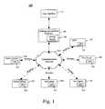
- FIG. 1is a block diagram of a system for tracking and locating objects within a highly accurate three dimensional model in accordance with the present invention.
- FIG. 2is a flow chart for tracking and locating objects within a highly accurate three dimensional model in accordance with the present invention.
- the present inventionrelates to a method and a system for tracking and locating objects and representing those objects as icons within a highly accurate three-dimensional (3D) model.
- the movements of various objects throughout an areacan be monitored.
- the locations and movements of police cruisers, helicopters, rescue vehicles, and personnelcan be continually monitored throughout a city.
- resources, such as personnelcan be accurately tracked when traveling through a city and, in particular, within multilevel structures.
- fire fighterscan be precisely located, tracked and monitored as they move about within a high rise structure during a structure fire.
- police officerscan be tracked as they give vehicle or foot chase to a criminal, for example in a multilevel parking garage.
- accurate 3D images from the perspective of an object being trackedcan be presented to a user.
- a supervisorcan view the bank from perspective of a police officer positioned on a roof near the bank.
- the perspective of other police officers at different positions around the bankalso can be presented to the supervisor for improved situational awareness. Accordingly, supervisors and dispatchers are provided detailed information of a particular scenario which can be used to better evaluate existing circumstances, thereby leading to a better decision making process and improved resource allocations, both of which improve public service.
- FIG. 1a block diagram 100 of a system for tracking and locating objects within a highly accurate three dimensional model is shown.
- the systemincludes tracking and location (T & L) software 105 , 3D mapping software (3D site model) 110 , and a user interface 115 .
- each object being trackedcan include a global positioning satellite (GPS) receiver 125 .
- GPSglobal positioning satellite
- GPS receiver 125there can be a GPS receiver 125 in a police cruiser 130 , on a police officer 135 , in a fire truck 140 , on a fire fighter 145 , in an ambulance 150 , or on an emergency medical technician 155 .
- many other objectscan carry a GPS receiver 125 to enable object tracking of manned and unmanned objects.
- Other examples
- Each GPS receivercan be connected to a transmitter to transmit GPS coordinates to the T & L software 105 using the communications network 120 .
- the GPS receivercan connect to existing RF transmission equipment, such as a police radio. If a GPS receiver is being carried on a person, however, the GPS receiver can include a transmitter.
- a GPS receivercan integrate with a cell phone or a mobile radio. Or it can integrate with other communications devices including those operating on radio frequencies or optical wavelengths.
- the T & L software 105can receive an object's latitude, longitude and altitude coordinates, and bearing data from a GPS receiver associated with the object.
- the T & L software 105then can place an icon representing the object into a 3D site model 110 that is presented to a user through the user interface 115 , for example on a video monitor.
- an indicatorcan be presented in the icon or associated with the icon to indicate the bearing of the object.
- a velocity of the objectcan be presented, indicating both the speed at which an object is moving and the direction the object is moving in.
- an arrowcan be presented with the icon to indicate a direction the object is moving.
- the directionalso can be presented numerically or graphically.
- degreescan be indicated numerically or with a compass style indicator.
- the speed at which the object is movingalso can be presented numerically or graphically.
- speedcan be indicated numerically or with an icon that represents a speedometer display.
- An indicatoralso can be associated with the icon to indicate the GPS coordinates of the object.
- the 3D site model 110can be an accurate model of an area incorporating geographic features and structures.
- the 3D site model 110can be a model of a city, including roads, bridges, structures, etc.
- the 3D modelcan be generated using techniques known to the skilled artisan.
- source imagerycan be used to generate polygons representing features and structures to be shown in the 3D site model 110 .
- the source imagerycan be any form of feature identification, for example information generated by aerial and satellite photography, electro-optical imaging, infrared detection, synthetic aperture radar (SAR), hyperspectral imaging, light detection and ranging (LIDAR), and even handheld photographs.
- the model resulting from the polygonsthen can be shaded and textured to provide a photo-realistic and accurate representation of the area.
- a databasecan be associated with the 3D site model and structures in the 3D site model 110 can be assigned attributes.
- the composition of structurescan be identified. Special features and comments related to a structure also can be noted, for example, whether a structure has a basement, the age of a structure, whether a structure has a fire escape and/or sprinkler system, and so on.
- the internal layout of particular structurescan be incorporated in the 3D site model 110 , for example, the elevation (altitude) of each floor and the location of stair wells and elevators within the structure.
- the databasecan be structured in a manner wherein the attributes associated with each building are organized by floor or altitude.
- the T & L software 105can be stored on a data storage device, such as a data storage associated with a computer system.
- the T & L software 105can be stored on a magnetic storage medium, an optical storage medium, a magneto-optical medium, etc.
- the T & L software 105can be executed on a computer or any other device incorporating a processor capable of processing 3D graphical information.
- the T & L software 105can be executed on a server, a workstation, a personal computer, a laptop computer, a mobile computer, a hand held computer, a body worn computer, etc.
- a communications network 120can be used by a GPS 125 to communicate GPS data to the T & L software 105 .
- the communications networkcan include the Internet, a wide area network (WAN), a local area network (LAN), a mobile communications network, a public switched telephone network, or any other network capable of transmitting GPS data.
- the GPS receivers 125can communicate via a wireless network, such as a cellular communications network or an IEEE 802.11 network.
- the communications network 120can include a myriad of systems capable of transmitting GPS data.
- a userfor example a supervisor or a dispatcher, can use the user interface 115 to interact with the T & L software 105 .
- the user interfacecan comprise a display, a keyboard, and a mouse.
- the user interfaceis not limited to these devices.
- the user interfacecan include a projector, a joystick, speech recognition hardware and software, speakers, and any other device a user can use to interact with a software package.
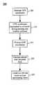
- FIG. 2is a flow chart 200 for tracking and locating an object within a highly accurate three dimensional model.
- GPS data for the objectcan be generated by a GPS receiver 125 and transmitted to the T & L software 105 , as previously noted.
- the GPS datacan be transmitted to a computer having the tracking and location software, as shown in step 210 .
- the GPS datacan be wirelessly transmitted from the GPS receiver to a basestation, which can wireline transmit the GPS data to the computer. Still, other transmission techniques can be used, as is well known to the skilled artisan.
- the computercan pass the GPS data to the T & L software 105 , which can process the GPS data and select a 3D site model correlating to the GPS data.
- a 3D site modelcan be selected for a particular city or a particular area within a city.
- the altitude coordinatecan be resolved into a floor or level designation, as shown in step 220 . For example, if a fire fighter is at an altitude of 100 feet in a particular structure, the altitude can be cross referenced to the attributes associated with the structure in the 3D site model to determine an accurate floor number correlating to that altitude.
- an icon representing the objectcan be accurately located in the 3D site model at the location identified by the GPS data received from the GPS receiver 125 .
- the iconcan be located in the 3D site model using a coordinate system employed by the T & L software 105 , as is known to those skilled in the art of tracking and location software.
- the latitude, longitude and altitude coordinatescan be translated into X, Y and Z coordinates within the T & L software's local space coordinate system using geospatial to local space coordinate system software.
- an indicatorsuch as a number, letter or symbol, can be associated with the icon to indicate a floor number or level. As previously noted, the indicator also can indicate the object's GPS coordinates and bearing data.
- accurate 3D images from the perspective of an object being trackedcan be presented via the user interface, for example to a supervisor or planner.
- the GPS data for an objectcan be processed by the T & L software 105 , which can then access the selected 3D site model.
- the T & L software 105then can display through the user interface the portions of the 3D site model correlating to the actual scene that is viewable from the objects vantage point.
- a usercan use a cursor to select an object in a 3D site model being displayed or the user can toggle through any tracked object being displayed to select one to be “active.”
- the usercan be provided with a selection of vantage points within the 3D site model that correlate to the perspective as would be seen by a person located where the selected object is located. Additional vantage points can be presented as well. For example, a top view of an object moving through a scene, an overhead “chase” view from a perspective that is behind and slightly above an object and which follows the object through a scene, a rear “chase” view from a perspective behind the object, and so on. Notably, there are a myriad of views and perspectives which can be displayed. All such arrangements will be understood to be included in the present invention.
- a vantage pointWhen a vantage point is selected, that vantage point can be displayed in the current window, in a second window, or on a different display. Further, user selectable icons can be provided on the display to enable the user to pan, zoom and quickly change vantage points within the 3D site model. These features can be of utmost importance in real-time scenarios, such as natural disasters, structure fires, hostage situations, police chases, acts of terror, etc. Additional user options can be provided as well. For example, data related to the selected (active) object can be displayed on the screen. For example, if the selected object is a fire truck, data associated with the fire truck can be provided on the display.
- the T & L software 105also can monitor parameters associated with an object.
- the T & L software 105can monitor biological statistics of a person, such as pulse, respiration, body temperature, brain activity, and so on.
- a fire fightercan be equipped with pulse, respiration, and body temperature measuring devices.
- the T & L software 105also can monitor operational parameters for objects that are machines, such as vehicles, aircraft, watercraft, etc.
- mechanical statisticssuch as mechanical stresses, tire pressure, oil pressure, fuel level, speed, velocity, and other parameters can be measured using sensors that are known in the art.
- Data generated by the monitoring devicescan be transmitted to the T & L software 105 using the same transmitter used for transmission of the GPS data. Alternatively, a separate transmitter can be provided to transmit the parameter measurement data.
- FIG. 3is a flow chart 300 for providing dynamically adjustable computer aided dispatch based on object location.
- the T & L software 105can receive GPS data (coordinates and bearing) for multiple objects being monitored.
- the coordinates and bearings of different objectscan be evaluated to determine which object is best suited to be dispatched in response to a crisis or need. For example, a comparison of the position of various objects can be generated and evaluated to select an object to dispatch. In one arrangement, other information can be evaluated as well for determining which object to dispatch. For example, evaluation can be based on the size of the ladder on a fire truck, the resources allocated for other crises, emergencies or events, and other factors that can effect the dispatch decisions.
- the T & L software 105then can provide to a dispatcher a recommendation for which object to allocate to a particular crisis, emergency or event, as shown in step 315 .
- the dispatcherthen can transmit a communication to the object with dispatch instructions.
- the T & L software 105can automatically transmit a communication with dispatch instructions to the object.
- the communicationcan be sent over the communications network 120 and can be encrypted using known security techniques.
Landscapes
- Physics & Mathematics (AREA)
- Engineering & Computer Science (AREA)
- General Physics & Mathematics (AREA)
- Radar, Positioning & Navigation (AREA)
- Remote Sensing (AREA)
- Position Fixing By Use Of Radio Waves (AREA)
- Navigation (AREA)
- Instructional Devices (AREA)
- Traffic Control Systems (AREA)
- Mobile Radio Communication Systems (AREA)
Abstract
Description
Claims (19)
Priority Applications (9)
| Application Number | Priority Date | Filing Date | Title |
|---|---|---|---|
| US10/265,757US6833811B2 (en) | 2002-10-07 | 2002-10-07 | System and method for highly accurate real time tracking and location in three dimensions |
| JP2004543043AJP2006502438A (en) | 2002-10-07 | 2003-09-30 | System and method for high-precision real-time tracking and positioning in three dimensions |
| CNB038239264ACN100483970C (en) | 2002-10-07 | 2003-09-30 | System and method for highly accurate real time tracking and positioning in three dimensions |
| AU2003272780AAU2003272780A1 (en) | 2002-10-07 | 2003-09-30 | System and method for highly accurate real time tracking and location in three dimensions |
| KR1020057006036AKR100719765B1 (en) | 2002-10-07 | 2003-09-30 | System and method for highly accurate real time tracking and location in three dimensions |
| CA002501361ACA2501361A1 (en) | 2002-10-07 | 2003-09-30 | System and method for highly accurate real time tracking and location in three dimensions |
| PCT/US2003/030749WO2004034076A2 (en) | 2002-10-07 | 2003-09-30 | System and method for highly accurate real time tracking and location in three dimensions |
| EP03754981AEP1556970B1 (en) | 2002-10-07 | 2003-09-30 | System and method for highly accurate real time tracking and location in three dimensions |
| TW092127793ATWI254136B (en) | 2002-10-07 | 2003-10-07 | System and method for highly accurate real time tracking and location in three dimensions |
Applications Claiming Priority (1)
| Application Number | Priority Date | Filing Date | Title |
|---|---|---|---|
| US10/265,757US6833811B2 (en) | 2002-10-07 | 2002-10-07 | System and method for highly accurate real time tracking and location in three dimensions |
Publications (2)
| Publication Number | Publication Date |
|---|---|
| US20040066329A1 US20040066329A1 (en) | 2004-04-08 |
| US6833811B2true US6833811B2 (en) | 2004-12-21 |
Family
ID=32042516
Family Applications (1)
| Application Number | Title | Priority Date | Filing Date |
|---|---|---|---|
| US10/265,757Expired - LifetimeUS6833811B2 (en) | 2002-10-07 | 2002-10-07 | System and method for highly accurate real time tracking and location in three dimensions |
Country Status (9)
| Country | Link |
|---|---|
| US (1) | US6833811B2 (en) |
| EP (1) | EP1556970B1 (en) |
| JP (1) | JP2006502438A (en) |
| KR (1) | KR100719765B1 (en) |
| CN (1) | CN100483970C (en) |
| AU (1) | AU2003272780A1 (en) |
| CA (1) | CA2501361A1 (en) |
| TW (1) | TWI254136B (en) |
| WO (1) | WO2004034076A2 (en) |
Cited By (48)
| Publication number | Priority date | Publication date | Assignee | Title |
|---|---|---|---|---|
| US20040036587A1 (en)* | 2002-07-05 | 2004-02-26 | Jefferson Derrick Howard | Vehicle collision detector and alert system |
| US20040164997A1 (en)* | 2002-12-18 | 2004-08-26 | Werner Jumpertz | Device and process for monitoring the deployment of respirator users |
| US20060100782A1 (en)* | 2004-11-09 | 2006-05-11 | Levi Robert W | Barometric floor level indicator |
| US20060176174A1 (en)* | 2005-02-10 | 2006-08-10 | Pinc Solutions | Position-tracking device for position-tracking system |
| US20060187028A1 (en)* | 2005-02-10 | 2006-08-24 | Pinc Solutions | Position-tracing system |
| US20070018811A1 (en)* | 2005-07-05 | 2007-01-25 | Pinc Solutions | Systems and methods for determining a location of an object |
| US20070171891A1 (en)* | 2006-01-26 | 2007-07-26 | Available For Licensing | Cellular device with broadcast radio or TV receiver |
| US20070222734A1 (en)* | 2006-03-25 | 2007-09-27 | Tran Bao Q | Mobile device capable of receiving music or video content from satellite radio providers |
| US20070262995A1 (en)* | 2006-05-12 | 2007-11-15 | Available For Licensing | Systems and methods for video editing |
| US20080021637A1 (en)* | 2004-11-05 | 2008-01-24 | Wirelesswerx International, Inc. | Method and system to configure and utilize geographical zones |
| US20080074494A1 (en)* | 2006-09-26 | 2008-03-27 | Harris Corporation | Video Surveillance System Providing Tracking of a Moving Object in a Geospatial Model and Related Methods |
| US20080129487A1 (en)* | 2006-11-30 | 2008-06-05 | Crucs Holdings, Llc | System and method for managing characteristics of a domain occupied by individuals |
| US20080228294A1 (en)* | 2007-03-13 | 2008-09-18 | Dycom Identity, Llc | Marking system and method with location and/or time tracking |
| US20080278314A1 (en)* | 2007-04-30 | 2008-11-13 | Ionearth Llc | Event tracking and monitoring system |
| US20090024309A1 (en)* | 2007-07-16 | 2009-01-22 | Crucs Holdings, Llc | System and method for monitoring vehicles on a roadway |
| US20090105950A1 (en)* | 2007-10-18 | 2009-04-23 | Ianywhere Solutions, Inc. | Real-Time Location Information System Using Multiple Positioning Technologies |
| US20090193362A1 (en)* | 2008-01-30 | 2009-07-30 | Honeywell International, Inc. | Apparatus and method for navigating amongst a plurality of symbols on a display device |
| US20100332609A1 (en)* | 2005-02-24 | 2010-12-30 | E-Courier (Uk) Ltd. | System and method for controlling the transport of articles |
| USD634656S1 (en) | 2010-03-01 | 2011-03-22 | Certusview Technologies, Llc | Shaft of a marking device |
| USD634657S1 (en) | 2010-03-01 | 2011-03-22 | Certusview Technologies, Llc | Paint holder of a marking device |
| USD634655S1 (en) | 2010-03-01 | 2011-03-22 | Certusview Technologies, Llc | Handle of a marking device |
| US20110148691A1 (en)* | 2009-12-18 | 2011-06-23 | Raytheon Company | Distributed Sensor SAR Processing System |
| USD643321S1 (en) | 2010-03-01 | 2011-08-16 | Certusview Technologies, Llc | Marking device |
| US20110218650A1 (en)* | 2007-07-16 | 2011-09-08 | Crucs Holdings, Llc | Systems and methods for automatically changing operational states of appliances |
| US20110225208A1 (en)* | 2010-03-12 | 2011-09-15 | Intergraph Technologies Company | Integrated GIS System with Interactive 3D Interface |
| US8060304B2 (en) | 2007-04-04 | 2011-11-15 | Certusview Technologies, Llc | Marking system and method |
| US8280631B2 (en) | 2008-10-02 | 2012-10-02 | Certusview Technologies, Llc | Methods and apparatus for generating an electronic record of a marking operation based on marking device actuations |
| US8311765B2 (en) | 2009-08-11 | 2012-11-13 | Certusview Technologies, Llc | Locating equipment communicatively coupled to or equipped with a mobile/portable device |
| US8400155B2 (en) | 2008-10-02 | 2013-03-19 | Certusview Technologies, Llc | Methods and apparatus for displaying an electronic rendering of a locate operation based on an electronic record of locate information |
| US8442766B2 (en) | 2008-10-02 | 2013-05-14 | Certusview Technologies, Llc | Marking apparatus having enhanced features for underground facility marking operations, and associated methods and systems |
| USD684067S1 (en) | 2012-02-15 | 2013-06-11 | Certusview Technologies, Llc | Modular marking device |
| US8473209B2 (en) | 2007-03-13 | 2013-06-25 | Certusview Technologies, Llc | Marking apparatus and marking methods using marking dispenser with machine-readable ID mechanism |
| US8478523B2 (en) | 2007-03-13 | 2013-07-02 | Certusview Technologies, Llc | Marking apparatus and methods for creating an electronic record of marking apparatus operations |
| US8532342B2 (en) | 2008-02-12 | 2013-09-10 | Certusview Technologies, Llc | Electronic manifest of underground facility locate marks |
| US8620616B2 (en) | 2009-08-20 | 2013-12-31 | Certusview Technologies, Llc | Methods and apparatus for assessing marking operations based on acceleration information |
| US8620572B2 (en) | 2009-08-20 | 2013-12-31 | Certusview Technologies, Llc | Marking device with transmitter for triangulating location during locate operations |
| US8626571B2 (en) | 2009-02-11 | 2014-01-07 | Certusview Technologies, Llc | Management system, and associated methods and apparatus, for dispatching tickets, receiving field information, and performing a quality assessment for underground facility locate and/or marking operations |
| US8688375B2 (en) | 2006-05-31 | 2014-04-01 | Trx Systems, Inc. | Method and system for locating and monitoring first responders |
| US8712686B2 (en) | 2007-08-06 | 2014-04-29 | Trx Systems, Inc. | System and method for locating, tracking, and/or monitoring the status of personnel and/or assets both indoors and outdoors |
| US8965700B2 (en) | 2008-10-02 | 2015-02-24 | Certusview Technologies, Llc | Methods and apparatus for generating an electronic record of environmental landmarks based on marking device actuations |
| US9097522B2 (en) | 2009-08-20 | 2015-08-04 | Certusview Technologies, Llc | Methods and marking devices with mechanisms for indicating and/or detecting marking material color |
| US9395190B1 (en) | 2007-05-31 | 2016-07-19 | Trx Systems, Inc. | Crowd sourced mapping with robust structural features |
| US9736618B1 (en) | 2005-04-04 | 2017-08-15 | X One, Inc. | Techniques for sharing relative position between mobile devices |
| US10231085B1 (en) | 2017-09-30 | 2019-03-12 | Oracle International Corporation | Scaling out moving objects for geo-fence proximity determination |
| US10352707B2 (en) | 2013-03-14 | 2019-07-16 | Trx Systems, Inc. | Collaborative creation of indoor maps |
| US10392222B2 (en) | 2013-10-28 | 2019-08-27 | Otis Elevator Company | Elevator remote destination entry based on altitude |
| US11156464B2 (en) | 2013-03-14 | 2021-10-26 | Trx Systems, Inc. | Crowd sourced mapping with robust structural features |
| US11268818B2 (en) | 2013-03-14 | 2022-03-08 | Trx Systems, Inc. | Crowd sourced mapping with robust structural features |
Families Citing this family (70)
| Publication number | Priority date | Publication date | Assignee | Title |
|---|---|---|---|---|
| US20040138929A1 (en)* | 2003-01-10 | 2004-07-15 | Awiszus Steven T. | Restaurant table management system |
| JP4666202B2 (en)* | 2004-07-30 | 2011-04-06 | 株式会社デンソー | Automobile equipment remote control system |
| JP4783620B2 (en)* | 2005-11-24 | 2011-09-28 | 株式会社トプコン | 3D data creation method and 3D data creation apparatus |
| US7446702B2 (en)* | 2005-12-28 | 2008-11-04 | Giga-Byte Communications Inc. | Position data exchange systems, mobile communication devices, and methods |
| US7546182B2 (en)* | 2006-02-21 | 2009-06-09 | Gm Global Technology Operations, Inc. | Inter vehicular ad hoc routing protocol and communication system |
| US7990263B2 (en)* | 2006-09-28 | 2011-08-02 | Beatty Street Properties, Inc. | Vector-based harbor scheduling |
| US7752483B1 (en)* | 2006-12-13 | 2010-07-06 | Science Applications International Corporation | Process and system for three-dimensional urban modeling |
| US8948778B2 (en) | 2007-09-11 | 2015-02-03 | Qualcomm Incorporated | Delayed radio resource signaling in a mobile radio network |
| US8908995B2 (en) | 2009-01-12 | 2014-12-09 | Intermec Ip Corp. | Semi-automatic dimensioning with imager on a portable device |
| KR101128254B1 (en)* | 2010-05-19 | 2012-03-23 | 주식회사 서경 | System and method for target identification |
| US20130018580A1 (en)* | 2011-07-14 | 2013-01-17 | Maria Scileppi | Creating a Graphic Display Based on Movement |
| US9779546B2 (en) | 2012-05-04 | 2017-10-03 | Intermec Ip Corp. | Volume dimensioning systems and methods |
| US9007368B2 (en) | 2012-05-07 | 2015-04-14 | Intermec Ip Corp. | Dimensioning system calibration systems and methods |
| US10007858B2 (en) | 2012-05-15 | 2018-06-26 | Honeywell International Inc. | Terminals and methods for dimensioning objects |
| US10321127B2 (en) | 2012-08-20 | 2019-06-11 | Intermec Ip Corp. | Volume dimensioning system calibration systems and methods |
| US9939259B2 (en) | 2012-10-04 | 2018-04-10 | Hand Held Products, Inc. | Measuring object dimensions using mobile computer |
| US20140104413A1 (en) | 2012-10-16 | 2014-04-17 | Hand Held Products, Inc. | Integrated dimensioning and weighing system |
| TWI477800B (en)* | 2012-11-12 | 2015-03-21 | Kinpo Elect Inc | Positioning device capable of detecting three dimensional trace and the three dimensional trace detecting method thereof |
| US9080856B2 (en) | 2013-03-13 | 2015-07-14 | Intermec Ip Corp. | Systems and methods for enhancing dimensioning, for example volume dimensioning |
| US11069015B2 (en)* | 2013-03-15 | 2021-07-20 | Norcom | Method and system for inter and intra agency communication, tracking and coordination |
| US10194301B2 (en)* | 2013-03-15 | 2019-01-29 | North East King County Regional Public Safety Communications Agency (Norcom) | Method and system for inter and intra agency communication, tracking and coordination |
| US20250046188A1 (en)* | 2013-03-15 | 2025-02-06 | Norcom | Method and system for inter and intra agency communication, tracking and coordination |
| US10741073B2 (en)* | 2013-03-15 | 2020-08-11 | North East King County Regional Public Safety Communications Agency (Norcom) | Method and system for inter and intra agency communication, tracking and coordination |
| US11521492B2 (en)* | 2013-03-15 | 2022-12-06 | Norcom | Method and system for inter and intra agency communication, tracking and coordination |
| US11514788B2 (en)* | 2013-03-15 | 2022-11-29 | Norcom | Method and system for inter and intra agency communication, tracking and coordination |
| US10228452B2 (en) | 2013-06-07 | 2019-03-12 | Hand Held Products, Inc. | Method of error correction for 3D imaging device |
| US9464885B2 (en) | 2013-08-30 | 2016-10-11 | Hand Held Products, Inc. | System and method for package dimensioning |
| US9823059B2 (en) | 2014-08-06 | 2017-11-21 | Hand Held Products, Inc. | Dimensioning system with guided alignment |
| US10810715B2 (en) | 2014-10-10 | 2020-10-20 | Hand Held Products, Inc | System and method for picking validation |
| US9779276B2 (en) | 2014-10-10 | 2017-10-03 | Hand Held Products, Inc. | Depth sensor based auto-focus system for an indicia scanner |
| US10775165B2 (en) | 2014-10-10 | 2020-09-15 | Hand Held Products, Inc. | Methods for improving the accuracy of dimensioning-system measurements |
| US9557166B2 (en) | 2014-10-21 | 2017-01-31 | Hand Held Products, Inc. | Dimensioning system with multipath interference mitigation |
| US9762793B2 (en) | 2014-10-21 | 2017-09-12 | Hand Held Products, Inc. | System and method for dimensioning |
| US9897434B2 (en) | 2014-10-21 | 2018-02-20 | Hand Held Products, Inc. | Handheld dimensioning system with measurement-conformance feedback |
| US10060729B2 (en) | 2014-10-21 | 2018-08-28 | Hand Held Products, Inc. | Handheld dimensioner with data-quality indication |
| US9752864B2 (en) | 2014-10-21 | 2017-09-05 | Hand Held Products, Inc. | Handheld dimensioning system with feedback |
| CN104376600B (en)* | 2014-11-25 | 2018-04-17 | 四川大学 | Stabilization threedimensional model tracking based on online management super-resolution block |
| CN105828024B (en)* | 2015-01-10 | 2019-01-29 | 浙江大学 | A kind of multiple target indoor locating system and localization method based on video acquisition |
| CN104657992B (en)* | 2015-02-12 | 2018-04-27 | 浙江大学 | A kind of multiple target outdoor positioning system and localization method based on video acquisition |
| US9786101B2 (en) | 2015-05-19 | 2017-10-10 | Hand Held Products, Inc. | Evaluating image values |
| US10066982B2 (en) | 2015-06-16 | 2018-09-04 | Hand Held Products, Inc. | Calibrating a volume dimensioner |
| US9857167B2 (en) | 2015-06-23 | 2018-01-02 | Hand Held Products, Inc. | Dual-projector three-dimensional scanner |
| US20160377414A1 (en) | 2015-06-23 | 2016-12-29 | Hand Held Products, Inc. | Optical pattern projector |
| US9835486B2 (en) | 2015-07-07 | 2017-12-05 | Hand Held Products, Inc. | Mobile dimensioner apparatus for use in commerce |
| EP3118576B1 (en) | 2015-07-15 | 2018-09-12 | Hand Held Products, Inc. | Mobile dimensioning device with dynamic accuracy compatible with nist standard |
| US20170017301A1 (en) | 2015-07-16 | 2017-01-19 | Hand Held Products, Inc. | Adjusting dimensioning results using augmented reality |
| US10094650B2 (en) | 2015-07-16 | 2018-10-09 | Hand Held Products, Inc. | Dimensioning and imaging items |
| CN105205986B (en)* | 2015-07-30 | 2017-10-20 | 浙江万里学院 | A kind of scene of fire fireman three-dimensional localization automatic rescue system |
| US9947230B2 (en) | 2015-08-03 | 2018-04-17 | Amber Garage, Inc. | Planning a flight path by identifying key frames |
| US9928649B2 (en)* | 2015-08-03 | 2018-03-27 | Amber Garage, Inc. | Interface for planning flight path |
| US10249030B2 (en) | 2015-10-30 | 2019-04-02 | Hand Held Products, Inc. | Image transformation for indicia reading |
| US10225544B2 (en) | 2015-11-19 | 2019-03-05 | Hand Held Products, Inc. | High resolution dot pattern |
| US10025314B2 (en) | 2016-01-27 | 2018-07-17 | Hand Held Products, Inc. | Vehicle positioning and object avoidance |
| US10339352B2 (en) | 2016-06-03 | 2019-07-02 | Hand Held Products, Inc. | Wearable metrological apparatus |
| US9940721B2 (en) | 2016-06-10 | 2018-04-10 | Hand Held Products, Inc. | Scene change detection in a dimensioner |
| US10163216B2 (en) | 2016-06-15 | 2018-12-25 | Hand Held Products, Inc. | Automatic mode switching in a volume dimensioner |
| US10909708B2 (en) | 2016-12-09 | 2021-02-02 | Hand Held Products, Inc. | Calibrating a dimensioner using ratios of measurable parameters of optic ally-perceptible geometric elements |
| US11047672B2 (en) | 2017-03-28 | 2021-06-29 | Hand Held Products, Inc. | System for optically dimensioning |
| US10733748B2 (en) | 2017-07-24 | 2020-08-04 | Hand Held Products, Inc. | Dual-pattern optical 3D dimensioning |
| US10584962B2 (en) | 2018-05-01 | 2020-03-10 | Hand Held Products, Inc | System and method for validating physical-item security |
| US10788952B2 (en)* | 2018-05-29 | 2020-09-29 | The Boeing Company | System and method for obtaining resource materials based on attribute association |
| WO2019232702A1 (en)* | 2018-06-06 | 2019-12-12 | Beijing Didi Infinity Technology And Development Co., Ltd. | System and method for determining location identifier |
| CN109095354A (en)* | 2018-09-12 | 2018-12-28 | 北京起重运输机械设计研究院有限公司 | Automatic rotary seat and its method of controlling rotation |
| EP3693699B1 (en)* | 2019-02-05 | 2021-12-22 | HERE Global B.V. | Determining of absolute altitudes of floors of a structure |
| JP6696016B2 (en)* | 2019-02-20 | 2020-05-20 | 能美防災株式会社 | Support system |
| US11639846B2 (en) | 2019-09-27 | 2023-05-02 | Honeywell International Inc. | Dual-pattern optical 3D dimensioning |
| CN111077558A (en)* | 2019-12-25 | 2020-04-28 | 交控科技股份有限公司 | Positioning system of rail vehicle and rail transit system |
| WO2021167422A1 (en) | 2020-02-20 | 2021-08-26 | 주식회사 에스360브이알 | Digital map-based online platform |
| CN114339609B (en)* | 2021-12-23 | 2023-06-13 | 浙江中控技术股份有限公司 | Personnel positioning method and device |
| CN115295132A (en)* | 2022-07-20 | 2022-11-04 | 青岛海信医疗设备股份有限公司 | Room position guiding method, server and number calling equipment |
Citations (34)
| Publication number | Priority date | Publication date | Assignee | Title |
|---|---|---|---|---|
| US5450329A (en)* | 1993-12-22 | 1995-09-12 | Tanner; Jesse H. | Vehicle location method and system |
| US5528518A (en) | 1994-10-25 | 1996-06-18 | Laser Technology, Inc. | System and method for collecting data used to form a geographic information system database |
| US5873056A (en) | 1993-10-12 | 1999-02-16 | The Syracuse University | Natural language processing system for semantic vector representation which accounts for lexical ambiguity |
| US5971595A (en) | 1997-04-28 | 1999-10-26 | Xilinx, Inc. | Method for linking a hardware description to an IC layout |
| US6161105A (en) | 1994-11-21 | 2000-12-12 | Oracle Corporation | Method and apparatus for multidimensional database using binary hyperspatial code |
| US6173287B1 (en) | 1998-03-11 | 2001-01-09 | Digital Equipment Corporation | Technique for ranking multimedia annotations of interest |
| US6195122B1 (en) | 1995-01-31 | 2001-02-27 | Robert Vincent | Spatial referenced photography |
| US6222482B1 (en) | 1999-01-29 | 2001-04-24 | International Business Machines Corporation | Hand-held device providing a closest feature location in a three-dimensional geometry database |
| WO2001041000A1 (en) | 1999-11-30 | 2001-06-07 | New Media Technology, Corp. | System and method for computer-assisted manual and automatic logging of time-based media |
| US6253239B1 (en) | 1997-09-23 | 2001-06-26 | Information Architects Corporation | System for indexing and display requested data having heterogeneous content and representation |
| US6281797B1 (en)* | 2000-04-04 | 2001-08-28 | Marconi Data Systems Inc. | Method and apparatus for detecting a container proximate to a transportation vessel hold |
| US6282362B1 (en) | 1995-11-07 | 2001-08-28 | Trimble Navigation Limited | Geographical position/image digital recording and display system |
| US6285805B1 (en) | 1999-01-25 | 2001-09-04 | International Business Machines Corp. | System and method for finding the distance from a moving query point to the closest point on one or more convex or non-convex shapes |
| US6304864B1 (en) | 1999-04-20 | 2001-10-16 | Textwise Llc | System for retrieving multimedia information from the internet using multiple evolving intelligent agents |
| US6307573B1 (en) | 1999-07-22 | 2001-10-23 | Barbara L. Barros | Graphic-information flow method and system for visually analyzing patterns and relationships |
| US20010038718A1 (en) | 1997-05-09 | 2001-11-08 | Rakesh Kumar | Method and apparatus for performing geo-spatial registration of imagery |
| US6327533B1 (en) | 2000-06-30 | 2001-12-04 | Geospatial Technologies, Inc. | Method and apparatus for continuously locating an object |
| WO2001098925A2 (en) | 2000-06-20 | 2001-12-27 | Globexplorer, Inc. | Method, system and computer program product for delivering spatially referenced information in a global computer network |
| US6360234B2 (en) | 1997-08-14 | 2002-03-19 | Virage, Inc. | Video cataloger system with synchronized encoders |
| US20020035451A1 (en) | 2000-09-18 | 2002-03-21 | Todd Rothermel | Spatail data enabled engineering, construction, and operations computer-aided design (CAD) project system, method and computer program product |
| US6362775B1 (en)* | 2000-04-25 | 2002-03-26 | Mcdonnell Douglas Corporation | Precision all-weather target location system |
| US20020055924A1 (en) | 2000-01-18 | 2002-05-09 | Richard Liming | System and method providing a spatial location context |
| US6421010B1 (en)* | 2001-02-16 | 2002-07-16 | The United States Of America As Represented By The Secretary Of Commerce | Atmospheric sondes and method for tracking |
| US20020118224A1 (en) | 2000-12-27 | 2002-08-29 | Isaac Levanon | System and methods for network image delivery with dynamic viewing frustum optimized for limited bandwidth communication channels |
| US6445983B1 (en) | 2000-07-07 | 2002-09-03 | Case Corporation | Sensor-fusion navigator for automated guidance of off-road vehicles |
| US6463180B1 (en) | 1998-04-07 | 2002-10-08 | Autodesk, Inc. | Spatial index compression through spatial subdivision encoding |
| US6480789B2 (en)* | 2000-12-04 | 2002-11-12 | American Gnc Corporation | Positioning and proximity warning method and system thereof for vehicle |
| US20020183072A1 (en) | 2001-04-17 | 2002-12-05 | Galia Steinbach | BeyondguideTM method and system |
| US6516099B1 (en) | 1997-08-05 | 2003-02-04 | Canon Kabushiki Kaisha | Image processing apparatus |
| US20030050927A1 (en) | 2001-09-07 | 2003-03-13 | Araha, Inc. | System and method for location, understanding and assimilation of digital documents through abstract indicia |
| US6552681B1 (en)* | 2000-10-02 | 2003-04-22 | Skynetix, Llc | Method for determining vertical and horizontal GPS position using altitude information |
| US6567980B1 (en) | 1997-08-14 | 2003-05-20 | Virage, Inc. | Video cataloger system with hyperlinked output |
| US20040008866A1 (en) | 2001-03-05 | 2004-01-15 | Rhoads Geoffrey B. | Geographic information systems using digital watermarks |
| US6681231B1 (en) | 1999-07-26 | 2004-01-20 | The Real Estate Cable Network, Inc. | Integrated information processing system for geospatial media |
Family Cites Families (17)
| Publication number | Priority date | Publication date | Assignee | Title |
|---|---|---|---|---|
| JPH05307693A (en)* | 1992-04-30 | 1993-11-19 | Hitachi Building Syst Eng & Service Co Ltd | Remote monitoring equipment |
| DE4419359A1 (en)* | 1994-06-03 | 1995-12-07 | Wolfram Dipl Ing Kirchner | Procedure for the acquisition, evaluation, measurement and storage of geographic information |
| JPH07334778A (en)* | 1994-06-07 | 1995-12-22 | Toshiba Corp | Maintenance monitoring device |
| JPH09107410A (en)* | 1995-10-12 | 1997-04-22 | Hitachi Building Syst Co Ltd | Positioning system for maintenance personnel |
| KR100216541B1 (en)* | 1997-05-29 | 1999-08-16 | 정선종 | Assistant apparatus for fire fighting of building and fire fighting method using it |
| CN2364487Y (en)* | 1999-01-25 | 2000-02-16 | 北京军泰科技开发有限责任公司 | Moving object GPS navigation monitoring and alarm device |
| US6281790B1 (en)* | 1999-09-01 | 2001-08-28 | Net Talon Security Systems, Inc. | Method and apparatus for remotely monitoring a site |
| JP3823664B2 (en)* | 2000-03-03 | 2006-09-20 | カシオ計算機株式会社 | Information terminal and storage medium |
| JP3823665B2 (en)* | 2000-03-03 | 2006-09-20 | カシオ計算機株式会社 | Information terminal and storage medium |
| JP4193957B2 (en)* | 2000-03-17 | 2008-12-10 | 株式会社小松製作所 | Construction machine start lock mechanism |
| WO2001074102A1 (en)* | 2000-03-31 | 2001-10-04 | Ntt Docomo, Inc. | Position information informing method and mobile communication terminal |
| JP2001330465A (en)* | 2000-05-22 | 2001-11-30 | Matsushita Electric Ind Co Ltd | Navigation device |
| CN1230687C (en)* | 2000-10-12 | 2005-12-07 | 颜弘澈 | Fire Automatic Command and Management System Using Satellite Positioning and Geographical Data |
| WO2002041205A1 (en)* | 2000-11-16 | 2002-05-23 | Ntt Docomo, Inc. | Moving situation information providing method and server |
| KR20040018308A (en)* | 2000-11-22 | 2004-03-03 | 디지털 앤젤 코포레이션 | Personnel and resource tracking method and system for enclosed spaces |
| JP4777521B2 (en)* | 2001-01-31 | 2011-09-21 | 株式会社日立製作所 | Information service system |
| JP2002245490A (en)* | 2001-02-16 | 2002-08-30 | Sony Corp | Device and method for image reproduction |
- 2002
- 2002-10-07USUS10/265,757patent/US6833811B2/ennot_activeExpired - Lifetime
- 2003
- 2003-09-30CNCNB038239264Apatent/CN100483970C/ennot_activeExpired - Fee Related
- 2003-09-30CACA002501361Apatent/CA2501361A1/ennot_activeAbandoned
- 2003-09-30KRKR1020057006036Apatent/KR100719765B1/ennot_activeExpired - Fee Related
- 2003-09-30EPEP03754981Apatent/EP1556970B1/ennot_activeExpired - Lifetime
- 2003-09-30JPJP2004543043Apatent/JP2006502438A/ennot_activeCeased
- 2003-09-30WOPCT/US2003/030749patent/WO2004034076A2/enactiveApplication Filing
- 2003-09-30AUAU2003272780Apatent/AU2003272780A1/ennot_activeAbandoned
- 2003-10-07TWTW092127793Apatent/TWI254136B/ennot_activeIP Right Cessation
Patent Citations (36)
| Publication number | Priority date | Publication date | Assignee | Title |
|---|---|---|---|---|
| US5873056A (en) | 1993-10-12 | 1999-02-16 | The Syracuse University | Natural language processing system for semantic vector representation which accounts for lexical ambiguity |
| US5450329A (en)* | 1993-12-22 | 1995-09-12 | Tanner; Jesse H. | Vehicle location method and system |
| US5528518A (en) | 1994-10-25 | 1996-06-18 | Laser Technology, Inc. | System and method for collecting data used to form a geographic information system database |
| US6161105A (en) | 1994-11-21 | 2000-12-12 | Oracle Corporation | Method and apparatus for multidimensional database using binary hyperspatial code |
| US6195122B1 (en) | 1995-01-31 | 2001-02-27 | Robert Vincent | Spatial referenced photography |
| US6292215B1 (en) | 1995-01-31 | 2001-09-18 | Transcenic L.L.C. | Apparatus for referencing and sorting images in a three-dimensional system |
| US6282362B1 (en) | 1995-11-07 | 2001-08-28 | Trimble Navigation Limited | Geographical position/image digital recording and display system |
| US5971595A (en) | 1997-04-28 | 1999-10-26 | Xilinx, Inc. | Method for linking a hardware description to an IC layout |
| US6597818B2 (en) | 1997-05-09 | 2003-07-22 | Sarnoff Corporation | Method and apparatus for performing geo-spatial registration of imagery |
| US20010038718A1 (en) | 1997-05-09 | 2001-11-08 | Rakesh Kumar | Method and apparatus for performing geo-spatial registration of imagery |
| US6516099B1 (en) | 1997-08-05 | 2003-02-04 | Canon Kabushiki Kaisha | Image processing apparatus |
| US6567980B1 (en) | 1997-08-14 | 2003-05-20 | Virage, Inc. | Video cataloger system with hyperlinked output |
| US6360234B2 (en) | 1997-08-14 | 2002-03-19 | Virage, Inc. | Video cataloger system with synchronized encoders |
| US6253239B1 (en) | 1997-09-23 | 2001-06-26 | Information Architects Corporation | System for indexing and display requested data having heterogeneous content and representation |
| US6173287B1 (en) | 1998-03-11 | 2001-01-09 | Digital Equipment Corporation | Technique for ranking multimedia annotations of interest |
| US6463180B1 (en) | 1998-04-07 | 2002-10-08 | Autodesk, Inc. | Spatial index compression through spatial subdivision encoding |
| US6285805B1 (en) | 1999-01-25 | 2001-09-04 | International Business Machines Corp. | System and method for finding the distance from a moving query point to the closest point on one or more convex or non-convex shapes |
| US6222482B1 (en) | 1999-01-29 | 2001-04-24 | International Business Machines Corporation | Hand-held device providing a closest feature location in a three-dimensional geometry database |
| US6304864B1 (en) | 1999-04-20 | 2001-10-16 | Textwise Llc | System for retrieving multimedia information from the internet using multiple evolving intelligent agents |
| US6307573B1 (en) | 1999-07-22 | 2001-10-23 | Barbara L. Barros | Graphic-information flow method and system for visually analyzing patterns and relationships |
| US6681231B1 (en) | 1999-07-26 | 2004-01-20 | The Real Estate Cable Network, Inc. | Integrated information processing system for geospatial media |
| WO2001041000A1 (en) | 1999-11-30 | 2001-06-07 | New Media Technology, Corp. | System and method for computer-assisted manual and automatic logging of time-based media |
| US20020055924A1 (en) | 2000-01-18 | 2002-05-09 | Richard Liming | System and method providing a spatial location context |
| US6281797B1 (en)* | 2000-04-04 | 2001-08-28 | Marconi Data Systems Inc. | Method and apparatus for detecting a container proximate to a transportation vessel hold |
| US6362775B1 (en)* | 2000-04-25 | 2002-03-26 | Mcdonnell Douglas Corporation | Precision all-weather target location system |
| WO2001098925A2 (en) | 2000-06-20 | 2001-12-27 | Globexplorer, Inc. | Method, system and computer program product for delivering spatially referenced information in a global computer network |
| US6327533B1 (en) | 2000-06-30 | 2001-12-04 | Geospatial Technologies, Inc. | Method and apparatus for continuously locating an object |
| US6445983B1 (en) | 2000-07-07 | 2002-09-03 | Case Corporation | Sensor-fusion navigator for automated guidance of off-road vehicles |
| US20020035451A1 (en) | 2000-09-18 | 2002-03-21 | Todd Rothermel | Spatail data enabled engineering, construction, and operations computer-aided design (CAD) project system, method and computer program product |
| US6552681B1 (en)* | 2000-10-02 | 2003-04-22 | Skynetix, Llc | Method for determining vertical and horizontal GPS position using altitude information |
| US6480789B2 (en)* | 2000-12-04 | 2002-11-12 | American Gnc Corporation | Positioning and proximity warning method and system thereof for vehicle |
| US20020118224A1 (en) | 2000-12-27 | 2002-08-29 | Isaac Levanon | System and methods for network image delivery with dynamic viewing frustum optimized for limited bandwidth communication channels |
| US6421010B1 (en)* | 2001-02-16 | 2002-07-16 | The United States Of America As Represented By The Secretary Of Commerce | Atmospheric sondes and method for tracking |
| US20040008866A1 (en) | 2001-03-05 | 2004-01-15 | Rhoads Geoffrey B. | Geographic information systems using digital watermarks |
| US20020183072A1 (en) | 2001-04-17 | 2002-12-05 | Galia Steinbach | BeyondguideTM method and system |
| US20030050927A1 (en) | 2001-09-07 | 2003-03-13 | Araha, Inc. | System and method for location, understanding and assimilation of digital documents through abstract indicia |
Non-Patent Citations (1)
| Title |
|---|
| Geospatial Imaging Solutions from SGI, product sheet. |
Cited By (112)
| Publication number | Priority date | Publication date | Assignee | Title |
|---|---|---|---|---|
| US20040036587A1 (en)* | 2002-07-05 | 2004-02-26 | Jefferson Derrick Howard | Vehicle collision detector and alert system |
| US20040164997A1 (en)* | 2002-12-18 | 2004-08-26 | Werner Jumpertz | Device and process for monitoring the deployment of respirator users |
| US20080021637A1 (en)* | 2004-11-05 | 2008-01-24 | Wirelesswerx International, Inc. | Method and system to configure and utilize geographical zones |
| US20060100782A1 (en)* | 2004-11-09 | 2006-05-11 | Levi Robert W | Barometric floor level indicator |
| US7162368B2 (en)* | 2004-11-09 | 2007-01-09 | Honeywell International Inc. | Barometric floor level indicator |
| US20060176174A1 (en)* | 2005-02-10 | 2006-08-10 | Pinc Solutions | Position-tracking device for position-tracking system |
| US20060187028A1 (en)* | 2005-02-10 | 2006-08-24 | Pinc Solutions | Position-tracing system |
| US7236091B2 (en) | 2005-02-10 | 2007-06-26 | Pinc Solutions | Position-tracking system |
| US7245215B2 (en) | 2005-02-10 | 2007-07-17 | Pinc Solutions | Position-tracking device for position-tracking system |
| US20100332609A1 (en)* | 2005-02-24 | 2010-12-30 | E-Courier (Uk) Ltd. | System and method for controlling the transport of articles |
| US10299071B2 (en) | 2005-04-04 | 2019-05-21 | X One, Inc. | Server-implemented methods and systems for sharing location amongst web-enabled cell phones |
| US9942705B1 (en) | 2005-04-04 | 2018-04-10 | X One, Inc. | Location sharing group for services provision |
| US10149092B1 (en) | 2005-04-04 | 2018-12-04 | X One, Inc. | Location sharing service between GPS-enabled wireless devices, with shared target location exchange |
| US9967704B1 (en) | 2005-04-04 | 2018-05-08 | X One, Inc. | Location sharing group map management |
| US10165059B2 (en) | 2005-04-04 | 2018-12-25 | X One, Inc. | Methods, systems and apparatuses for the formation and tracking of location sharing groups |
| US10200811B1 (en) | 2005-04-04 | 2019-02-05 | X One, Inc. | Map presentation on cellular device showing positions of multiple other wireless device users |
| US9955298B1 (en) | 2005-04-04 | 2018-04-24 | X One, Inc. | Methods, systems and apparatuses for the formation and tracking of location sharing groups |
| US10313826B2 (en) | 2005-04-04 | 2019-06-04 | X One, Inc. | Location sharing and map support in connection with services request |
| US10341808B2 (en) | 2005-04-04 | 2019-07-02 | X One, Inc. | Location sharing for commercial and proprietary content applications |
| US9736618B1 (en) | 2005-04-04 | 2017-08-15 | X One, Inc. | Techniques for sharing relative position between mobile devices |
| US10341809B2 (en) | 2005-04-04 | 2019-07-02 | X One, Inc. | Location sharing with facilitated meeting point definition |
| US9749790B1 (en) | 2005-04-04 | 2017-08-29 | X One, Inc. | Rendez vous management using mobile phones or other mobile devices |
| US9854402B1 (en) | 2005-04-04 | 2017-12-26 | X One, Inc. | Formation of wireless device location sharing group |
| US9854394B1 (en) | 2005-04-04 | 2017-12-26 | X One, Inc. | Ad hoc location sharing group between first and second cellular wireless devices |
| US11778415B2 (en) | 2005-04-04 | 2023-10-03 | Xone, Inc. | Location sharing application in association with services provision |
| US11356799B2 (en) | 2005-04-04 | 2022-06-07 | X One, Inc. | Fleet location sharing application in association with services provision |
| US10856099B2 (en) | 2005-04-04 | 2020-12-01 | X One, Inc. | Application-based two-way tracking and mapping function with selected individuals |
| US10791414B2 (en) | 2005-04-04 | 2020-09-29 | X One, Inc. | Location sharing for commercial and proprietary content applications |
| US10750309B2 (en) | 2005-04-04 | 2020-08-18 | X One, Inc. | Ad hoc location sharing group establishment for wireless devices with designated meeting point |
| US10750310B2 (en) | 2005-04-04 | 2020-08-18 | X One, Inc. | Temporary location sharing group with event based termination |
| US10750311B2 (en) | 2005-04-04 | 2020-08-18 | X One, Inc. | Application-based tracking and mapping function in connection with vehicle-based services provision |
| US9883360B1 (en) | 2005-04-04 | 2018-01-30 | X One, Inc. | Rendez vous management using mobile phones or other mobile devices |
| US7321305B2 (en) | 2005-07-05 | 2008-01-22 | Pinc Solutions | Systems and methods for determining a location of an object |
| US20070018811A1 (en)* | 2005-07-05 | 2007-01-25 | Pinc Solutions | Systems and methods for determining a location of an object |
| US20070171891A1 (en)* | 2006-01-26 | 2007-07-26 | Available For Licensing | Cellular device with broadcast radio or TV receiver |
| US20070222734A1 (en)* | 2006-03-25 | 2007-09-27 | Tran Bao Q | Mobile device capable of receiving music or video content from satellite radio providers |
| US20070262995A1 (en)* | 2006-05-12 | 2007-11-15 | Available For Licensing | Systems and methods for video editing |
| US20110230232A1 (en)* | 2006-05-12 | 2011-09-22 | Tran Bao Q | Systems and methods for video editing |
| US7827491B2 (en) | 2006-05-12 | 2010-11-02 | Tran Bao Q | Systems and methods for video editing |
| US8688375B2 (en) | 2006-05-31 | 2014-04-01 | Trx Systems, Inc. | Method and system for locating and monitoring first responders |
| US8706414B2 (en) | 2006-05-31 | 2014-04-22 | Trx Systems, Inc. | Method and system for locating and monitoring first responders |
| US20080074494A1 (en)* | 2006-09-26 | 2008-03-27 | Harris Corporation | Video Surveillance System Providing Tracking of a Moving Object in a Geospatial Model and Related Methods |
| US20080129487A1 (en)* | 2006-11-30 | 2008-06-05 | Crucs Holdings, Llc | System and method for managing characteristics of a domain occupied by individuals |
| US8407001B2 (en) | 2007-03-13 | 2013-03-26 | Certusview Technologies, Llc | Systems and methods for using location data to electronically display dispensing of markers by a marking system or marking tool |
| US7640105B2 (en) | 2007-03-13 | 2009-12-29 | Certus View Technologies, LLC | Marking system and method with location and/or time tracking |
| US9086277B2 (en) | 2007-03-13 | 2015-07-21 | Certusview Technologies, Llc | Electronically controlled marking apparatus and methods |
| US8473209B2 (en) | 2007-03-13 | 2013-06-25 | Certusview Technologies, Llc | Marking apparatus and marking methods using marking dispenser with machine-readable ID mechanism |
| US8775077B2 (en) | 2007-03-13 | 2014-07-08 | Certusview Technologies, Llc | Systems and methods for using location data to electronically display dispensing of markers by a marking system or marking tool |
| US8478523B2 (en) | 2007-03-13 | 2013-07-02 | Certusview Technologies, Llc | Marking apparatus and methods for creating an electronic record of marking apparatus operations |
| US8700325B2 (en) | 2007-03-13 | 2014-04-15 | Certusview Technologies, Llc | Marking apparatus and methods for creating an electronic record of marking operations |
| US8401791B2 (en) | 2007-03-13 | 2013-03-19 | Certusview Technologies, Llc | Methods for evaluating operation of marking apparatus |
| US8903643B2 (en) | 2007-03-13 | 2014-12-02 | Certusview Technologies, Llc | Hand-held marking apparatus with location tracking system and methods for logging geographic location of same |
| US20080228294A1 (en)* | 2007-03-13 | 2008-09-18 | Dycom Identity, Llc | Marking system and method with location and/or time tracking |
| US8374789B2 (en) | 2007-04-04 | 2013-02-12 | Certusview Technologies, Llc | Systems and methods for using marking information to electronically display dispensing of markers by a marking system or marking tool |
| US8386178B2 (en) | 2007-04-04 | 2013-02-26 | Certusview Technologies, Llc | Marking system and method |
| US8060304B2 (en) | 2007-04-04 | 2011-11-15 | Certusview Technologies, Llc | Marking system and method |
| US20080278314A1 (en)* | 2007-04-30 | 2008-11-13 | Ionearth Llc | Event tracking and monitoring system |
| US9448072B2 (en) | 2007-05-31 | 2016-09-20 | Trx Systems, Inc. | System and method for locating, tracking, and/or monitoring the status of personnel and/or assets both indoors and outdoors |
| US9395190B1 (en) | 2007-05-31 | 2016-07-19 | Trx Systems, Inc. | Crowd sourced mapping with robust structural features |
| US20090024309A1 (en)* | 2007-07-16 | 2009-01-22 | Crucs Holdings, Llc | System and method for monitoring vehicles on a roadway |
| US9076331B2 (en) | 2007-07-16 | 2015-07-07 | Crucs Holdings, Llc | System and method to monitor vehicles on a roadway and to control driving restrictions of vehicle drivers |
| US20110218650A1 (en)* | 2007-07-16 | 2011-09-08 | Crucs Holdings, Llc | Systems and methods for automatically changing operational states of appliances |
| US8868220B2 (en) | 2007-07-16 | 2014-10-21 | Crucs Holdings, Llc | Systems and methods for automatically changing operational states of appliances |
| US8712686B2 (en) | 2007-08-06 | 2014-04-29 | Trx Systems, Inc. | System and method for locating, tracking, and/or monitoring the status of personnel and/or assets both indoors and outdoors |
| US9008962B2 (en) | 2007-08-06 | 2015-04-14 | Trx Systems, Inc. | System and method for locating, tracking, and/or monitoring the status of personnel and/or assets both indoors and outdoors |
| US9046373B2 (en) | 2007-08-06 | 2015-06-02 | Trx Systems, Inc. | System and method for locating, tracking, and/or monitoring the status of personnel and/or assets both indoors and outdoors |
| US8965688B2 (en) | 2007-08-06 | 2015-02-24 | Trx Systems, Inc. | System and method for locating, tracking, and/or monitoring the status of personnel and/or assets both indoors and outdoors |
| US20090105950A1 (en)* | 2007-10-18 | 2009-04-23 | Ianywhere Solutions, Inc. | Real-Time Location Information System Using Multiple Positioning Technologies |
| US9068836B2 (en)* | 2007-10-18 | 2015-06-30 | Carlos Arteaga | Real-time location information system using multiple positioning technologies |
| US20090193362A1 (en)* | 2008-01-30 | 2009-07-30 | Honeywell International, Inc. | Apparatus and method for navigating amongst a plurality of symbols on a display device |
| US8166419B2 (en)* | 2008-01-30 | 2012-04-24 | Honeywell International Inc. | Apparatus and method for navigating amongst a plurality of symbols on a display device |
| US8532342B2 (en) | 2008-02-12 | 2013-09-10 | Certusview Technologies, Llc | Electronic manifest of underground facility locate marks |
| US8442766B2 (en) | 2008-10-02 | 2013-05-14 | Certusview Technologies, Llc | Marking apparatus having enhanced features for underground facility marking operations, and associated methods and systems |
| US8965700B2 (en) | 2008-10-02 | 2015-02-24 | Certusview Technologies, Llc | Methods and apparatus for generating an electronic record of environmental landmarks based on marking device actuations |
| US8770140B2 (en) | 2008-10-02 | 2014-07-08 | Certusview Technologies, Llc | Marking apparatus having environmental sensors and operations sensors for underground facility marking operations, and associated methods and systems |
| US8731830B2 (en) | 2008-10-02 | 2014-05-20 | Certusview Technologies, Llc | Marking apparatus for receiving environmental information regarding underground facility marking operations, and associated methods and systems |
| US8612148B2 (en) | 2008-10-02 | 2013-12-17 | Certusview Technologies, Llc | Marking apparatus configured to detect out-of-tolerance conditions in connection with underground facility marking operations, and associated methods and systems |
| US8478525B2 (en) | 2008-10-02 | 2013-07-02 | Certusview Technologies, Llc | Methods, apparatus, and systems for analyzing use of a marking device by a technician to perform an underground facility marking operation |
| US8478524B2 (en) | 2008-10-02 | 2013-07-02 | Certusview Technologies, Llc | Methods and apparatus for dispensing marking material in connection with underground facility marking operations based on environmental information and/or operational information |
| US9542863B2 (en) | 2008-10-02 | 2017-01-10 | Certusview Technologies, Llc | Methods and apparatus for generating output data streams relating to underground utility marking operations |
| US8467969B2 (en) | 2008-10-02 | 2013-06-18 | Certusview Technologies, Llc | Marking apparatus having operational sensors for underground facility marking operations, and associated methods and systems |
| US8457893B2 (en) | 2008-10-02 | 2013-06-04 | Certusview Technologies, Llc | Methods and apparatus for generating an electronic record of a marking operation including service-related information and/or ticket information |
| US8400155B2 (en) | 2008-10-02 | 2013-03-19 | Certusview Technologies, Llc | Methods and apparatus for displaying an electronic rendering of a locate operation based on an electronic record of locate information |
| US8361543B2 (en) | 2008-10-02 | 2013-01-29 | Certusview Technologies, Llc | Methods and apparatus for displaying an electronic rendering of a marking operation based on an electronic record of marking information |
| US8280631B2 (en) | 2008-10-02 | 2012-10-02 | Certusview Technologies, Llc | Methods and apparatus for generating an electronic record of a marking operation based on marking device actuations |
| US8626571B2 (en) | 2009-02-11 | 2014-01-07 | Certusview Technologies, Llc | Management system, and associated methods and apparatus, for dispatching tickets, receiving field information, and performing a quality assessment for underground facility locate and/or marking operations |
| US9185176B2 (en) | 2009-02-11 | 2015-11-10 | Certusview Technologies, Llc | Methods and apparatus for managing locate and/or marking operations |
| US8731999B2 (en) | 2009-02-11 | 2014-05-20 | Certusview Technologies, Llc | Management system, and associated methods and apparatus, for providing improved visibility, quality control and audit capability for underground facility locate and/or marking operations |
| US8311765B2 (en) | 2009-08-11 | 2012-11-13 | Certusview Technologies, Llc | Locating equipment communicatively coupled to or equipped with a mobile/portable device |
| US9097522B2 (en) | 2009-08-20 | 2015-08-04 | Certusview Technologies, Llc | Methods and marking devices with mechanisms for indicating and/or detecting marking material color |
| US8620572B2 (en) | 2009-08-20 | 2013-12-31 | Certusview Technologies, Llc | Marking device with transmitter for triangulating location during locate operations |
| US8620616B2 (en) | 2009-08-20 | 2013-12-31 | Certusview Technologies, Llc | Methods and apparatus for assessing marking operations based on acceleration information |
| US20110148691A1 (en)* | 2009-12-18 | 2011-06-23 | Raytheon Company | Distributed Sensor SAR Processing System |
| USD634655S1 (en) | 2010-03-01 | 2011-03-22 | Certusview Technologies, Llc | Handle of a marking device |
| USD634657S1 (en) | 2010-03-01 | 2011-03-22 | Certusview Technologies, Llc | Paint holder of a marking device |
| USD634656S1 (en) | 2010-03-01 | 2011-03-22 | Certusview Technologies, Llc | Shaft of a marking device |
| USD643321S1 (en) | 2010-03-01 | 2011-08-16 | Certusview Technologies, Llc | Marking device |
| US8525827B2 (en)* | 2010-03-12 | 2013-09-03 | Intergraph Technologies Company | Integrated GIS system with interactive 3D interface |
| US20130257862A1 (en)* | 2010-03-12 | 2013-10-03 | Intergraph Corporation | System, apparatus, and method of modifying 2.5d gis data for a 2d gis system |
| US8896595B2 (en)* | 2010-03-12 | 2014-11-25 | Intergraph Corporation | System, apparatus, and method of modifying 2.5D GIS data for a 2D GIS system |
| US20110225208A1 (en)* | 2010-03-12 | 2011-09-15 | Intergraph Technologies Company | Integrated GIS System with Interactive 3D Interface |
| USD684067S1 (en) | 2012-02-15 | 2013-06-11 | Certusview Technologies, Llc | Modular marking device |
| US10852145B2 (en) | 2012-06-12 | 2020-12-01 | Trx Systems, Inc. | Crowd sourced mapping with robust structural features |
| US11359921B2 (en) | 2012-06-12 | 2022-06-14 | Trx Systems, Inc. | Crowd sourced mapping with robust structural features |
| US10352707B2 (en) | 2013-03-14 | 2019-07-16 | Trx Systems, Inc. | Collaborative creation of indoor maps |
| US11156464B2 (en) | 2013-03-14 | 2021-10-26 | Trx Systems, Inc. | Crowd sourced mapping with robust structural features |
| US11199412B2 (en) | 2013-03-14 | 2021-12-14 | Trx Systems, Inc. | Collaborative creation of indoor maps |
| US11268818B2 (en) | 2013-03-14 | 2022-03-08 | Trx Systems, Inc. | Crowd sourced mapping with robust structural features |
| US10392222B2 (en) | 2013-10-28 | 2019-08-27 | Otis Elevator Company | Elevator remote destination entry based on altitude |
| US10349210B2 (en) | 2017-09-30 | 2019-07-09 | Oracle International Corporation | Scaling out moving objects for geo-fence proximity determination |
| US11412343B2 (en) | 2017-09-30 | 2022-08-09 | Oracle International Corporation | Geo-hashing for proximity computation in a stream of a distributed system |
| US10231085B1 (en) | 2017-09-30 | 2019-03-12 | Oracle International Corporation | Scaling out moving objects for geo-fence proximity determination |
Also Published As
| Publication number | Publication date |
|---|---|
| TWI254136B (en) | 2006-05-01 |
| CA2501361A1 (en) | 2004-04-22 |
| US20040066329A1 (en) | 2004-04-08 |
| EP1556970B1 (en) | 2012-08-15 |
| WO2004034076A2 (en) | 2004-04-22 |
| CN1689253A (en) | 2005-10-26 |
| WO2004034076A3 (en) | 2004-08-05 |
| EP1556970A4 (en) | 2010-10-20 |
| AU2003272780A8 (en) | 2004-05-04 |
| AU2003272780A1 (en) | 2004-05-04 |
| CN100483970C (en) | 2009-04-29 |
| KR20050070042A (en) | 2005-07-05 |
| EP1556970A2 (en) | 2005-07-27 |
| TW200415371A (en) | 2004-08-16 |
| KR100719765B1 (en) | 2007-05-17 |
| JP2006502438A (en) | 2006-01-19 |
Similar Documents
| Publication | Publication Date | Title |
|---|---|---|
| US6833811B2 (en) | System and method for highly accurate real time tracking and location in three dimensions | |
| EP3980723B1 (en) | Time varying loudness prediction system for determining a route for an aerial vehicle | |
| CN116308944B (en) | Emergency rescue-oriented digital battlefield actual combat control platform and architecture | |
| US20220215742A1 (en) | Contextualized augmented reality display system | |
| CN112988925A (en) | Rescue support in large-scale emergency situations | |
| US10349227B2 (en) | Personal safety system | |
| US20080114543A1 (en) | Mobile phone based navigation system | |
| US20210409927A1 (en) | Systems and methods for providing augmented reality emergency response solutions | |
| US20060015254A1 (en) | User-centric event reporting | |
| US10762768B2 (en) | Systems and methods for providing augmented reality emergency response solutions | |
| KR102693052B1 (en) | Integrated control system for emergency disaster response and method for providing service thereof | |
| CA2559684C (en) | User-centric event reporting | |
| CN110267087B (en) | Dynamic label adding method, device and system | |
| Lee et al. | Distant object localization with a single image obtained from a smartphone in an urban environment | |
| CN113820736B (en) | Security early warning method, device, system and readable storage medium | |
| CN115272891A (en) | Visual intelligent command system of fire rescue | |
| CN113057604A (en) | Buried pressure personnel rescue platform | |
| Gupta et al. | Smart Transportation Systems for Vehicle Geographical Tracking | |
| Saputra et al. | Implementation of Location Based Service on Monito ring System of Visually Impaired Position with A-GPS Method | |
| CN118486138A (en) | Mountain-based tourist attraction safety monitoring management system | |
| CN119767246A (en) | Mining area electronic fence early warning management method, device, equipment and storage medium |
Legal Events
| Date | Code | Title | Description |
|---|---|---|---|
| AS | Assignment | Owner name:HARRIS CORPORATION, FLORIDA Free format text:ASSIGNMENT OF ASSIGNORS INTEREST;ASSIGNORS:ZEITFUSS, MICHAEL P.;NEMETHY, JOSEPH M.;VENEZIA, JOSEPH A.;REEL/FRAME:013371/0669;SIGNING DATES FROM 20020916 TO 20020926 | |
| STCF | Information on status: patent grant | Free format text:PATENTED CASE | |
| CC | Certificate of correction | ||
| AS | Assignment | Owner name:HARRIS CORPORATION, FLORIDA Free format text:ASSIGNMENT OF ASSIGNORS INTEREST;ASSIGNOR:GALLAGHER, SHAWN;REEL/FRAME:017507/0084 Effective date:20060329 | |
| FPAY | Fee payment | Year of fee payment:4 | |
| REMI | Maintenance fee reminder mailed | ||
| FPAY | Fee payment | Year of fee payment:8 | |
| FPAY | Fee payment | Year of fee payment:12 | |
| AS | Assignment | Owner name:STARBOARD VALUE INTERMEDIATE FUND LP, AS COLLATERAL AGENT, NEW YORK Free format text:PATENT SECURITY AGREEMENT;ASSIGNORS:ACACIA RESEARCH GROUP LLC;AMERICAN VEHICULAR SCIENCES LLC;BONUTTI SKELETAL INNOVATIONS LLC;AND OTHERS;REEL/FRAME:052853/0153 Effective date:20200604 | |
| AS | Assignment | Owner name:ACACIA RESEARCH GROUP LLC, TEXAS Free format text:ASSIGNMENT OF ASSIGNORS INTEREST;ASSIGNORS:EAGLE TECHNOLOGIES, INC.;L3HARRIS TECHNOLOGIES, INC.;HARRIS GLOBAL COMMUNICATIONS, INC.;REEL/FRAME:053019/0876 Effective date:20200421 Owner name:STINGRAY IP SOLUTIONS LLC, TEXAS Free format text:ASSIGNMENT OF ASSIGNORS INTEREST;ASSIGNOR:ACACIA RESEARCH GROUP LLC;REEL/FRAME:053326/0636 Effective date:20200504 | |
| AS | Assignment | Owner name:SUPER INTERCONNECT TECHNOLOGIES LLC, TEXAS Free format text:RELEASE OF SECURITY INTEREST IN PATENTS;ASSIGNOR:STARBOARD VALUE INTERMEDIATE FUND LP;REEL/FRAME:053654/0254 Effective date:20200630 Owner name:INNOVATIVE DISPLAY TECHNOLOGIES LLC, TEXAS Free format text:RELEASE OF SECURITY INTEREST IN PATENTS;ASSIGNOR:STARBOARD VALUE INTERMEDIATE FUND LP;REEL/FRAME:053654/0254 Effective date:20200630 Owner name:SAINT LAWRENCE COMMUNICATIONS LLC, TEXAS Free format text:RELEASE OF SECURITY INTEREST IN PATENTS;ASSIGNOR:STARBOARD VALUE INTERMEDIATE FUND LP;REEL/FRAME:053654/0254 Effective date:20200630 Owner name:STINGRAY IP SOLUTIONS LLC, TEXAS Free format text:RELEASE OF SECURITY INTEREST IN PATENTS;ASSIGNOR:STARBOARD VALUE INTERMEDIATE FUND LP;REEL/FRAME:053654/0254 Effective date:20200630 Owner name:TELECONFERENCE SYSTEMS LLC, TEXAS Free format text:RELEASE OF SECURITY INTEREST IN PATENTS;ASSIGNOR:STARBOARD VALUE INTERMEDIATE FUND LP;REEL/FRAME:053654/0254 Effective date:20200630 Owner name:MOBILE ENHANCEMENT SOLUTIONS LLC, TEXAS Free format text:RELEASE OF SECURITY INTEREST IN PATENTS;ASSIGNOR:STARBOARD VALUE INTERMEDIATE FUND LP;REEL/FRAME:053654/0254 Effective date:20200630 Owner name:PARTHENON UNIFIED MEMORY ARCHITECTURE LLC, TEXAS Free format text:RELEASE OF SECURITY INTEREST IN PATENTS;ASSIGNOR:STARBOARD VALUE INTERMEDIATE FUND LP;REEL/FRAME:053654/0254 Effective date:20200630 Owner name:AMERICAN VEHICULAR SCIENCES LLC, TEXAS Free format text:RELEASE OF SECURITY INTEREST IN PATENTS;ASSIGNOR:STARBOARD VALUE INTERMEDIATE FUND LP;REEL/FRAME:053654/0254 Effective date:20200630 Owner name:CELLULAR COMMUNICATIONS EQUIPMENT LLC, TEXAS Free format text:RELEASE OF SECURITY INTEREST IN PATENTS;ASSIGNOR:STARBOARD VALUE INTERMEDIATE FUND LP;REEL/FRAME:053654/0254 Effective date:20200630 Owner name:ACACIA RESEARCH GROUP LLC, NEW YORK Free format text:RELEASE OF SECURITY INTEREST IN PATENTS;ASSIGNOR:STARBOARD VALUE INTERMEDIATE FUND LP;REEL/FRAME:053654/0254 Effective date:20200630 Owner name:NEXUS DISPLAY TECHNOLOGIES LLC, TEXAS Free format text:RELEASE OF SECURITY INTEREST IN PATENTS;ASSIGNOR:STARBOARD VALUE INTERMEDIATE FUND LP;REEL/FRAME:053654/0254 Effective date:20200630 Owner name:LIFEPORT SCIENCES LLC, TEXAS Free format text:RELEASE OF SECURITY INTEREST IN PATENTS;ASSIGNOR:STARBOARD VALUE INTERMEDIATE FUND LP;REEL/FRAME:053654/0254 Effective date:20200630 Owner name:MONARCH NETWORKING SOLUTIONS LLC, CALIFORNIA Free format text:RELEASE OF SECURITY INTEREST IN PATENTS;ASSIGNOR:STARBOARD VALUE INTERMEDIATE FUND LP;REEL/FRAME:053654/0254 Effective date:20200630 Owner name:BONUTTI SKELETAL INNOVATIONS LLC, TEXAS Free format text:RELEASE OF SECURITY INTEREST IN PATENTS;ASSIGNOR:STARBOARD VALUE INTERMEDIATE FUND LP;REEL/FRAME:053654/0254 Effective date:20200630 Owner name:LIMESTONE MEMORY SYSTEMS LLC, CALIFORNIA Free format text:RELEASE OF SECURITY INTEREST IN PATENTS;ASSIGNOR:STARBOARD VALUE INTERMEDIATE FUND LP;REEL/FRAME:053654/0254 Effective date:20200630 Owner name:UNIFICATION TECHNOLOGIES LLC, TEXAS Free format text:RELEASE OF SECURITY INTEREST IN PATENTS;ASSIGNOR:STARBOARD VALUE INTERMEDIATE FUND LP;REEL/FRAME:053654/0254 Effective date:20200630 Owner name:R2 SOLUTIONS LLC, TEXAS Free format text:RELEASE OF SECURITY INTEREST IN PATENTS;ASSIGNOR:STARBOARD VALUE INTERMEDIATE FUND LP;REEL/FRAME:053654/0254 Effective date:20200630 | |
| AS | Assignment | Owner name:STARBOARD VALUE INTERMEDIATE FUND LP, AS COLLATERAL AGENT, NEW YORK Free format text:CORRECTIVE ASSIGNMENT TO CORRECT THE ASSIGNOR NAME PREVIOUSLY RECORDED ON REEL 052853 FRAME 0153. ASSIGNOR(S) HEREBY CONFIRMS THE SECURITY INTEREST GRANTED PURSUANT TO THE PATENT SECURITY AGREEMENT PREVIOUSLY RECORDED;ASSIGNOR:STINGRAY IP SOLUTIONS LLC;REEL/FRAME:058825/0107 Effective date:20200604 Owner name:STINGRAY IP SOLUTIONS LLC, TEXAS Free format text:CORRECTIVE ASSIGNMENT TO CORRECT THE ASSIGNEE NAME PREVIOUSLY RECORDED ON REEL 053654 FRAME 0254. ASSIGNOR(S) HEREBY CONFIRMS THE RELEASE OF SECURITY INTEREST GRANTED PURSUANT TO THE PATENT SECURITY AGREEMENT PREVIOUSLY RECORDED;ASSIGNOR:STARBOARD VALUE INTERMEDIATE FUND LP, AS COLLATERAL AGENT;REEL/FRAME:058266/0599 Effective date:20200630 |