US6778903B2 - Method and system for exchanging routing data between end users - Google Patents
Method and system for exchanging routing data between end usersDownload PDFInfo
- Publication number
- US6778903B2 US6778903B2US10/413,113US41311303AUS6778903B2US 6778903 B2US6778903 B2US 6778903B2US 41311303 AUS41311303 AUS 41311303AUS 6778903 B2US6778903 B2US 6778903B2
- Authority
- US
- United States
- Prior art keywords
- route
- user
- data
- data file
- recorder
- Prior art date
- Legal status (The legal status is an assumption and is not a legal conclusion. Google has not performed a legal analysis and makes no representation as to the accuracy of the status listed.)
- Expired - Lifetime
Links
- 238000000034methodMethods0.000titleclaimsabstractdescription28
- 238000004364calculation methodMethods0.000description15
- 230000008859changeEffects0.000description12
- 230000006870functionEffects0.000description11
- 238000012552reviewMethods0.000description8
- 238000013480data collectionMethods0.000description4
- 230000005540biological transmissionEffects0.000description3
- 230000008569processEffects0.000description3
- 238000013500data storageMethods0.000description2
- 230000006872improvementEffects0.000description2
- 230000001413cellular effectEffects0.000description1
- 238000004891communicationMethods0.000description1
- 238000010276constructionMethods0.000description1
- 238000010586diagramMethods0.000description1
- 238000005516engineering processMethods0.000description1
- 230000004044responseEffects0.000description1
- 238000012546transferMethods0.000description1
- 238000013519translationMethods0.000description1
- 230000000007visual effectEffects0.000description1
Images


Classifications
- G—PHYSICS
- G01—MEASURING; TESTING
- G01C—MEASURING DISTANCES, LEVELS OR BEARINGS; SURVEYING; NAVIGATION; GYROSCOPIC INSTRUMENTS; PHOTOGRAMMETRY OR VIDEOGRAMMETRY
- G01C21/00—Navigation; Navigational instruments not provided for in groups G01C1/00 - G01C19/00
- G01C21/26—Navigation; Navigational instruments not provided for in groups G01C1/00 - G01C19/00 specially adapted for navigation in a road network
- G01C21/34—Route searching; Route guidance
- G01C21/3407—Route searching; Route guidance specially adapted for specific applications
Definitions
- the present inventionrelates to computer-based systems that provide navigation-related features and more particularly the present invention relates to providing a means that enables end users of computer-based systems that provide navigation-related features to exchange data that define routes.
- Navigation systemsare available that provide end users (such as drivers and passengers of the vehicles in which the in-vehicle navigation systems are installed) with various navigation-related functions and features. For example, some navigation systems are able to determine an optimum route to travel by roads between locations in a geographic region. Using input from the end user, and optionally from equipment that can determine one's physical location (such as a GPS system), a navigation system can examine various routes between two locations and determine an optimum route to travel from a starting location to a destination location in a geographic region. The navigation system may then provide the end user with information about the optimum route in the form of guidance that identifies the driving maneuvers required to be taken by the end user to travel from the starting location to the destination location.
- end userssuch as drivers and passengers of the vehicles in which the in-vehicle navigation systems are installed
- some navigation systemsare able to determine an optimum route to travel by roads between locations in a geographic region. Using input from the end user, and optionally from equipment that can determine one's physical location (such as
- the guidancemay take the form of visual and/or audio instructions that are provided along the way as the end user is traveling the route.
- Some navigation systemsare able to show detailed maps on computer displays outlining routes to destinations, the types of maneuvers to be taken at various locations along the routes, locations of certain types of features, and so on.
- the geographic datamay be in the form of one or more databases that include data that represent physical features in a geographic region.
- the geographic databasemay include data representing the roads and intersections in a geographic region and also may include information relating to the represented roads and intersections in the geographic region, such as turn restrictions at intersections, speed limits along the roads, street names of the various roads, address ranges along the roads, and so on.
- a first personmay know a particular route that he/she would like to share with another person. The first person may know that the particular route is faster or safer than other routes and the first person may want to share this information with one or more other persons.
- a businessmay want to provide customers with routing information to avoid a construction site.
- a businessmay want delivery trucks to follow a route to a particular entrance gate to avoid a school crossing. There are numerous other examples.
- a personcan provide written or oral directions for following a particular route to a destination.
- One important considerationis that the person to whom the written or oral directions is given may be using a navigation system that is providing driving directions to the destination. These driving directions may be different from the oral or written driving directions for following the particular route. In these circumstances, it would be useful if the directions for following the particular route could be provided in a manner such that the navigation system of the person receiving the directions could incorporate the directions and provide directions for following the route.
- the present inventioncomprises a method and system that provides end users with the ability to exchange routing data.
- a route recorder application on a first computing systemprovides a first end user with the ability to define a route formed of specific road segments and store data that represent the route in a data file.
- the data fileis distributed to a second end user who uses the data that represent the route in a second computing system to provide guidance for following the route.
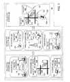
- FIG. 1is a diagram illustrating categories of component systems that form alternative embodiments of the present invention.
- FIG. 2is a flowchart showing the steps performed by the route recorder in FIG. 1 .
- FIG. 3is a flowchart showing the steps performed by the in-vehicle route recorder application in FIG. 1 .
- FIG. 1shows an overall system 90 that enables end users to exchange data about routes with other end users.
- end usersi.e., “end user/recorders”
- end users who defined the routesare provided with a means to distribute the data that define the routes.
- end usersi.e., “end user/recipients”
- end user/recipientsare provided with a means to use the data that define the routes.
- FIG. 1shows a collection systems category 100 , a distribution systems category 104 and a utilization systems category 108 .
- Each of these categoriesrelates to one of the main functions mentioned above.
- Within each categoryare shown various alternative embodiments of systems that can be used to accomplish the function associated with the category. In general, any system in one category can be used with any system from either of the other categories.
- a web-based route data collection system 112includes a vehicle-driven route data collection system 116 , and a standalone route data collection system 120 .
- Each of these systemsmay be used by an end user/recorder (also referred to as a “first end user”) to record and store data that define a route.
- this systemincludes a client system 124 .
- the client system 124includes any type of device that can connect to the Internet 128 .
- the client system 124includes appropriate hardware and software that enables the end user/recorder using the client system 124 to connect to the Internet 128 .
- the client system 124can be a personal computer, a terminal, an Internet appliance, a web-enabled phone, a personal digital assistant (PDA), etc.
- the web-based system 112also includes a server system 132 .
- the server system 132is accessed over the Internet 128 by the client system 124 .
- the server system 132includes a route recorder application 136 .
- the route recorder application 136allows the end user/recorder to define and store a route.
- FIG. 2shows the steps in a process performed by the route recorder application 136 .
- a user/recorder 140provides data 144 indicating an origin and destination to the route recorder application 136 .
- the user/recorder 140uses the client system 124 to access the route recorder application 136 which is located over the Internet 128 on the server system 132 .
- the route recorder application 136may present the user/recorder 140 with a menu and blank data fields into which the user/recorder can enter information that defines an origin and a destination.
- the route recorder application 136may provide the user/recorder 140 with a graphical map on the display screen of the client system 124 . The map can be panned and zoomed in order to allow the user/recorder 140 to identify geographic locations for the origin and destination by pointing-and-clicking locations on the map being displayed.
- the route recorder application 136receives the data 144 indicating an origin and destination from the user/recorder 140 (Step 148 ). Using the data 144 input by the user/recorder 140 , the route recorder application 136 determines a route (Step 152 ). In the embodiment of FIG. 2, the route recorder application 136 calls a route calculation application 156 and provides the data 144 defining the origin and destination to the route calculation application 156 .
- the route calculation application 156may use any known means to determine a route between the origin and destination. Examples of methods that the route calculation application 156 can use to determine a route are described in the copending patent application Ser. No. 09/047,698, filed Mar. 25, 1998, the entire disclosure of which is incorporated by reference herein.
- the route calculation application 156uses a geographic database 160 .
- the geographic database 160includes data about the geographic features in a covered area, including data about the roadway network in the covered geographic area.
- the geographic database 160includes node data records and segment data records. Node data records represent physical locations in the geographic area (such as roadway intersections and other positions) and segment data records represent portions of roadways between the physical locations represented by nodes.
- Each road segment in the geographic regionis represented by a road segment data entity (i.e., a record) in the geographic database 160 .
- Each road segment data record in the geographic database 160has two nodes which represent the coordinate positions at each end of the road segment represented by the road segment data record.
- the data recordsinclude information that can be used during route calculation, such as turn restrictions, vehicle access, restricted driving conditions, etc.
- route calculationsuch as turn restrictions, vehicle access, restricted driving conditions, etc.
- nodesand “segments” represent only one terminology for describing these physical geographic features and other terminology for these feature is intended to be encompassed within the scope of these concepts.
- the route calculation application 156determines a plurality of road segments that form a continuous path between the origin and destination.
- the solution routeconforms to known traffic restrictions.
- the solution routemay also be optimized for certain criteria, e.g., least travel time, shortest distance, and so on.
- the route recorder applicationAfter the route calculation application 156 determines a solution route, the route recorder application provides 136 a means by which the user/recorder 140 can review and change the route (Step 164 ). There are several ways that the route recorder application 136 can provide the route to the user/recorder 140 for review.
- the route recorder application 136can provide the route to the user/recorder 140 for review is to display the route graphically on the display of the client system 124 that the user/recorder 140 is using to operate the route recorder application 136 .
- the route informationis displayed graphically to the user/recorder 140
- the path of the routemay be highlighted on a map displayed graphically on the client system 124 .
- the route recorder application 136uses a map display application 168 for this purpose.
- the map display application 136uses data from the geographic database 160 .
- There are various ways for displaying map data graphically. Examples of methods that the map display application 168 can useare described in U.S. Pat. No. 6,092,076 and copending patent application Ser. No. 09/092,625, filed Jun. 5, 1998, the entire disclosures of which are incorporated by reference herein.
- the route recorder application 136can provide the route to the user/recorder 140 for review is to provide the user/recorder with a list of maneuvering instructions for following the route calculated by the route calculation application 156 .
- the route recorder application 136uses a route guidance application 172 for this purpose.
- the route guidance application 172uses data from the geographic database 160 .
- the maneuvering instructions provided by the route guidance application 172include text that describes the route and in particular describes all the maneuvers required to follow the route. Examples of methods that the route guidance application 172 can use are described in copending patent application Ser. No. 08/893,201, filed Jul. 15, 1997, the entire disclosure of which is incorporated by reference herein.
- the route recorder application 136When the route recorder application 136 provides data indicating the route to the user/recorder 140 , it provides sufficient information so that the user/recorder can review each segment that forms the solution route. As part of this step, the route recorder application 136 also provides the user/recorder 140 with a means to select and change any portion of the route. As an example, if the solution route indicated a left turn at a particular intersection, the user/recorder 140 , when reviewing the route, can change the route to a right turn.
- the route recorder application 136receives the user/recorder's input (Step 176 ).
- the user/recorder's inputmay be to accept the route provided in Step 164 .
- the user/recorder's inputmay include changes to the route based on the user/recorder's review.
- the route recorder application 136obtains a new solution route that includes the change made by the user/recorder. First, the route recorder application 136 determines whether the user/recorder 140 has proposed a change to the route (Step 180 ). If the user/recorder 140 has proposed a change, the route recorder application loops back to the portion of the process at which the route to the destination is calculated (i.e., Step 152 ) and has a new route calculated (Step 182 ).
- the route calculation application 156is constrained to use the change proposed by the user/recorder 140 .
- the new solution routeis determined, it is provided to the user/recorder again for review, as described above.
- the user/recorder 140can make iterative changes until the route is the exactly the way the user/recorder wants it.
- Step 180If the user/recorder 140 has no more changes to the route (Step 180 ), the route recorder application 136 saves a data file 184 that defines the route determined by the user/recorder 140 (Step 188 ). The route recorder application 136 then ends (Step 192 ).
- the standalone system 120uses a computing system 200 .
- the computing system 200can be a personal computer, a terminal, an Internet appliance, a web-enabled phone, a PDA, a network, etc.
- a route recorder application 204is locally on the computing system 200 .
- the route recorder application 204may include similar or identical steps as the route recorder application 136 described in FIG. 2 .
- a user/recorder 140uses the route recorder application 204 run on the computing system 200 to determine a route and save a data file that defines the route.
- the vehicle-driven system 116operates with a navigation system 208 which is located in a vehicle 212 of the user/recorder.
- the navigation system 208is a combination of hardware and software components. Included among the software components of the navigation system 208 is an in-vehicle route recorder application 216 .
- the in-vehicle route recorder application 216is similar to the route recorder applications 136 and 204 , described previously.
- the in-vehicle route recorder application 216allows the user/recorder to determine and save data that define a route.
- the in-vehicle route recorder application 216includes the additional function that it is able to record data about a route being driven by the vehicle 212 .
- FIG. 3is a flowchart that shows the steps performed in one embodiment of the in-vehicle route recorder application 216 .
- the in-vehicle route recorder application 216is used while the vehicle 212 is being driven along roads ( 214 in FIG. 1) in a geographic area ( 218 in FIG. 1 ).
- the in-vehicle route recorder application 216receives input 220 from the user/recorder 140 to start recording data that defines a route (Step 224 ).
- the input from the user/recorder 140may be received through the user interface of the navigation system 208 .
- a callis made to a vehicle positioning application 228 to obtain data that identifies the current position of the vehicle 212 (Step 232 ).
- the vehicle positioning application 228may be part of the software applications included in the vehicle navigation system 208 .
- the vehicle positioning application 228uses data from a geographic database 236 when performing this function.
- the geographic database 236may be similar or identical to the geographic database 160 , described above. Examples of methods that the vehicle positioning application 228 can use to determine the position of the vehicle are described in copending patent application Ser. No. 09/276,377, filed Mar. 25, 1999, Ser. No. 09/680,162, filed Oct. 5, 2000, and Ser. No. 09/680,161, filed Oct. 5, 2000, the entire disclosures of which are incorporated by reference herein.
- the vehicle positioning application 228provides data that identify the road segment upon which the vehicle 212 is located, the position of the vehicle along the identified road segment, and the direction of travel of the vehicle along the identified road segment.
- the route recorder application 216captures the data indicating the road segment upon which the vehicle is located (and optionally data indicating the vehicle position and direction) and saves the data in a data file 240 (Step 244 ). Newly received data are appended to previously received data so that the file 240 includes data that identify each road segment upon which the vehicle 212 traveled.
- Step 248If the route recorder application 216 does not receive data indicating that route recording has stopped (Step 248 ), the process loops back to the step in which the vehicle position is obtained. In this manner, data indicating the vehicle position are obtained continuously as the vehicle is being driven. These data are obtained by the route recorder application 216 relatively frequently, e.g., every second, so that each road segment upon which the vehicle travels is identified and data indicating the road segment are stored in the data file 240 .
- the route recorder application 216receives data indicating that route recording should stop (Step 248 ).
- the data indicating that route recording should stopmay be an indication from the user/recorder 140 .
- the indication from the user/recordermay be made via a user interface of the navigation system 208 .
- the data indicating that route recording should stopmay be an indication that the vehicle has been turned off. This indication may be received from a controller associated with the vehicle ignition.
- the route recorder application 216When the route recorder application 216 receives data indicating that route recording should stop, the temporary data file 240 is stored as a (relatively) permanent data file 252 (Step 254 ). The route recorder application 216 ends (Step 258 ).
- the dataare distributed to other users.
- the media-based system 262uses physical media 266 to distribute the data defining a route that had been stored using one of the collection systems 100 .
- the mediamay be CD-ROM disks, DVD disks, floppy disks, memory cards, EPROMs, tape, hard disks, or other kinds of media.
- the data defining a route that had been defined and saved using one of the collection systems 100( 184 in FIG. 2 or 252 in FIG. 3) are stored in one or more data files on the media 266 .
- the media 266are distributed to end user/recipients by any means.
- the mediamay be physically delivered by mail, hand-delivered, etc.
- the media used for distributionare selected so that they are compatible with the systems that the end user/recipients use to receive route calculation and guidance features.
- the media used for distributionshould be compatible with the navigation system 268 .
- the mediaare compatible if the end user/recipient can use the medium directly in his/her navigation system or if the end user has the means to convert or otherwise transfer the data defining a route from the medium used for distribution into the navigation system 268 .
- the web-based system 270includes a client system 274 and a server system 278 .
- the client system 124includes any type of device that can connect to the Internet 128 , such as a personal computer, a terminal, an Internet appliance, a web-enabled phone, a PDA, etc.
- the server system 278is accessed over the Internet 128 by the client system 274 .
- the server system 274includes a route distribution application 282 .
- the route distribution application 282allows the end user to download data that define a route.
- the data that the route distribution application 282 allows end user/recipients to downloadinclude the data defining routes that had been defined and saved using one of the collection systems 100 .
- the wireless-based system 290includes a wireless data transmitter 292 .
- the wireless data transmitter 292includes a communications system capable of transmitting data wirelessly. Such systems include those capable of relatively long-range data transmission, such as cellular, PCS, etc., as well as systems capable of relatively short-range data transmission, such as infrared, Bluetooth® systems, etc.
- Each end user/recipienthas a receiver. The receiver is capable of receiving the data transmissions from the wireless data transmitter 292 .
- the receivermay be part of a navigation system 298 installed in the end user/recipient's vehicle 300 .
- the receivermay be part of a portable computing device 302 , such as a PDA (e.g., a PalmPilot®-type device).
- the wireless data transmitter 292transmits the data that define a route that had been saved using one of the collection systems 100 ( 184 in FIG. 2 or 252 in FIG. 3) to the end user/recipient's receiver.
- the end user/recipient's systemreceives the route data that had been transmitted and saves the data in a local data storage.
- an end user/recipientuses one of the distribution systems 104 to receive the data that define a route
- the end useruses the data in a system that provides information for following the route.
- a system that provides information for following the routeThere are various systems that can be used to provide the end user/recipient with information for following the route that had been defined by an end user/recorder using one of the collections systems 100 . Some of these systems are indicated among the utilization systems 108 in FIG. 1 .
- the vehicle navigation system 306is installed in an end user/recipient's vehicle 310 .
- the vehicle navigation system 306may be similar or identical to the vehicle navigation system 208 , described above, although the vehicle navigation system 306 in the end user/recipient's vehicle does not need to have the route recorder capability.
- the end user/recipient's navigation system 306includes hardware and software for receiving the data that define a route (using any of the collection systems 100 and distribution systems 104 ) and using the data that define a route to provide the end user/recipient with information for following the route.
- the end user/recipient's navigation system 306includes a drive or slot capable of receiving the media and accessing and reading the data stored thereon that define a route.
- the drive or slotmay be in addition to the drive or slot used by the end user/recipient's navigation system 306 for a geographic database.
- the geographic database used by the user/recipient's navigation system 306may be temporarily removed from its drive or slot, the media 266 containing the data that define a route installed in the drive or slot normally used for the geographic database, and then the data that define a route copied from the media 266 onto a data storage medium in the navigation system 306 .
- the end user/recipient's navigation system 306uses the data that define a route to provide route calculation and guidance. These functions can be provided by routines included in the route calculation and guidance applications included in the end user/recipient's navigation system.
- the data that define a routewill define only a portion of the entire route needed by the end user/recipient.
- the route defined by the datamay relate to the road segments that a business wants delivery trucks to use to travel to the site of the business in order to avoid a school crossing. This defined route may represent only the last 2 miles before reaching the site of the business. The delivery trucks would still need to reach the beginning of the defined route.
- the route calculation program used by the end user/recipient's navigation systemincludes the capability to read the data file containing the defined route, calculate a route to the beginning of the defined route, and then incorporate the defined route into an entire solution route for the end user/recipient to follow to reach the destination.
- route guidance for following the defined routecan be provided in the same manner as any other route for which guidance is provided by the end user/recipient's navigation system.
- the PDA 320may be carried by a person located in a vehicle 322 .
- the PDA 320includes software applications that use geographic data to provide routing instructions.
- the software applications in the PDA 320may be similar or identical to those in the navigation system 306 .
- the PDAmay also include positioning equipment (such as a GPS system) that determines the location of the PDA 320 .
- the navigation applications in the PDA 320use the received data that define a route to provide guidance for following the defined route.
- the navigation applications in the PDA 320may also include the capability to incorporate the defined route into an overall route, as described above in connection with the navigation system 306 .
- Another one of the utilization systems 108is the vehicle navigation system 298 that obtains data that define a route wirelessly.
- This navigation system 330was described in connection with the wireless-based distribution system 290 .
- This navigation system 298is installed in the vehicle 300 .
- This navigation system 298includes the hardware and software needed to receive data from the wireless distribution system 290 .
- the navigation system 298uses the data to provide information for the end user/recipient to follow the route, similar to the navigation system 306 , described above.
- the end user/recipient systemse.g., navigation systems 298 and 306 and PDA 320 in the utilization category 108 include the capability to read and use the data that define a route. There are several different ways that the end user/recipient's navigation system can use to provide this capability.
- the segments in the defined routeare identified by ID's that are assigned by the geographic database developer.
- ID'sare assigned to the data records that represent individual road segments. These ID's can be used in the route recorder applications (e.g., 126 , 204 and 216 in FIG. 1) used by the end user/recorders to define routes. Then, when the defined routes are used by the end user/recipient systems, the route calculation application in the end user/recipient systems use the ID's to identify the road segments that form the defined route.
- ID numbers assigned to road segmentsmay change.
- ID numbers assigned to road segmentsmay change in different versions of the geographic database.
- translation tablesare used to translate ID numbers assigned to road segments from one version to another version.
- the individual road segments that form the defined routeare identified in terms of their coordinates (i.e., latitude and longitude).
- Each road segmentcan be identified by its coordinates (i.e., the latitude and longitude of its end points).
- the route recorder application( 126 , 216 , or 204 in FIG. 1) stores data that identify the coordinates (i.e., latitude and longitude of the end points) of each road segment in the defined route. Then, the end user/recipient's navigation system uses the data that identify the coordinates of the road segments to identify the actual road segments in the defined route.
- the road segments that form the defined routeare identified by street names, directions and distances.
- the route recorder application( 126 , 216 , or 204 in FIG. 1) stores data that identify the defined route using the names of the streets (e.g., “HIGGINS”, “MANNEHEIM”, etc.), the direction along each street (e.g., “NORTH”, “WEST”, etc.) and distance (e.g., “TRAVEL 3 MILES”).
- these recorded dataare used to identify the actual route segments that make up the defined route.
- These actual road segmentsare identified using the database in the user/recipient's system.
- route guidance for following the defined routeis determined by the end user/recipient's system and provided to the end user/recipient.
- a consideration related to this featureis that determination of a convenient meeting place for both persons (i.e., taking into account the locations of both persons) is performed on one navigation system, but the guidance for traveling to the selected meeting place may be provided by two navigation systems, one associated with each person. Accordingly, in these embodiments, there is a need for the one navigation system that determines the convenient meeting place to transmit data that defines the route to the other navigation system to provide guidance for one of the persons to reach the selected destination. Embodiments in the present application provide this capability.
- data that identify the route for the other person to travel to reach the selected destinationare transmitted to the other person so that the other person can use the data in his/her navigation system in order to follow the route.
Landscapes
- Engineering & Computer Science (AREA)
- Radar, Positioning & Navigation (AREA)
- Remote Sensing (AREA)
- Automation & Control Theory (AREA)
- Physics & Mathematics (AREA)
- General Physics & Mathematics (AREA)
- Navigation (AREA)
- Traffic Control Systems (AREA)
Abstract
Description
Claims (21)
Priority Applications (1)
| Application Number | Priority Date | Filing Date | Title |
|---|---|---|---|
| US10/413,113US6778903B2 (en) | 2000-11-22 | 2003-04-14 | Method and system for exchanging routing data between end users |
Applications Claiming Priority (2)
| Application Number | Priority Date | Filing Date | Title |
|---|---|---|---|
| US09/718,752US6577949B1 (en) | 2000-11-22 | 2000-11-22 | Method and system for exchanging routing data between end users |
| US10/413,113US6778903B2 (en) | 2000-11-22 | 2003-04-14 | Method and system for exchanging routing data between end users |
Related Parent Applications (1)
| Application Number | Title | Priority Date | Filing Date |
|---|---|---|---|
| US09/718,752ContinuationUS6577949B1 (en) | 2000-11-22 | 2000-11-22 | Method and system for exchanging routing data between end users |
Publications (2)
| Publication Number | Publication Date |
|---|---|
| US20030191584A1 US20030191584A1 (en) | 2003-10-09 |
| US6778903B2true US6778903B2 (en) | 2004-08-17 |
Family
ID=24887368
Family Applications (2)
| Application Number | Title | Priority Date | Filing Date |
|---|---|---|---|
| US09/718,752Expired - LifetimeUS6577949B1 (en) | 2000-11-22 | 2000-11-22 | Method and system for exchanging routing data between end users |
| US10/413,113Expired - LifetimeUS6778903B2 (en) | 2000-11-22 | 2003-04-14 | Method and system for exchanging routing data between end users |
Family Applications Before (1)
| Application Number | Title | Priority Date | Filing Date |
|---|---|---|---|
| US09/718,752Expired - LifetimeUS6577949B1 (en) | 2000-11-22 | 2000-11-22 | Method and system for exchanging routing data between end users |
Country Status (1)
| Country | Link |
|---|---|
| US (2) | US6577949B1 (en) |
Cited By (24)
| Publication number | Priority date | Publication date | Assignee | Title |
|---|---|---|---|---|
| US20050131637A1 (en)* | 2003-12-15 | 2005-06-16 | Hsiao-Wei Chu | Method of constructing personal map database for generating personal map |
| US20050222756A1 (en)* | 2004-04-05 | 2005-10-06 | Davis Scott B | Methods for displaying a route traveled by mobile users in a communication network |
| US20060195550A1 (en)* | 2001-01-15 | 2006-08-31 | Ron Craik | System and method for storing and retrieving equipment inspection and maintenance data |
| US20060220913A1 (en)* | 2005-03-17 | 2006-10-05 | Wolfgang Krautter | Method and device for guiding a vehicle, as well as a corresponding computer program and a corresponding computer-readable storage medium |
| US20060271290A1 (en)* | 2005-03-14 | 2006-11-30 | Wei-Tin Li | Method for exchanging route schemes of global positioning system |
| US20070073480A1 (en)* | 2005-09-23 | 2007-03-29 | Mona Singh | System and method for selecting and presenting a route to a user |
| US20080018730A1 (en)* | 2006-07-20 | 2008-01-24 | Marc Roth | For-hire vehicle interactive communication systems and methods thereof |
| US20080091341A1 (en)* | 2006-06-27 | 2008-04-17 | Microsoft Corporation | Route monetization |
| US20080097688A1 (en)* | 2006-06-27 | 2008-04-24 | Microsoft Corporation | Route generation based upon activity criteria |
| US20090051502A1 (en)* | 2001-11-13 | 2009-02-26 | Ron Craik | System and method for storing and retrieving equipment inspection and maintenance data |
| US20090157583A1 (en)* | 2007-12-14 | 2009-06-18 | Microsoft Corporation | Route transfer between devices |
| US20090157312A1 (en)* | 2007-12-14 | 2009-06-18 | Microsoft Corporation | Social network based routes |
| US20090157307A1 (en)* | 2007-12-14 | 2009-06-18 | Microsoft Corporation | Additional content based on intended travel destination |
| US20090157302A1 (en)* | 2007-12-14 | 2009-06-18 | Microsoft Corporation | Pedestrian route production |
| US20090157499A1 (en)* | 2007-12-14 | 2009-06-18 | Microsoft Corporation | Automatic splices for targeted advertisements |
| US20090157311A1 (en)* | 2007-12-14 | 2009-06-18 | Microsoft Corporation | Federated route production |
| US20090210143A1 (en)* | 2008-02-19 | 2009-08-20 | Microsoft Corporation | Route-based activity planner |
| US20090210276A1 (en)* | 2008-02-19 | 2009-08-20 | Microsoft Corporation | Ad hoc and opportunistic transportation services |
| US20090210242A1 (en)* | 2008-02-19 | 2009-08-20 | Microsoft Corporation | Load balance payment |
| US20100161214A1 (en)* | 2006-04-14 | 2010-06-24 | Mona Singh | System And Method For Presenting A Computed Route |
| US20130013192A1 (en)* | 2008-01-07 | 2013-01-10 | Hakan Yakali | Navigation Device and Method Providing a Logging Function |
| US8564417B2 (en) | 2001-01-15 | 2013-10-22 | Ron Craik | System and method for storing and retrieving equipment inspection and maintenance data |
| US8620532B2 (en) | 2009-03-25 | 2013-12-31 | Waldeck Technology, Llc | Passive crowd-sourced map updates and alternate route recommendations |
| US8718925B2 (en) | 2006-06-27 | 2014-05-06 | Microsoft Corporation | Collaborative route planning for generating personalized and context-sensitive routing recommendations |
Families Citing this family (30)
| Publication number | Priority date | Publication date | Assignee | Title |
|---|---|---|---|---|
| EP1366435A2 (en)* | 2000-08-22 | 2003-12-03 | Symbian Limited | Database for use with a wireless information device |
| US6577949B1 (en)* | 2000-11-22 | 2003-06-10 | Navigation Technologies Corp. | Method and system for exchanging routing data between end users |
| US20030014414A1 (en)* | 2000-12-07 | 2003-01-16 | Newman Bruce D. | Personcast - customized end-user briefing |
| US20020162002A1 (en)* | 2001-04-25 | 2002-10-31 | Gunter Carl A. | Method and system for controlling access to services |
| US20030236977A1 (en)* | 2001-04-25 | 2003-12-25 | Levas Robert George | Method and system for providing secure access to applications |
| US20030172297A1 (en)* | 2002-03-05 | 2003-09-11 | Gunter Carl A. | Method and system for maintaining secure access to web server services using public keys |
| US20020162004A1 (en)* | 2001-04-25 | 2002-10-31 | Gunter Carl A. | Method and system for managing access to services |
| US20050210263A1 (en)* | 2001-04-25 | 2005-09-22 | Levas Robert G | Electronic form routing and data capture system and method |
| US6885388B2 (en)* | 2001-04-25 | 2005-04-26 | Probaris Technologies Inc. | Method for automatically generating list of meeting participants and delegation permission |
| US20030172299A1 (en)* | 2002-03-05 | 2003-09-11 | Gunter Carl A. | Method and system for maintaining secure access to web server services using permissions |
| US20020162019A1 (en)* | 2001-04-25 | 2002-10-31 | Berry Michael C. | Method and system for managing access to services |
| US7493210B2 (en)* | 2001-08-09 | 2009-02-17 | International Business Machines Corporation | Vehicle navigation method |
| JP2003130655A (en)* | 2001-10-29 | 2003-05-08 | Matsushita Electric Ind Co Ltd | Navigation system |
| US6785608B1 (en)* | 2001-12-19 | 2004-08-31 | Navteq North America, Llc | System and method for calculating an optimized route and calculation thereof |
| EP1491858A1 (en)* | 2003-06-27 | 2004-12-29 | Harman Becker Automotive Systems GmbH | Navigation method and system |
| AU2003265278A1 (en)* | 2003-07-16 | 2005-03-07 | Harman Becker Automotive Systems Gmbh | Transmission of special routes to a navigation device |
| US20060015246A1 (en)* | 2004-07-15 | 2006-01-19 | Alvin Hui | Method and apparatus for specifying destination using previous destinations stored in navigation system |
| US20060235856A1 (en)* | 2004-12-16 | 2006-10-19 | Halcrow Michael A | Route generation for task completion by a location-aware device |
| US11390165B2 (en) | 2005-11-17 | 2022-07-19 | Invently Automotive Inc. | Electric vehicle power management system |
| US11325468B2 (en) | 2005-11-17 | 2022-05-10 | Invently Automotive Inc. | Vehicle power management system |
| KR101387504B1 (en)* | 2007-08-20 | 2014-04-21 | 엘지전자 주식회사 | Terminal having function for managing position information and program recording medium |
| US8108141B2 (en)* | 2008-08-28 | 2012-01-31 | Empire Technology Development Llc | Intelligent travel routing system and method |
| US7881861B2 (en)* | 2008-08-28 | 2011-02-01 | Skypebble Associates Llc | Networked navigation system |
| US20100211304A1 (en)* | 2009-02-19 | 2010-08-19 | Hwang Timothy H | Personalized User Routing and Recommendations |
| EP2290322B1 (en) | 2009-08-25 | 2017-03-01 | BlackBerry Limited | Method and Device for Generating and Communicating Geographic Route Information between Wireless Communication Devices |
| US8352178B2 (en)* | 2009-08-25 | 2013-01-08 | Research In Motion Limited | Method and device for generating and communicating geographic route information between wireless communication devices |
| US9310213B2 (en)* | 2012-11-08 | 2016-04-12 | Apple Inc. | Obtaining updated navigation information for road trips |
| US11182870B2 (en)* | 2014-12-24 | 2021-11-23 | Mcafee, Llc | System and method for collective and collaborative navigation by a group of individuals |
| US10288444B2 (en) | 2017-01-10 | 2019-05-14 | Microsoft Technology Licensing, Llc | Generating instructions for shared travel experiences |
| US10346773B2 (en)* | 2017-05-12 | 2019-07-09 | International Business Machines Corporation | Coordinating and providing navigation for a group of people traveling together in a transport hub |
Citations (9)
| Publication number | Priority date | Publication date | Assignee | Title |
|---|---|---|---|---|
| US5523950A (en) | 1991-02-01 | 1996-06-04 | Peterson; Thomas D. | Method and apparatus for providing shortest elapsed time route information to users |
| US6081609A (en) | 1996-11-18 | 2000-06-27 | Sony Corporation | Apparatus, method and medium for providing map image information along with self-reproduction control information |
| US6141609A (en) | 1993-11-08 | 2000-10-31 | Mannesmann Aktiengesellschaft | Device for recording information on a vehicle's itinerary |
| US6148090A (en) | 1996-11-18 | 2000-11-14 | Sony Corporation | Apparatus and method for providing map information in image form |
| US6199010B1 (en) | 1998-05-04 | 2001-03-06 | Lucent Technologies, Inc. | Wireless telecommunications system that provides navigational assistance to travelers |
| US6300946B1 (en) | 1997-01-29 | 2001-10-09 | Palm, Inc. | Method and apparatus for interacting with a portable computer |
| US6339746B1 (en)* | 1999-09-30 | 2002-01-15 | Kabushiki Kaisha Toshiba | Route guidance system and method for a pedestrian |
| US6577949B1 (en)* | 2000-11-22 | 2003-06-10 | Navigation Technologies Corp. | Method and system for exchanging routing data between end users |
| US6633809B1 (en) | 2000-08-15 | 2003-10-14 | Hitachi, Ltd. | Wireless method and system for providing navigation information |
Family Cites Families (1)
| Publication number | Priority date | Publication date | Assignee | Title |
|---|---|---|---|---|
| JPH1151671A (en)* | 1997-07-31 | 1999-02-26 | Honda Motor Co Ltd | Travel guide device |
- 2000
- 2000-11-22USUS09/718,752patent/US6577949B1/ennot_activeExpired - Lifetime
- 2003
- 2003-04-14USUS10/413,113patent/US6778903B2/ennot_activeExpired - Lifetime
Patent Citations (9)
| Publication number | Priority date | Publication date | Assignee | Title |
|---|---|---|---|---|
| US5523950A (en) | 1991-02-01 | 1996-06-04 | Peterson; Thomas D. | Method and apparatus for providing shortest elapsed time route information to users |
| US6141609A (en) | 1993-11-08 | 2000-10-31 | Mannesmann Aktiengesellschaft | Device for recording information on a vehicle's itinerary |
| US6081609A (en) | 1996-11-18 | 2000-06-27 | Sony Corporation | Apparatus, method and medium for providing map image information along with self-reproduction control information |
| US6148090A (en) | 1996-11-18 | 2000-11-14 | Sony Corporation | Apparatus and method for providing map information in image form |
| US6300946B1 (en) | 1997-01-29 | 2001-10-09 | Palm, Inc. | Method and apparatus for interacting with a portable computer |
| US6199010B1 (en) | 1998-05-04 | 2001-03-06 | Lucent Technologies, Inc. | Wireless telecommunications system that provides navigational assistance to travelers |
| US6339746B1 (en)* | 1999-09-30 | 2002-01-15 | Kabushiki Kaisha Toshiba | Route guidance system and method for a pedestrian |
| US6633809B1 (en) | 2000-08-15 | 2003-10-14 | Hitachi, Ltd. | Wireless method and system for providing navigation information |
| US6577949B1 (en)* | 2000-11-22 | 2003-06-10 | Navigation Technologies Corp. | Method and system for exchanging routing data between end users |
Cited By (45)
| Publication number | Priority date | Publication date | Assignee | Title |
|---|---|---|---|---|
| US7383318B2 (en)* | 2001-01-15 | 2008-06-03 | Ron Craik | System and method for storing and retrieving equipment inspection and maintenance data |
| US20060195550A1 (en)* | 2001-01-15 | 2006-08-31 | Ron Craik | System and method for storing and retrieving equipment inspection and maintenance data |
| US8564417B2 (en) | 2001-01-15 | 2013-10-22 | Ron Craik | System and method for storing and retrieving equipment inspection and maintenance data |
| US20080228347A1 (en)* | 2001-01-15 | 2008-09-18 | Ron Craik | System and method for storing and retrieving equipment inspection and maintenance data |
| US8198986B2 (en) | 2001-11-13 | 2012-06-12 | Ron Craik | System and method for storing and retrieving equipment inspection and maintenance data |
| US20090051502A1 (en)* | 2001-11-13 | 2009-02-26 | Ron Craik | System and method for storing and retrieving equipment inspection and maintenance data |
| US20050131637A1 (en)* | 2003-12-15 | 2005-06-16 | Hsiao-Wei Chu | Method of constructing personal map database for generating personal map |
| US20050222756A1 (en)* | 2004-04-05 | 2005-10-06 | Davis Scott B | Methods for displaying a route traveled by mobile users in a communication network |
| US20060271290A1 (en)* | 2005-03-14 | 2006-11-30 | Wei-Tin Li | Method for exchanging route schemes of global positioning system |
| US7471212B2 (en)* | 2005-03-17 | 2008-12-30 | Robert Bosch Gmbh | Method and device for guiding a vehicle, as well as a corresponding computer program and a corresponding computer-readable storage medium |
| US20060220913A1 (en)* | 2005-03-17 | 2006-10-05 | Wolfgang Krautter | Method and device for guiding a vehicle, as well as a corresponding computer program and a corresponding computer-readable storage medium |
| US7698061B2 (en) | 2005-09-23 | 2010-04-13 | Scenera Technologies, Llc | System and method for selecting and presenting a route to a user |
| US9366542B2 (en) | 2005-09-23 | 2016-06-14 | Scenera Technologies, Llc | System and method for selecting and presenting a route to a user |
| US8589064B2 (en) | 2005-09-23 | 2013-11-19 | Scenera Technologies, Llc | System and method for selecting and presenting a route to a user |
| US20070073480A1 (en)* | 2005-09-23 | 2007-03-29 | Mona Singh | System and method for selecting and presenting a route to a user |
| US7991544B2 (en) | 2005-09-23 | 2011-08-02 | Scenera Technologies, Llc | System and method for selecting and presenting a route to a user |
| US20100152999A1 (en)* | 2005-09-23 | 2010-06-17 | Mona Singh | System And Method For Selecting And Presenting A Route To A User |
| US8577598B2 (en) | 2006-04-14 | 2013-11-05 | Scenera Technologies, Llc | System and method for presenting a computed route |
| US9228850B2 (en) | 2006-04-14 | 2016-01-05 | Scenera Technologies, Llc | System and method for presenting a computed route |
| US20100161214A1 (en)* | 2006-04-14 | 2010-06-24 | Mona Singh | System And Method For Presenting A Computed Route |
| US7991548B2 (en) | 2006-04-14 | 2011-08-02 | Scenera Technologies, Llc | System and method for presenting a computed route |
| US8718925B2 (en) | 2006-06-27 | 2014-05-06 | Microsoft Corporation | Collaborative route planning for generating personalized and context-sensitive routing recommendations |
| US20080091341A1 (en)* | 2006-06-27 | 2008-04-17 | Microsoft Corporation | Route monetization |
| US8793066B2 (en) | 2006-06-27 | 2014-07-29 | Microsoft Corporation | Route monetization |
| US20080097688A1 (en)* | 2006-06-27 | 2008-04-24 | Microsoft Corporation | Route generation based upon activity criteria |
| US20080018730A1 (en)* | 2006-07-20 | 2008-01-24 | Marc Roth | For-hire vehicle interactive communication systems and methods thereof |
| US20090157307A1 (en)* | 2007-12-14 | 2009-06-18 | Microsoft Corporation | Additional content based on intended travel destination |
| US8060297B2 (en) | 2007-12-14 | 2011-11-15 | Microsoft Corporation | Route transfer between devices |
| US8090532B2 (en) | 2007-12-14 | 2012-01-03 | Microsoft Corporation | Pedestrian route production |
| US20090157312A1 (en)* | 2007-12-14 | 2009-06-18 | Microsoft Corporation | Social network based routes |
| US20090157311A1 (en)* | 2007-12-14 | 2009-06-18 | Microsoft Corporation | Federated route production |
| US8428859B2 (en) | 2007-12-14 | 2013-04-23 | Microsoft Corporation | Federated route production |
| US8473198B2 (en) | 2007-12-14 | 2013-06-25 | Microsoft Corporation | Additional content based on intended travel destination |
| US20090157583A1 (en)* | 2007-12-14 | 2009-06-18 | Microsoft Corporation | Route transfer between devices |
| US20090157302A1 (en)* | 2007-12-14 | 2009-06-18 | Microsoft Corporation | Pedestrian route production |
| US20090157499A1 (en)* | 2007-12-14 | 2009-06-18 | Microsoft Corporation | Automatic splices for targeted advertisements |
| US20130013192A1 (en)* | 2008-01-07 | 2013-01-10 | Hakan Yakali | Navigation Device and Method Providing a Logging Function |
| US9329048B2 (en)* | 2008-01-07 | 2016-05-03 | Tomtom International B.V. | Navigation device and method providing a logging function |
| US20090210242A1 (en)* | 2008-02-19 | 2009-08-20 | Microsoft Corporation | Load balance payment |
| US8793065B2 (en) | 2008-02-19 | 2014-07-29 | Microsoft Corporation | Route-based activity planner |
| US20090210276A1 (en)* | 2008-02-19 | 2009-08-20 | Microsoft Corporation | Ad hoc and opportunistic transportation services |
| US20090210143A1 (en)* | 2008-02-19 | 2009-08-20 | Microsoft Corporation | Route-based activity planner |
| US8620532B2 (en) | 2009-03-25 | 2013-12-31 | Waldeck Technology, Llc | Passive crowd-sourced map updates and alternate route recommendations |
| US9140566B1 (en) | 2009-03-25 | 2015-09-22 | Waldeck Technology, Llc | Passive crowd-sourced map updates and alternative route recommendations |
| US9410814B2 (en) | 2009-03-25 | 2016-08-09 | Waldeck Technology, Llc | Passive crowd-sourced map updates and alternate route recommendations |
Also Published As
| Publication number | Publication date |
|---|---|
| US6577949B1 (en) | 2003-06-10 |
| US20030191584A1 (en) | 2003-10-09 |
Similar Documents
| Publication | Publication Date | Title |
|---|---|---|
| US6778903B2 (en) | Method and system for exchanging routing data between end users | |
| US6763301B2 (en) | Method and system for compact representation of routes | |
| CA2533484C (en) | Navigation system | |
| JP4490028B2 (en) | Geographic database configuration to facilitate location-based advertising | |
| US8543617B2 (en) | Method and system for forming a keyword database for referencing physical locations | |
| US6463384B1 (en) | Geographic database including data for providing instructions about tollways | |
| US6587782B1 (en) | Method and system for providing reminders about points of interests while traveling | |
| US7085648B2 (en) | Information delivering server and clients and method thereof and storing medium stored programs to execute information delivery | |
| CN101469999B (en) | Manage differences between geodatabase versions | |
| JP4408635B2 (en) | How to provide location-based advertising along with route information | |
| EP1588340A1 (en) | Acquiring, managing, distributing, and presenting contextual data relating to a known position for location-based services to and between users | |
| AU2016201843B2 (en) | Method for representing linear features in a location content management system | |
| EP2400450A1 (en) | Method of operating a navigation system to block unwanted advertisements | |
| JP2007520687A (en) | Method and system for providing map search service | |
| JP2003014481A (en) | Electronic map information device | |
| JP7064463B2 (en) | Route-related information acquisition device and route-related information acquisition method |
Legal Events
| Date | Code | Title | Description |
|---|---|---|---|
| AS | Assignment | Owner name:NAVTEQ CORPORATION, ILLINOIS Free format text:ASSIGNMENT OF ASSIGNORS INTEREST;ASSIGNOR:NAVIGATION TECHNOLOGIES CORPORATION;REEL/FRAME:015293/0400 Effective date:20040203 Owner name:NAVTEQ NORTH AMERICA LLC, ILLINOIS Free format text:ASSIGNMENT OF ASSIGNORS INTEREST;ASSIGNOR:NAVTEQ CORPORATION;REEL/FRAME:015286/0504 Effective date:20040510 Owner name:NAVTEQ NORTH AMERICA LLC,ILLINOIS Free format text:ASSIGNMENT OF ASSIGNORS INTEREST;ASSIGNOR:NAVTEQ CORPORATION;REEL/FRAME:015286/0504 Effective date:20040510 Owner name:NAVTEQ CORPORATION,ILLINOIS Free format text:ASSIGNMENT OF ASSIGNORS INTEREST;ASSIGNOR:NAVIGATION TECHNOLOGIES CORPORATION;REEL/FRAME:015293/0400 Effective date:20040203 | |
| STCF | Information on status: patent grant | Free format text:PATENTED CASE | |
| CC | Certificate of correction | ||
| FPAY | Fee payment | Year of fee payment:4 | |
| FPAY | Fee payment | Year of fee payment:8 | |
| AS | Assignment | Owner name:HERE GLOBAL B.V., NETHERLANDS Free format text:CHANGE OF NAME;ASSIGNOR:NAVTEQ B.V.;REEL/FRAME:031075/0573 Effective date:20130423 | |
| AS | Assignment | Owner name:HERE NORTH AMERICA, LLC, ILLINOIS Free format text:CHANGE OF NAME;ASSIGNOR:NAVTEQ NORTH AMERICA, LLC;REEL/FRAME:031589/0139 Effective date:20130402 | |
| AS | Assignment | Owner name:HERE GLOBAL B.V., NETHERLANDS Free format text:ASSIGNMENT OF ASSIGNORS INTEREST;ASSIGNOR:HERE NORTH AMERICA, LLC;REEL/FRAME:031637/0901 Effective date:20131119 | |
| FPAY | Fee payment | Year of fee payment:12 |