US6529822B1 - Navigation system with zoomed maneuver instruction - Google Patents
Navigation system with zoomed maneuver instructionDownload PDFInfo
- Publication number
- US6529822B1 US6529822B1US09/547,004US54700400AUS6529822B1US 6529822 B1US6529822 B1US 6529822B1US 54700400 AUS54700400 AUS 54700400AUS 6529822 B1US6529822 B1US 6529822B1
- Authority
- US
- United States
- Prior art keywords
- maneuver
- vehicle
- navigation system
- zoomed
- display
- Prior art date
- Legal status (The legal status is an assumption and is not a legal conclusion. Google has not performed a legal analysis and makes no representation as to the accuracy of the status listed.)
- Expired - Lifetime
Links
- 238000000034methodMethods0.000claimsdescription17
- 238000013459approachMethods0.000description4
- 238000012986modificationMethods0.000description2
- 230000004048modificationEffects0.000description2
- 230000000007visual effectEffects0.000description1
Images


Classifications
- G—PHYSICS
- G01—MEASURING; TESTING
- G01C—MEASURING DISTANCES, LEVELS OR BEARINGS; SURVEYING; NAVIGATION; GYROSCOPIC INSTRUMENTS; PHOTOGRAMMETRY OR VIDEOGRAMMETRY
- G01C21/00—Navigation; Navigational instruments not provided for in groups G01C1/00 - G01C19/00
- G01C21/26—Navigation; Navigational instruments not provided for in groups G01C1/00 - G01C19/00 specially adapted for navigation in a road network
- G01C21/34—Route searching; Route guidance
- G01C21/36—Input/output arrangements for on-board computers
- G01C21/3626—Details of the output of route guidance instructions
- G01C21/3632—Guidance using simplified or iconic instructions, e.g. using arrows
Definitions
- This inventiongenerally relates to navigation or route guidance systems and, more particularly, to a system having a zoomed maneuver instruction view which provides a magnified view of a complex maneuver to provide clear and detailed instructions through the complex maneuver.
- Navigation systemsgenerally provide a recommended route to a desired destination.
- the desired destinationis selected from a large database of roads stored in a mass media storage, such as a CD ROM, which includes the roads in the area to be traveled by the user.
- a mass media storagesuch as a CD ROM
- the starting pointis typically associated with the vehicle position and can be input to the navigation system by an associated position determining system that usually includes a GPS (Global Positioning System) receiver.
- GPSGlobal Positioning System
- the navigation systemdetermines a route to the destination utilizing an algorithm well-known to those in the art and currently in use in many navigation systems. Usually there are many potential routes between the selected starting point and the desired destination. Typical navigation systems select a recommended route based upon certain “cost” values associated with each segment of road in the road database. These cost values include the length of the road segment and the estimated time of travel through the road segment. The navigation system selects the potential route with the lowest total cost to be the recommended route. Depending upon the predetermined algorithm of the navigation system, the navigation system will recommend the route with the shortest total length, the lowest total time, or some weighted average of length and time.
- the recommended routeis then displayed to the user as a map showing the vehicle, the desired destination and highlighting the recommended route.
- the navigation systemdisplays the current position of the vehicle and provides visual turn-by-turn instructions to the driver, guiding the driver to the selected destination.
- the turn-by-turn instructionis typically selected from a database of predefined maneuver instructions such as a generic left-turn instruction, a right-turn instruction straight-ahead instruction or the like.
- a database of predefined maneuver instructionssuch as a generic left-turn instruction, a right-turn instruction straight-ahead instruction or the like.
- the particular upcoming maneuvermay not be provided in the maneuver instruction database. This may be confusing to the driver as the driver may have trouble identifying the generic instructed maneuver with the surroundings. This is particularly troubling in a highly congested and road intense environment such as a city.
- this inventionprovides a zoomed maneuver instruction view which provides a magnified view of a map display view.
- the navigation systemgenerally includes a database of a plurality of roads, a position determining system, an input device, and a route determination system.
- the position determining systemdetermines a position of the vehicle relative to the plurality of roads.
- the userselects a destination from the database with the input device.
- the navigation systemthen calculates and displays a recommended route directing the driver of the vehicle to the desired destination. As the vehicle approaches an upcoming maneuver the display magnifies the large-scale map display view to provide a zoomed maneuver instruction view.
- a single maneuver instruction representationis displayed in a known manner.
- the maneuver instructionillustrates the upcoming maneuver to be performed along the recommended route to the destination.
- a usermay be required to perform a complex or unusual maneuver to continue along a recommended route.
- Such complex maneuversare typical in metro areas and may lead a user to incorrectly perform the maneuver.
- the present inventionswitches to a zoomed maneuver instruction view which displays a magnified view of the complex maneuver.
- Display of the zoomed maneuver instruction viewis preferably related to the complexity of the road segments adjacent the upcoming maneuver.
- Each road segment and nodeare commonly stored within the database in a compressed or short-hand format to save space.
- the beginning and ending latitude and longitude (hereafter lat/long) pointis the node which connects one segment to another road segment.
- the nodebeing the ending lat/long point for the first road segment and also the beginning lat/long point for a second road segment.
- the databaseis therefore composed of a simple list of segments and associated beginning and ending lat/long points. This is effective for straight road segments.
- a shape pointis added between the beginning and ending lat/long points.
- Each shape pointis preferably related back to the previous shape point.
- a first shape pointis stored within the database as a lat/long point relative to the beginning lat/long point.
- the compressed road segment storage within the databaseallows the CPU to determine the complexity of any road segment.
- the displayswitches to the zoomed maneuver instruction view.
- the zoomed maneuver instruction viewis displayed if more than N numbers of shape points are within a predetermined distance along the recommended route. In another embodiment, the zoomed maneuver instruction view is displayed if the recommended route includes an upcoming complex maneuver adjacent a road segment with more than N number of shape points.
- the zoomed maneuver instruction viewis a magnified view of the map display view.
- the CPUwill continue to magnify the complex maneuver in the zoomed maneuver instruction view as the vehicle and associated vehicle icon progresses through the complex maneuver.
- the CPUwill no longer zoom in on the complex maneuver in the zoomed maneuver instruction view.
- the zoomed maneuver instruction viewwill be maintained at this magnification as the vehicle icon progresses through the complex maneuver. The user can therefore better identify the relative position of the vehicle as vehicle icon progresses toward the next upcoming maneuver of the complex maneuver.
- the useris thereby provided with clear instruction through the complex maneuver and is less likely to incorrectly perform the maneuver. This is particularly advantageous in a highly congested or road intense environment such as a city.
- FIG. 1is a schematic of a navigation system according to the present invention
- FIG. 2is the OIM of the navigation system illustrated in FIG. 1 showing a map display
- FIG. 3Aillustrates a methodology for compressed storage of a straight road segment
- FIG. 3Billustrates a methodology for compressed storage of a non-straight road segment
- FIG. 4Ais the OIM of the navigation system illustrated in FIG. 1 showing a map display view with the vehicle approaching a complex maneuver;
- FIG. 4Bis an expanded view of the complex maneuver area illustrated on the map display view of FIG. 4A;
- FIG. 5is a zoomed maneuver instruction view as the vehicle approaches closer to the complex maneuver.
- FIG. 6is a further magnified zoomed maneuver instruction view as the vehicle travels along the complex maneuver illustrated in FIG. 5 .
- the navigation system 20 of the present inventionis shown schematically in FIG. 1 installed in a vehicle 21 .
- the navigation system 20includes an Operator Interface Module (“OIM”) 22 including input and output devices.
- the OIM 22includes a display 24 , such as a high resolution LCD or flat panel display, and an audio speaker 26 .
- the OIM 22also includes input devices 28 , preferably a plurality of buttons and directional keypad, but alternatively including a mouse, keyboard, keypad, remote device or microphone.
- the display 24can be a touch screen display.
- the navigation system 20further includes a computer module 30 connected to the OIM 22 .
- the computer module 30includes a CPU 32 and storage device 34 connected to the CPU 32 .
- the storage device 34may include a hard drive, CD ROM, DVD, RAM, ROM or other optically readable storage, magnetic storage or integrated circuit.
- the storage device 34contains a database 36 including a map of all the roads in the area to be traveled by the vehicle 21 as well as the locations of potential destinations, such as addresses, hotels, restaurants, or previously stored locations.
- the software for the CPU 32including the graphical user interface, route guidance, operating system, position-determining software, etc may also be stored in storage device 34 or alternatively in ROM, RAM or flash memory.
- the computer module 30preferably includes navigation sensors, such as a GPS receiver 38 and an inertial sensor, which is preferably a multi-axis accelerometer 40 .
- the computer module 30may alternatively or additionally include one or more gyros 42 , a compass 44 , a wheel speed sensor 46 and altimeter 48 , all connected to the CPU 32 .
- Such position and motion determining devicesare well known and are commercially available.
- the navigation system 20propagates the position of the vehicle 21 relative to the map database 36 , i.e. relative positions on road segments and intersections (“nodes”).
- the navigation system 20also determines the current location of the vehicle 21 in terms of latitude and longitude. Utilizing any of a variety of known techniques, the position of the vehicle 21 relative to the map database 36 and/or in terms of latitude and longitude is determined at least in part based upon the motion signals from the multi-axis accelerometer 40 .
- the current local time and datecan be determined from the GPS signals received by the GPS receiver 38 .
- the CPU 32 and position and motion determining devicesdetermine the position of the vehicle 21 relative to the database 36 of roads utilizing dead reckoning, map-matching, etc. Further, as is known in navigation systems, the user can select a destination relative to the database 36 of roads utilizing the input device 28 and the display 24 .
- the navigation system 20then calculates and displays a recommended route on the display 24 directing the driver of the vehicle 21 to the desired destination. Preferably, the navigation system 20 displays turn-by-turn instructions on display 24 and gives corresponding audible instructions on audio speaker 26 , guiding the driver to the desired destination.
- FIG. 2illustrates the OIM 22 .
- the input devices 28include an “enter” key 28 a.
- the display 24is in a map display mode displaying a map view 50 , including a vehicle icon 52 representing the current position of the vehicle 21 on roads 54 .
- the navigation system 20is in a route guidance mode and displays a recommended route 61 .
- the navigation system 20displays the current position by displaying the vehicle icon 52 relative to the roads 54 , on display 24 .
- the map display view 50 of FIG. 2is normally displayed with the heading of the vehicle icon 52 directed upwards with the map of roads 54 moving and rotating based upon movement of the vehicle 21 .
- the map display view 50can also display a movable vehicle icon 52 relative to a constant heading (such as North up), based upon user preference.
- the map display view 50is a 2-dimensional top down view.
- the recommended route 61is preferably highlighted or bolded to stand out against the map of roads 54 .
- Other route indicatorssuch as arrows 56 can also be displayed along the recommended route 61 .
- the map of roadsare selected from the database 36 described above and displays the position of the vehicle 21 relative to the map database 36 , i.e. relative positions on road segments and intersections (“nodes”). Each road segment and node are commonly stored within the database 36 in a compressed or short-hand format to save space.
- FIG. 3Aschematically illustrates a compressed format.
- a segment 60is stored by a beginning latitude and longitude (lat/long) point 60 B and an ending lat/long point 60 E.
- the beginning and ending lat/long pointis the node which connects one segment to another road segment.
- the nodebeing the ending lat/long point 60 E for the first road segment 60 and also the beginning lat/long point 66 B for a second road segment 66 .
- the database 36is therefore composed of a simple list of segments and associated beginning and ending lat/long points. This is effective for straight road segments.
- a shape point 68 Sis also added between the beginning 68 B and ending lat/long points 68 E.
- Each shape points 68 Spreferably related back to the previous shape point.
- the first shape point 68 S′is stored within the database 36 as a lat/long point relative to the beginning lat/long point 68 B. Because the first lat/long of the shape point 68 S′ is in close proximity to the lat/long of the beginning lat/long point 68 B, only the difference in lat/long is stored in the database 36 . This again saves storage space within the database. Further shape points are stored in relation to the previous shape point. For example, a second shape point 68 S′′ is stored relative to the first shape point 68 S′.
- the database 36is a list of segments, associated beginning and ending lat/long points, and relatively stored shape points located therebetween.
- the compressed road segment storage within the database 36thereby allows the CPU 32 to determine the complexity of any road segment.
- a single maneuver instruction representationis displayed in a known manner.
- the maneuver instructionillustrates the upcoming maneuver to be performed along the recommended route to the destination.
- a usermay be required to perform a complex or other unusual maneuvers to continue along the recommended route 61 (FIG. 2 ).
- Such maneuversare typical in metro areas and may lead a user to incorrectly perform the maneuver.
- the display 24switches to a zoomed maneuver instruction view 78 (FIG. 5 ).
- Display of the zoomed maneuver instruction view 78is preferably related to the complexity of the upcoming maneuvers.
- the zoomed maneuver instruction view 78is displayed if more than N numbers of shape points are within a predetermined distance along the recommended route 61 .
- the zoomed maneuver instruction view 78is displayed if the recommended route 61 includes an upcoming complex maneuver adjacent a road segment with more than N number of shape points.
- the method of the present invention and the use of the zoomed maneuver instruction view 78will be described as it would be used to instruct a driver to make a complex maneuver such as a traffic circle turn.
- the method and systemwould be utilized to provide other route guidance instructions for other complex maneuvers.
- the display 24is in a map display mode displaying a map view 50 , including a vehicle icon 52 representing the current position of the vehicle 21 on roads 54 .
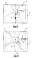
- the vehicleis travelling along the recommended route 61 and approaching a complex maneuver 90 , which in this disclosed embodiment is a traffic circle 90 .
- the traffic circle 90includes a first road segment 92 , a circle road segment 94 and an exit road segment 96 .
- each of the segments 92 , 94 , 96include a beginning point B, an end point E, and a plurality of shape points S as illustrated in the expanded view of FIG. 4 B.
- the CPU 32identifies that more than an N number of shape points S are present within a predetermined distance P along recommended route 61 .
- three (3) shape points Sare located in the circle road segment 94 and one (1) shape point is included within the exit road segment 96 .
- Nwill be set equal to three (3). More than three (3) shape points within the predetermined distance P will cause the CPU 32 to switch the display 24 to the zoomed maneuver instruction view 78 .
- the predetermined distance Pcan encompass more than a single road segment. In this embodiment, the predetermined distance P encompasses a portion of the first road segment 92 , the circle road segment 94 and a portion of the exit road segment 96 .
- the zoomed maneuver instruction view 78(FIG. 5) can also be displayed when an upcoming complex maneuver has but a single road segment with more than N number of shape points.
- the CPU 32Upon identification of more than an N number of shape points S, the CPU 32 , will switch the display 24 to the zoomed maneuver instruction view 78 (FIG. 5) when the vehicle 21 approaches within the vicinity of the complex maneuver 90 .
- the CPUswitches to the zoomed maneuver instruction view 78 when both the complex maneuver 90 and the vehicle icon 52 are both visible on the display 24 when in map view 50 .
- the CPU 32switches to the zoomed maneuver instruction view 78 when both the complex maneuver 90 and the vehicle icon 52 are within a border 98 (FIG. 4A) set within the display 24 .
- a border 98FOG. 4A
- the CPU 32switches to the zoomed maneuver instruction view 78 when both the complex maneuver 90 and the vehicle icon 52 are within a border 98 (FIG. 4A) set within the display 24 .
- the CPU 22switches from the map display view 50 (FIG. 4A) to the zoomed maneuver instruction view 78 (FIG. 5 ).
- the border 98is a line of pixels located a predetermined number of pixels from the edges of the display 24 .
- the CPU 32(FIG. 1) will thereby identify movement of the vehicle icon 52 and complex maneuver 90 through the border 98 .
- the magnification or “zoom” of the zoomed maneuver instruction view 78can be adjusted by the CPU 32 with reference to the border 98 .
- the CPU 32magnifies the zoomed maneuver instruction view 78 until the vehicle icon 52 and complex maneuver 90 contact the border 98 . Accordingly, the CPU 32 maintains an optimal magnification without cropping the vehicle icon 52 or complex maneuver 90 .
- the zoomed maneuver instruction view 78is a magnified view of the map display view 50 .
- the first road segment 92 , the circle road segment 94 and the exit road segment 96filling a larger portion of the display 24 .
- Vehicle icon 52is located along the first road segment 92 and along the recommended path 61 just prior to the circle road segment 94 .
- the CPUwill continue to magnify the complex maneuver in the zoomed maneuver instruction view 78 as the vehicle 21 and associated vehicle icon 52 progresses through the complex maneuver 90 .
- the vehicle 21has further progressed through the complex maneuver 90 and the associated vehicle icon 52 is now located on the circle road segment 94 .
- the CPU 32will no longer zoom in on the complex maneuver 90 in the zoomed maneuver instruction view 78 .
- the zoomed maneuver instruction view 78will therefore be maintained at this magnification as the vehicle icon 52 progresses through the complex maneuver.
- the usercan therefore better identify the relative position of the vehicle 21 as vehicle icon 52 progresses toward the next upcoming maneuver (exit road segment 96 ) of the complex maneuver 90 .
- route indicator arrows 56are displayed along the recommended route 61 in the zoomed maneuver instruction view 78 .
- the route indicator arrows 56are only displayed forward of the vehicle icon 52 along the recommended route 61 to further orient a user within the complex maneuver 90 .
Landscapes
- Engineering & Computer Science (AREA)
- Radar, Positioning & Navigation (AREA)
- Remote Sensing (AREA)
- Automation & Control Theory (AREA)
- Physics & Mathematics (AREA)
- General Physics & Mathematics (AREA)
- Navigation (AREA)
Abstract
Description
Claims (40)
Priority Applications (1)
| Application Number | Priority Date | Filing Date | Title |
|---|---|---|---|
| US09/547,004US6529822B1 (en) | 2000-04-11 | 2000-04-11 | Navigation system with zoomed maneuver instruction |
Applications Claiming Priority (1)
| Application Number | Priority Date | Filing Date | Title |
|---|---|---|---|
| US09/547,004US6529822B1 (en) | 2000-04-11 | 2000-04-11 | Navigation system with zoomed maneuver instruction |
Publications (1)
| Publication Number | Publication Date |
|---|---|
| US6529822B1true US6529822B1 (en) | 2003-03-04 |
Family
ID=24182953
Family Applications (1)
| Application Number | Title | Priority Date | Filing Date |
|---|---|---|---|
| US09/547,004Expired - LifetimeUS6529822B1 (en) | 2000-04-11 | 2000-04-11 | Navigation system with zoomed maneuver instruction |
Country Status (1)
| Country | Link |
|---|---|
| US (1) | US6529822B1 (en) |
Cited By (41)
| Publication number | Priority date | Publication date | Assignee | Title |
|---|---|---|---|---|
| WO2004008172A1 (en)* | 2002-07-11 | 2004-01-22 | Metrobot Llc | A method, apparatus, and computer program product for providing a graphical user interface with a linear map component |
| US20060287815A1 (en)* | 2005-06-21 | 2006-12-21 | Mappick Technologies, Llc. | Navigation system and method |
| US20070055444A1 (en)* | 2005-09-05 | 2007-03-08 | Denso Corporation | Routing assistance system |
| US20070100544A1 (en)* | 2005-10-31 | 2007-05-03 | Denso Corporation | System for traffic circle navigation |
| US20070162223A1 (en)* | 2006-01-09 | 2007-07-12 | Thales Navigation, Inc. | Smart detour |
| US20070250515A1 (en)* | 2006-04-21 | 2007-10-25 | Lea David H | Method and system of securing content and destination of digital download via the internet |
| US20080027641A1 (en)* | 2006-07-27 | 2008-01-31 | Kiyozumi Fujiwara | Navigation Device And Route Guide Method |
| US20080051995A1 (en)* | 2006-08-25 | 2008-02-28 | Magellan Navigation, Inc. | Rerouting in Vehicle Navigation Systems |
| US20080139181A1 (en)* | 2006-12-08 | 2008-06-12 | Magellan Navigation, Inc. | Methods and apparatus for measuring the effectiveness of advertisements presented on a mobile navigation device |
| US20080198162A1 (en)* | 2007-02-16 | 2008-08-21 | Magellan Navigation, Inc. | A method of generating curved baseline for map labeling |
| US20080221787A1 (en)* | 2007-03-09 | 2008-09-11 | Magellan Navigation, Inc. | Methods and apparatus for determining a route having an estimated minimum fuel usage for a vehicle |
| US20080270468A1 (en)* | 2007-04-25 | 2008-10-30 | Magellan Navigation, Inc. | Adjusting spatial operations based on map density |
| EP2026038A2 (en) | 2007-08-14 | 2009-02-18 | Navigon AG | Method for changing the scale of a map representation in a navigation device |
| US20090055774A1 (en)* | 2007-08-08 | 2009-02-26 | Steffen Joachim | Method For Operating A Navigation System |
| US20090070293A1 (en)* | 2007-09-10 | 2009-03-12 | Magellan Navigation, Inc. | Nearest-Neighbor Geographic Search |
| US20090138190A1 (en)* | 2007-11-26 | 2009-05-28 | Magellan Navigation, Inc. | System and Method of Providing Traffic Data to a Mobile Device |
| US20090171584A1 (en)* | 2007-12-31 | 2009-07-02 | Magellan Navigation, Inc. | System and Method for Accessing a Navigation System |
| US20090182498A1 (en)* | 2008-01-11 | 2009-07-16 | Magellan Navigation, Inc. | Systems and Methods to Provide Navigational Assistance Using an Online Social Network |
| US20090187342A1 (en)* | 2008-01-18 | 2009-07-23 | Magellan Navigation, Inc. | Method and apparatus for access point recording using a position device |
| US20090187340A1 (en)* | 2008-01-18 | 2009-07-23 | Magellan Navigation, Inc. | Method and apparatus for hybrid routing using breadcrumb paths |
| US20090187341A1 (en)* | 2008-01-18 | 2009-07-23 | Magellan Navigation, Inc. | Method and apparatus to search for local parking |
| US20100035631A1 (en)* | 2008-08-07 | 2010-02-11 | Magellan Navigation, Inc. | Systems and Methods to Record and Present a Trip |
| US20100049696A1 (en)* | 2008-08-20 | 2010-02-25 | Magellan Navigation, Inc. | Systems and Methods for Smart City Search |
| US20100076674A1 (en)* | 2008-09-22 | 2010-03-25 | Magellan Navigation, Inc. | Route Navigation via a Proximity Point |
| US20100083894A1 (en)* | 2008-10-07 | 2010-04-08 | Continental Automotive Systems Us, Inc. | Multi-colored features for instrument cluster gauges |
| US20100153010A1 (en)* | 2008-12-17 | 2010-06-17 | Telenav, Inc | Navigation system with query mechanism and method of operation thereof |
| US20100198496A1 (en)* | 2009-02-03 | 2010-08-05 | Telenav, Inc. | Navigation system with path prediction and method of operation thereof |
| US20100305847A1 (en)* | 2005-06-21 | 2010-12-02 | Mappick Technologies, Llc | Navigation system and method |
| US20100318291A1 (en)* | 2005-06-21 | 2010-12-16 | Dense Media, Inc | Navigation system and method |
| US7908080B2 (en) | 2004-12-31 | 2011-03-15 | Google Inc. | Transportation routing |
| US20110172917A1 (en)* | 2010-01-11 | 2011-07-14 | Hrvoje Muzina | Adjusting a level of map detail displayed on a personal navigation device according to detected speed |
| US8554475B2 (en) | 2007-10-01 | 2013-10-08 | Mitac International Corporation | Static and dynamic contours |
| US20150019127A1 (en)* | 2013-07-12 | 2015-01-15 | Google Inc. | Systems and Methods for Displaying Navigational Information |
| US20160050533A1 (en)* | 2000-02-28 | 2016-02-18 | Ipventure, Inc. | Method and apparatus for location identification and presentation |
| US9706374B2 (en) | 2002-04-24 | 2017-07-11 | Ipventure, Inc. | Method and system for enhanced messaging using temperature information |
| US9759817B2 (en) | 2002-04-24 | 2017-09-12 | Ipventure, Inc. | Method and apparatus for intelligent acquisition of position information |
| US10609516B2 (en) | 2000-02-28 | 2020-03-31 | Ipventure, Inc. | Authorized location monitoring and notifications therefor |
| US10614408B2 (en) | 2002-04-24 | 2020-04-07 | Ipventure, Inc. | Method and system for providing shipment tracking and notifications |
| US10628783B2 (en) | 2000-02-28 | 2020-04-21 | Ipventure, Inc. | Method and system for providing shipment tracking and notifications |
| US20210156705A1 (en)* | 2019-11-21 | 2021-05-27 | Tesla, Inc. | Context sensitive user interface for enhanced vehicle operation |
| US20230025576A1 (en)* | 2016-06-12 | 2023-01-26 | Apple Inc. | Grouping Maneuvers for Display in a Navigation Presentation |
Citations (4)
| Publication number | Priority date | Publication date | Assignee | Title |
|---|---|---|---|---|
| US5848364A (en)* | 1996-05-10 | 1998-12-08 | Honda Giken Kogyo Kabushiki Kaisha | Method and apparatus for vehicle navigation and guidance through a traffic circle |
| US6081609A (en)* | 1996-11-18 | 2000-06-27 | Sony Corporation | Apparatus, method and medium for providing map image information along with self-reproduction control information |
| US6092076A (en)* | 1998-03-24 | 2000-07-18 | Navigation Technologies Corporation | Method and system for map display in a navigation application |
| US6151552A (en)* | 1997-08-28 | 2000-11-21 | Denso Corporation | Route guidance apparatus |
- 2000
- 2000-04-11USUS09/547,004patent/US6529822B1/ennot_activeExpired - Lifetime
Patent Citations (4)
| Publication number | Priority date | Publication date | Assignee | Title |
|---|---|---|---|---|
| US5848364A (en)* | 1996-05-10 | 1998-12-08 | Honda Giken Kogyo Kabushiki Kaisha | Method and apparatus for vehicle navigation and guidance through a traffic circle |
| US6081609A (en)* | 1996-11-18 | 2000-06-27 | Sony Corporation | Apparatus, method and medium for providing map image information along with self-reproduction control information |
| US6151552A (en)* | 1997-08-28 | 2000-11-21 | Denso Corporation | Route guidance apparatus |
| US6092076A (en)* | 1998-03-24 | 2000-07-18 | Navigation Technologies Corporation | Method and system for map display in a navigation application |
Cited By (104)
| Publication number | Priority date | Publication date | Assignee | Title |
|---|---|---|---|---|
| US10873828B2 (en) | 2000-02-28 | 2020-12-22 | Ipventure, Inc. | Method and apparatus identifying and presenting location and location-related information |
| US20160050533A1 (en)* | 2000-02-28 | 2016-02-18 | Ipventure, Inc. | Method and apparatus for location identification and presentation |
| US9723442B2 (en) | 2000-02-28 | 2017-08-01 | Ipventure, Inc. | Method and apparatus for identifying and presenting location and location-related information |
| US10609516B2 (en) | 2000-02-28 | 2020-03-31 | Ipventure, Inc. | Authorized location monitoring and notifications therefor |
| US11330419B2 (en) | 2000-02-28 | 2022-05-10 | Ipventure, Inc. | Method and system for authorized location monitoring |
| US10628783B2 (en) | 2000-02-28 | 2020-04-21 | Ipventure, Inc. | Method and system for providing shipment tracking and notifications |
| US10652690B2 (en) | 2000-02-28 | 2020-05-12 | Ipventure, Inc. | Method and apparatus for identifying and presenting location and location-related information |
| US10827298B2 (en)* | 2000-02-28 | 2020-11-03 | Ipventure, Inc. | Method and apparatus for location identification and presentation |
| US11067704B2 (en) | 2002-04-24 | 2021-07-20 | Ipventure, Inc. | Method and apparatus for intelligent acquisition of position information |
| US10356568B2 (en) | 2002-04-24 | 2019-07-16 | Ipventure, Inc. | Method and system for enhanced messaging using presentation information |
| US11915186B2 (en) | 2002-04-24 | 2024-02-27 | Ipventure, Inc. | Personalized medical monitoring and notifications therefor |
| US11054527B2 (en) | 2002-04-24 | 2021-07-06 | Ipventure, Inc. | Method and apparatus for intelligent acquisition of position information |
| US11041960B2 (en) | 2002-04-24 | 2021-06-22 | Ipventure, Inc. | Method and apparatus for intelligent acquisition of position information |
| US11032677B2 (en) | 2002-04-24 | 2021-06-08 | Ipventure, Inc. | Method and system for enhanced messaging using sensor input |
| US11218848B2 (en) | 2002-04-24 | 2022-01-04 | Ipventure, Inc. | Messaging enhancement with location information |
| US10848932B2 (en) | 2002-04-24 | 2020-11-24 | Ipventure, Inc. | Enhanced electronic messaging using location related data |
| US11238398B2 (en) | 2002-04-24 | 2022-02-01 | Ipventure, Inc. | Tracking movement of objects and notifications therefor |
| US10761214B2 (en) | 2002-04-24 | 2020-09-01 | Ipventure, Inc. | Method and apparatus for intelligent acquisition of position information |
| US10715970B2 (en) | 2002-04-24 | 2020-07-14 | Ipventure, Inc. | Method and system for enhanced messaging using direction of travel |
| US10664789B2 (en) | 2002-04-24 | 2020-05-26 | Ipventure, Inc. | Method and system for personalized medical monitoring and notifications therefor |
| US11249196B2 (en) | 2002-04-24 | 2022-02-15 | Ipventure, Inc. | Method and apparatus for intelligent acquisition of position information |
| US11308441B2 (en) | 2002-04-24 | 2022-04-19 | Ipventure, Inc. | Method and system for tracking and monitoring assets |
| US10614408B2 (en) | 2002-04-24 | 2020-04-07 | Ipventure, Inc. | Method and system for providing shipment tracking and notifications |
| US11368808B2 (en) | 2002-04-24 | 2022-06-21 | Ipventure, Inc. | Method and apparatus for identifying and presenting location and location-related information |
| US10516975B2 (en) | 2002-04-24 | 2019-12-24 | Ipventure, Inc. | Enhanced messaging using environmental information |
| US9706374B2 (en) | 2002-04-24 | 2017-07-11 | Ipventure, Inc. | Method and system for enhanced messaging using temperature information |
| US10327115B2 (en) | 2002-04-24 | 2019-06-18 | Ipventure, Inc. | Method and system for enhanced messaging using movement information |
| US10034150B2 (en) | 2002-04-24 | 2018-07-24 | Ipventure, Inc. | Audio enhanced messaging |
| US9998886B2 (en) | 2002-04-24 | 2018-06-12 | Ipventure, Inc. | Method and system for enhanced messaging using emotional and locational information |
| US11418905B2 (en) | 2002-04-24 | 2022-08-16 | Ipventure, Inc. | Method and apparatus for identifying and presenting location and location-related information |
| US9930503B2 (en) | 2002-04-24 | 2018-03-27 | Ipventure, Inc. | Method and system for enhanced messaging using movement information |
| US9759817B2 (en) | 2002-04-24 | 2017-09-12 | Ipventure, Inc. | Method and apparatus for intelligent acquisition of position information |
| US9769630B2 (en) | 2002-04-24 | 2017-09-19 | Ipventure, Inc. | Method and system for enhanced messaging using emotional information |
| WO2004008172A1 (en)* | 2002-07-11 | 2004-01-22 | Metrobot Llc | A method, apparatus, and computer program product for providing a graphical user interface with a linear map component |
| US9778055B2 (en) | 2004-12-31 | 2017-10-03 | Google Inc. | Transportation routing |
| US9945686B2 (en) | 2004-12-31 | 2018-04-17 | Google Llc | Transportation routing |
| US9709415B2 (en) | 2004-12-31 | 2017-07-18 | Google Inc. | Transportation routing |
| US11092455B2 (en) | 2004-12-31 | 2021-08-17 | Google Llc | Transportation routing |
| US8606514B2 (en) | 2004-12-31 | 2013-12-10 | Google Inc. | Transportation routing |
| US7908080B2 (en) | 2004-12-31 | 2011-03-15 | Google Inc. | Transportation routing |
| US8798917B2 (en) | 2004-12-31 | 2014-08-05 | Google Inc. | Transportation routing |
| US8670925B2 (en) | 2005-06-21 | 2014-03-11 | Calabrese Holdings L.L.C. | Navigation system and method |
| US9726513B2 (en) | 2005-06-21 | 2017-08-08 | Nytell Software LLC | Navigation system and method |
| US20060287815A1 (en)* | 2005-06-21 | 2006-12-21 | Mappick Technologies, Llc. | Navigation system and method |
| US10247569B2 (en) | 2005-06-21 | 2019-04-02 | Nytell Software LLC | Navigation system and method |
| US10684139B2 (en) | 2005-06-21 | 2020-06-16 | Nytell Software LLC | Navigation system and method |
| US7711478B2 (en)* | 2005-06-21 | 2010-05-04 | Mappick Technologies, Llc | Navigation system and method |
| US20100305847A1 (en)* | 2005-06-21 | 2010-12-02 | Mappick Technologies, Llc | Navigation system and method |
| US20100318291A1 (en)* | 2005-06-21 | 2010-12-16 | Dense Media, Inc | Navigation system and method |
| US9052211B2 (en) | 2005-06-21 | 2015-06-09 | Calabrese Holdings L.L.C. | Navigation system and method |
| US7788031B2 (en)* | 2005-09-05 | 2010-08-31 | Denso Corporation | Routing assistance system |
| US20070055444A1 (en)* | 2005-09-05 | 2007-03-08 | Denso Corporation | Routing assistance system |
| US20070100544A1 (en)* | 2005-10-31 | 2007-05-03 | Denso Corporation | System for traffic circle navigation |
| US7590490B2 (en) | 2006-01-09 | 2009-09-15 | Mitac International Corporation | Smart detour |
| US20070162223A1 (en)* | 2006-01-09 | 2007-07-12 | Thales Navigation, Inc. | Smart detour |
| US20070250515A1 (en)* | 2006-04-21 | 2007-10-25 | Lea David H | Method and system of securing content and destination of digital download via the internet |
| US20080027641A1 (en)* | 2006-07-27 | 2008-01-31 | Kiyozumi Fujiwara | Navigation Device And Route Guide Method |
| US7706974B2 (en)* | 2006-07-27 | 2010-04-27 | Alpine Electronics, Inc. | Navigation device and route guide method |
| US7945386B2 (en) | 2006-08-25 | 2011-05-17 | Mitac International Corporation | Rerouting in vehicle navigation systems |
| US20080051995A1 (en)* | 2006-08-25 | 2008-02-28 | Magellan Navigation, Inc. | Rerouting in Vehicle Navigation Systems |
| US20080139181A1 (en)* | 2006-12-08 | 2008-06-12 | Magellan Navigation, Inc. | Methods and apparatus for measuring the effectiveness of advertisements presented on a mobile navigation device |
| US7692655B2 (en) | 2007-02-16 | 2010-04-06 | Mitac International Corporation | Apparatus and method of generating curved baseline for map labeling |
| US20080198162A1 (en)* | 2007-02-16 | 2008-08-21 | Magellan Navigation, Inc. | A method of generating curved baseline for map labeling |
| US20080221787A1 (en)* | 2007-03-09 | 2008-09-11 | Magellan Navigation, Inc. | Methods and apparatus for determining a route having an estimated minimum fuel usage for a vehicle |
| US7783417B2 (en) | 2007-03-09 | 2010-08-24 | Mitac International Corporation | Methods and apparatus for determining a route having an estimated minimum fuel usage for a vehicle |
| US20080270468A1 (en)* | 2007-04-25 | 2008-10-30 | Magellan Navigation, Inc. | Adjusting spatial operations based on map density |
| US8078641B2 (en) | 2007-04-25 | 2011-12-13 | Mitac International Corporation | Adjusting spatial operations based on map density |
| US20090055774A1 (en)* | 2007-08-08 | 2009-02-26 | Steffen Joachim | Method For Operating A Navigation System |
| DE102007038464A1 (en) | 2007-08-14 | 2009-02-26 | Navigon Ag | Method for operating a device |
| US20090046111A1 (en)* | 2007-08-14 | 2009-02-19 | Steffen Joachim | Method For Operating A Device |
| EP2026038A2 (en) | 2007-08-14 | 2009-02-18 | Navigon AG | Method for changing the scale of a map representation in a navigation device |
| US8237744B2 (en)* | 2007-08-14 | 2012-08-07 | Garmin Würzburg GmbH | Method for changing scale in a navigation device |
| US7882102B2 (en) | 2007-09-10 | 2011-02-01 | Mitac International Corporation | Nearest-neighbor geographic search |
| US20090070293A1 (en)* | 2007-09-10 | 2009-03-12 | Magellan Navigation, Inc. | Nearest-Neighbor Geographic Search |
| US8554475B2 (en) | 2007-10-01 | 2013-10-08 | Mitac International Corporation | Static and dynamic contours |
| US20090138190A1 (en)* | 2007-11-26 | 2009-05-28 | Magellan Navigation, Inc. | System and Method of Providing Traffic Data to a Mobile Device |
| US20090171584A1 (en)* | 2007-12-31 | 2009-07-02 | Magellan Navigation, Inc. | System and Method for Accessing a Navigation System |
| US20090182498A1 (en)* | 2008-01-11 | 2009-07-16 | Magellan Navigation, Inc. | Systems and Methods to Provide Navigational Assistance Using an Online Social Network |
| US20090187340A1 (en)* | 2008-01-18 | 2009-07-23 | Magellan Navigation, Inc. | Method and apparatus for hybrid routing using breadcrumb paths |
| US20090187342A1 (en)* | 2008-01-18 | 2009-07-23 | Magellan Navigation, Inc. | Method and apparatus for access point recording using a position device |
| US8700314B2 (en) | 2008-01-18 | 2014-04-15 | Mitac International Corporation | Method and apparatus to search for local parking |
| US20090187341A1 (en)* | 2008-01-18 | 2009-07-23 | Magellan Navigation, Inc. | Method and apparatus to search for local parking |
| US8290703B2 (en) | 2008-01-18 | 2012-10-16 | Mitac International Corporation | Method and apparatus for access point recording using a position device |
| US8498808B2 (en) | 2008-01-18 | 2013-07-30 | Mitac International Corp. | Method and apparatus for hybrid routing using breadcrumb paths |
| US20100035631A1 (en)* | 2008-08-07 | 2010-02-11 | Magellan Navigation, Inc. | Systems and Methods to Record and Present a Trip |
| US20100049696A1 (en)* | 2008-08-20 | 2010-02-25 | Magellan Navigation, Inc. | Systems and Methods for Smart City Search |
| US8249804B2 (en) | 2008-08-20 | 2012-08-21 | Mitac International Corporation | Systems and methods for smart city search |
| US20100076674A1 (en)* | 2008-09-22 | 2010-03-25 | Magellan Navigation, Inc. | Route Navigation via a Proximity Point |
| US8219317B2 (en) | 2008-09-22 | 2012-07-10 | Mitac International Corporation | Route navigation via a proximity point |
| US20100083894A1 (en)* | 2008-10-07 | 2010-04-08 | Continental Automotive Systems Us, Inc. | Multi-colored features for instrument cluster gauges |
| US20100153010A1 (en)* | 2008-12-17 | 2010-06-17 | Telenav, Inc | Navigation system with query mechanism and method of operation thereof |
| US8990004B2 (en)* | 2008-12-17 | 2015-03-24 | Telenav, Inc. | Navigation system with query mechanism and method of operation thereof |
| CN102317989A (en)* | 2008-12-17 | 2012-01-11 | 泰为信息科技公司 | Navigation system with query mechanism and method of operation thereof |
| US20100198496A1 (en)* | 2009-02-03 | 2010-08-05 | Telenav, Inc. | Navigation system with path prediction and method of operation thereof |
| US9250094B2 (en) | 2009-02-03 | 2016-02-02 | Telenav, Inc. | Navigation system with path prediction and method of operation thereof |
| US20110172917A1 (en)* | 2010-01-11 | 2011-07-14 | Hrvoje Muzina | Adjusting a level of map detail displayed on a personal navigation device according to detected speed |
| US8386173B2 (en)* | 2010-01-11 | 2013-02-26 | Mitac International Corp. | Adjusting a level of map detail displayed on a personal navigation device according to detected speed |
| US9267810B2 (en)* | 2013-07-12 | 2016-02-23 | Google Inc. | Systems and methods for displaying navigational information |
| US20150019127A1 (en)* | 2013-07-12 | 2015-01-15 | Google Inc. | Systems and Methods for Displaying Navigational Information |
| US20230025576A1 (en)* | 2016-06-12 | 2023-01-26 | Apple Inc. | Grouping Maneuvers for Display in a Navigation Presentation |
| US12259252B2 (en)* | 2016-06-12 | 2025-03-25 | Apple Inc. | Grouping maneuvers for display in a navigation presentation |
| US20210156705A1 (en)* | 2019-11-21 | 2021-05-27 | Tesla, Inc. | Context sensitive user interface for enhanced vehicle operation |
| CN114902018A (en)* | 2019-11-21 | 2022-08-12 | 特斯拉公司 | Context sensitive user interface for enhanced vehicle operation |
| US12345542B2 (en)* | 2019-11-21 | 2025-07-01 | Tesla, Inc. | Context sensitive user interface for enhanced vehicle operation |
Similar Documents
| Publication | Publication Date | Title |
|---|---|---|
| US6529822B1 (en) | Navigation system with zoomed maneuver instruction | |
| US6397145B1 (en) | Navigation system with complex maneuver instruction | |
| US6049755A (en) | Navigation system vehicle location display | |
| JP4722433B2 (en) | Car navigation system | |
| EP1254349B1 (en) | A navigation system with unique audio tones for maneuver notification | |
| EP1250566B1 (en) | Navigation system with route indicators | |
| US7541945B2 (en) | Navigation system and landmark highlighting method | |
| JP4760792B2 (en) | Vehicle navigation device | |
| JP4609886B2 (en) | Navigation device | |
| JP2002090167A (en) | Route guiding method for on-vehicle navigation device | |
| WO2007077829A1 (en) | Navigation device and guidance map display method | |
| JP4817993B2 (en) | Navigation device and guide route setting method | |
| US20080136841A1 (en) | Display apparatus | |
| JP2005249485A (en) | Voice guidance method of onboard navigation system | |
| JP2004177209A (en) | Navigation device | |
| JP2005308661A (en) | Navigation system | |
| JP4447286B2 (en) | In-vehicle navigation device and voice guidance method thereof | |
| JP2005127887A (en) | On-vehicle navigation device, and route traffic information providing method | |
| JP5104348B2 (en) | Map display device | |
| JP5092809B2 (en) | Map display device | |
| JP2006003328A (en) | On-vehicle navigation system | |
| JP4180471B2 (en) | Navigation system | |
| JP4357953B2 (en) | On-vehicle navigation device and traveling locus display method | |
| JP2006119056A (en) | In-vehicle navigation system and method for displaying district name | |
| JP2006214939A (en) | Vehicle-borne navigation device |
Legal Events
| Date | Code | Title | Description |
|---|---|---|---|
| AS | Assignment | Owner name:MAGELLAN DRIVER INFORMATION SYSTEMS, INC., MICHIGA Free format text:ASSIGNMENT OF ASSIGNORS INTEREST;ASSIGNORS:MILLINGTON, JEFFREY ALAN;SLOMINSK, ANTHONY A.;REEL/FRAME:010729/0138 Effective date:20000403 | |
| STCF | Information on status: patent grant | Free format text:PATENTED CASE | |
| FPAY | Fee payment | Year of fee payment:4 | |
| AS | Assignment | Owner name:THALES NAVIGATION SOLUTIONS, INC., CALIFORNIA Free format text:CHANGE OF NAME;ASSIGNOR:MAGELLAN DIS, INC.;REEL/FRAME:019690/0798 Effective date:20050502 Owner name:THALES NAVIGATION SOLUTIONS, LLC., CALIFORNIA Free format text:CONVERSION OF A DELAWARE CORPORATION TO A DELAWARE LIMITED LIABILITY COMPANY;ASSIGNOR:THALES NAVIGATION SOLUTIONS, INC.;REEL/FRAME:019690/0639 Effective date:20060810 Owner name:MAGELLAN NAVIGATION, INC., CALIFORNIA Free format text:ASSIGNMENT OF ASSIGNORS INTEREST;ASSIGNOR:THALES NAVIGATION SOLUTIONS, LLC;REEL/FRAME:019690/0784 Effective date:20060831 | |
| AS | Assignment | Owner name:MITAC INTERNATIONAL CORP., TAIWAN Free format text:ASSIGNMENT OF ASSIGNORS INTEREST;ASSIGNOR:MAGELLAN NAVIGATION, INC.;REEL/FRAME:022343/0987 Effective date:20081214 | |
| FPAY | Fee payment | Year of fee payment:8 | |
| FPAY | Fee payment | Year of fee payment:12 | |
| AS | Assignment | Owner name:DIDI (HK) SCIENCE AND TECHNOLOGY LIMITED, CHINA Free format text:ASSIGNMENT OF ASSIGNORS INTEREST;ASSIGNOR:MITAC INTERNATIONAL CORPORATION;REEL/FRAME:040117/0651 Effective date:20161019 |