US6515595B1 - Personal communication and positioning system - Google Patents
Personal communication and positioning systemDownload PDFInfo
- Publication number
- US6515595B1 US6515595B1US09/670,002US67000200AUS6515595B1US 6515595 B1US6515595 B1US 6515595B1US 67000200 AUS67000200 AUS 67000200AUS 6515595 B1US6515595 B1US 6515595B1
- Authority
- US
- United States
- Prior art keywords
- information
- condition reporting
- map
- processor
- pcd
- Prior art date
- Legal status (The legal status is an assumption and is not a legal conclusion. Google has not performed a legal analysis and makes no representation as to the accuracy of the status listed.)
- Expired - Lifetime, expires
Links
- 238000004891communicationMethods0.000titleabstractdescription49
- 238000000034methodMethods0.000claimsdescription84
- 230000008569processEffects0.000claimsdescription47
- 239000003550markerSubstances0.000claimsdescription20
- 238000012545processingMethods0.000claimsdescription2
- 230000006870functionEffects0.000description32
- 238000003825pressingMethods0.000description25
- 230000005540biological transmissionEffects0.000description21
- 230000001413cellular effectEffects0.000description15
- 238000010586diagramMethods0.000description11
- 238000013475authorizationMethods0.000description10
- 239000000835fiberSubstances0.000description8
- 230000004044responseEffects0.000description7
- 230000008901benefitEffects0.000description6
- 238000001228spectrumMethods0.000description5
- 238000013500data storageMethods0.000description3
- 238000005516engineering processMethods0.000description3
- 230000005055memory storageEffects0.000description3
- 238000004458analytical methodMethods0.000description2
- 230000008859changeEffects0.000description2
- 238000001514detection methodMethods0.000description2
- 238000012423maintenanceMethods0.000description2
- 238000013507mappingMethods0.000description2
- 238000012986modificationMethods0.000description2
- 230000004048modificationEffects0.000description2
- 238000012544monitoring processMethods0.000description2
- 230000001755vocal effectEffects0.000description2
- 241000282376Panthera tigrisSpecies0.000description1
- 230000004913activationEffects0.000description1
- 238000004364calculation methodMethods0.000description1
- 238000013479data entryMethods0.000description1
- 238000012217deletionMethods0.000description1
- 230000037430deletionEffects0.000description1
- 230000001419dependent effectEffects0.000description1
- 230000000881depressing effectEffects0.000description1
- 230000000994depressogenic effectEffects0.000description1
- 230000009365direct transmissionEffects0.000description1
- JEIPFZHSYJVQDO-UHFFFAOYSA-Nferric oxideChemical compoundO=[Fe]O[Fe]=OJEIPFZHSYJVQDO-UHFFFAOYSA-N0.000description1
- 239000000463materialSubstances0.000description1
- 238000012806monitoring deviceMethods0.000description1
- 238000011084recoveryMethods0.000description1
- 230000000717retained effectEffects0.000description1
- 238000012552reviewMethods0.000description1
- 238000012163sequencing techniqueMethods0.000description1
- 238000012732spatial analysisMethods0.000description1
- 230000000007visual effectEffects0.000description1
Images


Classifications
- G—PHYSICS
- G09—EDUCATION; CRYPTOGRAPHY; DISPLAY; ADVERTISING; SEALS
- G09B—EDUCATIONAL OR DEMONSTRATION APPLIANCES; APPLIANCES FOR TEACHING, OR COMMUNICATING WITH, THE BLIND, DEAF OR MUTE; MODELS; PLANETARIA; GLOBES; MAPS; DIAGRAMS
- G09B29/00—Maps; Plans; Charts; Diagrams, e.g. route diagram
- G09B29/10—Map spot or coordinate position indicators; Map reading aids
- G09B29/106—Map spot or coordinate position indicators; Map reading aids using electronic means
- G—PHYSICS
- G01—MEASURING; TESTING
- G01C—MEASURING DISTANCES, LEVELS OR BEARINGS; SURVEYING; NAVIGATION; GYROSCOPIC INSTRUMENTS; PHOTOGRAMMETRY OR VIDEOGRAMMETRY
- G01C21/00—Navigation; Navigational instruments not provided for in groups G01C1/00 - G01C19/00
- G01C21/20—Instruments for performing navigational calculations
- G—PHYSICS
- G08—SIGNALLING
- G08G—TRAFFIC CONTROL SYSTEMS
- G08G1/00—Traffic control systems for road vehicles
- G08G1/09—Arrangements for giving variable traffic instructions
- G08G1/0962—Arrangements for giving variable traffic instructions having an indicator mounted inside the vehicle, e.g. giving voice messages
- H—ELECTRICITY
- H04—ELECTRIC COMMUNICATION TECHNIQUE
- H04L—TRANSMISSION OF DIGITAL INFORMATION, e.g. TELEGRAPHIC COMMUNICATION
- H04L67/00—Network arrangements or protocols for supporting network services or applications
- H04L67/50—Network services
- H04L67/52—Network services specially adapted for the location of the user terminal
- H—ELECTRICITY
- H04—ELECTRIC COMMUNICATION TECHNIQUE
- H04W—WIRELESS COMMUNICATION NETWORKS
- H04W4/00—Services specially adapted for wireless communication networks; Facilities therefor
- H04W4/02—Services making use of location information
- H—ELECTRICITY
- H04—ELECTRIC COMMUNICATION TECHNIQUE
- H04W—WIRELESS COMMUNICATION NETWORKS
- H04W4/00—Services specially adapted for wireless communication networks; Facilities therefor
- H04W4/02—Services making use of location information
- H04W4/029—Location-based management or tracking services
Definitions
- the inventionrelates generally to a system for communicating data including global-positioning-encoded information.
- the present inventionrelates specifically to a device and system for communicating and retrieving position and position related data.
- GPS capable devicesgenerally have a GPS receiver for receiving satellite signals from the GPS satellite network that allow for determination of the device's position. Such devices allow for precisely locating the device in terms of latitude and longitude using the GPS receiver. Some devices have map data stored in memory and a display for showing the device position with reference to the map data. Other devices have no underlying map data base for reference. Rather, they show only the geographic. coordinates of the device's location. These coordinates may be referred to as waypoints. Most GPS receiver devices can store many waypoints. Some GPS receiver devices can plot and display a trail of waypoints and store this trail for future retrieval. Sophisticated devices may compute the device's heading, speed, and other information based on comparisons with previous GPS determined positions.
- GPS receiver devices with map display capabilitymay store the map information on computer diskettes, CD-ROM's, or other computer memory storage devices. The device location may then be displayed on a display terminal with reference to a map stored in the computer memory storage device.
- the available quantity of map datacan overwhelm the memory capability of easily portable computer devices. This problem is exacerbated when additional information is included and linked with the map data. In addition, information is more valuable when it is up to date and available at the time of consumption, and such devices do not incorporate a means for updating the stored information.
- a CD ROMcould never maintain an up-to-date list of every 5-star restaurant.
- GPS receiver deviceshave the ability to communicate over a telecommunications network. These devices do not provide for automatic or semi-automatic dynamic exchange of on-line position dependent or related information. In addition, these devices cannot communicate with third parties in the absence of a uniform data format standard. For example, a cellular-phone-based system comprising GPS location information working in conjunction with proprietary Public Safety Answering Point (PSAP) telephone equipment is known. The device provides personal and medical information on an emergency basis to the proper authorities. Such a device does not allow third parties to communicate, tag, interrogate, limit, designate, modify or share this information amongst themselves for any other use.
- PSAPPublic Safety Answering Point
- the system of the present inventionutilizes Personal Communications Devices (PCDs), and traditional computer systems with GPS engines, routers, and other application programs to request, process, and transmit tagged GPS encoded information.
- PCDsPersonal Communications Devices
- the systemwith related applications, can be accessed by device users, traditional computer users, web-site users (cyberspace), data publishers, public or private enterprises or individuals, by means of application programs.
- the tagged GPS encoded data filescan be stored or sent via communication links using AM, FM, spread spectrum, microwave, laser or light beam in free or fiber optic, line-of-sight, reflected, satellite, secure or non-secure, or any type of communications between multiple points that the application or the state-of-the-art may allow.
- the systemis a waypoint tag and interrogation system using various protocols to answer requests and provide GPS-encoded information.
- the applicationsuse GPS devices, engines, routing and encoding for access to specific requester-designated data retrieval requests.
- the applicationsaccess fax machines, beepers, telephones and other communication linked devices.
- the systemaccesses computer and storage systems with various applications in order to provide this information from a plurality of providers. The system thereby eliminates or reduces the need for large storage devices and interchangeable storage modules.
- One embodiment of the present inventionincludes a requesting device, a data provider (hardware and software), a user, tagger applications or GPS engine and router system with protocols for encoding, tagging, modifying, interrogating, arranging, limiting, displaying, sorting, mapping, segregating, sending, receiving and updating waypoint and the waypoints connected data structures with digital or graphic maps, digital voice files, linked digital web files properly encoded and tagged by way of specific devices, or by traditional computer and storage systems.
- a data providerhardware and software
- tagger applications or GPS engine and router systemwith protocols for encoding, tagging, modifying, interrogating, arranging, limiting, displaying, sorting, mapping, segregating, sending, receiving and updating waypoint and the waypoints connected data structures with digital or graphic maps, digital voice files, linked digital web files properly encoded and tagged by way of specific devices, or by traditional computer and storage systems.
- the application programscontain protocols for users, providers, taggers, list maintenance organizations, and others, and will use a dynamic identification system from applications containing GPS search engines, route planners, compilers, designators, publishers, and others to permit communication of information.
- the PCDis a cellular-phone-sized electronic device, combining the capabilities of a GPS receiver, transceiver, digital beeper, cell phone and projection system into one compact unit.
- the PCDis capable of uploading emergency information (medical, police alert, etc.) via a one-push button that phones 911 or a security monitoring center similar to those used for house alarms. The alert continues to be broadcast until a response is made.
- the PCDis also capable of downloading information via a request to a data provider, similar to a request for directory information from a phone company or other service. In this mode the PCD acts similar to calling a phone operator for information. However, in this instance, no human contact is required.
- the callerrequests specific information (location of gas stations, names of restaurants, local banks, etc.) via a voice command (“Download e.g., Wells Fargo Banks”) or via digital commands using a keypad or other input device and the requested information is automatically downloaded to and stored in the memory of the user's PCD. This information can be accessed off-line via the screen on the PCD.
- the PCDcan be plugged into an automobile input port or similar device, if available, and provide distances and directions to locations of interest. Similar information of a condensed nature can also be provided to the user via the screen of the PCD.
- the useris not required to be a subscriber to some proprietary system, instead the PCD can use any means to access any data base from any potential provider, whether GPS encoded or not.
- the informationwould be sent and received by way of a Local Area Broadcast via radio frequency signals to each home, car or PCD within a reception area.
- usersare able to access companies listed on the broadcast network from data providers of properly tagged, yellow page-type information or are provided with GPS encoded information and maps similar to web page listings. This would be advantageous to small towns with little information available for travelers, but which have an interest in providing up-to-date traffic, weather and travel advisories to benefit the local community and businesses.
- Such a systemdoes not require a master, home or base unit.
- the providers of data base or advertising informationcould be a single data provider and could also be individual users with application programs that allow provision of such data.
- the application programsprovide a means for sending and receiving data, GPS encoded data and graphics encoded data.
- the application programscan also act as a universal coder/decoder to other proprietary GPS data bases.
- the present inventionallows users to request detailed information relating to their present location as well as information related to distant locales.
- Informationcan be received digitally by a PCD user from any system.
- Display menus, interfaces and applicationscan be viewed on heads-up display systems in automobiles, homes, businesses and various commercial applications.
- Maps and other digital datamay be transmitted/received by fax, beeper (receive only), computer, phone and radio.
- the systemalso utilizes a system of non-subscribers communicating to each other in a similar fashion, without the use of base stations.
- the non-subscriberscould send personal data bases with maps included, GPS information, and other information of non-related data or graphics from publishers of any such data base.
- the devicewould act as a transceiver, sending and receiving dynamic moving waypoint information in digital formats, including maps of various sizes and embodiments.
- the PCDcan display a singular or a plurality of images and displays, project an image on to a screen or viewing surface, store or communicate data (depicted as a line, graphic, icon, etc.) to and/or receive latitude and longitude data from third parties.
- the devicecan send/receive latitude- and longitude-encoded maps and other data to/from a third party, send/receive standard or non-standard phone and fax communications (AM, FM, spread spectrum, microwave, laser or light beam in free or fiber optic, line of sight, reflected, satellite, secure or non-secure, or any type of communications between two points that the application or state-of-the-art may allow), perform computer functions from existing application software and operating systems, receive standard or non-standard beeper messages, interface with a conventional computer and provide an interface to a heads-up display, an external viewing device or any projection system.
- send/receive standard or non-standard phone and fax communicationsAM, FM, spread spectrum, microwave, laser or light beam in free or fiber optic, line of sight, reflected, satellite, secure or non-secure, or any type of communications between two points that the application or state-of-the-art may allow
- perform computer functions from existing application software and operating systemsreceive standard or non-standard beeper messages, interface with a conventional computer and provide
- An embodiment of this inventionincorporates a GPS transceiver with a designated application used with a communication system or network.
- a communication system or networkSeveral users can communicate and send data, maps and graphic files with or without GPS encoding.
- a usercould request from sensing, weather, or condition reporting devices details concerning remote locations. These sensing, weather, and condition reporting devices may also be accessible over cable land lines or other communication media.
- the device and tagging system informationis communicated from locations, homes, businesses, commercial designations, government resources, public and private areas, cyberspace and other communication systems.
- Various designated locations, or a plurality and multiplicity of locations, or data structures,are assigned as waypoints. These waypoints could be tagged, or interrogated from an application program which describes, encodes, reports, modifies and communicates this encoded information and data from any location.
- the transmitting devicemay report a plurality and multiplicity of locations or events unrelated to either the location of either the transmitting or receiving device. Indeed, the device could communicate to many unlinked, unreported or unconnected waypoints and send active dynamic information to the requester.
- Cyberspace providersmay enter the network web system, use applications for device communications and participate in the exchange of information using designated GPS engines and applications.
- the inventioncan provide a requester with dynamic location information, or other data to a location anywhere in the U.S. This location information may be used to locate individuals in determining whether to authorize credit requests, whether PCD or item containing a PCD, such as an automobile, is moved, or in routing electronic communications.
- the systemis similar to the world wide web, except the web does not use GPS engines, applications, tagging systems, etc.
- the inventionuses GPS devices, engines, applications and encoding for access to specific requester designated data retrieval techniques.
- the inventionprovides a means to locate specific individuals both physically and in terms of an electronically accessible location.
- Another advantage the invention providesis a means to display this type of information and a means to store data unrelated to any interrogation by the PCD device.
- Methods of displayinclude multiple of displays including, by example, overhead displays, heads-up displays, projection systems, LCD displays, computer displays or any past or future designed displays whether connected directly or by some electromagnetic means.
- the preferred embodiment of the devicecould include any means of display or combinations thereof.
- the devicecould include many control devices such as remote control, remote mouse type devices and any combination of keyboards.
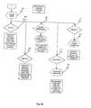
- FIG. 1illustrates a GPS transceiver system and communication links incorporating the present invention
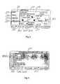
- FIG. 2is a front perspective view of a PCD of the present invention showing a layout of controls and an initialization screen;
- FIG. 3is a rear view of the PCD of FIG. 2;
- FIG. 4is a block diagram of the PCD of FIG. 2;
- FIG. 4Ashows a screen menu hierarchy of the PCD of FIG. 2;
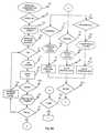
- FIG. 5Aillustrates a flow chart depicting the program sequence for the entry of a personal identification number (PIN) and personal data into the PCD of FIG. 2
- PINpersonal identification number
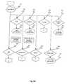
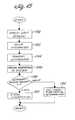
- FIG. 5Billustrates a flow chart depicting the program sequence for the user to select a mode of operation using the PCD of FIG. 2;
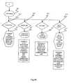
- FIG. 5Cillustrates a flow chart depicting the program sequence for the user to control the GPS mode of the PCD of FIG. 2;
- FIG. 5Dillustrates a flow chart depicting the program sequence for the user to control the phone mode of the PCD of FIG. 2;
- FIG. 5Eillustrates a flow chart depicting the program sequence for the user to control the computer mode of the PCD of FIG. 2;
- FIG. 5Fillustrates a flow chart depicting the program sequence for the user to control the radio mode of the PCD of FIG. 2;
- FIG. 6illustrates the Main Menu page of the PCD of FIG. 2;
- FIG. 7illustrates the select GPS Function page of the PCD of FIG. 2
- FIG. 8illustrates the GPS: Location page of the PCD of FIG. 2;
- FIG. 9illustrates the GPS: Show Me page of the PCD of FIG. 2;
- FIG. 10illustrates the GPS: Get Map page of the PCD of FIG. 2;
- FIG. 11illustrates the GPS: Third Party page of the PCD of FIG. 2;
- FIG. 12illustrates the FAX page of the PCD of FIG. 2
- FIG. 13illustrates the Beeper page of the PCD of FIG. 2
- FIG. 14illustrates the Phone page of the PCD of FIG. 2
- FIG. 15illustrates an Information Request page of the PCD of FIG. 2;
- FIG. 16illustrates the Computer page of the PCD of FIG. 2
- FIG. 17illustrates the Radio page of the PCD of FIG. 2
- FIG. 18illustrates the Receive Queue page of the PCD of FIG. 2
- FIG. 19illustrates the Send Queue page of the PCD of FIG. 2;
- FIG. 20illustrates a typical listing downloaded from a data provider
- FIG. 21illustrates a typical GPS encoded map downloaded from a data provider
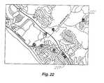
- FIG. 22illustrates a typical GPS encoded map with waypoints locating restaurants within a specified radius
- FIG. 23Aillustrates an exemplary data provider
- FIG. 23Billustrates an exemplary configuration of a non-PCD computer utilizing a modified application module
- FIG. 24illustrates a software module configuration of a requester
- FIG. 25illustrates a software module configuration of a provider
- FIG. 26illustrates a software module configuration of the application module
- FIG. 27illustrates a software module configuration of the tagging system
- FIG. 28illustrates a software module configuration of the GPS engine
- FIG. 29illustrates a software module configuration of the universal translator
- FIG. 30illustrates a typical configuration of the service provider
- FIG. 31illustrates a possible configuration of the digital web TV
- FIG. 32illustrates the Weather Map Request page of the PCD of FIG. 2;
- FIG. 33illustrates a weather reporting device
- FIG. 34illustrates a block diagram of the condition reporting device of the present invention
- FIG. 35illustrates several condition reporting devices of FIG. 34 deployed along an arterial route
- FIG. 36illustrates a block diagram of a cable television distribution system for condition reporting devices of the present invention
- FIG. 37illustrates a process for using route information to obtain information concerning the availability of condition reporting devices
- FIG. 38illustrates a PCD displaying a trail plot with condition reporting device locations
- FIG. 39illustrates a process of a manual method of obtaining condition reporting device information
- FIG. 40illustrates a PCD display showing information received from a condition reporting device
- FIG. 41illustrates a process of the automatic handoff method for obtaining condition reporting device information
- FIG. 42illustrates a process of the automatic sequence method for obtaining condition reporting device information
- FIG. 43illustrates a display of a PCD display showing a user's route comprised of multiple segments
- FIG. 44illustrates a block diagram of a local area transmission system for providing multimedia information
- FIG. 45illustrates a process of obtaining cell site based information
- FIG. 46illustrates a process of credit authorization
- FIG. 47illustrates a process of determining alternative route travel times.
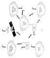
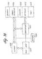
- FIG. 1shows a system capable of communicating using the electromagnetic energy spectrum, traditional computer networks, cellular phone networks, public telephone networks, and satellite system networks.
- the major components of the systemcomprises personal communication devices (PCDs) 20 and one or more of the following: a cellular phone network 60 , a standard phone line network 70 , an electromagnetic energy spectrum network 80 and/or a computer network 90 .
- the PCDreceives signals from a GPS satellite system 10 .
- FIG. 2illustrates a PCD of the present invention.
- the PCDhas a display 28 a .
- the displaymay be of a LCD type or other types known in the art.
- Incorporated with the displayis a touch screen input device 28 b , which are known in the art.
- the PCDalso has a alphanumeric key pad 26 , which includes many of the standard keys generally found on computer keyboards. The location of the keys, and the selection of the characters used on a single key, may be varied as desired.
- the PCDalso has specialized keys 27 a-g , n related to GPS, telecommunications, and other functions. Located on one side of the PCD are a number of input and output ports.
- these portsinclude a modem output port 29 g , a generalized communication port 29 f , a power port 35 b , an infrared port 29 e , and a heads-up display interface port 25 k .
- the location of these portsare shown for descriptive purposes only, the specific location of these ports on the PCD is not critical.
- the power portallows the PCD to be operated from an external power source (not shown).
- the communication portallows the PCD to be connected to printers, local computer networks, and the like.
- FIG. 3shows a rear view of the PCD of FIG. 2 .
- the rear of the PCDcontains a microphone 34 towards one edge of the rear of the PCD and a speaker 33 towards the opposing edge.
- the layout of the microphone and the speakeris similar to that found in portable cellular telephones.
- An antenna 32extends from the edge near the speaker to allow for communication in a cellular telephone network or via other electromagnetic spectrum means.
- the PCDcontains a battery 38 a .
- the batteryallows for mobile operation of the PCD and is the selected power source if an external power source is not available through the power port.
- the PCD's operationis governed by a processor 21 .
- a variety of microprocessorsmay be used, with the selection of such determined by processing power, power utilization, and other factors and requirements.
- the PCDhas a slot 23 for a PCMCIA card, CD-ROM, or other computer accessory.
- the PCDis powered on when the power button 31 (shown in FIG. 2) is depressed.
- the processorcauses the PCD to display the initialization screen 100 (shown in FIG. 2 ).
- FIG. 4shows a block diagram of the PCD. Control and logic functions are performed by the processor 21 .
- Internal data storage 22which is provided by conventional memory such as RAM or ROM or variations thereof, may be accessed by the processor.
- the processormay also access removable data storage devices 23 such as a hard disk installed via the PCMCIA slot, a CD-ROM type device or other similar removable data storage devices.
- the processoris connected by a data bus 24 to a number of devices. These include the alphanumeric key pad and other special purpose keys, the touch screen, and other hard wired input devices.
- the heads-up display output port and the display screenare also connected via the data bus to the processor, it being recognized that a number of display related devices such as VGA cards, chips, and the like are also required to implement the display device functions and the other previously mentioned functions.
- the microprocessormay also access or control communications with telephone networks, either hardwired or cellular, radio transmissions, infra-red transmissions, or communications with other computer devices.
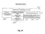
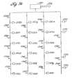
- FIG. 24illustrates a block diagram of the PCD's software components.
- An application module or program 51interfaces with the PCD's operating system 241 .
- the operating systemmay be DOS, UNIX, Windows 95, Windows NT, O/S2 Apple McIntosh, Next Computer, or other operating systems, including operating systems well suited to devices with constrained memory or other limitations due to the small physical size of the PCD.
- the operating systemadditionally interfaces with other application programs 242 that provide standard file edit and other functions typically found in personal computers.
- the operating system, or other application programs interfacing with the operating systemprovide for maintenance of data bases 245 used by the PCD.
- the application moduleincludes a GPS engine 53 providing GPS functions, including interfacing with the GPS receiver 243 (shown in FIG. 4 ).
- a query menu program 54 of the application modulecontrols the graphical user interface and related functions for the device. Included in the application module is a universal converter 55 .
- the universal converterenables the PCD to read in data provided by third parties 291 a, b and convert or filter such data to a format useable by the PCD.
- the universal converterfirst inspects the received data to determine if the data is in a known format which can be converted to the format used by the PCD. If the format is not known by the device, the universal converter attempts to extract any ASCII data or format the data as a bit map as appropriate.
- the application modulefurther includes programs to implement data formatting and communication protocols using header protocols 271 , layer protocols 272 , and data provider protocols 273 .
- the application modulealso includes a tagging system interface program 274 .
- the elements of the tagging systemare illustrated in FIG. 27 .
- the purpose of the tagging systemis to provide a common universal data structure for requests and responding to requests.
- Various techniques common in the GEO coding industry, using U.S. Census bureau data and tiger files with certain modifications,can establish parameters for software suppliers to use latitude and longitude encoding as coordinate pairs, postal code encoding and street centering encoding, all for the benefit of accuracy in designating certain files as “tagged”.
- the tagging systemprovides the ability to apply and strip header and layer information to and from data files.
- FIG. 4Ashows the top level page menu display hierarchy of the PCD.
- the initialization page 25 a(shown in FIG. 2) is displayed.
- the initialization pageallows for the entry of a personal identification number and other data.
- Depressing the home button 27 E(shown in FIG. 2) displays the Main Menu page 25 b .
- a number of additional pagesare available from the Main Menu page. These include the GPS 25 c , Fax 25 d , Beeper 25 e , Phone 25 f , Computer 25 g , Radio 25 h , Send Queue 25 i , and Receive Queue 25 j pages.
- FIG. 5Alists a sequence for the operator of the PCD to answer certain questions, provide information for future access regarding handling of emergency events and handling of same by civil authorities or private individuals empowered to act on behalf of the operator. Access is denied or provided based upon user codes. The entry of a user code may allow for limited to full access of the data stored in the device and usage of same with different codes providing different levels of access and usage. Similar information and sequencing is provided by the application modules and operating system for medical and other information in the event of emergencies.
- the preferences screen(not shown) information can be displayed in a specified manner, events recorded and equipment options listed. Specific usage of the device and furnished software would be recalled by each user having access and user codes to operate the PCD, each user having unique individual screens and setups based on that user's preferences. The initial setup of screen preferences and other user configuration details are well known in the art.
- Selecting PIN 111 from the Main Menu pagedisplays a screen 113 prompting the user to input a personal identification number.
- the userUsing an alphanumeric key pad 26 , the user inputs a personal identification number and presses ENTER 27 g .
- the processoranalyzes the entered personal identification number and determines if the number is valid 115 FIG. If the entered personal identification number is valid the processor enables PERSONAL 121 , MEDICAL 131 , PREFERENCES 141 touch points on the display screen. These touchpoints, and touchpoints later referred to, are selectable either by pressing the display screen at the touchpoint location or by selecting the underlying display item with the cursor. If the PCD already contains personal, medical and preference data, the HOME button 27 e is enabled.
- the processor 21will increase the device security level 119 . This may include, but is not limited to, disabling the PCD operation for a specified time. Selecting PERSONAL 121 , MEDICAL 131 or PREFERENCES 141 touchpoints displays the corresponding pages 123 , 133 , or 143 . These pages request specific data, and allow the user to input data using alphanumeric key pad 26 . Completion of data entry is indicated by pressing the ENTER button 27 g.
- the Initialization page 100 FIG. 2displays the time and the date 103 , touch points for QUE IN 550 and OUT 600 (described later in this document) and limited GPS information 107 .
- the limited GPS informationcomprises of the user's location (latitude and longitude), an arrow pointing to north and an arrow indicating direction of device travel.
- the processorWhen enabled, pressing the HOME button 27 e (FIG. 2) signals the processor to display the Main Menu page 150 FIG. 5 B. As shown in FIG. 6, the Main Menu page allows the operator to use the touch screen to select the GPS 200 , FAX 300 , BEEPER 350 , PHONE 400 , COMPUTER 450 , RADIO 500 , RECEIVE QUE 550 and SEND QUE 600 touchpoints. The heading and directional information are displayed in real time and are dynamic. Pressing the FAX touchpoint causes the processor to display a Fax page (shown in FIG. 12) which lists received facsimile messages 301 .
- a Fax pageshown in FIG. 12
- the Fax pageincludes display interfaces appropriate for the sending and receiving of facsimile communications through the FAX Phone Modem port 29 g , and such displays and functions are well known in the art. Pressing the BEEPER touchpoint causes the processor to display a Beeper page (shown in FIG. 13 ).
- the Beeper pagedisplays received beeper messages 351 and allows for the deletion of such messages from the display and internal memory storage. Also, a sub-menu portion of the display 151 is reserved for sub-menus and directories.
- Pressing GPS 200causes the processor 21 to display a GPS Function page 201 , which is illustrated in FIG. 7 .
- the GPS pageprovides for selection of a GPS mode through touch points in the sub-menu portion of the display.
- the available modesare location 210 , show me 230 , get map 250 and third party 270 modes.
- the displayreturns to the GPS Function page when the PREVIOUS button 27 i (shown in FIG. 2) is pressed.
- the display hierarchy for the GPS functionsis illustrated in FIG. 5 C.
- the Location, Show Me, Get Map, and Third Party pagesdescend from the GPS Menu page.
- the Location pagecomprises the current map, the location on the map of the device, and a plot of the trail of the device on the map.
- the sub-menu portion of the displayprovides for additional selection of still further pages. These pages include a Menu page, a Mode page, a Waypoint page, and a Preferences page.
- the Location pageis illustrated in FIG. 8 .
- the Location pageincludes a GPS map 219 (latitude and longitude encoded coordinate pairs).
- the sample page shownis an encoded map showing the device position, plot trail and the encoded map location of the selected waypoint.
- the map displayedcould be from on-board memory or sent by other third parties by way of communication links to the PCD.
- map data filesare encoded with location information, the location information can be referred to as waypoints.
- These tagged waypoints, with links to other data structures,can then be sent to users via an application to various communication systems. Closed-loop or proprietary GPS receivers can send/receive data to/from other third parties (Brand X, Brand Y) via their own proprietary format using an application system as a universal converter.
- the location informationis dynamic and updated periodically by the PCD's communication system via link-up with GPS-based satellites.
- the Location pageindicates the PCD position 801 , indicated by a walking person, as being located on a highway 810 .
- a waypoint 802is along the highway en route to the desired destination address 803 located on a local street 804 which intersects the highway.
- a first point of interest 807is also displayed as being along the highway, as is a second point of interest 805 along a second local road intersecting the highway.
- the limited GPS informationproviding location, heading and north, is also displayed.
- the illustrated Location page displayshows only one possible combination of a map layout. Other display sequences such as North up, course up, user at top of screen, user in middle, and other display sequences are possible.
- the dynamic nature of the PCDallows the PCD to display GPS encoded maps as the PCD progresses dynamically with relation to the maps.
- interpolation techniquesperforming spatial query analysis, and establishing layers for best display scale for any given map record allows the device to provide the user extended capability not possessed by traditional GPS devices.
- Applying various protocols and interpolation techniquesallow files to be arranged geographically by distance from a designated point (usually the requesters latitude and longitude as the starting point, but other locations may also be used).
- the mapsare also arranged in layers, menus, limited, listed, showed, displayed, and sorted.
- the Location modeprovides typical GPS system functions.
- the touch points MENU 213 , MODE 215 and WAYPOINT 217 and PREFERENCES 221provide access to the Menu, Mode, Waypoint, and Preferences pages. These pages, along with various buttons on the alphanumeric key pad 26 FIGS. 2 and 4 and special function buttons 27 , are used to configure the display to the user's preference.
- the preferences page 221enables selection of such features as voice, maps, scroll, off screen maps away from cursor and other features.
- the listing name 219 portion of the Location pagedisplays information pertaining to a waypoint selected through the use of the cursor.
- FIG. 9illustrates the Show Me page accessed from the GPS page.
- the Show Me pageshows a list of available maps 901 a-i stored on-board, which includes maps retrieved from the receive queue area of the PCD memory.
- the usercan load a map into the location or third party pages by pressing the corresponding number key on alphanumeric key pad 26 (shown in FIG. 2) or by scrolling through the list to highlight the appropriate map and then pressing ENTER button 27 g . Maps may also be removed from on-board storage using the DELETE button 27 h.
- FIG. 10illustrates the Get Map page accessed from the GPS Menu page.
- the user of the PCDcan request the map by location from PCD memory or an external source. The user may enter a desired map location. If a map location is entered, the PCD will only search PCD memory for a map for the entered location. Maps from an external source are downloaded via any of the communication links such as the FAX, BEEPER, PHONE or RADIO touchpoints provided in the sub-menu portion of the display 151 . Depending on the user's requirements, several maps could exist showing similar map areas with different layers for viewing. By way of example, airport maps with air space requirements, coastal waterway, maps, and interstate maps, and even hand drawn maps scanned into a computer system all show different resources within a given geographic area.
- Mapsare retrieved by pressing QUE IN 550 , scrolling to highlight the desired map, and pressing ENTER 27 g FIG. 2 .
- FIG. 11illustrates the Third Party page accessed from the GPS menu page.
- the Third Party pageprovides an interface to communications with a third party through touch points in the sub-menu display 151 .
- a usercan receive a third party's data and GPS encoded map for viewing on the device or save it for future usage.
- the usercan also dynamically track the third party by periodically having the third party send updates via normal communication links.
- the third party locationcan be displayed on maps dynamically sent by map publishers, maps already on-board (furnished at some earlier date), or on maps sent by the third party.
- the PCDplots and interpolates the GPS data sent by the third party and places an icon 951 (GPS latitude and latitude coordinate pair) on the displayed map using spatial query analysis techniques performed by an application module.
- the information received from the third partymay be other than maps or GPS encoded information, but may be information of any type.
- the datais received from the third party using phone 400 and radio communication links 500 .
- a PREFERENCES touch point 274enables entry of items such as phone numbers for automatic call back and time interval for automatic transmission of information. If the radio, a satellite phone, or other frequency based communications link is utilized, the PREFERENCES touch point allows entry of frequencies for use for automatic transmission of information.
- a split screendisplays the user's location on a map on the left side of display 272 and, after contact with a third party via a communication link, the third party's map and location on the right side of display 273 . If the third party's location is sufficiently close to the user's location, or if the user's displayed map covers a sufficiently large area, both the user's and third party's location can be shown on the same map without resort to a split screen display.
- the Fax pageis accessed by pressing the FAX touchpoint on the Main Menu page.
- FIG. 12illustrates the Fax page.
- the sub-menu portion of the displayis available for listing previously stored phone numbers. These phone numbers are selectable as a facsimile destination. In addition, the user can directly enter the phone number to indicate the facsimile destination.
- the PCDcontinues to dynamically display the limited GPS information of location, north and heading.
- the PCD facsimile functionis performed by application software executed by the processor. Multiple fax locations, time set, send after certain time, and other traditional functions of fax machines and their implementation are well known in the art.
- the Fax pageprovides for display of a message (not shown) entered via the alphanumeric key pad 26 (shown in FIG.
- the Beeper pageis accessed from the Main Menu page. Pressing the BEEPER touch point on the Main Menu page causes the processor to display the Beeper page.
- the devicecontains capabilities consistent with common practices of beepers, also known as pagers, such as sending and receiving messages. These functions and their implementation are well known in the art.
- the PCDis also satellite communications capable. Beeper messages can be received by the PCD without interference to the other device capabilities. Therefore, the user could continue using the telephone or other features seemingly uninterrupted by the reception of digital beeper messages and display of those messages.
- the Beeper pageprovides a list of beeper messages (not shown) stored in the receive queue area. Messages stored in the receive queue can be selected by scrolling through listing 353 FIG. 13 of all beeper messages stored. To view a stored message, the user uses the SCROLL button to highlight a desired message and presses the ENTER button 27 g . Messages are deleted when the DELETE button is pressed with at least one message selected.
- the Phone pageis illustrated in FIG. 14 .
- the Phone pageis accessed from the Main Menu page. Pressing the PHONE touchpoint on the Main Menu page causes the processor to display the Phone page.
- the Phone pageis also accessed by pressing the PHONE touchpoint on the Get Map and Third Party pages.
- the limited GPS datais continuously displayed showing PCD location, heading, and north.
- the PCDcan access several areas of the display even while the PCD is being used as a telephone. Information provided in the display area 1401 will vary depending upon the page from which the phone page was accessed.
- the Phone pageprovides for selection of a function through touch points displayed in the sub-menu portion of the display.
- the selectable touchpointsare: POLICE 403 , MEDICAL 405 , DATA PROVIDER 407 , DIRECTORY 413 , and MEMORY 415 .
- the PCDWhen the POLICE touchpoint is pressed, the PCD places a call to emergency 911 .
- the 911 telephone numberis the default, another number could instead have been entered for any particular user through the preferences selection.
- the PCDprovides the information entered using the Preferences function and the device location.
- the usermay also establish voice and data communications through the microphone 34 and speaker 33 (shown in FIG. 3 ).
- the PCDperforms equivalent functions when the MEDICAL touchpoint is pressed. As different phone numbers and information can be entered in the selection of user preferences, however, different phone numbers may be used and different information may be transmitted.
- the processordisplays the Data Provider Connect page.
- the Data Provider Connect pageprovides a means to specify the type and amount of data to be downloaded from a specified data provider.
- the Data Provider Connect pagehas numerous data fields which are selected by use of the cursor. Once a field is selected, the user may enter data in that field using the alphanumeric keys.
- the data fieldsinclude data for name, city, state, map area, zip code, telephone area code, retail category, distance from device location, and maximum number of listings to be provided by the data supplier. Whether a map only is requested and what particular types of maps, such as interstate maps, walking area maps, zip code maps, street maps, area code maps, or state maps, are requested are also provided as options.
- Touch points for weather information and traffic reportsare also provided. Once the appropriate data fields and/or type of data required is input or selected, pressing the send key transmits the data request to the data provider. Details regarding the method of transmission of the responsive data is automatically sent by the data provider to the data provider along with the data request.
- the primary data providersmay include the public telephone company networks but may also include other entities.
- the data providersmaintain data, including maps, telephone yellow page entries, and other information such as traffic and weather reports. This information is maintained in a timely manner and is accessible through the use of data base methods well known in those in the art.
- the data providerdetermines the nature of the data request, searches the appropriate data base or data bases, and transmits the requested information to the requesting device in the manner specified by the requesting device.
- the userafter the PCD receives the data as requested, disconnects, goes off line to review the information, deleting some, saving others, and storing other encoded information on the PCD.
- the usercan now further edit the device's entire data base and decide a sequence for navigating to the locations listed in the various menus as waypoints.
- users of the PCDcan decide to navigate using the GPS features of the PCD and select certain waypoints and the order in which to proceed.
- userscould select gas stations, banks, restaurants, shopping centers in unfamiliar areas, navigate today from one point of beginning and tomorrow continue navigating from another point of beginning, being assured that the device will always know how to get to various locations.
- the PCDis capable of obtaining new navigational data and adding to the already active route plan without having to completely start over.
- Pressing the DIRECTORY touchpoint 413displays an alphabetical listing (not shown) of phone numbers stored on-board. The user may scroll through the listing and select a desired phone number. Pressing MEMORY 415 , displays an alphabetical listing (not shown) of frequently used phone numbers. The user may scroll through the listing and select a desired number. Pressing the SEND button causes the device to dial the selected phone number.
- FIG. 16illustrates the Computer page.
- the Computer pageis accessed by pressing the COMPUTER touchpoint 450 (shown in FIG. 6) on the Main Menu page.
- the Computer pageallows the user to operate the device as a standard personal computer utilizing application programs of the type normally present on personal computers.
- the display of FIG. 16provides for touchpoints in the sub-menu portion of the display for calendar date entry, notes, and organizer application programs. As with the other pages, the limited GPS information is also displayed.
- FIG. 17illustrates the Radio page.
- the Radio pageis accessed by pressing the RADIO touchpoint 500 on the Main Menu page.
- the radio modeprovides the user with an interface for selecting the type of radio signal through touch points displayed in the sub-menu 151 area.
- the selectable typesare: AM 503 , FM 507 and TRANSCEIVER 511 . Selecting any type will display a page (not shown) requesting frequency, volume, and other parameters relating to radio transmission and reception.
- the AM and FMare standard receivers.
- the devicecan thereby tune and listen to broadcasts that provide data links and receive data files using legal AM or FM radio bands (or any other radio band legal to access and provide radio station information).
- the devicetherefore allows users to communicate information amongst themselves without having to rely on telephone technology. This is especially valuable when telephone technology is not available.
- the Receive Queue pagedisplays stored received messages.
- the received messagesmay be displayed by reception type through selection of the transmission line type listed in the sub-menu portion of the display, the selectable types, through touch points displayed in the sub-menu 151 area, are: ALL 553 , FAX 555 , BEEPER 557 , PHONE 559 , COMPUTER 561 and RADIO 563 . Selecting a type, will sort (by specified type) and display (by date and time) all messages received.
- the radio queuecontains GPS-encoded voice mail or digital files (containing information to various sites) provided by private third-party sources.
- the phone system queuecontains previous calls with digital messages linked to web pages containing voice and video data.
- the computerwhich may be queued contains personal letters, calendars, notes and the like from more traditional sources or user created tagged files for storage.
- the fax queuecontains traditional faxes which may illustrate maps with waypoints.
- the beeper mode queuecontains received beeper messages (digital and voice).
- the Send Queue pageis accessed by pressing the SEND QUE touchpoint on the Main Menu page.
- the Send Queue pageincludes similar functions as the receive queue, except the Send Queue is a staging area for sending messages.
- the Send Queue pagedisplays sent or to-be-sent data and an interface for selecting the specific type of queue.
- the selectable typesthrough touch points displayed in the sub-menu portion of the display 151 , are: ALL 603 , FAX 605 , BEEPER 607 , PHONE 609 , COMPUTER 611 and RADIO 613 . Selecting a type, will sort (by specified type) and display (by date and time) all messages sent or waiting to be sent.
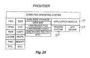
- FIGS. 23 A and Bare a system block diagram including a block diagram of a data provider.
- a plurality of PCDs 231 , 232 , 233communicate with each other using the aforementioned communication means.
- the PCDsalso communicate with various data base information suppliers including private data base information suppliers, publisher data base information suppliers, telephone service data base information suppliers, and a data base provider.
- the data base providerreceives digital requests for map information or other data regarding a geographic area.
- the data providercollects map data and other data and tags the other data to the map data and maintains the map and location tagged data in a data base. Human intervention is not required in responding to data requests.
- the application module of the deviceis ported to a computer system not GPS capable, or merely not portable so as to have no need for a GPS receiver.
- the application moduleallows non-PCD based computer users to provide data to the data provider in the correct format, as well as receive data from devices or the data provider. This allows the non-device base computer user to track the location of devices and to collect information to be manually entered into a traditional GPS capable device as an aid in future trip planning.
- FIG. 20illustrates a list of GPS encoded data for a restaurant listing of restaurants in a requested area. This list may have been furnished by third parties or a data provider.
- the PCDhas stored this information in digital format and is displayed on a GEO coded map, GIFF map or any other map the PCD stored in memory or receives from a third party or data provider.
- the informationcan be arranged by the PCD using criteria enabling the user unlimited access to the data. If the user chooses to navigate to these locations singularly or as a group, the GPS engine performs these functions, allowing a user of the device to accurately travel to the desired restaurant.
- the PCDcan use any scale of map or combinations and other types of maps as shown.
- the user of the PCDselects certain maps for storage and recalls same when needed for navigation.
- the user's devicecould have a local Los Angeles street map, an interstate map (as shown in FIG. 21 ), and a New York city map in device memory.
- the usercould navigate to the airport using the GPS functions and stored Los Angeles map, fly to New Jersey, rent a car and navigate to New York using the interstate map and, finally, find a specific restaurant in New York City by using the third map stored in PCD memory.
- the PCDcontains a map with various waypoint locations the user has selected. These waypoints are both standard waypoints 221 and linked waypoints 222 .
- the waypointsare indicated by a marker on the display. Standard waypoints indicate identifiable locations of interest.
- Linked waypointshave additional data associated with the waypoint.
- the additional datamay be text data, visual data such as a photographic image of the waypoint, or an audio data file.
- the processordetermines if the additional data associated with the waypoint is available in the PCD memory. If the additional data is not available in the PCD memory, the PCD automatically requests the additional data from a data provider. Once the additional data is available, the PCD displays or otherwise makes use of the additional data.
- the usercould navigate to a school, restaurant, bank, gas station, government office using the PCD to interpolate using spatial query techniques to find the best routes to each location.
- the PCDcan re-collate the list for the most efficient route using the application and GPS engine modules.
- persons skilled in the artswill utilize spatial analysis queries and functions to determine best routing and “closest to” scenarios.
- centroid interpolation functions and match-rate comparison functions used by the GEO coding communitywill further enhance this application's ability to universally communicate with other systems.
- FIG. 30further illustrates a system whereby the user uses a PCD to dial a direct access number similar to dialing 411, but all requests are requested and serviced automatically.
- the usermakes keyboard requests to the PCD or traditional computer system using the application program of the PCD.
- the provider or suppliersearches the data base for data responsive to the request.
- the provider or suppliercan access further data through data links to other third party sources and continue to provide all data required by the requester.
- This systemis consistent with the world wide web, linking data through hypertext connections and designations.
- This invention's systemconverts information requests to data requests, not verbal requests, as presently being practiced in directory assistance type services. This narrow usage of the application module allows convenient access to directory assistance that primarily provides data and chunks of information in a short period of time consistent with directory assistance today.
- FIG. 31shows a web page screen with a data provider icon displayed on the device. Pressing or otherwise selecting the icon will enable a menu for the requester to specify a data request. Download will be in the form of a compressed digital data file that may include video, sound, or other digitally encoded data.
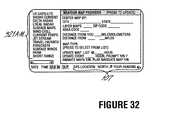
- FIG. 32illustrates a Weather Map Request page.
- the Weather Map Request pageis accessed by pressing the Weather button 27 n (shown in FIG. 2) on the PCD.
- the Weather Map Request pageallows the PCD user to specify the map location and scale, the map type, whether the selected map should be automatically updated at specified intervals, and whether a set of maps should be displayed in a sequential fashion.
- the PCDdisplays a number of different types of weather maps, including satellite images, radar maps, temperature maps, wind chill maps, and any other type of weather map available. Some weather information is more perfectly provided by showing a sequence of displays indicating the change in weather over time. Therefore, the PCD allows the operator to sequentially display a set of maps, thus providing an animated map display.
- FIG. 33illustrates a weather reporting device.
- the weather reporting devicehas a power port 334 to provide electrical power to the weather reporting device. As with the PCD, the weather reporting device may also be powered by a battery (not shown).
- the weather reporting devicealso has a computer port 335 , an interface port 333 , an antenna port 332 , a pressure access port 331 a , and a number of auxiliary ports 33 l b-e .
- the computer portprovides a communications interface to a standard personal computer or the PCD.
- the interface portprovides an interface to systems with weather detection features, such as aircraft with weather radars or lightning strike finders.
- the antenna portallows an external antenna to be connected to the weather reporting device, thereby providing remote operation capability.
- the pressure access portprovides external access for an internal pressure sensitive device (not shown) for the determination of barometric pressure.
- a plurality of auxiliary input ports 441 b-eprovide an interface for connecting the weather reporting device to external weather detection sensors such as temperature sensors, wind sensors, and other weather sensing devices.
- the weather reporting deviceadditionally includes a coaxial cable port, a fiber optics port, and a telephone line port.
- the coaxial cable portallows the weather reporting device to be attached to a cable television distribution system. Attachment to the cable distribution system allows the device to transmit information over the cable distribution system to a central office of a cable television network.
- the fiber optic portsimilarly allows the weather reporting device to be attached to a fiber optic communications network.
- the fiber optics communication networkmay be either a cable television distribution system or a telephone distribution system.
- the telephone access portallows for the connection of the weather reporting device to a standard telephone network.
- a condition reporting deviceis a weather reporting device, but with increased capabilities.
- the condition reporting devicefurther includes a radio radar unit similar to those used by police agencies to detect automotive vehicular speed.
- the condition reporting devicemay be equipped with sonar, infrared, or other distance measuring devices.
- FIG. 34illustrates a block diagram of the condition reporting device (CRD).
- the CRDincludes a processor 1200 , memory 1202 , a battery 1204 , a speed detector 1206 , a digital camera 1208 , a radio transceiver 1210 , an antenna 1212 , a coaxial cable port 1214 , and sensors 1216 .
- the memorystores data pertaining to operation of the CRD, including instructions for execution by the processor which controls operation of the CRD. Specifically, the processor reads data from the various sensors and transmits data via the transceiver.
- the memoryadditionally stores data pertaining to normal expected conditions, such as normal temperatures or traffic flow, at the CRD location. This data could take the form of merely the average normal temperature at the site, but more preferably provides daily or hourly normal temperatures and hourly traffic pattern information.
- the condition reporting devicemay be mounted on the sides of freeway overpasses or poles adjacent a vehicular arterial route to determine automotive vehicular speeds on the freeway or arterial route.
- the radar unitmay be replaced by a sonar unit wherein the use of sound waves are used in place of radar waves to determine vehicular speed on the freeway or arterial route.
- the condition reporting deviceadditionally includes sufficient computer memory to store at least a single digitized video picture.
- the single pictureis provided to the condition reporting device through the digital camera, which may be a charged coupled device (CCD) coupled to the condition reporting device through one of the auxiliary input ports.
- CCDcharged coupled device
- the condition reporting devicemay also obtain data representing the single digitized video picture via a direct transmission to the condition reporting device through the antenna of the condition reporting device.
- photographs in digital format obtained by others, such as television news helicoptersmay transmit a digital picture to the condition reporting device for storage.
- the radio transceiver unitallows the condition reporting device to transmit information via radio signals both to end-users and to other condition reporting devices.
- first through fourth condition reporting devices 1220 a-dare located alongside an arterial route 1222 . Traveling along the arterial route are automobiles 1224 a,b.
- a home 1226 equipped with a radio receiver 1228is located near the arterial route. Specifically, the home is located most near the fourth condition 1220 d reporting device, and most distant from the first condition reporting device 1220 a .
- the automobilesreceive information from the condition reporting devices via radio signals, as does the home, and thus end-users in the automobiles and the home receive up-to-date information regarding conditions along the arterial.
- condition reporting devicesare two-way daisy-chained together. That is, the second condition reporting device receives information broadcast from the first condition reporting device and the third condition reporting device. The second condition reporting device also transmits the information received from the first condition reporting device and the third condition reporting device in addition to the information specific to the second condition reporting device.
- the transmission of informationis accomplished using a time-interleaf method in which the second condition reporting device transmits the information received from the first condition reporting device over a first time interval, and transmits the information specific to the second condition reporting device over a second time interval.
- each condition reporting device in the daisy-chainis programmed with the number of other condition reporting devices in the daisy-chain, the transmission frequency the two closest condition reporting devices in the two-way daisy-chain, the total number of condition reporting devices in the chain, and the position of the condition reporting device in the chain.
- the condition reporting deviceuses this information to determine the time necessary to receive transmissions from the two closest condition reporting devices in the chain and to determine the total transmission time for each cycle of transmission of the condition reporting device. For example, if each condition reporting device is allocated 30 second for transmitting their own information, the total cycle transmission time is two minutes if the first through fourth condition reporting devices are two-way daisy chained together.
- FIG. 36illustrates a block diagram of a cable television distribution system for the weather reporting and condition reporting devices.
- a central cable television office 1230provides for transmission of television signals over land line 1231 to various locations 1231 a-v .
- the various locationsmay be residences, businesses, or other users of cable television distribution services.
- the land linesmay be coaxial cable or fiber optic land lines.
- a central cable television officealso provides links 1236 to telephone and computer networks for the transmission of Internet-related data. Thus, the land lines provides two-way communication between the central cable television office and the various locations.
- condition reporting devices 1234are attached to the land line either through the cable access port or the fiber optic access port, depending on the nature of the land line to the condition reporting devices.
- the condition reporting devicestransmit digital data corresponding to the data received by the devices input sensors over the land line to the central cable television office.
- the central cable television officethen transmits digital information received by the condition reporting devices to the residences in other locations, with each condition reporting device provided a separate cable television channel.
- condition reporting devicesmay be located in a variety of geographic locations throughout a cable television distribution area. Receivers of cable television may set their channels to a channel for a specific condition reporting device and obtain weather, traffic, and video information for a specific location within the cable television broadcast area. Moreover, condition reporting devices located in bars, restaurants, and other venues may transmit video pictures of the interior of such establishments as a form of advertising for the establishments, as well as for the entertainment of television viewers at home or elsewhere.
- the locations of the condition reporting devicesare also tracked by a central computer system.
- the central computermaintains a database of the locations of condition reporting devices.
- the central computer systemalso stores in the database an indication of the road or highway along which the condition reporting device is located.
- many organizationsparticularly state highway departments, maintain digital cameras providing roadway information available over the World Wide Web (WWW or WEB).
- WEBWorld Wide Web
- CRD location datamay be used in conjunction with route information (plot trail) stored by the PCD.
- FIG. 37illustrates a process for using the route information stored by the PCD to obtain information concerning the availability of condition reporting devices from the central computer system along the route stored by the PCD.
- a request for condition reporting device locationsis transmitted by the PCD to the central computer system. Any of the communication means included with the PCD may be used to form such transmission, with one embodiment using cellular telephone communication.
- Included with the request for condition reporting device locationsis data indicating the route information maintained by the PCD.
- the route informationincludes waypoint information for waypoints along the route. Road and highway identifiers are also transmitted when the route information also includes road or highway identifiers.
- the central computerreceives the condition report device request from the PCD.
- the central computer systemdetermines the locations of condition reporting devices along the route. If the route information includes road or highway identifiers, then the central computer system identifies condition reporting devices along such roads or highways, and also determines the condition reporting devices along such roads or highways within the latitude and longitude constraints, as indicated by waypoints, of the route. This process is performed for each road or highway identified in the route information as being along the route. If the route information does not include road or highway identifiers, then the central computer system determines the locations of condition reporting devices within one-tenth of a mile of the route. The central computer system of course need not be limited to reporting condition reporting device locations within one-tenth of a mile of the route. Other distance values may be used, and the PCD may also transmit a requested search criteria to the central computer system for use by the central computer system.
- the central computer systemtransmits condition reporting device locations along the route to a PCD.
- the central computer systemalso transmits information identifying methods of communication with the condition reporting devices.
- some condition reporting devicesmay make data available over computer networks such as the Internet or World Wide Web.
- Other condition reporting devicesmay only transmit information via radio communications within a small area, or may be part of a linked condition reporting device system allowing for radio communication over larger areas.
- step 1248the PCD receives the locations of reporting devices.
- step 1250the PCD correlates the condition reporting device locations to the route information and forms a map display indicating the trail plot and the condition reporting device locations the process then returns.
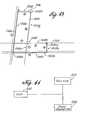
- FIG. 38illustrates a display of a PCD displaying a trail plot with condition reporting device locations.
- the trail plotis indicated by a thick line.
- the thick linefollows a first route 1262 until the first route intersects a second route 1260 .
- the plot trailthereafter follows the second route.
- the locations of condition reporting devices 1264 a-bare indicated along the route by star symbols ( ⁇ ).
- Three methodsare used by the PCD to obtain condition reporting device information, a manual method, an automatic hand-off method, and an automatic sequence method.
- FIG. 39illustrates a process of the manual method.
- the user of the PCDslews the cursor over the reported location of the condition reporting device in step 1270 .
- the userselects the condition reporting device identified by the cursor.
- the PCDdetermines whether the condition reporting device is communicated with a via a computer network or via radio transmissions. If the condition reporting device is communicated with via a computer network, then the PCD transmits a request to the condition reporting device for data over the computer network in step 1275 . If the condition reporting device transmits information via radio communications, then the PCD sets its radio receiver to the appropriate frequency for receiving transmissions from the condition reporting device in step 1276 . In step 1278 the PCD receives the information from the condition reporting device. The PCD then formats the data in step 1280 and displays the data in step 1282 .
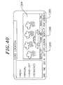
- FIG. 40illustrates a PCD display showing information received from the condition reporting device.
- the information from condition reporting deviceincludes a single digital photo 1284 .
- the information received from the condition reporting devicealso includes traffic speed indications 1286 and current weather information, including temperature 1288 and wind speed 1289 .
- FIG. 41illustrates a process of the automatic hand-off method for obtaining condition reporting device information.
- the automatic hand-off methodis similar to the manual method, but the user of the PCD is not required to select condition reporting device locations with the cursor. Instead, the PCD maintains a sequential list of condition reporting device locations along the route. The sequential list is ordered by condition reporting device locations along the route such that a first condition reporting device expected to be encountered along the route is placed first in the list, and the last condition reporting device expected to be encountered along the route is placed last in the list. As the PCD travels along the route condition reporting devices are removed from the list when the PCD comes within a predetermined distance, one-tenth of a mile in the preferred embodiment, of the condition reporting device location.
- the PCDdetermines which condition reporting device is currently first on the list. The PCD then contacts the condition reporting device, as in the manual method, and displays the condition reporting device information, also as in the manual method. Once the PCD comes within the predetermined distance of the condition reporting device the PCD removes the condition reporting device from the list, and automatically requests information from the next condition reporting device along the route and displays such information.
- the processdetermines an ordered list of CRDs along the route in step 1290 .
- the processcauses information from the next CRD to be displayed.
- the processdetermines if the CRD whose information is being displayed is within a predefined distance of the PCD. Once the CRD is within the predefined distance the process deletes the CRD from the ordered list in step 1296 .
- the processdetermines if the list is empty. If the list is empty, the process returns. Otherwise, the process displays information from the next CRD in the list to be displayed in step 1292 .
- FIG. 42illustrates a process of the automatic sequence method for obtaining condition reporting device information.
- the PCDmaintains a sequential list of condition reporting device locations along the route.
- the sequential listis ordered by condition reporting device locations along the route such that a first condition reporting device expected to be encountered along the route is placed first in the list, and the last condition reporting device expected to be encountered along the route is placed last in the list.
- Information from each condition reporting device in the sequential listis displayed for a period of time, in one embodiment ten seconds, and then the next condition reporting device in the sequential list is displayed. After information from the last condition reporting device in the sequential list is displayed, the PCD displays information from the condition reporting device first in the sequential list.
- condition reporting devicesare removed from the list when the PCD comes within a predetermined distance of the condition reporting device location.
- step 1310the process creates a travel list comprising a sequential list of CRDs expected to be encountered over the route.
- the processcauses data from the first CRD in the list to be displayed in step 1312 .
- the processdetermines if a predefined time period has elapsed in step 1314 . Once the predefined time period elapses the process determines if the list is empty in step 1316 . If the list is empty the process returns. If the list is not empty the process causes display of data from the next CRD in the list in step 1317 .
- the processthen waits predefined time period in step 1318 .
- the processdetermines if the end of the sequential list has been reached in step 1320 . If the end of the list has been reached the process causes display of information from the first CRD in the list in step 1317 . Otherwise, the process causes display of information from the next CRD in the sequential list in step 1317 .
- the usermay have a PCD in his automobile and be automatically informed of current road conditions along the expected route. If road conditions are reported as unpassable due to weather or traffic, then the user may appropriately plan to take alternate routes.
- the use of the PCD in conjunction with CRDsaccordingly provides the PCD user the capability to receive up-to-date detailed information regarding conditions along the PCD user's route. This allows the PCD user to plan use alternative routes as conditions warrant. Such planning is further enhanced by an alternative route (ALT RTE) function of the PCD.
- ALT RTEalternative route
- FIG. 43illustrates a PCD display showing a user's route 1300 comprised of multiple segments 1300 a-d .
- the user's routefollows a first street 1300 a , a first highway 1300 b , and a second highway 1300 c .
- Roads and highways near the users routeinclude a second street, a third street 1304 , and a fourth street 1306 .
- the user's routeincludes a segment A which follows the first street 1300 a in a southerly direction to the first highway 1300 b , which runs in a east-west direction.
- the user's routethen has a segment B which follows the first highway 1300 b in a westerly direction until the first highway intersects the second highway 1300 c , which runs in a north-south direction.
- the user's routethen has a segment C which follows the second highway 1300 c until the termination of the route at the intersection of the second highway 1300 c and the fourth street 1306 .
- the usercould take a route including a second street 1302 which runs in a east-west direction, a third street 1304 which runs in a north-south direction and intersects the second street and the fourth street 1306 .
- The-second streetis comprised of a segment D from the user's start point to the third street, and a segment E from the third street to the second highway.
- the third streetis similarly comprised of a segment F and a segment G.
- Condition reporting devices 1308 a-jare located at various points along the streets and highways.
- the condition reporting devicesprovide traffic speed and weather indications through the PCD via methods discussed above.
- the map information made available to the PCD and stored by the PCDcontains distance information.
- the PCDtherefore is able to make use of the traffic speed information and the distance information to determine travel times for the various route and route alternative segments. Real time calculation and display of segment travel times accordingly allows the PCD user to accurately determine and estimate travel times to particular destinations over a plurality of different roads and road segments.
- FIG. 47illustrates a process of determining travel times.
- the processreads route information stored by the PCD.
- the processdetermines if the user has provided alternative route segments. If the user has provided alternative route segments the process reads information describing the alternative route segments in step 1394 . Otherwise, the process determines alternative route segments in step 1396 . Regardless, if the source of the alternative route segments, the process determines travel times for each of the route segments; and the route as a whole, in step 1398 . The process then returns.
- FIG. 44illustrates a block diagram of a local area transmission system for providing multimedia information using GPS navigation system coordinates.
- Data 1330 pertaining to a local geographic areais maintained by cellular telephone system providers or other entities.
- the particular local geographic locationsare based on the locations of cell sites for cellular telephone networks, and the location specific data is transmitted by a cell site 1332 both over a standard radio broadcast system using a radio transmitter 1334 and by request to the cell site via a telephone access number.
- This dataincludes ASCII or other text formats, digital graphical images, including maps, digital photo-based images, and audio data.
- a first radio frequencyis used to inform receivers of the radio broadcast of specific frequencies to be used to obtain particular types of data.
- the specific frequenciescontinually transmit data pertaining to services and information of the type specified for the particular frequency.
- the dataincludes text and graphics normally including names, addresses, phone numbers and GPS locational information for providers of the services of the type for that frequency. Additionally, digital GPS maps for the particular cell site broadcast location are also included.
- each cell site locationis provided a specific telephone number.
- Users of cellular telephone-capable devicescall the number and are in turn provided a list of telephone numbers for providing data equivalent to the data provided by the radio broadcast system.
- Two sets of phone numbersare provided. The first set provides voice audio information, and the second set provides information in digital form.
- users of a PCDthen direct the PCD device to obtain digital text, graphical maps, and GPS location information from the cell site telephone number. This information may then be used by the user of the PCD device to determine route information and to obtain data in the same manner as from other GPS tagged data providers.
- FIG. 45illustrates a method of directing a PCD to obtain restaurant-related information from the cell site telephone number.
- the PCDdisplays a screen having PHN #, PHN/EMAIL, and RTN ADDRS entry fields.
- the userenters the cell site telephone number in the PHN # entry field, P or E in the PHN/EMAIL entry field, and either the phone number of the PCD or an e-mail address in the RTN ADDRS entry field.
- step 1342the user enters information in the PHN #, PHN/EMAIL, and RTN ADDRS entry fields. If the user enters P in the PHN/EMAIL entry field, then the user should also enter the phone number of the PCD in the RTN ADDRS entry field. If the user enters E in the PHN/EMAIL entry field, then the user should enter an e-mail address in the RTN ADDRS entry field.
- step 1344the user selects the TRNSMT option and the information entered by the user in step 1342 is transmitted by the PCD to the cell site telephone number.
- step 1346the cell site computer system determines which information pertains to the cell site telephone number.
- step 1348the cell site computer system determines whether the information transmitted by the PCD included a P or an E in the PHN/EMAIL field.
- step 1352the cell site computer system instructs the cell site to transmit the information pertaining to the cell site telephone number to the phone number transmitted by the PCD in the RTN ADDRS field if the PHN/EMAIL field contains a P.
- step 1350the cell site computer system transmits an e-mail message to the e-mail address transmitted by the PCD in the RTN ADDRS field if the PHN/EMAIL field contains an E.
- Each cell site data provideradditionally provides traffic and weather information for the cell site.
- a central data providermay receive weather and traffic information from weather reporting devices and condition reporting devices and store that data by the latitude and longitude location of those devices. This data may be then transmitted over a particular frequency or made accessible by having users call a particular telephone number so that individuals may obtain accurate and timely weather and traffic information regarding specific localities.
- the PCDalso serves as a position monitoring device. To begin the position monitoring function the user selects the monitor on the PCD. Upon selecting the monitor function, the PCD displays a menu including INTERROG, AUTO-TIMED, and MOVE options. When the INTERROG function is selected the PCD will display an e-mail entry field allowing input by the user of an e-mail address. After the e-mail address is entered, the PCD responds to appropriate interrogatories by transmitting its current position. An appropriate interrogatory includes the security code active when the INTERROG mode was selected and an Internet e-mail address. Upon receipt of an appropriate interrogatory the PCD will transmit the GPS receiver determined latitude and longitude of the device to the e-mail address.
- the PCDdisplays a time entry field and an e-mail address entry field. After entry of the time entry field and the e-mail address, the PCD will count down the time period entered by the user, and, upon the completion of the time period, transmit an e-mail to the entered e-mail address indicating the PCD location. After transmitting the PCD location to the e-mail address, the PCD will begin counting down the time period previously entered by the user, and once again transmit the PCD location upon the completion of the time period. Thus, for example, if the user enters the time 30 minutes into the time field and the e-mail address of abc@def.com, then every 30 minutes the PCD will transmit the PCD location to abc@def.com.
- the PCDWhen a user selects the MOVE option the PCD displays a distance entry field and an e-mail address entry field. After entry of the distance field and the e-mail address field, the PCD transmits an e-mail containing the device location to the e-mail address specified in the e-mail field whenever the PCD moves a distance greater than the distance entered in the distance field.
- the PCD transmits an e-mail indicating the device positionthe current device position is stored and the PCD waits until the device has moved the distance specified in the distance field from the current location prior to again transmitting the PCD location to the e-mail address specified in the e-mail address field.
- the PCDcan be used to monitor the locations of individuals utilizing PCDs.
- credit authorization agenciesmay make use of the location monitoring capability provided by the PCD in determining the validity of credit requests.
- FIG. 46illustrates a method of credit authorization using the PCD.
- an individualmakes a request for credit. This may be accomplished in a variety of manners, including “swiping” a credit card through a credit card reader at a gas station, supermarket, or a variety of other locations, or merely by providing a credit card to a retail clerk who thereafter requests credit authorization.
- the request for creditmay be made to a credit card issuer, or may merely be a request for credit authorization by a credit reporting facility.
- step 1362the request for credit is transmitted to a credit authorizer.
- step 1364the credit authorizer determines whether credit authorization is appropriate in view of the credit authorizer's prior art credit authorization practices. Such prior art practices include the use of credit limits, past credit usage, and other factors. If the credit authorizer determines that credit authorization according to prior art practices is not appropriate, then credit authorization is denied in step 1366 . If credit authorization according to prior art practices is appropriate, then the credit authorizer transmits an interrogatory to the individual's PCD in step 1368 . In step 1370 the credit authorizer waits a predetermined time for a response from the PCD. In step 1371 the credit authorizer determines if a response from the PCD has been received.
- the credit authorizerdetermines if the PCD location is consistent with the request for credit in step 1372 . This may be accomplished by determining if the PCD is at the location from which credit was requested. If the reported location is consistent with the request for credit, then the process grants or authorizes credit in step 1378 . If the reported location is not consistent with the request for credit, the process denies credit in step 1366 . If no response is received from the PCD, the credit authorizer determines if previous PCD reported locations are consistent with the location from which credit was requested in step 1374 .
- the credit authorizermay have received responses from previous requests for position from the PCD, or an e-mail address of the credit authorizer may have been entered by the individual for AUTO-TIMED or MOVE position updates. If the previous location is consistent with the request for credit, then the process grants or authorizes credit in step 1378 . If the previous locations is not consistent with the request for credit, the process denies credit in step 1366 .
- PCDscan be used to monitor automobile locations and thereby discourage automobile theft or aid in the recovery of the automobile. For example, for an active PCD left in the INTERROG mode, upon discovery of the theft of the PCD or item in which the PCD is located, the user merely need to interrogate the PCD as to its location and thereafter be immediately informed as to the device location, thus allowing for ease in locating and returning the device to the proper user.
- the usercan leave the active PCD in MOVE mode, with the user's e-mail address designated as a recipient of the location of the PCD device.
- the usercan receive instantaneous notification of the movement of the PCD and any object carrying the PCD.
- the usermay select a SECURITY option from the main menu.
- the SECURITY optionthe PCD is automatically configured in the MOVE mode, and the PCD is also automatically configured to transmit an e-mail to a user defined address in addition to any other addresses specified in the MOVE mode.
- the user defined addressis preferably that of a police agency or security service.
- the PCDadditionally places a telephone call via the PCD's cellular telephonic capabilities to a user defined telephone umber. Upon answer by the receiving telephone the PCD automatically transmits an indication, which may be a prerecorded voice message, that the PCD has moved from its prior location.
- the user defined telephone numbermay be the universal telephone number of the user, which is later herein described.
- the predefined telephone numberis the universal telephone number of the user the PCD additionally transmits a password corresponding to security level. The password and security level are selected by the user, and are also later herein described in conjunction with the universal telephone number.
- the central computer systemalso maintains information in a database allowing individual users to be easily located both physically and in terms of their electronic communication locations.
- the central computer systemmaintains a database of individuals and an Internet address linked to each individual.
- the Internet address linked to each individualneed not be a unique address, but instead many individuals may make use of a single computer indicated by the Internet address in the Internet address field.
- the central computer systemmay be the computer system identified by the Internet address.
- the systemalso contains a large number of computer systems linked by the Internet, and which are the computer systems pointed to by the address field for the individuals in the Internet address field. Each of these computers form a home site computer system. The responsibility of maintaining the home site computer systems are the responsibility of the individuals.
- the home site computer systemmaintains electronic contact information and geographic location of the individual.
- the electronic contact informationincludes home telephone numbers, office telephone numbers, cellular telephone numbers, fax numbers, and e-mail addresses.
- the geographic locationis provided in terms of latitude and longitude, although street addresses or site names can also be provided with the latitude and longitude.
- a security level indexis a number between one and ten.
- the individualassigns security level indexes for each item of information.
- the useralso identifies other individuals who may wish to contact the user, and indicates which security index level each such other individual should be provided. Other individuals who are not identified by the user are provided a default security level index.
- the other individualprovides an identifier, such as the individual's name to the home site.
- the other individualalso provides a password to the home site so that the home site may authenticate the identity of the individual. Based on the identity of the individual, preferably authenticated, the home site determines the other individual's security level index.
- the other individualis thereafter only able to obtain information for the other individual's security level index value and those values below the other individual's security level index.
- a user's general office work numbermay be assigned a security level index of ten, with the user's direct line phone number provided a security level index of six.
- a first other individual with a security index level of sevencan only obtain the user's general office number while a second other individual with a security index level of six can also obtain the user's direct line phone number.
- the user's geographic locationis updated through the PCD.
- the PCDcan be used to provide e-mails indicative of the user's location in varying manners.
- the user's home site computer systemmay track the user over time.
- the user's home site computer systemis always provided a copy of any e-mail position updates provided by the PCD.
- condition reporting devicesFor example, a particular user is identified as being at a particular location, other individuals may request via the central computer system the location of condition reporting devices in that area. If the condition reporting device has digital picture capability, then the other individuals may request information from the particular condition reporting device and determine if the user is in fact at the location.
- the system of the present inventionprovides a method and system for tracking individuals, and for confirming the presence of individuals at particular locations.
- the user's home site computer systemmaintains a universal phone number, fax number, and e-mail address for the individual.
- the home site computer systemautomatically routes the incoming call, fax, or e-mail to the phone number, fax number, or e-mail address currently indicated as active for the individual. This routing is done, however, in conjunction with the other individual's security index level.
- the active phone number for the useris the user's cellular telephone number, but the other individual does not have a security level index sufficient to determine the user's cellular telephone number, then the call to the user by the other individual will be automatically routed to the phone number with the highest number security level index available to the other individual. If the telephone number to which the other individual has been routed is not currently active for the user, the other individual will be left in a voice mail or other automatic answering system if available. Thus, users may selectively forward phone calls, facsimiles, or e-mails depending on requirements of the user.
- the home site computer systemmaintains data indicative of the location of telephone numbers, fax numbers, and e-mail addresses. As the user's geographic location is updated through use of the PCD, the home site computer system automatically maintains a list of active phone numbers, facsimile numbers, and e-mail addresses for the user. Thus, if the user's geographic location as provided by the PCD indicates that the user is at the user's office, then the user's office phone numbers are made active. If the user's geographic location as provided by the PCD indicates that the user is at the user's home, then the user's home phone numbers are made active. If the user is at an undetermined location, then the user's home site computer system identifies the user's cellular telephone as the active phone. Thus, phone calls, facsimiles, and e-mails may be automatically routed, using call forwarding technology known in the art, to the electronic communication access number of the user without resort to sequentially calling various phone numbers.
- the user's home site computer systemalso serves as a repository for data for use with the user's PCD.
- One purpose in providing such a repositoryis that the PCD may be unable to store all data requested from a data provider or other parties due to device memory constraints.
- the usermay request a map of a relatively large area and a relatively great amount of detail. Such a map may be too large for storage in the memory of the PCD.
- the usercould request a subset of the desired map, if such a request or map is available, and request further subsets of the map as desired.
- Such a methodentails repeated requests for map information, and is also inconvenient if a single map section is repeatedly later used after other map sections are requested.
- the home site computer systemprovides a repository for such material. Data providers and information suppliers, instead of downloading data directly to a PCD in response to a request for information by a PCD, instead route data to the user's home site computer system.
- requests from a PCD for datainclude an indication of allowable memory space for downloaded data.
- the allowable memory spacemay be automatically determined by the PCD based on the total device memory and the memory available at a given time. Thus, if a particular PCD can only accommodate additional data of 8 megabytes or less, the request for information would indicate a maximum download data size of 8 megabytes.
- the allowable memory spacemay be set by the user.
- the data provider or other information supplierAfter the data provider or other information supplier receives a request for information, the data provider or information supplier then transmits the requested data to the home site computer system, via e-mail or other means described herein, in multiple files, each less than the maximum memory size of the PCD.
- the data provider or information supplierdetermines which information, such as map information is responsive to the request, and prepares individually readable and displayable files, or data packets, less than the allowable memory size.
- the usermay thereafter request the data directly from the home site computer system, and later reuse the same information at the users convenience.
- the useris also able to use the requested data using other PCDs, or even other computer systems.
Landscapes
- Engineering & Computer Science (AREA)
- Physics & Mathematics (AREA)
- General Physics & Mathematics (AREA)
- Radar, Positioning & Navigation (AREA)
- Remote Sensing (AREA)
- Computer Networks & Wireless Communication (AREA)
- Signal Processing (AREA)
- Theoretical Computer Science (AREA)
- Mathematical Physics (AREA)
- Automation & Control Theory (AREA)
- Business, Economics & Management (AREA)
- Educational Administration (AREA)
- Educational Technology (AREA)
- Mobile Radio Communication Systems (AREA)
- Navigation (AREA)
- Position Fixing By Use Of Radio Waves (AREA)
Abstract
Description
Claims (18)
Priority Applications (4)
| Application Number | Priority Date | Filing Date | Title |
|---|---|---|---|
| US09/670,002US6515595B1 (en) | 1997-06-20 | 2000-09-25 | Personal communication and positioning system |
| US10/315,661US6924748B2 (en) | 1997-06-20 | 2002-12-09 | Personal communication and positioning system |
| US11/029,310US7236100B2 (en) | 1997-06-20 | 2005-01-04 | Personal communication and positioning system |
| US11/768,153US7561065B2 (en) | 1997-06-20 | 2007-06-25 | Personal communication and positioning system |
Applications Claiming Priority (3)
| Application Number | Priority Date | Filing Date | Title |
|---|---|---|---|
| US08/879,955US6148261A (en) | 1997-06-20 | 1997-06-20 | Personal communication system to send and receive voice data positioning information |
| US09/126,936US6133853A (en) | 1998-07-30 | 1998-07-30 | Personal communication and positioning system |
| US09/670,002US6515595B1 (en) | 1997-06-20 | 2000-09-25 | Personal communication and positioning system |
Related Parent Applications (1)
| Application Number | Title | Priority Date | Filing Date |
|---|---|---|---|
| US09/126,936ContinuationUS6133853A (en) | 1997-06-20 | 1998-07-30 | Personal communication and positioning system |
Related Child Applications (1)
| Application Number | Title | Priority Date | Filing Date |
|---|---|---|---|
| US10/315,661ContinuationUS6924748B2 (en) | 1997-06-20 | 2002-12-09 | Personal communication and positioning system |
Publications (1)
| Publication Number | Publication Date |
|---|---|
| US6515595B1true US6515595B1 (en) | 2003-02-04 |
Family
ID=22427456
Family Applications (5)
| Application Number | Title | Priority Date | Filing Date |
|---|---|---|---|
| US09/126,936Expired - LifetimeUS6133853A (en) | 1997-06-20 | 1998-07-30 | Personal communication and positioning system |
| US09/670,002Expired - LifetimeUS6515595B1 (en) | 1997-06-20 | 2000-09-25 | Personal communication and positioning system |
| US10/315,661Expired - Fee RelatedUS6924748B2 (en) | 1997-06-20 | 2002-12-09 | Personal communication and positioning system |
| US11/029,310Expired - Fee RelatedUS7236100B2 (en) | 1997-06-20 | 2005-01-04 | Personal communication and positioning system |
| US11/768,153Expired - Fee RelatedUS7561065B2 (en) | 1997-06-20 | 2007-06-25 | Personal communication and positioning system |
Family Applications Before (1)
| Application Number | Title | Priority Date | Filing Date |
|---|---|---|---|
| US09/126,936Expired - LifetimeUS6133853A (en) | 1997-06-20 | 1998-07-30 | Personal communication and positioning system |
Family Applications After (3)
| Application Number | Title | Priority Date | Filing Date |
|---|---|---|---|
| US10/315,661Expired - Fee RelatedUS6924748B2 (en) | 1997-06-20 | 2002-12-09 | Personal communication and positioning system |
| US11/029,310Expired - Fee RelatedUS7236100B2 (en) | 1997-06-20 | 2005-01-04 | Personal communication and positioning system |
| US11/768,153Expired - Fee RelatedUS7561065B2 (en) | 1997-06-20 | 2007-06-25 | Personal communication and positioning system |
Country Status (1)
| Country | Link |
|---|---|
| US (5) | US6133853A (en) |
Cited By (94)
| Publication number | Priority date | Publication date | Assignee | Title |
|---|---|---|---|---|
| US20010055373A1 (en)* | 2000-06-14 | 2001-12-27 | Kabushiki Kaisha Toshiba | Information processing system, information device and information processing device |
| US20020007354A1 (en)* | 2000-07-14 | 2002-01-17 | Sony Corporation | Method and system for identifying a time specific event |
| US20020010652A1 (en)* | 2000-07-14 | 2002-01-24 | Sony Corporation | Vendor ID tracking for e-marker |
| US20020085111A1 (en)* | 2001-01-03 | 2002-07-04 | Arie Heiman | Method and apparatus for providing travel information |
| US20020091735A1 (en)* | 2001-01-08 | 2002-07-11 | Yung-Chung Chen. | Method and apparatus for locating geographically classified establishment information |
| US20020097894A1 (en)* | 2001-01-24 | 2002-07-25 | David Staas | System and method for geographical indexing of images |
| US20020145589A1 (en)* | 2001-04-06 | 2002-10-10 | Sony Corporation Of Japan | User interface for an e-marker |
| US20020152205A1 (en)* | 2001-04-11 | 2002-10-17 | Henrik Hodam | Method of operating an automatic sector information system |
| US20030034956A1 (en)* | 2001-08-17 | 2003-02-20 | Yuichiro Deguchi | Virtual e-marker |
| US20030036967A1 (en)* | 2001-08-17 | 2003-02-20 | Yuichiro Deguchi | Electronic music marker device delayed notification |
| US20030036846A1 (en)* | 2001-08-15 | 2003-02-20 | Hidekazu Ikeda | Map display method, map display device and map display system |
| US20030110133A1 (en)* | 2001-12-07 | 2003-06-12 | Maritzen L. Michael | Automated digital rights management and payment system with embedded content |
| US20030135463A1 (en)* | 2002-01-16 | 2003-07-17 | International Business Machines Corporation | Credit authorization system and method |
| US20030144008A1 (en)* | 2002-01-28 | 2003-07-31 | Rehkopf Thomas W. | System and method for accessing computer services via a wireless network |
| US6611752B1 (en)* | 2002-05-13 | 2003-08-26 | Lucent Technologies Inc. | Translation technology for navigation system arrangement |
| US20030194993A1 (en)* | 1997-08-04 | 2003-10-16 | Mundi Fomukong | Location reporting satellite paging system with optional blocking of location reporting |
| US20030229446A1 (en)* | 2002-06-06 | 2003-12-11 | Boscamp Robert L. | Mobile education and entertainment system, method and device |
| US20040002938A1 (en)* | 2002-06-28 | 2004-01-01 | Sony Corporation And Sony Electronics Inc. | Device and method for exchanging information |
| US20040000995A1 (en)* | 2002-06-28 | 2004-01-01 | Yuichiro Deguchi | GPS e-marker |
| US20040044467A1 (en)* | 1993-05-18 | 2004-03-04 | David Laird | Notification systems and methods enabling user entry of notification trigger information based upon monitored mobile vehicle location |
| US20040044469A1 (en)* | 2002-09-03 | 2004-03-04 | Thorsten Bender | Displaying road maps |
| US20040053625A1 (en)* | 2002-09-18 | 2004-03-18 | Roger Bye | Mobile location explorer and methods therefor |
| US20040193371A1 (en)* | 2003-03-24 | 2004-09-30 | Yoshikazu Koshiji | Vehicle navigation system with multi-use display |
| US6823257B2 (en)* | 2002-01-04 | 2004-11-23 | Intel Corporation | Non-GPS navigation |
| US6873907B1 (en)* | 1998-05-05 | 2005-03-29 | Magellan Dis, Inc. | Navigation system with user interface |
| US20050070308A1 (en)* | 2003-09-26 | 2005-03-31 | Rami Caspi | System and method for in-building presence system |
| US20050071237A1 (en)* | 2003-09-26 | 2005-03-31 | Rami Caspi | System and method for global positioning system (GPS) based presence |
| US20050070297A1 (en)* | 2003-09-26 | 2005-03-31 | Rami Caspi | System and method for presence alarming |
| US20050070310A1 (en)* | 2003-09-26 | 2005-03-31 | Rami Caspi | System and method for global positioning system enhanced presence rules |
| US20050070301A1 (en)* | 2003-09-26 | 2005-03-31 | Rami Caspi | System and method for failsafe presence monitoring |
| US20050068227A1 (en)* | 2003-09-26 | 2005-03-31 | Rami Caspi | System and method for presence-based area monitoring |
| US20050070300A1 (en)* | 2003-09-26 | 2005-03-31 | Rami Caspi | System and method for speed-based presence state modification |
| US20050070298A1 (en)* | 2003-09-26 | 2005-03-31 | Rami Caspi | System and method for presence perimeter rule downloading |
| US20050079873A1 (en)* | 2003-09-26 | 2005-04-14 | Rami Caspi | System and method for centrally-hosted presence reporting |
| US20050128102A1 (en)* | 1997-06-20 | 2005-06-16 | American Calcar, Inc. | Personal communication and positioning system |
| US20050215194A1 (en)* | 2004-03-09 | 2005-09-29 | Boling Brian M | Combination service request and satellite radio system |
| US20050253752A1 (en)* | 2004-05-13 | 2005-11-17 | Bushnell Performance Optics | Apparatus and method for allowing user to track path of travel over extended period of time |
| US20050253753A1 (en)* | 2004-05-13 | 2005-11-17 | Bushnell Performance Optics | Apparatus and method for allowing user to track path of travel over extended period of time |
| US20060116800A1 (en)* | 1998-12-23 | 2006-06-01 | American Calcar Inc. | Technique for effective communications with, and provision of global positioning system (GPS) based advertising information to, automobiles |
| US20060200490A1 (en)* | 2005-03-03 | 2006-09-07 | Abbiss Roger O | Geographical indexing system and method |
| US7127454B2 (en) | 2001-08-17 | 2006-10-24 | Sony Corporation | E-marker find music |
| US20060238378A1 (en)* | 2004-07-29 | 2006-10-26 | Eriko Ohdachi | Communication type map display device |
| US20060268930A1 (en)* | 2001-04-24 | 2006-11-30 | Medius, Inc. | Method and apparatus for dynamic configuration of multiprocessor system |
| US20060276962A1 (en)* | 2005-02-17 | 2006-12-07 | Mototaka Yoshioka | Moving history conversion apparatus and moving history conversion method |
| US7177651B1 (en)* | 2000-09-22 | 2007-02-13 | Texas Instruments Incorporated | System and method for the exchange of location information in a telephone network |
| US20070112444A1 (en)* | 2005-11-14 | 2007-05-17 | Alberth William P Jr | Portable wireless communication device with HUD projector, systems and methods |
| US20070111712A1 (en)* | 2005-11-17 | 2007-05-17 | Nitesh Ratnakar | Advertising in Yellow Book for the Phone |
| US20070111711A1 (en)* | 2005-11-17 | 2007-05-17 | Nitesh Ratnakar | Yellow Book for the Phone |
| US7224966B2 (en) | 2003-09-26 | 2007-05-29 | Siemens Communications, Inc. | System and method for web-based presence perimeter rule monitoring |
| US20070162223A1 (en)* | 2006-01-09 | 2007-07-12 | Thales Navigation, Inc. | Smart detour |
| US20070225911A1 (en)* | 2006-03-23 | 2007-09-27 | Rich Chanick | User positional and venue information integration system and method |
| US20070242922A1 (en)* | 2003-08-04 | 2007-10-18 | Semiconductor Energy Laboratory Co., Ltd. | Beam homogenizer, laser irradiation apparatus, and method for manufacturing semiconductor device |
| US20070250515A1 (en)* | 2006-04-21 | 2007-10-25 | Lea David H | Method and system of securing content and destination of digital download via the internet |
| US20070290039A1 (en)* | 2006-06-20 | 2007-12-20 | Lucent Technologies Inc. | Method and apparatus for in vehicle low price fuel finder |
| US20080026772A1 (en)* | 2006-07-27 | 2008-01-31 | Shin-Wen Chang | Mobile communication system utilizing gps device and having group communication capability |
| US20080051995A1 (en)* | 2006-08-25 | 2008-02-28 | Magellan Navigation, Inc. | Rerouting in Vehicle Navigation Systems |
| US20080052622A1 (en)* | 2004-07-20 | 2008-02-28 | Matsushita Electric Industrial Co., Ltd. | Guidance Display Device |
| US20080120024A1 (en)* | 1999-10-19 | 2008-05-22 | American Calcar Inc. | Technique for effective navigation based on user preferences |
| US20080139181A1 (en)* | 2006-12-08 | 2008-06-12 | Magellan Navigation, Inc. | Methods and apparatus for measuring the effectiveness of advertisements presented on a mobile navigation device |
| US20080198162A1 (en)* | 2007-02-16 | 2008-08-21 | Magellan Navigation, Inc. | A method of generating curved baseline for map labeling |
| US20080221787A1 (en)* | 2007-03-09 | 2008-09-11 | Magellan Navigation, Inc. | Methods and apparatus for determining a route having an estimated minimum fuel usage for a vehicle |
| US20080270468A1 (en)* | 2007-04-25 | 2008-10-30 | Magellan Navigation, Inc. | Adjusting spatial operations based on map density |
| US7466992B1 (en) | 2001-10-18 | 2008-12-16 | Iwao Fujisaki | Communication device |
| US20090070293A1 (en)* | 2007-09-10 | 2009-03-12 | Magellan Navigation, Inc. | Nearest-Neighbor Geographic Search |
| US20090138190A1 (en)* | 2007-11-26 | 2009-05-28 | Magellan Navigation, Inc. | System and Method of Providing Traffic Data to a Mobile Device |
| US20090171584A1 (en)* | 2007-12-31 | 2009-07-02 | Magellan Navigation, Inc. | System and Method for Accessing a Navigation System |
| US20090171934A1 (en)* | 2007-12-28 | 2009-07-02 | Nitesh Ratnakar | Method and system for determining popularity of an enterprise and associating a ranking factor based on popularity with contact information for the enterprise stored locally on a communication device |
| US20090177374A1 (en)* | 2008-01-09 | 2009-07-09 | Mitac Internation Corp. | Method for real-time updating background weather patern of electronic map |
| US20090182498A1 (en)* | 2008-01-11 | 2009-07-16 | Magellan Navigation, Inc. | Systems and Methods to Provide Navigational Assistance Using an Online Social Network |
| US20090187341A1 (en)* | 2008-01-18 | 2009-07-23 | Magellan Navigation, Inc. | Method and apparatus to search for local parking |
| US20090187340A1 (en)* | 2008-01-18 | 2009-07-23 | Magellan Navigation, Inc. | Method and apparatus for hybrid routing using breadcrumb paths |
| US20090187342A1 (en)* | 2008-01-18 | 2009-07-23 | Magellan Navigation, Inc. | Method and apparatus for access point recording using a position device |
| US7580792B1 (en)* | 2005-10-28 | 2009-08-25 | At&T Corp. | Method and apparatus for providing traffic information associated with map requests |
| US20090222587A1 (en)* | 2008-02-28 | 2009-09-03 | Point-I Co., Ltd. | Providing location path |
| US7606577B2 (en) | 2003-09-26 | 2009-10-20 | Siemens Communications, Inc. | System and method for alternative presence reporting system |
| US20100035631A1 (en)* | 2008-08-07 | 2010-02-11 | Magellan Navigation, Inc. | Systems and Methods to Record and Present a Trip |
| US7664846B2 (en) | 2003-11-26 | 2010-02-16 | Siemens Communications, Inc. | System and method for distributed modeling of real time systems |
| US20100049696A1 (en)* | 2008-08-20 | 2010-02-25 | Magellan Navigation, Inc. | Systems and Methods for Smart City Search |
| US7681448B1 (en) | 2004-11-09 | 2010-03-23 | Medius, Inc. | System and method for aligning sensors on a vehicle |
| US20100076674A1 (en)* | 2008-09-22 | 2010-03-25 | Magellan Navigation, Inc. | Route Navigation via a Proximity Point |
| US7793136B2 (en) | 2002-04-24 | 2010-09-07 | Eagle Harbor Holdings LLC | Application management system with configurable software applications |
| US20120303260A1 (en)* | 2004-09-28 | 2012-11-29 | Nokia Corporation | System for interaction of navigation and connectivity programs and personal information management applications |
| US8369967B2 (en) | 1999-02-01 | 2013-02-05 | Hoffberg Steven M | Alarm system controller and a method for controlling an alarm system |
| US8417490B1 (en) | 2009-05-11 | 2013-04-09 | Eagle Harbor Holdings, Llc | System and method for the configuration of an automotive vehicle with modeled sensors |
| US20130190908A1 (en)* | 2001-02-20 | 2013-07-25 | Adidas Ag | Performance Monitoring Devices and Methods |
| US8554475B2 (en) | 2007-10-01 | 2013-10-08 | Mitac International Corporation | Static and dynamic contours |
| US8886392B1 (en) | 2011-12-21 | 2014-11-11 | Intellectual Ventures Fund 79 Llc | Methods, devices, and mediums associated with managing vehicle maintenance activities |
| US8892495B2 (en) | 1991-12-23 | 2014-11-18 | Blanding Hovenweep, Llc | Adaptive pattern recognition based controller apparatus and method and human-interface therefore |
| US9358924B1 (en) | 2009-05-08 | 2016-06-07 | Eagle Harbor Holdings, Llc | System and method for modeling advanced automotive safety systems |
| US10244361B1 (en) | 2004-09-07 | 2019-03-26 | Tierravision, Inc. | System and method of wireless downloads of map and geographic based data to portable computing devices |
| US10298735B2 (en) | 2001-04-24 | 2019-05-21 | Northwater Intellectual Property Fund L.P. 2 | Method and apparatus for dynamic configuration of a multiprocessor health data system |
| US10361802B1 (en) | 1999-02-01 | 2019-07-23 | Blanding Hovenweep, Llc | Adaptive pattern recognition based control system and method |
| US10390175B2 (en) | 2001-10-04 | 2019-08-20 | Traxcell Technologies Llc | Mobile wireless device tracking and notification system |
| US11481091B2 (en)* | 2013-05-15 | 2022-10-25 | Google Llc | Method and apparatus for supporting user interactions with non- designated locations on a digital map |
Families Citing this family (218)
| Publication number | Priority date | Publication date | Assignee | Title |
|---|---|---|---|---|
| US9832610B2 (en) | 1994-11-29 | 2017-11-28 | Apple Inc. | System for collecting, analyzing, and transmitting information relevant to transportation networks |
| US8799461B2 (en) | 1994-11-29 | 2014-08-05 | Apple Inc. | System for collecting, analyzing, and transmitting information relevant to transportation networks |
| US8606851B2 (en) | 1995-06-06 | 2013-12-10 | Wayport, Inc. | Method and apparatus for geographic-based communications service |
| US5835061A (en) | 1995-06-06 | 1998-11-10 | Wayport, Inc. | Method and apparatus for geographic-based communications service |
| US6272332B1 (en)* | 1996-07-19 | 2001-08-07 | Pioneer Electronic Corporation | Information presentation system and portable telephone apparatus with information displaying function |
| FI106990B (en)* | 1996-12-31 | 2001-05-15 | Nokia Mobile Phones Ltd | Procedure for communicating information to users |
| US6009355A (en)* | 1997-01-28 | 1999-12-28 | American Calcar Inc. | Multimedia information and control system for automobiles |
| US6148261A (en) | 1997-06-20 | 2000-11-14 | American Calcar, Inc. | Personal communication system to send and receive voice data positioning information |
| US6275231B1 (en)* | 1997-08-01 | 2001-08-14 | American Calcar Inc. | Centralized control and management system for automobiles |
| US6690931B2 (en)* | 1998-03-25 | 2004-02-10 | Lg Information & Communications, Ltd. | Method of doing a broadcast service of a short message in a communication system |
| US7792297B1 (en) | 1998-03-31 | 2010-09-07 | Piccionelli Greg A | System and process for limiting distribution of information on a communication network based on geographic location |
| DE19839413A1 (en)* | 1998-08-29 | 2000-03-02 | Bosch Gmbh Robert | Process for linking digital traffic route network descriptions and location database |
| JP2000194726A (en)* | 1998-10-19 | 2000-07-14 | Sony Corp | Device, method and system for processing information and providing medium |
| WO2000024131A1 (en) | 1998-10-21 | 2000-04-27 | American Calcar, Inc. | Positional camera and gps data interchange device |
| US6819356B1 (en)* | 1998-11-18 | 2004-11-16 | Casio Computer Co., Ltd. | Image search method in electronic still camera with GPS reception function |
| US6332127B1 (en)* | 1999-01-28 | 2001-12-18 | International Business Machines Corporation | Systems, methods and computer program products for providing time and location specific advertising via the internet |
| US6434403B1 (en)* | 1999-02-19 | 2002-08-13 | Bodycom, Inc. | Personal digital assistant with wireless telephone |
| DE60035978D1 (en)* | 1999-03-19 | 2007-09-27 | Shopper Trak Rct Corp | SYSTEM TO INDICATE PEDESTRIAN TRAFFIC |
| US7330150B1 (en) | 1999-05-07 | 2008-02-12 | Garmin Corporation | Combined global positioning system receiver and radio |
| US7356494B2 (en)* | 1999-05-19 | 2008-04-08 | I.D. Systems, Inc. | Robust wireless communications system architecture and asset management applications performed thereon |
| WO2000070530A1 (en)* | 1999-05-19 | 2000-11-23 | I.D. Systems, Inc. | Fully automated vehicle rental system |
| US7656271B2 (en)* | 2002-01-09 | 2010-02-02 | I.D. Systems, Inc. | System and method for managing a remotely located asset |
| US6266617B1 (en)* | 1999-06-10 | 2001-07-24 | Wayne W. Evans | Method and apparatus for an automatic vehicle location, collision notification and synthetic voice |
| US6526268B1 (en)* | 1999-09-07 | 2003-02-25 | Delphi Technologies, Inc. | Mobile weather band radio and method |
| US20040102197A1 (en)* | 1999-09-30 | 2004-05-27 | Dietz Timothy Alan | Dynamic web page construction based on determination of client device location |
| US6716103B1 (en) | 1999-10-07 | 2004-04-06 | Nintendo Co., Ltd. | Portable game machine |
| US7475057B1 (en) | 1999-10-27 | 2009-01-06 | American Calcar, Inc. | System and method for user navigation |
| EP1226697B1 (en) | 1999-11-03 | 2010-09-22 | Wayport, Inc. | Distributed network communication system which enables multiple network providers to use a common distributed network infrastructure |
| US7813958B1 (en)* | 1999-11-17 | 2010-10-12 | Heavy Hammer, Inc. | Method, system, and software for geographically focused network advertising |
| US6415223B1 (en)* | 1999-11-29 | 2002-07-02 | American Gnc Corporation | Interruption-free hand-held positioning method and system thereof |
| WO2001048581A2 (en)* | 1999-12-09 | 2001-07-05 | Linden Craig L | Mobile advertising methods and improvements |
| US6584328B1 (en)* | 2000-01-10 | 2003-06-24 | Compal Electronics, Inc. | Wireless communication system that uses keywords to find and display map graphic data |
| US7588180B1 (en)* | 2000-01-28 | 2009-09-15 | International Apparel Group, Llc | Multi-application smart card with currency exchange, location tracking, and personal identification capabilities |
| US6895558B1 (en)* | 2000-02-11 | 2005-05-17 | Microsoft Corporation | Multi-access mode electronic personal assistant |
| KR100770644B1 (en)* | 2000-02-16 | 2007-10-29 | 텔레비게이션 인크 | Method and system for efficient operating environment in real time navigation system |
| KR100433197B1 (en)* | 2000-03-09 | 2004-05-27 | 최희연 | Hybrid method and system of the improved bidirectional gps and cellular/pcs for the next generation intelligent multi-purpose mobile radio communication |
| JP2003528398A (en)* | 2000-03-21 | 2003-09-24 | リットマスター,テッド・アール | System and process for delivering information to a communication network |
| US7187947B1 (en) | 2000-03-28 | 2007-03-06 | Affinity Labs, Llc | System and method for communicating selected information to an electronic device |
| US7587733B2 (en)* | 2000-04-07 | 2009-09-08 | Livetv, Llc | Aircraft in-flight entertainment system providing weather information and associated methods |
| US6462674B2 (en)* | 2000-04-18 | 2002-10-08 | Mazda Motor Corporation | Communication apparatus and its current position communication method, navigation apparatus for a vehicle and its information communication method, computer program product, and computer-readable storage medium |
| US6292747B1 (en)* | 2000-04-20 | 2001-09-18 | International Business Machines Corporation | Heterogeneous wireless network for traveler information |
| US7813875B2 (en)* | 2002-10-10 | 2010-10-12 | Sirf Technology, Inc. | Layered host based satellite positioning solutions |
| US20090100168A1 (en)* | 2000-05-24 | 2009-04-16 | Harris Scott C | Automatic location detection in a computing environment |
| KR100727903B1 (en)* | 2000-05-26 | 2007-06-14 | 삼성전자주식회사 | Peripheral location information processing device and method in navigation system |
| US8037152B2 (en)* | 2000-06-20 | 2011-10-11 | At&T Intellectual Property Ii, L.P. | Active requesting of information for psuedo-live performance |
| US8090791B1 (en) | 2000-06-20 | 2012-01-03 | At&T Intellectual Property Ii, L.P. | Active requesting of information for pseudo-live performance |
| US6675017B1 (en) | 2000-06-30 | 2004-01-06 | Bellsouth Intellectual Property Corporation | Location blocking service for wireless networks |
| US8041817B2 (en) | 2000-06-30 | 2011-10-18 | At&T Intellectual Property I, Lp | Anonymous location service for wireless networks |
| US6738808B1 (en)* | 2000-06-30 | 2004-05-18 | Bell South Intellectual Property Corporation | Anonymous location service for wireless networks |
| US6505123B1 (en) | 2000-07-24 | 2003-01-07 | Weatherbank, Inc. | Interactive weather advisory system |
| AU2001278953A1 (en) | 2000-07-28 | 2002-02-13 | American Calcar, Inc. | Technique for effective organization and communication of information |
| US7796998B1 (en) | 2000-08-01 | 2010-09-14 | At&T Intellectual Property, I, L.P. | Method and system for delivery of a calling party's location |
| US6363320B1 (en)* | 2000-08-18 | 2002-03-26 | Geospatial Technologies Inc. | Thin-client real-time interpretive object tracking system |
| US7065446B2 (en)* | 2000-08-18 | 2006-06-20 | Geospatial Technologies, Inc. | Real-time smart mobile device for location information processing |
| WO2002021258A1 (en)* | 2000-09-08 | 2002-03-14 | United States Postal Service | Systems and methods for providing zip code linked web sites |
| US20020059420A1 (en)* | 2000-09-09 | 2002-05-16 | Ching-Fang Lin | Networked position multiple tracking process |
| WO2002023893A1 (en)* | 2000-09-11 | 2002-03-21 | Wishoo, Inc. | Portable system for digital photo management |
| US7120144B1 (en)* | 2000-09-20 | 2006-10-10 | Ipolicy Networks, Inc. | Universal application decode engine |
| US20020116287A1 (en)* | 2000-10-23 | 2002-08-22 | Schubert Timothy D. | Multi-faceted, tier driven electronic commerce facilitator |
| US6529804B1 (en)* | 2000-11-07 | 2003-03-04 | Motorola, Inc. | Method of and apparatus for enabling the selection of content on a multi-media device |
| JP2002163267A (en)* | 2000-11-28 | 2002-06-07 | Nec Corp | Store information display system |
| US7245925B2 (en)* | 2000-12-19 | 2007-07-17 | At&T Intellectual Property, Inc. | System and method for using location information to execute an action |
| US7110749B2 (en)* | 2000-12-19 | 2006-09-19 | Bellsouth Intellectual Property Corporation | Identity blocking service from a wireless service provider |
| US7428411B2 (en) | 2000-12-19 | 2008-09-23 | At&T Delaware Intellectual Property, Inc. | Location-based security rules |
| US7181225B1 (en)* | 2000-12-19 | 2007-02-20 | Bellsouth Intellectual Property Corporation | System and method for surveying wireless device users by location |
| US7224978B2 (en) | 2000-12-19 | 2007-05-29 | Bellsouth Intellectual Property Corporation | Location blocking service from a wireless service provider |
| US7130630B1 (en) | 2000-12-19 | 2006-10-31 | Bellsouth Intellectual Property Corporation | Location query service for wireless networks |
| US20020077897A1 (en)* | 2000-12-19 | 2002-06-20 | Zellner Samuel N. | Identity blocking service from a web advertiser |
| US7085555B2 (en) | 2000-12-19 | 2006-08-01 | Bellsouth Intellectual Property Corporation | Location blocking service from a web advertiser |
| US7116977B1 (en) | 2000-12-19 | 2006-10-03 | Bellsouth Intellectual Property Corporation | System and method for using location information to execute an action |
| US7096007B2 (en)* | 2001-01-09 | 2006-08-22 | Thomson Licensing | Mobile communication system having a direct and broadcast link |
| US6477460B2 (en)* | 2001-02-27 | 2002-11-05 | Metro One Telecommunications, Inc. | Process and system for the annotation of machine-generated directions with easily recognized landmarks and other relevant information |
| AUPR344501A0 (en)* | 2001-03-01 | 2001-03-29 | Digislide International Pty Ltd | An apparatus and method for providing local geographical information |
| US20020161640A1 (en)* | 2001-03-13 | 2002-10-31 | Jason Wolfe | Method for the wireless delivery and redemption of merchant discount offers |
| US20020160761A1 (en)* | 2001-03-13 | 2002-10-31 | Jason Wolfe | Apparatus for the wireless delivery and redemption of merchant discount offers |
| US20020130840A1 (en)* | 2001-03-16 | 2002-09-19 | Michael Borell | Integrated recorder |
| US20020184642A1 (en)* | 2001-04-23 | 2002-12-05 | Lude Peter J. | Method and apparatus for opportunistically broadcasting rich media digital content |
| JP2002340605A (en)* | 2001-05-15 | 2002-11-27 | Yamaha Corp | Portable communication device, navigation server and navigation system |
| AU2002310023A1 (en)* | 2001-05-22 | 2002-12-03 | Geospatial Technologies, Inc. | A durable global asset-tracking device and a method of using the same |
| AU2002310341A1 (en)* | 2001-06-07 | 2002-12-16 | Unwired Express, Inc. | Method and system for providing context awareness |
| US7548875B2 (en) | 2001-06-27 | 2009-06-16 | John Mikkelsen | Media delivery platform |
| AU2002346211B2 (en) | 2001-06-27 | 2008-06-12 | Sony Corporation | Integrated circuit device, information processing device, information recording device memory management method, mobile terminal device, semiconductor integrated circuit device, and communication method using mobile terminal device |
| US7313617B2 (en) | 2001-09-28 | 2007-12-25 | Dale Malik | Methods and systems for a communications and information resource manager |
| US7472187B2 (en) | 2001-09-28 | 2008-12-30 | At&T Intellectual Property I, L.P. | Communications and information resource manager |
| US7142900B1 (en) | 2001-11-01 | 2006-11-28 | Garmin Ltd. | Combined global positioning system receiver and radio |
| WO2003054654A2 (en) | 2001-12-21 | 2003-07-03 | Nokia Corporation | Location-based novelty index value and recommendation system and method |
| US7130300B2 (en)* | 2001-12-21 | 2006-10-31 | Visteon Global Technologies, Inc. | Use of phone—UART multiplexer to create low software overhead external access to internal data modem with wireless communications and phone |
| US11275405B2 (en)* | 2005-03-04 | 2022-03-15 | Apple Inc. | Multi-functional hand-held device |
| US7424447B2 (en)* | 2002-08-26 | 2008-09-09 | Aperture Investments, Llc | List-based selection system and methods for using same |
| KR20040047345A (en)* | 2002-11-29 | 2004-06-05 | 엘지전자 주식회사 | data broadcasting assistance system by using bidirection remote controller and the method |
| US7202801B2 (en)* | 2002-12-11 | 2007-04-10 | Geospatial Technologies, Inc. | Method and apparatus for an automated location-based, dynamic notification system (ALDNS) |
| US6882290B2 (en)* | 2002-12-20 | 2005-04-19 | Mobile Knowledge Inc. | Method and system for dynamically personalizing transportation in a vehicle |
| US7359716B2 (en)* | 2003-01-31 | 2008-04-15 | Douglas Rowitch | Location based service (LBS) system, method and apparatus for authorization of mobile station LBS applications |
| JP4490414B2 (en)* | 2003-01-31 | 2010-06-23 | クゥアルコム・インコーポレイテッド | Location-based service (LBS) system, method and apparatus for triggering a mobile station LBS application |
| WO2004074778A1 (en)* | 2003-02-14 | 2004-09-02 | Networks In Motion, Inc. | Method and system for saving and retrieving spatial related information |
| US20040162648A1 (en)* | 2003-02-18 | 2004-08-19 | Honeywell International, Inc. | Configurable cockpit information presentation device |
| US7114388B1 (en)* | 2003-04-21 | 2006-10-03 | Ada Technologies, Inc. | Geographically distributed environmental sensor system |
| US20040252050A1 (en)* | 2003-06-16 | 2004-12-16 | Tengler Steven C. | Vehicle fleet navigation system |
| AU2004302220A1 (en)* | 2003-08-08 | 2005-02-17 | Telecommunication Systems, Inc. | Method and system for collecting synchronizing and reporting telecommunication call events and work flow related information |
| US7818317B1 (en)* | 2003-09-09 | 2010-10-19 | James Roskind | Location-based tasks |
| US7729729B2 (en)* | 2003-11-21 | 2010-06-01 | Samsung Electronics Co., Ltd | Method for displaying information in a mobile communication terminal |
| JP4274913B2 (en)* | 2003-11-27 | 2009-06-10 | アルパイン株式会社 | Destination search device |
| US20090191893A1 (en)* | 2004-01-02 | 2009-07-30 | Larry Wardell Smith | Strong media-computer satellite smart telephone with integrated global directory |
| US20050168353A1 (en)* | 2004-01-16 | 2005-08-04 | Mci, Inc. | User interface for defining geographic zones for tracking mobile telemetry devices |
| US20050156715A1 (en)* | 2004-01-16 | 2005-07-21 | Jie Zou | Method and system for interfacing with mobile telemetry devices |
| EP1759173A4 (en)* | 2004-06-02 | 2012-02-22 | Rockwell Collins Control Technologies Inc | Image-augmented inertial navigation system (iains) and method |
| US7568203B2 (en)* | 2004-06-18 | 2009-07-28 | Telmap Ltd | Mobile device with local server |
| US7251561B2 (en)* | 2004-07-28 | 2007-07-31 | Telmap Ltd. | Selective download of corridor map data |
| US20060030340A1 (en)* | 2004-08-05 | 2006-02-09 | Motorola, Inc. | Method and system for determining a destination in a mobile radio |
| US7414637B2 (en)* | 2004-09-10 | 2008-08-19 | Telmap Ltd. | Placement of map labels |
| US20060168123A1 (en)* | 2004-12-14 | 2006-07-27 | Alcatel | Queue and load for wireless hotspots |
| US20060161469A1 (en) | 2005-01-14 | 2006-07-20 | Weatherbank, Inc. | Interactive advisory system |
| US7236882B2 (en)* | 2005-01-26 | 2007-06-26 | Broadcom Corporation | Downloading map segment(s) to a cell phone based upon its GPS coordinates and mobility |
| US7667573B2 (en) | 2005-03-01 | 2010-02-23 | I.D. Systems, Inc. | Mobile portal for RFID applications |
| CA2600896A1 (en)* | 2005-03-01 | 2006-09-08 | I.D. Systems, Inc. | Mobile portal for rfid applications |
| KR100857019B1 (en)* | 2005-04-19 | 2008-09-05 | 주식회사 엘지화학 | Mechanical and electrical connecting members |
| DE102005046735B4 (en)* | 2005-09-29 | 2019-01-24 | Intel Deutschland Gmbh | Method for the computer-aided determination of a position in a map, navigation device and mobile telephone |
| US7574428B2 (en)* | 2005-10-11 | 2009-08-11 | Telmap Ltd | Geometry-based search engine for navigation systems |
| US8397310B2 (en)* | 2005-10-11 | 2013-03-12 | Earl H. Parris | Smart container system for charging, storing, and using electronic devices |
| US20070087828A1 (en)* | 2005-10-14 | 2007-04-19 | Alexander Robertson | Computer system for creating and playing location aware games |
| US20070088495A1 (en)* | 2005-10-18 | 2007-04-19 | Ibrahim Wael M | System and method for identifying information for a fixed location |
| US8766796B2 (en)* | 2005-10-28 | 2014-07-01 | Getac Technology Corporation | Method for reading position data from remote portable electronic device through signal switching network system |
| GB2445659A (en)* | 2005-11-18 | 2008-07-16 | Applied Generics Ltd | Navigation device including audio and/or visual traffic information |
| GB0523513D0 (en)* | 2005-11-18 | 2005-12-28 | Applied Generics Ltd | Efficient location and tracking of mobile subscribers |
| GB0523512D0 (en)* | 2005-11-18 | 2005-12-28 | Applied Generics Ltd | Enhancing traffic and navigation information with visual and audio data |
| US7663671B2 (en)* | 2005-11-22 | 2010-02-16 | Eastman Kodak Company | Location based image classification with map segmentation |
| US20070118284A1 (en)* | 2005-11-23 | 2007-05-24 | Sbc Knowledge Ventures, L.P. | Customized GPS provisioning |
| WO2007073470A2 (en) | 2005-12-23 | 2007-06-28 | Perdiem, Llc | System and method for defining an event based on a relationship between an object location and a user-defined zone |
| US7525425B2 (en) | 2006-01-20 | 2009-04-28 | Perdiem Llc | System and method for defining an event based on relationship between an object location and a user-defined zone |
| US8229467B2 (en) | 2006-01-19 | 2012-07-24 | Locator IP, L.P. | Interactive advisory system |
| US20070179702A1 (en)* | 2006-01-27 | 2007-08-02 | Garmin Ltd., A Cayman Islands Corporation | Combined receiver and power adapter |
| US20080039120A1 (en)* | 2006-02-24 | 2008-02-14 | Telmap Ltd. | Visual inputs for navigation |
| JP4819891B2 (en)* | 2006-06-22 | 2011-11-24 | 富士通株式会社 | Facility guidance program, facility guidance method and facility guidance device |
| US7636557B2 (en)* | 2006-08-31 | 2009-12-22 | David Allen Klunk | Identifying radio stations along a travel route that broadcast specified radio program formats |
| US7890060B2 (en)* | 2006-10-11 | 2011-02-15 | Nokia Corporation | Enhanced location based service for positioning intersecting objects in the measured radio coverage |
| US20080114543A1 (en)* | 2006-11-14 | 2008-05-15 | Interchain Solution Private Limited | Mobile phone based navigation system |
| TW200823740A (en)* | 2006-11-28 | 2008-06-01 | Inst Information Industry | Mobile electronic apparatus, method, application program, and computer readable medium thereof for dynamically arranging the display sequence of function options |
| US8275313B1 (en) | 2007-01-15 | 2012-09-25 | Advanced Distributed Sensor Systems | Long range, low power, mesh networking without concurrent timing |
| US20150310564A1 (en)* | 2007-01-29 | 2015-10-29 | Capital One Financial Corporation | Systems and methods for geo-coded financial account statement visualization |
| US8634814B2 (en) | 2007-02-23 | 2014-01-21 | Locator IP, L.P. | Interactive advisory system for prioritizing content |
| US8498654B2 (en) | 2007-03-23 | 2013-07-30 | At&T Intellectual Property I, L.P. | Method and system for location-based communication |
| KR101328948B1 (en)* | 2007-03-30 | 2013-11-13 | 엘지전자 주식회사 | Method for processing a broadcast signal and broadcast receiver |
| JP4433002B2 (en)* | 2007-06-19 | 2010-03-17 | 株式会社カシオ日立モバイルコミュニケーションズ | Electronic device and program |
| US20090012798A1 (en)* | 2007-07-02 | 2009-01-08 | Verizon Corporate Services Group, Inc. | Traveler safety information correlation system and associated methods |
| US7548198B2 (en)* | 2007-09-28 | 2009-06-16 | Federal Network Systems Llc | Method and system for providing preference based location aware content |
| US8442477B2 (en)* | 2007-11-09 | 2013-05-14 | Garmin Switzerland Gmbh | Traffic receiver and power adapter for portable navigation devices |
| US20090125229A1 (en)* | 2007-11-14 | 2009-05-14 | Telmap, Ltd. | Corridor mapping with alternative routes |
| US20090132673A1 (en)* | 2007-11-18 | 2009-05-21 | Sprigg Stephen A | System and method for transmitting alert locations to navigational devices |
| US20090171710A1 (en)* | 2007-12-29 | 2009-07-02 | Telenav, Inc. | Mobile Advertisement System With Advertisement Status |
| US20090167559A1 (en)* | 2007-12-31 | 2009-07-02 | Gaddy Kent B | Advertising system and method of use |
| US9109918B2 (en)* | 2008-02-25 | 2015-08-18 | At&T Intellectual Property Ii, L.P. | Method and system for managing delivery of content in a navigational environment |
| US8634796B2 (en) | 2008-03-14 | 2014-01-21 | William J. Johnson | System and method for location based exchanges of data facilitating distributed location applications |
| US8600341B2 (en) | 2008-03-14 | 2013-12-03 | William J. Johnson | System and method for location based exchanges of data facilitating distributed locational applications |
| US8566839B2 (en) | 2008-03-14 | 2013-10-22 | William J. Johnson | System and method for automated content presentation objects |
| US8639267B2 (en) | 2008-03-14 | 2014-01-28 | William J. Johnson | System and method for location based exchanges of data facilitating distributed locational applications |
| US8761751B2 (en) | 2008-03-14 | 2014-06-24 | William J. Johnson | System and method for targeting data processing system(s) with data |
| US8718928B2 (en)* | 2008-04-23 | 2014-05-06 | Verizon Patent And Licensing Inc. | Traffic monitoring systems and methods |
| JP5180670B2 (en)* | 2008-05-07 | 2013-04-10 | キヤノン株式会社 | Image processing apparatus and image processing method |
| CN102119397A (en)* | 2008-06-09 | 2011-07-06 | 佳售乐公司 | Systems and methods for facilitating a mobile retail environment |
| US8423536B2 (en) | 2008-08-05 | 2013-04-16 | Yellowpages.Com Llc | Systems and methods to sort information related to entities having different locations |
| US20100077361A1 (en)* | 2008-09-24 | 2010-03-25 | Andrew Watkins | Method of displaying multiple points of interest on a personal navigation device |
| JP2010130669A (en)* | 2008-12-01 | 2010-06-10 | Fujitsu Ten Ltd | In-vehicle device and wireless communication system |
| US20100240339A1 (en)* | 2009-03-18 | 2010-09-23 | Delphi Technologies, Inc. | Communication system and device providing alert warnings and method therefor |
| US8990118B1 (en)* | 2009-05-04 | 2015-03-24 | United Services Automobile Association (Usaa) | Laser identification devices and methods |
| JP4719804B2 (en)* | 2009-09-24 | 2011-07-06 | 富士通東芝モバイルコミュニケーションズ株式会社 | Mobile device |
| US8618935B2 (en)* | 2009-11-03 | 2013-12-31 | Verizon Patent And Licensing Inc. | Systems and methods for enhancing a user visit to a site premises |
| US20110106439A1 (en)* | 2009-11-04 | 2011-05-05 | In-Tai Huang | Method of displaying multiple points of interest on a personal navigation device |
| US8897741B2 (en) | 2009-11-13 | 2014-11-25 | William J. Johnson | System and method for mobile device usability by locational conditions |
| TWI426239B (en)* | 2009-12-28 | 2014-02-11 | Mitac Int Corp | Method of displaying multiple points of interest on a personal navigation device and device thereof |
| CN102192751A (en)* | 2010-03-19 | 2011-09-21 | 神达电脑股份有限公司 | Method and related device for displaying multiple points of interest on personal navigation device |
| TW201133386A (en)* | 2010-03-22 | 2011-10-01 | Vmax Telecom Co Ltd | Interactive mobile service system |
| US20120254804A1 (en) | 2010-05-21 | 2012-10-04 | Sheha Michael A | Personal wireless navigation system |
| US8433344B1 (en) | 2010-08-12 | 2013-04-30 | David Virga | Displaying a tier of risk in a region of a map displayed via a mobile computing device |
| US8744920B2 (en) | 2010-10-05 | 2014-06-03 | Guestlogix, Inc. | Systems and methods for integration of travel and related services and operations |
| US9558645B2 (en) | 2012-01-06 | 2017-01-31 | 3M Innovative Properties Company | Released offender geospatial location information trend analysis |
| US10157188B2 (en) | 2012-01-06 | 2018-12-18 | 3M Innovative Properties Company | Released offender geospatial location information clearinghouse |
| AU2013207537B2 (en) | 2012-01-06 | 2015-04-16 | Attenti Electronic Monitoring Ltd | Released offender geospatial location information user application |
| EP2621202B1 (en)* | 2012-01-27 | 2016-11-30 | Alcatel Lucent | Mobile communication device tracing |
| EP2823413A4 (en) | 2012-03-07 | 2016-05-04 | Snap Trends Inc | Methods and systems of aggregating information of social networks based on geographical locations via a network |
| US20150160031A1 (en)* | 2012-05-11 | 2015-06-11 | Google Inc. | Method and system for maneuver-level contextual filters in directions |
| US9383448B2 (en) | 2012-07-05 | 2016-07-05 | Deca System Co., Ltd. | Golf GPS device with automatic hole recognition and playing hole selection |
| WO2014033742A2 (en)* | 2012-08-14 | 2014-03-06 | Tata Consultancy Services Limited | A method and system for gps based water logging detection and notification |
| WO2014045146A1 (en) | 2012-09-23 | 2014-03-27 | Telmap Ltd | Inferring user risk profile from travel patterns |
| US9690454B2 (en)* | 2013-03-15 | 2017-06-27 | Amir H. Rezvan | Methods and systems for remotely viewing and auditing cell sites comprising a digital data structure comprising a substantially 360 degree digital representation of the site |
| US9477991B2 (en) | 2013-08-27 | 2016-10-25 | Snap Trends, Inc. | Methods and systems of aggregating information of geographic context regions of social networks based on geographical locations via a network |
| US9894489B2 (en) | 2013-09-30 | 2018-02-13 | William J. Johnson | System and method for situational proximity observation alerting privileged recipients |
| RU2659188C2 (en)* | 2013-11-11 | 2018-06-28 | Общество С Ограниченной Ответственностью "Яндекс" | Location services management for mobile devices |
| US9151627B2 (en)* | 2014-03-04 | 2015-10-06 | Google Inc. | Navigation directions between automatically determined starting points and selected destinations |
| US9838858B2 (en) | 2014-07-08 | 2017-12-05 | Rapidsos, Inc. | System and method for call management |
| WO2016044540A1 (en) | 2014-09-19 | 2016-03-24 | Rapidsos, Inc. | Method and system for emergency call management |
| CN104933293A (en)* | 2015-05-22 | 2015-09-23 | 小米科技有限责任公司 | Road information processing method and device |
| CN105028495A (en)* | 2015-06-02 | 2015-11-11 | 内蒙古帅旗生物科技股份有限公司 | Plant-source insect and fungus killing agent with fertilizer efficiency |
| CN105139576A (en)* | 2015-07-09 | 2015-12-09 | 小米科技有限责任公司 | Road condition prompting method and device |
| US9871546B2 (en)* | 2015-09-11 | 2018-01-16 | Panasonic Intellectual Property Corporation Of America | Wearable terminal mountable on part of body of user |
| CN105222802A (en)* | 2015-09-22 | 2016-01-06 | 小米科技有限责任公司 | navigation, navigation video generation method and device |
| KR102082586B1 (en) | 2015-09-24 | 2020-02-27 | 로케이터 아이피, 엘피 | Highly-localized weather / environment data |
| CN105222773B (en)* | 2015-09-29 | 2018-09-21 | 小米科技有限责任公司 | Air navigation aid and device |
| CN108476260A (en) | 2015-11-02 | 2018-08-31 | 快速求救公司 | The method and system of Situation Awareness for emergency response |
| DE102015225409A1 (en)* | 2015-12-16 | 2017-06-22 | Bayerische Motoren Werke Aktiengesellschaft | Control unit and method for delimiting movement areas |
| JP2019505117A (en) | 2015-12-17 | 2019-02-21 | ラピッドエスオーエス,インク. | Device and method for efficient emergency calling |
| US9986404B2 (en) | 2016-02-26 | 2018-05-29 | Rapidsos, Inc. | Systems and methods for emergency communications amongst groups of devices based on shared data |
| CN109417692A (en) | 2016-04-26 | 2019-03-01 | 快速求救公司 | System and method for emergency communication |
| MX2018013813A (en) | 2016-05-09 | 2019-09-10 | Rapidsos Inc | SYSTEMS AND METHODS FOR EMERGENCY COMMUNICATIONS. |
| US10861320B2 (en) | 2016-08-22 | 2020-12-08 | Rapidsos, Inc. | Predictive analytics for emergency detection and response management |
| US10018475B2 (en)* | 2016-09-09 | 2018-07-10 | Ford Global Technologies, Llc | Water depth detection for vehicle navigation |
| EP3388801B1 (en)* | 2017-04-11 | 2020-06-10 | NXP USA, Inc. | Temperature sensor system, radar device and method therefor |
| EP3721402A4 (en) | 2017-12-05 | 2021-08-04 | Rapidsos Inc. | Social media content for emergency management |
| US10820181B2 (en) | 2018-02-09 | 2020-10-27 | Rapidsos, Inc. | Emergency location analysis system |
| WO2019204228A1 (en) | 2018-04-16 | 2019-10-24 | Rapidsos, Inc. | Emergency data management and access system |
| US11175654B2 (en)* | 2018-05-03 | 2021-11-16 | DoorDash, Inc. | Virtual vehicle control system |
| US10805786B2 (en) | 2018-06-11 | 2020-10-13 | Rapidsos, Inc. | Systems and user interfaces for emergency data integration |
| US11917514B2 (en) | 2018-08-14 | 2024-02-27 | Rapidsos, Inc. | Systems and methods for intelligently managing multimedia for emergency response |
| US10977927B2 (en) | 2018-10-24 | 2021-04-13 | Rapidsos, Inc. | Emergency communication flow management and notification system |
| WO2020172612A1 (en) | 2019-02-22 | 2020-08-27 | Rapidsos, Inc. | Systems & methods for automated emergency response |
| US11146680B2 (en) | 2019-03-29 | 2021-10-12 | Rapidsos, Inc. | Systems and methods for emergency data integration |
| AU2020254292B2 (en) | 2019-03-29 | 2025-08-28 | Rapidsos, Inc. | Systems and methods for emergency data integration |
| US11228891B2 (en) | 2019-07-03 | 2022-01-18 | Rapidsos, Inc. | Systems and methods for emergency medical communications |
| US11330664B1 (en) | 2020-12-31 | 2022-05-10 | Rapidsos, Inc. | Apparatus and method for obtaining emergency data and providing a map view |
Citations (189)
| Publication number | Priority date | Publication date | Assignee | Title |
|---|---|---|---|---|
| US4350970A (en) | 1979-11-13 | 1982-09-21 | Siemens Aktiengesellschaft | Method for traffic determination in a routing and information system for individual motor vehicle traffic |
| US4521857A (en) | 1982-05-17 | 1985-06-04 | Avimage, Inc. | Aviation weather information dissemination system |
| US4792803A (en) | 1987-06-08 | 1988-12-20 | Madnick Peter A | Traffic monitoring and reporting system |
| US4812843A (en) | 1987-05-04 | 1989-03-14 | Champion Iii C Paul | Telephone accessible information system |
| US4977509A (en) | 1988-12-09 | 1990-12-11 | Campsport, Inc. | Personal multi-purpose navigational apparatus and method for operation thereof |
| US5023934A (en) | 1988-03-02 | 1991-06-11 | Radair, Inc. | Apparatus and method for communication of visual graphic data with radio subcarrier frequencies |
| US5043736A (en) | 1990-07-27 | 1991-08-27 | Cae-Link Corporation | Cellular position locating system |
| US5117359A (en) | 1990-01-26 | 1992-05-26 | The Mitre Corporation | System and method for detection of microbursts by measuring various weather condition parameters at both spaced time and location intervals |
| US5119504A (en) | 1990-07-19 | 1992-06-02 | Motorola, Inc. | Position aided subscriber unit for a satellite cellular system |
| US5124915A (en) | 1990-05-29 | 1992-06-23 | Arthur Krenzel | Computer-aided data collection system for assisting in analyzing critical situations |
| US5164904A (en) | 1990-07-26 | 1992-11-17 | Farradyne Systems, Inc. | In-vehicle traffic congestion information system |
| US5189632A (en) | 1990-08-20 | 1993-02-23 | Oy Nokia Ab | Portable personal computer and mobile telephone device |
| US5225843A (en) | 1992-09-01 | 1993-07-06 | Motorola, Inc. | Method for accessing a trunked communication system |
| US5235633A (en) | 1991-12-26 | 1993-08-10 | Everett Dennison | Cellular telephone system that uses position of a mobile unit to make call management decisions |
| US5265024A (en) | 1991-04-05 | 1993-11-23 | Vigyan, Inc. | Pilots automated weather support system |
| US5267042A (en) | 1991-01-11 | 1993-11-30 | Pioneer Electronic Corporation | Image pickup device for automatically recording the location where an image is recorded |
| US5272638A (en) | 1991-05-31 | 1993-12-21 | Texas Instruments Incorporated | Systems and methods for planning the scheduling travel routes |
| US5295064A (en) | 1987-09-21 | 1994-03-15 | Videocart, Inc. | Intelligent shopping cart system having cart position determining and service queue position securing capability |
| US5299132A (en) | 1991-01-17 | 1994-03-29 | By-Word Technologies, Inc. | Vehicle locating and communicating method and apparatus using cellular telephone network |
| US5335276A (en) | 1992-12-16 | 1994-08-02 | Texas Instruments Incorporated | Communication system and methods for enhanced information transfer |
| US5334974A (en) | 1992-02-06 | 1994-08-02 | Simms James R | Personal security system |
| US5420592A (en) | 1993-04-05 | 1995-05-30 | Radix Technologies, Inc. | Separated GPS sensor and processing system for remote GPS sensing and centralized ground station processing for remote mobile position and velocity determinations |
| US5432841A (en) | 1992-07-10 | 1995-07-11 | Rimer; Neil A. | System for locating and communicating with mobile vehicles |
| US5450329A (en) | 1993-12-22 | 1995-09-12 | Tanner; Jesse H. | Vehicle location method and system |
| US5479482A (en) | 1993-08-30 | 1995-12-26 | At&T Corp. | Cellular terminal for providing public emergency call location information |
| US5497339A (en) | 1993-11-15 | 1996-03-05 | Ete, Inc. | Portable apparatus for providing multiple integrated communication media |
| US5504684A (en) | 1993-12-10 | 1996-04-02 | Trimble Navigation Limited | Single-chip GPS receiver digital signal processing and microcomputer |
| US5504482A (en) | 1993-06-11 | 1996-04-02 | Rockwell International Corporation | Automobile navigation guidance, control and safety system |
| US5517193A (en) | 1993-04-30 | 1996-05-14 | International Business Machines Corporation | Meteorological workstation |
| US5519403A (en) | 1993-11-29 | 1996-05-21 | Motorola, Inc. | Global positioning system communications multi-interface |
| US5523950A (en) | 1991-02-01 | 1996-06-04 | Peterson; Thomas D. | Method and apparatus for providing shortest elapsed time route information to users |
| US5528248A (en) | 1994-08-19 | 1996-06-18 | Trimble Navigation, Ltd. | Personal digital location assistant including a memory cartridge, a GPS smart antenna and a personal computing device |
| US5528493A (en) | 1994-08-22 | 1996-06-18 | Arete Associates | Observations from below a rough water surface to determine conditions of or above the surface waves |
| US5539645A (en) | 1993-11-19 | 1996-07-23 | Philips Electronics North America Corporation | Traffic monitoring system with reduced communications requirements |
| US5543789A (en) | 1994-06-24 | 1996-08-06 | Shields Enterprises, Inc. | Computerized navigation system |
| US5555286A (en) | 1994-01-31 | 1996-09-10 | Tendler Technologies, Inc. | Cellular phone based automatic emergency vessel/vehicle location system |
| US5559520A (en) | 1994-09-26 | 1996-09-24 | Lucent Technologies Inc. | Wireless information system for acquiring location related information |
| US5559707A (en) | 1994-06-24 | 1996-09-24 | Delorme Publishing Company | Computer aided routing system |
| US5559864A (en)* | 1993-03-05 | 1996-09-24 | E-Systems, Inc. | Cellular based traffic sensor system |
| US5572204A (en) | 1995-04-10 | 1996-11-05 | Ford Motor Company | Vehicular emergency message system |
| US5579535A (en) | 1991-07-01 | 1996-11-26 | Motorola, Inc. | Personal communication system providing supplemental information mode |
| US5596317A (en) | 1994-05-24 | 1997-01-21 | Mercedes-Benz Ag | Vehicle safety device with electronically coded access authorization |
| US5600796A (en) | 1993-05-21 | 1997-02-04 | Toyota Jidosha Kabushiki Kaisha | Token ring fault recovery system for automatically restoring network which includes a transmit possible and receive impossible token holding station |
| US5602425A (en) | 1993-11-16 | 1997-02-11 | Mercedes-Benz Ag | Motor vehicle seat-occupancy-detection device |
| US5604407A (en) | 1993-09-10 | 1997-02-18 | Mercedes-Benz Ag | Method and device for controlling vehicle interior lighting |
| US5604676A (en) | 1994-07-25 | 1997-02-18 | Lucent Technologies Inc. | System and method for coordinating personal transportation |
| US5608300A (en) | 1993-10-26 | 1997-03-04 | Toyota Jidosha Kabushiki Kaisha | Electrical angle-detecting apparatus and driving system of synchronous motor using the same |
| US5612699A (en) | 1995-02-08 | 1997-03-18 | Toyota Jidosha Kabushiki Kaisha | Vehicle radar for excluding a vehicle changing a lane from targets to track |
| US5625884A (en) | 1994-06-08 | 1997-04-29 | Lucent Technologies Inc. | Global paging with reverse virtual call setup in wireless personal communications |
| US5625668A (en) | 1994-04-12 | 1997-04-29 | Trimble Navigation Limited | Position reporting cellular telephone |
| US5627549A (en) | 1994-07-29 | 1997-05-06 | Seiko Communications Holding N.V. | Dual channel advertising referencing vehicle location |
| US5627547A (en) | 1995-04-07 | 1997-05-06 | Delco Electronics Corporation | Mapless GPS navigation system in vehicle entertainment system |
| US5630068A (en) | 1987-10-14 | 1997-05-13 | Vela; Leo | Shoppers communication system and processes relating thereto |
| US5636269A (en) | 1994-07-01 | 1997-06-03 | Lucent Technologies Inc. | Intelligent call waiting |
| US5638274A (en) | 1993-10-15 | 1997-06-10 | Fujitsu Ten Limited | Electronic control apparatus for an air-bag system |
| US5638279A (en) | 1992-08-19 | 1997-06-10 | Toyota Jidosha Kabushiki Kaisha | Vehicle navigation system and navigation method |
| US5640156A (en) | 1994-11-02 | 1997-06-17 | Toyota Jidosha Kabushiki Kaisha | Mobile communication method |
| US5642285A (en) | 1995-01-31 | 1997-06-24 | Trimble Navigation Limited | Outdoor movie camera GPS-position and time code data-logging for special effects production |
| US5641209A (en) | 1994-03-15 | 1997-06-24 | Toyota Jidosha Kabushiki Kaisha | Vehicle braking system distribution of front and rear braking forces is controlled according to two different distribution patterns depending upon vehicle load |
| US5647002A (en) | 1995-09-01 | 1997-07-08 | Lucent Technologies Inc. | Synchronization of mailboxes of different types |
| US5648769A (en) | 1994-10-06 | 1997-07-15 | Toyota Jidosha Kabushiki Kaisha | Vehicle data processing system which can communicate with information center |
| US5648763A (en) | 1992-10-05 | 1997-07-15 | Trimble Navigation, Ltd. | Method and apparatus for global position responsive security system |
| US5652379A (en) | 1995-01-26 | 1997-07-29 | Toyota Jidosha Kabushiki Kaisha | Vehicle state observer system |
| US5654886A (en) | 1995-03-14 | 1997-08-05 | Wsi Corporation | Multimedia outdoor information system |
| US5657163A (en) | 1995-05-31 | 1997-08-12 | Delco Electronics Corporation | Fiber optic illumination of HUD image source |
| US5655992A (en) | 1994-12-05 | 1997-08-12 | Toyota Jidosha Kabushiki Kaisha | Control system for motor vehicle having continuously variable transmission |
| US5661811A (en) | 1994-08-25 | 1997-08-26 | Delco Electronics Corporation | Rear seat audio control with multiple media |
| US5661652A (en) | 1994-02-22 | 1997-08-26 | Trimble Navigation Limited | Mobile network with automatic position reporting between member units |
| US5663880A (en) | 1994-12-05 | 1997-09-02 | Mercedes-Benz Ag | Cruise control road speed control device with means for influencing fluctuations in control |
| US5663548A (en) | 1994-08-05 | 1997-09-02 | Toyota Jidosha Kabushiki Kaisha | Vehicle-carried unit for automatic toll-paying systems and automatic toll-receiving apparatus |
| US5663720A (en) | 1995-06-02 | 1997-09-02 | Weissman; Isaac | Method and system for regional traffic monitoring |
| US5670963A (en) | 1995-03-17 | 1997-09-23 | Toyota Jidosha Kabushiki Kaisha | Radar apparatus of automotive vehicle for producing accurate beam axis correction value |
| US5673039A (en) | 1992-04-13 | 1997-09-30 | Pietzsch Ag | Method of monitoring vehicular traffic and of providing information to drivers and system for carring out the method |
| US5675732A (en) | 1995-05-08 | 1997-10-07 | Lucent Technologies Inc. | Dynamic channel assignment for TCP/IP data transmitted via cable television channels by managing the channels as a single sub network |
| US5675627A (en) | 1994-11-29 | 1997-10-07 | Lucent Technologies Inc. | Integrated pager and calling card |
| US5676433A (en) | 1995-10-25 | 1997-10-14 | Toyota Jidosha Kabushiki Kaisha | Device for estimating side slide velocity of vehicle compatible with rolling and cant |
| US5677837A (en) | 1995-10-18 | 1997-10-14 | Trimble Navigation, Ltd. | Dial a destination system |
| US5680050A (en) | 1994-03-07 | 1997-10-21 | Nippondenso Co., Ltd. | Battery condition detection method |
| US5679092A (en) | 1994-10-21 | 1997-10-21 | Toyota Jidosha Kabushiki Kaisha | Gear-shift control system of automatic transmission for motor vehicle |
| US5680122A (en) | 1995-09-11 | 1997-10-21 | Toyota Jidosha Kabushiki Kaisha | Platoon running control system |
| US5680444A (en) | 1994-11-22 | 1997-10-21 | Lucent Technologies Inc. | Message forwarding in voice-mail system |
| US5684699A (en) | 1992-01-14 | 1997-11-04 | Toyota Jidosha Kabushiki Kaisha | Travel characteristic control system for automotive vehicle |
| US5689252A (en) | 1994-11-04 | 1997-11-18 | Lucent Technologies Inc. | Navigation system for an automotive vehicle |
| US5694514A (en) | 1993-08-24 | 1997-12-02 | Lucent Technologies Inc. | System and method for creating personalized image collections from multiple locations by using a communication network |
| US5694912A (en) | 1995-08-29 | 1997-12-09 | Toyota Jidosha Kabushiki Kaisha | Fuel injection amount control apparatus for engine |
| US5696680A (en) | 1992-09-01 | 1997-12-09 | Toyota Jidosha Kabushiki Kaisha | Electric motorcar drive system having shift-lever operated clutch means between electric motor and speed reduction gear |
| US5698955A (en) | 1994-09-01 | 1997-12-16 | Toyota Jidosha Kabushiki Kaisha | Method of controlling generated power in series hybrid vehicle |
| US5699056A (en) | 1994-12-28 | 1997-12-16 | Omron Corporation | Traffic information system |
| US5697338A (en) | 1992-08-20 | 1997-12-16 | Toyota Jidosha Kabushiki Kaisha | Fuel injection controller for use in an internal combustion engine |
| US5697479A (en) | 1994-07-20 | 1997-12-16 | Toyota Jidosha Kabushiki Kaisha | Slip control apparatus for motor vehicle lock-up clutch |
| US5699255A (en) | 1995-10-18 | 1997-12-16 | Trimble Navigation Limited | Map transmission for in-vehicle navigation system with dynamic scale/detail adjustment |
| US5697634A (en) | 1995-05-01 | 1997-12-16 | Toyota Jidosha Kabushiki Kaisha | Suspension system of automotive vehicle and electric control apparatus for the same |
| US5700951A (en) | 1995-06-08 | 1997-12-23 | Toyota Jidosha Kabushiki Kaisha | Testing apparatus of steering system |
| US5701245A (en) | 1994-10-07 | 1997-12-23 | Toyota Jidosha Jabushiki Kaisha | Suspension control system |
| US5699960A (en) | 1995-03-20 | 1997-12-23 | Nippondenso Co., Ltd. | Air conditioner for a vehicle |
| US5702165A (en) | 1995-05-17 | 1997-12-30 | Toyota Jidosha Kabushiki Kaisha | Behavior control system of vehicle distinctive of oversteered and understeered conditions |
| US5707317A (en) | 1995-09-21 | 1998-01-13 | Toyota Jidosha Kabushiki Kaisha | Control system for automatic transmission |
| US5708712A (en) | 1994-04-01 | 1998-01-13 | Mercedes-Benz Ag | Vehicle security device with electronic use authorization coding |
| US5712830A (en) | 1993-08-19 | 1998-01-27 | Lucent Technologies Inc. | Acoustically monitored shopper traffic surveillance and security system for shopping malls and retail space |
| US5712625A (en) | 1995-05-15 | 1998-01-27 | Delco Electronics Corporation | Vehicle operator verification system that prevents vehicle adapting systems from adapting |
| US5714927A (en) | 1996-12-09 | 1998-02-03 | Delco Electronics Corporation | Method of improving zone of coverage response of automotive radar |
| US5717749A (en) | 1994-10-26 | 1998-02-10 | Lucent Technologies Inc. | Means and method for providing local telephone number portability |
| US5717748A (en) | 1994-10-28 | 1998-02-10 | Lucent Technologies Inc. | Means and method for updating databases supporting local telephone number portability |
| US5719936A (en) | 1995-03-07 | 1998-02-17 | Siemens Aktiengesellschaft | Communication device for mobile operation having a telephone and notebook with display |
| US5720037A (en) | 1994-06-16 | 1998-02-17 | Lucent Technologies Inc. | Multimedia on-demand server |
| US5721705A (en) | 1995-12-20 | 1998-02-24 | Hyundai Electronics Industries Co., Ltd. | Circuitry for controlling a threshold voltage in a flash memory cell |
| US5724417A (en) | 1995-09-11 | 1998-03-03 | Lucent Technologies Inc. | Call forwarding techniques using smart cards |
| US5724161A (en) | 1995-09-29 | 1998-03-03 | Delco Electronics Corp. | Holographic information display for exterior vehicle application |
| US5724316A (en) | 1995-09-26 | 1998-03-03 | Delco Electronics Corporation | GPS based time determining system and method |
| US5727053A (en) | 1995-01-05 | 1998-03-10 | Lucent Technologies, Inc. | System and apparatus for recording and displaying received information at a remote location |
| US5731997A (en) | 1996-03-19 | 1998-03-24 | Trimble Navigation Limited | Method and apparatus for collecting recording and displaying data pertaining to an artifact |
| US5734344A (en) | 1995-11-10 | 1998-03-31 | Toyota Jidosha Kabushiki Kaisha | Radar apparatus for detecting a direction of a center of a target |
| US5736233A (en) | 1996-12-09 | 1998-04-07 | Delco Electronics Corporation | Method of producing multicolor backlit display graphics, and product thereof |
| US5742226A (en) | 1994-07-05 | 1998-04-21 | Delco Electronics Corporaiton | Simple theft deterrent for electronic control modules |
| US5742509A (en) | 1995-04-11 | 1998-04-21 | Trimble Navigation Limited | Personal tracking system integrated with base station |
| US5745070A (en) | 1996-08-12 | 1998-04-28 | Toyota Jidosha Kabushiki Kaisha | Vehicle accurately detect an object in a lane of the radar equipped vehicle moving in a curve |
| US5745855A (en) | 1994-08-26 | 1998-04-28 | Toyota Jidosha Kabushiki Kaisha | Mobile radio communication system permitting a mobile station to specify a base station used by the same |
| US5743553A (en) | 1994-04-22 | 1998-04-28 | Mercedes-Benz Ag | Active suspension system |
| US5748106A (en) | 1996-03-25 | 1998-05-05 | Delco Electronics Corp. | Method and apparatus for controlling transponder signaling |
| US5748252A (en) | 1996-02-20 | 1998-05-05 | Delco Electronics Corporation | Method and apparatus for synchronizing internal and external video signals |
| US5760742A (en) | 1995-05-12 | 1998-06-02 | Trimble Navigation Limited | Integrated mobile GIS/GPS/AVL with wireless messaging capability |
| US5774827A (en) | 1996-04-03 | 1998-06-30 | Motorola Inc. | Commuter route selection system |
| US5774070A (en) | 1995-11-22 | 1998-06-30 | Rendon; Edward | Method and system for the precise thermal mapping of roads, runways and the like for wintertime safety monitoring and maintenance |
| US5774825A (en) | 1995-10-18 | 1998-06-30 | Trimble Navigation Limited | System for automatic vehicle location via cable TV |
| US5781150A (en) | 1995-01-25 | 1998-07-14 | American Technology Corporation | GPS relative position detection system |
| US5786789A (en) | 1994-11-14 | 1998-07-28 | Trimble Navigation Limited | GPS and cellphone unit having add-on modules |
| US5790974A (en) | 1996-04-29 | 1998-08-04 | Sun Microsystems, Inc. | Portable calendaring device having perceptual agent managing calendar entries |
| US5794174A (en) | 1995-10-18 | 1998-08-11 | Trimble Navigation Limited | System for automatic vehicle location viewing via television |
| US5802492A (en) | 1994-06-24 | 1998-09-01 | Delorme Publishing Company, Inc. | Computer aided routing and positioning system |
| US5812069A (en)* | 1995-07-07 | 1998-09-22 | Mannesmann Aktiengesellschaft | Method and system for forecasting traffic flows |
| US5819227A (en) | 1995-08-24 | 1998-10-06 | Toyota Jidosha Kabushiki Kaisha | Tour schedule processor for moving bodies |
| US5848373A (en) | 1994-06-24 | 1998-12-08 | Delorme Publishing Company | Computer aided map location system |
| US5864305A (en) | 1994-03-04 | 1999-01-26 | Ab Volvo | Traffic information system |
| US5908464A (en) | 1996-10-25 | 1999-06-01 | Mitsubishi Denki Kabushiki Kaisha | Traffic information display device method of displaying traffic information and medium on which display control program for use in traffic information display device is recorded |
| US5917405A (en) | 1993-06-08 | 1999-06-29 | Joao; Raymond Anthony | Control apparatus and methods for vehicles |
| US5919246A (en) | 1994-10-07 | 1999-07-06 | Mannesmann Aktiengesellschaft | Target input for navigation system |
| US5929774A (en) | 1997-06-13 | 1999-07-27 | Charlton; Norman J | Combination pager, organizer and radio |
| US5938721A (en) | 1996-10-24 | 1999-08-17 | Trimble Navigation Limited | Position based personal digital assistant |
| US5946626A (en) | 1995-12-26 | 1999-08-31 | At&T Corp. | Method and system for determining location of subscriber of two-way paging service |
| US5948040A (en) | 1994-06-24 | 1999-09-07 | Delorme Publishing Co. | Travel reservation information and planning system |
| US5963956A (en) | 1997-02-27 | 1999-10-05 | Telcontar | System and method of optimizing database queries in two or more dimensions |
| US5982298A (en) | 1996-11-14 | 1999-11-09 | Microsoft Corporation | Interactive traffic display and trip planner |
| US5999124A (en) | 1998-04-22 | 1999-12-07 | Snaptrack, Inc, | Satellite positioning system augmentation with wireless communication signals |
| US5999877A (en) | 1996-05-15 | 1999-12-07 | Hitachi, Ltd. | Traffic flow monitor apparatus |
| US6028550A (en) | 1997-08-08 | 2000-02-22 | Trimble Navigation Limited | Vehicle guidance system using signature zones to detect travel path |
| US6047327A (en) | 1996-02-16 | 2000-04-04 | Intel Corporation | System for distributing electronic information to a targeted group of users |
| US6075874A (en) | 1996-01-12 | 2000-06-13 | Sumitomo Electric Industries, Ltd. | Traffic congestion measuring method and apparatus and image processing method and apparatus |
| US6087965A (en) | 1995-06-15 | 2000-07-11 | Trimble Navigation Limited | Vehicle mileage meter and a GPS position tracking system |
| US6092076A (en) | 1998-03-24 | 2000-07-18 | Navigation Technologies Corporation | Method and system for map display in a navigation application |
| US6107939A (en) | 1998-11-05 | 2000-08-22 | Trimble Navigation Limited | Lane change alarm for use in a highway vehicle |
| US6111539A (en)* | 1994-09-01 | 2000-08-29 | British Telecommunications Public Limited Company | Navigation information system |
| US6119066A (en) | 1996-08-29 | 2000-09-12 | Denso Corporation | Vehicle navigation system and method for setting direction labels for connecting roads |
| US6122506A (en) | 1998-05-04 | 2000-09-19 | Trimble Navigation Limited | GSM cellular telephone and GPS receiver combination |
| US6124825A (en) | 1997-07-21 | 2000-09-26 | Trimble Navigation Limited | GPS based augmented reality collision avoidance system |
| US6127945A (en) | 1995-10-18 | 2000-10-03 | Trimble Navigation Limited | Mobile personal navigator |
| US6131066A (en) | 1996-01-26 | 2000-10-10 | Navigation Technologies Corp. | System and method for distributing information for storage media |
| US6131067A (en) | 1995-10-09 | 2000-10-10 | Snaptrack, Inc. | Client-server based remote locator device |
| US6133853A (en)* | 1998-07-30 | 2000-10-17 | American Calcar, Inc. | Personal communication and positioning system |
| US6134501A (en) | 1997-08-29 | 2000-10-17 | Denso Corporation | Vehicle travel-route guidance apparatus with internal intersection discount feature |
| US6141610A (en) | 1998-09-08 | 2000-10-31 | Trimble Navigation Limited | Automated vehicle monitoring system |
| US6144920A (en) | 1997-08-29 | 2000-11-07 | Denso Corporation | Map displaying apparatus |
| US6147598A (en) | 1997-07-03 | 2000-11-14 | Trimble Navigation Limited | Vehicle theft system including a handheld computing device |
| US6148261A (en) | 1997-06-20 | 2000-11-14 | American Calcar, Inc. | Personal communication system to send and receive voice data positioning information |
| US6163749A (en) | 1998-06-05 | 2000-12-19 | Navigation Technologies Corp. | Method and system for scrolling a map display in a navigation application |
| US6163753A (en) | 1996-06-17 | 2000-12-19 | Trimble Navigation Limited | Radio navigation emulating GPS system |
| US6166626A (en) | 1993-11-24 | 2000-12-26 | Trimble Navigation Limited | Clandestine missing vehicle location reporting using cellular channels |
| US6169955B1 (en) | 1997-04-16 | 2001-01-02 | Trimble Navigation Limited | Communication and navigation system incorporating position determination |
| US6173231B1 (en) | 2000-01-31 | 2001-01-09 | Navigation Technologies Corp. | Method and system for collecting data concerning thermal properties of roads for a geographic database and use thereof in a vehicle safety system |
| US6178374B1 (en)* | 1996-10-10 | 2001-01-23 | Mannesmann Ag | Method and device for transmitting data on traffic assessment |
| US6185427B1 (en) | 1996-09-06 | 2001-02-06 | Snaptrack, Inc. | Distributed satellite position system processing and application network |
| US6184801B1 (en) | 1993-11-24 | 2001-02-06 | Trimble Navigation Limited | Clandestine location reporting for missing vehicles |
| US6188957B1 (en) | 1999-10-04 | 2001-02-13 | Navigation Technologies Corporation | Method and system for providing bicycle information with a navigation system |
| US6192312B1 (en) | 1999-03-25 | 2001-02-20 | Navigation Technologies Corp. | Position determining program and method |
| US6192314B1 (en) | 1998-03-25 | 2001-02-20 | Navigation Technologies Corp. | Method and system for route calculation in a navigation application |
| US6199013B1 (en) | 1997-07-15 | 2001-03-06 | Navigation Technologies Corp. | Maneuver generation program and method |
| US6202023B1 (en) | 1996-08-22 | 2001-03-13 | Go2 Systems, Inc. | Internet based geographic location referencing system and method |
| US6208934B1 (en) | 1999-01-19 | 2001-03-27 | Navigation Technologies Corp. | Method and system for providing walking instructions with route guidance in a navigation program |
| US6212472B1 (en) | 1997-09-04 | 2001-04-03 | Visteon Technologies, Llc | Method and apparatus for displaying current vehicle position |
| US6212470B1 (en) | 1991-11-01 | 2001-04-03 | Motorola, Inc. | Driver preference responsive vehicle route guidance system |
| US6212392B1 (en) | 1999-02-26 | 2001-04-03 | Signal Soft Corp. | Method for determining if the location of a wireless communication device is within a specified area |
| US6212473B1 (en) | 1999-09-20 | 2001-04-03 | Ford Global Technologies, Inc. | Vehicle navigation system having inferred user preferences |
| US6215993B1 (en) | 1999-02-24 | 2001-04-10 | Ericsson Inc. | Caller ID preview for mobile telephones |
| US6215857B1 (en) | 1997-11-20 | 2001-04-10 | Ericsson Inc. | System, method and apparatus for direct voice mail access and blocking |
| US6219694B1 (en) | 1998-05-29 | 2001-04-17 | Research In Motion Limited | System and method for pushing information from a host system to a mobile data communication device having a shared electronic address |
| US6219557B1 (en) | 1998-12-11 | 2001-04-17 | Ericsson Inc. | System and method for providing location services in parallel to existing services in general packet radio services architecture |
| US6219614B1 (en) | 1997-05-15 | 2001-04-17 | Mitsubishi Denki Kabushiki Kaisha | Navigation system providing simplified navigation instructions using graphics and voice guidance to preferred routes and using landmarks |
| US6321158B1 (en) | 1994-06-24 | 2001-11-20 | Delorme Publishing Company | Integrated routing/mapping information |
| US6324468B1 (en)* | 1996-12-16 | 2001-11-27 | Mannesmann Ag | Process for transmitting route information which concerns a route of a vehicle in a road network between a traffic information center and a terminal in a vehicle, traffic information center and terminal |
| US6332127B1 (en) | 1999-01-28 | 2001-12-18 | International Business Machines Corporation | Systems, methods and computer program products for providing time and location specific advertising via the internet |
Family Cites Families (18)
| Publication number | Priority date | Publication date | Assignee | Title |
|---|---|---|---|---|
| US3706969A (en)* | 1971-03-17 | 1972-12-19 | Forney Eng Co | Airport ground aircraft automatic taxi route selecting and traffic control system |
| JPS53124003A (en)* | 1977-04-06 | 1978-10-30 | Nissan Motor | Automotive audio instantaneous communication device |
| US5187810A (en)* | 1988-06-10 | 1993-02-16 | Oki Electric Industry Co., Ltd. | Route guidance system for provding a mobile station with optimum route data in response to a guidance request together with base station data indicative of an identification of a base station |
| US5182555A (en)* | 1990-07-26 | 1993-01-26 | Farradyne Systems, Inc. | Cell messaging process for an in-vehicle traffic congestion information system |
| US5845227A (en)* | 1991-02-01 | 1998-12-01 | Peterson; Thomas D. | Method and apparatus for providing shortest elapsed time route and tracking information to users |
| US5214793A (en)* | 1991-03-15 | 1993-05-25 | Pulse-Com Corporation | Electronic billboard and vehicle traffic control communication system |
| FR2700047B1 (en) | 1992-12-30 | 1995-05-19 | Meis Constantin | Navigation and security system, in real time, using geographic / road maps and city maps recorded on optical disks. |
| IL108549A (en)* | 1994-02-03 | 1998-08-16 | Zelinkovsky Reuven | Transport system |
| US5875412A (en)* | 1994-08-03 | 1999-02-23 | Siemens Automotive L.P. | Vehicle navigation and route guidance system |
| JP3045013B2 (en)* | 1994-09-16 | 2000-05-22 | 住友電気工業株式会社 | Navigation device |
| JP3371605B2 (en)* | 1995-04-19 | 2003-01-27 | 日産自動車株式会社 | Bird's-eye view display navigation system with atmospheric effect display function |
| US5911773A (en)* | 1995-07-24 | 1999-06-15 | Aisin Aw Co., Ltd. | Navigation system for vehicles |
| US5748242A (en)* | 1995-08-25 | 1998-05-05 | Lucent Technologies Inc. | Color video vector quantization with chrominance codebook bypass |
| JP3134735B2 (en)* | 1995-10-06 | 2001-02-13 | トヨタ自動車株式会社 | Communication control method for mobile object |
| JPH09231263A (en) | 1996-02-23 | 1997-09-05 | Toshiba Corp | Information service receiving device, information service providing device, and information service providing system |
| ES2153159T3 (en)* | 1996-03-25 | 2001-02-16 | Mannesmann Ag | PROCEDURE AND SYSTEM FOR THE REGISTRATION OF TRAFFIC SITUATION THROUGH A STATIONAL SYSTEM OF DATA REGISTRATION. |
| US6061628A (en)* | 1996-04-24 | 2000-05-09 | Aisin Aw Co., Ltd. | Navigation system for vehicles |
| EP0810570B1 (en)* | 1996-05-31 | 2003-10-15 | Xanavi Informatics Corporation | Navigation system indicating distance to traffic jams |
- 1998
- 1998-07-30USUS09/126,936patent/US6133853A/ennot_activeExpired - Lifetime
- 2000
- 2000-09-25USUS09/670,002patent/US6515595B1/ennot_activeExpired - Lifetime
- 2002
- 2002-12-09USUS10/315,661patent/US6924748B2/ennot_activeExpired - Fee Related
- 2005
- 2005-01-04USUS11/029,310patent/US7236100B2/ennot_activeExpired - Fee Related
- 2007
- 2007-06-25USUS11/768,153patent/US7561065B2/ennot_activeExpired - Fee Related
Patent Citations (192)
| Publication number | Priority date | Publication date | Assignee | Title |
|---|---|---|---|---|
| US4350970A (en) | 1979-11-13 | 1982-09-21 | Siemens Aktiengesellschaft | Method for traffic determination in a routing and information system for individual motor vehicle traffic |
| US4521857A (en) | 1982-05-17 | 1985-06-04 | Avimage, Inc. | Aviation weather information dissemination system |
| US4812843A (en) | 1987-05-04 | 1989-03-14 | Champion Iii C Paul | Telephone accessible information system |
| US4792803A (en) | 1987-06-08 | 1988-12-20 | Madnick Peter A | Traffic monitoring and reporting system |
| US5295064A (en) | 1987-09-21 | 1994-03-15 | Videocart, Inc. | Intelligent shopping cart system having cart position determining and service queue position securing capability |
| US5630068A (en) | 1987-10-14 | 1997-05-13 | Vela; Leo | Shoppers communication system and processes relating thereto |
| US5023934A (en) | 1988-03-02 | 1991-06-11 | Radair, Inc. | Apparatus and method for communication of visual graphic data with radio subcarrier frequencies |
| US4977509A (en) | 1988-12-09 | 1990-12-11 | Campsport, Inc. | Personal multi-purpose navigational apparatus and method for operation thereof |
| US5117359A (en) | 1990-01-26 | 1992-05-26 | The Mitre Corporation | System and method for detection of microbursts by measuring various weather condition parameters at both spaced time and location intervals |
| US5124915A (en) | 1990-05-29 | 1992-06-23 | Arthur Krenzel | Computer-aided data collection system for assisting in analyzing critical situations |
| US5119504A (en) | 1990-07-19 | 1992-06-02 | Motorola, Inc. | Position aided subscriber unit for a satellite cellular system |
| US5164904A (en) | 1990-07-26 | 1992-11-17 | Farradyne Systems, Inc. | In-vehicle traffic congestion information system |
| US5043736B1 (en) | 1990-07-27 | 1994-09-06 | Cae Link Corp | Cellular position location system |
| US5043736A (en) | 1990-07-27 | 1991-08-27 | Cae-Link Corporation | Cellular position locating system |
| US5189632A (en) | 1990-08-20 | 1993-02-23 | Oy Nokia Ab | Portable personal computer and mobile telephone device |
| US5267042A (en) | 1991-01-11 | 1993-11-30 | Pioneer Electronic Corporation | Image pickup device for automatically recording the location where an image is recorded |
| US5299132A (en) | 1991-01-17 | 1994-03-29 | By-Word Technologies, Inc. | Vehicle locating and communicating method and apparatus using cellular telephone network |
| US5523950A (en) | 1991-02-01 | 1996-06-04 | Peterson; Thomas D. | Method and apparatus for providing shortest elapsed time route information to users |
| US5265024A (en) | 1991-04-05 | 1993-11-23 | Vigyan, Inc. | Pilots automated weather support system |
| US5272638A (en) | 1991-05-31 | 1993-12-21 | Texas Instruments Incorporated | Systems and methods for planning the scheduling travel routes |
| US5579535A (en) | 1991-07-01 | 1996-11-26 | Motorola, Inc. | Personal communication system providing supplemental information mode |
| US6212470B1 (en) | 1991-11-01 | 2001-04-03 | Motorola, Inc. | Driver preference responsive vehicle route guidance system |
| US5235633A (en) | 1991-12-26 | 1993-08-10 | Everett Dennison | Cellular telephone system that uses position of a mobile unit to make call management decisions |
| US5684699A (en) | 1992-01-14 | 1997-11-04 | Toyota Jidosha Kabushiki Kaisha | Travel characteristic control system for automotive vehicle |
| US5334974A (en) | 1992-02-06 | 1994-08-02 | Simms James R | Personal security system |
| US5673039A (en) | 1992-04-13 | 1997-09-30 | Pietzsch Ag | Method of monitoring vehicular traffic and of providing information to drivers and system for carring out the method |
| US5432841A (en) | 1992-07-10 | 1995-07-11 | Rimer; Neil A. | System for locating and communicating with mobile vehicles |
| US5638279A (en) | 1992-08-19 | 1997-06-10 | Toyota Jidosha Kabushiki Kaisha | Vehicle navigation system and navigation method |
| US5697338A (en) | 1992-08-20 | 1997-12-16 | Toyota Jidosha Kabushiki Kaisha | Fuel injection controller for use in an internal combustion engine |
| US5225843A (en) | 1992-09-01 | 1993-07-06 | Motorola, Inc. | Method for accessing a trunked communication system |
| US5696680A (en) | 1992-09-01 | 1997-12-09 | Toyota Jidosha Kabushiki Kaisha | Electric motorcar drive system having shift-lever operated clutch means between electric motor and speed reduction gear |
| US5648763A (en) | 1992-10-05 | 1997-07-15 | Trimble Navigation, Ltd. | Method and apparatus for global position responsive security system |
| US5335276A (en) | 1992-12-16 | 1994-08-02 | Texas Instruments Incorporated | Communication system and methods for enhanced information transfer |
| US5559864A (en)* | 1993-03-05 | 1996-09-24 | E-Systems, Inc. | Cellular based traffic sensor system |
| US5420592A (en) | 1993-04-05 | 1995-05-30 | Radix Technologies, Inc. | Separated GPS sensor and processing system for remote GPS sensing and centralized ground station processing for remote mobile position and velocity determinations |
| US5517193A (en) | 1993-04-30 | 1996-05-14 | International Business Machines Corporation | Meteorological workstation |
| US5600796A (en) | 1993-05-21 | 1997-02-04 | Toyota Jidosha Kabushiki Kaisha | Token ring fault recovery system for automatically restoring network which includes a transmit possible and receive impossible token holding station |
| US5917405A (en) | 1993-06-08 | 1999-06-29 | Joao; Raymond Anthony | Control apparatus and methods for vehicles |
| US5504482A (en) | 1993-06-11 | 1996-04-02 | Rockwell International Corporation | Automobile navigation guidance, control and safety system |
| US5712830A (en) | 1993-08-19 | 1998-01-27 | Lucent Technologies Inc. | Acoustically monitored shopper traffic surveillance and security system for shopping malls and retail space |
| US5694514A (en) | 1993-08-24 | 1997-12-02 | Lucent Technologies Inc. | System and method for creating personalized image collections from multiple locations by using a communication network |
| US5479482A (en) | 1993-08-30 | 1995-12-26 | At&T Corp. | Cellular terminal for providing public emergency call location information |
| US5604407A (en) | 1993-09-10 | 1997-02-18 | Mercedes-Benz Ag | Method and device for controlling vehicle interior lighting |
| US5638274A (en) | 1993-10-15 | 1997-06-10 | Fujitsu Ten Limited | Electronic control apparatus for an air-bag system |
| US5608300A (en) | 1993-10-26 | 1997-03-04 | Toyota Jidosha Kabushiki Kaisha | Electrical angle-detecting apparatus and driving system of synchronous motor using the same |
| US5497339A (en) | 1993-11-15 | 1996-03-05 | Ete, Inc. | Portable apparatus for providing multiple integrated communication media |
| US5602425A (en) | 1993-11-16 | 1997-02-11 | Mercedes-Benz Ag | Motor vehicle seat-occupancy-detection device |
| US5539645A (en) | 1993-11-19 | 1996-07-23 | Philips Electronics North America Corporation | Traffic monitoring system with reduced communications requirements |
| US6184801B1 (en) | 1993-11-24 | 2001-02-06 | Trimble Navigation Limited | Clandestine location reporting for missing vehicles |
| US6166626A (en) | 1993-11-24 | 2000-12-26 | Trimble Navigation Limited | Clandestine missing vehicle location reporting using cellular channels |
| US5519403A (en) | 1993-11-29 | 1996-05-21 | Motorola, Inc. | Global positioning system communications multi-interface |
| US5504684A (en) | 1993-12-10 | 1996-04-02 | Trimble Navigation Limited | Single-chip GPS receiver digital signal processing and microcomputer |
| US5450329A (en) | 1993-12-22 | 1995-09-12 | Tanner; Jesse H. | Vehicle location method and system |
| US5555286A (en) | 1994-01-31 | 1996-09-10 | Tendler Technologies, Inc. | Cellular phone based automatic emergency vessel/vehicle location system |
| US5661652A (en) | 1994-02-22 | 1997-08-26 | Trimble Navigation Limited | Mobile network with automatic position reporting between member units |
| US5864305A (en) | 1994-03-04 | 1999-01-26 | Ab Volvo | Traffic information system |
| US5680050A (en) | 1994-03-07 | 1997-10-21 | Nippondenso Co., Ltd. | Battery condition detection method |
| US5641209A (en) | 1994-03-15 | 1997-06-24 | Toyota Jidosha Kabushiki Kaisha | Vehicle braking system distribution of front and rear braking forces is controlled according to two different distribution patterns depending upon vehicle load |
| US5708712A (en) | 1994-04-01 | 1998-01-13 | Mercedes-Benz Ag | Vehicle security device with electronic use authorization coding |
| US5625668A (en) | 1994-04-12 | 1997-04-29 | Trimble Navigation Limited | Position reporting cellular telephone |
| US5743553A (en) | 1994-04-22 | 1998-04-28 | Mercedes-Benz Ag | Active suspension system |
| US5596317A (en) | 1994-05-24 | 1997-01-21 | Mercedes-Benz Ag | Vehicle safety device with electronically coded access authorization |
| US5625884A (en) | 1994-06-08 | 1997-04-29 | Lucent Technologies Inc. | Global paging with reverse virtual call setup in wireless personal communications |
| US5720037A (en) | 1994-06-16 | 1998-02-17 | Lucent Technologies Inc. | Multimedia on-demand server |
| US5543789A (en) | 1994-06-24 | 1996-08-06 | Shields Enterprises, Inc. | Computerized navigation system |
| US6321158B1 (en) | 1994-06-24 | 2001-11-20 | Delorme Publishing Company | Integrated routing/mapping information |
| US5948040A (en) | 1994-06-24 | 1999-09-07 | Delorme Publishing Co. | Travel reservation information and planning system |
| US6107944A (en) | 1994-06-24 | 2000-08-22 | Navigation Technologies Corporation | Electronic navigation system and method |
| US5848373A (en) | 1994-06-24 | 1998-12-08 | Delorme Publishing Company | Computer aided map location system |
| US5559707A (en) | 1994-06-24 | 1996-09-24 | Delorme Publishing Company | Computer aided routing system |
| US5802492A (en) | 1994-06-24 | 1998-09-01 | Delorme Publishing Company, Inc. | Computer aided routing and positioning system |
| US5636269A (en) | 1994-07-01 | 1997-06-03 | Lucent Technologies Inc. | Intelligent call waiting |
| US5742226A (en) | 1994-07-05 | 1998-04-21 | Delco Electronics Corporaiton | Simple theft deterrent for electronic control modules |
| US5697479A (en) | 1994-07-20 | 1997-12-16 | Toyota Jidosha Kabushiki Kaisha | Slip control apparatus for motor vehicle lock-up clutch |
| US5604676A (en) | 1994-07-25 | 1997-02-18 | Lucent Technologies Inc. | System and method for coordinating personal transportation |
| US5627549A (en) | 1994-07-29 | 1997-05-06 | Seiko Communications Holding N.V. | Dual channel advertising referencing vehicle location |
| US5663548A (en) | 1994-08-05 | 1997-09-02 | Toyota Jidosha Kabushiki Kaisha | Vehicle-carried unit for automatic toll-paying systems and automatic toll-receiving apparatus |
| US5528248A (en) | 1994-08-19 | 1996-06-18 | Trimble Navigation, Ltd. | Personal digital location assistant including a memory cartridge, a GPS smart antenna and a personal computing device |
| US5528493A (en) | 1994-08-22 | 1996-06-18 | Arete Associates | Observations from below a rough water surface to determine conditions of or above the surface waves |
| US5661811A (en) | 1994-08-25 | 1997-08-26 | Delco Electronics Corporation | Rear seat audio control with multiple media |
| US5745855A (en) | 1994-08-26 | 1998-04-28 | Toyota Jidosha Kabushiki Kaisha | Mobile radio communication system permitting a mobile station to specify a base station used by the same |
| US5698955A (en) | 1994-09-01 | 1997-12-16 | Toyota Jidosha Kabushiki Kaisha | Method of controlling generated power in series hybrid vehicle |
| US6111539A (en)* | 1994-09-01 | 2000-08-29 | British Telecommunications Public Limited Company | Navigation information system |
| US5559520A (en) | 1994-09-26 | 1996-09-24 | Lucent Technologies Inc. | Wireless information system for acquiring location related information |
| US5648769A (en) | 1994-10-06 | 1997-07-15 | Toyota Jidosha Kabushiki Kaisha | Vehicle data processing system which can communicate with information center |
| US5919246A (en) | 1994-10-07 | 1999-07-06 | Mannesmann Aktiengesellschaft | Target input for navigation system |
| US5701245A (en) | 1994-10-07 | 1997-12-23 | Toyota Jidosha Jabushiki Kaisha | Suspension control system |
| US5679092A (en) | 1994-10-21 | 1997-10-21 | Toyota Jidosha Kabushiki Kaisha | Gear-shift control system of automatic transmission for motor vehicle |
| US5717749A (en) | 1994-10-26 | 1998-02-10 | Lucent Technologies Inc. | Means and method for providing local telephone number portability |
| US5717748A (en) | 1994-10-28 | 1998-02-10 | Lucent Technologies Inc. | Means and method for updating databases supporting local telephone number portability |
| US5640156A (en) | 1994-11-02 | 1997-06-17 | Toyota Jidosha Kabushiki Kaisha | Mobile communication method |
| US5689252A (en) | 1994-11-04 | 1997-11-18 | Lucent Technologies Inc. | Navigation system for an automotive vehicle |
| US5786789A (en) | 1994-11-14 | 1998-07-28 | Trimble Navigation Limited | GPS and cellphone unit having add-on modules |
| US5680444A (en) | 1994-11-22 | 1997-10-21 | Lucent Technologies Inc. | Message forwarding in voice-mail system |
| US5675627A (en) | 1994-11-29 | 1997-10-07 | Lucent Technologies Inc. | Integrated pager and calling card |
| US5663880A (en) | 1994-12-05 | 1997-09-02 | Mercedes-Benz Ag | Cruise control road speed control device with means for influencing fluctuations in control |
| US5655992A (en) | 1994-12-05 | 1997-08-12 | Toyota Jidosha Kabushiki Kaisha | Control system for motor vehicle having continuously variable transmission |
| US5699056A (en) | 1994-12-28 | 1997-12-16 | Omron Corporation | Traffic information system |
| US5727053A (en) | 1995-01-05 | 1998-03-10 | Lucent Technologies, Inc. | System and apparatus for recording and displaying received information at a remote location |
| US5781150A (en) | 1995-01-25 | 1998-07-14 | American Technology Corporation | GPS relative position detection system |
| US5652379A (en) | 1995-01-26 | 1997-07-29 | Toyota Jidosha Kabushiki Kaisha | Vehicle state observer system |
| US5642285A (en) | 1995-01-31 | 1997-06-24 | Trimble Navigation Limited | Outdoor movie camera GPS-position and time code data-logging for special effects production |
| US5612699A (en) | 1995-02-08 | 1997-03-18 | Toyota Jidosha Kabushiki Kaisha | Vehicle radar for excluding a vehicle changing a lane from targets to track |
| US5719936A (en) | 1995-03-07 | 1998-02-17 | Siemens Aktiengesellschaft | Communication device for mobile operation having a telephone and notebook with display |
| US5654886A (en) | 1995-03-14 | 1997-08-05 | Wsi Corporation | Multimedia outdoor information system |
| US5670963A (en) | 1995-03-17 | 1997-09-23 | Toyota Jidosha Kabushiki Kaisha | Radar apparatus of automotive vehicle for producing accurate beam axis correction value |
| US5699960A (en) | 1995-03-20 | 1997-12-23 | Nippondenso Co., Ltd. | Air conditioner for a vehicle |
| US5627547A (en) | 1995-04-07 | 1997-05-06 | Delco Electronics Corporation | Mapless GPS navigation system in vehicle entertainment system |
| US5572204A (en) | 1995-04-10 | 1996-11-05 | Ford Motor Company | Vehicular emergency message system |
| US5742509A (en) | 1995-04-11 | 1998-04-21 | Trimble Navigation Limited | Personal tracking system integrated with base station |
| US5697634A (en) | 1995-05-01 | 1997-12-16 | Toyota Jidosha Kabushiki Kaisha | Suspension system of automotive vehicle and electric control apparatus for the same |
| US5675732A (en) | 1995-05-08 | 1997-10-07 | Lucent Technologies Inc. | Dynamic channel assignment for TCP/IP data transmitted via cable television channels by managing the channels as a single sub network |
| US5760742A (en) | 1995-05-12 | 1998-06-02 | Trimble Navigation Limited | Integrated mobile GIS/GPS/AVL with wireless messaging capability |
| US5712625A (en) | 1995-05-15 | 1998-01-27 | Delco Electronics Corporation | Vehicle operator verification system that prevents vehicle adapting systems from adapting |
| US5702165A (en) | 1995-05-17 | 1997-12-30 | Toyota Jidosha Kabushiki Kaisha | Behavior control system of vehicle distinctive of oversteered and understeered conditions |
| US5657163A (en) | 1995-05-31 | 1997-08-12 | Delco Electronics Corporation | Fiber optic illumination of HUD image source |
| US5663720A (en) | 1995-06-02 | 1997-09-02 | Weissman; Isaac | Method and system for regional traffic monitoring |
| US5700951A (en) | 1995-06-08 | 1997-12-23 | Toyota Jidosha Kabushiki Kaisha | Testing apparatus of steering system |
| US6087965A (en) | 1995-06-15 | 2000-07-11 | Trimble Navigation Limited | Vehicle mileage meter and a GPS position tracking system |
| US5812069A (en)* | 1995-07-07 | 1998-09-22 | Mannesmann Aktiengesellschaft | Method and system for forecasting traffic flows |
| US5819227A (en) | 1995-08-24 | 1998-10-06 | Toyota Jidosha Kabushiki Kaisha | Tour schedule processor for moving bodies |
| US5694912A (en) | 1995-08-29 | 1997-12-09 | Toyota Jidosha Kabushiki Kaisha | Fuel injection amount control apparatus for engine |
| US5647002A (en) | 1995-09-01 | 1997-07-08 | Lucent Technologies Inc. | Synchronization of mailboxes of different types |
| US5680122B1 (en) | 1995-09-11 | 2000-04-04 | Toyota Motor Co Ltd | Platoon running control system |
| US5724417A (en) | 1995-09-11 | 1998-03-03 | Lucent Technologies Inc. | Call forwarding techniques using smart cards |
| US5680122A (en) | 1995-09-11 | 1997-10-21 | Toyota Jidosha Kabushiki Kaisha | Platoon running control system |
| US5707317A (en) | 1995-09-21 | 1998-01-13 | Toyota Jidosha Kabushiki Kaisha | Control system for automatic transmission |
| US5724316A (en) | 1995-09-26 | 1998-03-03 | Delco Electronics Corporation | GPS based time determining system and method |
| US5724161A (en) | 1995-09-29 | 1998-03-03 | Delco Electronics Corp. | Holographic information display for exterior vehicle application |
| US6131067A (en) | 1995-10-09 | 2000-10-10 | Snaptrack, Inc. | Client-server based remote locator device |
| US5774825A (en) | 1995-10-18 | 1998-06-30 | Trimble Navigation Limited | System for automatic vehicle location via cable TV |
| US5699255A (en) | 1995-10-18 | 1997-12-16 | Trimble Navigation Limited | Map transmission for in-vehicle navigation system with dynamic scale/detail adjustment |
| US5794174A (en) | 1995-10-18 | 1998-08-11 | Trimble Navigation Limited | System for automatic vehicle location viewing via television |
| US6127945A (en) | 1995-10-18 | 2000-10-03 | Trimble Navigation Limited | Mobile personal navigator |
| US5677837A (en) | 1995-10-18 | 1997-10-14 | Trimble Navigation, Ltd. | Dial a destination system |
| US5676433A (en) | 1995-10-25 | 1997-10-14 | Toyota Jidosha Kabushiki Kaisha | Device for estimating side slide velocity of vehicle compatible with rolling and cant |
| US5734344A (en) | 1995-11-10 | 1998-03-31 | Toyota Jidosha Kabushiki Kaisha | Radar apparatus for detecting a direction of a center of a target |
| US5774070A (en) | 1995-11-22 | 1998-06-30 | Rendon; Edward | Method and system for the precise thermal mapping of roads, runways and the like for wintertime safety monitoring and maintenance |
| US5721705A (en) | 1995-12-20 | 1998-02-24 | Hyundai Electronics Industries Co., Ltd. | Circuitry for controlling a threshold voltage in a flash memory cell |
| US5946626A (en) | 1995-12-26 | 1999-08-31 | At&T Corp. | Method and system for determining location of subscriber of two-way paging service |
| US6075874A (en) | 1996-01-12 | 2000-06-13 | Sumitomo Electric Industries, Ltd. | Traffic congestion measuring method and apparatus and image processing method and apparatus |
| US6131066A (en) | 1996-01-26 | 2000-10-10 | Navigation Technologies Corp. | System and method for distributing information for storage media |
| US6047327A (en) | 1996-02-16 | 2000-04-04 | Intel Corporation | System for distributing electronic information to a targeted group of users |
| US5748252A (en) | 1996-02-20 | 1998-05-05 | Delco Electronics Corporation | Method and apparatus for synchronizing internal and external video signals |
| US5731997A (en) | 1996-03-19 | 1998-03-24 | Trimble Navigation Limited | Method and apparatus for collecting recording and displaying data pertaining to an artifact |
| US5748106A (en) | 1996-03-25 | 1998-05-05 | Delco Electronics Corp. | Method and apparatus for controlling transponder signaling |
| US5774827A (en) | 1996-04-03 | 1998-06-30 | Motorola Inc. | Commuter route selection system |
| US5790974A (en) | 1996-04-29 | 1998-08-04 | Sun Microsystems, Inc. | Portable calendaring device having perceptual agent managing calendar entries |
| US5999877A (en) | 1996-05-15 | 1999-12-07 | Hitachi, Ltd. | Traffic flow monitor apparatus |
| US6163753A (en) | 1996-06-17 | 2000-12-19 | Trimble Navigation Limited | Radio navigation emulating GPS system |
| US5745070A (en) | 1996-08-12 | 1998-04-28 | Toyota Jidosha Kabushiki Kaisha | Vehicle accurately detect an object in a lane of the radar equipped vehicle moving in a curve |
| US6202023B1 (en) | 1996-08-22 | 2001-03-13 | Go2 Systems, Inc. | Internet based geographic location referencing system and method |
| US6119066A (en) | 1996-08-29 | 2000-09-12 | Denso Corporation | Vehicle navigation system and method for setting direction labels for connecting roads |
| US6185427B1 (en) | 1996-09-06 | 2001-02-06 | Snaptrack, Inc. | Distributed satellite position system processing and application network |
| US6178374B1 (en)* | 1996-10-10 | 2001-01-23 | Mannesmann Ag | Method and device for transmitting data on traffic assessment |
| US5938721A (en) | 1996-10-24 | 1999-08-17 | Trimble Navigation Limited | Position based personal digital assistant |
| US5908464A (en) | 1996-10-25 | 1999-06-01 | Mitsubishi Denki Kabushiki Kaisha | Traffic information display device method of displaying traffic information and medium on which display control program for use in traffic information display device is recorded |
| US5982298A (en) | 1996-11-14 | 1999-11-09 | Microsoft Corporation | Interactive traffic display and trip planner |
| US5736233A (en) | 1996-12-09 | 1998-04-07 | Delco Electronics Corporation | Method of producing multicolor backlit display graphics, and product thereof |
| US5714927A (en) | 1996-12-09 | 1998-02-03 | Delco Electronics Corporation | Method of improving zone of coverage response of automotive radar |
| US6324468B1 (en)* | 1996-12-16 | 2001-11-27 | Mannesmann Ag | Process for transmitting route information which concerns a route of a vehicle in a road network between a traffic information center and a terminal in a vehicle, traffic information center and terminal |
| US5963956A (en) | 1997-02-27 | 1999-10-05 | Telcontar | System and method of optimizing database queries in two or more dimensions |
| US6169955B1 (en) | 1997-04-16 | 2001-01-02 | Trimble Navigation Limited | Communication and navigation system incorporating position determination |
| US6219614B1 (en) | 1997-05-15 | 2001-04-17 | Mitsubishi Denki Kabushiki Kaisha | Navigation system providing simplified navigation instructions using graphics and voice guidance to preferred routes and using landmarks |
| US5929774A (en) | 1997-06-13 | 1999-07-27 | Charlton; Norman J | Combination pager, organizer and radio |
| US6148261A (en) | 1997-06-20 | 2000-11-14 | American Calcar, Inc. | Personal communication system to send and receive voice data positioning information |
| US6147598A (en) | 1997-07-03 | 2000-11-14 | Trimble Navigation Limited | Vehicle theft system including a handheld computing device |
| US6199013B1 (en) | 1997-07-15 | 2001-03-06 | Navigation Technologies Corp. | Maneuver generation program and method |
| US6124825A (en) | 1997-07-21 | 2000-09-26 | Trimble Navigation Limited | GPS based augmented reality collision avoidance system |
| US6028550A (en) | 1997-08-08 | 2000-02-22 | Trimble Navigation Limited | Vehicle guidance system using signature zones to detect travel path |
| US6144920A (en) | 1997-08-29 | 2000-11-07 | Denso Corporation | Map displaying apparatus |
| US6134501A (en) | 1997-08-29 | 2000-10-17 | Denso Corporation | Vehicle travel-route guidance apparatus with internal intersection discount feature |
| US6212472B1 (en) | 1997-09-04 | 2001-04-03 | Visteon Technologies, Llc | Method and apparatus for displaying current vehicle position |
| US6215857B1 (en) | 1997-11-20 | 2001-04-10 | Ericsson Inc. | System, method and apparatus for direct voice mail access and blocking |
| US6092076A (en) | 1998-03-24 | 2000-07-18 | Navigation Technologies Corporation | Method and system for map display in a navigation application |
| US6192314B1 (en) | 1998-03-25 | 2001-02-20 | Navigation Technologies Corp. | Method and system for route calculation in a navigation application |
| US5999124A (en) | 1998-04-22 | 1999-12-07 | Snaptrack, Inc, | Satellite positioning system augmentation with wireless communication signals |
| US6122506A (en) | 1998-05-04 | 2000-09-19 | Trimble Navigation Limited | GSM cellular telephone and GPS receiver combination |
| US6219694B1 (en) | 1998-05-29 | 2001-04-17 | Research In Motion Limited | System and method for pushing information from a host system to a mobile data communication device having a shared electronic address |
| US6163749A (en) | 1998-06-05 | 2000-12-19 | Navigation Technologies Corp. | Method and system for scrolling a map display in a navigation application |
| US6133853A (en)* | 1998-07-30 | 2000-10-17 | American Calcar, Inc. | Personal communication and positioning system |
| US6141610A (en) | 1998-09-08 | 2000-10-31 | Trimble Navigation Limited | Automated vehicle monitoring system |
| US6107939A (en) | 1998-11-05 | 2000-08-22 | Trimble Navigation Limited | Lane change alarm for use in a highway vehicle |
| US6219557B1 (en) | 1998-12-11 | 2001-04-17 | Ericsson Inc. | System and method for providing location services in parallel to existing services in general packet radio services architecture |
| US6208934B1 (en) | 1999-01-19 | 2001-03-27 | Navigation Technologies Corp. | Method and system for providing walking instructions with route guidance in a navigation program |
| US6332127B1 (en) | 1999-01-28 | 2001-12-18 | International Business Machines Corporation | Systems, methods and computer program products for providing time and location specific advertising via the internet |
| US6215993B1 (en) | 1999-02-24 | 2001-04-10 | Ericsson Inc. | Caller ID preview for mobile telephones |
| US6212392B1 (en) | 1999-02-26 | 2001-04-03 | Signal Soft Corp. | Method for determining if the location of a wireless communication device is within a specified area |
| US6192312B1 (en) | 1999-03-25 | 2001-02-20 | Navigation Technologies Corp. | Position determining program and method |
| US6212473B1 (en) | 1999-09-20 | 2001-04-03 | Ford Global Technologies, Inc. | Vehicle navigation system having inferred user preferences |
| US6188957B1 (en) | 1999-10-04 | 2001-02-13 | Navigation Technologies Corporation | Method and system for providing bicycle information with a navigation system |
| US6173231B1 (en) | 2000-01-31 | 2001-01-09 | Navigation Technologies Corp. | Method and system for collecting data concerning thermal properties of roads for a geographic database and use thereof in a vehicle safety system |
Non-Patent Citations (28)
| Title |
|---|
| "Big Yellow web pages", NYNEX Information Technologies Company, 1997 (6 pages). |
| "Calcar Unveils New Technology", Calcar, Inc., 1998 (1 page advertisement). |
| "DeLorme AAA Map'n'Go; City.Net Travel; Yahoo!Maps", DeLorme; Excite, Inc.; Yahoo?, 1997 (7 pages). |
| "DUATS Free Color Weather Graphics-And Cirrus Software for Windows", GTE, (1 page advertisement). |
| "DUATS Free Color Weather Graphics—And Cirrus Software for Windows", GTE, (1 page advertisement). |
| "GeoSystems, Corporate web pages", GeoSystems, 1997 14 pages. |
| "GeoSystems, Home and Corporate web pages", GeoSystems, 1997 (4 pages). |
| "GeoSystems, Products and Map Room pages", GeoSystems, 1997 (23 pages). |
| "Maps On Us Web Pages", Lucent Technologies; Bell Labs Innovations, http://www.MapsOnUs.com (14 pages). |
| "Maps On Us, Search Categories", Lucent Technologies; Bell Labs Innovations, http://www.MapsOnUs.com (14 pages). |
| "Monet (Mobile Network)", Toyota (2 pages). |
| "Nokia 9000 Communicator Web Pages", Nokia, Jan. 28, 1997 (16 pages). |
| "Super Road Whiz", Unocal 76, Sep. 1997 (2 page advertisement). |
| "Trimble Demonstrates Trimoconnect", Flying Jul. 1997 (page 51). |
| Andrew Kupfer, "How Hot is Cable, Really?", Fortune Cover Stores, Publication Date Feb. 16, 1998, pp. 70, 71, 74 & 76. |
| Demmler, Al, "Another Car Navigation System", Automotive Engineering, Jun. 1996 (pages 87, 89). |
| Dye, Steve, et al., "The GPS Manual Principles and Applications", Baylin Publications, Feb. 1997 (23 pages, incomplete manual). |
| Edward W. Desmond, "Malone Again," Fortune Cover Stories, Publicaton Date Feb. 16, 1998, pp. 66, 68 & 69. |
| Heuchert, Susan P., "Eyes Forward: An Ergonomic Solution to Driver Information Overload", Automotive Engineering, Sep. 1996, (pages 27-31). |
| Jewett, Dale, "Toyota Offers Navigation System as U.S. Option", Automotive News, Nov. 18, 1996 (page 16, 2 pages). |
| Mapquest web page, GeoSystems Global Corporation, 1996-1997 (1 page). |
| Martin Wolk, "Microsoft unveils plans for car dashboard computer", Reuters Article, Copyright date 1998. |
| Noguchi, Yoshikazu, "Intelligent Car-History and the Future in Japan and Toyota", 98C015, (pages 121-125). |
| Noguchi, Yoshikazu, "Intelligent Car—History and the Future in Japan and Toyota", 98C015, (pages 121-125). |
| Noriyuki, Duane, "Just Think of It as a Big Eye in the Sky . . . Watching", Los Angeles Times, Apr. 27, 1997, Section E (3 pages E1, E8). |
| Sedgwick, David, "Butterfly Gives Clue to Cars of Tomorrow Speakers", Automotive News, Oct. 28, 1996 (page 43, 2 pages). |
| Wolk, Martin, "Microsoft Unveils Plans for Car Dashboard Computer", http://biz.yahoo.com/finance/980107/computers-microsoft-2, Jan. 7, 1998 (2 pages). |
| Yamaguchi, Jack, "Honda In-Car Navigation System for the U.S.", Automotive Engineering, Jun. 1996 (pages 82-84). |
Cited By (222)
| Publication number | Priority date | Publication date | Assignee | Title |
|---|---|---|---|---|
| US8892495B2 (en) | 1991-12-23 | 2014-11-18 | Blanding Hovenweep, Llc | Adaptive pattern recognition based controller apparatus and method and human-interface therefore |
| US20040044467A1 (en)* | 1993-05-18 | 2004-03-04 | David Laird | Notification systems and methods enabling user entry of notification trigger information based upon monitored mobile vehicle location |
| US7191058B2 (en)* | 1993-05-18 | 2007-03-13 | Melvino Technologies, Limited | Notification systems and methods enabling user entry of notification trigger information based upon monitored mobile vehicle location |
| US20050128102A1 (en)* | 1997-06-20 | 2005-06-16 | American Calcar, Inc. | Personal communication and positioning system |
| US7236100B2 (en)* | 1997-06-20 | 2007-06-26 | American Calcar, Inc. | Personal communication and positioning system |
| US20080068142A1 (en)* | 1997-06-20 | 2008-03-20 | American Calcar, Inc. | Personal communication and positioning system |
| US7561065B2 (en)* | 1997-06-20 | 2009-07-14 | American Calcar, Inc. | Personal communication and positioning system |
| US20030194993A1 (en)* | 1997-08-04 | 2003-10-16 | Mundi Fomukong | Location reporting satellite paging system with optional blocking of location reporting |
| US8195188B2 (en) | 1997-08-04 | 2012-06-05 | Enovsys Llc | Location reporting satellite paging system with optional blocking of location reporting |
| US8060109B2 (en) | 1997-08-04 | 2011-11-15 | Enovsys Llc | Authorized location reporting mobile communication system |
| US8706078B2 (en) | 1997-08-04 | 2014-04-22 | Enovsys Llc | Location reporting satellite paging system with privacy feature |
| US8559942B2 (en) | 1997-08-04 | 2013-10-15 | Mundi Fomukong | Updating a mobile device's location |
| US6873907B1 (en)* | 1998-05-05 | 2005-03-29 | Magellan Dis, Inc. | Navigation system with user interface |
| US20060116800A1 (en)* | 1998-12-23 | 2006-06-01 | American Calcar Inc. | Technique for effective communications with, and provision of global positioning system (GPS) based advertising information to, automobiles |
| US20060206577A1 (en)* | 1998-12-23 | 2006-09-14 | American Calcar Inc. | Technique for effective communications with, and provision of global positioning system (GPS) based advertising information to, automobiles |
| US8369967B2 (en) | 1999-02-01 | 2013-02-05 | Hoffberg Steven M | Alarm system controller and a method for controlling an alarm system |
| US10361802B1 (en) | 1999-02-01 | 2019-07-23 | Blanding Hovenweep, Llc | Adaptive pattern recognition based control system and method |
| US9535563B2 (en) | 1999-02-01 | 2017-01-03 | Blanding Hovenweep, Llc | Internet appliance system and method |
| US8467961B2 (en) | 1999-10-19 | 2013-06-18 | Silver State Intellectual Technologies, Inc. | Technique for effective navigation based on user preferences |
| US20080120024A1 (en)* | 1999-10-19 | 2008-05-22 | American Calcar Inc. | Technique for effective navigation based on user preferences |
| US7650234B2 (en) | 1999-10-19 | 2010-01-19 | American Calcar Inc. | Technique for effective navigation based on user preferences |
| US9983015B2 (en) | 1999-10-19 | 2018-05-29 | Silver State Intellectual Technologies, Inc. | Technique for effective navigation based on user preferences |
| US20080208469A1 (en)* | 1999-10-19 | 2008-08-28 | American Calcar Inc. | Technique for effective navigation based on user preferences |
| US20010055373A1 (en)* | 2000-06-14 | 2001-12-27 | Kabushiki Kaisha Toshiba | Information processing system, information device and information processing device |
| US6751546B2 (en)* | 2000-06-14 | 2004-06-15 | Kabushiki Kaisha Toshiba | Information processing system, information device and information processing device |
| US7895265B2 (en) | 2000-07-14 | 2011-02-22 | Sony Corporation | Method and system for identifying a time specific event |
| US7062528B2 (en) | 2000-07-14 | 2006-06-13 | Sony Corporation | Method and system for identifying a time specific event |
| US20020010652A1 (en)* | 2000-07-14 | 2002-01-24 | Sony Corporation | Vendor ID tracking for e-marker |
| US20020007354A1 (en)* | 2000-07-14 | 2002-01-17 | Sony Corporation | Method and system for identifying a time specific event |
| US7177651B1 (en)* | 2000-09-22 | 2007-02-13 | Texas Instruments Incorporated | System and method for the exchange of location information in a telephone network |
| US20020085111A1 (en)* | 2001-01-03 | 2002-07-04 | Arie Heiman | Method and apparatus for providing travel information |
| US20020091735A1 (en)* | 2001-01-08 | 2002-07-11 | Yung-Chung Chen. | Method and apparatus for locating geographically classified establishment information |
| US20020097894A1 (en)* | 2001-01-24 | 2002-07-25 | David Staas | System and method for geographical indexing of images |
| US6868169B2 (en)* | 2001-01-24 | 2005-03-15 | Hewlett-Packard Development Company, L.P. | System and method for geographical indexing of images |
| US9767709B2 (en) | 2001-02-20 | 2017-09-19 | Adidas Ag | Performance monitoring systems and methods |
| US20130190908A1 (en)* | 2001-02-20 | 2013-07-25 | Adidas Ag | Performance Monitoring Devices and Methods |
| US9489863B2 (en) | 2001-02-20 | 2016-11-08 | Adidas Ag | Performance monitoring systems and methods |
| US9478149B2 (en) | 2001-02-20 | 2016-10-25 | Adidas Ag | Performance monitoring systems and methods |
| US9415267B2 (en) | 2001-02-20 | 2016-08-16 | Adidas Ag | Performance monitoring systems and methods |
| US9679494B2 (en) | 2001-02-20 | 2017-06-13 | Adidas Ag | Performance monitoring systems and methods |
| US9401098B2 (en) | 2001-02-20 | 2016-07-26 | Adidas Ag | Performance monitoring systems and methods |
| US9683847B2 (en) | 2001-02-20 | 2017-06-20 | Adidas Ag | Performance monitoring systems and methods |
| US9711062B2 (en) | 2001-02-20 | 2017-07-18 | Adidas Ag | Performance monitoring systems and methods |
| US9589480B2 (en) | 2001-02-20 | 2017-03-07 | Adidas Ag | Health monitoring systems and methods |
| US9983007B2 (en) | 2001-02-20 | 2018-05-29 | Adidas Ag | Performance monitoring systems and methods |
| US10060745B2 (en) | 2001-02-20 | 2018-08-28 | Adidas Ag | Performance monitoring systems and methods |
| US10082396B2 (en) | 2001-02-20 | 2018-09-25 | Adidas Ag | Performance monitoring systems and methods |
| US10943688B2 (en) | 2001-02-20 | 2021-03-09 | Adidas Ag | Performance monitoring systems and methods |
| US10991459B2 (en) | 2001-02-20 | 2021-04-27 | Adidas Ag | Performance monitoring systems and methods |
| US11557388B2 (en) | 2001-02-20 | 2023-01-17 | Adidas Ag | Performance monitoring systems and methods |
| US8694136B2 (en)* | 2001-02-20 | 2014-04-08 | Adidas Ag | Performance monitoring devices and methods |
| US20020145589A1 (en)* | 2001-04-06 | 2002-10-10 | Sony Corporation Of Japan | User interface for an e-marker |
| US20020152205A1 (en)* | 2001-04-11 | 2002-10-17 | Henrik Hodam | Method of operating an automatic sector information system |
| US8958315B2 (en) | 2001-04-24 | 2015-02-17 | Eagle Harbor Holdings, Llc | Method and apparatus for dynamic configuration of multiprocessor system |
| US8346186B1 (en) | 2001-04-24 | 2013-01-01 | Eagle Harbor Holdings, Llc | Method and apparatus for dynamic configuration of multiprocessor system |
| US8751712B2 (en) | 2001-04-24 | 2014-06-10 | Eagle Harbor Holdings, Llc | Method and apparatus for a priority based processing system |
| US20060268930A1 (en)* | 2001-04-24 | 2006-11-30 | Medius, Inc. | Method and apparatus for dynamic configuration of multiprocessor system |
| US8762610B2 (en) | 2001-04-24 | 2014-06-24 | Eagle Harbor Holdings, Llc | Processing method for reprioritizing software application tasks |
| US8630196B2 (en) | 2001-04-24 | 2014-01-14 | Eagle Harbor Holdings, Llc | Multiprocessor system and method for conducting transactions from a vehicle |
| US11042385B2 (en) | 2001-04-24 | 2021-06-22 | Micropairing Technologies Llc. | Method and system for dynamic configuration of multiprocessor system |
| US8953816B1 (en) | 2001-04-24 | 2015-02-10 | Eagle Harbor Holdings LLC | Method and apparatus to dynamically configure a vehicle audio system |
| US8583292B2 (en) | 2001-04-24 | 2013-11-12 | Eagle Harbor Holdings, Llc | System and method for restricting access to vehicle software systems |
| US20090047904A1 (en)* | 2001-04-24 | 2009-02-19 | Medius, Inc. | Method and apparatus for dynamic configuration of multiprocessor system |
| US9292334B2 (en) | 2001-04-24 | 2016-03-22 | Eagle Harbor Holdings, Llc | Method and apparatus for dynamic configuration of multiprocessor system |
| US9336043B2 (en) | 2001-04-24 | 2016-05-10 | Dan Alan Preston | Method and apparatus for a task priority processing system |
| US8386113B2 (en) | 2001-04-24 | 2013-02-26 | Eagle Harbor Holdings, Llc | Multiprocessor system for managing devices in a home |
| US8380383B2 (en) | 2001-04-24 | 2013-02-19 | Eagle Harbor Holdings, Llc | Distributed vehicle control system |
| US9348637B2 (en) | 2001-04-24 | 2016-05-24 | Eagle Harbor Holdings, Llc | Dynamic configuration of a home multiprocessor system |
| US9645832B2 (en) | 2001-04-24 | 2017-05-09 | Dan A. Preston | Dynamic configuration of a home multiprocessor system |
| US8364335B1 (en) | 2001-04-24 | 2013-01-29 | Eagle Harbor Holdings, Llc | Method and apparatus for dynamic configuration of multiprocessors system |
| US8744672B1 (en) | 2001-04-24 | 2014-06-03 | Eagle Harbor Holdings, Llc | Method and apparatus for dynamic configuration of multiprocessor system |
| US8331279B2 (en) | 2001-04-24 | 2012-12-11 | Eagle Harbor Holdings, Llc | Wireless telecommunications method and apparatus |
| US9652257B2 (en) | 2001-04-24 | 2017-05-16 | Eagle Harbor Holdings, Llc | Vehicle safety system |
| US8165057B2 (en) | 2001-04-24 | 2012-04-24 | Eagle Harbor Holdings, Llc | Wireless telecommunications method |
| US9697015B2 (en) | 2001-04-24 | 2017-07-04 | Eagle Harbor Holdings, Llc | Vehicle audio application management system using logic circuitry |
| US8045729B2 (en) | 2001-04-24 | 2011-10-25 | Eagle Harbor Holdings, Llc | Audio system with application management system for operating different types of audio sources |
| US8027268B2 (en) | 2001-04-24 | 2011-09-27 | Eagle Harbor Holdings, Llc | Method and apparatus for dynamic configuration of multiprocessor system |
| US20110066318A1 (en)* | 2001-04-24 | 2011-03-17 | Medius, Inc. | Wireless telecommunications method |
| US9811354B2 (en) | 2001-04-24 | 2017-11-07 | Eagle Harbor Holdings, Llc | Home audio system for operating different types of audio sources |
| US10102013B2 (en) | 2001-04-24 | 2018-10-16 | Northwater Intellectual Property Fund, L.P. 2 | Method and system for dynamic configuration of multiprocessor system |
| US10298735B2 (en) | 2001-04-24 | 2019-05-21 | Northwater Intellectual Property Fund L.P. 2 | Method and apparatus for dynamic configuration of a multiprocessor health data system |
| US20100332357A1 (en)* | 2001-04-24 | 2010-12-30 | Medius, Inc. | Method and apparatus for dynamic configuration of multiprocessor system |
| US20100312433A1 (en)* | 2001-04-24 | 2010-12-09 | Medius, Inc. | System and method for restricting access to vehicle software systems |
| US20100241312A1 (en)* | 2001-04-24 | 2010-09-23 | Medius, Inc. | Wireless telecommunications method |
| US10387166B2 (en) | 2001-04-24 | 2019-08-20 | Northwater Intellectual Property Fund L.P. 2 | Dynamic configuration of a multiprocessor system |
| US7778739B2 (en) | 2001-04-24 | 2010-08-17 | Medius, Inc. | Method and apparatus for dynamic configuration of multiprocessor system |
| US20030036846A1 (en)* | 2001-08-15 | 2003-02-20 | Hidekazu Ikeda | Map display method, map display device and map display system |
| US7082571B2 (en)* | 2001-08-15 | 2006-07-25 | Sony Corporation | Map display method, map display device and map display system |
| US20060259375A1 (en)* | 2001-08-17 | 2006-11-16 | Yuichiro Deguchi | Electronic music marker device delayed notification |
| US7127454B2 (en) | 2001-08-17 | 2006-10-24 | Sony Corporation | E-marker find music |
| US20030034956A1 (en)* | 2001-08-17 | 2003-02-20 | Yuichiro Deguchi | Virtual e-marker |
| US20030036967A1 (en)* | 2001-08-17 | 2003-02-20 | Yuichiro Deguchi | Electronic music marker device delayed notification |
| US7107234B2 (en) | 2001-08-17 | 2006-09-12 | Sony Corporation | Electronic music marker device delayed notification |
| US8271354B2 (en) | 2001-08-17 | 2012-09-18 | Sony Corporation | Electronic music marker device delayed notification |
| US11445328B2 (en) | 2001-10-04 | 2022-09-13 | Traxcell Technologies, LLC | Wireless network and method for suggesting corrective action and restricting communications in response to detecting communications errors |
| US10820147B2 (en) | 2001-10-04 | 2020-10-27 | Traxcell Technologies, LLC | Mobile wireless device providing off-line and on-line geographic navigation information |
| US10743135B2 (en) | 2001-10-04 | 2020-08-11 | Traxcell Technologies, LLC | Wireless network and method for suggesting corrective action in response to detecting communications errors |
| US10701517B1 (en) | 2001-10-04 | 2020-06-30 | Traxcell Technologies Llc | Wireless network and method for suggesting corrective action based on performance and controlling access to location information |
| US10448209B2 (en) | 2001-10-04 | 2019-10-15 | Traxcell Technologies Llc | Wireless network and method with communications error trend analysis |
| US10390175B2 (en) | 2001-10-04 | 2019-08-20 | Traxcell Technologies Llc | Mobile wireless device tracking and notification system |
| US7466992B1 (en) | 2001-10-18 | 2008-12-16 | Iwao Fujisaki | Communication device |
| US20030110133A1 (en)* | 2001-12-07 | 2003-06-12 | Maritzen L. Michael | Automated digital rights management and payment system with embedded content |
| US7162365B2 (en)* | 2002-01-04 | 2007-01-09 | Intel Corporation | Non-GPS navigation |
| US6823257B2 (en)* | 2002-01-04 | 2004-11-23 | Intel Corporation | Non-GPS navigation |
| US20050033509A1 (en)* | 2002-01-04 | 2005-02-10 | Clapper Edward O. | Non-GPS navigation |
| US20030135463A1 (en)* | 2002-01-16 | 2003-07-17 | International Business Machines Corporation | Credit authorization system and method |
| US7752135B2 (en)* | 2002-01-16 | 2010-07-06 | International Business Machines Corporation | Credit authorization system and method |
| US20100227625A1 (en)* | 2002-01-28 | 2010-09-09 | Rehkopf Thomas W | System and Method for Accessing Computer Services Via a Wireless Network |
| US7027821B2 (en) | 2002-01-28 | 2006-04-11 | Bellsouth Intellectual Property Corporation | System and method for accessing computer services via a wireless network |
| US20030144008A1 (en)* | 2002-01-28 | 2003-07-31 | Rehkopf Thomas W. | System and method for accessing computer services via a wireless network |
| WO2003065744A1 (en)* | 2002-01-28 | 2003-08-07 | Bellsouth Intellectual Property Corporation | System and method for accessing computer services via a wireless network |
| US7676233B1 (en) | 2002-01-28 | 2010-03-09 | At&T Intellectual Property I, L.P. | System and method for accessing computer services via a wireless network |
| US8868108B2 (en) | 2002-01-28 | 2014-10-21 | At&T Intellectual Property I, L.P. | System and method for accessing location-based business services via electronic mail |
| US7793136B2 (en) | 2002-04-24 | 2010-09-07 | Eagle Harbor Holdings LLC | Application management system with configurable software applications |
| US8020028B1 (en) | 2002-04-24 | 2011-09-13 | Eagle Harbor Holdings | Application management system for mobile devices |
| US8006118B1 (en) | 2002-04-24 | 2011-08-23 | Eagle Harbor Holdings | System and method for application failure detection |
| US8006117B1 (en) | 2002-04-24 | 2011-08-23 | Eagle Harbor Holdings | Method for multi-tasking multiple java virtual machines in a secure environment |
| US8006119B1 (en) | 2002-04-24 | 2011-08-23 | Eagle Harbor Holdings | Application management system |
| US8375243B1 (en) | 2002-04-24 | 2013-02-12 | Eagle Harbor Holdings, Llc | Failure determination system |
| US6611752B1 (en)* | 2002-05-13 | 2003-08-26 | Lucent Technologies Inc. | Translation technology for navigation system arrangement |
| US20030229446A1 (en)* | 2002-06-06 | 2003-12-11 | Boscamp Robert L. | Mobile education and entertainment system, method and device |
| US20040002938A1 (en)* | 2002-06-28 | 2004-01-01 | Sony Corporation And Sony Electronics Inc. | Device and method for exchanging information |
| US6972698B2 (en)* | 2002-06-28 | 2005-12-06 | Sony Corporation | GPS e-marker |
| US20040000995A1 (en)* | 2002-06-28 | 2004-01-01 | Yuichiro Deguchi | GPS e-marker |
| US20040044469A1 (en)* | 2002-09-03 | 2004-03-04 | Thorsten Bender | Displaying road maps |
| WO2004028176A1 (en)* | 2002-09-18 | 2004-04-01 | Motorola, Inc. | Mobile location explorer and methods therefor |
| US20040053625A1 (en)* | 2002-09-18 | 2004-03-18 | Roger Bye | Mobile location explorer and methods therefor |
| US6957073B2 (en)* | 2002-09-18 | 2005-10-18 | Motorola, Inc. | Mobile location explorer and methods therefor |
| US20040193371A1 (en)* | 2003-03-24 | 2004-09-30 | Yoshikazu Koshiji | Vehicle navigation system with multi-use display |
| US7272497B2 (en) | 2003-03-24 | 2007-09-18 | Fuji Jukogyo Kabushiki Kaisha | Vehicle navigation system with multi-use display |
| US20070242922A1 (en)* | 2003-08-04 | 2007-10-18 | Semiconductor Energy Laboratory Co., Ltd. | Beam homogenizer, laser irradiation apparatus, and method for manufacturing semiconductor device |
| US20050070301A1 (en)* | 2003-09-26 | 2005-03-31 | Rami Caspi | System and method for failsafe presence monitoring |
| US20050071237A1 (en)* | 2003-09-26 | 2005-03-31 | Rami Caspi | System and method for global positioning system (GPS) based presence |
| US7546127B2 (en) | 2003-09-26 | 2009-06-09 | Siemens Communications, Inc. | System and method for centrally-hosted presence reporting |
| US7403786B2 (en) | 2003-09-26 | 2008-07-22 | Siemens Communications, Inc. | System and method for in-building presence system |
| US7202814B2 (en) | 2003-09-26 | 2007-04-10 | Siemens Communications, Inc. | System and method for presence-based area monitoring |
| US7333819B2 (en) | 2003-09-26 | 2008-02-19 | Siemens Communications, Inc. | System and method for global positioning system enhanced presence rules |
| US7606577B2 (en) | 2003-09-26 | 2009-10-20 | Siemens Communications, Inc. | System and method for alternative presence reporting system |
| US7315746B2 (en) | 2003-09-26 | 2008-01-01 | Siemens Communications, Inc. | System and method for speed-based presence state modification |
| US7428417B2 (en) | 2003-09-26 | 2008-09-23 | Siemens Communications, Inc. | System and method for presence perimeter rule downloading |
| US20050079873A1 (en)* | 2003-09-26 | 2005-04-14 | Rami Caspi | System and method for centrally-hosted presence reporting |
| US20050070308A1 (en)* | 2003-09-26 | 2005-03-31 | Rami Caspi | System and method for in-building presence system |
| US7224966B2 (en) | 2003-09-26 | 2007-05-29 | Siemens Communications, Inc. | System and method for web-based presence perimeter rule monitoring |
| US20050070297A1 (en)* | 2003-09-26 | 2005-03-31 | Rami Caspi | System and method for presence alarming |
| US20050070310A1 (en)* | 2003-09-26 | 2005-03-31 | Rami Caspi | System and method for global positioning system enhanced presence rules |
| US20050068227A1 (en)* | 2003-09-26 | 2005-03-31 | Rami Caspi | System and method for presence-based area monitoring |
| US7885665B2 (en) | 2003-09-26 | 2011-02-08 | Siemens Enterprise Communications, Inc. | System and method for failsafe presence monitoring |
| US7848760B2 (en) | 2003-09-26 | 2010-12-07 | Siemens Enterprise Communications, Inc. | System and method for presence alarming |
| US7848761B2 (en) | 2003-09-26 | 2010-12-07 | Siemens Enterprise Communications, Inc. | System and method for global positioning system (GPS) based presence |
| US20050070300A1 (en)* | 2003-09-26 | 2005-03-31 | Rami Caspi | System and method for speed-based presence state modification |
| US20050070298A1 (en)* | 2003-09-26 | 2005-03-31 | Rami Caspi | System and method for presence perimeter rule downloading |
| US7664846B2 (en) | 2003-11-26 | 2010-02-16 | Siemens Communications, Inc. | System and method for distributed modeling of real time systems |
| US20050215194A1 (en)* | 2004-03-09 | 2005-09-29 | Boling Brian M | Combination service request and satellite radio system |
| US20050253752A1 (en)* | 2004-05-13 | 2005-11-17 | Bushnell Performance Optics | Apparatus and method for allowing user to track path of travel over extended period of time |
| US20070126628A1 (en)* | 2004-05-13 | 2007-06-07 | Christopher Lalik | Apparatus and method for allowing user to track path of travel over extended period of time |
| US20050253753A1 (en)* | 2004-05-13 | 2005-11-17 | Bushnell Performance Optics | Apparatus and method for allowing user to track path of travel over extended period of time |
| US7123189B2 (en) | 2004-05-13 | 2006-10-17 | Bushnell Performance Optics | Apparatus and method for allowing user to track path of travel over extended period of time |
| US7861183B2 (en)* | 2004-07-20 | 2010-12-28 | Panasonic Corporation | Guidance display device |
| US20080052622A1 (en)* | 2004-07-20 | 2008-02-28 | Matsushita Electric Industrial Co., Ltd. | Guidance Display Device |
| US20060238378A1 (en)* | 2004-07-29 | 2006-10-26 | Eriko Ohdachi | Communication type map display device |
| US10244361B1 (en) | 2004-09-07 | 2019-03-26 | Tierravision, Inc. | System and method of wireless downloads of map and geographic based data to portable computing devices |
| US8972181B2 (en)* | 2004-09-28 | 2015-03-03 | Nokia Corporation | System for interaction of navigation and connectivity programs and personal information management applications |
| US20120303260A1 (en)* | 2004-09-28 | 2012-11-29 | Nokia Corporation | System for interaction of navigation and connectivity programs and personal information management applications |
| US9528849B2 (en) | 2004-09-28 | 2016-12-27 | Nokia Corporation | System for interaction of navigation and connectivity applications and personal information management applications |
| US8978439B1 (en) | 2004-11-09 | 2015-03-17 | Eagle Harbor Holdings, Llc | System and apparatus for the alignment of multi-aperture systems |
| US7681448B1 (en) | 2004-11-09 | 2010-03-23 | Medius, Inc. | System and method for aligning sensors on a vehicle |
| US8001860B1 (en) | 2004-11-09 | 2011-08-23 | Eagle Harbor Holdings LLC | Method and apparatus for the alignment of multi-aperture systems |
| US20060276962A1 (en)* | 2005-02-17 | 2006-12-07 | Mototaka Yoshioka | Moving history conversion apparatus and moving history conversion method |
| US7672777B2 (en)* | 2005-02-17 | 2010-03-02 | Panasonic Corporation | Moving history conversion apparatus and moving history conversion method |
| US20060200490A1 (en)* | 2005-03-03 | 2006-09-07 | Abbiss Roger O | Geographical indexing system and method |
| US8855908B2 (en) | 2005-10-28 | 2014-10-07 | At&T Intellectual Property Ii, L.P. | Method and apparatus for providing traffic information associated with map requests |
| US10295358B2 (en) | 2005-10-28 | 2019-05-21 | At&T Intellectual Property Ii, L.P. | Method and apparatus for providing traffic information associated with map requests |
| US9823087B2 (en) | 2005-10-28 | 2017-11-21 | At&T Intellectual Property Ii, L.P. | Method and apparatus for providing traffic information associated with map requests |
| US7580792B1 (en)* | 2005-10-28 | 2009-08-25 | At&T Corp. | Method and apparatus for providing traffic information associated with map requests |
| US9360327B2 (en) | 2005-10-28 | 2016-06-07 | At&T Intellectual Property Ii, L.P. | Method and apparatus for providing traffic information associated with map requests |
| US20070112444A1 (en)* | 2005-11-14 | 2007-05-17 | Alberth William P Jr | Portable wireless communication device with HUD projector, systems and methods |
| US8254893B2 (en) | 2005-11-17 | 2012-08-28 | Nitesh Ratnakar | System and method for automatically downloading and storing contact information to a personal communication device based on a geographical position of the personal communication device |
| US7593721B2 (en) | 2005-11-17 | 2009-09-22 | Nitesh Ratnakar | Method and apparatus for delivering geographical specific advertisements to a communication device |
| US20070111712A1 (en)* | 2005-11-17 | 2007-05-17 | Nitesh Ratnakar | Advertising in Yellow Book for the Phone |
| US20070111711A1 (en)* | 2005-11-17 | 2007-05-17 | Nitesh Ratnakar | Yellow Book for the Phone |
| US20070162223A1 (en)* | 2006-01-09 | 2007-07-12 | Thales Navigation, Inc. | Smart detour |
| US7590490B2 (en) | 2006-01-09 | 2009-09-15 | Mitac International Corporation | Smart detour |
| US20070225911A1 (en)* | 2006-03-23 | 2007-09-27 | Rich Chanick | User positional and venue information integration system and method |
| US20070250515A1 (en)* | 2006-04-21 | 2007-10-25 | Lea David H | Method and system of securing content and destination of digital download via the internet |
| US20070290039A1 (en)* | 2006-06-20 | 2007-12-20 | Lucent Technologies Inc. | Method and apparatus for in vehicle low price fuel finder |
| US20080026772A1 (en)* | 2006-07-27 | 2008-01-31 | Shin-Wen Chang | Mobile communication system utilizing gps device and having group communication capability |
| US7945386B2 (en) | 2006-08-25 | 2011-05-17 | Mitac International Corporation | Rerouting in vehicle navigation systems |
| US20080051995A1 (en)* | 2006-08-25 | 2008-02-28 | Magellan Navigation, Inc. | Rerouting in Vehicle Navigation Systems |
| US20080139181A1 (en)* | 2006-12-08 | 2008-06-12 | Magellan Navigation, Inc. | Methods and apparatus for measuring the effectiveness of advertisements presented on a mobile navigation device |
| US7692655B2 (en) | 2007-02-16 | 2010-04-06 | Mitac International Corporation | Apparatus and method of generating curved baseline for map labeling |
| US20080198162A1 (en)* | 2007-02-16 | 2008-08-21 | Magellan Navigation, Inc. | A method of generating curved baseline for map labeling |
| US7783417B2 (en) | 2007-03-09 | 2010-08-24 | Mitac International Corporation | Methods and apparatus for determining a route having an estimated minimum fuel usage for a vehicle |
| US20080221787A1 (en)* | 2007-03-09 | 2008-09-11 | Magellan Navigation, Inc. | Methods and apparatus for determining a route having an estimated minimum fuel usage for a vehicle |
| US20080270468A1 (en)* | 2007-04-25 | 2008-10-30 | Magellan Navigation, Inc. | Adjusting spatial operations based on map density |
| US8078641B2 (en) | 2007-04-25 | 2011-12-13 | Mitac International Corporation | Adjusting spatial operations based on map density |
| US20090070293A1 (en)* | 2007-09-10 | 2009-03-12 | Magellan Navigation, Inc. | Nearest-Neighbor Geographic Search |
| US7882102B2 (en) | 2007-09-10 | 2011-02-01 | Mitac International Corporation | Nearest-neighbor geographic search |
| US8554475B2 (en) | 2007-10-01 | 2013-10-08 | Mitac International Corporation | Static and dynamic contours |
| US20090138190A1 (en)* | 2007-11-26 | 2009-05-28 | Magellan Navigation, Inc. | System and Method of Providing Traffic Data to a Mobile Device |
| US8180329B2 (en) | 2007-12-28 | 2012-05-15 | Novation Science Holding, Llc | Method and system for determining popularity of an enterprise and associating a ranking factor based on popularity with contact information for the enterprise stored locally on a communication device |
| US20090171934A1 (en)* | 2007-12-28 | 2009-07-02 | Nitesh Ratnakar | Method and system for determining popularity of an enterprise and associating a ranking factor based on popularity with contact information for the enterprise stored locally on a communication device |
| US20090171584A1 (en)* | 2007-12-31 | 2009-07-02 | Magellan Navigation, Inc. | System and Method for Accessing a Navigation System |
| US20090177374A1 (en)* | 2008-01-09 | 2009-07-09 | Mitac Internation Corp. | Method for real-time updating background weather patern of electronic map |
| US20090182498A1 (en)* | 2008-01-11 | 2009-07-16 | Magellan Navigation, Inc. | Systems and Methods to Provide Navigational Assistance Using an Online Social Network |
| US8700314B2 (en) | 2008-01-18 | 2014-04-15 | Mitac International Corporation | Method and apparatus to search for local parking |
| US8498808B2 (en) | 2008-01-18 | 2013-07-30 | Mitac International Corp. | Method and apparatus for hybrid routing using breadcrumb paths |
| US20090187342A1 (en)* | 2008-01-18 | 2009-07-23 | Magellan Navigation, Inc. | Method and apparatus for access point recording using a position device |
| US20090187340A1 (en)* | 2008-01-18 | 2009-07-23 | Magellan Navigation, Inc. | Method and apparatus for hybrid routing using breadcrumb paths |
| US20090187341A1 (en)* | 2008-01-18 | 2009-07-23 | Magellan Navigation, Inc. | Method and apparatus to search for local parking |
| US8290703B2 (en) | 2008-01-18 | 2012-10-16 | Mitac International Corporation | Method and apparatus for access point recording using a position device |
| US20090222587A1 (en)* | 2008-02-28 | 2009-09-03 | Point-I Co., Ltd. | Providing location path |
| US20100035631A1 (en)* | 2008-08-07 | 2010-02-11 | Magellan Navigation, Inc. | Systems and Methods to Record and Present a Trip |
| US8249804B2 (en) | 2008-08-20 | 2012-08-21 | Mitac International Corporation | Systems and methods for smart city search |
| US20100049696A1 (en)* | 2008-08-20 | 2010-02-25 | Magellan Navigation, Inc. | Systems and Methods for Smart City Search |
| US20100076674A1 (en)* | 2008-09-22 | 2010-03-25 | Magellan Navigation, Inc. | Route Navigation via a Proximity Point |
| US8219317B2 (en) | 2008-09-22 | 2012-07-10 | Mitac International Corporation | Route navigation via a proximity point |
| US9358924B1 (en) | 2009-05-08 | 2016-06-07 | Eagle Harbor Holdings, Llc | System and method for modeling advanced automotive safety systems |
| US8417490B1 (en) | 2009-05-11 | 2013-04-09 | Eagle Harbor Holdings, Llc | System and method for the configuration of an automotive vehicle with modeled sensors |
| US8886392B1 (en) | 2011-12-21 | 2014-11-11 | Intellectual Ventures Fund 79 Llc | Methods, devices, and mediums associated with managing vehicle maintenance activities |
| US11481091B2 (en)* | 2013-05-15 | 2022-10-25 | Google Llc | Method and apparatus for supporting user interactions with non- designated locations on a digital map |
| US11816315B2 (en) | 2013-05-15 | 2023-11-14 | Google Llc | Method and apparatus for supporting user interactions with non-designated locations on a digital map |
| US12248665B2 (en) | 2013-05-15 | 2025-03-11 | Google Llc | Method and apparatus for supporting user interactions with non-designated locations on a digital map |
Also Published As
| Publication number | Publication date |
|---|---|
| US7561065B2 (en) | 2009-07-14 |
| US6924748B2 (en) | 2005-08-02 |
| US7236100B2 (en) | 2007-06-26 |
| US6133853A (en) | 2000-10-17 |
| US20030117297A1 (en) | 2003-06-26 |
| US20050128102A1 (en) | 2005-06-16 |
| US20080068142A1 (en) | 2008-03-20 |
Similar Documents
| Publication | Publication Date | Title |
|---|---|---|
| US10237439B2 (en) | Positional camera and GPS data interchange device | |
| US6515595B1 (en) | Personal communication and positioning system | |
| US6868335B2 (en) | Personal communication system for communicating voice data positioning information | |
| EP1095361B8 (en) | Personal communication and positioning system | |
| EP1626382B1 (en) | Personal communication and positioning system |
Legal Events
| Date | Code | Title | Description |
|---|---|---|---|
| STCF | Information on status: patent grant | Free format text:PATENTED CASE | |
| FPAY | Fee payment | Year of fee payment:4 | |
| AS | Assignment | Owner name:AMERICAN CALCAR, INC., DELAWARE Free format text:ASSIGNMENT OF ASSIGNORS INTEREST;ASSIGNOR:CALCAR, INC.;REEL/FRAME:022012/0392 Effective date:20000713 Owner name:CALCAR ADVERTISING, INC., CALIFORNIA Free format text:ASSIGNMENT OF ASSIGNORS INTEREST;ASSIGNORS:OBRADOVICH, MICHAEL L.;PIRTLE, JOHN;DUSEK, CORENA;REEL/FRAME:022012/0577 Effective date:19980730 Owner name:AMERICAN CALCAR, INC., NEVADA Free format text:ASSIGNMENT OF ASSIGNORS INTEREST;ASSIGNOR:AMERICAN CALCAR, INC.;REEL/FRAME:022012/0605 Effective date:20080114 Owner name:CALCAR, INC., CALIFORNIA Free format text:CHANGE OF NAME;ASSIGNOR:CALCAR ADVERTISING, INC.;REEL/FRAME:022012/0582 Effective date:19980925 | |
| FEPP | Fee payment procedure | Free format text:PAYER NUMBER DE-ASSIGNED (ORIGINAL EVENT CODE: RMPN); ENTITY STATUS OF PATENT OWNER: LARGE ENTITY Free format text:PAYOR NUMBER ASSIGNED (ORIGINAL EVENT CODE: ASPN); ENTITY STATUS OF PATENT OWNER: LARGE ENTITY Free format text:PAT HOLDER NO LONGER CLAIMS SMALL ENTITY STATUS, ENTITY STATUS SET TO UNDISCOUNTED (ORIGINAL EVENT CODE: STOL); ENTITY STATUS OF PATENT OWNER: LARGE ENTITY | |
| FPAY | Fee payment | Year of fee payment:8 | |
| AS | Assignment | Owner name:SILVER STATE INTELLECTUAL TECHNOLOGIES, INC., NEVA Free format text:ASSIGNMENT OF ASSIGNORS INTEREST;ASSIGNOR:AMERICAN CALCAR, INC.;REEL/FRAME:026904/0642 Effective date:20110910 | |
| FPAY | Fee payment | Year of fee payment:12 |