US6507785B1 - Method and system for detecting and correcting off route navigation for server based route guidance systems - Google Patents
Method and system for detecting and correcting off route navigation for server based route guidance systemsDownload PDFInfo
- Publication number
- US6507785B1 US6507785B1US09/960,693US96069301AUS6507785B1US 6507785 B1US6507785 B1US 6507785B1US 96069301 AUS96069301 AUS 96069301AUS 6507785 B1US6507785 B1US 6507785B1
- Authority
- US
- United States
- Prior art keywords
- vehicle
- generation application
- ellipse
- route
- remote
- Prior art date
- Legal status (The legal status is an assumption and is not a legal conclusion. Google has not performed a legal analysis and makes no representation as to the accuracy of the status listed.)
- Expired - Lifetime
Links
- 238000000034methodMethods0.000titleclaimsabstractdescription29
- 238000004590computer programMethods0.000claimsdescription14
- 238000011084recoveryMethods0.000claimsdescription9
- 230000004044responseEffects0.000abstractdescription4
- 238000007726management methodMethods0.000description13
- 238000004891communicationMethods0.000description10
- 238000010586diagramMethods0.000description6
- 238000005516engineering processMethods0.000description3
- 230000008569processEffects0.000description3
- 238000010276constructionMethods0.000description2
- 230000018109developmental processEffects0.000description2
- 230000002452interceptive effectEffects0.000description2
- 238000012545processingMethods0.000description2
- 230000001960triggered effectEffects0.000description2
- 230000009471actionEffects0.000description1
- 238000013459approachMethods0.000description1
- 230000005540biological transmissionEffects0.000description1
- 238000011161developmentMethods0.000description1
- 238000012986modificationMethods0.000description1
- 230000004048modificationEffects0.000description1
- 230000011664signalingEffects0.000description1
- 230000000007visual effectEffects0.000description1
Images


Classifications
- G—PHYSICS
- G01—MEASURING; TESTING
- G01C—MEASURING DISTANCES, LEVELS OR BEARINGS; SURVEYING; NAVIGATION; GYROSCOPIC INSTRUMENTS; PHOTOGRAMMETRY OR VIDEOGRAMMETRY
- G01C21/00—Navigation; Navigational instruments not provided for in groups G01C1/00 - G01C19/00
- G01C21/26—Navigation; Navigational instruments not provided for in groups G01C1/00 - G01C19/00 specially adapted for navigation in a road network
- G01C21/34—Route searching; Route guidance
- G01C21/3446—Details of route searching algorithms, e.g. Dijkstra, A*, arc-flags or using precalculated routes
Definitions
- This inventionrelates generally to the navigation of a moving vehicle.
- this inventionrelates to a method and system for detecting and correcting off route navigation.
- One aspect of the present inventionprovides a method of generating more effective navigation instructions for a vehicle that has traveled off of a planned route.
- a plurality of nodes located on road segmentsis provided, a plurality of pre-established checkpoints at intersections is generated and a signal including location coordinates identifying a vehicles current position is received.
- a vehicle's coordinatesare compared to checkpoints coordinates, a proximity ellipse is constructed in response to the comparison of a vehicle's location coordinates to the coordinates of the checkpoints and determination is made if at least one return path cycle exist within a proximity ellipse.
- the programmay include computer readable program code that provides a plurality of nodes located on road segments, generates a plurality of pre-established checkpoints at intersections and receives a signal including location coordinates identifying a vehicle's current position.
- the programmay also include computer readable program code that compares a vehicle's coordinates to coordinates of checkpoints, constructs a proximity ellipse in response to the comparison of the vehicle's location coordinates to the coordinates of the checkpoints and identifies at least one return path cycle within the proximity ellipse.
- the systemmay include means for providing a plurality of nodes located on road segments, means for generating a plurality of pre-established checkpoints at intersections and means for receiving a signal including location coordinates identifying a vehicle's current position. It may also include means for comparing the vehicle's coordinates to coordinates of checkpoints, means for constructing a proximity ellipse in response to the comparison of the vehicle's location coordinates to the coordinates of the checkpoints and means for identifying at least one return path cycle within the proximity ellipse.
- FIG. 1is a schematic diagram of a system for generating navigation information for a vehicle in accordance with the present invention
- FIG. 2is a schematic diagram of another embodiment of a system for generating navigation information for a vehicle in accordance with the present invention
- FIG. 3is a flow diagram of one embodiment of a method for of a method for detecting and correcting off-route navigation of a vehicle in accordance with the present invention
- FIG. 4is a sequence diagram of one embodiment of a method for detecting and correcting off-route navigation of a vehicle in accordance with the present invention.
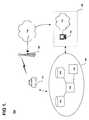
- FIG. 1shows one embodiment of a system for providing services to a vehicle in accordance with the present invention at 100 .
- the systemmay include one or more vehicle clients 101 , one or more carrier systems 120 , one or more communication networks 130 , one or more service management subsystems 140 , and one or more navigation subsystems 150 .
- the service management subsystemsmay comprise one or more service management applications 142 and one or more service managers 144 .
- the navigation subsystems 150may comprise one or more route applications 151 , 152 and one or more coordinate databases 153 , 154 .
- Navigation subsystem 150is a system for generating routes to be delivered to vehicle client 101 and for receiving route information from vehicle client 101 .
- Navigation subsystem 150may be connected with or in communication with service management subsystem 140 .
- Service management subsystem 140may be used to manage the delivery of information to or from navigation subsystem 150 to other parts of system 100 .
- Routesmay be delivered or information may be received via a live agent, such as a human advisor, or via a virtual agent, such as an interactive computer program.
- Navigation subsystem 150may be any suitable hardware or software configuration, or combination of hardware and software that is configured to generate a route, process route information or receive information from vehicle client 101 .
- navigation subsystem 150comprises one or more route applications 151 , 152 and one or more coordinate databases 153 , 154 .
- route applications 151 , 152may be any suitable software application for generating route information or otherwise processing route information.
- Coordinate databases 153 , 154may be any suitable databases for storing route information, such as location coordinates.
- Vehicle client 101may be any suitable vehicle.
- the vehiclemay be an automobile or a passenger-carrying unit such as a bus or train.
- vehicle client 101may be an occupant of the vehicle or any suitable client device contained in the vehicle.
- vehicle client 101may be a mobile or portable device equipped to communicate with service management subsystem 140 .
- Carrier system 120may be any suitable system for transmitting a signal from vehicle 101 to service management subsystem 140 .
- Carrier system 120may also transmit a signal from service management subsystem 140 to vehicle client 101 .
- carrier system 120may be a wireless carrier system as is well known in the art.
- Carrier system 120may be; for example, a transmitter/receiver unit attached to vehicle client 101 .
- carrier system 120may be a separate transmitter/receiver carried by vehicle client 101 .
- Communication network 130may be any suitable system for communicating between vehicle client 101 and service management subsystem 140 .
- communication networkmay be a public switched telephone network (PSTN).
- PSTNpublic switched telephone network
- communication network 130may be a multiprotocol Internet or Intranet capable or transmitting voice and/or data in either analog or digital form or a combination of both.
- communication network 130may be a hybrid communication network or virtual network.
- Service management subsystem 140may be a system for managing a variety of services to be delivered to or from vehicle client 101 .
- service management subsystem 140manages services that can be distributed over a variety of channels.
- servicesmay be delivered via a live agent, such as a human advisor, or via a virtual agent, such as an interactive computer program.
- the structure of service management subsystem 140may enable services to be delivered in a uniform manner regardless of the channel used for delivery or of the service being delivered.
- Service management subsystem 140may maintain a consistent subscriber experience and “look and feel” across the products being delivered across the service distribution channels enabled.
- FIG. 2shows one embodiment of a navigation system in accordance with the present invention at 200 .
- Navigation system 200may include one or more navigation clients 210 , 212 . Each navigation client 210 , 212 may have an in-vehicle navigator 221 , 222 .
- Navigation system 200may also include one or more route generation applications 251 , 252 .
- Navigation system 200may also include one or more coordinate databases 253 , 254 .
- Navigation clients 210 , 212may be one or more vehicle clients as described above.
- In-vehicle navigator 221 , 222may be any suitable component of navigation client 210 , 212 , which may be used to navigate vehicle client 210 , 212 .
- in-vehicle navigator 221 , 222may be a driver.
- in-vehicle navigator 221 , 222may be an automatic system for navigating vehicle 210 , 212 .
- Route generation applications 251 , 252may be any suitable application for calculating maneuver lists of directions between one or more locations.
- route generation applications 251 , 252may be any suitable software or hardware programs for managing or calculating routes, portions of route or route coordinates.
- Route generation applicationsmay include or be able to calculate routes from navigation client's current location to private residences, businesses or recreational facilities.
- route generation applications 251 , 252are in communication with coordinate databases 253 , 254 .
- Route generation applications 251 , 252may generate navigation information in any suitable manner. For example, route generation applications 251 , 252 may generate routes using geocoding. That is, the application 251 , 252 determines a corresponding latitude and longitude based on an input navigation address. Alternatively, route generation applications 251 , 252 may generate routes using reverse geocoding. That is, the application 251 , 252 determines a corresponding navigation address based on input latitude and longitude coordinates.
- Coordinate databases 253 , 254may be any suitable databases for storing such location coordinates as latitude and longitude of a variety of locations. These locations may be, for example, points of interest. Coordinate databases 253 , 254 may also be a database of street addresses. Coordinate databases 253 , 254 may also be a database of routes between points.
- FIG. 3shows a flow diagram of one embodiment of a method for detecting and correcting off-route navigation of a vehicle in accordance with the present invention at 300 .
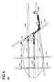
- FIG. 4is a sequence diagram of one embodiment of a method for detecting and correcting off-route navigation of a vehicle in accordance with the present invention at 400 .
- the client vehiclemay upload coordinates identifying its current position and, heading and speed information to the navigation system server 150 (block 303 ).
- the vehiclecontinues to navigate along a planned route 413 which may have been downloaded from the navigation system server 150 .
- the vehiclemay detour off of the planned route 413 and approach and pass an off-route checkpoint (block 305 ).
- Crossing the off-route checkpointmay signal a failure to execute an expected maneuver and may for example, trigger an audible or visible alarm.
- the crossing of an off-route checkpointmay trigger the construction of a proximity ellipse (block 307 ) by a method known in the art.
- the area within the proximity ellipsecontains nodes and road segments.
- these nodes and road segmentscan be connected to generate a return path, known in the art as a cycle, that may be navigated to return to a node on the planned route 413 .
- a return pathknown in the art as a cycle
- Candidate cycles within the ellipsemay be identified (block 309 ) and if acceptable candidate cycles found within this list (block 311 ), the cycle that is closest to the planned route may be selected (block 317 ) and the vehicle may navigate back to a node on the planned route 413 .
- a recovery rectangle 418can be constructed (block 313 ) by using the leftmost focal point of the proximity ellipse as the rightmost point of the rectangle.
- the major axis length of the recovery rectanglemay be predetermined based on various conditions, for example, road density, vehicle speed and navigation server information load.
- Candidate return path cyclesmay be identified within this rectangle.
- the return path cycle that is closest to the navigating vehicle 101may be selected (block 317 ) and the vehicle may use this cycle to navigate to a node back on the planned route 413 (block 319 ).
- the process of identifying candidate cycles and selecting the cycle closest to the travelling vehiclemay continue until an acceptable cycle is identified or until another predetermined action is triggered. In some embodiments the number of times that this process is repeated may be predetermined on the navigation system server 150 .
- a planned route 413may be generated using the route generation applications 251 , 252 and then downloaded from the navigation system server 150 along with a list of off-route checkpoints.
- Point 405may be the starting point of the vehicle client 101 on the planned route 413 and may be the planned end point 419 .
- the client vehiclemay incorrectly turn left at street m 425 . It may than cross checkpoint 415 signaling that it has detoured off of the planned route 413 and an audible or visual signal may be triggered.
- An ellipse 420may be constructed by a method known in the art, using the off-route checkpoint location as the rightmost focal point for the ellipse.
- the major axiscan be determined based on various factors. In this embodiment, it is based on the current road density of the navigated road segment of street m 425 , the navigating vehicle speed and the information load of the navigation system server 150 .
- the area bound by the ellipsecontains road segments and nodes which can be connected to form a navigable path. Based on a method known in the art of graph theory, a cycle may be connected road segments and nodes that form a route with its end point being connected to a node on planned route 413 .
- cycle 417may be the cycle nearest to the current location of the vehicle and may be identified as the innermost acceptable cycle.
- the vehiclemay select the first cycle 417 as the route to navigate back to the planned route 413 .
- a recovery rectangle 418may have been constructed.
- the focal points of the ellipsemay be used as the baseline for the construction of the rectangle.
Landscapes
- Engineering & Computer Science (AREA)
- Radar, Positioning & Navigation (AREA)
- Remote Sensing (AREA)
- Automation & Control Theory (AREA)
- Physics & Mathematics (AREA)
- General Physics & Mathematics (AREA)
- Navigation (AREA)
Abstract
Description
Claims (20)
Priority Applications (1)
| Application Number | Priority Date | Filing Date | Title |
|---|---|---|---|
| US09/960,693US6507785B1 (en) | 2001-09-21 | 2001-09-21 | Method and system for detecting and correcting off route navigation for server based route guidance systems |
Applications Claiming Priority (1)
| Application Number | Priority Date | Filing Date | Title |
|---|---|---|---|
| US09/960,693US6507785B1 (en) | 2001-09-21 | 2001-09-21 | Method and system for detecting and correcting off route navigation for server based route guidance systems |
Publications (1)
| Publication Number | Publication Date |
|---|---|
| US6507785B1true US6507785B1 (en) | 2003-01-14 |
Family
ID=25503493
Family Applications (1)
| Application Number | Title | Priority Date | Filing Date |
|---|---|---|---|
| US09/960,693Expired - LifetimeUS6507785B1 (en) | 2001-09-21 | 2001-09-21 | Method and system for detecting and correcting off route navigation for server based route guidance systems |
Country Status (1)
| Country | Link |
|---|---|
| US (1) | US6507785B1 (en) |
Cited By (28)
| Publication number | Priority date | Publication date | Assignee | Title |
|---|---|---|---|---|
| US6609005B1 (en)* | 2000-03-28 | 2003-08-19 | Leap Wireless International, Inc. | System and method for displaying the location of a wireless communications device wiring a universal resource locator |
| US20030165254A1 (en)* | 2002-02-15 | 2003-09-04 | International Business Machines Corporation | Adapting point geometry for storing address density |
| US6684155B1 (en)* | 2002-10-28 | 2004-01-27 | Sin Etke Technology Co., Ltd. | Vehicle management system |
| US20040199325A1 (en)* | 2003-04-03 | 2004-10-07 | Mitsubishi Denki Kabushiki Kaisha | Route guidance learning device |
| US20040203932A1 (en)* | 2002-06-11 | 2004-10-14 | Hitachi Electronic Service Co. Ltd. | Automatic report control system for reporting arrival at destination or passing point |
| US20050004753A1 (en)* | 2003-06-19 | 2005-01-06 | Michael Weiland | Method of representing road lanes |
| US20050080553A1 (en)* | 2002-10-23 | 2005-04-14 | Um Bong Su | Navigation system and controlling method for the motor vehicle |
| US20060111836A1 (en)* | 2004-11-24 | 2006-05-25 | Fast Todd H | Navigation guidance cancellation apparatus and methods of canceling navigation guidance |
| US20060265125A1 (en)* | 2005-05-23 | 2006-11-23 | General Motors Corporation | Method and system for selecting route guidance data for off-board navigation |
| US20070013708A1 (en)* | 2005-07-14 | 2007-01-18 | Bob Barcklay | Tiled map display on a wireless device |
| US20080004790A1 (en)* | 2006-06-30 | 2008-01-03 | General Motors Corporation | Methods and system for providing routing assistance to a vehicle |
| US20090030603A1 (en)* | 2007-07-27 | 2009-01-29 | Madalin Jr William A | Digital map database and method for obtaining evacuation route information |
| US20090070445A1 (en)* | 2007-09-11 | 2009-03-12 | Regan Gill | Dynamic configuration of mobile station location services |
| US20090098889A1 (en)* | 2007-09-11 | 2009-04-16 | Bob Barcklay | Wireless device location alerts on battery notification events |
| US20090144247A1 (en)* | 2007-11-09 | 2009-06-04 | Eric Wistrand | Point-of-interest panning on a displayed map with a persistent search on a wireless phone using persistent point-of-interest criterion |
| US20090254273A1 (en)* | 2008-04-07 | 2009-10-08 | Regan Gill | Context enabled address selection |
| US20090265340A1 (en)* | 2008-04-07 | 2009-10-22 | Bob Barcklay | Proximity search for point-of-interest names combining inexact string match with an expanding radius search |
| US20100036605A1 (en)* | 2008-08-07 | 2010-02-11 | Mitac International Corp. | Navigation systems and route planning methods thereof |
| US20100087167A1 (en)* | 2008-10-06 | 2010-04-08 | Kevin Tsurutome | Remotely provisioned wirelessly proxy |
| US20100088018A1 (en)* | 2008-10-08 | 2010-04-08 | Kevin Tsurutome | Glance ahead navigation |
| US20100088019A1 (en)* | 2008-10-06 | 2010-04-08 | Bob Barcklay | Probabilistic reverse geocoding |
| US20100088020A1 (en)* | 2008-10-07 | 2010-04-08 | Darrell Sano | User interface for predictive traffic |
| US20100087207A1 (en)* | 2008-10-07 | 2010-04-08 | Kevin Tsurutome | User interface for content channel hud (heads-up display) and channel sets for location-based maps |
| US20100094550A1 (en)* | 2008-10-07 | 2010-04-15 | Kevin Tsurutome | User interface for dynamic user-defined stopovers during guided naviation ('side trips") |
| US20100332113A1 (en)* | 2009-06-24 | 2010-12-30 | General Motors Corporation | System and method for providing route guidance to a requesting vehicle |
| US8983768B1 (en) | 2005-02-11 | 2015-03-17 | Enovation Controls, Llc | Event sensor |
| US9052717B1 (en) | 2004-02-11 | 2015-06-09 | Enovation Controls, Llc | Watercraft speed control device |
| US9207675B1 (en) | 2005-02-11 | 2015-12-08 | Enovation Controls, Llc | Event sensor |
Citations (8)
| Publication number | Priority date | Publication date | Assignee | Title |
|---|---|---|---|---|
| US5638280A (en)* | 1994-03-30 | 1997-06-10 | Sumitomo Electric Industries, Ltd. | Vehicle navigation apparatus and method |
| US5902349A (en)* | 1995-12-28 | 1999-05-11 | Alpine Electronics, Inc. | Navigation apparatus |
| US5926118A (en)* | 1995-06-28 | 1999-07-20 | Aisin Aw Co., Ltd. | Vehicular navigation apparatus |
| US5931888A (en)* | 1994-09-22 | 1999-08-03 | Aisin Aw Co., Ltd. | Navigation system for vehicles with alternative route searching capabilities |
| US5977885A (en)* | 1996-08-30 | 1999-11-02 | Aisin Aw Co., Ltd. | Land vehicle navigation apparatus with local route guidance selectivity and storage medium therefor |
| US6061630A (en)* | 1996-12-20 | 2000-05-09 | U.S. Philips Corporation | Navigation system and method for guiding a road vehicle |
| US6101443A (en)* | 1997-04-08 | 2000-08-08 | Aisin Aw Co., Ltd. | Route search and navigation apparatus and storage medium storing computer programs for navigation processing with travel difficulty by-pass |
| US6249740B1 (en)* | 1998-01-21 | 2001-06-19 | Kabushikikaisha Equos Research | Communications navigation system, and navigation base apparatus and vehicle navigation apparatus both used in the navigation system |
- 2001
- 2001-09-21USUS09/960,693patent/US6507785B1/ennot_activeExpired - Lifetime
Patent Citations (8)
| Publication number | Priority date | Publication date | Assignee | Title |
|---|---|---|---|---|
| US5638280A (en)* | 1994-03-30 | 1997-06-10 | Sumitomo Electric Industries, Ltd. | Vehicle navigation apparatus and method |
| US5931888A (en)* | 1994-09-22 | 1999-08-03 | Aisin Aw Co., Ltd. | Navigation system for vehicles with alternative route searching capabilities |
| US5926118A (en)* | 1995-06-28 | 1999-07-20 | Aisin Aw Co., Ltd. | Vehicular navigation apparatus |
| US5902349A (en)* | 1995-12-28 | 1999-05-11 | Alpine Electronics, Inc. | Navigation apparatus |
| US5977885A (en)* | 1996-08-30 | 1999-11-02 | Aisin Aw Co., Ltd. | Land vehicle navigation apparatus with local route guidance selectivity and storage medium therefor |
| US6061630A (en)* | 1996-12-20 | 2000-05-09 | U.S. Philips Corporation | Navigation system and method for guiding a road vehicle |
| US6101443A (en)* | 1997-04-08 | 2000-08-08 | Aisin Aw Co., Ltd. | Route search and navigation apparatus and storage medium storing computer programs for navigation processing with travel difficulty by-pass |
| US6249740B1 (en)* | 1998-01-21 | 2001-06-19 | Kabushikikaisha Equos Research | Communications navigation system, and navigation base apparatus and vehicle navigation apparatus both used in the navigation system |
Cited By (53)
| Publication number | Priority date | Publication date | Assignee | Title |
|---|---|---|---|---|
| US6609005B1 (en)* | 2000-03-28 | 2003-08-19 | Leap Wireless International, Inc. | System and method for displaying the location of a wireless communications device wiring a universal resource locator |
| US7046827B2 (en)* | 2002-02-15 | 2006-05-16 | International Business Machines Corporation | Adapting point geometry for storing address density |
| US20030165254A1 (en)* | 2002-02-15 | 2003-09-04 | International Business Machines Corporation | Adapting point geometry for storing address density |
| US20040203932A1 (en)* | 2002-06-11 | 2004-10-14 | Hitachi Electronic Service Co. Ltd. | Automatic report control system for reporting arrival at destination or passing point |
| US6983157B2 (en)* | 2002-06-11 | 2006-01-03 | Hitachi Electronic Service Co. Ltd. | Automatic report control system for reporting arrival at destination or passing point |
| US7890250B2 (en)* | 2002-10-23 | 2011-02-15 | Sk Telecom Co., Ltd. | Navigation system and controlling method for the motor vehicle |
| US20050080553A1 (en)* | 2002-10-23 | 2005-04-14 | Um Bong Su | Navigation system and controlling method for the motor vehicle |
| US6684155B1 (en)* | 2002-10-28 | 2004-01-27 | Sin Etke Technology Co., Ltd. | Vehicle management system |
| US20040199325A1 (en)* | 2003-04-03 | 2004-10-07 | Mitsubishi Denki Kabushiki Kaisha | Route guidance learning device |
| US7197395B2 (en)* | 2003-04-03 | 2007-03-27 | Mitsubhishi Denki Kabushiki Kaisha | Route guidance learning device |
| US20050004753A1 (en)* | 2003-06-19 | 2005-01-06 | Michael Weiland | Method of representing road lanes |
| US9052717B1 (en) | 2004-02-11 | 2015-06-09 | Enovation Controls, Llc | Watercraft speed control device |
| US20060111836A1 (en)* | 2004-11-24 | 2006-05-25 | Fast Todd H | Navigation guidance cancellation apparatus and methods of canceling navigation guidance |
| US7289905B2 (en)* | 2004-11-24 | 2007-10-30 | General Motors Corporation | Navigation guidance cancellation apparatus and methods of canceling navigation guidance |
| US8983768B1 (en) | 2005-02-11 | 2015-03-17 | Enovation Controls, Llc | Event sensor |
| US9207675B1 (en) | 2005-02-11 | 2015-12-08 | Enovation Controls, Llc | Event sensor |
| US9068838B1 (en) | 2005-02-11 | 2015-06-30 | Enovation Controls, Llc | Event sensor |
| US9092033B1 (en) | 2005-02-11 | 2015-07-28 | Enovation Controls, Llc | Event sensor |
| US9098083B1 (en)* | 2005-02-11 | 2015-08-04 | Enovation Controls, Llc | Event sensor |
| US7266450B2 (en)* | 2005-05-23 | 2007-09-04 | General Motors Corporation | Method and system for selecting route guidance data for off-board navigation |
| US20060265125A1 (en)* | 2005-05-23 | 2006-11-23 | General Motors Corporation | Method and system for selecting route guidance data for off-board navigation |
| US9041744B2 (en) | 2005-07-14 | 2015-05-26 | Telecommunication Systems, Inc. | Tiled map display on a wireless device |
| US9367566B2 (en) | 2005-07-14 | 2016-06-14 | Telecommunication Systems, Inc. | Tiled map display on a wireless device |
| US20070013708A1 (en)* | 2005-07-14 | 2007-01-18 | Bob Barcklay | Tiled map display on a wireless device |
| US20080004790A1 (en)* | 2006-06-30 | 2008-01-03 | General Motors Corporation | Methods and system for providing routing assistance to a vehicle |
| US20090030603A1 (en)* | 2007-07-27 | 2009-01-29 | Madalin Jr William A | Digital map database and method for obtaining evacuation route information |
| US9554245B2 (en) | 2007-09-11 | 2017-01-24 | Telecommunication Systems, Inc. | Dynamic configuration of mobile station location services |
| US20090098889A1 (en)* | 2007-09-11 | 2009-04-16 | Bob Barcklay | Wireless device location alerts on battery notification events |
| US20090070445A1 (en)* | 2007-09-11 | 2009-03-12 | Regan Gill | Dynamic configuration of mobile station location services |
| US8862710B2 (en) | 2007-09-11 | 2014-10-14 | Telecommunication Systems, Inc. | Dynamic configuration of mobile station location services |
| US20090144247A1 (en)* | 2007-11-09 | 2009-06-04 | Eric Wistrand | Point-of-interest panning on a displayed map with a persistent search on a wireless phone using persistent point-of-interest criterion |
| US8428869B2 (en) | 2008-04-07 | 2013-04-23 | Telecommunication Systems, Inc. | Context enabled address selection |
| US20090254273A1 (en)* | 2008-04-07 | 2009-10-08 | Regan Gill | Context enabled address selection |
| US20090265340A1 (en)* | 2008-04-07 | 2009-10-22 | Bob Barcklay | Proximity search for point-of-interest names combining inexact string match with an expanding radius search |
| US20100036605A1 (en)* | 2008-08-07 | 2010-02-11 | Mitac International Corp. | Navigation systems and route planning methods thereof |
| US8594627B2 (en) | 2008-10-06 | 2013-11-26 | Telecommunications Systems, Inc. | Remotely provisioned wirelessly proxy |
| US8712408B2 (en) | 2008-10-06 | 2014-04-29 | Telecommunication Systems, Inc. | Remotely provisioned wireless proxy |
| US8838379B2 (en) | 2008-10-06 | 2014-09-16 | Telecommunication Systems, Inc. | Probalistic reverse geocoding |
| US9420398B2 (en) | 2008-10-06 | 2016-08-16 | Telecommunication Systems, Inc. | Remotely provisioned wireless proxy |
| US20160169693A1 (en)* | 2008-10-06 | 2016-06-16 | Telecommunication Systems, Inc. | Probabilistic Reverse Geocoding |
| US9400182B2 (en) | 2008-10-06 | 2016-07-26 | Telecommunication Systems, Inc. | Probabilistic reverse geocoding |
| US20100088019A1 (en)* | 2008-10-06 | 2010-04-08 | Bob Barcklay | Probabilistic reverse geocoding |
| US8396658B2 (en)* | 2008-10-06 | 2013-03-12 | Telecommunication Systems, Inc. | Probabilistic reverse geocoding |
| US20100087167A1 (en)* | 2008-10-06 | 2010-04-08 | Kevin Tsurutome | Remotely provisioned wirelessly proxy |
| US20100088020A1 (en)* | 2008-10-07 | 2010-04-08 | Darrell Sano | User interface for predictive traffic |
| US9200913B2 (en) | 2008-10-07 | 2015-12-01 | Telecommunication Systems, Inc. | User interface for predictive traffic |
| US9285239B2 (en) | 2008-10-07 | 2016-03-15 | Telecommunication Systems, Inc. | User interface for content channel HUD (heads-up display) and channel sets for location-based maps |
| US20100087207A1 (en)* | 2008-10-07 | 2010-04-08 | Kevin Tsurutome | User interface for content channel hud (heads-up display) and channel sets for location-based maps |
| US20100094550A1 (en)* | 2008-10-07 | 2010-04-15 | Kevin Tsurutome | User interface for dynamic user-defined stopovers during guided naviation ('side trips") |
| US9372091B2 (en) | 2008-10-07 | 2016-06-21 | Telecommunication Systems, Inc. | User interface for predictive traffic |
| US20100088018A1 (en)* | 2008-10-08 | 2010-04-08 | Kevin Tsurutome | Glance ahead navigation |
| US20100332113A1 (en)* | 2009-06-24 | 2010-12-30 | General Motors Corporation | System and method for providing route guidance to a requesting vehicle |
| US8321125B2 (en) | 2009-06-24 | 2012-11-27 | General Motors Llc | System and method for providing route guidance to a requesting vehicle |
Similar Documents
| Publication | Publication Date | Title |
|---|---|---|
| US6507785B1 (en) | Method and system for detecting and correcting off route navigation for server based route guidance systems | |
| US6708110B2 (en) | Method of providing vehicle instructions to a non-navigable point of interest | |
| US6701251B2 (en) | Method and system for providing multiple beginning maneuvers for navigation of a vehicle | |
| US6427119B1 (en) | Method and system for providing multiple entry points to a vehicle navigation route | |
| US8548734B2 (en) | System and method for real-time travel path prediction and automatic incident alerts | |
| EP0901001B1 (en) | Method and apparatus for displaying current position of a vehicle | |
| US6615134B2 (en) | Data communication system and method, and mobile body apparatus | |
| US9677903B2 (en) | Selected driver notification of transitory roadtrip events | |
| US6278939B1 (en) | Method and system for providing data from a remotely located geographic database for use in navigation system units | |
| US9097553B2 (en) | Navigation based on direction of travel/user-defined path | |
| US10989553B2 (en) | Method, apparatus and computer program product for determining likelihood of a route | |
| US20040225433A1 (en) | Method for associating real-time information with a geographical location | |
| US20030158652A1 (en) | Method for making available route data for a navigational device | |
| US6775613B2 (en) | Method and system for vehicle proximity searching | |
| EP1560187B1 (en) | Computer product having distribution map data, distribution map data creation method, distribution map data creation device, and terminal device | |
| JPH07509559A (en) | Route determination method and route guidance module of route guidance system | |
| US6240363B1 (en) | Navigation method, in particular for vehicles | |
| WO2006009246A1 (en) | Navigation system, route search device, navigation device, and program | |
| US20020152024A1 (en) | Method and system for generating a list of maneuvers for navigation of a vehicle | |
| WO2005032177A1 (en) | Method and system for providing map data search service | |
| CN101526365B (en) | Fuzzy navigation method and device thereof | |
| WO2017089600A1 (en) | Methods and systems for generating routes to optimise traffic flow | |
| WO2023156258A1 (en) | Processing digital map data | |
| US6625538B2 (en) | Method and system for reducing maneuver proximity diameter for a waypoint navigation system | |
| US6466864B1 (en) | Method and system for detecting anomalous road geometry for a navigation system |
Legal Events
| Date | Code | Title | Description |
|---|---|---|---|
| STCF | Information on status: patent grant | Free format text:PATENTED CASE | |
| FPAY | Fee payment | Year of fee payment:4 | |
| AS | Assignment | Owner name:UNITED STATES DEPARTMENT OF THE TREASURY, DISTRICT Free format text:SECURITY AGREEMENT;ASSIGNOR:GENERAL MOTORS CORPORATION;REEL/FRAME:022191/0254 Effective date:20081231 Owner name:UNITED STATES DEPARTMENT OF THE TREASURY,DISTRICT Free format text:SECURITY AGREEMENT;ASSIGNOR:GENERAL MOTORS CORPORATION;REEL/FRAME:022191/0254 Effective date:20081231 | |
| AS | Assignment | Owner name:CITICORP USA, INC. AS AGENT FOR BANK PRIORITY SECU Free format text:SECURITY AGREEMENT;ASSIGNOR:GENERAL MOTORS CORPORATION;REEL/FRAME:022552/0006 Effective date:20090409 Owner name:CITICORP USA, INC. AS AGENT FOR HEDGE PRIORITY SEC Free format text:SECURITY AGREEMENT;ASSIGNOR:GENERAL MOTORS CORPORATION;REEL/FRAME:022552/0006 Effective date:20090409 | |
| AS | Assignment | Owner name:MOTORS LIQUIDATION COMPANY (F/K/A GENERAL MOTORS C Free format text:RELEASE BY SECURED PARTY;ASSIGNOR:UNITED STATES DEPARTMENT OF THE TREASURY;REEL/FRAME:023119/0491 Effective date:20090709 | |
| AS | Assignment | Owner name:MOTORS LIQUIDATION COMPANY (F/K/A GENERAL MOTORS C Free format text:RELEASE BY SECURED PARTY;ASSIGNORS:CITICORP USA, INC. AS AGENT FOR BANK PRIORITY SECURED PARTIES;CITICORP USA, INC. AS AGENT FOR HEDGE PRIORITY SECURED PARTIES;REEL/FRAME:023119/0817 Effective date:20090709 Owner name:MOTORS LIQUIDATION COMPANY, MICHIGAN Free format text:CHANGE OF NAME;ASSIGNOR:GENERAL MOTORS CORPORATION;REEL/FRAME:023129/0236 Effective date:20090709 Owner name:MOTORS LIQUIDATION COMPANY,MICHIGAN Free format text:CHANGE OF NAME;ASSIGNOR:GENERAL MOTORS CORPORATION;REEL/FRAME:023129/0236 Effective date:20090709 | |
| AS | Assignment | Owner name:GENERAL MOTORS COMPANY, MICHIGAN Free format text:ASSIGNMENT OF ASSIGNORS INTEREST;ASSIGNOR:MOTORS LIQUIDATION COMPANY;REEL/FRAME:023148/0248 Effective date:20090710 Owner name:UNITED STATES DEPARTMENT OF THE TREASURY, DISTRICT Free format text:SECURITY AGREEMENT;ASSIGNOR:GENERAL MOTORS COMPANY;REEL/FRAME:023155/0814 Effective date:20090710 Owner name:UAW RETIREE MEDICAL BENEFITS TRUST, MICHIGAN Free format text:SECURITY AGREEMENT;ASSIGNOR:GENERAL MOTORS COMPANY;REEL/FRAME:023155/0849 Effective date:20090710 Owner name:GENERAL MOTORS COMPANY,MICHIGAN Free format text:ASSIGNMENT OF ASSIGNORS INTEREST;ASSIGNOR:MOTORS LIQUIDATION COMPANY;REEL/FRAME:023148/0248 Effective date:20090710 Owner name:UNITED STATES DEPARTMENT OF THE TREASURY,DISTRICT Free format text:SECURITY AGREEMENT;ASSIGNOR:GENERAL MOTORS COMPANY;REEL/FRAME:023155/0814 Effective date:20090710 Owner name:UAW RETIREE MEDICAL BENEFITS TRUST,MICHIGAN Free format text:SECURITY AGREEMENT;ASSIGNOR:GENERAL MOTORS COMPANY;REEL/FRAME:023155/0849 Effective date:20090710 | |
| AS | Assignment | Owner name:GENERAL MOTORS LLC, MICHIGAN Free format text:CHANGE OF NAME;ASSIGNOR:GENERAL MOTORS COMPANY;REEL/FRAME:023504/0691 Effective date:20091016 Owner name:GENERAL MOTORS LLC,MICHIGAN Free format text:CHANGE OF NAME;ASSIGNOR:GENERAL MOTORS COMPANY;REEL/FRAME:023504/0691 Effective date:20091016 | |
| FPAY | Fee payment | Year of fee payment:8 | |
| AS | Assignment | Owner name:GM GLOBAL TECHNOLOGY OPERATIONS, INC., MICHIGAN Free format text:RELEASE BY SECURED PARTY;ASSIGNOR:UAW RETIREE MEDICAL BENEFITS TRUST;REEL/FRAME:025311/0680 Effective date:20101026 Owner name:GM GLOBAL TECHNOLOGY OPERATIONS, INC., MICHIGAN Free format text:RELEASE BY SECURED PARTY;ASSIGNOR:UNITED STATES DEPARTMENT OF THE TREASURY;REEL/FRAME:025245/0273 Effective date:20100420 | |
| AS | Assignment | Owner name:WILMINGTON TRUST COMPANY, DELAWARE Free format text:SECURITY AGREEMENT;ASSIGNOR:GENERAL MOTORS LLC;REEL/FRAME:025327/0196 Effective date:20101027 | |
| FPAY | Fee payment | Year of fee payment:12 | |
| AS | Assignment | Owner name:GENERAL MOTORS LLC, MICHIGAN Free format text:RELEASE BY SECURED PARTY;ASSIGNOR:WILMINGTON TRUST COMPANY;REEL/FRAME:034183/0436 Effective date:20141017 |