US6480783B1 - Real time vehicle guidance and forecasting system under traffic jam conditions - Google Patents
Real time vehicle guidance and forecasting system under traffic jam conditionsDownload PDFInfo
- Publication number
- US6480783B1 US6480783B1US09/528,134US52813400AUS6480783B1US 6480783 B1US6480783 B1US 6480783B1US 52813400 AUS52813400 AUS 52813400AUS 6480783 B1US6480783 B1US 6480783B1
- Authority
- US
- United States
- Prior art keywords
- statistical
- data
- travel
- traffic
- time
- Prior art date
- Legal status (The legal status is an assumption and is not a legal conclusion. Google has not performed a legal analysis and makes no representation as to the accuracy of the status listed.)
- Expired - Lifetime
Links
- 238000000034methodMethods0.000claimsabstractdescription31
- 238000004422calculation algorithmMethods0.000claimsdescription42
- 238000012545processingMethods0.000claimsdescription29
- 238000013439planningMethods0.000claimsdescription20
- 238000004364calculation methodMethods0.000claimsdescription15
- 238000004891communicationMethods0.000claimsdescription12
- 230000001934delayEffects0.000claimsdescription8
- 238000005457optimizationMethods0.000claimsdescription4
- 238000005259measurementMethods0.000claimsdescription3
- 238000013473artificial intelligenceMethods0.000claimsdescription2
- 239000002131composite materialSubstances0.000claims5
- 230000001131transforming effectEffects0.000claims4
- 230000003247decreasing effectEffects0.000claims2
- 238000013179statistical modelMethods0.000claims2
- 230000009977dual effectEffects0.000claims1
- 230000006870functionEffects0.000description15
- 239000000243solutionSubstances0.000description13
- 238000012790confirmationMethods0.000description8
- 238000012546transferMethods0.000description8
- 230000008569processEffects0.000description7
- 206010039203Road traffic accidentDiseases0.000description6
- 238000012544monitoring processMethods0.000description6
- 230000008859changeEffects0.000description5
- 238000013480data collectionMethods0.000description5
- 238000012417linear regressionMethods0.000description5
- 238000007726management methodMethods0.000description5
- 230000003068static effectEffects0.000description5
- 230000000694effectsEffects0.000description4
- 238000010276constructionMethods0.000description3
- 238000012935AveragingMethods0.000description2
- 230000006978adaptationEffects0.000description2
- 230000001413cellular effectEffects0.000description2
- 238000012937correctionMethods0.000description2
- 230000002354daily effectEffects0.000description2
- 238000013461designMethods0.000description2
- 238000011161developmentMethods0.000description2
- 230000003203everyday effectEffects0.000description2
- 230000006872improvementEffects0.000description2
- 238000009434installationMethods0.000description2
- 230000033001locomotionEffects0.000description2
- 230000007774longtermEffects0.000description2
- 230000000717retained effectEffects0.000description2
- 238000012360testing methodMethods0.000description2
- 238000013519translationMethods0.000description2
- 238000012795verificationMethods0.000description2
- 230000000007visual effectEffects0.000description2
- 241000854350Enicospilus groupSpecies0.000description1
- 230000008901benefitEffects0.000description1
- 230000005540biological transmissionEffects0.000description1
- 238000007635classification algorithmMethods0.000description1
- 238000010586diagramMethods0.000description1
- 238000005516engineering processMethods0.000description1
- 230000010365information processingEffects0.000description1
- 230000010354integrationEffects0.000description1
- 230000003993interactionEffects0.000description1
- 238000012423maintenanceMethods0.000description1
- 238000012986modificationMethods0.000description1
- 230000004048modificationEffects0.000description1
- 230000003287optical effectEffects0.000description1
- 210000001747pupilAnatomy0.000description1
- 230000009467reductionEffects0.000description1
- 230000001932seasonal effectEffects0.000description1
- 238000000638solvent extractionMethods0.000description1
- 239000012086standard solutionSubstances0.000description1
- 238000013517stratificationMethods0.000description1
- 230000029305taxisEffects0.000description1
- 239000013598vectorSubstances0.000description1
- 230000001755vocal effectEffects0.000description1
- 238000013316zoningMethods0.000description1
Images


Classifications
- G—PHYSICS
- G08—SIGNALLING
- G08G—TRAFFIC CONTROL SYSTEMS
- G08G1/00—Traffic control systems for road vehicles
- G08G1/09—Arrangements for giving variable traffic instructions
- G08G1/0962—Arrangements for giving variable traffic instructions having an indicator mounted inside the vehicle, e.g. giving voice messages
- G08G1/0968—Systems involving transmission of navigation instructions to the vehicle
- G08G1/096805—Systems involving transmission of navigation instructions to the vehicle where the transmitted instructions are used to compute a route
- G08G1/096811—Systems involving transmission of navigation instructions to the vehicle where the transmitted instructions are used to compute a route where the route is computed offboard
- G—PHYSICS
- G01—MEASURING; TESTING
- G01C—MEASURING DISTANCES, LEVELS OR BEARINGS; SURVEYING; NAVIGATION; GYROSCOPIC INSTRUMENTS; PHOTOGRAMMETRY OR VIDEOGRAMMETRY
- G01C21/00—Navigation; Navigational instruments not provided for in groups G01C1/00 - G01C19/00
- G01C21/26—Navigation; Navigational instruments not provided for in groups G01C1/00 - G01C19/00 specially adapted for navigation in a road network
- G01C21/34—Route searching; Route guidance
- G01C21/3453—Special cost functions, i.e. other than distance or default speed limit of road segments
- G01C21/3492—Special cost functions, i.e. other than distance or default speed limit of road segments employing speed data or traffic data, e.g. real-time or historical
- G—PHYSICS
- G08—SIGNALLING
- G08G—TRAFFIC CONTROL SYSTEMS
- G08G1/00—Traffic control systems for road vehicles
- G08G1/09—Arrangements for giving variable traffic instructions
- G08G1/0962—Arrangements for giving variable traffic instructions having an indicator mounted inside the vehicle, e.g. giving voice messages
- G08G1/0968—Systems involving transmission of navigation instructions to the vehicle
- G08G1/096805—Systems involving transmission of navigation instructions to the vehicle where the transmitted instructions are used to compute a route
- G08G1/096811—Systems involving transmission of navigation instructions to the vehicle where the transmitted instructions are used to compute a route where the route is computed offboard
- G08G1/096816—Systems involving transmission of navigation instructions to the vehicle where the transmitted instructions are used to compute a route where the route is computed offboard where the complete route is transmitted to the vehicle at once
- G—PHYSICS
- G08—SIGNALLING
- G08G—TRAFFIC CONTROL SYSTEMS
- G08G1/00—Traffic control systems for road vehicles
- G08G1/09—Arrangements for giving variable traffic instructions
- G08G1/0962—Arrangements for giving variable traffic instructions having an indicator mounted inside the vehicle, e.g. giving voice messages
- G08G1/0968—Systems involving transmission of navigation instructions to the vehicle
- G08G1/096833—Systems involving transmission of navigation instructions to the vehicle where different aspects are considered when computing the route
- G08G1/096838—Systems involving transmission of navigation instructions to the vehicle where different aspects are considered when computing the route where the user preferences are taken into account or the user selects one route out of a plurality
- G—PHYSICS
- G08—SIGNALLING
- G08G—TRAFFIC CONTROL SYSTEMS
- G08G1/00—Traffic control systems for road vehicles
- G08G1/09—Arrangements for giving variable traffic instructions
- G08G1/0962—Arrangements for giving variable traffic instructions having an indicator mounted inside the vehicle, e.g. giving voice messages
- G08G1/0968—Systems involving transmission of navigation instructions to the vehicle
- G08G1/096833—Systems involving transmission of navigation instructions to the vehicle where different aspects are considered when computing the route
- G08G1/096844—Systems involving transmission of navigation instructions to the vehicle where different aspects are considered when computing the route where the complete route is dynamically recomputed based on new data
- G—PHYSICS
- G08—SIGNALLING
- G08G—TRAFFIC CONTROL SYSTEMS
- G08G1/00—Traffic control systems for road vehicles
- G08G1/09—Arrangements for giving variable traffic instructions
- G08G1/0962—Arrangements for giving variable traffic instructions having an indicator mounted inside the vehicle, e.g. giving voice messages
- G08G1/0968—Systems involving transmission of navigation instructions to the vehicle
- G08G1/096855—Systems involving transmission of navigation instructions to the vehicle where the output is provided in a suitable form to the driver
- G08G1/096872—Systems involving transmission of navigation instructions to the vehicle where the output is provided in a suitable form to the driver where instructions are given per voice
- G—PHYSICS
- G08—SIGNALLING
- G08G—TRAFFIC CONTROL SYSTEMS
- G08G1/00—Traffic control systems for road vehicles
- G08G1/09—Arrangements for giving variable traffic instructions
- G08G1/0962—Arrangements for giving variable traffic instructions having an indicator mounted inside the vehicle, e.g. giving voice messages
- G08G1/0968—Systems involving transmission of navigation instructions to the vehicle
- G08G1/096877—Systems involving transmission of navigation instructions to the vehicle where the input to the navigation device is provided by a suitable I/O arrangement
- G08G1/096883—Systems involving transmission of navigation instructions to the vehicle where the input to the navigation device is provided by a suitable I/O arrangement where input information is obtained using a mobile device, e.g. a mobile phone, a PDA
Definitions
- the present inventiondescribes the vehicle Guidance System consisting of a plurality of vehicles equipped with IMUs including GPS units and of the CTU computer.
- the CTUbroadcasts the updated traffic data collected from a number of sample vehicles via Multicast Broadcasting System thereby enabling the IMUs to dynamically update the desired optimal travel routes.
- the conventional on-vehicle guidance systemsare usually stand-alone applications wherein the traffic data are static and cannot be easily dynamically updated. Consequently, the proposed routes are accurate only under ideal traffic conditions.
- the stand-alone versionscannot take into account current traffic jam conditions or real time emergencies. Hence, even when a so-called ‘optimal route’ is found, it may not be usable solution in real time situations and can only be used as a general recommendation.
- the present inventioneliminates the need for a large number of static sensors and relies instead on a number of highly mobile GPS carrying sample vehicles. Naturally, the reliability of the results will depend on the size of the sample vehicle fleet, and the ability of the server to process the incoming information simultaneously. Similar ideas could be found in existing inventions. Of particular relevance is U.S. Pat. No. 5,699,056 wherein the problem statement is similar to ours. In particular, it formulates the problem of dealing with traffic jams and other bottleneck situations. For detecting traffic jams and representing them in its database, this patent uses data obtained from traveling vehicles, in particular their IDs, positions, times, and speeds. In Embodiment 2, it divides all the vehicles into blocks (i.e. groups), measures average speed in each block, and defines a situation as a jam if the average speed is less than a predetermined value.
- blocksi.e. groups
- This inventionprovides real time traffic Guidance System, which is capable of providing optimal route from the present position of a vehicle to a desired target destination when traffic jams may be present, thereby reducing the burden upon the driver when the vehicle is traveling at high speeds on unfamiliar roads. Thereafter the optimal route found is communicated to the driver and displayed on the vehicle's computer screen featuring the digital map of the relevant region and/or via audio instructions.
- the travel time between two road intersections A and Bis the sum of travel times for all sections of roads connecting A and B on the shortest route either by the minimal time criterion, or by some other criterion. Then in order to be able to compute a travel time between two positions on a map, we must be able to determine travel times for all sections of roads connecting those positions, or road intersections close to them.
- a routeis computed by a mathematical optimization algorithm while travel times are computed as distances divided by maximal allowed speeds. While being simple, such solutions have an obvious shortcoming in that they do not take into account the real conditions on the roads and therefore can serve only as a guidance suggestion.
- a true real time systemshould collect, store and make use of the following kinds of data:
- the system in the present inventionis built around an idea of collecting and processing information that describes all those changing conditions.
- the Guidance System in the present inventionconsists of CTU and a fleet of IMUs, i.e. traveling vehicles.
- the vehicle fleetis divided into two categories: sample vehicles SMU and all other client vehicles CMU.
- CMUsare only clients that “consume” traffic congestion data provided by the CTU.
- the sample vehiclescan be both clients and serve also as antennas or tentacles for collecting real time data on traffic situations, which can be used by all end users for updating their optimal routes. This data collection is performed by permanent monitoring of GPS signals obtained from SMUs and by concurrent measuring of their current travel times along a broad range of roads.
- FIG. 1is a schematic representation of the information exchange between CTU and IMUs in the Guidance System.
- the data transfer from SMUs to CTUis done by wireless RF communication, and from CTU to both SMUs and CMUs by one-to-many multicasting system.
- the SMU vehiclescommunicate to CTU their GPS data: the present positions, the position time, their IDs, and their speed vectors at specific time intervals.
- CTUsends to CMUs updated information on traffic bottleneck situations (i.e. road ID, current time, and travel times of the latest n vehicles).
- traffic bottleneck situationsi.e. road ID, current time, and travel times of the latest n vehicles.
- the CTUalso maintains the database containing travel times for all sections of roads at a particular time of the day, for a particular of day of the week, etc.
- those travel timesare theoretical travel times but as the time goes by and observational data are being collected and processed, they are replaced by empirical travel times reflecting realistic travel conditions, and on particular occasions by current travel times, which reflect sudden and unpredictable changes in traffic conditions.
- Those travel timesare being measured and periodically broadcasted by the CTU via satellite IP Multicasting broadcast to end-users where they are entered into the databases of the on-vehicle computers for future use.
- the end-user on-vehicle computerOn receiving a request from a driver for a shortest route to a particular destination, the end-user on-vehicle computer applies an optimization procedure for computing an optimal route while making use of updated by CTU travel times for individual sections of roads. Thereafter, the optimal route is communicated to the driver either visually on the computer map, or auditorilly through a sequence of voice instructions.
- the Guidance SystemBelow is the list of the major functions performed by the Guidance System.
- FIG. 1shows Information Exchange in the Guidance System
- FIG. 2shows Information Flow Between Individual Components of the Guidance System
- FIG. 3shows Information Flow from SMU to CTU
- FIG. 4shows Information Exchange Between IMU and CTU
- FIG. 5shows the Flowchart of the Guidance System with Real Time Traffic Volume Updates
- FIG. 6shows the Algorithm for Processing User's Request
- FIG. 7shows the Section Travel Time Managing Algorithm
- FIG. 8shows Vehicle Hardware Configuration
- FIG. 9shows Vehicle Display Panel
- FIG. 10is the Road Type Classification
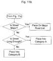
- FIG. 11is Road Classification Flowchart
- FIG. 12is IP-Multicasting to Vehicles Traveling from Zone to Zone;
- FIG. 13shows Calculations of Travel Times in Category A Roads
- FIG. 14shows the CTU Database
- FIG. 15is Table of Administrator for Category A Roads
- FIG. 16is Table of Administrator for Category B Roads
- FIG. 17shows the Multilevel Road Information Gathering System
- FIG. 18shows the Method of Maintaining Two Lists of Vehicles
- FIG. 19shows the Algorithm for Maintaining Two Lists of Vehicles for Category A Sections
- FIG. 20illustrates Regression-Based Prediction of Current Travel Times
- FIG. 21illustrates the Computation of Optimal Routes the algorithm A*
- FIG. 22shows Algorithm Z for Planning in Two-Layer Hierarchical Model
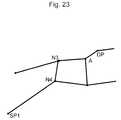
- FIG. 23shows the Algorithm Z for Planning at Upper Layer
- FIG. 24shows the Algorithm Z for Planning at the Extended Road Network
- FIG. 25shows the Flowchart of Algorithm Z for Route Planning.
- the major goal of the inventionis to provide a real time travel Guidance System capable of handling a driver's request for a shortest route to any destination.
- the drivercan enter a request for alternative route and will receive an updated route reflecting the real time traffic situation directly on his display panel.
- the informationwill also be updated by visual and audio instructions, and driver's vehicle position will be displayed dynamically on the display unit.
- Another goalis to provide the driver with a tool for strategic trip planning. By entering alternate times for future trips and comparing their travel time estimates for the same destination, the driver receives an option to select a trip proposal ideally suited for his needs.
- the Guidance Systemalso enables the user to manually, or by verbal commands, to update and customize his information database and adapt it to his personal needs and requirements.
- the Guidance Systemcomprises client vehicles CMU, sample vehicles SMU, and the central traffic unit CTU (see FIG. 1 ).
- the CTU unitis configured to receive GPS data obtained from a fleet of sample vehicles SMU that are traveling and passively collecting sample traffic congestion data along a broad range of road systems.
- the CTUprocesses the information and passes it along to be multicasted to the groups of client vehicles CMU each according to its group position.
- FIG. 2shows information flow between individual components of the Guidance System.
- the GPS data obtained via satelliteis transmitted by means of on-vehicle modem and transmitter to the CTU.
- CTUuses the map database and information obtained from all GPS units for calculation of real time information traffic updates that are thereafter IP-multicasted to IMU receivers and utilized for calculation of routes by on-vehicle computers.
- FIG. 3shows information flow from SMU to CTU for a case when SMU is not a client, i.e. is not using the guidance services, and therefore is equipped only with GPS unit and Unit 1 shows the satellite supplying GPS signals to SMU.
- the only function of such SMUs in the Guidance Systemis providing GPS travel coordinates (Unit 2 ) along roads and transmitting them to CTU (Unit 5 ) by modem (Unit 3 ) RF transmitter (Unit 4 ). After the CTU processes the data and creates the real time traffic updates, it IP-multicasts them to all IMUs.
- FIG. 4shows the main components of the IMU and information exchange between IMUs and CTU. It illustrates two cases: when IMU is a client and when it is both a client and a sample vehicle.
- IMUis a client only
- Units 1 to 10show the satellite supplying GPS signals to IMU.
- the IMU navigation unitcomprises Units 2 to 8 . It consists of the GPS locator unit 2 , processor (on-vehicle computer) 3 with its map database 6 , display unit 4 , an additional user manual input option 5 , the map update database 7 , and receiver 8 .
- the IP Multicast 9accomplishes the communication from CTU 10 to IMU.
- client vehicleswill be able to function as sample vehicles as well, they will be equipped with its own transmitter unit 11 for performing RF transmissions 12 .
- the clientis required to enter the desired starting point SP and the destination point DP (Units 2 and 4 ).
- SPmay also be obtained automatically via GPS (Unit 1 ).
- specific zonesare assigned with points SP and DP of sizes according to predetermined criteria and called SP zone and DP zone respectively (Units 3 and 5 ).
- algorithm Zis used to calculate the shortest travel route using current travel times. Again, the newly calculated route is compared to the stored version (Unit 13 ) and the updated route in SP zone is displayed as real time travel route. In the event, that the SP is not located on a category A road (Unit 10 ), it is updated on category B road table (Unit 15 ) as described in Regular Empirical Travel Times below. In Unit 16 algorithm Z is used to calculate the shortest travel route using category B road data. If the proposed route differs from the previously stored route (Unit 17 ), it is displayed on the display as real time travel route (Unit 14 ).
- this displayed routewould likely differ from the theoretical travel time route in (Unit 9 ) in that it will reflect the collected statistical data for the SP zone.
- the applicationwill immediately proceed to Unit 10 ), etc. till display as real time travel route (Unit 14 ).
- the Guidance Systembegins processing user's request for an optimal route (see FIG. 6, Unit 1 ) by looking at destination point DP received from the user, and by utilizing available data updates from CTU on the traffic situation in the specific zone (Unit 3 ).
- the applicationuses the default of the current vehicle position in Unit 6 as obtained by GPS in Unit 2 unless otherwise specified by the user (Units 4 and 5 ).
- the route-planning algorithmcalculates the optimal route while using multilevel map database (Unit 8 ), requesting travel times for various sections from the section travel time managing algorithm in Unit 9 (see details in FIG. 7 ), and using the returned section travel times for further processing.
- the shortest route calculated in Unit 7is transformed into a required form (signs to be shown on a map, or audio directions) and communicated to the display unit in Unit 11 .
- FIG. 8illustrates the Hardware Configuration on IMU vehicle where GPS locator and a modem (Unit 1 ) are positioned on the vehicle. GPS information is then transmitted by modem RF antenna (Unit 2 ) to CTU (Unit 3 ). The updated data-grams are received by hand-held operating Unit 4 equipped with hard disk, local map database and modem. In the default state, the hand-held Unit 4 is attached to Unit 1 , but it can be also detached and operated remotely to enable full flexibility of use. In this fashion, the hand-held Unit 4 can function fully as a stand-alone version.
- CMU Display Panel Unit 1the display unit is color CRT or a touch screen color display device easily accessible to the driver.
- the travel mapsare displayed on the screen and the present vehicle GPS location can be observed dynamically on the map.
- the driverenters the desired destination point DP 2 and may specify route preferences by selecting the shortest Travel Time (option 3 ) or shortest Travel Distance (option 4 ).
- the usermay also enter DP and route requests via voice commands decoder in the audio controller Unit 12 .
- the calculated routeis then stored in the storage unit.
- the driveris notified by audio Unit 12 from the speaker, and simultaneously receives the updated path on the screen.
- the drivercan override the alternate path by specifying override preference (Unit 5 ).
- the CMUcan also perform a check of present location prior to each sudden change of path and measure the distance to the next intersection in order that a safe change of path can be executed (Unit 8 ).
- the drivermay select both audio and visual summary of all traffic situations and slowdowns (Unit 9 ) in the particular zone he is traveling in, all in real time. He will be able to record any unusual or sudden traffic problems locally on CMU input Unit 7 and in addition may enter any items of interest connected to his travel route in the user Unit 8 and accessed by simple query.
- the vehicle fleetis divided into sample vehicles, or SMU, and end users, or CMU.
- the CMUsonly “consume” traffic congestion data, while the SMU also collect real time data on traffic situations, that will later be used by all end-users for updating their routes.
- One reason for specifying only SMUs for collecting current datais that the data will be processed in real time and may quickly overwhelm the server capabilities. Since the number of SMUs is a parameter that one can set at will by the Administrator, the volume of relevant calculations can be kept under control. It should be noted that in the future embodiments, under appropriate circumstances, distinction between CMUs and SMUs might be eliminated, and all vehicles could be used as sample vehicles.
- sample vehiclesborrowed from statistics does not mean that the vehicles are picked at random, but only that they do not travel on a predetermined path.
- Sample vehiclesmay include taxis, police cars or any other vehicles equipped with reporting devices. Randomness enters here only as the subset of roads they “chose” to travel at a given moment. While the order at which the traveling times on these roads are updated may be at random as a whole the real time information on regional traffic situation may be made statistically accurate.
- a and BTwo basic road categories: A and B.
- Category Aconsists of all main roads according to the following criteria:
- Category Bcontains all roads not in category A.
- a straightforward method to make this divisionmay be based on conventional road types. For example, interstate highways, state highways, national roads and some major streets might be grouped into category A, with the remaining ones into the category B.
- FIG. 10shows a flowchart of Road Type Classification based on a conventional road map.
- Each roadis identified according to its type and code such as Interstate, State, National etc. codes, and is as processed according the above-mentioned criteria. Accordingly, each road is grouped into category A or category B as appropriate. An algorithm for doing this is shown in FIG. 11 . In this manner a list of all A roads is created before the traffic volume coefficients in category A roads can be assigned. It should be noted that many roads may be further subdivided into smaller road sections and recorded separately with their individual origin point and endpoint coordinates, as well as the section ID, name, length, etc.
- a more sophisticated divisioncould be done by a more complex classification algorithm that performs classification based on type, maximum allowed speed, road length, road width, average traffic volume, registered average traffic volume (if available).
- Such an algorithmwill have an obvious advantage of being able to perform automatic classification. Its apparent disadvantage is that it may still not satisfy some of the criteria outlined above.
- experience gained in utilizing the Guidance System for some timemay show desirability of including additional roads into category A, or moving others into category B.
- an average traffic volumewhich is an important factor in classifying a road into category A or B. This factor may be unavailable at the beginning of the Guidance System functioning, and moreover, it may be changing over time.
- all the databases in the sample vehicles and user vehiclesare updated from CTU on a regular basis. These updates are done for both statistical (empirical) travel times and current travel times.
- a driver presently situated in Jerusalemrequests a route through Haifa.
- present traffic jams in Jerusalemmay be relevant while planning a route while those existing presently in Haifa are not since the traffic situation in Haifa is subject to change by the time the driver arrives there.
- the traffic jams there if anymay become relevant for recalculating of the route. Therefore, it seems logical while planning a route to use different travel times in different locations, in particular, to use current travel times in the vicinity of the present position of a vehicle, and at the same time to use statistical travel times elsewhere.
- the present inventionutilizes IP multicasting technology as described i.e. in the monograph by B. Williamson, Developing IP Multicast Networks, vol. 1, Cisco Press, 2000 (see especially pp. 17-18), in the following way.
- a large geographic areamay be subdivided into a set number of subregions, a simple division consisting of squares in a regular grid.
- the size and division of the gridis predetermined by a number of criteria such as road density and average volume of traffic.
- a zonemay be defined as a group of squares put together for a particular task.
- a zone of nine contiguous squaresis called a neighborhood of its central square.
- the zone1 , 2 , 3 , 5 , 6 , 7 , 9 , 10 , 11 ) is identified as the neighborhood of the square 6 .
- a vehicleWhen a vehicle enters a square, say, square 6 , its IMU database receives the updated information required for optimal navigation in that particular square and in its neighborhood ( 1 , 2 , 3 , 5 , 6 , 7 , 9 , 10 , 11 ).
- This informationis specific traffic load data pertaining to that neighborhood. It is chunked accordingly and multicasted to all vehicles situated inside of that square at preset time intervals, say, each 15 minutes. If the updated data is different from the previously stored data, then the on-vehicle database will automatically replace the old data and recalculate an alternate route. If so desired, the driver will be given an option to continue on the previous route (see display in FIG. 9 ).
- the IMW databasesalso contain geographical digital maps and all pertinent zone information. However, in order to enable an efficient and speedy information transfer, updating of the relevant traffic jam information is done only on the local zone basis. In the present Embodiment, all the IMU databases are updated via satellite IP-Multicasting broadcast, or via other conventional wireless solutions like cellular modem.
- Travel speeds along roads of various typescan be obtained from the maximum allowed travel speed and by multiplying it by corresponding speed coefficients, so that traveling along any particular road is assumed to be done with a speed pertinent to the type of that road.
- the resulting speedswill be called the theoretical speeds, see below, and the corresponding coefficients will be stored in a database in advance and provided on request.
- theoretical speedsare relevant only to ideal cases and will be probably never utilized except between midnight and early hours in the morning and even then under particularly favorably conditions. There are many reasons for this such as traffic congestion in rush hours, less than perfect road conditions, unfavorable whether conditions, falling trees, public gatherings, demonstrations, and probably a host of other factors that are difficult to enumerate.
- the factorsmay be conveniently classified into three categories:
- Factors in the first categorymay be usually dealt with by intervention of the human operator who can enter opening times and their duration manually in advance, and can provide for appropriate corrections into the database.
- FIG. 7shows the Section Travel Time Managing Algorithm from Unit 9 in FIG. 6 .
- Unit 1A section of the road for processing is received from Route-Planning Algorithm (Unit 7 in FIG. 6 ).
- Unit 2If the section is opened for traffic, go to Unit 4 , otherwise in Unit 3 a long travel time is put on it to make it unlikely to be selected for traveling by the route-planning algorithm.
- Unit 4If the section is in category A, calculate travel time for it in Unit 5 (see FIG. 13 for details), otherwise use a regular travel time extracted from the database (Unit 6 ).
- Factors in the second categorycan probably be better accounted for by using statistical tools, i.e. by collecting statistics on travel times along particular roads or particular types of roads, at particular hours, at particular days of the week, etc. Being averages by necessity, those statistical or empirical travel times will nevertheless be much better approximations to reality than theoretical times often used in similar navigation systems. As the time passes by and enough statistics have been collected, the theoretical times are replaced by the corresponding empirical, i.e. statistical travel times based on which the corresponding empirical speed coefficients may be calculated and used instead of the theoretical speed coefficients (see calculation of empirical travel times in the section Regular Empirical Travel Times below).
- FIG. 14shows structured diagram of the CTU database and the corresponding information and control flows.
- the GPS signals received from sample vehicles(Unit 1 ) are utilized for processing statistical database times (Unit 2 ) and current travel times (Unit 3 ).
- An important function of the CTU databaseis maintaining and updating geographical maps of all major and minor roads divided according to geographical zones (Units 5 and 6 ).
- the CTU databasealso stores all the data relevant to particular zones such as coordinates of their squares on the grid (Unit 4 ).
- the travel time datais combined with geographical data, grouped according to geographical zones (numbered from 1 to N), and stored for future use. Intervention of human Administrator is possible at this stage (Unit 7 ).
- All information relevant to the roadssuch as distances, allowable speeds, traffic lights, traffic intersections, traffic directions, etc. is also grouped according to geographical zones and stored in the CTU database. Everything associated with each particular zone is stored in the CTU database as one structure (Units 8 - 12 ): theoretical travel times, regular (statistical) travel times, the updated traffic data associated with category A roads and all necessary data for computation of current travel times, accident and weather reports. After zone traffic data updates have been prepared (Unit 13 ), they are multicasted to IMUs (Unit 14 ).
- the individual IMU databasesalso contain geographical digital maps and all pertinent zone information. However, in order to enable an efficient and speedy information transfer, updating of the relevant traffic jam information is done only on the local zone basis. Since on-vehicle navigation systems use complex mathematical algorithms for route planning, it is important that they receive only those data, which are necessary for obtaining optimal solutions.
- a vehicleWhen a vehicle enters a geographical zone, its IMU database receives all the information multicasted periodically by chunks to end-users traveling in that particular zone. As the vehicle moves from one zone to another, the chunks of information that the on-vehicle database is receiving are changed accordingly.
- the present Guidance Systemuses for route planning empirical statistical travel times instead of theoretical travel times. These empirical travel times are preserved in the form of empirical speed coefficients by which the maximum allowed speeds should be multiplied. Accordingly, another major part of the system database consists of a multidimensional table of speed coefficients (see FIG. 15 and FIG. 16 and more details in the section Regular Empirical Travel Times below).
- the present Guidance Systemcan also account for rapid unpredictable changes in road conditions by maintaining special data structures associated with all category A sections that make it possible to store on-line information on such changes and use them for predicting future traffic conditions within a short time range.
- the key elements of those data structuresordered lists of travel times of the vehicles that have recently left the corresponding sections—are periodically multicasted to IMU databases for calculations of optimal routes (see more details in the section Current Travel Times below).
- the CTUprovides for clients requesting travel time between their present position and their desired destination the theoretical travel times.
- TTTTheoretical Travel Times
- the CTUmonitors all SMU vehicles and registers their travel times along a sample of sections of roads by processing their GPS signals.
- empirical, or regular, travel timesare averaged, transformed into empirical speed coefficients and stored in the central database as attached to all sections of roads according to a number of categories: type of road, day of the week, month in the year (this may help to account for seasonal changes between summer and winter etc.), various combinations of working days or holidays, holidays for students and school pupils, time of the day.
- FIG. 15 and FIG. 16 called Tables of Administratorshow the basic structure of this part of the CTU database.
- the CTUWhen sufficient data have been accumulated for accurate enough estimation of mean (regular empirical) travel times for each individual section in category A and for each class in category B, the CTU is able to provide those regular empirical travel times rather than theoretical travel times TTT (see FIG. 17 ).
- the present Guidance Systemmakes real time monitoring of all roads in category A and stores thus obtained data in special data structures associated with those roads.
- Those data structurescontain Exit Lists (EXL), i.e. actual travel times registered for a number of vehicles that have recently traveled along this section.
- EXLs of sections of roadsare multicasted at short time intervals from CTU to end-user databases and are available for use by their route-finding routines. How these EXLs are created and updated is described below whereas here we explain how they are used for route planning.
- FIG. 13describes Calculations of travel times in category A roads.
- Unit 1Get a section S (in category A) to be processed.
- Unit 2Read the EXL associated with section S.
- Unit 3The goal here is to detect bottleneck situations, and to modify estimated Current Travel Time (CTT) accordingly.
- CTTCurrent Travel Time
- RTTRegular Travel Times
- the criterion for using CTT rather than Regular Travel Times (RTT) for various sectionsis that EXL contains recent enough data. If 1) latest n vehicles on EXL have left section S within predetermined Time Interval (TI) (short enough to consider the detected bottleneck to be current), and 2) each of them has spent considerably more time on S than the corresponding RTT, then the situation can be interpreted as a bottleneck on the section S.
- TITime Interval
- the CTTis predicted by the linear regression technique (Unit 5 ), otherwise the RTT in the database is used in computations (Unit 4 ).
- Unit 5Since a bottleneck situation has been detected, the CTT is estimated as a predicted value at the time point t for the vehicle under discussion. This prediction is based on linear regression (see the regression-based prediction of current travel times below).
- Unit 6Here a check is made whether the regression estimated time is reasonably large, i.e. is greater than MinTime where MinTime is the shortest time needed for traveling on section S. If CTT is greater than MinTime, then CTT will be used in computations (Unit 7 ), otherwise the MinTime will be used (Unit 8 ). After the current travel time has been estimated in either Unit 4 , or Unit 7 , or Unit 8 , the control is transferred to the route-planning algorithm in Unit 9 .
- Each such data structure related to a particular section Sconsists of two lists of sample vehicles as shown in FIG. 18 .
- the first list, Entry List (EL),contains all the sample vehicles presently traveling on this section of the road identified by their IDs together with their TEs.
- the second list, EXLrepresents a queue of the latest n vehicles' TEXs (optionally, n is set equal to 3) that already left section S.
- the CTUstores their ID's together with their TEs and their TEXs.
- the two listsare updated as follows: When a vehicle enters section S, it is put on EL of S together with its TE. When a vehicle leaves S, it is removed from EL of S and is put last on EXL of S together with its TE and TEX. Simultaneously, the first vehicle in the queue is removed from EXL.
- FIG. 19presents the Algorithm for Maintaining Two Lists of Vehicles for Category A Sections.
- Unit 2tests whether it is located on some section S in category A. If so, Unit 5 tests whether V has already been on the EL of some section S′ in category A (which might be section S itself). If yes, it is tested whether S is identical to S′ (Unit 7 ). If S is not identical to S′, then the lists of both sections S and S′ are updated accordingly in Unit 8 . If, on the other hand, S is identical to S′ which means that V continue traveling on S, then nothing should be done and the computations stop in Unit 9 . In Unit 5 , it is checked if V has not previously been on the EL of any section in category A (which means V has traveled along a category B section). V is then put on the EL of S in Unit 6 .
- the above constructionmight be inefficient for sections of considerable length for which traveling could take a long time. In such cases, considerable delays in measuring travel times could cause time estimates to be obsolete by the time they have been computed. Still, the described method can be amended (without attempting to measure vehicle speeds in traffic jams) as follows. A long section is cut into two artificial subsections and a dummy intersection is introduced between them. The two lists as described above are maintained in the database for each subsection. The traveling times for the subsections will be reduced by half, and more accurate estimates could be obtained.
- the EXLcontains n travel times t( 1 ), t( 2 ), . . . , t(n), and let TE( 1 ), TE( 2 ), . . . , TE(n) and TEX( 1 ), TEX( 2 ), . . . , TEX(n) be the corresponding entry times and exit times respectively
- t ( i )TEX ( i ) ⁇ TE ( i ).
- entry timesare ordered increasingly: TE( 1 ) ⁇ TE( 2 ) ⁇ . . . ⁇ TE(n). Then compute a linear regression of the travel times t( 1 ), t( 2 ), . . . , t(n) on the entry times TE( 1 ), TE( 2 ), . . . , TE(n), and estimate the CTT t as a predicted value at point t.
- algorithm A*is applied to travel times not distances.
- current travel timesare being used as a basis for forecasting future travel times, see FIG. 21 .
- the current section S being considered by algorithm A*is section r 6 .
- the (future) travel time r 6 for Sis to be predicted by the linear regression method based on the TEXs supplied by the latest three vehicles that traveled on r 6 (see 1 st table in FIG. 21 ).
- TE(r 6 )be the entry time to section r 6 for our vehicle V, and TEX(r 6 ) its exit time for r 6 predicted by linear regression. Then prediction of the travel time for V for section r 7 , say, is based on TEX(r 6 ) as the TE for section r 7 and the exit list EXL associated with section r 7 . This process is repeated for all sections that are being considered by algorithm A* until an optimal travel route and corresponding travel time have been calculated.
- the algorithm Zuses stratification of road network into a hierarchy of layers, executes searches separately on each layer, and then combines the obtained results to produce a solution route, which leads to considerable reduction in search times.
- a search for optimal routebegins by setting the origin and the destination points denoted by SP and DP respectively.
- a node N on a large roadis called a neighbor of SP if the shortest path from SP to N consists of sections of small roads alone (no sections of large roads).
- the neighbors of SP 2are the four nodes N 1 , N 2 , N 3 and N 4 .
- dummy arcsmay or may not coincide with real sections on the map.
- the dummy arc (SP 2 , N 3 ) in FIG. 24does not coincide with any real section although its length is equal to the shortest path from SP 2 to N 3 .
- Now running algorithm A* on the extended networkwe obtain the shortest path (SP 2 , N 3 , A, DP) from SP 2 to DP where (SP 2 , N 3 ) is a dummy arc from SP to its neighbor N 3 , and (N 3 , A, DP) is a real path on the network of large roads.
- FIG. 25shows the flowchart of algorithm Z.
- a request for optimal route from the origin point SP to the destination point DPis received from the user in Unit 1 .
- the origin and destination pointsare checked to be located on large roads; if they do not, their neighbors are constructed and added to the network of large roads to make an extended network.
- an optimal route from SP to DPis calculated on the extended network by algorithm A*. In so doing, the multilevel map database is queried for updated travel times (Unit 5 ).
- an optimal route from SP to one of its neighborsis calculated by algorithm A* on the network of small roads.
- an optimal route from a neighbor of DP to DPis calculated. The obtained routes are combined into the final route in Unit 7 , which is passed to the user in Unit 8 .
- sample vehicles SMUsare equipped with RF wireless transmitters in order to reduce overall costs and information overloads. Consequently, only the SMU vehicles are in direct communication with the CTU. Obviously, greater number of sample vehicles would enable better and more precise data collection. In future, it is intended to utilize the client CMU vehicles as part of the sample traffic data.
- IP-multicast configurationssuch as One-to-Many (1toM) and Many-to-One (Mto1)
- IP-Multicasting Multicasting ‘confirmation’ protocolThis is achieved by two-way exchange between CTU and the client vehicles (1toM), without the RF transmitter units and with only passive involvement by the client CMU units.
- the CTU unitinitiates both the updates of traffic data to specific groups of CMU vehicles (1toM) and the collection of the GPS data from these vehicles via (Mto1) ‘confirmation’ protocol.
- the GPS data from client vehicles CMUscan then be processed in CTU unit and included in all the statistical and real time traffic calculations together with the SMU sample data.
- the ‘confirmation’ protocolcan also facilitate all group-related traffic updates: the CTU database receives updates on GPS positions, directions of all the vehicles etc. in real time that are traveling in a specific geographical zone.
- the CTUmay give higher priority to IP-multicast update to one group, while delaying broadcasts to another group. It would also be desirable to stagger the multicast updating at the source at say a 1-minute delay to each subsequent group so that continuous data transfer is enabled. In this manner, a flexible multicasting application may be developed to control CTU data transfer to individual groups and provide more efficient and intelligent information management.
- the IP-Multicast confirmation capabilitiescould further allow for individual client requests directly to and from CTU database.
- the clientcould initiate queries to the CTU such as real time information on favorite restaurants, clubs, sports facilities etc. directly from CTU rather then the more limited on-vehicle databases.
- the drivermay select A/V broadcast, lecture etc. available in the CTU broadcasting library but due to large memory requirements not available on the CMU unit.
- GPS tracking capability of client vehicles CMUs individuallycould also enable various conventional security-related applications such as vehicle monitoring, warning and alarm systems without RF transmitters, as long as the vehicle modem is on stand-by.
- This embodimentwould consist of statistical traffic reports and data collection of vehicle movements along federal, state, municipal and rural regional road networks. At present, these agencies rely mostly on extensive manpower resources as well as other mechanical installations to obtain statistical traffic data.
- all potential users, trip planners and driverscould also access the online Guidance System via Internet browsers. These Internet users could receive the shortest path solution by entering the SP and destination DP point.
- the real time guidancecould be made available in number of geographical regions depending on distribution and availability of sample vehicles in that region. In regions where the real time jam information is temporarily not available, the user could still receive the shortest route based on statistical traffic data.
- the CTU database administratorcan utilize most recent information on various traffic accidents and road disturbances reported by reliable sources. These are generally reported as static news items and presented in various formats. The administrator can enter this data directly into the CTU database together with the geographical location, time of the event, expected duration etc. Similarly, the administrator can record all weather reports and road conditions as related to specific regions. This data can then be included in the IP-multicast update to specific zones together with other traffic data as a part of regional or zone traffic report.
- specific road disturbancessuch as road accidents or road conditions could also be entered automatically in real time, into the CTU database after appropriate verification, and data translation. The specific road sections where these accidents occurred would be updated automatically and new time coefficients temporarily altered according to a predetermined rating system. Once the road is cleared and report is verified, the original road ratings could be restored to previous status. While the management of large amounts of temporary traffic data could be rather involved, the improvement of updating capabilities would be dramatic, especially in zones with large number of road incidents and frequent weather changes.
- sample vehicles SMUsare equipped with RF wireless transmitters in order to reduce overall costs and information overloads. Consequently, only the SMU vehicles are in direct communication with the CTU. Obviously, greater number of sample vehicles would enable better and more precise data collection. In future, it is intended to utilize the client CMU vehicles as part of the sample traffic data.
- IP-multicast configurationssuch as One-to-Many (1toM) and Many-to-One (Mto1)
- IP-Multicasting ‘confirmation’ protocolThis is achieved by two-way exchange between CTU and the client vehicles (1toM), without the RF transmitter units and with only passive involvement by the client CMU units.
- the CTU unitinitiates both the updates of traffic data to specific groups of CMU vehicles (1toM) and the collection of the GPS data from these vehicles via (Mto1) ‘confirmation’ protocol.
- the GPS data from client vehicles CMUscan then be processed in CTU unit and included in all the statistical and real time traffic calculations together with the SMU sample data.
- the ‘confirmation’ protocolcan also facilitate all group-related traffic updates: the CTU database receives updates on GPS positions, directions of all the vehicles etc. in real time that are traveling in a specific geographical zone.
- the CTUmay give higher priority to IP-multicast update to one group, while delaying broadcasts to another group. It would also be desirable to stagger the multicast updating at the source at say a 1-minute delay to each subsequent group so that continuous data transfer is enabled. In this manner, a flexible multicasting application may be developed to control CTU data transfer to individual groups and provide more efficient and intelligent information management.
- the IP-Multicast confirmation capabilitiescould further allow for individual client requests directly to and from CTU database.
- the clientcould initiate queries to the CTU such as real time information on favorite restaurants, clubs, sports facilities etc. directly from CTU rather then the more limited on-vehicle databases.
- the drivermay select A/V broadcast, lecture etc. available in the CTU broadcasting library but due to large memory requirements not available on the CMU unit.
- GPS tracking capability of client vehicles CMUs individuallycould also enable various conventional security-related applications such as vehicle monitoring, warning and alarm systems without RF transmitters, as long as the vehicle modem is on stand-by.
- This embodimentwould consist of statistical traffic reports and data collection of vehicle movements along federal, state, municipal and rural regional road networks. At present, these agencies rely mostly on extensive manpower resources as well as other mechanical installations to obtain statistical traffic data.
- GSM Cellular positioningwill soon be widely available on the world market. It will be available globally; it works with newest WAP platform phones as well as standard phones without any modifications of existing digital networks, requiring no costly overlays or other hardware investments.
- the existing communication networkis functional in WAP applications and constantly developing with growing demand.
- FIG. 26describes our Guidance System in Mobile Phone-Internet/WAP Configuration.
- GSM-based mobile phone developmentenables the transfer of position information within reasonable degree of accuracy and therefore can replace the previous GPS standard.
- the Internet Servermaintains database and can process all individual requests in real time. Calculated route is then transferred via Internet/WAP application code to the user. Due to the size limitations of the cell-phone LCD displays, it will be desirable to provide an independent on-vehicle A/V color monitor with full connection capabilities to the cell-phone.
- any client vehicle with a cell-phonecan function as sample vehicle.
- All potential clients and trip planners including usual WEB userscan access the online Guidance System via Internet browsers. These WEB users could receive the shortest path solution by entering the origin SP and destination DP points.
- the real time guidancecould be made available in number of geographical regions depending on distribution and availability of sample vehicles in that region. It is expected that the wide use of cell-phones will enable to significantly increase the size and geographical distribution of the sample vehicle fleet.
- the CTU database administratorcan utilize most recent information on various traffic accidents and road disturbances reported by reliable sources. These are generally reported as static news items and presented in various formats. The administrator can enter this data directly into the CTU database together with the geographical location, time of the event, expected duration etc. Similarly, the administrator can record all weather reports and road conditions as related to specific regions. This data can then be included in the IP-multicast update to specific zones together with other traffic data as a part of regional or zone traffic report.
- specific road disturbancessuch as road accidents or road conditions could also be entered automatically in real time, into the CTU database after appropriate verification, and data translation.
- the specific road sections where these accidents occurredwould be updated automatically and new time coefficients temporarily altered according to a predetermined rating system. Once the road is cleared and report is verified, the original road ratings could be restored to previous status. While the management of large amounts of temporary traffic data could be rather involved, the improvement of updating capabilities would be dramatic, especially in zones with large number of road incidents and frequent weather changes.
Landscapes
- Engineering & Computer Science (AREA)
- Radar, Positioning & Navigation (AREA)
- Remote Sensing (AREA)
- Physics & Mathematics (AREA)
- General Physics & Mathematics (AREA)
- Automation & Control Theory (AREA)
- Mathematical Physics (AREA)
- Navigation (AREA)
- Traffic Control Systems (AREA)
Abstract
Description
1. Field of the Invention
The present invention describes the vehicle Guidance System consisting of a plurality of vehicles equipped with IMUs including GPS units and of the CTU computer. The CTU broadcasts the updated traffic data collected from a number of sample vehicles via Multicast Broadcasting System thereby enabling the IMUs to dynamically update the desired optimal travel routes.
2. Description of the State of Art
The conventional on-vehicle guidance systems are usually stand-alone applications wherein the traffic data are static and cannot be easily dynamically updated. Consequently, the proposed routes are accurate only under ideal traffic conditions. The stand-alone versions cannot take into account current traffic jam conditions or real time emergencies. Hence, even when a so-called ‘optimal route’ is found, it may not be usable solution in real time situations and can only be used as a general recommendation.
Other systems rely on electronic and optical sensors situated at various key locations to measure and update the current traffic loads. These systems are typically costly to install and to maintain and to be effective they must be distributed over large sectors of roads. Still other real time traffic control systems utilize real time field information typically gathered from various service vehicle such as traffic police, ambulances, road maintenance teams, etc. which is usually transmitted by radio to the control center and from there broadcasted to the public.
The present invention eliminates the need for a large number of static sensors and relies instead on a number of highly mobile GPS carrying sample vehicles. Naturally, the reliability of the results will depend on the size of the sample vehicle fleet, and the ability of the server to process the incoming information simultaneously. Similar ideas could be found in existing inventions. Of particular relevance is U.S. Pat. No. 5,699,056 wherein the problem statement is similar to ours. In particular, it formulates the problem of dealing with traffic jams and other bottleneck situations. For detecting traffic jams and representing them in its database, this patent uses data obtained from traveling vehicles, in particular their IDs, positions, times, and speeds. InEmbodiment 2, it divides all the vehicles into blocks (i.e. groups), measures average speed in each block, and defines a situation as a jam if the average speed is less than a predetermined value.
In our view, the proposed there solution contains a number of problematic points that require further development and which remained unclear in the patent description. 1) The definition of blocks is not quite clear. No algorithm is given for partitioning the vehicles into blocks; 2) The number of roads or more precisely, sections of roads may be very large, say, tens of thousands. It may be difficult to cover them all, i.e. store all the relevant data, process and update it on-line; 3) The number of vehicles can also be very large, say, tens of thousands, so processing and updating in real time signals sent by them at time intervals of, say, a minute might be challenging for a server of average capacity; 4) An important point in his solution is evaluating vehicle speeds and averaging them over a block. This seemingly innocuous operation may highly problematic, however, within a traffic jam as many if not all speed measurements may return zero values. In other words, speed as a function of time may be wildly discontinuous and measuring it on time grid of a minute may prove highly inaccurate. Consider a case of growing jam. Average speeds will in this case give no indication of this dynamic change, the same being true of a dissipating jam. Averaging is a static operation incapable of catching a trend. Average speed is compared with a fixed constant while it might be better to compare it to “usual” speed empirically determined previously and stored in the database.
This invention provides real time traffic Guidance System, which is capable of providing optimal route from the present position of a vehicle to a desired target destination when traffic jams may be present, thereby reducing the burden upon the driver when the vehicle is traveling at high speeds on unfamiliar roads. Thereafter the optimal route found is communicated to the driver and displayed on the vehicle's computer screen featuring the digital map of the relevant region and/or via audio instructions.
The travel time between two road intersections A and B is the sum of travel times for all sections of roads connecting A and B on the shortest route either by the minimal time criterion, or by some other criterion. Then in order to be able to compute a travel time between two positions on a map, we must be able to determine travel times for all sections of roads connecting those positions, or road intersections close to them. In the standard solution (an autonomous or stand-alone on-vehicle application), a route is computed by a mathematical optimization algorithm while travel times are computed as distances divided by maximal allowed speeds. While being simple, such solutions have an obvious shortcoming in that they do not take into account the real conditions on the roads and therefore can serve only as a guidance suggestion. Obviously, a true real time system should collect, store and make use of the following kinds of data:
1) Temporary changes in road conditions known in advance like closed roads under construction, traffic reroutes, etc.;
2) Regular predictable changes like everyday slowdowns in rush hours;
3) Sudden unpredictable changes such traffic accidents, traffic congestion due to sudden and drastic changes in traffic arrangements because of visiting dignitaries, etc.
The system in the present invention is built around an idea of collecting and processing information that describes all those changing conditions.
Overview of the Guidance System
The Guidance System in the present invention consists of CTU and a fleet of IMUs, i.e. traveling vehicles. In order to have an updated data on traffic situations, the vehicle fleet is divided into two categories: sample vehicles SMU and all other client vehicles CMU. In general, CMUs are only clients that “consume” traffic congestion data provided by the CTU. The sample vehicles, on the other hand can be both clients and serve also as antennas or tentacles for collecting real time data on traffic situations, which can be used by all end users for updating their optimal routes. This data collection is performed by permanent monitoring of GPS signals obtained from SMUs and by concurrent measuring of their current travel times along a broad range of roads.
FIG. 1 is a schematic representation of the information exchange between CTU and IMUs in the Guidance System. The data transfer from SMUs to CTU is done by wireless RF communication, and from CTU to both SMUs and CMUs by one-to-many multicasting system. The SMU vehicles communicate to CTU their GPS data: the present positions, the position time, their IDs, and their speed vectors at specific time intervals. After processing the information, CTU sends to CMUs updated information on traffic bottleneck situations (i.e. road ID, current time, and travel times of the latest n vehicles). At any given moment, the CTU also maintains the database containing travel times for all sections of roads at a particular time of the day, for a particular of day of the week, etc.
Initially, those travel times are theoretical travel times but as the time goes by and observational data are being collected and processed, they are replaced by empirical travel times reflecting realistic travel conditions, and on particular occasions by current travel times, which reflect sudden and unpredictable changes in traffic conditions. Those travel times are being measured and periodically broadcasted by the CTU via satellite IP Multicasting broadcast to end-users where they are entered into the databases of the on-vehicle computers for future use.
On receiving a request from a driver for a shortest route to a particular destination, the end-user on-vehicle computer applies an optimization procedure for computing an optimal route while making use of updated by CTU travel times for individual sections of roads. Thereafter, the optimal route is communicated to the driver either visually on the computer map, or auditorilly through a sequence of voice instructions. Below is the list of the major functions performed by the Guidance System.
The CTU Functions
1. Receiving GPS signals from sample vehicles.
2. Processing those signals and storing the information in the central database.
3. Managing (processing and storing) theoretical travel times.
4. Managing (processing, storing and updating) regular (statistical) travel times.
5. Managing (processing, storing and updating) current travel times.
6. Maintaining and updating digital geographical maps of all roads.
7. Managing zoning information.
8. IP-Multicasting.
9. Interaction with Administrator (human operator)
The IMU Functions
1. The SMU Functions:
2. Receiving and Processing GPS Data.
3. RF Transmitting GPS Data to CTU.
The CMU Functions
On-Line Information Processing:
1. Receiving and Processing GPS Data.
2. Maintaining Local On-Vehicle Database.
3. Receiving and Processing IP-Multicast Updates.
Processing Individual Navigation Requests:
1. Receiving a Destination Point (and Optionally a Starting Point) from a Client.
2. Translating Request into Standard Form.
3. Processing Client's Request, i.e. Calculating the Shortest Route.
4. Passing Solution to Display and Audio Unit.
5. Processing Additional Individual User's Requests.
FIG. 1 shows Information Exchange in the Guidance System;
FIG. 2 shows Information Flow Between Individual Components of the Guidance System;
FIG. 3 shows Information Flow from SMU to CTU;
FIG. 4 shows Information Exchange Between IMU and CTU;
FIG. 5 shows the Flowchart of the Guidance System with Real Time Traffic Volume Updates;
FIG. 6 shows the Algorithm for Processing User's Request;
FIG. 7 shows the Section Travel Time Managing Algorithm;
FIG. 8 shows Vehicle Hardware Configuration;
FIG. 9 shows Vehicle Display Panel;
FIG. 10 is the Road Type Classification;
FIG. 11 is Road Classification Flowchart;
FIG. 12 is IP-Multicasting to Vehicles Traveling from Zone to Zone;
FIG. 13 shows Calculations of Travel Times in Category A Roads;
FIG. 14 shows the CTU Database;
FIG. 15 is Table of Administrator for Category A Roads;
FIG. 16 is Table of Administrator for Category B Roads;
FIG. 17 shows the Multilevel Road Information Gathering System;
FIG. 18 shows the Method of Maintaining Two Lists of Vehicles;
FIG. 19 shows the Algorithm for Maintaining Two Lists of Vehicles for Category A Sections;
FIG. 20 illustrates Regression-Based Prediction of Current Travel Times;
FIG. 21 illustrates the Computation of Optimal Routes the algorithm A*;
FIG. 22 shows Algorithm Z for Planning in Two-Layer Hierarchical Model;
FIG. 23 shows the Algorithm Z for Planning at Upper Layer;
FIG. 24 shows the Algorithm Z for Planning at the Extended Road Network; and
FIG. 25 shows the Flowchart of Algorithm Z for Route Planning.
The major goal of the invention is to provide a real time travel Guidance System capable of handling a driver's request for a shortest route to any destination. At any point of the journey the driver can enter a request for alternative route and will receive an updated route reflecting the real time traffic situation directly on his display panel. The information will also be updated by visual and audio instructions, and driver's vehicle position will be displayed dynamically on the display unit. Another goal is to provide the driver with a tool for strategic trip planning. By entering alternate times for future trips and comparing their travel time estimates for the same destination, the driver receives an option to select a trip proposal ideally suited for his needs. The Guidance System also enables the user to manually, or by verbal commands, to update and customize his information database and adapt it to his personal needs and requirements.
The subsequent description of the Guidance System is divided into the following parts:
1. Information Flow in the Guidance System
2. Algorithm for processing user's request
3. Vehicle's display and hardware
4. Sample vehicles and client vehicles
5. Two categories of roads
6. Information zones: updating on-vehicle databases via multicasting
7. Travel times data
8. General description of databases
9. Theoretical travel times
10. Regular empirical travel times
11. Current travel times
12. Computation of optimal route
Information Flow in the Guidance System
The Guidance System comprises client vehicles CMU, sample vehicles SMU, and the central traffic unit CTU (see FIG.1). The CTU unit is configured to receive GPS data obtained from a fleet of sample vehicles SMU that are traveling and passively collecting sample traffic congestion data along a broad range of road systems. The CTU processes the information and passes it along to be multicasted to the groups of client vehicles CMU each according to its group position.
FIG. 2 shows information flow between individual components of the Guidance System. The GPS data obtained via satellite is transmitted by means of on-vehicle modem and transmitter to the CTU. CTU uses the map database and information obtained from all GPS units for calculation of real time information traffic updates that are thereafter IP-multicasted to IMU receivers and utilized for calculation of routes by on-vehicle computers.
FIG. 3 shows information flow from SMU to CTU for a case when SMU is not a client, i.e. is not using the guidance services, and therefore is equipped only with GPS unit andUnit 1 shows the satellite supplying GPS signals to SMU. The only function of such SMUs in the Guidance System is providing GPS travel coordinates (Unit2) along roads and transmitting them to CTU (Unit5) by modem (Unit3) RF transmitter (Unit4). After the CTU processes the data and creates the real time traffic updates, it IP-multicasts them to all IMUs.
FIG. 4 shows the main components of the IMU and information exchange between IMUs and CTU. It illustrates two cases: when IMU is a client and when it is both a client and a sample vehicle. When IMU is a client only, considerUnits 1 to10.Unit 1 shows the satellite supplying GPS signals to IMU. The IMU navigation unit comprisesUnits 2 to8. It consists of theGPS locator unit 2, processor (on-vehicle computer)3 with itsmap database 6,display unit 4, an additional usermanual input option 5, themap update database 7, andreceiver 8. TheIP Multicast 9 accomplishes the communication fromCTU 10 to IMU. In the future embodiments, when client vehicles will be able to function as sample vehicles as well, they will be equipped with itsown transmitter unit 11 for performingRF transmissions 12.
Major part of the Guidance System is illustrated by the flowchart in FIG.5. The client is required to enter the desired starting point SP and the destination point DP (Units 2 and4). In the on-vehicle application, SP may also be obtained automatically via GPS (Unit1). For each SP and DP, specific zones are assigned with points SP and DP of sizes according to predetermined criteria and called SP zone and DP zone respectively (Units 3 and5).
In order to determine if the current time information is available along the travel route, it is necessary to locate both SP zone and DP zone relative to the proposed travel route. If the two zones are not identical, i.e. the point DP is not located in the SP zone, it is assumed that only SP zone current time updates are be relevant to route calculations (Unit6). Anymore real data at this point will only slow the calculation process. InUnit 7 algorithm Z is used to calculate the shortest travel route using theoretical travel times only. If the proposed route differs from the previously calculated stored route (Unit8), it is displayed on the display as the theoretical travel time route (Unit9). This is to emphasize the difference between the real time travel route and the default theoretical travel time route. The application now proceeds to produce shortest travel route in SP zone only. If the SP is located on a category A road (Unit10), the most recent current travel times data collected by the SMU vehicles for the givenSP zone 8 will be used in route recalculation step (Unit11).
InUnit 12, algorithm Z is used to calculate the shortest travel route using current travel times. Again, the newly calculated route is compared to the stored version (Unit13) and the updated route in SP zone is displayed as real time travel route. In the event, that the SP is not located on a category A road (Unit10), it is updated on category B road table (Unit15) as described in Regular Empirical Travel Times below. In Unit16 algorithm Z is used to calculate the shortest travel route using category B road data. If the proposed route differs from the previously stored route (Unit17), it is displayed on the display as real time travel route (Unit14). It should be noted, that this displayed route would likely differ from the theoretical travel time route in (Unit9) in that it will reflect the collected statistical data for the SP zone. Similarly, inUnit 6, if the SP zone is identical to the DP zone, i.e. the desired destination point DP is inside SP zone, the application will immediately proceed to Unit10), etc. till display as real time travel route (Unit14).
Algorithm for Processing User's Request
The Guidance System begins processing user's request for an optimal route (see FIG. 6, Unit1) by looking at destination point DP received from the user, and by utilizing available data updates from CTU on the traffic situation in the specific zone (Unit3). For the vehicle origin point SP, the application uses the default of the current vehicle position inUnit 6 as obtained by GPS inUnit 2 unless otherwise specified by the user (Units 4 and5). InUnit 7, the route-planning algorithm calculates the optimal route while using multilevel map database (Unit8), requesting travel times for various sections from the section travel time managing algorithm in Unit9 (see details in FIG.7), and using the returned section travel times for further processing. InUnit 10, the shortest route calculated inUnit 7 is transformed into a required form (signs to be shown on a map, or audio directions) and communicated to the display unit inUnit 11.
Vehicle's Display and Hardware
FIG. 8 illustrates the Hardware Configuration on IMU vehicle where GPS locator and a modem (Unit1) are positioned on the vehicle. GPS information is then transmitted by modem RF antenna (Unit2) to CTU (Unit3). The updated data-grams are received by hand-heldoperating Unit 4 equipped with hard disk, local map database and modem. In the default state, the hand-heldUnit 4 is attached toUnit 1, but it can be also detached and operated remotely to enable full flexibility of use. In this fashion, the hand-heldUnit 4 can function fully as a stand-alone version.
Reference is made to FIG.9 and the functions of CMUDisplay Panel Unit 1. In the preferred embodiment the display unit is color CRT or a touch screen color display device easily accessible to the driver. The travel maps are displayed on the screen and the present vehicle GPS location can be observed dynamically on the map. The driver enters the desireddestination point DP 2 and may specify route preferences by selecting the shortest Travel Time (option3) or shortest Travel Distance (option4). The user may also enter DP and route requests via voice commands decoder in theaudio controller Unit 12. The calculated route is then stored in the storage unit. When the update of the traffic information broadcast is received, the driver is notified byaudio Unit 12 from the speaker, and simultaneously receives the updated path on the screen. If so desired, the driver can override the alternate path by specifying override preference (Unit5). The CMU can also perform a check of present location prior to each sudden change of path and measure the distance to the next intersection in order that a safe change of path can be executed (Unit8). In addition, the driver may select both audio and visual summary of all traffic situations and slowdowns (Unit9) in the particular zone he is traveling in, all in real time. He will be able to record any unusual or sudden traffic problems locally onCMU input Unit 7 and in addition may enter any items of interest connected to his travel route in theuser Unit 8 and accessed by simple query.
Sample Vehicles and Client Vehicles
As indicated in the brief description, in the present invention the vehicle fleet is divided into sample vehicles, or SMU, and end users, or CMU. The CMUs only “consume” traffic congestion data, while the SMU also collect real time data on traffic situations, that will later be used by all end-users for updating their routes. One reason for specifying only SMUs for collecting current data is that the data will be processed in real time and may quickly overwhelm the server capabilities. Since the number of SMUs is a parameter that one can set at will by the Administrator, the volume of relevant calculations can be kept under control. It should be noted that in the future embodiments, under appropriate circumstances, distinction between CMUs and SMUs might be eliminated, and all vehicles could be used as sample vehicles.
A remark on terminology may be in order. Our term ‘sample vehicles’ borrowed from statistics does not mean that the vehicles are picked at random, but only that they do not travel on a predetermined path. Sample vehicles may include taxis, police cars or any other vehicles equipped with reporting devices. Randomness enters here only as the subset of roads they “chose” to travel at a given moment. While the order at which the traveling times on these roads are updated may be at random as a whole the real time information on regional traffic situation may be made statistically accurate.
Two Categories of Roads
It appears practically impossible to collect, store and update information on all sections of roads even in a moderately large area where the numbers may run into hundreds of thousands or even millions, so the present invention proposes a division of all roads in a given geographical area into two basic road categories: A and B. Category A consists of all main roads according to the following criteria:
1) Roads that connect important geographical or administrative locations;
2) Roads that carry large volumes of traffic;
3) Roads that are long enough to enable real time monitoring through SMUs.
Category B contains all roads not in category A.
When a vehicle is traveling along a road in category A, its transmitting device is supposed to communicate its GPS coordinates enough times to allow for accurate estimation of the travel time for this specific road. It is expected that doing real time traffic monitoring on the roads in category A alone will help to keep the volume of relevant calculations under control.
It should be noted that the division of roads into categories A and B might not exactly correspond to the conventional classification into types such as interstate highways, state highways, etc. It is only being done for the use in data processing and constitutes an important part of preliminary database tuning.
A straightforward method to make this division may be based on conventional road types. For example, interstate highways, state highways, national roads and some major streets might be grouped into category A, with the remaining ones into the category B.
FIG. 10 shows a flowchart of Road Type Classification based on a conventional road map. Each road is identified according to its type and code such as Interstate, State, National etc. codes, and is as processed according the above-mentioned criteria. Accordingly, each road is grouped into category A or category B as appropriate. An algorithm for doing this is shown in FIG.11. In this manner a list of all A roads is created before the traffic volume coefficients in category A roads can be assigned. It should be noted that many roads may be further subdivided into smaller road sections and recorded separately with their individual origin point and endpoint coordinates, as well as the section ID, name, length, etc.
A more sophisticated division could be done by a more complex classification algorithm that performs classification based on type, maximum allowed speed, road length, road width, average traffic volume, registered average traffic volume (if available). Such an algorithm will have an obvious advantage of being able to perform automatic classification. Its apparent disadvantage is that it may still not satisfy some of the criteria outlined above. Besides, experience gained in utilizing the Guidance System for some time may show desirability of including additional roads into category A, or moving others into category B. As an example, consider an average traffic volume which is an important factor in classifying a road into category A or B. This factor may be unavailable at the beginning of the Guidance System functioning, and moreover, it may be changing over time. However, after the Guidance System has been operative for a period of time, and enough statistical data on traffic loads has been collected, we can introduce corrections into original subdivision of roads into categories A and B. Therefore, it appears unwarranted to try to rely solely on automatic classification, and a possibility of human intervention should be provided for at all stages of the Guidance System functioning.
Information Zones: Updating On-Vehicle Databases Via Multicasting
In the present Embodiment, all the databases in the sample vehicles and user vehicles are updated from CTU on a regular basis. These updates are done for both statistical (empirical) travel times and current travel times.
It appears, however, that such updating made on a global scale may not be practical as, quantities of data on traffic loads associated with all roads in category A and statistical data associated with roads in category B may be simply too vast to be multicasted and stored in on-vehicle databases. On the other hand, the updates in such volumes are clearly not necessary. Consider a simple example.
A driver presently situated in Jerusalem requests a route through Haifa. Obviously, present traffic jams in Jerusalem may be relevant while planning a route while those existing presently in Haifa are not since the traffic situation in Haifa is subject to change by the time the driver arrives there. On the other hand, by the time the driver arrives in the neighborhoods of Haifa, the traffic jams there if any may become relevant for recalculating of the route. Therefore, it seems logical while planning a route to use different travel times in different locations, in particular, to use current travel times in the vicinity of the present position of a vehicle, and at the same time to use statistical travel times elsewhere. For these purposes, the present invention utilizes IP multicasting technology as described i.e. in the monograph by B. Williamson, Developing IP Multicast Networks, vol. 1, Cisco Press, 2000 (see especially pp. 17-18), in the following way.
A large geographic area may be subdivided into a set number of subregions, a simple division consisting of squares in a regular grid. The size and division of the grid is predetermined by a number of criteria such as road density and average volume of traffic. A zone may be defined as a group of squares put together for a particular task. In particular, a zone of nine contiguous squares is called a neighborhood of its central square. For example, in FIG. 12, the zone (1,2,3,5,6,7,9,10,11) is identified as the neighborhood of thesquare 6. When a vehicle enters a square, say, square6, its IMU database receives the updated information required for optimal navigation in that particular square and in its neighborhood (1,2,3,5,6,7,9,10,11). This information is specific traffic load data pertaining to that neighborhood. It is chunked accordingly and multicasted to all vehicles situated inside of that square at preset time intervals, say, each 15 minutes. If the updated data is different from the previously stored data, then the on-vehicle database will automatically replace the old data and recalculate an alternate route. If so desired, the driver will be given an option to continue on the previous route (see display in FIG.9). As a vehicle moves from square6 tosquare 7, say, it receives the updated real time data directed tosquare 7 and related to traffic load within its new neighborhood (2,3,4,6,7,8,10,11,12).
The IMW databases also contain geographical digital maps and all pertinent zone information. However, in order to enable an efficient and speedy information transfer, updating of the relevant traffic jam information is done only on the local zone basis. In the present Embodiment, all the IMU databases are updated via satellite IP-Multicasting broadcast, or via other conventional wireless solutions like cellular modem.
Travel Times Data
Travel speeds along roads of various types (see FIG. 10) can be obtained from the maximum allowed travel speed and by multiplying it by corresponding speed coefficients, so that traveling along any particular road is assumed to be done with a speed pertinent to the type of that road. The resulting speeds will be called the theoretical speeds, see below, and the corresponding coefficients will be stored in a database in advance and provided on request. However, theoretical speeds are relevant only to ideal cases and will be probably never utilized except between midnight and early hours in the morning and even then under particularly favorably conditions. There are many reasons for this such as traffic congestion in rush hours, less than perfect road conditions, unfavorable whether conditions, falling trees, public gatherings, demonstrations, and probably a host of other factors that are difficult to enumerate.
The factors may be conveniently classified into three categories:
1. More or less stable changes in road conditions known in advance like closed roads under construction, traffic reroutes, changes in traffic arrangements because of visiting dignitaries, etc.;
2. Regular predictable changes like everyday slowdowns in rush hours;
3. Sudden unpredictable changes such traffic accidents, traffic congestion due to sudden and drastic changes in whether conditions, etc.
Factors in the first category may be usually dealt with by intervention of the human operator who can enter opening times and their duration manually in advance, and can provide for appropriate corrections into the database.
FIG. 7 shows the Section Travel Time Managing Algorithm fromUnit 9 in FIG.6. Unit1: A section of the road for processing is received from Route-Planning Algorithm (Unit 7 in FIG.6). Unit2: If the section is opened for traffic, go toUnit 4, otherwise in Unit3 a long travel time is put on it to make it unlikely to be selected for traveling by the route-planning algorithm. Unit4: If the section is in category A, calculate travel time for it in Unit5 (see FIG. 13 for details), otherwise use a regular travel time extracted from the database (Unit6).
Factors in the second category can probably be better accounted for by using statistical tools, i.e. by collecting statistics on travel times along particular roads or particular types of roads, at particular hours, at particular days of the week, etc. Being averages by necessity, those statistical or empirical travel times will nevertheless be much better approximations to reality than theoretical times often used in similar navigation systems. As the time passes by and enough statistics have been collected, the theoretical times are replaced by the corresponding empirical, i.e. statistical travel times based on which the corresponding empirical speed coefficients may be calculated and used instead of the theoretical speed coefficients (see calculation of empirical travel times in the section Regular Empirical Travel Times below).
As to factors in the third category, it appears that even empirical travel times may be unsuitable for describing traffic conditions arising from sudden and unexpected circumstances which might drastically influence traffic conditions, so that the present Guidance System takes care of such eventualities by creating and updating special data structures associated with all roads in category A. Any slowdowns on those roads reflected in excessive travel times of sample vehicles are identified and stored in the database for a limited period of time and may be utilized by end-user computers if and when relevant (see FIG.13 and the accompanying description in the section Current Travel Times.). This last feature provides the present invention with truly real time capabilities.
General Description of Databases
Major functions performed by the CTU have been listed in the Brief Description of the Invention.
FIG. 14 shows structured diagram of the CTU database and the corresponding information and control flows. The GPS signals received from sample vehicles (Unit1) are utilized for processing statistical database times (Unit2) and current travel times (Unit3). An important function of the CTU database is maintaining and updating geographical maps of all major and minor roads divided according to geographical zones (Units 5 and6). The CTU database also stores all the data relevant to particular zones such as coordinates of their squares on the grid (Unit4). InUnit 5 the travel time data is combined with geographical data, grouped according to geographical zones (numbered from 1 to N), and stored for future use. Intervention of human Administrator is possible at this stage (Unit7). All information relevant to the roads such as distances, allowable speeds, traffic lights, traffic intersections, traffic directions, etc. is also grouped according to geographical zones and stored in the CTU database. Everything associated with each particular zone is stored in the CTU database as one structure (Units8-12): theoretical travel times, regular (statistical) travel times, the updated traffic data associated with category A roads and all necessary data for computation of current travel times, accident and weather reports. After zone traffic data updates have been prepared (Unit13), they are multicasted to IMUs (Unit14).
The individual IMU databases also contain geographical digital maps and all pertinent zone information. However, in order to enable an efficient and speedy information transfer, updating of the relevant traffic jam information is done only on the local zone basis. Since on-vehicle navigation systems use complex mathematical algorithms for route planning, it is important that they receive only those data, which are necessary for obtaining optimal solutions.
When a vehicle enters a geographical zone, its IMU database receives all the information multicasted periodically by chunks to end-users traveling in that particular zone. As the vehicle moves from one zone to another, the chunks of information that the on-vehicle database is receiving are changed accordingly.
As said above, the present Guidance System uses for route planning empirical statistical travel times instead of theoretical travel times. These empirical travel times are preserved in the form of empirical speed coefficients by which the maximum allowed speeds should be multiplied. Accordingly, another major part of the system database consists of a multidimensional table of speed coefficients (see FIG.15 and FIG.16 and more details in the section Regular Empirical Travel Times below).
The present Guidance System can also account for rapid unpredictable changes in road conditions by maintaining special data structures associated with all category A sections that make it possible to store on-line information on such changes and use them for predicting future traffic conditions within a short time range. The key elements of those data structures—ordered lists of travel times of the vehicles that have recently left the corresponding sections—are periodically multicasted to IMU databases for calculations of optimal routes (see more details in the section Current Travel Times below).
Theoretical Travel Times
At the initial period, the CTU provides for clients requesting travel time between their present position and their desired destination the theoretical travel times. Those Theoretical Travel Times (TTT) are valid only under ideal conditions and can be calculated by the formula
where L is the length of the section S, and V is the maximal speed allowed on section S. Of course, for different types of roads the maximum speeds are different. Whenever possible, these theoretical travel times will be replaced by estimated empirical travel times as described below.
Regular Empirical Travel Times
The CTU monitors all SMU vehicles and registers their travel times along a sample of sections of roads by processing their GPS signals. Thus obtained empirical, or regular, travel times are averaged, transformed into empirical speed coefficients and stored in the central database as attached to all sections of roads according to a number of categories: type of road, day of the week, month in the year (this may help to account for seasonal changes between summer and winter etc.), various combinations of working days or holidays, holidays for students and school pupils, time of the day. FIG.15 and FIG. 16 called Tables of Administrator show the basic structure of this part of the CTU database.
When sufficient data have been accumulated for accurate enough estimation of mean (regular empirical) travel times for each individual section in category A and for each class in category B, the CTU is able to provide those regular empirical travel times rather than theoretical travel times TTT (see FIG.17).
Current Travel Times
As indicated above, the present Guidance System makes real time monitoring of all roads in category A and stores thus obtained data in special data structures associated with those roads. Those data structures contain Exit Lists (EXL), i.e. actual travel times registered for a number of vehicles that have recently traveled along this section. EXLs of sections of roads are multicasted at short time intervals from CTU to end-user databases and are available for use by their route-finding routines. How these EXLs are created and updated is described below whereas here we explain how they are used for route planning.
When the section travel time managing algorithm (FIG. 7) needs to calculate the travel time for a section S inUnit 5, it calls the procedure shown in FIG.13.
FIG. 13 describes Calculations of travel times in category A roads. Unit1: Get a section S (in category A) to be processed. Unit2: Read the EXL associated with section S. Unit3: The goal here is to detect bottleneck situations, and to modify estimated Current Travel Time (CTT) accordingly. The criterion for using CTT rather than Regular Travel Times (RTT) for various sections is that EXL contains recent enough data. If 1) latest n vehicles on EXL have left section S within predetermined Time Interval (TI) (short enough to consider the detected bottleneck to be current), and 2) each of them has spent considerably more time on S than the corresponding RTT, then the situation can be interpreted as a bottleneck on the section S.
Let t denote the time the vehicle under discussion is expected to commence traveling on S, TE(i) and TEX(i) the entry and exit times respectively for each vehicle V(i), i=1, 2, . . . , N, on the EXL, and the value e denote a significant change between RTT and the observed travel time (say, e=10% of RTT). Then for each vehicle V(i) on EXL we check two conditions:
and
If all these 2n conditions are satisfied, the CTT is predicted by the linear regression technique (Unit5), otherwise the RTT in the database is used in computations (Unit4). Unit5: Since a bottleneck situation has been detected, the CTT is estimated as a predicted value at the time point t for the vehicle under discussion. This prediction is based on linear regression (see the regression-based prediction of current travel times below). Unit6: Here a check is made whether the regression estimated time is reasonably large, i.e. is greater than MinTime where MinTime is the shortest time needed for traveling on section S. If CTT is greater than MinTime, then CTT will be used in computations (Unit7), otherwise the MinTime will be used (Unit8). After the current travel time has been estimated in eitherUnit 4, orUnit 7, orUnit 8, the control is transferred to the route-planning algorithm inUnit 9.
Now we describe the data structures associated with sections in category A. Each such data structure related to a particular section S consists of two lists of sample vehicles as shown in FIG.18. The first list, Entry List (EL), contains all the sample vehicles presently traveling on this section of the road identified by their IDs together with their TEs. The second list, EXL, represents a queue of the latest n vehicles' TEXs (optionally, n is set equal to 3) that already left section S. The CTU stores their ID's together with their TEs and their TEXs. The two lists are updated as follows: When a vehicle enters section S, it is put on EL of S together with its TE. When a vehicle leaves S, it is removed from EL of S and is put last on EXL of S together with its TE and TEX. Simultaneously, the first vehicle in the queue is removed from EXL.
FIG. 19 presents the Algorithm for Maintaining Two Lists of Vehicles for Category A Sections. After receiving signal from a vehicle V inUnit 1,Unit 2 tests whether it is located on some section S in category A. If so,Unit 5 tests whether V has already been on the EL of some section S′ in category A (which might be section S itself). If yes, it is tested whether S is identical to S′ (Unit7). If S is not identical to S′, then the lists of both sections S and S′ are updated accordingly inUnit 8. If, on the other hand, S is identical to S′ which means that V continue traveling on S, then nothing should be done and the computations stop inUnit 9. InUnit 5, it is checked if V has not previously been on the EL of any section in category A (which means V has traveled along a category B section). V is then put on the EL of S inUnit 6.
Returning toUnit 2, if V is not on a category A section (which means that V is on a category B section), it is checked whether V has previously been on the EL of some section S′ in category A (Unit3). If yes, both lists of section S′ are updated accordingly inUnit 4, and if no (which means that V has passed from a section in category B to a section in category B, or simply continues traveling along a category B section), the computation is discontinued (Unit9).
The above construction might be inefficient for sections of considerable length for which traveling could take a long time. In such cases, considerable delays in measuring travel times could cause time estimates to be obsolete by the time they have been computed. Still, the described method can be amended (without attempting to measure vehicle speeds in traffic jams) as follows. A long section is cut into two artificial subsections and a dummy intersection is introduced between them. The two lists as described above are maintained in the database for each subsection. The traveling times for the subsections will be reduced by half, and more accurate estimates could be obtained.
Regression-Based Prediction of Current Travel Times presented in FIG. 20 is performed as follows:
Assume that the EXL contains n travel times t(1), t(2), . . . , t(n), and let TE(1), TE(2), . . . , TE(n) and TEX(1), TEX(2), . . . , TEX(n) be the corresponding entry times and exit times respectively
t(i)=TEX(i)−TE(i).
Also assume that the entry times are ordered increasingly: TE(1)<TE(2)< . . . <TE(n). Then compute a linear regression of the travel times t(1), t(2), . . . , t(n) on the entry times TE(1), TE(2), . . . , TE(n), and estimate the CTT t as a predicted value at point t.
Computation of Optimal Routes
Principally, search for optimal (shortest) route on a graph of roads could be done by using the algorithm A* developed in the field of Artificial Intelligence (Hart P. E., Nilsson N. J., and Raphael B. (1968). A formal basis for the heuristic determination of minimum cost paths. IEEE Trans. Syst. Science and Cybernetics, SSC-4 (2), 100-107). For problems such as this one it is known to be superior to Dijkstra's algorithm often used for similar purposes.
In the present invention, algorithm A* is applied to travel times not distances. As indicated above, when feasible, current travel times are being used as a basis for forecasting future travel times, see FIG.21. Assume that the current section S being considered by algorithm A* is section r6. The (future) travel time r6 for S is to be predicted by the linear regression method based on the TEXs supplied by the latest three vehicles that traveled on r6 (see 1sttable in FIG.21).
Let TE(r6) be the entry time to section r6 for our vehicle V, and TEX(r6) its exit time for r6 predicted by linear regression. Then prediction of the travel time for V for section r7, say, is based on TEX(r6) as the TE for section r7 and the exit list EXL associated with section r7. This process is repeated for all sections that are being considered by algorithm A* until an optimal travel route and corresponding travel time have been calculated.
Still, due to enormous number of S sections of roads even in a moderately large geographical area (tens of thousands, hundreds of thousands, or even millions), more intelligent and domain-specific algorithm seems to be preferable. In particular, it appears that to simplify the search, a hierarchy of road layers should be created such as interstate and state highways atlayer 1, national highways and major streets atlayer 2, and local streets atlayer 3.
In the present invention, we propose a new method for route planning called the algorithm Z. It utilizes stratification of road network into a hierarchy of layers, executes searches separately on each layer, and then combines the obtained results to produce a solution route, which leads to considerable reduction in search times.
For simplicity of presentation, assume that there are only two layers: upper layer containing large roads, say, interstate highways, and lower layer containing smaller roads, say, state roads. A search for optimal route begins by setting the origin and the destination points denoted by SP and DP respectively.
First consider a case when both SP and DP are on large roads: see origin point SP=SP1 and destination point DP in FIG.22. In this case the algorithm A* is run on the network of large roads, see FIG. 23, and the obtained solution (SP1, N4, N3, A, DP) is the desired route.
Now consider a case when at least one of the points SP or DP is not on a large road: see the origin point SP=SP2 on a small road and the destination point DP on a large road in FIG.22. Then a node N on a large road is called a neighbor of SP if the shortest path from SP to N consists of sections of small roads alone (no sections of large roads). In FIG. 22, the neighbors of SP2 are the four nodes N1, N2, N3 and N4. For SP2 and each of its neighbors, we can construct a dummy arc with the length equal to the shortest path between them. These dummy arcs for all neighbors of SP are added to the network of large roads, which thereafter is called the extended network, see FIG.24. These dummy arcs may or may not coincide with real sections on the map. For instance, the dummy arc (SP2, N3) in FIG. 24 does not coincide with any real section although its length is equal to the shortest path from SP2 to N3. Now running algorithm A* on the extended network, we obtain the shortest path (SP2, N3, A, DP) from SP2 to DP where (SP2, N3) is a dummy arc from SP to its neighbor N3, and (N3, A, DP) is a real path on the network of large roads. Finally, we replace the dummy arc (SP2, N3) by the corresponding shortest path from SP2 to N3 on small roads found by A* in a separate search, and combine the two paths to obtain the solution. The case when the destination point is not on a large road is treated similarly.
FIG. 25 shows the flowchart of algorithm Z. A request for optimal route from the origin point SP to the destination point DP is received from the user inUnit 1. InUnit 2, the origin and destination points are checked to be located on large roads; if they do not, their neighbors are constructed and added to the network of large roads to make an extended network. InUnit 3, an optimal route from SP to DP is calculated on the extended network by algorithm A*. In so doing, the multilevel map database is queried for updated travel times (Unit5). InUnit 4, an optimal route from SP to one of its neighbors is calculated by algorithm A* on the network of small roads. Similarly, inUnit 6, an optimal route from a neighbor of DP to DP is calculated. The obtained routes are combined into the final route inUnit 7, which is passed to the user inUnit 8.
Patent Refinements and Future Embodiments
In the present invention, only sample vehicles SMUs are equipped with RF wireless transmitters in order to reduce overall costs and information overloads. Consequently, only the SMU vehicles are in direct communication with the CTU. Obviously, greater number of sample vehicles would enable better and more precise data collection. In future, it is intended to utilize the client CMU vehicles as part of the sample traffic data.
In IP-multicast configurations, such as One-to-Many (1toM) and Many-to-One (Mto1), it may be possible to obtain client vehicle current GPS locations via IP-Multicasting Multicasting ‘confirmation’ protocol. This is achieved by two-way exchange between CTU and the client vehicles (1toM), without the RF transmitter units and with only passive involvement by the client CMU units.
The CTU unit initiates both the updates of traffic data to specific groups of CMU vehicles (1toM) and the collection of the GPS data from these vehicles via (Mto1) ‘confirmation’ protocol. The GPS data from client vehicles CMUs can then be processed in CTU unit and included in all the statistical and real time traffic calculations together with the SMU sample data.
The ‘confirmation’ protocol can also facilitate all group-related traffic updates: the CTU database receives updates on GPS positions, directions of all the vehicles etc. in real time that are traveling in a specific geographical zone.
By identifying zones of unusual traffic activities and large concentrations of client vehicles, the CTU may give higher priority to IP-multicast update to one group, while delaying broadcasts to another group. It would also be desirable to stagger the multicast updating at the source at say a 1-minute delay to each subsequent group so that continuous data transfer is enabled. In this manner, a flexible multicasting application may be developed to control CTU data transfer to individual groups and provide more efficient and intelligent information management.
The IP-Multicast confirmation capabilities could further allow for individual client requests directly to and from CTU database. The client could initiate queries to the CTU such as real time information on favorite restaurants, clubs, sports facilities etc. directly from CTU rather then the more limited on-vehicle databases. Similarly, the driver may select A/V broadcast, lecture etc. available in the CTU broadcasting library but due to large memory requirements not available on the CMU unit.
GPS tracking capability of client vehicles CMUs individually could also enable various conventional security-related applications such as vehicle monitoring, warning and alarm systems without RF transmitters, as long as the vehicle modem is on stand-by.
Statistical Information Gathering for Government Road Design and Traffic Planning Agencies
This embodiment would consist of statistical traffic reports and data collection of vehicle movements along federal, state, municipal and rural regional road networks. At present, these agencies rely mostly on extensive manpower resources as well as other mechanical installations to obtain statistical traffic data.
It is proposed here, to use the travel time information obtained by IMU sample vehicles to enable studies of long-term traffic data and their accumulated effects on optimal traffic flows in specific geographical regions. For this application it would be useful to develop correlation between vehicle travel times on specific road section and the number of vehicles traveling in that road section at a given time period. However, while in the current patent only the most recent traffic information is retained in the CTU database, this application could classify and tabulate traffic data in each zone and produce daily, monthly and yearly traffic charts. The statistical traffic reports can then be made accessible to all the agencies mentioned above, as well as to public in general via electronic and other media publications.
In another patent refinement, all potential users, trip planners and drivers could also access the online Guidance System via Internet browsers. These Internet users could receive the shortest path solution by entering the SP and destination DP point. The real time guidance could be made available in number of geographical regions depending on distribution and availability of sample vehicles in that region. In regions where the real time jam information is temporarily not available, the user could still receive the shortest route based on statistical traffic data.
Online Traffic Accidents and Weather Reports
In this refinement, the CTU database administrator can utilize most recent information on various traffic accidents and road disturbances reported by reliable sources. These are generally reported as static news items and presented in various formats. The administrator can enter this data directly into the CTU database together with the geographical location, time of the event, expected duration etc. Similarly, the administrator can record all weather reports and road conditions as related to specific regions. This data can then be included in the IP-multicast update to specific zones together with other traffic data as a part of regional or zone traffic report. In additional refinement, specific road disturbances such as road accidents or road conditions could also be entered automatically in real time, into the CTU database after appropriate verification, and data translation. The specific road sections where these accidents occurred would be updated automatically and new time coefficients temporarily altered according to a predetermined rating system. Once the road is cleared and report is verified, the original road ratings could be restored to previous status. While the management of large amounts of temporary traffic data could be rather involved, the improvement of updating capabilities would be dramatic, especially in zones with large number of road incidents and frequent weather changes.
Patent Refinements and Future Embodiments
In the present invention, only sample vehicles SMUs are equipped with RF wireless transmitters in order to reduce overall costs and information overloads. Consequently, only the SMU vehicles are in direct communication with the CTU. Obviously, greater number of sample vehicles would enable better and more precise data collection. In future, it is intended to utilize the client CMU vehicles as part of the sample traffic data.
In IP-multicast configurations, such as One-to-Many (1toM) and Many-to-One (Mto1), it may be possible to obtain client vehicle current GPS locations via IP-Multicasting ‘confirmation’ protocol. This is achieved by two-way exchange between CTU and the client vehicles (1toM), without the RF transmitter units and with only passive involvement by the client CMU units.
The CTU unit initiates both the updates of traffic data to specific groups of CMU vehicles (1toM) and the collection of the GPS data from these vehicles via (Mto1) ‘confirmation’ protocol. The GPS data from client vehicles CMUs can then be processed in CTU unit and included in all the statistical and real time traffic calculations together with the SMU sample data.
The ‘confirmation’ protocol can also facilitate all group-related traffic updates: the CTU database receives updates on GPS positions, directions of all the vehicles etc. in real time that are traveling in a specific geographical zone.
By identifying zones of unusual traffic activities and large concentrations of client vehicles, the CTU may give higher priority to IP-multicast update to one group, while delaying broadcasts to another group. It would also be desirable to stagger the multicast updating at the source at say a 1-minute delay to each subsequent group so that continuous data transfer is enabled. In this manner, a flexible multicasting application may be developed to control CTU data transfer to individual groups and provide more efficient and intelligent information management.
The IP-Multicast confirmation capabilities could further allow for individual client requests directly to and from CTU database. The client could initiate queries to the CTU such as real time information on favorite restaurants, clubs, sports facilities etc. directly from CTU rather then the more limited on-vehicle databases. Similarly, the driver may select A/V broadcast, lecture etc. available in the CTU broadcasting library but due to large memory requirements not available on the CMU unit.
GPS tracking capability of client vehicles CMUs individually could also enable various conventional security-related applications such as vehicle monitoring, warning and alarm systems without RF transmitters, as long as the vehicle modem is on stand-by.
Statistical Information Gathering for Government Road Design and Traffic Planning Agencies
This embodiment would consist of statistical traffic reports and data collection of vehicle movements along federal, state, municipal and rural regional road networks. At present, these agencies rely mostly on extensive manpower resources as well as other mechanical installations to obtain statistical traffic data.
It is proposed here, to use the travel time information obtained by IMU sample vehicles to enable studies of long-term traffic data and their accumulated effects on optimal traffic flows in specific geographical regions. For this application it would be useful to develop correlation between vehicle travel times on specific road section and the number of vehicles traveling in that road section at a given time period.
However, while in the current patent only the most recent traffic information is retained in the CTU database, this application could classify and tabulate traffic data in each zone and produce daily, monthly and yearly traffic charts. The statistical traffic reports can then be made accessible to all the agencies mentioned above, as well as to public in general via electronic and other media publications.
Future Adaptation of the Route Planning Guidance System in a Mobile Wireless Internet Environment
GSM Cellular positioning will soon be widely available on the world market. It will be available globally; it works with newest WAP platform phones as well as standard phones without any modifications of existing digital networks, requiring no costly overlays or other hardware investments.
It can be coordinated worldwide from a remote central location. The existing communication network is functional in WAP applications and constantly developing with growing demand.
In view of the above it would seem advantageous to make available the Guidance System of the present invention to the mass-market hand-held wireless devices. In order to accomplish this, several changes would have to be incorporated into the present patent structure. Both the data processing and route planning previously executed at the CMUs are now transferred to the Internet server database.
The main load of processing data and computation of optimal routes now rests on the server. This will require expanded server capabilities and computation time. Due to frequent client requests and entries, a new information management application will have to be developed which will enable the CTU server to deal with increased information traffic.
As pointed above, due to the limitations of all these wireless mobile units there is a growing need for introduction of new wireless application protocols such as WAP. Naturally, the WAP protocol requires adaptation of the communication modules and server applications. However, as this protocol becomes more widespread in the industry, seamless integration of the major functions of the proposed system will be achieved. FIG. 26 describes our Guidance System in Mobile Phone-Internet/WAP Configuration. GSM-based mobile phone development enables the transfer of position information within reasonable degree of accuracy and therefore can replace the previous GPS standard. By accessing this data, the Internet Server maintains database and can process all individual requests in real time. Calculated route is then transferred via Internet/WAP application code to the user. Due to the size limitations of the cell-phone LCD displays, it will be desirable to provide an independent on-vehicle A/V color monitor with full connection capabilities to the cell-phone.
It should be noted that in this refinement any client vehicle with a cell-phone can function as sample vehicle.
All potential clients and trip planners including usual WEB users can access the online Guidance System via Internet browsers. These WEB users could receive the shortest path solution by entering the origin SP and destination DP points. The real time guidance could be made available in number of geographical regions depending on distribution and availability of sample vehicles in that region. It is expected that the wide use of cell-phones will enable to significantly increase the size and geographical distribution of the sample vehicle fleet.
In regions, where the real time jam information is temporarily not available, the user could still receive the shortest route based on statistical traffic data.
Online Traffic Accidents and Weather Reports
In this refinement, the CTU database administrator can utilize most recent information on various traffic accidents and road disturbances reported by reliable sources. These are generally reported as static news items and presented in various formats. The administrator can enter this data directly into the CTU database together with the geographical location, time of the event, expected duration etc. Similarly, the administrator can record all weather reports and road conditions as related to specific regions. This data can then be included in the IP-multicast update to specific zones together with other traffic data as a part of regional or zone traffic report.
In additional refinement, specific road disturbances such as road accidents or road conditions could also be entered automatically in real time, into the CTU database after appropriate verification, and data translation. The specific road sections where these accidents occurred would be updated automatically and new time coefficients temporarily altered according to a predetermined rating system. Once the road is cleared and report is verified, the original road ratings could be restored to previous status. While the management of large amounts of temporary traffic data could be rather involved, the improvement of updating capabilities would be dramatic, especially in zones with large number of road incidents and frequent weather changes.
Claims (23)
1. Multi-layer vehicular navigation system, where preferred starting point and destination point of the navigation route are significantly geographically different from each other, the system comprising:
a wireless communications system for communicating with client vehicles, and a computer system operatively connected to the communications system, the computer system performing a hierarchically computed route search based on current and statistical section data by choosing roads with fastest classifications first, the computer system further combining data from intermediate layers subsequently and slowest rated roads last and then applying predicted road section coefficients corresponding to each route section;
receiving device for collecting GPS data at predetermined time intervals from sample vehicles moving within a predefined geographical region;
map database containing digital road maps of a predefined geographical region together with predetermined relevant data on road factors;
said computer system operatively connected to the communications system capable of processing in real time said GPS data and transforming them into appropriately structured data suitable for being stored on the computer;
a database suitable for storing and updating statistical data on traffic loads on individual roads;
statistical application for collecting structured GPS data, computing individual statistical travel time estimates (regular times) for predetermined roads, and storing the results;
statistical means application for periodical updating of the said statistical data using statistical criteria for determining volumes of data necessary for obtaining valid and reliable estimates; and
computational tools for automatic identification of real time traffic jam conditions at various locations of the individual roads by utilizing the sample vehicles for measuring time delays.
2. The multi-layer vehicular navigation system ofclaim 1 , comprising:
receiving device for collecting GPS data at predetermined time intervals from a limited number of sample mobile units moving within a predefined geographical region;
map database containing digital road maps of the entire predefined geographical region (country, state, etc.) together with predetermined relevant data on speed limits, road capacity, road category, one-way or two-way designations, entry and exit ramps, left and right turns, and other road factors;
said computer system operatively connected to the communications system capable of processing in real time said GPS data and transforming them into appropriately structured data suitable for being stored on the computer hard disk and being retrieved for future use;
a database suitable for storing and updating statistical data on traffic loads on a limited number of individual roads (defined as roads of category A), and also on all other roads (defined as roads of category B) which are classified according to the standard road classifications;
table of administrator, said statistical data further subdivided into finer categories according to day of the week, hour of the day, etc., and stored accordingly;
statistical application for collecting structured GPS data, computing individual statistical time travel estimates (regular times) for category A roads, and storing the results in the table of administrator according to said fine subdivisions;
statistical application for collecting said structured GPS data, computing common statistical time travel estimates for category B roads (regular times), and storing the results in table of administrator according to said fine subdivisions;
statistical means application for periodical updating of the said statistical data using statistical criteria for determining volumes of data necessary for obtaining valid and reliable estimates;
computational tools for real time traffic jam identification at various locations of category A roads by utilizing the limited number of said sample vehicles that are used as “antennas” for measuring time delays due to road congestion;
computational tools for dividing said geographical region into appropriate number of smaller geographical zones for the dual purpose of reducing volumes of traffic load data that will be broadcasted at predetermined time intervals to client vehicles, and for reducing the complexity of computations being made by on-vehicle computers;
transmitting device for one-to-many IP multicasting of real time traffic load data updates to all registered clients;
wherein multicasting of data is done on regional geographical basis according to said smaller geographical zones and is disseminated to end-users traveling within given geographical regions based on their GPS vehicle positions.
3. The multi-layer vehicular navigation system ofclaim 1 , comprising limited but significant number of sample mobile units carrying GPS location units and RF transmitters for transmitting at predetermined time intervals their GPS data to CTU for further processing.
4. Client mobile unit guidance system for motor vehicles, the system comprising computing units capable of updating current travel times tables, predicted or estimated travel times tables and statistical travel times data tables continuously or according to predetermined time intervals from a central traffic unit, wherein the systems further includes:
receiving device for allowing collection of GPS data at predetermined time intervals from sample vehicles moving within a predefined geographical region;
map database containing digital road maps of a predefined geographical region together with predetermined relevant data on road factors;
said computer system operatively connected to the communications system capable of processing in real time said GPS data and transforming them into appropriately structured data suitable for being stored on the computer;
a database suitable for storing and updating statistical data on traffic loads on individual roads;
statistical application for collecting structured GPS data, computing individual statistical travel time estimates (regular times) for predetermined roads, and storing the results;
statistical means application for periodical updating of the said statistical data using statistical criteria for determining volumes of data necessary for obtaining valid and reliable estimates; and
computational tools for real time traffic jam identification at various locations of the individual roads by utilizing the sample vehicles for measuring time delays,
wherein the received data are used for estimating statistical models of traffic situations, and the client mobile units are provided with optimal travel routes based on those statistical models.
5. The client mobile unit guidance system ofclaim 4 wherein:
each of said client mobile units carries GPS location units, IP multicast receivers, on-vehicle computers, map databases, guidance software, and display units;
said IP multicast receivers are used for periodically receiving travel time traffic updates from CTU;
said guidance software is based on mathematical and Artificial Intelligence algorithms together with map databases for calculating fastest available travel routes from the present vehicle position to the desired destination while taking into account both statistical travel times and current travel times;
said travel time traffic updates from CTU are automatically entered in the database and the alternate travel route is proposed for the desired destination;
said statistical travel times are transferred from CTU to on-vehicle databases via multicasting, and said current travel times are calculated by on-vehicle computers using said guidance software;
calculation of said current travel times in traffic congestion is made directly by a special algorithm based only on said travel time traffic updates rather than using any vehicle speed estimates in traffic jams (as many if not all speed measurements may return zero values, thereby making the resulting estimates highly unstable and unreliable);
estimation of said current travel times for class A roads is based on regression prediction methods thereby enabling to detect increasing time delays when road congestion is growing, or alternatively, to detect decreasing time delays when road congestion is decreasing;
said fastest travel routes are calculated using said current travel times in the zones contiguous to the vehicle while using statistical travel times in the zones situated further from the vehicle because traffic jams far away from the present location of the vehicle may not be relevant for route planning at the given moment.
6. The system inclaim 4 further comprising computing units capable of calculating an optimal fastest short and long range composite travel route for a predetermined extended time period corresponding to client's position or requested starting and destination points by calculating an optimal fastest short and long range composite travel route for a predetermined extended time period corresponding to client's position or requested starting and destination points.
7. The system inclaim 4 further comprising computing units capable of calculating an optimal fastest short and long range composite travel route for 2 hours or more corresponding to client's position or requested starting and destination points by calculating an optimal fastest short and long range composite travel route for a predetermined extended time period corresponding to client's position or requested starting and destination points.
8. The system inclaim 4 further comprising computing units capable of updating current travel times data in specified area only for current real time updates from the central traffic unit.
9. The system inclaim 4 further comprising computing units capable of updating statistical travel times data in specified area only for current real time updates from the Central Traffic Unit.
10. The system inclaim 4 further comprising computing units capable of updating standard travel times in specified area only for current real time updates from the central traffic unit.
11. The system inclaim 4 further comprising computing units with multi-layer vehicular navigation capabilities the computing units including multi-layer vehicular navigation system, in which a preferred starting point and destination point of the navigation route are significantly geographically different from each other, the navigation system performing a hierarchically computed route search based on current and statistical section data by choosing roads with fastest classifications first, combining data from intermediate layers subsequently and slowest rated roads last and then applying predicted road section coefficients corresponding to each route section, wherein the client mobile unit obtains preferred starting and destination point from client input and performs multi-layer route search.
12. Method of operating a central traffic guidance unit comprising method of calculating an optimal fastest short and long range composite travel route for a predetermined extended time period corresponding to client's position or requested starting and destination points;
collecting GPS data at predetermined time intervals from sample vehicles moving within a predefined geographical region;
providing a map database containing digital road maps of a predefined geographical region together with predetermined relevant data on road factors;
processing in real time said GPS data and transforming them into appropriately structured data suitable for being stored on using a computer system operatively connected to a communications system;
storing and updating statistical data on traffic loads on individual roads;
subdividing said statistical data into subdivisions according to time factors;
collecting GPS data and computing individual statistical travel time estimates (regular times) for predetermined roads, and storing the results according to said subdivisions;
periodical updating of the said statistical data using statistical criteria for determining volumes of data necessary for obtaining valid and reliable estimates;
computing real time traffic jam identification at various locations of the individual roads by utilizing the sample vehicles for measuring time delays; and
transmitting real time traffic load data updates.
13. The method ofclaim 12 , wherein the extended time period is at least 2 hours.
14. The method inclaim 12 further comprising measurements and calculations of longer-term traffic conditions and delays which may immediately influence the optimal route selection now and may require revision of the current travelling route accordingly.
15. The method inclaim 12 further comprising mathematical optimization of estimated travel times, wherein the travel times in the current area are based on current time range within a first predetermined estimated travel time from the current position and are computed with data from a predetermined intermediate time range of travel and estimates consisting of travel times within a longer predetermined time range based on statistical travel times collected for that given period.
16. The method ofclaim 15 comprising determining the intermediate time range statistical predictions.
17. The method inclaim 4 comprising mathematical optimization of estimated travel times, wherein the travel times in the current area are based on current time range within 20 minutes of the current position and are computed with data from intermediate 20 to 60 minutes travel range, corresponding to an intermediate geographical area, the intermediate travel range based on statistical predictions or other traffic delay reports and forecasted estimates consisting of travel times in 1 to 2 hour or longer range based on statistical travel times collected for that given period.
18. The method inclaim 12 further comprising multi-stage calculations of optimal travel route based on accumulated time criteria algorithms in which different time ranges are used for searching for optimal route solutions at each different stage.
19. The method ofclaim 18 , comprising obtaining the different time ranges used for searching for optimal route solutions at each different stage from predicted current travel times, statistical travel times and standard travel times.
20. The method inclaim 12 further comprising continuous tracking sample data lists for each corresponding road section by maintaining current status Entry List classified by current IDs and entry times of all sample vehicles, past and current duration of travel on the given section, wherein Exit times of all sample (reporting) vehicles which left that road section within a given time interval are registered in Exit Lists containing also the vehicles IDs and past travel history interval with all appropriate travel times for statistical prediction computations.
21. The method inclaim 12 further comprising short time range statistical estimates of current travel times for any road section wherein up to 20 minutes advanced statistical predictions are prepared by regressing a set of registered travel times of all vehicles on the corresponding Exit List on their registered entry times and making short time range statistical predictions of travel times for the corresponding road section within a given short time horizon.
22. The method inclaim 12 further comprising establishing short time range statistical estimates of current travel times for a predetermined short time range by using statistical predictions obtained by regressing a set of registered travel times of all vehicles on a corresponding exit list based on their registered entry times.
23. The method inclaim 12 further comprising:
establishing short time range statistical estimates of current travel times by using statistical predictions prepared by regressing a set of registered travel times of all vehicles on a corresponding exit list based on their registered entry times; and
making short time range statistical predictions of travel times for the corresponding road section within a given short time horizon.
Priority Applications (4)
| Application Number | Priority Date | Filing Date | Title |
|---|---|---|---|
| US09/528,134US6480783B1 (en) | 2000-03-17 | 2000-03-17 | Real time vehicle guidance and forecasting system under traffic jam conditions |
| US09/800,116US6615130B2 (en) | 2000-03-17 | 2001-03-06 | Real time vehicle guidance and traffic forecasting system |
| PCT/IB2001/000371WO2001069570A2 (en) | 2000-03-17 | 2001-03-14 | Real time vehicle guidance and traffic forecasting system |
| AU40972/01AAU4097201A (en) | 2000-03-17 | 2001-03-14 | Real time vehicle guidance and traffic forecasting system |
Applications Claiming Priority (1)
| Application Number | Priority Date | Filing Date | Title |
|---|---|---|---|
| US09/528,134US6480783B1 (en) | 2000-03-17 | 2000-03-17 | Real time vehicle guidance and forecasting system under traffic jam conditions |
Related Child Applications (1)
| Application Number | Title | Priority Date | Filing Date |
|---|---|---|---|
| US09/800,116Continuation-In-PartUS6615130B2 (en) | 2000-03-17 | 2001-03-06 | Real time vehicle guidance and traffic forecasting system |
Publications (1)
| Publication Number | Publication Date |
|---|---|
| US6480783B1true US6480783B1 (en) | 2002-11-12 |
Family
ID=24104392
Family Applications (1)
| Application Number | Title | Priority Date | Filing Date |
|---|---|---|---|
| US09/528,134Expired - LifetimeUS6480783B1 (en) | 2000-03-17 | 2000-03-17 | Real time vehicle guidance and forecasting system under traffic jam conditions |
Country Status (1)
| Country | Link |
|---|---|
| US (1) | US6480783B1 (en) |
Cited By (342)
| Publication number | Priority date | Publication date | Assignee | Title |
|---|---|---|---|---|
| US20010025224A1 (en)* | 2000-02-17 | 2001-09-27 | Atecs Mannesmann Ag | Screensaver road map |
| US20010032236A1 (en)* | 1999-12-09 | 2001-10-18 | Ching-Fang Lin | Portable multi-tracking method and system |
| US20020004700A1 (en)* | 2000-05-04 | 2002-01-10 | Bernhard Klein | Navigation route planning system |
| US20020073245A1 (en)* | 2000-12-12 | 2002-06-13 | Jason Hallford | Dynamically loading program code over a push-based network |
| US20020103892A1 (en)* | 2000-03-14 | 2002-08-01 | Rieger Charles J. | System for communicating through maps |
| US20020132627A1 (en)* | 2001-03-19 | 2002-09-19 | Pioneer Corporation | Information assisting system, information assisting method, information terminal apparatus, and information assisting apparatus |
| US20020167947A1 (en)* | 2001-05-11 | 2002-11-14 | Hallford Jason C. | Method and apparatus for combining broadcast schedules and content on a digital broadcast-enabled client platform |
| US20030004637A1 (en)* | 2000-12-08 | 2003-01-02 | Shinya Adachi | Position information identifier providing system, and position information identifier transmitting method and device |
| US20030005465A1 (en)* | 2001-06-15 | 2003-01-02 | Connelly Jay H. | Method and apparatus to send feedback from clients to a server in a content distribution broadcast system |
| US20030033077A1 (en)* | 2001-08-07 | 2003-02-13 | Yoshinori Watanabe | Traffic information notification system |
| US20030046708A1 (en)* | 2001-08-28 | 2003-03-06 | Jutzi Curtis E. | Error correction for regional and dynamic factors in communications |
| US20030046683A1 (en)* | 2001-08-28 | 2003-03-06 | Jutzi Curtis E. | Server-side preference prediction based on customer billing information to generate a broadcast schedule |
| US20030052796A1 (en)* | 2001-09-17 | 2003-03-20 | Koninklijke Kpn N.V. | Service mediator system for vehicles and vehicle users in a traffic network |
| US20030096621A1 (en)* | 2001-11-19 | 2003-05-22 | Rittwik Jana | Method and apparatus for identifying a group of users of a wireless service |
| US6611750B2 (en)* | 2001-09-27 | 2003-08-26 | International Business Machines Corporation | Hierarchical traffic control system |
| US6622082B1 (en)* | 1999-08-25 | 2003-09-16 | Vodafone Holding Gmbh | Location-related WAP traffic jam map by associating map excerpts in a traffic information center |
| US6629034B1 (en)* | 2001-06-06 | 2003-09-30 | Navigation Technologies Corp. | Driving profile method and system |
| US6650948B1 (en)* | 2000-11-28 | 2003-11-18 | Applied Generics Limited | Traffic flow monitoring |
| US20030216859A1 (en)* | 2001-05-04 | 2003-11-20 | Martell David Kenneth | System |
| US20030214410A1 (en)* | 2002-05-14 | 2003-11-20 | Johnson Mark J. | System and method for inferring a set of characteristics of an environment with location-capable devices |
| US20030214397A1 (en)* | 2002-05-14 | 2003-11-20 | Perkins Matthew R. | System and method for inferring an electronic rendering of an environment |
| US6681175B2 (en)* | 2001-09-27 | 2004-01-20 | International Business Machines Corporation | Hierarchical traffic control system which includes vehicle roles and permissions |
| US20040034464A1 (en)* | 2001-08-10 | 2004-02-19 | Kazutaka Yoshikawa | Traffic infornation retrieval method, traffic information retrieval system, mobile communication device, and network navigation center |
| US20040039528A1 (en)* | 2002-08-23 | 2004-02-26 | Hyun-Joo Jun | Method and apparatus for determining vehicle position on a map |
| US20040054687A1 (en)* | 2002-09-16 | 2004-03-18 | Mcdonough William | Method for streamlined representation of roads in a geographic database |
| US20040068393A1 (en)* | 2000-12-11 | 2004-04-08 | Lawrence Malcolm G. | Highway vehicular traffic flow control |
| US6721685B2 (en)* | 2000-08-23 | 2004-04-13 | Hitachi, Ltd. | Remote maintenance system |
| US20040117113A1 (en)* | 2001-02-07 | 2004-06-17 | Arne Friedrichs | Updating routing and traffic flow data and vehicle navigation device |
| US20040143387A1 (en)* | 2002-12-18 | 2004-07-22 | Aisin Aw Co., Ltd. | Navigation system, and program and storage medium for use in the same |
| US20040235492A1 (en)* | 2003-05-21 | 2004-11-25 | Lucent Technologies, Inc. | Apprising system for use with a cellular telephone and a method of operation thereof |
| US20040233070A1 (en)* | 2003-05-19 | 2004-11-25 | Mark Finnern | Traffic monitoring system |
| US20040243301A1 (en)* | 2003-05-28 | 2004-12-02 | Lg Electronics Inc. | System and method for estimating drive elapsed time using road traffic condition information |
| US20040249568A1 (en)* | 2003-04-11 | 2004-12-09 | Yoshinori Endo | Travel time calculating method and traffic information display method for a navigation device |
| EP1496338A2 (en) | 2003-07-10 | 2005-01-12 | Aisin Aw Co., Ltd. | Navigation apparatus, navigation system, and navigation search method |
| US20050027451A1 (en)* | 2003-07-24 | 2005-02-03 | Yusuke Funayose | Vehicle navigation system |
| US6853915B2 (en)* | 2000-09-12 | 2005-02-08 | Harman Becker Automotive Systems Gmbh | Motor vehicle navigation system that receives route information from a central unit |
| US6856902B1 (en)* | 2002-07-12 | 2005-02-15 | Bellsouth Intellectual Property Corporation | Systems and methods for providing alerts to a navigation device |
| US6861960B2 (en)* | 2000-03-30 | 2005-03-01 | Robert Bosch Gmbh | Method for transmitting traffic information about a traffic obstruction |
| US20050080552A1 (en)* | 2000-08-28 | 2005-04-14 | Trafficsoft, Inc. (Formerly Estimotion Inc.) | Method and system for modeling and processing vehicular traffic data and information and applying thereof |
| US6882718B1 (en) | 2002-09-06 | 2005-04-19 | Bellsouth Intellectual Property Corp. | Real time customer service data manipulation to allow multiple services per trigger type |
| US20050085998A1 (en)* | 2002-06-02 | 2005-04-21 | Werner Bless | Provision of route-specific information |
| ES2230993A1 (en)* | 2003-01-09 | 2005-05-01 | Miguel Aznar Fajardo | System for determining intensity of vehicle in traffic, has components, where one of components is provided with global positioning system, processing unit and receptor/transmitter |
| EP1528361A1 (en)* | 2003-11-03 | 2005-05-04 | Hewlett-Packard Development Company, L.P. | Navigation routing system and method |
| US20050099322A1 (en)* | 2003-11-07 | 2005-05-12 | The Boeing Company | Method and system of utilizing satellites to transmit traffic congestion information to vehicles |
| US20050131628A1 (en)* | 2003-12-12 | 2005-06-16 | Palo Alto Research Center, Inc. | Traffic flow data collection agents |
| US20050131627A1 (en)* | 2003-12-15 | 2005-06-16 | Gary Ignatin | Traffic management in a roadway travel data exchange network |
| US20050140525A1 (en)* | 2003-12-26 | 2005-06-30 | Aisin Aw Co., Ltd. | Systems and methods of displaying predicted traffic information |
| US6915204B1 (en)* | 2000-06-01 | 2005-07-05 | Webraska, Inc. | Method, system, and article of manufacture for minimizing travel time to a user selected location |
| US20050149259A1 (en)* | 1997-10-16 | 2005-07-07 | Kevin Cherveny | System and method for updating, enhancing, or refining a geographic database using feedback |
| US20050164673A1 (en)* | 2003-12-23 | 2005-07-28 | Gregory Ehlers | System and method for providing information to an operator of an emergency response vehicle |
| US20050197767A1 (en)* | 2004-02-05 | 2005-09-08 | Nortrup Edward H. | Smart answering machine |
| US20050197764A1 (en)* | 2002-06-12 | 2005-09-08 | Siemens Aktiengesellschaft | Navigation system for a vehicle |
| US20050209772A1 (en)* | 2004-03-22 | 2005-09-22 | Aisin Aw Co., Ltd. | Navigation systems, methods, and programs |
| US20050209774A1 (en)* | 2004-03-22 | 2005-09-22 | Speedinfo | Digital map system |
| US20050256634A1 (en)* | 2004-05-14 | 2005-11-17 | Microsoft Corporation | Self-measuring automotive traffic |
| US20050266793A1 (en)* | 2004-05-28 | 2005-12-01 | Microsoft Corporation | Sports channel |
| US20050278750A1 (en)* | 2004-05-28 | 2005-12-15 | Microsoft Corporation | Movies channel |
| EP1612517A1 (en)* | 2004-07-02 | 2006-01-04 | Aisin Aw Co., Ltd. | Navigation system and traffic prediction method |
| US20060015249A1 (en)* | 2003-07-16 | 2006-01-19 | Arnold Gieseke | Transmission of special routes to a navigation device |
| US20060026088A1 (en)* | 2004-07-30 | 2006-02-02 | Microsoft Corporation | Stock channel and news channel |
| US20060031566A1 (en)* | 2002-12-24 | 2006-02-09 | Keisuke Ohnishi | Road information providing server, road information providing system, road information providing method, route search server, route search system, and route search method |
| US20060046732A1 (en)* | 2004-08-24 | 2006-03-02 | Microsoft Corporation | Traffic channel |
| US20060058950A1 (en)* | 2004-09-10 | 2006-03-16 | Manabu Kato | Apparatus and method for processing and displaying traffic information in an automotive navigation system |
| US20060055565A1 (en)* | 2004-09-10 | 2006-03-16 | Yukihiro Kawamata | System and method for processing and displaying traffic information in an automotive navigation system |
| US20060063516A1 (en)* | 2004-09-17 | 2006-03-23 | Microsoft Corporation | Lottery channel |
| US20060063567A1 (en)* | 2004-09-17 | 2006-03-23 | Microsoft Corporation | Horoscope channel |
| US20060085501A1 (en)* | 2004-10-20 | 2006-04-20 | Alcatel | Mediation system for browsing Internet applications and non-Internet applications |
| US20060089787A1 (en)* | 2002-08-29 | 2006-04-27 | Burr Jonathan C | Traffic scheduling system |
| US20060089793A1 (en)* | 2004-10-22 | 2006-04-27 | Richard Rudow | Systems, methods and devices for trip management functions |
| US20060122846A1 (en)* | 2002-08-29 | 2006-06-08 | Jonathan Burr | Apparatus and method for providing traffic information |
| US20060155427A1 (en)* | 2003-02-27 | 2006-07-13 | Shaopeng Yang | Road traffic control method and traffic facilities |
| US20060178806A1 (en)* | 2005-02-07 | 2006-08-10 | Zhen Liu | Method and apparatus for predicting future travel times over a transportation network |
| US20060178807A1 (en)* | 2004-09-10 | 2006-08-10 | Xanavi Informatics Corporation | Apparatus and method for processing and displaying traffic information in an automotive navigation system |
| US20060187889A1 (en)* | 2005-02-19 | 2006-08-24 | Mr. Chand Mehta | System to mine information from data generated by Location Enabled Devices |
| US7133506B1 (en) | 2002-08-12 | 2006-11-07 | Bellsouth Intellectual Property Corp. | Message delivery systems and methods |
| US20060259497A1 (en)* | 2002-09-09 | 2006-11-16 | Smith Benjamin V | Methods and systems for delivering travel-related information |
| US7139382B1 (en) | 2002-09-09 | 2006-11-21 | Bellsouth Intellectual Property Corp. | System and method for restricting incoming calls |
| WO2006125291A1 (en)* | 2005-05-25 | 2006-11-30 | Hiroyuki Takada | System and method for estimating travel times of a traffic probe |
| US20060287811A1 (en)* | 2000-12-28 | 2006-12-21 | Joachim Rentel | Vehicle navigation system |
| US20070005226A1 (en)* | 2005-06-30 | 2007-01-04 | Sehat Sutardja | GPS-based traffic monitoring system |
| US20070005228A1 (en)* | 2005-06-30 | 2007-01-04 | Sehat Sutardja | GPS-based traffic monitoring system |
| US20070001873A1 (en)* | 2005-06-21 | 2007-01-04 | Aisin Aw. Co., Ltd. | Travel time database generating device, method and program |
| US20070010941A1 (en)* | 2005-07-07 | 2007-01-11 | Marsh David C | Land navigation system |
| US20070016570A1 (en)* | 2005-07-14 | 2007-01-18 | Nokia Corporation | Method, apparatus and computer program product providing an application integrated mobile device search solution using context information |
| US20070038360A1 (en)* | 2005-08-12 | 2007-02-15 | Samsung Electronics Co., Ltd. | Traffic alert system and method |
| US7191097B1 (en)* | 2004-03-31 | 2007-03-13 | United States Of America | Method, apparatus, and system for assessing conditions |
| US20070058625A1 (en)* | 2005-09-13 | 2007-03-15 | Hitachi, Ltd. | In-vehicle terminal, server, traffic information system, link data update method, and traffic information provision method |
| US20070073477A1 (en)* | 2005-09-29 | 2007-03-29 | Microsoft Corporation | Methods for predicting destinations from partial trajectories employing open- and closed-world modeling methods |
| US20070094262A1 (en)* | 2005-10-05 | 2007-04-26 | Honda Motor Co., Ltd. | Server, vehicle-mounted navigation apparatus, vehicle employing these, and particular information distribution system related to these |
| US20070113291A1 (en)* | 2005-11-17 | 2007-05-17 | Juin-Jia Dai | Method for administrating the function access |
| US20070129886A1 (en)* | 2005-12-06 | 2007-06-07 | Toms Mona L | Method for traffic-only access using integrated satellite radio data and navigation system |
| US7231653B2 (en) | 2001-09-24 | 2007-06-12 | Intel Corporation | Method for delivering transport stream data |
| US20070150168A1 (en)* | 2005-12-12 | 2007-06-28 | Microsoft Corporation | Traffic channel |
| US20070156324A1 (en)* | 2001-12-31 | 2007-07-05 | Rdpa, Llc | Satellite positioning system enabled media measurement system and method |
| US20070162222A1 (en)* | 2004-01-16 | 2007-07-12 | Yoshinori Endo | Route search method for navigation device |
| US20070174229A1 (en)* | 2006-01-24 | 2007-07-26 | Ismail Samir A | Real time wireless informational services |
| US20070187934A1 (en)* | 2006-01-27 | 2007-08-16 | Thomas Fink | Metal-sealing material-feedthrough and utilization of the metal-sealing material feedthrough with an airbag, a belt tensioning device, and an ignition device |
| US20070197217A1 (en)* | 2005-06-30 | 2007-08-23 | Sehat Sutardja | GPS-based traffic monitoring system |
| US20070208496A1 (en)* | 2006-03-03 | 2007-09-06 | Downs Oliver B | Obtaining road traffic condition data from mobile data sources |
| US20070208497A1 (en)* | 2006-03-03 | 2007-09-06 | Inrix, Inc. | Detecting anomalous road traffic conditions |
| US20070208495A1 (en)* | 2006-03-03 | 2007-09-06 | Chapman Craig H | Filtering road traffic condition data obtained from mobile data sources |
| US20070208498A1 (en)* | 2006-03-03 | 2007-09-06 | Inrix, Inc. | Displaying road traffic condition information and user controls |
| US7269775B2 (en) | 2001-06-29 | 2007-09-11 | Intel Corporation | Correcting for data losses with feedback and response |
| US7275254B1 (en) | 2000-11-21 | 2007-09-25 | Intel Corporation | Method and apparatus for determining and displaying the service level of a digital television broadcast signal |
| US20070244637A1 (en)* | 2006-04-14 | 2007-10-18 | Mona Singh | System and Method For Presenting a Computed Route |
| US7289904B2 (en) | 2004-04-06 | 2007-10-30 | Honda Motor Co., Ltd. | Vehicle navigation system and methods for incorporating user preferences into same |
| US20070299599A1 (en)* | 2006-06-27 | 2007-12-27 | Microsoft Corporation | Collaborative route planning for generating personalized and context-sensitive routing recommendations |
| US20080004794A1 (en)* | 2006-06-30 | 2008-01-03 | Microsoft Corporation | Computation of travel routes, durations, and plans over multiple contexts |
| US20080004789A1 (en)* | 2006-06-30 | 2008-01-03 | Microsoft Corporation | Inferring road speeds for context-sensitive routing |
| US20080004793A1 (en)* | 2006-06-30 | 2008-01-03 | Microsoft Corporation | Computing and harnessing inferences about the timing, duration, and nature of motion and cessation of motion with applications to mobile computing and communications |
| US20080004802A1 (en)* | 2006-06-30 | 2008-01-03 | Microsoft Corporation | Route planning with contingencies |
| US20080004926A1 (en)* | 2006-06-30 | 2008-01-03 | Microsoft Corporation | Methods and architectures for context-sensitive reminders and service facilitation |
| US7319931B2 (en) | 2004-04-06 | 2008-01-15 | Honda Motor Co., Ltd. | Methods for filtering and providing traffic information |
| US20080019269A1 (en)* | 2006-07-18 | 2008-01-24 | Chatschik Bisdikian | Proactive mechanism for supporting the global management of vehicle traffic flow |
| US7328455B2 (en) | 2001-06-28 | 2008-02-05 | Intel Corporation | Apparatus and method for enabling secure content decryption within a set-top box |
| US20080046165A1 (en)* | 2006-08-18 | 2008-02-21 | Inrix, Inc. | Rectifying erroneous road traffic sensor data |
| US20080071466A1 (en)* | 2006-08-18 | 2008-03-20 | Inrix, Inc. | Representative road traffic flow information based on historical data |
| US7366606B2 (en) | 2004-04-06 | 2008-04-29 | Honda Motor Co., Ltd. | Method for refining traffic flow data |
| US20080167774A1 (en)* | 2007-01-04 | 2008-07-10 | Cisco Technology, Inc | Ad-hoc mobile ip network for intelligent transportation system |
| US20080177460A1 (en)* | 2007-01-10 | 2008-07-24 | Adrian Blackwood | Navigation device and method for enhancing traffic data |
| US20080183375A1 (en)* | 2007-01-26 | 2008-07-31 | Xanavi Informatics Corporation | Traffic Information Distribution Method, Traffic Information Distribution Apparatus and In-Vehicle Terminal |
| US20080201071A1 (en)* | 2001-03-29 | 2008-08-21 | Gilad Odinak | Vehicle navigation system and method |
| US20080202267A1 (en)* | 2007-02-23 | 2008-08-28 | Hendrickson James D | Multi-Speed Transmission With Countershaft Gearing |
| US20080269985A1 (en)* | 2007-04-25 | 2008-10-30 | Denso Corporation | Travel information collection apparatus |
| US7447588B1 (en) | 2007-07-16 | 2008-11-04 | Wenshine Technology Ltd. | Method and system for partitioning a continental roadway network for an intelligent vehicle highway system |
| US7451042B2 (en) | 2004-04-06 | 2008-11-11 | Honda Motor Co., Ltd. | Bandwidth and memory conserving methods for a vehicle navigation system |
| US20080284615A1 (en)* | 2007-01-30 | 2008-11-20 | Denso Corporation | Information provision apparatus |
| US20090005926A1 (en)* | 2007-06-29 | 2009-01-01 | Tele Atlas North America, Inc. | System and method for determining routing point placement for aiding in encoding and decoding a path |
| US20090024309A1 (en)* | 2007-07-16 | 2009-01-22 | Crucs Holdings, Llc | System and method for monitoring vehicles on a roadway |
| US20090037086A1 (en)* | 2005-07-18 | 2009-02-05 | Dieter Kolb | Method for equalizing traffic flows and for avoiding and resolving congestion |
| US20090063045A1 (en)* | 2007-08-30 | 2009-03-05 | Microsoft Corporation | Gps based fuel efficiency optimizer |
| US20090157540A1 (en)* | 2007-12-14 | 2009-06-18 | Microsoft Corporation | Destination auctioned through business of interest |
| US20090157498A1 (en)* | 2007-12-14 | 2009-06-18 | Microsoft Corporation | Generational intelligent navigation synchronization or update |
| US7567799B2 (en) | 2004-09-17 | 2009-07-28 | Microsoft Corporation | Daily diversion channel |
| US20090210242A1 (en)* | 2008-02-19 | 2009-08-20 | Microsoft Corporation | Load balance payment |
| US20090210142A1 (en)* | 2008-02-19 | 2009-08-20 | Microsoft Corporation | Safe route configuration |
| US20090277226A1 (en)* | 2007-10-16 | 2009-11-12 | Santangelo Salvatore R | Modular melter |
| US20090299615A1 (en)* | 2008-05-30 | 2009-12-03 | Navteq North America, Llc | Data mining in a digital map database to identify insufficient merge lanes along roads and enabling precautionary actions in a vehicle |
| US20090299622A1 (en)* | 2008-05-30 | 2009-12-03 | Navteq North America, Llc | Data mining to identify locations of potentially hazardous conditions for vehicle operation and use thereof |
| US20090299616A1 (en)* | 2008-05-30 | 2009-12-03 | Navteq North America, Llc | Data mining in a digital map database to identify intersections located over hills and enabling precautionary actions in a vehicle |
| US20090299626A1 (en)* | 2008-05-30 | 2009-12-03 | Navteq North America, Llc | Data mining in a digital map database to identify unusually narrow lanes or roads and enabling precautionary actions in a vehicle |
| US20090299624A1 (en)* | 2008-05-30 | 2009-12-03 | Navteq North America, Llc | Data mining in a digital map database to identify speed changes on upcoming curves along roads and enabling precautionary actions in a vehicle |
| US20090299629A1 (en)* | 2008-06-02 | 2009-12-03 | Grigsby Travis M | Preventative traffic congestion social networking improvement system within a community |
| US20090300035A1 (en)* | 2008-05-30 | 2009-12-03 | Navteq North America, Llc | Data mining in a digital map database to identify community reported driving hazards along roads and enabling precautionary actions in a vehicle |
| US20090300067A1 (en)* | 2008-05-30 | 2009-12-03 | Navteq North America, Llc | Data mining in a digital map database to identify decreasing radius of curvature along roads and enabling precautionary actions in a vehicle |
| US20090299625A1 (en)* | 2008-05-30 | 2009-12-03 | Navteq North America, Llc | Data mining in a digital map database to identify blind intersections along roads and enabling precautionary actions in a vehicle |
| US20090299630A1 (en)* | 2008-05-30 | 2009-12-03 | Navteq North America, Llc | Data mining in a digital map database to identify insufficient superelevation along roads and enabling precautionary actions in a vehicle |
| US20090327422A1 (en)* | 2008-02-08 | 2009-12-31 | Rebelvox Llc | Communication application for conducting conversations including multiple media types in either a real-time mode or a time-shifted mode |
| US20100010733A1 (en)* | 2008-07-09 | 2010-01-14 | Microsoft Corporation | Route prediction |
| US20100017102A1 (en)* | 2008-07-18 | 2010-01-21 | Sensys Networks, Inc. | Method and apparatus generating and/or using estimates of arterial vehicular movement |
| US20100036594A1 (en)* | 2008-08-11 | 2010-02-11 | Clarion Co., Ltd. | Method and apparatus for determining traffic data |
| US20100036611A1 (en)* | 2008-08-08 | 2010-02-11 | Yoo Siyun | Telematics device and method for uploading and downloading personal car drive information file |
| US7668653B2 (en) | 2007-05-31 | 2010-02-23 | Honda Motor Co., Ltd. | System and method for selectively filtering and providing event program information |
| US20100057340A1 (en)* | 2008-08-28 | 2010-03-04 | Leonid Kravets | Networked Navigation System |
| US20100057346A1 (en)* | 2008-08-28 | 2010-03-04 | Ehrlacher Edward A | Intelligent Travel Routing System and Method |
| US20100088020A1 (en)* | 2008-10-07 | 2010-04-08 | Darrell Sano | User interface for predictive traffic |
| US20100106415A1 (en)* | 2008-10-28 | 2010-04-29 | Caterpillar Inc. | System and method for analyzing a route location |
| US20100106603A1 (en)* | 2008-10-20 | 2010-04-29 | Carnegie Mellon University | System, method and device for predicting navigational decision-making behavior |
| US20100152999A1 (en)* | 2005-09-23 | 2010-06-17 | Mona Singh | System And Method For Selecting And Presenting A Route To A User |
| US20100158202A1 (en)* | 2008-12-23 | 2010-06-24 | International Business Machines Corporation | Location Based Emergency Services Dispatching |
| US7751362B2 (en) | 2007-10-19 | 2010-07-06 | Rebelvox Llc | Graceful degradation for voice communication services over wired and wireless networks |
| US7751361B2 (en) | 2007-10-19 | 2010-07-06 | Rebelvox Llc | Graceful degradation for voice communication services over wired and wireless networks |
| US20100211304A1 (en)* | 2009-02-19 | 2010-08-19 | Hwang Timothy H | Personalized User Routing and Recommendations |
| US20100217523A1 (en)* | 2007-09-13 | 2010-08-26 | Cpmtomemta; Teves AG & Co. oHG | Safety-critical updating of maps via a data channel of a satellite navigation system |
| US20100217519A1 (en)* | 2009-02-26 | 2010-08-26 | Navigon Ag | Method and navigation device for determining the estimated time of travel |
| US7813870B2 (en) | 2006-03-03 | 2010-10-12 | Inrix, Inc. | Dynamic time series prediction of future traffic conditions |
| US20100268456A1 (en)* | 2003-07-25 | 2010-10-21 | Christopher Kantarjiev | System and method for delivering departure notifications |
| US7831380B2 (en) | 2006-03-03 | 2010-11-09 | Inrix, Inc. | Assessing road traffic flow conditions using data obtained from mobile data sources |
| US20110028132A1 (en)* | 2009-07-29 | 2011-02-03 | Research In Motion Limited | Mobile phone arrival time estimator |
| US7912628B2 (en) | 2006-03-03 | 2011-03-22 | Inrix, Inc. | Determining road traffic conditions using data from multiple data sources |
| US20110068952A1 (en)* | 2009-09-23 | 2011-03-24 | Sudharshan Srinivasan | Time slot based roadway traffic management system |
| CN102024325A (en)* | 2010-12-23 | 2011-04-20 | 福建工程学院 | Traffic jam point identification method based on floating car technology |
| US20110106416A1 (en)* | 2009-04-22 | 2011-05-05 | Christopher Laurence Scofield | Predicting expected road traffic conditions based on historical and current data |
| US20110118972A1 (en)* | 2008-06-25 | 2011-05-19 | Breght Boschker | Navigation device & method |
| US20110131666A1 (en)* | 2008-07-25 | 2011-06-02 | Toyota Jidosha Kabushiki Kaisha | Vehicle data storage system, vehicle data storage apparatus, vehicle data storage server, and vehicle data storage method |
| US20110137552A1 (en)* | 2009-12-08 | 2011-06-09 | Chien-Yang Chang | Navigation system and route planning method using the same |
| US20110137553A1 (en)* | 2008-07-03 | 2011-06-09 | Thinkwaresystems Corp | Method for providing traffic conditions data using a wireless communications device, and a navigation device in which this method is employed |
| US7962573B2 (en) | 2000-03-21 | 2011-06-14 | Intel Corporation | Method and apparatus to determine broadcast content and scheduling in a broadcast system |
| US20110153742A1 (en)* | 2009-12-23 | 2011-06-23 | Aws Convergence Technologies, Inc. | Method and Apparatus for Conveying Vehicle Driving Information |
| US8001261B2 (en) | 2007-10-19 | 2011-08-16 | Voxer Ip Llc | Telecommunication and multimedia management method and apparatus |
| US20110218650A1 (en)* | 2007-07-16 | 2011-09-08 | Crucs Holdings, Llc | Systems and methods for automatically changing operational states of appliances |
| US20110295498A1 (en)* | 2008-09-18 | 2011-12-01 | Cyril Labidi | Communications device having a commute time function and methods of use thereof |
| US8090867B2 (en) | 2007-10-19 | 2012-01-03 | Voxer Ip Llc | Telecommunication and multimedia management method and apparatus |
| US8099512B2 (en) | 2007-10-19 | 2012-01-17 | Voxer Ip Llc | Method and system for real-time synchronization across a distributed services communication network |
| US8099236B2 (en) | 2010-06-18 | 2012-01-17 | Olson Dwight C | GPS navigator |
| US8107604B2 (en) | 2007-06-28 | 2012-01-31 | Voxer Ip Llc | Telecommunication and multimedia management method and apparatus |
| US8111713B2 (en) | 2007-10-19 | 2012-02-07 | Voxer Ip Llc | Telecommunication and multimedia management method and apparatus |
| US20120035848A1 (en)* | 2010-08-06 | 2012-02-09 | Aisin Aw Co., Ltd. | Route search device, route search method, and computer program |
| US8145780B2 (en) | 2007-10-19 | 2012-03-27 | Voxer Ip Llc | Telecommunication and multimedia management method and apparatus |
| US8233598B2 (en) | 2007-10-19 | 2012-07-31 | Voxer Ip Llc | Telecommunication and multimedia management method and apparatus |
| US8250181B2 (en) | 2007-10-19 | 2012-08-21 | Voxer Ip Llc | Method and apparatus for near real-time synchronization of voice communications |
| US8270950B2 (en) | 2008-12-05 | 2012-09-18 | Voxer Ip Llc | Mobile communication device, method, and system for reducing exposure to radio frequency energy during transmissions by transmitting media in/out while the mobile communication device is safe distance away from user |
| US8321581B2 (en) | 2007-10-19 | 2012-11-27 | Voxer Ip Llc | Telecommunication and multimedia management method and apparatus |
| US8325662B2 (en) | 2008-09-17 | 2012-12-04 | Voxer Ip Llc | Apparatus and method for enabling communication when network connectivity is reduced or lost during a conversation and for resuming the conversation when connectivity improves |
| US8380874B2 (en) | 2007-10-19 | 2013-02-19 | Voxer Ip Llc | Telecommunication and multimedia management method and apparatus |
| US8391312B2 (en) | 2007-10-19 | 2013-03-05 | Voxer Ip Llc | Telecommunication and multimedia management method and apparatus |
| US8401583B2 (en) | 2008-04-11 | 2013-03-19 | Voxer Ip Llc | Time-shifting for push to talk voice communication systems |
| US8531312B2 (en) | 2002-03-05 | 2013-09-10 | Triangle Software Llc | Method for choosing a traffic route |
| US8531318B2 (en) | 2008-05-30 | 2013-09-10 | Navteq B.V. | Data mining in a digital map database to identify intersections located at hill bottoms and enabling precautionary actions in a vehicle |
| US8533611B2 (en) | 2009-08-10 | 2013-09-10 | Voxer Ip Llc | Browser enabled communication device for conducting conversations in either a real-time mode, a time-shifted mode, and with the ability to seamlessly shift the conversation between the two modes |
| US8538686B2 (en) | 2011-09-09 | 2013-09-17 | Microsoft Corporation | Transport-dependent prediction of destinations |
| US8542804B2 (en) | 2008-02-08 | 2013-09-24 | Voxer Ip Llc | Voice and text mail application for communication devices |
| US8549552B2 (en) | 2009-11-03 | 2013-10-01 | The Nielsen Company (Us), Llc | Methods and apparatus to monitor media exposure in vehicles |
| US20130268138A1 (en)* | 2012-04-05 | 2013-10-10 | Caterpillar Inc. | High Availability For Autonomous Machine Control System |
| US8559319B2 (en) | 2007-10-19 | 2013-10-15 | Voxer Ip Llc | Method and system for real-time synchronization across a distributed services communication network |
| US8565783B2 (en) | 2010-11-24 | 2013-10-22 | Microsoft Corporation | Path progression matching for indoor positioning systems |
| US8594627B2 (en) | 2008-10-06 | 2013-11-26 | Telecommunications Systems, Inc. | Remotely provisioned wirelessly proxy |
| US8619072B2 (en) | 2009-03-04 | 2013-12-31 | Triangle Software Llc | Controlling a three-dimensional virtual broadcast presentation |
| US8620532B2 (en) | 2009-03-25 | 2013-12-31 | Waldeck Technology, Llc | Passive crowd-sourced map updates and alternate route recommendations |
| US8645477B2 (en) | 2009-01-30 | 2014-02-04 | Voxer Ip Llc | Progressive messaging apparatus and method capable of supporting near real-time communication |
| US20140035921A1 (en)* | 2012-07-31 | 2014-02-06 | Xerox Corporation | Analysis and visualization of passenger movement in a transportation system |
| US8666645B2 (en)* | 2011-12-21 | 2014-03-04 | Navteq B.V. | Method of selecting a traffic pattern for use by a navigation system |
| US8682336B2 (en) | 2007-10-19 | 2014-03-25 | Voxer Ip Llc | Telecommunication and multimedia management method and apparatus |
| US8688789B2 (en) | 2009-01-30 | 2014-04-01 | Voxer Ip Llc | Progressive messaging apparatus and method capable of supporting near real-time communication |
| US8699678B2 (en) | 2007-10-19 | 2014-04-15 | Voxer Ip Llc | Telecommunication and multimedia management method and apparatus |
| US8699383B2 (en) | 2007-10-19 | 2014-04-15 | Voxer Ip Llc | Method and apparatus for real-time synchronization of voice communications |
| US8700296B2 (en) | 2006-03-03 | 2014-04-15 | Inrix, Inc. | Dynamic prediction of road traffic conditions |
| US8706907B2 (en) | 2007-10-19 | 2014-04-22 | Voxer Ip Llc | Telecommunication and multimedia management method and apparatus |
| US8718910B2 (en) | 2010-11-14 | 2014-05-06 | Pelmorex Canada Inc. | Crowd sourced traffic reporting |
| US8725396B2 (en) | 2011-05-18 | 2014-05-13 | Pelmorex Canada Inc. | System for providing traffic data and driving efficiency data |
| US20140159923A1 (en)* | 2012-12-07 | 2014-06-12 | Cisco Technology, Inc. | Elastic Clustering of Vehicles Equipped with Broadband Wireless Communication Devices |
| US8782274B2 (en) | 2007-10-19 | 2014-07-15 | Voxer Ip Llc | Method and system for progressively transmitting a voice message from sender to recipients across a distributed services communication network |
| US8781718B2 (en) | 2012-01-27 | 2014-07-15 | Pelmorex Canada Inc. | Estimating time travel distributions on signalized arterials |
| US8793066B2 (en) | 2006-06-27 | 2014-07-29 | Microsoft Corporation | Route monetization |
| US8818380B2 (en) | 2004-07-09 | 2014-08-26 | Israel Feldman | System and method for geographically locating a cellular phone |
| US20140244152A1 (en)* | 2008-11-14 | 2014-08-28 | Google Inc. | System and method for storing and providing routes |
| US8825772B2 (en) | 2007-06-28 | 2014-09-02 | Voxer Ip Llc | System and method for operating a server for real-time communication of time-based media |
| USD712421S1 (en)* | 2012-06-06 | 2014-09-02 | Apple Inc. | Display screen or portion thereof with graphical user interface |
| US8832299B2 (en) | 2009-01-30 | 2014-09-09 | Voxer Ip Llc | Using the addressing, protocols and the infrastructure of email to support real-time communication |
| US8838379B2 (en) | 2008-10-06 | 2014-09-16 | Telecommunication Systems, Inc. | Probalistic reverse geocoding |
| US8849561B2 (en) | 2013-01-04 | 2014-09-30 | International Business Machines Corporation | Determining the location of an incident affecting traffic |
| US8849927B2 (en) | 2009-01-30 | 2014-09-30 | Voxer Ip Llc | Method for implementing real-time voice messaging on a server node |
| US8855902B2 (en) | 2013-02-28 | 2014-10-07 | Trafficware Group, Inc. | Wireless vehicle detection system and associated methods having enhanced response time |
| US8862710B2 (en) | 2007-09-11 | 2014-10-14 | Telecommunication Systems, Inc. | Dynamic configuration of mobile station location services |
| US8880336B2 (en) | 2012-06-05 | 2014-11-04 | Apple Inc. | 3D navigation |
| US8930115B2 (en) | 2013-02-26 | 2015-01-06 | Ford Global Technologies, Llc | Efficiency-based speed control with traffic-compatible speed offsets |
| US8930116B2 (en) | 2013-02-26 | 2015-01-06 | Ford Global Technologies, Llc | On-board real-time speed control setpoint variation using stochastic optimization |
| US8943540B2 (en) | 2001-09-28 | 2015-01-27 | Intel Corporation | Method and apparatus to provide a personalized channel |
| US8965696B2 (en) | 2012-06-05 | 2015-02-24 | Apple Inc. | Providing navigation instructions while operating navigation application in background |
| US8965597B2 (en) | 2013-02-26 | 2015-02-24 | Ford Global Technologies, Llc | Road grade auto-mapping |
| US8983778B2 (en) | 2012-06-05 | 2015-03-17 | Apple Inc. | Generation of intersection information by a mapping service |
| US8982116B2 (en) | 2009-03-04 | 2015-03-17 | Pelmorex Canada Inc. | Touch screen based interaction with traffic data |
| CN104422455A (en)* | 2013-08-24 | 2015-03-18 | 李竹君 | Road condition real time navigation system |
| US8990032B2 (en) | 2010-12-30 | 2015-03-24 | Sensys Networks, Inc. | In-pavement wireless vibration sensor nodes, networks and systems |
| US9043150B2 (en) | 2012-06-05 | 2015-05-26 | Apple Inc. | Routing applications for navigation |
| US9046924B2 (en) | 2009-03-04 | 2015-06-02 | Pelmorex Canada Inc. | Gesture based interaction with traffic data |
| US9047691B2 (en) | 2012-06-05 | 2015-06-02 | Apple Inc. | Route display and review |
| US9054912B2 (en) | 2008-02-08 | 2015-06-09 | Voxer Ip Llc | Communication application for conducting conversations including multiple media types in either a real-time mode or a time-shifted mode |
| US20150168174A1 (en)* | 2012-06-21 | 2015-06-18 | Cellepathy Ltd. | Navigation instructions |
| US20150185035A1 (en)* | 2011-05-11 | 2015-07-02 | Gyuhyeon Park | Electronic device and operation method thereof |
| USD733722S1 (en)* | 2012-12-27 | 2015-07-07 | Nissan Jidosha Kabushiki Kaisha | Display screen or portion thereof with graphical user interface |
| US20150191084A1 (en)* | 2012-07-11 | 2015-07-09 | Robert Bosch Gmbh | Method for operating a driver assistance system for a vehicle and driver assistance system for a vehicle |
| US9146125B2 (en) | 2012-06-05 | 2015-09-29 | Apple Inc. | Navigation application with adaptive display of graphical directional indicators |
| US9152295B2 (en) | 2012-06-05 | 2015-10-06 | Apple Inc. | Triage tool for problem reporting in maps |
| US20150296343A1 (en)* | 2014-04-11 | 2015-10-15 | Wavemarket, Inc. | System and method for scheduling location measurements |
| US9163952B2 (en) | 2011-04-15 | 2015-10-20 | Microsoft Technology Licensing, Llc | Suggestive mapping |
| US9171464B2 (en) | 2012-06-10 | 2015-10-27 | Apple Inc. | Encoded representation of route data |
| US9178916B2 (en) | 2007-06-28 | 2015-11-03 | Voxer Ip Llc | Real-time messaging method and apparatus |
| US9175964B2 (en) | 2007-06-28 | 2015-11-03 | Apple Inc. | Integrated calendar and map applications in a mobile device |
| US9182243B2 (en) | 2012-06-05 | 2015-11-10 | Apple Inc. | Navigation application |
| US9230556B2 (en) | 2012-06-05 | 2016-01-05 | Apple Inc. | Voice instructions during navigation |
| US9235906B2 (en) | 2012-06-10 | 2016-01-12 | Apple Inc. | Scalable processing for associating geometries with map tiles |
| US9269178B2 (en) | 2012-06-05 | 2016-02-23 | Apple Inc. | Virtual camera for 3D maps |
| US9275073B2 (en) | 2006-08-21 | 2016-03-01 | Telecommunication Systems, Inc. | Associating metro street address guide (MSAG) validated addresses with geographic map data |
| US9285239B2 (en) | 2008-10-07 | 2016-03-15 | Telecommunication Systems, Inc. | User interface for content channel HUD (heads-up display) and channel sets for location-based maps |
| US9305380B2 (en) | 2012-06-06 | 2016-04-05 | Apple Inc. | Generating land cover for display by a mapping application |
| US9311750B2 (en) | 2012-06-05 | 2016-04-12 | Apple Inc. | Rotation operations in a mapping application |
| US20160102981A1 (en)* | 2011-11-17 | 2016-04-14 | Speedgauge, Inc. | Position accuracy testing system |
| US9319831B2 (en) | 2012-06-05 | 2016-04-19 | Apple Inc. | Mapping application with automatic stepping capabilities |
| US9367959B2 (en) | 2012-06-05 | 2016-06-14 | Apple Inc. | Mapping application with 3D presentation |
| US20160176309A1 (en)* | 2014-12-17 | 2016-06-23 | North Carolina State University | Method and apparatus for estimating state of charge (soc) of battery in electric vehicle |
| USD761312S1 (en)* | 2013-10-15 | 2016-07-12 | Deere & Company | Display screen or portion thereof with icon |
| US9395193B2 (en) | 2012-06-10 | 2016-07-19 | Apple Inc. | Scalable and efficient cutting of map tiles |
| US9418672B2 (en) | 2012-06-05 | 2016-08-16 | Apple Inc. | Navigation application with adaptive instruction text |
| US9418545B2 (en) | 2011-06-29 | 2016-08-16 | Inrix Holding Limited | Method and system for collecting traffic data |
| US9429657B2 (en) | 2011-12-14 | 2016-08-30 | Microsoft Technology Licensing, Llc | Power efficient activation of a device movement sensor module |
| US9430941B2 (en) | 2012-06-10 | 2016-08-30 | Apple Inc. | Harvesting traffic information from mobile devices |
| US9464903B2 (en) | 2011-07-14 | 2016-10-11 | Microsoft Technology Licensing, Llc | Crowd sourcing based on dead reckoning |
| US9470529B2 (en) | 2011-07-14 | 2016-10-18 | Microsoft Technology Licensing, Llc | Activating and deactivating sensors for dead reckoning |
| US9482296B2 (en) | 2012-06-05 | 2016-11-01 | Apple Inc. | Rendering road signs during navigation |
| US9489849B2 (en) | 2014-03-19 | 2016-11-08 | Honda Motor Co., Ltd. | System and method for monitoring road conditions using blind spot information |
| US9541412B1 (en)* | 2015-11-19 | 2017-01-10 | International Business Machines Corporation | Method, computer readable storage medium and system for providing a safe mobility area |
| US9551588B2 (en) | 2014-08-29 | 2017-01-24 | The Nielsen Company, LLC | Methods and systems to determine consumer locations based on navigational voice cues |
| WO2016207901A3 (en)* | 2015-06-26 | 2017-03-09 | Optibus Ltd. | System and method for real time scheduling |
| US9631930B2 (en) | 2013-03-15 | 2017-04-25 | Apple Inc. | Warning for frequently traveled trips based on traffic |
| US9638537B2 (en) | 2012-06-21 | 2017-05-02 | Cellepathy Inc. | Interface selection in navigation guidance systems |
| US9672734B1 (en)* | 2016-04-08 | 2017-06-06 | Sivalogeswaran Ratnasingam | Traffic aware lane determination for human driver and autonomous vehicle driving system |
| US9756571B2 (en) | 2012-02-28 | 2017-09-05 | Microsoft Technology Licensing, Llc | Energy efficient maximization of network connectivity |
| US9772196B2 (en) | 2013-08-23 | 2017-09-26 | Cellepathy Inc. | Dynamic navigation instructions |
| US9798985B2 (en) | 2009-02-02 | 2017-10-24 | Inrix Holdings Limited | Apparatus and methods for providing journey information |
| US9817125B2 (en) | 2012-09-07 | 2017-11-14 | Microsoft Technology Licensing, Llc | Estimating and predicting structures proximate to a mobile device |
| US20170337810A1 (en)* | 2016-05-19 | 2017-11-23 | Honda Motor Co., Ltd. | Traffic condition estimation apparatus, vehicle control system, route guidance apparatus, traffic condition estimation method, and traffic condition estimation program |
| US9832749B2 (en) | 2011-06-03 | 2017-11-28 | Microsoft Technology Licensing, Llc | Low accuracy positional data by detecting improbable samples |
| US9858819B2 (en)* | 2016-02-03 | 2018-01-02 | Caterpillar Inc. | Traffic control system having deadlock avoidance functionality |
| US9857193B2 (en) | 2013-06-08 | 2018-01-02 | Apple Inc. | Mapping application with turn-by-turn navigation mode for output to vehicle display |
| US9886794B2 (en) | 2012-06-05 | 2018-02-06 | Apple Inc. | Problem reporting in maps |
| US9958280B2 (en) | 2011-08-16 | 2018-05-01 | Inrix, Inc. | Assessing inter-modal passenger travel options |
| CN108021980A (en)* | 2017-12-15 | 2018-05-11 | 中国科学院地理科学与资源研究所 | A kind of fine dimension Urban population quantitative forecasting technique based on data in mobile phone |
| US9986084B2 (en) | 2012-06-21 | 2018-05-29 | Cellepathy Inc. | Context-based mobility stoppage characterization |
| US9997069B2 (en) | 2012-06-05 | 2018-06-12 | Apple Inc. | Context-aware voice guidance |
| US20180196437A1 (en)* | 2013-03-15 | 2018-07-12 | Waymo Llc | Trajectory Assistance for Autonomous Vehicles |
| US10030988B2 (en) | 2010-12-17 | 2018-07-24 | Uber Technologies, Inc. | Mobile search based on predicted location |
| US20180225966A1 (en)* | 2008-05-19 | 2018-08-09 | Google Llc | System and method for realtime community information exchange |
| US10082403B2 (en) | 2011-12-02 | 2018-09-25 | Uber Technologies, Inc. | System for vehicle routing that combines real-time and likelihood information for traffic, construction and weather |
| US10154130B2 (en) | 2013-08-23 | 2018-12-11 | Cellepathy Inc. | Mobile device context aware determinations |
| US10154501B2 (en) | 2017-03-17 | 2018-12-11 | At&T Intellectual Property I, L.P. | Determining wireless network availability for connected vehicles |
| US20180374344A1 (en)* | 2017-06-21 | 2018-12-27 | International Business Machines Corporation | Management of mobile objects |
| US10168424B1 (en) | 2017-06-21 | 2019-01-01 | International Business Machines Corporation | Management of mobile objects |
| US10176633B2 (en) | 2012-06-05 | 2019-01-08 | Apple Inc. | Integrated mapping and navigation application |
| US10184798B2 (en) | 2011-10-28 | 2019-01-22 | Microsoft Technology Licensing, Llc | Multi-stage dead reckoning for crowd sourcing |
| US20190056728A1 (en)* | 2017-08-21 | 2019-02-21 | Verizon Patent And Licensing Inc. | Multicast transmission of service area information associated with a vehicle network |
| US10223909B2 (en) | 2012-10-18 | 2019-03-05 | Uber Technologies, Inc. | Estimating time travel distributions on signalized arterials |
| CN109559509A (en)* | 2018-11-16 | 2019-04-02 | 浩鲸云计算科技股份有限公司 | One kind is based on letter control induction shunt method under emergency event |
| US10262529B2 (en) | 2015-06-19 | 2019-04-16 | International Business Machines Corporation | Management of moving objects |
| US10339810B2 (en) | 2017-06-21 | 2019-07-02 | International Business Machines Corporation | Management of mobile objects |
| US10375139B2 (en) | 2007-06-28 | 2019-08-06 | Voxer Ip Llc | Method for downloading and using a communication application through a web browser |
| CN110263996A (en)* | 2019-06-18 | 2019-09-20 | 重庆大学 | A kind of traffic flow character parameter spatio-temporal correlation analysis method |
| US10504368B2 (en) | 2017-06-21 | 2019-12-10 | International Business Machines Corporation | Management of mobile objects |
| CN110667434A (en)* | 2019-09-11 | 2020-01-10 | 南京航空航天大学 | Working condition-adaptive pure electric vehicle driving mileage estimation method and system |
| US10540895B2 (en) | 2017-06-21 | 2020-01-21 | International Business Machines Corporation | Management of mobile objects |
| US10579939B2 (en) | 2013-03-15 | 2020-03-03 | Apple Inc. | Mobile device with predictive routing engine |
| US10600322B2 (en) | 2017-06-21 | 2020-03-24 | International Business Machines Corporation | Management of mobile objects |
| US10742478B2 (en) | 2015-07-07 | 2020-08-11 | International Business Machines Corporation | Management of events and moving objects |
| US10769217B2 (en) | 2013-06-08 | 2020-09-08 | Apple Inc. | Harvesting addresses |
| CN113096400A (en)* | 2021-04-06 | 2021-07-09 | 厦门兴南洋信息技术有限公司 | Urban traffic indication vehicle linkage system |
| US11095583B2 (en) | 2007-06-28 | 2021-08-17 | Voxer Ip Llc | Real-time messaging method and apparatus |
| US20210312805A1 (en)* | 2020-04-06 | 2021-10-07 | Hyundai Motor Company | Server and method for providing vehicle information |
| US11222528B2 (en)* | 2008-04-23 | 2022-01-11 | Verizon Patent and & Licensing Inc. | Traffic monitoring systems and methods |
| CN113945958A (en)* | 2021-09-09 | 2022-01-18 | 杭州电子科技大学 | Taxi GPS data-based method for identifying vehicle in passenger searching state in road section |
| US20220105958A1 (en)* | 2020-10-07 | 2022-04-07 | Hyundai Motor Company | Autonomous driving apparatus and method for generating precise map |
| WO2022095813A1 (en)* | 2020-11-06 | 2022-05-12 | 腾讯科技(深圳)有限公司 | Service data processing method, device, and readable storage medium |
| US11395112B2 (en)* | 2018-06-14 | 2022-07-19 | Sumitomo Electric Industries, Ltd. | Wireless sensor system, wireless terminal device, communication control method and communication control program |
| US11423775B2 (en)* | 2019-07-18 | 2022-08-23 | International Business Machines Corporation | Predictive route congestion management |
| US11445328B2 (en) | 2001-10-04 | 2022-09-13 | Traxcell Technologies, LLC | Wireless network and method for suggesting corrective action and restricting communications in response to detecting communications errors |
| CN115641217A (en)* | 2022-10-18 | 2023-01-24 | 深圳市杰讯互联科技有限公司 | System for fast settlement and fast settlement of traffic accident |
| CN115662114A (en)* | 2022-10-08 | 2023-01-31 | 广州玩鑫信息科技有限公司 | Intelligent traffic system for relieving congestion based on big data and operation method thereof |
| WO2023014311A1 (en)* | 2021-08-06 | 2023-02-09 | Basarsoft Bilgi Teknolojileri Anonim Sirketi | Traffic density estimation system and a method thereof |
| CN115909734A (en)* | 2022-11-14 | 2023-04-04 | 南京智慧交通信息股份有限公司 | Vehicle driving data screening and updating system and method based on track big data |
| CN116363891A (en)* | 2023-05-31 | 2023-06-30 | 江西科技学院 | Smart city off-network operation method and system based on Internet of vehicles |
| CN116524724A (en)* | 2023-06-29 | 2023-08-01 | 中南大学 | A method and system for alleviating congestion on bottleneck road sections considering traffic fairness |
| US11935190B2 (en) | 2012-06-10 | 2024-03-19 | Apple Inc. | Representing traffic along a route |
| US20240111515A1 (en)* | 2022-09-29 | 2024-04-04 | Honda Motor Co., Ltd. | Driving support device, vehicle, driving support method, and storage medium |
Citations (21)
| Publication number | Priority date | Publication date | Assignee | Title |
|---|---|---|---|---|
| US4954958A (en) | 1988-08-19 | 1990-09-04 | Hacowie Corporation | Directional information system |
| US5058201A (en)* | 1988-06-07 | 1991-10-15 | Oki Electric Industry Co., Ltd. | Mobile telecommunications system using distributed miniature zones |
| US5187810A (en)* | 1988-06-10 | 1993-02-16 | Oki Electric Industry Co., Ltd. | Route guidance system for provding a mobile station with optimum route data in response to a guidance request together with base station data indicative of an identification of a base station |
| US5420794A (en)* | 1993-06-30 | 1995-05-30 | James; Robert D. | Automated highway system for controlling the operating parameters of a vehicle |
| WO1995021435A1 (en) | 1994-02-02 | 1995-08-10 | Rolf Rising | Information system for controlling of vehicles |
| US5539645A (en)* | 1993-11-19 | 1996-07-23 | Philips Electronics North America Corporation | Traffic monitoring system with reduced communications requirements |
| US5543789A (en) | 1994-06-24 | 1996-08-06 | Shields Enterprises, Inc. | Computerized navigation system |
| DE19547574A1 (en) | 1995-04-06 | 1996-10-10 | Deutsche Telekom Mobil | Method for a vehicle control and information system |
| US5610821A (en)* | 1994-11-18 | 1997-03-11 | Ibm Corporation | Optimal and stable route planning system |
| US5699056A (en)* | 1994-12-28 | 1997-12-16 | Omron Corporation | Traffic information system |
| WO1998027525A1 (en) | 1996-12-16 | 1998-06-25 | Mannesmann Ag | Process for completing and/or verifying data concerning the state of a road network; traffic information centre |
| US5797330A (en)* | 1996-07-31 | 1998-08-25 | Li; Zhengzhong | Mass transit system |
| US5822712A (en)* | 1992-11-19 | 1998-10-13 | Olsson; Kjell | Prediction method of traffic parameters |
| FR2762906A1 (en) | 1997-05-02 | 1998-11-06 | Renault | Vehicle guidance procedure has a connection to a remote database |
| EP0903916A2 (en) | 1997-09-19 | 1999-03-24 | MANNESMANN Aktiengesellschaft | Method for call number allocation and device for carrying out the method |
| US5911773A (en)* | 1995-07-24 | 1999-06-15 | Aisin Aw Co., Ltd. | Navigation system for vehicles |
| US5919246A (en) | 1994-10-07 | 1999-07-06 | Mannesmann Aktiengesellschaft | Target input for navigation system |
| US5928294A (en)* | 1994-02-03 | 1999-07-27 | Zelinkovsky; Reuven | Transport system |
| US6150961A (en)* | 1998-11-24 | 2000-11-21 | International Business Machines Corporation | Automated traffic mapping |
| US6163751A (en)* | 1996-10-26 | 2000-12-19 | Mannesmann Vdo Ag | Navigation system for a vehicle |
| US6216088B1 (en)* | 1996-11-27 | 2001-04-10 | Mannesmann Ag | Method for determining itinerary data |
- 2000
- 2000-03-17USUS09/528,134patent/US6480783B1/ennot_activeExpired - Lifetime
Patent Citations (21)
| Publication number | Priority date | Publication date | Assignee | Title |
|---|---|---|---|---|
| US5058201A (en)* | 1988-06-07 | 1991-10-15 | Oki Electric Industry Co., Ltd. | Mobile telecommunications system using distributed miniature zones |
| US5187810A (en)* | 1988-06-10 | 1993-02-16 | Oki Electric Industry Co., Ltd. | Route guidance system for provding a mobile station with optimum route data in response to a guidance request together with base station data indicative of an identification of a base station |
| US4954958A (en) | 1988-08-19 | 1990-09-04 | Hacowie Corporation | Directional information system |
| US5822712A (en)* | 1992-11-19 | 1998-10-13 | Olsson; Kjell | Prediction method of traffic parameters |
| US5420794A (en)* | 1993-06-30 | 1995-05-30 | James; Robert D. | Automated highway system for controlling the operating parameters of a vehicle |
| US5539645A (en)* | 1993-11-19 | 1996-07-23 | Philips Electronics North America Corporation | Traffic monitoring system with reduced communications requirements |
| WO1995021435A1 (en) | 1994-02-02 | 1995-08-10 | Rolf Rising | Information system for controlling of vehicles |
| US5928294A (en)* | 1994-02-03 | 1999-07-27 | Zelinkovsky; Reuven | Transport system |
| US5543789A (en) | 1994-06-24 | 1996-08-06 | Shields Enterprises, Inc. | Computerized navigation system |
| US5919246A (en) | 1994-10-07 | 1999-07-06 | Mannesmann Aktiengesellschaft | Target input for navigation system |
| US5610821A (en)* | 1994-11-18 | 1997-03-11 | Ibm Corporation | Optimal and stable route planning system |
| US5699056A (en)* | 1994-12-28 | 1997-12-16 | Omron Corporation | Traffic information system |
| DE19547574A1 (en) | 1995-04-06 | 1996-10-10 | Deutsche Telekom Mobil | Method for a vehicle control and information system |
| US5911773A (en)* | 1995-07-24 | 1999-06-15 | Aisin Aw Co., Ltd. | Navigation system for vehicles |
| US5797330A (en)* | 1996-07-31 | 1998-08-25 | Li; Zhengzhong | Mass transit system |
| US6163751A (en)* | 1996-10-26 | 2000-12-19 | Mannesmann Vdo Ag | Navigation system for a vehicle |
| US6216088B1 (en)* | 1996-11-27 | 2001-04-10 | Mannesmann Ag | Method for determining itinerary data |
| WO1998027525A1 (en) | 1996-12-16 | 1998-06-25 | Mannesmann Ag | Process for completing and/or verifying data concerning the state of a road network; traffic information centre |
| FR2762906A1 (en) | 1997-05-02 | 1998-11-06 | Renault | Vehicle guidance procedure has a connection to a remote database |
| EP0903916A2 (en) | 1997-09-19 | 1999-03-24 | MANNESMANN Aktiengesellschaft | Method for call number allocation and device for carrying out the method |
| US6150961A (en)* | 1998-11-24 | 2000-11-21 | International Business Machines Corporation | Automated traffic mapping |
Cited By (724)
| Publication number | Priority date | Publication date | Assignee | Title |
|---|---|---|---|---|
| US8666593B2 (en)* | 1920-04-25 | 2014-03-04 | Denso Corporation | Travel information collection apparatus |
| US20050149259A1 (en)* | 1997-10-16 | 2005-07-07 | Kevin Cherveny | System and method for updating, enhancing, or refining a geographic database using feedback |
| US6622082B1 (en)* | 1999-08-25 | 2003-09-16 | Vodafone Holding Gmbh | Location-related WAP traffic jam map by associating map excerpts in a traffic information center |
| US20010032236A1 (en)* | 1999-12-09 | 2001-10-18 | Ching-Fang Lin | Portable multi-tracking method and system |
| US7143130B2 (en)* | 1999-12-09 | 2006-11-28 | Ching-Fang Lin | Portable multi-tracking method and system |
| US20010025224A1 (en)* | 2000-02-17 | 2001-09-27 | Atecs Mannesmann Ag | Screensaver road map |
| US7136915B2 (en) | 2000-03-14 | 2006-11-14 | Rieger Iii Charles J | System for communicating through maps |
| US20020103892A1 (en)* | 2000-03-14 | 2002-08-01 | Rieger Charles J. | System for communicating through maps |
| US8839298B2 (en) | 2000-03-21 | 2014-09-16 | Intel Corporation | Method and apparatus to determine broadcast content and scheduling in a broadcast system |
| US7962573B2 (en) | 2000-03-21 | 2011-06-14 | Intel Corporation | Method and apparatus to determine broadcast content and scheduling in a broadcast system |
| US8108542B2 (en) | 2000-03-21 | 2012-01-31 | Intel Corporation | Method and apparatus to determine broadcast content and scheduling in a broadcast system |
| US6861960B2 (en)* | 2000-03-30 | 2005-03-01 | Robert Bosch Gmbh | Method for transmitting traffic information about a traffic obstruction |
| US20020004700A1 (en)* | 2000-05-04 | 2002-01-10 | Bernhard Klein | Navigation route planning system |
| US6915204B1 (en)* | 2000-06-01 | 2005-07-05 | Webraska, Inc. | Method, system, and article of manufacture for minimizing travel time to a user selected location |
| US6721685B2 (en)* | 2000-08-23 | 2004-04-13 | Hitachi, Ltd. | Remote maintenance system |
| US8918278B2 (en)* | 2000-08-28 | 2014-12-23 | Inrix Global Services Limited | Method and system for modeling and processing vehicular traffic data and information and applying thereof |
| US20050080552A1 (en)* | 2000-08-28 | 2005-04-14 | Trafficsoft, Inc. (Formerly Estimotion Inc.) | Method and system for modeling and processing vehicular traffic data and information and applying thereof |
| US9324232B2 (en) | 2000-08-28 | 2016-04-26 | INRX Gloabal Services Limited | Method and system for modeling and processing vehicular traffic data and information and applying thereof |
| US20060111833A1 (en)* | 2000-08-28 | 2006-05-25 | Israel Feldman | Method and system for modeling and processing vehicular traffic data and information and applying thereof |
| US9552725B2 (en) | 2000-08-28 | 2017-01-24 | Inrix Global Services Limited | Method and system for modeling and processing vehicular traffic data and information and applying thereof |
| US6853915B2 (en)* | 2000-09-12 | 2005-02-08 | Harman Becker Automotive Systems Gmbh | Motor vehicle navigation system that receives route information from a central unit |
| US7275254B1 (en) | 2000-11-21 | 2007-09-25 | Intel Corporation | Method and apparatus for determining and displaying the service level of a digital television broadcast signal |
| US6650948B1 (en)* | 2000-11-28 | 2003-11-18 | Applied Generics Limited | Traffic flow monitoring |
| US20030004637A1 (en)* | 2000-12-08 | 2003-01-02 | Shinya Adachi | Position information identifier providing system, and position information identifier transmitting method and device |
| US20040068393A1 (en)* | 2000-12-11 | 2004-04-08 | Lawrence Malcolm G. | Highway vehicular traffic flow control |
| US7002486B2 (en)* | 2000-12-11 | 2006-02-21 | Lawrence Malcolm G | Highway vehicular traffic flow control |
| US20020073245A1 (en)* | 2000-12-12 | 2002-06-13 | Jason Hallford | Dynamically loading program code over a push-based network |
| US7140011B2 (en)* | 2000-12-12 | 2006-11-21 | Intel Corporation | Dynamically loading program code over a push-based network |
| US20060287811A1 (en)* | 2000-12-28 | 2006-12-21 | Joachim Rentel | Vehicle navigation system |
| US20040117113A1 (en)* | 2001-02-07 | 2004-06-17 | Arne Friedrichs | Updating routing and traffic flow data and vehicle navigation device |
| US20020132627A1 (en)* | 2001-03-19 | 2002-09-19 | Pioneer Corporation | Information assisting system, information assisting method, information terminal apparatus, and information assisting apparatus |
| US20080201071A1 (en)* | 2001-03-29 | 2008-08-21 | Gilad Odinak | Vehicle navigation system and method |
| US20030216859A1 (en)* | 2001-05-04 | 2003-11-20 | Martell David Kenneth | System |
| US6917876B2 (en)* | 2001-05-04 | 2005-07-12 | Trafficmaster Plc | Route guidance for vehicles |
| US20020167947A1 (en)* | 2001-05-11 | 2002-11-14 | Hallford Jason C. | Method and apparatus for combining broadcast schedules and content on a digital broadcast-enabled client platform |
| US7185352B2 (en) | 2001-05-11 | 2007-02-27 | Intel Corporation | Method and apparatus for combining broadcast schedules and content on a digital broadcast-enabled client platform |
| US6629034B1 (en)* | 2001-06-06 | 2003-09-30 | Navigation Technologies Corp. | Driving profile method and system |
| US20030195694A1 (en)* | 2001-06-06 | 2003-10-16 | Frank Kozak | Driving profile method and system |
| US6944533B2 (en) | 2001-06-06 | 2005-09-13 | Navteq North America, Llc | Method of operation of a navigation system to reduce expenses on future trips and to provide other functions |
| US20030005465A1 (en)* | 2001-06-15 | 2003-01-02 | Connelly Jay H. | Method and apparatus to send feedback from clients to a server in a content distribution broadcast system |
| US7328455B2 (en) | 2001-06-28 | 2008-02-05 | Intel Corporation | Apparatus and method for enabling secure content decryption within a set-top box |
| US7363569B2 (en) | 2001-06-29 | 2008-04-22 | Intel Corporation | Correcting for data losses with feedback and response |
| US8209574B2 (en) | 2001-06-29 | 2012-06-26 | Intel Corporation | Correcting for data losses with feedback and response |
| US7269775B2 (en) | 2001-06-29 | 2007-09-11 | Intel Corporation | Correcting for data losses with feedback and response |
| US6813556B2 (en)* | 2001-08-07 | 2004-11-02 | Denso Corporation | Traffic information notification system |
| US20030033077A1 (en)* | 2001-08-07 | 2003-02-13 | Yoshinori Watanabe | Traffic information notification system |
| US6922629B2 (en)* | 2001-08-10 | 2005-07-26 | Aisin Aw Co., Ltd. | Traffic information retrieval method, traffic information retrieval system, mobile communication device, and network navigation center |
| US20040034464A1 (en)* | 2001-08-10 | 2004-02-19 | Kazutaka Yoshikawa | Traffic infornation retrieval method, traffic information retrieval system, mobile communication device, and network navigation center |
| US7047456B2 (en) | 2001-08-28 | 2006-05-16 | Intel Corporation | Error correction for regional and dynamic factors in communications |
| US20030046708A1 (en)* | 2001-08-28 | 2003-03-06 | Jutzi Curtis E. | Error correction for regional and dynamic factors in communications |
| US20030046683A1 (en)* | 2001-08-28 | 2003-03-06 | Jutzi Curtis E. | Server-side preference prediction based on customer billing information to generate a broadcast schedule |
| US20030052796A1 (en)* | 2001-09-17 | 2003-03-20 | Koninklijke Kpn N.V. | Service mediator system for vehicles and vehicle users in a traffic network |
| US7231653B2 (en) | 2001-09-24 | 2007-06-12 | Intel Corporation | Method for delivering transport stream data |
| US6611750B2 (en)* | 2001-09-27 | 2003-08-26 | International Business Machines Corporation | Hierarchical traffic control system |
| US6681175B2 (en)* | 2001-09-27 | 2004-01-20 | International Business Machines Corporation | Hierarchical traffic control system which includes vehicle roles and permissions |
| US8943540B2 (en) | 2001-09-28 | 2015-01-27 | Intel Corporation | Method and apparatus to provide a personalized channel |
| US11445328B2 (en) | 2001-10-04 | 2022-09-13 | Traxcell Technologies, LLC | Wireless network and method for suggesting corrective action and restricting communications in response to detecting communications errors |
| US20030096621A1 (en)* | 2001-11-19 | 2003-05-22 | Rittwik Jana | Method and apparatus for identifying a group of users of a wireless service |
| WO2003058540A1 (en)* | 2001-12-26 | 2003-07-17 | Mobilecomnetworks, Inc. | System for communicating through maps |
| US7586439B2 (en) | 2001-12-31 | 2009-09-08 | Rdpa, Llc | Satellite positioning system enabled media measurement system and method |
| US20080246657A1 (en)* | 2001-12-31 | 2008-10-09 | Rdpa, Llc | Satellite positioning system enabled media measurement system and method |
| US7408502B2 (en)* | 2001-12-31 | 2008-08-05 | Rdpa, Llc | Satellite positioning system enabled business location planning |
| US20090073035A1 (en)* | 2001-12-31 | 2009-03-19 | Rdpa, Llc | Satellite positioning system enabled traffic determination |
| US20070156324A1 (en)* | 2001-12-31 | 2007-07-05 | Rdpa, Llc | Satellite positioning system enabled media measurement system and method |
| US8462048B2 (en) | 2001-12-31 | 2013-06-11 | Rdpa, Llc | Satellite positioning system and method for determining the demographics of individuals passing retail locations |
| US9070291B2 (en) | 2002-03-05 | 2015-06-30 | Pelmorex Canada Inc. | Method for predicting a travel time for a traffic route |
| US9368029B2 (en) | 2002-03-05 | 2016-06-14 | Pelmorex Canada Inc. | GPS generated traffic information |
| US8786464B2 (en) | 2002-03-05 | 2014-07-22 | Pelmorex Canada Inc. | GPS generated traffic information |
| US8564455B2 (en) | 2002-03-05 | 2013-10-22 | Triangle Software Llc | Generating visual information associated with traffic |
| US8958988B2 (en) | 2002-03-05 | 2015-02-17 | Pelmorex Canada Inc. | Method for choosing a traffic route |
| US9640073B2 (en) | 2002-03-05 | 2017-05-02 | Pelmorex Canada Inc. | Generating visual information associated with traffic |
| US9489842B2 (en) | 2002-03-05 | 2016-11-08 | Pelmorex Canada Inc. | Method for choosing a traffic route |
| US9401088B2 (en) | 2002-03-05 | 2016-07-26 | Pelmorex Canada Inc. | Method for predicting a travel time for a traffic route |
| US9602977B2 (en) | 2002-03-05 | 2017-03-21 | Pelmorex Canada Inc. | GPS generated traffic information |
| US8537033B2 (en)* | 2002-03-05 | 2013-09-17 | Triangle Software Llc | Method for predicting a travel time for a traffic route |
| US9082303B2 (en) | 2002-03-05 | 2015-07-14 | Pelmorex Canada Inc. | Generating visual information associated with traffic |
| US8531312B2 (en) | 2002-03-05 | 2013-09-10 | Triangle Software Llc | Method for choosing a traffic route |
| US20030214410A1 (en)* | 2002-05-14 | 2003-11-20 | Johnson Mark J. | System and method for inferring a set of characteristics of an environment with location-capable devices |
| US20030214397A1 (en)* | 2002-05-14 | 2003-11-20 | Perkins Matthew R. | System and method for inferring an electronic rendering of an environment |
| US7064660B2 (en) | 2002-05-14 | 2006-06-20 | Motorola, Inc. | System and method for inferring an electronic rendering of an environment |
| US20050085998A1 (en)* | 2002-06-02 | 2005-04-21 | Werner Bless | Provision of route-specific information |
| US20050197764A1 (en)* | 2002-06-12 | 2005-09-08 | Siemens Aktiengesellschaft | Navigation system for a vehicle |
| US7292934B2 (en)* | 2002-06-12 | 2007-11-06 | Siemens Ag | Navigation system for a vehicle |
| US6856902B1 (en)* | 2002-07-12 | 2005-02-15 | Bellsouth Intellectual Property Corporation | Systems and methods for providing alerts to a navigation device |
| US7133506B1 (en) | 2002-08-12 | 2006-11-07 | Bellsouth Intellectual Property Corp. | Message delivery systems and methods |
| US20040039528A1 (en)* | 2002-08-23 | 2004-02-26 | Hyun-Joo Jun | Method and apparatus for determining vehicle position on a map |
| US6865485B2 (en)* | 2002-08-23 | 2005-03-08 | Hyundai Motor Company | Method and apparatus for determining vehicle position on a map |
| US20060122846A1 (en)* | 2002-08-29 | 2006-06-08 | Jonathan Burr | Apparatus and method for providing traffic information |
| US20060089787A1 (en)* | 2002-08-29 | 2006-04-27 | Burr Jonathan C | Traffic scheduling system |
| US6882718B1 (en) | 2002-09-06 | 2005-04-19 | Bellsouth Intellectual Property Corp. | Real time customer service data manipulation to allow multiple services per trigger type |
| US7162254B1 (en) | 2002-09-09 | 2007-01-09 | Bellsouth Intellectual Property Corp: | Methods and systems for delivering travel-related information |
| US7995999B2 (en) | 2002-09-09 | 2011-08-09 | At&T Intellectual Property I, Lp | Methods and systems for delivering travel-related information |
| US7139382B1 (en) | 2002-09-09 | 2006-11-21 | Bellsouth Intellectual Property Corp. | System and method for restricting incoming calls |
| US8340648B2 (en) | 2002-09-09 | 2012-12-25 | At&T Intellectual Property I, Lp | Methods and systems for delivering travel-related information |
| US20060259497A1 (en)* | 2002-09-09 | 2006-11-16 | Smith Benjamin V | Methods and systems for delivering travel-related information |
| US8660583B2 (en) | 2002-09-09 | 2014-02-25 | At&T Intellectual Property I, L.P. | Methods and systems for delivering travel-related information |
| US20040054687A1 (en)* | 2002-09-16 | 2004-03-18 | Mcdonough William | Method for streamlined representation of roads in a geographic database |
| US6836781B2 (en)* | 2002-09-16 | 2004-12-28 | Navteq North America, Llc | Method for streamlined representation of roads in a geographic database |
| CN100339877C (en)* | 2002-12-18 | 2007-09-26 | 爱信艾达株式会社 | Navigation equipment, and program and storage medium therefor |
| US20040143387A1 (en)* | 2002-12-18 | 2004-07-22 | Aisin Aw Co., Ltd. | Navigation system, and program and storage medium for use in the same |
| US7065447B2 (en)* | 2002-12-18 | 2006-06-20 | Aisin Aw Co., Ltd. | Navigation system, and program and storage medium for use in the same |
| US20060031566A1 (en)* | 2002-12-24 | 2006-02-09 | Keisuke Ohnishi | Road information providing server, road information providing system, road information providing method, route search server, route search system, and route search method |
| US7418338B2 (en)* | 2002-12-24 | 2008-08-26 | Navitime Japan Co., Ltd. | Road information provision server, road information provision system, road information provision method, route search server, route search system, and route search method |
| ES2230993B1 (en)* | 2003-01-09 | 2006-01-16 | Miguel Aznar Fajardo | SYSTEM TO DETERMINE IN REAL TIME THE INTENSITY OF VEHICLE TRAFFIC. |
| ES2230993A1 (en)* | 2003-01-09 | 2005-05-01 | Miguel Aznar Fajardo | System for determining intensity of vehicle in traffic, has components, where one of components is provided with global positioning system, processing unit and receptor/transmitter |
| US7860639B2 (en)* | 2003-02-27 | 2010-12-28 | Shaoping Yang | Road traffic control method and traffic facilities |
| US20060155427A1 (en)* | 2003-02-27 | 2006-07-13 | Shaopeng Yang | Road traffic control method and traffic facilities |
| US20040249568A1 (en)* | 2003-04-11 | 2004-12-09 | Yoshinori Endo | Travel time calculating method and traffic information display method for a navigation device |
| US7376509B2 (en)* | 2003-04-11 | 2008-05-20 | Xanavi Informatics Corporation | Travel time calculating method and traffic information display method for a navigation device |
| US6965325B2 (en)* | 2003-05-19 | 2005-11-15 | Sap Aktiengesellschaft | Traffic monitoring system |
| US20040233070A1 (en)* | 2003-05-19 | 2004-11-25 | Mark Finnern | Traffic monitoring system |
| US20040235492A1 (en)* | 2003-05-21 | 2004-11-25 | Lucent Technologies, Inc. | Apprising system for use with a cellular telephone and a method of operation thereof |
| US20040243301A1 (en)* | 2003-05-28 | 2004-12-02 | Lg Electronics Inc. | System and method for estimating drive elapsed time using road traffic condition information |
| US7657370B2 (en)* | 2003-07-10 | 2010-02-02 | Aisin Aw Co., Ltd. | Navigation apparatus, navigation system, and navigation search method |
| EP1496338A2 (en) | 2003-07-10 | 2005-01-12 | Aisin Aw Co., Ltd. | Navigation apparatus, navigation system, and navigation search method |
| US20050010360A1 (en)* | 2003-07-10 | 2005-01-13 | Aisin Aw Co., Ltd. | Navigation apparatus, navigation system, and navigation search method |
| EP1496338A3 (en)* | 2003-07-10 | 2012-09-05 | Aisin Aw Co., Ltd. | Navigation apparatus, navigation system, and navigation search method |
| US20060015249A1 (en)* | 2003-07-16 | 2006-01-19 | Arnold Gieseke | Transmission of special routes to a navigation device |
| US7873471B2 (en)* | 2003-07-16 | 2011-01-18 | Harman Becker Automotive Systems Gmbh | Transmission of special routes to a navigation device |
| US20050027451A1 (en)* | 2003-07-24 | 2005-02-03 | Yusuke Funayose | Vehicle navigation system |
| US7299128B2 (en)* | 2003-07-24 | 2007-11-20 | Honda Motor Co., Ltd. | Vehicle navigation system |
| US8660780B2 (en) | 2003-07-25 | 2014-02-25 | Pelmorex Canada Inc. | System and method for delivering departure notifications |
| US20100268456A1 (en)* | 2003-07-25 | 2010-10-21 | Christopher Kantarjiev | System and method for delivering departure notifications |
| US9644982B2 (en) | 2003-07-25 | 2017-05-09 | Pelmorex Canada Inc. | System and method for delivering departure notifications |
| US9127959B2 (en) | 2003-07-25 | 2015-09-08 | Pelmorex Canada Inc. | System and method for delivering departure notifications |
| US8103443B2 (en) | 2003-07-25 | 2012-01-24 | Triangle Software Llc | System and method for delivering departure notifications |
| EP1528361A1 (en)* | 2003-11-03 | 2005-05-04 | Hewlett-Packard Development Company, L.P. | Navigation routing system and method |
| EP1571419A3 (en)* | 2003-11-03 | 2006-07-26 | Hewlett-Packard Development Company, L.P. | Navigation routing system and method |
| US20050096840A1 (en)* | 2003-11-03 | 2005-05-05 | Simske Steven J. | Navigation routing system and method |
| US7026958B2 (en)* | 2003-11-07 | 2006-04-11 | The Boeing Company | Method and system of utilizing satellites to transmit traffic congestion information to vehicles |
| US20050099322A1 (en)* | 2003-11-07 | 2005-05-12 | The Boeing Company | Method and system of utilizing satellites to transmit traffic congestion information to vehicles |
| US20050131628A1 (en)* | 2003-12-12 | 2005-06-16 | Palo Alto Research Center, Inc. | Traffic flow data collection agents |
| US7124023B2 (en)* | 2003-12-12 | 2006-10-17 | Palo Alto Research Center Incorporated | Traffic flow data collection agents |
| US20050131627A1 (en)* | 2003-12-15 | 2005-06-16 | Gary Ignatin | Traffic management in a roadway travel data exchange network |
| US7174154B2 (en) | 2003-12-23 | 2007-02-06 | Gregory Ehlers | System and method for providing information to an operator of a motor vehicle |
| US20050216184A1 (en)* | 2003-12-23 | 2005-09-29 | Gregory Ehlers | System and method for providing information to an operator of a motor vehicle |
| US20050164673A1 (en)* | 2003-12-23 | 2005-07-28 | Gregory Ehlers | System and method for providing information to an operator of an emergency response vehicle |
| US7174153B2 (en) | 2003-12-23 | 2007-02-06 | Gregory A Ehlers | System and method for providing information to an operator of an emergency response vehicle |
| US20050140525A1 (en)* | 2003-12-26 | 2005-06-30 | Aisin Aw Co., Ltd. | Systems and methods of displaying predicted traffic information |
| US7890258B2 (en)* | 2004-01-16 | 2011-02-15 | Xanavi Informatics Corporation | Route search method for navigation device |
| US20070162222A1 (en)* | 2004-01-16 | 2007-07-12 | Yoshinori Endo | Route search method for navigation device |
| US20050197767A1 (en)* | 2004-02-05 | 2005-09-08 | Nortrup Edward H. | Smart answering machine |
| US11874131B2 (en) | 2004-02-05 | 2024-01-16 | Edward H. Nortrup | Method and system for providing travel time information |
| US9014972B2 (en) | 2004-02-05 | 2015-04-21 | Edward H. Nortrup | Method and system for providing travel time information |
| US20100299058A1 (en)* | 2004-02-05 | 2010-11-25 | Nortrup Edward H | Method and system for providing travel time information |
| US8744761B2 (en) | 2004-02-05 | 2014-06-03 | Edward H. Nortrup | Method and system for providing travel time information |
| US8457871B2 (en) | 2004-02-05 | 2013-06-04 | Edward H. Nortrup | Real-time traffic condition measurement and presentation of sponsored content |
| US8548719B2 (en) | 2004-02-05 | 2013-10-01 | Edward H. Nortrup | Real-time traffic condition measurement |
| US10444028B2 (en) | 2004-02-05 | 2019-10-15 | Blackbird Tech Llc | Method and system for providing travel time information |
| US20090157310A1 (en)* | 2004-02-05 | 2009-06-18 | Nortrup Edward H | Method and system for providing travel time information |
| US20110125559A1 (en)* | 2004-02-05 | 2011-05-26 | Nortrup Edward H | Method and system for providing travel time information |
| US7522995B2 (en)* | 2004-02-05 | 2009-04-21 | Nortrup Edward H | Method and system for providing travel time information |
| US9086295B2 (en) | 2004-02-05 | 2015-07-21 | Edward H. Nortrup | Real-time traffic condition measurement using network transmission data |
| US11879747B2 (en) | 2004-02-05 | 2024-01-23 | Edward H. Nortrup | Method and system for providing travel time information |
| US11307048B2 (en) | 2004-02-05 | 2022-04-19 | Edward H. Nortrup | Method and system for providing travel time information |
| US8489314B2 (en) | 2004-02-05 | 2013-07-16 | Edward H. Nortrup | Real-time traffic condition measurement and presentation of user-based route data |
| US9243927B2 (en) | 2004-02-05 | 2016-01-26 | Edward H. Nortrup | Method and system for providing travel time information |
| US7904240B2 (en) | 2004-02-05 | 2011-03-08 | Nortrup Edward H | Method and system for providing travel time information |
| US8306746B2 (en) | 2004-02-05 | 2012-11-06 | Nortrup Edward H | Method and system for providing travel time information |
| EP1580531A3 (en)* | 2004-03-22 | 2012-12-12 | Aisin Aw Co., Ltd. | Navigation systems, methods, and programs |
| US20050209772A1 (en)* | 2004-03-22 | 2005-09-22 | Aisin Aw Co., Ltd. | Navigation systems, methods, and programs |
| US20050209774A1 (en)* | 2004-03-22 | 2005-09-22 | Speedinfo | Digital map system |
| US7525451B2 (en)* | 2004-03-22 | 2009-04-28 | Aisin Aw Co., Ltd. | Navigation systems, methods, and programs |
| US7191097B1 (en)* | 2004-03-31 | 2007-03-13 | United States Of America | Method, apparatus, and system for assessing conditions |
| US7366606B2 (en) | 2004-04-06 | 2008-04-29 | Honda Motor Co., Ltd. | Method for refining traffic flow data |
| US7289904B2 (en) | 2004-04-06 | 2007-10-30 | Honda Motor Co., Ltd. | Vehicle navigation system and methods for incorporating user preferences into same |
| US7319931B2 (en) | 2004-04-06 | 2008-01-15 | Honda Motor Co., Ltd. | Methods for filtering and providing traffic information |
| US7451042B2 (en) | 2004-04-06 | 2008-11-11 | Honda Motor Co., Ltd. | Bandwidth and memory conserving methods for a vehicle navigation system |
| US20050256634A1 (en)* | 2004-05-14 | 2005-11-17 | Microsoft Corporation | Self-measuring automotive traffic |
| US7480560B2 (en)* | 2004-05-14 | 2009-01-20 | Microsoft Corporation | Self-measuring automotive traffic |
| US20050266793A1 (en)* | 2004-05-28 | 2005-12-01 | Microsoft Corporation | Sports channel |
| US7577974B2 (en) | 2004-05-28 | 2009-08-18 | Microsoft Corporation | Movies channel |
| US20050278750A1 (en)* | 2004-05-28 | 2005-12-15 | Microsoft Corporation | Movies channel |
| US7366546B2 (en) | 2004-05-28 | 2008-04-29 | Microsoft Corporation | Sports channel |
| US20060004511A1 (en)* | 2004-07-02 | 2006-01-05 | Aisin Aw Co., Ltd. | Navigation system, traffic prediction method, and traffic prediction program |
| EP1612517A1 (en)* | 2004-07-02 | 2006-01-04 | Aisin Aw Co., Ltd. | Navigation system and traffic prediction method |
| CN1715835B (en)* | 2004-07-02 | 2011-05-25 | 爱信艾达株式会社 | Navigation system |
| US8818380B2 (en) | 2004-07-09 | 2014-08-26 | Israel Feldman | System and method for geographically locating a cellular phone |
| US9026114B2 (en) | 2004-07-09 | 2015-05-05 | INRX Global Services Limited | System and method for geographically locating a cellular phone |
| US9155060B2 (en) | 2004-07-09 | 2015-10-06 | INRX Global Services Limited | System and method for geographically locating a cellular phone |
| US20060026088A1 (en)* | 2004-07-30 | 2006-02-02 | Microsoft Corporation | Stock channel and news channel |
| US7555257B2 (en) | 2004-07-30 | 2009-06-30 | Microsoft Corporation | Stock channel and news channel |
| US20060046732A1 (en)* | 2004-08-24 | 2006-03-02 | Microsoft Corporation | Traffic channel |
| US7289039B2 (en) | 2004-09-10 | 2007-10-30 | Xanavi Informatics Corporation | Apparatus and method for processing and displaying traffic information in an automotive navigation system |
| US20060178807A1 (en)* | 2004-09-10 | 2006-08-10 | Xanavi Informatics Corporation | Apparatus and method for processing and displaying traffic information in an automotive navigation system |
| US7176813B2 (en) | 2004-09-10 | 2007-02-13 | Xanavi Informatics Corporation | System and method for processing and displaying traffic information in an automotive navigation system |
| US7439878B2 (en) | 2004-09-10 | 2008-10-21 | Xanavi Informatics Corporation | Apparatus and method for processing and displaying traffic information in an automotive navigation system |
| US20060058950A1 (en)* | 2004-09-10 | 2006-03-16 | Manabu Kato | Apparatus and method for processing and displaying traffic information in an automotive navigation system |
| US20060055565A1 (en)* | 2004-09-10 | 2006-03-16 | Yukihiro Kawamata | System and method for processing and displaying traffic information in an automotive navigation system |
| US7383037B2 (en) | 2004-09-17 | 2008-06-03 | Microsoft Corporation | Lottery channel |
| US7567799B2 (en) | 2004-09-17 | 2009-07-28 | Microsoft Corporation | Daily diversion channel |
| US20060063516A1 (en)* | 2004-09-17 | 2006-03-23 | Microsoft Corporation | Lottery channel |
| US20060063567A1 (en)* | 2004-09-17 | 2006-03-23 | Microsoft Corporation | Horoscope channel |
| US20060085501A1 (en)* | 2004-10-20 | 2006-04-20 | Alcatel | Mediation system for browsing Internet applications and non-Internet applications |
| US20090043505A1 (en)* | 2004-10-22 | 2009-02-12 | Richard Rudow | Systems, methods and devices for trip management functions |
| US20090070033A1 (en)* | 2004-10-22 | 2009-03-12 | Richard Rudow | Systems, Methods and Devices for Trip Management Functions |
| US20090070032A1 (en)* | 2004-10-22 | 2009-03-12 | Richard Rudow | Systems, Methods and Devices for Trip Management Functions |
| US20060089793A1 (en)* | 2004-10-22 | 2006-04-27 | Richard Rudow | Systems, methods and devices for trip management functions |
| US9565273B2 (en) | 2004-10-22 | 2017-02-07 | Trimble Inc. | Systems, methods and devices for trip management functions |
| US9565274B2 (en) | 2004-10-22 | 2017-02-07 | Trimble Inc. | Systems, methods and devices for trip management functions |
| US7920960B2 (en) | 2005-02-07 | 2011-04-05 | International Business Machines Corporation | Method and apparatus for predicting future travel times over a transportation network |
| US20060178806A1 (en)* | 2005-02-07 | 2006-08-10 | Zhen Liu | Method and apparatus for predicting future travel times over a transportation network |
| US7363144B2 (en)* | 2005-02-07 | 2008-04-22 | International Business Machines Corporation | Method and apparatus for predicting future travel times over a transportation network |
| US20080147307A1 (en)* | 2005-02-07 | 2008-06-19 | Zhen Liu | Method and apparatus for predicting future travel times over a transportation network |
| US20060187889A1 (en)* | 2005-02-19 | 2006-08-24 | Mr. Chand Mehta | System to mine information from data generated by Location Enabled Devices |
| WO2006125291A1 (en)* | 2005-05-25 | 2006-11-30 | Hiroyuki Takada | System and method for estimating travel times of a traffic probe |
| US20070001873A1 (en)* | 2005-06-21 | 2007-01-04 | Aisin Aw. Co., Ltd. | Travel time database generating device, method and program |
| TWI407392B (en)* | 2005-06-30 | 2013-09-01 | Marvell World Trade Ltd | Gps-based traffic monitoring system |
| US20070005228A1 (en)* | 2005-06-30 | 2007-01-04 | Sehat Sutardja | GPS-based traffic monitoring system |
| US7885758B2 (en) | 2005-06-30 | 2011-02-08 | Marvell World Trade Ltd. | GPS-based traffic monitoring system |
| US8064931B2 (en) | 2005-06-30 | 2011-11-22 | Marvell World Trade Ltd. | GPS-based traffic monitoring system |
| US20080177467A1 (en)* | 2005-06-30 | 2008-07-24 | Sehat Sutardja | GPS-based traffic monitoring system |
| US20070005226A1 (en)* | 2005-06-30 | 2007-01-04 | Sehat Sutardja | GPS-based traffic monitoring system |
| US7885760B2 (en) | 2005-06-30 | 2011-02-08 | Marvell World Trade Ltd. | GPS-based traffic monitoring system |
| US7983839B2 (en) | 2005-06-30 | 2011-07-19 | Marvell World Trade Ltd. | GPS-based traffic monitoring system |
| US20070005225A1 (en)* | 2005-06-30 | 2007-01-04 | Sehat Sutardja | GPS-based traffic monitoring system |
| US20070005224A1 (en)* | 2005-06-30 | 2007-01-04 | Sehat Sutardja | GPS-based traffic monitoring system |
| US7885759B2 (en) | 2005-06-30 | 2011-02-08 | Marvell World Trade Ltd. | GPS-based traffic monitoring system |
| US9047765B2 (en)* | 2005-06-30 | 2015-06-02 | Marvell World Trade Ltd. | GPS-based traffic monitoring system |
| US20070197217A1 (en)* | 2005-06-30 | 2007-08-23 | Sehat Sutardja | GPS-based traffic monitoring system |
| US7260472B2 (en)* | 2005-06-30 | 2007-08-21 | Marvell World Trade Ltd. | GPS-based traffic monitoring system |
| US20070005227A1 (en)* | 2005-06-30 | 2007-01-04 | Sehat Sutardja | GPS-based traffic monitoring system |
| US20080177470A1 (en)* | 2005-06-30 | 2008-07-24 | Sehat Sutardja | GPS-based traffic monitoring system |
| US20070010941A1 (en)* | 2005-07-07 | 2007-01-11 | Marsh David C | Land navigation system |
| US10769215B2 (en)* | 2005-07-14 | 2020-09-08 | Conversant Wireless Licensing S.A R.L. | Method, apparatus and computer program product providing an application integrated mobile device search solution using context information |
| US20070016570A1 (en)* | 2005-07-14 | 2007-01-18 | Nokia Corporation | Method, apparatus and computer program product providing an application integrated mobile device search solution using context information |
| US20090037086A1 (en)* | 2005-07-18 | 2009-02-05 | Dieter Kolb | Method for equalizing traffic flows and for avoiding and resolving congestion |
| US8116969B2 (en)* | 2005-07-18 | 2012-02-14 | Siemens Aktiengesellschaft | Method for equalizing traffic flows and for avoiding and resolving congestion |
| US8594915B2 (en)* | 2005-08-12 | 2013-11-26 | Samsung Electronics Co., Ltd. | Traffic alert system and method |
| US20070038360A1 (en)* | 2005-08-12 | 2007-02-15 | Samsung Electronics Co., Ltd. | Traffic alert system and method |
| US20070058625A1 (en)* | 2005-09-13 | 2007-03-15 | Hitachi, Ltd. | In-vehicle terminal, server, traffic information system, link data update method, and traffic information provision method |
| US20100152999A1 (en)* | 2005-09-23 | 2010-06-17 | Mona Singh | System And Method For Selecting And Presenting A Route To A User |
| US7991544B2 (en) | 2005-09-23 | 2011-08-02 | Scenera Technologies, Llc | System and method for selecting and presenting a route to a user |
| US9366542B2 (en) | 2005-09-23 | 2016-06-14 | Scenera Technologies, Llc | System and method for selecting and presenting a route to a user |
| US10746561B2 (en)* | 2005-09-29 | 2020-08-18 | Microsoft Technology Licensing, Llc | Methods for predicting destinations from partial trajectories employing open- and closed-world modeling methods |
| US8024112B2 (en)* | 2005-09-29 | 2011-09-20 | Microsoft Corporation | Methods for predicting destinations from partial trajectories employing open-and closed-world modeling methods |
| US20110282571A1 (en)* | 2005-09-29 | 2011-11-17 | Microsoft Corporation | Methods for predicting destinations from partial trajectories employing open- and closed-world modeling methods |
| US20070073477A1 (en)* | 2005-09-29 | 2007-03-29 | Microsoft Corporation | Methods for predicting destinations from partial trajectories employing open- and closed-world modeling methods |
| US20070094262A1 (en)* | 2005-10-05 | 2007-04-26 | Honda Motor Co., Ltd. | Server, vehicle-mounted navigation apparatus, vehicle employing these, and particular information distribution system related to these |
| US20070113291A1 (en)* | 2005-11-17 | 2007-05-17 | Juin-Jia Dai | Method for administrating the function access |
| US20070129886A1 (en)* | 2005-12-06 | 2007-06-07 | Toms Mona L | Method for traffic-only access using integrated satellite radio data and navigation system |
| US20070150168A1 (en)* | 2005-12-12 | 2007-06-28 | Microsoft Corporation | Traffic channel |
| US20070174229A1 (en)* | 2006-01-24 | 2007-07-26 | Ismail Samir A | Real time wireless informational services |
| US20070187934A1 (en)* | 2006-01-27 | 2007-08-16 | Thomas Fink | Metal-sealing material-feedthrough and utilization of the metal-sealing material feedthrough with an airbag, a belt tensioning device, and an ignition device |
| US20070208496A1 (en)* | 2006-03-03 | 2007-09-06 | Downs Oliver B | Obtaining road traffic condition data from mobile data sources |
| US8909463B2 (en) | 2006-03-03 | 2014-12-09 | Inrix, Inc. | Assessing road traffic speed using data from multiple data sources |
| US20110029224A1 (en)* | 2006-03-03 | 2011-02-03 | Inrix, Inc. | Assessing road traffic flow conditions using data obtained from mobile data sources |
| US20100185382A1 (en)* | 2006-03-03 | 2010-07-22 | Inrix, Inc. | Displaying road traffic condition information and user controls |
| US8190362B2 (en) | 2006-03-03 | 2012-05-29 | Inrix, Inc. | Displaying road traffic condition information and user controls |
| US20070208495A1 (en)* | 2006-03-03 | 2007-09-06 | Chapman Craig H | Filtering road traffic condition data obtained from mobile data sources |
| US8160805B2 (en) | 2006-03-03 | 2012-04-17 | Inrix, Inc. | Obtaining road traffic condition data from mobile data sources |
| US7813870B2 (en) | 2006-03-03 | 2010-10-12 | Inrix, Inc. | Dynamic time series prediction of future traffic conditions |
| US7899611B2 (en) | 2006-03-03 | 2011-03-01 | Inrix, Inc. | Detecting anomalous road traffic conditions |
| US8483940B2 (en) | 2006-03-03 | 2013-07-09 | Inrix, Inc. | Determining road traffic conditions using multiple data samples |
| US8615354B2 (en) | 2006-03-03 | 2013-12-24 | Inrix, Inc. | Displaying road traffic condition information and user controls |
| US7912627B2 (en) | 2006-03-03 | 2011-03-22 | Inrix, Inc. | Obtaining road traffic condition data from mobile data sources |
| US7912628B2 (en) | 2006-03-03 | 2011-03-22 | Inrix, Inc. | Determining road traffic conditions using data from multiple data sources |
| US20070208497A1 (en)* | 2006-03-03 | 2007-09-06 | Inrix, Inc. | Detecting anomalous road traffic conditions |
| US7831380B2 (en) | 2006-03-03 | 2010-11-09 | Inrix, Inc. | Assessing road traffic flow conditions using data obtained from mobile data sources |
| US20110082636A1 (en)* | 2006-03-03 | 2011-04-07 | Inrix, Inc. | Dynamic time series prediction of future traffic conditions |
| US8880324B2 (en) | 2006-03-03 | 2014-11-04 | Inrix, Inx. | Detecting unrepresentative road traffic condition data |
| US8065073B2 (en) | 2006-03-03 | 2011-11-22 | Inrix, Inc. | Dynamic time series prediction of future traffic conditions |
| US8014936B2 (en) | 2006-03-03 | 2011-09-06 | Inrix, Inc. | Filtering road traffic condition data obtained from mobile data sources |
| US9449508B2 (en) | 2006-03-03 | 2016-09-20 | Inrix, Inc. | Filtering road traffic condition data obtained from mobile data sources |
| US8090524B2 (en) | 2006-03-03 | 2012-01-03 | Inrix, Inc. | Determining road traffic conditions using data from multiple data sources |
| US8275540B2 (en) | 2006-03-03 | 2012-09-25 | Inrix, Inc. | Dynamic time series prediction of traffic conditions |
| US8700296B2 (en) | 2006-03-03 | 2014-04-15 | Inrix, Inc. | Dynamic prediction of road traffic conditions |
| US9280894B2 (en) | 2006-03-03 | 2016-03-08 | Inrix, Inc. | Filtering road traffic data from multiple data sources |
| US8682571B2 (en) | 2006-03-03 | 2014-03-25 | Inrix, Inc. | Detecting anomalous road traffic conditions |
| US20070208498A1 (en)* | 2006-03-03 | 2007-09-06 | Inrix, Inc. | Displaying road traffic condition information and user controls |
| US8577598B2 (en) | 2006-04-14 | 2013-11-05 | Scenera Technologies, Llc | System and method for presenting a computed route |
| US7991548B2 (en) | 2006-04-14 | 2011-08-02 | Scenera Technologies, Llc | System and method for presenting a computed route |
| US9228850B2 (en) | 2006-04-14 | 2016-01-05 | Scenera Technologies, Llc | System and method for presenting a computed route |
| US20070244637A1 (en)* | 2006-04-14 | 2007-10-18 | Mona Singh | System and Method For Presenting a Computed Route |
| US7702456B2 (en)* | 2006-04-14 | 2010-04-20 | Scenera Technologies, Llc | System and method for presenting a computed route |
| US20100161214A1 (en)* | 2006-04-14 | 2010-06-24 | Mona Singh | System And Method For Presenting A Computed Route |
| US8718925B2 (en) | 2006-06-27 | 2014-05-06 | Microsoft Corporation | Collaborative route planning for generating personalized and context-sensitive routing recommendations |
| US8793066B2 (en) | 2006-06-27 | 2014-07-29 | Microsoft Corporation | Route monetization |
| US20070299599A1 (en)* | 2006-06-27 | 2007-12-27 | Microsoft Corporation | Collaborative route planning for generating personalized and context-sensitive routing recommendations |
| US7610151B2 (en) | 2006-06-27 | 2009-10-27 | Microsoft Corporation | Collaborative route planning for generating personalized and context-sensitive routing recommendations |
| US8126641B2 (en)* | 2006-06-30 | 2012-02-28 | Microsoft Corporation | Route planning with contingencies |
| US7739040B2 (en)* | 2006-06-30 | 2010-06-15 | Microsoft Corporation | Computation of travel routes, durations, and plans over multiple contexts |
| US9398420B2 (en) | 2006-06-30 | 2016-07-19 | Microsoft Technology Licensing, Llc | Computing and harnessing inferences about the timing, duration, and nature of motion and cessation of motion with applications to mobile computing and communications |
| US8473197B2 (en) | 2006-06-30 | 2013-06-25 | Microsoft Corporation | Computation of travel routes, durations, and plans over multiple contexts |
| US9008960B2 (en) | 2006-06-30 | 2015-04-14 | Microsoft Technology Licensing, Llc | Computation of travel routes, durations, and plans over multiple contexts |
| US8090530B2 (en) | 2006-06-30 | 2012-01-03 | Microsoft Corporation | Computation of travel routes, durations, and plans over multiple contexts |
| US20080004926A1 (en)* | 2006-06-30 | 2008-01-03 | Microsoft Corporation | Methods and architectures for context-sensitive reminders and service facilitation |
| US20080004802A1 (en)* | 2006-06-30 | 2008-01-03 | Microsoft Corporation | Route planning with contingencies |
| US20080004793A1 (en)* | 2006-06-30 | 2008-01-03 | Microsoft Corporation | Computing and harnessing inferences about the timing, duration, and nature of motion and cessation of motion with applications to mobile computing and communications |
| US20080004789A1 (en)* | 2006-06-30 | 2008-01-03 | Microsoft Corporation | Inferring road speeds for context-sensitive routing |
| US7706964B2 (en) | 2006-06-30 | 2010-04-27 | Microsoft Corporation | Inferring road speeds for context-sensitive routing |
| US7617042B2 (en) | 2006-06-30 | 2009-11-10 | Microsoft Corporation | Computing and harnessing inferences about the timing, duration, and nature of motion and cessation of motion with applications to mobile computing and communications |
| US20080004794A1 (en)* | 2006-06-30 | 2008-01-03 | Microsoft Corporation | Computation of travel routes, durations, and plans over multiple contexts |
| US20080167795A1 (en)* | 2006-07-18 | 2008-07-10 | International Business Machines Corporation | Proactive Mechanism for Supporting the Global Managment of Vehicle Traffic Flow |
| US7725250B2 (en) | 2006-07-18 | 2010-05-25 | International Business Machines Corporation | Proactive mechanism for supporting the global management of vehicle traffic flow |
| US20080019269A1 (en)* | 2006-07-18 | 2008-01-24 | Chatschik Bisdikian | Proactive mechanism for supporting the global management of vehicle traffic flow |
| US20080046165A1 (en)* | 2006-08-18 | 2008-02-21 | Inrix, Inc. | Rectifying erroneous road traffic sensor data |
| US7908076B2 (en) | 2006-08-18 | 2011-03-15 | Inrix, Inc. | Representative road traffic flow information based on historical data |
| US7706965B2 (en) | 2006-08-18 | 2010-04-27 | Inrix, Inc. | Rectifying erroneous road traffic sensor data |
| US8700294B2 (en) | 2006-08-18 | 2014-04-15 | Inrix, Inc. | Representative road traffic flow information based on historical data |
| US20080071466A1 (en)* | 2006-08-18 | 2008-03-20 | Inrix, Inc. | Representative road traffic flow information based on historical data |
| US20110202266A1 (en)* | 2006-08-18 | 2011-08-18 | Inrix, Inc. | Representative road traffic flow information based on historical data |
| US9275073B2 (en) | 2006-08-21 | 2016-03-01 | Telecommunication Systems, Inc. | Associating metro street address guide (MSAG) validated addresses with geographic map data |
| US8036782B2 (en)* | 2007-01-04 | 2011-10-11 | Cisco Technology, Inc. | Ad-hoc mobile IP network for intelligent transportation system |
| US20110106337A1 (en)* | 2007-01-04 | 2011-05-05 | Cisco Technology, Inc. | Ad-hoc mobile ip network for intelligent transportation system |
| US8620491B2 (en) | 2007-01-04 | 2013-12-31 | Cisco Technology, Inc. | Ad-hoc mobile IP network for intelligent transportation system |
| US7813843B2 (en) | 2007-01-04 | 2010-10-12 | Cisco Technology, Inc | Ad-hoc mobile IP network for intelligent transportation system |
| US8938353B2 (en) | 2007-01-04 | 2015-01-20 | Cisco Technology, Inc. | Ad-hoc mobile IP network for intelligent transportation system |
| US8311726B2 (en) | 2007-01-04 | 2012-11-13 | Cisco Technology, Inc. | Ad-hoc mobile IP network for intelligent transportation system |
| US20080167774A1 (en)* | 2007-01-04 | 2008-07-10 | Cisco Technology, Inc | Ad-hoc mobile ip network for intelligent transportation system |
| US20080177460A1 (en)* | 2007-01-10 | 2008-07-24 | Adrian Blackwood | Navigation device and method for enhancing traffic data |
| US8700293B2 (en)* | 2007-01-26 | 2014-04-15 | Xanavi Informatics Corporation | Traffic information distribution method, traffic information distribution apparatus and in-vehicle terminal |
| US20080183375A1 (en)* | 2007-01-26 | 2008-07-31 | Xanavi Informatics Corporation | Traffic Information Distribution Method, Traffic Information Distribution Apparatus and In-Vehicle Terminal |
| US20080284615A1 (en)* | 2007-01-30 | 2008-11-20 | Denso Corporation | Information provision apparatus |
| US8305234B2 (en)* | 2007-01-30 | 2012-11-06 | Denso Corporation | Vehicular information provision apparatus |
| US20080202267A1 (en)* | 2007-02-23 | 2008-08-28 | Hendrickson James D | Multi-Speed Transmission With Countershaft Gearing |
| US20080269985A1 (en)* | 2007-04-25 | 2008-10-30 | Denso Corporation | Travel information collection apparatus |
| DE102008020590B4 (en)* | 2007-04-25 | 2015-05-21 | Denso Corporation | A driving information collecting device and method for learning driving information of a vehicle |
| US7668653B2 (en) | 2007-05-31 | 2010-02-23 | Honda Motor Co., Ltd. | System and method for selectively filtering and providing event program information |
| US8565149B2 (en) | 2007-06-28 | 2013-10-22 | Voxer Ip Llc | Multi-media messaging method, apparatus and applications for conducting real-time and time-shifted communications |
| US8532270B2 (en) | 2007-06-28 | 2013-09-10 | Voxer Ip Llc | Telecommunication and multimedia management method and apparatus |
| US8311050B2 (en) | 2007-06-28 | 2012-11-13 | Voxer Ip Llc | Telecommunication and multimedia management method and apparatus |
| US9800528B2 (en) | 2007-06-28 | 2017-10-24 | Voxer Ip Llc | Real-time messaging method and apparatus |
| US9742712B2 (en) | 2007-06-28 | 2017-08-22 | Voxer Ip Llc | Real-time messaging method and apparatus |
| US9674122B2 (en) | 2007-06-28 | 2017-06-06 | Vover IP LLC | Telecommunication and multimedia management method and apparatus |
| US9634969B2 (en) | 2007-06-28 | 2017-04-25 | Voxer Ip Llc | Real-time messaging method and apparatus |
| US9621491B2 (en) | 2007-06-28 | 2017-04-11 | Voxer Ip Llc | Telecommunication and multimedia management method and apparatus |
| US9608947B2 (en) | 2007-06-28 | 2017-03-28 | Voxer Ip Llc | Telecommunication and multimedia management method and apparatus |
| US8345836B2 (en) | 2007-06-28 | 2013-01-01 | Voxer Ip Llc | Telecommunication and multimedia management method and apparatus |
| US8687779B2 (en) | 2007-06-28 | 2014-04-01 | Voxer Ip Llc | Telecommunication and multimedia management method and apparatus |
| US8705714B2 (en) | 2007-06-28 | 2014-04-22 | Voxer Ip Llc | Telecommunication and multimedia management method and apparatus |
| US10129191B2 (en) | 2007-06-28 | 2018-11-13 | Voxer Ip Llc | Telecommunication and multimedia management method and apparatus |
| US10142270B2 (en) | 2007-06-28 | 2018-11-27 | Voxer Ip Llc | Telecommunication and multimedia management method and apparatus |
| US10158591B2 (en) | 2007-06-28 | 2018-12-18 | Voxer Ip Llc | Telecommunication and multimedia management method and apparatus |
| US9456087B2 (en) | 2007-06-28 | 2016-09-27 | Voxer Ip Llc | Telecommunication and multimedia management method and apparatus |
| US10326721B2 (en) | 2007-06-28 | 2019-06-18 | Voxer Ip Llc | Real-time messaging method and apparatus |
| US10356023B2 (en) | 2007-06-28 | 2019-07-16 | Voxer Ip Llc | Real-time messaging method and apparatus |
| US10375139B2 (en) | 2007-06-28 | 2019-08-06 | Voxer Ip Llc | Method for downloading and using a communication application through a web browser |
| US9338113B2 (en) | 2007-06-28 | 2016-05-10 | Voxer Ip Llc | Real-time messaging method and apparatus |
| US8243894B2 (en) | 2007-06-28 | 2012-08-14 | Voxer Ip Llc | Telecommunication and multimedia management method and apparatus |
| US10511557B2 (en) | 2007-06-28 | 2019-12-17 | Voxer Ip Llc | Telecommunication and multimedia management method and apparatus |
| US9175964B2 (en) | 2007-06-28 | 2015-11-03 | Apple Inc. | Integrated calendar and map applications in a mobile device |
| US9178916B2 (en) | 2007-06-28 | 2015-11-03 | Voxer Ip Llc | Real-time messaging method and apparatus |
| US8718244B2 (en) | 2007-06-28 | 2014-05-06 | Voxer Ip Llc | Telecommunication and multimedia management method and apparatus |
| US8180029B2 (en) | 2007-06-28 | 2012-05-15 | Voxer Ip Llc | Telecommunication and multimedia management method and apparatus |
| US8180030B2 (en) | 2007-06-28 | 2012-05-15 | Voxer Ip Llc | Telecommunication and multimedia management method and apparatus |
| US10841261B2 (en) | 2007-06-28 | 2020-11-17 | Voxer Ip Llc | Telecommunication and multimedia management method and apparatus |
| US9154628B2 (en) | 2007-06-28 | 2015-10-06 | Voxer Ip Llc | Telecommunication and multimedia management method and apparatus |
| US8175234B2 (en) | 2007-06-28 | 2012-05-08 | Voxer Ip Llc | Telecommunication and multimedia management method and apparatus |
| US8526456B2 (en) | 2007-06-28 | 2013-09-03 | Voxer Ip Llc | Telecommunication and multimedia management method and apparatus |
| US8744050B2 (en) | 2007-06-28 | 2014-06-03 | Voxer Ip Llc | Telecommunication and multimedia management method and apparatus |
| US11095583B2 (en) | 2007-06-28 | 2021-08-17 | Voxer Ip Llc | Real-time messaging method and apparatus |
| US8693647B2 (en) | 2007-06-28 | 2014-04-08 | Voxer Ip Llc | Telecommunication and multimedia management method and apparatus |
| US8670531B2 (en) | 2007-06-28 | 2014-03-11 | Voxer Ip Llc | Telecommunication and multimedia management method and apparatus |
| US11146516B2 (en) | 2007-06-28 | 2021-10-12 | Voxer Ip Llc | Telecommunication and multimedia management method and apparatus |
| US8762566B2 (en) | 2007-06-28 | 2014-06-24 | Voxer Ip Llc | Telecommunication and multimedia management method and apparatus |
| US8825772B2 (en) | 2007-06-28 | 2014-09-02 | Voxer Ip Llc | System and method for operating a server for real-time communication of time-based media |
| US12113761B2 (en) | 2007-06-28 | 2024-10-08 | Voxer Ip Llc | Real-time messaging method and apparatus |
| US20230051915A1 (en) | 2007-06-28 | 2023-02-16 | Voxer Ip Llc | Telecommunication and multimedia management method and apparatus |
| US11658929B2 (en) | 2007-06-28 | 2023-05-23 | Voxer Ip Llc | Telecommunication and multimedia management method and apparatus |
| US11658927B2 (en) | 2007-06-28 | 2023-05-23 | Voxer Ip Llc | Telecommunication and multimedia management method and apparatus |
| US11700219B2 (en) | 2007-06-28 | 2023-07-11 | Voxer Ip Llc | Telecommunication and multimedia management method and apparatus |
| US8130921B2 (en) | 2007-06-28 | 2012-03-06 | Voxer Ip Llc | Telecommunication and multimedia management method and apparatus |
| US8121271B2 (en) | 2007-06-28 | 2012-02-21 | Voxer Ip Llc | Telecommunication and multimedia management method and apparatus |
| US8107604B2 (en) | 2007-06-28 | 2012-01-31 | Voxer Ip Llc | Telecommunication and multimedia management method and apparatus |
| US8121270B2 (en) | 2007-06-28 | 2012-02-21 | Voxer Ip Llc | Telecommunication and multimedia management method and apparatus |
| US8948354B2 (en) | 2007-06-28 | 2015-02-03 | Voxer Ip Llc | Telecommunication and multimedia management method and apparatus |
| US11777883B2 (en) | 2007-06-28 | 2023-10-03 | Voxer Ip Llc | Telecommunication and multimedia management method and apparatus |
| US11943186B2 (en) | 2007-06-28 | 2024-03-26 | Voxer Ip Llc | Real-time messaging method and apparatus |
| US8902749B2 (en) | 2007-06-28 | 2014-12-02 | Voxer Ip Llc | Multi-media messaging method, apparatus and application for conducting real-time and time-shifted communications |
| US12335327B2 (en) | 2007-06-28 | 2025-06-17 | Voxer Ip Llc | Telecommunication and multimedia management method and apparatus |
| US8170793B2 (en)* | 2007-06-29 | 2012-05-01 | Tele Atlas North America, Inc. | System and method for determining routing point placement for aiding in encoding and decoding a path |
| US20090005926A1 (en)* | 2007-06-29 | 2009-01-01 | Tele Atlas North America, Inc. | System and method for determining routing point placement for aiding in encoding and decoding a path |
| US8868220B2 (en) | 2007-07-16 | 2014-10-21 | Crucs Holdings, Llc | Systems and methods for automatically changing operational states of appliances |
| US7447588B1 (en) | 2007-07-16 | 2008-11-04 | Wenshine Technology Ltd. | Method and system for partitioning a continental roadway network for an intelligent vehicle highway system |
| US9076331B2 (en) | 2007-07-16 | 2015-07-07 | Crucs Holdings, Llc | System and method to monitor vehicles on a roadway and to control driving restrictions of vehicle drivers |
| US20090024309A1 (en)* | 2007-07-16 | 2009-01-22 | Crucs Holdings, Llc | System and method for monitoring vehicles on a roadway |
| US20090048769A1 (en)* | 2007-07-16 | 2009-02-19 | Wenshine Technology Ltd. | Method and system for partitioning a continental roadway network for an intelligent vehicle highway system |
| US20110218650A1 (en)* | 2007-07-16 | 2011-09-08 | Crucs Holdings, Llc | Systems and methods for automatically changing operational states of appliances |
| US20090063045A1 (en)* | 2007-08-30 | 2009-03-05 | Microsoft Corporation | Gps based fuel efficiency optimizer |
| US8862710B2 (en) | 2007-09-11 | 2014-10-14 | Telecommunication Systems, Inc. | Dynamic configuration of mobile station location services |
| US9554245B2 (en) | 2007-09-11 | 2017-01-24 | Telecommunication Systems, Inc. | Dynamic configuration of mobile station location services |
| US9091554B2 (en)* | 2007-09-13 | 2015-07-28 | Continental Teves Ag & Co. Ohg | Safety-critical updating of maps via a data channel of a satellite navigation system |
| US20100217523A1 (en)* | 2007-09-13 | 2010-08-26 | Cpmtomemta; Teves AG & Co. oHG | Safety-critical updating of maps via a data channel of a satellite navigation system |
| US20090277226A1 (en)* | 2007-10-16 | 2009-11-12 | Santangelo Salvatore R | Modular melter |
| US7751361B2 (en) | 2007-10-19 | 2010-07-06 | Rebelvox Llc | Graceful degradation for voice communication services over wired and wireless networks |
| US8391312B2 (en) | 2007-10-19 | 2013-03-05 | Voxer Ip Llc | Telecommunication and multimedia management method and apparatus |
| US8699678B2 (en) | 2007-10-19 | 2014-04-15 | Voxer Ip Llc | Telecommunication and multimedia management method and apparatus |
| US8699383B2 (en) | 2007-10-19 | 2014-04-15 | Voxer Ip Llc | Method and apparatus for real-time synchronization of voice communications |
| US8111713B2 (en) | 2007-10-19 | 2012-02-07 | Voxer Ip Llc | Telecommunication and multimedia management method and apparatus |
| US8422388B2 (en) | 2007-10-19 | 2013-04-16 | Voxer Ip Llc | Graceful degradation for communication services over wired and wireless networks |
| US8250181B2 (en) | 2007-10-19 | 2012-08-21 | Voxer Ip Llc | Method and apparatus for near real-time synchronization of voice communications |
| US8001261B2 (en) | 2007-10-19 | 2011-08-16 | Voxer Ip Llc | Telecommunication and multimedia management method and apparatus |
| US8706907B2 (en) | 2007-10-19 | 2014-04-22 | Voxer Ip Llc | Telecommunication and multimedia management method and apparatus |
| US8682336B2 (en) | 2007-10-19 | 2014-03-25 | Voxer Ip Llc | Telecommunication and multimedia management method and apparatus |
| US8233598B2 (en) | 2007-10-19 | 2012-07-31 | Voxer Ip Llc | Telecommunication and multimedia management method and apparatus |
| US8090867B2 (en) | 2007-10-19 | 2012-01-03 | Voxer Ip Llc | Telecommunication and multimedia management method and apparatus |
| US8559319B2 (en) | 2007-10-19 | 2013-10-15 | Voxer Ip Llc | Method and system for real-time synchronization across a distributed services communication network |
| US8380874B2 (en) | 2007-10-19 | 2013-02-19 | Voxer Ip Llc | Telecommunication and multimedia management method and apparatus |
| US8989098B2 (en) | 2007-10-19 | 2015-03-24 | Voxer Ip Llc | Graceful degradation for communication services over wired and wireless networks |
| US8855276B2 (en) | 2007-10-19 | 2014-10-07 | Voxer Ip Llc | Telecommunication and multimedia management method and apparatus |
| US8391213B2 (en) | 2007-10-19 | 2013-03-05 | Voxer Ip Llc | Graceful degradation for communication services over wired and wireless networks |
| US7751362B2 (en) | 2007-10-19 | 2010-07-06 | Rebelvox Llc | Graceful degradation for voice communication services over wired and wireless networks |
| US8099512B2 (en) | 2007-10-19 | 2012-01-17 | Voxer Ip Llc | Method and system for real-time synchronization across a distributed services communication network |
| US8145780B2 (en) | 2007-10-19 | 2012-03-27 | Voxer Ip Llc | Telecommunication and multimedia management method and apparatus |
| US8782274B2 (en) | 2007-10-19 | 2014-07-15 | Voxer Ip Llc | Method and system for progressively transmitting a voice message from sender to recipients across a distributed services communication network |
| US8321581B2 (en) | 2007-10-19 | 2012-11-27 | Voxer Ip Llc | Telecommunication and multimedia management method and apparatus |
| US20090157540A1 (en)* | 2007-12-14 | 2009-06-18 | Microsoft Corporation | Destination auctioned through business of interest |
| US20090157498A1 (en)* | 2007-12-14 | 2009-06-18 | Microsoft Corporation | Generational intelligent navigation synchronization or update |
| US9054912B2 (en) | 2008-02-08 | 2015-06-09 | Voxer Ip Llc | Communication application for conducting conversations including multiple media types in either a real-time mode or a time-shifted mode |
| US8542804B2 (en) | 2008-02-08 | 2013-09-24 | Voxer Ip Llc | Voice and text mail application for communication devices |
| US8509123B2 (en) | 2008-02-08 | 2013-08-13 | Voxer Ip Llc | Communication application for conducting conversations including multiple media types in either a real-time mode or a time-shifted mode |
| US20090327422A1 (en)* | 2008-02-08 | 2009-12-31 | Rebelvox Llc | Communication application for conducting conversations including multiple media types in either a real-time mode or a time-shifted mode |
| US8321582B2 (en) | 2008-02-08 | 2012-11-27 | Voxer Ip Llc | Communication application for conducting conversations including multiple media types in either a real-time mode or a time-shifted mode |
| US8412845B2 (en) | 2008-02-08 | 2013-04-02 | Voxer Ip Llc | Communication application for conducting conversations including multiple media types in either a real-time mode or a time-shifted mode |
| US20090210242A1 (en)* | 2008-02-19 | 2009-08-20 | Microsoft Corporation | Load balance payment |
| US20090210142A1 (en)* | 2008-02-19 | 2009-08-20 | Microsoft Corporation | Safe route configuration |
| US8401582B2 (en) | 2008-04-11 | 2013-03-19 | Voxer Ip Llc | Time-shifting for push to talk voice communication systems |
| US8401583B2 (en) | 2008-04-11 | 2013-03-19 | Voxer Ip Llc | Time-shifting for push to talk voice communication systems |
| US8670792B2 (en) | 2008-04-11 | 2014-03-11 | Voxer Ip Llc | Time-shifting for push to talk voice communication systems |
| US8538471B2 (en) | 2008-04-11 | 2013-09-17 | Voxer Ip Llc | Time-shifting for push to talk voice communication systems |
| US11222528B2 (en)* | 2008-04-23 | 2022-01-11 | Verizon Patent and & Licensing Inc. | Traffic monitoring systems and methods |
| US20180225966A1 (en)* | 2008-05-19 | 2018-08-09 | Google Llc | System and method for realtime community information exchange |
| US9797735B2 (en) | 2008-05-30 | 2017-10-24 | Here Global B.V. | Data mining in a digital map database to identify blind intersections along roads and enabling precautionary actions in a vehicle |
| US8531318B2 (en) | 2008-05-30 | 2013-09-10 | Navteq B.V. | Data mining in a digital map database to identify intersections located at hill bottoms and enabling precautionary actions in a vehicle |
| US20090299626A1 (en)* | 2008-05-30 | 2009-12-03 | Navteq North America, Llc | Data mining in a digital map database to identify unusually narrow lanes or roads and enabling precautionary actions in a vehicle |
| US9399468B2 (en) | 2008-05-30 | 2016-07-26 | Here Global B.V. | Data mining in a digital map database to identify intersections located at hill bottoms and enabling precautionary actions in a vehicle |
| US10648818B2 (en) | 2008-05-30 | 2020-05-12 | Here Global B.V. | Data mining in a digital map database to identify blind intersections along roads and enabling precautionary actions in a vehicle |
| US9909881B2 (en) | 2008-05-30 | 2018-03-06 | Here Global B.V. | Data mining in a digital map database to identify insufficient superelevation along roads and enabling precautionary actions in a vehicle |
| US20090300035A1 (en)* | 2008-05-30 | 2009-12-03 | Navteq North America, Llc | Data mining in a digital map database to identify community reported driving hazards along roads and enabling precautionary actions in a vehicle |
| US10323945B2 (en) | 2008-05-30 | 2019-06-18 | Here Global B.V. | Data mining to identify locations of potentially hazardous conditions for vehicle operation and use thereof |
| US9182241B2 (en)* | 2008-05-30 | 2015-11-10 | Here Global B.V. | Data mining in a digital map database to identify unusually narrow lanes or roads and enabling precautionary actions in a vehicle |
| US20090299624A1 (en)* | 2008-05-30 | 2009-12-03 | Navteq North America, Llc | Data mining in a digital map database to identify speed changes on upcoming curves along roads and enabling precautionary actions in a vehicle |
| US10648817B2 (en) | 2008-05-30 | 2020-05-12 | Here Global B.V. | Data mining in a digital map database to identify speed changes on upcoming curves along roads and enabling precautionary actions in a vehicle |
| US9228844B2 (en) | 2008-05-30 | 2016-01-05 | Here Global B.V. | Data mining in a digital map database to identify insufficient merge lanes along roads and enabling precautionary actions in a vehicle |
| US20090299616A1 (en)* | 2008-05-30 | 2009-12-03 | Navteq North America, Llc | Data mining in a digital map database to identify intersections located over hills and enabling precautionary actions in a vehicle |
| US10359781B2 (en) | 2008-05-30 | 2019-07-23 | Here Global B.V. | Data mining in a digital map database to identify unusually narrow lanes or roads and enabling precautionary actions in a vehicle |
| US20090300067A1 (en)* | 2008-05-30 | 2009-12-03 | Navteq North America, Llc | Data mining in a digital map database to identify decreasing radius of curvature along roads and enabling precautionary actions in a vehicle |
| US20090299625A1 (en)* | 2008-05-30 | 2009-12-03 | Navteq North America, Llc | Data mining in a digital map database to identify blind intersections along roads and enabling precautionary actions in a vehicle |
| US9733093B2 (en) | 2008-05-30 | 2017-08-15 | Here Global B.V. | Data mining to identify locations of potentially hazardous conditions for vehicle operation and use thereof |
| US10012510B2 (en) | 2008-05-30 | 2018-07-03 | Here Global B.V. | Data mining in a digital map database to identify decreasing radius of curvature along roads and enabling precautionary actions in a vehicle |
| US10627240B2 (en) | 2008-05-30 | 2020-04-21 | Here Global B.V. | Data mining in a digital map database to identify decreasing radius of curvature along roads and enabling precautionary actions in a vehicle |
| US8698649B2 (en) | 2008-05-30 | 2014-04-15 | Navteq B.V. | Data mining in a digital map database to identify decreasing radius of curvature along roads and enabling precautionary actions in a vehicle |
| US9134133B2 (en) | 2008-05-30 | 2015-09-15 | Here Global B.V. | Data mining to identify locations of potentially hazardous conditions for vehicle operation and use thereof |
| US20090299630A1 (en)* | 2008-05-30 | 2009-12-03 | Navteq North America, Llc | Data mining in a digital map database to identify insufficient superelevation along roads and enabling precautionary actions in a vehicle |
| US8134478B2 (en)* | 2008-05-30 | 2012-03-13 | Navteq B.V. | Data mining in a digital map database to identify community reported driving hazards along roads and enabling precautionary actions in a vehicle |
| US9121716B2 (en) | 2008-05-30 | 2015-09-01 | Here Global B.V. | Data mining in a digital map database to identify insufficient superelevation along roads and enabling precautionary actions in a vehicle |
| US9035804B2 (en) | 2008-05-30 | 2015-05-19 | Here Global B.V. | Data mining in a digital map database to identify intersections located at hill bottoms and enabling precautionary actions in a vehicle |
| US8688369B2 (en) | 2008-05-30 | 2014-04-01 | Navteq B.V. | Data mining in a digital map database to identify blind intersections along roads and enabling precautionary actions in a vehicle |
| US11119493B2 (en) | 2008-05-30 | 2021-09-14 | Here Global B.V. | Data mining in a digital map database to identify unusually narrow lanes or roads and enabling precautionary actions in a vehicle |
| US9043127B2 (en) | 2008-05-30 | 2015-05-26 | Here Global B.V. | Data mining in a digital map database to identify blind intersections along roads and enabling precautionary actions in a vehicle |
| US10612931B2 (en) | 2008-05-30 | 2020-04-07 | Here Global B.V. | Data mining in a digital map database to identify intersections located at hill bottoms and enabling precautionary actions in a vehicle |
| US20090299622A1 (en)* | 2008-05-30 | 2009-12-03 | Navteq North America, Llc | Data mining to identify locations of potentially hazardous conditions for vehicle operation and use thereof |
| US10578442B2 (en) | 2008-05-30 | 2020-03-03 | Here Global B.V. | Data mining to identify locations of potentially hazardous conditions for vehicle operation and use thereof |
| US9752884B2 (en) | 2008-05-30 | 2017-09-05 | Here Global B.V. | Data mining in a digital map database to identify insufficient merge lanes along roads and enabling precautionary actions in a vehicle |
| US8775073B2 (en) | 2008-05-30 | 2014-07-08 | Navteq B.V. | Data mining in a digital map database to identify insufficient merge lanes along roads and enabling precautionary actions in a vehicle |
| US9279688B2 (en) | 2008-05-30 | 2016-03-08 | Here Global B.V. | Data mining in a digital map database to identify blind intersections along roads and enabling precautionary actions in a vehicle |
| US20090299615A1 (en)* | 2008-05-30 | 2009-12-03 | Navteq North America, Llc | Data mining in a digital map database to identify insufficient merge lanes along roads and enabling precautionary actions in a vehicle |
| US20090299629A1 (en)* | 2008-06-02 | 2009-12-03 | Grigsby Travis M | Preventative traffic congestion social networking improvement system within a community |
| US8712675B2 (en)* | 2008-06-02 | 2014-04-29 | International Business Machines Corporation | Preventative traffic congestion social networking improvement system within a community |
| US9453736B2 (en) | 2008-06-02 | 2016-09-27 | International Business Machines Corporation | Preventative traffic congestion social networking improvement system within a community |
| US9257044B2 (en)* | 2008-06-25 | 2016-02-09 | Tomtom International B.V. | Navigation device and method |
| US20110118972A1 (en)* | 2008-06-25 | 2011-05-19 | Breght Boschker | Navigation device & method |
| US20110137553A1 (en)* | 2008-07-03 | 2011-06-09 | Thinkwaresystems Corp | Method for providing traffic conditions data using a wireless communications device, and a navigation device in which this method is employed |
| US9342985B2 (en)* | 2008-07-03 | 2016-05-17 | Intellectual Discovery Co., Ltd. | Traffic condition data providing method using wireless communication device and navigation device performing the same |
| US9778064B2 (en) | 2008-07-03 | 2017-10-03 | Intellectual Discovery Co., Ltd. | Method for providing traffic conditions data using a wireless communications device, and a navigation device in which this method is employed |
| US9846049B2 (en) | 2008-07-09 | 2017-12-19 | Microsoft Technology Licensing, Llc | Route prediction |
| US20100010733A1 (en)* | 2008-07-09 | 2010-01-14 | Microsoft Corporation | Route prediction |
| US20100017102A1 (en)* | 2008-07-18 | 2010-01-21 | Sensys Networks, Inc. | Method and apparatus generating and/or using estimates of arterial vehicular movement |
| US8989996B1 (en) | 2008-07-18 | 2015-03-24 | Sensys Networks, Inc. | Method and apparatus generating and/or using estimates of arterial vehicular movement |
| US8417441B2 (en)* | 2008-07-18 | 2013-04-09 | Sensys Networks, Inc. | Method and apparatus generating and/or using estimates of arterial vehicular movement |
| US20110131666A1 (en)* | 2008-07-25 | 2011-06-02 | Toyota Jidosha Kabushiki Kaisha | Vehicle data storage system, vehicle data storage apparatus, vehicle data storage server, and vehicle data storage method |
| US8825280B2 (en)* | 2008-07-25 | 2014-09-02 | Toyota Jidosha Kabushiki Kaisha | Vehicle data storage system, vehicle data storage apparatus, vehicle data storage server, and vehicle data storage method |
| US20100036611A1 (en)* | 2008-08-08 | 2010-02-11 | Yoo Siyun | Telematics device and method for uploading and downloading personal car drive information file |
| US8392100B2 (en)* | 2008-08-11 | 2013-03-05 | Clarion Co., Ltd. | Method and apparatus for determining traffic data |
| US20100036594A1 (en)* | 2008-08-11 | 2010-02-11 | Clarion Co., Ltd. | Method and apparatus for determining traffic data |
| US20100057346A1 (en)* | 2008-08-28 | 2010-03-04 | Ehrlacher Edward A | Intelligent Travel Routing System and Method |
| US7881861B2 (en)* | 2008-08-28 | 2011-02-01 | Skypebble Associates Llc | Networked navigation system |
| US20100057340A1 (en)* | 2008-08-28 | 2010-03-04 | Leonid Kravets | Networked Navigation System |
| US8108141B2 (en) | 2008-08-28 | 2012-01-31 | Empire Technology Development Llc | Intelligent travel routing system and method |
| US8325662B2 (en) | 2008-09-17 | 2012-12-04 | Voxer Ip Llc | Apparatus and method for enabling communication when network connectivity is reduced or lost during a conversation and for resuming the conversation when connectivity improves |
| US20110295498A1 (en)* | 2008-09-18 | 2011-12-01 | Cyril Labidi | Communications device having a commute time function and methods of use thereof |
| US8346237B2 (en)* | 2008-09-18 | 2013-01-01 | Apple Inc. | Communications device having a commute time function and methods of use thereof |
| US8838379B2 (en) | 2008-10-06 | 2014-09-16 | Telecommunication Systems, Inc. | Probalistic reverse geocoding |
| US9400182B2 (en) | 2008-10-06 | 2016-07-26 | Telecommunication Systems, Inc. | Probabilistic reverse geocoding |
| US8594627B2 (en) | 2008-10-06 | 2013-11-26 | Telecommunications Systems, Inc. | Remotely provisioned wirelessly proxy |
| US20160169693A1 (en)* | 2008-10-06 | 2016-06-16 | Telecommunication Systems, Inc. | Probabilistic Reverse Geocoding |
| US9200913B2 (en)* | 2008-10-07 | 2015-12-01 | Telecommunication Systems, Inc. | User interface for predictive traffic |
| US9372091B2 (en)* | 2008-10-07 | 2016-06-21 | Telecommunication Systems, Inc. | User interface for predictive traffic |
| US9285239B2 (en) | 2008-10-07 | 2016-03-15 | Telecommunication Systems, Inc. | User interface for content channel HUD (heads-up display) and channel sets for location-based maps |
| US20100088020A1 (en)* | 2008-10-07 | 2010-04-08 | Darrell Sano | User interface for predictive traffic |
| US20100106603A1 (en)* | 2008-10-20 | 2010-04-29 | Carnegie Mellon University | System, method and device for predicting navigational decision-making behavior |
| US8478642B2 (en) | 2008-10-20 | 2013-07-02 | Carnegie Mellon University | System, method and device for predicting navigational decision-making behavior |
| US20100106415A1 (en)* | 2008-10-28 | 2010-04-29 | Caterpillar Inc. | System and method for analyzing a route location |
| US12123731B2 (en)* | 2008-11-14 | 2024-10-22 | Google Llc | System and method for storing and providing routes |
| US9612125B2 (en)* | 2008-11-14 | 2017-04-04 | Google Inc. | System and method for storing and providing routes |
| US11243088B2 (en) | 2008-11-14 | 2022-02-08 | Google Llc | System and method for storing and providing routes |
| US20140244152A1 (en)* | 2008-11-14 | 2014-08-28 | Google Inc. | System and method for storing and providing routes |
| US10247563B2 (en) | 2008-11-14 | 2019-04-02 | Google Llc | System and method for storing and providing routes |
| US20220155084A1 (en)* | 2008-11-14 | 2022-05-19 | Google Llc | System And Method For Storing And Providing Routes |
| US8447287B2 (en) | 2008-12-05 | 2013-05-21 | Voxer Ip Llc | System and method for reducing RF radiation exposure for a user of a mobile communication device by saving transmission containing non time-sensitive media until the user of the mobile communication device is a safe distance away from the user |
| US8270950B2 (en) | 2008-12-05 | 2012-09-18 | Voxer Ip Llc | Mobile communication device, method, and system for reducing exposure to radio frequency energy during transmissions by transmitting media in/out while the mobile communication device is safe distance away from user |
| US20100158202A1 (en)* | 2008-12-23 | 2010-06-24 | International Business Machines Corporation | Location Based Emergency Services Dispatching |
| US8849927B2 (en) | 2009-01-30 | 2014-09-30 | Voxer Ip Llc | Method for implementing real-time voice messaging on a server node |
| US8645477B2 (en) | 2009-01-30 | 2014-02-04 | Voxer Ip Llc | Progressive messaging apparatus and method capable of supporting near real-time communication |
| US8832299B2 (en) | 2009-01-30 | 2014-09-09 | Voxer Ip Llc | Using the addressing, protocols and the infrastructure of email to support real-time communication |
| US8688789B2 (en) | 2009-01-30 | 2014-04-01 | Voxer Ip Llc | Progressive messaging apparatus and method capable of supporting near real-time communication |
| US9798985B2 (en) | 2009-02-02 | 2017-10-24 | Inrix Holdings Limited | Apparatus and methods for providing journey information |
| US20100211304A1 (en)* | 2009-02-19 | 2010-08-19 | Hwang Timothy H | Personalized User Routing and Recommendations |
| US20100217519A1 (en)* | 2009-02-26 | 2010-08-26 | Navigon Ag | Method and navigation device for determining the estimated time of travel |
| US9046924B2 (en) | 2009-03-04 | 2015-06-02 | Pelmorex Canada Inc. | Gesture based interaction with traffic data |
| US8982116B2 (en) | 2009-03-04 | 2015-03-17 | Pelmorex Canada Inc. | Touch screen based interaction with traffic data |
| US10289264B2 (en) | 2009-03-04 | 2019-05-14 | Uber Technologies, Inc. | Controlling a three-dimensional virtual broadcast presentation |
| US9448690B2 (en) | 2009-03-04 | 2016-09-20 | Pelmorex Canada Inc. | Controlling a three-dimensional virtual broadcast presentation |
| US8619072B2 (en) | 2009-03-04 | 2013-12-31 | Triangle Software Llc | Controlling a three-dimensional virtual broadcast presentation |
| US9140566B1 (en) | 2009-03-25 | 2015-09-22 | Waldeck Technology, Llc | Passive crowd-sourced map updates and alternative route recommendations |
| US9410814B2 (en) | 2009-03-25 | 2016-08-09 | Waldeck Technology, Llc | Passive crowd-sourced map updates and alternate route recommendations |
| US8620532B2 (en) | 2009-03-25 | 2013-12-31 | Waldeck Technology, Llc | Passive crowd-sourced map updates and alternate route recommendations |
| US9257041B2 (en) | 2009-04-22 | 2016-02-09 | Inrix, Inc. | Predicting expected road traffic conditions based on historical and current data |
| US20110106416A1 (en)* | 2009-04-22 | 2011-05-05 | Christopher Laurence Scofield | Predicting expected road traffic conditions based on historical and current data |
| US20110028132A1 (en)* | 2009-07-29 | 2011-02-03 | Research In Motion Limited | Mobile phone arrival time estimator |
| US8533611B2 (en) | 2009-08-10 | 2013-09-10 | Voxer Ip Llc | Browser enabled communication device for conducting conversations in either a real-time mode, a time-shifted mode, and with the ability to seamlessly shift the conversation between the two modes |
| US8255146B2 (en)* | 2009-09-23 | 2012-08-28 | Sudharshan Srinivasan | Time slot based roadway traffic management system |
| US20110068952A1 (en)* | 2009-09-23 | 2011-03-24 | Sudharshan Srinivasan | Time slot based roadway traffic management system |
| USRE45786E1 (en) | 2009-11-03 | 2015-10-27 | The Nielsen Company (Us), Llc | Methods and apparatus to monitor media exposure in vehicles |
| USRE46329E1 (en) | 2009-11-03 | 2017-02-28 | The Nielsen Company (Us), Llc | Methods and apparatus to monitor media exposure in vehicles |
| US8549552B2 (en) | 2009-11-03 | 2013-10-01 | The Nielsen Company (Us), Llc | Methods and apparatus to monitor media exposure in vehicles |
| US8467965B2 (en)* | 2009-12-08 | 2013-06-18 | Mitac International Corp. | Navigation system and route planning method using the same |
| US20110137552A1 (en)* | 2009-12-08 | 2011-06-09 | Chien-Yang Chang | Navigation system and route planning method using the same |
| US20110153742A1 (en)* | 2009-12-23 | 2011-06-23 | Aws Convergence Technologies, Inc. | Method and Apparatus for Conveying Vehicle Driving Information |
| US8655951B2 (en) | 2009-12-23 | 2014-02-18 | Earth Networks, Inc. | Method and apparatus for conveying vehicle driving information |
| US9547987B2 (en) | 2009-12-23 | 2017-01-17 | Earth Networks, Inc. | Method and apparatus for conveying vehicle driving information |
| US8099236B2 (en) | 2010-06-18 | 2012-01-17 | Olson Dwight C | GPS navigator |
| US8521421B2 (en) | 2010-06-18 | 2013-08-27 | Dwight C. Olson | GPS navigator |
| US8918279B2 (en)* | 2010-08-06 | 2014-12-23 | Aisin Aw Co., Ltd. | Route search device, route search method, and computer program |
| US20120035848A1 (en)* | 2010-08-06 | 2012-02-09 | Aisin Aw Co., Ltd. | Route search device, route search method, and computer program |
| US8718910B2 (en) | 2010-11-14 | 2014-05-06 | Pelmorex Canada Inc. | Crowd sourced traffic reporting |
| US8565783B2 (en) | 2010-11-24 | 2013-10-22 | Microsoft Corporation | Path progression matching for indoor positioning systems |
| US12078501B2 (en) | 2010-12-17 | 2024-09-03 | Uber Technologies, Inc. | Mobile search based on predicted location |
| US11614336B2 (en) | 2010-12-17 | 2023-03-28 | Uber Technologies, Inc. | Mobile search based on predicted location |
| US10030988B2 (en) | 2010-12-17 | 2018-07-24 | Uber Technologies, Inc. | Mobile search based on predicted location |
| US10935389B2 (en) | 2010-12-17 | 2021-03-02 | Uber Technologies, Inc. | Mobile search based on predicted location |
| CN102024325B (en)* | 2010-12-23 | 2012-07-25 | 福建工程学院 | Traffic jam point identification method based on floating car technology |
| CN102024325A (en)* | 2010-12-23 | 2011-04-20 | 福建工程学院 | Traffic jam point identification method based on floating car technology |
| US8990032B2 (en) | 2010-12-30 | 2015-03-24 | Sensys Networks, Inc. | In-pavement wireless vibration sensor nodes, networks and systems |
| US9163952B2 (en) | 2011-04-15 | 2015-10-20 | Microsoft Technology Licensing, Llc | Suggestive mapping |
| US9733099B2 (en)* | 2011-05-11 | 2017-08-15 | Thinkwaresystems Corp. | Electronic device and operation method thereof |
| US20150185035A1 (en)* | 2011-05-11 | 2015-07-02 | Gyuhyeon Park | Electronic device and operation method thereof |
| US9390620B2 (en) | 2011-05-18 | 2016-07-12 | Pelmorex Canada Inc. | System for providing traffic data and driving efficiency data |
| US9547984B2 (en) | 2011-05-18 | 2017-01-17 | Pelmorex Canada Inc. | System for providing traffic data and driving efficiency data |
| US8725396B2 (en) | 2011-05-18 | 2014-05-13 | Pelmorex Canada Inc. | System for providing traffic data and driving efficiency data |
| US9832749B2 (en) | 2011-06-03 | 2017-11-28 | Microsoft Technology Licensing, Llc | Low accuracy positional data by detecting improbable samples |
| US9418545B2 (en) | 2011-06-29 | 2016-08-16 | Inrix Holding Limited | Method and system for collecting traffic data |
| US10082397B2 (en) | 2011-07-14 | 2018-09-25 | Microsoft Technology Licensing, Llc | Activating and deactivating sensors for dead reckoning |
| US9470529B2 (en) | 2011-07-14 | 2016-10-18 | Microsoft Technology Licensing, Llc | Activating and deactivating sensors for dead reckoning |
| US9464903B2 (en) | 2011-07-14 | 2016-10-11 | Microsoft Technology Licensing, Llc | Crowd sourcing based on dead reckoning |
| US9958280B2 (en) | 2011-08-16 | 2018-05-01 | Inrix, Inc. | Assessing inter-modal passenger travel options |
| US8538686B2 (en) | 2011-09-09 | 2013-09-17 | Microsoft Corporation | Transport-dependent prediction of destinations |
| US10184798B2 (en) | 2011-10-28 | 2019-01-22 | Microsoft Technology Licensing, Llc | Multi-stage dead reckoning for crowd sourcing |
| US9897451B2 (en)* | 2011-11-17 | 2018-02-20 | Speedgauge, Inc. | Position accuracy testing system |
| US20160102981A1 (en)* | 2011-11-17 | 2016-04-14 | Speedgauge, Inc. | Position accuracy testing system |
| US10539427B2 (en) | 2011-12-02 | 2020-01-21 | Uber Technologies, Inc. | System and method for improved routing that combines real-time and likelihood information |
| US10082403B2 (en) | 2011-12-02 | 2018-09-25 | Uber Technologies, Inc. | System for vehicle routing that combines real-time and likelihood information for traffic, construction and weather |
| US11067412B2 (en) | 2011-12-02 | 2021-07-20 | Uber Technologies, Inc. | System and method for improved routing that combines real-time and likelihood information |
| US9429657B2 (en) | 2011-12-14 | 2016-08-30 | Microsoft Technology Licensing, Llc | Power efficient activation of a device movement sensor module |
| US8666645B2 (en)* | 2011-12-21 | 2014-03-04 | Navteq B.V. | Method of selecting a traffic pattern for use by a navigation system |
| US9293039B2 (en) | 2012-01-27 | 2016-03-22 | Pelmorex Canada Inc. | Estimating time travel distributions on signalized arterials |
| US8781718B2 (en) | 2012-01-27 | 2014-07-15 | Pelmorex Canada Inc. | Estimating time travel distributions on signalized arterials |
| US9756571B2 (en) | 2012-02-28 | 2017-09-05 | Microsoft Technology Licensing, Llc | Energy efficient maximization of network connectivity |
| US20130268138A1 (en)* | 2012-04-05 | 2013-10-10 | Caterpillar Inc. | High Availability For Autonomous Machine Control System |
| US9418672B2 (en) | 2012-06-05 | 2016-08-16 | Apple Inc. | Navigation application with adaptive instruction text |
| US11082773B2 (en) | 2012-06-05 | 2021-08-03 | Apple Inc. | Context-aware voice guidance |
| US9269178B2 (en) | 2012-06-05 | 2016-02-23 | Apple Inc. | Virtual camera for 3D maps |
| US9243924B2 (en) | 2012-06-05 | 2016-01-26 | Apple Inc. | Providing navigation instructions while device is in locked mode |
| US10508926B2 (en) | 2012-06-05 | 2019-12-17 | Apple Inc. | Providing navigation instructions while device is in locked mode |
| US11956609B2 (en) | 2012-06-05 | 2024-04-09 | Apple Inc. | Context-aware voice guidance |
| US9311750B2 (en) | 2012-06-05 | 2016-04-12 | Apple Inc. | Rotation operations in a mapping application |
| US9319831B2 (en) | 2012-06-05 | 2016-04-19 | Apple Inc. | Mapping application with automatic stepping capabilities |
| US9880019B2 (en) | 2012-06-05 | 2018-01-30 | Apple Inc. | Generation of intersection information by a mapping service |
| US9886794B2 (en) | 2012-06-05 | 2018-02-06 | Apple Inc. | Problem reporting in maps |
| US8880336B2 (en) | 2012-06-05 | 2014-11-04 | Apple Inc. | 3D navigation |
| US11727641B2 (en) | 2012-06-05 | 2023-08-15 | Apple Inc. | Problem reporting in maps |
| US8965696B2 (en) | 2012-06-05 | 2015-02-24 | Apple Inc. | Providing navigation instructions while operating navigation application in background |
| US9903732B2 (en) | 2012-06-05 | 2018-02-27 | Apple Inc. | Providing navigation instructions while device is in locked mode |
| US9230556B2 (en) | 2012-06-05 | 2016-01-05 | Apple Inc. | Voice instructions during navigation |
| US9182243B2 (en) | 2012-06-05 | 2015-11-10 | Apple Inc. | Navigation application |
| US8983778B2 (en) | 2012-06-05 | 2015-03-17 | Apple Inc. | Generation of intersection information by a mapping service |
| US9043150B2 (en) | 2012-06-05 | 2015-05-26 | Apple Inc. | Routing applications for navigation |
| US9367959B2 (en) | 2012-06-05 | 2016-06-14 | Apple Inc. | Mapping application with 3D presentation |
| US9997069B2 (en) | 2012-06-05 | 2018-06-12 | Apple Inc. | Context-aware voice guidance |
| US10006505B2 (en) | 2012-06-05 | 2018-06-26 | Apple Inc. | Rendering road signs during navigation |
| US10718625B2 (en) | 2012-06-05 | 2020-07-21 | Apple Inc. | Voice instructions during navigation |
| US10018478B2 (en) | 2012-06-05 | 2018-07-10 | Apple Inc. | Voice instructions during navigation |
| US9047691B2 (en) | 2012-06-05 | 2015-06-02 | Apple Inc. | Route display and review |
| US9052197B2 (en) | 2012-06-05 | 2015-06-09 | Apple Inc. | Providing navigation instructions while device is in locked mode |
| US11290820B2 (en) | 2012-06-05 | 2022-03-29 | Apple Inc. | Voice instructions during navigation |
| US10732003B2 (en) | 2012-06-05 | 2020-08-04 | Apple Inc. | Voice instructions during navigation |
| US10323701B2 (en) | 2012-06-05 | 2019-06-18 | Apple Inc. | Rendering road signs during navigation |
| US10318104B2 (en) | 2012-06-05 | 2019-06-11 | Apple Inc. | Navigation application with adaptive instruction text |
| US10911872B2 (en) | 2012-06-05 | 2021-02-02 | Apple Inc. | Context-aware voice guidance |
| US9111380B2 (en) | 2012-06-05 | 2015-08-18 | Apple Inc. | Rendering maps |
| US9152295B2 (en) | 2012-06-05 | 2015-10-06 | Apple Inc. | Triage tool for problem reporting in maps |
| US10176633B2 (en) | 2012-06-05 | 2019-01-08 | Apple Inc. | Integrated mapping and navigation application |
| US9482296B2 (en) | 2012-06-05 | 2016-11-01 | Apple Inc. | Rendering road signs during navigation |
| US10156455B2 (en) | 2012-06-05 | 2018-12-18 | Apple Inc. | Context-aware voice guidance |
| US9146125B2 (en) | 2012-06-05 | 2015-09-29 | Apple Inc. | Navigation application with adaptive display of graphical directional indicators |
| US11055912B2 (en) | 2012-06-05 | 2021-07-06 | Apple Inc. | Problem reporting in maps |
| US9396563B2 (en) | 2012-06-06 | 2016-07-19 | Apple Inc. | Constructing road geometry |
| USD712421S1 (en)* | 2012-06-06 | 2014-09-02 | Apple Inc. | Display screen or portion thereof with graphical user interface |
| US9305380B2 (en) | 2012-06-06 | 2016-04-05 | Apple Inc. | Generating land cover for display by a mapping application |
| US9355476B2 (en) | 2012-06-06 | 2016-05-31 | Apple Inc. | Smoothing road geometry |
| US9489754B2 (en) | 2012-06-06 | 2016-11-08 | Apple Inc. | Annotation of map geometry vertices |
| US9863780B2 (en) | 2012-06-10 | 2018-01-09 | Apple Inc. | Encoded representation of traffic data |
| US9909897B2 (en) | 2012-06-10 | 2018-03-06 | Apple Inc. | Encoded representation of route data |
| US10783703B2 (en) | 2012-06-10 | 2020-09-22 | Apple Inc. | Representing traffic along a route |
| US10119831B2 (en) | 2012-06-10 | 2018-11-06 | Apple Inc. | Representing traffic along a route |
| US9395193B2 (en) | 2012-06-10 | 2016-07-19 | Apple Inc. | Scalable and efficient cutting of map tiles |
| US12260500B2 (en) | 2012-06-10 | 2025-03-25 | Apple Inc. | Representing traffic along a route |
| US9430941B2 (en) | 2012-06-10 | 2016-08-30 | Apple Inc. | Harvesting traffic information from mobile devices |
| US11935190B2 (en) | 2012-06-10 | 2024-03-19 | Apple Inc. | Representing traffic along a route |
| US11410382B2 (en) | 2012-06-10 | 2022-08-09 | Apple Inc. | Representing traffic along a route |
| US9171464B2 (en) | 2012-06-10 | 2015-10-27 | Apple Inc. | Encoded representation of route data |
| US9235906B2 (en) | 2012-06-10 | 2016-01-12 | Apple Inc. | Scalable processing for associating geometries with map tiles |
| US9986084B2 (en) | 2012-06-21 | 2018-05-29 | Cellepathy Inc. | Context-based mobility stoppage characterization |
| US20150241231A1 (en)* | 2012-06-21 | 2015-08-27 | Cellepathy Ltd. | Navigation instructions |
| US9638537B2 (en) | 2012-06-21 | 2017-05-02 | Cellepathy Inc. | Interface selection in navigation guidance systems |
| US20150168174A1 (en)* | 2012-06-21 | 2015-06-18 | Cellepathy Ltd. | Navigation instructions |
| US9175967B2 (en)* | 2012-06-21 | 2015-11-03 | Cellepathy Ltd. | Navigation instructions |
| US20150191084A1 (en)* | 2012-07-11 | 2015-07-09 | Robert Bosch Gmbh | Method for operating a driver assistance system for a vehicle and driver assistance system for a vehicle |
| US20140035921A1 (en)* | 2012-07-31 | 2014-02-06 | Xerox Corporation | Analysis and visualization of passenger movement in a transportation system |
| US9817125B2 (en) | 2012-09-07 | 2017-11-14 | Microsoft Technology Licensing, Llc | Estimating and predicting structures proximate to a mobile device |
| US10223909B2 (en) | 2012-10-18 | 2019-03-05 | Uber Technologies, Inc. | Estimating time travel distributions on signalized arterials |
| US10971000B2 (en) | 2012-10-18 | 2021-04-06 | Uber Technologies, Inc. | Estimating time travel distributions on signalized arterials |
| US20140159923A1 (en)* | 2012-12-07 | 2014-06-12 | Cisco Technology, Inc. | Elastic Clustering of Vehicles Equipped with Broadband Wireless Communication Devices |
| USD733722S1 (en)* | 2012-12-27 | 2015-07-07 | Nissan Jidosha Kabushiki Kaisha | Display screen or portion thereof with graphical user interface |
| US8849561B2 (en) | 2013-01-04 | 2014-09-30 | International Business Machines Corporation | Determining the location of an incident affecting traffic |
| US8965597B2 (en) | 2013-02-26 | 2015-02-24 | Ford Global Technologies, Llc | Road grade auto-mapping |
| US8930115B2 (en) | 2013-02-26 | 2015-01-06 | Ford Global Technologies, Llc | Efficiency-based speed control with traffic-compatible speed offsets |
| US8930116B2 (en) | 2013-02-26 | 2015-01-06 | Ford Global Technologies, Llc | On-board real-time speed control setpoint variation using stochastic optimization |
| US9412270B2 (en) | 2013-02-28 | 2016-08-09 | Trafficware Group, Inc. | Wireless vehicle detection system and associated methods having enhanced response time |
| US9020742B2 (en) | 2013-02-28 | 2015-04-28 | Trafficware Group, Inc. | Wireless vehicle detection system and associated methods having enhanced response time |
| US8855902B2 (en) | 2013-02-28 | 2014-10-07 | Trafficware Group, Inc. | Wireless vehicle detection system and associated methods having enhanced response time |
| US9489840B2 (en) | 2013-02-28 | 2016-11-08 | Trafficware Group, Inc. | Wireless vehicle detector aggregator and interface to controller and associated methods |
| US10579939B2 (en) | 2013-03-15 | 2020-03-03 | Apple Inc. | Mobile device with predictive routing engine |
| US10371526B2 (en) | 2013-03-15 | 2019-08-06 | Apple Inc. | Warning for frequently traveled trips based on traffic |
| US11934961B2 (en) | 2013-03-15 | 2024-03-19 | Apple Inc. | Mobile device with predictive routing engine |
| US11506497B2 (en) | 2013-03-15 | 2022-11-22 | Apple Inc. | Warning for frequently traveled trips based on traffic |
| US11029687B2 (en)* | 2013-03-15 | 2021-06-08 | Waymo Llc | Trajectory assistance for autonomous vehicles |
| US20180196437A1 (en)* | 2013-03-15 | 2018-07-12 | Waymo Llc | Trajectory Assistance for Autonomous Vehicles |
| US9631930B2 (en) | 2013-03-15 | 2017-04-25 | Apple Inc. | Warning for frequently traveled trips based on traffic |
| US10769217B2 (en) | 2013-06-08 | 2020-09-08 | Apple Inc. | Harvesting addresses |
| US9857193B2 (en) | 2013-06-08 | 2018-01-02 | Apple Inc. | Mapping application with turn-by-turn navigation mode for output to vehicle display |
| US10655979B2 (en) | 2013-06-08 | 2020-05-19 | Apple Inc. | User interface for displaying predicted destinations |
| US10677606B2 (en) | 2013-06-08 | 2020-06-09 | Apple Inc. | Mapping application with turn-by-turn navigation mode for output to vehicle display |
| US10718627B2 (en) | 2013-06-08 | 2020-07-21 | Apple Inc. | Mapping application search function |
| US12320661B2 (en) | 2013-06-08 | 2025-06-03 | Apple Inc. | Mapping application with turn-by-turn navigation mode for output to vehicle display |
| US11874128B2 (en) | 2013-06-08 | 2024-01-16 | Apple Inc. | Mapping application with turn-by-turn navigation mode for output to vehicle display |
| US9891068B2 (en) | 2013-06-08 | 2018-02-13 | Apple Inc. | Mapping application search function |
| US10154130B2 (en) | 2013-08-23 | 2018-12-11 | Cellepathy Inc. | Mobile device context aware determinations |
| US9772196B2 (en) | 2013-08-23 | 2017-09-26 | Cellepathy Inc. | Dynamic navigation instructions |
| CN104422455A (en)* | 2013-08-24 | 2015-03-18 | 李竹君 | Road condition real time navigation system |
| USD761312S1 (en)* | 2013-10-15 | 2016-07-12 | Deere & Company | Display screen or portion thereof with icon |
| US9489849B2 (en) | 2014-03-19 | 2016-11-08 | Honda Motor Co., Ltd. | System and method for monitoring road conditions using blind spot information |
| US20150296343A1 (en)* | 2014-04-11 | 2015-10-15 | Wavemarket, Inc. | System and method for scheduling location measurements |
| US9510152B2 (en)* | 2014-04-11 | 2016-11-29 | Location Labs, Inc. | System and method for scheduling location measurements |
| US9904938B2 (en) | 2014-08-29 | 2018-02-27 | The Nielsen Company (Us), Llc | Methods and systems to determine consumer locations based on navigational voice cues |
| US9551588B2 (en) | 2014-08-29 | 2017-01-24 | The Nielsen Company, LLC | Methods and systems to determine consumer locations based on navigational voice cues |
| US20160176309A1 (en)* | 2014-12-17 | 2016-06-23 | North Carolina State University | Method and apparatus for estimating state of charge (soc) of battery in electric vehicle |
| US9643511B2 (en)* | 2014-12-17 | 2017-05-09 | Samsung Electronics Co., Ltd. | Method and apparatus for estimating state of charge (SOC) of battery in electric vehicle |
| US10262529B2 (en) | 2015-06-19 | 2019-04-16 | International Business Machines Corporation | Management of moving objects |
| WO2016207901A3 (en)* | 2015-06-26 | 2017-03-09 | Optibus Ltd. | System and method for real time scheduling |
| US10742478B2 (en) | 2015-07-07 | 2020-08-11 | International Business Machines Corporation | Management of events and moving objects |
| US10749734B2 (en) | 2015-07-07 | 2020-08-18 | International Business Machines Corporation | Management of events and moving objects |
| US10742479B2 (en) | 2015-07-07 | 2020-08-11 | International Business Machines Corporation | Management of events and moving objects |
| US9541412B1 (en)* | 2015-11-19 | 2017-01-10 | International Business Machines Corporation | Method, computer readable storage medium and system for providing a safe mobility area |
| US9858819B2 (en)* | 2016-02-03 | 2018-01-02 | Caterpillar Inc. | Traffic control system having deadlock avoidance functionality |
| US9672734B1 (en)* | 2016-04-08 | 2017-06-06 | Sivalogeswaran Ratnasingam | Traffic aware lane determination for human driver and autonomous vehicle driving system |
| US20170337810A1 (en)* | 2016-05-19 | 2017-11-23 | Honda Motor Co., Ltd. | Traffic condition estimation apparatus, vehicle control system, route guidance apparatus, traffic condition estimation method, and traffic condition estimation program |
| US10154501B2 (en) | 2017-03-17 | 2018-12-11 | At&T Intellectual Property I, L.P. | Determining wireless network availability for connected vehicles |
| US11386785B2 (en) | 2017-06-21 | 2022-07-12 | International Business Machines Corporation | Management of mobile objects |
| US11315428B2 (en) | 2017-06-21 | 2022-04-26 | International Business Machines Corporation | Management of mobile objects |
| US10540895B2 (en) | 2017-06-21 | 2020-01-21 | International Business Machines Corporation | Management of mobile objects |
| US11024161B2 (en) | 2017-06-21 | 2021-06-01 | International Business Machines Corporation | Management of mobile objects |
| US10339810B2 (en) | 2017-06-21 | 2019-07-02 | International Business Machines Corporation | Management of mobile objects |
| US10168424B1 (en) | 2017-06-21 | 2019-01-01 | International Business Machines Corporation | Management of mobile objects |
| US10546488B2 (en) | 2017-06-21 | 2020-01-28 | International Business Machines Corporation | Management of mobile objects |
| US20180374344A1 (en)* | 2017-06-21 | 2018-12-27 | International Business Machines Corporation | Management of mobile objects |
| US10535266B2 (en) | 2017-06-21 | 2020-01-14 | International Business Machines Corporation | Management of mobile objects |
| US10585180B2 (en) | 2017-06-21 | 2020-03-10 | International Business Machines Corporation | Management of mobile objects |
| US10600322B2 (en) | 2017-06-21 | 2020-03-24 | International Business Machines Corporation | Management of mobile objects |
| US10504368B2 (en) | 2017-06-21 | 2019-12-10 | International Business Machines Corporation | Management of mobile objects |
| US20190056728A1 (en)* | 2017-08-21 | 2019-02-21 | Verizon Patent And Licensing Inc. | Multicast transmission of service area information associated with a vehicle network |
| US10635099B2 (en)* | 2017-08-21 | 2020-04-28 | Verizon Patent And Licensing Inc. | Multicast transmission of service area information associated with a vehicle network |
| CN108021980B (en)* | 2017-12-15 | 2020-04-17 | 中国科学院地理科学与资源研究所 | Fine-scale urban population quantity prediction method based on mobile phone data |
| CN108021980A (en)* | 2017-12-15 | 2018-05-11 | 中国科学院地理科学与资源研究所 | A kind of fine dimension Urban population quantitative forecasting technique based on data in mobile phone |
| US11395112B2 (en)* | 2018-06-14 | 2022-07-19 | Sumitomo Electric Industries, Ltd. | Wireless sensor system, wireless terminal device, communication control method and communication control program |
| US20230319526A1 (en)* | 2018-06-14 | 2023-10-05 | Sumitomo Electric Industries, Ltd. | Wireless sensor system, wireless terminal device, communication control method and communication control program |
| US11683669B2 (en)* | 2018-06-14 | 2023-06-20 | Sumitomo Electric Industries, Ltd. | Wireless sensor system, wireless terminal device, communication control method and communication control program |
| US11930431B2 (en)* | 2018-06-14 | 2024-03-12 | Sumitomo Electric Industries, Ltd. | Wireless sensor system, wireless terminal device, communication control method and communication control program |
| US20220312161A1 (en)* | 2018-06-14 | 2022-09-29 | Sumitomo Electric Industries, Ltd. | Wireless sensor system, wireless terminal device, communication control method and communication control program |
| CN109559509A (en)* | 2018-11-16 | 2019-04-02 | 浩鲸云计算科技股份有限公司 | One kind is based on letter control induction shunt method under emergency event |
| CN110263996B (en)* | 2019-06-18 | 2022-12-02 | 重庆大学 | A Method for Analyzing Spatiotemporal Correlation of Traffic Flow Characteristic Parameters |
| CN110263996A (en)* | 2019-06-18 | 2019-09-20 | 重庆大学 | A kind of traffic flow character parameter spatio-temporal correlation analysis method |
| US11423775B2 (en)* | 2019-07-18 | 2022-08-23 | International Business Machines Corporation | Predictive route congestion management |
| CN110667434A (en)* | 2019-09-11 | 2020-01-10 | 南京航空航天大学 | Working condition-adaptive pure electric vehicle driving mileage estimation method and system |
| US11881103B2 (en)* | 2020-04-06 | 2024-01-23 | Hyundai Motor Company | Server and method for providing vehicle information |
| US20210312805A1 (en)* | 2020-04-06 | 2021-10-07 | Hyundai Motor Company | Server and method for providing vehicle information |
| US20220105958A1 (en)* | 2020-10-07 | 2022-04-07 | Hyundai Motor Company | Autonomous driving apparatus and method for generating precise map |
| US12168457B2 (en)* | 2020-10-07 | 2024-12-17 | Hyundai Motor Company | Autonomous driving apparatus and method for generating precise map |
| US12372960B2 (en) | 2020-11-06 | 2025-07-29 | Tencent Technology (Shenzhen) Company Limited | Controlling delivery via unmanned delivery service through allocated network resources |
| WO2022095813A1 (en)* | 2020-11-06 | 2022-05-12 | 腾讯科技(深圳)有限公司 | Service data processing method, device, and readable storage medium |
| CN113096400A (en)* | 2021-04-06 | 2021-07-09 | 厦门兴南洋信息技术有限公司 | Urban traffic indication vehicle linkage system |
| WO2023014311A1 (en)* | 2021-08-06 | 2023-02-09 | Basarsoft Bilgi Teknolojileri Anonim Sirketi | Traffic density estimation system and a method thereof |
| CN113945958A (en)* | 2021-09-09 | 2022-01-18 | 杭州电子科技大学 | Taxi GPS data-based method for identifying vehicle in passenger searching state in road section |
| US20240111515A1 (en)* | 2022-09-29 | 2024-04-04 | Honda Motor Co., Ltd. | Driving support device, vehicle, driving support method, and storage medium |
| CN115662114A (en)* | 2022-10-08 | 2023-01-31 | 广州玩鑫信息科技有限公司 | Intelligent traffic system for relieving congestion based on big data and operation method thereof |
| CN115641217A (en)* | 2022-10-18 | 2023-01-24 | 深圳市杰讯互联科技有限公司 | System for fast settlement and fast settlement of traffic accident |
| CN115641217B (en)* | 2022-10-18 | 2023-08-15 | 深圳市杰讯互联科技有限公司 | System for be used for fast place of traffic accident to reimburse soon |
| CN115909734A (en)* | 2022-11-14 | 2023-04-04 | 南京智慧交通信息股份有限公司 | Vehicle driving data screening and updating system and method based on track big data |
| CN115909734B (en)* | 2022-11-14 | 2024-01-09 | 南京智慧交通信息股份有限公司 | Vehicle driving data screening and updating system and method based on track big data |
| CN116363891A (en)* | 2023-05-31 | 2023-06-30 | 江西科技学院 | Smart city off-network operation method and system based on Internet of vehicles |
| CN116363891B (en)* | 2023-05-31 | 2023-08-04 | 江西科技学院 | Smart city off-network computing method and system based on Internet of Vehicles |
| CN116524724A (en)* | 2023-06-29 | 2023-08-01 | 中南大学 | A method and system for alleviating congestion on bottleneck road sections considering traffic fairness |
| CN116524724B (en)* | 2023-06-29 | 2023-09-22 | 中南大学 | Bottleneck road section congestion relieving method and system considering traffic fairness |
Similar Documents
| Publication | Publication Date | Title |
|---|---|---|
| US6480783B1 (en) | Real time vehicle guidance and forecasting system under traffic jam conditions | |
| US6615130B2 (en) | Real time vehicle guidance and traffic forecasting system | |
| US6278939B1 (en) | Method and system for providing data from a remotely located geographic database for use in navigation system units | |
| US7487918B2 (en) | Information acquisition method, information presenting method, and information acquisition system | |
| US10290073B2 (en) | Providing guidance for locating street parking | |
| US9640073B2 (en) | Generating visual information associated with traffic | |
| US7538690B1 (en) | Method of collecting parking availability information for a geographic database for use with a navigation system | |
| EP3410348A1 (en) | Method and apparatus for building a parking occupancy model | |
| US7805239B2 (en) | Method of operating a navigation system to provide parking availability information | |
| US7801904B2 (en) | Navigation system with distributed computing architecture | |
| US8548734B2 (en) | System and method for real-time travel path prediction and automatic incident alerts | |
| US6490519B1 (en) | Traffic monitoring system and methods for traffic monitoring and route guidance useful therewith | |
| EP1251334B1 (en) | Geographic database including data indicating wireless coverage and method and system for use thereof | |
| US7092964B1 (en) | Method of collecting market research information | |
| US6587780B2 (en) | System and method for disseminating traffic information | |
| US8938358B1 (en) | System and method for suggesting alternative travel destinations | |
| JP2002163267A (en) | Store information display system | |
| JP4881970B2 (en) | How to collect market research information | |
| JP2004240543A (en) | Mobile travel time providing device | |
| WO2004075138A1 (en) | Road information management apparatus, road information management method, and program causing computer to execute the method |
Legal Events
| Date | Code | Title | Description |
|---|---|---|---|
| AS | Assignment | Owner name:MAKOR ISSUES AND RIGHTS LTD., ISRAEL Free format text:ASSIGNMENT OF ASSIGNORS INTEREST;ASSIGNOR:MYR, DAVID;REEL/FRAME:010683/0687 Effective date:20000222 | |
| STCF | Information on status: patent grant | Free format text:PATENTED CASE | |
| FPAY | Fee payment | Year of fee payment:4 | |
| FPAY | Fee payment | Year of fee payment:8 | |
| FPAY | Fee payment | Year of fee payment:12 | |
| IPR | Aia trial proceeding filed before the patent and appeal board: inter partes review | Free format text:TRIAL NO: IPR2016-01535 Opponent name:GOOGLE INC. ANDWAZE INC. Effective date:20160805 | |
| STCV | Information on status: appeal procedure | Free format text:APPLICATION INVOLVED IN COURT PROCEEDINGS |