US6459405B1 - Satellite-based location system employing knowledge-based sequential signal search strategy - Google Patents
Satellite-based location system employing knowledge-based sequential signal search strategyDownload PDFInfo
- Publication number
- US6459405B1 US6459405B1US09/392,765US39276599AUS6459405B1US 6459405 B1US6459405 B1US 6459405B1US 39276599 AUS39276599 AUS 39276599AUS 6459405 B1US6459405 B1US 6459405B1
- Authority
- US
- United States
- Prior art keywords
- satellite
- search
- parameters
- signals
- signal
- Prior art date
- Legal status (The legal status is an assumption and is not a legal conclusion. Google has not performed a legal analysis and makes no representation as to the accuracy of the status listed.)
- Expired - Lifetime
Links
Images


Classifications
- G—PHYSICS
- G01—MEASURING; TESTING
- G01S—RADIO DIRECTION-FINDING; RADIO NAVIGATION; DETERMINING DISTANCE OR VELOCITY BY USE OF RADIO WAVES; LOCATING OR PRESENCE-DETECTING BY USE OF THE REFLECTION OR RERADIATION OF RADIO WAVES; ANALOGOUS ARRANGEMENTS USING OTHER WAVES
- G01S19/00—Satellite radio beacon positioning systems; Determining position, velocity or attitude using signals transmitted by such systems
- G01S19/01—Satellite radio beacon positioning systems transmitting time-stamped messages, e.g. GPS [Global Positioning System], GLONASS [Global Orbiting Navigation Satellite System] or GALILEO
- G01S19/03—Cooperating elements; Interaction or communication between different cooperating elements or between cooperating elements and receivers
- G01S19/05—Cooperating elements; Interaction or communication between different cooperating elements or between cooperating elements and receivers providing aiding data
- G01S19/06—Cooperating elements; Interaction or communication between different cooperating elements or between cooperating elements and receivers providing aiding data employing an initial estimate of the location of the receiver as aiding data or in generating aiding data
- G—PHYSICS
- G01—MEASURING; TESTING
- G01S—RADIO DIRECTION-FINDING; RADIO NAVIGATION; DETERMINING DISTANCE OR VELOCITY BY USE OF RADIO WAVES; LOCATING OR PRESENCE-DETECTING BY USE OF THE REFLECTION OR RERADIATION OF RADIO WAVES; ANALOGOUS ARRANGEMENTS USING OTHER WAVES
- G01S19/00—Satellite radio beacon positioning systems; Determining position, velocity or attitude using signals transmitted by such systems
- G01S19/01—Satellite radio beacon positioning systems transmitting time-stamped messages, e.g. GPS [Global Positioning System], GLONASS [Global Orbiting Navigation Satellite System] or GALILEO
- G01S19/13—Receivers
- G01S19/24—Acquisition or tracking or demodulation of signals transmitted by the system
- G01S19/28—Satellite selection
Definitions
- the present inventionrelates generally to wireless communication systems and, in particular, to satellite-based location systems.
- Satellite-based navigational systemsprovide accurate, three dimensional position information to worldwide users.
- Prior art satellite-based navigational systemsutilize a time consuming search process for determining position information. Time consuming search processes are undesirable in navigational systems particularly when the user is moving or in an emergency situation requiring immediate assistance.
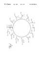
- FIG. 1depicts a well-known satellite-based navigational system referred to as Global Positioning System (GPS) 10 .
- Each satellite 12 -jorbiting earth at a known speed v j and being a known distance apart from the other satellites 12 -j.
- Each satellite 12 -jtransmits a GPS signal 11 -j which includes a carrier signal with a known frequency f modulated using a unique pseudo-random noise (PN-j) code and navigational data (ND-j) associated with the particular satellite 12 -j, wherein the PN-j code includes a unique sequence of PN chips and navigation data ND-j includes a satellite identifier, timing information and orbital data, such as elevation angle ⁇ j and azimuth angle ⁇ j .
- FIG. 2depicts a typical 20 ms frame of the GPS signal 11 -j which comprises twenty full sequences of a PN-j code in addition to a sequence of navigation data ND-j.
- GPS receiver 14detects GPS signals 11 -j via PN-j codes.
- Detecting GPS signals 12 -jinvolves a correlation process wherein correlators 16 -k are used to search for PN-j codes in a carrier frequency dimension and a code phase dimension.
- Such correlation processis implemented as a real-time multiplication of a phase shifted replicated PN-j codes modulated onto a replicated carrier signal with the received GPS signals 11 -j, followed by an integration and dump process.
- GPS receiver 14replicates carrier signals to match the frequencies of the GPS signals 11 -j as they arrive at GPS receiver 14 .
- the frequency f at which GPS signals 11 -j are transmittedchanges an unknown amount ⁇ f j before GPS signal 11 -j arrives at GPS receiver 14 — that is, each GPS signal 11 -j should have a frequency f+ ⁇ f j when it arrives at GPS receiver 14 .
- GPS receiver 14replicates the carrier signals across a frequency spectrums f spec ranging from f+ ⁇ f min to f+ ⁇ f max until the frequency of the replicated carrier signal matches the frequency of the received GPS signal 11 -j, wherein ⁇ f min and ⁇ f max are a minimum and maximum change in frequency GPS signals 11 -j will undergo due to the Doppler effect as they travel from satellites 12 -j to GPS receiver 14 , i.e., ⁇ f min ⁇ f j ⁇ f max .
- GPS receiver 14replicates the unique PN-j codes associated with each satellite 12 -j.
- the phases of the replicated PN-j codesare shifted across code phase spectrums R j (spec) until replicated carrier signals modulated with the replicated PN-j codes correlate, if at all, with GPS signals 11 -j being received by GPS receiver 14 , wherein each code phase spectrum R j (spec) includes every possible phase shift for the associated PN-j code.
- GPS receiver 14extracts the navigation data ND-j from the detected GPS signals 11 -j and uses the navigation data ND-j to determine a location for GPS receiver 14 , as is well-known in the art.
- Correlators 16 -kare configured to perform parallel searches for a plurality of PN-j codes across the frequency spectrum f spec and the code phase spectrums R f (spec). In other words, each of the plurality of correlators 16 -k are dedicated to searching for a particular PN-j code across each possible frequency between f+ ⁇ f min to f+ ⁇ f max and each possible for that PN-j code. When a correlator 16 -k completes its search for a PN-j code, the correlator 16 -k searches for another PN-j code across each possible frequency between f+ ⁇ f min to f+ ⁇ f max and each possible phase shift for that PN-j code.
- PN-j codesare collectively searched for by the plurality of correlators 16 -k. For example, suppose there are twelve satellites 12 -j, thus there would be twelve unique PN-j codes. If GPS receiver 14 has six correlators 16 -k, then GPS receiver 14 would use its correlators 16 -k to search for two sets of six different PN-j codes at a time. Specifically, correlators 16 -k search for the first six PN-j codes, i.e., correlator 16 - 1 searches for PN- 1 , correlator 16 - 2 searches for PN- 2 , etc.
- correlators 16 -ksearch for the next six PN-j codes, i.e., correlator 16 - 1 searches for PN- 7 , correlator 16 - 2 searches for PN- 8 , etc.
- correlator 16 -kFor each PN-j code being searched, correlator 16 -k performs an integration and dump process for each combination of frequency and phase shifts for that PN-j code. For example, suppose the frequency spectrum f spec includes 50 possible frequencies for the carrier signal and the code phase spectrum R f (spec) for a PN-j code includes 2,046 possible half-chip phase shifts. To search for every possible combination of frequency and half-chip phase shifts for the PN-j code, the correlator 16 -k would then need to perform 102,300 integrations.
- a typical integration time for correlators 16 -kis 1 ms, which is generally sufficient for GPS receiver 14 to detect GPS signals 11 -j when antenna 15 has a clear view of the sky or a direct line-of-sight to satellites 12 -j.
- 102.3 secondswould be required for one correlator 16 -k to search every possible combination of frequency and half-chip phase shifts for a PN-j code.
- GPS receiversare now being incorporated into mobile-telephones or other types of mobile communication devices which do not always have a clear view of the sky.
- GPS receiver 14will not always have a clear view of the sky.
- the signal-to-noise ratios of GPS signals 11 -j received by GPS receiver 14are typically much lower than when GPS receiver 14 does have a clear view of the sky, thus making it more difficult for GPS receiver 14 to detect the GPS signals 11 -j.
- correlators 16 -kcan be configured with longer integration times. A sufficient integration time, in this case, would be approximately 1 second.
- Wireless assisted GPS (WAG) systemswere developed to facilitate detection of GPS signals 11 -j by GPS receivers configured with short or long integration times.
- the WAG systemfacilitates detection of GPS signals 11 -j by reducing the number of integrations to be performed by correlators searching for GPS signals 11 -j.
- the number of integrationsis reduced by narrowing the frequency range and code phase ranges to be searched.
- the WAG systemlimits the search for GPS signals 11 -j to a specific frequency or frequencies and to a range of code phases less than the code phase spectrum R f (spec).
- FIG. 3depicts a WAG system 20 comprising a WAG server 22 , a plurality of base stations 23 and at least one WAG client 24 .
- WAG server 22includes a GPS receiver 26 having an antenna 27 installed in a known stationary location with a clear view of the sky. GPS receiver 26 would typically have correlators configured with short integration times because antenna 27 has a clear view of the sky.
- WAG server 22being operable to communicate with base stations 23 either via a wired or wireless interface.
- Each base station 23has a known location and provides communication services to WAG clients located within a geographical area or cell 25 associated with the base station 23 , wherein each cell 25 is a known size and is divided into a plurality of sectors.
- WAG client 24includes a GPS receiver 28 and perhaps a mobile-telephone 27 , and is typically in motion and/or in an unknown location with or without a clear view of the sky.
- GPS receiver 28having correlators typically configured with long integration times.
- mobile-telephonefor purposes of this application, shall be construed to include, but is not limited to, any communication device.
- FIG. 4is a flowchart 300 illustrating the operation of WAG system 20 .
- WAG server 22detects a plurality of satellites 12 -j via their GPS signals 11 -j using its GPS receiver 26 .
- WAG server 22acquires the following information from each detected satellite 12 -j: the identity of satellite 12 -j and frequency f j , code phase, elevation angle ⁇ j and azimuth angle ⁇ j associated with the detected satellite 12 -j, wherein the elevation angle ⁇ j is defined as the angle between the line of sight from WAG server 22 or client 24 to a satellite 12 -j and a projection of the line of sight on the horizontal plane, and the azimuth angle ⁇ j is defined as the angle between the projection of the line of sight on the horizontal plane and a projection of the north direction on the horizontal plane. See FIG. 5, which depicts an elevation angle ⁇ j and an azimuth angle ⁇ j corresponding to a satellite 12 -j and a WAG server 22 or WAG client
- WAG server 22receives sector information from base station 23 currently in communication with or serving WAG client 24 , wherein the sector information indicates a sector WAG client 24 is currently located.
- WAG server 22makes an initial estimate of WAG client's position based on the known location of the serving base station, the cell size associated with the serving base station, and the sector in which WAG client 24 is currently located. In one embodiment, WAG server 22 initially estimates that WAG client 24 is located at a reference point within the sector, e.g., point at approximate center of sector. In another embodiment, WAG server 22 initially estimates WAG client 24 's position using well-known forward link triangulation techniques.
- WAG server 22uses the information acquired from the detected GPS signals 11 -j to predict a frequency f j (r) at the reference point and a code phase search range R j (sect) which includes all possible code phases for GPS signal 11 -j arriving anywhere within the sector where WAG client 24 is currently located.
- WAG server 22transmits a search message to the serving base station 23 , wherein the search message includes, for each detected satellite 12 -j, information regarding the associated PN-j code, predicted frequency f j (r) and code phase search range R j(sect).
- serving base station 23transmits the search message to WAG client 24 which, in step 360 , begins a parallel search for the satellites 12 -j indicated in the search message.
- WAG client 24will use its correlators to simultaneously search for each of the GPS signals 11 -j at the predicted frequency f j (r) within the limitations of the code phase search range R j (sect) indicated in the search message.
- the number of integrationsis reduced to the predicted frequency f j (r) within the limitations of the code phase search range R j (sect).
- the search timeis still considered time consuming. Accordingly, there exists a need to facilitate detection of satellites 12 -j particularly when GPS receiver correlators are configured with longer integration times.
- the present inventionis a method and apparatus for facilitating detection of satellite signals using a sequential search technique.
- the present inventionuses a sequential search technique to sequentially search for satellite signals based on information in a search message. Information accumulated during prior searches of satellite signals is then used, in conjunction with the information in the search message, to effectively reduce the area and code phase search ranges in which a GPS receiver searches for other satellite signals.
- the GPS receiveruses a plurality of its correlators to search for a first satellite indicated in a search message based on the one or more of the following criteria: maximize utilization of correlators; minimize search time; and maximize the amount of information regarding location of the GPS receiver.
- the GPS receiveruses its correlators to search for a second satellite indicated in the search message based information acquired upon detecting the first satellite and on one or more of the following criteria: maximize utilization of correlators; minimize search time; and maximize the amount of additional information regarding location of the GPS receiver when used in conjunction with the information obtained from a signal transmitted by the first satellite.
- Information acquired upon detecting the first and second satellitesare used to predict an area in which the GPS receiver may be located.
- Such areais typically an area much smaller than the size of the sector in which the GPS receiver is currently located.
- code phase search ranges R j (pred)are predicted for the remaining satellites indicated in the search message.
- the predicted code phase search ranges R f (pred)are narrower than code phase search ranges R j (sect) indicated in the search message.
- the GPS receiveruses the predicted code phase search ranges and frequencies indicated in the search message to perform a parallel search for two or more of the remaining satellites. Upon detecting some or all of the satellites indicated in the search message, a position of the GPS receiver can be estimated using navigation data in signals transmitted by the detected satellites.
- FIG. 1depicts a well-known satellite-based navigational system referred to as Global Positioning System (GPS);
- GPSGlobal Positioning System
- FIG. 2depicts a typical 20 ms frame of a GPS signal
- FIG. 3depicts a Wireless Assisted GPS (WAG) system
- FIG. 4depicts a flowchart illustrating the operation of the WAG system of FIG. 3;
- FIG. 5depicts an elevation angle ⁇ j and an azimuth angle ⁇ j corresponding to a satellite and a WAG server or WAG client;
- FIG. 6is a flowchart illustrating a sequential search technique used in accordance with one embodiment of the present invention.
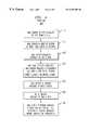
- FIG. 6is a flowchart 600 illustrating a sequential search technique use in accordance with one embodiment of the present invention.
- WAG client 24receives a search message from its serving base station 23 or WAG server 22 .
- the search messageincludes, for each satellite 12 -j detected by WAG server 22 , information regarding the associated PN-j code, predicted frequency f j (r) at a reference point within the sector/cell where WAG client 24 is currently located, code phase search range R f (sect) including all possible phase shifts for a GPS signal 11 -j transmitted by satellite 12 -j and arriving within the sector/cell where WAG client 24 is currently located, and orbital data including elevation angle ⁇ j and azimuth angle ⁇ j .
- WAG client 24selects a first satellite 12 -j indicated search message to search.
- WAG client 24uses one or more criteria in a set of first satellite selection criteria to select the first satellite 12 -j.
- the set of first satellite/selection criteriaare as follows: (1) maximize utilization of correlators; (2) minimize search time; and (3) maximize the amount of information regarding location of WAG client 24 (or GPS receiver 14 or antenna 15 ).
- the first criteria of maximizing utilization of correlatorsinvolves using as many of the available correlators to simultaneously search for a satellite 12 -j.
- the second criteria of minimizing search timeinvolves reducing the number of integrations to be performed by each correlator, e.g., each correlator performs one integration. Reducing the number of integrations to be performed by each correlator essentially means selecting a satellite 12 -j having the smallest associated code phase search range R, indicated in the search message.
- the third criteria of maximizing the amount of information regarding the location of WAG client 24involves selecting a satellite 12 -j that, when detected will indicate an area in the sector where WAG client 24 is located. For example, a satellite 12 -j with a small elevation angle ⁇ j , when detected, will indicate strait in the sector where WAG client is located, whereas a satellite 12 -j with a large elevation angle ⁇ j will indicate a wider strait in the sector where WAG client is located.
- WAG client 24Upon selecting a first satellite 12 -j to be searched, in step 620 , WAG client 24 searches for the first satellite 12 -j using the frequency f j (r) and code phase search range R j (sect) indicated in the search message for the first satellite 12 -j. Once the first satellite 12 -j has been detected, in step 630 , WAG client 24 predicts a first area in which WAG client 24 may be located using information extracted from a GPS signal 11 I j transmitted by the first satellite 12 -j, as is well-known in the art. The first predicted area typically being a strait or small area within the sector where WAG client 24 is currently located. Such calculation is later used to narrow down the code phase search range R j of subsequent satellite searches.
- WAG client 24uses the search message to pick a second satellite 12 -j to search.
- WAG client 24uses one or more criteria in a set of second satellite selection criteria to select the second satellite 12 -j.
- the set of second satellite selection criteriaare as follows: (1) maximize utilization of correlators; (2) minimize search time; and (3) maximize the amount of additional information regarding location of WAG client 24 (or GPS receiver 14 or antenna 15 ) when used in conjunction with the results of the first search.
- the first and second criteriabeing identical to the first and second criteria of step 610 .
- the third criteriainvolves selecting a second satellite 12 -j that will result in an area which intersects/least, but nevertheless intersects, with the first predicted area.
- the second satellite 12 -j selectedis a satellite 12 -j that forms an angle of approximately 90° with the first satellite and WAG server 22 or WAG client 24 , wherein WAG server 22 or WAG client 24 is the vertex.
- the angle between the fist and second satellites and WAG server 22 or client 24can be determined using a difference between azimuth angles associated with the first and second satellites.
- WAG client 24redefines or narrows down the code phase search range R j (sect) indicated in the search message for the second satellite 12 -j based on the first predicted area.
- the redefined or narrowed down code phase search range R j (sect)is hereinafter referred to as a “predicted code phase search range R j (pred).”
- the predicted code phase search range R j (pred) for the second satelliteincludes all possible phase shifts for GPS signals 11 -j transmitted by the second satellite and arriving in the first predicted area.
- the corresponding predicted code phase search range R j (pred)will be narrower than the corresponding code phase search range R j (sect) originally indicated in the search message for the second satellite.
- WAG client 24searches for the second satellite 12 -j using the frequency f j (r) indicated in the search message and the predicted code phase search range R j (pred) for the second satellite 12 -j.
- WAG client 24predicts a second area in which WAG client 24 may be located using information extracted from a GPS signal 11 -j transmitted by the second satellite 12 -j.
- the second predicted areais typically a strait or small area within the sector in which WAG client 24 is currently located.
- step 660WAG client 24 uses the intersected area and the code phase search range R j (sect) indicated in the search message to predict code phase search range R j (pred) for the remaining satellites 12 -j indicated in the search message, thereby facilitating detection of the remaining satellites 12 -j.
- Such predicted code phase search ranges R j (pred)include code phases for GPS signals 11 -j transmitted by the remaining satellites indicated in the search message and arriving anywhere within the intersected area.
- WAG client 24searches for the remaining satellites 12 -j within the confines of the predicted code phase search ranges R j (pred) for the remaining satellites 12 -j.
- WAG client 24uses its correlators to perform parallel searches for two or more remaining satellites 12 -j.
- WAG client 24calculates its location using the navigation data ND-j extracted from GPS signals 11 -j transmitted by at least three satellites 11 -j, as is well-known in the art.
- the present inventionis described herein with reference to certain embodiments, including an embodiment in which the first, second and all or some of the remaining satellites are searched sequentially.
- the sequential search of the present inventionmay involve GPS receiver 28 searching in parallel for the fist and second satellites, and then searching in parallel for all or some of the remaining satellites.
- the present inventionis also applicable to non-GPS satellite-based or non-satellite-based navigation system. Accordingly, the present invention should not be limited to the embodiments disclosed herein.
Landscapes
- Engineering & Computer Science (AREA)
- Radar, Positioning & Navigation (AREA)
- Remote Sensing (AREA)
- Computer Networks & Wireless Communication (AREA)
- Physics & Mathematics (AREA)
- General Physics & Mathematics (AREA)
- Position Fixing By Use Of Radio Waves (AREA)
Abstract
Description
Related subject matter is disclosed in the following applications and assigned to the same Assignee hereof: U.S. patent application Ser. No. 08/927,434 entitled “An Auxiliary System For Assisting A Wireless Terminal In Determining Its Position From Signals Transmitted From A Navigation Satellite,” inventors Robert Ellis Richton and Giovanni Vannucci; U.S. patent application Ser. No. 08/927,432 entitled “Telecommunications Assisted Satellite Positioning System,” inventors Giovanni Vannucci; U.S. patent application Ser. No. 09/321,075 entitled “Wireless Assisted GPS Using A Reference Location,” inventors Robert Ellis Richton and Giovanni Vannucci; and U.S. patent application Ser. No. 60/114,491 entitled “Wireless Assisted Satellite Location Using a Reference Point,” inventors Robert Ellis Richton and Giovanni Vannucci. Related subject matter is disclosed in the following application filed concurrently herewith and assigned to the same Assignee hereof: U.S. patent application entitled “Satellite-Based Location System Employing Dynamic Integration Techniques”, Ser. No. 09/391,123.
The present invention relates generally to wireless communication systems and, in particular, to satellite-based location systems.
Satellite-based navigational systems provide accurate, three dimensional position information to worldwide users. Prior art satellite-based navigational systems, however, utilize a time consuming search process for determining position information. Time consuming search processes are undesirable in navigational systems particularly when the user is moving or in an emergency situation requiring immediate assistance.
FIG. 1 depicts a well-known satellite-based navigational system referred to as Global Positioning System (GPS)10.GPS 10 comprises a plurality of satellites12-j and at least oneGPS receiver 14, where j=1,2, . . . ,n. Each satellite12-j orbiting earth at a known speed vjand being a known distance apart from the other satellites12-j. Each satellite12-j transmits a GPS signal11-j which includes a carrier signal with a known frequency f modulated using a unique pseudo-random noise (PN-j) code and navigational data (ND-j) associated with the particular satellite12-j, wherein the PN-j code includes a unique sequence of PN chips and navigation data ND-j includes a satellite identifier, timing information and orbital data, such as elevation angle αjand azimuth angle φj. FIG. 2 depicts a typical20 ms frame of the GPS signal11-j which comprises twenty full sequences of a PN-j code in addition to a sequence of navigation data ND-j.
In the carrier frequency dimension,GPS receiver 14 replicates carrier signals to match the frequencies of the GPS signals11-j as they arrive atGPS receiver 14. However, due to the Doppler effect, the frequency f at which GPS signals11-j are transmitted changes an unknown amount Δfjbefore GPS signal11-j arrives atGPS receiver 14— that is, each GPS signal11-j should have a frequency f+Δfjwhen it arrives atGPS receiver 14. To account for the Doppler effect,GPS receiver 14 replicates the carrier signals across a frequency spectrums fspecranging from f+Δfminto f+Δfmaxuntil the frequency of the replicated carrier signal matches the frequency of the received GPS signal11-j, wherein Δfminand Δfmaxare a minimum and maximum change in frequency GPS signals11-j will undergo due to the Doppler effect as they travel from satellites12-j toGPS receiver 14, i.e., Δfmin≦Δfj≦Δfmax.
In the code phase dimension,GPS receiver 14 replicates the unique PN-j codes associated with each satellite12-j. The phases of the replicated PN-j codes are shifted across code phase spectrums Rj(spec) until replicated carrier signals modulated with the replicated PN-j codes correlate, if at all, with GPS signals11-j being received byGPS receiver 14, wherein each code phase spectrum Rj(spec) includes every possible phase shift for the associated PN-j code. When GPS signals11-j are detected by correlators16-k,GPS receiver 14 extracts the navigation data ND-j from the detected GPS signals11-j and uses the navigation data ND-j to determine a location forGPS receiver 14, as is well-known in the art.
Correlators16-k are configured to perform parallel searches for a plurality of PN-j codes across the frequency spectrum fspecand the code phase spectrums Rf(spec). In other words, each of the plurality of correlators16-k are dedicated to searching for a particular PN-j code across each possible frequency between f+Δfminto f+Δfmaxand each possible for that PN-j code. When a correlator16-k completes its search for a PN-j code, the correlator16-k searches for another PN-j code across each possible frequency between f+Δfminto f+Δfmaxand each possible phase shift for that PN-j code. This process continues until all PN-j codes are collectively searched for by the plurality of correlators16-k. For example, suppose there are twelve satellites12-j, thus there would be twelve unique PN-j codes. IfGPS receiver 14 has six correlators16-k, thenGPS receiver 14 would use its correlators16-k to search for two sets of six different PN-j codes at a time. Specifically, correlators16-k search for the first six PN-j codes, i.e., correlator16-1 searches for PN-1, correlator16-2 searches for PN-2, etc. Upon completing the search for the first six PN-j codes, correlators16-k search for the next six PN-j codes, i.e., correlator16-1 searches for PN-7, correlator16-2 searches for PN-8, etc.
For each PN-j code being searched, correlator16-k performs an integration and dump process for each combination of frequency and phase shifts for that PN-j code. For example, suppose the frequency spectrum fspecincludes 50 possible frequencies for the carrier signal and the code phase spectrum Rf(spec) for a PN-j code includes 2,046 possible half-chip phase shifts. To search for every possible combination of frequency and half-chip phase shifts for the PN-j code, the correlator16-k would then need to perform 102,300 integrations. A typical integration time for correlators16-k is 1 ms, which is generally sufficient forGPS receiver 14 to detect GPS signals11-j whenantenna 15 has a clear view of the sky or a direct line-of-sight to satellites12-j. Thus, for the above example, 102.3 seconds would be required for one correlator16-k to search every possible combination of frequency and half-chip phase shifts for a PN-j code.
GPS receivers, however, are now being incorporated into mobile-telephones or other types of mobile communication devices which do not always have a clear view of the sky. Thus,GPS receiver 14 will not always have a clear view of the sky. In this situation, the signal-to-noise ratios of GPS signals11-j received byGPS receiver 14 are typically much lower than whenGPS receiver 14 does have a clear view of the sky, thus making it more difficult forGPS receiver 14 to detect the GPS signals11-j. To compensate for weaker signal-to-noise ratios and enhance detection of GPS signals11-j, correlators16-k can be configured with longer integration times. A sufficient integration time, in this case, would be approximately 1 second. Thus, for the example above, 102,300 seconds would be required for a correlator16-k to search for every possible combination of frequency and half-chip phase shifts for a PN-j code. Longer integration times result in longer acquisition times for detecting GPS signals11-j. Longer acquisition times are undesirable.
Wireless assisted GPS (WAG) systems were developed to facilitate detection of GPS signals11-j by GPS receivers configured with short or long integration times. The WAG system facilitates detection of GPS signals11-j by reducing the number of integrations to be performed by correlators searching for GPS signals11-j. The number of integrations is reduced by narrowing the frequency range and code phase ranges to be searched. Specifically, the WAG system limits the search for GPS signals11-j to a specific frequency or frequencies and to a range of code phases less than the code phase spectrum Rf(spec).
FIG. 3 depicts aWAG system 20 comprising aWAG server 22, a plurality ofbase stations 23 and at least oneWAG client 24. WAGserver 22 includes aGPS receiver 26 having anantenna 27 installed in a known stationary location with a clear view of the sky.GPS receiver 26 would typically have correlators configured with short integration times becauseantenna 27 has a clear view of the sky. WAGserver 22 being operable to communicate withbase stations 23 either via a wired or wireless interface. Eachbase station 23 has a known location and provides communication services to WAG clients located within a geographical area orcell 25 associated with thebase station 23, wherein eachcell 25 is a known size and is divided into a plurality of sectors. WAGclient 24 includes aGPS receiver 28 and perhaps a mobile-telephone 27, and is typically in motion and/or in an unknown location with or without a clear view of the sky.GPS receiver 28 having correlators typically configured with long integration times. Note that the term “mobile-telephone,” for purposes of this application, shall be construed to include, but is not limited to, any communication device.
FIG. 4 is a flowchart300 illustrating the operation ofWAG system 20. Instep 310, WAGserver 22 detects a plurality of satellites12-j via their GPS signals11-j using itsGPS receiver 26. WAGserver 22 acquires the following information from each detected satellite12-j: the identity of satellite12-j and frequency fj, code phase, elevation angle αjand azimuth angle φjassociated with the detected satellite12-j, wherein the elevation angle αjis defined as the angle between the line of sight from WAGserver 22 orclient 24 to a satellite12-j and a projection of the line of sight on the horizontal plane, and the azimuth angle φjis defined as the angle between the projection of the line of sight on the horizontal plane and a projection of the north direction on the horizontal plane. See FIG. 5, which depicts an elevation angle αjand an azimuth angle φjcorresponding to a satellite12-j and aWAG server 22 orWAG client 24.
Instep 315,WAG server 22 receives sector information frombase station 23 currently in communication with or servingWAG client 24, wherein the sector information indicates asector WAG client 24 is currently located. Instep 320,WAG server 22 makes an initial estimate of WAG client's position based on the known location of the serving base station, the cell size associated with the serving base station, and the sector in whichWAG client 24 is currently located. In one embodiment,WAG server 22 initially estimates thatWAG client 24 is located at a reference point within the sector, e.g., point at approximate center of sector. In another embodiment,WAG server 22 initially estimatesWAG client 24's position using well-known forward link triangulation techniques.
Instep 330, for each detected satellite12-j,WAG server 22 uses the information acquired from the detected GPS signals11-j to predict a frequency fj(r) at the reference point and a code phase search range Rj(sect) which includes all possible code phases for GPS signal11-j arriving anywhere within the sector whereWAG client 24 is currently located. Instep 340,WAG server 22 transmits a search message to the servingbase station 23, wherein the search message includes, for each detected satellite12-j, information regarding the associated PN-j code, predicted frequency fj(r) and code phase search range Rj(sect).
Instep 350, servingbase station 23 transmits the search message toWAG client 24 which, instep 360, begins a parallel search for the satellites12-j indicated in the search message. Specifically,WAG client 24 will use its correlators to simultaneously search for each of the GPS signals11-j at the predicted frequency fj(r) within the limitations of the code phase search range Rj(sect) indicated in the search message. Thus, the number of integrations is reduced to the predicted frequency fj(r) within the limitations of the code phase search range Rj(sect). However, due to the long integration times ofGPS receiver 28 inWAG client 24, the search time is still considered time consuming. Accordingly, there exists a need to facilitate detection of satellites12-j particularly when GPS receiver correlators are configured with longer integration times.
The present invention is a method and apparatus for facilitating detection of satellite signals using a sequential search technique. The present invention uses a sequential search technique to sequentially search for satellite signals based on information in a search message. Information accumulated during prior searches of satellite signals is then used, in conjunction with the information in the search message, to effectively reduce the area and code phase search ranges in which a GPS receiver searches for other satellite signals.
In one embodiment, the GPS receiver uses a plurality of its correlators to search for a first satellite indicated in a search message based on the one or more of the following criteria: maximize utilization of correlators; minimize search time; and maximize the amount of information regarding location of the GPS receiver. Subsequently, the GPS receiver uses its correlators to search for a second satellite indicated in the search message based information acquired upon detecting the first satellite and on one or more of the following criteria: maximize utilization of correlators; minimize search time; and maximize the amount of additional information regarding location of the GPS receiver when used in conjunction with the information obtained from a signal transmitted by the first satellite. Information acquired upon detecting the first and second satellites are used to predict an area in which the GPS receiver may be located. Such area is typically an area much smaller than the size of the sector in which the GPS receiver is currently located. Based on the predicted area, code phase search ranges Rj(pred) are predicted for the remaining satellites indicated in the search message. Advantageously, the predicted code phase search ranges Rf(pred) are narrower than code phase search ranges Rj(sect) indicated in the search message. The GPS receiver uses the predicted code phase search ranges and frequencies indicated in the search message to perform a parallel search for two or more of the remaining satellites. Upon detecting some or all of the satellites indicated in the search message, a position of the GPS receiver can be estimated using navigation data in signals transmitted by the detected satellites.
The features, aspects, and advantages of the present invention will become better understood with regard to the following description, appended claims, and accompanying drawings where:
FIG. 1 depicts a well-known satellite-based navigational system referred to as Global Positioning System (GPS);
FIG. 2 depicts a typical 20 ms frame of a GPS signal;
FIG. 3 depicts a Wireless Assisted GPS (WAG) system;
FIG. 4 depicts a flowchart illustrating the operation of the WAG system of FIG. 3;
FIG. 5 depicts an elevation angle αjand an azimuth angle φjcorresponding to a satellite and a WAG server or WAG client; and
FIG. 6 is a flowchart illustrating a sequential search technique used in accordance with one embodiment of the present invention.
The present invention is described herein with reference to the aforementioned WAG system. This should not be construed, however, to limit the present invention any manner.
FIG. 6 is a flowchart600 illustrating a sequential search technique use in accordance with one embodiment of the present invention. Instep 605,WAG client 24 receives a search message from its servingbase station 23 orWAG server 22. In the present invention, the search message includes, for each satellite12-j detected byWAG server 22, information regarding the associated PN-j code, predicted frequency fj(r) at a reference point within the sector/cell whereWAG client 24 is currently located, code phase search range Rf(sect) including all possible phase shifts for a GPS signal11-j transmitted by satellite12-j and arriving within the sector/cell whereWAG client 24 is currently located, and orbital data including elevation angle αjand azimuth angle φj.
Instep 610,WAG client 24 selects a first satellite12-j indicated search message to search.WAG client 24 uses one or more criteria in a set of first satellite selection criteria to select the first satellite12-j. In one embodiment, the set of first satellite/selection criteria are as follows: (1) maximize utilization of correlators; (2) minimize search time; and (3) maximize the amount of information regarding location of WAG client24 (orGPS receiver 14 or antenna15). The first criteria of maximizing utilization of correlators involves using as many of the available correlators to simultaneously search for a satellite12-j. The second criteria of minimizing search time involves reducing the number of integrations to be performed by each correlator, e.g., each correlator performs one integration. Reducing the number of integrations to be performed by each correlator essentially means selecting a satellite12-j having the smallest associated code phase search range R, indicated in the search message.
The third criteria of maximizing the amount of information regarding the location ofWAG client 24 involves selecting a satellite12-j that, when detected will indicate an area in the sector whereWAG client 24 is located. For example, a satellite12-j with a small elevation angle αj, when detected, will indicate strait in the sector where WAG client is located, whereas a satellite12-j with a large elevation angle αjwill indicate a wider strait in the sector where WAG client is located.
Upon selecting a first satellite12-j to be searched, instep 620,WAG client 24 searches for the first satellite12-j using the frequency fj(r) and code phase search range Rj(sect) indicated in the search message for the first satellite12-j. Once the first satellite12-j has been detected, instep 630,WAG client 24 predicts a first area in whichWAG client 24 may be located using information extracted from a GPS signal11I j transmitted by the first satellite12-j, as is well-known in the art. The first predicted area typically being a strait or small area within the sector whereWAG client 24 is currently located. Such calculation is later used to narrow down the code phase search range Rjof subsequent satellite searches.
Instep 640,WAG client 24 uses the search message to pick a second satellite12-j to search.WAG client 24 uses one or more criteria in a set of second satellite selection criteria to select the second satellite12-j. In one embodiment, the set of second satellite selection criteria are as follows: (1) maximize utilization of correlators; (2) minimize search time; and (3) maximize the amount of additional information regarding location of WAG client24 (orGPS receiver 14 or antenna15) when used in conjunction with the results of the first search. The first and second criteria being identical to the first and second criteria ofstep 610. The third criteria involves selecting a second satellite12-j that will result in an area which intersects/least, but nevertheless intersects, with the first predicted area. In one embodiment, the second satellite12-j selected is a satellite12-j that forms an angle of approximately 90° with the first satellite andWAG server 22 orWAG client 24, whereinWAG server 22 orWAG client 24 is the vertex. The angle between the fist and second satellites andWAG server 22 orclient 24 can be determined using a difference between azimuth angles associated with the first and second satellites.
Instep 645,WAG client 24 redefines or narrows down the code phase search range Rj(sect) indicated in the search message for the second satellite12-j based on the first predicted area. The redefined or narrowed down code phase search range Rj(sect) is hereinafter referred to as a “predicted code phase search range Rj(pred).” The predicted code phase search range Rj(pred) for the second satellite includes all possible phase shifts for GPS signals11-j transmitted by the second satellite and arriving in the first predicted area. Since the first predicted area is a strait or small area within the sector whereWAG client 24 is currently located, the corresponding predicted code phase search range Rj(pred) will be narrower than the corresponding code phase search range Rj(sect) originally indicated in the search message for the second satellite.
Instep 650,WAG client 24 searches for the second satellite12-j using the frequency fj(r) indicated in the search message and the predicted code phase search range Rj(pred) for the second satellite12-j. Once the second satellite12-j has been detected instep 655,WAG client 24 predicts a second area in whichWAG client 24 may be located using information extracted from a GPS signal11-j transmitted by the second satellite12-j. Like the first predicted area, the second predicted area is typically a strait or small area within the sector in whichWAG client 24 is currently located.
The intersection of the first and second predicted areas effectively reduces the size of the search area in whichWAG client 24 may be located. Instep 660,WAG client 24 uses the intersected area and the code phase search range Rj(sect) indicated in the search message to predict code phase search range Rj(pred) for the remaining satellites12-j indicated in the search message, thereby facilitating detection of the remaining satellites12-j. Such predicted code phase search ranges Rj(pred) include code phases for GPS signals11-j transmitted by the remaining satellites indicated in the search message and arriving anywhere within the intersected area.
Instep 670,WAG client 24 searches for the remaining satellites12-j within the confines of the predicted code phase search ranges Rj(pred) for the remaining satellites12-j. In an embodiment of the present invention,WAG client 24 uses its correlators to perform parallel searches for two or more remaining satellites12-j. Upon detecting the remaining satellites12-j, instep 680,WAG client 24 calculates its location using the navigation data ND-j extracted from GPS signals11-j transmitted by at least three satellites11-j, as is well-known in the art.
The present invention is described herein with reference to certain embodiments, including an embodiment in which the first, second and all or some of the remaining satellites are searched sequentially. Other embodiments are possible. For example, the sequential search of the present invention may involveGPS receiver 28 searching in parallel for the fist and second satellites, and then searching in parallel for all or some of the remaining satellites. The present invention is also applicable to non-GPS satellite-based or non-satellite-based navigation system. Accordingly, the present invention should not be limited to the embodiments disclosed herein.
Claims (28)
1. A method for detecting a plurality of signals comprising the steps of:
searching for a first signal using a first set of parameters;
predicting a first area using information obtained upon detecting the first signal;
searching for a second signal using a second set of parameters; and
searching for other signals using a third set of parameters, the first predicted area and information obtained upon detecting the second signal.
2. The method ofclaim 1 , wherein a plurality of correlators are used to sequentially searched for the first, second and other signals.
3. The method ofclaim 1 , wherein the step of searching for the second signal includes using information obtained upon detecting the first signal.
4. The method ofclaim 1 , wherein the first, second and other signals are associated with unique codes and the first, second and third sets of parameters indicate at least one frequency and a plurality of code phase search ranges at which to search for the first, second and other signals.
5. The method ofclaim 4 , wherein the information obtained upon detecting the first and second signals is used to redefine one or more of the code phase search ranges indicated in the third set of parameters.
6. The method ofclaim 1 , wherein the first, second and third sets of parameters are based on an initial position estimate.
7. The method ofclaim 1 comprising the additional step of:
determining a position using the information obtained upon detecting the first and second signals and information obtained upon detecting the other signals.
8. A method for detecting satellite signals comprising the steps of:
receiving with an antenna a search message indicating a plurality of satellites and sets of parameters, wherein the sets of parameters indicate at least one frequency and a plurality of code phase search ranges, elevation angles and azimuth angles for each of the plurality of satellites indicated in the search message;
searching for a first signal transmitted by a first satellite indicated in the search message using a first set of parameters;
searching for a second signal transmitted by a second satellite indicated in the search message using a second set of parameters;
searching for other signals transmitted by other satellites indicated in the search message using a third set of parameters and information obtained upon detecting the first and second signals.
9. The method ofclaim 8 , wherein the frequency indicated in the search message is based on an initial position estimate of the antenna.
10. The method ofclaim 8 , wherein the plurality of code phase search ranges indicated in the search message include all possible phase shifts for the first, second and other signals arriving within a sector in which the antenna is currently located.
11. The method ofclaim 8 , wherein the first satellite is a satellite with a small elevation angle relative to a majority of the elevation angles associated with the other satellites indicated in the search message.
12. The method ofclaim 8 , wherein the second satellite is a satellite that an angle of approximately ninety degrees with the first satellite and the antenna.
13. A method for detecting satellite signals comprising the steps of:
receiving with an antenna a search message indicating a plurality of satellites and sets of parameters;
searching for a first signal transmitted by a first satellite indicated in the search message using a first set of parameters;
predicting a first area in which the antenna is currently located using information obtained from the first signal;
searching for a second signal transmitted by a second satellite indicated in the search message using a second set of parameters;
searching for other signals transmitted by other satellites indicated in the search message using a third set of parameters and information obtained upon detecting the first and second signals.
14. The method ofclaim 13 , comprising the additional step of:
redefining a code phase search range indicated in the search message for the second satellite using the first predicted area.
15. The method ofclaim 14 , wherein the redefined code phase search range for the second satellite is used to search for the second signal.
16. The method ofclaim 15 , wherein the second satellite is a satellite that provides information for predicting a second area in which the antenna is currently located that intersects least with the first area.
17. The method ofclaim 16 comprising the additional steps of:
predicting a second area in which the antenna is currently located using information obtained upon detecting the second signal.
18. The method ofclaim 17 comprising the additional step of:
redefining code phase search ranges indicated in the search message for at least one of the other satellites based on an intersection between the first and second areas.
19. The method of18, wherein the at least one of the other satellites indicated in the search message is searched for using the redefined code phase search ranges.
20. A receiver comprising:
an antenna for receiving signals;
means for selecting a first satellite signal to search based on at least one criteria from a set of first satellite selection criteria;
means for selecting a second satellite signal to search based on at least one criteria from a set of second satellite selection criteria;
a plurality of correlators configured to sequentially search for the first satellite signal using a first set of parameters, the second satellite signal using a second set of parameters and other satellite signals using a third set of parameters and information obtained upon detecting the first and second satellite signals, wherein the first, second and third sets of parameters indicate at least one frequency and a plurality of code phase search ranges;
means for predicting a first area using the first satellite signal;
means for redefining a code phase search range indicated in the second set of parameters using the first predicted area.
21. A receiver comprising:
an antenna for receiving signals;
means for selecting a first satellite signal to search based on at least one criteria from a set of first satellite selection criteria;
means for predicting a first area based on information acquired upon detecting the first satellite signal;
means for selecting a second satellite signal to search based on at least one criteria from a set of second satellite selection criteria;
a plurality of correlators configured to sequentially search for the first satellite signal using a first set of parameters, the second satellite signal using a second set of parameters and other satellite signals using a third set of parameters and information obtained upon detecting the first and second satellite signals, wherein the first, second and third sets of parameters indicate at least one frequency and a plurality of code phase search ranges.
22. The receiver ofclaim 21 further comprising:
means for redefining a code phase search range indicated in the second set of parameters using the first area, wherein the plurality of correlators search for the second satellite signal using the redefined code phase search range indicated in the second set of parameters.
23. The receiver ofclaim 22 further comprising:
means for predicting a second area based on information acquired upon detecting the second satellite signal.
24. The receiver ofclaim 23 further comprising:
means for redefining code phase search ranges indicated in the third set of parameters using the first and second areas, wherein the plurality of correlators search for the other satellite signals using the redefined code phase search ranges indicated in the third set of parameters.
25. A receiver comprising:
an antenna for receiving signals;
means for selecting a first satellite signal to search based on at least one criteria from a set of first satellite selection criteria;
means for selecting a second satellite signal to search based on at least one criteria from a set of second satellite selection criteria;
a plurality of correlators configured to sequentially search for the first satellite signal using a first set of parameters, the second satellite signal using a second set of parameters and other satellite signals using a third set of parameters and information obtained upon detecting the first and second satellite signals, wherein the first, second and third sets of parameters indicate at least one frequency and a plurality of code phase search ranges;
means for predicting a first area using the first satellite signal and a second area using the second satellite signal;
means for redefining code phase search ranges indicated in the third set of parameters using the first and second predicted areas.
26. The receiver ofclaim 20 ,21, or25 wherein the first, second and third sets of parameters indicate at least one frequency and a plurality of code phase search ranges at which to search for the first, second and other satellite signals.
27. The receiver ofclaim 20 ,21 or25 further comprising:
means for replicating carrier signals having frequencies ranging from f+Δfminand f+Δfmax, wherein Δfminand Δfmaxare a minimum and maximum change in frequency the first, second and other satellite signals will undergo due to a Doppler effect.
28. The receiver ofclaim 20 ,21 or25 further comprising:
means for replicating codes associated with the first, second and other satellite signals.
Priority Applications (9)
| Application Number | Priority Date | Filing Date | Title |
|---|---|---|---|
| US09/392,765US6459405B1 (en) | 1999-09-07 | 1999-09-07 | Satellite-based location system employing knowledge-based sequential signal search strategy |
| EP00307389AEP1083441A3 (en) | 1999-09-07 | 2000-08-29 | Satellite-based location system employing knowledge-based sequential signal search strategy |
| BR0003879-2ABR0003879A (en) | 1999-09-07 | 2000-08-30 | Satellite-assisted location system using sequential signal search strategy based on information |
| JP2000262275AJP2001108736A (en) | 1999-09-07 | 2000-08-31 | System for confirming position by satellite using knowledge-based successive signal serch system |
| CA2317200ACA2317200A1 (en) | 1999-09-07 | 2000-08-31 | Satellite-based location system employing knowledge-based sequential signal search strategy |
| AU55060/00AAU5506000A (en) | 1999-09-07 | 2000-08-31 | Satellite-based location system employing knowledge-based sequential signal search strategy |
| KR1020000052324AKR20010050336A (en) | 1999-09-07 | 2000-09-05 | Satellite-based location system employing knowledge-based sequential signal search strategy |
| CN00126843ACN1287274A (en) | 1999-09-07 | 2000-09-06 | Satellite primary fixer system using policy of cognitive base sequential signal search |
| IDP20000759DID27183A (en) | 1999-09-07 | 2000-09-06 | SATELLITE-BASED LOCATION SYSTEM USING SEQUENTIAL SIGNAL SEARCH STRATEGIES BASED ON KNOWLEDGE. |
Applications Claiming Priority (1)
| Application Number | Priority Date | Filing Date | Title |
|---|---|---|---|
| US09/392,765US6459405B1 (en) | 1999-09-07 | 1999-09-07 | Satellite-based location system employing knowledge-based sequential signal search strategy |
Publications (1)
| Publication Number | Publication Date |
|---|---|
| US6459405B1true US6459405B1 (en) | 2002-10-01 |
Family
ID=23551917
Family Applications (1)
| Application Number | Title | Priority Date | Filing Date |
|---|---|---|---|
| US09/392,765Expired - LifetimeUS6459405B1 (en) | 1999-09-07 | 1999-09-07 | Satellite-based location system employing knowledge-based sequential signal search strategy |
Country Status (9)
| Country | Link |
|---|---|
| US (1) | US6459405B1 (en) |
| EP (1) | EP1083441A3 (en) |
| JP (1) | JP2001108736A (en) |
| KR (1) | KR20010050336A (en) |
| CN (1) | CN1287274A (en) |
| AU (1) | AU5506000A (en) |
| BR (1) | BR0003879A (en) |
| CA (1) | CA2317200A1 (en) |
| ID (1) | ID27183A (en) |
Cited By (14)
| Publication number | Priority date | Publication date | Assignee | Title |
|---|---|---|---|---|
| US20040125763A1 (en)* | 2002-12-05 | 2004-07-01 | Galetti Ralph R. | Serial port multiplexing protocol |
| US20040203400A1 (en)* | 2002-12-05 | 2004-10-14 | Galetti Ralph R. | Communications protocol for mobile device |
| US20040203952A1 (en)* | 2002-12-05 | 2004-10-14 | Galetti Ralph R. | Programmable messages for communication system having one-button user interface |
| US20060245480A1 (en)* | 1999-12-30 | 2006-11-02 | Infineon Technologies Ag | Fast initial acquisition & search device for a spread spectrum communication system |
| US20060250304A1 (en)* | 2005-05-06 | 2006-11-09 | Jun Mo | System and method for fast initialization of navigational satellite signal receivers |
| US20070008217A1 (en)* | 2005-07-01 | 2007-01-11 | Chun Yang | Method and device for acquiring weak global navigation satellite system (GNSS) signals |
| US20070205940A1 (en)* | 2005-07-01 | 2007-09-06 | Chun Yang | Method and device for tracking weak global navigation satellite system (gnss) signals |
| US20070229351A1 (en)* | 2006-03-28 | 2007-10-04 | Mediatek Inc. | Cold start satellite search method |
| US20080070497A1 (en)* | 2006-09-14 | 2008-03-20 | Rayman Wai Pon | System and/or method for acquisition of gnss signals |
| US20090135063A1 (en)* | 2006-03-28 | 2009-05-28 | Mediatek Inc. | Satellite search method and receiver using the same |
| US20090179796A1 (en)* | 2006-03-28 | 2009-07-16 | Mediatek Inc. | Satellite search method and receiver using the same |
| US7671796B2 (en) | 2006-03-28 | 2010-03-02 | Mediatek Inc. | Satellite search method |
| US20100056012A1 (en)* | 2006-06-23 | 2010-03-04 | Tsinghua University | Field emission element having carbon nanotube and manufacturing method thereof |
| US20110068977A1 (en)* | 2009-09-23 | 2011-03-24 | Andrew Llc | Enhancing location accuracy using multiple satellite measurements based on environment |
Families Citing this family (15)
| Publication number | Priority date | Publication date | Assignee | Title |
|---|---|---|---|---|
| US7279522B2 (en) | 2001-09-05 | 2007-10-09 | 3M Innovative Properties Company | Fluoropolymer dispersions containing no or little low molecular weight fluorinated surfactant |
| KR100450954B1 (en)* | 2002-06-12 | 2004-10-02 | 삼성전자주식회사 | Method and apparatus for selecting optimum satellites in global positioning system |
| KR101029800B1 (en)* | 2003-08-29 | 2011-04-20 | 엘지전자 주식회사 | How to compress and retrieve satellite antenna setting information |
| GB0514398D0 (en) | 2005-07-15 | 2005-08-17 | 3M Innovative Properties Co | Aqueous emulsion polymerization of fluorinated monomers using a fluorinated surfactant |
| GB0525978D0 (en) | 2005-12-21 | 2006-02-01 | 3M Innovative Properties Co | Fluorinated Surfactants For Making Fluoropolymers |
| US20070025902A1 (en) | 2005-07-15 | 2007-02-01 | 3M Innovative Properties Company | Recovery of fluorinated carboxylic acid from adsorbent particles |
| GB0523853D0 (en) | 2005-11-24 | 2006-01-04 | 3M Innovative Properties Co | Fluorinated surfactants for use in making a fluoropolymer |
| US20080015304A1 (en) | 2006-07-13 | 2008-01-17 | Klaus Hintzer | Aqueous emulsion polymerization process for producing fluoropolymers |
| US7754795B2 (en) | 2006-05-25 | 2010-07-13 | 3M Innovative Properties Company | Coating composition |
| US8119750B2 (en) | 2006-07-13 | 2012-02-21 | 3M Innovative Properties Company | Explosion taming surfactants for the production of perfluoropolymers |
| CN1916658B (en)* | 2006-08-30 | 2010-05-12 | 威盛电子股份有限公司 | Global positioning system signal receiver and searching method thereof |
| JP4479705B2 (en)* | 2006-09-07 | 2010-06-09 | セイコーエプソン株式会社 | TERMINAL DEVICE, TERMINAL DEVICE CONTROL METHOD, CONTROL PROGRAM THEREOF, AND RECORDING MEDIUM THEREOF |
| RU2431866C2 (en)* | 2006-09-14 | 2011-10-20 | Квэлкомм Инкорпорейтед | System and/or method for detecting global navigation satellite system signals |
| KR101413876B1 (en)* | 2010-11-15 | 2014-06-30 | 한국전자통신연구원 | Apparatus and method for non-coherent integration in global navigation satellite system receiver |
| KR102664113B1 (en)* | 2018-11-16 | 2024-05-10 | 현대자동차주식회사 | Vehicle location estimation apparatus and method |
Citations (4)
| Publication number | Priority date | Publication date | Assignee | Title |
|---|---|---|---|---|
| US5185761A (en)* | 1990-02-13 | 1993-02-09 | Pioneer Electronic Corporation | Gps receiver |
| US5874914A (en)* | 1995-10-09 | 1999-02-23 | Snaptrack, Inc. | GPS receiver utilizing a communication link |
| US6081229A (en)* | 1998-03-17 | 2000-06-27 | Qualcomm Incorporated | System and method for determining the position of a wireless CDMA transceiver |
| US6114992A (en)* | 1997-05-22 | 2000-09-05 | Conexant Systems, Inc. | Satellite acquisition and measurement system and process |
Family Cites Families (4)
| Publication number | Priority date | Publication date | Assignee | Title |
|---|---|---|---|---|
| US5418538A (en)* | 1993-05-21 | 1995-05-23 | Trimble Navigation Limited | Rapid satellite signal acquisition in a satellite positioning system |
| US5808582A (en)* | 1996-09-13 | 1998-09-15 | Litton Consulting Group, Inc. | Global positioning system receiver with improved multipath signal rejection |
| US6070078A (en)* | 1997-10-15 | 2000-05-30 | Ericsson Inc. | Reduced global positioning system receiver code shift search space for a cellular telephone system |
| US6075987A (en)* | 1998-02-27 | 2000-06-13 | Ericsson Inc. | Stand alone global positioning system (GPS) and method with high sensitivity |
- 1999
- 1999-09-07USUS09/392,765patent/US6459405B1/ennot_activeExpired - Lifetime
- 2000
- 2000-08-29EPEP00307389Apatent/EP1083441A3/ennot_activeWithdrawn
- 2000-08-30BRBR0003879-2Apatent/BR0003879A/ennot_activeApplication Discontinuation
- 2000-08-31JPJP2000262275Apatent/JP2001108736A/ennot_activeWithdrawn
- 2000-08-31AUAU55060/00Apatent/AU5506000A/ennot_activeAbandoned
- 2000-08-31CACA2317200Apatent/CA2317200A1/ennot_activeAbandoned
- 2000-09-05KRKR1020000052324Apatent/KR20010050336A/ennot_activeCeased
- 2000-09-06IDIDP20000759Dpatent/ID27183A/enunknown
- 2000-09-06CNCN00126843Apatent/CN1287274A/enactivePending
Patent Citations (4)
| Publication number | Priority date | Publication date | Assignee | Title |
|---|---|---|---|---|
| US5185761A (en)* | 1990-02-13 | 1993-02-09 | Pioneer Electronic Corporation | Gps receiver |
| US5874914A (en)* | 1995-10-09 | 1999-02-23 | Snaptrack, Inc. | GPS receiver utilizing a communication link |
| US6114992A (en)* | 1997-05-22 | 2000-09-05 | Conexant Systems, Inc. | Satellite acquisition and measurement system and process |
| US6081229A (en)* | 1998-03-17 | 2000-06-27 | Qualcomm Incorporated | System and method for determining the position of a wireless CDMA transceiver |
Cited By (31)
| Publication number | Priority date | Publication date | Assignee | Title |
|---|---|---|---|---|
| US20060245480A1 (en)* | 1999-12-30 | 2006-11-02 | Infineon Technologies Ag | Fast initial acquisition & search device for a spread spectrum communication system |
| US7310533B2 (en) | 2002-12-05 | 2007-12-18 | The Boeing Company | Programmable messages for communication system having one-button user interface |
| US20040203952A1 (en)* | 2002-12-05 | 2004-10-14 | Galetti Ralph R. | Programmable messages for communication system having one-button user interface |
| US20040203400A1 (en)* | 2002-12-05 | 2004-10-14 | Galetti Ralph R. | Communications protocol for mobile device |
| US7269429B2 (en)* | 2002-12-05 | 2007-09-11 | The Boeing Company | Communications protocol for mobile device |
| US20040125763A1 (en)* | 2002-12-05 | 2004-07-01 | Galetti Ralph R. | Serial port multiplexing protocol |
| US7626958B2 (en)* | 2002-12-05 | 2009-12-01 | The Boeing Company | Serial port multiplexing protocol |
| US20060250304A1 (en)* | 2005-05-06 | 2006-11-09 | Jun Mo | System and method for fast initialization of navigational satellite signal receivers |
| US7324045B2 (en) | 2005-05-06 | 2008-01-29 | Sirf Technology, Inc. | System and method for fast initialization of navigational satellite signal receivers |
| US20070008217A1 (en)* | 2005-07-01 | 2007-01-11 | Chun Yang | Method and device for acquiring weak global navigation satellite system (GNSS) signals |
| US20070205940A1 (en)* | 2005-07-01 | 2007-09-06 | Chun Yang | Method and device for tracking weak global navigation satellite system (gnss) signals |
| US7639181B2 (en) | 2005-07-01 | 2009-12-29 | Sirf Technology Holdings, Inc. | Method and device for tracking weak global navigation satellite system (GNSS) signals |
| US7522100B2 (en) | 2005-07-01 | 2009-04-21 | Sirf Technology Holdings, Inc. | Method and device for acquiring weak global navigation satellite system (GNSS) signals |
| US20090179796A1 (en)* | 2006-03-28 | 2009-07-16 | Mediatek Inc. | Satellite search method and receiver using the same |
| US7839333B2 (en) | 2006-03-28 | 2010-11-23 | Mediatek Inc. | Satellite search method and receiver using the same |
| US7612714B2 (en) | 2006-03-28 | 2009-11-03 | Mediatek Inc. | Satellite search method |
| US7839332B2 (en) | 2006-03-28 | 2010-11-23 | Mediatek Inc. | Satellite search method and receiver using the same |
| US20070229351A1 (en)* | 2006-03-28 | 2007-10-04 | Mediatek Inc. | Cold start satellite search method |
| US20100007556A1 (en)* | 2006-03-28 | 2010-01-14 | Mediatek Inc. | Cold start satellite search method |
| US7671796B2 (en) | 2006-03-28 | 2010-03-02 | Mediatek Inc. | Satellite search method |
| US20090135063A1 (en)* | 2006-03-28 | 2009-05-28 | Mediatek Inc. | Satellite search method and receiver using the same |
| US7796084B2 (en) | 2006-03-28 | 2010-09-14 | Mediatek Inc. | Cold start satellite search method |
| US20100056012A1 (en)* | 2006-06-23 | 2010-03-04 | Tsinghua University | Field emission element having carbon nanotube and manufacturing method thereof |
| US7993180B2 (en) | 2006-06-23 | 2011-08-09 | Tsinghua University | Manufacturing method of field emission element having carbon nanotubes |
| US20080070497A1 (en)* | 2006-09-14 | 2008-03-20 | Rayman Wai Pon | System and/or method for acquisition of gnss signals |
| US8026847B2 (en)* | 2006-09-14 | 2011-09-27 | Qualcomm Incorporated | System and/or method for acquisition of GNSS signals |
| US20110298662A1 (en)* | 2006-09-14 | 2011-12-08 | Qualcomm Incorporated | System and/or method for acquisition of gnss signals |
| US8502732B2 (en)* | 2006-09-14 | 2013-08-06 | Qualcomm Incorporated | System and/or method for acquisition of GNSS signals |
| TWI467208B (en)* | 2006-09-14 | 2015-01-01 | Qualcomm Inc | System and/or method for acquisition of gnss signals |
| US20110068977A1 (en)* | 2009-09-23 | 2011-03-24 | Andrew Llc | Enhancing location accuracy using multiple satellite measurements based on environment |
| US8217832B2 (en)* | 2009-09-23 | 2012-07-10 | Andrew, Llc | Enhancing location accuracy using multiple satellite measurements based on environment |
Also Published As
| Publication number | Publication date |
|---|---|
| AU5506000A (en) | 2001-03-08 |
| CN1287274A (en) | 2001-03-14 |
| CA2317200A1 (en) | 2001-03-07 |
| EP1083441A3 (en) | 2003-11-05 |
| EP1083441A2 (en) | 2001-03-14 |
| KR20010050336A (en) | 2001-06-15 |
| JP2001108736A (en) | 2001-04-20 |
| ID27183A (en) | 2001-03-08 |
| BR0003879A (en) | 2001-08-21 |
Similar Documents
| Publication | Publication Date | Title |
|---|---|---|
| US6459405B1 (en) | Satellite-based location system employing knowledge-based sequential signal search strategy | |
| US6965760B1 (en) | Satellite-based location system employing dynamic integration techniques | |
| US6922546B1 (en) | GPS signal acquisition based on frequency-domain and time-domain processing | |
| JP4014807B2 (en) | Enhancement of GPS system signal detection capability | |
| KR100616247B1 (en) | Global Positioning System Receiver for Cellular Mobile Phone Systems with Reduced Codeshift Search Space | |
| US6084544A (en) | Method for determining the location of a GPS receiver using an estimated reference time | |
| JP5780701B2 (en) | Global positioning system (GPS) user receiver and geometric surface processing for full-field coherent GPS signal pseudo-random noise (PRN) code acquisition and navigation solution determination | |
| EP2062065B1 (en) | System and method for reducing ambiguities in received sps signals | |
| CN102540212A (en) | System and method to obtain signal acquisition assistance data | |
| WO2000049737A1 (en) | Gps signal acquisition method and system | |
| JP2002529745A (en) | Digital correlator in satellite signal receiver of radio navigation system | |
| US20210048537A1 (en) | Self-assisted fast acquisition and first fix for a standalone gnss receiver | |
| KR100448574B1 (en) | GPS Receiver and Method for Determining Position of a Wireless Terminal | |
| CN102016622A (en) | Methods and apparatuses for processing satellite positioning system signals | |
| US7142878B1 (en) | Method of timing calibration | |
| EP1107017A2 (en) | A method of timing calibration | |
| JP2002303663A (en) | Gps receiver capable of shortening ttff | |
| KR20070086465A (en) | Recognition of code modulated signals |
Legal Events
| Date | Code | Title | Description |
|---|---|---|---|
| AS | Assignment | Owner name:LUCENT TECHNOLOGIES INC., NEW JERSEY Free format text:ASSIGNMENT OF ASSIGNORS INTEREST;ASSIGNORS:DA, REN;VANNUCCI, GIOVANNI;REEL/FRAME:010235/0225 Effective date:19990902 | |
| STCF | Information on status: patent grant | Free format text:PATENTED CASE | |
| FPAY | Fee payment | Year of fee payment:4 | |
| FEPP | Fee payment procedure | Free format text:PAYOR NUMBER ASSIGNED (ORIGINAL EVENT CODE: ASPN); ENTITY STATUS OF PATENT OWNER: LARGE ENTITY | |
| FPAY | Fee payment | Year of fee payment:8 | |
| AS | Assignment | Owner name:CREDIT SUISSE AG, NEW YORK Free format text:SECURITY INTEREST;ASSIGNOR:ALCATEL-LUCENT USA INC.;REEL/FRAME:030510/0627 Effective date:20130130 | |
| FPAY | Fee payment | Year of fee payment:12 | |
| AS | Assignment | Owner name:ALCATEL-LUCENT USA INC., NEW JERSEY Free format text:RELEASE BY SECURED PARTY;ASSIGNOR:CREDIT SUISSE AG;REEL/FRAME:033950/0001 Effective date:20140819 |