US6456938B1 - Personal dGPS golf course cartographer, navigator and internet web site with map exchange and tutor - Google Patents
Personal dGPS golf course cartographer, navigator and internet web site with map exchange and tutorDownload PDFInfo
- Publication number
- US6456938B1 US6456938B1US09/620,784US62078400AUS6456938B1US 6456938 B1US6456938 B1US 6456938B1US 62078400 AUS62078400 AUS 62078400AUS 6456938 B1US6456938 B1US 6456938B1
- Authority
- US
- United States
- Prior art keywords
- information
- information processing
- data
- viewing device
- location
- Prior art date
- Legal status (The legal status is an assumption and is not a legal conclusion. Google has not performed a legal analysis and makes no representation as to the accuracy of the status listed.)
- Expired - Lifetime
Links
- 230000000007visual effectEffects0.000claimsabstractdescription22
- 238000000034methodMethods0.000claimsdescription67
- 238000012937correctionMethods0.000claimsdescription50
- 238000012876topographyMethods0.000claimsdescription28
- 238000004891communicationMethods0.000claimsdescription24
- 230000008569processEffects0.000claimsdescription16
- 238000012545processingMethods0.000claimsdescription13
- 230000005540biological transmissionEffects0.000claimsdescription5
- 230000010365information processingEffects0.000claims137
- 238000009313farmingMethods0.000claims7
- 238000002372labellingMethods0.000claims1
- 238000013507mappingMethods0.000abstractdescription40
- 238000003825pressingMethods0.000description47
- 239000013598vectorSubstances0.000description33
- 230000006870functionEffects0.000description19
- 241000273930Brevoortia tyrannusSpecies0.000description13
- 238000010790dilutionMethods0.000description12
- 239000012895dilutionSubstances0.000description12
- 241001422033ThestylusSpecies0.000description10
- LIWAQLJGPBVORC-UHFFFAOYSA-NethylmethylamineChemical compoundCCNCLIWAQLJGPBVORC-UHFFFAOYSA-N0.000description10
- 238000012546transferMethods0.000description10
- XLYOFNOQVPJJNP-UHFFFAOYSA-NwaterSubstancesOXLYOFNOQVPJJNP-UHFFFAOYSA-N0.000description10
- 239000003550markerSubstances0.000description9
- 230000008901benefitEffects0.000description7
- 238000010276constructionMethods0.000description7
- 239000000243solutionSubstances0.000description7
- 230000008859changeEffects0.000description6
- 235000021384green leafy vegetablesNutrition0.000description6
- 238000005259measurementMethods0.000description5
- 230000000116mitigating effectEffects0.000description5
- 239000011435rockSubstances0.000description5
- 239000003086colorantSubstances0.000description4
- 230000009467reductionEffects0.000description4
- 241001061260Emmelichthys struhsakeriSpecies0.000description3
- 238000004364calculation methodMethods0.000description3
- 238000013461designMethods0.000description3
- 238000010586diagramMethods0.000description3
- 238000005516engineering processMethods0.000description3
- 238000007726management methodMethods0.000description3
- 230000000737periodic effectEffects0.000description3
- 238000000926separation methodMethods0.000description3
- 230000009471actionEffects0.000description2
- 238000004458analytical methodMethods0.000description2
- 238000012790confirmationMethods0.000description2
- 230000000694effectsEffects0.000description2
- 238000009434installationMethods0.000description2
- 230000003993interactionEffects0.000description2
- 238000012544monitoring processMethods0.000description2
- 238000013439planningMethods0.000description2
- 230000000717retained effectEffects0.000description2
- 238000012552reviewMethods0.000description2
- 230000001360synchronised effectEffects0.000description2
- 244000025254Cannabis sativaSpecies0.000description1
- 238000006364Duff aldehyde synthesis reactionMethods0.000description1
- 208000028257Joubert syndrome with oculorenal defectDiseases0.000description1
- HBBGRARXTFLTSG-UHFFFAOYSA-NLithium ionChemical compound[Li+]HBBGRARXTFLTSG-UHFFFAOYSA-N0.000description1
- 238000013459approachMethods0.000description1
- 230000003416augmentationEffects0.000description1
- 230000009286beneficial effectEffects0.000description1
- OJIJEKBXJYRIBZ-UHFFFAOYSA-Ncadmium nickelChemical compound[Ni].[Cd]OJIJEKBXJYRIBZ-UHFFFAOYSA-N0.000description1
- 230000001413cellular effectEffects0.000description1
- 230000003750conditioning effectEffects0.000description1
- 238000013480data collectionMethods0.000description1
- 238000013500data storageMethods0.000description1
- 230000001934delayEffects0.000description1
- 238000012217deletionMethods0.000description1
- 230000037430deletionEffects0.000description1
- 238000001514detection methodMethods0.000description1
- 238000011161developmentMethods0.000description1
- 230000003467diminishing effectEffects0.000description1
- 238000011439discrete element methodMethods0.000description1
- 230000009977dual effectEffects0.000description1
- 230000008030eliminationEffects0.000description1
- 238000003379elimination reactionMethods0.000description1
- 238000011156evaluationMethods0.000description1
- 238000001914filtrationMethods0.000description1
- PCHJSUWPFVWCPO-UHFFFAOYSA-NgoldChemical compound[Au]PCHJSUWPFVWCPO-UHFFFAOYSA-N0.000description1
- 239000010931goldSubstances0.000description1
- 229910052737goldInorganic materials0.000description1
- 210000004209hairAnatomy0.000description1
- 238000003384imaging methodMethods0.000description1
- 230000006872improvementEffects0.000description1
- 230000010354integrationEffects0.000description1
- 239000005433ionosphereSubstances0.000description1
- 229910001416lithium ionInorganic materials0.000description1
- 235000021184main courseNutrition0.000description1
- 230000005055memory storageEffects0.000description1
- 229910052987metal hydrideInorganic materials0.000description1
- 238000012986modificationMethods0.000description1
- 230000004048modificationEffects0.000description1
- 229910052759nickelInorganic materials0.000description1
- PXHVJJICTQNCMI-UHFFFAOYSA-NnickelSubstances[Ni]PXHVJJICTQNCMI-UHFFFAOYSA-N0.000description1
- -1nickel metal hydrideChemical class0.000description1
- 238000004091panningMethods0.000description1
- 230000037361pathwayEffects0.000description1
- 238000003909pattern recognitionMethods0.000description1
- 238000012805post-processingMethods0.000description1
- 238000003908quality control methodMethods0.000description1
- 238000011160researchMethods0.000description1
- 239000004576sandSubstances0.000description1
- 239000007787solidSubstances0.000description1
- 238000001228spectrumMethods0.000description1
- 238000007619statistical methodMethods0.000description1
- 230000004936stimulating effectEffects0.000description1
- 230000000153supplemental effectEffects0.000description1
- 101150087593tba-2 geneProteins0.000description1
- 230000007704transitionEffects0.000description1
- 239000005436troposphereSubstances0.000description1
- 238000013024troubleshootingMethods0.000description1
Images


Classifications
- A—HUMAN NECESSITIES
- A63—SPORTS; GAMES; AMUSEMENTS
- A63B—APPARATUS FOR PHYSICAL TRAINING, GYMNASTICS, SWIMMING, CLIMBING, OR FENCING; BALL GAMES; TRAINING EQUIPMENT
- A63B57/00—Golfing accessories
- A—HUMAN NECESSITIES
- A63—SPORTS; GAMES; AMUSEMENTS
- A63B—APPARATUS FOR PHYSICAL TRAINING, GYMNASTICS, SWIMMING, CLIMBING, OR FENCING; BALL GAMES; TRAINING EQUIPMENT
- A63B71/00—Games or sports accessories not covered in groups A63B1/00 - A63B69/00
- A63B71/06—Indicating or scoring devices for games or players, or for other sports activities
- G—PHYSICS
- G01—MEASURING; TESTING
- G01C—MEASURING DISTANCES, LEVELS OR BEARINGS; SURVEYING; NAVIGATION; GYROSCOPIC INSTRUMENTS; PHOTOGRAMMETRY OR VIDEOGRAMMETRY
- G01C15/00—Surveying instruments or accessories not provided for in groups G01C1/00 - G01C13/00
- G—PHYSICS
- G01—MEASURING; TESTING
- G01C—MEASURING DISTANCES, LEVELS OR BEARINGS; SURVEYING; NAVIGATION; GYROSCOPIC INSTRUMENTS; PHOTOGRAMMETRY OR VIDEOGRAMMETRY
- G01C22/00—Measuring distance traversed on the ground by vehicles, persons, animals or other moving solid bodies, e.g. using odometers, using pedometers
- G01C22/004—Measuring distance traversed on the ground by vehicles, persons, animals or other moving solid bodies, e.g. using odometers, using pedometers for golf carts
- G—PHYSICS
- G01—MEASURING; TESTING
- G01S—RADIO DIRECTION-FINDING; RADIO NAVIGATION; DETERMINING DISTANCE OR VELOCITY BY USE OF RADIO WAVES; LOCATING OR PRESENCE-DETECTING BY USE OF THE REFLECTION OR RERADIATION OF RADIO WAVES; ANALOGOUS ARRANGEMENTS USING OTHER WAVES
- G01S19/00—Satellite radio beacon positioning systems; Determining position, velocity or attitude using signals transmitted by such systems
- G01S19/01—Satellite radio beacon positioning systems transmitting time-stamped messages, e.g. GPS [Global Positioning System], GLONASS [Global Orbiting Navigation Satellite System] or GALILEO
- G01S19/13—Receivers
- G01S19/14—Receivers specially adapted for specific applications
- G01S19/19—Sporting applications
- A—HUMAN NECESSITIES
- A63—SPORTS; GAMES; AMUSEMENTS
- A63B—APPARATUS FOR PHYSICAL TRAINING, GYMNASTICS, SWIMMING, CLIMBING, OR FENCING; BALL GAMES; TRAINING EQUIPMENT
- A63B71/00—Games or sports accessories not covered in groups A63B1/00 - A63B69/00
- A63B71/06—Indicating or scoring devices for games or players, or for other sports activities
- A63B2071/0691—Maps, e.g. yardage maps or electronic maps
- A—HUMAN NECESSITIES
- A63—SPORTS; GAMES; AMUSEMENTS
- A63B—APPARATUS FOR PHYSICAL TRAINING, GYMNASTICS, SWIMMING, CLIMBING, OR FENCING; BALL GAMES; TRAINING EQUIPMENT
- A63B2102/00—Application of clubs, bats, rackets or the like to the sporting activity ; particular sports involving the use of balls and clubs, bats, rackets, or the like
- A63B2102/32—Golf
- A—HUMAN NECESSITIES
- A63—SPORTS; GAMES; AMUSEMENTS
- A63B—APPARATUS FOR PHYSICAL TRAINING, GYMNASTICS, SWIMMING, CLIMBING, OR FENCING; BALL GAMES; TRAINING EQUIPMENT
- A63B2220/00—Measuring of physical parameters relating to sporting activity
- A63B2220/10—Positions
- A63B2220/12—Absolute positions, e.g. by using GPS
- A—HUMAN NECESSITIES
- A63—SPORTS; GAMES; AMUSEMENTS
- A63B—APPARATUS FOR PHYSICAL TRAINING, GYMNASTICS, SWIMMING, CLIMBING, OR FENCING; BALL GAMES; TRAINING EQUIPMENT
- A63B2220/00—Measuring of physical parameters relating to sporting activity
- A63B2220/10—Positions
- A63B2220/13—Relative positions
- A—HUMAN NECESSITIES
- A63—SPORTS; GAMES; AMUSEMENTS
- A63B—APPARATUS FOR PHYSICAL TRAINING, GYMNASTICS, SWIMMING, CLIMBING, OR FENCING; BALL GAMES; TRAINING EQUIPMENT
- A63B2220/00—Measuring of physical parameters relating to sporting activity
- A63B2220/10—Positions
- A63B2220/14—Geo-tagging, e.g. for correlating route or track location data with specific information related to that specific location
- A—HUMAN NECESSITIES
- A63—SPORTS; GAMES; AMUSEMENTS
- A63B—APPARATUS FOR PHYSICAL TRAINING, GYMNASTICS, SWIMMING, CLIMBING, OR FENCING; BALL GAMES; TRAINING EQUIPMENT
- A63B2220/00—Measuring of physical parameters relating to sporting activity
- A63B2220/20—Distances or displacements
- A—HUMAN NECESSITIES
- A63—SPORTS; GAMES; AMUSEMENTS
- A63B—APPARATUS FOR PHYSICAL TRAINING, GYMNASTICS, SWIMMING, CLIMBING, OR FENCING; BALL GAMES; TRAINING EQUIPMENT
- A63B2225/00—Miscellaneous features of sport apparatus, devices or equipment
- A63B2225/20—Miscellaneous features of sport apparatus, devices or equipment with means for remote communication, e.g. internet or the like
- G—PHYSICS
- G01—MEASURING; TESTING
- G01S—RADIO DIRECTION-FINDING; RADIO NAVIGATION; DETERMINING DISTANCE OR VELOCITY BY USE OF RADIO WAVES; LOCATING OR PRESENCE-DETECTING BY USE OF THE REFLECTION OR RERADIATION OF RADIO WAVES; ANALOGOUS ARRANGEMENTS USING OTHER WAVES
- G01S19/00—Satellite radio beacon positioning systems; Determining position, velocity or attitude using signals transmitted by such systems
- G01S19/38—Determining a navigation solution using signals transmitted by a satellite radio beacon positioning system
- G01S19/39—Determining a navigation solution using signals transmitted by a satellite radio beacon positioning system the satellite radio beacon positioning system transmitting time-stamped messages, e.g. GPS [Global Positioning System], GLONASS [Global Orbiting Navigation Satellite System] or GALILEO
- G01S19/40—Correcting position, velocity or attitude
- G01S19/41—Differential correction, e.g. DGPS [differential GPS]
Definitions
- One of the informational tools currently available to a golferis a printed scorecard or printed graphical course yardage guide.
- the scorecardprovides a basic score keeping function and course specifications including approximate yardage per tee box.
- the graphical course guidetypically provides a graphical representation of the course layout. It can also provide distances to some features for each hole.
- GPSGlobal Positioning System
- U.S. GovernmentThe Global Positioning System
- a constellation of 24 satellitesprovides worldwide, 24 hour, 3 dimensional (3-D) coverage.
- the determination of positions on a golf course utilizing GPSis well known in the art, and is explained in detail in U.S. Pat. No. 5,507,485, entitled GOLF COMPUTER AND GOLF REPLAY DEVICE which is incorporated herein by reference.
- SAselective availability
- SAdithers the GPS signal to degrade its horizontal locational accuracy to within 100 meters 95% of the time.
- SA offas it is now, the accuracy of GPS based position information is within 12 meters, 95% of the time; and to within less than 6 meters, 50% of the time.
- the receipt and processing of GPS signalsare now commonly accomplished using compact devices that are well known in the art.
- Most GPS receivershave from 5 to 12 channels, each channel receiving signals from a single satellite, for simultaneous line of site tracking of as many satellites as possible.
- GLONASSis a Russian controlled satellite constellation providing substantially the same locational functionality as GPS.
- Other satellite constellationsmay be developed in the future that will provide adequate autonomous accuracies under 1 meter.
- DSNSDifferential Satellite Navigation Systems
- dGPSDifferential GPS
- dGLONASSDifferential GLONASS
- DSNSuse a comparison between the actual known position of a reference receiver and the position of the reference receiver calculated from the satellite system to determine what correction is necessary to reduce satellite system calculated position errors, known as psuedo-range errors, in the general vicinity of the reference receiver.
- dGPS and DGLONASS systemsuse reference receivers at surveyed locations. These reference receivers are programed with their surveyed location information.
- the reference receiversthen establish the difference between their surveyed position and their calculated position (the pseudo range error) and broadcast the corrections that allow roving receivers in the region to correct their position calculations for these psuedo-range errors. This allows for the removal of the negative effects that SA, the ionosphere and troposphere and other error sources can have on positional accuracy.
- a common nonproprietary broadcast standard for this error-correcting informationis RTCM SC-104 Version 2.
- WAASWide Area Augmentation System
- FAAFederal Aviation Administration
- Differential Correctionscan also be broadcast on a FM subcarrier with a range of about 30 to 50 kilometers from the transmitter.
- FM correctionsare primarily proprietary broadcasts that have a periodic fee associated with their use.
- the differential reference stationsare networked together to one or more master stations.
- the master stationreceives the error corrections from each reference station, then combines them into a differential format that will be valid over an extended range.
- the correctionis then broadcast to users across the extended range, often via a satellite communications link. Satellite corrections are primarily proprietary broadcasts that have a periodic fee associated with their use.
- a private reference station situated near roving userscan provide local differential corrections. These corrections can be broadcast, for example, on the 900 MHz or 2.4 or 3.6 GHz license-free frequencies. This is the preferred method of differential broadcast for cart-mounted and club owned or leased dGPS systems in the golf industry.
- the proprietary radio linktypically provides two way digital communication between the club house and roving carts to facilitate differential correction, automatic vehicle location, advertisement transmission and course play monitoring by the course manager.
- Another method of supplying real time differential corrections to a roving GPS receiver on any golf coursewould be with a real time Radio Frequency (RF) Internet connection.
- RFRadio Frequency
- the roving unitrequests the correction data, as needed, from the Internet server correction database.
- Direct signalsare those received by the GPS receiver in a “line of sight” path from the satellite. Indirect signals are those which reflect off some other object before being received by the receiver. These indirect signals are known as multipath. Rejection of the indirect signals is termed multipath mitigation. When GPS receivers cannot distinguish between direct and indirect signals, position and measurement errors can occur. Receivers such as those manufactured by Ashtech are capable of using proprietary mitigation methods such as Edge CorrelatorTM or Strobe CorrelatorTM multipath mitigation to improve positional determination accuracy on the golf course. Antenna design can also mitigate multipath; choke rings and NovAtel's recent Pinwheel TechnologyTM, as used in its GPS 600 antennas, are two examples of multipath mitigating antennas.
- Dilution of precisionis a measure of the receiver/satellite(s) geometry. DOP relates the statistical accuracy of the GPS measurements to the statistical accuracy of the calculated position information.
- Geometric Dilution of Precisionis composed of Time Dilution of Precision (TDOP) and Position Dilution of Precision (PDOP).
- HDOPbecomes an issue when a user on a golf course moves into and out of areas that are blocked from satellite reception, primarily by trees.
- an HDOP valueWhen satellites on the horizon are blocked from view of the receiver and only satellites from more directly over head are used for the position solution, the HDOP value will increase. For example, an HDOP of 2 means that the standard deviation of the total error in a given position information waypoint will be twice the standard deviation of the GPS pseudorange error.
- GPS receiversneed to be in a format recognized by the receiver for it to utilize the broadcast to determine position.
- data transmitted by GPS receiversneed to be in a format recognized for the receiving unit to utilize the data. Standardization of these formats facilitates wide compatibility among different forms of equipment. The following are two such standardized formats.
- NMEANational Marine Electronics Association
- NMEAhas published standard formats that GPS receivers may transmit data in.
- An exampleis “NMEA 0183 Standard Version 2.1”.
- One of the data strings in the formatis the GGA GPS Position Message.
- the formatmay be as follows:
- RTCM SC-104is the standard format used for the broadcast of differential correction data by marine beacon reference stations. This is also the format accepted by GPS engines when differential correction data is passed to them via a communication port from a differential receiver.
- An object of the present inventionis to provide an individual player owned dGPS system that enables a golfer to positionally map and/or play a golf course whether or not the course offers positional equipment or information.
- Another object of the present inventionis to provide previously created maps for downloading and editing by users and to provide for the uploading of maps and play data through a public access computer system such as the Internet.
- a third object of the present inventionis to provide a dGPS system that would receive WAAS correction information on one of its channels.
- the inventionwill incorporate the capability to include the use of WAAS as it becomes available, thus reducing the number of receiver/antenna combinations required from two to one. This would also enable the provision of a reliably accurate locational device with lower power requirements.
- a fourth object of the present inventionis to provide a dGPS system capable of receiving a signal broadcast from a reference station conforming to the International Association of Maritime Aids to Navigation and Lighthouse authorities standards.
- One embodiment of the differential beacon receiverimplements multiple frequency reception of beacon data to allow automatic selection of the beacon signal with the best reception.
- Another embodimentemploys a multiple channel beacon receiver using correction from 2 or more transmitters for interpolation to ameliorate atmospheric induced errors in the rover's location.
- a fifth object of the present inventionis to provide a dGPS system that utilizes a FM differential receiver for the reduction of position determination errors.
- a sixth object of the present inventionis to provide a dGPS system that utilizes a satellite differential receiver for the reduction of position determination errors.
- a seventh object of the present inventionis to provide a dGPS system that utilizes multipath mitigation techniques for the reduction of position determination errors.
- An eighth object of the present inventionis to provide a dGPS system that utilizes differing depictions of course features corresponding to their relative HDOP, differential signal reception status, and satellite count to enable the user to evaluate the quality of the attribute mapping.
- a ninth object of the present inventionis to provide a dGPS system that utilizes the NMEA data message format as well as combinations of other message formats such as GLL, GSA, GSV, RMC, POS to achieve similar functionality.
- a tenth object of the present inventionis to provide a dGPS system in which the portable device is of modular construction to provide enhanced flexibility of utilization, increased battery life, and ease of system upgrading.
- Another object of the present inventionis to provide for a personal dGPS system that provides the user with complete autonomy from course owners and course owned systems with no additional reoccurring service fees or compensation for its use.
- Another object of the present inventionis to provide a dGPS system that is operational on golf courses that do not have on-site positioning systems.
- Another object of the present inventionis to provide a personal dGPS system that enables a user to transfer (upload and download) course maps over a public access computer network such as the Internet.
- Another object of the present inventionis to provide for a personal dGPS system that enables a player to archive, retrieve, and analyze a personal database of golf round statistics including locational data and scoring, as well as review and replay a round on a Personal Computer or at Web site. Furthermore, the invention avoids potentially incompatible play data gathered from differing course owned systems.
- this inventionis operable without a golf cart, and carryable in one's hand or a golf bag. It may incorporate a belt clip for constant wearing, and may be held directly over a ball lie for greatest accuracy of positioning and ball lie recording.
- the present inventionprovides the user with the tools to personally create a horizontal vector map of any golf course as needed.
- the inventionprovides continually zoomable vector definitions (maps) of greens, fairways, hazards, boundaries, holes, cups, and other golf course attributes.
- the present inventionprovides a heretofore absent method of golf course map creation, ongoing map modification, and map exchange between golfers worldwide via publicly accessible networks such as the Internet. It also provides a novel, on-site, dGPS mapping method and Graphical User Interface (GUI) mapping software specifically designed for easily mapping golf courses and especially effective for on site real-time editing to correct errors in a map.
- GUIGraphical User Interface
- One embodiment of the present inventionenables the user to determine an accurate change in elevation from a current position to a practically unlimited selection of target locations.
- the present inventionincludes a receive-only function when in operation.
- RFRadio Frequency
- a further benefit of the present invention over a course owner controlled dGPS deviceis the availability of the dGPS module to the user for applications other than golf.
- itmay be used in a vehicle with a different set of software suited for vehicle navigation.
- Utility Companiesmay use it for locating structures.
- the flexibility of the present invention's modular systemenables the use of modules suitable for diverse applications.
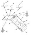
- FIG. 1is the palm-held modular satellite based position system of this invention.
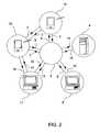
- FIG. 2is a block diagram of an Internet or public network golf course map handling system utilizing the palm-held device of the present invention.
- FIG. 3is a diagram of the mapping procedure utilizing the position quality tool.
- FIGS. 4depict, in flowchart form, the processes relating to searching for a golf course map in the present invention.
- FIG. 5is a representative initial image shown on the viewing display during operation of the course mapper software.
- FIG. 6shows a progression of left menu columns following an initial pressing of SETUP on the viewing display during course mapping.
- FIG. 7shows a progression of left menu columns following an initial pressing of LINKS on the viewing display during course mapping.
- FIG. 8shows a progression of left menu columns following an initial pressing of EDIT on the viewing display during course mapping.
- FIG. 9shows a progression of left menu columns following an initial pressing of EDIT and subsequently a pressing of NOTE on the viewing display during course mapping.
- FIG. 10shows a progression of left menu columns following an initial pressing of EDIT and subsequently a pressing of MOVE on the viewing display during course mapping.
- FIG. 11shows a progression of left menu columns following an initial pressing of EDIT and subsequently a pressing of ADD on the viewing display during course mapping.
- FIG. 12shows a Table displayed on the viewing display following an initial pressing of MARK on the viewing display during course mapping.
- FIG. 13shows a progression of left menu columns displayed on the viewing device following an initial pressing of any key in the table of FIG. 12, represented by XXXX, which is not in the column headed A/L/Pt.
- FIG. 14shows a progression of left menu columns displayed on the viewing device following an initial pressing of any key, represented by XXXX, in the column headed A/L/Pt of the table of FIG. 12 .
- FIG. 15is a golf course feature table showing relative depiction qualities, associations and mapping log rates of features in the mapping software of the present invention.
- FIG. 16shows a progression of left menu columns following an initial pressing of VIEW and subsequently pressings of ZOOM and PAN on the viewing display during course mapping.
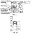
- FIG. 17is a representative initial image shown on the viewing display during operation of the course player software, with added explanations (not depicted on the viewing display when in operation) of the contents of the display.
- FIG. 18shows a progression of left menu columns following an initial pressing of SETUP and subsequently pressings of CLUBS and OTHER on the viewing display during operation of the course player software.
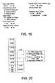
- FIG. 19shows a dialog box of options to be selected in the setup procedure of the course mapper software.
- FIG. 20shows a left menu column and table shown on the viewing display following an initial pressing of LINKS during operation of the course player software.
- FIG. 21shows a progression of left menu columns and a number pad table shown following an initial pressing of SCORE and a subsequent pressing of PUTTS during operation of the course player software.
- FIG. 22shows a progression of left menu columns shown on the viewing display following an initial pressing of MARK during operation of the course player software.
- FIG. 23shows a progression of a left menu column and a table shown on the viewing display with explanatory dialog boxes (dialog boxes not actually depicted on the viewing display) following an initial pressing of CLUB during operation of the course player software.
- FIG. 24shows a progression of left menu columns following an initial pressing of VIEW and subsequent pressings of ZOOM and PAN during operation of the course player software.
- FIG. 25shows a progression of left menu columns following an initial pressing of DGPS and subsequent pressings of DIFF and PICK during operation of the course player software.
- FIG. 26shows the various symbols unique to the course player software as depicted on the viewing display.
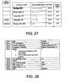
- FIG. 27shows the viewing display of the relative signal strengths of various differential transmitters being received by the differential GPS receiver.
- FIG. 28is a table of the format that various GPS data aspects are displayed in.
- FIG. 29is a table of the various symbols the course player and course mapper softwares depict the attributes of a golf course on the viewing display.
- FIG. 30is a schematic circuit diagram of the connections of the DGPS receiver hardware of the present invention.
- FIG. 1depicts a dGPS receiver Position Module 17 connected to and saddling a display module 1 A.
- the dGPS receiver Position Module 17comprises a main housing 18 for enclosing electronic circuits, and is in operative connection with a removable battery module 19 for providing power, a combined GPS and AM beacon differential antenna module 20 , an electrical interface connector 21 between the Display Module 1 A and the main housing 18 , and an integrated lock tab 22 to hold the Display Module 1 A to the position module 17 .
- the electrical interface connector 21may be a physical link complying with one or more of the following known standards or systems: an RS232 serial port; Universal Serial Bus (“USB”) serial port or IEEE 1394.
- Connector 21may also be a light wave link complying with industry standards including those of the Infrared Data Association (“IrDA”) or a wireless radio frequency link using such standards as Bluetooth or others.
- the antenna module 20simultaneously receives radio signals from multiple GPS satellites 23 and from multiple AM band beacon differential transmitters 24 .
- FIG. 1An aspect of the embodiment of the present invention depicted in FIG. 1 is its modular construction. Modular construction facilitates ease of upgrade to enable ready adaptability to quickly changing designs of Display Modules 1 A, and GPS and differential hardware, primarily the position module 17 and the antenna module 20 .
- a Battery Module 19fits on and is detachable from various Position Modules 17 . Attaching the Battery Module 19 to the Position Modules 17 automatically makes an electrical connection through connector 21 for power and charging and communication.
- the Position Module 17is detachable from a Display Module 1 A which, in an embodiment, is a palm held computer.
- An Antenna Module 20can carry all necessary antennas and may be detachable from the Position Module 17 to enable placement in a position for optimum reception. This form of modular construction allows the Display Module 1 A to be available for other functions when not used with the Position Module 17 .
- Battery Module (BM) 19include, but are not limited to, nickel cadmium, nickel metal hydride or lithium ion rechargeable battery pack such as a Motorola part number 97127. Attachment of a BM 19 to a PM 17 automatically creates an electrical connection for communication, power and other circuits between the BM 19 and PM 17 . The BM 19 disconnects easily from the position module 17 to facilitate battery changes to provide extended golf playing time. The lower power requirements and primarily daytime use of the position module 17 enables the integration of solar cells into the BM 19 or other module to provide supplemental power or battery module 19 charging.
- the Antenna Module (AM) 20houses all antennas 54 necessary for the device to function. Typically, a GPS antenna and a differential antenna are needed, though the WAAS will require only a GPS antenna.
- the antenna module 20provides the ability to unplug the antenna module 20 from the position module 17 for the repositioning of the AM 20 to maintain line of site integrity to satellites.
- the AM 54may be mounted remote from the PM 17 with a cable routed into the PM 17 to allow for satellite acquisition with minimum signal blockage.
- An AM 20also allows for switchable antenna selections for the best fit to a specific application.
- a preferred embodimentmay include a detachable and repositionable antenna module 20 that houses a GPS antenna and an H-field loop antenna, such as a Starlink H-Field MSK DGPS radiobeacon antenna, part number TBA-2, for AM Marine beacon signal reception.
- a detachable and repositionable antenna module 20that houses a GPS antenna and an H-field loop antenna, such as a Starlink H-Field MSK DGPS radiobeacon antenna, part number TBA-2, for AM Marine beacon signal reception.
- the consumermay choose from a plurality of position modules 17 .
- Various levels of accuracy, cost, differential source availability, power requirements, signal subscription cost and sizewill differentiate the position modules 17 . It is expected that reductions in cost, size, weight and power requirement of position modules will be ongoing.
- An advantage of the present inventionis the facilitation of position module upgrades as technologies improve.
- a position module 17will include a GPS component receiver 52 such as the Ashtech G8TM GPS receiver (part number 701067) or similar small form factor GPS engine, and may include a differential receiver 53 . It will be understood, however, that any suitable Global Navigation Satellite System (GNSS) engine could be used to ensure compatibility with the desired GNSS system, i.e., 1) The US Federal Governments Global Positioning System; 2) Russia's GLONASS system; 3) The European Union's planned (GNSS); 4) Any other time based satellite location system signal.
- GNSSGlobal Navigation Satellite System
- the differential signal receiver 53could use any of, but not be limited to, the following correction sources: 1) US Coast Guard or the International Association of Lighthouse authorities Marine radio beacons in the 283.5-325 kHz range; 2) Satloc 450 MHz satellite; 3) Racal L band satellite corrections; 4) FM subcarrier; 5) proprietary local differential; 6) Omnistar L band satellite corrections; 7) WAAS; 8) Real time Internet correction data via radio frequencies (RF).
- RFradio frequencies
- All position modules 17will have a power on/off switch 48 . Additionally, status and troubleshooting indicators ( 49 , 50 , 51 ) will inform the user of the current performance of the position module 17 .
- One panel mounted LED 49will indicate if sufficient battery power is being applied to the position module 17 for it to function.
- a second panel mounted LED 50may be on when differential correction data is synchronized, and off if the data is not synchronized. If LED 50 is off for up to 15 seconds, the positional determination accuracy would not be greatly degraded. However, after a significantly longer period of time, positional accuracy would degrade.
- a third panel mounted LED 51flashing in a selected repeated pattern, will indicate how many satellites were currently being used to calculate position.
- Position Module 17 and related modulesmay include a marine beacon receiver 53 operating in the 283.5-325.0 kHz range such as a Communications System International, Inc. SBX-2, part number 9834-2181-0001.
- This differential receiver 53consumes less than one watt of power, measures 3.0′′ ⁇ 2.0′′ ⁇ 0.54′′ and weighs less than one ounce, valuable qualities for a personal palm-held device.
- a digital dual channel design in this receiver 53uses digital signal processing (DSP) to search for and switch to beacons transmitting superior signals.
- DSPdigital signal processing
- a GPS or combination GPS/differential signal antenna module 54is connected to the receiver module 17 via a SMB connector 55 or similar shielded connector to facilitate removal of the antenna module 54 from the receiver module 17 . Removal of antenna 54 allows it to be placed in an optimal position to view a maximum number of satellites 23 in the sky.
- a RF splitter 56is used to separate the GPS signal and the differential signal into their respective components and make them available to their respective receiver circuitry.
- a separate marine beacon receiver power switch 57is optional and would allow the dGPS receiver 17 to function as a GPS only receiver with the differential correction circuitry and beacon receiver 53 inactive.
- Communication circuitry 58converts TTL level signals from the GPS receiver 52 and marine beacon receiver 53 circuitry into signals for communication with the palm-held computer 1 A.
- a communication switch 59is optional and would facilitate asynchronous communication between the computer 1 A and both the GPS receiver 52 and marine beacon 53 receivers.
- a backup battery 60is used in the position module 17 to provide back-up power to the GPS receiver 52 .
- This back-up powerallows the GPS receiver 52 to store GPS satellite 23 almanac data.
- the almanac dataallows the GPS receiver to predict the position of satellites in the GPS constellation when the receiver is powered up. This prediction ability allows the GPS receiver to greatly reduce the Time to First Fix (TFF).
- TFFis the amount of time it takes the GPS engine to provide its first location solution following a fresh power-up.
- the preferred embodimenthas a power conditioning/charging circuit 61 to charge, regulate, convert and measure battery voltage in the Battery Module 19 .
- a power plug 62will allow the connection of an external power source and operation without the battery module 19 .
- the power/charging circuit 61charges the battery module 19 from the external power source.
- the connector 21provides an electrical connection between the display module 1 A and the position module 17 for communication. This may be a RS 232 connection or even a direct connect to the display module 1 A CPU's data and address bus (not depicted).
- a printed circuit carrier board 63is used to electrically interconnect components and provide mechanical support.
- the RF splitter 56 , GPS receiver 52 , differential beacon receiver 53 , as well as other componentscan alternatively be integrated into a single component.
- Another embodiment of the inventionincorporates a differentially corrected GPS/GLONASS receiver similar to the Ashtech GG24.
- This type of receivercontains 48 satellites in the combined and complete constellation. By increasing the pool of distributed satellites the receiver may select a set that will minimize the dilution of precision effects on the location calculation. Also, this greatly improves the possibility of acquiring the necessary minimum quantity of satellites for a location solution when in areas where tree cover, hills, rocks or other obstacles may block line of sight to GPS only satellites. Another advantage is a more accurate position solution than dGPS alone.
- a baselineis a vector that interconnects the real-time location of the roving GPS/GLONASS satellite receiver and the surveyed location of the fixed GPS/GLONASS satellite receiver that is providing correction data.
- Baselines that will be experienced using a coast guard beacon for differential correctionwill vary from 20 to 140 miles.
- dGPS rover locational accuracyis typically proportional to baseline length.
- the following position modules, with known-in-the-art accuracy estimates for a 20 to 140 mile baseline range, and means of utilization,are employable in modular construction embodiments of the present invention:
- Economy Marine Beacon Position ModuleEmploys an 8 channel, L 1 frequency, C/A code Standard Positioning Service (SPS) GPS receiver. Varieties available include an Ashtech G8TM GPS receiver, part number 701067 and a Communications System International, Inc. SBX-2 digital differential beacon receiver. This receiver combination can provide positional determination accuracies of 1 to 3 meters, and a once per second frequency of horizontal real-time position solutions. This accuracy level is acceptable for ball lie recording and skill evaluation from the tee box and on the fairways. Distance measurements of this accuracy will be helpful to novice and moderate golfers. Typically, there are markers near the green to indicate distance to the green. However, on neither of the 2 nd shot of a par five nor near the green are there normally markers provided for ranging to hazards. The benefit of this unit on the green will depend on the skill of the golfer.
- SPSC/A code Standard Positioning Service
- Standard Marine Beacon Position ModuleEmploys a 12-channel GPS code and carrier GPS receiver such as an Ashtech G12 GPS BoardTM part number 990191 and a Communications System International, Inc. SBX-2 digital differential beacon receiver.
- This receiver combinationcan provide positional determination accuracies of 0.5 to 1 meter and can produce horizontal real-time position solutions up to 20 times per second. This accuracy level is acceptable for all aspects of play and mapping.
- Premium Marine Beacon Position ModuleEmploys a 12-channel GPS code and carrier GPS and 12 channel GLONASS code and carrier receiver such as an Ashtech GG24 GPS BoardTM part number 990229 and a Communications System International, Inc. SBX-2 digital, differential beacon receiver.
- This receiver combinationcan provide positional accuracies of 0.5 to 1 meter horizontal real-time position solutions at a frequency of once per second. This accuracy level is acceptable for all aspects of play and mapping. There will be noticeable accuracy improvements versus the economy and standard position modules described above on courses with many trees that may block the line of site to some satellites.
- the Display Module (DM) 1 Ais multifunctional and receptive to a broad range of attachments or extensions. Suitable DM's are commonly called Personal Data Assistants (PDAs) and include Compaq iPAQ model 3650 Pocket PC or similar palm held computer with either embedded Pocket PC or Microsoft Windows CE operating system (OS), 3Com Palm OS the Linux operating system as well as any other compatible present or future hardware/software combination.
- PDAsPersonal Data Assistants
- the DM capabilitieswill variously include displaying images in 2 or 3 dimensions, and raster or vector images in monochrome, grayscale or full color.
- an operating Position Module 17is connected to a Display Module 1 A running the Course Player software (defined below), GPS location features automatically become available during the operation of the Course Player software.
- the limited display space on a palm held computerresults in the displayed features of almost all golf holes as being elongated since, relative to display length, little display width is needed.
- the displayed informationwould thus make use of the left and or right sides of the Palm-PC display for purposes other than course-graphics such as user entry, touch sensitive buttons and distance and elevation display.
- the course or hole layout graphicsmay extend completely to the top and bottom pixels of the display device.
- One aspect of the present inventionis compatibility with built in, serial or compact flash card modems to facilitate data transfer with a web site or desktop PC.
- An embodiment employing a palm held computer with wireless Internet connection abilitieswill allow the unit to connect directly to the Internet via a wireless RF link, to transfer golf course maps and other information to and from a web site.
- the modular approach of the present inventionenables use of the Course Player game management software without a functioning Position Module 17 attached.
- the userestimates his actual location by keying on visual attributes of the course.
- a cursoris then moved over the displayed map of the course and the estimated location, which may or may not be the ball location, is plotted and the other features of the system are used.
- all other distance and statistic features of the Course Player softwarefunction as they do when a Position Module 17 is used (described below). This allows the product to be used, without dGPS, after some courses have been mapped and input into the Display Module 1 A for example, from the website via the Internet.
- the present inventionmay be constructed so that the Display Module 1 A Position Module 17 and Battery Module 19 are integrated into one unit, while maintaining all the other features and benefits of the present invention except those directly resulting from modular construction.
- FIG. 3is a depiction of a golf course mapping process.
- a user 25walks the perimeter 26 of green 27 to construct a vector image display 28 of the actual green 27 in real time on the display 28 of the display module 1 A.
- the software mapping processis started, the current location (Latitude and Longitude (Lat/Lon)) of the receiver 52 is logged as a new vertex 29 in the RAM of the display module 1 A.
- the vertex 29is also displayed on the display 28 at the same moment it is logged.
- locations or vertexesare logged approximately once per step or pace of the user at a pre-determined time interval (each second is operable).
- Each vertex 29is displayed to the user in real time as a box or dot and is connected with a displayed ray 30 to the preceding logged vertex.
- the accuracy of the position informationwill vary as a function of, among other things, satellite switching or dropping, differential reception quality and HDOP. Obstacles such as trees 32 , hills, buildings and the user's 25 body may block the relatively weak signals 33 from some of the GPS satellites 23 . In addition, electrical noise from man-made and natural sources may degrade the AM differential correction signal 36 from the differential correction transmitter 24 as the user moves about the course, mapping features.
- the GPS mapping software of the present inventionprovides the user the ability to move errant vertexs 35 into a position on the display that more correctly represent the perimeter of the course attribute being mapped. This is an opportune time and place to make corrections to the data since the user has just traversed the object and knows its approximate shape.
- On the display 28 of the Display Module 1 Aas a stylus is touched to a vertex 29 and it is dragged to a location that better defines the shape that was just mapped, the attached rays 30 follow. When the stylus is removed from the Display Module 1 A, the new vertex location 35 A is logged in place of the old one.
- each vertex box or dotmay be a specific shape or color to represent a confidence level in its respective accuracy.
- Errant vertexs 35 as depicted in FIG. 3are sometimes readily identified as not matching the contour of the feature just mapped on the golf course. However, other times it is not clear to the user which vertex needs to be moved.
- a display module 1 A with a color display 28would display each vertex block or dot 29 with an assigned color indicating the quality of the position information at that vertex.
- the indicatormay be black, green, yellow or red.
- the colorcould be based on real time values for differential correction quality, number of satellites tracked and HDOP. However, the color could also be determined by relative differential correction quality, number of satellites tracked and HDOP. In other words, immediately upon completing the mapping of the perimeter 26 of the green 27 , the list of data logged for each vertex 29 and 35 , including differential correction quality, number of satellites tracked and HDOP, is analyzed and colors assigned to vertexs to indicate which vertexs have the highest confidence level for relative accuracy.
- the GGA data set for the green 27could be analyzed and colors assigned to each displayed vertex 29 and 35 based on its quality level within the data set.
- a black blockcould indicate good quality differential correction, maximum satellites used and a low horizontal dilution of precision (HDOP).
- a green blockcould indicate good quality differential correction, a moderate number of satellites used and a moderate horizontal dilution of precision (HDOP).
- a yellow blockcould indicate good quality differential correction with moderate age or a moderate number of satellites used and a higher HDOP.
- a red blockcould indicate no differential correction or very old differential correction or a low number of satellites used or a high HDOP.
- a low number of satellites in some casesdoes not necessarily indicate a degraded location accuracy.
- foliage obstructionmay block signals from the GPS satellites and cause the number of satellites in use to fluctuate or be substantially reduced, it is important to consider satellite number in deciding which vertex or vertexs to manipulate.
- vector data file sizemay be minimized by logging points along fairway or other relatively straight vectors at greater time intervals, for example, once per 3 seconds.
- minimizing the number of logged points representing logged locationsis accomplished variously by controlling the rate of logging as a function of speed, bearing or attribute. More points need to be logged when traveling the course at higher speeds or where there are significant and frequent changes in bearing.
- loggingmay optionally done by setting a logging interval equivalent to distance traversed between points.
- Another embodimentmaps a reduced number of features in lieu of the entire course.
- a usermay create and submit to a web site a vector-map that includes at least 2 feature perimeter vectors with a maximum spatial separation between greens.
- maximum spatial separationmeans selecting features that are not on adjacent holes but are as far apart from each other as practical.
- rays connecting the three chosen featureswould approximate an equilateral triangle with the maximum length sides possible for the course.
- Positioning these vectorswith the aid of known Geographic Information System (GIS), software, over a raster aerial or satellite image of the course, and manipulating the submitted map until the 2 or 3 user entered green-area perimeter vectors are in alignment with the image of the course. This will rectify the image to the submitted vector-map. Subsequently, the balance of the fairway, green and bunker vectors could be traced as described below.
- GISGeographic Information System
- pin locationsare mapped as needed and uploaded to the web site or transferred to other palm PCs via the IrDA port or other communications means.
- submeter-pixel, full color, panchromatic or near infrared aerial or satellite images of target golf coursesare acquired and rectified to surveyed locations. Rectification can be done with the aid of a laser digital elevation model (DEM) of the golf course.
- the rectified full color raster imageis then usable on a color-compatible palm held computers of the type used as display modules 1 A in the present invention.
- Vectors of each hole featurecan be created by tracing features over the top of a displayed aerial or satellite image on a computer graphics workstation.
- the resulting vector mapmay be made publicly available on a web-site for downloading into compatible palm held computers. This embodiment would prevent the need for a course to be physically traversed.
- the rectification process described abovewill require the use of surveyed data for true ground points.
- Another compatible aerial imaging methodis to fly at a low altitude and collect multiple images along parallel paths across a golf course until the entire course is imaged. Each time the shutter of the camera is activated a dPGS location is logged. The image and location data is then processed in a GIS where it is mosaiced and automatically georectified as understood in the art. Course features are then traced as described above.
- All of the rectification methods abovecan be completed on a workstation at the web server 4 .
- the individual that gathered the vector datamay complete the rectification and course attribute tracing on their home PC II through their browser via the Internet.
- an Internet connectionis made to the host web server at its Universal Resource Locator (URL), and the user requests access to an image of a local course map. This image would have been previously gathered by aircraft or satellite and placed in a publicly accessible database.
- the useropens up his own vector data file and displays it over the top of the web page image. The user then manipulates the 2 or 3 green vectors or surveyed points until they lay precisely on the corresponding photographed depiction of the same greens.
- VMLVector Markup Language
- color patternsmay fill vector area attributes on palm PCs that support color.
- the grass areas of the coursemay be displayed in shades of green appropriate for fairways, greens, tee boxes and background areas that are otherwise not designated. Water may be shown as blue, bunkers as tan, cart paths as gray and lines separating each as black.
- accurate golf course elevation point datacan be tagged with latitude and longitude coordinates and gathered into the inventive unit via any of the following methods:
- RTKReal Time Kinematic
- LADARLaser detection and ranging
- the palm held computer executing the Course Player softwaremay interpolate elevation data for its current horizontal latitude and longitude location and cursor target horizontal latitude and longitude location from the elevation data that is gathered in the elevation database above and compute a change in elevation for display to the player.
- the elevation datawill be combined with the GPS coordinates for the palm device to display 3D graphical elevation views of an almost unlimited variety of selectable target areas for the hole in play, as well as dynamically display numeric changes in elevation between the receiver location and target locations.
- a preferred embodiment of the Course Player softwarehas the capability of displaying elevations between a current position and a target cursor in real time as the target cursor is moved over the surface of the map.
- This embodiment of the present inventionutilizes an on-line public computer network, the most commonly known of which is the Internet.
- FIG. 1depicts a palm-held computer 1 A which, in one embodiment, is an iPAQ H3650 model palm computer sold by the Compaq Computer Corporation.
- the computer 1 Ais used to create or edit maps of golf courses and exchange them with other golfers through an Internet web site.
- a usermay transmit a complete or incomplete map directly to other palm-held computers 1 B over a datalink 2 as shown in FIG. 2 .
- the palm-held computerwill also receive maps and data over the datalink 3 from other palm-held computers 1 B.
- the palm-held computers 1 A and 1 Bwill also collect positional data, including target positions and actual ball lies, which relate to the play of a golf round.
- the palm computerswill exchange data on a pathway that may be a physical link such as an RS232 serial, USB serial, IEEE 1394 serial; a light wave link such as IRDA; a wireless RF link such as Bluetooth or others.
- the palm computersmay transmit collected map and play data to a web server 4 over the Internet 5 or other public access network.
- a transmission datalink 6 to the internetmay include a modem and telephony line or any other switchable connection means, including a wireless packet-data network such as Metricom's Ricochet, Motient, Cellular Digital Packet Data (CDPD) or BellSouth Wireless Data (BSWD), all of which include hardware that may be built into or added as an attachment to the palm-held computer.
- CDPDCellular Digital Packet Data
- BSWDBellSouth Wireless Data
- Wireless Local Area Networksmay also be used in a home, office or golf course club house environment.
- Bluetooth or Jinicould also be used to transfer the data onto the Internet.
- the usermay browse a company web site hosted on a remote server 4 for a desired golf course map and download the map into the palm-held computer 1 A via from the internet by a datalink 7 .
- a workstation 8through connection 9 to the Internet, receives notification from the web server 4 when a new golf course map is submitted for the database.
- Quality controlled golf course mapsmay also be submitted by the company workstation 8 via datalink 10 over the Internet 5 to the web server 4 .
- a desk-top or companion PC 11may optionally be used to facilitate synchronizing data with palm-held computers, data storage or communication purposes.
- the desk-top PC 11may also connect to the Internet via datalinks 12 and 13 for exchanging map and play data with the company web site.
- the web serversends and receives information from the Internet by datalinks 14 and 15 .
- the desk top PC 11also connects to the palm-held computer 1 B and communicates with the palm-held computer 1 B via datalinks 16 and 17 .
- the inventionwill provide a World Wide Web (www) Internet site where owners of the dGPS golf device of the present invention may transfer golf course maps. As device owners map courses, they can upload them to the site so that other device owners may download them and avoid the need to remap the same course.
- the userFor a user to download a copy of a golf course map golf system of the present invention, or to view the golf course layout online, the user enters the URL of the web site into their palm held computer browser or desktop computer browser and accesses the company golf course map database through a search engine on the company's host server. A new search is initiated as depicted generally in FIGS. 4A through 4E.
- the searchis submitted 40 A to the host web server, generally, 41 via the Internet 42 .
- a different type of search(FIG. 4B through E) may be made with varying search criteria ( 38 B through E) and search results ( 44 B through E).
- the web server, generally 41generates an HTML page, generally 43 , with the results, generally 44 , of the search and returns the information to the requesting PC via the Internet 42 as is well known in the art.
- the desired course nameis displayed 45 , the user selects it to download the appropriate map or display the course layout map 46 . If not, another search may be performed, generally 47 .
- the exchange of user mapped courseswill enable multiple user processing and editing to greatly enhance the quality of the maps. Moreover, individual users may add or modify features to existing course maps as they are encountered on a course.
- position information gathered while mapping a coursecan be uploaded to the web site for differential post processing to improve on real-time dGPS-only map quality.
- the uploaded position data, corresponding satellite data from a nearby CORS reference station and post processing softwaremay be used to fix vertexs or points that may have been recorded with old differential real-time data or no differential data.
- Course mapsmay be organized in a server database progressively by: Continent; Country; State, province, or Territory; City; Course Name.
- the following map and position datamay be available to be exchanged for each course:
- Map data filesmay also include typical score card data such as hole data including yardage, rating, slope information, par, handicap and other course data such as course name, phone number, address and amenities.
- typical score card datasuch as hole data including yardage, rating, slope information, par, handicap and other course data such as course name, phone number, address and amenities.
- the web sitewill further provide users with the ability to upload play data.
- Various graphical statistics programswill use the play data for display of performance parameters including, but not limited to:
- All of the data setsmay be viewed for: submitting player, left hand players, right hand players all players, etc.
- a browser-based executablefor example, a Java applet or Shockwave movie
- Aerial or satellite full color images or the uploaded vector mapmay be used as background for the replay.
- the web sitemay also provide automatic e-mail notification of both scheduled and unscheduled marine beacon transmitter outages.
- the usercan select, from a list presented on the web site, which transmitter location outages should generate an automatic e-mail outage message.
- the web sitemay host a player provided rating system for rating mapped courses based on various criteria including, but not limited to, course condition—greens, fairways, drainage etc.; and course design—fairway width, difficult water, quantity and quality of bunkers; green size etc.
- course conditiongreens, fairways, drainage etc.
- course designfairway width, difficult water, quantity and quality of bunkers; green size etc.
- the criteria listed hereare only examples and are not all-inclusive.
- the Course Mapper software packageutilizes a Graphical User Interface (GUI) and touch sensitive screen such as those of the display 28 of the display module 1 A.
- GUIGraphical User Interface
- the mapping taskcan occur with any combination of walking, golf cart driving or golf bag cart pulling or pushing as previously explained.
- Each item mappedshall be labeled by selecting from a standard set of labels. Additional explanatory data may be added to each mapped item.
- the display module 1 AWhen the display module 1 A is turned on, the last course mapped is displayed.
- the orientation of the displayed vectors of the mapshall be north toward the top of the display.
- Appropriate dialog boxesshall be implemented for the OS running. Because most holes on a golf course are long and narrow, the location of the touch sensitive menu buttons is thus preferably along the side of the display.
- FIG. 5depicts the approximate size and resolution on a Palm III PDA
- FIG. 5depicted is a representative image on the display 28 of the display module 1 A when course mapping.
- the majority of the screenshows a graphic representation of the course area being viewed termed the map area, and the left side of the screen shows a vertical menu column of touch sensitive, labeled menu buttons.
- the menu column displayed in FIG. 5is the common start menu column.
- the left side vertical menu column of labeled menu buttonswill be a repeating aspect of the following software operations with the content of the labels and the actions which result from pressing a given labeled menu button differing as described following.
- the side by side vertical menu columnsindicate a progression of menu buttons displayed, one menu column at a time, starting from the left most menu column and proceeding to the right.
- a particular menu buttonis depicted as double-bordered, the double-border indicates that the pressing of that button in that menu column will then cause the display to show the next most menu column to the right in that Figure.
- the displayed image(s)include a table comprised of more than one menu column in continuous contact without vertical spacing between them.
- the entire tablewill be displayed at once upon the pressing of the double-bordered button.
- the pressing of the double-bordered menu buttoncauses the display to switch from showing the menu column to showing the table.
- the headings at the top of the menu columnsare for reference only, and refer to the double-bordered menu button pressed immediately before that column was displayed.
- Setupwill be used to set mapping parameters that will be changed infrequently as further defined in FIG. 6 .
- mapping operationTo begin a mapping operation, either a new course must be created or an existing one opened.
- Newshall allow the creation of a new course map when a position module is attached.
- a dialog boxshall be displayed to facilitate naming of the course, entering hole par strokes, handicap and tee colors and their respective yardages.
- Openshall allow the user to open and edit a previously created or downloaded course map.
- the opened courseneed not be reopened after a power down/up cycle of the display module 1 A.
- a dialog boxshall be displayed to facilitate selection from a list of existing course names.
- Closeshall allow the user to close the current course so another may be opened or created.
- Editis used to modify features of an existing map. After edit is pressed and the next dialog displayed, the user will be prompted to select a feature to edit. A tap of a stylus on the display locates the nearest feature. A small, unfilled, 2 nd box will be displayed at each position vertex to indicate which attribute was chosen. The box shall be large enough for the stylus to pick it. If “Delete”, “Note”, “Move” or “Add” is pressed before an attribute is selected, a dialog box, with an “OK” button, will appear to instruct the user to select an attribute. The “Delete”, “Note”, “Move” and “Add” buttons shall not function until an attribute has been selected.
- buttonsWhile these buttons are displayed each touch of the stylus on the map area shall either select a feature or, if one is already selected, toggle it off and select another.
- the toggled off featuremay not be reselectable immediately after it is toggled off. Once the correct feature is selected, the user selects the type of edit to perform.
- a confirmation window stating the pending actionshall be displayed with a confirming “Yes” or “No” selection required.
- the usermust select a vertex to be deleted with the stylus before the “Point” button will work. If “Point” is pressed and no point to be deleted has been selected, the user is prompted to do so.
- a selected vertexshall change from an unfilled 2 nd box to a filled box when it is selected. Retouching it will deselect it. Further relevant description may be found under the common components section following the “Apply”, “Save” and “Cancel” items.
- dialog boxshall be displayed that will allow the use of the display module's text editor to modify the note.
- the stylusmay be placed in a vertex and that box dragged to a new location. As a stylus is touched to the vertex and it is dragged to a location that better defines the shape that was mapped, the attached rays follow as previously described. When the stylus is removed, the new vertex location is logged in place of the old one. “Cancel” or “Save” finishes the move edit.
- the stylusWhen add is selected, the stylus may be used to add a point to an existing line or area that was selected after “EDIT” was pressed.
- the systemshall set a point where the user touches the display with the stylus near the end of a line or the middle of a line. If “END” or “MIDDL” is pressed before a point is set, a dialog box with an “OK” button, will appear to instruct the user to set a point. After the point is set, the system shall accept the “END” or “MIDDL” button entry. If “END” is selected, the system will prompt the user to pick the vertex that indicates the end of the line to add the point to. If “MIDDL”” is selected the system will prompt the user to pick the two vertexes that the new point is to be placed between.
- the mark functionis used to map golf course attributes by walking or riding around their perimeter as previously described.
- “Mark”is selected, to facilitate mapping of a feature, that feature is displayed in real-time to facilitate quality control for the user.
- Connected line segments (rays) enclosing an areawill be created from the series of consecutively collected positions. Additionally, points or lines not defining an area may also be created from the positions, as appropriate. The user shall avoid, if possible, beginning the mapping of an area at or near a corner or on a sharp curve.
- the mark type table FIG. 12is no longer displayed.
- the selected mark typeis displayed to the user and the “BEGIN”/“CANCL” menu box is displayed.
- the useris prompted to enter the respective hole number the mark is to be associated with.
- the menu of FIG. 14is displayed if Tree, Bush, Rock or Other is selected from the feature table of FIG. 12 .
- the “Point” buttonis pressed if the user wishes to mark the point location of a single entity and “Begin” to start the process of marking an area or line of the chosen attribute.
- a dialog boxwill be displayed that may include the following message: “A (Mark Type) (s) location is being logged while (Walking or Riding).” Also, after “Begin” is pressed an “End” button shall be added to the menu to allow the user to indicate when she is within one or two steps of returning to the original starting point of an area feature being mapped or to terminate a linear feature being mapped.
- the systemimmediately begins logging the GPS locational data from the serial port at the predetermined rate. The positional data is logged until the “Pause” or “End” button is pressed.
- End buttonAs she nears the original start point of an area or the end of a line.
- End buttonWhen “End” is pressed, the user is prompted for a note to be added about that feature.
- the Nested “Mark” buttonis shown in the rightmost column of FIG. 14, second button from the top.
- the userWhen selected, the user is allowed to mark another feature in the same physical portion of the course as the original feature being marked.
- the usermay then, press “Resume” and continue on with the mapping of the original feature. Only one level of nested marking may be permitted.
- FIG. 15is a chart showing the various options available to a user for the various features.
- a feature's edgemay be mapped as a line in lieu of traversing the complete feature to map it as an area. Moving the unit along the edge of a feature marks the feature's edge.
- a line featureis any marked feature where the user does not return to the original starting point to create an enclosed area.
- a linefor instance, could be the edge of a forest or lake or simply along the center of a cart path.
- Hole associationincluded in the table of FIG. 15, will be a selection that the user makes to let the system know which hole or holes a feature is associated with. This selection shall determine if the feature is displayed in that particular hole view. Some features must have at least one hole association; indicated by an X. In the features in the table designated with an O, association is optional, but not required. If the feature is not associated with a hole or holes it will be displayed in all views. All features may be associated with multiple holes.
- the selectable featuresmay include:
- the systemWhen “Tee” is selected, the system shall label the data to be logged in the map file with a unique identifier for a tee box. Throughout the system, tee data is treated as an area. The system shall also prompt the user to enter the hole number for the tee box. It then advances to the next menu. After “End” is pressed, a note may be added. The systems shall permit multiple tee boxes areas per hole.
- the systemWhen “Fairway” is selected, the system shall label the data to be logged in the map file with a unique identifier for a fairway. Throughout the system, fairway data is treated as an area or areas. The system shall also prompt the user to enter the hole number for the fairway. It then advances to the next menu. After “End” is pressed and a note added, the user is prompted to mark a reference point for the normal line of play through the center of the fairway. This reference point is used in Course Player for the computation of the three displayed distances. For perfectly straight holes and par 3s, no reference pointed is needed. For doglegs, the reference point is set in the fairway, midway from each side, at the dogleg. The system may permit multiple, separate fairway areas per hole.
- the systemWhen “Green” is selected, the system shall label the data to be logged in the map file with a unique identifier for a green. Throughout the system green data is treated as an area. The system shall also prompt the user to enter the hole number for the green. It then advances to the next menu. The system shall only permit one green to be mapped per hole.
- the area defined as the holemay be fictitious or real and encompasses the tee boxes, fairway, some bunkers and the green in their entirety.
- Holethe system shall label the data to be logged in the map file with a unique identifier for a hole. Throughout the system, hole data is treated as an area. The system may also prompt the user to enter the hole number for the hole and then advance to the next menu. The system shall only permit one hole to be mapped per hole number.
- the systemWhen “Bunkr” is selected, the system shall label the data to be logged in the map file with a unique identifier for a bunker. It then advances to the next menu. After “End” is pressed, a note may be added. A bunker is to be mapped such that the first logged point is at the front of the bunker.
- the systemshall label the data to be logged in the map file with a unique identifier for a rough. It then advances to the next menu. After “End” is pressed, a note may be added.
- the systemWhen “Water” is selected, the system shall label the data to be logged in the map file with a unique identifier for water. It then advances to the next menu. After “End” is pressed, a note may be added.
- the systemshall label the data to be logged in the map file with a unique identifier for it. It then advances to the next menu. After “End” is pressed, a note may be added. These attributes may be logged as an area, line or single item (point).
- a circledepicts the contour of a mound.
- the systemshall label the data to be logged in the map file with a unique identifier for a cart path. It then advances to the next menu. “End” is pressed to complete the path mark. Notes are not added for paths. Moving the GPS antenna along the center of the path is the method used for marking a cart path.
- the systemshall label the data to be logged in the map file with a unique identifier for Out of Bounds. It then advances to the next menu. After “End” is pressed a note may be added.
- the out-of-bounds portionsmay be mapped by moving along out-of-bound markers at the edge of the area that is potentially effected.
- a graphic flag as shown in FIG. 29A graphic flag as shown in FIG. 29 .
- the systemWhen “Ditch” is selected the system shall label the data to be logged in the map file with a unique identifier for a ditch. It then advances to the next menu. After “End” is pressed a note may be added.
- a narrow ditchmay be mapped with one line by moving the antenna along the bottom center of the ditch.
- a wide ditchmay be mapped by moving along each side of the ditch and creating two somewhat parallel lines.
- the frequency of marking pin placementswill be much greater than that of marking any other attribute. Also, users will want to download pin placements from other palm PCs and our web site without altering other map data. Because of this it is necessary to have an independent file that is pin location specific and tagged by date. The file may be identified as course_name.pin When “Pin” is selected, the location available at the serial port is logged as that pin location. After “Pin” is pressed the user is prompted to enter the hole number and a note. If “Pin” is selected in Course Player setup for the green reference point, the pin placement is used for the computation of distance between the target cursor and the green. Only one pin location may be mapped per hole.
- Usersmay receive updated pin locations from another display module 1 A via any transition method suitable for communication between such units.
- a courseitself may upload new pin locations to the Web Site with a date and time estimate for the new hole location changes.
- the datais directly available to golfers at the club house with their display module 1 A.
- the systemhas the capability of displaying and zooming the current map or portion of a map while on the golf course.
- the left most physical buttonmay zoom out and the right most physical button may zoom in. Pressing and holding the zoom buttons will zoom the display at an increasing rate. For Course Mapper, all zoom views are north up.
- Pressing “In”shall zoom in on the displayed map. All features become twice as large each time the in button is pressed. The system shall zoom in to the point that at least one point of a vector is displayed. The center of the map remains the center after zoom in.
- Pressing “Out”shall zoom out on the displayed map. All features become half as large each time the out button is pressed. Maximum zoom-in will be approximately 8 pixels per foot for most display modules 1 A. The maximum zoom-out shall be what ever it takes to display all mapped attributes for the selected course. The center of the map remains the center after zoom out.
- a physical rocker switch on the display module 1 Amay also pan the displayed image, for example, at a rate of 1 pixel per press in the direction it is rocked up or down. Pressing and holding the rocker will pan the display at an increasing rate. Redraw capabilities of the display module 1 A will determine the maximum pan speed.
- Each physical button to the immediate left and right of the rockershall also serve the same capability for panning left and right respectively.
- This menu buttonshall move the displayed map to the left each time it is pressed.
- This menu buttonshall move the displayed map to the right each time it is pressed. ⁇
- This menu buttonshall move the displayed map up each time it is pressed. ⁇
- This menu buttonshall move the displayed map down each time it is pressed.
- Pressing “Me”shall shift the map to place the receiver current location in the center of the display without changing zoom level.
- the Course Mapper softwareshall facilitate uploading of all course data to a Personal Computer for use in a PC Instant Replay program to the web site.
- Level 1includes the Course Player software and supplied course data only. Level 1 requires the user to identify and mark his or her location on the hole by visual reference. This level does not allow users to map their own courses. Course data must be created and supplied by others.
- Level 2Adding a position module 17 receiver to the Level 1 system enables Level 2 capabilities.
- the Course Player software in the Level 1 versionalready has all the capabilities for interaction with the position module 17 for creating or editing their own course maps.
- Level 2also allows users to upload mapped courses to the Web site for use by other users.
- buttons and liststhat appear as needed on the display 28 of the display module 1 A large enough that a stylus is not needed during the normal course of play, only a finger.
- the course datamay be loaded by connecting to a PC or directly to the Internet web site.
- the course datawill be stored in nonvolatile RAM or a removable RAM data card.
- Depictedis an image that will be seen at a general initial state of use of the Course Player software.
- the left side of the screencontains menu buttons and information pertaining to the depicted image as detailed in FIG. 17 .
- buttons depicted with soft wavy bordersare not shown during normal play. until they are scrolled to, due to the space limitations of the display screen.
- a scroll buttonis used to advance the menu list up or down.
- a double border line, straight or wavyindicates the next menu column to the right is shown when the button with a double bordered line is pressed.
- Setupwill be used to set player preferences. It is placed at the top of the menu list in anticipation of little use.
- the squiggly button boundariesindicate the menu items are, for this menu implementation, scrolled off the top of the display 28 and are not visible during normal play.
- setup columns menu as shown in FIG. 18shall be displayed in place of the main menu.
- the green reference pointshall be used for the computation of distance between the selected green reference point and the target cursor.
- This itemshall allow the selection of the preferred displayed units of measure.
- the distanceshall be displayed in whole yards. If any displayed distance drops below 10 yards the distance is then displayed in feet with a “F” added to the end of the number i.e. 25 F.
- the distanceshall be displayed in meters. If any displayed distance drops below 10 meters the distance is then displayed in tenths of meters i.e. 9.5.
- This setup featureshall allow the cursor ghost lines to be either displayed or not displayed.
- the cursor ghost lineconnects the current ball position, the target cursor and the green reference point.
- the default target cursor locationis “x” number of yards along the line connecting the front of the tee box and the fairway normal line of play reference point. If the default target cursor location is beyond the green location selected in setup, then the distance to the green location becomes the default target cursor distance.
- the entry fieldshall contain 3 digits with the entry units of yards or meters. Min and Max limits (0-999) will be used to validate entry data. The user shall have the capability of modifying this value without the use of a stylus.
- Pressing the LINKS buttonshall allow the user to select courses and present factual information for the selected course and hole.
- the userwill be allowed to select the course, tee box color to play and beginning hole of play. After doing so, the full view of that hole shall be displayed.
- the greenshall always be located toward the top of the display with the tee boxes being toward the bottom.
- the links column and course data column of FIG. 20display simultaneously.
- Each of the scroll buttons in the right vertical column of FIG. 20will automatically scroll with increasing scroll speed if it is held down.
- Each presswill step one line through the data in each field. The data will loop continuously when the button is pressed and held down.
- This buttonshall display a name for each course loaded into the display module 1 A either in RAM Flash Card or other memory storage system.
- the rating and slope for the selected tee boxis displayed under the Course Name.
- the respective rating and slope for each tee boxis displayed as the tee box selection below is changed.
- This buttonshall display the number of par strokes and the handicap for each hole on the displayed course. If “Save” is selected the displayed hole shall become the hole in play. This allows the user to select the beginning hole of play or play the course out of order.
- This buttonshall display the tee box designation and the advertised yardage associated with it for each hole on the displayed course. If “Save” is selected the currently displayed tee box color shall be used throughout the round unless changed and saved.
- the score menuis displayed and a standard 4 player score card (not depicted) shall be displayed in place of the course map. If restricted by display space only nine holes at a time may be displayed.
- the systemwill automatically keep score for the user of the system. This shall be accomplished by the marking of lies.
- the usershall be allowed to edit their system-derived score.
- the userwill manually enter strokes on this screen for the other 3 players. This screen will have the following minimum information: hole number, par/hole, handicap/hole, strokes/hole, putts hole, strokes over or under/hole, total strokes/player, total putts/player, handicap/player, Net/player.
- the buttonshall be highlighted and, in addition to the putts column a number pad is shown displayed in place of the score card for quantity of putts taken to be easily entered without a stylus.
- the default-highlighted numbershall be 2. When a number is pressed on the number pad it shall be highlighted.
- “Save”is pressed the putts are saved and the score card updated and redisplayed where the number pad was. Pressing “Save” after “Putts” also indicates the hole is complete and the next hole is displayed.
- the buttonshall be highlighted and a number pad displayed for a quantity of penalty strokes to be easily entered without a stylus.
- the default-highlighted numbershall be 1. When a number is pressed on the number pad it shall be highlighted. When save is pressed the penalty stokes are saved and the score card updated and redisplayed where the number pad was.
- Pressing “NEW ROUND”shall cause the system to close and save the last played round of data and allow a new round with a clean score card. Players' names shall be retained.
- the mark functionshall provide the user with the ability to mark a target location i.e. the location the golfer is shooting toward before she swings. Before pressing the “Mark” button on the “Course Player” main screen the user will move the target cursor to the target location.
- the target cursormay be moved on the displayed map by touching a stylus or a finger tip to the display and dragging it to a new location or by using a mechanical joy stick that cause the target cursor to move in the indicated direction on the stick.
- the “Target” buttonWhen the “Target” button is pressed the system shall record the target location position to RAM for latter analysis. A target marker shall be dropped and remain on the display 28 until a new round is selected for play. The user can either “Save” the Target mark or “Cancl” the mark.
- Pressing the “Cup” buttonindicates the last shot landed in the cup and the hole is complete.
- the usercan either “Save” or “Cancl” the cup mark.
- the systemshall then advance to the next complete hole view. If “Pin” is selected as the green reference point in setup, the system shall use the recorded pin location instead of the position presented by the position module 17 . Otherwise, if “Center of Green” or “front of Green” is selected the real-time GPS position is logged.
- the “Club” button on the main Course Player menuis used to record clubs used during play and for viewing history of club performance.
- the best club for the shot to the target and that that clubs average distanceis dynamically displayed on the club button as the target cursor is moved about the hole map in.
- the Club data table of FIG. 23is displayed.
- the distance value between the user and target cursorshall be used to highlight the club with the closest average distance.
- the club used for a particular strokeshall be selected after the swing and prior to marking the next lie.
- the selection of the actual club usedshall be made on this display by pressing the screen for the club used. After pressing it, the button shall be highlighted. “Save” shall confirm the selection, log the information to RAM and update the score card.
- Each buttonshows a club and average stroke length above, and shows below average distance left or right of the line, and % left or right for the higher of the two, from lie to intended marked target. For example, if a club yields 15% of the shots left of the line and 85% right “85” will be displayed below.
- the perpendicular distance value of the shots landing left of the target lineare averaged and displayed left of the % value.
- the perpendicular distance value of the shots landing right of the target lineare averaged and displayed to the right of the % value.
- This buttonis pressed when the player duffs a shot and does not want the location averaged into the club accuracy data. The location will be logged and the score card updated but the shot will not alter the club data.
- Viewwill allow the user to better display a particular portion of the course being played.
- the systemshall automatically zoom a rectangle including the green, the target and the current location with an added 10 yard buffer around the image.
- Pressing “In”shall zoom in on the displayed map. All features become twice as large each time the in button is pressed.
- the systemshall zoom in to the point that at least one point of a vector is displayed.
- the center of the mapremains the center after zoom in. During this zoom, the green-up-for-current-hole orientation shall be used.
- Pressing “Out”shall zoom out on the displayed map. All features become half as large each time the out button is pressed. The system shall zoom out to the point that the whole course is displayed. The center of the map remains the center after zoom in. During this zoom the green-up-for-current-hole orientation shall be used.
- the “entire hole view”zooms the display to a full view of the hole in play as indicated on the scorecard. This view's extents will include the played tee box and hazards near the back of the green. During this zoom the green-up-for-current-hole orientation shall be used.
- the intermediate zoom viewis a view that includes all the features enclosed by a rectangle that extends 10 yards beyond the current ball location and the green. The intermediate zoom view automatically displays following the marking of each new lie and it does not function until the first lie is marked. When the intermediate zoom view is invoked the target cursor is automatically positioned halfway between the lie and the green reference point.
- the map of the entire courseshall be displayed. For this button press only, the map is displayed north up. North may be determined from the Lat/Lon vector data.
- the greenis up (toward the top of the display) for the currently selected hole in play.
- upis defined as the direction traveled along the normal play line for the hole with normal play proceeding up the fairway.
- upis in the direction beginning from the reference point and moving toward the front of the green.
- This menu buttonshall move the displayed map to the left each time it is pressed.
- This menu buttonshall move the displayed map to the right each time it is pressed.
- This menu buttonshall move the displayed map up each time it is pressed.
- This menu buttonshall move the displayed map down each time it is pressed.
- Pressing “Me”shall shift the map to place the receiver current location in the center of the display without changing zoom level.
- the active touch sensitive area for the symbolshall include the distance indicator area immediately below it also. This will provide a large touch area for he user.
- the number to the right of the up/down scroll arrowsis the current hole in play and the one being scored.
- the top numbershall be the distance between the target cursor and the green.
- the middle numbershall be the total distance from the receiver to the target cursor to the front of the green or pin or the distance from the receiver to the front of the green or pin.
- the bottom numbershall be the distance between the current ball location and the target cursor.
- a windowshall be displayed, as depicted in FIG. 17, over the map that indicates the change in elevation between the ground level of the antenna position when the antenna is at the current ball location, and the ground level at the target cursor location. If the elevation at the target cursor is lower than the user the ⁇ elevation is displayed as a negative value, if higher than the user a positive value, for example, ⁇ 15 or +8.
- the windowshall be positionable on the display by touching it with the stylus and dragging it. The window shall be turned on and off in setup. A value for the distance between the receiver's antenna and the ground will be entered in Setup.
- the elevation for both the target cursor and the useris calculated by interpolation between nearby points where elevation as a function of location has been surveyed and logged to a database. If English US units are selected in Setup the ⁇ elevation is displayed in feet. If metric units are selected in Setup the ⁇ elevation is displayed in meters and tenths.
- FIG. 25defines symbols that are used only in Course Player. See common components following for symbols common to Course Player and Course Mapper. None of the symbols in this Figure change size during zoom.
- the area near the target cursoris defined as an imaginary square equal in size to or slightly larger than the extents of the cross hairs of the target cursor.
- the target cursorUpon moving on to the next hole of play, the target cursor is displayed at a default location on the hole. For par three holes the default location is the selected green reference point. The default location for all other holes is placed along the line connecting the front of the chosen tee box of play, an intermediate mapped point for dogleg holes and the front of the green or pin. The default target cursor placement is along the length of the described line above at a distance from the front of the selected tee box as defined by the user in the “Setup”.
- the lie markerindicates a teed or played ball location.
- a lie markeris placed immediately prior to each stroke so that distance statistical data may be stored.
- the respective displayed distancesshall begin to be calculated from the new lie.
- the lie markershall be red or another shape for a penalty ball.
- a target markerwill be placed when the user moves the target cursor to a desired target spot on the course, presses the “Mark” button and then the “Target” button. Targets are removed from the display when a new round is started. Target data is logged in the database for statistical analysis.
- the player softwareshall facilitate uploading of all data to another computer, for example, a PC for use in a reply program.
- the map backgroundmay be white. Font size for any item used during a round should be as large as possible.
- buttonsshall carry their respective definition wherever they are used throughout the system:
- CANCL(Cancel) Assumes the view of the data could have changed. Save no changes since entering the current dialog and returns to the previous dialog.
- This dialog boxshall allow interpretation and display of NMEA data flowing in the position module 17 .
- the menuwill help the user determine if switch settings on the position module 17 are correct for golf play, GPS or beacon diagnostics or configuration.
- An optional switch 59 on the position module 17 labeled “USE” and “SETUP”will allow the display module 1 A to communicate with either the GPS receiver 52 or the differential beacon receiver 53 .
- Differential correction datais received by the beacon receiver 53 in the position module 17 from land based correction stations on the AM band.
- the correction datais then ported to the GPS receiver 52 for position correction or to the display module 1 A for beacon receiver setup and performance monitoring.
- the optional switch 59 on the position module 17may be used to make the selection.
- Autowill be used to set the differential beacon receiver 53 to auto-tune mode. If “Auto” is pressed a beacon receiver command such as the following may be transmitted to the differential receiver 53 : $GPMSK,,A,,A,n ⁇ CR> ⁇ LF>.
- the display module 1 Awill listen for the Acknowledge return string ($PCSI,ACK,GPMSK,fff.f,A,ddd.A,n) from the beacon receiver 53 . If it is not received, the user is instructed to check the battery power and switch setting. When it is received, the display module 1 A displays a “Wait, scanning for beacon signal” window on the display 28 .
- Selecting “SCAN”shall send a Global Search command such as $PCSI,4 ⁇ CR> ⁇ LF>, pause 5 seconds and then send a Receiver Search Dump command such as $PCSI,3 ⁇ CR> ⁇ LF> to the differential receiver.
- the receiver search dumpmay return data in the $PCSI,xx,ffff,sid,ci,snr,ss format for all 84 possible frequencies in the beacon radio spectrum.
- the display module 1 Ashall select the 5 strongest signals and display them in order of quality to the user for manual selection as shown below. When a city is selected by being pressed it changes shades to indicate its selection.
- a beacon databaseshall be provided with the Mapper and Player software so that station ID numbers can be cross-referenced to city locations and names and distances may be computed.
- Distance to each transmittershall be computed to a known point on the selected golf course or the current location if available.
- Selecting “Ver#”shall poll and display hardware and firmware serial numbers for the GPS receiver 52 and the differential receiver 53 .
- Strings of GPS positional datashall be received by the Display Module 1 A software.
- the stringsshall be in NMEA 0183 Version 2.01format and consist of GGA, GSA and RMC messages. Position shall be calculated using the full resolution of the NMEA Lat/Lon data.
- GPSGlobal System
- the serial portis polled to determine if no data is present, RTCM data is present or NMEA strings are present. If RTCM is present a window will be displayed instructing the user to set the “USE”/“SETUP” switch to “USE”. If no data is present, the user is instructed that no data is being received from the dGPS module and to ensure the battery power is ok, the switch is set to “USE” and the port is connected.
- the symbol table shown at FIG. 29contains examples of symbols which may be used to refer to the various elements listed. A representative indication is depicted. Each symbol is given a hierarchical number to indicate which is drawn on top of the other when displayed. For example, a bunker may lie completely within the perimeter of a fairway. If the bunker had a lower priority than the fairway it would be completely overwritten when the fairway is drawn on the display.
- a holeis an actual or fictitious border around the fairway, tee boxes, green and nearby bunkers.
- a tee-boxis depicted as an enclosed area with no fill pattern. It will carry a label of Gold (yardage), Blue (yardage), White (yardage), Green (yardage) and Red (yardage).
- a greenis depicted as an enclosed area with no fill pattern.
- a fairwayis depicted as an enclosed area with no fill pattern.
- This symbolshall be used in a repeated pattern to indicate a rough when the area is zoomed enough to allow the display of it.
- a large rough areamay be mapped without walking all the way around it to indicate an area by using the line feature.
- the mapperwill walk a line along the edge of the rough area. It will be indicated by a linear equivalent of the same pattern and color as rough area and be 4′ wide.
- a ditchis depicted as a line.
- a line on both sides of itmay depict a wide ditch.
- a large group of buildingsmay be mapped without walking all the way around them to indicate an area by using the line feature.
- the mapperwill walk a line along the edge of the area. It will be indicated by a linear equivalent of the same pattern and color as a building area and be 4′ wide.
- This symbolshall be used in a repeated pattern to indicate a sand hazard when the area is zoomed enough to allow the display of it.
- This symbolshall be used in a repeated pattern to indicate a water hazard when the area is zoomed enough to allow the display of it.
- a large body of watermay be mapped without walking all the way around it to indicate an area by using the line feature.
- the mapperwill walk a line along the edge of the area. It will be indicated by a linear equivalent of the same pattern and color as water area and be 4′ wide.
- This symbolshall be used to indicate a bush or bushes when the area is zoomed enough to allow the display of it. As an area is zoomed more bushes will be indicated and they will have a geographically correct location. The geographical location will be the bottom of the bush symbol. A large group of bushes may be mapped without walking all the way around them to indicate an area by using the line feature. The mapper will walk a line along the edge of the area. It will be indicated by a linear equivalent of the same pattern and color as bush area and be 4′ wide.
- This symbolshall be used to indicate a tree or trees when the area is zoomed enough to allow the display of it. As an area is zoomed more trees will be indicated and they will have a geographically correct location. The geographical location will be the bottom of the tree symbol. A large group of trees may be mapped without walking all the way around them to indicate an area by using the line feature. The mapper will walk a line along the edge of the area. It will be indicated by a linear equivalent of the same pattern and color as an area of trees and be 4′ wide.
- a large rocky areamay be mapped without walking all the way around it to indicate an area by using the line feature.
- the mapperwill walk a line along the edge of the area. It will be indicated by a linear equivalent of the same pattern and color as a rock area and be 4′ wide.
- a cart pathis depicted as a 6′ wide solid gray line on a color display.
- a broken lineshall indicate out of bound marks.
- This symbolindicates the location of the system. It blinks and moves at the 1 Hz dGPS update rate. Concentric circles around this rover cursor shall be turned on and off in setup. The concentric circles shall appear at 5 yard/meter intervals out to 20 yards/meters. This feature will permit the user to estimate his ball location from the cart and mark it on the display to facilitate club selection without leaving the cart.
- the files on the display modulemay be stored and accessed from device RAM or a Compact Flash card or other memory system.
- the course map data fileshall be binary with one file per course and may contain all information for that course. They shall have a file name compatible with the operating system of the display module 1 A.
- the map data fileshall include all necessary data to fulfill the functionality described in this document yet minimized to conserve RAM requirements.
- the map data file formatshall include bytes for elevation data to be added later.
- the pin placement data fileshall be binary with one file per course and may contain all pin placement info for that course. They shall have a file name “coursename.dpp” or otherwise as is compatible with the operating system of the Display Module 1 A.
- the pin placement data fileshall include all necessary data to fulfill the functionality described in this document yet minimized to conserve RAM requirements.
- the databasewill contain the following fields: date, hole number, latitude, longitude.
- the player data filemay be ASCI format with the capability of storing multiple player's data per file and shall contain all personal information for each player. They shall have a file extension “*.clb” or otherwise as is compatible with the operating system of the display module 1 A.
- the player data fileshall include all necessary data to fulfill the functionality described in this document yet minimized to conserve RAM requirements.
- the round data fileshall be ASCI format and shall store locational and scoring data for one round of golf per file.
- a roundcan be any combination of nine holes. It shall have a file extension “99-99-99 9.scr” or otherwise as is compatible with the operating system of the display module 1 A. This name will indicate the date the round was played and the round number one through nine for that date.
- the round data fileshall include all necessary round data to fulfill the functionality described in this document yet minimized to conserve RAM requirements. At a minimum the database will contain the following data: date, course name, hole number, stoke number, latitude and longitude.
- an alert status windowwill automatically appear with details on the lost signal's city name. If less than 4 GPS satellites are being tracked an alert status window will appear prompting the user to attempt to remedy the signal blockage by turning or moving.
- the systemmay include the following elements implemented through a public access computer network such as the Internet:
- a websitemay have a page for access to new Course Mapper, Course Player and other software upgrades. This page will also provide instruction for upgrade installation.
- E-mail notificationshall be made available for marine beacon outages, planned or unplanned. We will automatically query the coast guard's web site for publications and automatically send out email based on a users selected region or towers or courses.
- a user forumshall be included for direct interaction between players.
- course transfer portion of the siteis perhaps one of its most important aspects.
- the course data transferred herewill be in a proprietary format.
- a usershall be able to access the Web site and indicate a desire to upload a mapped course to be presented for use by others.
- the only map files that will be accepted by the serverwill be those that are defined in the Course Map File section of this document. Once uploaded and reviewed, if the course meets the administrators acceptable minimum quality standards it is added to those that may be viewed on the download page. If a course owner wishes to upload a daily pin placement file they must enter a password.
- coursesshall be grouped by Country, State/Province, City, Course and mapper name (person who is submitting it to the site). It shall be possible to have multiple maps of the same course with different mapper names. Some users may prefer a particular mapper's techniques to another. The potential downloader shall be permitted to view a course before it is downloaded. A forum for golf course map requests will be offered in hopes of stimulating someone to add a missing course. Users will have the choice of downloading the entire course or just pin placements. All downloadable files will carry a creation or edit date.
- the Virtual ClubHousewill allow users to upload data for a round or multiple rounds and perform various statistical operations on the sequential locational data. Based on this analysis the player may be tutored.
- the upload functionshall allow transfer of game shot data from the Palm PC to the Web Site directly or via a desk top PC.
- Web ready GIS softwarewill be used so patrons will be able to display and navigate across a course in raster and or vector depending on what is available.
- a lava appletmay be ran to depict replay of a round with speed of replay being adjustable. Replay will be depicted as a ball beginning from the tee box and sequentially arching its way to each marked location.
- a georeferenced and rectified satellite image or aerial photograph of the coursemay be selected as the background image for a graphical display of the various ball lies. This backdrop may also be used for strategic play planning.
- the logged elevations from the Elevation Mapper softwaremay be overlaid onto the image as vector topography lines.
Landscapes
- Engineering & Computer Science (AREA)
- Radar, Positioning & Navigation (AREA)
- Remote Sensing (AREA)
- Physics & Mathematics (AREA)
- General Physics & Mathematics (AREA)
- Health & Medical Sciences (AREA)
- General Health & Medical Sciences (AREA)
- Physical Education & Sports Medicine (AREA)
- Computer Networks & Wireless Communication (AREA)
- Position Fixing By Use Of Radio Waves (AREA)
Abstract
Description
| Description | ||
| m1 | Current UTC time of position fix in hours, minutes, | ||
| and seconds (hhmmss.ss) | |||
| m2 | Latitude component of position in degrees and | ||
| decimal minutes (ddmm.mmmmmm) | |||
| c1 | Direction of Latitude N = North, S = South | ||
| m3 | Longitudinal component of position in degrees and | ||
| decimal minutes (dddmm.mmmmmm) | |||
| c2 | Direction of Longitude E = East, W = West | ||
| Position type | |||
| 0. Fix not available or invalid | |||
| 1. Autonomous Position (GPS SPS mode) | |||
| 2. RTCM differential corrected position or | |||
| float position | |||
| 9. Position computed using almanac information | |||
| d2 | Number of GPS satellites being used in the position | ||
| computation | |||
| f1 | Horizontal dilution of precision (HDOP) | ||
| f2 | Altitude in meters above the reference ellipsoid. | ||
| M | Altitude units M = meters | ||
| f3 | Geoidal seperation | ||
| M | Geoidal seperation units M = meters | ||
| d3 | Age of differential corrections (seconds) | ||
| d4 | Differential reference Station ID | ||
| cc | Checksum | ||
| Pin Placements | Mapped Date | Mapper's Name | ||
| Vector Map | Mapped Date | Mapper's Name | ||
| Raster Map | Mapped Date | Mapper's Name | ||
Claims (86)
Priority Applications (1)
| Application Number | Priority Date | Filing Date | Title |
|---|---|---|---|
| US09/620,784US6456938B1 (en) | 1999-07-23 | 2000-07-21 | Personal dGPS golf course cartographer, navigator and internet web site with map exchange and tutor |
Applications Claiming Priority (2)
| Application Number | Priority Date | Filing Date | Title |
|---|---|---|---|
| US14514399P | 1999-07-23 | 1999-07-23 | |
| US09/620,784US6456938B1 (en) | 1999-07-23 | 2000-07-21 | Personal dGPS golf course cartographer, navigator and internet web site with map exchange and tutor |
Publications (1)
| Publication Number | Publication Date |
|---|---|
| US6456938B1true US6456938B1 (en) | 2002-09-24 |
Family
ID=26842707
Family Applications (1)
| Application Number | Title | Priority Date | Filing Date |
|---|---|---|---|
| US09/620,784Expired - LifetimeUS6456938B1 (en) | 1999-07-23 | 2000-07-21 | Personal dGPS golf course cartographer, navigator and internet web site with map exchange and tutor |
Country Status (1)
| Country | Link |
|---|---|
| US (1) | US6456938B1 (en) |
Cited By (267)
| Publication number | Priority date | Publication date | Assignee | Title |
|---|---|---|---|---|
| US20020019677A1 (en)* | 2000-08-09 | 2002-02-14 | Lee Jae Woo | Method for providing personal golf record information using the internet |
| US20020052750A1 (en)* | 2000-05-09 | 2002-05-02 | Masaharu Hirooka | Method of business in which GPS golf-course map data is collected and distributed |
| US20020082775A1 (en)* | 2000-06-16 | 2002-06-27 | Meadows James W. | Personal golfing assistant |
| US20020113797A1 (en)* | 2000-11-17 | 2002-08-22 | Potter Scott T. | Systems and methods for representing and displaying graphics |
| US20020151994A1 (en)* | 2000-06-16 | 2002-10-17 | Kent Sisco | Methods and apparatus for providing information on the game of golf |
| US20020186150A1 (en)* | 2001-04-13 | 2002-12-12 | Sweetapple Lee A. | System and method for detecting interference in global positioning satellite signals |
| US20030023747A1 (en)* | 2001-07-25 | 2003-01-30 | Fouquet Julie E. | Method for establishing a communication network based on topographic network devices and for transmitting a message through same |
| US6520853B2 (en)* | 2000-07-11 | 2003-02-18 | Jatco Transtechnology Ltd. | Game system |
| US20030115415A1 (en)* | 2001-12-18 | 2003-06-19 | Roy Want | Portable memory device |
| US20030115038A1 (en)* | 2001-12-18 | 2003-06-19 | Roy Want | Method and device for emulating electronic apparatus |
| US20030114190A1 (en)* | 2001-12-18 | 2003-06-19 | Roy Want | Method and device for communicating data |
| US20030114104A1 (en)* | 2001-12-18 | 2003-06-19 | Roy Want | Method and system for identifying when a first device is within a physical range of a second device |
| US20030144996A1 (en)* | 2002-01-28 | 2003-07-31 | Moore Larry Richard | Method and system for transporting and displaying search results and information hierarchies |
| US20030163541A1 (en)* | 2002-02-25 | 2003-08-28 | Austin James F. | System and method for distributing information |
| US6658325B2 (en)* | 2001-01-16 | 2003-12-02 | Stephen Eliot Zweig | Mobile robotic with web server and digital radio links |
| US20040008881A1 (en)* | 2002-07-12 | 2004-01-15 | Laurence A. Boyd (50%) | Method of mapping a three dimensional area |
| US6693586B1 (en)* | 2002-08-10 | 2004-02-17 | Garmin Ltd. | Navigation apparatus for coupling with an expansion slot of a portable, handheld computing device |
| US20040032411A1 (en)* | 1996-10-30 | 2004-02-19 | Roy Gregory Andrew | Vector-based geographic data |
| US6697820B1 (en)* | 2000-01-14 | 2004-02-24 | Martin B. Tarlie | System for and method of golf performance recordation and analysis |
| FR2849785A1 (en)* | 2003-01-13 | 2004-07-16 | Franck Alain Cornu | Scores management device for golf game, has mobile terminal for data collection connected by radio to control base having alert signal and management function, and including screen and push buttons |
| US6768450B1 (en) | 2002-11-07 | 2004-07-27 | Garmin Ltd. | System and method for wirelessly linking a GPS device and a portable electronic device |
| US20040147329A1 (en)* | 2000-06-16 | 2004-07-29 | Meadows James W. | Personal golfing assistant and method and system for graphically displaying golf related information and for collection, processing and distribution of golf related data |
| US20040157641A1 (en)* | 1996-10-30 | 2004-08-12 | Autodesk, Inc. | Method and apparatus for providing access to maps on a personal digital assistant (PDA) |
| US20040167709A1 (en)* | 2002-09-20 | 2004-08-26 | M7 Visual Intelligence, Lp | Vehicle based data collection and processing system |
| US20040204782A1 (en)* | 2003-01-10 | 2004-10-14 | Kim Young Soon | Apparatus for analyzing information on golfer's play and method thereof |
| US6810293B1 (en)* | 2001-07-26 | 2004-10-26 | United International Engineering, Inc. | Compact integrated self contained surveillance unit |
| US6816782B1 (en)* | 2002-10-10 | 2004-11-09 | Garmin Ltd. | Apparatus, systems and methods for navigation data transfer between portable devices |
| US20040224700A1 (en)* | 2003-04-22 | 2004-11-11 | Tetsuya Sawano | Image processing server |
| US20040242158A1 (en)* | 2003-04-01 | 2004-12-02 | Imad Fattouch | Method of calculating and displaying mutual interference in the down direction in a cellular radiotelephone network with a W-CDMA type access |
| US20040255011A1 (en)* | 1999-11-22 | 2004-12-16 | Miwako Doi | Customer navigation system and customer navigation method |
| US20040260467A1 (en)* | 2003-01-17 | 2004-12-23 | Uplink Corporation | Method and system for golf cart control |
| US20050026709A1 (en)* | 2003-07-28 | 2005-02-03 | Palmer Peter J. | Golf scorekeeping and analysis system |
| US20050043109A1 (en)* | 2001-06-25 | 2005-02-24 | Buckley James Gerald | Device and method for recording parameters of a golf game |
| US20050071257A1 (en)* | 1999-10-14 | 2005-03-31 | Jarbridge, Inc. | Merged images viewed via a virtual storage closet |
| US20050101415A1 (en)* | 2003-11-12 | 2005-05-12 | Mark Sweeney | Topography linked golf aid |
| US20050101411A1 (en)* | 2003-11-10 | 2005-05-12 | Sharon Stiller | Golf ball locator |
| US6903682B1 (en) | 2004-01-14 | 2005-06-07 | Innotek, Inc. | DGPS animal containment system |
| ES2235625A1 (en)* | 2003-11-07 | 2005-07-01 | Santiago Lago Bornstein | Assistance system for assisting players while playing golf game, has central server that receives and sends information to user terminals, and access network assisted by global positioning system |
| US20050149258A1 (en)* | 2004-01-07 | 2005-07-07 | Ullas Gargi | Assisting navigation of digital content using a tangible medium |
| WO2005094955A1 (en)* | 2004-03-29 | 2005-10-13 | Sports Analysis Limited | A process and system for producing or generating a map |
| US20050228547A1 (en)* | 2004-04-12 | 2005-10-13 | Golf Cart Media, Inc. | Interactive media system and method for use with golf carts |
| US20050234642A1 (en)* | 2004-04-15 | 2005-10-20 | International Business Machines Corporation | Location responsive application development and system |
| US6971063B1 (en)* | 2000-07-28 | 2005-11-29 | Wireless Valley Communications Inc. | System, method, and apparatus for portable design, deployment, test, and optimization of a communication network |
| US7014576B1 (en)* | 2001-01-23 | 2006-03-21 | John Posey | Golfing aide system |
| US7031730B1 (en)* | 2001-10-01 | 2006-04-18 | Garmin Ltd. | Method and system for minimizing storage and processing of ionospheric grid point correction information in a wireless communications device |
| US7030810B1 (en) | 2002-08-10 | 2006-04-18 | Garman Ltd. | Navigation apparatus for coupling with an expansion slot of a portable, handheld computing device |
| US20060178827A1 (en)* | 2005-02-10 | 2006-08-10 | Xanavi Informatics Corporation | Map display apparatus, map display method and navigation system |
| US20060178110A1 (en)* | 2005-02-09 | 2006-08-10 | Nokia Corporation | System and method for interacting with an entity by means of a mobile station via a user-wearable terminal |
| US7096090B1 (en)* | 2003-11-03 | 2006-08-22 | Stephen Eliot Zweig | Mobile robotic router with web server and digital radio links |
| US20060212221A1 (en)* | 2005-03-16 | 2006-09-21 | Chun-Sam Liu | Golfing aid device capable of displaying and setting points-of-interest |
| EP1712879A1 (en)* | 2005-04-11 | 2006-10-18 | Last Mile Communications/Tivis Limited | Methods and apparatus for determining location, providing location information, and providing location specific information |
| EP1712929A3 (en)* | 2005-03-25 | 2006-11-02 | Chun-Sam Liu | Golfing aid device capable of displaying and setting points-of-interest |
| US7142900B1 (en) | 2001-11-01 | 2006-11-28 | Garmin Ltd. | Combined global positioning system receiver and radio |
| US7142196B1 (en)* | 1999-10-12 | 2006-11-28 | Autodesk, Inc. | Geographical data markup on a personal digital assistant (PDA) |
| US20060271290A1 (en)* | 2005-03-14 | 2006-11-30 | Wei-Tin Li | Method for exchanging route schemes of global positioning system |
| US20070024495A1 (en)* | 2005-07-29 | 2007-02-01 | Honeywell International Inc. | Automatic detection of gps sa base value for hfom |
| EP1752867A1 (en)* | 2005-07-21 | 2007-02-14 | Tatung Co., Ltd. | Method of zooming in a display image for a portable electrical device |
| US20070046448A1 (en)* | 2002-09-20 | 2007-03-01 | M7 Visual Intelligence | Vehicle based data collection and processing system and imaging sensor system and methods thereof |
| US20070061072A1 (en)* | 2005-09-12 | 2007-03-15 | Markus Wuersch | System and method for the selection of a unique geographic feature |
| US20070060408A1 (en)* | 2005-08-31 | 2007-03-15 | Motorola, Inc. | Method and system for location based game services for wireless devices |
| US7196659B1 (en) | 1999-05-07 | 2007-03-27 | Garmin Corporation | Combined global positioning system receiver and radio |
| US20070069030A1 (en)* | 2005-09-28 | 2007-03-29 | Sauerwein James T Jr | Data collection device and network having radio signal responsive mode switching |
| US7207902B1 (en) | 2004-12-06 | 2007-04-24 | Thomas B Hamlin | Method and apparatus for locating and recording the position of a golf ball during a golf game |
| US20070126647A1 (en)* | 2005-11-18 | 2007-06-07 | The Boeing Company | Satellite antenna positioning system |
| EP1605422A3 (en)* | 2004-05-24 | 2007-07-04 | Sitour Italia S.r.l. | Panorama board with electronic interaction |
| US20070167236A1 (en)* | 2005-03-22 | 2007-07-19 | Heckendorf Francis A Iii | Active play interactive game system |
| US20070173211A1 (en)* | 2006-01-20 | 2007-07-26 | Liermann Travis K | Optical communication device |
| US7269508B1 (en) | 2001-12-21 | 2007-09-11 | Garmin Ltd. | Guidance with feature accounting for insignificant roads |
| US20070214169A1 (en)* | 2001-10-15 | 2007-09-13 | Mathieu Audet | Multi-dimensional locating system and method |
| FR2898510A1 (en)* | 2006-03-14 | 2007-09-21 | Fernand Duplan | Golf course monitoring device for providing e.g. cumulative distance traveled by golf ball from beginning, has function keys storing reference relative to golf course, geo-positioning measurement related to ball position and club type |
| US7277794B1 (en) | 2001-12-21 | 2007-10-02 | Garmin Ltd. | Guidance with feature accounting for insignificant roads |
| US7308359B1 (en) | 2001-12-21 | 2007-12-11 | Garmin Ltd. | Navigation system, method and device with automatic next turn page |
| US20070288196A1 (en)* | 2003-11-20 | 2007-12-13 | Intelligent Spatial Technologies, Inc. | Mobile device and geographic information system background and summary of the related art |
| US7330150B1 (en) | 1999-05-07 | 2008-02-12 | Garmin Corporation | Combined global positioning system receiver and radio |
| US7369014B1 (en) | 2004-05-12 | 2008-05-06 | Joseph C. Fehsenfeld | Flexible surface acoustic wave device |
| US7386374B1 (en)* | 2002-10-18 | 2008-06-10 | Garmin International, Inc. | Methods, data structures, and systems to configure avionic equipment with profile data |
| US20080162032A1 (en)* | 2006-06-30 | 2008-07-03 | Markus Wuersch | Mobile geographic information system and method |
| US20080180317A1 (en)* | 2006-01-26 | 2008-07-31 | Keith Bushfield | System for locating the position of an object |
| US7409288B1 (en) | 2001-12-20 | 2008-08-05 | Garmin Ltd. | Portable navigation system and device with audible turn instructions |
| US20080188330A1 (en)* | 2007-02-07 | 2008-08-07 | Doherty Matthew P | Systems and methods for golf performance analytics |
| US20080186164A1 (en)* | 2003-09-09 | 2008-08-07 | Emigh Aaron T | Mobile surveillance |
| US20080201106A1 (en)* | 2007-02-07 | 2008-08-21 | Doherty Matthew P | Situation-neutral golf metrics systems and methods |
| US20080201107A1 (en)* | 2007-02-07 | 2008-08-21 | Doherty Matthew P | Coaching aid for golf |
| US7418407B2 (en) | 1999-10-14 | 2008-08-26 | Jarbridge, Inc. | Method for electronic gifting using merging images |
| US20080207357A1 (en)* | 2007-02-09 | 2008-08-28 | Chris Savarese | Combined range and tag finder |
| US20080254916A1 (en)* | 2007-04-11 | 2008-10-16 | Samsung Electronics Co., Ltd. | Method of providing golf contents in mobile terminal |
| US7439969B2 (en) | 2000-03-29 | 2008-10-21 | Autodesk, Inc. | Single gesture map navigation graphical user interface for a thin client |
| US20080291280A1 (en)* | 2002-08-28 | 2008-11-27 | Peters Iii Leo J | Retinal array compound camera system having at least three imaging sensors |
| USD582421S1 (en)* | 2007-08-31 | 2008-12-09 | Brother Industries, Ltd. | Radio frequency identification tag reader |
| US20090015569A1 (en)* | 2007-07-10 | 2009-01-15 | Fuji Xerox Co., Ltd. | Image forming apparatus, information processing apparatus and display control method |
| WO2009023935A1 (en)* | 2007-08-22 | 2009-02-26 | Xbug Pty Ltd | Golfing apparatus |
| US20090075761A1 (en)* | 2007-09-18 | 2009-03-19 | Joseph Balardeta | Golf gps device and system |
| US20090079625A1 (en)* | 2007-09-20 | 2009-03-26 | Scott Denton | Golf gps device with voice recognition |
| US20090082139A1 (en)* | 2007-06-19 | 2009-03-26 | Hart John D | Methods and apparatus for determining distances to selected targets on a golf course using a wireless communication device |
| US7519327B2 (en) | 2004-03-05 | 2009-04-14 | Affinity Labs Of Texas, Llc | Athletic monitoring system and method |
| US20090143882A1 (en)* | 2007-12-03 | 2009-06-04 | Julius Young | Machine and Method for Caddying and Golf Instruction |
| US20090177396A1 (en)* | 2008-01-07 | 2009-07-09 | Erik Thomassen | Navigation device and method |
| US7577516B2 (en) | 2006-05-09 | 2009-08-18 | Hand Held Products, Inc. | Power management apparatus and methods for portable data terminals |
| US20090209358A1 (en)* | 2008-02-20 | 2009-08-20 | Niegowski James A | System and method for tracking one or more rounds of golf |
| US20090216438A1 (en)* | 2008-02-21 | 2009-08-27 | Microsoft Corporation | Facility map framework |
| WO2009108150A1 (en)* | 2008-02-28 | 2009-09-03 | Volvo Group North America, Inc. | Gps filter algorithm |
| WO2009106697A1 (en)* | 2008-02-28 | 2009-09-03 | Whatamap.Com Oy | Method and device for distributed binding of map image |
| US20090258733A1 (en)* | 2008-04-09 | 2009-10-15 | Chun-Sam Liu | Method and device of golf aiding with a function of setting a specific-point diagram |
| US20090281718A1 (en)* | 2008-05-09 | 2009-11-12 | Christophe Gibran | Predictive downloading of map data |
| WO2009145638A1 (en) | 2008-05-30 | 2009-12-03 | Forsvarets Forskningsinstitutt | Role based system and device for command and control |
| US20090305820A1 (en)* | 2007-09-18 | 2009-12-10 | Scott Denton | Golf gps device |
| US20090305819A1 (en)* | 2008-06-04 | 2009-12-10 | Scott Denton | Golf gps device |
| US7725748B1 (en) | 2000-12-29 | 2010-05-25 | Intel Corporation | Low power subsystem for portable computers |
| US20100169014A1 (en)* | 2007-06-25 | 2010-07-01 | Airbus Operations (Sas) | Method and device for determining a reliable position of an aircraft |
| US20100174480A1 (en)* | 2009-01-05 | 2010-07-08 | Garmin Ltd. | Golf system user interface |
| US20100245169A1 (en)* | 2006-07-05 | 2010-09-30 | Topcon Positioning Systems, Inc. | Three dimensional terrain mapping |
| US7818317B1 (en) | 2003-09-09 | 2010-10-19 | James Roskind | Location-based tasks |
| GB2469860A (en)* | 2009-04-30 | 2010-11-03 | Luckybite Llp | Apparatus for integrating with a handheld computing device. |
| US20100303339A1 (en)* | 2008-12-22 | 2010-12-02 | David Caduff | System and Method for Initiating Actions and Providing Feedback by Pointing at Object of Interest |
| US20100306707A1 (en)* | 2008-12-22 | 2010-12-02 | David Caduff | System and Method for Exploring 3D Scenes by Pointing at a Reference Object |
| US20100303293A1 (en)* | 2008-12-22 | 2010-12-02 | David Caduff | System and Method for Linking Real-World Objects and Object Representations by Pointing |
| US20100312474A1 (en)* | 2009-06-05 | 2010-12-09 | Callaway Golf Company | Gps device |
| US20100312461A1 (en)* | 2009-06-08 | 2010-12-09 | Haynie Michael B | System and method for vitally determining position and position uncertainty of a railroad vehicle employing diverse sensors including a global positioning system sensor |
| US20100309220A1 (en)* | 2009-06-05 | 2010-12-09 | Callaway Golf Company | Gps device |
| US20100311522A1 (en)* | 2009-06-05 | 2010-12-09 | Callaway Golf Company | Gps device |
| US20110046880A1 (en)* | 2009-08-20 | 2011-02-24 | Callaway Golf Company | Golf gps device |
| US7917397B1 (en) | 1999-10-14 | 2011-03-29 | Jarbridge, Inc. | Merging private images for gifting |
| US20110076657A1 (en)* | 2009-09-30 | 2011-03-31 | Forest Carl A | Sport personal coach system |
| US7925320B2 (en) | 2006-03-06 | 2011-04-12 | Garmin Switzerland Gmbh | Electronic device mount |
| US20110124351A1 (en)* | 2003-11-20 | 2011-05-26 | Intelligent Spatial Technologies, Inc. | Mobile Device and Geographic Information System Background and Summary of the Related Art |
| US20110184538A1 (en)* | 2010-01-28 | 2011-07-28 | Epic Think Media, Llc | Electronic Golf Assistant Utilizing Electronic Storing |
| US20110183780A1 (en)* | 2010-01-28 | 2011-07-28 | Nike, Inc. | Golf Swing Data Gathering Method And System |
| US20110213474A1 (en)* | 2008-11-05 | 2011-09-01 | Egtron Co., Ltd | Intelligent, real-time golf tournament management system and terminal for use therewith |
| US20110224011A1 (en)* | 2010-03-09 | 2011-09-15 | Callaway Golf Company | Method and system for shot tracking |
| US20110230273A1 (en)* | 2008-02-20 | 2011-09-22 | Nike, Inc. | Systems and Methods for Storing and Analyzing Golf Data, Including Community and Individual Golf Data Collection and Storage at a Central Hub |
| US20110230986A1 (en)* | 2008-02-20 | 2011-09-22 | Nike, Inc. | Systems and Methods for Storing and Analyzing Golf Data, Including Community and Individual Golf Data Collection and Storage at a Central Hub |
| US20110244991A1 (en)* | 2010-04-01 | 2011-10-06 | GTA Electronics Co., Ltd. | Golf assisting device and method of automatically switching target golf holes |
| US20120023152A1 (en)* | 2010-07-20 | 2012-01-26 | Verizon Patent And Licensing, Inc. | Methods and Systems for Providing Location-Based Interactive Golf Content for Display by a Mobile Device |
| US20120071277A1 (en)* | 2008-06-04 | 2012-03-22 | Callaway Golf Company | Golf gps |
| FR2966923A1 (en)* | 2010-10-28 | 2012-05-04 | M3 Systems | GEOREFERENCING METHOD AND SYSTEM FOR IMPLEMENTING SUCH A METHOD. |
| US8172702B2 (en) | 2000-06-16 | 2012-05-08 | Skyhawke Technologies, Llc. | Personal golfing assistant and method and system for graphically displaying golf related information and for collection, processing and distribution of golf related data |
| US20120150573A1 (en)* | 2010-12-13 | 2012-06-14 | Omar Soubra | Real-time site monitoring design |
| GB2458100B (en)* | 2008-02-29 | 2012-10-17 | Christopher John Clegg | Golf scoring and performance analysis device and system |
| US8316306B2 (en) | 2001-10-15 | 2012-11-20 | Maya-Systems Inc. | Method and system for sequentially navigating axes of elements |
| US20130029790A1 (en)* | 2011-07-29 | 2013-01-31 | John Clark | Handheld Performance Tracking and Mapping Device Utilizing an Optical Scanner |
| JP2013516213A (en)* | 2009-12-31 | 2013-05-13 | ゴルフゾン カンパニー リミテッド | Virtual golf simulation apparatus and method for providing a mini map |
| WO2013071291A1 (en) | 2011-11-10 | 2013-05-16 | Skyhawke Technologies, Llc. | System and method of storing and commmunicating the location of a pin on a golf course |
| US8465376B2 (en) | 2010-08-26 | 2013-06-18 | Blast Motion, Inc. | Wireless golf club shot count system |
| US8483960B2 (en) | 2002-09-20 | 2013-07-09 | Visual Intelligence, LP | Self-calibrated, remote imaging and data processing system |
| US8483519B2 (en) | 2008-12-22 | 2013-07-09 | Ipointer Inc. | Mobile image search and indexing system and method |
| US8529380B1 (en)* | 2012-08-20 | 2013-09-10 | Dale Edward Hubenthal | Apparatus, system and method for golf club recommendation |
| US20130301879A1 (en)* | 2012-05-14 | 2013-11-14 | Orbotix, Inc. | Operating a computing device by detecting rounded objects in an image |
| US8607155B2 (en) | 2008-09-12 | 2013-12-10 | 9224-5489 Quebec Inc. | Method of managing groups of arrays of documents |
| US8613676B2 (en) | 2010-08-26 | 2013-12-24 | Blast Motion, Inc. | Handle integrated motion capture element mount |
| US8620463B2 (en) | 2007-02-07 | 2013-12-31 | Skyhawke Technologies, Llc | Systems and methods for golf analytics visualization |
| US8662973B1 (en)* | 2004-03-05 | 2014-03-04 | Roger Lynn Sorrell | Method and apparatus for tracking movement of a ball |
| US8700354B1 (en) | 2013-06-10 | 2014-04-15 | Blast Motion Inc. | Wireless motion capture test head system |
| US8698622B1 (en) | 2006-08-22 | 2014-04-15 | S. Moore Maschine Limited Liability Company | Alerting based on location, region, and temporal specification |
| US8702516B2 (en) | 2010-08-26 | 2014-04-22 | Blast Motion Inc. | Motion event recognition system and method |
| US8739050B2 (en) | 2008-03-07 | 2014-05-27 | 9224-5489 Quebec Inc. | Documents discrimination system and method thereof |
| US8788937B2 (en) | 2007-08-22 | 2014-07-22 | 9224-5489 Quebec Inc. | Method and tool for classifying documents to allow a multi-dimensional graphical representation |
| US20140244012A1 (en)* | 2007-02-07 | 2014-08-28 | Skyhawke Technologies, Llc | Coaching Aid for Golf |
| US8826123B2 (en) | 2007-05-25 | 2014-09-02 | 9224-5489 Quebec Inc. | Timescale for presenting information |
| US8827824B2 (en) | 2010-08-26 | 2014-09-09 | Blast Motion, Inc. | Broadcasting system for broadcasting images with augmented motion data |
| US20140277627A1 (en)* | 2013-03-14 | 2014-09-18 | Peter S. Bastawros | Golf game management and entertainment system integrating pre-game, in-game, and post-game content for enhanced golfing experience |
| US20140335784A1 (en)* | 2013-05-07 | 2014-11-13 | Nxp B.V. | NFC Architecture |
| US8903521B2 (en) | 2010-08-26 | 2014-12-02 | Blast Motion Inc. | Motion capture element |
| US8905855B2 (en) | 2010-08-26 | 2014-12-09 | Blast Motion Inc. | System and method for utilizing motion capture data |
| US8913134B2 (en) | 2012-01-17 | 2014-12-16 | Blast Motion Inc. | Initializing an inertial sensor using soft constraints and penalty functions |
| US20150011279A1 (en)* | 2012-01-31 | 2015-01-08 | Golfzon Co., Ltd. | Virtual golf simulation apparatus and method for supporting generation of virtual green |
| US8941723B2 (en) | 2010-08-26 | 2015-01-27 | Blast Motion Inc. | Portable wireless mobile device motion capture and analysis system and method |
| US8944928B2 (en) | 2010-08-26 | 2015-02-03 | Blast Motion Inc. | Virtual reality system for viewing current and previously stored or calculated motion data |
| US20150066358A1 (en)* | 2013-08-30 | 2015-03-05 | Deca System, Inc. | Golf gps device with approximate hole cup location selection |
| US8988418B1 (en) | 2007-01-05 | 2015-03-24 | Florelle, Inc. | System and method for parametric display of modular aesthetic designs |
| US8994826B2 (en) | 2010-08-26 | 2015-03-31 | Blast Motion Inc. | Portable wireless mobile device motion capture and analysis system and method |
| US9028337B2 (en) | 2010-08-26 | 2015-05-12 | Blast Motion Inc. | Motion capture element mount |
| US9033810B2 (en) | 2010-08-26 | 2015-05-19 | Blast Motion Inc. | Motion capture element mount |
| US9039527B2 (en) | 2010-08-26 | 2015-05-26 | Blast Motion Inc. | Broadcasting method for broadcasting images with augmented motion data |
| US9052201B2 (en) | 2010-08-26 | 2015-06-09 | Blast Motion Inc. | Calibration system for simultaneous calibration of multiple motion capture elements |
| US9058093B2 (en) | 2011-02-01 | 2015-06-16 | 9224-5489 Quebec Inc. | Active element |
| US9076041B2 (en) | 2010-08-26 | 2015-07-07 | Blast Motion Inc. | Motion event recognition and video synchronization system and method |
| US9235765B2 (en) | 2010-08-26 | 2016-01-12 | Blast Motion Inc. | Video and motion event integration system |
| US9247212B2 (en) | 2010-08-26 | 2016-01-26 | Blast Motion Inc. | Intelligent motion capture element |
| US20160023042A1 (en)* | 2014-07-22 | 2016-01-28 | Cleopatrick Cherry | Tracking Assembly |
| US9251643B2 (en) | 2001-10-15 | 2016-02-02 | Apple Inc. | Multimedia interface progression bar |
| US9261526B2 (en) | 2010-08-26 | 2016-02-16 | Blast Motion Inc. | Fitting system for sporting equipment |
| US9262381B2 (en) | 2007-08-22 | 2016-02-16 | 9224-5489 Quebec Inc. | Array of documents with past, present and future portions thereof |
| GB2470376B (en)* | 2009-05-20 | 2016-02-17 | Cellhire Plc | Improvements in relation to remote tracking systems |
| US9292758B2 (en) | 2012-05-14 | 2016-03-22 | Sphero, Inc. | Augmentation of elements in data content |
| CN105466445A (en)* | 2016-01-05 | 2016-04-06 | 武汉大学 | Path planning method based on terrain semantics |
| US9320957B2 (en) | 2010-08-26 | 2016-04-26 | Blast Motion Inc. | Wireless and visual hybrid motion capture system |
| US9339714B2 (en) | 2014-05-20 | 2016-05-17 | Arccos Golf Llc | System and method for monitoring performance characteristics associated with user activities involving swinging instruments |
| US20160158599A1 (en)* | 2014-12-05 | 2016-06-09 | Konstantin Roslyakov | Golf Tracker |
| US9375624B2 (en) | 2011-04-28 | 2016-06-28 | Nike, Inc. | Golf clubs and golf club heads |
| US9396385B2 (en) | 2010-08-26 | 2016-07-19 | Blast Motion Inc. | Integrated sensor and video motion analysis method |
| US9401178B2 (en) | 2010-08-26 | 2016-07-26 | Blast Motion Inc. | Event analysis system |
| US9406336B2 (en) | 2010-08-26 | 2016-08-02 | Blast Motion Inc. | Multi-sensor event detection system |
| US9409076B2 (en) | 2011-04-28 | 2016-08-09 | Nike, Inc. | Golf clubs and golf club heads |
| US9409073B2 (en) | 2011-04-28 | 2016-08-09 | Nike, Inc. | Golf clubs and golf club heads |
| US9418705B2 (en) | 2010-08-26 | 2016-08-16 | Blast Motion Inc. | Sensor and media event detection system |
| US9427639B2 (en) | 2011-04-05 | 2016-08-30 | Nike, Inc. | Automatic club setting and ball flight optimization |
| US9433845B2 (en) | 2011-04-28 | 2016-09-06 | Nike, Inc. | Golf clubs and golf club heads |
| US9433844B2 (en) | 2011-04-28 | 2016-09-06 | Nike, Inc. | Golf clubs and golf club heads |
| US9446294B2 (en) | 2009-01-20 | 2016-09-20 | Nike, Inc. | Golf club and golf club head structures |
| US9486669B2 (en) | 2008-02-20 | 2016-11-08 | Nike, Inc. | Systems and methods for storing and analyzing golf data, including community and individual golf data collection and storage at a central hub |
| US9519693B2 (en) | 2012-06-11 | 2016-12-13 | 9224-5489 Quebec Inc. | Method and apparatus for displaying data element axes |
| US9524479B2 (en) | 2012-10-19 | 2016-12-20 | Gkps Llc | System, method, and computer readable storage media for managing and processing golf data |
| US9604142B2 (en) | 2010-08-26 | 2017-03-28 | Blast Motion Inc. | Portable wireless mobile device motion capture data mining system and method |
| US9607652B2 (en) | 2010-08-26 | 2017-03-28 | Blast Motion Inc. | Multi-sensor event detection and tagging system |
| US9613167B2 (en) | 2011-09-25 | 2017-04-04 | 9224-5489 Quebec Inc. | Method of inserting and removing information elements in ordered information element arrays |
| US9610480B2 (en) | 2014-06-20 | 2017-04-04 | Nike, Inc. | Golf club head or other ball striking device having impact-influencing body features |
| US9622361B2 (en) | 2010-08-26 | 2017-04-11 | Blast Motion Inc. | Enclosure and mount for motion capture element |
| US9619891B2 (en) | 2010-08-26 | 2017-04-11 | Blast Motion Inc. | Event analysis and tagging system |
| US9623284B2 (en) | 2008-02-20 | 2017-04-18 | Karsten Manufacturing Corporation | Systems and methods for storing and analyzing golf data, including community and individual golf data collection and storage at a central hub |
| US9626554B2 (en) | 2010-08-26 | 2017-04-18 | Blast Motion Inc. | Motion capture system that combines sensors with different measurement ranges |
| US9646080B2 (en) | 2012-06-12 | 2017-05-09 | 9224-5489 Quebec Inc. | Multi-functions axis-based interface |
| US9646209B2 (en) | 2010-08-26 | 2017-05-09 | Blast Motion Inc. | Sensor and media event detection and tagging system |
| US9643049B2 (en) | 2010-08-26 | 2017-05-09 | Blast Motion Inc. | Shatter proof enclosure and mount for a motion capture element |
| US9662551B2 (en) | 2010-11-30 | 2017-05-30 | Nike, Inc. | Golf club head or other ball striking device having impact-influencing body features |
| US9678660B2 (en)* | 2012-11-05 | 2017-06-13 | Nokia Technologies Oy | Method and apparatus for conveying efficient map panning over a mapping user interface |
| US9694267B1 (en) | 2016-07-19 | 2017-07-04 | Blast Motion Inc. | Swing analysis method using a swing plane reference frame |
| US9746354B2 (en) | 2010-08-26 | 2017-08-29 | Blast Motion Inc. | Elastomer encased motion sensor package |
| US9766620B2 (en) | 2011-01-05 | 2017-09-19 | Sphero, Inc. | Self-propelled device with actively engaged drive system |
| US9770639B2 (en) | 2015-07-21 | 2017-09-26 | Arccos Golf, Llc | System and method for monitoring performance characteristics associated with user activities involving swinging instruments |
| US9829882B2 (en) | 2013-12-20 | 2017-11-28 | Sphero, Inc. | Self-propelled device with center of mass drive system |
| US9827487B2 (en) | 2012-05-14 | 2017-11-28 | Sphero, Inc. | Interactive augmented reality using a self-propelled device |
| US9886032B2 (en) | 2011-01-05 | 2018-02-06 | Sphero, Inc. | Self propelled device with magnetic coupling |
| US9927525B2 (en)* | 2013-10-01 | 2018-03-27 | Scott Zimmerman | Golf ball locating system |
| US9925433B2 (en) | 2011-04-28 | 2018-03-27 | Nike, Inc. | Golf clubs and golf club heads |
| US9940508B2 (en) | 2010-08-26 | 2018-04-10 | Blast Motion Inc. | Event detection, confirmation and publication system that integrates sensor data and social media |
| CN108153903A (en)* | 2018-01-16 | 2018-06-12 | 浙江远望土地勘测规划设计有限公司 | A kind of mapping real-time acquisition system of operation |
| US10021527B2 (en)* | 2015-06-08 | 2018-07-10 | Microsoft Technology Licensing, Llc | GPS sensor control |
| US10022643B2 (en) | 2011-01-05 | 2018-07-17 | Sphero, Inc. | Magnetically coupled accessory for a self-propelled device |
| US10056791B2 (en) | 2012-07-13 | 2018-08-21 | Sphero, Inc. | Self-optimizing power transfer |
| US10124230B2 (en) | 2016-07-19 | 2018-11-13 | Blast Motion Inc. | Swing analysis method using a sweet spot trajectory |
| US10137347B2 (en) | 2016-05-02 | 2018-11-27 | Nike, Inc. | Golf clubs and golf club heads having a sensor |
| US10159885B2 (en) | 2016-05-02 | 2018-12-25 | Nike, Inc. | Swing analysis system using angular rate and linear acceleration sensors |
| US20180369665A1 (en)* | 2010-01-28 | 2018-12-27 | Chsz, Llc | Electronic golf assistant utilizing one or more lay up positions |
| US10168701B2 (en) | 2011-01-05 | 2019-01-01 | Sphero, Inc. | Multi-purposed self-propelled device |
| US10207170B2 (en) | 2013-11-06 | 2019-02-19 | Percentageplay Golf, Llc | Combining statistically determined capabilities of a golfer with golf course data to aid shot selection |
| US10220285B2 (en) | 2016-05-02 | 2019-03-05 | Nike, Inc. | Golf clubs and golf club heads having a sensor |
| USD842723S1 (en) | 2017-09-27 | 2019-03-12 | Bushnell Inc. | Rangefinder |
| US10226681B2 (en) | 2016-05-02 | 2019-03-12 | Nike, Inc. | Golf clubs and golf club heads having a plurality of sensors for detecting one or more swing parameters |
| US10248921B2 (en)* | 2016-05-03 | 2019-04-02 | United States Golf Association (Usga) | Analyzing and optimizing maintenance of golf courses and golf course designs by use of allocable resources |
| US10248118B2 (en) | 2011-01-05 | 2019-04-02 | Sphero, Inc. | Remotely controlling a self-propelled device in a virtualized environment |
| US10254139B2 (en) | 2010-08-26 | 2019-04-09 | Blast Motion Inc. | Method of coupling a motion sensor to a piece of equipment |
| US10265602B2 (en) | 2016-03-03 | 2019-04-23 | Blast Motion Inc. | Aiming feedback system with inertial sensors |
| US20190151725A1 (en)* | 2017-11-20 | 2019-05-23 | Andrew Bennett | Golf course carrier controller and assistant |
| US10369451B2 (en) | 2012-07-05 | 2019-08-06 | Golfzondeca, Inc. | Golf GPS device with automatic hole recognition and playing hole selection |
| US10441867B2 (en)* | 2013-06-04 | 2019-10-15 | Isolynx, Llc | Systems and methods for tracking tag management |
| USD875200S1 (en) | 2018-01-03 | 2020-02-11 | Bushnell Inc. | Rangefinder display device |
| US10671266B2 (en) | 2017-06-05 | 2020-06-02 | 9224-5489 Quebec Inc. | Method and apparatus of aligning information element axes |
| US10682562B2 (en) | 2017-01-17 | 2020-06-16 | Arccos Golf Llc | Autonomous personalized golf recommendation and analysis environment |
| US10786728B2 (en) | 2017-05-23 | 2020-09-29 | Blast Motion Inc. | Motion mirroring system that incorporates virtual environment constraints |
| USD926606S1 (en) | 2017-11-01 | 2021-08-03 | Bushnell Inc. | Rangefinder |
| USRE49105E1 (en) | 2002-09-20 | 2022-06-14 | Vi Technologies, Llc | Self-calibrated, remote imaging and data processing system |
| US11393358B2 (en) | 2007-02-07 | 2022-07-19 | Skyhawke Technologies, Llc | Coaching aid for golf |
| US11471744B2 (en)* | 2019-03-04 | 2022-10-18 | Vc Inc. | Distance information calculation method and electronic device where the method is applied |
| US11565163B2 (en) | 2015-07-16 | 2023-01-31 | Blast Motion Inc. | Equipment fitting system that compares swing metrics |
| US11577142B2 (en) | 2015-07-16 | 2023-02-14 | Blast Motion Inc. | Swing analysis system that calculates a rotational profile |
| US11833406B2 (en) | 2015-07-16 | 2023-12-05 | Blast Motion Inc. | Swing quality measurement system |
| US11990160B2 (en) | 2015-07-16 | 2024-05-21 | Blast Motion Inc. | Disparate sensor event correlation system |
| US12007477B2 (en) | 2019-01-07 | 2024-06-11 | Bushnell Inc. | Golf rangefinder device with integral magnet mount |
| US12026170B2 (en) | 2014-05-30 | 2024-07-02 | Apple Inc. | User interface for searching |
| US12172066B2 (en) | 2017-01-17 | 2024-12-24 | Arccos Golf Llc | Autonomous tracking and personalized golf recommendation and analysis environment |
| US12236792B2 (en)* | 2022-02-11 | 2025-02-25 | Thales | Electronic aircraft navigation assistance system, associated method and computer program |
| USD1084206S1 (en) | 2018-01-03 | 2025-07-15 | Bushnell Inc. | Rangefinder display screen |
| US12403375B1 (en)* | 2024-12-23 | 2025-09-02 | Pga Tour Enterprises, Llc | Golf tournament management system |
| EP4610664A2 (en) | 2017-09-27 | 2025-09-03 | Bushnell Inc. | Golf laser rangefinders |
| US12418705B2 (en) | 2024-01-03 | 2025-09-16 | Pga Tour Enterprises, Llc | Platform to manipulate golf data to enable creation of broadcast production graphics |
| US12432392B1 (en) | 2024-08-23 | 2025-09-30 | Pga Tour Enterprises, Llc | Golf event broadcast production system |
| US12444317B2 (en) | 2023-12-20 | 2025-10-14 | Skyhawke Technologies, Llc | Coaching aid for golf |
Citations (39)
| Publication number | Priority date | Publication date | Assignee | Title |
|---|---|---|---|---|
| US4910677A (en)* | 1988-05-18 | 1990-03-20 | Joseph W. Remedio | Golf score recording system and network |
| GB2249202A (en)* | 1990-09-25 | 1992-04-29 | Fuke Osamu | Golfing data recorder |
| US5127044A (en)* | 1990-02-20 | 1992-06-30 | Golf Scoring Systems Unlimited, Inc. | Automatic golf scoring and scheduling system |
| US5214757A (en) | 1990-08-07 | 1993-05-25 | Georesearch, Inc. | Interactive automated mapping system |
| US5245537A (en) | 1991-11-25 | 1993-09-14 | Barber Andrew T | Golf distance tracking, club selection, and player performance statistics apparatus and method |
| GB2271063A (en)* | 1992-09-14 | 1994-04-06 | Olivia May Leisure Limited | Golfing apparatus |
| US5364093A (en) | 1991-12-10 | 1994-11-15 | Huston Charles D | Golf distance measuring system and method |
| US5434789A (en) | 1993-10-06 | 1995-07-18 | Fraker; William F. | GPS golf diagnostic system |
| US5438518A (en) | 1994-01-19 | 1995-08-01 | Bianco; Joseph A. | Player positioning and distance finding system |
| US5469175A (en) | 1993-03-29 | 1995-11-21 | Golf Scoring Systems Unlimited, Inc. | System and method for measuring distance between two objects on a golf course |
| JPH0857105A (en)* | 1994-08-18 | 1996-03-05 | Tsuru Kenkyusho:Kk | Golf data display |
| US5507485A (en) | 1994-04-28 | 1996-04-16 | Roblor Marketing Group, Inc. | Golf computer and golf replay device |
| US5524081A (en) | 1994-05-02 | 1996-06-04 | Paul; Benjamin J. | Golf information and course mangement system |
| US5528518A (en) | 1994-10-25 | 1996-06-18 | Laser Technology, Inc. | System and method for collecting data used to form a geographic information system database |
| US5528248A (en) | 1994-08-19 | 1996-06-18 | Trimble Navigation, Ltd. | Personal digital location assistant including a memory cartridge, a GPS smart antenna and a personal computing device |
| US5558333A (en) | 1993-11-30 | 1996-09-24 | Kelson; Steven M. | Golf game data recorder, analyzer, and game improver using display simulations with plural resolutions |
| WO1996040387A1 (en)* | 1995-06-07 | 1996-12-19 | Crawford Allen Irvine | Golf computer device and an associated method |
| US5664880A (en) | 1994-07-14 | 1997-09-09 | Agtsports, Inc. | Handheld golf course distance computer for automatically computing distances to sequentially selected points |
| US5685786A (en) | 1994-05-11 | 1997-11-11 | Yardmark, Inc. | Passive golf information system and method |
| US5689431A (en) | 1995-04-18 | 1997-11-18 | Leading Edge Technologies, Inc. | Golf course yardage and information system |
| US5699244A (en) | 1994-03-07 | 1997-12-16 | Monsanto Company | Hand-held GUI PDA with GPS/DGPS receiver for collecting agronomic and GPS position data |
| US5740077A (en) | 1995-02-03 | 1998-04-14 | Reeves; G. George | Golf round data system |
| US5772534A (en) | 1992-09-09 | 1998-06-30 | Dudley; Douglas P. | Satellite enhanced golf information system |
| US5779566A (en)* | 1993-05-04 | 1998-07-14 | Wilens; Peter S. | Handheld golf reporting and statistical analysis apparatus and method |
| JPH10216294A (en)* | 1997-02-10 | 1998-08-18 | Iigaa:Kk | Portable golf score summing-up system |
| US5797809A (en)* | 1994-02-24 | 1998-08-25 | Hyuga; Makoto | Golf course guidance method, guidance device, and management system |
| US5802492A (en) | 1994-06-24 | 1998-09-01 | Delorme Publishing Company, Inc. | Computer aided routing and positioning system |
| US5810680A (en) | 1996-07-17 | 1998-09-22 | Lawrence P. Lobb | Computer aided game apparatus |
| US5835896A (en) | 1996-03-29 | 1998-11-10 | Onsale, Inc. | Method and system for processing and transmitting electronic auction information |
| US5873797A (en) | 1997-04-03 | 1999-02-23 | Leading Edge Technologies, Inc. | Remote golf ball locator |
| US5882269A (en) | 1995-10-16 | 1999-03-16 | Lewis; Robert D | Statistical analysis and feedback system for sports employing a projectile |
| US5904727A (en)* | 1995-05-17 | 1999-05-18 | Mobile Information Systems, Inc. | Graphical fleet management methods |
| US5949679A (en)* | 1996-07-03 | 1999-09-07 | Tournament Tracker, Inc. | Golf scoring computer system |
| US6025512A (en)* | 1999-01-06 | 2000-02-15 | Univation Technologies, Llc | Pentafulvene synthesis |
| US6029121A (en)* | 1997-08-22 | 2000-02-22 | Stashko; Stephen O. | Golf pin distance measuring system |
| US6060991A (en)* | 1998-01-02 | 2000-05-09 | Everyday Technology Co., Ltd. | Detecting method and apparatus using a programmable memory device for storing a digitized reference value |
| US6111541A (en)* | 1997-05-09 | 2000-08-29 | Sony Corporation | Positioning system using packet radio to provide differential global positioning satellite corrections and information relative to a position |
| US6171199B1 (en)* | 1998-08-20 | 2001-01-09 | Callahan & Associates, Inc. | Method and system of providing information on golf courses for players and for course design and modification |
| US6263279B1 (en)* | 1994-01-19 | 2001-07-17 | Joseph A. Bianco | Memory for GPS-based golf distancing system |
- 2000
- 2000-07-21USUS09/620,784patent/US6456938B1/ennot_activeExpired - Lifetime
Patent Citations (40)
| Publication number | Priority date | Publication date | Assignee | Title |
|---|---|---|---|---|
| US4910677A (en)* | 1988-05-18 | 1990-03-20 | Joseph W. Remedio | Golf score recording system and network |
| US5127044A (en)* | 1990-02-20 | 1992-06-30 | Golf Scoring Systems Unlimited, Inc. | Automatic golf scoring and scheduling system |
| US5214757A (en) | 1990-08-07 | 1993-05-25 | Georesearch, Inc. | Interactive automated mapping system |
| GB2249202A (en)* | 1990-09-25 | 1992-04-29 | Fuke Osamu | Golfing data recorder |
| US5245537A (en) | 1991-11-25 | 1993-09-14 | Barber Andrew T | Golf distance tracking, club selection, and player performance statistics apparatus and method |
| US5364093A (en) | 1991-12-10 | 1994-11-15 | Huston Charles D | Golf distance measuring system and method |
| US5772534A (en) | 1992-09-09 | 1998-06-30 | Dudley; Douglas P. | Satellite enhanced golf information system |
| GB2271063A (en)* | 1992-09-14 | 1994-04-06 | Olivia May Leisure Limited | Golfing apparatus |
| US5469175A (en) | 1993-03-29 | 1995-11-21 | Golf Scoring Systems Unlimited, Inc. | System and method for measuring distance between two objects on a golf course |
| US5779566A (en)* | 1993-05-04 | 1998-07-14 | Wilens; Peter S. | Handheld golf reporting and statistical analysis apparatus and method |
| US5434789A (en) | 1993-10-06 | 1995-07-18 | Fraker; William F. | GPS golf diagnostic system |
| US5558333A (en) | 1993-11-30 | 1996-09-24 | Kelson; Steven M. | Golf game data recorder, analyzer, and game improver using display simulations with plural resolutions |
| US6263279B1 (en)* | 1994-01-19 | 2001-07-17 | Joseph A. Bianco | Memory for GPS-based golf distancing system |
| US5438518A (en) | 1994-01-19 | 1995-08-01 | Bianco; Joseph A. | Player positioning and distance finding system |
| US5797809A (en)* | 1994-02-24 | 1998-08-25 | Hyuga; Makoto | Golf course guidance method, guidance device, and management system |
| US5699244A (en) | 1994-03-07 | 1997-12-16 | Monsanto Company | Hand-held GUI PDA with GPS/DGPS receiver for collecting agronomic and GPS position data |
| US5507485A (en) | 1994-04-28 | 1996-04-16 | Roblor Marketing Group, Inc. | Golf computer and golf replay device |
| US5524081A (en) | 1994-05-02 | 1996-06-04 | Paul; Benjamin J. | Golf information and course mangement system |
| US5685786A (en) | 1994-05-11 | 1997-11-11 | Yardmark, Inc. | Passive golf information system and method |
| US5802492A (en) | 1994-06-24 | 1998-09-01 | Delorme Publishing Company, Inc. | Computer aided routing and positioning system |
| US5664880A (en) | 1994-07-14 | 1997-09-09 | Agtsports, Inc. | Handheld golf course distance computer for automatically computing distances to sequentially selected points |
| JPH0857105A (en)* | 1994-08-18 | 1996-03-05 | Tsuru Kenkyusho:Kk | Golf data display |
| US5528248A (en) | 1994-08-19 | 1996-06-18 | Trimble Navigation, Ltd. | Personal digital location assistant including a memory cartridge, a GPS smart antenna and a personal computing device |
| US5528518A (en) | 1994-10-25 | 1996-06-18 | Laser Technology, Inc. | System and method for collecting data used to form a geographic information system database |
| US5740077A (en) | 1995-02-03 | 1998-04-14 | Reeves; G. George | Golf round data system |
| US5878369A (en)* | 1995-04-18 | 1999-03-02 | Leading Edge Technologies, Inc. | Golf course yardage and information system |
| US5689431A (en) | 1995-04-18 | 1997-11-18 | Leading Edge Technologies, Inc. | Golf course yardage and information system |
| US5904727A (en)* | 1995-05-17 | 1999-05-18 | Mobile Information Systems, Inc. | Graphical fleet management methods |
| WO1996040387A1 (en)* | 1995-06-07 | 1996-12-19 | Crawford Allen Irvine | Golf computer device and an associated method |
| US5882269A (en) | 1995-10-16 | 1999-03-16 | Lewis; Robert D | Statistical analysis and feedback system for sports employing a projectile |
| US5835896A (en) | 1996-03-29 | 1998-11-10 | Onsale, Inc. | Method and system for processing and transmitting electronic auction information |
| US5949679A (en)* | 1996-07-03 | 1999-09-07 | Tournament Tracker, Inc. | Golf scoring computer system |
| US5810680A (en) | 1996-07-17 | 1998-09-22 | Lawrence P. Lobb | Computer aided game apparatus |
| JPH10216294A (en)* | 1997-02-10 | 1998-08-18 | Iigaa:Kk | Portable golf score summing-up system |
| US5873797A (en) | 1997-04-03 | 1999-02-23 | Leading Edge Technologies, Inc. | Remote golf ball locator |
| US6111541A (en)* | 1997-05-09 | 2000-08-29 | Sony Corporation | Positioning system using packet radio to provide differential global positioning satellite corrections and information relative to a position |
| US6029121A (en)* | 1997-08-22 | 2000-02-22 | Stashko; Stephen O. | Golf pin distance measuring system |
| US6060991A (en)* | 1998-01-02 | 2000-05-09 | Everyday Technology Co., Ltd. | Detecting method and apparatus using a programmable memory device for storing a digitized reference value |
| US6171199B1 (en)* | 1998-08-20 | 2001-01-09 | Callahan & Associates, Inc. | Method and system of providing information on golf courses for players and for course design and modification |
| US6025512A (en)* | 1999-01-06 | 2000-02-15 | Univation Technologies, Llc | Pentafulvene synthesis |
Non-Patent Citations (36)
| Title |
|---|
| GPS Applications for Golf Course Measuring and Mapping; Maj. Steven Fleming, 2nd Lt. Christopher Oxendine, Cadet Jason Maassel, Dept. of Geography and Environmental Engineering, United States Military Academy, at http://www.georesearch.com/confer/fleming.htm, 1997. |
| Grossman, John, "The Wiring of the Green", Inc. Technology, pp. 55-58 (1996, No. 4). |
| http://www.green.com/golf.htm, "The Global Positioning System (GPS) and Golf" 1997-Greenfield Associates. |
| Hurn, Jeff, "Differential GPS Explained", Copyright 1993 by Trimble Navigation Limited. |
| Internet Web Site of Differential Corrections, Inc., http://www.dgps.com, No date |
| Internet Web Site of Karrie Communications "Intelligolf (TM)", http:www.intelligolf.com a software and service provider, copyright 1998. |
| Internet Web Site of Karrie Communications "Intelligolf ™", http:www.intelligolf.com a software and service provider, copyright 1998. |
| Press Release entitled "Trimble and ProShot Golf set New Course for GPS" announced at 1996 PGA Merchandise Show. |
| Reed, Morgan D., "An Operational Airborne LIDAR Survey System Using Kinematic DGPS"; Presented at Institute of Navigation's ION GPS 98 in Nashville, TN. |
| Sales Literatuare/Specifications by Ashtech Inc. for the "G8(TM) GPS Board", Copyright Sep. 1997. |
| Sales Literatuare/Specifications by Ashtech Inc. for the "G8™ GPS Board", Copyright Sep. 1997. |
| Sales Literature for "Omnigolf System" by ProShot No Date. |
| Sales Literature for "ParView" byParView No Date. |
| Sales Literature for "Prolink" byProlink No Date. |
| Sales Literature for the "Spyder 9000 System" by Wuenite Corporation 1998 by Quenite Corporation. |
| Sales Literature for the "The Spotter System" by Sports Guide Inc. No Date. |
| Sales Literature/For the "Inforemer 2000" Course Management System by Inforetech Golf Technology, 2000, Inc. |
| Sales Literature/Specfications by Ashtech Inc. for the "G12(TM) GPS Board", Copyright May 1996. |
| Sales Literature/Specfications by Ashtech Inc. for the "G12™ GPS Board", Copyright May 1996. |
| Sales Literature/Specification by Differential Corrections Inc., Copyright 1997, "OEM 4000, High Performance, credit card sized, FM receiver for Differential GPS embedded applications". |
| Sales Literature/Specifications by Ashtech Inc. for the "GG24(TM) Receiver", Copyright Jun. 1996. |
| Sales Literature/Specifications by Ashtech Inc. for the "GG24™ Receiver", Copyright Jun. 1996. |
| Sales Literature/Specifications by Bushnell for the Yardage Pro 400, 800 and Component laser range finders. 1998 Bushnell Corporation. |
| Sales Literature/Specifications by Canadian Marconi Company, Components Division, GPS OEM Group for the "12-channel Superstar GPS Receiver OEM Module", Superstar 07/98. |
| Sales Literature/Specifications by Communications Systems Internatinonal, Inc. for the "GBX-PRO (TM) Combined GPS/Beacon Receiver", Copyright 1997. |
| Sales Literature/Specifications by Communications Systems Internatinonal, Inc. for the "GBX-PRO ™ Combined GPS/Beacon Receiver", Copyright 1997. |
| Sales Literature/Specifications by Communications Systems International, Inc. "SBX-2(R) The Intelligent Radiobeacon Receiver Engine", Copyright 1997. |
| Sales Literature/Specifications by Communications Systems International, Inc. "SBX-2® The Intelligent Radiobeacon Receiver Engine", Copyright 1997. |
| Sales Literature/Specifications by Garmin International for "PhaseTrac 12(TM)", "MultiTrak 8(TM)" and "TracPak(TM)", Copyright 1995. |
| Sales Literature/Specifications by Garmin International for "PhaseTrac 12™", "MultiTrak 8™" and "TracPak™", Copyright 1995. |
| Sales Literature/Specifications by Pacific Crest corporation, for the "Skipperbld OEM MSK Beacon Receiver", Copyright 1996. |
| Sales Literature/Specifications by Sport-Tronix USA, Inc. for the "Golf Score Master System(TM)" No date. |
| Sales Literature/Specifications by Sport-Tronix USA, Inc. for the "Golf Score Master System™" No date. |
| Sales Literature/Specifications by Starlink for the "Starlink Invicta 210 GPS/Beacon Receiver Board" Not Dated. |
| Sales Literature/Specifications by Trimble Navigation Limited for the "Lassen(TM)-SK8 GPS Board For Fast Integration", Copyright Mar. 1996. |
| Sales Literature/Specifications by Trimble Navigation Limited for the "Lassen™-SK8 GPS Board For Fast Integration", Copyright Mar. 1996. |
Cited By (499)
| Publication number | Priority date | Publication date | Assignee | Title |
|---|---|---|---|---|
| US20040032411A1 (en)* | 1996-10-30 | 2004-02-19 | Roy Gregory Andrew | Vector-based geographic data |
| US20040157641A1 (en)* | 1996-10-30 | 2004-08-12 | Autodesk, Inc. | Method and apparatus for providing access to maps on a personal digital assistant (PDA) |
| US7483025B2 (en) | 1996-10-30 | 2009-01-27 | Autodesk, Inc. | Vector-based geographic data |
| US7236173B2 (en) | 1996-10-30 | 2007-06-26 | Autodesk, Inc. | Method and apparatus for providing access to maps on a thin client |
| US7330150B1 (en) | 1999-05-07 | 2008-02-12 | Garmin Corporation | Combined global positioning system receiver and radio |
| US7456784B2 (en) | 1999-05-07 | 2008-11-25 | Garmin Corporation | Combined global positioning system receiver and radio |
| US7196659B1 (en) | 1999-05-07 | 2007-03-27 | Garmin Corporation | Combined global positioning system receiver and radio |
| US7142196B1 (en)* | 1999-10-12 | 2006-11-28 | Autodesk, Inc. | Geographical data markup on a personal digital assistant (PDA) |
| US7917397B1 (en) | 1999-10-14 | 2011-03-29 | Jarbridge, Inc. | Merging private images for gifting |
| US7712035B2 (en) | 1999-10-14 | 2010-05-04 | Jarbridge, Inc. | Merged images viewed via a virtual storage closet |
| US6903756B1 (en)* | 1999-10-14 | 2005-06-07 | Jarbridge, Inc. | Merged images viewed via a virtual storage closet |
| US20050071257A1 (en)* | 1999-10-14 | 2005-03-31 | Jarbridge, Inc. | Merged images viewed via a virtual storage closet |
| US7418407B2 (en) | 1999-10-14 | 2008-08-26 | Jarbridge, Inc. | Method for electronic gifting using merging images |
| US20040255011A1 (en)* | 1999-11-22 | 2004-12-16 | Miwako Doi | Customer navigation system and customer navigation method |
| US6697820B1 (en)* | 2000-01-14 | 2004-02-24 | Martin B. Tarlie | System for and method of golf performance recordation and analysis |
| US20040162125A1 (en)* | 2000-01-14 | 2004-08-19 | Tarlie Martin B. | System for and method of golf performance recordation and analysis |
| US7010550B2 (en)* | 2000-01-14 | 2006-03-07 | Tarlie Martin B | System for and method of golf performance recordation and analysis |
| US7439969B2 (en) | 2000-03-29 | 2008-10-21 | Autodesk, Inc. | Single gesture map navigation graphical user interface for a thin client |
| US20020052750A1 (en)* | 2000-05-09 | 2002-05-02 | Masaharu Hirooka | Method of business in which GPS golf-course map data is collected and distributed |
| US8221269B2 (en)* | 2000-06-16 | 2012-07-17 | Skyhawke Technologies, Llc | Personal golfing assistant and method and system for graphically displaying golf related information and for collection, processing and distribution of golf related data |
| US7118498B2 (en)* | 2000-06-16 | 2006-10-10 | Skyhawke Technologies, Llc | Personal golfing assistant and method and system for graphically displaying golf related information and for collection, processing and distribution of golf related data |
| US8172702B2 (en) | 2000-06-16 | 2012-05-08 | Skyhawke Technologies, Llc. | Personal golfing assistant and method and system for graphically displaying golf related information and for collection, processing and distribution of golf related data |
| US20040147329A1 (en)* | 2000-06-16 | 2004-07-29 | Meadows James W. | Personal golfing assistant and method and system for graphically displaying golf related information and for collection, processing and distribution of golf related data |
| US8523711B2 (en) | 2000-06-16 | 2013-09-03 | Skyhawke Technologies, Llc. | Personal golfing assistant and method and system for graphically displaying golf related information and for collection, processing and distribution of golf related data |
| US20020151994A1 (en)* | 2000-06-16 | 2002-10-17 | Kent Sisco | Methods and apparatus for providing information on the game of golf |
| US20140018195A1 (en)* | 2000-06-16 | 2014-01-16 | Skyhawke Technologies, Llc | Personal golfing assistant and method and system for graphically displaying golf related information and for collection, processing and distribution of golf related data |
| US20020082775A1 (en)* | 2000-06-16 | 2002-06-27 | Meadows James W. | Personal golfing assistant |
| US9656134B2 (en)* | 2000-06-16 | 2017-05-23 | Skyhawke Technologies, Llc. | Personal golfing assistant and method and system for graphically displaying golf related information and for collection, processing and distribution of golf related data |
| US8556752B2 (en) | 2000-06-16 | 2013-10-15 | Skyhawke Technologies, Llc. | Personal golfing assistant and method and system for graphically displaying golf related information and for collection, processing and distribution of golf related data |
| US6520853B2 (en)* | 2000-07-11 | 2003-02-18 | Jatco Transtechnology Ltd. | Game system |
| US6971063B1 (en)* | 2000-07-28 | 2005-11-29 | Wireless Valley Communications Inc. | System, method, and apparatus for portable design, deployment, test, and optimization of a communication network |
| US20060015814A1 (en)* | 2000-07-28 | 2006-01-19 | Rappaport Theodore S | System, method, and apparatus for portable design, deployment, test, and optimization of a communication network |
| US20020019677A1 (en)* | 2000-08-09 | 2002-02-14 | Lee Jae Woo | Method for providing personal golf record information using the internet |
| US20020113797A1 (en)* | 2000-11-17 | 2002-08-22 | Potter Scott T. | Systems and methods for representing and displaying graphics |
| US7725748B1 (en) | 2000-12-29 | 2010-05-25 | Intel Corporation | Low power subsystem for portable computers |
| US6658325B2 (en)* | 2001-01-16 | 2003-12-02 | Stephen Eliot Zweig | Mobile robotic with web server and digital radio links |
| US7014576B1 (en)* | 2001-01-23 | 2006-03-21 | John Posey | Golfing aide system |
| US6985812B2 (en)* | 2001-04-13 | 2006-01-10 | General Dynamics Advanced Information Systems, Inc. | System and method for detecting interference in global positioning satellite signals |
| US7366611B2 (en) | 2001-04-13 | 2008-04-29 | General Dynamics Advanced Information Systems, Inc. | System and method for detecting interference in global positioning satellite signals |
| US20020186150A1 (en)* | 2001-04-13 | 2002-12-12 | Sweetapple Lee A. | System and method for detecting interference in global positioning satellite signals |
| US20060069505A1 (en)* | 2001-04-13 | 2006-03-30 | Sweetapple Lee A | System and method for detecting interference in global positioning satellite signals |
| US20080119298A1 (en)* | 2001-06-25 | 2008-05-22 | James Gerald Buckley | Device for recording parameters of a golf game |
| US20130218311A1 (en)* | 2001-06-25 | 2013-08-22 | James Gerald Buckley | Device for recording parameters of a golf game |
| US20050043109A1 (en)* | 2001-06-25 | 2005-02-24 | Buckley James Gerald | Device and method for recording parameters of a golf game |
| US7035936B2 (en)* | 2001-07-25 | 2006-04-25 | Fouquet Julie E | Method for establishing a communication network based on topographic network devices and for transmitting a message through same |
| US20030023747A1 (en)* | 2001-07-25 | 2003-01-30 | Fouquet Julie E. | Method for establishing a communication network based on topographic network devices and for transmitting a message through same |
| US6810293B1 (en)* | 2001-07-26 | 2004-10-26 | United International Engineering, Inc. | Compact integrated self contained surveillance unit |
| US7031730B1 (en)* | 2001-10-01 | 2006-04-18 | Garmin Ltd. | Method and system for minimizing storage and processing of ionospheric grid point correction information in a wireless communications device |
| US8316306B2 (en) | 2001-10-15 | 2012-11-20 | Maya-Systems Inc. | Method and system for sequentially navigating axes of elements |
| US8904281B2 (en) | 2001-10-15 | 2014-12-02 | Apple Inc. | Method and system for managing multi-user user-selectable elements |
| US9454529B2 (en) | 2001-10-15 | 2016-09-27 | Apple Inc. | Method of improving a search |
| US9251643B2 (en) | 2001-10-15 | 2016-02-02 | Apple Inc. | Multimedia interface progression bar |
| US7606819B2 (en)* | 2001-10-15 | 2009-10-20 | Maya-Systems Inc. | Multi-dimensional locating system and method |
| US8954847B2 (en) | 2001-10-15 | 2015-02-10 | Apple Inc. | Displays of user select icons with an axes-based multimedia interface |
| US8893046B2 (en) | 2001-10-15 | 2014-11-18 | Apple Inc. | Method of managing user-selectable elements in a plurality of directions |
| US20070214169A1 (en)* | 2001-10-15 | 2007-09-13 | Mathieu Audet | Multi-dimensional locating system and method |
| US8645826B2 (en) | 2001-10-15 | 2014-02-04 | Apple Inc. | Graphical multidimensional file management system and method |
| US8151185B2 (en) | 2001-10-15 | 2012-04-03 | Maya-Systems Inc. | Multimedia interface |
| US7729684B1 (en) | 2001-11-01 | 2010-06-01 | Garmin Ltd. | Combined global positioning system receiver and radio |
| US7962165B2 (en) | 2001-11-01 | 2011-06-14 | Garmin Switzerland Gmbh | Combined global positioning system receiver and radio |
| US7142900B1 (en) | 2001-11-01 | 2006-11-28 | Garmin Ltd. | Combined global positioning system receiver and radio |
| US20110059772A1 (en)* | 2001-12-18 | 2011-03-10 | Roy Want | Method and Device for Communicating Data |
| US20030115415A1 (en)* | 2001-12-18 | 2003-06-19 | Roy Want | Portable memory device |
| US20030114190A1 (en)* | 2001-12-18 | 2003-06-19 | Roy Want | Method and device for communicating data |
| US8254995B2 (en) | 2001-12-18 | 2012-08-28 | Intel Corporation | Method and device for communicating data |
| US20030115038A1 (en)* | 2001-12-18 | 2003-06-19 | Roy Want | Method and device for emulating electronic apparatus |
| US20030114104A1 (en)* | 2001-12-18 | 2003-06-19 | Roy Want | Method and system for identifying when a first device is within a physical range of a second device |
| US7831278B2 (en) | 2001-12-18 | 2010-11-09 | Intel Corporation | Method and device for communicating data with a personal wireless storage device |
| US7202783B2 (en) | 2001-12-18 | 2007-04-10 | Intel Corporation | Method and system for identifying when a first device is within a physical range of a second device |
| US7409288B1 (en) | 2001-12-20 | 2008-08-05 | Garmin Ltd. | Portable navigation system and device with audible turn instructions |
| US7277794B1 (en) | 2001-12-21 | 2007-10-02 | Garmin Ltd. | Guidance with feature accounting for insignificant roads |
| US7269508B1 (en) | 2001-12-21 | 2007-09-11 | Garmin Ltd. | Guidance with feature accounting for insignificant roads |
| US7308359B1 (en) | 2001-12-21 | 2007-12-11 | Garmin Ltd. | Navigation system, method and device with automatic next turn page |
| US20030144996A1 (en)* | 2002-01-28 | 2003-07-31 | Moore Larry Richard | Method and system for transporting and displaying search results and information hierarchies |
| US20030163541A1 (en)* | 2002-02-25 | 2003-08-28 | Austin James F. | System and method for distributing information |
| US7065244B2 (en)* | 2002-07-12 | 2006-06-20 | Laurence A. Boyd | Method of mapping a three dimensional area |
| WO2004008382A1 (en)* | 2002-07-12 | 2004-01-22 | Boyd, Arnold | Method of mapping a three dimensional area |
| US20040008881A1 (en)* | 2002-07-12 | 2004-01-15 | Laurence A. Boyd (50%) | Method of mapping a three dimensional area |
| US6970130B1 (en) | 2002-08-10 | 2005-11-29 | Garmin Ltd. | Navigation apparatus for coupling with an expansion slot of a portable, handheld computing device |
| US6693586B1 (en)* | 2002-08-10 | 2004-02-17 | Garmin Ltd. | Navigation apparatus for coupling with an expansion slot of a portable, handheld computing device |
| US7030810B1 (en) | 2002-08-10 | 2006-04-18 | Garman Ltd. | Navigation apparatus for coupling with an expansion slot of a portable, handheld computing device |
| US8334903B2 (en) | 2002-08-28 | 2012-12-18 | Visual Intelligence, L.P. | Retinal array compound camera system having at least three imaging sensors |
| US8896695B2 (en) | 2002-08-28 | 2014-11-25 | Visual Intelligence Lp | Retinal concave array compound camera system |
| US8471907B2 (en) | 2002-08-28 | 2013-06-25 | Visual Intelligence, LP | Method of producing a remote imaging array |
| US20090322883A1 (en)* | 2002-08-28 | 2009-12-31 | Visual Intelligence Systems, Inc. | Method of producing a remote imaging array |
| US20080291280A1 (en)* | 2002-08-28 | 2008-11-27 | Peters Iii Leo J | Retinal array compound camera system having at least three imaging sensors |
| US9797980B2 (en) | 2002-09-20 | 2017-10-24 | Visual Intelligence Lp | Self-calibrated, remote imaging and data processing system |
| US9389298B2 (en) | 2002-09-20 | 2016-07-12 | Visual Intelligence Lp | Self-calibrated, remote imaging and data processing system |
| US8483960B2 (en) | 2002-09-20 | 2013-07-09 | Visual Intelligence, LP | Self-calibrated, remote imaging and data processing system |
| US7127348B2 (en)* | 2002-09-20 | 2006-10-24 | M7 Visual Intelligence, Lp | Vehicle based data collection and processing system |
| US20070046448A1 (en)* | 2002-09-20 | 2007-03-01 | M7 Visual Intelligence | Vehicle based data collection and processing system and imaging sensor system and methods thereof |
| US20040167709A1 (en)* | 2002-09-20 | 2004-08-26 | M7 Visual Intelligence, Lp | Vehicle based data collection and processing system |
| US7725258B2 (en) | 2002-09-20 | 2010-05-25 | M7 Visual Intelligence, L.P. | Vehicle based data collection and processing system and imaging sensor system and methods thereof |
| USRE49105E1 (en) | 2002-09-20 | 2022-06-14 | Vi Technologies, Llc | Self-calibrated, remote imaging and data processing system |
| US6816782B1 (en)* | 2002-10-10 | 2004-11-09 | Garmin Ltd. | Apparatus, systems and methods for navigation data transfer between portable devices |
| US20090009363A1 (en)* | 2002-10-18 | 2009-01-08 | Garmin International Inc. | Methods, data structures, and systems to configure avionic equipment with profile data |
| US7386374B1 (en)* | 2002-10-18 | 2008-06-10 | Garmin International, Inc. | Methods, data structures, and systems to configure avionic equipment with profile data |
| EP2520344A1 (en)* | 2002-10-30 | 2012-11-07 | Skyhawke Technologies, LLC | Personal golfing assistant and method and system for graphically displaying golf related information and for collection, processing and distribution of golf related data |
| WO2004042517A3 (en)* | 2002-10-30 | 2005-02-03 | Skyhawke Technologies Llc | Personal golfing assistant and method and system for graphically displaying golf related information and for collection, processing and distribution of golf related data |
| US6768450B1 (en) | 2002-11-07 | 2004-07-27 | Garmin Ltd. | System and method for wirelessly linking a GPS device and a portable electronic device |
| US7034747B1 (en) | 2002-11-07 | 2006-04-25 | Garmin Ltd. | System and method for wirelessly linking a GPS device and a portable electronic device |
| US20040204782A1 (en)* | 2003-01-10 | 2004-10-14 | Kim Young Soon | Apparatus for analyzing information on golfer's play and method thereof |
| FR2849785A1 (en)* | 2003-01-13 | 2004-07-16 | Franck Alain Cornu | Scores management device for golf game, has mobile terminal for data collection connected by radio to control base having alert signal and management function, and including screen and push buttons |
| US7239965B2 (en)* | 2003-01-17 | 2007-07-03 | Uplink Corporation | Method and system for golf cart control |
| US20040260467A1 (en)* | 2003-01-17 | 2004-12-23 | Uplink Corporation | Method and system for golf cart control |
| US7480569B2 (en)* | 2003-01-17 | 2009-01-20 | Uplink Corporation | Method and system for golf cart control |
| US20070233339A1 (en)* | 2003-01-17 | 2007-10-04 | Wehrlen David J | Method and System for Golf Cart Control |
| US20040242158A1 (en)* | 2003-04-01 | 2004-12-02 | Imad Fattouch | Method of calculating and displaying mutual interference in the down direction in a cellular radiotelephone network with a W-CDMA type access |
| US20040224700A1 (en)* | 2003-04-22 | 2004-11-11 | Tetsuya Sawano | Image processing server |
| WO2005028033A3 (en)* | 2003-07-28 | 2007-02-15 | Digiantix | Golf scorekeeping and analysis system |
| US20050026709A1 (en)* | 2003-07-28 | 2005-02-03 | Palmer Peter J. | Golf scorekeeping and analysis system |
| US9360990B1 (en)* | 2003-09-09 | 2016-06-07 | James A. Roskind | Location-based applications |
| US8049615B2 (en) | 2003-09-09 | 2011-11-01 | James. A. Roskind | Mobile surveillance |
| US20100332562A1 (en)* | 2003-09-09 | 2010-12-30 | Emigh Aaron T | Location-Based Services |
| US8949230B2 (en) | 2003-09-09 | 2015-02-03 | James A. Roskind | Location-based services |
| US20100176949A1 (en)* | 2003-09-09 | 2010-07-15 | Emigh Aaron T | Mobile surveillance |
| US7714712B2 (en) | 2003-09-09 | 2010-05-11 | Emigh Aaron T | Mobile surveillance |
| US8896438B2 (en) | 2003-09-09 | 2014-11-25 | James A. Roskind | Mobile surveillance |
| US11093102B2 (en) | 2003-09-09 | 2021-08-17 | James A. Roskind | Location-based applications |
| US10057711B2 (en) | 2003-09-09 | 2018-08-21 | James A. Roskind | Mobile surveillance |
| US9357345B2 (en) | 2003-09-09 | 2016-05-31 | James A. Roskind | Mobile surveillance |
| US20080186164A1 (en)* | 2003-09-09 | 2008-08-07 | Emigh Aaron T | Mobile surveillance |
| US7818317B1 (en) | 2003-09-09 | 2010-10-19 | James Roskind | Location-based tasks |
| US7096090B1 (en)* | 2003-11-03 | 2006-08-22 | Stephen Eliot Zweig | Mobile robotic router with web server and digital radio links |
| ES2235625B1 (en)* | 2003-11-07 | 2007-02-16 | Santiago Lago Bornstein | SYSTEM TO HELP THE GOLF GAME. |
| ES2235625A1 (en)* | 2003-11-07 | 2005-07-01 | Santiago Lago Bornstein | Assistance system for assisting players while playing golf game, has central server that receives and sends information to user terminals, and access network assisted by global positioning system |
| US20050101411A1 (en)* | 2003-11-10 | 2005-05-12 | Sharon Stiller | Golf ball locator |
| US20100227713A1 (en)* | 2003-11-12 | 2010-09-09 | Mark Sweeney | Topography linked golf aid |
| US8444149B2 (en) | 2003-11-12 | 2013-05-21 | Sweeney Holdings, LLC. | Topography linked golf aid |
| WO2005046802A3 (en)* | 2003-11-12 | 2006-07-13 | Sweeney Holdings Llc | Improved topography linked golf aid |
| US7713148B2 (en)* | 2003-11-12 | 2010-05-11 | Sweeney Holdings Llc | Topography linked golf aid |
| US8757625B2 (en) | 2003-11-12 | 2014-06-24 | Sweeney Holdings Llc | Topography linked golf aid |
| US20050101415A1 (en)* | 2003-11-12 | 2005-05-12 | Mark Sweeney | Topography linked golf aid |
| US20110124351A1 (en)* | 2003-11-20 | 2011-05-26 | Intelligent Spatial Technologies, Inc. | Mobile Device and Geographic Information System Background and Summary of the Related Art |
| US8023962B2 (en) | 2003-11-20 | 2011-09-20 | Intelligent Spatial Technologies, Inc. | Mobile device and geographic information system background and summary of the related art |
| US9237420B2 (en) | 2003-11-20 | 2016-01-12 | Intel Corporation | Mobile device and geographic information system background and summary of the related art |
| US9913098B2 (en) | 2003-11-20 | 2018-03-06 | Intel Corporation | Mobile device and geographic information system background and summary of the related art |
| US8929911B2 (en) | 2003-11-20 | 2015-01-06 | Ipointer Inc. | Mobile device and geographic information system background and summary of the related art |
| US20070288196A1 (en)* | 2003-11-20 | 2007-12-13 | Intelligent Spatial Technologies, Inc. | Mobile device and geographic information system background and summary of the related art |
| US8060112B2 (en) | 2003-11-20 | 2011-11-15 | Intellient Spatial Technologies, Inc. | Mobile device and geographic information system background and summary of the related art |
| US20050149258A1 (en)* | 2004-01-07 | 2005-07-07 | Ullas Gargi | Assisting navigation of digital content using a tangible medium |
| US6903682B1 (en) | 2004-01-14 | 2005-06-07 | Innotek, Inc. | DGPS animal containment system |
| US8662973B1 (en)* | 2004-03-05 | 2014-03-04 | Roger Lynn Sorrell | Method and apparatus for tracking movement of a ball |
| US7519327B2 (en) | 2004-03-05 | 2009-04-14 | Affinity Labs Of Texas, Llc | Athletic monitoring system and method |
| WO2005094955A1 (en)* | 2004-03-29 | 2005-10-13 | Sports Analysis Limited | A process and system for producing or generating a map |
| US20080268984A1 (en)* | 2004-03-29 | 2008-10-30 | Stephen Mair | Process and System for Producing or Generating a Map |
| US20050228547A1 (en)* | 2004-04-12 | 2005-10-13 | Golf Cart Media, Inc. | Interactive media system and method for use with golf carts |
| US20050234642A1 (en)* | 2004-04-15 | 2005-10-20 | International Business Machines Corporation | Location responsive application development and system |
| US7369014B1 (en) | 2004-05-12 | 2008-05-06 | Joseph C. Fehsenfeld | Flexible surface acoustic wave device |
| EP1605422A3 (en)* | 2004-05-24 | 2007-07-04 | Sitour Italia S.r.l. | Panorama board with electronic interaction |
| US7207902B1 (en) | 2004-12-06 | 2007-04-24 | Thomas B Hamlin | Method and apparatus for locating and recording the position of a golf ball during a golf game |
| US20060178110A1 (en)* | 2005-02-09 | 2006-08-10 | Nokia Corporation | System and method for interacting with an entity by means of a mobile station via a user-wearable terminal |
| WO2006085181A3 (en)* | 2005-02-09 | 2006-11-02 | Nokia Corp | System and method for interacting with an entity by means of a mobile station via a user-wearable terminal |
| US20060178827A1 (en)* | 2005-02-10 | 2006-08-10 | Xanavi Informatics Corporation | Map display apparatus, map display method and navigation system |
| US7844395B2 (en)* | 2005-02-10 | 2010-11-30 | Xanavi Informatics Corporation | Map display having scaling factors on the display and selecting scaling factors by touch sense |
| US20060271290A1 (en)* | 2005-03-14 | 2006-11-30 | Wei-Tin Li | Method for exchanging route schemes of global positioning system |
| US7571052B2 (en)* | 2005-03-16 | 2009-08-04 | Chun-Sam Liu | Golfing aid device capable of displaying and setting points-of-interest |
| US20060212221A1 (en)* | 2005-03-16 | 2006-09-21 | Chun-Sam Liu | Golfing aid device capable of displaying and setting points-of-interest |
| US7922586B2 (en) | 2005-03-22 | 2011-04-12 | Heckendorf Iii Francis Aicher | Active play interactive game system |
| US20110190078A1 (en)* | 2005-03-22 | 2011-08-04 | Heckendorf Iii Francis Aicher | Active Play Interactive Game System |
| US20070167236A1 (en)* | 2005-03-22 | 2007-07-19 | Heckendorf Francis A Iii | Active play interactive game system |
| EP1712929A3 (en)* | 2005-03-25 | 2006-11-02 | Chun-Sam Liu | Golfing aid device capable of displaying and setting points-of-interest |
| EP1712879A1 (en)* | 2005-04-11 | 2006-10-18 | Last Mile Communications/Tivis Limited | Methods and apparatus for determining location, providing location information, and providing location specific information |
| EP1752867A1 (en)* | 2005-07-21 | 2007-02-14 | Tatung Co., Ltd. | Method of zooming in a display image for a portable electrical device |
| US20070024495A1 (en)* | 2005-07-29 | 2007-02-01 | Honeywell International Inc. | Automatic detection of gps sa base value for hfom |
| US7570205B2 (en)* | 2005-07-29 | 2009-08-04 | Honeywell International Inc. | Automatic detection of GPS SA base value for HFOM |
| US20070060408A1 (en)* | 2005-08-31 | 2007-03-15 | Motorola, Inc. | Method and system for location based game services for wireless devices |
| US7418341B2 (en)* | 2005-09-12 | 2008-08-26 | Intelligent Spatial Technologies | System and method for the selection of a unique geographic feature |
| US20070061072A1 (en)* | 2005-09-12 | 2007-03-15 | Markus Wuersch | System and method for the selection of a unique geographic feature |
| US8560225B2 (en)* | 2005-09-12 | 2013-10-15 | IPointer, Inc. | System and method for the selection of a unique geographic feature |
| US20080262723A1 (en)* | 2005-09-12 | 2008-10-23 | Intelligent Spatial Technologies, Inc. | System and method for the selection of a unique geographic feature |
| US7712670B2 (en) | 2005-09-28 | 2010-05-11 | Sauerwein Jr James T | Data collection device and network having radio signal responsive mode switching |
| US8157168B2 (en) | 2005-09-28 | 2012-04-17 | Hand Held Products, Inc. | Data collection device and network having radio signal responsive operation |
| US20070069030A1 (en)* | 2005-09-28 | 2007-03-29 | Sauerwein James T Jr | Data collection device and network having radio signal responsive mode switching |
| US8281993B2 (en) | 2005-09-28 | 2012-10-09 | Hand Held Products, Inc. | Data collection device and network having radio signal responsive operation |
| US20100217723A1 (en)* | 2005-09-28 | 2010-08-26 | Hand Held Products, Inc. | Data collection device and network having radio signal responsive operation |
| US20070126647A1 (en)* | 2005-11-18 | 2007-06-07 | The Boeing Company | Satellite antenna positioning system |
| US7250915B2 (en)* | 2005-11-18 | 2007-07-31 | The Boeing Company | Satellite antenna positioning system |
| US20070173211A1 (en)* | 2006-01-20 | 2007-07-26 | Liermann Travis K | Optical communication device |
| US20080180317A1 (en)* | 2006-01-26 | 2008-07-31 | Keith Bushfield | System for locating the position of an object |
| US7925320B2 (en) | 2006-03-06 | 2011-04-12 | Garmin Switzerland Gmbh | Electronic device mount |
| FR2898510A1 (en)* | 2006-03-14 | 2007-09-21 | Fernand Duplan | Golf course monitoring device for providing e.g. cumulative distance traveled by golf ball from beginning, has function keys storing reference relative to golf course, geo-positioning measurement related to ball position and club type |
| US7577516B2 (en) | 2006-05-09 | 2009-08-18 | Hand Held Products, Inc. | Power management apparatus and methods for portable data terminals |
| US8538676B2 (en) | 2006-06-30 | 2013-09-17 | IPointer, Inc. | Mobile geographic information system and method |
| US20080162032A1 (en)* | 2006-06-30 | 2008-07-03 | Markus Wuersch | Mobile geographic information system and method |
| US8775066B2 (en)* | 2006-07-05 | 2014-07-08 | Topcon Positioning Systems, Inc. | Three dimensional terrain mapping |
| US20100245169A1 (en)* | 2006-07-05 | 2010-09-30 | Topcon Positioning Systems, Inc. | Three dimensional terrain mapping |
| US8698622B1 (en) | 2006-08-22 | 2014-04-15 | S. Moore Maschine Limited Liability Company | Alerting based on location, region, and temporal specification |
| US8943077B1 (en) | 2006-08-22 | 2015-01-27 | Vivint, Inc. | Community-modified profile with activity-based authorization |
| US8988418B1 (en) | 2007-01-05 | 2015-03-24 | Florelle, Inc. | System and method for parametric display of modular aesthetic designs |
| US11393358B2 (en) | 2007-02-07 | 2022-07-19 | Skyhawke Technologies, Llc | Coaching aid for golf |
| US20080201107A1 (en)* | 2007-02-07 | 2008-08-21 | Doherty Matthew P | Coaching aid for golf |
| US8364293B2 (en) | 2007-02-07 | 2013-01-29 | Skyhawke Technologies, Llc | Situation-neutral golf metrics systems and methods |
| US8620463B2 (en) | 2007-02-07 | 2013-12-31 | Skyhawke Technologies, Llc | Systems and methods for golf analytics visualization |
| US11904220B2 (en) | 2007-02-07 | 2024-02-20 | Skyhawke Technologies, Llc | Coaching aid for golf |
| US9868043B2 (en)* | 2007-02-07 | 2018-01-16 | Skyhawke Technologies, Llc | Coaching aid for golf |
| US20080188330A1 (en)* | 2007-02-07 | 2008-08-07 | Doherty Matthew P | Systems and methods for golf performance analytics |
| US8708841B2 (en) | 2007-02-07 | 2014-04-29 | Skyhawke Technologies, Llc | Systems and methods for golf performance analytics |
| US11854421B2 (en) | 2007-02-07 | 2023-12-26 | Skyhawke Technologies, Llc | Coaching aid for golf |
| US9295895B2 (en)* | 2007-02-07 | 2016-03-29 | Skyhawker Technologies, LLC | Coaching aid for golf |
| US10272314B2 (en) | 2007-02-07 | 2019-04-30 | Skyhawke Technologies, Llc | Coaching aid for golf |
| US10561921B2 (en) | 2007-02-07 | 2020-02-18 | Skyhawke Technologies, Llc | Coaching aid for golf |
| US20160199694A1 (en)* | 2007-02-07 | 2016-07-14 | Skyhawke Technologies, Llc | Coaching Aid for Golf |
| US20080201106A1 (en)* | 2007-02-07 | 2008-08-21 | Doherty Matthew P | Situation-neutral golf metrics systems and methods |
| US20140244012A1 (en)* | 2007-02-07 | 2014-08-28 | Skyhawke Technologies, Llc | Coaching Aid for Golf |
| US11395951B2 (en) | 2007-02-07 | 2022-07-26 | Skyhawke Technologies, Llc | Coaching aid for golf |
| US11049412B2 (en) | 2007-02-07 | 2021-06-29 | Skyhawke Technologies, Llc | Coaching aid for golf |
| US20080207357A1 (en)* | 2007-02-09 | 2008-08-28 | Chris Savarese | Combined range and tag finder |
| US20080254916A1 (en)* | 2007-04-11 | 2008-10-16 | Samsung Electronics Co., Ltd. | Method of providing golf contents in mobile terminal |
| US8147335B2 (en)* | 2007-04-11 | 2012-04-03 | Samsung Electronics Co., Ltd. | Method of providing golf contents in mobile terminal |
| US8826123B2 (en) | 2007-05-25 | 2014-09-02 | 9224-5489 Quebec Inc. | Timescale for presenting information |
| US8460111B2 (en)* | 2007-06-19 | 2013-06-11 | Qualcomm Incorporated | Methods and apparatus for determining distances to selected targets on a golf course using a wireless communication device |
| US20090082139A1 (en)* | 2007-06-19 | 2009-03-26 | Hart John D | Methods and apparatus for determining distances to selected targets on a golf course using a wireless communication device |
| US20100169014A1 (en)* | 2007-06-25 | 2010-07-01 | Airbus Operations (Sas) | Method and device for determining a reliable position of an aircraft |
| US8244467B2 (en)* | 2007-06-25 | 2012-08-14 | Airbus Operations Sas | Method and device for determining a reliable position of an aircraft |
| US20090015569A1 (en)* | 2007-07-10 | 2009-01-15 | Fuji Xerox Co., Ltd. | Image forming apparatus, information processing apparatus and display control method |
| US9348800B2 (en) | 2007-08-22 | 2016-05-24 | 9224-5489 Quebec Inc. | Method of managing arrays of documents |
| US10719658B2 (en) | 2007-08-22 | 2020-07-21 | 9224-5489 Quebec Inc. | Method of displaying axes of documents with time-spaces |
| US9690460B2 (en) | 2007-08-22 | 2017-06-27 | 9224-5489 Quebec Inc. | Method and apparatus for identifying user-selectable elements having a commonality thereof |
| US11550987B2 (en) | 2007-08-22 | 2023-01-10 | 9224-5489 Quebec Inc. | Timeline for presenting information |
| US9262381B2 (en) | 2007-08-22 | 2016-02-16 | 9224-5489 Quebec Inc. | Array of documents with past, present and future portions thereof |
| US10282072B2 (en) | 2007-08-22 | 2019-05-07 | 9224-5489 Quebec Inc. | Method and apparatus for identifying user-selectable elements having a commonality thereof |
| WO2009023935A1 (en)* | 2007-08-22 | 2009-02-26 | Xbug Pty Ltd | Golfing apparatus |
| US10430495B2 (en) | 2007-08-22 | 2019-10-01 | 9224-5489 Quebec Inc. | Timescales for axis of user-selectable elements |
| US8788937B2 (en) | 2007-08-22 | 2014-07-22 | 9224-5489 Quebec Inc. | Method and tool for classifying documents to allow a multi-dimensional graphical representation |
| USD582421S1 (en)* | 2007-08-31 | 2008-12-09 | Brother Industries, Ltd. | Radio frequency identification tag reader |
| DE112008002532T5 (en) | 2007-09-18 | 2010-08-26 | Callaway Golf Company, Carlsbad | Golf GPS device and system |
| WO2009039073A1 (en)* | 2007-09-18 | 2009-03-26 | Uplay, Llc | Golf gps device and system |
| GB2466168A (en)* | 2007-09-18 | 2010-06-16 | Callaway Golf Co | Golf GPS device and system |
| US20090305820A1 (en)* | 2007-09-18 | 2009-12-10 | Scott Denton | Golf gps device |
| GB2466168B (en)* | 2007-09-18 | 2012-09-26 | Callaway Golf Co | Golf GPS device and system |
| US20090075761A1 (en)* | 2007-09-18 | 2009-03-19 | Joseph Balardeta | Golf gps device and system |
| US8070628B2 (en)* | 2007-09-18 | 2011-12-06 | Callaway Golf Company | Golf GPS device |
| US20090079625A1 (en)* | 2007-09-20 | 2009-03-26 | Scott Denton | Golf gps device with voice recognition |
| US20100332129A1 (en)* | 2007-09-20 | 2010-12-30 | Callaway Golf Company | Gps device |
| US20090143882A1 (en)* | 2007-12-03 | 2009-06-04 | Julius Young | Machine and Method for Caddying and Golf Instruction |
| US8202148B2 (en)* | 2007-12-03 | 2012-06-19 | Julius Young | Machine and method for caddying and golf instruction |
| US20090177396A1 (en)* | 2008-01-07 | 2009-07-09 | Erik Thomassen | Navigation device and method |
| US8583356B2 (en)* | 2008-01-07 | 2013-11-12 | Tomtom International B.V. | Navigation device and method |
| US9661894B2 (en) | 2008-02-20 | 2017-05-30 | Nike, Inc. | Systems and methods for storing and analyzing golf data, including community and individual golf data collection and storage at a central hub |
| US20090209358A1 (en)* | 2008-02-20 | 2009-08-20 | Niegowski James A | System and method for tracking one or more rounds of golf |
| US9623284B2 (en) | 2008-02-20 | 2017-04-18 | Karsten Manufacturing Corporation | Systems and methods for storing and analyzing golf data, including community and individual golf data collection and storage at a central hub |
| US9486669B2 (en) | 2008-02-20 | 2016-11-08 | Nike, Inc. | Systems and methods for storing and analyzing golf data, including community and individual golf data collection and storage at a central hub |
| US9393478B2 (en) | 2008-02-20 | 2016-07-19 | Nike, Inc. | System and method for tracking one or more rounds of golf |
| US20110230273A1 (en)* | 2008-02-20 | 2011-09-22 | Nike, Inc. | Systems and Methods for Storing and Analyzing Golf Data, Including Community and Individual Golf Data Collection and Storage at a Central Hub |
| US20110230986A1 (en)* | 2008-02-20 | 2011-09-22 | Nike, Inc. | Systems and Methods for Storing and Analyzing Golf Data, Including Community and Individual Golf Data Collection and Storage at a Central Hub |
| US20090216438A1 (en)* | 2008-02-21 | 2009-08-27 | Microsoft Corporation | Facility map framework |
| US8626435B2 (en)* | 2008-02-28 | 2014-01-07 | Volvo Group North America Llc | GPS filter algorithm |
| WO2009106697A1 (en)* | 2008-02-28 | 2009-09-03 | Whatamap.Com Oy | Method and device for distributed binding of map image |
| US20110018760A1 (en)* | 2008-02-28 | 2011-01-27 | Gardea Raymond A | Gps filter algorithm |
| WO2009108150A1 (en)* | 2008-02-28 | 2009-09-03 | Volvo Group North America, Inc. | Gps filter algorithm |
| AU2008351425B2 (en)* | 2008-02-28 | 2014-01-23 | Volvo Group North America, Llc | GPS filter algorithm |
| GB2458100B (en)* | 2008-02-29 | 2012-10-17 | Christopher John Clegg | Golf scoring and performance analysis device and system |
| US9652438B2 (en) | 2008-03-07 | 2017-05-16 | 9224-5489 Quebec Inc. | Method of distinguishing documents |
| US8739050B2 (en) | 2008-03-07 | 2014-05-27 | 9224-5489 Quebec Inc. | Documents discrimination system and method thereof |
| US20090258733A1 (en)* | 2008-04-09 | 2009-10-15 | Chun-Sam Liu | Method and device of golf aiding with a function of setting a specific-point diagram |
| US11187541B2 (en)* | 2008-05-09 | 2021-11-30 | Blackberry Limited | Predictive downloading of map data |
| US20090281718A1 (en)* | 2008-05-09 | 2009-11-12 | Christophe Gibran | Predictive downloading of map data |
| WO2009145638A1 (en) | 2008-05-30 | 2009-12-03 | Forsvarets Forskningsinstitutt | Role based system and device for command and control |
| US20090305819A1 (en)* | 2008-06-04 | 2009-12-10 | Scott Denton | Golf gps device |
| US20120071277A1 (en)* | 2008-06-04 | 2012-03-22 | Callaway Golf Company | Golf gps |
| US8984417B2 (en) | 2008-09-12 | 2015-03-17 | 9224-5489 Quebec Inc. | Method of associating attributes with documents |
| US8607155B2 (en) | 2008-09-12 | 2013-12-10 | 9224-5489 Quebec Inc. | Method of managing groups of arrays of documents |
| US8517854B2 (en)* | 2008-11-05 | 2013-08-27 | Egtron, Co., Ltd. | Automatic golf scoring system that detects shot based upon motion of golfer and caddy |
| US20110213474A1 (en)* | 2008-11-05 | 2011-09-01 | Egtron Co., Ltd | Intelligent, real-time golf tournament management system and terminal for use therewith |
| US8873857B2 (en) | 2008-12-22 | 2014-10-28 | Ipointer Inc. | Mobile image search and indexing system and method |
| US8184858B2 (en) | 2008-12-22 | 2012-05-22 | Intelligent Spatial Technologies Inc. | System and method for linking real-world objects and object representations by pointing |
| US8483519B2 (en) | 2008-12-22 | 2013-07-09 | Ipointer Inc. | Mobile image search and indexing system and method |
| US8494255B2 (en) | 2008-12-22 | 2013-07-23 | IPointer, Inc. | System and method for linking real-world objects and object representations by pointing |
| US20100306707A1 (en)* | 2008-12-22 | 2010-12-02 | David Caduff | System and Method for Exploring 3D Scenes by Pointing at a Reference Object |
| US8745090B2 (en) | 2008-12-22 | 2014-06-03 | IPointer, Inc. | System and method for exploring 3D scenes by pointing at a reference object |
| US20100303293A1 (en)* | 2008-12-22 | 2010-12-02 | David Caduff | System and Method for Linking Real-World Objects and Object Representations by Pointing |
| US8675912B2 (en) | 2008-12-22 | 2014-03-18 | IPointer, Inc. | System and method for initiating actions and providing feedback by pointing at object of interest |
| US20100303339A1 (en)* | 2008-12-22 | 2010-12-02 | David Caduff | System and Method for Initiating Actions and Providing Feedback by Pointing at Object of Interest |
| US9095761B2 (en)* | 2009-01-05 | 2015-08-04 | Garmin Switzerland Gmbh | Golf system user interface |
| CN102271770A (en)* | 2009-01-05 | 2011-12-07 | 佳明瑞士有限责任公司 | Golf System User Interface |
| CN106039684A (en)* | 2009-01-05 | 2016-10-26 | 佳明瑞士有限责任公司 | Golf system user interface |
| US20100174480A1 (en)* | 2009-01-05 | 2010-07-08 | Garmin Ltd. | Golf system user interface |
| US9446294B2 (en) | 2009-01-20 | 2016-09-20 | Nike, Inc. | Golf club and golf club head structures |
| GB2469860A (en)* | 2009-04-30 | 2010-11-03 | Luckybite Llp | Apparatus for integrating with a handheld computing device. |
| GB2470376B (en)* | 2009-05-20 | 2016-02-17 | Cellhire Plc | Improvements in relation to remote tracking systems |
| US20100309047A1 (en)* | 2009-06-05 | 2010-12-09 | Callaway Golf Company | Gps device |
| US20100309220A1 (en)* | 2009-06-05 | 2010-12-09 | Callaway Golf Company | Gps device |
| US20100311523A1 (en)* | 2009-06-05 | 2010-12-09 | Callaway Golf Company | Gps device |
| US8070629B2 (en)* | 2009-06-05 | 2011-12-06 | Callaway Golf Company | GPS device |
| US7942762B2 (en) | 2009-06-05 | 2011-05-17 | Callaway Golf Company | GPS device |
| US7922606B2 (en)* | 2009-06-05 | 2011-04-12 | Callaway Golf Company | GPS device |
| US20100311522A1 (en)* | 2009-06-05 | 2010-12-09 | Callaway Golf Company | Gps device |
| US20120115650A1 (en)* | 2009-06-05 | 2012-05-10 | Callaway Golf Company | Gps device |
| US8845459B2 (en) | 2009-06-05 | 2014-09-30 | Callaway Golf Company | Method and system for shot tracking |
| US20100312474A1 (en)* | 2009-06-05 | 2010-12-09 | Callaway Golf Company | Gps device |
| US20110224025A1 (en)* | 2009-06-05 | 2011-09-15 | Callaway Golf Company | Method and system for shot tracking |
| US8296065B2 (en) | 2009-06-08 | 2012-10-23 | Ansaldo Sts Usa, Inc. | System and method for vitally determining position and position uncertainty of a railroad vehicle employing diverse sensors including a global positioning system sensor |
| US20100312461A1 (en)* | 2009-06-08 | 2010-12-09 | Haynie Michael B | System and method for vitally determining position and position uncertainty of a railroad vehicle employing diverse sensors including a global positioning system sensor |
| US20110046880A1 (en)* | 2009-08-20 | 2011-02-24 | Callaway Golf Company | Golf gps device |
| US8355869B2 (en) | 2009-08-20 | 2013-01-15 | Callaway Golf Company | Golf GPS device |
| US8562356B2 (en) | 2009-09-30 | 2013-10-22 | Carl A. Forest | Sport personal coach system |
| US8303311B2 (en)* | 2009-09-30 | 2012-11-06 | Forest Carl A | Sport personal coach system |
| US20110076657A1 (en)* | 2009-09-30 | 2011-03-31 | Forest Carl A | Sport personal coach system |
| JP2013516213A (en)* | 2009-12-31 | 2013-05-13 | ゴルフゾン カンパニー リミテッド | Virtual golf simulation apparatus and method for providing a mini map |
| US8882606B2 (en) | 2010-01-28 | 2014-11-11 | Nike, Inc. | Golf swing data gathering method and system |
| US9028344B2 (en)* | 2010-01-28 | 2015-05-12 | Chsz, Llc | Electronic golf assistant utilizing electronic storing |
| US20180369665A1 (en)* | 2010-01-28 | 2018-12-27 | Chsz, Llc | Electronic golf assistant utilizing one or more lay up positions |
| US20110183780A1 (en)* | 2010-01-28 | 2011-07-28 | Nike, Inc. | Golf Swing Data Gathering Method And System |
| US20110184538A1 (en)* | 2010-01-28 | 2011-07-28 | Epic Think Media, Llc | Electronic Golf Assistant Utilizing Electronic Storing |
| US10737155B2 (en)* | 2010-01-28 | 2020-08-11 | Shotzoom, LLC | Electronic golf assistant utilizing one or more lay up positions |
| US20110224011A1 (en)* | 2010-03-09 | 2011-09-15 | Callaway Golf Company | Method and system for shot tracking |
| US8192293B2 (en) | 2010-03-09 | 2012-06-05 | Callaway Golf Company | Method and system for shot tracking |
| US20110244991A1 (en)* | 2010-04-01 | 2011-10-06 | GTA Electronics Co., Ltd. | Golf assisting device and method of automatically switching target golf holes |
| US20120023152A1 (en)* | 2010-07-20 | 2012-01-26 | Verizon Patent And Licensing, Inc. | Methods and Systems for Providing Location-Based Interactive Golf Content for Display by a Mobile Device |
| US10607349B2 (en) | 2010-08-26 | 2020-03-31 | Blast Motion Inc. | Multi-sensor event system |
| US8944928B2 (en) | 2010-08-26 | 2015-02-03 | Blast Motion Inc. | Virtual reality system for viewing current and previously stored or calculated motion data |
| US9247212B2 (en) | 2010-08-26 | 2016-01-26 | Blast Motion Inc. | Intelligent motion capture element |
| US8613676B2 (en) | 2010-08-26 | 2013-12-24 | Blast Motion, Inc. | Handle integrated motion capture element mount |
| US10406399B2 (en) | 2010-08-26 | 2019-09-10 | Blast Motion Inc. | Portable wireless mobile device motion capture data mining system and method |
| US9320957B2 (en) | 2010-08-26 | 2016-04-26 | Blast Motion Inc. | Wireless and visual hybrid motion capture system |
| US10350455B2 (en) | 2010-08-26 | 2019-07-16 | Blast Motion Inc. | Motion capture data fitting system |
| US9235765B2 (en) | 2010-08-26 | 2016-01-12 | Blast Motion Inc. | Video and motion event integration system |
| US9349049B2 (en) | 2010-08-26 | 2016-05-24 | Blast Motion Inc. | Motion capture and analysis system |
| US10706273B2 (en) | 2010-08-26 | 2020-07-07 | Blast Motion Inc. | Motion capture system that combines sensors with different measurement ranges |
| US9076041B2 (en) | 2010-08-26 | 2015-07-07 | Blast Motion Inc. | Motion event recognition and video synchronization system and method |
| US9361522B2 (en) | 2010-08-26 | 2016-06-07 | Blast Motion Inc. | Motion event recognition and video synchronization system and method |
| US10339978B2 (en) | 2010-08-26 | 2019-07-02 | Blast Motion Inc. | Multi-sensor event correlation system |
| US10748581B2 (en) | 2010-08-26 | 2020-08-18 | Blast Motion Inc. | Multi-sensor event correlation system |
| US9052201B2 (en) | 2010-08-26 | 2015-06-09 | Blast Motion Inc. | Calibration system for simultaneous calibration of multiple motion capture elements |
| US9039527B2 (en) | 2010-08-26 | 2015-05-26 | Blast Motion Inc. | Broadcasting method for broadcasting images with augmented motion data |
| US9396385B2 (en) | 2010-08-26 | 2016-07-19 | Blast Motion Inc. | Integrated sensor and video motion analysis method |
| US9033810B2 (en) | 2010-08-26 | 2015-05-19 | Blast Motion Inc. | Motion capture element mount |
| US9401178B2 (en) | 2010-08-26 | 2016-07-26 | Blast Motion Inc. | Event analysis system |
| US9406336B2 (en) | 2010-08-26 | 2016-08-02 | Blast Motion Inc. | Multi-sensor event detection system |
| US9028337B2 (en) | 2010-08-26 | 2015-05-12 | Blast Motion Inc. | Motion capture element mount |
| US10254139B2 (en) | 2010-08-26 | 2019-04-09 | Blast Motion Inc. | Method of coupling a motion sensor to a piece of equipment |
| US9418705B2 (en) | 2010-08-26 | 2016-08-16 | Blast Motion Inc. | Sensor and media event detection system |
| US10881908B2 (en) | 2010-08-26 | 2021-01-05 | Blast Motion Inc. | Motion capture data fitting system |
| US10133919B2 (en) | 2010-08-26 | 2018-11-20 | Blast Motion Inc. | Motion capture system that combines sensors with different measurement ranges |
| US10109061B2 (en) | 2010-08-26 | 2018-10-23 | Blast Motion Inc. | Multi-sensor even analysis and tagging system |
| US8994826B2 (en) | 2010-08-26 | 2015-03-31 | Blast Motion Inc. | Portable wireless mobile device motion capture and analysis system and method |
| US9261526B2 (en) | 2010-08-26 | 2016-02-16 | Blast Motion Inc. | Fitting system for sporting equipment |
| US8941723B2 (en) | 2010-08-26 | 2015-01-27 | Blast Motion Inc. | Portable wireless mobile device motion capture and analysis system and method |
| US9940508B2 (en) | 2010-08-26 | 2018-04-10 | Blast Motion Inc. | Event detection, confirmation and publication system that integrates sensor data and social media |
| US9911045B2 (en) | 2010-08-26 | 2018-03-06 | Blast Motion Inc. | Event analysis and tagging system |
| US8905855B2 (en) | 2010-08-26 | 2014-12-09 | Blast Motion Inc. | System and method for utilizing motion capture data |
| US8903521B2 (en) | 2010-08-26 | 2014-12-02 | Blast Motion Inc. | Motion capture element |
| US9866827B2 (en) | 2010-08-26 | 2018-01-09 | Blast Motion Inc. | Intelligent motion capture element |
| US9830951B2 (en) | 2010-08-26 | 2017-11-28 | Blast Motion Inc. | Multi-sensor event detection and tagging system |
| US9824264B2 (en) | 2010-08-26 | 2017-11-21 | Blast Motion Inc. | Motion capture system that combines sensors with different measurement ranges |
| US9604142B2 (en) | 2010-08-26 | 2017-03-28 | Blast Motion Inc. | Portable wireless mobile device motion capture data mining system and method |
| US9607652B2 (en) | 2010-08-26 | 2017-03-28 | Blast Motion Inc. | Multi-sensor event detection and tagging system |
| US9814935B2 (en) | 2010-08-26 | 2017-11-14 | Blast Motion Inc. | Fitting system for sporting equipment |
| US11311775B2 (en) | 2010-08-26 | 2022-04-26 | Blast Motion Inc. | Motion capture data fitting system |
| US9746354B2 (en) | 2010-08-26 | 2017-08-29 | Blast Motion Inc. | Elastomer encased motion sensor package |
| US9622361B2 (en) | 2010-08-26 | 2017-04-11 | Blast Motion Inc. | Enclosure and mount for motion capture element |
| US9619891B2 (en) | 2010-08-26 | 2017-04-11 | Blast Motion Inc. | Event analysis and tagging system |
| US11355160B2 (en) | 2010-08-26 | 2022-06-07 | Blast Motion Inc. | Multi-source event correlation system |
| US9626554B2 (en) | 2010-08-26 | 2017-04-18 | Blast Motion Inc. | Motion capture system that combines sensors with different measurement ranges |
| US8827824B2 (en) | 2010-08-26 | 2014-09-09 | Blast Motion, Inc. | Broadcasting system for broadcasting images with augmented motion data |
| US9633254B2 (en) | 2010-08-26 | 2017-04-25 | Blast Motion Inc. | Intelligent motion capture element |
| US8465376B2 (en) | 2010-08-26 | 2013-06-18 | Blast Motion, Inc. | Wireless golf club shot count system |
| US8702516B2 (en) | 2010-08-26 | 2014-04-22 | Blast Motion Inc. | Motion event recognition system and method |
| US9643049B2 (en) | 2010-08-26 | 2017-05-09 | Blast Motion Inc. | Shatter proof enclosure and mount for a motion capture element |
| US9646209B2 (en) | 2010-08-26 | 2017-05-09 | Blast Motion Inc. | Sensor and media event detection and tagging system |
| US9646199B2 (en) | 2010-08-26 | 2017-05-09 | Blast Motion Inc. | Multi-sensor event analysis and tagging system |
| WO2012056188A3 (en)* | 2010-10-28 | 2012-08-30 | M3 Systems | Method of georeferencing and system for the implementation of such a method |
| FR2966923A1 (en)* | 2010-10-28 | 2012-05-04 | M3 Systems | GEOREFERENCING METHOD AND SYSTEM FOR IMPLEMENTING SUCH A METHOD. |
| US9662551B2 (en) | 2010-11-30 | 2017-05-30 | Nike, Inc. | Golf club head or other ball striking device having impact-influencing body features |
| US20120150573A1 (en)* | 2010-12-13 | 2012-06-14 | Omar Soubra | Real-time site monitoring design |
| US10423155B2 (en) | 2011-01-05 | 2019-09-24 | Sphero, Inc. | Self propelled device with magnetic coupling |
| US10281915B2 (en) | 2011-01-05 | 2019-05-07 | Sphero, Inc. | Multi-purposed self-propelled device |
| US9886032B2 (en) | 2011-01-05 | 2018-02-06 | Sphero, Inc. | Self propelled device with magnetic coupling |
| US10022643B2 (en) | 2011-01-05 | 2018-07-17 | Sphero, Inc. | Magnetically coupled accessory for a self-propelled device |
| US12001203B2 (en) | 2011-01-05 | 2024-06-04 | Sphero, Inc. | Self propelled device with magnetic coupling |
| US10012985B2 (en) | 2011-01-05 | 2018-07-03 | Sphero, Inc. | Self-propelled device for interpreting input from a controller device |
| US9841758B2 (en) | 2011-01-05 | 2017-12-12 | Sphero, Inc. | Orienting a user interface of a controller for operating a self-propelled device |
| US10248118B2 (en) | 2011-01-05 | 2019-04-02 | Sphero, Inc. | Remotely controlling a self-propelled device in a virtualized environment |
| US9766620B2 (en) | 2011-01-05 | 2017-09-19 | Sphero, Inc. | Self-propelled device with actively engaged drive system |
| US11630457B2 (en) | 2011-01-05 | 2023-04-18 | Sphero, Inc. | Multi-purposed self-propelled device |
| US9836046B2 (en) | 2011-01-05 | 2017-12-05 | Adam Wilson | System and method for controlling a self-propelled device using a dynamically configurable instruction library |
| US9952590B2 (en) | 2011-01-05 | 2018-04-24 | Sphero, Inc. | Self-propelled device implementing three-dimensional control |
| US11460837B2 (en) | 2011-01-05 | 2022-10-04 | Sphero, Inc. | Self-propelled device with actively engaged drive system |
| US10168701B2 (en) | 2011-01-05 | 2019-01-01 | Sphero, Inc. | Multi-purposed self-propelled device |
| US10678235B2 (en) | 2011-01-05 | 2020-06-09 | Sphero, Inc. | Self-propelled device with actively engaged drive system |
| US9733801B2 (en) | 2011-01-27 | 2017-08-15 | 9224-5489 Quebec Inc. | Expandable and collapsible arrays of aligned documents |
| US9122374B2 (en) | 2011-02-01 | 2015-09-01 | 9224-5489 Quebec Inc. | Expandable and collapsible arrays of documents |
| US9588646B2 (en) | 2011-02-01 | 2017-03-07 | 9224-5489 Quebec Inc. | Selection and operations on axes of computer-readable files and groups of axes thereof |
| US9058093B2 (en) | 2011-02-01 | 2015-06-16 | 9224-5489 Quebec Inc. | Active element |
| US9189129B2 (en) | 2011-02-01 | 2015-11-17 | 9224-5489 Quebec Inc. | Non-homogeneous objects magnification and reduction |
| US10067638B2 (en) | 2011-02-01 | 2018-09-04 | 9224-5489 Quebec Inc. | Method of navigating axes of information elements |
| US9529495B2 (en) | 2011-02-01 | 2016-12-27 | 9224-5489 Quebec Inc. | Static and dynamic information elements selection |
| US9427639B2 (en) | 2011-04-05 | 2016-08-30 | Nike, Inc. | Automatic club setting and ball flight optimization |
| US9409076B2 (en) | 2011-04-28 | 2016-08-09 | Nike, Inc. | Golf clubs and golf club heads |
| US9375624B2 (en) | 2011-04-28 | 2016-06-28 | Nike, Inc. | Golf clubs and golf club heads |
| US10500452B2 (en) | 2011-04-28 | 2019-12-10 | Nike, Inc. | Golf clubs and golf club heads |
| US11077343B2 (en) | 2011-04-28 | 2021-08-03 | Nike, Inc. | Monitoring device for a piece of sports equipment |
| US9433845B2 (en) | 2011-04-28 | 2016-09-06 | Nike, Inc. | Golf clubs and golf club heads |
| US9925433B2 (en) | 2011-04-28 | 2018-03-27 | Nike, Inc. | Golf clubs and golf club heads |
| US9409073B2 (en) | 2011-04-28 | 2016-08-09 | Nike, Inc. | Golf clubs and golf club heads |
| US9433844B2 (en) | 2011-04-28 | 2016-09-06 | Nike, Inc. | Golf clubs and golf club heads |
| US8858368B2 (en)* | 2011-07-29 | 2014-10-14 | John Clark | Handheld performance tracking and mapping device utilizing an optical scanner |
| US20130029790A1 (en)* | 2011-07-29 | 2013-01-31 | John Clark | Handheld Performance Tracking and Mapping Device Utilizing an Optical Scanner |
| US11281843B2 (en) | 2011-09-25 | 2022-03-22 | 9224-5489 Quebec Inc. | Method of displaying axis of user-selectable elements over years, months, and days |
| US10289657B2 (en) | 2011-09-25 | 2019-05-14 | 9224-5489 Quebec Inc. | Method of retrieving information elements on an undisplayed portion of an axis of information elements |
| US11080465B2 (en) | 2011-09-25 | 2021-08-03 | 9224-5489 Quebec Inc. | Method of expanding stacked elements |
| US10558733B2 (en) | 2011-09-25 | 2020-02-11 | 9224-5489 Quebec Inc. | Method of managing elements in an information element array collating unit |
| US9613167B2 (en) | 2011-09-25 | 2017-04-04 | 9224-5489 Quebec Inc. | Method of inserting and removing information elements in ordered information element arrays |
| EP2776858A4 (en)* | 2011-11-10 | 2015-05-06 | Skyhawke Technologies Llc | SYSTEM AND METHOD FOR STORING AND COMMUNICATING THE LOCATION OF A GOLF HOLE ON A GOLF COURSE |
| WO2013071291A1 (en) | 2011-11-10 | 2013-05-16 | Skyhawke Technologies, Llc. | System and method of storing and commmunicating the location of a pin on a golf course |
| US8913134B2 (en) | 2012-01-17 | 2014-12-16 | Blast Motion Inc. | Initializing an inertial sensor using soft constraints and penalty functions |
| US20150011279A1 (en)* | 2012-01-31 | 2015-01-08 | Golfzon Co., Ltd. | Virtual golf simulation apparatus and method for supporting generation of virtual green |
| US10300392B2 (en)* | 2012-01-31 | 2019-05-28 | Golfzon Co., Ltd. | Virtual golf simulation apparatus and method for supporting generation of virtual green |
| US10192310B2 (en) | 2012-05-14 | 2019-01-29 | Sphero, Inc. | Operating a computing device by detecting rounded objects in an image |
| US9483876B2 (en) | 2012-05-14 | 2016-11-01 | Sphero, Inc. | Augmentation of elements in a data content |
| US9292758B2 (en) | 2012-05-14 | 2016-03-22 | Sphero, Inc. | Augmentation of elements in data content |
| US9827487B2 (en) | 2012-05-14 | 2017-11-28 | Sphero, Inc. | Interactive augmented reality using a self-propelled device |
| US9280717B2 (en)* | 2012-05-14 | 2016-03-08 | Sphero, Inc. | Operating a computing device by detecting rounded objects in an image |
| US20130301879A1 (en)* | 2012-05-14 | 2013-11-14 | Orbotix, Inc. | Operating a computing device by detecting rounded objects in an image |
| US10845952B2 (en) | 2012-06-11 | 2020-11-24 | 9224-5489 Quebec Inc. | Method of abutting multiple sets of elements along an axis thereof |
| US9519693B2 (en) | 2012-06-11 | 2016-12-13 | 9224-5489 Quebec Inc. | Method and apparatus for displaying data element axes |
| US11513660B2 (en) | 2012-06-11 | 2022-11-29 | 9224-5489 Quebec Inc. | Method of selecting a time-based subset of information elements |
| US10180773B2 (en) | 2012-06-12 | 2019-01-15 | 9224-5489 Quebec Inc. | Method of displaying axes in an axis-based interface |
| US9646080B2 (en) | 2012-06-12 | 2017-05-09 | 9224-5489 Quebec Inc. | Multi-functions axis-based interface |
| US10369451B2 (en) | 2012-07-05 | 2019-08-06 | Golfzondeca, Inc. | Golf GPS device with automatic hole recognition and playing hole selection |
| US11045708B2 (en) | 2012-07-05 | 2021-06-29 | Golfzondeca, Inc. | Golf GPS device with hole recognition and hole selection |
| US11590403B2 (en) | 2012-07-05 | 2023-02-28 | GolfzonDeca Inc. | Golf GPS device with hole recognition and hole selection |
| US10056791B2 (en) | 2012-07-13 | 2018-08-21 | Sphero, Inc. | Self-optimizing power transfer |
| US8529380B1 (en)* | 2012-08-20 | 2013-09-10 | Dale Edward Hubenthal | Apparatus, system and method for golf club recommendation |
| US9524479B2 (en) | 2012-10-19 | 2016-12-20 | Gkps Llc | System, method, and computer readable storage media for managing and processing golf data |
| US9811596B2 (en) | 2012-10-19 | 2017-11-07 | Gkps Llc | System, method, and computer readable storage media for managing and processing golf data |
| US9678660B2 (en)* | 2012-11-05 | 2017-06-13 | Nokia Technologies Oy | Method and apparatus for conveying efficient map panning over a mapping user interface |
| US9486694B2 (en)* | 2013-03-14 | 2016-11-08 | Peter S. Bastawros | Golf game management and entertainment system integrating pre-game, in-game, and post-game content for performance data collection |
| US20160008696A1 (en)* | 2013-03-14 | 2016-01-14 | Peter S. Bastawros | Golf game management and entertainment system integrating pre-game, in-game, and post-game content for performance data collection |
| US20170080319A1 (en)* | 2013-03-14 | 2017-03-23 | Peter S. Bastawros | Public safety and commercial delivery management system integrating activity and event performance data collection |
| US20140277627A1 (en)* | 2013-03-14 | 2014-09-18 | Peter S. Bastawros | Golf game management and entertainment system integrating pre-game, in-game, and post-game content for enhanced golfing experience |
| US9138638B2 (en)* | 2013-03-14 | 2015-09-22 | Peter S. Bastawros | Golf game management and entertainment system integrating pre-game, in-game, and post-game content for enhanced golfing experience |
| US9975031B2 (en)* | 2013-03-14 | 2018-05-22 | Peter S. Bastawros | Public safety and commercial delivery management system integrating activity and event performance data collection |
| US20140335784A1 (en)* | 2013-05-07 | 2014-11-13 | Nxp B.V. | NFC Architecture |
| US9634727B2 (en)* | 2013-05-07 | 2017-04-25 | Nxp B.V. | NFC architecture |
| US10441867B2 (en)* | 2013-06-04 | 2019-10-15 | Isolynx, Llc | Systems and methods for tracking tag management |
| US8700354B1 (en) | 2013-06-10 | 2014-04-15 | Blast Motion Inc. | Wireless motion capture test head system |
| US10151842B2 (en) | 2013-08-30 | 2018-12-11 | GolfzonDeca Inc. | Golf GPS device with approximate hole cup location selection |
| US9535162B2 (en)* | 2013-08-30 | 2017-01-03 | Deca System, Inc. | Golf GPS device with approximate hole cup location selection |
| US20150066358A1 (en)* | 2013-08-30 | 2015-03-05 | Deca System, Inc. | Golf gps device with approximate hole cup location selection |
| US9927525B2 (en)* | 2013-10-01 | 2018-03-27 | Scott Zimmerman | Golf ball locating system |
| US10207170B2 (en) | 2013-11-06 | 2019-02-19 | Percentageplay Golf, Llc | Combining statistically determined capabilities of a golfer with golf course data to aid shot selection |
| US9829882B2 (en) | 2013-12-20 | 2017-11-28 | Sphero, Inc. | Self-propelled device with center of mass drive system |
| US11454963B2 (en) | 2013-12-20 | 2022-09-27 | Sphero, Inc. | Self-propelled device with center of mass drive system |
| US10620622B2 (en) | 2013-12-20 | 2020-04-14 | Sphero, Inc. | Self-propelled device with center of mass drive system |
| US9339714B2 (en) | 2014-05-20 | 2016-05-17 | Arccos Golf Llc | System and method for monitoring performance characteristics associated with user activities involving swinging instruments |
| US10427017B2 (en) | 2014-05-20 | 2019-10-01 | Arccos Golf Llc | System and method for monitoring performance characteristics associated with user activities involving swinging instruments |
| US12026170B2 (en) | 2014-05-30 | 2024-07-02 | Apple Inc. | User interface for searching |
| US9643064B2 (en) | 2014-06-20 | 2017-05-09 | Nike, Inc. | Golf club head or other ball striking device having impact-influencing body features |
| US9610480B2 (en) | 2014-06-20 | 2017-04-04 | Nike, Inc. | Golf club head or other ball striking device having impact-influencing body features |
| US9889346B2 (en) | 2014-06-20 | 2018-02-13 | Karsten Manufacturing Corporation | Golf club head or other ball striking device having impact-influencing body features |
| US9776050B2 (en) | 2014-06-20 | 2017-10-03 | Karsten Manufacturing Corporation | Golf club head or other ball striking device having impact-influencing body features |
| US9789371B2 (en) | 2014-06-20 | 2017-10-17 | Karsten Manufacturing Corporation | Golf club head or other ball striking device having impact-influencing body features |
| US9616299B2 (en) | 2014-06-20 | 2017-04-11 | Nike, Inc. | Golf club head or other ball striking device having impact-influencing body features |
| US20160023042A1 (en)* | 2014-07-22 | 2016-01-28 | Cleopatrick Cherry | Tracking Assembly |
| US20160158599A1 (en)* | 2014-12-05 | 2016-06-09 | Konstantin Roslyakov | Golf Tracker |
| US10021527B2 (en)* | 2015-06-08 | 2018-07-10 | Microsoft Technology Licensing, Llc | GPS sensor control |
| US11833406B2 (en) | 2015-07-16 | 2023-12-05 | Blast Motion Inc. | Swing quality measurement system |
| US11577142B2 (en) | 2015-07-16 | 2023-02-14 | Blast Motion Inc. | Swing analysis system that calculates a rotational profile |
| US11565163B2 (en) | 2015-07-16 | 2023-01-31 | Blast Motion Inc. | Equipment fitting system that compares swing metrics |
| US11990160B2 (en) | 2015-07-16 | 2024-05-21 | Blast Motion Inc. | Disparate sensor event correlation system |
| US10589161B2 (en)* | 2015-07-21 | 2020-03-17 | Arccos Golf, Llc | System and method for monitoring performance characteristics associated with user activities involving swinging instruments |
| US9770639B2 (en) | 2015-07-21 | 2017-09-26 | Arccos Golf, Llc | System and method for monitoring performance characteristics associated with user activities involving swinging instruments |
| US20180015349A1 (en)* | 2015-07-21 | 2018-01-18 | Arccos Golf, Llc | System and Method for Monitoring Performance Characteristics Associated With User Activities Involving Swinging Instruments |
| CN105466445A (en)* | 2016-01-05 | 2016-04-06 | 武汉大学 | Path planning method based on terrain semantics |
| CN105466445B (en)* | 2016-01-05 | 2018-03-13 | 武汉大学 | A kind of paths planning method based on ground fractal semantic |
| US10265602B2 (en) | 2016-03-03 | 2019-04-23 | Blast Motion Inc. | Aiming feedback system with inertial sensors |
| US10159885B2 (en) | 2016-05-02 | 2018-12-25 | Nike, Inc. | Swing analysis system using angular rate and linear acceleration sensors |
| US10220285B2 (en) | 2016-05-02 | 2019-03-05 | Nike, Inc. | Golf clubs and golf club heads having a sensor |
| US10137347B2 (en) | 2016-05-02 | 2018-11-27 | Nike, Inc. | Golf clubs and golf club heads having a sensor |
| US10226681B2 (en) | 2016-05-02 | 2019-03-12 | Nike, Inc. | Golf clubs and golf club heads having a plurality of sensors for detecting one or more swing parameters |
| US10248921B2 (en)* | 2016-05-03 | 2019-04-02 | United States Golf Association (Usga) | Analyzing and optimizing maintenance of golf courses and golf course designs by use of allocable resources |
| US9694267B1 (en) | 2016-07-19 | 2017-07-04 | Blast Motion Inc. | Swing analysis method using a swing plane reference frame |
| US10716989B2 (en) | 2016-07-19 | 2020-07-21 | Blast Motion Inc. | Swing analysis method using a sweet spot trajectory |
| US10617926B2 (en) | 2016-07-19 | 2020-04-14 | Blast Motion Inc. | Swing analysis method using a swing plane reference frame |
| US10124230B2 (en) | 2016-07-19 | 2018-11-13 | Blast Motion Inc. | Swing analysis method using a sweet spot trajectory |
| US10682562B2 (en) | 2017-01-17 | 2020-06-16 | Arccos Golf Llc | Autonomous personalized golf recommendation and analysis environment |
| US11219814B2 (en) | 2017-01-17 | 2022-01-11 | Arccos Golf Llc | Autonomous personalized golf recommendation and analysis environment |
| US12172066B2 (en) | 2017-01-17 | 2024-12-24 | Arccos Golf Llc | Autonomous tracking and personalized golf recommendation and analysis environment |
| US12005344B2 (en) | 2017-05-23 | 2024-06-11 | Blast Motion Inc. | Motion mirroring system that incorporates virtual environment constraints |
| US11400362B2 (en) | 2017-05-23 | 2022-08-02 | Blast Motion Inc. | Motion mirroring system that incorporates virtual environment constraints |
| US10786728B2 (en) | 2017-05-23 | 2020-09-29 | Blast Motion Inc. | Motion mirroring system that incorporates virtual environment constraints |
| US10671266B2 (en) | 2017-06-05 | 2020-06-02 | 9224-5489 Quebec Inc. | Method and apparatus of aligning information element axes |
| EP4610664A2 (en) | 2017-09-27 | 2025-09-03 | Bushnell Inc. | Golf laser rangefinders |
| USD842723S1 (en) | 2017-09-27 | 2019-03-12 | Bushnell Inc. | Rangefinder |
| USD926606S1 (en) | 2017-11-01 | 2021-08-03 | Bushnell Inc. | Rangefinder |
| US20190151725A1 (en)* | 2017-11-20 | 2019-05-23 | Andrew Bennett | Golf course carrier controller and assistant |
| USD1084206S1 (en) | 2018-01-03 | 2025-07-15 | Bushnell Inc. | Rangefinder display screen |
| USD875200S1 (en) | 2018-01-03 | 2020-02-11 | Bushnell Inc. | Rangefinder display device |
| USD954171S1 (en) | 2018-01-03 | 2022-06-07 | Bushnell Inc. | Rangefinder display device |
| CN108153903A (en)* | 2018-01-16 | 2018-06-12 | 浙江远望土地勘测规划设计有限公司 | A kind of mapping real-time acquisition system of operation |
| US12007477B2 (en) | 2019-01-07 | 2024-06-11 | Bushnell Inc. | Golf rangefinder device with integral magnet mount |
| US11471744B2 (en)* | 2019-03-04 | 2022-10-18 | Vc Inc. | Distance information calculation method and electronic device where the method is applied |
| US12236792B2 (en)* | 2022-02-11 | 2025-02-25 | Thales | Electronic aircraft navigation assistance system, associated method and computer program |
| US12444317B2 (en) | 2023-12-20 | 2025-10-14 | Skyhawke Technologies, Llc | Coaching aid for golf |
| US12418705B2 (en) | 2024-01-03 | 2025-09-16 | Pga Tour Enterprises, Llc | Platform to manipulate golf data to enable creation of broadcast production graphics |
| US12432392B1 (en) | 2024-08-23 | 2025-09-30 | Pga Tour Enterprises, Llc | Golf event broadcast production system |
| US12403375B1 (en)* | 2024-12-23 | 2025-09-02 | Pga Tour Enterprises, Llc | Golf tournament management system |
Similar Documents
| Publication | Publication Date | Title |
|---|---|---|
| US6456938B1 (en) | Personal dGPS golf course cartographer, navigator and internet web site with map exchange and tutor | |
| US11813511B2 (en) | Personal golfing assistant and method and system for graphically displaying golf related information and for collection, processing and distribution of golf related data | |
| US8556752B2 (en) | Personal golfing assistant and method and system for graphically displaying golf related information and for collection, processing and distribution of golf related data | |
| US5810680A (en) | Computer aided game apparatus | |
| US20020082775A1 (en) | Personal golfing assistant | |
| US20020161461A1 (en) | Computer aided game apparatus | |
| US5761095A (en) | System for monitoring the depth of snow | |
| US6496141B2 (en) | Hybrid system and method for golf course distance determination using GPS navigation signals | |
| US20080036587A1 (en) | Race tracking system and method | |
| Stafford et al. | A hand-held data logger with integral GPS for producing weed maps by field walking | |
| US20040146185A1 (en) | Apparatus, system, and method for creating an electronic description of a geographic site | |
| KR20000029750A (en) | Robust golf navigation system | |
| JP2005034529A (en) | Method and system for assisting golf player in play | |
| KR100647773B1 (en) | Mobile terminal and mobile communication system and service providing method using same | |
| JP2006189407A (en) | Mobile terminal, program for mobile terminal, and system for providing table data to mobile terminal | |
| JP2021029147A (en) | Lawn surface information display system | |
| JP2004078722A (en) | Golf information providing device |
Legal Events
| Date | Code | Title | Description |
|---|---|---|---|
| AS | Assignment | Owner name:TECHNIAG, ILLINOIS Free format text:ASSIGNMENT OF ASSIGNORS INTEREST;ASSIGNOR:BARNARD, KENT DEON;REEL/FRAME:011353/0427 Effective date:20001120 | |
| STCF | Information on status: patent grant | Free format text:PATENTED CASE | |
| AS | Assignment | Owner name:GPS SPORTS LLC, ILLINOIS Free format text:ASSIGNMENT OF ASSIGNORS INTEREST;ASSIGNOR:TECHNIAG;REEL/FRAME:013599/0571 Effective date:20021212 | |
| FPAY | Fee payment | Year of fee payment:4 | |
| FEPP | Fee payment procedure | Free format text:PAYER NUMBER DE-ASSIGNED (ORIGINAL EVENT CODE: RMPN); ENTITY STATUS OF PATENT OWNER: SMALL ENTITY Free format text:PAYOR NUMBER ASSIGNED (ORIGINAL EVENT CODE: ASPN); ENTITY STATUS OF PATENT OWNER: SMALL ENTITY | |
| AS | Assignment | Owner name:SKYHAWKE TECHNOLOGIES, LLC, MISSISSIPPI Free format text:ASSIGNMENT OF ASSIGNORS INTEREST;ASSIGNOR:GPS SPORTS L.L.C.;REEL/FRAME:020886/0948 Effective date:20080322 | |
| AS | Assignment | Owner name:LASALLE BUSINESS CREDIT, LLC, ILLINOIS Free format text:ASSIGNMENT OF ASSIGNORS INTEREST;ASSIGNOR:LASALLE BUSINESS CREDIT, LLC;REEL/FRAME:021387/0356 Effective date:20080404 | |
| FPAY | Fee payment | Year of fee payment:8 | |
| AS | Assignment | Owner name:LASALLE BUSINESS CREDIT, LLC, ILLINOIS Free format text:CORRECTIVE ASSIGNMENT TO CORRECT THE CONVEYING PARTY AND ALSO THE CONVEYANCE TO REFLECT A SECURITY AGREEMENT PREVIOUSLY RECORDED ON REEL 021387 FRAME 0356. ASSIGNOR(S) HEREBY CONFIRMS THE SECURITY AGREEMENT;ASSIGNOR:SKYHAWKE TECHNOLOGIES, LLC;REEL/FRAME:026911/0462 Effective date:20080404 | |
| RR | Request for reexamination filed | Effective date:20110923 | |
| RR | Request for reexamination filed | Effective date:20120214 | |
| RR | Request for reexamination filed | Effective date:20120330 | |
| B1 | Reexamination certificate first reexamination | Free format text:CLAIMS 55 AND 56 ARE CANCELLED. CLAIMS 1-54 AND 57-86 WERE NOT REEXAMINED. | |
| B2 | Reexamination certificate second reexamination | Free format text:THE PATENTABILITY OF CLAIMS 1, 2, 8-11, 13, 14 AND 20-23 IS CONFIRMED.CLAIMS 55 AND 56 WERE PREVIOUSLY CANCELLED.CLAIMS 3-7, 12, 15-19,24-54 AND 57-86 WERE NOT REEXAMINED. | |
| FPAY | Fee payment | Year of fee payment:12 | |
| AS | Assignment | Owner name:STONEHENGE CAPITAL FUND MISSISSIPPI I, LLC, TEXAS Free format text:SECURITY INTEREST;ASSIGNOR:SKYHAWKE TECHNOLOGIES, LLC;REEL/FRAME:035289/0294 Effective date:20141230 |