US6438561B1 - Method and system for using real-time traffic broadcasts with navigation systems - Google Patents
Method and system for using real-time traffic broadcasts with navigation systemsDownload PDFInfo
- Publication number
- US6438561B1 US6438561B1US09/196,409US19640998AUS6438561B1US 6438561 B1US6438561 B1US 6438561B1US 19640998 AUS19640998 AUS 19640998AUS 6438561 B1US6438561 B1US 6438561B1
- Authority
- US
- United States
- Prior art keywords
- data
- traffic
- location
- geographic database
- location reference
- Prior art date
- Legal status (The legal status is an assumption and is not a legal conclusion. Google has not performed a legal analysis and makes no representation as to the accuracy of the status listed.)
- Expired - Lifetime
Links
Images


Classifications
- G—PHYSICS
- G08—SIGNALLING
- G08G—TRAFFIC CONTROL SYSTEMS
- G08G1/00—Traffic control systems for road vehicles
- G08G1/09—Arrangements for giving variable traffic instructions
- G08G1/0962—Arrangements for giving variable traffic instructions having an indicator mounted inside the vehicle, e.g. giving voice messages
- G08G1/0968—Systems involving transmission of navigation instructions to the vehicle
- G08G1/096805—Systems involving transmission of navigation instructions to the vehicle where the transmitted instructions are used to compute a route
- G08G1/096827—Systems involving transmission of navigation instructions to the vehicle where the transmitted instructions are used to compute a route where the route is computed onboard
- G—PHYSICS
- G01—MEASURING; TESTING
- G01C—MEASURING DISTANCES, LEVELS OR BEARINGS; SURVEYING; NAVIGATION; GYROSCOPIC INSTRUMENTS; PHOTOGRAMMETRY OR VIDEOGRAMMETRY
- G01C21/00—Navigation; Navigational instruments not provided for in groups G01C1/00 - G01C19/00
- G01C21/26—Navigation; Navigational instruments not provided for in groups G01C1/00 - G01C19/00 specially adapted for navigation in a road network
- G01C21/34—Route searching; Route guidance
- G01C21/3453—Special cost functions, i.e. other than distance or default speed limit of road segments
- G01C21/3492—Special cost functions, i.e. other than distance or default speed limit of road segments employing speed data or traffic data, e.g. real-time or historical
- G—PHYSICS
- G08—SIGNALLING
- G08G—TRAFFIC CONTROL SYSTEMS
- G08G1/00—Traffic control systems for road vehicles
- G08G1/09—Arrangements for giving variable traffic instructions
- G08G1/0962—Arrangements for giving variable traffic instructions having an indicator mounted inside the vehicle, e.g. giving voice messages
- G08G1/0968—Systems involving transmission of navigation instructions to the vehicle
- G08G1/096855—Systems involving transmission of navigation instructions to the vehicle where the output is provided in a suitable form to the driver
- G08G1/096866—Systems involving transmission of navigation instructions to the vehicle where the output is provided in a suitable form to the driver where the complete route is shown to the driver
- G—PHYSICS
- G08—SIGNALLING
- G08G—TRAFFIC CONTROL SYSTEMS
- G08G1/00—Traffic control systems for road vehicles
- G08G1/09—Arrangements for giving variable traffic instructions
- G08G1/0962—Arrangements for giving variable traffic instructions having an indicator mounted inside the vehicle, e.g. giving voice messages
- G08G1/0968—Systems involving transmission of navigation instructions to the vehicle
- G08G1/096855—Systems involving transmission of navigation instructions to the vehicle where the output is provided in a suitable form to the driver
- G08G1/096872—Systems involving transmission of navigation instructions to the vehicle where the output is provided in a suitable form to the driver where instructions are given per voice
- Y—GENERAL TAGGING OF NEW TECHNOLOGICAL DEVELOPMENTS; GENERAL TAGGING OF CROSS-SECTIONAL TECHNOLOGIES SPANNING OVER SEVERAL SECTIONS OF THE IPC; TECHNICAL SUBJECTS COVERED BY FORMER USPC CROSS-REFERENCE ART COLLECTIONS [XRACs] AND DIGESTS
- Y10—TECHNICAL SUBJECTS COVERED BY FORMER USPC
- Y10S—TECHNICAL SUBJECTS COVERED BY FORMER USPC CROSS-REFERENCE ART COLLECTIONS [XRACs] AND DIGESTS
- Y10S707/00—Data processing: database and file management or data structures
- Y10S707/912—Applications of a database
- Y10S707/918—Location
- Y10S707/919—Geographic
- Y10S707/92—Navigation
- Y—GENERAL TAGGING OF NEW TECHNOLOGICAL DEVELOPMENTS; GENERAL TAGGING OF CROSS-SECTIONAL TECHNOLOGIES SPANNING OVER SEVERAL SECTIONS OF THE IPC; TECHNICAL SUBJECTS COVERED BY FORMER USPC CROSS-REFERENCE ART COLLECTIONS [XRACs] AND DIGESTS
- Y10—TECHNICAL SUBJECTS COVERED BY FORMER USPC
- Y10S—TECHNICAL SUBJECTS COVERED BY FORMER USPC CROSS-REFERENCE ART COLLECTIONS [XRACs] AND DIGESTS
- Y10S707/00—Data processing: database and file management or data structures
- Y10S707/99931—Database or file accessing
- Y10S707/99933—Query processing, i.e. searching
- Y—GENERAL TAGGING OF NEW TECHNOLOGICAL DEVELOPMENTS; GENERAL TAGGING OF CROSS-SECTIONAL TECHNOLOGIES SPANNING OVER SEVERAL SECTIONS OF THE IPC; TECHNICAL SUBJECTS COVERED BY FORMER USPC CROSS-REFERENCE ART COLLECTIONS [XRACs] AND DIGESTS
- Y10—TECHNICAL SUBJECTS COVERED BY FORMER USPC
- Y10S—TECHNICAL SUBJECTS COVERED BY FORMER USPC CROSS-REFERENCE ART COLLECTIONS [XRACs] AND DIGESTS
- Y10S707/00—Data processing: database and file management or data structures
- Y10S707/99941—Database schema or data structure
- Y10S707/99944—Object-oriented database structure
- Y10S707/99945—Object-oriented database structure processing
- Y—GENERAL TAGGING OF NEW TECHNOLOGICAL DEVELOPMENTS; GENERAL TAGGING OF CROSS-SECTIONAL TECHNOLOGIES SPANNING OVER SEVERAL SECTIONS OF THE IPC; TECHNICAL SUBJECTS COVERED BY FORMER USPC CROSS-REFERENCE ART COLLECTIONS [XRACs] AND DIGESTS
- Y10—TECHNICAL SUBJECTS COVERED BY FORMER USPC
- Y10S—TECHNICAL SUBJECTS COVERED BY FORMER USPC CROSS-REFERENCE ART COLLECTIONS [XRACs] AND DIGESTS
- Y10S707/00—Data processing: database and file management or data structures
- Y10S707/99941—Database schema or data structure
- Y10S707/99948—Application of database or data structure, e.g. distributed, multimedia, or image
Definitions
- the present inventionrelates to a system and method for using real-time broadcasts of traffic and road conditions in a navigation system, and more particularly, the present invention relates to a system and method that facilitates and implements the use and coordination of traffic broadcast data in a navigation system that uses a geographic database.
- systemshave been implemented that broadcast up-to-the-minute reports of traffic and road condition information. These systems broadcast traffic and road condition information on a continuous, periodic, or frequently occurring basis. These broadcasts can be received by receivers installed on-board vehicles that travel in the region. The on-board receivers decode the broadcast reports and make the information in the reports available to the vehicle driver.
- traffic report broadcast systemshave several advantages over the simple broadcasting of traffic reports over radio stations. For example, with these traffic broadcasting systems, a driver can obtain the report more quickly. The driver does not have to wait until a radio station broadcasts a traffic report. Another advantage of these traffic broadcasting systems is that the driver does not have to listen to descriptions of traffic conditions for areas remote from his or her location. Another advantage of traffic broadcast systems is that more detailed and possibly more up-to-date information can be provided.
- the traffic information that is broadcastconforms to one or more pre-established specifications or formats. These specifications or formats are used by the on-board receivers in the vehicles that travel in the region to decode the traffic report messages.
- RDS-TMCRadio Data System-Traffic Message Channel
- the RDS-TMC systemis used in some European countries.
- the RDS-TMC systemis described in various publications, including “Radio Data System, CENELEC END50067:1996, Specification of the Radio Data System.”
- the RDS-TMC systembroadcasts traffic messages to vehicles using an FM station data channel.
- RDS-TMC messagesare broadcast regularly or at varying intervals depending on the priority of the events. Similar or identical systems are being used or are being planned in other countries and regions.
- Vehicle navigation systemsprovide various navigating features to drivers of vehicles, as well as others.
- the features provided by a vehicle navigation systemdiffer from those provided by a traffic broadcast system.
- a navigation systemcan calculate a specific route for a driver.
- the route calculated for the drivercan begin at any street location in a covered geographic area and have a destination located at any other street location in the covered geographic region.
- the vehicle navigation systemmay also provide route guidance to the driver.
- the route guidance functioncan also be specific to the route calculated for the driver.
- the route guidance functionmay provide maneuvering instructions, audibly or visually, to the driver as the route is being followed.
- the navigation systemmay also provide other features, such as finding one or more destinations of a particular type within a given search area, such as all the Italian restaurants within two miles of a present position of the vehicle.
- the navigation systemuses a detailed geographic database, either located in the vehicle or accessible over a wireless communication link.
- traffic broadcast systems and navigation systemscan provide drivers with valuable features.
- data in the traffic broadcast reportscould be used in conjunction with the navigation system features.
- the data in the traffic messagescould be utilized when calculating a route using the route calculation function in the navigation system.
- the data in the reports broadcast by traffic broadcast systemsdo not relate to the data used by the navigation system.
- the location numbers assigned by the traffic broadcast system authoritiesdo not directly relate to any physical feature represented by the data records in the geographic database used by a navigation system.
- a system and methodallow a navigation system that uses a geographic database to also use the data in traffic messages broadcast by a traffic broadcast system.
- One aspect of a present embodimentincludes the formation, storage, and use of location reference data records in a geographic database used by a navigation system. These location reference data records identify certain other kinds of data records that represent physical geographic features, such as data records that represent segments of roads, as being associated with certain location reference numbers. These location reference data records may be included in a geographic database installed in the vehicle or may be provided to vehicles via a wireless communication link.
- Another aspect of a present embodimentincludes the formation, storage, and use of one or more indices that relate location reference numbers used by a traffic broadcast system to location reference data records in a geographic database used by the navigation system.
- Another aspect of a present embodimentis the formation, storage, and use of location reference data records in parcels.
- Still another aspect of a present embodimentis the formation, storage, and use of data that identifies, for each location reference number, the immediately previous and the immediately next location reference number.
- Still another aspect of a present embodimentincludes the programming, and methods of use thereof, that query the geographic database and return the data entities associated with certain identified location reference numbers.
- Another aspect of a present embodimentis the ability to support multiple different types of traffic message systems using a geographic database.
- Another aspect of a present embodimentincludes a geographic database that supports use of real time traffic data that are transmitted to a navigation application that uses the geographic database, wherein the means by which the real time traffic data are transmitted include forms of wireless transmission, such as broadcasting and direct transmission, as well as forms of non-wireless transmission, such as telephone and data lines.
- FIG. 1is diagram illustrating components of a traffic broadcast system in a geographic region.
- FIG. 2is a block diagram illustrating components of the traffic broadcast system and one of the vehicles with an on-board navigation system, as shown in FIG. 1 .
- FIG. 3is a diagram illustrating data components included in one of the traffic messages shown in FIG. 2 .
- FIG. 4illustrates a map illustrating a geographic region which may correspond to the region shown in FIG. 1 .
- FIG. 5is an expanded view of a portion of the map of FIG. 4 .
- FIG. 6is a block diagram showing an organization by type of the geographic database in FIG. 2 .
- FIG. 7is a block diagram showing an organization by layer of the routing type of the geographic database shown in FIG. 6 .
- FIG. 8is a block diagram showing an organization of the geographic database shown in FIG. 2 .
- FIG. 9is an illustration of a portion of a roadway along which intersections have been assigned location reference numbers which are used by the traffic broadcast system of FIG. 1 .
- FIG. 10is a diagram of the components of a location reference key formed to relate location reference numbers as shown in FIG. 9 to data included in the geographic database shown in FIGS. 2 and 8.
- FIG. 11is a block diagram illustrating the components that form the location reference record.
- FIG. 12is a block diagram illustration the organization of data in one of the parcels containing location reference data records shown in FIG. 8 .
- FIG. 13is a block diagram illustrating the organization of indices for the location reference records.
- FIG. 14is a flow chart illustrating the steps performed by programming in a navigation system of FIG. 2 that uses traffic broadcast message data in conjunction with geographic data.
- FIG. 15is a flow chart showing the steps performed in a first example that uses the programming steps shown in FIG. 14 .
- FIG. 16is a flow chart showing the steps performed in a second example that uses the programming steps shown in FIG. 14 .
- FIG. 17is a block diagram illustrating an alternative embodiment for utilizing traffic message data with a navigation system.
- FIG. 1is diagram illustrating a region 10 .
- the region 10may be a metropolitan area, such as the New York metropolitan area, the Los Angeles metropolitan area, or any other metropolitan area.
- the region 10may be a state, province, or country, such as California, Illinois, France, England, or Germany.
- the geographic region 10can be combination of one or more metropolitan areas, states, countries and so on.
- Located in the region 10is a road network 12 .
- a traffic broadcast system 20is located in the region 10 .
- the traffic broadcast system 20broadcasts data 50 regarding the traffic and road conditions in the region 10 .
- the traffic broadcast system 20may be operated by a government organization or may be privately operated.
- the traffic broadcasting system 20conforms to the RDS (Radio Data System) standard, although alternative systems can be used.
- Vehicles 11 (A), 11 (B), 11 (C) . . . 11 (n)travel on the road network 12 in the region 10 .
- the vehicles 11may include cars or trucks. Some or all of the vehicles 11 include suitable equipment that enables them to receive the traffic and road condition data broadcast by the traffic broadcast system 20 .
- the data 50 broadcast from the traffic broadcast system 20may also be received and used in systems that are not installed in vehicles (e.g., “non-vehicles 80”).
- These non-vehicles 80may include workstations, personal computers, personal digital assistants, networks, pagers, televisions, radio receivers, telephones, and so on.
- the non-vehicle 80 that receive the data 50may obtain them in the same manner as the vehicles, i.e., by broadcast.
- the non-vehicles 80may receive the data 50 by other means, such as over telephone lines, over the Internet, via cable, and so on.
- the systems in the vehicles 11 or in the non-vehicles 80 that receive the traffic data 50may include various different platforms.
- FIG. 2shows diagrammatically the components of the traffic information broadcast system 20 and one of the vehicles 11 in FIG. 1 .
- the traffic information broadcast system 20provides for the collection of data relating to traffic and road conditions, the analysis and organization of these collected data, the formatting of the analyzed data into traffic messages, and the transmission of these traffic messages to the vehicles 11 in the region 10 on a regular and continuing basis.
- the traffic broadcast system 20uses various means 22 to obtain information about traffic and road conditions. These means 22 may include sensors located in or near the roads in the road network 12 , aerial sensors, sensors in vehicles 11 , radar, as well as other technologies.
- the traffic broadcast system 20includes equipment and programming 20 ( 1 ) for collecting the data relating to traffic and road conditions in the region 10 from the various sensors 22 .
- This equipment and programming 20 ( 1 )includes, for example, various communications links (including wireless links), receivers, data storage devices, programming that saves the collected data, programming that logs data collection times and locations, and so on.
- the traffic broadcast system 20includes equipment and programming 20 ( 2 ) for assembling, organizing, analyzing and formatting the collected traffic and road condition data.
- This programming and equipment 20 ( 2 )includes storage devices, programming that statistically analyzes the collected data for potential errors, programming that organizes the collected data, programming that uses the data to prepare messages in one or more appropriate predetermined formats.
- the traffic broadcast system 20also includes suitable equipment and programming 20 ( 3 ) for broadcasting the data.
- the equipment and programming 20 ( 3 )includes interfaces to transmitters, programming that communicates formatted messages at regular intervals to the transmitters, and so on.
- the traffic broadcast system 20also includes transmission equipment 20 ( 4 ).
- This equipment 20 ( 4 )may comprise one or more FM transmitters, including antennas, or other wireless transmitters.
- This equipment 20 ( 4 )provides for broadcasting the formatted messages as traffic and road condition data 50 throughout the region 10 .
- the broadcasting equipment 20 ( 4 )may be part of the traffic broadcast system 20 , or alternatively, the broadcast system 20 may use broadcasting equipment from other types of systems, such as cellular or paging systems, FM radio stations, and so on, to broadcast the traffic messages 50 to the vehicles 11 in the region. (For purposes of this disclosure and the appended claims, the broadcasting of traffic messages is intended to include any form of transmission, including direct wireless transmission.)
- FIG. 3illustrates the data components of one of the traffic messages 50 .
- the traffic message 50can include various kinds of information.
- One useful kind of information that the traffic message 50 can includerelates to traffic congestion.
- the traffic message 50includes data components that identify one or more locations along a road that are congested, how bad the congestion is, and how far the congestion extends.
- the traffic message 50includes the following data components: an event description 50 ( 1 ), a location 50 ( 2 ), a direction 50 ( 3 ), an extent 50 ( 4 ), a duration 50 ( 5 ) and advice 50 ( 6 ).
- the traffic message 50may also include components that provide other information 50 (n).
- the event description component 50 ( 1 )includes data that describe a traffic problem 50 ( 1 )( 1 ) along with data that describe a level of severity 50 (l)( 2 ) of the traffic problem 50 ( 1 )( 1 ).
- the location component 50 ( 2 )includes a reference number that identifies the location of the traffic problem 50 ( 1 )( 1 ).
- the direction component 50 ( 3 )includes data that indicate the direction of traffic affected.
- the extent component 50 ( 4 )includes data that identify a length of a traffic congestion queue with respect to the location 50 ( 2 ).
- the extent component 50 ( 4 )implicitly defines another (e.g., a secondary location) straddling the traffic condition in terms of the number of location references in between.
- the advice component 50 ( 6 )provides a recommendation for a diversion of route.
- the traffic message 50conforms to the standard format for ALERT-C messages established in the RDS-TMC system.
- the location 50 ( 2 ) portion of the message 50is included in a RDS-TMC code 51 .
- the RDS-TMC code 51includes a location number 51 ( 1 ), a location table number 51 ( 2 ), a country code 51 ( 3 ), and a direction 51 ( 4 ).
- the location number 51 ( 1 )is a unique number within a region to which one location table (i.e., a database of numbers) corresponds.
- the location table number 51 ( 2 )is a unique number assigned to each separate location table.
- the country code 51 ( 3 )is a number that identifies the country in which the location referenced by the location number 51 ( 1 ) is located.
- the direction 51 ( 4 )takes into account factors such as bi-directionality and whether or not the segments are external to the junction.
- the RDS-TMC code 51is published in the message 50 in a string as follows:
- Vehicles 11 in the region 10 that have appropriate equipment installed in themcan receive these traffic messages 50 .
- These messages 50can be provided to the drivers or passengers in these vehicles 11 .
- the vehicle 11may be a car or truck.
- Installed in the vehicle 11is a navigation system 110 .
- the navigation system 110is a combination of hardware and software components.
- the navigation system 110includes a processor 112 , a drive 114 connected to the processor 112 , and a non-volatile memory storage device 116 for storing a navigation application software program 118 and possibly other information.
- the processor 112may be of any type used in navigation systems, such as 32-bit processors using a flat address space, such as a Hitachi SH1, an Intel 80386, an Intel 960, a Motorola 68020 (or other processors having similar or greater addressing space). Processor types other than these, as well as processors that may be developed in the future, may also be suitable.
- the navigation system 110may also include a positioning system 124 .
- the positioning system 124may utilize GPS-type technology, a dead reckoning-type system, or combinations of these, or other systems, all of which are known in the art.
- the positioning system 124may include suitable sensing devices 123 that measure the traveling distance speed, direction, and so on, of the vehicle.
- the positioning system 124may also include appropriate technology to obtain a GPS signal, in a manner which is known in the art.
- the positioning system 124outputs a signal to the processor 112 .
- the signal from the positioning system 124may be used by the navigation application software 118 that is run on the processor 112 to determine the location, direction, speed, etc., of the vehicle 11 .
- the vehicle 11includes a traffic message receiver 125 .
- the receiver 125may be an FM receiver tuned to the appropriate frequency at which the traffic broadcast system 20 is using to broadcast the traffic messages 50 .
- the receiver 125receives the traffic messages 50 from the traffic broadcast system 20 .
- the receiver 125 in the vehicle 11may be similar or identical to a cellular telephone.
- the receiver 125provides an output to the processor 112 so that appropriate programming in the navigation system 110 can utilize the data broadcast by the traffic broadcast system 20 when performing navigation functions, as described more fully below.
- the navigation system 110also includes a user interface 131 .
- the user interface 131includes appropriate equipment that allows the end-user (e.g., the driver or passengers) to input information into the navigation system.
- This input informationmay include a request to use the navigation features of the navigation system.
- the input informationmay include a request for a route to a desired destination.
- the input informationmay also include requests for other kinds of information.
- the user interface equipment used to input information into the navigation system 110may include a keypad, a keyboard, a microphone, etc., as well as appropriate software, such as a voice recognition program.
- the user interface 131also includes suitable equipment that provides information back to the end-user. This equipment may include a display 127 , speakers 129 , or other means.
- the navigation system 110uses a map database 140 stored on a storage medium 132 .
- the storage medium 132is installed in the drive 114 so that the map database 140 can be read and used by the navigation system.
- the storage medium 132may be removable and replaceable so that a storage medium with an appropriate map database for the geographic region in which the vehicle is traveling can be used.
- the storage medium 132may be replaceable so that the map database 140 on it can be updated easily.
- the geographic data 140may be a geographic database published by Navigation Technologies of Sunnyvale, California.
- the storage medium 132is a CD-ROM disk.
- the storage medium 132may be a PCMCIA card in which case the drive 114 would be substituted with a PCMCIA slot.
- Various other storage mediamay be used, including fixed or hard disks, DVD disks, or other currently available storage media, as well as storage media that may be developed in the future.
- the storage medium 132 and the geographic database 140do not have to be physically provided at the location of the navigation system.
- the storage medium 132upon which some or all of the geographic data 140 are stored, may be located remotely from the rest of the navigation system and portions of the geographic data provided via a communications link, as needed.
- the navigation application software program 118is loaded from the non-volatile memory 116 into a RAM 120 associated with the processor 112 in order to operate the navigation system.
- the processor 112also receives input from the user interface 131 .
- the inputmay include a request for navigation information.
- the navigation system 110uses the map database 140 stored on the storage medium 132 , possibly in conjunction with the outputs from the positioning system 124 and the receiver 125 , to provide various navigation features and functions.
- the navigation application software program 118may include separate applications (or subprograms) that provide these various navigation features and functions.
- These functions and featuresmay include route calculation 141 (wherein a route to a destination identified by the end-user is determined), route guidance 142 (wherein detailed directions are provided for reaching a desired destination), map display 143 , and vehicle positioning 144 (e.g., map matching). Also included in the programming 118 on the navigation system is location referencing programming 145 , which is explained in more detail below. Other functions and programming 146 , in addition to these, may be included in the navigation system 110 .
- the navigation application program 118may be written in a suitable computer programming language such as C, although other programming languages, such as C++ or Java, are also suitable.
- the speed and/or functionality of a navigation systemcan be enhanced by a combination that includes improvements in the storage, arrangement, and/or structuring of the geographic data used by the system to facilitate the use of the data by some of the functions in the navigation application program in the systems that use the data.
- a combinationthat includes improvements in the storage, arrangement, and/or structuring of the geographic data used by the system to facilitate the use of the data by some of the functions in the navigation application program in the systems that use the data.
- functions in the navigation application program that access and use the datacan implement routines that exploit the improvements incorporated into the geographic data. This combination can result in overall improved performance by the navigation system.
- the map database 140contains information about the roadway network in the geographic region.
- the map database 140includes node data and segment data. These data represent components of the physical road network. Node data represent physical locations in the geographic region (such as roadway intersections and other positions) and segment data represent portions of roadways between the physical locations represented by nodes. Each road segment in the geographic region is represented by a road segment data entity (i.e., a record) in the map database 140 . Each road segment data record in the map database is associated with two nodes which represent the coordinate positions at each end of the road segment represented by the road segment data record.
- the information included in the node and segment data entitiesis explained with reference to FIGS. 4 and 5. (The terms “nodes” and “segments” represent only one terminology for describing these physical geographic features and other terminology for these features is intended to be encompassed within the scope of these concepts.)
- FIG. 4illustrates a map 210 showing a geographic region 212 .
- the geographic region 212 in FIG. 4may correspond to the geographic region 10 in FIGS. 1 and 2, or the geographic region 212 may have different boundaries.
- the region 10 (in FIG. 1) for which the traffic broadcast system 20 provides traffic condition serviceis encompassed within the region 212 (in FIG. 4) represented by the geographic database 140 .
- a plurality of locations 214are shown to be located in the geographic region 212 .
- Each of the locations 214represents a place or point in the geographic area 212 at which there is located a feature about which it is desired to include information in a geographic database.
- Each of these locations 214has a unique physical location (latitude, longitude, and optionally absolute or relative altitude) and each of the locations 214 can be uniquely identified by its two dimensional (or three dimensional) geographic coordinates (i.e., latitude, longitude, and optionally altitude).
- a location 214may correspond to an intersection at which two or more roads meet, a point along a road segment at which the direction of the road changes, a point along a road segment at which the speed limit changes, a point at which a road reaches a dead end, and so on.
- the location 214may correspond to a position of a point-of-interest, such as a hotel or civic center, a boundary of a natural feature, such as a lake, or a position along a railroad track or ferry.
- Each of the locations 214may correspond to anything physically located in the geographic area 212 .
- FIG. 5shows an expanded view of a portion 216 of the map 210 .
- the portion 216 in FIG. 5illustrates part of the road network 220 in the geographic region 212 .
- This road network 220may correspond to the road network 12 in FIGS. 1 and 2 or alternatively the road networks 220 and 12 may be different.
- the road network 12 about which the traffic broadcast system 20 provides traffic condition datais encompassed within the road network 220 represented by the geographic database 140 .
- the road network 220includes among other things, roads and intersections located in the geographic region 212 .
- each road in the geographic region 212is composed of one or more segments, 222 ( 1 ), 222 ( 2 ). . .
- a road segmentrepresents a portion of the road.
- each road segment 222is shown to have associated with it two nodes 223 : one node represents the point at one end of the road segment and the other node represents the point at the other end of the road segment.
- the node at either end of a road segmentmay correspond to a location at which the road meets another road, e.g., an intersection, or where the road dead ends.
- geographic databasethere is at least one database entry (also referred to as “entity” or “record”) for each road segment represented in a geographic region.
- This road segment data recordmay have associated with it information (such as “attributes”, “fields”, etc.) that allows identification of the nodes associated with the road segment and/or the geographic positions (e.g., the latitude and longitude coordinates) of the two nodes.
- the road segment recordmay have associated with it information (e.g., more “attributes”, “fields”, etc.), that specify the speed of travel on the portion of the roadway represented by the road segment record, the direction of travel permitted on the road portion represented by the road segment record, what if any turn restrictions exist at each of the nodes which correspond to intersections at the ends of the road portion represented by the road segment record, the street address ranges of the roadway portion represented by the road segment record, the name of the road, and so on.
- Each segment data entity that represents an other-than-straight road segmentmay include one or more shape point data attributes that define the other-than-straight shape of the road segment.
- the various attributes associated with a road segmentmay be included in a single road segment record, or preferably are included in more than one type of road segment record which are cross-referenced to each other.
- a geographic databasethat represents the region 212
- the node data recordmay have associated with it information (such as “attributes”, “fields”, etc.) that allows identification of the road segment(s) that connect to it and/or its geographic position (e.g., its latitude and longitude coordinates).
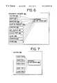
- FIG. 6there is a diagram illustrating the organization of the geographic database 140 by data type.
- One way that the accessing of geographic data can be enhanced for performing various navigation functionsis to provide separate collections or subsets of the geographic data 140 for use by each of the separate functions (e.g., 141 - 146 ) in the navigation application program 18 .
- Each of these separate subsetsis tailored specifically for use by one of the functions.
- the route calculation function 141(in FIG. 2) normally requires only a portion of all the information in the geographic database that is associated with a segment of a road. When the route calculation function 141 is being run, it may require information such as the speed along a road segment, turn restrictions from one road segment to another, and so on.
- the route calculation function 141does not necessarily require the name of the road to calculate a route.
- some of the information associated with a road segmentsuch as the speed limits or turn restrictions, is not required. Instead, when the map display function 143 is run, it uses only a portion of the information associated with the road segment, such as the shapes and locations of roads, and possibly the names of the roads. Even further, when the route guidance function 142 is being run, some of the information associated with a segment of a road, such as the speed and turn restrictions, is not required. Instead, when the route guidance function 142 is being run, it uses information that includes the name of the road represented by the road segment, the address range along the road segment, any signs along the road segment, and so on.
- each data entity recordwould be relatively large. Thus, whenever any one of the navigation functions accessed an entity record, it would have to read into memory a significant amount of information much of which would not be needed by the navigation function. Moreover, when reading the data entity from disk, relatively few data entities could be read at a time since each data entity would be relatively large.
- FIG. 6illustrates the geographic database 140 comprised of separate routing data 236 , cartographic data 237 (for map display), maneuver data 238 (for route guidance), point-of-interest data 239 (for identifying specific points of interest, such as hotels, restaurants, museums, stadiums, airports, etc.), and junction data 240 (for identifying named intersections).
- the geographic database 140may include navigation feature data 241 . This subset of data includes the names of the navigable features (such as roads).
- the geographic databasemay also include data subsets for postal codes 243 and places 244 (e.g., cities, states, and counties).
- the geographic database 140includes a separate subset of data for location references 245 , as explained further below.
- a geographic databasemay be defined with fewer or more subsets than these, and other types of data 246 may be defined and included.
- Each subset of dataincludes only the data required to be used by a particular navigation function. There is some overlap of data between each of these subsets, with the result that some parts of the information may be included in more than one subset.
- both the road segment data entity in the routing data subset 236 as well as the road segment data entity in the cartographic data subset 237may include attributes identifying the nodes located at the ends of the segments.
- Providing for separate subsets of geographic data for each of the navigation functionsalso takes into account that usage of each of these navigation functions relates to the others of the navigating functions in expected ways. For example, an end-user may first want to view a present position, then enter a destination, then receive instructions how to start toward the destination, then observe a map showing the initial portion of the route, then receive further instructions, then have a map displayed of the next portion of the route, and so on. Because of this type of expected usage, dividing the data into subsets provides for efficient use of the data when using each separate finction.
- the division of the geographic data into subsetsprovides for efficient use of the data by each of the different navigation functions, it becomes necessary to provide that the different navigating functions that use these different subsets of the database work together.
- the routing subset 236 of geographic datais accessed first to obtain the routing road segment data entities for the optimum route, and then the cartographic subset 237 of the geographic database is accessed to obtain the cartographic road segment data entities corresponding to the routing data entities.
- indicesmay be included that provide cross references, search trees, or other data finding techniques.
- Indicescan be located within any of the subsets of data or external of any of the subsets.
- external indices 247are shown. Storing indices external of the data that are being indexed has the advantage that the index can be loaded and used to determine which data among the various subsets of data needs to be loaded next.
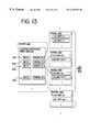
- Some of the navigation functionsmay use data at different levels of detail. For example, when using the map display function 143 , it is sometimes desired to provide for panning and zooming. Zooming can be done more efficiently if the data are organized into layers, with greater detail at the lower layers and less detail at the higher layers.
- the route calculation function 141it is also advantageous to use the data at different levels of detail. For example, when calculating a route between two locations, it would be inefficient to examine all the possible road segments that diverge from each intersection along the route, including secondary streets and alleys.
- routing dataare layered, higher layers that omit secondary roads can be used when possible to minimize the possible road segments to be investigated when calculating the route. Therefore, within some of the subsets of data types, the geographic data are provided in separate collections or groups corresponding to separate layers.
- each road segment data record in the map database 140also identifies the rank of the corresponding portion of the roadway that it represents.
- a rank of a road segmentmay correspond to its functional class.
- Road segments having a rank of “4”may include high volume, controlled access roads, such as expressways and freeways.
- Road segments having a rank of “3”may be high volume roads with few speed changes, but are not necessarily controlled access roads.
- the lower ranked roadshandle corresponding lower volumes and generally have more speed changes or slower speeds.
- Roads having a rank of “0”can handle the lowest volumes. For example, these roads lowest ranked roads may include side streets, alleyways, etc.
- the rank of a road segment data entityalso specifies the highest data layer in which a road segment entity is included.
- the routing type data 236may include five separate layers of the data, R 0 , R 1 , R 2 , R 3 , and R 4 , each comprising a separate collection of the routing data with a different level of detail, which can be used by the route calculation function.
- layer 0(“R0”) includes the road segment data entities (and some or all of their corresponding routing data attributes) having a rank of “0” or higher.
- layer 0includes road segment data entities corresponding to all the portions of all the roads in the geographic region.
- Layer 1 of the routing data 236comprises a separate subset (or collection) of the routing data and includes only the routing segment data entities (and some or all of their corresponding routing data attributes) having a rank of “1” or higher.
- Layer 2 of the routing datacomprises a separate subset of the routing data and includes only the routing segment data entities (and some or all of their corresponding navigation data attributes) having a rank of level 2 or higher, and so on.
- a highest layer (layer n)includes only records having a rank of n. In a present embodiment, n is equal to 4, although in other embodiments, n may be any number greater than 0. Each higher layer includes fewer records, however these records represent roads upon which travel is generally faster.
- the other types of datasuch as the cartographic subset type 237 may include separate collections of the data, each with a different level of detail, which can be used by the map display function. Using these different layers of cartographic data, the map display function can provide rapid panning and zooming.
- Indices 249may be provided for this purpose. In FIG. 7, internal indices are shown. Internal indices 249 are included among the various types of data.
- FIG. 8is a diagram illustrating the organization of the geographic database 140 embodied on the data storage medium 132 .
- the geographic database 140 on the medium 132includes header and global data 321 and geographic data 310 .
- the header and global data 321include information pertaining to the entire geographic database 140 , such as an identification of the region (e.g., 212 in FIG. 4) represented by the database, the release date of the database, what kinds of data compression are used, if any, and so on.
- the geographic data 310includes the data relating to the geographic features. Specifically, the geographic data 310 includes all the data which correspond to the different types of geographic data represented in FIG. 6, such as the routing data 236 , the cartographic data 237 , the maneuver data 238 and so on.
- the geographic data 310also include indices, such as the indices 247 shown in FIG. 6 and the indices 249 shown in FIG. 7 .
- the geographic data 310are organized by type (shown in FIG. 6) and by layer (as shown in FIG. 7) for those types that have layers.
- the data 310are comprised of a plurality of data entities or records.
- these data entitiesare grouped into a plurality of parcels 320 .
- Each parcelcontains a portion of the plurality of data entities which comprise each type or layer of the geographic data 310 .
- the size of each parcelconforms to a regular data size, e.g., sixteen kilobytes, eight kilobytes, etc.
- This organization of data records into parcelsfacilitates storage and retrieval of the geographic data.
- all the data which correspond to the different types of geographic data represented in FIG. 6, such as the routing data 236 , the cartographic data 237 , the maneuver data 238 , and so on,are organized into parcels 320 .
- a meansthat facilitates using traffic messages that are broadcast by a traffic broadcast system in conjunction with a navigation system that also uses a geographic database.
- the present embodimentprovides a means that facilitates using the traffic messages 50 broadcast by the broadcast system 20 in conjunction with the navigation system 110 that uses the geographic database 132 shown in FIGS. 1, 2 and 6 - 8 .
- Using broadcast traffic messages together with a geographic databaseallows a navigation system to provide improved navigating features to a driver.
- using broadcast traffic messages together with a geographic databasealso allows a navigation system to provide navigation features that had previously been unavailable.
- One important advantage of using traffic broadcast messages together with a geographic databaseis that a route calculation finction in the navigation system can take into account up-to-the-minute traffic conditions when calculating a route to a desired destination location.
- the present embodimentprovides a means by which the navigation system relates the data in the traffic messages to the data in the geographic database.
- the data in the traffic messagemay have a different form than the data in the geographic database.
- the traffic broadcast systemmay assign specific reference codes to locations in the geographic region about which the traffic messages relate. Traffic broadcast systems, such as the RDS-TMC system, use these reference codes instead of the actual location names for several reasons. For example, using reference codes avoids possible ambiguities that might arise if actual street names or addresses were used. Also, specially assigned codes may be necessary where particular locations along roads do not have names. In addition, using codes instead of actual location names may reduce the overall size of the data messages that are broadcast.
- location reference codesmay not be readily usable by navigation systems that include geographic databases.
- One reason that navigation systems may not be able to readily use the location reference codes assigned by the traffic broadcast systemis that these codes do not necessarily correspond to any known physical features.
- the location reference codes for positions along an interstate highwaymay be arbitrary n-bit (e.g., 20 bit) numbers. These numbers by themselves do not necessarily have any meaning for end-users of navigation systems, such as motorists. Motorists are not likely to know the n-bit location reference code number for a particular highway interchange.
- a traffic message that identified a location of traffic congestion by referring to its n-bit location reference numberwould not necessarily have any meaningful significance to end-user drivers.
- RDS/TMCtraffic broadcast system
- the RDS-TMC messagesconform to the ALERT-C protocol.
- many primary and some secondary road interchangeshave predefined location numbers. These location numbers are a part of the traffic messages that are broadcast. These location numbers are assigned by the road authorities or other parties involved in the development and maintenance of the RDS/TMC system. These location numbers are standardized for all users. That is, any receiver that uses the messages from the traffic broadcast system is required to be able to relate the location reference numbers in the RDS-TMC messages to the known locations to which the numbers are assigned.
- the location reference numbersmay be unique within a regional database of the specific traffic broadcast system. Such a regional database is known as a “location table.” A separate location table is defined for each different region. This location table region corresponds to the region 10 in FIG. 1, but does not necessarily correspond to (i.e., have boundaries that coincide exactly with) the geographic area 212 in FIG. 4 .
- FIG. 9shows one example of how location reference numbers are assigned.
- the example of FIG. 9is similar to the RDS/TMC system.
- FIG. 9illustrates a portion of a roadway 500 .
- This roadway 500is one of the roadways in the roadway network 12 (in FIG. 1) about which the traffic broadcast system 20 monitors traffic congestion and about which the traffic broadcast system 20 reports on traffic congestion by means of traffic messages 50 .
- location reference numberse.g., LR 12005 , LR 12006 , and LR 13297 .
- LR 12005 , LR 12006 , and LR 13297are pre-assigned to locations along the roadway 500 . These location reference numbers are assigned by the road authorities or others involved with the traffic broadcast system 20 .
- the messages 50 (in FIGS. 1-3) broadcast by the traffic broadcast system 20include these location reference numbers when identifying locations of traffic congestion.
- the roadway 500 being monitored and about which traffic messages are broadcastis usually an expressway or major arterial road. Traffic conditions along minor roads may not be monitored by these kinds of traffic broadcast systems. Accordingly, in traffic broadcast systems, such as the RDS-TMC system, location reference numbers are assigned to locations along expressways and major arterial roads, but not along minor roads.
- FIG. 9shows only three location numbers, LR 12005 , LR 12006 , and LR 13297 . It is understood that in a typical traffic broadcast system, there may be hundreds, thousands, or more, of location reference numbers assigned to locations along roads in each region represented by a location table. As shown in FIG. 9, the location reference numbers correspond to interchanges along the roadway 500 . However, location reference numbers may be assigned to any position along the roadway 500 , including positions between interchanges.
- directionsmay be defined as positive or negative.
- the directionis positive for travel directions west to east and from south to north.
- the location reference numbersmay be, but are not necessarily, assigned in consecutive order along a roadway.
- each roadwayis assigned its own location reference numbers.
- the location reference numbers of one roadwayare not shared with other roadways. Therefore, at an interchange between two roadways each of which is assigned location reference numbers, one location reference number is assigned to the interchange for the first of the roadways and a second different location reference number is assigned to the same interchange for the second of the roadways.
- a single interchangemay have two or more location reference numbers assigned to it, one for each of the roadways that meet at the interchange.
- the location reference numbersdo not necessarily relate to any physical roadway features.
- the roadway 500is shown to consist of individual road segments, labeled S 101 , S 102 , . . . S 132 .
- These road segments S 101 , S 102 , . . . S 132correspond to individual portions (i.e., segments) of the roadway 500 .
- each of these individual segments of the roadway 500may comprise a portion of the roadway 500 between intersections of the roadway 500 with other roads, including on-ramps and off-ramps.
- each of these separate road segments, S 101 , S 102 , . . . S 132is represented by at least one separate data record.
- the roadway 500 shown in FIG. 9there are separate road segments associated with the lanes of the roadway 500 for each direction.
- the lanesare actually physically separate from each other, such as in the portion of the roadway 500 depicted in FIG. 9, there may be separate segment data records in the geographic database 140 for the lanes in one direction and the lanes in the other direction. Even where the lanes of the roadway are not physically separated from each other, they may be represented by separate data records in the geographic database.
- a single segment data recordmay be included in the database that represents all the lanes of the roadway in both directions.
- the database recordsinclude attributes that indicate whether they represent lanes in both directions or only lanes in a single direction.
- each of these multiple segments of the roadway 500may be represented by at least one record in the geographic database 140 .
- Each of these segments of the roadway 500 between interchangesmay be represented by at least one record in the geographic database 140 .
- none of these individual road segments S 101 , S 102 . . . , S 132is separately identified as relating to the location reference numbers by the traffic broadcast system in the messages that are broadcast.
- the data in the traffic messages 50could be utilized when calculating a route using the route calculation finction 141 in the navigation system 110 (in FIG. 2 ). If the data in the traffic messages could be used by the navigation system, the segments associated with traffic congested locations that are assigned location reference numbers could be avoided by the route calculation function.
- the location numbers assigned by the traffic broadcast system authoritiesdo not directly relate to any physical feature represented by the data records in the geographic database 140 .
- the traffic messages broadcast by the traffic broadcast system 20do not necessarily relate to any of the actual road segments that are represented by data records in the geographic database.
- the length of the roadway affected by an occurrence of traffic congestionis reported in terms of the “extent” data 50 ( 4 ) which is included in the broadcast traffic message, as mentioned above in connection with FIG. 3 .
- the “extent” dataare defined in terms of the number of adjacent positions represented by location numbers that are affected by the traffic congestion condition relative to the position along the roadway identified by the location reference number in the traffic message.
- the “extent” data 50 ( 4 )also do not bear any direct relationship with physical features represented by data records in the geographic database.
- Using “extent” data in traffic messagescompounds the difficulty of incorporating traffic broadcast message information in the route calculation function 141 of the navigation system 110 .
- route calculationmay be performed by exploring multiple potential solution routes from a starting location to a destination location.
- the route calculation function 141may perform this process by comparing multiple possible paths from intersections along parts of potential solution routes and selecting the path that has the best overall cost, based upon some cost assignment criteria.
- the data records that represent each road segment in these potential solution routesare examined. These data records include information from which a comparison of the potential solution routes can be made.
- the data records that represent road segmentsmay include attributes that indicate the speed limit along the represented road segment, whether there is a stop light at the end of the road segment, and so on.
- the potential solution routescan compared to each other so that the best solution route (e.g., the route with the fastest overall travel time or the least overall distance) can be selected.
- the data in the traffic messages 50 broadcast by the traffic broadcast systemmay be pertinent to the calculation of the best overall route.
- the route calculation functionit is required to identify the data records that represent the road segments that are associated with the interchanges, including those road segments that lead into the interchanges, for which location reference numbers have been assigned by the traffic broadcast system 20 .
- present embodimentsinclude combinations of features and/or components that allow a navigation application program 118 in the navigation system 110 to use the data in the traffic messages 50 .
- location reference data recordsare formed, stored and used to identify certain segment data records in the geographic database as being associated with certain location reference numbers. These location reference records may be included in the geographic database 141 or may be provided to vehicles via a wireless communication link. The components of a location reference record are illustrated in FIG. 11 .
- one or more indicesare formed, stored and used to relate location reference numbers to location reference records. These indices are illustrated in FIG. 13 .
- parcels of location reference data recordare formed, stored, and used.
- a parcel containing location reference datais illustrated in FIG. 12 .
- dataare formed, stored and used to identify, for each location reference number, the immediately previous and the immediately next location reference number. This allows the “extent” data in a broadcast message to be interpreted and related to records in the geographic database.
- programmingis included in the navigation system that queries the geographic database and returns the data entities associated with certain identified location reference numbers. This aspect of the present embodiment is illustrated in FIGS. 14-16.
- data recordsare formed that provide for the association of certain data entities in the geographic database used by the navigation system with the location reference codes used by the traffic broadcast system.
- a “location key”is formed as part of this process.
- the location keyis an aggregation of data components that relate to a location reference code. Each location key forms a unique identifier for that location code in the geographic database. Because of this feature, the location keys can be used as entity ID's for these records in the geographic database.
- the components of a location key 505are shown in FIG. 10 .
- the location key 505is formed of a combination of the country code, the location table number and the location number. This combination together forms a unique 32 bit number.
- the location numberis 16 bits
- the location table numberis 6 bits
- the country codeis 4 bits. This unique number is used as a numeric sort key, as explained below.
- the location keysare formed to provide a unique identifier for each location in the region represented by the geographic database for which one or more traffic broadcast systems have assigned location reference numbers
- the data entities in the geographic database to be associated with each location keyare identified.
- the data entities that represent road segments that are contained in or that lead into the interchanges represented by location keysare identified.
- the interchange associated with the location reference number LR 12006contains both internal segments and external segments.
- the internal segments of the interchange represented by the location reference number LR 12006include S 113 and S 114 .
- the external segments of the interchange represented by the location reference number LR 12006include the two segments, S 110 and S 112 , that lead into the interchange in the positive direction and the two segments, S 122 and S 123 , that lead into the interchange in the negative direction.
- the segment data entities associated with these 6 segments(S 113 , S 114 , S 110 , S 112 , S 122 and S 123 ) are identified as being associated with the location key for the interchange LR 12006 .
- the segments leading out of the interchange LR 12006are not associated with the location reference number for the interchange. Instead, these segments are associated with the location reference number of the interchange that they lead into.
- the segment identified by S 121leads into the interchange represented by the location reference number LR 13297
- the segment identified by S 111leads into the interchange represented by the location reference number LR 12005 . Accordingly, they are associated in the geographic database with the location keys for those interchanges.
- FIG. 11illustrates a location reference data record 260 .
- the entity ID for this recordis the location key, formed in the manner described above.
- the location reference record 260includes a list 260 ( 1 ) of segment ID's, (e.g., segment ID(x), segment ID(w), segment ID(p) . . . segment ID(j)). These segment ID's identify the segment data records that represent the road segments associated with the interchange identified by the location reference key. In the case of the location reference record that represents the interchange LR 12006 in FIG. 9, there would be 6 segment ID's in the list 260 ( 1 ) of entity ID's, i.e., S 113 , S 114 , S 110 , S 112 , S 122 , and S 123 .
- the segment ID'sare ordered. Various orderings may be used. In a present embodiment, the segment ID's are ordered to provide a valid navigable path. For example, S 123 , S 122 , S 113 , would form a valid path in the negative (“N”) direction and S 110 , S 112 , and S 114 form a valid path in the positive (“P”) direction.
- Nnegative
- Ppositive
- the geographic database 140may include more than one layer of certain types of data, such as the routing data 236 . Each of these layers may assign a different segment ID to the same road segment. This has the result that the same road segment may be represented by more than one segment ID in the geographic database.
- the list 260 ( 1 ) of segment entity ID's in the location reference data record 260may include the segment record ID's for the lowest layer (i.e., layer R 0 ), or for any other layer (e.g., layers R 1 -R 4 ). Alternatively, the list 260 ( 1 ) may include the segment entity ID's for more than one layer or for all the layers.
- the list 260 ( 1 ) of segment entity ID'sincludes the segment record ID's for the lowest layer only, a means may be provided to obtain the corresponding segment ID's of the road segments in other layers.
- the segment data records in layer 0may include references to the corresponding segment data records in other layers that represent the same road segment.
- the roadways to which location reference numbers have been assigned by the traffic broadcast systemtend generally to be high volume, limited access roads, the roadway tends to be made up of segments of only the highest rank, e.g., rank 4 .
- higher layersmay include data records that represent aggregations of individual road segments. Aggregations of road segments in higher layers may be represented by separate data records because the intersections of the higher ranked road segments with lower ranked road segments may be suppressed or eliminated in the higher layers in which the lower ranked roads are not included. Using aggregated segments data records may enhance performance of some navigation functions.
- these aggregated segments data recordsrepresent portions of roads that are associated with location reference numbers and the list 260 ( 1 ) of segment ID's in a location reference record 260 includes only layer 0 segment ID's
- the layer 0 segment data records that represent road segments that are included in aggregations of road segments that are represented in higher layers by aggregated segments data recordsmay include references that identify the associated aggregated segments data records.
- the segment ID's of aggregated segments data recordsmay be included in the list 260 ( 1 ) of the location reference record.
- the location reference record 260may identify other data entities 260 ( 2 ) associated with the location represented by the location reference number.
- the location reference record 260may include a list of node ID's that represent the nodes associated with the location reference number.
- the location reference number data record 260may also include other data components.
- the location reference number 260includes a direction attribute 260 ( 3 ).
- the location reference number 260may also optionally include an intersection attribute 260 ( 4 ).
- the direction attribute 260 ( 3 )indicates the direction of the location reference number.
- the intersection attribute 260 ( 4 ), if provided,includes data that indicates the type of location represented by the location reference record.
- the intersection attribute 260 ( 4 )may include data that indicates that the location identified by the location reference number is a ramped interchange, a terminus, or that the intersection includes stoplights, and so on.
- the location reference number data record 260may also include other data 260 ( 5 ).
- the data components of all the location recordsare organized, arranged and stored in the geographic database 140 used by the navigation system in a manner that facilitates the rapid identification and retrieval of all associated segment records, given a location reference number and an extent.
- the organization, arrangement and storage of the location reference dataare illustrated in connection with FIGS. 12 and 13.
- the location key 505 associated with the location reference numberis used as a preliminary step to locating the segment records in the geographic database which are associated with a location reference number.
- the location keyis formed of the components of a traffic message that includes a location reference number.
- a location key index 247 (LR)is used.
- the location key index 247 (LR)is formed and stored in or with the geographic database 140 .
- This location key index 247 (LR)may be located in a portion of the geographic database 140 separate from the location reference record data 245 . Referring to FIG. 13, in a present embodiment, the location key index 247 (LR) is included among the index files 247 (also shown in FIG. 6 ).
- the entire location key index 247 (LR)may be read into the memory of the navigation system and used to identify the location of the desired location reference record. Storing the location key index 247 (LR) separately from the location reference data avoids the need to load unnecessary data into the memory of the navigation system thereby enhancing performance.
- the location key index 247 (LR)may be maintained in memory along with other indices included among the index files 247 . Alternatively, the location key index 247 (LR) may be loaded into memory and used only when needed. (If the size of the location key index 247 (LR) is relatively large, it may be required to store it in more than one parcel.)
- the location key index 247 (LR)does not identify the location of each specific location reference record, but instead the location key index 247 (LR) identifies the parcel 320 (LR) of location reference data 245 that contains that desired location reference record.
- the location key reference index 247 (LR)includes a list 510 of entries.
- the entries in this list 510include only those location reference keys 505 that correspond to the first location reference records in each of the plurality of parcels 320 (LR) that contain location reference data 245 .
- Each of the entries in the list 510also includes an identification of the parcel of data that includes the location reference record that corresponds to the location key in the entry. This identification may be a pointer or other reference, or alternatively, the identification may be a parcel ID from which the location of the parcel in the database and/or on the medium can be determined.
- the location reference keys 50 in the list 510 in the location key index 247 (LR)are sorted and/or arranged in order (e.g., numerically smallest to largest, or vice versa). Therefore, the entries in the list 510 can be used to identify the parcel in which the location reference record associated with any location key is located. Given a location key, the list 510 can be traversed until an entry larger than the given location key is encountered. Then, the parcel that contains the location reference record associated with the given location key is the parcel referenced by the previous entry in the list. Alternatively, other searching techniques (e.g., binary searches) can be used to find the parcel that contains a desired location reference number. Thus, this list 510 accommodates searching techniques that allow finding the parcel that contains a location reference record quickly.
- searching techniquese.g., binary searches
- the location key indexmay comprise a multiple layer search tree, each layer of which may be binary searched by key for a location tree parcel at the next lower layer, or (from the lowest layer location index parcel) for a location reference record parcel.
- Each of the parcels 320 (LR) that contain location reference data 245has a similar organization.
- the organization of a representative parcel 320 (LR)(n) of location reference data 245is shown in FIG. 12 .
- Each parcel 320 (LR) of location reference dataincludes a data component 521 that identifies the location reference record (e.g., by location key) that has the minimum location reference key within the parcel. This record corresponds to the record pointed to by the entry in the location key index 247 (LR).
- the parcel of location reference data 245also includes an offset table 545 and location reference records 550 .
- the offset table 545includes a list of entries 546 ( 1 ), 546 ( 2 ), 546 ( 3 ) . . . that correspond to each of the location reference records 550 ( 1 ), 550 ( 2 ) . . . 550 (n), included in the parcel.
- the entries 546 in the list 545reflect the ordering of the location reference records which in a present embodiment are numerically ordered.
- Each entry 546identifies the length 547 of its corresponding location reference record in the parcel.
- the offset table 545also includes, for each entry 546 , data that identify the next location key 549 .
- the data in the next location key 549identify the location key 505 of the immediately next location reference number along the roadway relative to the location key of the entry 546 .
- each entry 546includes data that identify the previous location key 551 .
- the data in the previous location key 551identify the location key of the immediately previous location reference number along the roadway relative to the position corresponding to the location key of the entry 546 .
- an entry 546 in the offset table for the location key for the interchange associated with “LR12006”would identify the location key for LR 12005 as its previous location key 551 and the location key for LR 132297 as its next location key 549 .
- location reference numbersare not necessarily assigned consecutively along a roadway. Therefore, the next and previous location keys for each location reference number are identified in the offset table 545 .
- the location reference record portion 550includes the location records 550 .
- Each location reference record 550 in the location reference parcel 320 (LR)includes the components identified in FIG. 11 .
- each location reference record 550includes a direction attribute (corresponding to the direction data 260 ( 2 ) in FIG. 11) and a list of segment ID's (corresponding to the list 360 ( 1 ) in FIG. 11 ).
- the location reference record 550may also include an intersection attribute (corresponding to the intersection data 260 ( 3 ) in FIG. 11 ),
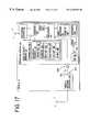
- Another aspect of the present embodimentincludes programming that uses both the data in the traffic messages 50 and the location reference data 245 in the geographic database 140 .
- This programmingis referred to herein as “location reference programming” or “location reference routine” 145 .
- the location reference programming 145may be included as part of the navigation application programming 118 (in FIG. 2) that is installed in and/or executed by the navigation system 110 .
- the location reference programming 145may be included as part of a software interface layer that resides between the navigation application functions (such as the routing finction 141 , the map display function 143 , etc.) and the geographic database 140 .
- the software interface layermay also be installed in and/or executed by the navigation system 110 . If the location reference programming is installed in the navigation system 110 in the vehicle, it may be stored in a non-volatile computer-readable medium that is part of the navigation system.
- FIG. 14shows a flowchart that sets forth the major steps in the location reference programming 145 .
- a receiver routine application 707which may be part of the navigation application program 118 , performs certain initial steps and then provides an output to the location reference programming 145 .
- the steps performed by the receiver routine application 707may be performed by the location reference programming 145 .
- a single traffic message 50is received.
- the traffic message 50may have a format similar to that shown in FIG. 3 .
- the traffic message 50is parsed to obtain the components of the message 50 , including the location reference number 51 ( 1 ), the extent 50 ( 4 ), and so on. These data are provided by the receiver routine application 707 to the location reference programming 145 .
- a location key 505is formed (Step 718 ).
- the location key 505may be formed by concatenating these components extracted from the traffic message.
- the location key index 247 (LR) in the geographic database 140is used to find the parcel 320 (LR) of location reference data records that contains the location reference record associated with the location key (Step 722 ).
- the parcelis accessed and read (Step 726 ).
- the parcel headerincluding the offset table 545 , is read first (Step 730 ).
- the offset table 545in which the location keys are numerically ordered
- the entry corresponding to the desired location keyis found (Step 734 ).
- the next location key 548 or the previous location key 551is read. Which of these keys (i.e., next or previous) is read depends on the direction data 50 ( 3 ) in the traffic message, which defines the direction of traffic congestion relative from the position of the location reference number.
- each of the other location keys to which the traffic message appliescan be determined (Step 738 ).
- the offset tablemay have to be used several times to identify all the location keys encompassed within an extent. For example, if the extent data 50 ( 4 ) is “4,” the offset table 545 is used first to identify the next (or previous, depending upon the direction) location key relative to the location key for the location reference number 51 ( 2 ) identified in the message 50 . Then, this next (or previous key) key is located in the offset table in order to identify its next (or previous location reference key).
- the offset table 545is used to locate the desired location reference data records within the parcel (Step 742 ). For each location key entry in the offset table, the offset into the parcel identifies the location within the parcel at which the data associated with the location key entry is found. For each location key entry, the location reference data record 550 is read (Step 746 ). Specifically, all the segment ID's associated with each identified location key are identified. These segment ID's identify all the segments that are affected by the traffic congestion in the traffic message 50 . These segment ID's may be associated with more than one location reference number because the extent data 50 ( 4 ) may identify more than one location reference number as being affected by the traffic congestion. This list of segment ID's 752 is then returned (Step 750 ) to the program that called it. Examples of how this location reference programming routine 145 can be used in the context of the navigation system are provided below.
- the location reference programming 145may return a list of segment ID's for one layer (e.g., routing layer 0 ), or alternatively, for more than one layer.
- these routing layer 0 data recordsmay be accessed first and read to obtain the references included in these layer 0 segment data records to the data records in other, higher layers. Then, these additional segment ID's 759 may also be returned to the calling application. If the higher layers include aggregated segments data records, references to these records may also be returned.
- the steps ( 756 and 758 ) included in this optional alternativeare illustrated by the dashed lines in FIG. 14 .
- the location reference programming 145may be written in any suitable programming language. In one embodiment, the location reference programming 145 is written in the same programming language as the other functions that access and use the geographic database. In a present embodiment, the location reference programming 145 is written in C, although in alternative embodiments, the location reference programming 145 may be written in any suitable programming language, such as C++, Java, or programming languages that may be developed in the future.
- a meansfor returning the entities corresponding to those references.
- the location referencewould represent the RDS-TMC code, which is the collective encoding of the location attributes as noted above.
- the entities or records returned from the geographic database 141would be segment data records
- traffic dataare obtained at initialization of the navigation system and then updated continuously or at regular intervals during use of the navigation system.
- a traffic data collection program 810is executed.
- This traffic data collection program 810may be part of the navigation application programming 118 , the interface layer programming (mentioned above), or any other part of the navigation system.
- the traffic data collection program 810may work in the background so that it does not interfere with other tasks that the end-user may call on the navigation system to perform.
- the traffic data collection program 810begins to receive traffic message broadcasts 50 . These may be received from the receiver 125 in FIG. 2 . For each traffic message 50 received, the traffic data collection program 810 calls the location reference routine 145 (shown in FIG. 14) (Step 825 ). The traffic data collection program 810 may have to buffer the traffic messages 50 received from the traffic broadcast system 20 until the location reference routine 145 is able to catch up with the messages. A portion of the memory of the navigation system may be provided for this purpose.
- the location reference routine 145For each traffic message 50 , the location reference routine 145 returns a list of segment ID's that are affected by the congestion reported in the traffic message. The severity of the congestion from the traffic message is associated with the segments and stored in a temporary database 818 (Steps 827 and 829 ). The data collection program 810 continues to store data that associates severity with segment data records until all the traffic messages have been obtained (Step 830 ). At this point the data collection program continues to collect traffic messages and updates the temporary database as necessary as the severity associated with segments changes (Step 831 ).
- the temporary database 818may be used by the navigation application.
- the route calculation function 141when executed to determine a solution route 833 , the temporary database 818 may be used in conjunction with the geographic database 140 .
- the route calculation functionexamines segments from the geographic database 140 for the purpose of determining potential solution routes and determines whether any of the segments have severity ratings associated with them in the temporary database 818 . If a segment in a potential solution route has a severity weighting associated with it in the temporary database 818 , the weighting is taken into account when comparing the potential solution route to other potential solution routes. If traffic is severely congested on a segment of a potential solution route, another potential solution route may be selected.
- the access performance of obtaining the segments associated with traffic messagesis not critical because the traffic data collection process accumulates the list of segment entities to be avoided in the temporary database 818 prior to route calculation.
- traffic data 50are not obtained until the route calculation program 141 is run.
- the route calculation program 141receives input that includes a desired destination and an origin (Step 901 ).
- a traffic data collection program 903is called.
- This traffic data collection program 903obtains traffic messages 50 broadcast by the traffic broadcast system 20 (Step 905 ). Each of these traffic messages may be temporarily stored in a memory of the navigation system 110 .
- the traffic messages 50may be filtered so that messages that pertain to locations relatively far away from potential solution routes are not processed. Then, the traffic data collection program 903 executes a routine 907 for each pertinent traffic message.
- the routine 907calls the location reference routine 145 (in FIG. 14) in order to obtain all the segment data entities (or at least the ID's for all the segment data entities) associated with the location reference number(s) in the traffic message including the location reference number explicitly specified in the traffic message as well as those location reference numbers which are implicitly specified by the extent data included in the traffic message.
- the severity of the traffic congestion included with the traffic messageis associated with each of these segment data entities (or ID's) (at Step 913 ). This association of severity with segment ID's is stored in a temporary database 916 (at Step 915 ).
- the route calculation function 141proceeds to determine a solution route 921 (Step 917 ).
- the temporary database 916 of weighted segmentsis used in conjunction with the geographic database 140 .
- the weightingis taken into account when comparing the potential solution route to other potential solution routes.
- the severity weightingmay indicate that the traffic congestion is so bad that the segment should be avoided entirely. Alternatively, the severity may be relatively light so that segments that include traffic congestion may still be used in a potential solution route.
- some or all of the navigation application programming or functions performed by the navigation systemmay be performed remotely.
- some or all of the navigation application programming functionsmay be performed by a service provider to which the vehicle has a wireless communication link. (The service provider is not necessarily associated with the traffic broadcast system.)
- the user's inputmay be transmitted to the remote service provider where the navigation function is performed and the result transmitted back to the vehicle.
- the location reference programming and/or the data collection programmingmay be located either in the vehicle or may be accessed remotely.
- some or all of the geographic database 140may be located remotely, with a service provider for example, and accessed by the navigation system in the vehicle via a wireless communication link.
- the location reference recordsmay be located either on a computer readable medium in the vehicle or may be located remotely and accessed via a communications link.
- the location referencing datamay be downloaded as needed via a wireless communication link and stored in the vehicle on a separate, writable media located in the vehicle, or alternatively, the location reference data may be stored in a table in a memory (such as a RAM) in the vehicle.
- the navigation programming in the vehicle that uses the location referencing dataaccesses the data from the separate medium.
- a primary source of location referencing datacan be stored with the geographic database and updates to the location referencing data can be downloaded and stored on a separate medium.
- the programming that uses the location referencing datauses both the primary location reference data and the updated data.
- the receiver that receives the traffic messages and provides the traffic messages to the programming that parses the traffic messagemay be part of the navigation system 110 (as shown at 125 in FIG. 2) or alternatively, the receiver may be a stand-alone unit or a unit associated with another kind of equipment.
- This alternative embodimentis shown at 1125 in FIG. 17 . If the receiver is not part of the navigation system 110 as shown at 1125 in FIG. 17, the receiver 1125 has an output port 1127 that can be coupled to an input port 1129 on the navigation system 110 in order to allow the transfer of data, such as the traffic messages, from the receiver 1125 to the navigation system 110 .
- the ports on the receiver and on the navigation system, 1127 and 1129may provide for a direct connection or alternatively may provide for connection by cabling 1131 .
- the navigation system and the geographic databaseare similar or the same as in the previously described embodiments.
- the geographic database 141may include location reference data that supports traffic broadcast messages from systems other than the RDS-TMC system.
- examples of such other systemsinclude GATS, VICS, and ITS Datum, as well as proprietary systems, and systems that may be developed in the future.
- Such other systemsmay include messages that are similar to the messages in the RDS-TMC system or may include different kinds of messages.
- These different kinds of messagesmay include a location referencing system, like the RDS-TMC system, or may include other kinds of location referencing.
- These different kinds of systemsmay include extent data that implicitly identify other locations, or alternatively all locations may be explicitly identified.
- the geographic databasemay include location reference data that supports more than one kind of traffic broadcast messaging format.
- the RDS-TMC systemas well as some other system may be supported.
- the geographic databasemay include separate sets of location reference data records, each formed with separate location keys. These separate sets may be stored in the geographic database 141 .
- the geographic databasemay support a query from the navigation application program to identify the kinds of real time traffic broadcast systems that are supported.
- the queryreturns an identification of the traffic broadcast systems whose location reference data are included in or supported by the geographic database.
- programmingmay also be provided in the navigation system that allows a selection of the traffic message format.
- the selection processmay be automatic or alternatively, the selection process may be made by the end user.
- Support for multiple traffic broadcast formatsmay be useful for vehicles that travel to different cities that have different traffic broadcast system formats.
- location reference data entitiesmay be used in the geographic database to utilize numbering references from systems other than those that broadcast traffic messages.
- Each of the venues for which tickets are availablemay be identified by the ticket seller by a reference number.
- the geographic databaseincludes location reference data entities that relate the reference numbers used by the ticket seller to data included in the geographic database.
- each location reference data entity in the geographic databasecorresponds to one of the reference numbers used by the ticket seller to identify a venue.
- Each location reference data entityidentifies a corresponding point-of-interest data entity record in the geographic database which corresponds to the location as the venue.
- the navigation applicationmay use these kinds of location reference data entities in a manner similar to the way it uses traffic message information.
- the navigation applicationreceives data from the ticket seller either directly or indirectly.
- the datamay be received by wireless or non-wireless means of communication.
- the data from the ticket selleridentifies venues by the identification numbers assigned by the ticket seller.
- the datamay also include performance times, ticket availability, ticket prices, programs, and so on.
- the navigation applicationuses the location reference data entities to relate the information received from the ticket seller to the point of interest data entities in the geographic database. The user can then access the information received from the ticket seller in conjunction with use of the point-of-interest data in the geographic database.
- the usercan use the data from the ticket seller as further criteria when searching the geographic database. For example, the user can search for theater performances within 25 miles and that start within the next 2 hours.
- Other kinds of systems to which the location reference number can be usedinclude hotel chains, restaurant organizations, real estate brokers'offices, and so on.
Landscapes
- Engineering & Computer Science (AREA)
- Radar, Positioning & Navigation (AREA)
- Remote Sensing (AREA)
- Physics & Mathematics (AREA)
- General Physics & Mathematics (AREA)
- Automation & Control Theory (AREA)
- Navigation (AREA)
- Traffic Control Systems (AREA)
- Instructional Devices (AREA)
Abstract
Description
Claims (32)
Priority Applications (6)
| Application Number | Priority Date | Filing Date | Title |
|---|---|---|---|
| US09/196,409US6438561B1 (en) | 1998-11-19 | 1998-11-19 | Method and system for using real-time traffic broadcasts with navigation systems |
| JP37810498AJP4148580B2 (en) | 1998-11-19 | 1998-12-18 | Method and system for using real-time traffic information broadcasting with a navigation system |
| DE69928484TDE69928484T2 (en) | 1998-11-19 | 1999-08-25 | Method and apparatus for using real-time traffic radio messages with navigation systems |
| EP99306761AEP1004852B1 (en) | 1998-11-19 | 1999-08-25 | Method and system for using real-time traffic broadcasts with navigation systems |
| AT99306761TATE310941T1 (en) | 1998-11-19 | 1999-08-25 | METHOD AND APPARATUS FOR USING REAL-TIME RADIO TRAFFIC NOTIFICATIONS WITH NAVIGATION SYSTEMS |
| US10/196,476US7031983B2 (en) | 1998-11-19 | 2002-07-16 | Method and system for using real-time traffic broadcasts with navigation systems |
Applications Claiming Priority (1)
| Application Number | Priority Date | Filing Date | Title |
|---|---|---|---|
| US09/196,409US6438561B1 (en) | 1998-11-19 | 1998-11-19 | Method and system for using real-time traffic broadcasts with navigation systems |
Related Child Applications (1)
| Application Number | Title | Priority Date | Filing Date |
|---|---|---|---|
| US10/196,476ContinuationUS7031983B2 (en) | 1998-11-19 | 2002-07-16 | Method and system for using real-time traffic broadcasts with navigation systems |
Publications (1)
| Publication Number | Publication Date |
|---|---|
| US6438561B1true US6438561B1 (en) | 2002-08-20 |
Family
ID=22725293
Family Applications (2)
| Application Number | Title | Priority Date | Filing Date |
|---|---|---|---|
| US09/196,409Expired - LifetimeUS6438561B1 (en) | 1998-11-19 | 1998-11-19 | Method and system for using real-time traffic broadcasts with navigation systems |
| US10/196,476Expired - LifetimeUS7031983B2 (en) | 1998-11-19 | 2002-07-16 | Method and system for using real-time traffic broadcasts with navigation systems |
Family Applications After (1)
| Application Number | Title | Priority Date | Filing Date |
|---|---|---|---|
| US10/196,476Expired - LifetimeUS7031983B2 (en) | 1998-11-19 | 2002-07-16 | Method and system for using real-time traffic broadcasts with navigation systems |
Country Status (5)
| Country | Link |
|---|---|
| US (2) | US6438561B1 (en) |
| EP (1) | EP1004852B1 (en) |
| JP (1) | JP4148580B2 (en) |
| AT (1) | ATE310941T1 (en) |
| DE (1) | DE69928484T2 (en) |
Cited By (101)
| Publication number | Priority date | Publication date | Assignee | Title |
|---|---|---|---|---|
| US20020032791A1 (en)* | 1999-01-25 | 2002-03-14 | David Isherwood | Method and system for sharing end user information on network |
| US20020037731A1 (en)* | 2000-09-22 | 2002-03-28 | Xiaohong Mao | Traffic congestion management when providing realtime information to service providers |
| US20020129148A1 (en)* | 1999-01-25 | 2002-09-12 | Peter Ritz | Method and system for identifying traffic conditions |
| US20020183923A1 (en)* | 2000-05-15 | 2002-12-05 | Matthias Hessling | Method, data format, encoding device, decoding device and system |
| US20020194170A1 (en)* | 1998-11-19 | 2002-12-19 | Israni Vijaya S. | Method and system for using real-time traffic broadcasts with navigation systems |
| US20030023586A1 (en)* | 2000-03-03 | 2003-01-30 | Super Internet Site System Pty Ltd. | On-line geographical directory |
| US6597982B1 (en)* | 1999-07-20 | 2003-07-22 | Robert Bosch Gmbh | Method for coding congestion affecting several traffic lanes |
| US6609063B1 (en)* | 2001-10-12 | 2003-08-19 | Navigation Technologies Corp. | System and method for using a map database with attributed no-outlet and circular segments |
| US20030216857A1 (en)* | 2000-08-28 | 2003-11-20 | Estimotion Inc. | Method and system for modeling and processing vehicular traffic data and information and applying thereof |
| US6662101B2 (en)* | 2001-01-29 | 2003-12-09 | Matsushita Electric Industrial Co., Ltd. | Method and apparatus for transmitting position information on a digital map |
| US20040044466A1 (en)* | 2002-08-29 | 2004-03-04 | Nesbitt David W. | Automated route determination |
| US20040150534A1 (en)* | 2003-01-31 | 2004-08-05 | Jian-Liang Linn | Navigation system for finding optimum route using traffic incidents information |
| US6778808B1 (en)* | 1999-10-26 | 2004-08-17 | Nec Corporation | Route-adaptive on-demand radio communication system for a driver, communication method using the same, and recording medium storing a program for executing the method |
| US6785551B1 (en)* | 2000-04-07 | 2004-08-31 | Ford Motor Company | Method of providing dynamic regionally relevant data to a mobile environment |
| US20040204845A1 (en)* | 2002-06-19 | 2004-10-14 | Winnie Wong | Display method and apparatus for navigation system |
| US6853915B2 (en)* | 2000-09-12 | 2005-02-08 | Harman Becker Automotive Systems Gmbh | Motor vehicle navigation system that receives route information from a central unit |
| US20050085998A1 (en)* | 2002-06-02 | 2005-04-21 | Werner Bless | Provision of route-specific information |
| US20050187708A1 (en)* | 2001-04-23 | 2005-08-25 | Lg Electronics Inc. | Apparatus and method for processing traffic information |
| US20050259606A1 (en)* | 2003-09-23 | 2005-11-24 | Shutter Jon D | Method and system for developing traffic messages |
| US6990407B1 (en) | 2003-09-23 | 2006-01-24 | Navteq North America, Llc | Method and system for developing traffic messages |
| US6996089B1 (en)* | 1999-02-11 | 2006-02-07 | Robert Bosch Gmbh | Method of transmitting digitally coded traffic information and radio receiver for same |
| US20060058950A1 (en)* | 2004-09-10 | 2006-03-16 | Manabu Kato | Apparatus and method for processing and displaying traffic information in an automotive navigation system |
| US20060122846A1 (en)* | 2002-08-29 | 2006-06-08 | Jonathan Burr | Apparatus and method for providing traffic information |
| US7089264B1 (en)* | 2001-06-22 | 2006-08-08 | Navteq North America, Llc | Geographic database organization that facilitates location-based advertising |
| US7092964B1 (en)* | 2001-06-22 | 2006-08-15 | Navteq North America, Llc | Method of collecting market research information |
| US20060184322A1 (en)* | 2005-02-16 | 2006-08-17 | Lg Electronics Inc. | Traffic Information Service Based on Traffic Information Transmitted to a Navigation System |
| US7096115B1 (en) | 2003-09-23 | 2006-08-22 | Navteq North America, Llc | Method and system for developing traffic messages |
| US20060262662A1 (en)* | 2005-05-18 | 2006-11-23 | Lg Electronics Inc. | Providing traffic information including sub-links of links |
| US20060265118A1 (en)* | 2005-05-18 | 2006-11-23 | Lg Electronics Inc. | Providing road information including vertex data for a link and using the same |
| US20060268736A1 (en)* | 2005-05-18 | 2006-11-30 | Lg Electronics Inc. | Providing traffic information relating to a prediction of speed on a link and using the same |
| US20060268721A1 (en)* | 2005-05-18 | 2006-11-30 | Lg Electronics Inc. | Providing information relating to traffic congestion tendency and using the same |
| US20060271273A1 (en)* | 2005-05-27 | 2006-11-30 | Lg Electronics Inc. / Law And Tec Patent Law Firm | Identifying and using traffic information including media information |
| US20060268737A1 (en)* | 2005-05-18 | 2006-11-30 | Lg Electronics Inc. | Providing traffic information including a prediction of travel time to traverse a link and using the same |
| US20070019562A1 (en)* | 2005-07-08 | 2007-01-25 | Lg Electronics Inc. | Format for providing traffic information and a method and apparatus for using the format |
| US20070021908A1 (en)* | 2005-07-21 | 2007-01-25 | Jeppesen Sanderson Inc. | System and method for data mapping and map discrepancy reporting |
| US20070061075A1 (en)* | 2005-09-15 | 2007-03-15 | Tae Jin Kim | Navigation system using radio frequency identification system and method for displaying construction area road |
| US20070124157A1 (en)* | 2005-05-06 | 2007-05-31 | Laumeyer Robert A | Network-based navigation system having virtual drive-thru advertisements integrated with actual imagery from along a physical route |
| US20070167172A1 (en)* | 2006-01-19 | 2007-07-19 | Lg Electronics, Inc. | Providing congestion and travel information to users |
| US7251558B1 (en) | 2003-09-23 | 2007-07-31 | Navteq North America, Llc | Method and system for developing traffic messages |
| US20070179702A1 (en)* | 2006-01-27 | 2007-08-02 | Garmin Ltd., A Cayman Islands Corporation | Combined receiver and power adapter |
| US20070249367A1 (en)* | 2004-08-05 | 2007-10-25 | Matsushita Electric Industrial Co., Ltd. | Information Receiving Terminal and Infomation Distibuting System |
| US20070255729A1 (en)* | 2005-09-21 | 2007-11-01 | Jeppesen Sanderson, Inc. | Creation of optimized terrain databases |
| US20070259634A1 (en)* | 2006-05-02 | 2007-11-08 | Navteq North America Llc. | Methods of providing advertisements in traffic channels and supporting apparatus, readable medium, and data structure |
| US20070271395A1 (en)* | 2001-08-30 | 2007-11-22 | Marina Libman | Method and apparatus for storing real-time text messages |
| US20070294023A1 (en)* | 2006-06-19 | 2007-12-20 | Navteq North America, Llc | Traffic data collection with probe vehicles |
| US20070299600A1 (en)* | 2006-05-26 | 2007-12-27 | C.R.F. Societa Consortile Per Azioni | Off-board navigation system for vehicles |
| US20080063239A1 (en)* | 2006-09-13 | 2008-03-13 | Ford Motor Company | Object detection system and method |
| US20080086685A1 (en)* | 2006-10-05 | 2008-04-10 | James Janky | Method for delivering tailored asset information to a device |
| US20080086427A1 (en)* | 2006-10-05 | 2008-04-10 | Daniel John Wallace | Externally augmented asset management |
| US20080086391A1 (en)* | 2006-10-05 | 2008-04-10 | Kurt Maynard | Impromptu asset tracking |
| US20080086320A1 (en)* | 2006-10-05 | 2008-04-10 | Paul Ballew | Integrated asset management |
| US20080086349A1 (en)* | 2006-10-05 | 2008-04-10 | Rob Petrie | Unreported event status change determination and alerting |
| US20080086428A1 (en)* | 2006-10-05 | 2008-04-10 | Daniel John Wallace | Method for enhancing revenue generation for a manufactured asset |
| US20080086322A1 (en)* | 2006-10-05 | 2008-04-10 | Daniel John Wallace | Method for automatic asset classification |
| US20080086323A1 (en)* | 2006-10-05 | 2008-04-10 | Rob Petrie | Limiting access to asset management information |
| US20080084334A1 (en)* | 2006-10-05 | 2008-04-10 | Paul Ballew | Method for providing status information pertaining to an asset |
| US20080086509A1 (en)* | 2006-10-05 | 2008-04-10 | Daniel John Wallace | System and method for asset management |
| US20080086497A1 (en)* | 2006-10-05 | 2008-04-10 | Daniel John Wallace | Enabling notifications pertaining to an asset |
| US20080086321A1 (en)* | 2006-10-05 | 2008-04-10 | Paul Walton | Utilizing historical data in an asset management environment |
| US20080114535A1 (en)* | 2002-12-30 | 2008-05-15 | Aol Llc | Presenting a travel route using more than one presentation style |
| US20080147313A1 (en)* | 2002-12-30 | 2008-06-19 | Aol Llc | Presenting a travel route |
| US7395031B1 (en)* | 1998-12-02 | 2008-07-01 | Swisscom Mobile Ag | Mobile device and method for receiving and processing program-accompanying data |
| US20080162028A1 (en)* | 2006-12-28 | 2008-07-03 | Denso Corporation | Traffic congestion degree determination device, traffic congestion degree notification device, and program |
| US20080177471A1 (en)* | 2007-01-10 | 2008-07-24 | William Deurwaarder | Navigation device and method for displaying traffic information |
| US20080215233A1 (en)* | 2002-03-27 | 2008-09-04 | Matsushita Electric Industrial Co., Ltd. | Road information provision system, road information provision apparatus, and road information generation method |
| US20090043496A1 (en)* | 2005-01-31 | 2009-02-12 | Pioneer Corporation | Program recording device, program recording method, program recording program, and computer-readable recording medium |
| US20090093958A1 (en)* | 2007-10-05 | 2009-04-09 | International Truck Intellectual Property Company, Llc | System and method for determining position within or without a complex polygon geofence |
| US20090121946A1 (en)* | 2007-11-09 | 2009-05-14 | Garmin Ltd. | Traffic receiver and power adapter for portable navigation devices |
| US20090125219A1 (en)* | 2005-05-18 | 2009-05-14 | Lg Electronics Inc. | Method and apparatus for providing transportation status information and using it |
| US20090140886A1 (en)* | 2007-12-03 | 2009-06-04 | International Truck Intellectual Property Company, Llc | Multiple geofence system for vehicles |
| US20090149143A1 (en)* | 2007-12-07 | 2009-06-11 | Motorola, Inc. | Method and apparatus for selecting a radio channel for transmitting an audio signal to a radio local receiver |
| US20090237270A1 (en)* | 2008-03-20 | 2009-09-24 | Navteq North America, Llc | Providing Sponsorship Information Alongside Traffic Messages |
| US20100015991A1 (en)* | 2008-07-15 | 2010-01-21 | Kota Enterprises, Llc | System and method for calling a geosoc |
| US20100027539A1 (en)* | 2008-08-01 | 2010-02-04 | Bigfoot Networks, Inc. | Remote message routing device and methods thereof |
| US20100041419A1 (en)* | 2008-08-12 | 2010-02-18 | Kota Enterprises, Llc | Customized content delivery through the use of arbitrary geographic shapes |
| US20100076878A1 (en)* | 2006-09-12 | 2010-03-25 | Itis Holdings Plc | Apparatus and method for implementing a road pricing scheme |
| US20100120436A1 (en)* | 2004-07-09 | 2010-05-13 | Itis Uk Limited | System and method for geographically locating a cellular phone |
| US20100188264A1 (en)* | 2009-01-29 | 2010-07-29 | Navteq North America, Llc | Method and System for Developing Traffic Messages |
| US7804860B2 (en) | 2005-10-05 | 2010-09-28 | Lg Electronics Inc. | Method of processing traffic information and digital broadcast system |
| US7818116B1 (en) | 2002-12-30 | 2010-10-19 | Mapquest, Inc. | Presenting a travel route in a ground-based vehicle |
| US7840868B2 (en) | 2005-10-05 | 2010-11-23 | Lg Electronics Inc. | Method of processing traffic information and digital broadcast system |
| US20110010091A1 (en)* | 2007-07-13 | 2011-01-13 | Dash Navigation, Inc. | System and method for identifying portions of roads |
| US7966003B2 (en) | 2004-07-09 | 2011-06-21 | Tegic Communications, Inc. | Disambiguating ambiguous characters |
| US20110161006A1 (en)* | 2006-03-08 | 2011-06-30 | William Deurwaarder | Navigation device and method of implementing audio features in a navigation device |
| US20110298637A1 (en)* | 2010-05-28 | 2011-12-08 | Harman Becker Automotive Systems Gmbh | Traffic information client device |
| US8150216B2 (en) | 2004-05-05 | 2012-04-03 | Google Inc. | Methods and apparatus for automated true object-based image analysis and retrieval |
| US20120197875A1 (en)* | 2011-01-31 | 2012-08-02 | GM Global Technology Operations LLC | Efficient Information Exchange Between Encountering Vehicles Using Approximate Knowledge Via Hash Functions |
| US8392457B1 (en) | 2001-10-12 | 2013-03-05 | Navteq B.V. | System and method for forming a map database with no-outlet and circular segments |
| US20130116919A1 (en)* | 2011-11-09 | 2013-05-09 | Hitachi Automotive Systems, Ltd. | Navigation system, navigation apparatus, method and server |
| US8463931B2 (en) | 2008-12-08 | 2013-06-11 | Lerni Technology, LLC | Protected distribution and location based aggregation service |
| US9041561B2 (en) | 2006-10-05 | 2015-05-26 | Trimble Navigation Limited | Method for controlling power usage of a reporting device |
| US9299053B2 (en) | 2003-12-17 | 2016-03-29 | West View Research, Llc | Portable computerized wireless apparatus |
| US9412367B2 (en) | 1999-06-10 | 2016-08-09 | West View Research, Llc | Computerized information and display apparatus |
| US9418545B2 (en) | 2011-06-29 | 2016-08-16 | Inrix Holding Limited | Method and system for collecting traffic data |
| US9639146B2 (en) | 2007-05-07 | 2017-05-02 | Trimble Inc. | Telematic asset microfluidic analysis |
| US9739763B2 (en) | 2011-05-16 | 2017-08-22 | Trimble Inc. | Telematic locomotive microfluidic analysis |
| US9760685B2 (en) | 2011-05-16 | 2017-09-12 | Trimble Inc. | Telematic microfluidic analysis using handheld device |
| US9798985B2 (en) | 2009-02-02 | 2017-10-24 | Inrix Holdings Limited | Apparatus and methods for providing journey information |
| US10244361B1 (en) | 2004-09-07 | 2019-03-26 | Tierravision, Inc. | System and method of wireless downloads of map and geographic based data to portable computing devices |
| CN109885587A (en)* | 2019-01-31 | 2019-06-14 | 上海小蓦智能科技有限公司 | A kind of method, apparatus, the equipment of dynamic adjustment TTS casting |
| US11781875B2 (en)* | 2019-08-21 | 2023-10-10 | Toyota Motor Engineering & Manufacturing North America, Inc. | Apparatus and method for forming and analyzing connected roads |
Families Citing this family (75)
| Publication number | Priority date | Publication date | Assignee | Title |
|---|---|---|---|---|
| US7629899B2 (en)* | 1997-10-22 | 2009-12-08 | Intelligent Technologies International, Inc. | Vehicular communication arrangement and method |
| US8209120B2 (en)* | 1997-10-22 | 2012-06-26 | American Vehicular Sciences Llc | Vehicular map database management techniques |
| US10358057B2 (en)* | 1997-10-22 | 2019-07-23 | American Vehicular Sciences Llc | In-vehicle signage techniques |
| US20080154629A1 (en)* | 1997-10-22 | 2008-06-26 | Intelligent Technologies International, Inc. | Vehicle Speed Control Method and Arrangement |
| US8630795B2 (en) | 1999-03-11 | 2014-01-14 | American Vehicular Sciences Llc | Vehicle speed control method and arrangement |
| US20040215387A1 (en)* | 2002-02-14 | 2004-10-28 | Matsushita Electric Industrial Co., Ltd. | Method for transmitting location information on a digital map, apparatus for implementing the method, and traffic information provision/reception system |
| US7894986B2 (en)* | 2000-06-02 | 2011-02-22 | Navteq North America, Llc | Method and system for forming a keyword database for referencing physical locations |
| KR20000072482A (en)* | 2000-09-06 | 2000-12-05 | 이재학 | Internet searching system to be easy by user and method thereof |
| US6700534B2 (en)* | 2000-10-16 | 2004-03-02 | Scott C. Harris | Position privacy in an electronic device |
| DE10111075A1 (en)* | 2001-03-08 | 2002-09-19 | Bosch Gmbh Robert | Method for providing information data and user-side and information provider-side device therefor |
| FR2857491B1 (en)* | 2002-01-29 | 2005-09-30 | Groupe Sofide | INFORMATION EXCHANGE CONTROL SYSTEM BETWEEN VEHICLES AND THEIR MONITORING CENTER, WITH AUTOMATIC INTEGRATION OF VARIABLE TRAFFIC CONDITIONS |
| US6741932B1 (en) | 2002-04-16 | 2004-05-25 | Navigation Technologies Corp. | Method and system for using real-time traffic broadcasts with navigation systems |
| US7827507B2 (en) | 2002-05-03 | 2010-11-02 | Pixearth Corporation | System to navigate within images spatially referenced to a computed space |
| US6845316B2 (en)* | 2002-10-14 | 2005-01-18 | Mytrafficnews.Com, Inc. | Distribution of traffic and transit information |
| US9544860B2 (en) | 2003-02-24 | 2017-01-10 | Qualcomm Incorporated | Pilot signals for use in multi-sector cells |
| US9661519B2 (en)* | 2003-02-24 | 2017-05-23 | Qualcomm Incorporated | Efficient reporting of information in a wireless communication system |
| US7218948B2 (en) | 2003-02-24 | 2007-05-15 | Qualcomm Incorporated | Method of transmitting pilot tones in a multi-sector cell, including null pilot tones, for generating channel quality indicators |
| US8811348B2 (en) | 2003-02-24 | 2014-08-19 | Qualcomm Incorporated | Methods and apparatus for generating, communicating, and/or using information relating to self-noise |
| US7099882B2 (en)* | 2003-04-29 | 2006-08-29 | Navteq North America, Llc | Method and system for forming, updating, and using a geographic database |
| US6965325B2 (en) | 2003-05-19 | 2005-11-15 | Sap Aktiengesellschaft | Traffic monitoring system |
| DE10324961A1 (en) | 2003-06-03 | 2004-12-23 | Robert Bosch Gmbh | System and method for calculating and / or determining routes |
| DE10340818A1 (en)* | 2003-09-04 | 2005-03-31 | Robert Bosch Gmbh | Navigation device and method for determining a route |
| US8503938B2 (en)* | 2004-10-14 | 2013-08-06 | Qualcomm Incorporated | Methods and apparatus for determining, communicating and using information including loading factors which can be used for interference control purposes |
| JP2008517539A (en) | 2004-10-14 | 2008-05-22 | クゥアルコム・フラリオン・テクノロジーズ、インコーポレイテッド | Method and apparatus for determining, communicating and using information that can be used for interference control |
| FR2882846B1 (en)* | 2005-03-07 | 2009-05-29 | Telediffusion Fse | METHOD OF LOCALIZING WITHIN A NETWORK OF AN ELEMENT ASSOCIATED WITH A GEOGRAPHICAL POSITION, LOCATION SERVER AND CORRESPONDING COMPUTER PROGRAM |
| US8483955B2 (en)* | 2005-03-30 | 2013-07-09 | Aisin Aw Co., Ltd. | Navigation system for a vehicle |
| JP4822099B2 (en)* | 2005-07-11 | 2011-11-24 | アイシン・エィ・ダブリュ株式会社 | Navigation device and navigation method |
| US10390212B2 (en) | 2016-09-15 | 2019-08-20 | Proximity Grid, Inc. | Tracking system having an option of not being trackable |
| US7761400B2 (en) | 2005-07-22 | 2010-07-20 | John Reimer | Identifying events |
| US10015630B2 (en) | 2016-09-15 | 2018-07-03 | Proximity Grid, Inc. | Tracking people |
| US20070033089A1 (en)* | 2005-08-04 | 2007-02-08 | Microsoft Corporation | User interface and geo-parsing data structure |
| US7574428B2 (en)* | 2005-10-11 | 2009-08-11 | Telmap Ltd | Geometry-based search engine for navigation systems |
| US9191840B2 (en) | 2005-10-14 | 2015-11-17 | Qualcomm Incorporated | Methods and apparatus for determining, communicating and using information which can be used for interference control |
| US8989084B2 (en)* | 2005-10-14 | 2015-03-24 | Qualcomm Incorporated | Methods and apparatus for broadcasting loading information corresponding to neighboring base stations |
| CN1967523B (en)* | 2005-11-15 | 2010-07-28 | 日电(中国)有限公司 | Inquiry system and method of traffic information |
| CN1967524B (en)* | 2005-11-15 | 2010-07-21 | 日电(中国)有限公司 | Collecting and inquiry system of traffic information and method thereof |
| US9148795B2 (en) | 2005-12-22 | 2015-09-29 | Qualcomm Incorporated | Methods and apparatus for flexible reporting of control information |
| US9125092B2 (en) | 2005-12-22 | 2015-09-01 | Qualcomm Incorporated | Methods and apparatus for reporting and/or using control information |
| US20070149132A1 (en)* | 2005-12-22 | 2007-06-28 | Junyl Li | Methods and apparatus related to selecting control channel reporting formats |
| US8437251B2 (en) | 2005-12-22 | 2013-05-07 | Qualcomm Incorporated | Methods and apparatus for communicating transmission backlog information |
| US9119220B2 (en)* | 2005-12-22 | 2015-08-25 | Qualcomm Incorporated | Methods and apparatus for communicating backlog related information |
| US9473265B2 (en)* | 2005-12-22 | 2016-10-18 | Qualcomm Incorporated | Methods and apparatus for communicating information utilizing a plurality of dictionaries |
| US9572179B2 (en)* | 2005-12-22 | 2017-02-14 | Qualcomm Incorporated | Methods and apparatus for communicating transmission backlog information |
| US9451491B2 (en) | 2005-12-22 | 2016-09-20 | Qualcomm Incorporated | Methods and apparatus relating to generating and transmitting initial and additional control information report sets in a wireless system |
| US9137072B2 (en)* | 2005-12-22 | 2015-09-15 | Qualcomm Incorporated | Methods and apparatus for communicating control information |
| US9125093B2 (en) | 2005-12-22 | 2015-09-01 | Qualcomm Incorporated | Methods and apparatus related to custom control channel reporting formats |
| US9338767B2 (en) | 2005-12-22 | 2016-05-10 | Qualcomm Incorporated | Methods and apparatus of implementing and/or using a dedicated control channel |
| US20070253449A1 (en)* | 2005-12-22 | 2007-11-01 | Arnab Das | Methods and apparatus related to determining, communicating, and/or using delay information |
| US8514771B2 (en) | 2005-12-22 | 2013-08-20 | Qualcomm Incorporated | Methods and apparatus for communicating and/or using transmission power information |
| US20070243882A1 (en)* | 2006-04-12 | 2007-10-18 | Qualcomm Incorporated | Method and apparatus for locating a wireless local area network associated with a wireless wide area network |
| DE102006038845A1 (en)* | 2006-08-18 | 2008-02-21 | Robert Bosch Gmbh | Method for the direction-dependent coding of traffic reports and their consideration in the route calculation |
| US20080091337A1 (en)* | 2006-10-12 | 2008-04-17 | Lg Electronics Inc. | Method for transmitting and receiving traffic information and apparatus for receiving traffic information |
| US7512487B1 (en) | 2006-11-02 | 2009-03-31 | Google Inc. | Adaptive and personalized navigation system |
| US8150870B1 (en)* | 2006-12-22 | 2012-04-03 | Amazon Technologies, Inc. | Scalable partitioning in a multilayered data service framework |
| US20080172580A1 (en)* | 2007-01-15 | 2008-07-17 | Microsoft Corporation | Collecting and Reporting Code Coverage Data |
| US20080172655A1 (en)* | 2007-01-15 | 2008-07-17 | Microsoft Corporation | Saving Code Coverage Data for Analysis |
| US20080172651A1 (en)* | 2007-01-15 | 2008-07-17 | Microsoft Corporation | Applying Function Level Ownership to Test Metrics |
| JP4454648B2 (en)* | 2007-03-29 | 2010-04-21 | 三洋電機株式会社 | Navigation device |
| US8180558B1 (en) | 2007-04-04 | 2012-05-15 | Xm Satellite Radio Inc. | System and method for improved traffic flow reporting using satellite digital audio radio service (SDARS) and vehicle communications, navigation and tracking system |
| AT507237B1 (en)* | 2008-07-17 | 2017-10-15 | Österreichisches Forschungs- Und Prüfzentrum Arsenal Ges M B H | PROCESS FOR PERSONALIZING TMC SERVICES |
| US20100082564A1 (en)* | 2008-10-01 | 2010-04-01 | Navteq North America, Llc | Spatial Index for Locating Geographic Data Parcels Stored on Physical Storage Media |
| US9927251B2 (en)* | 2009-02-24 | 2018-03-27 | Alpine Electronics, Inc. | Method and apparatus for detecting and correcting freeway-ramp-freeway situation in calculated route |
| US20110241935A1 (en)* | 2009-03-23 | 2011-10-06 | Srdjan Miocinovic | Method and apparatus for improving gps receiver accuracy using an embedded map database |
| TWI402780B (en)* | 2010-02-03 | 2013-07-21 | Mitac Int Corp | Navigating apparatus and navigating method thereof |
| JP5535711B2 (en)* | 2010-03-24 | 2014-07-02 | アルパイン株式会社 | Car navigation system and traffic information display method |
| EP2391037A1 (en)* | 2010-05-28 | 2011-11-30 | Harman Becker Automotive Systems GmbH | Method for receiving Transport Protocol Expert Group (TPEG) messages and associating an event text to a TPEG event code and device for implementing the method |
| TWI428249B (en)* | 2011-08-23 | 2014-03-01 | Ind Tech Res Inst | Telematics apparatus for driving assistance, system of the same, and method of the same |
| US8736487B2 (en) | 2011-09-21 | 2014-05-27 | Csr Technology Inc. | Method and apparatus of using height aiding from a contour table for GNSS positioning |
| CN102831779A (en)* | 2012-08-16 | 2012-12-19 | 深圳市领华卫通数码科技有限公司 | Method and system for realizing road condition prompting and navigation |
| US20140269465A1 (en)* | 2013-03-14 | 2014-09-18 | Motorola Mobility Llc | Method and apparatus for alert message reception |
| US9226125B2 (en) | 2013-03-14 | 2015-12-29 | Google Technology Holdings LLC | Method and apparatus for alert message reception |
| CN103310649A (en)* | 2013-06-07 | 2013-09-18 | 安徽工程大学 | Vehicular intelligent navigation system |
| CN103884344B (en)* | 2014-03-31 | 2017-01-25 | 深圳市赛格导航科技股份有限公司 | Intelligent navigation method and system based on mass vehicle data |
| DE102014209788B4 (en) | 2014-05-22 | 2016-01-14 | Technisat Digital Gmbh | Method and arrangement for processing information in a vehicle assistance and information system |
| CN108318044A (en)* | 2018-01-03 | 2018-07-24 | 重庆大学 | One landscape road network modeling based on multi-source heterogeneous crowdsourcing data |
Citations (18)
| Publication number | Priority date | Publication date | Assignee | Title |
|---|---|---|---|---|
| US4888698A (en)* | 1986-10-23 | 1989-12-19 | U.S. Philips Corporation | Method for storing a parcelwise divided digital data base as well as of addressing a data parcel in a mass memory, and apparatus for carrying out the method |
| US4907159A (en)* | 1987-05-09 | 1990-03-06 | U.S. Philips Corporation | Device for receiving and processing road information |
| US5173691A (en)* | 1990-07-26 | 1992-12-22 | Farradyne Systems, Inc. | Data fusion process for an in-vehicle traffic congestion information system |
| US5592665A (en) | 1993-10-04 | 1997-01-07 | U.S. Philips Corporation | Method and apparatus for fast accessing of data items from a sorted list for use with such method and/or apparatus |
| US5592655A (en)* | 1990-08-10 | 1997-01-07 | Hitachi, Ltd. | Logic simulation method |
| US5712632A (en) | 1994-09-16 | 1998-01-27 | Sumitomo Electric Industries,Ltd. | Navigation apparatus for land vehicle inputting road traffic information |
| EP0838663A2 (en) | 1996-10-25 | 1998-04-29 | Navigation Technologies Corporation | System and method for storing geographic data on a physical storage medium |
| US5784691A (en)* | 1995-07-26 | 1998-07-21 | U.S. Philips Corporation | RDS-TMC broadcast receiver |
| EP0871010A2 (en) | 1997-04-08 | 1998-10-14 | Aisin Aw Co., Ltd. | Vehicle navigation apparatus |
| US5913917A (en)* | 1997-08-04 | 1999-06-22 | Trimble Navigation Limited | Fuel consumption estimation |
| US5933094A (en)* | 1995-05-05 | 1999-08-03 | Robert Bosch GmbH | Device for editing and outputting information for a motor vehicle driver |
| US5940803A (en)* | 1996-01-31 | 1999-08-17 | Toyota Jidosha Kabushiki Kaisha | Itinerary making system |
| US5974419A (en)* | 1996-10-25 | 1999-10-26 | Navigation Technologies Corporation | Parcelization of geographic data for storage and use in a navigation application |
| US5987382A (en)* | 1995-10-16 | 1999-11-16 | Bayerische Motoren Werke Aktiengesellschaft | Radio signal receiver for motor vehicles with an RDS decoder for digital signals |
| US5995970A (en)* | 1997-08-01 | 1999-11-30 | Garmin Corporation | Method and apparatus for geographic coordinate data storage |
| US6038559A (en)* | 1998-03-16 | 2000-03-14 | Navigation Technologies Corporation | Segment aggregation in a geographic database and methods for use thereof in a navigation application |
| US6058390A (en)* | 1996-11-26 | 2000-05-02 | Visteon Technologies, Llc | Vehicle navigation assistance device having fast file access capability |
| US6232917B1 (en)* | 1997-08-25 | 2001-05-15 | Texas Instruments Incorporated | Navigational system |
Family Cites Families (63)
| Publication number | Priority date | Publication date | Assignee | Title |
|---|---|---|---|---|
| US521077A (en)* | 1894-06-05 | Leather-skiving machine | ||
| US4994379A (en)* | 1983-03-09 | 1991-02-19 | Cetus Corporation | Modified signal peptides |
| US4959312A (en)* | 1985-05-31 | 1990-09-25 | The University Of Tennessee Research Corporation | Full spectrum mutagenesis |
| US5866363A (en)* | 1985-08-28 | 1999-02-02 | Pieczenik; George | Method and means for sorting and identifying biological information |
| US5824469A (en)* | 1986-07-17 | 1998-10-20 | University Of Washington | Method for producing novel DNA sequences with biological activity |
| US5447839A (en)* | 1988-09-09 | 1995-09-05 | Hoffmann-La Roche Inc. | Detection of human papillomavirus by the polymerase chain reaction |
| US5066584A (en)* | 1988-09-23 | 1991-11-19 | Cetus Corporation | Methods for generating single stranded dna by the polymerase chain reaction |
| FR2641793B1 (en)* | 1988-12-26 | 1993-10-01 | Setratech | METHOD OF IN VIVO RECOMBINATION OF DNA SEQUENCES HAVING BASIC MATCHING |
| US5043272A (en)* | 1989-04-27 | 1991-08-27 | Life Technologies, Incorporated | Amplification of nucleic acid sequences using oligonucleotides of random sequence as primers |
| US5023171A (en)* | 1989-08-10 | 1991-06-11 | Mayo Foundation For Medical Education And Research | Method for gene splicing by overlap extension using the polymerase chain reaction |
| US5182555A (en)* | 1990-07-26 | 1993-01-26 | Farradyne Systems, Inc. | Cell messaging process for an in-vehicle traffic congestion information system |
| US5264563A (en)* | 1990-08-24 | 1993-11-23 | Ixsys Inc. | Process for synthesizing oligonucleotides with random codons |
| ATE352612T1 (en)* | 1990-08-29 | 2007-02-15 | Pharming Intellectual Pty Bv | HOMOLOGOUS RECOMBINATION IN MAMMAL CELLS |
| US5512463A (en)* | 1991-04-26 | 1996-04-30 | Eli Lilly And Company | Enzymatic inverse polymerase chain reaction library mutagenesis |
| US5675253A (en)* | 1991-11-20 | 1997-10-07 | Auburn International, Inc. | Partial least square regression techniques in obtaining measurements of one or more polymer properties with an on-line nmr system |
| US5650722A (en)* | 1991-11-20 | 1997-07-22 | Auburn International, Inc. | Using resin age factor to obtain measurements of improved accuracy of one or more polymer properties with an on-line NMR system |
| US5519319A (en)* | 1991-11-20 | 1996-05-21 | Auburn International, Inc. | Obtaining measurements of improved accuracy of one or more polymer properties with an on-line NMR system |
| FR2689667B1 (en)* | 1992-04-01 | 1995-10-20 | Sagem | ON-BOARD RECEIVER FOR NAVIGATION OF A MOTOR VEHICLE. |
| US5869644A (en)* | 1992-04-15 | 1999-02-09 | The Johns Hopkins University | Synthesis of diverse and useful collections of oligonucleotidies |
| US5319308A (en)* | 1992-10-13 | 1994-06-07 | Auburn International, Inc. | Real time magnetic resonance analysis with non-linear regression means |
| US5408181A (en)* | 1993-08-30 | 1995-04-18 | Auburn International, Inc. | NMR system for measuring polymer properties |
| DE733059T1 (en)* | 1993-12-09 | 1997-08-28 | Univ Jefferson | CONNECTIONS AND METHOD FOR LOCATION-SPECIFIC MUTATION IN EUKARYOTIC CELLS |
| JP3082549B2 (en)* | 1993-12-27 | 2000-08-28 | 株式会社村田製作所 | Method for producing ceramic green sheet with supporting film |
| US5506793A (en)* | 1994-01-14 | 1996-04-09 | Gerber Systems Corporation | Method and apparatus for distortion compensation in an automatic optical inspection system |
| US6117679A (en)* | 1994-02-17 | 2000-09-12 | Maxygen, Inc. | Methods for generating polynucleotides having desired characteristics by iterative selection and recombination |
| US5837458A (en)* | 1994-02-17 | 1998-11-17 | Maxygen, Inc. | Methods and compositions for cellular and metabolic engineering |
| US5834252A (en)* | 1995-04-18 | 1998-11-10 | Glaxo Group Limited | End-complementary polymerase reaction |
| US5928905A (en)* | 1995-04-18 | 1999-07-27 | Glaxo Group Limited | End-complementary polymerase reaction |
| US5605793A (en)* | 1994-02-17 | 1997-02-25 | Affymax Technologies N.V. | Methods for in vitro recombination |
| US5580730A (en)* | 1994-08-19 | 1996-12-03 | Olympus America, Inc. | Enzyme digestion method for the detection of amplified DNA |
| US5717085A (en)* | 1994-11-23 | 1998-02-10 | Terrapin Technologies, Inc. | Process for preparing codon amidites |
| US5514588A (en)* | 1994-12-13 | 1996-05-07 | Exxon Research And Engineering Company | Surfactant-nutrients for bioremediation of hydrocarbon contaminated soils and water |
| WO1996020947A1 (en)* | 1994-12-30 | 1996-07-11 | Chiron Corporation | Method for the controlled synthesis of polynucleotide mixtures which encode desired mixtures of peptides |
| US6004788A (en)* | 1995-07-18 | 1999-12-21 | Diversa Corporation | Enzyme kits and libraries |
| US5958672A (en)* | 1995-07-18 | 1999-09-28 | Diversa Corporation | Protein activity screening of clones having DNA from uncultivated microorganisms |
| US6030779A (en)* | 1995-07-18 | 2000-02-29 | Diversa Corporation | Screening for novel bioactivities |
| US5962258A (en)* | 1995-08-23 | 1999-10-05 | Diversa Corporation | Carboxymethyl cellulase fromthermotoga maritima |
| JP3477952B2 (en)* | 1995-11-08 | 2003-12-10 | トヨタ自動車株式会社 | Traffic information display device |
| US5814473A (en)* | 1996-02-09 | 1998-09-29 | Diversa Corporation | Transaminases and aminotransferases |
| US5962283A (en)* | 1995-12-07 | 1999-10-05 | Diversa Corporation | Transminases and amnotransferases |
| US5939250A (en)* | 1995-12-07 | 1999-08-17 | Diversa Corporation | Production of enzymes having desired activities by mutagenesis |
| US5965408A (en)* | 1996-07-09 | 1999-10-12 | Diversa Corporation | Method of DNA reassembly by interrupting synthesis |
| US5830696A (en)* | 1996-12-05 | 1998-11-03 | Diversa Corporation | Directed evolution of thermophilic enzymes |
| US5942430A (en)* | 1996-02-16 | 1999-08-24 | Diversa Corporation | Esterases |
| US5958751A (en)* | 1996-03-08 | 1999-09-28 | Diversa Corporation | α-galactosidase |
| TW303436B (en)* | 1996-03-12 | 1997-04-21 | Philips Electronics Nv | Storage medium carrying geographical location data |
| US6096548A (en)* | 1996-03-25 | 2000-08-01 | Maxygen, Inc. | Method for directing evolution of a virus |
| JP3446922B2 (en)* | 1996-04-22 | 2003-09-16 | 松下電器産業株式会社 | Route selection method |
| US5760012A (en)* | 1996-05-01 | 1998-06-02 | Thomas Jefferson University | Methods and compounds for curing diseases caused by mutations |
| US5789228A (en)* | 1996-05-22 | 1998-08-04 | Diversa Corporation | Endoglucanases |
| US5877001A (en)* | 1996-06-17 | 1999-03-02 | Diverso Corporation | Amidase |
| US5763239A (en)* | 1996-06-18 | 1998-06-09 | Diversa Corporation | Production and use of normalized DNA libraries |
| US5939300A (en)* | 1996-07-03 | 1999-08-17 | Diversa Corporation | Catalases |
| JPH1082647A (en)* | 1996-09-05 | 1998-03-31 | Mitsubishi Electric Corp | Navigation system for moving objects |
| US6047280A (en)* | 1996-10-25 | 2000-04-04 | Navigation Technologies Corporation | Interface layer for navigation system |
| JPH10232996A (en)* | 1997-02-20 | 1998-09-02 | Matsushita Electric Ind Co Ltd | Traffic information display device |
| US6153410A (en)* | 1997-03-25 | 2000-11-28 | California Institute Of Technology | Recombination of polynucleotide sequences using random or defined primers |
| JPH10300485A (en)* | 1997-04-25 | 1998-11-13 | Sony Corp | Navigation device |
| GB9712512D0 (en)* | 1997-06-16 | 1997-08-20 | Bioinvent Int Ab | A method for in vitro molecular evolution of protein function |
| US5948666A (en)* | 1997-08-06 | 1999-09-07 | Diversa Corporation | Isolation and identification of polymerases |
| US5876997A (en)* | 1997-08-13 | 1999-03-02 | Diversa Corporation | Phytase |
| US6438561B1 (en)* | 1998-11-19 | 2002-08-20 | Navigation Technologies Corp. | Method and system for using real-time traffic broadcasts with navigation systems |
| EP1141909B1 (en)* | 1998-12-14 | 2002-09-04 | Vodafone AG | Method for transmitting traffic information |
- 1998
- 1998-11-19USUS09/196,409patent/US6438561B1/ennot_activeExpired - Lifetime
- 1998-12-18JPJP37810498Apatent/JP4148580B2/ennot_activeExpired - Lifetime
- 1999
- 1999-08-25DEDE69928484Tpatent/DE69928484T2/ennot_activeExpired - Lifetime
- 1999-08-25EPEP99306761Apatent/EP1004852B1/ennot_activeExpired - Lifetime
- 1999-08-25ATAT99306761Tpatent/ATE310941T1/ennot_activeIP Right Cessation
- 2002
- 2002-07-16USUS10/196,476patent/US7031983B2/ennot_activeExpired - Lifetime
Patent Citations (19)
| Publication number | Priority date | Publication date | Assignee | Title |
|---|---|---|---|---|
| US4888698A (en)* | 1986-10-23 | 1989-12-19 | U.S. Philips Corporation | Method for storing a parcelwise divided digital data base as well as of addressing a data parcel in a mass memory, and apparatus for carrying out the method |
| US4907159A (en)* | 1987-05-09 | 1990-03-06 | U.S. Philips Corporation | Device for receiving and processing road information |
| US5173691A (en)* | 1990-07-26 | 1992-12-22 | Farradyne Systems, Inc. | Data fusion process for an in-vehicle traffic congestion information system |
| US5592655A (en)* | 1990-08-10 | 1997-01-07 | Hitachi, Ltd. | Logic simulation method |
| US5592665A (en) | 1993-10-04 | 1997-01-07 | U.S. Philips Corporation | Method and apparatus for fast accessing of data items from a sorted list for use with such method and/or apparatus |
| US5712632A (en) | 1994-09-16 | 1998-01-27 | Sumitomo Electric Industries,Ltd. | Navigation apparatus for land vehicle inputting road traffic information |
| US5933094A (en)* | 1995-05-05 | 1999-08-03 | Robert Bosch GmbH | Device for editing and outputting information for a motor vehicle driver |
| US5784691A (en)* | 1995-07-26 | 1998-07-21 | U.S. Philips Corporation | RDS-TMC broadcast receiver |
| US5987382A (en)* | 1995-10-16 | 1999-11-16 | Bayerische Motoren Werke Aktiengesellschaft | Radio signal receiver for motor vehicles with an RDS decoder for digital signals |
| US5940803A (en)* | 1996-01-31 | 1999-08-17 | Toyota Jidosha Kabushiki Kaisha | Itinerary making system |
| US5974419A (en)* | 1996-10-25 | 1999-10-26 | Navigation Technologies Corporation | Parcelization of geographic data for storage and use in a navigation application |
| EP0838663A2 (en) | 1996-10-25 | 1998-04-29 | Navigation Technologies Corporation | System and method for storing geographic data on a physical storage medium |
| US6058390A (en)* | 1996-11-26 | 2000-05-02 | Visteon Technologies, Llc | Vehicle navigation assistance device having fast file access capability |
| EP0871010A2 (en) | 1997-04-08 | 1998-10-14 | Aisin Aw Co., Ltd. | Vehicle navigation apparatus |
| US6101443A (en)* | 1997-04-08 | 2000-08-08 | Aisin Aw Co., Ltd. | Route search and navigation apparatus and storage medium storing computer programs for navigation processing with travel difficulty by-pass |
| US5995970A (en)* | 1997-08-01 | 1999-11-30 | Garmin Corporation | Method and apparatus for geographic coordinate data storage |
| US5913917A (en)* | 1997-08-04 | 1999-06-22 | Trimble Navigation Limited | Fuel consumption estimation |
| US6232917B1 (en)* | 1997-08-25 | 2001-05-15 | Texas Instruments Incorporated | Navigational system |
| US6038559A (en)* | 1998-03-16 | 2000-03-14 | Navigation Technologies Corporation | Segment aggregation in a geographic database and methods for use thereof in a navigation application |
Non-Patent Citations (2)
| Title |
|---|
| Hoffman, Steve and Stewart, Charles, "Text-based Routing: An Affordable Way Ahead?", Proceedings of the IEEE-IEE Vehicle Navigation & Information System Conference, Ottawa, Canada-VNIS 1993. |
| Hoffman, Steve and Stewart, Charles, "Text-based Routing: An Affordable Way Ahead?", Proceedings of the IEEE-IEE Vehicle Navigation & Information System Conference, Ottawa, Canada—VNIS 1993. |
Cited By (242)
| Publication number | Priority date | Publication date | Assignee | Title |
|---|---|---|---|---|
| US20020194170A1 (en)* | 1998-11-19 | 2002-12-19 | Israni Vijaya S. | Method and system for using real-time traffic broadcasts with navigation systems |
| US7031983B2 (en)* | 1998-11-19 | 2006-04-18 | Navteq North America, Llc | Method and system for using real-time traffic broadcasts with navigation systems |
| US7395031B1 (en)* | 1998-12-02 | 2008-07-01 | Swisscom Mobile Ag | Mobile device and method for receiving and processing program-accompanying data |
| US20020032791A1 (en)* | 1999-01-25 | 2002-03-14 | David Isherwood | Method and system for sharing end user information on network |
| US20020129148A1 (en)* | 1999-01-25 | 2002-09-12 | Peter Ritz | Method and system for identifying traffic conditions |
| US6996089B1 (en)* | 1999-02-11 | 2006-02-07 | Robert Bosch Gmbh | Method of transmitting digitally coded traffic information and radio receiver for same |
| US9709972B2 (en) | 1999-06-10 | 2017-07-18 | West View Research, Llc | Computerized information and display apparatus with remote environment control |
| US9715368B2 (en) | 1999-06-10 | 2017-07-25 | West View Research, Llc | Computerized information and display apparatus with rapid convergence algorithm |
| US9412367B2 (en) | 1999-06-10 | 2016-08-09 | West View Research, Llc | Computerized information and display apparatus |
| US9710225B2 (en) | 1999-06-10 | 2017-07-18 | West View Research, Llc | Computerized information and display apparatus with automatic context determination |
| US6597982B1 (en)* | 1999-07-20 | 2003-07-22 | Robert Bosch Gmbh | Method for coding congestion affecting several traffic lanes |
| US6778808B1 (en)* | 1999-10-26 | 2004-08-17 | Nec Corporation | Route-adaptive on-demand radio communication system for a driver, communication method using the same, and recording medium storing a program for executing the method |
| US20070033182A1 (en)* | 2000-03-03 | 2007-02-08 | Super Internet Site System Pty Ltd. | On-line geographical directory |
| US8065291B2 (en) | 2000-03-03 | 2011-11-22 | Siss Business Systems Limited | On-line geographical directory |
| US20030023586A1 (en)* | 2000-03-03 | 2003-01-30 | Super Internet Site System Pty Ltd. | On-line geographical directory |
| US20090150389A1 (en)* | 2000-03-03 | 2009-06-11 | Super Internet Site System Pty Ltd. | On-line geographical directory |
| US6785551B1 (en)* | 2000-04-07 | 2004-08-31 | Ford Motor Company | Method of providing dynamic regionally relevant data to a mobile environment |
| US20020183923A1 (en)* | 2000-05-15 | 2002-12-05 | Matthias Hessling | Method, data format, encoding device, decoding device and system |
| US7925667B2 (en)* | 2000-05-15 | 2011-04-12 | Robert Bosch Gmbh | Method, data format, encoding device, decoding device and system |
| US20030216857A1 (en)* | 2000-08-28 | 2003-11-20 | Estimotion Inc. | Method and system for modeling and processing vehicular traffic data and information and applying thereof |
| US20060069496A1 (en)* | 2000-08-28 | 2006-03-30 | Israel Feldman | Method and system for modeling and processing vehicular traffic data and information and applying thereof |
| US6879907B2 (en)* | 2000-08-28 | 2005-04-12 | Trafficsoft, Inc. | Method and system for modeling and processing vehicular traffic data and information and applying thereof |
| US9552725B2 (en) | 2000-08-28 | 2017-01-24 | Inrix Global Services Limited | Method and system for modeling and processing vehicular traffic data and information and applying thereof |
| US20060111833A1 (en)* | 2000-08-28 | 2006-05-25 | Israel Feldman | Method and system for modeling and processing vehicular traffic data and information and applying thereof |
| US8918278B2 (en) | 2000-08-28 | 2014-12-23 | Inrix Global Services Limited | Method and system for modeling and processing vehicular traffic data and information and applying thereof |
| US9324232B2 (en) | 2000-08-28 | 2016-04-26 | INRX Gloabal Services Limited | Method and system for modeling and processing vehicular traffic data and information and applying thereof |
| US6853915B2 (en)* | 2000-09-12 | 2005-02-08 | Harman Becker Automotive Systems Gmbh | Motor vehicle navigation system that receives route information from a central unit |
| US20020037731A1 (en)* | 2000-09-22 | 2002-03-28 | Xiaohong Mao | Traffic congestion management when providing realtime information to service providers |
| US6725048B2 (en)* | 2000-09-22 | 2004-04-20 | Ericsson Inc. | Traffic congestion management when providing realtime information to service providers |
| US6662101B2 (en)* | 2001-01-29 | 2003-12-09 | Matsushita Electric Industrial Co., Ltd. | Method and apparatus for transmitting position information on a digital map |
| CN101514904A (en)* | 2001-01-29 | 2009-08-26 | 松下电器产业株式会社 | Position information transmitting and receiving, and target road segment identifying method and device |
| US7353108B2 (en)* | 2001-01-29 | 2008-04-01 | Matsushita Electric Industrial Co., Ltd. | Method and apparatus for transmitting position information on a digital map |
| US20040039524A1 (en)* | 2001-01-29 | 2004-02-26 | Matsushita Electric Industrial Co., Ltd | Method and apparatus for transmitting position information on a digital map |
| US8185306B2 (en) | 2001-01-29 | 2012-05-22 | Panasonic Corporation | Method and apparatus for transmitting position information on a digital map |
| US20050187708A1 (en)* | 2001-04-23 | 2005-08-25 | Lg Electronics Inc. | Apparatus and method for processing traffic information |
| US20060253481A1 (en)* | 2001-06-22 | 2006-11-09 | Guido Matthew A | Geographic database organization that facilitates location-based advertising |
| US7089264B1 (en)* | 2001-06-22 | 2006-08-08 | Navteq North America, Llc | Geographic database organization that facilitates location-based advertising |
| US7092964B1 (en)* | 2001-06-22 | 2006-08-15 | Navteq North America, Llc | Method of collecting market research information |
| US7814106B2 (en) | 2001-06-22 | 2010-10-12 | Navteq North America, Llc | Geographic database organization that facilitates location-based advertising |
| US20140304348A1 (en)* | 2001-08-30 | 2014-10-09 | Telecommunication Systems, Inc. | Method and Apparatus for Storing Real-Time Text Messages |
| US8799516B2 (en)* | 2001-08-30 | 2014-08-05 | Telecommunication Systems, Inc. | Method and apparatus for storing real-time text messages |
| US20070271395A1 (en)* | 2001-08-30 | 2007-11-22 | Marina Libman | Method and apparatus for storing real-time text messages |
| US6609063B1 (en)* | 2001-10-12 | 2003-08-19 | Navigation Technologies Corp. | System and method for using a map database with attributed no-outlet and circular segments |
| US8392457B1 (en) | 2001-10-12 | 2013-03-05 | Navteq B.V. | System and method for forming a map database with no-outlet and circular segments |
| US20080215233A1 (en)* | 2002-03-27 | 2008-09-04 | Matsushita Electric Industrial Co., Ltd. | Road information provision system, road information provision apparatus, and road information generation method |
| US7747381B2 (en)* | 2002-03-27 | 2010-06-29 | Panasonic Corporation | Road information provision system, road information provision apparatus, and road information generation method |
| US20050085998A1 (en)* | 2002-06-02 | 2005-04-21 | Werner Bless | Provision of route-specific information |
| US6865480B2 (en) | 2002-06-19 | 2005-03-08 | Alpine Electronics, Inc | Display method and apparatus for navigation system |
| US20040204845A1 (en)* | 2002-06-19 | 2004-10-14 | Winnie Wong | Display method and apparatus for navigation system |
| US20040052239A1 (en)* | 2002-08-29 | 2004-03-18 | Nesbitt David W. | Automated route determination |
| US8649975B2 (en) | 2002-08-29 | 2014-02-11 | Mapquest, Inc. | Automated route determination |
| US8560223B2 (en) | 2002-08-29 | 2013-10-15 | Mapquest, Inc. | Automated route determination |
| US8510040B2 (en) | 2002-08-29 | 2013-08-13 | Mapquest, Inc. | Automated route determination |
| US10718623B2 (en) | 2002-08-29 | 2020-07-21 | Verizon Patent And Licensing, Inc. | Automated route determination |
| US20040044466A1 (en)* | 2002-08-29 | 2004-03-04 | Nesbitt David W. | Automated route determination |
| US20040042405A1 (en)* | 2002-08-29 | 2004-03-04 | Nesbitt David W. | Automated route determination |
| US20100121562A1 (en)* | 2002-08-29 | 2010-05-13 | Aol Inc. | Automated route determination |
| US10697785B2 (en) | 2002-08-29 | 2020-06-30 | Verizon Patent And Licensing, Inc. | Automated route determination |
| US20060122846A1 (en)* | 2002-08-29 | 2006-06-08 | Jonathan Burr | Apparatus and method for providing traffic information |
| US10551203B2 (en) | 2002-08-29 | 2020-02-04 | Verizon Patent And Licensing Inc. | Automated route determination |
| US7925430B2 (en) | 2002-12-30 | 2011-04-12 | Aol Inc. | Presenting a travel route |
| US20110153187A1 (en)* | 2002-12-30 | 2011-06-23 | Mapquest, Inc. | Presenting a travel route using more than one presentation style |
| US8977497B2 (en) | 2002-12-30 | 2015-03-10 | Aol Inc. | Presenting a travel route |
| US7904238B2 (en) | 2002-12-30 | 2011-03-08 | Mapquest, Inc. | Presenting a travel route using more than one presentation style |
| US7818116B1 (en) | 2002-12-30 | 2010-10-19 | Mapquest, Inc. | Presenting a travel route in a ground-based vehicle |
| US8954274B2 (en) | 2002-12-30 | 2015-02-10 | Facebook, Inc. | Indicating a travel route based on a user selection |
| US10113880B2 (en) | 2002-12-30 | 2018-10-30 | Facebook, Inc. | Custom printing of a travel route |
| US20080147313A1 (en)* | 2002-12-30 | 2008-06-19 | Aol Llc | Presenting a travel route |
| US20080114535A1 (en)* | 2002-12-30 | 2008-05-15 | Aol Llc | Presenting a travel route using more than one presentation style |
| US7702454B2 (en) | 2002-12-30 | 2010-04-20 | Mapquest, Inc. | Presenting a travel route |
| US8296061B2 (en) | 2002-12-30 | 2012-10-23 | Facebook, Inc. | Presenting a travel route using more than one presentation style |
| US8335646B2 (en) | 2002-12-30 | 2012-12-18 | Aol Inc. | Presenting a travel route |
| US7474960B1 (en) | 2002-12-30 | 2009-01-06 | Mapquest, Inc. | Presenting a travel route |
| US9599487B2 (en) | 2002-12-30 | 2017-03-21 | Mapquest, Inc. | Presenting a travel route |
| US7161504B2 (en) | 2003-01-31 | 2007-01-09 | Alpine Electronics, Inc. | Navigation system for finding optimum route using traffic incidents information |
| US20040150534A1 (en)* | 2003-01-31 | 2004-08-05 | Jian-Liang Linn | Navigation system for finding optimum route using traffic incidents information |
| US7307513B2 (en)* | 2003-09-23 | 2007-12-11 | Navteq North America, Llc | Method and system for developing traffic messages |
| US20060064237A1 (en)* | 2003-09-23 | 2006-03-23 | Lumumba Mbekeani | Method and system for developing traffic messages |
| US7269503B2 (en) | 2003-09-23 | 2007-09-11 | Navteq North America, Llc | Method and system for developing traffic messages |
| US7251558B1 (en) | 2003-09-23 | 2007-07-31 | Navteq North America, Llc | Method and system for developing traffic messages |
| US20050259606A1 (en)* | 2003-09-23 | 2005-11-24 | Shutter Jon D | Method and system for developing traffic messages |
| US6990407B1 (en) | 2003-09-23 | 2006-01-24 | Navteq North America, Llc | Method and system for developing traffic messages |
| US7139659B2 (en) | 2003-09-23 | 2006-11-21 | Navteq North America, Llc | Method and system for developing traffic messages |
| US7096115B1 (en) | 2003-09-23 | 2006-08-22 | Navteq North America, Llc | Method and system for developing traffic messages |
| US7050903B1 (en) | 2003-09-23 | 2006-05-23 | Navteq North America, Llc | Method and system for developing traffic messages |
| US9396450B2 (en) | 2003-12-17 | 2016-07-19 | West View Research, Llc | Computerized apparatus and methods for transfer between locations |
| US11240238B2 (en) | 2003-12-17 | 2022-02-01 | West View Research, Llc | Computerized apparatus and methods for location-based service provision |
| US10057265B2 (en) | 2003-12-17 | 2018-08-21 | West View Research, Llc | Computerized vehicular apparatus for location-based service provision |
| US9299053B2 (en) | 2003-12-17 | 2016-03-29 | West View Research, Llc | Portable computerized wireless apparatus |
| US9781110B2 (en) | 2003-12-17 | 2017-10-03 | West View Research, Llc | Computerized methods for location-based service provision |
| US9349112B2 (en) | 2003-12-17 | 2016-05-24 | West View Research, Llc | Computerized apparatus for transfer between locations |
| US11870778B2 (en) | 2003-12-17 | 2024-01-09 | West View Research, Llc | Computerized apparatus and methods for user authentication and object handling |
| US9424547B2 (en) | 2003-12-17 | 2016-08-23 | West View Research, Llc | Methods of transport of one or more items between locations |
| US9607280B2 (en) | 2003-12-17 | 2017-03-28 | West View Research, Llc | Methods for shipping element processing |
| US10686784B2 (en) | 2003-12-17 | 2020-06-16 | West View Research, Llc | Computerized apparatus and methods for location-based service provision |
| US7349799B2 (en)* | 2004-04-23 | 2008-03-25 | Lg Electronics Inc. | Apparatus and method for processing traffic information |
| US8908996B2 (en) | 2004-05-05 | 2014-12-09 | Google Inc. | Methods and apparatus for automated true object-based image analysis and retrieval |
| US9424277B2 (en) | 2004-05-05 | 2016-08-23 | Google Inc. | Methods and apparatus for automated true object-based image analysis and retrieval |
| US8903199B2 (en) | 2004-05-05 | 2014-12-02 | Google Inc. | Methods and apparatus for automated true object-based image analysis and retrieval |
| US8150216B2 (en) | 2004-05-05 | 2012-04-03 | Google Inc. | Methods and apparatus for automated true object-based image analysis and retrieval |
| US8908997B2 (en) | 2004-05-05 | 2014-12-09 | Google Inc. | Methods and apparatus for automated true object-based image analysis and retrieval |
| US9155060B2 (en) | 2004-07-09 | 2015-10-06 | INRX Global Services Limited | System and method for geographically locating a cellular phone |
| US20110159875A1 (en)* | 2004-07-09 | 2011-06-30 | Itis Uk Limited | System and method for geographically locating a cellular phone |
| US20100120436A1 (en)* | 2004-07-09 | 2010-05-13 | Itis Uk Limited | System and method for geographically locating a cellular phone |
| US7966003B2 (en) | 2004-07-09 | 2011-06-21 | Tegic Communications, Inc. | Disambiguating ambiguous characters |
| US8818380B2 (en) | 2004-07-09 | 2014-08-26 | Israel Feldman | System and method for geographically locating a cellular phone |
| US8583087B2 (en) | 2004-07-09 | 2013-11-12 | Nuance Communications, Inc. | Disambiguating ambiguous characters |
| US9026114B2 (en) | 2004-07-09 | 2015-05-05 | INRX Global Services Limited | System and method for geographically locating a cellular phone |
| US20110171961A1 (en)* | 2004-07-09 | 2011-07-14 | Itis Uk Limited | System and method for geographically locating a cellular phone |
| US20070249367A1 (en)* | 2004-08-05 | 2007-10-25 | Matsushita Electric Industrial Co., Ltd. | Information Receiving Terminal and Infomation Distibuting System |
| US8014792B2 (en)* | 2004-08-05 | 2011-09-06 | Panasonic Corporation | Information receiving terminal and information distributing system |
| US10244361B1 (en) | 2004-09-07 | 2019-03-26 | Tierravision, Inc. | System and method of wireless downloads of map and geographic based data to portable computing devices |
| US20060058950A1 (en)* | 2004-09-10 | 2006-03-16 | Manabu Kato | Apparatus and method for processing and displaying traffic information in an automotive navigation system |
| US7439878B2 (en)* | 2004-09-10 | 2008-10-21 | Xanavi Informatics Corporation | Apparatus and method for processing and displaying traffic information in an automotive navigation system |
| US20090043496A1 (en)* | 2005-01-31 | 2009-02-12 | Pioneer Corporation | Program recording device, program recording method, program recording program, and computer-readable recording medium |
| US8150622B2 (en)* | 2005-02-16 | 2012-04-03 | Lg Electronics Inc. | Traffic information service based on traffic information transmitted to a navigation system |
| US20060184322A1 (en)* | 2005-02-16 | 2006-08-17 | Lg Electronics Inc. | Traffic Information Service Based on Traffic Information Transmitted to a Navigation System |
| US8406992B2 (en) | 2005-05-06 | 2013-03-26 | Rialcardo Tice B.V. Llc | Network-based navigation system having virtual drive-thru advertisements integrated with actual imagery from along a physical route |
| US7451041B2 (en) | 2005-05-06 | 2008-11-11 | Facet Technology Corporation | Network-based navigation system having virtual drive-thru advertisements integrated with actual imagery from along a physical route |
| US20070124157A1 (en)* | 2005-05-06 | 2007-05-31 | Laumeyer Robert A | Network-based navigation system having virtual drive-thru advertisements integrated with actual imagery from along a physical route |
| US7941269B2 (en) | 2005-05-06 | 2011-05-10 | Rialcardo Tice B.V. Llc | Network-based navigation system having virtual drive-thru advertisements integrated with actual imagery from along a physical route |
| WO2006121986A3 (en)* | 2005-05-06 | 2007-11-15 | Facet Technology Corp | Network-based navigation system having virtual drive-thru advertisements integrated with actual imagery from along a physical route |
| US20060268737A1 (en)* | 2005-05-18 | 2006-11-30 | Lg Electronics Inc. | Providing traffic information including a prediction of travel time to traverse a link and using the same |
| US20060265118A1 (en)* | 2005-05-18 | 2006-11-23 | Lg Electronics Inc. | Providing road information including vertex data for a link and using the same |
| US7907590B2 (en) | 2005-05-18 | 2011-03-15 | Lg Electronics Inc. | Providing information relating to traffic congestion tendency and using the same |
| US7940741B2 (en)* | 2005-05-18 | 2011-05-10 | Lg Electronics Inc. | Providing traffic information relating to a prediction of speed on a link and using the same |
| US20090125219A1 (en)* | 2005-05-18 | 2009-05-14 | Lg Electronics Inc. | Method and apparatus for providing transportation status information and using it |
| US20060268721A1 (en)* | 2005-05-18 | 2006-11-30 | Lg Electronics Inc. | Providing information relating to traffic congestion tendency and using the same |
| US8086393B2 (en) | 2005-05-18 | 2011-12-27 | Lg Electronics Inc. | Providing road information including vertex data for a link and using the same |
| US20060262662A1 (en)* | 2005-05-18 | 2006-11-23 | Lg Electronics Inc. | Providing traffic information including sub-links of links |
| USRE47239E1 (en) | 2005-05-18 | 2019-02-12 | Lg Electronics Inc. | Method and apparatus for providing transportation status information and using it |
| US7940742B2 (en) | 2005-05-18 | 2011-05-10 | Lg Electronics Inc. | Method and device for providing traffic information including a prediction of travel time to traverse a link and using the same |
| US8332131B2 (en) | 2005-05-18 | 2012-12-11 | Lg Electronics Inc. | Method and apparatus for providing transportation status information and using it |
| US8050853B2 (en) | 2005-05-18 | 2011-11-01 | Lg Electronics Inc. | Providing traffic information including sub-links of links |
| US20060268736A1 (en)* | 2005-05-18 | 2006-11-30 | Lg Electronics Inc. | Providing traffic information relating to a prediction of speed on a link and using the same |
| US20060271273A1 (en)* | 2005-05-27 | 2006-11-30 | Lg Electronics Inc. / Law And Tec Patent Law Firm | Identifying and using traffic information including media information |
| US8711850B2 (en)* | 2005-07-08 | 2014-04-29 | Lg Electronics Inc. | Format for providing traffic information and a method and apparatus for using the format |
| US20070019562A1 (en)* | 2005-07-08 | 2007-01-25 | Lg Electronics Inc. | Format for providing traffic information and a method and apparatus for using the format |
| US7706971B2 (en) | 2005-07-21 | 2010-04-27 | The Boeing Company | System and method for data mapping and map discrepancy reporting |
| US20070021908A1 (en)* | 2005-07-21 | 2007-01-25 | Jeppesen Sanderson Inc. | System and method for data mapping and map discrepancy reporting |
| US20070061075A1 (en)* | 2005-09-15 | 2007-03-15 | Tae Jin Kim | Navigation system using radio frequency identification system and method for displaying construction area road |
| US7672780B2 (en)* | 2005-09-15 | 2010-03-02 | Hyundai Autonet Co., Ltd. | Navigation system using radio frequency identification system and method for displaying construction area road |
| US7783612B2 (en) | 2005-09-21 | 2010-08-24 | The Boeing Company | Creation of optimized terrain databases |
| US20070255729A1 (en)* | 2005-09-21 | 2007-11-01 | Jeppesen Sanderson, Inc. | Creation of optimized terrain databases |
| US8018978B2 (en) | 2005-10-05 | 2011-09-13 | Lg Electronics Inc. | Method of processing traffic information and digital broadcast system |
| US8098694B2 (en) | 2005-10-05 | 2012-01-17 | Lg Electronics Inc. | Method of processing traffic information and digital broadcast system |
| USRE46891E1 (en) | 2005-10-05 | 2018-06-12 | Lg Electronics Inc. | Method of processing traffic information and digital broadcast system |
| US8473807B2 (en) | 2005-10-05 | 2013-06-25 | Lg Electronics Inc. | Method of processing traffic information and digital broadcast system |
| US7804860B2 (en) | 2005-10-05 | 2010-09-28 | Lg Electronics Inc. | Method of processing traffic information and digital broadcast system |
| USRE48627E1 (en) | 2005-10-05 | 2021-07-06 | Lg Electronics Inc. | Method of processing traffic information and digital broadcast system |
| US8018977B2 (en) | 2005-10-05 | 2011-09-13 | Lg Electronics Inc. | Method of processing traffic information and digital broadcast system |
| US7840868B2 (en) | 2005-10-05 | 2010-11-23 | Lg Electronics Inc. | Method of processing traffic information and digital broadcast system |
| US8018976B2 (en) | 2005-10-05 | 2011-09-13 | Lg Electronics Inc. | Method of processing traffic information and digital broadcast system |
| USRE47294E1 (en) | 2005-10-05 | 2019-03-12 | Lg Electronics Inc. | Method of processing traffic information and digital broadcast system |
| US8542709B2 (en) | 2005-10-05 | 2013-09-24 | Lg Electronics Inc. | Method of processing traffic information and digital broadcast system |
| USRE49757E1 (en) | 2005-10-05 | 2023-12-12 | Lg Electronics Inc. | Method of processing traffic information and digital broadcast system |
| US8009659B2 (en) | 2006-01-19 | 2011-08-30 | Lg Electronics Inc. | Providing congestion and travel information to users |
| US20070167172A1 (en)* | 2006-01-19 | 2007-07-19 | Lg Electronics, Inc. | Providing congestion and travel information to users |
| US20070179702A1 (en)* | 2006-01-27 | 2007-08-02 | Garmin Ltd., A Cayman Islands Corporation | Combined receiver and power adapter |
| US20110161006A1 (en)* | 2006-03-08 | 2011-06-30 | William Deurwaarder | Navigation device and method of implementing audio features in a navigation device |
| US10282988B2 (en) | 2006-05-02 | 2019-05-07 | Here Global B.V. | Methods of providing advertisements in traffic channels and supporting apparatus, readable medium, and data structure |
| US20070259634A1 (en)* | 2006-05-02 | 2007-11-08 | Navteq North America Llc. | Methods of providing advertisements in traffic channels and supporting apparatus, readable medium, and data structure |
| US8068981B2 (en)* | 2006-05-26 | 2011-11-29 | C.R.F. Societa Consortile Per Azioni | Off-board navigation system for vehicles |
| US20070299600A1 (en)* | 2006-05-26 | 2007-12-27 | C.R.F. Societa Consortile Per Azioni | Off-board navigation system for vehicles |
| US20070294023A1 (en)* | 2006-06-19 | 2007-12-20 | Navteq North America, Llc | Traffic data collection with probe vehicles |
| US20100076878A1 (en)* | 2006-09-12 | 2010-03-25 | Itis Holdings Plc | Apparatus and method for implementing a road pricing scheme |
| US7720260B2 (en)* | 2006-09-13 | 2010-05-18 | Ford Motor Company | Object detection system and method |
| US20080063239A1 (en)* | 2006-09-13 | 2008-03-13 | Ford Motor Company | Object detection system and method |
| US8965841B2 (en) | 2006-10-05 | 2015-02-24 | Trimble Navigation Limited | Method for automatic asset classification |
| US9519876B2 (en) | 2006-10-05 | 2016-12-13 | Trimble Navigation Limited | Method for providing maintenance to an asset |
| US20080086685A1 (en)* | 2006-10-05 | 2008-04-10 | James Janky | Method for delivering tailored asset information to a device |
| US8645176B2 (en) | 2006-10-05 | 2014-02-04 | Trimble Navigation Limited | Utilizing historical data in an asset management environment |
| US20080086428A1 (en)* | 2006-10-05 | 2008-04-10 | Daniel John Wallace | Method for enhancing revenue generation for a manufactured asset |
| US8666936B2 (en) | 2006-10-05 | 2014-03-04 | Trimble Navigation Limited | System and method for asset management |
| US20080086321A1 (en)* | 2006-10-05 | 2008-04-10 | Paul Walton | Utilizing historical data in an asset management environment |
| US9536405B2 (en) | 2006-10-05 | 2017-01-03 | Trimble Inc. | Unreported event status change determination and alerting |
| US20080086497A1 (en)* | 2006-10-05 | 2008-04-10 | Daniel John Wallace | Enabling notifications pertaining to an asset |
| US9811949B2 (en) | 2006-10-05 | 2017-11-07 | Trimble Inc. | Method for providing status information pertaining to an asset |
| US9928477B2 (en)* | 2006-10-05 | 2018-03-27 | Trimble Inc. | Externally augmented asset management |
| US20080086427A1 (en)* | 2006-10-05 | 2008-04-10 | Daniel John Wallace | Externally augmented asset management |
| US20080086322A1 (en)* | 2006-10-05 | 2008-04-10 | Daniel John Wallace | Method for automatic asset classification |
| US20080086391A1 (en)* | 2006-10-05 | 2008-04-10 | Kurt Maynard | Impromptu asset tracking |
| US9747571B2 (en) | 2006-10-05 | 2017-08-29 | Trimble Inc. | Integrated asset management |
| US20080086320A1 (en)* | 2006-10-05 | 2008-04-10 | Paul Ballew | Integrated asset management |
| US9747329B2 (en) | 2006-10-05 | 2017-08-29 | Trimble Inc. | Limiting access to asset management information |
| US20080086509A1 (en)* | 2006-10-05 | 2008-04-10 | Daniel John Wallace | System and method for asset management |
| US20080086323A1 (en)* | 2006-10-05 | 2008-04-10 | Rob Petrie | Limiting access to asset management information |
| US20080086349A1 (en)* | 2006-10-05 | 2008-04-10 | Rob Petrie | Unreported event status change determination and alerting |
| US9041561B2 (en) | 2006-10-05 | 2015-05-26 | Trimble Navigation Limited | Method for controlling power usage of a reporting device |
| US9773222B2 (en)* | 2006-10-05 | 2017-09-26 | Trimble Inc. | Externally augmented asset management |
| US9111234B2 (en) | 2006-10-05 | 2015-08-18 | Trimble Navigation Limited | Enabling notifications pertaining to an asset |
| US20080084334A1 (en)* | 2006-10-05 | 2008-04-10 | Paul Ballew | Method for providing status information pertaining to an asset |
| US9760851B2 (en) | 2006-10-05 | 2017-09-12 | Trimble Inc. | Integrated asset management |
| US9298803B2 (en) | 2006-10-05 | 2016-03-29 | Trimble Navigation Limited | System and method for asset management |
| US9753970B2 (en) | 2006-10-05 | 2017-09-05 | Trimble Inc. | Limiting access to asset management information |
| US8108135B2 (en)* | 2006-12-28 | 2012-01-31 | Denso Corporation | Traffic congestion degree determination device, traffic congestion degree notification device, and program |
| US20080162028A1 (en)* | 2006-12-28 | 2008-07-03 | Denso Corporation | Traffic congestion degree determination device, traffic congestion degree notification device, and program |
| DE102007062680B4 (en)* | 2006-12-28 | 2013-05-23 | Denso Corporation | Traffic congestion meter, traffic congestion indicator and program |
| US20080177471A1 (en)* | 2007-01-10 | 2008-07-24 | William Deurwaarder | Navigation device and method for displaying traffic information |
| US9639146B2 (en) | 2007-05-07 | 2017-05-02 | Trimble Inc. | Telematic asset microfluidic analysis |
| US8340898B2 (en)* | 2007-07-13 | 2012-12-25 | Dash Navigation, Inc. | System and method for identifying portions of roads |
| US20110010091A1 (en)* | 2007-07-13 | 2011-01-13 | Dash Navigation, Inc. | System and method for identifying portions of roads |
| US8046168B2 (en) | 2007-10-05 | 2011-10-25 | International Truck Intellectual Property Company, Llc | System and method for determining position within or without a complex polygon geofence |
| US20090093958A1 (en)* | 2007-10-05 | 2009-04-09 | International Truck Intellectual Property Company, Llc | System and method for determining position within or without a complex polygon geofence |
| US20090121946A1 (en)* | 2007-11-09 | 2009-05-14 | Garmin Ltd. | Traffic receiver and power adapter for portable navigation devices |
| US8442477B2 (en) | 2007-11-09 | 2013-05-14 | Garmin Switzerland Gmbh | Traffic receiver and power adapter for portable navigation devices |
| US20090140886A1 (en)* | 2007-12-03 | 2009-06-04 | International Truck Intellectual Property Company, Llc | Multiple geofence system for vehicles |
| US7986928B2 (en)* | 2007-12-07 | 2011-07-26 | Motorola Mobility, Inc. | Method and apparatus for selecting a radio channel for transmitting an audio signal to a radio local receiver |
| US20090149143A1 (en)* | 2007-12-07 | 2009-06-11 | Motorola, Inc. | Method and apparatus for selecting a radio channel for transmitting an audio signal to a radio local receiver |
| US20100292997A1 (en)* | 2008-03-20 | 2010-11-18 | Navteq North America, Llc | Providing sponsorship information alongside traffic messages |
| US7990284B2 (en) | 2008-03-20 | 2011-08-02 | Navteq North America, Llc | Providing sponsorship information alongside traffic messages |
| US20110046875A1 (en)* | 2008-03-20 | 2011-02-24 | Navteq North America, Llc | Providing sponsorship information alongside traffic messages |
| US20090237270A1 (en)* | 2008-03-20 | 2009-09-24 | Navteq North America, Llc | Providing Sponsorship Information Alongside Traffic Messages |
| US8269653B2 (en) | 2008-03-20 | 2012-09-18 | Navteq B.V. | Providing sponsorship information alongside traffic messages |
| US20110181439A1 (en)* | 2008-03-20 | 2011-07-28 | Navteq North America, Llc | Providing sponsorship information alongside traffic messages |
| US7791500B2 (en) | 2008-03-20 | 2010-09-07 | Navteq North America, Llc | Providing sponsorship information alongside traffic messages |
| US7855659B2 (en) | 2008-03-20 | 2010-12-21 | Navteq North America, Llc | Providing sponsorship information alongside traffic messages |
| US20100015991A1 (en)* | 2008-07-15 | 2010-01-21 | Kota Enterprises, Llc | System and method for calling a geosoc |
| US20100027539A1 (en)* | 2008-08-01 | 2010-02-04 | Bigfoot Networks, Inc. | Remote message routing device and methods thereof |
| US8289867B2 (en)* | 2008-08-01 | 2012-10-16 | Qualcomm Atheros, Inc. | Message routing mechanism for communication networks |
| US9450855B2 (en) | 2008-08-01 | 2016-09-20 | Qualcomm Incorporated | Message routing mechanism for communication networks |
| US20100041419A1 (en)* | 2008-08-12 | 2010-02-18 | Kota Enterprises, Llc | Customized content delivery through the use of arbitrary geographic shapes |
| US9160802B2 (en) | 2008-08-12 | 2015-10-13 | Teaneck Enterprises, Llc | Customized content delivery based on geographic area |
| US8923889B2 (en) | 2008-08-12 | 2014-12-30 | Teaneck Enterprises, Llc | Customized content delivery based on geographic area |
| US8504073B2 (en) | 2008-08-12 | 2013-08-06 | Teaneck Enterprises, Llc | Customized content delivery through the use of arbitrary geographic shapes |
| US9424595B2 (en) | 2008-08-12 | 2016-08-23 | Teaneck Enterprises, Llc | Customized content delivery based on geographic area |
| US9055037B2 (en) | 2008-12-08 | 2015-06-09 | Lemi Technology, Llc | Protected distribution and location based aggregation service |
| US8463931B2 (en) | 2008-12-08 | 2013-06-11 | Lerni Technology, LLC | Protected distribution and location based aggregation service |
| US8264375B2 (en) | 2009-01-29 | 2012-09-11 | Navteq B.V. | Method and system for developing traffic messages |
| US20100188264A1 (en)* | 2009-01-29 | 2010-07-29 | Navteq North America, Llc | Method and System for Developing Traffic Messages |
| US9798985B2 (en) | 2009-02-02 | 2017-10-24 | Inrix Holdings Limited | Apparatus and methods for providing journey information |
| US20110298637A1 (en)* | 2010-05-28 | 2011-12-08 | Harman Becker Automotive Systems Gmbh | Traffic information client device |
| US9698923B2 (en)* | 2010-05-28 | 2017-07-04 | Harman Becker Automotive Systems Gmbh | Traffic information client device |
| US8510324B2 (en)* | 2011-01-31 | 2013-08-13 | GM Global Technology Operations LLC | Efficient information exchange between encountering vehicles using approximate knowledge via hash functions |
| US20120197875A1 (en)* | 2011-01-31 | 2012-08-02 | GM Global Technology Operations LLC | Efficient Information Exchange Between Encountering Vehicles Using Approximate Knowledge Via Hash Functions |
| US9739763B2 (en) | 2011-05-16 | 2017-08-22 | Trimble Inc. | Telematic locomotive microfluidic analysis |
| US9760685B2 (en) | 2011-05-16 | 2017-09-12 | Trimble Inc. | Telematic microfluidic analysis using handheld device |
| US9418545B2 (en) | 2011-06-29 | 2016-08-16 | Inrix Holding Limited | Method and system for collecting traffic data |
| US8855915B2 (en)* | 2011-11-09 | 2014-10-07 | Hitachi Automotive Systems, Ltd. | Navigation system, navigation apparatus, method and server |
| US20130116919A1 (en)* | 2011-11-09 | 2013-05-09 | Hitachi Automotive Systems, Ltd. | Navigation system, navigation apparatus, method and server |
| CN109885587A (en)* | 2019-01-31 | 2019-06-14 | 上海小蓦智能科技有限公司 | A kind of method, apparatus, the equipment of dynamic adjustment TTS casting |
| US11781875B2 (en)* | 2019-08-21 | 2023-10-10 | Toyota Motor Engineering & Manufacturing North America, Inc. | Apparatus and method for forming and analyzing connected roads |
Also Published As
| Publication number | Publication date |
|---|---|
| JP4148580B2 (en) | 2008-09-10 |
| JP2000221046A (en) | 2000-08-11 |
| ATE310941T1 (en) | 2005-12-15 |
| DE69928484T2 (en) | 2006-07-20 |
| DE69928484D1 (en) | 2005-12-29 |
| EP1004852A3 (en) | 2001-08-22 |
| US7031983B2 (en) | 2006-04-18 |
| EP1004852B1 (en) | 2005-11-23 |
| US20020194170A1 (en) | 2002-12-19 |
| EP1004852A2 (en) | 2000-05-31 |
Similar Documents
| Publication | Publication Date | Title |
|---|---|---|
| US6438561B1 (en) | Method and system for using real-time traffic broadcasts with navigation systems | |
| EP1202029B1 (en) | Method and system for compact representation of routes | |
| US6038559A (en) | Segment aggregation in a geographic database and methods for use thereof in a navigation application | |
| US6741932B1 (en) | Method and system for using real-time traffic broadcasts with navigation systems | |
| JP4498486B2 (en) | Interleaving data types in geographic databases and methods for using them for navigation applications | |
| US5953722A (en) | Method and system for forming and using geographic data | |
| US6381537B1 (en) | Method and system for obtaining geographic data using navigation systems | |
| US6184823B1 (en) | Geographic database architecture for representation of named intersections and complex intersections and methods for formation thereof and use in a navigation application program | |
| US6122593A (en) | Method and system for providing a preview of a route calculated with a navigation system | |
| US6671615B1 (en) | Navigation system with sign assistance | |
| EP1251334B1 (en) | Geographic database including data indicating wireless coverage and method and system for use thereof | |
| US6745123B1 (en) | Method and device for transmitting navigation information from data processing center to an on-board navigation system | |
| EP1271458B1 (en) | Geographic database organization that facilitates location-based advertising | |
| US9251703B1 (en) | Methods of providing traffic information and supporting apparatus, readable medium, and memory | |
| US20030182057A1 (en) | Method and system for vehicle proximity searching | |
| JP2003509753A (en) | Object coding method by reference to traffic network | |
| EP2795602B1 (en) | Method of selecting a traffic pattern for use by a navigation system | |
| US6989770B1 (en) | Navigation system that supports multiple languages and formats | |
| US7925667B2 (en) | Method, data format, encoding device, decoding device and system | |
| Huang et al. | A new location coding scheme for intelligent transportation systems | |
| JP3753045B2 (en) | Navigation system and route search method program | |
| CN1342960A (en) | More optimal way searching system combined with paging system and its method |
Legal Events
| Date | Code | Title | Description |
|---|---|---|---|
| AS | Assignment | Owner name:NAVIGATION TECHNOLOGIES CORP., ILLINOIS Free format text:ASSIGNMENT OF ASSIGNORS INTEREST;ASSIGNORS:ISRANI, VIJAYA S.;FERNEKES, ROBERT;ASHBY, RICHARD A.;AND OTHERS;REEL/FRAME:009607/0494 Effective date:19981117 | |
| STCF | Information on status: patent grant | Free format text:PATENTED CASE | |
| AS | Assignment | Owner name:NAVTEQ CORPORATION, ILLINOIS Free format text:ASSIGNMENT OF ASSIGNORS INTEREST;ASSIGNOR:NAVIGATION TECHNOLOGIES CORPORATION;REEL/FRAME:015293/0400 Effective date:20040203 Owner name:NAVTEQ NORTH AMERICA LLC, ILLINOIS Free format text:ASSIGNMENT OF ASSIGNORS INTEREST;ASSIGNOR:NAVTEQ CORPORATION;REEL/FRAME:015286/0504 Effective date:20040510 Owner name:NAVTEQ NORTH AMERICA LLC,ILLINOIS Free format text:ASSIGNMENT OF ASSIGNORS INTEREST;ASSIGNOR:NAVTEQ CORPORATION;REEL/FRAME:015286/0504 Effective date:20040510 Owner name:NAVTEQ CORPORATION,ILLINOIS Free format text:ASSIGNMENT OF ASSIGNORS INTEREST;ASSIGNOR:NAVIGATION TECHNOLOGIES CORPORATION;REEL/FRAME:015293/0400 Effective date:20040203 | |
| FPAY | Fee payment | Year of fee payment:4 | |
| FPAY | Fee payment | Year of fee payment:8 | |
| AS | Assignment | Owner name:NAVTEQ B.V., NETHERLANDS Free format text:ASSIGNMENT OF ASSIGNORS INTEREST;ASSIGNOR:NAVTEQ NORTH AMERICA, LLC;REEL/FRAME:027588/0051 Effective date:20111229 | |
| FPAY | Fee payment | Year of fee payment:12 | |
| AS | Assignment | Owner name:HERE GLOBAL B.V., NETHERLANDS Free format text:CHANGE OF NAME;ASSIGNOR:NAVTEQ B.V.;REEL/FRAME:033830/0681 Effective date:20130423 |