US6430501B1 - Navigation system with route indicators - Google Patents
Navigation system with route indicatorsDownload PDFInfo
- Publication number
- US6430501B1 US6430501B1US09/487,654US48765400AUS6430501B1US 6430501 B1US6430501 B1US 6430501B1US 48765400 AUS48765400 AUS 48765400AUS 6430501 B1US6430501 B1US 6430501B1
- Authority
- US
- United States
- Prior art keywords
- recommended route
- displaying
- arrows
- destination
- route
- Prior art date
- Legal status (The legal status is an assumption and is not a legal conclusion. Google has not performed a legal analysis and makes no representation as to the accuracy of the status listed.)
- Expired - Lifetime
Links
- 239000003086colorantSubstances0.000description3
- 230000003247decreasing effectEffects0.000description2
- 230000007423decreaseEffects0.000description1
Images


Classifications
- G—PHYSICS
- G01—MEASURING; TESTING
- G01C—MEASURING DISTANCES, LEVELS OR BEARINGS; SURVEYING; NAVIGATION; GYROSCOPIC INSTRUMENTS; PHOTOGRAMMETRY OR VIDEOGRAMMETRY
- G01C21/00—Navigation; Navigational instruments not provided for in groups G01C1/00 - G01C19/00
- G01C21/26—Navigation; Navigational instruments not provided for in groups G01C1/00 - G01C19/00 specially adapted for navigation in a road network
- G01C21/34—Route searching; Route guidance
- G01C21/36—Input/output arrangements for on-board computers
- G01C21/3626—Details of the output of route guidance instructions
- G01C21/3632—Guidance using simplified or iconic instructions, e.g. using arrows
Definitions
- the present inventionrelates generally to navigation systems and more particularly to a navigation system with an improved display for displaying a recommended route to a destination.
- a known navigation systemincludes motion and position determining devices which determine the position of the vehicle relative to a map database. Using a user interface, a user can select a destination in the map database. The navigation system calculates a recommended route from the current position of the vehicle to the destination, then guides the user to the destination along the recommended route. The recommended route is displayed as a map from the current position toward the destination. On the display, the recommended route is “highlighted” by being displayed in a different color from the other roads.
- the roads on the mapmay already be displayed in several different colors. Different colors of the roads on the map display represent roads of different levels, i.e., highways versus main roads, versus side streets. As a result, the recommended route, which is shown as yet another color, may not stand out sufficiently.
- the present inventionprovides a navigation system which displays a recommended route on a map display of road segments with a plurality of arrows arranged on the recommended route toward the destination.
- the recommended routeis highlighted in a color different from other road segments on the map display and arrows of yet another color are also displayed along the recommended route oriented toward the destination.
- the positioning of the arrowsdepends upon the current scale of the displayed map (zoom level). As the scale of the map increases, the represented distance between the arrows increases, such that the arrows appear to stay in the same position on the display. To place the arrows on the highlighted route, the distance of each road segment is calculated. These distances are added together. An arrow is drawn when the summed distance equals a predetermined value selected based upon the current map scale.
- the recommended routeis more easily visible and is more distinguishable because of the arrows.
- the arrowsassist the observer in discerning and understanding the route quickly.
- FIG. 1is schematic of the navigation system of the present invention
- FIG. 2is the OIM and display of FIG. 1 showing the map display of the present invention.
- FIG. 3is the display of FIG. 2 showing the map display with a different map scale.
- the navigation system 20 of the present inventionis shown schematically in FIG. 1 installed in a vehicle 21 .
- the navigation system 20includes an Operator Interface Module (“OIM”) 22 including input and output devices.
- the OIM 22includes a display 24 , such as a high resolution LCD or flat panel display, and an audio speaker 26 .
- the OIM 22also includes input devices 28 , preferably a plurality of buttons and directional keypad, but alternatively including a mouse, keyboard, keypad, remote device or microphone.
- the display 24can be a touch screen display.
- the navigation system 20further includes a computer module 30 connected to the OIM 22 .
- the computer module 30includes a CPU 32 and storage device 34 connected to the CPU 32 .
- the storage device 34may include a hard drive, CD-ROM, DVD, RAM, ROM or other optically readable storage, magnetic storage or integrated circuit.
- the storage device 34contains a database 36 including a map of all the roads in the area to be traveled by the vehicle 21 as well as the locations of potential destinations, such as addresses, hotels, restaurants, or previously stored locations.
- the software for the CPU 32including the graphical user interface, route guidance, operating system, position-determining software, etc may also be stored in storage device 34 or alternatively in ROM, RAM or flash memory.
- the computer module 30preferably includes navigation sensors, such as a GPS receiver 38 and an inertial sensor, which is preferably a multi-axis accelerometer 40 .
- the computer module 30may alternatively or additionally include one or more gyros 42 , a compass 44 , a wheel speed sensor 46 and altimeter 48 , all connected to the CPU 32 .
- Such position and motion determining devicesare well known and are commercially available.
- the navigation system 20propagates the position of the vehicle 21 relative to the map database 36 , i.e. relative to road segments and intersections.
- the navigation system 20also determines the current location of the vehicle 21 in terms of latitude and longitude.
- the CPU 32 and position and motion determining devicesdetermine the position of the vehicle 21 relative to the database 36 of roads utilizing dead reckoning, map matching, etc.
- the usercan select a destination relative to the database 36 of roads utilizing the input device 28 and the display 24 .
- the navigation system 20calculates and displays a recommended route directing the driver of the vehicle 21 to the desired destination.
- the navigation system 20displays turn-by-turn instructions on display 24 and gives corresponding audible instructions on audio speaker 26 , guiding the driver to the desired destination.
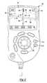
- FIG. 2illustrates the OIM 22 of FIG. 1 with the display 24 displaying a map display screen 54 .
- Map display screen 54displays a plurality of road segments 56 and a vehicle icon 58 at its current position relative to the road segments 56 , as determined by the navigation system 20 .
- a road segment 56is defined as a portion of the road between intersections and other nodes or shape points.
- Road segments 56are preferably displayed in different colors, according to the level of the particular road segment 56 , i.e., interstate, main street or side street.
- the display 24also displays a destination icon 60 at the location of the destination selected by the operator.
- the map display screen 54also displays the recommended route 62 .
- the recommended route 62comprises a plurality of the road segments 56 leading from the current position of the vehicle icon 58 to the destination icon 60 .
- the recommended route 62is preferably highlighted, i.e., displayed in a color different from all of the other road segments 56 .
- the map display screen 54also displays a plurality of arrows 64 along the recommended route 62 oriented toward the destination icon 60 from the vehicle icon 58 .
- the arrows 64are preferably displayed in a color different from all of the road segments 56 and the recommended route 62 .
- the map display screen 54scrolls, keeping the vehicle icon 58 in the center of the map display screen 54 .
- the arrows 64scroll with the road segments 56 across the map display screen 54 as the vehicle icon 58 travels along the recommended route 62 .
- the arrows 64appear to pass under the vehicle icon 58 as they scroll.
- the usercan more quickly and easily discern the recommended route on the map display screen 54 from the other road segments 56 , because the recommended route is displayed in a different color and with the arrows 64 .
- Arrows 64also indicate to the observer the direction to be traveled along the recommended route 62 . This is particularly important in the case where, as shown in FIG. 2, the recommended route 62 crosses over itself.
- the positioning of the arrows 64 on the portion of the recommended route 62 displayed on the display 24depends upon the current scale of the displayed map (zoom level). Preferably, as the scale of the map display screen 54 is increased and decreased (such as by the using pressing zoom input buttons 61 a and 61 b ), some of the arrows 64 appear to stay generally in the same position relative to the display 24 . In order to achieve this, the distance of each road segment 56 on map display screen 54 is calculated.
- the arrows 64are spaced at an interval that is generally fixed, but varies based upon the current map display scale according to the following table:
- FIG. 3illustrates the map display screen 54 after the scale of the map display has been decreased.
- the vehicle icon 58 and some of the arrows 64 on the current roadremain generally in the same position on the map display screen 54 .
- some arrows 64 that were previously displayed in FIG. 2are no longer on the map display screen 54 because some road segments 56 and some portions of road segments 56 are no longer displayed on map display screen 54 .
- the destination icon 60 of FIG. 2is not displayed. Note from the above table that the interval between arrows 64 increases and decreases proportionally to the changes in the map scale. Generally, this provides a constant maximum number of arrows 64 in each of the X and Y directions on the display 24 , independent of the current scale.
- the navigation system 20includes other map display modes that would also utilize the route indication arrows 64 .
- the map display screen 54may be displayed to show the vehicle icon 58 and a plurality of consecutive maneuvers, particularly where the maneuvers are close together.
- the destination 60would not always be displayed on the map display screen 54 .
- the destination 60would only be displayed on map display screen 54 when in the field of view of display 24 , depending upon the distance between the current vehicle position, as shown by vehicle icon 58 , to the destination 60 , and the current map zoom level. Further, the vehicle icon 58 would also not necessarily always be displayed in map display screen 54 .
Landscapes
- Engineering & Computer Science (AREA)
- Radar, Positioning & Navigation (AREA)
- Remote Sensing (AREA)
- Automation & Control Theory (AREA)
- Physics & Mathematics (AREA)
- General Physics & Mathematics (AREA)
- Navigation (AREA)
Abstract
Description
| Meters Across Screen | Meters Across Screen | Meters/ | |
| Map Scale | in X axis | in Y axis | Arrow |
| 2 | 704 | 468 | 200 |
| 4 | 1408 | 936 | 400 |
| 16 | 5632 | 3744 | 1600 |
| 64 | 22528 | 14976 | 6400 |
Claims (36)
Priority Applications (5)
| Application Number | Priority Date | Filing Date | Title |
|---|---|---|---|
| US09/487,654US6430501B1 (en) | 2000-01-19 | 2000-01-19 | Navigation system with route indicators |
| PCT/US2000/041619WO2001053777A1 (en) | 2000-01-19 | 2000-10-26 | Navigation system with route indicators |
| EP00989727AEP1250566B1 (en) | 2000-01-19 | 2000-10-26 | Navigation system with route indicators |
| DE60030591TDE60030591T2 (en) | 2000-01-19 | 2000-10-26 | NAVIGATION SYSTEM WITH GUIDES |
| AU2001226199AAU2001226199A1 (en) | 2000-01-19 | 2000-10-26 | Navigation system with route indicators |
Applications Claiming Priority (1)
| Application Number | Priority Date | Filing Date | Title |
|---|---|---|---|
| US09/487,654US6430501B1 (en) | 2000-01-19 | 2000-01-19 | Navigation system with route indicators |
Publications (1)
| Publication Number | Publication Date |
|---|---|
| US6430501B1true US6430501B1 (en) | 2002-08-06 |
Family
ID=23936608
Family Applications (1)
| Application Number | Title | Priority Date | Filing Date |
|---|---|---|---|
| US09/487,654Expired - LifetimeUS6430501B1 (en) | 2000-01-19 | 2000-01-19 | Navigation system with route indicators |
Country Status (5)
| Country | Link |
|---|---|
| US (1) | US6430501B1 (en) |
| EP (1) | EP1250566B1 (en) |
| AU (1) | AU2001226199A1 (en) |
| DE (1) | DE60030591T2 (en) |
| WO (1) | WO2001053777A1 (en) |
Cited By (52)
| Publication number | Priority date | Publication date | Assignee | Title |
|---|---|---|---|---|
| US20020000999A1 (en)* | 2000-03-30 | 2002-01-03 | Mccarty John M. | Address presentation system interface |
| US20040044466A1 (en)* | 2002-08-29 | 2004-03-04 | Nesbitt David W. | Automated route determination |
| US6751551B2 (en)* | 2001-05-23 | 2004-06-15 | Honda Giken Kogyo Kabushiki Kaisha | Navigation system for vehicle |
| USD515904S1 (en)* | 2005-04-13 | 2006-02-28 | Eric Beare Associates Ltd. | Travel tool |
| US20070162223A1 (en)* | 2006-01-09 | 2007-07-12 | Thales Navigation, Inc. | Smart detour |
| US20070250515A1 (en)* | 2006-04-21 | 2007-10-25 | Lea David H | Method and system of securing content and destination of digital download via the internet |
| US20080027641A1 (en)* | 2006-07-27 | 2008-01-31 | Kiyozumi Fujiwara | Navigation Device And Route Guide Method |
| US20080051995A1 (en)* | 2006-08-25 | 2008-02-28 | Magellan Navigation, Inc. | Rerouting in Vehicle Navigation Systems |
| US7356405B1 (en)* | 2002-08-29 | 2008-04-08 | Aol Llc | Automated route determination to avoid a particular maneuver |
| WO2008056884A1 (en)* | 2006-11-08 | 2008-05-15 | Thinkware Systems Corporation | Method for choosing point on the electronic map |
| US7376510B1 (en)* | 2004-11-05 | 2008-05-20 | Navteq North America, Llc | Map display for a navigation system |
| US20080139181A1 (en)* | 2006-12-08 | 2008-06-12 | Magellan Navigation, Inc. | Methods and apparatus for measuring the effectiveness of advertisements presented on a mobile navigation device |
| US20080147313A1 (en)* | 2002-12-30 | 2008-06-19 | Aol Llc | Presenting a travel route |
| US20080198162A1 (en)* | 2007-02-16 | 2008-08-21 | Magellan Navigation, Inc. | A method of generating curved baseline for map labeling |
| US20080221787A1 (en)* | 2007-03-09 | 2008-09-11 | Magellan Navigation, Inc. | Methods and apparatus for determining a route having an estimated minimum fuel usage for a vehicle |
| US20080270468A1 (en)* | 2007-04-25 | 2008-10-30 | Magellan Navigation, Inc. | Adjusting spatial operations based on map density |
| US20090012707A1 (en)* | 2007-07-06 | 2009-01-08 | Krage Mark K | Position data entry and route planning entry for portable navigation systems |
| DE102007039446A1 (en)* | 2007-08-21 | 2009-02-26 | Volkswagen Ag | A method of displaying information in a variable scale vehicle and display device |
| US20090070293A1 (en)* | 2007-09-10 | 2009-03-12 | Magellan Navigation, Inc. | Nearest-Neighbor Geographic Search |
| US20090138190A1 (en)* | 2007-11-26 | 2009-05-28 | Magellan Navigation, Inc. | System and Method of Providing Traffic Data to a Mobile Device |
| US20090171584A1 (en)* | 2007-12-31 | 2009-07-02 | Magellan Navigation, Inc. | System and Method for Accessing a Navigation System |
| US20090182498A1 (en)* | 2008-01-11 | 2009-07-16 | Magellan Navigation, Inc. | Systems and Methods to Provide Navigational Assistance Using an Online Social Network |
| US20090187342A1 (en)* | 2008-01-18 | 2009-07-23 | Magellan Navigation, Inc. | Method and apparatus for access point recording using a position device |
| US20090187341A1 (en)* | 2008-01-18 | 2009-07-23 | Magellan Navigation, Inc. | Method and apparatus to search for local parking |
| US20090187340A1 (en)* | 2008-01-18 | 2009-07-23 | Magellan Navigation, Inc. | Method and apparatus for hybrid routing using breadcrumb paths |
| US7589628B1 (en) | 2002-06-27 | 2009-09-15 | Earthcomber Llc | System and method for providing location-based information to mobile consumers |
| US20100035631A1 (en)* | 2008-08-07 | 2010-02-11 | Magellan Navigation, Inc. | Systems and Methods to Record and Present a Trip |
| US20100049696A1 (en)* | 2008-08-20 | 2010-02-25 | Magellan Navigation, Inc. | Systems and Methods for Smart City Search |
| US20100076674A1 (en)* | 2008-09-22 | 2010-03-25 | Magellan Navigation, Inc. | Route Navigation via a Proximity Point |
| US20100185975A1 (en)* | 2000-04-14 | 2010-07-22 | Samsung Electronics Co., Ltd. | User interface systems and methods for manipulating and viewing digital documents |
| US20100241355A1 (en)* | 2007-05-14 | 2010-09-23 | Thinkware Systems Corporation | Method for correcting map matching and navigation system implementing the method |
| US7818116B1 (en) | 2002-12-30 | 2010-10-19 | Mapquest, Inc. | Presenting a travel route in a ground-based vehicle |
| US7904238B2 (en) | 2002-12-30 | 2011-03-08 | Mapquest, Inc. | Presenting a travel route using more than one presentation style |
| US7908080B2 (en) | 2004-12-31 | 2011-03-15 | Google Inc. | Transportation routing |
| US7966003B2 (en) | 2004-07-09 | 2011-06-21 | Tegic Communications, Inc. | Disambiguating ambiguous characters |
| US20110179363A1 (en)* | 2007-08-21 | 2011-07-21 | Rainer Dehmann | Method for displaying information in a motor vehicle and display device for a motor vehicle |
| US20110205162A1 (en)* | 2007-08-21 | 2011-08-25 | Waeller Christoph | Method for displaying information in a vehicle and display device for a vehicle |
| US8102253B1 (en) | 2002-06-27 | 2012-01-24 | Earthcomber, Llc | System and method for notifying a user of people, places or things having attributes matching a user's stated preference |
| US20130047112A1 (en)* | 2010-03-11 | 2013-02-21 | X | Method and device for operating a user interface |
| US8427303B1 (en) | 2002-06-27 | 2013-04-23 | Geomass Limited Liability Company | System and method for providing media content having attributes matching a user's stated preference |
| US8554475B2 (en) | 2007-10-01 | 2013-10-08 | Mitac International Corporation | Static and dynamic contours |
| US8640020B2 (en) | 2010-06-02 | 2014-01-28 | Microsoft Corporation | Adjustable and progressive mobile device street view |
| US8681149B2 (en) | 2010-07-23 | 2014-03-25 | Microsoft Corporation | 3D layering of map metadata |
| US20140107915A1 (en)* | 2012-10-14 | 2014-04-17 | Shan-Chih Yang | System and related method for offering navigation guidance |
| US8706415B2 (en) | 2011-05-23 | 2014-04-22 | Microsoft Corporation | Changing emphasis of list items in a map navigation tool |
| US20140278093A1 (en)* | 2013-03-15 | 2014-09-18 | Giuseppe B. Raffa | Sketch aided route selection for navigation devices and applications |
| US20140316694A1 (en)* | 2000-10-16 | 2014-10-23 | Platt Technology Investments Llc | Method and system for mobile device selectively reporting of gps position information to others |
| US20140344296A1 (en)* | 2013-05-15 | 2014-11-20 | Google Inc. | Efficient Fetching of Map Tile Data |
| US9342998B2 (en) | 2010-11-16 | 2016-05-17 | Microsoft Technology Licensing, Llc | Techniques to annotate street view images with contextual information |
| US9470545B2 (en) | 2014-06-25 | 2016-10-18 | International Business Machines Corporation | Mapping preferred locations using multiple arrows |
| US9778836B2 (en) | 2000-04-14 | 2017-10-03 | Samsung Electronics Co., Ltd. | User interface systems and methods for manipulating and viewing digital documents |
| US11977832B2 (en)* | 2016-03-28 | 2024-05-07 | Microsoft Technology Licensing, Llc | Map note annotations at corresponding geographic locations |
Citations (28)
| Publication number | Priority date | Publication date | Assignee | Title |
|---|---|---|---|---|
| US4086632A (en) | 1976-09-27 | 1978-04-25 | The Boeing Company | Area navigation system including a map display unit for establishing and modifying navigation routes |
| GB2260210A (en) | 1991-10-04 | 1993-04-07 | Ford Motor Co | Navigation system |
| US5243528A (en) | 1990-09-12 | 1993-09-07 | Motorola, Inc. | Land vehicle navigation apparatus with visual display |
| US5402120A (en) | 1993-08-18 | 1995-03-28 | Zexel Corporation | Navigation system |
| US5537323A (en) | 1991-10-29 | 1996-07-16 | U.S. Philips Corporation | Navigation device vehicle comprising the device |
| EP0767448A1 (en) | 1995-10-04 | 1997-04-09 | Aisin Aw Co., Ltd. | Navigation apparatus for a vehicle |
| EP0779498A2 (en) | 1995-11-30 | 1997-06-18 | Aisin Aw Co., Ltd. | Navigation device |
| US5654892A (en) | 1991-10-18 | 1997-08-05 | Zexel Usa Corporation | Navigation system displaying forthcoming turns |
| US5654908A (en) | 1994-05-16 | 1997-08-05 | Kabushikikaisha Equos Research | Electronic diary with navigation destination output |
| EP0803708A2 (en) | 1996-04-28 | 1997-10-29 | Aisin Aw Co., Ltd. | Route searching and route guidance device |
| US5731978A (en) | 1995-06-07 | 1998-03-24 | Zexel Corporation | Method and apparatus for enhancing vehicle navigation through recognition of geographical region types |
| US5732385A (en) | 1994-04-15 | 1998-03-24 | Nissan Motor Co., Ltd. | Vehicle navigation system displaying bird-eye view of different visual points and different contraction scale ratios depending upon vehicle travel conditions |
| US5739772A (en)* | 1995-08-25 | 1998-04-14 | Aisin Aw Co., Ltd. | Navigation system for vehicles |
| US5793310A (en) | 1994-02-04 | 1998-08-11 | Nissan Motor Co., Ltd. | Portable or vehicular navigating apparatus and method capable of displaying bird's eye view |
| US5802492A (en) | 1994-06-24 | 1998-09-01 | Delorme Publishing Company, Inc. | Computer aided routing and positioning system |
| US5832408A (en)* | 1996-02-14 | 1998-11-03 | Zexel Corporation | Method and apparatus for selecting a destination in a vehicle navigation system |
| US5835881A (en) | 1996-01-16 | 1998-11-10 | Philips Electronics North America Corporation | Portable system for providing voice driving directions |
| US5842147A (en) | 1995-03-06 | 1998-11-24 | Aisin Aw Co., Ltd. | Navigation display device which indicates goal and route direction information |
| US5862510A (en)* | 1995-09-06 | 1999-01-19 | Mitsubishi Jidosha Kogyo Kabushiki Kaisha | Navigation device |
| US5877708A (en)* | 1995-01-24 | 1999-03-02 | Pioneer Electronic Corporation | On-vehicle navigation system having route searching function |
| US5905451A (en) | 1996-04-24 | 1999-05-18 | Denso Corporation | Vehicular navigation system |
| US5908464A (en)* | 1996-10-25 | 1999-06-01 | Mitsubishi Denki Kabushiki Kaisha | Traffic information display device method of displaying traffic information and medium on which display control program for use in traffic information display device is recorded |
| GB2333838A (en) | 1998-01-28 | 1999-08-04 | Rover Group | Method and apparatus for navigating a surface vehicle |
| US5936631A (en) | 1995-01-20 | 1999-08-10 | Mitsubishi Denki Kabushiki Kaisha | Mobile navigation system |
| GB2334102A (en) | 1998-02-06 | 1999-08-11 | Rover Group | A navigation system |
| US5961570A (en)* | 1997-11-12 | 1999-10-05 | Harness System Technologies Research, Ltd. | Display unit for vehicle |
| US6049755A (en)* | 1998-05-05 | 2000-04-11 | Magellan Dis, Inc. | Navigation system vehicle location display |
| US6067502A (en)* | 1996-08-21 | 2000-05-23 | Aisin Aw Co., Ltd. | Device for displaying map |
- 2000
- 2000-01-19USUS09/487,654patent/US6430501B1/ennot_activeExpired - Lifetime
- 2000-10-26AUAU2001226199Apatent/AU2001226199A1/ennot_activeAbandoned
- 2000-10-26WOPCT/US2000/041619patent/WO2001053777A1/enactiveIP Right Grant
- 2000-10-26DEDE60030591Tpatent/DE60030591T2/ennot_activeExpired - Lifetime
- 2000-10-26EPEP00989727Apatent/EP1250566B1/ennot_activeExpired - Lifetime
Patent Citations (28)
| Publication number | Priority date | Publication date | Assignee | Title |
|---|---|---|---|---|
| US4086632A (en) | 1976-09-27 | 1978-04-25 | The Boeing Company | Area navigation system including a map display unit for establishing and modifying navigation routes |
| US5243528A (en) | 1990-09-12 | 1993-09-07 | Motorola, Inc. | Land vehicle navigation apparatus with visual display |
| GB2260210A (en) | 1991-10-04 | 1993-04-07 | Ford Motor Co | Navigation system |
| US5654892A (en) | 1991-10-18 | 1997-08-05 | Zexel Usa Corporation | Navigation system displaying forthcoming turns |
| US5537323A (en) | 1991-10-29 | 1996-07-16 | U.S. Philips Corporation | Navigation device vehicle comprising the device |
| US5402120A (en) | 1993-08-18 | 1995-03-28 | Zexel Corporation | Navigation system |
| US5793310A (en) | 1994-02-04 | 1998-08-11 | Nissan Motor Co., Ltd. | Portable or vehicular navigating apparatus and method capable of displaying bird's eye view |
| US5732385A (en) | 1994-04-15 | 1998-03-24 | Nissan Motor Co., Ltd. | Vehicle navigation system displaying bird-eye view of different visual points and different contraction scale ratios depending upon vehicle travel conditions |
| US5654908A (en) | 1994-05-16 | 1997-08-05 | Kabushikikaisha Equos Research | Electronic diary with navigation destination output |
| US5802492A (en) | 1994-06-24 | 1998-09-01 | Delorme Publishing Company, Inc. | Computer aided routing and positioning system |
| US5936631A (en) | 1995-01-20 | 1999-08-10 | Mitsubishi Denki Kabushiki Kaisha | Mobile navigation system |
| US5877708A (en)* | 1995-01-24 | 1999-03-02 | Pioneer Electronic Corporation | On-vehicle navigation system having route searching function |
| US5842147A (en) | 1995-03-06 | 1998-11-24 | Aisin Aw Co., Ltd. | Navigation display device which indicates goal and route direction information |
| US5731978A (en) | 1995-06-07 | 1998-03-24 | Zexel Corporation | Method and apparatus for enhancing vehicle navigation through recognition of geographical region types |
| US5739772A (en)* | 1995-08-25 | 1998-04-14 | Aisin Aw Co., Ltd. | Navigation system for vehicles |
| US5862510A (en)* | 1995-09-06 | 1999-01-19 | Mitsubishi Jidosha Kogyo Kabushiki Kaisha | Navigation device |
| EP0767448A1 (en) | 1995-10-04 | 1997-04-09 | Aisin Aw Co., Ltd. | Navigation apparatus for a vehicle |
| EP0779498A2 (en) | 1995-11-30 | 1997-06-18 | Aisin Aw Co., Ltd. | Navigation device |
| US5835881A (en) | 1996-01-16 | 1998-11-10 | Philips Electronics North America Corporation | Portable system for providing voice driving directions |
| US5832408A (en)* | 1996-02-14 | 1998-11-03 | Zexel Corporation | Method and apparatus for selecting a destination in a vehicle navigation system |
| US5905451A (en) | 1996-04-24 | 1999-05-18 | Denso Corporation | Vehicular navigation system |
| EP0803708A2 (en) | 1996-04-28 | 1997-10-29 | Aisin Aw Co., Ltd. | Route searching and route guidance device |
| US6067502A (en)* | 1996-08-21 | 2000-05-23 | Aisin Aw Co., Ltd. | Device for displaying map |
| US5908464A (en)* | 1996-10-25 | 1999-06-01 | Mitsubishi Denki Kabushiki Kaisha | Traffic information display device method of displaying traffic information and medium on which display control program for use in traffic information display device is recorded |
| US5961570A (en)* | 1997-11-12 | 1999-10-05 | Harness System Technologies Research, Ltd. | Display unit for vehicle |
| GB2333838A (en) | 1998-01-28 | 1999-08-04 | Rover Group | Method and apparatus for navigating a surface vehicle |
| GB2334102A (en) | 1998-02-06 | 1999-08-11 | Rover Group | A navigation system |
| US6049755A (en)* | 1998-05-05 | 2000-04-11 | Magellan Dis, Inc. | Navigation system vehicle location display |
Cited By (122)
| Publication number | Priority date | Publication date | Assignee | Title |
|---|---|---|---|---|
| US20020000999A1 (en)* | 2000-03-30 | 2002-01-03 | Mccarty John M. | Address presentation system interface |
| US9778836B2 (en) | 2000-04-14 | 2017-10-03 | Samsung Electronics Co., Ltd. | User interface systems and methods for manipulating and viewing digital documents |
| US20100185975A1 (en)* | 2000-04-14 | 2010-07-22 | Samsung Electronics Co., Ltd. | User interface systems and methods for manipulating and viewing digital documents |
| US20100185948A1 (en)* | 2000-04-14 | 2010-07-22 | Samsung Electronics Co., Ltd. | User interface systems and methods for manipulating and viewing digital documents |
| US20140316694A1 (en)* | 2000-10-16 | 2014-10-23 | Platt Technology Investments Llc | Method and system for mobile device selectively reporting of gps position information to others |
| US9625269B2 (en)* | 2000-10-16 | 2017-04-18 | Gula Consulting Limited Liability Company | Method and system for mobile device selectively reporting of GPS position information to others |
| US6751551B2 (en)* | 2001-05-23 | 2004-06-15 | Honda Giken Kogyo Kabushiki Kaisha | Navigation system for vehicle |
| US8427303B1 (en) | 2002-06-27 | 2013-04-23 | Geomass Limited Liability Company | System and method for providing media content having attributes matching a user's stated preference |
| US7876215B1 (en) | 2002-06-27 | 2011-01-25 | Earthcomber, Llc | System and method for locating and notifying a mobile user of people having attributes or interests matching a stated preference |
| US7589628B1 (en) | 2002-06-27 | 2009-09-15 | Earthcomber Llc | System and method for providing location-based information to mobile consumers |
| US10959046B2 (en) | 2002-06-27 | 2021-03-23 | Chemtron Research Llc | System and method for providing information matching a user's stated preferences |
| US11290845B2 (en) | 2002-06-27 | 2022-03-29 | Chemtron Research Llc | System and method for providing information matching a user's stated preferences |
| US7847684B1 (en) | 2002-06-27 | 2010-12-07 | Earthcomber, Llc | System and method for locating and notifying a mobile user of people having attributes or interests matching a stated preference |
| US8680985B2 (en) | 2002-06-27 | 2014-03-25 | Geomass Limited Liability Company | System and method for providing media content having attributes matching a user's stated preference |
| US7876214B1 (en) | 2002-06-27 | 2011-01-25 | Earthcomber, Llc | System and method for providing reviews to a mobile user of restaurants having attributes matching a stated preference |
| US10097955B2 (en) | 2002-06-27 | 2018-10-09 | Chemtron Research Llc | System and method for providing information matching a user's stated preferences |
| US9602608B2 (en) | 2002-06-27 | 2017-03-21 | Chemtron Research Llc | System and method for notifying a user of people, places or things having attributes matching a user's stated preference |
| US10362446B2 (en) | 2002-06-27 | 2019-07-23 | Chemtron Research Llc | System and method for providing information matching a user's stated preferences |
| US8102253B1 (en) | 2002-06-27 | 2012-01-24 | Earthcomber, Llc | System and method for notifying a user of people, places or things having attributes matching a user's stated preference |
| US7911335B1 (en) | 2002-06-27 | 2011-03-22 | Earthcomber, Llc | System and method for locating and notifying a mobile user of people having attributes or interests matching a stated preference |
| US8510040B2 (en) | 2002-08-29 | 2013-08-13 | Mapquest, Inc. | Automated route determination |
| US10718623B2 (en) | 2002-08-29 | 2020-07-21 | Verizon Patent And Licensing, Inc. | Automated route determination |
| US8560223B2 (en) | 2002-08-29 | 2013-10-15 | Mapquest, Inc. | Automated route determination |
| US20040052239A1 (en)* | 2002-08-29 | 2004-03-18 | Nesbitt David W. | Automated route determination |
| US20040044466A1 (en)* | 2002-08-29 | 2004-03-04 | Nesbitt David W. | Automated route determination |
| US8649975B2 (en) | 2002-08-29 | 2014-02-11 | Mapquest, Inc. | Automated route determination |
| US20100121562A1 (en)* | 2002-08-29 | 2010-05-13 | Aol Inc. | Automated route determination |
| US8655583B2 (en) | 2002-08-29 | 2014-02-18 | Mapquest, Inc. | Automated route determination |
| US7356405B1 (en)* | 2002-08-29 | 2008-04-08 | Aol Llc | Automated route determination to avoid a particular maneuver |
| US10551203B2 (en) | 2002-08-29 | 2020-02-04 | Verizon Patent And Licensing Inc. | Automated route determination |
| US10697785B2 (en) | 2002-08-29 | 2020-06-30 | Verizon Patent And Licensing, Inc. | Automated route determination |
| US20130073203A1 (en)* | 2002-12-30 | 2013-03-21 | Mapquest, Inc. | Presenting a travel route |
| US8954274B2 (en) | 2002-12-30 | 2015-02-10 | Facebook, Inc. | Indicating a travel route based on a user selection |
| US8977497B2 (en)* | 2002-12-30 | 2015-03-10 | Aol Inc. | Presenting a travel route |
| US9599487B2 (en) | 2002-12-30 | 2017-03-21 | Mapquest, Inc. | Presenting a travel route |
| US7702454B2 (en) | 2002-12-30 | 2010-04-20 | Mapquest, Inc. | Presenting a travel route |
| US7925430B2 (en) | 2002-12-30 | 2011-04-12 | Aol Inc. | Presenting a travel route |
| US7474960B1 (en) | 2002-12-30 | 2009-01-06 | Mapquest, Inc. | Presenting a travel route |
| US10113880B2 (en) | 2002-12-30 | 2018-10-30 | Facebook, Inc. | Custom printing of a travel route |
| US20080147313A1 (en)* | 2002-12-30 | 2008-06-19 | Aol Llc | Presenting a travel route |
| US20110153187A1 (en)* | 2002-12-30 | 2011-06-23 | Mapquest, Inc. | Presenting a travel route using more than one presentation style |
| US7904238B2 (en) | 2002-12-30 | 2011-03-08 | Mapquest, Inc. | Presenting a travel route using more than one presentation style |
| US7818116B1 (en) | 2002-12-30 | 2010-10-19 | Mapquest, Inc. | Presenting a travel route in a ground-based vehicle |
| US8335646B2 (en) | 2002-12-30 | 2012-12-18 | Aol Inc. | Presenting a travel route |
| US8296061B2 (en) | 2002-12-30 | 2012-10-23 | Facebook, Inc. | Presenting a travel route using more than one presentation style |
| US8583087B2 (en) | 2004-07-09 | 2013-11-12 | Nuance Communications, Inc. | Disambiguating ambiguous characters |
| US7966003B2 (en) | 2004-07-09 | 2011-06-21 | Tegic Communications, Inc. | Disambiguating ambiguous characters |
| US7376510B1 (en)* | 2004-11-05 | 2008-05-20 | Navteq North America, Llc | Map display for a navigation system |
| US20080195314A1 (en)* | 2004-11-05 | 2008-08-14 | Navteq North America, Llc | Map Display for a Navigation System |
| US7623965B2 (en) | 2004-11-05 | 2009-11-24 | Navteq North America, Llc | Map display for a navigation system |
| US8606514B2 (en) | 2004-12-31 | 2013-12-10 | Google Inc. | Transportation routing |
| US9778055B2 (en) | 2004-12-31 | 2017-10-03 | Google Inc. | Transportation routing |
| US9945686B2 (en) | 2004-12-31 | 2018-04-17 | Google Llc | Transportation routing |
| US7908080B2 (en) | 2004-12-31 | 2011-03-15 | Google Inc. | Transportation routing |
| US11092455B2 (en) | 2004-12-31 | 2021-08-17 | Google Llc | Transportation routing |
| US9709415B2 (en) | 2004-12-31 | 2017-07-18 | Google Inc. | Transportation routing |
| US8798917B2 (en) | 2004-12-31 | 2014-08-05 | Google Inc. | Transportation routing |
| USD515904S1 (en)* | 2005-04-13 | 2006-02-28 | Eric Beare Associates Ltd. | Travel tool |
| US20070162223A1 (en)* | 2006-01-09 | 2007-07-12 | Thales Navigation, Inc. | Smart detour |
| US7590490B2 (en) | 2006-01-09 | 2009-09-15 | Mitac International Corporation | Smart detour |
| US20070250515A1 (en)* | 2006-04-21 | 2007-10-25 | Lea David H | Method and system of securing content and destination of digital download via the internet |
| US20080027641A1 (en)* | 2006-07-27 | 2008-01-31 | Kiyozumi Fujiwara | Navigation Device And Route Guide Method |
| US7706974B2 (en)* | 2006-07-27 | 2010-04-27 | Alpine Electronics, Inc. | Navigation device and route guide method |
| US7945386B2 (en) | 2006-08-25 | 2011-05-17 | Mitac International Corporation | Rerouting in vehicle navigation systems |
| US20080051995A1 (en)* | 2006-08-25 | 2008-02-28 | Magellan Navigation, Inc. | Rerouting in Vehicle Navigation Systems |
| WO2008056884A1 (en)* | 2006-11-08 | 2008-05-15 | Thinkware Systems Corporation | Method for choosing point on the electronic map |
| US20080139181A1 (en)* | 2006-12-08 | 2008-06-12 | Magellan Navigation, Inc. | Methods and apparatus for measuring the effectiveness of advertisements presented on a mobile navigation device |
| US7692655B2 (en) | 2007-02-16 | 2010-04-06 | Mitac International Corporation | Apparatus and method of generating curved baseline for map labeling |
| US20080198162A1 (en)* | 2007-02-16 | 2008-08-21 | Magellan Navigation, Inc. | A method of generating curved baseline for map labeling |
| US20080221787A1 (en)* | 2007-03-09 | 2008-09-11 | Magellan Navigation, Inc. | Methods and apparatus for determining a route having an estimated minimum fuel usage for a vehicle |
| US7783417B2 (en) | 2007-03-09 | 2010-08-24 | Mitac International Corporation | Methods and apparatus for determining a route having an estimated minimum fuel usage for a vehicle |
| US8078641B2 (en) | 2007-04-25 | 2011-12-13 | Mitac International Corporation | Adjusting spatial operations based on map density |
| US20080270468A1 (en)* | 2007-04-25 | 2008-10-30 | Magellan Navigation, Inc. | Adjusting spatial operations based on map density |
| US20100241355A1 (en)* | 2007-05-14 | 2010-09-23 | Thinkware Systems Corporation | Method for correcting map matching and navigation system implementing the method |
| US8321128B2 (en)* | 2007-05-14 | 2012-11-27 | Thinkware Systems Corporation | Method for correcting map matching and navigation system implementing the method |
| US20090012707A1 (en)* | 2007-07-06 | 2009-01-08 | Krage Mark K | Position data entry and route planning entry for portable navigation systems |
| US9836208B2 (en) | 2007-08-21 | 2017-12-05 | Volkswagen Ag | Method for displaying information in a motor vehicle with a variable scale and display device |
| US8677271B2 (en) | 2007-08-21 | 2014-03-18 | Volkswagen Ag | Method for displaying information in a motor vehicle and display device for a motor vehicle |
| DE102007039446A1 (en)* | 2007-08-21 | 2009-02-26 | Volkswagen Ag | A method of displaying information in a variable scale vehicle and display device |
| US8477108B2 (en) | 2007-08-21 | 2013-07-02 | Volkswagen Ag | Method for displaying information in a vehicle and display device for a vehicle |
| US20110205162A1 (en)* | 2007-08-21 | 2011-08-25 | Waeller Christoph | Method for displaying information in a vehicle and display device for a vehicle |
| US20110179363A1 (en)* | 2007-08-21 | 2011-07-21 | Rainer Dehmann | Method for displaying information in a motor vehicle and display device for a motor vehicle |
| US20090070293A1 (en)* | 2007-09-10 | 2009-03-12 | Magellan Navigation, Inc. | Nearest-Neighbor Geographic Search |
| US7882102B2 (en) | 2007-09-10 | 2011-02-01 | Mitac International Corporation | Nearest-neighbor geographic search |
| US8554475B2 (en) | 2007-10-01 | 2013-10-08 | Mitac International Corporation | Static and dynamic contours |
| US20090138190A1 (en)* | 2007-11-26 | 2009-05-28 | Magellan Navigation, Inc. | System and Method of Providing Traffic Data to a Mobile Device |
| US20090171584A1 (en)* | 2007-12-31 | 2009-07-02 | Magellan Navigation, Inc. | System and Method for Accessing a Navigation System |
| US20090182498A1 (en)* | 2008-01-11 | 2009-07-16 | Magellan Navigation, Inc. | Systems and Methods to Provide Navigational Assistance Using an Online Social Network |
| US8290703B2 (en) | 2008-01-18 | 2012-10-16 | Mitac International Corporation | Method and apparatus for access point recording using a position device |
| US8700314B2 (en) | 2008-01-18 | 2014-04-15 | Mitac International Corporation | Method and apparatus to search for local parking |
| US20090187342A1 (en)* | 2008-01-18 | 2009-07-23 | Magellan Navigation, Inc. | Method and apparatus for access point recording using a position device |
| US20090187341A1 (en)* | 2008-01-18 | 2009-07-23 | Magellan Navigation, Inc. | Method and apparatus to search for local parking |
| US20090187340A1 (en)* | 2008-01-18 | 2009-07-23 | Magellan Navigation, Inc. | Method and apparatus for hybrid routing using breadcrumb paths |
| US8498808B2 (en) | 2008-01-18 | 2013-07-30 | Mitac International Corp. | Method and apparatus for hybrid routing using breadcrumb paths |
| US20100035631A1 (en)* | 2008-08-07 | 2010-02-11 | Magellan Navigation, Inc. | Systems and Methods to Record and Present a Trip |
| US20100049696A1 (en)* | 2008-08-20 | 2010-02-25 | Magellan Navigation, Inc. | Systems and Methods for Smart City Search |
| US8249804B2 (en) | 2008-08-20 | 2012-08-21 | Mitac International Corporation | Systems and methods for smart city search |
| US20100076674A1 (en)* | 2008-09-22 | 2010-03-25 | Magellan Navigation, Inc. | Route Navigation via a Proximity Point |
| US8219317B2 (en) | 2008-09-22 | 2012-07-10 | Mitac International Corporation | Route navigation via a proximity point |
| US9283829B2 (en)* | 2010-03-11 | 2016-03-15 | Volkswagen Ag | Process and device for displaying different information for driver and passenger of a vehicle |
| US20130047112A1 (en)* | 2010-03-11 | 2013-02-21 | X | Method and device for operating a user interface |
| US8640020B2 (en) | 2010-06-02 | 2014-01-28 | Microsoft Corporation | Adjustable and progressive mobile device street view |
| US8681149B2 (en) | 2010-07-23 | 2014-03-25 | Microsoft Corporation | 3D layering of map metadata |
| US9342998B2 (en) | 2010-11-16 | 2016-05-17 | Microsoft Technology Licensing, Llc | Techniques to annotate street view images with contextual information |
| US8788203B2 (en) | 2011-05-23 | 2014-07-22 | Microsoft Corporation | User-driven navigation in a map navigation tool |
| US9273979B2 (en) | 2011-05-23 | 2016-03-01 | Microsoft Technology Licensing, Llc | Adjustable destination icon in a map navigation tool |
| US8706415B2 (en) | 2011-05-23 | 2014-04-22 | Microsoft Corporation | Changing emphasis of list items in a map navigation tool |
| US9194715B2 (en)* | 2012-10-14 | 2015-11-24 | Mitac International Corp. | System and related method for offering navigation guidance |
| US20140107915A1 (en)* | 2012-10-14 | 2014-04-17 | Shan-Chih Yang | System and related method for offering navigation guidance |
| US10955258B2 (en) | 2013-03-15 | 2021-03-23 | Intel Corporation | Route selection for navigation devices and applications |
| US20140278093A1 (en)* | 2013-03-15 | 2014-09-18 | Giuseppe B. Raffa | Sketch aided route selection for navigation devices and applications |
| US9689704B2 (en) | 2013-03-15 | 2017-06-27 | Intel Corporation | Sketch aided route selection for navigation devices and applications |
| US9116009B2 (en)* | 2013-03-15 | 2015-08-25 | Intel Corporation | Sketch aided route selection for navigation devices and applications |
| US20140344296A1 (en)* | 2013-05-15 | 2014-11-20 | Google Inc. | Efficient Fetching of Map Tile Data |
| US9201898B2 (en)* | 2013-05-15 | 2015-12-01 | Google Inc. | Efficient fetching of map tile data |
| US9470545B2 (en) | 2014-06-25 | 2016-10-18 | International Business Machines Corporation | Mapping preferred locations using multiple arrows |
| US9605972B2 (en) | 2014-06-25 | 2017-03-28 | International Business Machines Corporation | Mapping preferred locations using multiple arrows |
| US11047703B2 (en) | 2014-06-25 | 2021-06-29 | Airbnb, Inc. | Mapping preferred locations using multiple arrows |
| US10228262B2 (en) | 2014-06-25 | 2019-03-12 | International Business Machines Corporation | Mapping preferred locations using multiple arrows |
| US11781879B2 (en) | 2014-06-25 | 2023-10-10 | Airbnb, Inc. | Mapping preferred locations using multiple arrows |
| US12253379B2 (en) | 2014-06-25 | 2025-03-18 | Airbnb, Inc. | Mapping preferred locations using multiple arrows |
| US11977832B2 (en)* | 2016-03-28 | 2024-05-07 | Microsoft Technology Licensing, Llc | Map note annotations at corresponding geographic locations |
Also Published As
| Publication number | Publication date |
|---|---|
| WO2001053777A1 (en) | 2001-07-26 |
| AU2001226199A1 (en) | 2001-07-31 |
| DE60030591D1 (en) | 2006-10-19 |
| EP1250566B1 (en) | 2006-09-06 |
| EP1250566A1 (en) | 2002-10-23 |
| DE60030591T2 (en) | 2007-09-13 |
Similar Documents
| Publication | Publication Date | Title |
|---|---|---|
| US6430501B1 (en) | Navigation system with route indicators | |
| US6529822B1 (en) | Navigation system with zoomed maneuver instruction | |
| US6397145B1 (en) | Navigation system with complex maneuver instruction | |
| US6574551B1 (en) | Autoscaling of recommended route | |
| US7853403B2 (en) | Vehicle navigation system | |
| EP1078222B1 (en) | Method for displaying a current vehicle location using a navigation system | |
| US6374180B1 (en) | Points of interest for a navigation system | |
| US6741928B2 (en) | Navigation system with figure of merit determination | |
| JP3412164B2 (en) | Route display device | |
| US20090177380A1 (en) | Navigation apparatus, route guide method and program | |
| JP3798489B2 (en) | Car navigation system | |
| US8428865B2 (en) | Navigation system and roadway search method | |
| JP4609886B2 (en) | Navigation device | |
| US20050004754A1 (en) | Navigation method and apparatus for learning and updating position of street address | |
| US7973808B2 (en) | Map display apparatus with scrolling text | |
| JPH04213019A (en) | Position detection accuracy determination method and vehicle guidance device using the method | |
| JP3482917B2 (en) | Car navigation system | |
| JP5082545B2 (en) | Navigation device and program | |
| EP1406064A1 (en) | Map display system | |
| JP2002071379A (en) | On-vehicle display | |
| EP2040034A1 (en) | Navigation device and method, navigation program, and storage medium | |
| JP2006119056A (en) | In-vehicle navigation system and method for displaying district name | |
| JP3354034B2 (en) | Map drawing method | |
| JP5390256B2 (en) | Car navigation system and route guidance display method | |
| JP2697356B2 (en) | Navigation system for moving objects |
Legal Events
| Date | Code | Title | Description |
|---|---|---|---|
| AS | Assignment | Owner name:MAGELLAN DIS, INC., MICHIGAN Free format text:ASSIGNMENT OF ASSIGNORS INTEREST;ASSIGNOR:SLOMINSKI, ANTHONY ALBERT;REEL/FRAME:010546/0124 Effective date:20000112 | |
| STCF | Information on status: patent grant | Free format text:PATENTED CASE | |
| CC | Certificate of correction | ||
| FPAY | Fee payment | Year of fee payment:4 | |
| SULP | Surcharge for late payment | ||
| AS | Assignment | Owner name:THALES NAVIGATION SOLUTIONS, LLC., CALIFORNIA Free format text:CONVERSION OF A DELAWARE CORPORATION TO A DELAWARE LIMITED LIABILITY COMPANY;ASSIGNOR:THALES NAVIGATION SOLUTIONS, INC.;REEL/FRAME:019690/0639 Effective date:20060810 Owner name:MAGELLAN NAVIGATION, INC., CALIFORNIA Free format text:ASSIGNMENT OF ASSIGNORS INTEREST;ASSIGNOR:THALES NAVIGATION SOLUTIONS, LLC;REEL/FRAME:019690/0784 Effective date:20060831 Owner name:THALES NAVIGATION SOLUTIONS, INC., CALIFORNIA Free format text:CHANGE OF NAME;ASSIGNOR:MAGELLAN DIS, INC.;REEL/FRAME:019690/0798 Effective date:20050502 | |
| AS | Assignment | Owner name:MITAC INTERNATIONAL CORP., TAIWAN Free format text:ASSIGNMENT OF ASSIGNORS INTEREST;ASSIGNOR:MAGELLAN NAVIGATION, INC.;REEL/FRAME:022343/0987 Effective date:20081214 | |
| FPAY | Fee payment | Year of fee payment:8 | |
| FPAY | Fee payment | Year of fee payment:12 | |
| AS | Assignment | Owner name:DIDI (HK) SCIENCE AND TECHNOLOGY LIMITED, CHINA Free format text:ASSIGNMENT OF ASSIGNORS INTEREST;ASSIGNOR:MITAC INTERNATIONAL CORPORATION;REEL/FRAME:040117/0651 Effective date:20161019 |