US6397145B1 - Navigation system with complex maneuver instruction - Google Patents
Navigation system with complex maneuver instructionDownload PDFInfo
- Publication number
- US6397145B1 US6397145B1US09/519,143US51914300AUS6397145B1US 6397145 B1US6397145 B1US 6397145B1US 51914300 AUS51914300 AUS 51914300AUS 6397145 B1US6397145 B1US 6397145B1
- Authority
- US
- United States
- Prior art keywords
- maneuver
- navigation system
- vehicle navigation
- recited
- vehicle
- Prior art date
- Legal status (The legal status is an assumption and is not a legal conclusion. Google has not performed a legal analysis and makes no representation as to the accuracy of the status listed.)
- Expired - Lifetime
Links
Images


Classifications
- G—PHYSICS
- G08—SIGNALLING
- G08G—TRAFFIC CONTROL SYSTEMS
- G08G1/00—Traffic control systems for road vehicles
- G08G1/09—Arrangements for giving variable traffic instructions
- G08G1/0962—Arrangements for giving variable traffic instructions having an indicator mounted inside the vehicle, e.g. giving voice messages
- G08G1/0968—Systems involving transmission of navigation instructions to the vehicle
- G08G1/096805—Systems involving transmission of navigation instructions to the vehicle where the transmitted instructions are used to compute a route
- G08G1/096827—Systems involving transmission of navigation instructions to the vehicle where the transmitted instructions are used to compute a route where the route is computed onboard
- G—PHYSICS
- G01—MEASURING; TESTING
- G01C—MEASURING DISTANCES, LEVELS OR BEARINGS; SURVEYING; NAVIGATION; GYROSCOPIC INSTRUMENTS; PHOTOGRAMMETRY OR VIDEOGRAMMETRY
- G01C21/00—Navigation; Navigational instruments not provided for in groups G01C1/00 - G01C19/00
- G01C21/26—Navigation; Navigational instruments not provided for in groups G01C1/00 - G01C19/00 specially adapted for navigation in a road network
- G01C21/34—Route searching; Route guidance
- G01C21/36—Input/output arrangements for on-board computers
- G—PHYSICS
- G08—SIGNALLING
- G08G—TRAFFIC CONTROL SYSTEMS
- G08G1/00—Traffic control systems for road vehicles
- G08G1/09—Arrangements for giving variable traffic instructions
- G08G1/0962—Arrangements for giving variable traffic instructions having an indicator mounted inside the vehicle, e.g. giving voice messages
- G08G1/0968—Systems involving transmission of navigation instructions to the vehicle
- G08G1/096855—Systems involving transmission of navigation instructions to the vehicle where the output is provided in a suitable form to the driver
- G08G1/096861—Systems involving transmission of navigation instructions to the vehicle where the output is provided in a suitable form to the driver where the immediate route instructions are output to the driver, e.g. arrow signs for next turn
Definitions
- This inventiongenerally relates to navigation or route guidance systems and, more particularly, to a navigation system that provides maneuver sequence notation adjacent each maneuver instruction and concatenates individual maneuver instructions to enhance the ability of a driver to correctly perceive a complex maneuver instruction.
- Navigation systemsgenerally provide a recommended route to a desired destination.
- the starting point and desired destinationare selected from a large database of roads stored in a mass media storage, such as a CD ROM, which includes the roads in the area to be traveled by the user.
- a mass media storagesuch as a CD ROM
- the starting pointis typically associated with the vehicle position and can be input to the navigation system by an associated position determining system that usually includes a GPS (Global Positioning System) receiver.
- GPSGlobal Positioning System
- the navigation systemdetermines a route to the destination utilizing an algorithm well-known to those in the art and currently in use in many navigation systems. Usually there are many potential routes between the selected starting point and the desired destination. Typical navigation systems select a recommended route based upon certain “cost” values associated with each segment of road in the road database. These cost values include the length of the road segment and the estimated time of travel through the road segment. The navigation system selects the potential route with the lowest total cost to be the recommended route. Depending upon the predetermined algorithm of the navigation system, the navigation system will recommend the route with the shortest total length, the lowest total time, or some weighted average of length and time.
- the recommended routeis then displayed to the user as a map showing the starting point and desired destination and highlighting the recommended route.
- the navigation systemdisplays the current position of the vehicle and provides visual turn-by-turn instructions to the driver, guiding the driver to the selected destination.
- the turn-by-turn instructionis typically selected from a database of predefined maneuver instructions such as a generic left-turn instruction, a right-turn instruction straight ahead instruction or the like.
- a database of predefined maneuver instructionssuch as a generic left-turn instruction, a right-turn instruction straight ahead instruction or the like.
- Highly congested and road intense environmentsuch as a city may require two maneuvers in close proximity or other unusual maneuvers to continue along a recommended route.
- a complex maneuvermay require a second maneuver immediately after a first maneuver with an intersection located between the first and second maneuver. This can be confusing as the driver may have trouble identifying the maneuver instruction with the correct road. This is particularly troubling when a plurality of similar instructions are individually provided in a road intense environment.
- this inventionprovides a vehicle navigation that provides maneuver sequence notation adjacent each maneuver instruction and concatenates individual maneuver instructions to enhance the ability of a driver to correctly perceive a complex maneuver instruction.
- the navigation systemgenerally includes a database of a plurality of roads, a position determining system, an input device, and a route determination system.
- the position determining systemdetermines a position of the vehicle relative to the plurality of roads.
- the userselects a destination from the database with the input device.
- the navigation systemthen calculates and displays a recommended route directing the driver of the vehicle to the desired destination.
- the navigation systemdisplays turn-by-turn instructions to the desired destination.
- the maneuver instruction viewindicates to the driver the next maneuver to be performed along the recommended route to the destination.
- a single maneuver instruction representationsuch as by a 3-dimensional turn arrow is displayed in a known manner.
- the maneuver instructionillustrates the upcoming maneuver to be performed along the recommended route to the destination.
- a usermay be required to perform two maneuvers in close proximity or other unusual maneuvers to continue along a recommended route.
- Such complex maneuversare typical in metro areas and may lead a user to incorrectly perform the maneuver.
- the present inventionswitches to a complex maneuver instruction view which displays multiple maneuver instructions concatenated together to enhance the ability of a driver to correctly perceive a complex maneuver instruction.
- Display of the complex maneuver instruction viewis preferably related to the relationship of the upcoming maneuvers.
- the complex maneuver instruction viewillustrates at least two maneuver instructions.
- Each maneuver instructionmay comprise a 3-dimensional arrow superimposed on a 3-dimensional representation of the intersection.
- the first maneuver instructiondisappears and only the second maneuver instruction is displayed.
- the complex maneuver instruction viewis displayed.
- a known single maneuver instruction viewis displayed to separately display a maneuver instruction for each upcoming maneuver.
- the navigation systemdisplays a plurality of maneuver sequence notations along the recommended route.
- the maneuver sequence notationsare preferably alphanumeric such as “1”, “2”, “3” . . . , “A”, “B”, “C” . . . , or the like.
- the maneuver sequence notationsindicate to the user the sequence and location of upcoming maneuvers along the recommended route.
- the maneuver sequence notationprovides the user with a frame of reference as the user proceeds along a recommended route.
- the maneuver sequence notationis preferably displayed both on the map display view and on the complex or single maneuver instruction view. In this way, the user immediately understands the upcoming maneuvers during the shift from the map display view to the maneuver instruction view.
- the useris thereby provided with clear instruction through the complex maneuver and is less likely to incorrectly perform the maneuver. This is particularly advantageous in a highly congested or road intense environment such as a city.
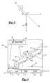
- FIG. 1is a schematic of a navigation system according to the present invention
- FIG. 2is the OIM of the navigation system illustrated in FIG. 1 showing a map display including maneuver sequence notations;
- FIG. 3illustrates a vector calculation methodology of locating the maneuver sequence notations according to the present invention
- FIG. 4is the display of FIG. 2 displaying a complex maneuver instruction view
- FIG. 5is the display of FIG. 2 displaying a complex maneuver instruction view.
- the navigation system 20 of the present inventionis shown schematically in FIG. 1 installed in a vehicle 21 .
- the navigation system 20includes an Operator Interface Module (“OIM”) 22 including input and output devices.
- the OIM 22includes a display 24 , such as a high resolution LCD or flat panel display, and an audio speaker 26 .
- the OIM 22also includes input devices 28 , preferably a plurality of buttons and directional keypad, but alternatively including a mouse, keyboard, keypad, remote device or microphone.
- the display 24can be a touch screen display.
- the navigation system 20further includes a computer module 30 connected to the OIM 22 .
- the computer module 30includes a CPU 32 and storage device 34 connected to the CPU 32 .
- the storage device 34may include a hard drive, CD ROM, DVD, RAM, ROM or other optically readable storage, magnetic storage or integrated circuit.
- the storage device 34contains a database 36 including a map of all the roads in the area to be traveled by the vehicle 21 as well as the locations of potential destinations, such as addresses, hotels, restaurants, or previously stored locations.
- the software for the CPU 32including the graphical user interface, route guidance, operating system, position-determining software, etc may also be stored in storage device 34 or alternatively in ROM, RAM or flash memory.
- the computer module 30preferably includes navigation sensors, such as a GPS receiver 38 and an inertial sensor, which is preferably a multi-axis accelerometer 40 .
- the computer module 30may alternatively or additionally include one or more gyros 42 , a compass 44 , a wheel speed sensor 46 and altimeter 48 , all connected to the CPU 32 .
- Such position and motion determining devicesare well known and are commercially available.
- the navigation system 20propagates the position of the vehicle 21 relative to the map database 36 , i.e. relative positions on road segments and intersections (“nodes”).
- the navigation system 20also determines the current location of the vehicle 21 in terms of latitude and longitude. Utilizing any of a variety of known techniques, the position of the vehicle 21 relative to the map database 36 and/or in terms of latitude and longitude is determined at least in part based upon the motion signals from the multi-axis accelerometer 40 .
- the current local time and datecan be determined from the GPS signals received by the GPS receiver 38 .
- the CPU 32 and position and motion determining devicesdetermine the position of the vehicle 21 relative to the database 36 of roads utilizing dead reckoning, map-matching, etc. Further, as is known in navigation systems, the user can select a destination relative to the database 36 of roads utilizing the input device 28 and the display 24 .
- the navigation system 20then calculates and displays a recommended route directing the driver of the vehicle 21 to the desired destination. Preferably, the navigation system 20 displays turn-by-turn instructions on display 24 and gives corresponding audible instructions on audio speaker 26 , guiding the driver to the desired destination.
- FIG. 2illustrates the OIM 22 .
- the input devices 28include an “enter” key 28 a .
- the display 24is in a map display mode displaying a map view 50 , including a vehicle icon 52 representing the current position of the vehicle 21 on roads 54 .
- the navigation system 20is in a route guidance mode and displays a recommended route 61 .
- the navigation system 20displays the current position by displaying the vehicle icon 52 relative to the roads 54 , on display 24 .
- the map display view 50 of FIG. 2is normally displayed with the heading of the vehicle icon 52 directed upwards with the map of roads 54 moving and rotating based upon movement of the vehicle 21 .
- the map display view 50can also display a movable vehicle icon 52 relative to a constant heading display 24 (such as North up), based upon user preference.
- the navigation system 20displays a plurality of maneuver sequence notation 62 along the recommended route 61 .
- the maneuver sequence notation 62such as “1”, “2”, “3” . . . “A”, “B”, “C” . . . or the like, indicates to the user the sequence and location of upcoming maneuvers along the recommended route 61 .
- the first upcoming maneuveris labeled as “1” or “A”, then each of the subsequent upcoming maneuvers are sequentially labeled.
- the maneuver sequence notations 62are not reused along the calculated recommended route 61 .
- Each upcoming maneuveris distinctively labeled until a new recommended route 61 is calculated.
- the maneuver sequence notation 62is calculated by the CPU 32 and provides the user with a frame of reference as the user proceeds along the recommended route 61 .
- the navigation system 20displays the maneuver sequence notations 62 adjacent each upcoming maneuver.
- the CPU 32locates the maneuver sequence notation 62 proximate the upcoming maneuver to provide a clear indication of where the upcoming maneuver is located along the recommended route 61 , while preventing the maneuver sequence notation 62 from obscuring the upcoming maneuver.
- the maneuver sequence notations 62are preferably calculated by vector addition. For example only, referring to FIG. 3, the vehicle 52 is travelling along a first road segment X and must turn onto a second road segment Y at upcoming maneuver M. To determine the location of maneuver sequence notation 62 , segment X and segment Y are averaged to obtain vector XY.
- segment XYis then calculated to obtain vector -XY.
- the maneuvers sequence notation 62is then located along vector -XY at a distance D from upcoming maneuver M.
- Dis calculated to locate the maneuver sequence notation 62 adjacent the maneuver instruction while preventing the maneuver sequence notation 62 from obscuring the upcoming maneuver. This can be accomplished by locating the maneuver sequence notation 62 a predetermined number of pixels along vector -XY and scaling the number of pixels in response to changes in the display 24 scale.
- a single maneuver instruction representationis displayed in a known manner.
- the maneuver instructionillustrates the upcoming maneuver to be performed along the recommended route to the destination.
- Thisis described in more detail in co-pending application U.S. Ser. No. 09/520096 filed on even date herewith under Express Mail No. EL491263376US and entitled NAVIGATION SYSTEM WITH IMPROVED ROUTE GUIDANCE DISPLAY MODES which is hereby incorporated by Reference in its entirety as if reproduced here.
- a usermay be required to perform two maneuvers in close proximity or other unusual maneuvers to continue along the recommended route 61 .
- Such maneuversare typical in metro areas and may lead a user to incorrectly perform the maneuver.
- the CPU 32switches the display 24 to a complex maneuver instruction view 68 (FIG. 4) which displays multiple maneuver instructions.
- the CPU 32switches the display 24 from the map display view 50 (FIG. 2) to a complex maneuver instruction view 68 .
- the CPU 32preferably displays the complex maneuver instruction view 68 in place of the known single maneuver instruction view depending upon a relationship between the upcoming maneuvers.
- the complex maneuver instruction view 68displays a plurality of maneuver instructions concatenated together.
- Complex maneuver instruction view 68illustrates at least two maneuver instructions 70 , each preferably represented by a 3-dimensional arrow superimposed on the 3-dimensional representation of the intersection.
- each 3-dimensional arrow maneuver instruction 70 ′ and 70 ′′is representative of a road segment having a predetermined length.
- Each upcoming maneuver instructionis preferably selected from the storage device 34 for display by the CPU 32 in a known manner. Because the maneuver instructions 70 ′, 70 ′′ represent a road segment of a predetermined length, the CPU 32 can compare their relationship.
- the complex maneuver instruction view 68is displayed.
- another conditionis preferably compared, for example assuring that no intersecting roads 54 fall within distance L. The intersecting roads 54 could confuse a driver if located between the maneuver instructions. However, if either of these conditions are not met, the known single maneuver instruction view is displayed for each upcoming maneuver.
- Each maneuver instruction 7 ′, 70 ′′includes the maneuver sequence notation 62 previously displayed on the map display view 50 (FIG. 2 ).
- the first maneuver instruction 7 ′includes the maneuver sequence notation 62 of “A”.
- the second maneuver instruction 70 ′′includes the maneuver sequence notation 62 of “B”.
- the maneuver sequence notation 62is displayed at the tail of the 3-dimensional arrow representation. In this way, the user immediately understands the upcoming maneuvers during the shift from the map display view 50 to the complex maneuver instruction view 68 .
- the maneuver instruction 7 ′disappears and only the second maneuver instruction 70 ′′ is displayed. The user is thereby provided with clear instruction through the complex maneuver and is less likely to incorrectly perform the maneuver.
- a text instruction field 84displays text of a maneuver instruction, such as “Exit M-24/Lapeer” or other turn instructions appropriate to the next maneuver.
- the text in the field 84corresponds to the maneuver instruction 70 .
- An information bar 72provides a compass heading 74 , a distance to next maneuver field 76 , a time to destination field 78 , a distance to destination field 80 , and a direction to destination “as the crow flies” field 82 .
- a background 75 of the compass heading 74 fieldis preferably changeable in color to indicate the quality of the GPS receiver 38 satellite fix. For example only, for a good satellite fix the background 75 color is green, if the fix is acceptable the background 75 color is yellow, and if the system is operating in an inertia mode without a GPS fix, the background 75 color is red.
- the maneuver instruction view 68also displays a countdown display such as a bar graph 84 which indicates the imminence of the upcoming maneuver.
- the bar graph 84preferably begins one-tenth of one mile prior to the upcoming maneuver and is depleted as the vehicle approaches the upcoming maneuver.
- a text instruction field 86can included within the bar graph 84 to indicate the distance to the upcoming maneuver.
- the bar graph 84gradually and continuously decreases as the vehicle 20 approaches the maneuver. Portions of the bar graph 84 which overlap text become reverse video, as shown. The user is thereby provided with constant information on the distance to the upcoming maneuver. This is particularly advantageous in a highly congested or road intense environment such as a city.
- FIG. 5another complex maneuver instruction view 68 ′ is displayed.
- the maneuver instruction view 68 ′illustrates a third upcoming maneuver 70 ′′′ that is in close proximity to the second maneuver instruction 70 ′′.
- the relative distance between the end of the second maneuver instruction 70 ′′ and the beginning of the third maneuver instruction 70 ′′′is less than the distance L. Further, no intervening roads 54 fall within distance L.
- the third upcoming maneuver 70 ′′′includes the maneuver sequence notation 62 of “C”.
- the display 24is shifted from the previous complex maneuver instruction view 68 (FIG. 4) to the next complex maneuver instruction view 68 ′ (FIG. 5) while the vehicle 21 is in the process of completing the second maneuver instruction 70 ′′.
- a useris less likely to be confused by two independent but identical maneuver instructions (represented by maneuver instruction “A” and “C”).
- intervening road 54 ′is located immediately prior to the third maneuver instruction 70 ′′′ along the recommended route 61 , it would be possible for a user to confuse two independent right turn maneuver instructions from the known single maneuver instruction view and incorrectly turn right on road 54 ′.
- the present inventionprevents such an incorrect maneuver by concatenating a plurality of maneuver instructions 70 and by providing maneuver sequence notation 62 . Further, by overlapping the second maneuver instruction 70 ′ ‘B’ from the previous 68 to the next complex maneuver instruction view 68 ′, the user is made aware of the immediacy of the third upcoming maneuver 70 ′′′ “C” while prevented from mistakenly turning onto road 54 ′.
Landscapes
- Engineering & Computer Science (AREA)
- Radar, Positioning & Navigation (AREA)
- Remote Sensing (AREA)
- Physics & Mathematics (AREA)
- General Physics & Mathematics (AREA)
- Automation & Control Theory (AREA)
- Navigation (AREA)
Abstract
Description
Claims (34)
Priority Applications (1)
| Application Number | Priority Date | Filing Date | Title |
|---|---|---|---|
| US09/519,143US6397145B1 (en) | 2000-03-06 | 2000-03-06 | Navigation system with complex maneuver instruction |
Applications Claiming Priority (1)
| Application Number | Priority Date | Filing Date | Title |
|---|---|---|---|
| US09/519,143US6397145B1 (en) | 2000-03-06 | 2000-03-06 | Navigation system with complex maneuver instruction |
Publications (1)
| Publication Number | Publication Date |
|---|---|
| US6397145B1true US6397145B1 (en) | 2002-05-28 |
Family
ID=24067023
Family Applications (1)
| Application Number | Title | Priority Date | Filing Date |
|---|---|---|---|
| US09/519,143Expired - LifetimeUS6397145B1 (en) | 2000-03-06 | 2000-03-06 | Navigation system with complex maneuver instruction |
Country Status (1)
| Country | Link |
|---|---|
| US (1) | US6397145B1 (en) |
Cited By (41)
| Publication number | Priority date | Publication date | Assignee | Title |
|---|---|---|---|---|
| US6625538B2 (en)* | 2001-11-01 | 2003-09-23 | General Motors Corporation | Method and system for reducing maneuver proximity diameter for a waypoint navigation system |
| US20040042405A1 (en)* | 2002-08-29 | 2004-03-04 | Nesbitt David W. | Automated route determination |
| US20050119826A1 (en)* | 2003-11-28 | 2005-06-02 | Samsung Electronics Co., Ltd. | Telematics system using image data and method for directing a route by using the same |
| US20050143912A1 (en)* | 2003-12-31 | 2005-06-30 | Samsung Electronics Co., Ltd. | Telematics terminal and method for transmitting route guidance information data fitted to a receiving terminal |
| US20060013487A1 (en)* | 2004-07-09 | 2006-01-19 | Longe Michael R | Disambiguating ambiguous characters |
| US20060111836A1 (en)* | 2004-11-24 | 2006-05-25 | Fast Todd H | Navigation guidance cancellation apparatus and methods of canceling navigation guidance |
| US20060178798A1 (en)* | 2005-02-07 | 2006-08-10 | E-Lead Electronics Co., Ltd. | Method for detecting vehicle speed |
| US7170518B1 (en)* | 2000-03-27 | 2007-01-30 | Magellan Dis, Inc. | Selective rendering of cartographic entities for a navigation system |
| US20070067103A1 (en)* | 2005-08-26 | 2007-03-22 | Denso Corporation | Map display device and map display method |
| US20070083296A1 (en)* | 2005-10-11 | 2007-04-12 | Nissan Technical Center North America, Inc. | Vehicle on-board unit |
| US20070162223A1 (en)* | 2006-01-09 | 2007-07-12 | Thales Navigation, Inc. | Smart detour |
| US20070250515A1 (en)* | 2006-04-21 | 2007-10-25 | Lea David H | Method and system of securing content and destination of digital download via the internet |
| US20080051995A1 (en)* | 2006-08-25 | 2008-02-28 | Magellan Navigation, Inc. | Rerouting in Vehicle Navigation Systems |
| US20080139181A1 (en)* | 2006-12-08 | 2008-06-12 | Magellan Navigation, Inc. | Methods and apparatus for measuring the effectiveness of advertisements presented on a mobile navigation device |
| US20080147313A1 (en)* | 2002-12-30 | 2008-06-19 | Aol Llc | Presenting a travel route |
| US20080198162A1 (en)* | 2007-02-16 | 2008-08-21 | Magellan Navigation, Inc. | A method of generating curved baseline for map labeling |
| US20080221787A1 (en)* | 2007-03-09 | 2008-09-11 | Magellan Navigation, Inc. | Methods and apparatus for determining a route having an estimated minimum fuel usage for a vehicle |
| US20080270468A1 (en)* | 2007-04-25 | 2008-10-30 | Magellan Navigation, Inc. | Adjusting spatial operations based on map density |
| US20080275633A1 (en)* | 2007-04-09 | 2008-11-06 | Ian Cummings | Apparatus and methods for reducing data transmission in wireless client-server navigation systems |
| US20090070293A1 (en)* | 2007-09-10 | 2009-03-12 | Magellan Navigation, Inc. | Nearest-Neighbor Geographic Search |
| US20090138190A1 (en)* | 2007-11-26 | 2009-05-28 | Magellan Navigation, Inc. | System and Method of Providing Traffic Data to a Mobile Device |
| US20090171584A1 (en)* | 2007-12-31 | 2009-07-02 | Magellan Navigation, Inc. | System and Method for Accessing a Navigation System |
| US20090182498A1 (en)* | 2008-01-11 | 2009-07-16 | Magellan Navigation, Inc. | Systems and Methods to Provide Navigational Assistance Using an Online Social Network |
| US20090187342A1 (en)* | 2008-01-18 | 2009-07-23 | Magellan Navigation, Inc. | Method and apparatus for access point recording using a position device |
| US20090187340A1 (en)* | 2008-01-18 | 2009-07-23 | Magellan Navigation, Inc. | Method and apparatus for hybrid routing using breadcrumb paths |
| US20090187341A1 (en)* | 2008-01-18 | 2009-07-23 | Magellan Navigation, Inc. | Method and apparatus to search for local parking |
| US20100035631A1 (en)* | 2008-08-07 | 2010-02-11 | Magellan Navigation, Inc. | Systems and Methods to Record and Present a Trip |
| US20100049696A1 (en)* | 2008-08-20 | 2010-02-25 | Magellan Navigation, Inc. | Systems and Methods for Smart City Search |
| US20100076674A1 (en)* | 2008-09-22 | 2010-03-25 | Magellan Navigation, Inc. | Route Navigation via a Proximity Point |
| US7818116B1 (en) | 2002-12-30 | 2010-10-19 | Mapquest, Inc. | Presenting a travel route in a ground-based vehicle |
| US7904238B2 (en) | 2002-12-30 | 2011-03-08 | Mapquest, Inc. | Presenting a travel route using more than one presentation style |
| US7908080B2 (en) | 2004-12-31 | 2011-03-15 | Google Inc. | Transportation routing |
| US20110069087A1 (en)* | 2008-07-30 | 2011-03-24 | Marcin Cuprjak | Method of and computer implemented system for generating a junction view image |
| US20110106430A1 (en)* | 2003-12-19 | 2011-05-05 | Harman Becker Automotive Systems Gmbh | Navigation system and navigation method |
| US20110283223A1 (en)* | 2010-05-16 | 2011-11-17 | Nokia Corporation | Method and apparatus for rendering user interface for location-based service having main view portion and preview portion |
| US8554475B2 (en) | 2007-10-01 | 2013-10-08 | Mitac International Corporation | Static and dynamic contours |
| US20150192426A1 (en)* | 2014-01-03 | 2015-07-09 | Google Inc. | Input/Output Functions Related To A Portable Device In An Automotive Environment |
| EP2148174A3 (en)* | 2008-07-22 | 2015-07-15 | Samsung Electronics Co., Ltd. | Navigation apparatus and method |
| US9243921B2 (en) | 2014-02-18 | 2016-01-26 | Google Inc. | Intuitive preview of upcoming navigational instructions |
| RU2604870C2 (en)* | 2015-02-04 | 2016-12-20 | Общество с ограниченной ответственностью "Светосистемы" | Control unit for lighting fixtures control system |
| US20230025576A1 (en)* | 2016-06-12 | 2023-01-26 | Apple Inc. | Grouping Maneuvers for Display in a Navigation Presentation |
Citations (14)
| Publication number | Priority date | Publication date | Assignee | Title |
|---|---|---|---|---|
| US4782447A (en) | 1985-04-03 | 1988-11-01 | Nissan Motor Company, Ltd | System and method for navigating a vehicle |
| US5043902A (en) | 1987-12-28 | 1991-08-27 | Aisin Aw Co., Ltd. | Vehicular navigation apparatus |
| US5113185A (en) | 1982-05-01 | 1992-05-12 | Honda Giken Kogyo Kabushiki Kaisha | Current location indication apparatus for use in an automotive vehicle |
| US5243529A (en) | 1991-08-29 | 1993-09-07 | Pioneer Electronic Corporation | Navigation apparatus |
| US5606414A (en) | 1983-04-01 | 1997-02-25 | Unisys Corporation | Interferometric ship's heading reference system |
| US5612882A (en) | 1995-02-01 | 1997-03-18 | Lefebvre; Rebecca K. | Method and apparatus for providing navigation guidance |
| US5654892A (en) | 1991-10-18 | 1997-08-05 | Zexel Usa Corporation | Navigation system displaying forthcoming turns |
| US5731766A (en) | 1995-08-18 | 1998-03-24 | Agency Of Industrial Science And Technology | Route guide system and method |
| US5848364A (en) | 1996-05-10 | 1998-12-08 | Honda Giken Kogyo Kabushiki Kaisha | Method and apparatus for vehicle navigation and guidance through a traffic circle |
| US5925091A (en) | 1995-06-12 | 1999-07-20 | Alpine Electronics, Inc. | Method and apparatus for drawing a map for a navigation system |
| US6108604A (en)* | 1997-08-08 | 2000-08-22 | Aisin Aw Co., Ltd. | Vehicular navigation system and storage medium |
| US6107944A (en)* | 1994-06-24 | 2000-08-22 | Navigation Technologies Corporation | Electronic navigation system and method |
| US6115669A (en)* | 1996-02-01 | 2000-09-05 | Aisin Aw Co., Ltd. | Navigation system for vehicles and waypoint entering and storage method |
| US6249740B1 (en)* | 1998-01-21 | 2001-06-19 | Kabushikikaisha Equos Research | Communications navigation system, and navigation base apparatus and vehicle navigation apparatus both used in the navigation system |
- 2000
- 2000-03-06USUS09/519,143patent/US6397145B1/ennot_activeExpired - Lifetime
Patent Citations (14)
| Publication number | Priority date | Publication date | Assignee | Title |
|---|---|---|---|---|
| US5113185A (en) | 1982-05-01 | 1992-05-12 | Honda Giken Kogyo Kabushiki Kaisha | Current location indication apparatus for use in an automotive vehicle |
| US5606414A (en) | 1983-04-01 | 1997-02-25 | Unisys Corporation | Interferometric ship's heading reference system |
| US4782447A (en) | 1985-04-03 | 1988-11-01 | Nissan Motor Company, Ltd | System and method for navigating a vehicle |
| US5043902A (en) | 1987-12-28 | 1991-08-27 | Aisin Aw Co., Ltd. | Vehicular navigation apparatus |
| US5243529A (en) | 1991-08-29 | 1993-09-07 | Pioneer Electronic Corporation | Navigation apparatus |
| US5654892A (en) | 1991-10-18 | 1997-08-05 | Zexel Usa Corporation | Navigation system displaying forthcoming turns |
| US6107944A (en)* | 1994-06-24 | 2000-08-22 | Navigation Technologies Corporation | Electronic navigation system and method |
| US5612882A (en) | 1995-02-01 | 1997-03-18 | Lefebvre; Rebecca K. | Method and apparatus for providing navigation guidance |
| US5925091A (en) | 1995-06-12 | 1999-07-20 | Alpine Electronics, Inc. | Method and apparatus for drawing a map for a navigation system |
| US5731766A (en) | 1995-08-18 | 1998-03-24 | Agency Of Industrial Science And Technology | Route guide system and method |
| US6115669A (en)* | 1996-02-01 | 2000-09-05 | Aisin Aw Co., Ltd. | Navigation system for vehicles and waypoint entering and storage method |
| US5848364A (en) | 1996-05-10 | 1998-12-08 | Honda Giken Kogyo Kabushiki Kaisha | Method and apparatus for vehicle navigation and guidance through a traffic circle |
| US6108604A (en)* | 1997-08-08 | 2000-08-22 | Aisin Aw Co., Ltd. | Vehicular navigation system and storage medium |
| US6249740B1 (en)* | 1998-01-21 | 2001-06-19 | Kabushikikaisha Equos Research | Communications navigation system, and navigation base apparatus and vehicle navigation apparatus both used in the navigation system |
Non-Patent Citations (1)
| Title |
|---|
| Magellan Driver Information Systems PathMaster Operator Guide issued Aug. 1, 1997, pp. 28 and 29. |
Cited By (91)
| Publication number | Priority date | Publication date | Assignee | Title |
|---|---|---|---|---|
| US7170518B1 (en)* | 2000-03-27 | 2007-01-30 | Magellan Dis, Inc. | Selective rendering of cartographic entities for a navigation system |
| US6625538B2 (en)* | 2001-11-01 | 2003-09-23 | General Motors Corporation | Method and system for reducing maneuver proximity diameter for a waypoint navigation system |
| US8649975B2 (en) | 2002-08-29 | 2014-02-11 | Mapquest, Inc. | Automated route determination |
| US20040052239A1 (en)* | 2002-08-29 | 2004-03-18 | Nesbitt David W. | Automated route determination |
| US20100121562A1 (en)* | 2002-08-29 | 2010-05-13 | Aol Inc. | Automated route determination |
| US20040042405A1 (en)* | 2002-08-29 | 2004-03-04 | Nesbitt David W. | Automated route determination |
| US10718623B2 (en) | 2002-08-29 | 2020-07-21 | Verizon Patent And Licensing, Inc. | Automated route determination |
| US10697785B2 (en) | 2002-08-29 | 2020-06-30 | Verizon Patent And Licensing, Inc. | Automated route determination |
| US10551203B2 (en) | 2002-08-29 | 2020-02-04 | Verizon Patent And Licensing Inc. | Automated route determination |
| US8560223B2 (en) | 2002-08-29 | 2013-10-15 | Mapquest, Inc. | Automated route determination |
| US20040044466A1 (en)* | 2002-08-29 | 2004-03-04 | Nesbitt David W. | Automated route determination |
| US8510040B2 (en) | 2002-08-29 | 2013-08-13 | Mapquest, Inc. | Automated route determination |
| US20080147313A1 (en)* | 2002-12-30 | 2008-06-19 | Aol Llc | Presenting a travel route |
| US8335646B2 (en) | 2002-12-30 | 2012-12-18 | Aol Inc. | Presenting a travel route |
| US8977497B2 (en) | 2002-12-30 | 2015-03-10 | Aol Inc. | Presenting a travel route |
| US8954274B2 (en)* | 2002-12-30 | 2015-02-10 | Facebook, Inc. | Indicating a travel route based on a user selection |
| US9599487B2 (en) | 2002-12-30 | 2017-03-21 | Mapquest, Inc. | Presenting a travel route |
| US7702454B2 (en) | 2002-12-30 | 2010-04-20 | Mapquest, Inc. | Presenting a travel route |
| US10113880B2 (en) | 2002-12-30 | 2018-10-30 | Facebook, Inc. | Custom printing of a travel route |
| US7818116B1 (en) | 2002-12-30 | 2010-10-19 | Mapquest, Inc. | Presenting a travel route in a ground-based vehicle |
| US7904238B2 (en) | 2002-12-30 | 2011-03-08 | Mapquest, Inc. | Presenting a travel route using more than one presentation style |
| US20130066553A1 (en)* | 2002-12-30 | 2013-03-14 | Facebook, Inc. | Presenting a travel route using more than one presentation style |
| US7925430B2 (en) | 2002-12-30 | 2011-04-12 | Aol Inc. | Presenting a travel route |
| US20110153187A1 (en)* | 2002-12-30 | 2011-06-23 | Mapquest, Inc. | Presenting a travel route using more than one presentation style |
| US8296061B2 (en) | 2002-12-30 | 2012-10-23 | Facebook, Inc. | Presenting a travel route using more than one presentation style |
| US7474960B1 (en)* | 2002-12-30 | 2009-01-06 | Mapquest, Inc. | Presenting a travel route |
| US20050119826A1 (en)* | 2003-11-28 | 2005-06-02 | Samsung Electronics Co., Ltd. | Telematics system using image data and method for directing a route by using the same |
| US7650235B2 (en)* | 2003-11-28 | 2010-01-19 | Samsung Electronics Co., Ltd | Telematics system using image data and method for directing a route by using the same |
| US9076334B2 (en)* | 2003-12-19 | 2015-07-07 | Samsung Electronics Co., Ltd. | Navigation system and navigation method |
| US20110106430A1 (en)* | 2003-12-19 | 2011-05-05 | Harman Becker Automotive Systems Gmbh | Navigation system and navigation method |
| US7444239B2 (en) | 2003-12-31 | 2008-10-28 | Samsung Electronics Co., Ltd. | Telematics terminal and method for transmitting route guidance information data fitted to a receiving terminal |
| US20050143912A1 (en)* | 2003-12-31 | 2005-06-30 | Samsung Electronics Co., Ltd. | Telematics terminal and method for transmitting route guidance information data fitted to a receiving terminal |
| EP1550989A3 (en)* | 2003-12-31 | 2006-10-04 | Samsung Electronics Co., Ltd. | Telematics terminal and method for transmitting route guidance information data |
| US8583087B2 (en) | 2004-07-09 | 2013-11-12 | Nuance Communications, Inc. | Disambiguating ambiguous characters |
| US20060013487A1 (en)* | 2004-07-09 | 2006-01-19 | Longe Michael R | Disambiguating ambiguous characters |
| US7966003B2 (en) | 2004-07-09 | 2011-06-21 | Tegic Communications, Inc. | Disambiguating ambiguous characters |
| US7289905B2 (en)* | 2004-11-24 | 2007-10-30 | General Motors Corporation | Navigation guidance cancellation apparatus and methods of canceling navigation guidance |
| US20060111836A1 (en)* | 2004-11-24 | 2006-05-25 | Fast Todd H | Navigation guidance cancellation apparatus and methods of canceling navigation guidance |
| US9945686B2 (en) | 2004-12-31 | 2018-04-17 | Google Llc | Transportation routing |
| US11092455B2 (en) | 2004-12-31 | 2021-08-17 | Google Llc | Transportation routing |
| US9709415B2 (en) | 2004-12-31 | 2017-07-18 | Google Inc. | Transportation routing |
| US9778055B2 (en) | 2004-12-31 | 2017-10-03 | Google Inc. | Transportation routing |
| US8798917B2 (en) | 2004-12-31 | 2014-08-05 | Google Inc. | Transportation routing |
| US7908080B2 (en) | 2004-12-31 | 2011-03-15 | Google Inc. | Transportation routing |
| US8606514B2 (en) | 2004-12-31 | 2013-12-10 | Google Inc. | Transportation routing |
| US20060178798A1 (en)* | 2005-02-07 | 2006-08-10 | E-Lead Electronics Co., Ltd. | Method for detecting vehicle speed |
| US20070067103A1 (en)* | 2005-08-26 | 2007-03-22 | Denso Corporation | Map display device and map display method |
| US7630833B2 (en)* | 2005-08-26 | 2009-12-08 | Denso Corporation | Map display device and map display method |
| US7433773B2 (en) | 2005-10-11 | 2008-10-07 | Nissan Technical Center North America, Inc. | Vehicle on-board unit |
| US20070083296A1 (en)* | 2005-10-11 | 2007-04-12 | Nissan Technical Center North America, Inc. | Vehicle on-board unit |
| US7590490B2 (en) | 2006-01-09 | 2009-09-15 | Mitac International Corporation | Smart detour |
| US20070162223A1 (en)* | 2006-01-09 | 2007-07-12 | Thales Navigation, Inc. | Smart detour |
| US20070250515A1 (en)* | 2006-04-21 | 2007-10-25 | Lea David H | Method and system of securing content and destination of digital download via the internet |
| US20080051995A1 (en)* | 2006-08-25 | 2008-02-28 | Magellan Navigation, Inc. | Rerouting in Vehicle Navigation Systems |
| US7945386B2 (en) | 2006-08-25 | 2011-05-17 | Mitac International Corporation | Rerouting in vehicle navigation systems |
| US20080139181A1 (en)* | 2006-12-08 | 2008-06-12 | Magellan Navigation, Inc. | Methods and apparatus for measuring the effectiveness of advertisements presented on a mobile navigation device |
| US20080198162A1 (en)* | 2007-02-16 | 2008-08-21 | Magellan Navigation, Inc. | A method of generating curved baseline for map labeling |
| US7692655B2 (en) | 2007-02-16 | 2010-04-06 | Mitac International Corporation | Apparatus and method of generating curved baseline for map labeling |
| US7783417B2 (en) | 2007-03-09 | 2010-08-24 | Mitac International Corporation | Methods and apparatus for determining a route having an estimated minimum fuel usage for a vehicle |
| US20080221787A1 (en)* | 2007-03-09 | 2008-09-11 | Magellan Navigation, Inc. | Methods and apparatus for determining a route having an estimated minimum fuel usage for a vehicle |
| US20080275633A1 (en)* | 2007-04-09 | 2008-11-06 | Ian Cummings | Apparatus and methods for reducing data transmission in wireless client-server navigation systems |
| US10281283B2 (en)* | 2007-04-09 | 2019-05-07 | Ian Cummings | Apparatus and methods for reducing data transmission in wireless client-server navigation systems |
| US20080270468A1 (en)* | 2007-04-25 | 2008-10-30 | Magellan Navigation, Inc. | Adjusting spatial operations based on map density |
| US8078641B2 (en) | 2007-04-25 | 2011-12-13 | Mitac International Corporation | Adjusting spatial operations based on map density |
| US20090070293A1 (en)* | 2007-09-10 | 2009-03-12 | Magellan Navigation, Inc. | Nearest-Neighbor Geographic Search |
| US7882102B2 (en) | 2007-09-10 | 2011-02-01 | Mitac International Corporation | Nearest-neighbor geographic search |
| US8554475B2 (en) | 2007-10-01 | 2013-10-08 | Mitac International Corporation | Static and dynamic contours |
| US20090138190A1 (en)* | 2007-11-26 | 2009-05-28 | Magellan Navigation, Inc. | System and Method of Providing Traffic Data to a Mobile Device |
| US20090171584A1 (en)* | 2007-12-31 | 2009-07-02 | Magellan Navigation, Inc. | System and Method for Accessing a Navigation System |
| US20090182498A1 (en)* | 2008-01-11 | 2009-07-16 | Magellan Navigation, Inc. | Systems and Methods to Provide Navigational Assistance Using an Online Social Network |
| US20090187340A1 (en)* | 2008-01-18 | 2009-07-23 | Magellan Navigation, Inc. | Method and apparatus for hybrid routing using breadcrumb paths |
| US8498808B2 (en) | 2008-01-18 | 2013-07-30 | Mitac International Corp. | Method and apparatus for hybrid routing using breadcrumb paths |
| US8290703B2 (en) | 2008-01-18 | 2012-10-16 | Mitac International Corporation | Method and apparatus for access point recording using a position device |
| US20090187341A1 (en)* | 2008-01-18 | 2009-07-23 | Magellan Navigation, Inc. | Method and apparatus to search for local parking |
| US8700314B2 (en) | 2008-01-18 | 2014-04-15 | Mitac International Corporation | Method and apparatus to search for local parking |
| US20090187342A1 (en)* | 2008-01-18 | 2009-07-23 | Magellan Navigation, Inc. | Method and apparatus for access point recording using a position device |
| EP2148174A3 (en)* | 2008-07-22 | 2015-07-15 | Samsung Electronics Co., Ltd. | Navigation apparatus and method |
| US8773458B2 (en)* | 2008-07-30 | 2014-07-08 | Tomtom Global Content B.V. | Method of and computer implemented system for generating a junction view image |
| US20110069087A1 (en)* | 2008-07-30 | 2011-03-24 | Marcin Cuprjak | Method of and computer implemented system for generating a junction view image |
| US20100035631A1 (en)* | 2008-08-07 | 2010-02-11 | Magellan Navigation, Inc. | Systems and Methods to Record and Present a Trip |
| US8249804B2 (en) | 2008-08-20 | 2012-08-21 | Mitac International Corporation | Systems and methods for smart city search |
| US20100049696A1 (en)* | 2008-08-20 | 2010-02-25 | Magellan Navigation, Inc. | Systems and Methods for Smart City Search |
| US8219317B2 (en) | 2008-09-22 | 2012-07-10 | Mitac International Corporation | Route navigation via a proximity point |
| US20100076674A1 (en)* | 2008-09-22 | 2010-03-25 | Magellan Navigation, Inc. | Route Navigation via a Proximity Point |
| US20110283223A1 (en)* | 2010-05-16 | 2011-11-17 | Nokia Corporation | Method and apparatus for rendering user interface for location-based service having main view portion and preview portion |
| US9582166B2 (en)* | 2010-05-16 | 2017-02-28 | Nokia Technologies Oy | Method and apparatus for rendering user interface for location-based service having main view portion and preview portion |
| US20150192426A1 (en)* | 2014-01-03 | 2015-07-09 | Google Inc. | Input/Output Functions Related To A Portable Device In An Automotive Environment |
| US9243921B2 (en) | 2014-02-18 | 2016-01-26 | Google Inc. | Intuitive preview of upcoming navigational instructions |
| RU2604870C2 (en)* | 2015-02-04 | 2016-12-20 | Общество с ограниченной ответственностью "Светосистемы" | Control unit for lighting fixtures control system |
| US20230025576A1 (en)* | 2016-06-12 | 2023-01-26 | Apple Inc. | Grouping Maneuvers for Display in a Navigation Presentation |
| US12259252B2 (en)* | 2016-06-12 | 2025-03-25 | Apple Inc. | Grouping maneuvers for display in a navigation presentation |
Similar Documents
| Publication | Publication Date | Title |
|---|---|---|
| US6397145B1 (en) | Navigation system with complex maneuver instruction | |
| US6529822B1 (en) | Navigation system with zoomed maneuver instruction | |
| US6836725B2 (en) | Vehicle navigation system with off-road navigation | |
| EP1254349B1 (en) | A navigation system with unique audio tones for maneuver notification | |
| US6430501B1 (en) | Navigation system with route indicators | |
| US7502685B2 (en) | Vehicle navigation apparatus and method with traveling direction indication at guidance intersection | |
| US6049755A (en) | Navigation system vehicle location display | |
| US7925438B2 (en) | Method and apparatus for displaying route guidance list for navigation system | |
| US8095308B2 (en) | Navigation apparatus | |
| US20010013837A1 (en) | Lane guidance display method, and navigation device and recording medium for realizing the method | |
| WO2008083739A1 (en) | Navigation device and method for displaying navigation information | |
| US7683805B2 (en) | Traffic situation display device, method and program thereof and recording medium with the program recorded therein | |
| JP4622676B2 (en) | Car navigation system | |
| JP4609886B2 (en) | Navigation device | |
| JP2001317956A (en) | Navigation apparatus and recording medium | |
| JP4357932B2 (en) | Car navigation system | |
| JP4128444B2 (en) | Guidance display method in in-vehicle navigator | |
| JP4817993B2 (en) | Navigation device and guide route setting method | |
| JP5082545B2 (en) | Navigation device and program | |
| JP4260574B2 (en) | Navigation device | |
| JP2006003328A (en) | On-vehicle navigation system | |
| JP4357953B2 (en) | On-vehicle navigation device and traveling locus display method | |
| JP4463675B2 (en) | Car navigation system | |
| JP2004226139A (en) | Course guiding method for on-vehicle navigation device | |
| JP2002286466A (en) | Guiding route displaying method and expanded chart displaying method for on-vehicle navigators |
Legal Events
| Date | Code | Title | Description |
|---|---|---|---|
| AS | Assignment | Owner name:MAGELLAN DIS, INC., MICHIGAN Free format text:ASSIGNMENT OF ASSIGNORS INTEREST;ASSIGNOR:MILLINGTON, JEFFREY ALAN;REEL/FRAME:010657/0521 Effective date:20000228 | |
| STCF | Information on status: patent grant | Free format text:PATENTED CASE | |
| CC | Certificate of correction | ||
| FPAY | Fee payment | Year of fee payment:4 | |
| AS | Assignment | Owner name:WACHOVIA CAPITAL FINANCE CORPORATION (WESTERN), CA Free format text:SECURITY AGREEMENT;ASSIGNOR:MAGELLAN NAVIGATION, INC.;REEL/FRAME:018194/0375 Effective date:20060831 | |
| AS | Assignment | Owner name:THALES NAVIGATION SOLUTIONS, INC., CALIFORNIA Free format text:CHANGE OF NAME;ASSIGNOR:MAGELLAN DIS, INC.;REEL/FRAME:019690/0937 Effective date:20050502 Owner name:THALES NAVIGATION SOLUTIONS, INC., CALIFORNIA Free format text:CONVERSION OF A DELAWARE CORPORATION TO A DELAWARE LIMITED LIABILITY COMPANY;ASSIGNOR:THALES NAVIGATION SOLUTIONS, INC.;REEL/FRAME:019690/0846 Effective date:20060810 | |
| AS | Assignment | Owner name:MAGELLAN NAVIGATION, INC., CALIFORNIA Free format text:ASSIGNMENT OF ASSIGNORS INTEREST;ASSIGNOR:THALES NAVIGATION SOLUTIONS, LLC;REEL/FRAME:019704/0015 Effective date:20060831 Owner name:THALES NAVIGATION SOLUTIONS, LLC, CALIFORNIA Free format text:CORRECTIVE ASSIGNMENT TO CORRECT THE CORRECTING ASSIGNEE FROM THALES NAVIGATION SOLUTIONS, INC. TO THALES NAVIGATION SOLUTIONS, LLC PREVIOUSLY RECORDED ON REEL 019690 FRAME 0846;ASSIGNOR:THALES NAVIGATION SOLUTIONS, INC.;REEL/FRAME:019699/0960 Effective date:20060810 | |
| AS | Assignment | Owner name:MITAC INTERNATIONAL CORP., TAIWAN Free format text:ASSIGNMENT OF ASSIGNORS INTEREST;ASSIGNOR:MAGELLAN NAVIGATION, INC.;REEL/FRAME:022343/0987 Effective date:20081214 | |
| AS | Assignment | Owner name:MAGELLAN NAVIGATION, INC., CALIFORNIA Free format text:RELEASE BY SECURED PARTY;ASSIGNOR:WACHOVIA CAPITAL FINANCE CORPORATION (WESTERN);REEL/FRAME:023180/0609 Effective date:20090112 | |
| FPAY | Fee payment | Year of fee payment:8 | |
| FPAY | Fee payment | Year of fee payment:12 | |
| AS | Assignment | Owner name:DIDI (HK) SCIENCE AND TECHNOLOGY LIMITED, CHINA Free format text:ASSIGNMENT OF ASSIGNORS INTEREST;ASSIGNOR:MITAC INTERNATIONAL CORPORATION;REEL/FRAME:040117/0651 Effective date:20161019 |