US6381537B1 - Method and system for obtaining geographic data using navigation systems - Google Patents
Method and system for obtaining geographic data using navigation systemsDownload PDFInfo
- Publication number
- US6381537B1 US6381537B1US09/586,276US58627600AUS6381537B1US 6381537 B1US6381537 B1US 6381537B1US 58627600 AUS58627600 AUS 58627600AUS 6381537 B1US6381537 B1US 6381537B1
- Authority
- US
- United States
- Prior art keywords
- data
- vehicle
- vehicles
- address
- desired destination
- Prior art date
- Legal status (The legal status is an assumption and is not a legal conclusion. Google has not performed a legal analysis and makes no representation as to the accuracy of the status listed.)
- Expired - Lifetime
Links
Images


Classifications
- G—PHYSICS
- G08—SIGNALLING
- G08G—TRAFFIC CONTROL SYSTEMS
- G08G1/00—Traffic control systems for road vehicles
- G08G1/20—Monitoring the location of vehicles belonging to a group, e.g. fleet of vehicles, countable or determined number of vehicles
- G—PHYSICS
- G08—SIGNALLING
- G08G—TRAFFIC CONTROL SYSTEMS
- G08G1/00—Traffic control systems for road vehicles
- G08G1/123—Traffic control systems for road vehicles indicating the position of vehicles, e.g. scheduled vehicles; Managing passenger vehicles circulating according to a fixed timetable, e.g. buses, trains, trams
Definitions
- the present inventionrelates to collecting geographic data for a geographic database and more particularly, the present invention relates to a method and system for collecting address data for a geographic database using end users navigation systems.
- Geographic databaseshave various uses. Geographic databases are used in in-vehicle navigation systems, personal computers, networked computing environments, and various other kinds of platforms, as well as on the Internet. Geographic databases are used with various kinds of applications to provide various navigation-related and related functions including map display, route calculation, route guidance, truck fleet deployment, traffic control, traffic monitoring, electronic yellow pages, roadside assistance, emergency services, and so on.
- a geographic databaseincludes data that represent geographic features in a region.
- the geographic features that are represented in a geographic databasemay include roads, intersections, and so on.
- a geographic databaseincludes information about the represented geographic features, such as the geographic coordinates of roads in a geographic region, speed limits along the road segments, locations of stop lights, turn restrictions at intersections of roads, address ranges, street names, and so on.
- a geographic databasemay also include information about points of interest in a region. Points of interest may include restaurants, hotels, airports, gas stations, stadiums, police stations, and so on.
- Collecting information for a geographic databaseis a significant task. Not only is the initial collection of data a significant undertaking, but a geographic database needs to be updated on a regular basis. For example, new streets are constructed, street names change, traffic lights are installed, and turn restrictions are added to existing roads. Also, new levels of detail may be added about geographic features that are already represented in an existing geographic database. For example, an existing geographic database for roads may be enhanced with information about lane widths, shoulder sizes, lane barriers, address ranges, sidewalks, bicycles paths, etc. Thus, there exists a need to continue to collect information for a geographic database.
- U.S. Pat. No. 6,047,234One method for collecting. data for a geographic database is described in U.S. Pat. No. 6,047,234.
- navigation systems installed in a plurality of vehiclesare used as probes to collect geographic data as the vehicles are driven in a geographic region. These navigation systems may also provide navigation-related features to the drivers and/or passengers of the vehicles in which they are installed, or alternatively, the navigation systems may serve only to collect geographic data as the vehicles in which they are installed are driven.
- the geographic data collected by the plurality of vehiclesare gathered together, analyzed, and used to update or refine a master geographic database. Copies of the master geographic database, or database products derived from the master copy, can then be distributed back to the plurality of vehicles and used in the navigation systems installed in the plurality of vehicles.
- the present inventioncomprises a method and system for collecting address and location data for a geographic database.
- Dataare collected using a plurality of end users navigation systems.
- the dataindicate a location at which a trip by a vehicle in which a navigation system is located ended and a desired destination entered into the navigation system by an end user prior thereto.
- These dataare received in a data collection facility that statistically analyzes the data and uses the data to update a geographic database.
- FIG. 1is a block diagram illustrating a navigation system.
- FIG. 2is a block diagram illustrating components of the navigation programming shown in FIG. 1 including a feature for collecting address data.
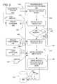
- FIG. 3is a flow chart showing steps performed by the address data collection program of FIG. 2 .
- FIG. 4is a block diagram showing components of the data file of FIG. 3 .
- FIG. 5is a flow chart showing steps performed by a central data collection facility that receives data from the process of FIG. 3 .
- FIG. 1there is a diagram illustrating an exemplary embodiment of a navigation system 110 .
- the navigation system 110is located in a vehicle 111 , such as an automobile, truck, or bus.
- the navigation system 110is a combination of hardware and software components.
- the hardware components of the navigation system 110may include a processor 112 , memory 120 , and so on.
- the navigation system 110also includes a positioning system 124 that determines the position of the vehicle 111 in which it is installed.
- the positioning system 124may include sensors 125 or other components that sense the speed, orientation, direction, angular acceleration, and so on, of the vehicle 111 .
- the positioning system 124may also include a GPS system.
- the navigation system 110also includes a user interface 131 .
- the user interface 131includes appropriate means 127 for receiving instructions and/or input from an end user of the navigation system.
- the instruction receiving means 127may include a keyboard, keypad, or other type of input panel 127 (P), a microphone 127 (M), as well as other means for accepting end-user input, such as voice recognition software, and so on, through which the end user may request navigation information and services.
- the user interface 131also includes appropriate means 129 for providing information back to the end user.
- the information providing means 129may include a display 129 (D) and speakers 129 (S) (including speech synthesis hardware and software) through which the end user can be provided with information and services from the navigation system 110 .
- the navigation system 110uses geographic data 140 .
- the geographic data 140include information about one or more geographic regions or coverage areas.
- the geographic data 140may be stored in the vehicle 111 or alternatively, the geographic data 140 may be stored remotely and made available to the navigation system 110 in the vehicle 111 through a wireless communication system which may be part of the navigation system 110 .
- a portion of the geographic data 140may be stored in the vehicle 111 and a portion of the geographic data 140 may be stored in a remote location and made available to the navigation system 110 in the vehicle 111 over a wireless communication system from the remote location.
- the navigation system 110includes a drive 114 (or other suitable peripheral device) into which the medium 132 can be installed and accessed.
- the storage medium 132is a CD-ROM disk.
- the storage medium 132may be a PCMCIA card in which case the drive 114 would be substituted with a PCMCIA slot.
- Various other storage mediamay be used, including fixed or hard disks, DVD disks or other currently available storage media, as well as storage media that may be developed in the future.
- the geographic data 140include data specifying the positions of the roads in the covered geographic region(s).
- the geographic data 140also include data relating to the roads, such as restrictions on directions of travel along the roads (e.g., one-way streets), street addresses along the roads, street names, speed limits along the roads, turn restrictions at intersections, and so on.
- the geographic data 140may also include information about points of interest in the geographic area, such as hotels, restaurants, museums, stadiums, offices, automobile dealerships, auto repair shops, etc.
- the geographic data 140may also include information about places, such as cities, towns, or other communities.
- the geographic data 140may include other kinds of data about the geographic area.
- the geographic data 140may take a variety of different forms.
- the geographic data 140are in the form of one or more computer-readable data files or databases 141 .
- Methods for forming and organizing a geographic databaseare disclosed in U.S. Pat. Nos. 5,953,722, 5,974,419 and 5,968,109, the disclosures of which are incorporated herein by reference.
- the geographic database 141contains a plurality of road segment data records. Each road segment data record represents a portion (or segment) of a navigable road in the geographic region.
- a road segment data recordmay include a segment ID by which the record can be identified in the geographic database.
- Data attributesare associated with each road segment data record to describe features or characteristics of the represented road segment.
- the road segment data recordmay includes attributes representing the speed limit along the road (or a speed limit range), the type of road (e.g., controlled access, ramp, bridge, tunnel, toll road, ferry, and so on), a functional rank, a permitted direction of travel, an address range, a name, a highway designation of the road of which the road segment is a part, and so on.
- the various attributes associated with a road segmentmay be included in a single road segment record, or may be included in more than one type of record that are cross-referenced to each other.
- Each physical road segmenthas two nodes associated with it, one at each of the endpoints of the road segment.
- the geographic database 141includes a plurality of data entities that represent these nodes.
- each road segment data recordincludes data references to the node data records that represent the endpoints of the represented road segment.
- the geographic dataare provided by Navigation Technologies Corporation of Rosemont, Ill. However, it is understood that the inventive concepts disclosed herein are not restricted to any particular source of data.
- the data records in the geographic database 141 that represent roadsmay not necessarily include all the same types of data attributes.
- roadsdo not all have the same properties.
- some roadshave a highway designation (e.g., “Wisconsin State Highway 120”) whereas other roads do not.
- Another reason why data records in the geographic database 141 that represent roads may not have the same data attributesis that some of the properties of a road may not have been collected or confirmed.
- Collecting data about roads for a geographic databasemay involve multiple steps. For example, road geometry data may be obtained using aerial photographs and then, street address data about roads are obtained by physically driving along the roads and recording the observed street addresses.
- street address dataare obtained for all the roads represented in the geographic database.
- street address dataare included for only some of the roads represented in the geographic database.
- some of the roadsare represented by data records that do not include street address data.
- the roads that are represented by data records that do not include street address datamay include only road geometry data. These may be roads for which geometry data were obtained from aerial photographs, but for which address data may not yet have been collected. If a navigation system uses a geographic database in which some of the data records representing roads do not include address data, certain navigation-related functions may not work or may not work as well.
- a geographic databaseincludes data records representing roads that do not include address data
- a route to a destination that had been specified using an addressmay guide the driver to only the general vicinity of the destination.
- a geographic databaseexcludes data records representing roads that do not include address data, it may not be possible to obtain a route to the destination at all.
- some of the data representing roadsmay include street address data whereas other data representing roads may not include street address data.
- the navigation system 110includes or uses navigation programming 228 .
- the navigation programming 228includes the software that provides for the functions and/or features performed by the navigation system 110 .
- the navigation programming 228uses the geographic data 140 in conjunction with input from the end user via the user interface 131 , and possibly in conjunction with outputs from the positioning system 124 , to provide various navigation-related features and/or functions.
- the navigation programming 228may be stored in a non-volatile storage medium 229 in the navigation system 110 .
- the navigation programming 228 and the geographic data 140may be stored together on a single storage device or medium.
- the navigation programming 228may be located at a remote location and may be provided to or accessed by the navigation system 110 over a communications system.
- the navigation programming 228is written in the C programming language although in alternative embodiments other programming languages may be used, such as C++, Java, Visual Basic, and so on.
- the navigation programming 228may be formed of separate component applications (also referred to as programs, subprograms, routines, or tools).
- the component applications of the navigation programming 228work together through defined programming interfaces.
- FIG. 2shows a block diagram illustrating some of the component applications for one embodiment of the navigation programming 228 included in the navigation system 110 of FIG. 1 .
- the navigation programming 228may include other component sub-routines or programs.
- the navigation programming 228is shown to include a navigation application manager 240 .
- the navigation application manager 240is a program or routine that provides for overall management of the functions of the navigation system 110 .
- the navigation application manager 240may also include support for and interfaces with the navigation system hardware, such as the positioning system 124 and the user interface 131 .
- the navigation-programming 228includes user interface functions 242 to interface with the user interface hardware 131 .
- These user interface functions 242may provide for presenting a menu to the end user on the screen display 129 (D) of the user interface hardware 131 , accepting inputs from the end user via the input devices 127 of the user interface hardware 131 , displaying results to the end user on the screen display 129 (D) of the user interface hardware 131 , and so on.
- the navigation programming 228includes sub-programs or routines that interface with the navigation application manager 240 and that provide for specific navigation-related features or functions to be performed by the navigation system. These sub-programs include a route calculation application 250 , a route guidance application 252 , a map display application 253 , a vehicle positioning application 256 and a geo-coding application 258 .
- the navigation programming 228may include other navigation applications in addition to these.
- a request for route guidancemay originate with input from the end user.
- the end useridentifies a desired destination.
- the end usermay identify the desired destination by street address, e.g. “100 WEST MAIN STREET.”
- the requestis received via the user interface 131 .
- the end user's inputis forwarded via the user interface functions 242 and the manager application 240 to the geo-coding application 258 .
- the geo-coding application 258identifies one or more database records associated with the street address entered as the destination by the end user. If address data are available for the database records (in the geographic database 141 in FIG. 1) that represent the destination street, the geo-coding application 258 identifies the specific road segment and possibly a position along the road segment associated with the entered street address.
- the geo-coding applicationidentifies the one or more road segments associated with the entered destination street address. Then, the geo-coding application 258 forwards data indicating the one or more identified database records to the route calculation application 250 .
- the vehicle positioning application 256identifies the database record that represents the road segment upon which the vehicle is currently located.
- the vehicle positioning application 256forwards data indicating the identified database record to the route calculation application 250 .
- the route calculation application 250Having received data identify the starting location from the vehicle positioning application 256 and the desired destination location from the geo-coding application 258 , the route calculation application 250 attempts to determine one or more solution routes between the starting location and the destination location.
- a solution routeis formed of a series of connected road segments over which a vehicle can travel from the starting location to the destination location.
- the route calculation application 250calculates a route, it accesses the geographic data 140 and obtains road segment data records that represent road segments around and between the starting location and the destination location.
- the route calculation application 250uses the information in the road segment data records to attempt to determine at least one valid solution route from the starting location to the destination location.
- the route calculation application 250may use various means or algorithms in determining solution routes.
- the route calculation program 250uses the data attributes associated with the road segment data records to account for direction of travel restrictions (e.g., one-way streets), turn restrictions at intersections (e.g., no left turns), and so on.
- the route calculation application 250may attempt to find a solution route that takes the least time to travel, that covers the least distance, or that meets some other specifiable criteria.
- the route calculation application 250provides an output.
- the output of the route calculation application 250is in the form of an ordered list 254 identifying a plurality of road segments.
- the plurality of road segmentsform the continuous navigable route between the origin and the destination that had been calculated by the route calculation application 250 .
- the route calculation application 250may calculate more than one solution route.
- the list 254 of road segments determined by the route calculation application 250is provided to the route guidance application 252 .
- the route guidance application 252uses the information in the list 254 , as well as additional information from the geographic database 141 , to provide maneuvering instructions and advice to the end user to travel the route defined by the list 254 output by the route calculation application 250 .
- the navigation system 110uses data from the positioning system 124 .
- the positioning system 124acquires data used to determine the position of the vehicle as it is traveling.
- the vehicle positioning application 256 in the navigation programming 228uses the data from the positioning system 124 to determine the vehicle's location relative to data in the geographic database 141 . Based on a comparison of the vehicle's position to the positions of the road segments in the calculated driving route 254 , maneuvering instructions are provided at appropriate times.
- the output of the route calculation application 250may also be provided to the map display application 253 so that graphical maps may be displayed as the vehicle is traveling the calculated route.
- the navigation system 110includes an address data collection program 400 .
- the address data collection program 400is used to collect address data. (The address data collection program 400 is also used for collecting location data, as described below.)
- the address data collection program 400is included in the navigation programming 228 in the navigation system 110 .
- FIG. 3includes a flowchart that shows some of the steps performed by the address data collection program 400 .
- a signal 410is sent from the electrical system 414 of the vehicle 111 to the address data collection program 400 .
- the signal 410may be sent when the vehicle 111 has been parked, when the vehicle engine has been turned off, when the vehicle transmission has been put into park, when the vehicle parking brake has been set, or any other condition or event that indicates that a vehicle trip is over. Any of these events or conditions can be detected by an appropriate program or switch in the vehicle electrical system 414 .
- the signal 410may be provided from the electrical system 414 to the address data collection program 400 via the application manager ( 240 in FIG. 2 ).
- the signal 410is received by the address data collection program 400 (Step 408 ).
- the address data collection program 400receives a message or signal 420 from the route guidance application 252 (Step 418 ).
- the message 420 from the route guidance program 252indicates whether the vehicle 111 had just been driven along a route that had been calculated by the route calculation application 250 .
- the message 420may be in response to a query request message 424 sent by the address data collection program 400 to the route guidance application 252 upon receiving the message 410 from the vehicle electrical system 414 .
- the route guidance application 252may also receive the signal 410 from the vehicle electrical system 414 indicating that the vehicle trip has been completed and, upon receiving the signal 410 , the route guidance application 252 sends the message 420 to the address data collection program 400 .
- the address data collection program 400obtains data 430 indicating the vehicle position from the vehicle positioning application 256 (Step 432 ).
- the data 430 from the vehicle positioning application 256 to the address data collection program 400indicates the vehicle position at the time the vehicle trip had been completed, e.g., when the vehicle had been parked or turned off.
- the data 430 from the vehicle positioning application 256may be in response to a query request message 434 sent by the address data collection program 400 to the vehicle positioning application 256 .
- the address data collection program 400obtains data 440 indicating the address of the destination of the route that had been calculated (Step 444 ).
- the address of the destination of the calculated routemay be obtained from the route calculation output 254 or alternatively, from the user interface 131 which may temporarily store the address information that had been entered, by the user when a request for route guidance was made. (The address information may be temporarily stored in a data storage memory, which may be part of the navigation system memory.)
- the address data collection program 400saves data 450 indicating the vehicle position at the time the vehicle trip had been completed (Step 452 ).
- the address data collection program 400also saves data 460 indicating the address of the destination of the route that had been calculated.
- the address data collection program 400may also save additional data 466 .
- the additional data 466may include the time and date.
- the additional data 466may also include an indication whether the data record representing the road segment upon which the destination address is located includes address data or does not include address data.
- the additional datamay also include an indication whether the vehicle had departed from the calculated route before the destination was reached.
- the address data collection program 400saves the vehicle position data 450 , the address data 460 , and the other data 466 together in a file or database 464 .
- the vehicle position data 450 , the address data 460 , and the other data 466are saved, they are saved as related entries in the file or database 464 so that there is an indication that these data 450 , 460 , and 466 are related to each other, i.e., the vehicle position data 450 represents the vehicle's position when the route to the address represented by the address data 460 had been completed.
- the database or file 464is stored on a writable, non-volatile storage medium 470 in the vehicle.
- the address data collection program 400is started each time a signal 410 is received from the vehicle electrical system 414 that indicates the occurrence of a condition or event associated with the vehicle having just completed a trip. If the condition at step 428 is met, new data 450 , 460 and 466 indicating the vehicle position, destination address and other data are added to the data already in the file 464 on the medium 470 .
- FIG. 4shows an exemplary structure for the data file 464 that contains the data indicating the vehicle position, destination address and other data.
- the data in the data file 464are sent from the vehicle 111 to a central data collection facility 500 .
- a geographic databasecan be updated using data collected by a plurality of vehicles traveling in a geographic area. Updating steps performed at the central data collection facility 500 are shown in FIG. 5 .
- the central data collection facility 500acquires the data from a plurality of vehicles 111 (Step 510 ). Each of the vehicles 111 in FIG. 5 has an address data collection program 400 that is identical or similar to the program described in connection with FIG. 3 .
- the central facility 500may obtain the data from each of the vehicles 111 by wireless data transmission or by other means (e.g., sending a diskette or via modem).
- the central facility 500processes the data using statistical analysis techniques (Step 520 ).
- the statistical analysis techniquesare used to find relationships between the locations at which vehicles were shut off and the associated addresses that had been entered as destinations before the vehicles had been shut off. It is expected that, in general, the vehicle driver will tend to park and shut off the vehicle at or close to the destination address and therefore the location at which the vehicle was shut off is an indication of the entered address.
- the statistical analysis techniquesmay also be used to discard data that are not meaningful. For example, in some cases a driver may have a change of mind and decide not to go to a destination for which a route had been calculated. In such cases, the location of the vehicle when shut off will not be close to (e.g., within walking distance of) a previously entered destination. In these cases, the data may be discarded.
- the location of the vehicle when shut offwill be close to a previously entered destination because the vehicle driver will tend to park and shut off the vehicle at or close to the destination address. It is recognized that there are numerous reasons why a vehicle might not be parked right in front of an indicated destination. For example, all the parking spaces right in front of the destination may be taken or parking may be prohibited directly in front of the destination. However, it is expected that, in general, the location at which a vehicle is shut off for a given address will tend to be close to the actual location of the address. Thus, when a large amount of data indicating the relationship between a vehicle shut-off location and an entered address is collected and analyzed using statistical analysis techniques, a meaningful relationship between the vehicle shut-off locations and the entered addresses can be obtained.
- address dataare stored in a master copy 600 of the geographic database (Step 530 ).
- the address datamay be stored as an attribute to a road segment data record. For example, if statistical analysis of data representing 1000 vehicle shut-off-destination-address pairs indicates that the “500-540” address range of “Main Street” is located on the west side of a road segment between two given intersections, then an address attribute “500-540” can be added to a data record that represents this road segment.
- the statistical analysis of data representing vehicle shut-off-destination-address pairsmay be used to determine actual point addresses.
- actual point addressesmay be determined in addition to address ranges.
- Actual point addressesmay indicate a position along a road segment between endpoints of the road segment. For example, if statistical analysis of data representing 1000 vehicle shut-off-destination-address pairs indicates that the “536” address on “Main Street” is located on the west side of a road segment 300 meters south of the northern endpoint of the road segment, then an address attribute “536” and segment position data attribute “300m” can be added to a data record that represents this road segment.
- the position along a road segmentmay be represented or expressed by a fractional portion of percentage of the road segment length, e.g., n/256 th of the road segment length from the northern endpoint.
- actual point address datacan be added to a master database 600 that already has address range data.
- the address data that are stored in the master copy 600 of the geographic databasemay be used to update existing data or to add new data.
- the master copy 600 of the databasemay already include address data for a particular represented road segment.
- the new address data obtained using the process described in FIGS. 3 and 5can be used to update the existing data, e.g., confirm the existing data or make the existing data more accurate.
- the master copy 600 of the geographic databasemay not include address. data for a particular road segment. If new address data are obtained for a road segment that is represented by a data record that does not already include an address data attribute, the new address data can be added as a new attribute of the data record.
- the geographic database with new or improved address datacan be used to make derived database products (Step 540 ).
- the derived database productsmay include only portions of all the data in the master version 600 of the database.
- the derived database productsmay include data that relate to only one or more specific regions.
- the derived database productsmay be used on various kinds of computing platforms.
- the derived database productsmay be used in navigation systems (such as in-vehicle navigation systems and hand-held portable navigation systems), personal computers (including desktop and notebook computers), and other kinds of devices (such as PalmPilot®-type devices, pagers, telephones, personal digital assistants, and so on).
- Derived database productsmay also be used on networked computing platforms and environments, including the Internet.
- the derived database productsmay be in a different format than the format in which the master copy of the database is maintained.
- the derived database productsmay be in a format that facilitates the uses of the derived products in the platforms in which they are installed.
- the derived database productsmay also be stored in a compressed format on the media on which they are located.
- the above described embodimentsshow how address data can be collected using end users vehicle navigation systems. Other kinds of data can be obtained using the above-described embodiments.
- a navigation system usermay specify a destination by name, e.g., “WRIGLEY FIELD”, “MCCORMICK PLACE”, “SEARS TOWER”, etc.
- the address data collection programcan also be used to collect data indicating the name of a location that is input as a desired destination.
- the address data collection programcollects data indicating the vehicle location at which the trip to the destination ended. These data are forwarded to the central data collection facility and used to update a master database, in a similar manner as described above.
- the data indicating positions at which vehicle trips to a named location endedmay be used to determine a more precise location of the named location or may indicate where parking for a particular named location is located.
- the address data collection programobtains and sends data indicating the actual vehicle route prior to being shut off as well as the entered destination and the location at which the vehicle was shut off.
- the data indicating the actual vehicle routecan be used by statistical analysis techniques at the central data collection facility to determine useful information. For example, one statistical analysis technique may examine a number of different actual vehicle routes to the same destination to find common points or the most common last point. If a statistically significant number of vehicles traveling to a given destination all departed from calculated routes at the same point close to a destination, the point may indicate the location of the destination and the various departures may indicate drivers attempts to find parking spaces.
- the present system and methodprovide for collecting data geographic data efficiently and quickly. More particularly, the present system and method provide for collecting geographic data using an existing infrastructure.
Landscapes
- Physics & Mathematics (AREA)
- General Physics & Mathematics (AREA)
- Engineering & Computer Science (AREA)
- Radar, Positioning & Navigation (AREA)
- Remote Sensing (AREA)
- Navigation (AREA)
Abstract
Description
Claims (21)
Priority Applications (2)
| Application Number | Priority Date | Filing Date | Title |
|---|---|---|---|
| US09/586,276US6381537B1 (en) | 2000-06-02 | 2000-06-02 | Method and system for obtaining geographic data using navigation systems |
| US10/133,823US6640187B1 (en) | 2000-06-02 | 2002-04-26 | Method for obtaining information for a geographic database |
Applications Claiming Priority (1)
| Application Number | Priority Date | Filing Date | Title |
|---|---|---|---|
| US09/586,276US6381537B1 (en) | 2000-06-02 | 2000-06-02 | Method and system for obtaining geographic data using navigation systems |
Related Child Applications (1)
| Application Number | Title | Priority Date | Filing Date |
|---|---|---|---|
| US10/133,823ContinuationUS6640187B1 (en) | 2000-06-02 | 2002-04-26 | Method for obtaining information for a geographic database |
Publications (1)
| Publication Number | Publication Date |
|---|---|
| US6381537B1true US6381537B1 (en) | 2002-04-30 |
Family
ID=24345082
Family Applications (2)
| Application Number | Title | Priority Date | Filing Date |
|---|---|---|---|
| US09/586,276Expired - LifetimeUS6381537B1 (en) | 2000-06-02 | 2000-06-02 | Method and system for obtaining geographic data using navigation systems |
| US10/133,823Expired - LifetimeUS6640187B1 (en) | 2000-06-02 | 2002-04-26 | Method for obtaining information for a geographic database |
Family Applications After (1)
| Application Number | Title | Priority Date | Filing Date |
|---|---|---|---|
| US10/133,823Expired - LifetimeUS6640187B1 (en) | 2000-06-02 | 2002-04-26 | Method for obtaining information for a geographic database |
Country Status (1)
| Country | Link |
|---|---|
| US (2) | US6381537B1 (en) |
Cited By (48)
| Publication number | Priority date | Publication date | Assignee | Title |
|---|---|---|---|---|
| US6509869B2 (en)* | 2000-11-24 | 2003-01-21 | Jatco Transtechnology Ltd. | GPS receiver |
| US6515621B2 (en)* | 2000-11-27 | 2003-02-04 | Jatco Transtechnology Ltd. | Navigation apparatus |
| US6601073B1 (en)* | 2000-03-22 | 2003-07-29 | Navigation Technologies Corp. | Deductive database architecture for geographic data |
| US6640187B1 (en)* | 2000-06-02 | 2003-10-28 | Navigation Technologies Corp. | Method for obtaining information for a geographic database |
| US6744383B1 (en)* | 2000-02-01 | 2004-06-01 | At&T Wireless Services, Inc. | Intelligent roadway system |
| US20040204838A1 (en)* | 2002-02-15 | 2004-10-14 | International Business Machiness Corporation | Programmatically calculating paths from a spatially-enabled database |
| US20040260461A1 (en)* | 2001-11-02 | 2004-12-23 | Junichi Sato | Terminal apparatus |
| US6850841B1 (en)* | 2003-05-15 | 2005-02-01 | Navtech North American, Llc | Method and system for obtaining lane data |
| US20050104748A1 (en)* | 1997-09-22 | 2005-05-19 | Block Gerald J. | Display system for airplane cockpit or other vehicle |
| US6920390B2 (en)* | 2001-05-18 | 2005-07-19 | Technology Planning Incorporated | Surface traffic movement system and method |
| US20050273007A1 (en)* | 2004-06-02 | 2005-12-08 | Cti Pet Systems, Inc. | Automated detection of alzheimer's disease by statistical analysis with positron emission tomography images |
| US20050278386A1 (en)* | 2004-06-15 | 2005-12-15 | Geographic Data Technology, Inc. | Geospatial information system and method for updating same |
| US20060155665A1 (en)* | 2005-01-11 | 2006-07-13 | Toyota Jidosha Kabushiki Kaisha | Agent apparatus for vehicle, agent system, agent controlling method, terminal apparatus and information providing method |
| US20060178807A1 (en)* | 2004-09-10 | 2006-08-10 | Xanavi Informatics Corporation | Apparatus and method for processing and displaying traffic information in an automotive navigation system |
| US20060282214A1 (en)* | 2005-06-09 | 2006-12-14 | Toyota Technical Center Usa, Inc. | Intelligent navigation system |
| WO2007074209A1 (en)* | 2005-12-27 | 2007-07-05 | Navicore Oy | Method for detecting defects in navigation data |
| US20070156333A1 (en)* | 2006-01-03 | 2007-07-05 | Mcbride Sandra L | Computer-aided route selection |
| US20090019085A1 (en)* | 2007-07-10 | 2009-01-15 | Fatdoor, Inc. | Hot news neighborhood banter in a geo-spatial social network |
| US20090030607A1 (en)* | 2006-03-14 | 2009-01-29 | Pioneer Corporation | Position registering apparatus, route retrieving apparatus, position registering method, position registering program, and recording medium |
| US7519472B1 (en) | 2008-05-15 | 2009-04-14 | International Business Machines Corporation | Inferring static traffic artifact presence, location, and specifics from aggregated navigation system data |
| WO2009156427A1 (en)* | 2008-06-25 | 2009-12-30 | Tomtom International B.V. | Apparatus and method for determining parking information |
| WO2010081546A1 (en)* | 2009-01-14 | 2010-07-22 | Tomtom International B.V. | Apparatus for enriching a representation of a parking location and method of enriching a representation of a parking location |
| WO2010081547A1 (en)* | 2009-01-14 | 2010-07-22 | Tomtom International B.V. | Navigation apparatus, server apparatus and method of collecting parking location information |
| US20100228477A1 (en)* | 2009-03-06 | 2010-09-09 | Denso International America, Inc. | Method of map address data update |
| US20110172902A1 (en)* | 2006-01-03 | 2011-07-14 | Strategic Design Federation W, Inc. | Computer-Aided Route Selection |
| WO2012119087A1 (en)* | 2011-03-03 | 2012-09-07 | Telogis, Inc. | Vehicle route calculation |
| US8483959B2 (en) | 2011-01-06 | 2013-07-09 | Telenav, Inc. | Navigation system with location adaptation and method of operation thereof |
| US8863245B1 (en) | 2006-10-19 | 2014-10-14 | Fatdoor, Inc. | Nextdoor neighborhood social network method, apparatus, and system |
| US8965409B2 (en) | 2006-03-17 | 2015-02-24 | Fatdoor, Inc. | User-generated community publication in an online neighborhood social network |
| US20150066173A1 (en)* | 2001-02-20 | 2015-03-05 | Adidas Ag | Performance Monitoring Systems and Methods |
| US9002754B2 (en) | 2006-03-17 | 2015-04-07 | Fatdoor, Inc. | Campaign in a geo-spatial environment |
| US9004396B1 (en) | 2014-04-24 | 2015-04-14 | Fatdoor, Inc. | Skyteboard quadcopter and method |
| US9022324B1 (en) | 2014-05-05 | 2015-05-05 | Fatdoor, Inc. | Coordination of aerial vehicles through a central server |
| US9037516B2 (en) | 2006-03-17 | 2015-05-19 | Fatdoor, Inc. | Direct mailing in a geo-spatial environment |
| US9064288B2 (en) | 2006-03-17 | 2015-06-23 | Fatdoor, Inc. | Government structures and neighborhood leads in a geo-spatial environment |
| US9070101B2 (en) | 2007-01-12 | 2015-06-30 | Fatdoor, Inc. | Peer-to-peer neighborhood delivery multi-copter and method |
| US9373149B2 (en) | 2006-03-17 | 2016-06-21 | Fatdoor, Inc. | Autonomous neighborhood vehicle commerce network and community |
| US9439367B2 (en) | 2014-02-07 | 2016-09-13 | Arthi Abhyanker | Network enabled gardening with a remotely controllable positioning extension |
| US9441981B2 (en) | 2014-06-20 | 2016-09-13 | Fatdoor, Inc. | Variable bus stops across a bus route in a regional transportation network |
| US9451020B2 (en) | 2014-07-18 | 2016-09-20 | Legalforce, Inc. | Distributed communication of independent autonomous vehicles to provide redundancy and performance |
| US9457901B2 (en) | 2014-04-22 | 2016-10-04 | Fatdoor, Inc. | Quadcopter with a printable payload extension system and method |
| US9459622B2 (en) | 2007-01-12 | 2016-10-04 | Legalforce, Inc. | Driverless vehicle commerce network and community |
| US9595073B1 (en)* | 2015-10-28 | 2017-03-14 | International Business Machines Corporation | Entity location management using vehicle logistics information |
| EP3220103A1 (en) | 2003-04-29 | 2017-09-20 | HERE Global B.V. | Method and system for forming, updating, and using a geographic database |
| US9971985B2 (en) | 2014-06-20 | 2018-05-15 | Raj Abhyanker | Train based community |
| US10082937B2 (en) | 2015-09-11 | 2018-09-25 | International Business Machines Corporation | Intelligent rendering of webpages |
| US10345818B2 (en) | 2017-05-12 | 2019-07-09 | Autonomy Squared Llc | Robot transport method with transportation container |
| US11282111B2 (en) | 2006-03-30 | 2022-03-22 | Groupon, Inc. | Location based advertising systems |
Families Citing this family (45)
| Publication number | Priority date | Publication date | Assignee | Title |
|---|---|---|---|---|
| JP3955472B2 (en)* | 2002-01-10 | 2007-08-08 | 三菱電機株式会社 | Navigation device, map information storage medium, and intersection location information providing method |
| US7184744B1 (en)* | 2002-10-10 | 2007-02-27 | Itt Manufacturing Enterprises, Inc. | GPS enabled emergency messaging system |
| JP4307121B2 (en)* | 2003-03-25 | 2009-08-05 | 三菱電機株式会社 | Map data processor |
| US20050004754A1 (en)* | 2003-07-03 | 2005-01-06 | David Hayes | Navigation method and apparatus for learning and updating position of street address |
| US7388519B1 (en) | 2003-07-22 | 2008-06-17 | Kreft Keith A | Displaying points of interest with qualitative information |
| US7373244B2 (en) | 2004-04-20 | 2008-05-13 | Keith Kreft | Information mapping approaches |
| US7672778B1 (en)* | 2004-07-20 | 2010-03-02 | Navteq North America, Llc | Navigation system with downloaded map data |
| US7562117B2 (en) | 2005-09-09 | 2009-07-14 | Outland Research, Llc | System, method and computer program product for collaborative broadcast media |
| US7542816B2 (en) | 2005-01-27 | 2009-06-02 | Outland Research, Llc | System, method and computer program product for automatically selecting, suggesting and playing music media files |
| US7489979B2 (en) | 2005-01-27 | 2009-02-10 | Outland Research, Llc | System, method and computer program product for rejecting or deferring the playing of a media file retrieved by an automated process |
| US20070189544A1 (en) | 2005-01-15 | 2007-08-16 | Outland Research, Llc | Ambient sound responsive media player |
| US9601015B2 (en) | 2005-02-25 | 2017-03-21 | Concaten, Inc. | Maintenance decision support system and method for vehicular and roadside applications |
| US7355509B2 (en)* | 2005-02-25 | 2008-04-08 | Iwapi Inc. | Smart modem device for vehicular and roadside applications |
| US7519537B2 (en) | 2005-07-19 | 2009-04-14 | Outland Research, Llc | Method and apparatus for a verbo-manual gesture interface |
| EP1907792A1 (en)* | 2005-07-22 | 2008-04-09 | Telargo Inc. | Method, device and system for modeling a road network graph |
| US8176101B2 (en) | 2006-02-07 | 2012-05-08 | Google Inc. | Collaborative rejection of media for physical establishments |
| US7577522B2 (en) | 2005-12-05 | 2009-08-18 | Outland Research, Llc | Spatially associated personal reminder system and method |
| US7586032B2 (en) | 2005-10-07 | 2009-09-08 | Outland Research, Llc | Shake responsive portable media player |
| US8793066B2 (en) | 2006-06-27 | 2014-07-29 | Microsoft Corporation | Route monetization |
| US7610151B2 (en)* | 2006-06-27 | 2009-10-27 | Microsoft Corporation | Collaborative route planning for generating personalized and context-sensitive routing recommendations |
| US20080097688A1 (en)* | 2006-06-27 | 2008-04-24 | Microsoft Corporation | Route generation based upon activity criteria |
| US8073617B2 (en)* | 2006-12-27 | 2011-12-06 | Aisin Aw Co., Ltd. | Map information generating systems, methods, and programs |
| CN101275854A (en)* | 2007-03-26 | 2008-10-01 | 日电(中国)有限公司 | Method and equipment for updating map data |
| US9864957B2 (en) | 2007-06-29 | 2018-01-09 | Concaten, Inc. | Information delivery and maintenance system for dynamically generated and updated data pertaining to road maintenance vehicles and other related information |
| US8275522B1 (en) | 2007-06-29 | 2012-09-25 | Concaten, Inc. | Information delivery and maintenance system for dynamically generated and updated data pertaining to road maintenance vehicles and other related information |
| US8428856B2 (en)* | 2007-10-29 | 2013-04-23 | At&T Intellectual Property I, L.P. | Methods, systems, devices, and computer program products for implementing condition alert services |
| US20090157498A1 (en)* | 2007-12-14 | 2009-06-18 | Microsoft Corporation | Generational intelligent navigation synchronization or update |
| US20090157499A1 (en)* | 2007-12-14 | 2009-06-18 | Microsoft Corporation | Automatic splices for targeted advertisements |
| US20090157540A1 (en)* | 2007-12-14 | 2009-06-18 | Microsoft Corporation | Destination auctioned through business of interest |
| US20090157312A1 (en)* | 2007-12-14 | 2009-06-18 | Microsoft Corporation | Social network based routes |
| US8473198B2 (en)* | 2007-12-14 | 2013-06-25 | Microsoft Corporation | Additional content based on intended travel destination |
| US8428859B2 (en)* | 2007-12-14 | 2013-04-23 | Microsoft Corporation | Federated route production |
| US8060297B2 (en)* | 2007-12-14 | 2011-11-15 | Microsoft Corporation | Route transfer between devices |
| US8090532B2 (en)* | 2007-12-14 | 2012-01-03 | Microsoft Corporation | Pedestrian route production |
| WO2009088946A1 (en) | 2008-01-03 | 2009-07-16 | Iwapi, Inc. | Integrated rail efficiency and safety support system |
| US20090210276A1 (en)* | 2008-02-19 | 2009-08-20 | Microsoft Corporation | Ad hoc and opportunistic transportation services |
| US20090210242A1 (en)* | 2008-02-19 | 2009-08-20 | Microsoft Corporation | Load balance payment |
| US20090210142A1 (en)* | 2008-02-19 | 2009-08-20 | Microsoft Corporation | Safe route configuration |
| US8793065B2 (en)* | 2008-02-19 | 2014-07-29 | Microsoft Corporation | Route-based activity planner |
| CN101403621B (en)* | 2008-10-29 | 2011-11-30 | 深圳市凯立德科技股份有限公司 | Instant recording method for electronic map road data |
| US8954265B2 (en)* | 2010-04-09 | 2015-02-10 | Tomtom North America, Inc. | Method of resolving a location from data representative thereof |
| WO2011149558A2 (en) | 2010-05-28 | 2011-12-01 | Abelow Daniel H | Reality alternate |
| US8902081B2 (en) | 2010-06-02 | 2014-12-02 | Concaten, Inc. | Distributed maintenance decision and support system and method |
| US9245428B2 (en) | 2012-08-02 | 2016-01-26 | Immersion Corporation | Systems and methods for haptic remote control gaming |
| KR101417432B1 (en)* | 2012-11-27 | 2014-07-08 | 현대자동차주식회사 | Apparatus for generating road information using moving information of vehicle |
Citations (27)
| Publication number | Priority date | Publication date | Assignee | Title |
|---|---|---|---|---|
| EP0377480A2 (en) | 1989-01-06 | 1990-07-11 | Teleatlas International B.V. | Procedure for setting up and keeping up-to-date data files for road traffic |
| US4982332A (en) | 1988-06-27 | 1991-01-01 | Pioneer Electronic Corporation | Road data generating method for use in an on-board navigation system |
| US5146219A (en) | 1987-01-10 | 1992-09-08 | Robert Bosch Gmbh | Device for the output of safety-related road information in locating and navigating systems of land vehicles |
| US5164904A (en) | 1990-07-26 | 1992-11-17 | Farradyne Systems, Inc. | In-vehicle traffic congestion information system |
| US5214757A (en)* | 1990-08-07 | 1993-05-25 | Georesearch, Inc. | Interactive automated mapping system |
| US5243528A (en) | 1990-09-12 | 1993-09-07 | Motorola, Inc. | Land vehicle navigation apparatus with visual display |
| US5315295A (en) | 1991-01-18 | 1994-05-24 | Mazda Motor Corporation | Vehicle speed control system |
| EP0715286A1 (en) | 1994-11-28 | 1996-06-05 | MANNESMANN Aktiengesellschaft | Method for reducing the amount of data to be transmitted from vehicles of a fleet of sample vehicles |
| US5543789A (en) | 1994-06-24 | 1996-08-06 | Shields Enterprises, Inc. | Computerized navigation system |
| US5610821A (en)* | 1994-11-18 | 1997-03-11 | Ibm Corporation | Optimal and stable route planning system |
| US5648768A (en)* | 1994-12-30 | 1997-07-15 | Mapsys, Inc. | System and method for identifying, tabulating and presenting information of interest along a travel route |
| US5699056A (en) | 1994-12-28 | 1997-12-16 | Omron Corporation | Traffic information system |
| US5731978A (en)* | 1995-06-07 | 1998-03-24 | Zexel Corporation | Method and apparatus for enhancing vehicle navigation through recognition of geographical region types |
| US5812069A (en) | 1995-07-07 | 1998-09-22 | Mannesmann Aktiengesellschaft | Method and system for forecasting traffic flows |
| US5828585A (en) | 1997-01-17 | 1998-10-27 | Delco Electronics Corporation | Vehicle speed signal calibration |
| WO1998054682A1 (en) | 1997-05-30 | 1998-12-03 | Booth David S | Generation and delivery of travel-related, location-sensitive information |
| US5933100A (en)* | 1995-12-27 | 1999-08-03 | Mitsubishi Electric Information Technology Center America, Inc. | Automobile navigation system with dynamic traffic data |
| US5948042A (en) | 1995-07-03 | 1999-09-07 | Mannesmann Aktiengesellschaft | Method and system for updating digital road maps |
| US6047234A (en)* | 1997-10-16 | 2000-04-04 | Navigation Technologies Corporation | System and method for updating, enhancing or refining a geographic database using feedback |
| US6061625A (en) | 1996-02-08 | 2000-05-09 | Mannesmann Ag | Process for obtaining traffic data |
| US6072396A (en) | 1994-12-30 | 2000-06-06 | Advanced Business Sciences | Apparatus and method for continuous electronic monitoring and tracking of individuals |
| US6144916A (en) | 1992-05-15 | 2000-11-07 | Micron Communications, Inc. | Itinerary monitoring system for storing a plurality of itinerary data points |
| US6154152A (en) | 1997-10-16 | 2000-11-28 | Toyota Jidosha Kabushiki Kaisha | Road data maintenance system and on-vehicle terminal apparatus compatible therewith |
| US6178374B1 (en) | 1996-10-10 | 2001-01-23 | Mannesmann Ag | Method and device for transmitting data on traffic assessment |
| US6202024B1 (en) | 1998-03-23 | 2001-03-13 | Kabushikikaisha Equos Research | Communicatory navigation system |
| US6232917B1 (en) | 1997-08-25 | 2001-05-15 | Texas Instruments Incorporated | Navigational system |
| US6236933B1 (en) | 1998-11-23 | 2001-05-22 | Infomove.Com, Inc. | Instantaneous traffic monitoring system |
Family Cites Families (4)
| Publication number | Priority date | Publication date | Assignee | Title |
|---|---|---|---|---|
| US5968109A (en) | 1996-10-25 | 1999-10-19 | Navigation Technologies Corporation | System and method for use and storage of geographic data on physical media |
| US5974419A (en) | 1996-10-25 | 1999-10-26 | Navigation Technologies Corporation | Parcelization of geographic data for storage and use in a navigation application |
| US5953722A (en) | 1996-10-25 | 1999-09-14 | Navigation Technologies Corporation | Method and system for forming and using geographic data |
| US6381537B1 (en)* | 2000-06-02 | 2002-04-30 | Navigation Technologies Corp. | Method and system for obtaining geographic data using navigation systems |
- 2000
- 2000-06-02USUS09/586,276patent/US6381537B1/ennot_activeExpired - Lifetime
- 2002
- 2002-04-26USUS10/133,823patent/US6640187B1/ennot_activeExpired - Lifetime
Patent Citations (27)
| Publication number | Priority date | Publication date | Assignee | Title |
|---|---|---|---|---|
| US5146219A (en) | 1987-01-10 | 1992-09-08 | Robert Bosch Gmbh | Device for the output of safety-related road information in locating and navigating systems of land vehicles |
| US4982332A (en) | 1988-06-27 | 1991-01-01 | Pioneer Electronic Corporation | Road data generating method for use in an on-board navigation system |
| EP0377480A2 (en) | 1989-01-06 | 1990-07-11 | Teleatlas International B.V. | Procedure for setting up and keeping up-to-date data files for road traffic |
| US5164904A (en) | 1990-07-26 | 1992-11-17 | Farradyne Systems, Inc. | In-vehicle traffic congestion information system |
| US5214757A (en)* | 1990-08-07 | 1993-05-25 | Georesearch, Inc. | Interactive automated mapping system |
| US5243528A (en) | 1990-09-12 | 1993-09-07 | Motorola, Inc. | Land vehicle navigation apparatus with visual display |
| US5315295A (en) | 1991-01-18 | 1994-05-24 | Mazda Motor Corporation | Vehicle speed control system |
| US6144916A (en) | 1992-05-15 | 2000-11-07 | Micron Communications, Inc. | Itinerary monitoring system for storing a plurality of itinerary data points |
| US5543789A (en) | 1994-06-24 | 1996-08-06 | Shields Enterprises, Inc. | Computerized navigation system |
| US5610821A (en)* | 1994-11-18 | 1997-03-11 | Ibm Corporation | Optimal and stable route planning system |
| EP0715286A1 (en) | 1994-11-28 | 1996-06-05 | MANNESMANN Aktiengesellschaft | Method for reducing the amount of data to be transmitted from vehicles of a fleet of sample vehicles |
| US5699056A (en) | 1994-12-28 | 1997-12-16 | Omron Corporation | Traffic information system |
| US5648768A (en)* | 1994-12-30 | 1997-07-15 | Mapsys, Inc. | System and method for identifying, tabulating and presenting information of interest along a travel route |
| US6072396A (en) | 1994-12-30 | 2000-06-06 | Advanced Business Sciences | Apparatus and method for continuous electronic monitoring and tracking of individuals |
| US5731978A (en)* | 1995-06-07 | 1998-03-24 | Zexel Corporation | Method and apparatus for enhancing vehicle navigation through recognition of geographical region types |
| US5948042A (en) | 1995-07-03 | 1999-09-07 | Mannesmann Aktiengesellschaft | Method and system for updating digital road maps |
| US5812069A (en) | 1995-07-07 | 1998-09-22 | Mannesmann Aktiengesellschaft | Method and system for forecasting traffic flows |
| US5933100A (en)* | 1995-12-27 | 1999-08-03 | Mitsubishi Electric Information Technology Center America, Inc. | Automobile navigation system with dynamic traffic data |
| US6061625A (en) | 1996-02-08 | 2000-05-09 | Mannesmann Ag | Process for obtaining traffic data |
| US6178374B1 (en) | 1996-10-10 | 2001-01-23 | Mannesmann Ag | Method and device for transmitting data on traffic assessment |
| US5828585A (en) | 1997-01-17 | 1998-10-27 | Delco Electronics Corporation | Vehicle speed signal calibration |
| WO1998054682A1 (en) | 1997-05-30 | 1998-12-03 | Booth David S | Generation and delivery of travel-related, location-sensitive information |
| US6232917B1 (en) | 1997-08-25 | 2001-05-15 | Texas Instruments Incorporated | Navigational system |
| US6047234A (en)* | 1997-10-16 | 2000-04-04 | Navigation Technologies Corporation | System and method for updating, enhancing or refining a geographic database using feedback |
| US6154152A (en) | 1997-10-16 | 2000-11-28 | Toyota Jidosha Kabushiki Kaisha | Road data maintenance system and on-vehicle terminal apparatus compatible therewith |
| US6202024B1 (en) | 1998-03-23 | 2001-03-13 | Kabushikikaisha Equos Research | Communicatory navigation system |
| US6236933B1 (en) | 1998-11-23 | 2001-05-22 | Infomove.Com, Inc. | Instantaneous traffic monitoring system |
Non-Patent Citations (1)
| Title |
|---|
| Jun. 5, 2000-European Search Report for EP 98 30 8256. |
Cited By (84)
| Publication number | Priority date | Publication date | Assignee | Title |
|---|---|---|---|---|
| US7187304B2 (en) | 1997-09-22 | 2007-03-06 | Spendel Avionics Llc | Display system for airplane cockpit or other vehicle |
| US20060092046A1 (en)* | 1997-09-22 | 2006-05-04 | Block Gerald J | Display system for airplane cockpit or other vehicle |
| US20070244933A1 (en)* | 1997-09-22 | 2007-10-18 | Block Gerald J | Display system for airplane cockpit or other vehicle |
| US20050104748A1 (en)* | 1997-09-22 | 2005-05-19 | Block Gerald J. | Display system for airplane cockpit or other vehicle |
| US6972695B2 (en)* | 1997-09-22 | 2005-12-06 | Sandel Avionics Llc | Display system for airplane cockpit or other vehicle |
| US6744383B1 (en)* | 2000-02-01 | 2004-06-01 | At&T Wireless Services, Inc. | Intelligent roadway system |
| US6601073B1 (en)* | 2000-03-22 | 2003-07-29 | Navigation Technologies Corp. | Deductive database architecture for geographic data |
| US6640187B1 (en)* | 2000-06-02 | 2003-10-28 | Navigation Technologies Corp. | Method for obtaining information for a geographic database |
| US6509869B2 (en)* | 2000-11-24 | 2003-01-21 | Jatco Transtechnology Ltd. | GPS receiver |
| US6515621B2 (en)* | 2000-11-27 | 2003-02-04 | Jatco Transtechnology Ltd. | Navigation apparatus |
| US20150066173A1 (en)* | 2001-02-20 | 2015-03-05 | Adidas Ag | Performance Monitoring Systems and Methods |
| US9546871B2 (en)* | 2001-02-20 | 2017-01-17 | Adidas Ag | Performance monitoring systems and methods |
| US6920390B2 (en)* | 2001-05-18 | 2005-07-19 | Technology Planning Incorporated | Surface traffic movement system and method |
| US7203597B2 (en)* | 2001-11-02 | 2007-04-10 | Matsushita Electric Industrial Co., Ltd. | Terminal apparatus for acquiring position-related content |
| US20040260461A1 (en)* | 2001-11-02 | 2004-12-23 | Junichi Sato | Terminal apparatus |
| US6865479B2 (en)* | 2002-02-15 | 2005-03-08 | International Business Machines Corporation | Programmatically calculating paths from a spatially-enabled database |
| US20040204838A1 (en)* | 2002-02-15 | 2004-10-14 | International Business Machiness Corporation | Programmatically calculating paths from a spatially-enabled database |
| EP3220103A1 (en) | 2003-04-29 | 2017-09-20 | HERE Global B.V. | Method and system for forming, updating, and using a geographic database |
| US6850841B1 (en)* | 2003-05-15 | 2005-02-01 | Navtech North American, Llc | Method and system for obtaining lane data |
| US20050273007A1 (en)* | 2004-06-02 | 2005-12-08 | Cti Pet Systems, Inc. | Automated detection of alzheimer's disease by statistical analysis with positron emission tomography images |
| US7873405B2 (en)* | 2004-06-02 | 2011-01-18 | Siemens Medical Solutions Usa, Inc. | Automated detection of Alzheimer's disease by statistical analysis with positron emission tomography images |
| US20050278386A1 (en)* | 2004-06-15 | 2005-12-15 | Geographic Data Technology, Inc. | Geospatial information system and method for updating same |
| US7289039B2 (en)* | 2004-09-10 | 2007-10-30 | Xanavi Informatics Corporation | Apparatus and method for processing and displaying traffic information in an automotive navigation system |
| US20060178807A1 (en)* | 2004-09-10 | 2006-08-10 | Xanavi Informatics Corporation | Apparatus and method for processing and displaying traffic information in an automotive navigation system |
| US20060155665A1 (en)* | 2005-01-11 | 2006-07-13 | Toyota Jidosha Kabushiki Kaisha | Agent apparatus for vehicle, agent system, agent controlling method, terminal apparatus and information providing method |
| US20060282214A1 (en)* | 2005-06-09 | 2006-12-14 | Toyota Technical Center Usa, Inc. | Intelligent navigation system |
| US7636632B2 (en)* | 2005-06-09 | 2009-12-22 | Toyota Motor Engineering & Manufacturing North America, Inc. | Intelligent navigation system |
| WO2007074209A1 (en)* | 2005-12-27 | 2007-07-05 | Navicore Oy | Method for detecting defects in navigation data |
| US11920941B2 (en) | 2006-01-03 | 2024-03-05 | Huawei Technologies Co., Ltd. | Computer-aided route selection |
| US7706973B2 (en)* | 2006-01-03 | 2010-04-27 | Navitrail Llc | Computer-aided route selection |
| US9829331B2 (en) | 2006-01-03 | 2017-11-28 | Strategic Design Federation W, Inc. | Computer-aided route selection |
| US10634511B2 (en) | 2006-01-03 | 2020-04-28 | Strategic Design Federation W, Llc | Computer-aided route selection |
| US9008967B2 (en) | 2006-01-03 | 2015-04-14 | Strategic Design Federation W, Inc. | Computer-aided route selection |
| US11371856B1 (en) | 2006-01-03 | 2022-06-28 | Huawei Technologies Co., Ltd. | Computer-aided route selection |
| US20070156333A1 (en)* | 2006-01-03 | 2007-07-05 | Mcbride Sandra L | Computer-aided route selection |
| US8538693B2 (en) | 2006-01-03 | 2013-09-17 | Strategic Design Federation W, Inc. | Computer-aided route selection |
| US20110172902A1 (en)* | 2006-01-03 | 2011-07-14 | Strategic Design Federation W, Inc. | Computer-Aided Route Selection |
| US8521425B2 (en) | 2006-03-14 | 2013-08-27 | Pioneer Corporation | Position registering apparatus, route retrieving apparatus, position registering method, position registering program, and recording medium |
| US20090030607A1 (en)* | 2006-03-14 | 2009-01-29 | Pioneer Corporation | Position registering apparatus, route retrieving apparatus, position registering method, position registering program, and recording medium |
| EP1995557A4 (en)* | 2006-03-14 | 2010-10-06 | Pioneer Corp | POSITION RECORDING DEVICE, ROUTE SEARCHING DEVICE, POSITION RECORDING METHOD, POSITION RECORDING PROGRAM, AND RECORDING MEDIUM THEREOF |
| US8965409B2 (en) | 2006-03-17 | 2015-02-24 | Fatdoor, Inc. | User-generated community publication in an online neighborhood social network |
| US9064288B2 (en) | 2006-03-17 | 2015-06-23 | Fatdoor, Inc. | Government structures and neighborhood leads in a geo-spatial environment |
| US9037516B2 (en) | 2006-03-17 | 2015-05-19 | Fatdoor, Inc. | Direct mailing in a geo-spatial environment |
| US9002754B2 (en) | 2006-03-17 | 2015-04-07 | Fatdoor, Inc. | Campaign in a geo-spatial environment |
| US9373149B2 (en) | 2006-03-17 | 2016-06-21 | Fatdoor, Inc. | Autonomous neighborhood vehicle commerce network and community |
| US11282111B2 (en) | 2006-03-30 | 2022-03-22 | Groupon, Inc. | Location based advertising systems |
| US8863245B1 (en) | 2006-10-19 | 2014-10-14 | Fatdoor, Inc. | Nextdoor neighborhood social network method, apparatus, and system |
| US9070101B2 (en) | 2007-01-12 | 2015-06-30 | Fatdoor, Inc. | Peer-to-peer neighborhood delivery multi-copter and method |
| US9459622B2 (en) | 2007-01-12 | 2016-10-04 | Legalforce, Inc. | Driverless vehicle commerce network and community |
| US9098545B2 (en) | 2007-07-10 | 2015-08-04 | Raj Abhyanker | Hot news neighborhood banter in a geo-spatial social network |
| US20090019085A1 (en)* | 2007-07-10 | 2009-01-15 | Fatdoor, Inc. | Hot news neighborhood banter in a geo-spatial social network |
| US7519472B1 (en) | 2008-05-15 | 2009-04-14 | International Business Machines Corporation | Inferring static traffic artifact presence, location, and specifics from aggregated navigation system data |
| CN104021694B (en)* | 2008-06-25 | 2018-01-16 | 通腾科技股份有限公司 | For determining the apparatus and method of parking information |
| WO2009156427A1 (en)* | 2008-06-25 | 2009-12-30 | Tomtom International B.V. | Apparatus and method for determining parking information |
| US20110063132A1 (en)* | 2008-06-25 | 2011-03-17 | Jeroen Trum | Apparatus and method for determining information |
| CN102027324B (en)* | 2008-06-25 | 2014-07-23 | 通腾科技股份有限公司 | Apparatus and method for determining parking information |
| CN102027324A (en)* | 2008-06-25 | 2011-04-20 | 通腾科技股份有限公司 | Apparatus and method for determining parking information |
| US8847790B2 (en) | 2008-06-25 | 2014-09-30 | Tomtom International B.V. | Apparatus and method for determining parking information |
| JP2011526017A (en)* | 2008-06-25 | 2011-09-29 | トムトム インターナショナル ベスローテン フエンノートシャップ | Apparatus and method for determining parking information |
| CN104021694A (en)* | 2008-06-25 | 2014-09-03 | 通腾科技股份有限公司 | Apparatus and method for determining parking information |
| US9759569B2 (en) | 2008-06-25 | 2017-09-12 | Tomtom Traffic B.V. | Apparatus and method for determining parking information |
| US8890715B2 (en) | 2009-01-14 | 2014-11-18 | Tomtom International B.V. | Navigation apparatus, server apparatus and method of collecting parking location information |
| WO2010081546A1 (en)* | 2009-01-14 | 2010-07-22 | Tomtom International B.V. | Apparatus for enriching a representation of a parking location and method of enriching a representation of a parking location |
| US9418550B2 (en) | 2009-01-14 | 2016-08-16 | Tomtom International B.V. | Navigation apparatus, server apparatus and method of collecting parking location information |
| WO2010081547A1 (en)* | 2009-01-14 | 2010-07-22 | Tomtom International B.V. | Navigation apparatus, server apparatus and method of collecting parking location information |
| US20100228477A1 (en)* | 2009-03-06 | 2010-09-09 | Denso International America, Inc. | Method of map address data update |
| US8483959B2 (en) | 2011-01-06 | 2013-07-09 | Telenav, Inc. | Navigation system with location adaptation and method of operation thereof |
| WO2012119087A1 (en)* | 2011-03-03 | 2012-09-07 | Telogis, Inc. | Vehicle route calculation |
| US9140567B2 (en) | 2011-03-03 | 2015-09-22 | Telogis, Inc. | Vehicle route calculation |
| US9439367B2 (en) | 2014-02-07 | 2016-09-13 | Arthi Abhyanker | Network enabled gardening with a remotely controllable positioning extension |
| US9457901B2 (en) | 2014-04-22 | 2016-10-04 | Fatdoor, Inc. | Quadcopter with a printable payload extension system and method |
| US9004396B1 (en) | 2014-04-24 | 2015-04-14 | Fatdoor, Inc. | Skyteboard quadcopter and method |
| US9022324B1 (en) | 2014-05-05 | 2015-05-05 | Fatdoor, Inc. | Coordination of aerial vehicles through a central server |
| US9971985B2 (en) | 2014-06-20 | 2018-05-15 | Raj Abhyanker | Train based community |
| US9441981B2 (en) | 2014-06-20 | 2016-09-13 | Fatdoor, Inc. | Variable bus stops across a bus route in a regional transportation network |
| US9451020B2 (en) | 2014-07-18 | 2016-09-20 | Legalforce, Inc. | Distributed communication of independent autonomous vehicles to provide redundancy and performance |
| US10082937B2 (en) | 2015-09-11 | 2018-09-25 | International Business Machines Corporation | Intelligent rendering of webpages |
| US9911168B2 (en) | 2015-10-28 | 2018-03-06 | International Business Machines Corporation | Entity location management using vehicle logistics information |
| US9886731B2 (en) | 2015-10-28 | 2018-02-06 | International Business Machines Corporation | Entity location management using vehicle logistics information |
| US9595073B1 (en)* | 2015-10-28 | 2017-03-14 | International Business Machines Corporation | Entity location management using vehicle logistics information |
| US10345818B2 (en) | 2017-05-12 | 2019-07-09 | Autonomy Squared Llc | Robot transport method with transportation container |
| US10459450B2 (en) | 2017-05-12 | 2019-10-29 | Autonomy Squared Llc | Robot delivery system |
| US10520948B2 (en) | 2017-05-12 | 2019-12-31 | Autonomy Squared Llc | Robot delivery method |
| US11009886B2 (en) | 2017-05-12 | 2021-05-18 | Autonomy Squared Llc | Robot pickup method |
Also Published As
| Publication number | Publication date |
|---|---|
| US6640187B1 (en) | 2003-10-28 |
Similar Documents
| Publication | Publication Date | Title |
|---|---|---|
| US6381537B1 (en) | Method and system for obtaining geographic data using navigation systems | |
| US7499949B2 (en) | Method and system for obtaining recurring delay data using navigation systems | |
| US6212472B1 (en) | Method and apparatus for displaying current vehicle position | |
| US7433889B1 (en) | Method and system for obtaining traffic sign data using navigation systems | |
| US7400972B2 (en) | Method and system for route calculation that avoids railroad crossings | |
| US6763301B2 (en) | Method and system for compact representation of routes | |
| US6463384B1 (en) | Geographic database including data for providing instructions about tollways | |
| EP1146496B1 (en) | Method and system for providing routing guidance | |
| US6671615B1 (en) | Navigation system with sign assistance | |
| JP4559551B2 (en) | System and method for updating, expanding, and improving geographic databases using feedback | |
| US6278939B1 (en) | Method and system for providing data from a remotely located geographic database for use in navigation system units | |
| JP4638010B2 (en) | Method and system for automatically generating shape and curvature for a geographic database | |
| JP4733251B2 (en) | Data collection method and system using mobile phone location matched with road network | |
| US9035804B2 (en) | Data mining in a digital map database to identify intersections located at hill bottoms and enabling precautionary actions in a vehicle | |
| US7092964B1 (en) | Method of collecting market research information | |
| EP1030167B1 (en) | Navigation system | |
| EP1840518A2 (en) | Navigation system | |
| US20110238292A1 (en) | Method of operating a navigation system | |
| JP4881970B2 (en) | How to collect market research information | |
| US6385533B1 (en) | Method and system using dynamic profiling in a mobile environment for collecting data for a geographic database | |
| JP4501619B2 (en) | Navigation system | |
| US6989770B1 (en) | Navigation system that supports multiple languages and formats |
Legal Events
| Date | Code | Title | Description |
|---|---|---|---|
| AS | Assignment | Owner name:NAVIGATION TECHNOLOGIES CORPORATION, ILLINOIS Free format text:ASSIGNMENT OF ASSIGNORS INTEREST;ASSIGNORS:CHENAULT, WILLIAM W.;KAPLAN, LAWRENCE M.;REEL/FRAME:010867/0928;SIGNING DATES FROM 20000601 TO 20000602 | |
| STCF | Information on status: patent grant | Free format text:PATENTED CASE | |
| AS | Assignment | Owner name:NAVTEQ CORPORATION, ILLINOIS Free format text:ASSIGNMENT OF ASSIGNORS INTEREST;ASSIGNOR:NAVIGATION TECHNOLOGIES CORPORATION;REEL/FRAME:015293/0400 Effective date:20040203 Owner name:NAVTEQ NORTH AMERICA LLC, ILLINOIS Free format text:ASSIGNMENT OF ASSIGNORS INTEREST;ASSIGNOR:NAVTEQ CORPORATION;REEL/FRAME:015286/0504 Effective date:20040510 Owner name:NAVTEQ NORTH AMERICA LLC,ILLINOIS Free format text:ASSIGNMENT OF ASSIGNORS INTEREST;ASSIGNOR:NAVTEQ CORPORATION;REEL/FRAME:015286/0504 Effective date:20040510 Owner name:NAVTEQ CORPORATION,ILLINOIS Free format text:ASSIGNMENT OF ASSIGNORS INTEREST;ASSIGNOR:NAVIGATION TECHNOLOGIES CORPORATION;REEL/FRAME:015293/0400 Effective date:20040203 | |
| FPAY | Fee payment | Year of fee payment:4 | |
| FPAY | Fee payment | Year of fee payment:8 | |
| AS | Assignment | Owner name:NAVTEQ B.V., NETHERLANDS Free format text:ASSIGNMENT OF ASSIGNORS INTEREST;ASSIGNOR:NAVTEQ NORTH AMERICA, LLC;REEL/FRAME:027588/0051 Effective date:20111229 | |
| FPAY | Fee payment | Year of fee payment:12 | |
| AS | Assignment | Owner name:HERE GLOBAL B.V., NETHERLANDS Free format text:CHANGE OF NAME;ASSIGNOR:NAVTEQ B.V.;REEL/FRAME:033830/0681 Effective date:20130423 |