US6353795B1 - Method and system for matching an incident to a route - Google Patents
Method and system for matching an incident to a routeDownload PDFInfo
- Publication number
- US6353795B1 US6353795B1US09/495,812US49581200AUS6353795B1US 6353795 B1US6353795 B1US 6353795B1US 49581200 AUS49581200 AUS 49581200AUS 6353795 B1US6353795 B1US 6353795B1
- Authority
- US
- United States
- Prior art keywords
- incident
- segment
- desired route
- closer
- route
- Prior art date
- Legal status (The legal status is an assumption and is not a legal conclusion. Google has not performed a legal analysis and makes no representation as to the accuracy of the status listed.)
- Expired - Lifetime
Links
- 238000000034methodMethods0.000titleclaimsabstractdescription23
- 238000004891communicationMethods0.000description10
- 238000012545processingMethods0.000description10
- 238000010586diagramMethods0.000description5
- 238000013507mappingMethods0.000description5
- 230000008569processEffects0.000description4
- 238000012546transferMethods0.000description3
- 230000007246mechanismEffects0.000description2
- 230000004044responseEffects0.000description2
- 230000003068static effectEffects0.000description2
- 230000005540biological transmissionEffects0.000description1
- 230000008859changeEffects0.000description1
- 238000006243chemical reactionMethods0.000description1
- 238000011161developmentMethods0.000description1
- 239000002360explosiveSubstances0.000description1
- 230000003993interactionEffects0.000description1
- 230000003287optical effectEffects0.000description1
Images


Classifications
- G—PHYSICS
- G01—MEASURING; TESTING
- G01C—MEASURING DISTANCES, LEVELS OR BEARINGS; SURVEYING; NAVIGATION; GYROSCOPIC INSTRUMENTS; PHOTOGRAMMETRY OR VIDEOGRAMMETRY
- G01C21/00—Navigation; Navigational instruments not provided for in groups G01C1/00 - G01C19/00
- G01C21/26—Navigation; Navigational instruments not provided for in groups G01C1/00 - G01C19/00 specially adapted for navigation in a road network
- G01C21/34—Route searching; Route guidance
- G01C21/36—Input/output arrangements for on-board computers
- G01C21/3691—Retrieval, searching and output of information related to real-time traffic, weather, or environmental conditions
- G01C21/3694—Output thereof on a road map
- G—PHYSICS
- G01—MEASURING; TESTING
- G01C—MEASURING DISTANCES, LEVELS OR BEARINGS; SURVEYING; NAVIGATION; GYROSCOPIC INSTRUMENTS; PHOTOGRAMMETRY OR VIDEOGRAMMETRY
- G01C21/00—Navigation; Navigational instruments not provided for in groups G01C1/00 - G01C19/00
- G01C21/26—Navigation; Navigational instruments not provided for in groups G01C1/00 - G01C19/00 specially adapted for navigation in a road network
- G01C21/34—Route searching; Route guidance
- G01C21/36—Input/output arrangements for on-board computers
- G01C21/3667—Display of a road map
- G—PHYSICS
- G08—SIGNALLING
- G08G—TRAFFIC CONTROL SYSTEMS
- G08G1/00—Traffic control systems for road vehicles
- G08G1/16—Anti-collision systems
- G08G1/164—Centralised systems, e.g. external to vehicles
Definitions
- This inventiongenerally relates to mapping a route on a computer, and more specifically, a method for depicting an online map of a route along with any traffic incidents on the route.
- Networksare well known in the computer communications field.
- a networkis a group of computers and associated devices that are connected by communications facilities or links.
- Network communicationscan be of a permanent nature, such as via cables, or can be of a temporary nature, such as connections made through telephone or radio links.
- Networksmay vary in size, from a local area network (LAN) consisting of a few computers or workstations and related devices; to a wide area network (WAN) which interconnects computers and LANs that are geographically dispersed; to a remote access service (RAS) which interconnects remote computers via temporary communication links.
- LANlocal area network
- WANwide area network
- RASremote access service
- An internetworkis the joining of multiple computer networks, both similar and dissimilar, by means of gateways or routers that facilitate data transfer and conversion from various networks.
- Internetrefers to the collection of networks and routers that use the Internet Protocol (IP) along with higher level protocols such as the Transmission Control Protocol/Internet Protocol (TCP/IP) or the Uniform Datagram Packet/Internet Protocol (UDP/IP) to communicate with one another.
- IPInternet Protocol
- TCP/IPTransmission Control Protocol/Internet Protocol
- UDP/IPUniform Datagram Packet/Internet Protocol
- the Internethas recently seen explosive growth by virtue of its ability to link computers located throughout the world. As the Internet has grown, so has the World Wide Web (WWW).
- the WWWis a vast collection of interconnected or “hypertext” documents written in HyperText Markup Language (HTML) that are electronically stored at “Web sites” throughout the Internet.
- HTMLHyperText Markup Language
- a Web siteis a server connected to the Internet that has mass storage facilities for storing hypertext documents and that runs administrative software for handling requests for those stored hypertext documents.
- a hypertext documentnormally includes a number of hyperlinks, i.e., highlighted portions of text which link the document to another hypertext document possibly stored at a Web site elsewhere on the Internet.
- Each hyperlinkis associated with a Uniform Resource Locator (URL) that provides the exact location of the linked document on a server connected to the Internet and describes the document.
- URLUniform Resource Locator
- a consumeris allowed to retrieve hypertext documents from the WWW, i.e., a consumer is allowed to “surf the Web,” via a Web browser.
- a Web browsersuch as Netscape's NAVIGATOR® or Microsoft's INTERNET EXPLORER®, is a software program implemented by a Web client, i.e., the consumer's computer, to provide a graphical user interface (GUI) to the WWW.
- GUIgraphical user interface
- the Web clientaccesses and retrieves the desired hypertext document from the appropriate Web server using the URL for the document and a protocol known as HyperText Transfer Protocol (HTTP).
- HTTPis a higher-level protocol than TCP/IP and is designed specifically for the requirements of the WWW. It is used on top of TCP/IP to transfer hypertext documents between servers and clients.
- mapping servicesprovide dynamic content such as online atlases and mapping services. Some of these online mapping services also provide traffic analysis and reporting of traffic incidents occurring on particular routes. However, these services determine if an incident occurs on a route by mapping the names or numbers of exits on particular highways or streets to determine where an incident is located. This does not adequately describe the locations of incidents, as a desired travel route may not have a named or numbered exit where an incident has occurred.
- the method and systemshould provide a consumer with the capability to easily and quickly view a depiction of their desired route along with any current incidents on the route.
- the present inventionsolves the above-described problems by providing a method and system for depicting a desired route as well as any traffic incidents occurring along that route.
- a WWW siteis provided that allows a consumer to easily and quickly access an information server that will provide them with a depiction of their desired route along with any current incidents on the route.
- An information serveris then provided to analyze the consumer's desired route by examining the latitudinal and longitudinal coordinates of the points along the route thereby allowing for greater accuracy when determining if an incident falls on a particular route.
- the consumerfirst provides the origination and destination addresses of the route.
- a mapping serverprovides a proposed route for the consumer's approval.
- the consumermay modify the proposed route or accept it as the final route they desire.
- the routeis analyzed to determine if any traffic incidents have occurred upon it based on retrieved incident information compared with the route. This analysis comprises preparing the route by creating regions of interest around the segments composing the route, examining if any traffic incidents fall within one or more of the regions of interest, and then determining for those incidents that do fall within a region of interest if the incident is closer than a threshold value to any segment on the route. If it is, then the incident is on the route, and the final analysis determines on which segment of the route the incident should be placed. The final route along with any incidents on the route is then depicted for the consumer via a WWW site or by some other device capable of depicting the route.
- a method, a system, and a computer-readable medium containing instructions for depicting an online map of a route along with any incidents on the routeare also provided.
- FIG. 1(Prior Art) is a block diagram of a representative portion of the Internet
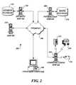
- FIG. 2is a pictorial diagram of a system of devices connected to the Internet, which depict the travel route in accordance with the present invention
- FIG. 3is a block diagram of the several components of the consumer's computer shown in FIG. 2 that is used to request information on a particular route in accordance with the present invention
- FIG. 4is a block diagram of the several components of an information server shown in FIG. 2 that is used to supply information on a particular route in accordance with the present invention
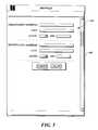
- FIG. 5illustrates a Web page produced by a Web browser installed on the consumer's computer from which the consumer enters the origination and destination of the consumer's desired route;
- FIG. 6illustrates a Web page produced by a Web browser installed on the consumer's computer displaying a possible route for the consumer's approval
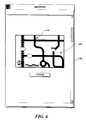
- FIG. 7illustrates a Web page produced by a Web browser installed on the consumer's computer displaying the consumer's desired route
- FIG. 8illustrates a Web page produced by a Web browser installed on the consumer's computer displaying the consumer's desired route with any incidents occurring on that route;
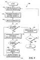
- FIG. 9is a flow chart illustrating the logic of a main routine used by the information server shown in FIG. 2 to receive and process the consumer's desired route and then locate any incidents on the route;
- FIG. 10is a flow chart illustrating the logic used by a subroutine of FIG. 9 to receive the consumer's desired route
- FIG. 11Ais a flow chart illustrating the logic used by a subroutine of FIG. 9 to determine regions of interest along the consumer's desired route;
- FIG. 11Bis a diagram depicting the regions of interest determined by the subroutine shown in FIG. 11A.
- FIGS. 12A-12Care a flow chart illustrating the logic used by a subroutine of FIG. 9 to determine where any incidents fall on the consumer's desired route.
- FIG. 1Prior Art
- LANslocal area networks
- WANwide area network
- the routers 120are generally special purpose computers used to interface one LAN or WAN to another.
- Communication links within the LANsmay be twisted wire pair, or coaxial cable, while communication links between networks may utilize 56 Kbps analog telephone lines, or 1 Mbps digital T- 1 lines and/or 45 Mbps T- 3 lines.
- Further computers and other related electronic devicescan be remotely connected to either the LANs 110 or the WAN 140 via a modem and temporary telephone link.
- Such computers and electronic devices 130are shown in FIG. 1 as connected to one of the LANs 110 via dotted lines.
- the Internetcomprises a vast number of such interconnected networks, computers, and routers and that only a small, representative section of the Internet 100 is shown in FIG. 1 .
- the World Wide Webis vast collection of interconnected, electronically stored information located on servers connected throughout the Internet 100 . Many companies are now providing services and access to their content over the Internet 100 using the WWW.
- a consumerrequests information about a desired route over the Internet 100 via a Web browser 500 installed on a consumer's computer and receives a description of the desired route along with any incidents that fall on the route. More specifically, the consumer requests information on a desired route from a computer 300 connected to the Internet 100 . The request is processed by an information server 400 located elsewhere on the Internet 100 .
- the information server 400If the information server 400 does not find the route in its route database 470 , it requests route data from a map server 210 also located elsewhere on the Internet 100 .
- the information server 400also requests incident data that describes the location of incidents using latitudinal and longitudinal coordinates from an incident server 220 located elsewhere on the Internet 100 .
- the incident server 220then retrieves the incident data from its incident database 225 . Once the information server 400 receives the incident data and route data it compares the incident data to the route data, to determine if any incidents fall on the desired route.
- the system 200 of computers and devices to which the information server 400 is connected and to which the consumer's computer 300 is also connectedis shown in more detail in FIG. 2 .
- the system 200includes a map server 210 used to supply route data to the information server 400 .
- the system 200also includes an incident server 220 that retrieves incident data from its incident database 225 to supply the information server 400 with incident data.
- the system 200also includes a communications server 230 used by the information server 400 to communicate with devices not connected directly to the Internet 100 such as telephones 232 , facsimile machines 234 and pagers 236 .
- the capabilities of the map server 210 , the incident server 220 and/or the communications server 230may all be embodied in the information server. Consequently, it would be appreciated that in these embodiments, the map server 210 , the incident server 220 and/or the communications server 230 would be unnecessary. Additionally, those of ordinary skill in the art will recognize that while only one consumer computer 300 , and information server 400 are depicted in FIG. 2, numerous consumer computers 300 and information servers 400 equipped with the hardware and software components described below may be connected to the Internet 100 .
- FIG. 3depicts several of the key components of the consumer's computer 300 .
- the consumer's computer 300includes many more components then those shown in FIG. 3 . However, it is not necessary that all of these generally conventional components be shown in order to disclose an illustrative embodiment for practicing the present invention.
- the consumer's computerincludes a network interface 310 for connecting to the Internet 100 .
- the network interface 310includes the necessary circuitry for such a connection, and is also constructed for use with the TCP/IP protocol.
- the consumer's computer 300also includes a processing unit 320 , a display 340 , and a memory 350 all interconnected along with the network interface 310 via a bus 360 .
- the memory 350generally comprises a random access memory (RAM), a read-only memory (ROM) and a permanent mass storage device, such as a disk drive.
- the memory 350stores the program code necessary for requesting and/or depicting a desired route over the Internet 100 in accordance with the present invention. More specifically, the memory 350 stores a Web browser 500 , such as Netscape's NAVIGATOR or Microsoft's INTERNET EXPLORER browsers, used in accordance with the present invention for depicting a desired route over the Internet 100 .
- memory 350also stores an operating system 355 . It will be appreciated that these software components may be stored on a computer-readable medium and loaded into memory 350 of the consumer's computer 300 using a drive mechanism associated with the computer-readable medium, such as a floppy, tape or CD-ROM drive.
- FIG. 4depicts several of the key components of the information server 400 .
- the information server 400includes many more components then those shown in FIG. 4 . However, it is not necessary that all of these generally conventional components be shown in order to disclose an illustrative embodiment for practicing the present invention.
- the information server 400is connected to the Internet 100 via a network interface 410 .
- the network interface 410includes the necessary circuitry for connecting the information server 400 to the Internet 100 , and is constructed for use with the TCP/IP protocol.
- the information server 400also includes a processing unit 420 , a display 440 , and a mass memory 450 all interconnected along with the network interface 410 via a bus 460 .
- the mass memory 450generally comprises a random access memory (RAM), read-only memory (ROM), and a permanent mass storage device, such as a hard disk drive, tape drive, optical drive, floppy disk drive, or combination thereof.
- the mass memory 450stores the program code and data necessary for incident and route analysis as well as supplying the results of that analysis to consumers in accordance with the present invention. More specifically, the mass memory 450 stores an incident and route analysis program 900 formed in accordance with the present invention for depicting travel routes along with traffic incidents occurring on those travel routes.
- mass memory 450stores a database 470 of consumer information continuously logged by the information server 400 consumer's route preferences. It will be appreciated by those of ordinary skill in the art that the database 470 of product and logged information may also be stored on other servers or storage devices connected to the either the information server 400 or the Internet 100 .
- mass memory 450stores Web server software 480 for handling requests for stored information received via the Internet 100 and the WWW, and an operating system 455 . It will be appreciated that the aforementioned software components may be stored on a computer-readable medium and loaded into mass memory 450 of the information server 400 using a drive mechanism associated with the computer-readable medium, such as floppy, tape or CD-ROM drive.
- FIG. 5illustrates a Web page 510 displayed by a Web browser 500 installed on the consumer's computer 300 from which the consumer enters the origination and destination addresses of the consumer's desired route and submits it to the information server 400 .
- the information server 400processes the origination and destination addresses and passes a request for a route based on the origination and destination addresses to the map server 210 .
- the map server 210returns route data such as would be used to create a map Web page 600 displayed by Web browser 500 in FIG.
- the consumermight modify the route by indicating to the information server 400 a key intersection 610 that the route must pass through. Accordingly, the information server 400 requests another set of route data from the map server 210 that includes the key intersection 610 . Accordingly, the map server 210 returns route data that is used to create a modified map Web page 700 displayed by Web browser 500 in FIG. 7 wherein the route now passes through the key intersection 610 .
- the information server 400will, in accordance with the present invention as described in more detail below, analyze the desired route and the incident data from the incident server 220 to produce a incident map Web page 800 as illustrated in FIG. 8 displaying the consumer's desired route with any incidents occurring on that route.
- FIG. 9is a flow chart illustrating the logic implemented by the incident and route analysis program 900 residing on the information server 400 to process the consumer's desired route and then locate any incidents on the route.
- the logicbegins in block 901 and proceeds to block 910 , where route data is obtained from the map server 210 in response to the consumer's submission of an origination and destination address as described above.
- An illustrative subroutine 100 for obtaining route datais described below with reference to FIG. 10 .
- Routine 900then continues from block 910 to block 915 .
- routine 900prepares the route for analysis by finding regions of interest near the route which should be examined for traffic incidents.
- An illustrative subroutine 1100 for finding the regions of interest near the desired routeis described below with reference to FIG. 11 A. Once the regions of interest are found, routine 900 continues from block 915 to block 920 .
- the routine 900obtains incident data from the incident server 220 , which maintains in the incident database 225 latitude and longitude coordinates identifying the location of any incidents reported to the incident server 220 .
- the latitude and longitude coordinates of all traffic incidents occurring in the state of Washingtonmay be reported to the incident server 220 and thus, may be retrieved by the information server 400 .
- routine 900continues from block 920 to a decision block 925 where it determines whether the retrieved incident data contains the coordinates for any further incidents.
- the consumerindicates the particular geographic area to which incident information should be limited.
- the incident route analysis program 900automatically selects the geographic area based on the desired route.
- routine 900branches to block 950 where the route and any previously identified and stored incidents are served to the consumer's computer 300 and displayed by the Web browser 500 to the consumer via a Web page 800 such as that shown in FIG. 8 .
- routine 900determines if the consumer has requested to exit the incident route and analysis program 900 , or elected to analyze a new route. If a new route is elected, the routine returns to block 910 of FIG. 9 . However, if the consumer elects to exit the program, the program ends in a block 199 .
- routine 900continues to block 930 .
- the incident data describing the first (and perhaps only) incidentis compared with the route data retrieved from the route database 470 and approved by the consumer to determine if the incident lies on the route.
- a subroutine 1200 for determining if an incident lies on a route in accordance with one actual embodiment of the present inventionis described below with reference to FIGS. 12A-12C.
- routine 900proceeds to block 940 where the incident defined by latitude and longitude coordinates is stored for use later in block 950 . Routine 900 then proceeds to a block 945 where the incident examined in subroutine 1200 is removed from the incident data so that it will not be considered again. On the other hand, if at block 925 it is determined that the incident does not fall on the desired route, the incident is not stored for later display and instead, routine 900 proceeds directly to block 945 where the incident examined in subroutine 1200 is removed from the incident data so that it will not be considered again.
- Routine 900then proceeds back to block 925 to determine if any more incidents need to be compared with the route. Blocks 935 through 945 are repeated for each available incident retrieved from the incident server 220 . However, if there are no further available incidents to process, the routine proceeds to block 950 in which the route approved by the consumer is served to the consumer's computer and displayed as a Web page 800 along with each of the incidents determined to have fallen on that route. Next, in a block 955 , the logic determines if the consumer has requested to exit the incident route and analysis program 900 , or elected to analyze a new route. If a new route is elected the routine returns to block 910 of FIG. 9 and blocks 910 - 999 are repeated to analyze the new route. However, if the consumer elects to exit the program, the program ends in a block 199 .
- Subroutine 1000performed by the information server 400 for obtaining a consumer's desired route in accordance with one actual embodiment of the present invention is illustrated.
- Subroutine 1000starts at block 1001 and proceeds to a decision block 1005 where it determines whether the information server 400 has a desired route in its route database 470 for the consumer.
- the information server 400may have stored the route previously desired by the user.
- subroutine 1000branches to a block 1099 where it ends. If at decision block 1005 a determination is made that the information server 400 does not have a previously stored desired route in its route database 470 for the consumer, subroutine 1000 proceeds to block 1010 where the information server 400 obtains the origination and destination addresses from the Web browser 500 on the consumer computer 300 as entered in the Web page 510 shown in FIG. 5 .
- the origination and destination addresses obtained from the consumerare sent to the map server 210 .
- Subroutine 1000proceeds to a block 1020 where the map server 210 returns, and the information server 400 receives, the best route corresponding to the addresses sent in block 1015 .
- the route returned by the map server 210comprises a plurality of segments, each segment having a pair of end points defined by latitude and longitude.
- the segments comprising the routeare of equal length.
- the segmentsmay be of unequal lengths.
- the routine 100then ends in a block 1099 and processing returns to block 915 in FIG. 9, where the route obtained in block 910 is prepared for analysis.
- FIG. 11Adepicts the subroutine 1100 performed by the information server 400 for determining the regions of interest around the consumer's route in accordance with one actual embodiment of the present invention.
- Subroutine 1100starts at block 1101 and proceeds to block 1105 where a padding value is assigned which is used, as described in more detail below, to define a distance from each segment of the desired route to a perimeter surrounding the segment.
- the area within the perimeter(as defined by latitude and longitude coordinates) is referred to as the region of interest for each segment.
- the padding valueis static and preprogrammed
- the padding valuemay vary as the granularity of the desired route, i.e., the number and length of segments in the route, changes so as to provide a more accurate calculation of the regions of interest surrounding the desired route.
- One possible method of assigning a padding value that varies with the route granularityis to calculate the padding value as: half the average length of the route segments in the desired route. It will be appreciated by those of ordinary skill in the art that other calculations of the padding value may be used that also vary with the granularity of the route. Regardless, once the padding value is assigned, subroutine 1100 proceeds from a block 1105 to block 1110 .
- a perimeteris drawn around each segment of the desired route using the previously assigned padding value so as to form a region of interest around each segment of the desired route. Desirable characteristics of the region of interest are that it should be quick and easy to determine if a location falls inside or outside its perimeter.
- a substantially elliptical perimeterhas these desirable properties. More specifically, if the sum of the distances from any incident location to both foci of an ellipse is less than the sum of the distances from both foci to any point on the ellipse, which is a constant value for that ellipse, then the incident location falls within the ellipse. Accordingly, at block 1110 and as shown in FIG.
- a perimeter 1160is formed around each segment 1150 of the desired route by creating an ellipse around the segment such that the end points 1155 of the segment are the foci of the ellipse and the sum of the distances from the end points to the edge of the ellipse is the length of the segment padded by twice the padding value assigned in block 1105 .
- a block 1115the latitude and longitude coordinates for regions of interest formed in block 1110 are stored for use later in analyzing the desired route.
- Subroutine 1100then ends in a block 1199 and processing returns to block 920 in FIG. 9 . It will be appreciated by those of ordinary skill in the art that regions of interest may be drawn in other than a substantially elliptical shape without departing from the scope of the present invention.
- Subroutine 1200performed by the information server 400 for analyzing the desired route (including regions of interest) and incident data to determine whether an incident lies on the desired route is depicted.
- Subroutine 1200starts at a block 1201 and proceeds to a block 1202 where it determines whether the incident occurs at a single location on the route or whether it occurs on multiple points along the route, i.e., at a multi-point location.
- subroutine 1200branches to a block 1214 in FIG. 12B which will be described in more detail below. Otherwise, the incident occurs at a single point on the route, i.e., at a single location, subroutine 1200 proceeds to a block 1204 .
- the single point incidentis compared with all segments of the desired route to determine if the incident is located within the region of interest of any of the segments. Accordingly, all segments whose regions of interest enclose the incident are stored for further analysis.
- subroutine 1200determines whether any segments were stored in block 1204 .
- routine 1200branches to block 1292 where it ends and processing returns to block 935 in FIG. 9 indicating that the incident does not fall on the desired route. However, if it is determined that at least one segment was stored in block 1204 , then routine 1200 proceeds to a decision block 1208 .
- subroutine 1200determines whether the single point incident is closer than a minimum distance to any point along any of the segments stored in block 1204 . In one actual embodiment of the present invention, this minimum distance varies with the granularity of the route. Accordingly, a value substantially similar to the padding value assigned in block 1105 of FIG. 11A is used as the minimum distance. If it is determined that no stored segments are closer than the minimum distance to the single point incident, subroutine 1200 branches to block 1292 where the subroutine ends and processing returns to block 935 in FIG. 9 indicating that the incident does not fall on the desired route. If it is determined that at least one segment is closer than the minimum distance to the incident, subroutine 1200 proceeds to block 1209 .
- subroutine 1200forms a triangle such as that shown in FIG. 11B between the incident 1170 and the end points 1155 of each segment 1150 that is closer than the minimum distance. Specifically, the triangle is formed such that the segment 1150 is the base of the triangle and the two other sides of the triangle are formed from the end points of the segment 1155 to the location of the single point incident 1170 . Accordingly, at a decision block 1210 , subroutine 1200 determines whether any of the triangles formed in block 1209 include angles formed off of the base that are ninety (90) degrees or less. If the result of decision block 1210 is positive, subroutine 1200 ends in a block 1290 and processing returns to block 935 in FIG.
- the result of decision block 1210is positive, subroutine 1200 ends in a block 1290 and processing returns to block 935 in FIG.
- subroutine 1200continues at a block 1214 where the first point in the sequence of points along the multi-point incident is chosen for analysis as the “point of incident” (POI).
- POIpoint of incident
- the POIis compared with all segments of the desired route to determine if the POI is located within the region of interest of any segments. Accordingly, all segments whose perimeters enclose the POI are stored for further analysis.
- subroutine 1200determines whether any segments were stored in block 1216 .
- subroutine 1200branches to a block 1230 where the POI is discarded from further consideration and the next available point along the multi-point incident is assigned as the POI. Routine 1200 then proceeds to block 1232 where it determines whether any points remain of the multi-point incident. If no points remain, subroutine 1200 ends in a block 1294 and processing returns to block 935 in FIG. 9 indicating that the incident does not fall on the desired route. Otherwise, if at least one point remains of the multi-point incident, subroutine 1200 branches back to block 1216 to continue the analysis of the multi-point incident.
- subroutine 1200proceeds to block 1220 , where it determines whether the current POI is closer than a minimum distance to any point along any of the segments stored in block 1216 . As noted above, in one actual embodiment of the present invention this minimum distance varies with the granularity of the route. Accordingly, a value substantially similar to the padding value assigned in block 1105 of FIG. 11A is used as the minimum distance. If no stored segments are closer than a minimum distance to the current POI, then subroutine 1200 branches to block 1230 as described above and the POI is discarded.
- subroutine 1200proceeds to a block 1221 in which a triangle (such as that shown in FIG. 11B) is formed between the current POI and the end points of each segment that is closer than the minimum distance. Specifically, each triangle is formed such that the segment is the base of the triangle and the two other sides of the triangle are formed from the end points of the segment to the location current POI.
- a trianglesuch as that shown in FIG. 11B
- the subroutine 1200determines whether any triangles formed with the POI in block 1221 include angles formed off of the base which are ninety (90) degrees or less. If the result of decision block 1222 is positive, subroutine 1200 proceeds to a block 1226 where the segment forming the base of the triangle is set as the beginning of the multi-point incident on the desired route. It will be appreciated that if more than one segment that is closer than a minimum distance to the POI forms such a triangle, then the first of any such segments is set as the beginning of the multi-point incident.
- Subroutine 1200then proceeds to a block 1228 so that the points of the multi-point incident can be examined in reverse sequential order to determine the last segment upon which the multi-point incident occurs, as will be described in more detail below. However, if no remaining segment forms a triangle such that the angles formed off of the base of the triangle are ninety (90) degrees or less, then subroutine 1200 proceeds from block 1222 to a block 1224 where the segment of the desired route having a point closest to the current POI is set as the beginning of the multi-point incident on the desired route. Routine 1200 then proceeds to a block 1228 .
- Routine 1200determines whether any segments were stored in block 1236 .
- routine 1200branches to a block 1250 where the current POI is discarded from further consideration and the next available point in the reversed sequence of points along the multi-point incident is assigned as the current POI. Routine 1200 then proceeds back to block 1236 to continue the analysis of the multi-point incident. On the other hand, if at block 1238 it is determined that at least one segment was stored in block 1236 , i.e., the current POI fell within the region of interest of at least one segment of the desired route, subroutine 1200 proceeds to a decision block 1240 .
- the subroutine 1200determines whether the POI is closer than a minimum distance to any point along any of the segments stored in block 1236 . As noted above, in one actual embodiment of the present invention, this minimum distance varies with the granularity of the route. Accordingly, a value substantially similar to the padding value assigned in block 1105 of FIG. 11A is used as the minimum. If no stored segments are closer than the minimum distance to the current POI, then routine 1200 branches to block 1250 as described above. If at least one segment is closer than the minimum distance to the POI, then routine 1200 proceeds to block 1241 in which a triangle is formed between the current POI and the end points of each such segment as described above in connection with block 1221 of FIG. 12 B.
- the subroutine 1200determines whether any of the triangles formed in block 1241 include angles formed off of the base that are ninety (90) degrees or less. If so, subroutine 1200 proceeds to block 1226 where the segment forming the base of the triangle is set as the end of the multi-point incident on the desired route. It will be appreciated that if more than one segment that is closer than a minimum distance to the POI forms such a triangle, then the first of any such segments is set as the end of the multi-point incident. Subroutine 1200 then proceeds to a block 1296 as described below.
- routine 1200proceeds from block 1246 to block 1244 where the segment of the desired route having a point closest to the current POI is set as the end of the multi-point incident on the desired route. Once the end of the multi-point incident has been set, routine 1200 ends in block 1296 and processing returns to block 935 in FIG. 9 indicating that the incident falls on the desired route from the beginning segment to the end segment.
- the present inventionprovides a method and system for analyzing and depicting travel routes along with incidents occurring on those travel routes. Aspects of the current invention may be utilized by a consumer to request a depiction of their desired route. The desired route, including any incidents along the desired route may then be depicted for the consumer. In this manner, a consumer can easily determine if and when it is best to travel along a particular route without having to actual travel along the route.
Landscapes
- Engineering & Computer Science (AREA)
- Radar, Positioning & Navigation (AREA)
- Remote Sensing (AREA)
- General Physics & Mathematics (AREA)
- Physics & Mathematics (AREA)
- Automation & Control Theory (AREA)
- Biodiversity & Conservation Biology (AREA)
- Environmental Sciences (AREA)
- Environmental & Geological Engineering (AREA)
- Ecology (AREA)
- Life Sciences & Earth Sciences (AREA)
- Atmospheric Sciences (AREA)
- Navigation (AREA)
Abstract
Description
Claims (18)
Priority Applications (2)
| Application Number | Priority Date | Filing Date | Title |
|---|---|---|---|
| US09/495,812US6353795B1 (en) | 2000-02-01 | 2000-02-01 | Method and system for matching an incident to a route |
| US10/050,807US7103473B2 (en) | 2000-02-01 | 2001-10-25 | Method and system for matching an incident to a route |
Applications Claiming Priority (1)
| Application Number | Priority Date | Filing Date | Title |
|---|---|---|---|
| US09/495,812US6353795B1 (en) | 2000-02-01 | 2000-02-01 | Method and system for matching an incident to a route |
Related Child Applications (1)
| Application Number | Title | Priority Date | Filing Date |
|---|---|---|---|
| US10/050,807ContinuationUS7103473B2 (en) | 2000-02-01 | 2001-10-25 | Method and system for matching an incident to a route |
Publications (1)
| Publication Number | Publication Date |
|---|---|
| US6353795B1true US6353795B1 (en) | 2002-03-05 |
Family
ID=23970080
Family Applications (2)
| Application Number | Title | Priority Date | Filing Date |
|---|---|---|---|
| US09/495,812Expired - LifetimeUS6353795B1 (en) | 2000-02-01 | 2000-02-01 | Method and system for matching an incident to a route |
| US10/050,807Expired - LifetimeUS7103473B2 (en) | 2000-02-01 | 2001-10-25 | Method and system for matching an incident to a route |
Family Applications After (1)
| Application Number | Title | Priority Date | Filing Date |
|---|---|---|---|
| US10/050,807Expired - LifetimeUS7103473B2 (en) | 2000-02-01 | 2001-10-25 | Method and system for matching an incident to a route |
Country Status (1)
| Country | Link |
|---|---|
| US (2) | US6353795B1 (en) |
Cited By (44)
| Publication number | Priority date | Publication date | Assignee | Title |
|---|---|---|---|---|
| US6594576B2 (en)* | 2001-07-03 | 2003-07-15 | At Road, Inc. | Using location data to determine traffic information |
| US20030187794A1 (en)* | 2002-03-27 | 2003-10-02 | Convergys Cmg Utah Inc. | System and method for a flexible device-based rating engine |
| US20040193365A1 (en)* | 2001-09-26 | 2004-09-30 | Yoshiyuki Kokojima | Destination guidance system, destination guidance server, user terminal, destination guidance method, computer readable memory that stores program for making computer generate information associated with guidance in building, destination guidance data acquisition system, destination guidance data acquisition server, destination guidance data acquisition terminal, destination guidance data acquisition method, and computer readable memory that stores program for making computer acquire data associated with guidance in building |
| US20040254698A1 (en)* | 2003-05-15 | 2004-12-16 | Jonathan Hubbard | System and method for evaluating vehicle and operator performance |
| US20040267440A1 (en)* | 1999-04-19 | 2004-12-30 | Dekock Bruce W | System for providing traffic information |
| US20050021225A1 (en)* | 2003-07-25 | 2005-01-27 | Christopher Kantarjiev | System and method for determining recommended departure time |
| US20050044016A1 (en)* | 2002-03-27 | 2005-02-24 | Convergys Information Management Group, Inc. | System and method for securing digital content |
| US6989765B2 (en) | 2002-03-05 | 2006-01-24 | Triangle Software Llc | Personalized traveler information dissemination system |
| US20060074546A1 (en)* | 1999-04-19 | 2006-04-06 | Dekock Bruce W | System for providing traffic information |
| US20060158330A1 (en)* | 2002-03-05 | 2006-07-20 | Andre Gueziec | Traffic information dissemination |
| US20060235856A1 (en)* | 2004-12-16 | 2006-10-19 | Halcrow Michael A | Route generation for task completion by a location-aware device |
| US20100225643A1 (en)* | 2009-03-04 | 2010-09-09 | Andre Gueziec | Controlling a Three-Dimensional Virtual Broadcast Presentation |
| US20100312462A1 (en)* | 2009-03-04 | 2010-12-09 | Gueziec Andre | Touch Screen Based Interaction with Traffic Data |
| US20100333045A1 (en)* | 2009-03-04 | 2010-12-30 | Gueziec Andre | Gesture Based Interaction with Traffic Data |
| US7908080B2 (en) | 2004-12-31 | 2011-03-15 | Google Inc. | Transportation routing |
| US8024111B1 (en) | 2008-04-02 | 2011-09-20 | Strategic Design Federation W, Inc. | Travel route system and method |
| US8606517B1 (en) | 2008-04-02 | 2013-12-10 | Strategic Design Federaton W, Inc. | Travel route system and method |
| CN103631776A (en)* | 2012-08-20 | 2014-03-12 | 同济大学 | Method for automatically recording and positioning semantic expression information of traffic accident site |
| US8718910B2 (en) | 2010-11-14 | 2014-05-06 | Pelmorex Canada Inc. | Crowd sourced traffic reporting |
| US8725396B2 (en) | 2011-05-18 | 2014-05-13 | Pelmorex Canada Inc. | System for providing traffic data and driving efficiency data |
| US8781718B2 (en) | 2012-01-27 | 2014-07-15 | Pelmorex Canada Inc. | Estimating time travel distributions on signalized arterials |
| CN104714960A (en)* | 2013-12-13 | 2015-06-17 | 方正国际软件(北京)有限公司 | Method and system for adsorbing multimedia information through track points |
| US10223909B2 (en) | 2012-10-18 | 2019-03-05 | Uber Technologies, Inc. | Estimating time travel distributions on signalized arterials |
| US10247563B2 (en)* | 2008-11-14 | 2019-04-02 | Google Llc | System and method for storing and providing routes |
| CN110906943A (en)* | 2018-09-17 | 2020-03-24 | 沈阳美行科技有限公司 | Optimization method and device for planned route |
| US10614519B2 (en) | 2007-12-14 | 2020-04-07 | Consumerinfo.Com, Inc. | Card registry systems and methods |
| US10621657B2 (en) | 2008-11-05 | 2020-04-14 | Consumerinfo.Com, Inc. | Systems and methods of credit information reporting |
| US10628448B1 (en) | 2013-11-20 | 2020-04-21 | Consumerinfo.Com, Inc. | Systems and user interfaces for dynamic access of multiple remote databases and synchronization of data based on user rules |
| US10642999B2 (en) | 2011-09-16 | 2020-05-05 | Consumerinfo.Com, Inc. | Systems and methods of identity protection and management |
| USRE47986E1 (en) | 2003-05-15 | 2020-05-12 | Speedgauge, Inc. | System and method for evaluating vehicle and operator performance |
| US10671749B2 (en) | 2018-09-05 | 2020-06-02 | Consumerinfo.Com, Inc. | Authenticated access and aggregation database platform |
| US10685398B1 (en) | 2013-04-23 | 2020-06-16 | Consumerinfo.Com, Inc. | Presenting credit score information |
| US10798197B2 (en) | 2011-07-08 | 2020-10-06 | Consumerinfo.Com, Inc. | Lifescore |
| US10929925B1 (en) | 2013-03-14 | 2021-02-23 | Consumerlnfo.com, Inc. | System and methods for credit dispute processing, resolution, and reporting |
| US10963959B2 (en) | 2012-11-30 | 2021-03-30 | Consumerinfo. Com, Inc. | Presentation of credit score factors |
| US11012491B1 (en) | 2012-11-12 | 2021-05-18 | ConsumerInfor.com, Inc. | Aggregating user web browsing data |
| US11113759B1 (en) | 2013-03-14 | 2021-09-07 | Consumerinfo.Com, Inc. | Account vulnerability alerts |
| US11157872B2 (en) | 2008-06-26 | 2021-10-26 | Experian Marketing Solutions, Llc | Systems and methods for providing an integrated identifier |
| US11200620B2 (en) | 2011-10-13 | 2021-12-14 | Consumerinfo.Com, Inc. | Debt services candidate locator |
| US11222528B2 (en)* | 2008-04-23 | 2022-01-11 | Verizon Patent and & Licensing Inc. | Traffic monitoring systems and methods |
| US11238656B1 (en) | 2019-02-22 | 2022-02-01 | Consumerinfo.Com, Inc. | System and method for an augmented reality experience via an artificial intelligence bot |
| US11315179B1 (en) | 2018-11-16 | 2022-04-26 | Consumerinfo.Com, Inc. | Methods and apparatuses for customized card recommendations |
| US11356430B1 (en) | 2012-05-07 | 2022-06-07 | Consumerinfo.Com, Inc. | Storage and maintenance of personal data |
| US11941065B1 (en) | 2019-09-13 | 2024-03-26 | Experian Information Solutions, Inc. | Single identifier platform for storing entity data |
Families Citing this family (20)
| Publication number | Priority date | Publication date | Assignee | Title |
|---|---|---|---|---|
| US6714967B1 (en) | 1999-07-30 | 2004-03-30 | Microsoft Corporation | Integration of a computer-based message priority system with mobile electronic devices |
| US7194681B1 (en) | 1999-07-30 | 2007-03-20 | Microsoft Corporation | Method for automatically assigning priorities to documents and messages |
| US20030217098A1 (en) | 2002-05-15 | 2003-11-20 | Microsoft Corporation | Method and system for supporting the communication of presence information regarding one or more telephony devices |
| US20030217142A1 (en) | 2002-05-15 | 2003-11-20 | Microsoft Corporation | Method and system for supporting the communication of presence information regarding one or more telephony devices |
| US7720993B2 (en)* | 2003-12-17 | 2010-05-18 | Palo Alto Research Center Incorporated | Information driven routing in ad hoc sensor networks |
| US7472169B2 (en)* | 2006-03-15 | 2008-12-30 | Traffic.Com, Inc. | Method of displaying traffic information on a web page |
| JP4944551B2 (en)* | 2006-09-26 | 2012-06-06 | 日立オートモティブシステムズ株式会社 | Travel control device, travel control method, and travel control program |
| US8271310B2 (en)* | 2006-12-20 | 2012-09-18 | Microsoft Corporation | Virtualizing consumer behavior as a financial instrument |
| US8799077B2 (en)* | 2006-12-20 | 2014-08-05 | Microsoft Corporation | Ad integration and extensible themes for operating systems |
| US20080154698A1 (en)* | 2006-12-20 | 2008-06-26 | Microsoft Corporation | Dyanmic product classification for opinion aggregation |
| US8112770B2 (en)* | 2006-12-20 | 2012-02-07 | Microsoft Corporation | Providing alternative content in a windowed environment |
| US20080154761A1 (en)* | 2006-12-20 | 2008-06-26 | Microsoft Corporation | Commoditization of products and product market |
| US20080154719A1 (en)* | 2006-12-20 | 2008-06-26 | Microsoft Corporation | Market sharing incentives |
| US20080154915A1 (en)* | 2006-12-20 | 2008-06-26 | Microsoft Corporation | Network-based recommendations |
| US7912637B2 (en)* | 2007-06-25 | 2011-03-22 | Microsoft Corporation | Landmark-based routing |
| US20080319660A1 (en)* | 2007-06-25 | 2008-12-25 | Microsoft Corporation | Landmark-based routing |
| US20080319658A1 (en)* | 2007-06-25 | 2008-12-25 | Microsoft Corporation | Landmark-based routing |
| US9589254B2 (en) | 2010-12-08 | 2017-03-07 | Microsoft Technology Licensing, Llc | Using e-mail message characteristics for prioritization |
| US10696272B2 (en)* | 2018-04-04 | 2020-06-30 | Ford Global Technologies, Llc | Vehicle lighting system featuring object identification and threat level assessment |
| US10421437B1 (en)* | 2018-12-19 | 2019-09-24 | Motorola Solutions, Inc. | System and method for dynamic perimeter threat detection for a movable vehicle |
Citations (10)
| Publication number | Priority date | Publication date | Assignee | Title |
|---|---|---|---|---|
| US4350970A (en)* | 1979-11-13 | 1982-09-21 | Siemens Aktiengesellschaft | Method for traffic determination in a routing and information system for individual motor vehicle traffic |
| US5164904A (en)* | 1990-07-26 | 1992-11-17 | Farradyne Systems, Inc. | In-vehicle traffic congestion information system |
| US5173691A (en)* | 1990-07-26 | 1992-12-22 | Farradyne Systems, Inc. | Data fusion process for an in-vehicle traffic congestion information system |
| US5182555A (en)* | 1990-07-26 | 1993-01-26 | Farradyne Systems, Inc. | Cell messaging process for an in-vehicle traffic congestion information system |
| US5371678A (en)* | 1990-11-22 | 1994-12-06 | Nissan Motor Co., Ltd. | System and method for navigating vehicle along set route of travel |
| US5539645A (en)* | 1993-11-19 | 1996-07-23 | Philips Electronics North America Corporation | Traffic monitoring system with reduced communications requirements |
| US5862510A (en)* | 1995-09-06 | 1999-01-19 | Mitsubishi Jidosha Kogyo Kabushiki Kaisha | Navigation device |
| US5911773A (en)* | 1995-07-24 | 1999-06-15 | Aisin Aw Co., Ltd. | Navigation system for vehicles |
| US6097313A (en)* | 1997-12-04 | 2000-08-01 | Hitachi, Ltd. | Information exchange system |
| US6216088B1 (en)* | 1996-11-27 | 2001-04-10 | Mannesmann Ag | Method for determining itinerary data |
Family Cites Families (12)
| Publication number | Priority date | Publication date | Assignee | Title |
|---|---|---|---|---|
| DE4008460A1 (en)* | 1990-03-16 | 1991-09-19 | Bosch Gmbh Robert | NAVIGATION SYSTEM |
| JP2671626B2 (en)* | 1991-04-08 | 1997-10-29 | 日産自動車株式会社 | Driving information provision device |
| DE4208277A1 (en)* | 1992-03-13 | 1993-09-16 | Bosch Gmbh Robert | BROADCASTING RECEIVER |
| DE4230294A1 (en)* | 1992-09-10 | 1994-03-17 | Bosch Gmbh Robert | Procedure for selecting route-relevant messages on RDS radios |
| JP3555191B2 (en)* | 1994-09-02 | 2004-08-18 | 株式会社デンソー | Sub route setting device and navigation device |
| US5610821A (en)* | 1994-11-18 | 1997-03-11 | Ibm Corporation | Optimal and stable route planning system |
| DE19539641C2 (en)* | 1995-10-25 | 2000-02-17 | Daimler Chrysler Ag | Method and device for traffic situation-dependent vehicle route guidance |
| US5635924A (en)* | 1996-03-29 | 1997-06-03 | Loral Aerospace Corp. | Travel route information monitor |
| US6111521A (en)* | 1996-09-18 | 2000-08-29 | Mannesmann Vdo Ag | Apparatus for supplying traffic-related information |
| US5982298A (en)* | 1996-11-14 | 1999-11-09 | Microsoft Corporation | Interactive traffic display and trip planner |
| DE19741116B4 (en)* | 1997-09-12 | 2004-02-26 | Mannesmann Ag | Method for the transmission of route data, method for analyzing a traffic route network, traffic detection center and terminal |
| US6292743B1 (en)* | 1999-01-06 | 2001-09-18 | Infogation Corporation | Mobile navigation system |
- 2000
- 2000-02-01USUS09/495,812patent/US6353795B1/ennot_activeExpired - Lifetime
- 2001
- 2001-10-25USUS10/050,807patent/US7103473B2/ennot_activeExpired - Lifetime
Patent Citations (10)
| Publication number | Priority date | Publication date | Assignee | Title |
|---|---|---|---|---|
| US4350970A (en)* | 1979-11-13 | 1982-09-21 | Siemens Aktiengesellschaft | Method for traffic determination in a routing and information system for individual motor vehicle traffic |
| US5164904A (en)* | 1990-07-26 | 1992-11-17 | Farradyne Systems, Inc. | In-vehicle traffic congestion information system |
| US5173691A (en)* | 1990-07-26 | 1992-12-22 | Farradyne Systems, Inc. | Data fusion process for an in-vehicle traffic congestion information system |
| US5182555A (en)* | 1990-07-26 | 1993-01-26 | Farradyne Systems, Inc. | Cell messaging process for an in-vehicle traffic congestion information system |
| US5371678A (en)* | 1990-11-22 | 1994-12-06 | Nissan Motor Co., Ltd. | System and method for navigating vehicle along set route of travel |
| US5539645A (en)* | 1993-11-19 | 1996-07-23 | Philips Electronics North America Corporation | Traffic monitoring system with reduced communications requirements |
| US5911773A (en)* | 1995-07-24 | 1999-06-15 | Aisin Aw Co., Ltd. | Navigation system for vehicles |
| US5862510A (en)* | 1995-09-06 | 1999-01-19 | Mitsubishi Jidosha Kogyo Kabushiki Kaisha | Navigation device |
| US6216088B1 (en)* | 1996-11-27 | 2001-04-10 | Mannesmann Ag | Method for determining itinerary data |
| US6097313A (en)* | 1997-12-04 | 2000-08-01 | Hitachi, Ltd. | Information exchange system |
Non-Patent Citations (3)
| Title |
|---|
| http://www.trafficstation.com/help/AddingRoutes.html, "Quick Guide to Adding Routes," available at least as early as Apr. 27, 2000. |
| http://www.trafficstation.com/help/QuickCheck.shtml, "QuickCheck Help," available at least as early as Apr. 27, 2000. |
| http://www.trafficstation.com/press_release/vicin.html, Press Release entitled "Traffic Station Joins Forces with MapBlast! to Bring Personalized Traffic Information and Intelligent Routing to Internet Users," available at least as early as Jul. 8, 1999. |
Cited By (123)
| Publication number | Priority date | Publication date | Assignee | Title |
|---|---|---|---|---|
| US20060074546A1 (en)* | 1999-04-19 | 2006-04-06 | Dekock Bruce W | System for providing traffic information |
| US20040267440A1 (en)* | 1999-04-19 | 2004-12-30 | Dekock Bruce W | System for providing traffic information |
| US20050248469A1 (en)* | 1999-04-19 | 2005-11-10 | Dekock Bruce W | System for providing traffic information |
| US6862524B1 (en) | 2001-07-03 | 2005-03-01 | At Road, Inc. | Using location data to determine traffic and route information |
| US6594576B2 (en)* | 2001-07-03 | 2003-07-15 | At Road, Inc. | Using location data to determine traffic information |
| US20040193365A1 (en)* | 2001-09-26 | 2004-09-30 | Yoshiyuki Kokojima | Destination guidance system, destination guidance server, user terminal, destination guidance method, computer readable memory that stores program for making computer generate information associated with guidance in building, destination guidance data acquisition system, destination guidance data acquisition server, destination guidance data acquisition terminal, destination guidance data acquisition method, and computer readable memory that stores program for making computer acquire data associated with guidance in building |
| US9368029B2 (en) | 2002-03-05 | 2016-06-14 | Pelmorex Canada Inc. | GPS generated traffic information |
| US20080109153A1 (en)* | 2002-03-05 | 2008-05-08 | Andre Gueziec | GPS-Generated Traffic Information |
| US9640073B2 (en) | 2002-03-05 | 2017-05-02 | Pelmorex Canada Inc. | Generating visual information associated with traffic |
| US6989765B2 (en) | 2002-03-05 | 2006-01-24 | Triangle Software Llc | Personalized traveler information dissemination system |
| US8531312B2 (en) | 2002-03-05 | 2013-09-10 | Triangle Software Llc | Method for choosing a traffic route |
| US20060145892A1 (en)* | 2002-03-05 | 2006-07-06 | Andre Gueziec | Personalized traveler information dissemination system |
| US20060158330A1 (en)* | 2002-03-05 | 2006-07-20 | Andre Gueziec | Traffic information dissemination |
| US9602977B2 (en) | 2002-03-05 | 2017-03-21 | Pelmorex Canada Inc. | GPS generated traffic information |
| US7161497B2 (en) | 2002-03-05 | 2007-01-09 | Triangle Software Llc | System for aggregating traveler information |
| US20070013551A1 (en)* | 2002-03-05 | 2007-01-18 | Andre Gueziec | System and method for predicting travel time for a travel route |
| US20070038362A1 (en)* | 2002-03-05 | 2007-02-15 | Triangle Software Llc | Traffic routing based on segment travel time |
| US7221287B2 (en) | 2002-03-05 | 2007-05-22 | Triangle Software Llc | Three-dimensional traffic report |
| US8358222B2 (en) | 2002-03-05 | 2013-01-22 | Triangle Software, Llc | GPS-generated traffic information |
| US7880642B2 (en) | 2002-03-05 | 2011-02-01 | Triangle Software Llc | GPS-generated traffic information |
| US7375649B2 (en) | 2002-03-05 | 2008-05-20 | Triangle Software Llc | Traffic routing based on segment travel time |
| US8786464B2 (en) | 2002-03-05 | 2014-07-22 | Pelmorex Canada Inc. | GPS generated traffic information |
| US7508321B2 (en) | 2002-03-05 | 2009-03-24 | Triangle Software Llc | System and method for predicting travel time for a travel route |
| US7557730B2 (en) | 2002-03-05 | 2009-07-07 | Triangle Software Llc | GPS-generated traffic information |
| US9489842B2 (en) | 2002-03-05 | 2016-11-08 | Pelmorex Canada Inc. | Method for choosing a traffic route |
| US20090309758A1 (en)* | 2002-03-05 | 2009-12-17 | Andre Gueziec | GPS-Generated Traffic Information |
| US9401088B2 (en) | 2002-03-05 | 2016-07-26 | Pelmorex Canada Inc. | Method for predicting a travel time for a traffic route |
| US8564455B2 (en) | 2002-03-05 | 2013-10-22 | Triangle Software Llc | Generating visual information associated with traffic |
| US8958988B2 (en) | 2002-03-05 | 2015-02-17 | Pelmorex Canada Inc. | Method for choosing a traffic route |
| US9070291B2 (en) | 2002-03-05 | 2015-06-30 | Pelmorex Canada Inc. | Method for predicting a travel time for a traffic route |
| US9082303B2 (en) | 2002-03-05 | 2015-07-14 | Pelmorex Canada Inc. | Generating visual information associated with traffic |
| US7496540B2 (en) | 2002-03-27 | 2009-02-24 | Convergys Cmg Utah | System and method for securing digital content |
| US20030187794A1 (en)* | 2002-03-27 | 2003-10-02 | Convergys Cmg Utah Inc. | System and method for a flexible device-based rating engine |
| US20050044016A1 (en)* | 2002-03-27 | 2005-02-24 | Convergys Information Management Group, Inc. | System and method for securing digital content |
| US8484130B2 (en) | 2002-03-27 | 2013-07-09 | Convergys Information Management Group, Inc. | System and method for a flexible device-based rating engine |
| USRE47986E1 (en) | 2003-05-15 | 2020-05-12 | Speedgauge, Inc. | System and method for evaluating vehicle and operator performance |
| US7356392B2 (en) | 2003-05-15 | 2008-04-08 | Landsonar, Inc. | System and method for evaluating vehicle and operator performance |
| US20040254698A1 (en)* | 2003-05-15 | 2004-12-16 | Jonathan Hubbard | System and method for evaluating vehicle and operator performance |
| US8103443B2 (en) | 2003-07-25 | 2012-01-24 | Triangle Software Llc | System and method for delivering departure notifications |
| US7610145B2 (en) | 2003-07-25 | 2009-10-27 | Triangle Software Llc | System and method for determining recommended departure time |
| US20100268456A1 (en)* | 2003-07-25 | 2010-10-21 | Christopher Kantarjiev | System and method for delivering departure notifications |
| US7702452B2 (en) | 2003-07-25 | 2010-04-20 | Triangle Software Llc | System and method for determining a prediction of average speed for a segment of roadway |
| US8660780B2 (en) | 2003-07-25 | 2014-02-25 | Pelmorex Canada Inc. | System and method for delivering departure notifications |
| US9644982B2 (en) | 2003-07-25 | 2017-05-09 | Pelmorex Canada Inc. | System and method for delivering departure notifications |
| US20050021225A1 (en)* | 2003-07-25 | 2005-01-27 | Christopher Kantarjiev | System and method for determining recommended departure time |
| US9127959B2 (en) | 2003-07-25 | 2015-09-08 | Pelmorex Canada Inc. | System and method for delivering departure notifications |
| US20060235856A1 (en)* | 2004-12-16 | 2006-10-19 | Halcrow Michael A | Route generation for task completion by a location-aware device |
| US9778055B2 (en) | 2004-12-31 | 2017-10-03 | Google Inc. | Transportation routing |
| US8798917B2 (en) | 2004-12-31 | 2014-08-05 | Google Inc. | Transportation routing |
| US8606514B2 (en) | 2004-12-31 | 2013-12-10 | Google Inc. | Transportation routing |
| US9709415B2 (en) | 2004-12-31 | 2017-07-18 | Google Inc. | Transportation routing |
| US11092455B2 (en) | 2004-12-31 | 2021-08-17 | Google Llc | Transportation routing |
| US9945686B2 (en) | 2004-12-31 | 2018-04-17 | Google Llc | Transportation routing |
| US7908080B2 (en) | 2004-12-31 | 2011-03-15 | Google Inc. | Transportation routing |
| US10614519B2 (en) | 2007-12-14 | 2020-04-07 | Consumerinfo.Com, Inc. | Card registry systems and methods |
| US10878499B2 (en) | 2007-12-14 | 2020-12-29 | Consumerinfo.Com, Inc. | Card registry systems and methods |
| US12067617B1 (en) | 2007-12-14 | 2024-08-20 | Consumerinfo.Com, Inc. | Card registry systems and methods |
| US11379916B1 (en) | 2007-12-14 | 2022-07-05 | Consumerinfo.Com, Inc. | Card registry systems and methods |
| US8024111B1 (en) | 2008-04-02 | 2011-09-20 | Strategic Design Federation W, Inc. | Travel route system and method |
| US8606517B1 (en) | 2008-04-02 | 2013-12-10 | Strategic Design Federaton W, Inc. | Travel route system and method |
| US11222528B2 (en)* | 2008-04-23 | 2022-01-11 | Verizon Patent and & Licensing Inc. | Traffic monitoring systems and methods |
| US11157872B2 (en) | 2008-06-26 | 2021-10-26 | Experian Marketing Solutions, Llc | Systems and methods for providing an integrated identifier |
| US11769112B2 (en) | 2008-06-26 | 2023-09-26 | Experian Marketing Solutions, Llc | Systems and methods for providing an integrated identifier |
| US12205076B2 (en) | 2008-06-26 | 2025-01-21 | Experian Marketing Solutions, Llc | Systems and methods for providing an integrated identifier |
| US10621657B2 (en) | 2008-11-05 | 2020-04-14 | Consumerinfo.Com, Inc. | Systems and methods of credit information reporting |
| US12123731B2 (en) | 2008-11-14 | 2024-10-22 | Google Llc | System and method for storing and providing routes |
| US10247563B2 (en)* | 2008-11-14 | 2019-04-02 | Google Llc | System and method for storing and providing routes |
| US11243088B2 (en)* | 2008-11-14 | 2022-02-08 | Google Llc | System and method for storing and providing routes |
| US20100312462A1 (en)* | 2009-03-04 | 2010-12-09 | Gueziec Andre | Touch Screen Based Interaction with Traffic Data |
| US20100225643A1 (en)* | 2009-03-04 | 2010-09-09 | Andre Gueziec | Controlling a Three-Dimensional Virtual Broadcast Presentation |
| US10289264B2 (en) | 2009-03-04 | 2019-05-14 | Uber Technologies, Inc. | Controlling a three-dimensional virtual broadcast presentation |
| US20100333045A1 (en)* | 2009-03-04 | 2010-12-30 | Gueziec Andre | Gesture Based Interaction with Traffic Data |
| US8619072B2 (en) | 2009-03-04 | 2013-12-31 | Triangle Software Llc | Controlling a three-dimensional virtual broadcast presentation |
| US9448690B2 (en) | 2009-03-04 | 2016-09-20 | Pelmorex Canada Inc. | Controlling a three-dimensional virtual broadcast presentation |
| US8982116B2 (en) | 2009-03-04 | 2015-03-17 | Pelmorex Canada Inc. | Touch screen based interaction with traffic data |
| US9046924B2 (en) | 2009-03-04 | 2015-06-02 | Pelmorex Canada Inc. | Gesture based interaction with traffic data |
| US8718910B2 (en) | 2010-11-14 | 2014-05-06 | Pelmorex Canada Inc. | Crowd sourced traffic reporting |
| US9547984B2 (en) | 2011-05-18 | 2017-01-17 | Pelmorex Canada Inc. | System for providing traffic data and driving efficiency data |
| US9390620B2 (en) | 2011-05-18 | 2016-07-12 | Pelmorex Canada Inc. | System for providing traffic data and driving efficiency data |
| US8725396B2 (en) | 2011-05-18 | 2014-05-13 | Pelmorex Canada Inc. | System for providing traffic data and driving efficiency data |
| US11665253B1 (en) | 2011-07-08 | 2023-05-30 | Consumerinfo.Com, Inc. | LifeScore |
| US10798197B2 (en) | 2011-07-08 | 2020-10-06 | Consumerinfo.Com, Inc. | Lifescore |
| US11790112B1 (en) | 2011-09-16 | 2023-10-17 | Consumerinfo.Com, Inc. | Systems and methods of identity protection and management |
| US11087022B2 (en) | 2011-09-16 | 2021-08-10 | Consumerinfo.Com, Inc. | Systems and methods of identity protection and management |
| US10642999B2 (en) | 2011-09-16 | 2020-05-05 | Consumerinfo.Com, Inc. | Systems and methods of identity protection and management |
| US11200620B2 (en) | 2011-10-13 | 2021-12-14 | Consumerinfo.Com, Inc. | Debt services candidate locator |
| US12014416B1 (en) | 2011-10-13 | 2024-06-18 | Consumerinfo.Com, Inc. | Debt services candidate locator |
| US9293039B2 (en) | 2012-01-27 | 2016-03-22 | Pelmorex Canada Inc. | Estimating time travel distributions on signalized arterials |
| US8781718B2 (en) | 2012-01-27 | 2014-07-15 | Pelmorex Canada Inc. | Estimating time travel distributions on signalized arterials |
| US11356430B1 (en) | 2012-05-07 | 2022-06-07 | Consumerinfo.Com, Inc. | Storage and maintenance of personal data |
| CN103631776A (en)* | 2012-08-20 | 2014-03-12 | 同济大学 | Method for automatically recording and positioning semantic expression information of traffic accident site |
| CN103631776B (en)* | 2012-08-20 | 2017-07-25 | 同济大学 | Automatic Recording and Locating Method of Semantic Expression Information of Traffic Accident Location |
| US10971000B2 (en) | 2012-10-18 | 2021-04-06 | Uber Technologies, Inc. | Estimating time travel distributions on signalized arterials |
| US10223909B2 (en) | 2012-10-18 | 2019-03-05 | Uber Technologies, Inc. | Estimating time travel distributions on signalized arterials |
| US11012491B1 (en) | 2012-11-12 | 2021-05-18 | ConsumerInfor.com, Inc. | Aggregating user web browsing data |
| US11863310B1 (en) | 2012-11-12 | 2024-01-02 | Consumerinfo.Com, Inc. | Aggregating user web browsing data |
| US11651426B1 (en) | 2012-11-30 | 2023-05-16 | Consumerlnfo.com, Inc. | Credit score goals and alerts systems and methods |
| US10963959B2 (en) | 2012-11-30 | 2021-03-30 | Consumerinfo. Com, Inc. | Presentation of credit score factors |
| US12020322B1 (en) | 2012-11-30 | 2024-06-25 | Consumerinfo.Com, Inc. | Credit score goals and alerts systems and methods |
| US11308551B1 (en) | 2012-11-30 | 2022-04-19 | Consumerinfo.Com, Inc. | Credit data analysis |
| US12020320B1 (en) | 2013-03-14 | 2024-06-25 | Consumerinfo.Com, Inc. | System and methods for credit dispute processing, resolution, and reporting |
| US12169867B1 (en) | 2013-03-14 | 2024-12-17 | Consumerinfo.Com, Inc. | Account vulnerability alerts |
| US11514519B1 (en) | 2013-03-14 | 2022-11-29 | Consumerinfo.Com, Inc. | System and methods for credit dispute processing, resolution, and reporting |
| US11769200B1 (en) | 2013-03-14 | 2023-09-26 | Consumerinfo.Com, Inc. | Account vulnerability alerts |
| US11113759B1 (en) | 2013-03-14 | 2021-09-07 | Consumerinfo.Com, Inc. | Account vulnerability alerts |
| US10929925B1 (en) | 2013-03-14 | 2021-02-23 | Consumerlnfo.com, Inc. | System and methods for credit dispute processing, resolution, and reporting |
| US10685398B1 (en) | 2013-04-23 | 2020-06-16 | Consumerinfo.Com, Inc. | Presenting credit score information |
| US11461364B1 (en) | 2013-11-20 | 2022-10-04 | Consumerinfo.Com, Inc. | Systems and user interfaces for dynamic access of multiple remote databases and synchronization of data based on user rules |
| US10628448B1 (en) | 2013-11-20 | 2020-04-21 | Consumerinfo.Com, Inc. | Systems and user interfaces for dynamic access of multiple remote databases and synchronization of data based on user rules |
| CN104714960A (en)* | 2013-12-13 | 2015-06-17 | 方正国际软件(北京)有限公司 | Method and system for adsorbing multimedia information through track points |
| CN104714960B (en)* | 2013-12-13 | 2019-09-20 | 方正国际软件(北京)有限公司 | A method and system for absorbing multimedia information by track points |
| US11265324B2 (en) | 2018-09-05 | 2022-03-01 | Consumerinfo.Com, Inc. | User permissions for access to secure data at third-party |
| US10671749B2 (en) | 2018-09-05 | 2020-06-02 | Consumerinfo.Com, Inc. | Authenticated access and aggregation database platform |
| US12074876B2 (en) | 2018-09-05 | 2024-08-27 | Consumerinfo.Com, Inc. | Authenticated access and aggregation database platform |
| US10880313B2 (en) | 2018-09-05 | 2020-12-29 | Consumerinfo.Com, Inc. | Database platform for realtime updating of user data from third party sources |
| US11399029B2 (en) | 2018-09-05 | 2022-07-26 | Consumerinfo.Com, Inc. | Database platform for realtime updating of user data from third party sources |
| CN110906943A (en)* | 2018-09-17 | 2020-03-24 | 沈阳美行科技有限公司 | Optimization method and device for planned route |
| US11315179B1 (en) | 2018-11-16 | 2022-04-26 | Consumerinfo.Com, Inc. | Methods and apparatuses for customized card recommendations |
| US12182859B1 (en) | 2018-11-16 | 2024-12-31 | Consumerinfo.Com, Inc. | Methods and apparatuses for customized credit card recommendations |
| US11842454B1 (en) | 2019-02-22 | 2023-12-12 | Consumerinfo.Com, Inc. | System and method for an augmented reality experience via an artificial intelligence bot |
| US11238656B1 (en) | 2019-02-22 | 2022-02-01 | Consumerinfo.Com, Inc. | System and method for an augmented reality experience via an artificial intelligence bot |
| US11941065B1 (en) | 2019-09-13 | 2024-03-26 | Experian Information Solutions, Inc. | Single identifier platform for storing entity data |
| US12353482B1 (en) | 2019-09-13 | 2025-07-08 | Experian Information Solutions, Inc. | Single identifier platform for storing entity data |
Also Published As
| Publication number | Publication date |
|---|---|
| US20020069014A1 (en) | 2002-06-06 |
| US7103473B2 (en) | 2006-09-05 |
Similar Documents
| Publication | Publication Date | Title |
|---|---|---|
| US6353795B1 (en) | Method and system for matching an incident to a route | |
| US7555542B1 (en) | Method and system for directing requests for content to a content server based on network performance | |
| CN1187696C (en) | System and method for time-limit access to news plate server | |
| US6003032A (en) | Data communication system | |
| CN102592179B (en) | For searching the optimization system and method for optimum cost | |
| EP0836145B1 (en) | Method for transferring and displaying data pages on a data network | |
| US8065388B1 (en) | Methods and systems of delivering directions to a mobile device | |
| US9729381B2 (en) | Unified geograhic database and methods of creating, maintaining and using the same | |
| US6457052B1 (en) | Method and apparatus for providing multimedia buffering capabilities based on assignment weights | |
| US6778986B1 (en) | Computer method and apparatus for determining site type of a web site | |
| EP0848338A1 (en) | Server providing documents according to user profiles | |
| US20040003125A1 (en) | Method of operating a gateway with a location information system | |
| EP0848339B1 (en) | Server with automatic loading of menus | |
| US20020055926A1 (en) | Open platform information on universal maps | |
| AU2002235334B2 (en) | Process to graphically display travel information on a map in electronic form | |
| JPH09319300A (en) | Information processing apparatus, information providing system, and information acquisition method | |
| JP2002506543A (en) | System and method for server-side optimization of data delivery over distributed computer networks | |
| JP2005510818A (en) | Communication system in which communication system having client and server also has browser performance | |
| US20020173996A1 (en) | Method and system for asynchronously booking travel inventory | |
| US20040010566A1 (en) | System and method for estimating the geographic location of an internet user | |
| EP0848336A1 (en) | Server with automatic update tracking | |
| EP1241446A2 (en) | System and method for providing map information | |
| CN111651533A (en) | POI mapping entity service method, server and verification method thereof | |
| WO2014188587A1 (en) | Information processing device, information processing method, and information processing program | |
| US9747602B2 (en) | Method of registering advertisements on an electronic map |
Legal Events
| Date | Code | Title | Description |
|---|---|---|---|
| AS | Assignment | Owner name:INFOSPACE, INC., WASHINGTON Free format text:ASSIGNMENT OF ASSIGNORS INTEREST;ASSIGNOR:RANJAN, PEEYUSH;REEL/FRAME:010797/0016 Effective date:20000505 | |
| FEPP | Fee payment procedure | Free format text:PAT HOLDER CLAIMS SMALL ENTITY STATUS, ENTITY STATUS SET TO SMALL (ORIGINAL EVENT CODE: LTOS); ENTITY STATUS OF PATENT OWNER: SMALL ENTITY | |
| FEPP | Fee payment procedure | Free format text:PAT HOLDER NO LONGER CLAIMS SMALL ENTITY STATUS, ENTITY STATUS SET TO UNDISCOUNTED (ORIGINAL EVENT CODE: STOL); ENTITY STATUS OF PATENT OWNER: SMALL ENTITY | |
| REFU | Refund | Free format text:REFUND - SURCHARGE, PETITION TO ACCEPT PYMT AFTER EXP, UNINTENTIONAL (ORIGINAL EVENT CODE: R2551); ENTITY STATUS OF PATENT OWNER: SMALL ENTITY Free format text:REFUND - SURCHARGE FOR LATE PAYMENT, SMALL ENTITY (ORIGINAL EVENT CODE: R2554); ENTITY STATUS OF PATENT OWNER: SMALL ENTITY | |
| FPAY | Fee payment | Year of fee payment:4 | |
| SULP | Surcharge for late payment | ||
| REMI | Maintenance fee reminder mailed | ||
| FEPP | Fee payment procedure | Free format text:PAT HOLDER CLAIMS SMALL ENTITY STATUS, ENTITY STATUS SET TO SMALL (ORIGINAL EVENT CODE: LTOS); ENTITY STATUS OF PATENT OWNER: SMALL ENTITY | |
| AS | Assignment | Owner name:IDEARC MEDIA CORP., TEXAS Free format text:ASSET PURCHASE AGREEMENT;ASSIGNOR:INFOSPACE, INC.;REEL/FRAME:020206/0590 Effective date:20071031 | |
| FEPP | Fee payment procedure | Free format text:PAT HOLDER NO LONGER CLAIMS SMALL ENTITY STATUS, ENTITY STATUS SET TO UNDISCOUNTED (ORIGINAL EVENT CODE: STOL); ENTITY STATUS OF PATENT OWNER: SMALL ENTITY | |
| FPAY | Fee payment | Year of fee payment:8 | |
| SULP | Surcharge for late payment | ||
| AS | Assignment | Owner name:JPMORGAN CHASE BANK, N.A., AS COLLATERAL AGENT,TEX Free format text:SECURITY AGREEMENT;ASSIGNOR:IDEARC MEDIA LLC;REEL/FRAME:023998/0520 Effective date:20091231 Owner name:JPMORGAN CHASE BANK, N.A., AS COLLATERAL AGENT, TE Free format text:SECURITY AGREEMENT;ASSIGNOR:IDEARC MEDIA LLC;REEL/FRAME:023998/0520 Effective date:20091231 | |
| AS | Assignment | Owner name:SUPERMEDIA LLC,TEXAS Free format text:CHANGE OF NAME;ASSIGNOR:IDEARC MEDIA LLC;REEL/FRAME:024213/0246 Effective date:20100104 Owner name:IDEARC MEDIA LLC,TEXAS Free format text:CHANGE OF NAME;ASSIGNOR:IDEARC MEDIA CORP.;REEL/FRAME:024213/0232 Effective date:20081231 Owner name:IDEARC MEDIA LLC, TEXAS Free format text:CHANGE OF NAME;ASSIGNOR:IDEARC MEDIA CORP.;REEL/FRAME:024213/0232 Effective date:20081231 Owner name:SUPERMEDIA LLC, TEXAS Free format text:CHANGE OF NAME;ASSIGNOR:IDEARC MEDIA LLC;REEL/FRAME:024213/0246 Effective date:20100104 | |
| AS | Assignment | Owner name:SWITCHBOARD LLC, WASHINGTON Free format text:ASSIGNMENT OF ASSIGNORS INTEREST;ASSIGNOR:SUPERMEDIA LLC;REEL/FRAME:027419/0228 Effective date:20111202 | |
| REMI | Maintenance fee reminder mailed | ||
| FEPP | Fee payment procedure | Free format text:PAT HOLDER CLAIMS SMALL ENTITY STATUS, ENTITY STATUS SET TO SMALL (ORIGINAL EVENT CODE: LTOS); ENTITY STATUS OF PATENT OWNER: SMALL ENTITY | |
| FEPP | Fee payment procedure | Free format text:PETITION RELATED TO MAINTENANCE FEES FILED (ORIGINAL EVENT CODE: PMFP); ENTITY STATUS OF PATENT OWNER: SMALL ENTITY | |
| FEPP | Fee payment procedure | Free format text:PETITION RELATED TO MAINTENANCE FEES GRANTED (ORIGINAL EVENT CODE: PMFG); ENTITY STATUS OF PATENT OWNER: SMALL ENTITY | |
| LAPS | Lapse for failure to pay maintenance fees | ||
| REIN | Reinstatement after maintenance fee payment confirmed | ||
| FP | Lapsed due to failure to pay maintenance fee | Effective date:20140305 | |
| FPAY | Fee payment | Year of fee payment:12 | |
| PRDP | Patent reinstated due to the acceptance of a late maintenance fee | Effective date:20140729 | |
| STCF | Information on status: patent grant | Free format text:PATENTED CASE | |
| AS | Assignment | Owner name:SUPERMEDIA LLC (FORMERLY IDEARC MEDIA LLC), ILLINO Free format text:RELEASE BY SECURED PARTY;ASSIGNOR:JPMORGAN CHASE BANK, N.A.;REEL/FRAME:039559/0376 Effective date:20160729 | |
| AS | Assignment | Owner name:SILICON VALLEY BANK, WASHINGTON Free format text:AMENDED AND RESTATED INTELLECTUAL PROPERTY SECURITY AGREEMENT;ASSIGNOR:WHITEPAGES, INC.;REEL/FRAME:046377/0486 Effective date:20180618 |