US6339747B1 - Weather tracking and display system and method - Google Patents
Weather tracking and display system and methodDownload PDFInfo
- Publication number
- US6339747B1 US6339747B1US09/543,046US54304600AUS6339747B1US 6339747 B1US6339747 B1US 6339747B1US 54304600 AUS54304600 AUS 54304600AUS 6339747 B1US6339747 B1US 6339747B1
- Authority
- US
- United States
- Prior art keywords
- weather
- cell
- information
- display
- weather information
- Prior art date
- Legal status (The legal status is an assumption and is not a legal conclusion. Google has not performed a legal analysis and makes no representation as to the accuracy of the status listed.)
- Expired - Lifetime
Links
- 238000000034methodMethods0.000titleclaimsabstractdescription47
- 230000006870functionEffects0.000abstractdescription6
- 230000010354integrationEffects0.000abstractdescription4
- 239000003550markerSubstances0.000description15
- 230000000694effectsEffects0.000description14
- 230000000875corresponding effectEffects0.000description12
- 230000002596correlated effectEffects0.000description9
- 238000010586diagramMethods0.000description5
- XUIMIQQOPSSXEZ-UHFFFAOYSA-NSiliconChemical compound[Si]XUIMIQQOPSSXEZ-UHFFFAOYSA-N0.000description3
- 230000008859changeEffects0.000description3
- 230000008569processEffects0.000description3
- 229910052710siliconInorganic materials0.000description3
- 239000010703siliconSubstances0.000description3
- 230000001360synchronised effectEffects0.000description3
- 230000008901benefitEffects0.000description2
- 238000001914filtrationMethods0.000description2
- 230000000007visual effectEffects0.000description2
- 239000002131composite materialSubstances0.000description1
- 230000000881depressing effectEffects0.000description1
- 238000007429general methodMethods0.000description1
- 230000010365information processingEffects0.000description1
- 230000003993interactionEffects0.000description1
- 238000002372labellingMethods0.000description1
- 239000007788liquidSubstances0.000description1
- 238000013507mappingMethods0.000description1
- 239000000463materialSubstances0.000description1
- 230000005055memory storageEffects0.000description1
- 230000000737periodic effectEffects0.000description1
- 238000002360preparation methodMethods0.000description1
- 238000002310reflectometryMethods0.000description1
Images


Classifications
- G—PHYSICS
- G01—MEASURING; TESTING
- G01W—METEOROLOGY
- G01W1/00—Meteorology
- G01W1/10—Devices for predicting weather conditions
- Y—GENERAL TAGGING OF NEW TECHNOLOGICAL DEVELOPMENTS; GENERAL TAGGING OF CROSS-SECTIONAL TECHNOLOGIES SPANNING OVER SEVERAL SECTIONS OF THE IPC; TECHNICAL SUBJECTS COVERED BY FORMER USPC CROSS-REFERENCE ART COLLECTIONS [XRACs] AND DIGESTS
- Y02—TECHNOLOGIES OR APPLICATIONS FOR MITIGATION OR ADAPTATION AGAINST CLIMATE CHANGE
- Y02A—TECHNOLOGIES FOR ADAPTATION TO CLIMATE CHANGE
- Y02A50/00—TECHNOLOGIES FOR ADAPTATION TO CLIMATE CHANGE in human health protection, e.g. against extreme weather
Definitions
- the present inventionpertains generally to systems and methods for displaying representations of weather phenomena over maps of geographic locations for televised weather presentations, and the like, and computer-based systems and methods for preparing and manipulating such displays including systems and methods for tracking and displaying the expected the future path of such weather phenomena.
- Various systems and methodshave been developed for providing viewers of broadcast and cable television weather presentations with informative and accurate weather information.
- Such systemsprovide a display of representations of weather phenomena, e.g., clouds, rain, storms, etc., overlaid on a map of a geographical area of interest.
- Such displayswere originally created by drawing representations of weather phenomena, or placing pre-made weather phenomena symbols, on a physical map of an area of interest. The image of the map was then broadcast to viewers, usually with a weather presenter positioned in front of the map to provide an explanation of the map display.
- Computer systemsare now employed to facilitate the generation of weather displays, using computer-generated graphics and animation.
- a typical computer-implemented system for preparing a weather presentationwill include detailed digital maps of geographic areas of interest stored for access by the computer.
- Weather informationsuch as satellite imagery and/or weather radar information, such as NEXRAD weather radar information provided by the government or live local radar data, is provided to the system.
- the systemscales the received weather information, which is then overlaid on the digital maps to create a graphic display of the weather for a particular area of interest.
- the weather information received by the systemmay be processed to generate weather symbols, color contours, or other representations of the weather information which are overlaid on the digital maps to create the weather display.
- a series of such weather displaysmay be generated by the computer system, and played back in sequence to provide an animated image of the movement of weather phenomena through a geographic area.
- Such systemsmay provide an operator with various tools for selecting, e.g., the geographic location to be displayed, reference points to be displayed on the geographic map, e.g., cities, roads, borders, etc., the source of weather information to be displayed on the geographic map, e.g., satellite imagery or radar, and how the weather information will be represented, e.g., symbols, color contours, etc.
- a complete weather displaymay be prepared in advance for replay and broadcast at a later time as part of a televised weather presentation.
- a live “on-air” weather presentermay desire to alter the weather display in real time during a live weather presentation. For example, a weather presenter may desire to zoom in on particular geographic areas of interest, where severe weather is developing or headed, to provide an instantaneous detailed display of the position of a storm to viewers.
- the weather presentermay desire to alter how weather information is presented, or the type of weather information being presented, during the live presentation, to provide a better real time explanation to the viewers of the weather situation that is developing.
- Real time changes to a weather displaycan be presented to viewers by scan converting the operator display output of the system used for preparing the display for broadcast. In such a case, however, broadcast viewers will see all of the manipulations which the weather presenter is performing to alter the display. For example, various menus, keystrokes and mouse inputs, and the like, which are employed by the presenter manipulating the display, will be visible to viewers of the presentation. This results in an unprofessional and distracting presentation.
- the most useful television weather presentationsprovide viewers not only with information on the past and present position of weather phenomena, but also with a prediction of the future path of certain weather of interest. For example, viewers are very interested in knowing if and when a developing storm is likely to reach their location.
- the weather information received by a system for preparing a weather displayincludes information which may be used to provide such a prediction.
- NEXRAD weather radar informationemployed by many such systems, includes a detailed “storm attributes” table, which defines storm cells, and provides detailed characteristics of such cells, such as the direction and speed of movement of such cells and whether such cells contain elements such as hail or tornadoes.
- This informationmay be used by the system for providing a display to viewers of when a particular storm cell is expected to reach a particular location, and the contents of the storm cell. What is desired is a system which allows an operator manually or automatically to employ such information to generate a display of the predicted path of movement of severe weather, including a display of when a particular weather condition is expected to reach a particular location.
- NEXRAD radar dataincludes detailed information on storm cells, including detailed information on the characteristics of the cells, including their speed and direction of movement, contents (e.g., hail or tornadoes), etc. This detailed information is obtained by the NEXRAD radar system by performing a volumetric radar scan of the atmosphere. NEXRAD radar systems are very expensive, costing millions of dollars, and the physical process of scanning the atmosphere as well as the computing process of deriving detailed weather information from the scan take relatively long to complete. A weather tracking and display system can expect to receive updated NEXRAD weather information no more often than every six (6) minutes.
- the speed and direction of movement of a severe weather cellcan change significantly during the relatively long period between NEXRAD updates.
- the predicted track of a storm cellwill become increasingly inaccurate between NEXRAD updates if NEXRAD information alone is relied upon to determine the predicted track of a storm cell.
- Local or remote live radar systemsperform a much more rapid scan of the atmosphere, and are, therefore, able to provide more up-to-the-minute information on the current location of a severe storm weather cell. Since such live radar systems are significantly less expensive than NEXRAD radar systems (costing tens to hundreds of thousands of dollars), many television news and weather operations have their own live local radar systems, in addition to access to government provided NEXRAD data.
- live radardoes not provide the detailed information regarding the attributes of storm cells which is provided by NEXRAD.
- Current weather tracking and display systemsallow an operator to display NEXRAD radar information overlaid on a map of a geographic location, and to display live radar data overlaid on the same map. In such a display scheme, however, there is no interaction or integration of the NEXRAD information with the live radar information.
- What is desiredis a system which integrates weather information from different sources, such as NEXRAD and live radar data, into a single weather display in such a manner as to improve the ability of a weather tracking and display system to predict and display the path of a severe weather cell and, e.g., the arrival time of such a cell at particular geographic locations.
- the present inventionprovides a system and method for preparing and manipulating a weather display including accurately displaying the current position of detailed weather storm cell information and predicting and displaying the future path of a weather storm cell.
- a weather tracking and display system in accordance with the present inventionprovides various operator tools and functions in a graphical user interface which allow an operator to prepare a weather display for broadcast, and to manipulate the display during a live weather presentation.
- the system and method of the present inventionprovides for accurately displaying the current position of detailed weather storm cell information and predicting and displaying the future path of the cell.
- Accurate storm cell path prediction and displayis provided by updating the displayed position of detailed NEXRAD weather cell information between NEXRAD updates, and, more particularly, by integration of detailed NEXRAD weather radar information with live radar data to provide an enhanced ability to predict accurately the movement of severe weather cells and to provide an accurate warning to those in the path of such cells.
- a weather tracking and display system in accordance with the present inventionmay be implemented in software on a conventional commercially available computer system.
- the systemmay receive weather information from various sources, such as storm warning information from the National Weather Service weather wire (typically provided as an input to a WxWarn system), NEXRAD, live radar data, and satellite imagery.
- This weather informationis combined with vector-based digital map data to provide a high quality weather display.
- the weather displayis presented on an operator display along with graphical user interface tools which allow an operator to manipulate the display.
- the weather displaythus generated may be saved or broadcast live as part of a live television weather presentation.
- the weather displaymay be broadcast in a manner such that the graphical user interface tools and manipulations employed by the operator to manipulate the display during a live presentation are not visible to viewers of the presentation.
- Various graphical user interface operator toolsmay be provided on the system operator display to allow an operator of the system to manipulate the display view.
- a layer list graphical user interfaceis provided on the operator display to allow an operator of the system to select the geographical elements which will be displayed on the map displayed in the display window.
- a label interfaceallows an operator of the system to label interactively map elements displayed in the weather display. Information on the map view currently displayed in the display window is provided by the user interface.
- the user interfaceallows the operator to define the geographical position and scale of the map view, and to save such a view as a preset view for easy recall using the graphical user interface or a keyboard.
- Other graphical user interface toolsallow an operator to zoom in, zoom out, and return to a home position in the map view.
- the display of the map presented in the weather display windowpreferably includes display filtering associated therewith, which determines at which map scale specific geographic features will be displayed. Navigated banners, logos, symbols, and other cut-outs may be positioned on the map based on latitude and longitude such that, even though the scale and/or position of the map view is changed, the cut-outs will remain positioned on the map in the proper geographic location.
- a weather tracking and display system in accordance with the present inventionpreferably provides for both manual and automatic storm cell tracking and display.
- Either a manual or automatic storm cell tracking modemay be entered into from the graphical user interface.
- manual tracking modean operator of the system draws a storm line on a map in a weather display window, and direction lines indicating the direction and speed of movement of the storm line.
- automatic tracking modethe operator selects storm cells to be tracked from NEXRAD information presented on the weather display or in a storm table.
- the NEXRAD storm cells to be tracked in automatic tracking modemay be selected automatically when characteristics of the storm cells satisfy certain preselected criteria.
- the systemmay automatically generate a marker at the current location of the storm cell, and a track display, such as tracking wedge, indicating the speed and direction of movement of the characteristics of the selected cell, based initially on the cell location, speed, direction, and other information available in the NEXRAD storm attributes table.
- a track displaysuch as tracking wedge, indicating the speed and direction of movement of the characteristics of the selected cell, based initially on the cell location, speed, direction, and other information available in the NEXRAD storm attributes table.
- the position and predicted track display of the storm characteristicsmay be updated between the receipt of NEXRAD data updates based, for example, on live radar storm position information.
- the detailed information describing other characteristics of the cellis updated each time new NEXRAD information is received.
- the weather tracking and display systemdisplays a window which contains a list of cities in the predicted path of a storm, and the estimated arrival time, or countdown time to impact, of a storm line or storm cell at selected cities. Each city included in the list is preferably highlighted in the correct geographic position on the weather display.
- the displayed position and predicted track of a storm cell whose characteristics are defined by detailed NEXRAD informationis updated between the receipt of NEXRAD information. This may be accomplished by updating the displayed storm cell position, and advancing the position of the NEXRAD storm attributes and predicted track display, periodically between NEXRAD updates, e.g., every minute, based on storm direction and speed of movement information contained in the latest available NEXRAD information itself. Preferably, however, the position of the NEXRAD defined storm cell and predicted track display are advanced by the system using live radar information.
- a selected storm cell defined by detailed NEXRAD informationis automatically correlated or linked to the same storm cell whose position is determined by live radar information. This may be accomplished by, for example, time synchronizing the latest available NEXRAD information with corresponding live radar data, and then analyzing the live radar data to locate storm activity therein which most likely corresponds to a selected NEXRAD storm cell. For example, the live radar image may be analyzed to locate the area of high intensity activity nearest to the time synchronized location of the selected NEXRAD storm cell. This area of high intensity is then linked or correlated to the NEXRAD defined storm cell. Each time a live radar scans the storm cell, a new location of the storm cell is determined.
- the position of the detailed NEXRAD defined attributes of the storm cellmay thus be advanced to the new position using the live radar data.
- a new predicted track displaye.g., arrow or tracking wedge, is then generated and displayed, extending from this updated location, using the attributes for the storm cell as provided by the NEXRAD storm attributes table.
- the live radar informationmay also be used to update the speed and direction of movement of the displayed storm cell.
- live radar informationmay also be used to adjust the track display, thereby providing for a more accurate cell position and predicted track display.
- the locations and storm cell characteristicse.g., intensities
- the present inventionprovides for improved accurate location and tracking of storm cells using integrated NEXRAD and live radar data by taking advantage of the best characteristics of each system, namely, detailed storm characteristics provided by NEXRAD and timely accurate location updates provided by live radar.
- FIG. 1is a schematic block diagram of a weather tracking and display system in accordance with the present invention.
- FIG. 2is an exemplary operator display for a weather tracking and display system in accordance with the present invention, including a weather display window and graphical user interface tools for manipulating the weather display in the weather display window.
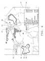
- FIG. 3is an exemplary weather display illustrating an example of manual storm cell tracking in accordance with the present invention.
- FIG. 4is an exemplary weather display illustrating an example of automatic storm cell tracking in accordance with the present invention.
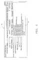
- FIG. 5is an exemplary storm table user interface listing storm cells identified in NEXRAD information, and selected characteristics of such cells, wherefrom storm cells to be tracked in a weather tracking and display system in accordance with the present invention may be selected.
- FIG. 6is an exemplary storm profile settings menu user interface, which allows an operator to define storm profiles which determine how NEXRAD storm cells will be handled by a weather tracking and display system in accordance with the present invention.
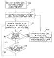
- FIG. 7is a flowchart diagram illustrating a method in accordance with the present invention for maintaining an accurate display of the position and track of storm cell information.
- FIG. 8is a flowchart diagram illustrating an exemplary method in accordance with the present invention for integrating NEXRAD and live radar data to provide an accurate display of the position and track of detailed NEXRAD storm cell attributes.
- the present inventionprovides a system and method for preparing and manipulating a high quality weather display including an accurately determined and displayed current position and future path of detailed weather storm cell information.
- a weather presenteror other operator, prepares a display of weather phenomena overlaid on a map of a selected geographic location.
- the displaymay be used to track severe weather phenomena, and may include a display of the predicted arrival of severe weather at specific geographic locations, including the type, intensity, or severity of the weather.
- a weather tracking and display system in accordance with the present inventionprovides various operator tools and functions in a graphical user interface to allow the operator to prepare a weather display for broadcast, and to manipulate the display during a live weather presentation.
- the system and method of the present inventionprovides for updating of the displayed position and predicted track of detailed NEXRAD defined storm cell attributes or characteristics between NEXRAD updates.
- the integration of detailed NEXRAD weather radar information with live radar datato provide an enhanced ability to predict and display accurately the movement of severe weather cells and to provide an accurate warning of both time of arrival and characteristics (e.g., type and severity) of a storm to those in the path of such cells is provided.
- time of arrival and characteristicse.g., type and severity
- the present inventionwill find particular applicability for use in preparing, and during the presentation of, a live on-air or cable television weather presentation, it should be understood that the present invention may be employed in the preparation and manipulation of a weather display to be distributed in any media, or in any situation where accurate weather tracking, prediction, and display is desired.
- FIG. 1An exemplary weather tracking and display system in accordance with the present invention is illustrated at 10 in FIG. 1 .
- the weather tracking and display system 10 of the present inventionis a computer-implemented system.
- the system 10may be implemented using any conventional modern commercially available computer processor 12 .
- a processor 12which has sufficient operating speed to manipulate large amounts of graphical and other data is preferred.
- the processor 12may preferably be implemented using the Silicon Graphics 320 Visual Workstation processor, or another Silicon Graphics NT Visual Workstation.
- Such processorsare known to have sufficient power to implement a weather tracking and display system in accordance with the present invention.
- the processor 12preferably includes conventional operator input 14 and display 16 devices associated therewith.
- the operator input devices 14may include, for example, a conventional computer keyboard, mouse, track ball, etc.
- the telestrating system and methods described in U.S. Pat. Nos. 5,270,820 and 5,699,442, incorporated herein by reference,may be integrated into the system 10 .
- a conventional operator display device 16 capable of displaying high quality graphicsmay be employed.
- a Silicon Graphics 1600 SW Flat Panel Monitor, or other similar operator display device 16is preferred.
- the processor 12is also provided with conventional computer memory 18 .
- the memory 18may be implemented in any conventional manner and may include both RAM memory and disk or other mass memory storage devices.
- the memory 18is employed in a conventional manner to store the software programs executed by the processor 12 to implement a weather tracking and display system in accordance with the present invention.
- Weather data information and digital geographic map informationis also stored in memory 18 in a conventional manner for use by the processor 12 .
- the weather tracking and display system 10 of the present inventionemploys high resolution digital maps for generating weather displays. Any commercially available high quality digital map data set may be employed. Most such commercially available digital map data sets include information for the entire country. Such digital map data is preferably vector-based.
- Vector-based map dataallows borders to be sharp and crisp no matter how far or close the map image is “zoomed” in or out for viewing.
- the digital map data stored in memorypreferably includes state borders, county borders, interstates, highways, roads, city streets, metropolitan areas, etc.
- the processor 12is preferably adapted to receive weather information from a variety of sources.
- sources of weather informationmay include National Weather Service weather wire storm warning information 20 , NEXRAD weather radar information 22 , live radar data 24 , and satellite imagery 26 .
- the National Weather Service weather wire information 20includes weather warning bulletins authored by the National Weather Service Storm Prediction Center, and other related government agencies.
- the weather warning bulletinsinclude tornado warnings, severe thunderstorm warnings, flash flood warnings, and the like. This information is typically employed by WxWarn, or another system, for displaying the warning bulletins, e.g., as an overlay on a television broadcast.
- WxWarn, or another system for displaying the weather wire warning bulletinsmay be integrated into the weather tracking and display system 10 .
- NEXRAD weather data 22is also provided by the government.
- NEXRAD information 22includes a storm attributes table which defines storm cells and provides detailed information concerning the cells, including the characteristics of the cells (e.g., hail and vortex intensity and location, rain fall intensity, speed, etc.), as well as the position, direction, and speed of movement of the cells.
- NEXRAD radar datais obtained from a volumetric scan of the atmosphere and is provided to the system 10 on a periodic basis, e.g., approximately every six (6) minutes.
- Live radar data 24may be provided to the system 10 from one or more local or remotely located radar systems. Live radar data 24 preferably provides real time radar sweep information to the system 10 much more often than NEXRAD information is provided to the system 10 .
- a conventional radar sweepmay generally be completed in thirty (30) seconds to ninety (90) seconds. If the live radar is operated to scan only a selected sector of interest, live radar information for the sector may be provided as often as every ten (10) seconds.
- NEXRAD 22 and live radar 24are both radar sources, NEXRAD information is provided from much more expensive and powerful radars and information processing systems than conventional live radar. Thus, NEXRAD radar information is much more detailed, but less timely, than live radar information.
- Satellite imagery 26 provided to the system 10may include high resolution visible and infrared satellite imagery.
- the format in which the weather information is provided from the various weather information sources to the system 10is available from the government or commercial providers of weather wire 20 , NEXRAD 22, and satellite imagery 26 .
- the format of live radar information 24 provided to the system 10will depend on the live radar system employed for any particular application.
- a weather tracking and display system 10 in accordance with the present inventionprovides an operator of the system with various tools, implemented in a graphical user interface, for preparing a high quality weather display for broadcast, i.e., over the air, via cable, etc. to viewers, and for manipulating the display during a live broadcast.
- the system 10preferably provides an output of such a weather display to a conventional over-the-air or cable broadcast system 28 .
- the weather display provided to the broadcast system 28is preferably different from the operator display provided on the operator display device 16 . Operator tools and manipulations visible on the operator display are preferably not included in the weather display provided for broadcast 28 .
- weather displays prepared using the system 10may be stored in digital form in memory 18 , or in analog form, to tape, etc., for retrieval and replay at a later time.
- the producer of a weather presentationsuch as a live presenter or meteorologist, is provided with the tools needed to prepare and display interactively a host of weather information on a variety of geographic scales.
- these toolsare implemented in software and provided to the operator as graphical user interface tools presented in an operator display which is displayed on the operator display device 16 .
- FIG. 2An exemplary operator display 30 including graphical user interface tools for preparing and manipulating a weather display is illustrated in FIG. 2 .
- the operator display 30includes a weather display window 32 and various graphical user interface menus, buttons, and other tools provided in a graphical user interface portion 33 of the operator display 30 .
- the weather display window 32shows the operator of the system the weather display being prepared and manipulated.
- the graphical user interface toolsare employed by the operator to define and manipulate what is shown in the weather display window 32 .
- the weather display displayed in the display window 32is the image that is provided on the video output of the system 10 for broadcast 28 .
- the image rendered in the display window 32is rendered directly to the output of the system 10 for broadcast 28 .
- no menus, windows, or other graphical user interface tools or manipulations that are displayed in the graphical user interface 33 portion of the operator display 30 , either along side of or on top of the display window 32will be provided for broadcast.
- Two different types of graphical user interface toolsare provided in the operator display, and employed by an operator during different modes of operation of the system 10 .
- provided graphical user interface toolsare used to select and arrange, for example, all map-related elements.
- the systemmay be operated in an “on-air” mode.
- on-air graphical user interface toolsare employed to manipulate dynamically the weather display.
- the weather display presented in the weather display window 32is preferably rendered in layers. Each layer includes different map or weather elements to be included in the weather display. Preferably, all weather information displayed in the weather display is layered over all map elements, but is made transparent so that map elements are visible through the weather phenomena being displayed.
- a layer list graphical user interface 34is provided in the operator display 30 to allow an operator of the system 10 to view the geographical elements which will be displayed on the map displayed in the display window 32 (and broadcast).
- the layer list graphical user interface 34presents layers of geographic elements which may be displayed in the display window 32 as an ordered list.
- the order of the listdetermines the order that the layers will be rendered in the display window 32 , and preferably may be established by an operator during the set-up mode.
- a user interface 35is preferably provided to allow an operator to change the order of the items listed in the layer list 34 .
- the first element to be rendered in the display window 32is at the top of the layer list 34 .
- Elements listed lower in the list 34will be rendered later, i.e., on top of layers listed before them in the list 34 .
- interstate highwayswill be rendered after state borders in the display window 32 , and thus interstate highways will appear on top of state borders in the weather display.
- An operatormay select a geographic element to be displayed by selecting an element from the layer list 34 using the operator input device 14 , such as a mouse.
- a dot 36is provided in the layer list graphical user interface 34 adjacent to each listed element to indicate if the particular layer has been selected for display in the weather display window 32 . Selection of a layer for display may be indicated by the color of the dot 36 or other marker (or the color of the element text listed in the layer list graphical user interface 34 ).
- graphical user interface toolsmay be provided in the graphical user interface portion 33 of the operator display 30 . These tools may be employed by an operator of the system 10 for manipulating the weather display presented in the display window 32 during a live broadcast of the display.
- a label control interface 38allows an operator of the system 10 to label interactively map elements displayed in the weather display 32 .
- the use of a vector based digital mapping packageallows an operator of the system 10 to select, for example, a street or other feature displayed on the map in the display window 32 , e.g., by clicking on the street or other feature using a mouse.
- the label interface tool 38is then selected, which provides a window in which a label for the street or other feature may be typed using the keyboard. This label will be displayed on the map provided in the display window 32 . This allows the labeling of city streets to be done easily and quickly.
- a weather tracking and display system 10 in accordance with the present inventionpreferably provides for both manual and automatic storm cell tracking.
- a manual tracking modemay be entered into by selecting the manual tracking mode control button 40 on the user interface portion 33 of the operator display 30 . Operation of the manual storm cell tracking mode will be described in detail with reference to the exemplary weather display 41 shown in FIG. 3 .
- an operatorusing the operator input device 14 , such as a mouse, draws a storm line 42 on the map in the display window.
- the storm line 42indicates the current position of a storm or squall line, and may be determined from the display of, e.g., live radar, NEXRAD, or other weather information 43 in the display 41 . The operator then indicates the direction and speed of movement of the storm line 42 .
- Direction lines 44extending from the ends of the storm line 42 , are drawn to indicate the direction of movement of the storm line 42 .
- the length of the direction lines 44indicate the speed of movement of the storm line 42 .
- the length of direction lines 44may indicate a distance that the storm line 42 is expected to travel in a specified period of time, e.g., one hour.
- the speed and direction of movement, as indicated by the lines 44are manually determined by the operator from, e.g., the information provided in a NEXRAD storm attributes table.
- the area 45 between the direction lines 44may be shaded to indicate the area over which the storm line 42 is expected to pass in the next, e.g., hour.
- a weather tracking and display system 10 in accordance with the present inventionpreferably also provides for automatic tracking of storm cells. This mode of operation may be activated by selecting an automatic tracking mode control button 46 provided on the user interface portion 33 of the operator display 30 . Operation of the automatic tracking mode will be described in detail with reference to the exemplary weather display 47 shown in FIG. 4 .
- the weather cells tracked in the weather display 47 in automatic tracking modeare defined by detailed NEXRAD weather data. Live radar weather information may also be displayed in the weather display 47 .
- For automatic trackinga subset of weather cells defined by available NEXRAD weather data and to be tracked in the weather display 47 must be selected. This selection may be performed manually or automatically.
- the weather cells to be tracked in the weather display 47may be selected manually by an operator from the weather display 47 itself, or from a storm table listing storm cells identified by the latest available NEXRAD information.
- the weather cells to be trackedmay be selected from the weather display 47 by, for example, allowing an operator of the system to move a pointing device, using, e.g., the mouse, over the representations of weather presented in the weather display 47 .
- a pointing devicepasses over the location of a weather cell, as defined by the data provided in the NEXRAD storm attributes table, a ring 48 or other marker is automatically displayed in the weather display 47 to indicate the location of the cell. Having found the location of a cell in the weather display 47 , the cell may be selected, e.g., using the mouse.
- a weather tracking and display system 10 in accordance with the present inventionpreferably also provides a storm table, listing storm cells identified by the latest available NEXRAD information, and from which storms to be tracked in automatic tracking mode may be selected.
- An exemplary storm table 49which may be accessed by an operator of the system 10 via the user interface portion 33 of the operator display 30 , is illustrated in FIG. 5 .
- the storm table 49is derived automatically by the system 10 from the NEXRAD Composite Reflectivity Product (CRP). It contains information about storm cells that the NEXRAD radar has identified. Included in this information is the speed, direction, and intensity of the cell. There are also indicators for hail and rotation.
- An operator of the system 10may select cells to be tracked automatically in the weather display 47 by selecting such cells from the storm table 49 , e.g., by indicating a line in the storm table 49 using the operator input device 14 to identify a cell to be tracked automatically.
- the way in which storm cells identified in available NEXRAD information will be handled by the weather tracking and display system 10may be determined by operator selectable storm profile settings.
- An exemplary storm profile settings menu 50which may be accessed by an operator of the system 10 using the user interface portion 33 of the operator display 30 , is illustrated in FIG. 6 .
- the storm profile settings menu 50allows an operator of the system 10 to characterize and customize how storm cells identified in NEXRAD information will be treated by the system 10 . An operator can choose which storm cell features should be used in grouping storm cells together, and how such cells should be displayed for tracking.
- the system 10When a storm cell is identified in a NEXRAD CRP product received by the system 10 , the system 10 will compare its attributes to a profile list 51 established using the profile settings menu 50 and displayed therein. This comparison may, for example, start at the top of the profile list 51 and work down to the bottom. (In such a case, the order of the profiles listed in the storm profiles list 51 would make a difference. The most restrictive profile should be at the top of the list 51 . The default profile should be at the bottom.)
- the storm profile settings menu 50may allow an operator to establish the following profile characteristics:
- Profile nameThis is the name that the profile will have when listed in the profile list 51 in the storm profile settings menu 50 .
- Each profilecan have a specific cut-out image or marker assigned to it.
- the cut-out image or markerwill be displayed in the weather display 47 when the storm cell is selected to be tracked therein, as discussed in more detail below.
- the cut-outmay be used by a navigated cut-out layer that is populated from the storm table.
- each storm being tracked which satisfies a given profilecan have a cut-out associated therewith that graphically represents the characteristics of the storm cell.
- a storm cell including tornadic activitymay be represented by a tornado shaped cut-out marker.
- JustificationThis controls which part of the displayed cut-out marker is aligned with the NEXRAD defined coordinates for the storm cell on the displayed map.
- the markermay be selected to be displayed centered on the identified coordinates of the storm cell on the map, or positioned above, below, or to the side of the indicated coordinates.
- Cue-colorThis allows the operator to set the color that a storm cell satisfying the profile will appear in the storm table 49 .
- Exemplary profile setting values that can be set for storm attributes available in the NEXRAD information, to define a storm profilemay include, for example:
- the storm profile settings menu 50may be used to profile a storm cell based on whether the storm cell includes a tornado vortex signature identified in the lowest elevation scan (TVS), whether an elevated tornado vortex signature is identified (but not identified in the lowest scan) (ETVS), or whether no TVS or ETVS is identified.
- TVSlowest elevation scan
- ETVSelevated tornado vortex signature
- the storm profile settings menu 50preferably allows an operator to select as a profile of a storm cell whether a mesocyclone is identified (MESO), whether 3-D correlated sheer is identified (did not meet necessary aspect ratio of length to width for “mesocyclone” identification) (3DCO), or whether uncorrelated sheer is identified (only a 2-D pattern detected with no correlation in the vertical) (UNCO).
- Other profile settingswhich may be established by an operator using the storm profile settings menu 50 include Severe Hail Probability (probability of severe hail identified as hail that is greater than or equal to 3 ⁇ 4 of an inch, displayed in increments of 10%), Hail Probability (identified as hail of any size, displayed in increments of 10%), Max Hail (maximum estimated hail size), Vertically Integrated Liquid (VIL) (used as a measure of storm intensity and as a hail predictor), and Max DBZ (maximum DBZ detected).
- Severe Hail Probabilityprobability of severe hail identified as hail that is greater than or equal to 3 ⁇ 4 of an inch, displayed in increments of 10%
- Hail Probabilityidentified as hail of any size, displayed in increments of 10%
- Max Hailmaximum estimated hail size
- VILVertically Integrated Liquid
- Max DBZmaximum DBZ detected.
- the storm cellsatisfies the selected profile, and will be handled by the system 10 accordingly (e.g., as defined in the storm profile settings menu 50 ).
- a cell to be tracked in the weather display 47 in automatic tracking modemay be selected automatically when the NEXRAD information for the cell satisfies preselected criteria. These criteria may be selected by a user of the system 10 , for example, using a storm profile settings menu 50 as described above. For example, a profile related to storm intensity or some other cell characteristic may be established as described above. If the NEXRAD data for a storm cell indicates that, e.g., the storm intensity or other characteristic matches the selected profile, that storm cell will be selected automatically to be tracked in the weather display 47 .
- the weather tracking and display system 10For each (automatically or manually) selected storm cell, the weather tracking and display system 10 generates a marker 52 at the current location of the storm cell and a track display, such as a shaded tracking wedge 53 , indicating the speed and direction of the selected cell.
- the marker 52may be of any shape, for example, as described above, the marker 52 may be a cut-out having a shape related to the characteristics of the storm cell being tracked. (The marker shape to be used may be selected by an operator using the storm profile settings menu 50 , as described above.)
- the length of the tracking wedge 53may indicate the speed of the cell, e.g., how far the cell will travel at current speed in, e.g., half an hour or some other time period. The length and width of the tracking wedge 53 may be user selectable.
- Another track display formatsuch as an arrow, line, parallel lines, etc., indicating storm cell speed and/or direction, may also be used.
- One or more storm cellsmay be tracked automatically in this manner.
- the data required to generate an initial display of the location, direction, and speed of the selected storm cellsis derived by the system 10 directly from the data provided in the NEXRAD storm attributes table.
- Each time new NEXRAD data is received from the NEXRAD data source 22the display of the position, direction, and speed of a selected storm cell 50 will be updated.
- the predicted path of the storm displayed in the display windowis thus updated automatically at least each time updated NEXRAD data is received.
- a weather tracking and display system 10 in accordance with the present inventionmay receive NEXRAD data from multiple NEXRAD sites.
- the storm data received from such multiple sitesmay overlap.
- data for a single storm cellmay appear in NEXRAD storm attributes tables from more than one site.
- the storm attribute data for a single storm cell provided from different sitesmay not be identical.
- the system 10preferably selects the attributes which are likely to be most accurate for a particular storm cell for display on the weather display and for predicting the track of the storm cell.
- the systemmay automatically select information for a particular storm cell from a NEXRAD site which indicates the greatest storm intensity, or some other user selected characteristic, or combination of characteristics, for the cell.
- the information from the NEXRAD site nearest to the stormmay be selected. Any other method for selecting the storm cell attributes for a particular storm cell for which storm cell attributes are being provided from more than one NEXRAD site may be employed.
- the weather tracking and display system 10 of the present inventionpreferably displays a window 54 in the weather display 41 , 47 which contains a list of cities in the predicted path of a storm, and the estimated arrival time of the storm line 42 or a storm cell 52 at those cities, based on the manual or automatic storm track prediction.
- the specific cities to be displayed in the window 54the number of cities to be displayed in the window 54 , and the order in which the cities are to be displayed are all user selectable.
- the citiesmay preferably be displayed in the window 54 in order of the arrival time of the line of storms 42 or storm cell 52 at the city. Note that (as shown in FIG. 4) separate lists of cities may be provided for each of the storms being tracked.
- the display window 54may display the time remaining from the present until the storm is predicted to reach a city. That is, a countdown to impact of the storm line 42 or a storm cell 52 at the city may be presented. Preferably each city included in the list provided in window 54 may also be highlighted as a dot 56 or other symbol displayed in the correct geographic position on the weather display in the expected path of the storm line 42 or storm cell 50 .
- graphical user interface control toolsare preferably provided in the user interface portion 33 of the operator display 30 which allow an operator of the system 10 to manipulate the view of the map displayed in the weather display window 32 . Every pixel in the weather display window 32 is preferably navigated. Therefore, an icon, text, or other material may be associated with a particular geographic location, and made to appear in the correct location when a view including that location is selected to be displayed.
- Information on the map view currently displayed in the display window 32is preferably provided in the user interface portion 33 of the operator display 30 .
- This displayed view informationpreferably includes the latitude 60 and longitude 62 of the center of the map displayed in the weather display window 32 .
- the number of miles 64 represented in the map from the center of the weather display window 32 to the outside edge thereofis preferably also provided. This provides an indication of the scale of the displayed map.
- An operatormay select these displays 60 , 62 , and 64 and type in new values if desired.
- an operatorcan define the geographical area and scale of the map displayed in the weather display window 32 .
- a defined map viewis saved as a preset view.
- a plurality of viewsmay preferably be saved in this manner, and made available for easy recall.
- a plurality of view buttons 68may be provided in the user interface portion 33 of the operator display 30 .
- the operatoris prompted to input a number corresponding to one of the view buttons 68 .
- the preset viewwill be recalled to the weather display window 32 .
- the view buttons 68 in the graphical user interfacemay be assigned to correspond to function keys on the keyboard, such that a preset view may be easily recalled by depressing the appropriate function key.
- Zoom in 70 , zoom out 72 , and home position 74 buttonsmay also be provided on the graphical user interface 33 .
- Zoom in control button 70magnifies the view of the map shown in the weather display window 32 each time the zoom in button 70 is selected. This control preferably magnifies the view of the map shown in the display window 32 in even steps each time the button 70 is selected.
- the zoom out control button 72zooms the view of the map shown in the display window 32 out in even steps each time the button 72 is selected.
- the home position button 74returns the view of the map shown in display window 32 back to a user defined “home” position or view.
- a usercan also zoom in anywhere on the map by defining a center point in a box.
- a transparent boxis displayed in the weather display window 32 so that viewers can clearly see the area that is being enlarged.
- banners, logos, symbols, etc.may be placed by an operator anywhere on a map displayed in the weather display window 32 .
- Such image-based “cut-outs”are preferably positioned on the map based on latitude and longitude. Thus, even though the scale or position of a view is changed, e.g., by zooming in and out, the cut-outs will remain positioned on the map in the proper geographic location. In other words, the cut-outs are navigated on the map.
- the display of the map presented in the weather display window 32preferably includes display filtering associated therewith which determines at which map scales specific geographic features will be displayed. For example, though city streets may be selected for display in the display window 32 , using the layer list graphical user interface 34 , such streets may not be displayed in large scale views over a selected threshold scale level. The fact that a geographical feature has been selected for display, but is not displayed in a currently displayed view because of the scale of the view, may be indicated on the layer list graphical user interface 34 by, e.g., a different color for the marker 36 associated with such features.
- NEXRADprovides detailed information on the location, direction, speed, and other characteristics of a storm cell, such data is updated on a relatively infrequent basis. As discussed above, NEXRAD data can only be expected to be provided to the weather tracking and display system 10 no more often than every six (6) minutes. Thus, even though a storm cell is in continuous motion, a displayed storm cell position and track based on NEXRAD data will remain fixed for up to six (6) minutes if the displayed position and track is only updated when new NEXRAD data is received, and then will jump to a new position when a NEXRAD update is received. The result is an inaccurate display of the current position of NEXRAD storm attributes, which becomes particularly apparent when the position of the NEXRAD attributes is displayed over a live radar image of weather locations.
- an accurate display of the current position and track of detailed storm cell attributes defined from NEXRAD datais provided by updating the displayed position and track of the storm cell attributes between NEXRAD updates.
- a general method of maintaining an accurate display of the position and track of NEXRAD storm cell attributes in accordance with the present inventionis illustrated by the flowchart diagram of FIG. 7 .
- the first step 100 in this tracking and display processis to select (either manually or automatically) storm cells to be displayed, and to determine the storm cell attributes, position, and track based, e.g., on the information contained in the NEXRAD storm attributes table. Based on this initial determination, the position and predicted track of the storm cell may be displayed based on NEXRAD data.
- the storm cell attributes, position, and trackmay be updated based on the new information received.
- the displayed position and track of the NEXRAD storm cell attributesis updated at step 104 . Updating of the storm cell position and track between NEXRAD updates may be based on the latest available NEXRAD information itself. For example, the displayed storm cell attributes, position, and track may be advanced periodically between NEXRAD updates based on the storm heading and speed information provided in the most recent NEXRAD update.
- the position and predicted track of detailed NEXRAD storm cell attributesis more accurately updated between NEXRAD data updates by integrating the detailed storm cell information provided by NEXRAD with live radar data from local or remote radar sites. As discussed above, such live radar scans can provide updated position information on storm cells at a rate of up to every ten (10) (for sector scans) to ninety (90) seconds.
- the location of intensities and other characteristics of a storm cell provided in a NEXRAD storm attributes tableare advanced along a predicted line using the speed and direction of movement of the storm cell as determined from a live radar source 24 which is being fed to the weather tracking and display system 10 of the present invention.
- Thisis achieved by linking or correlating a storm cell being tracked by live radar with the same storm cell as identified in the latest available NEXRAD information.
- the new location of the weather cell attributes defined by NEXRADmay be determined.
- the display of the position of the weather cell 52 in the weather display 47is advanced to the new position determined by the live radar data.
- a new track display 53is then generated and displayed, extending from this updated location, using the attributes for the storm cell as provided by the NEXRAD storm attributes table, but starting from the new location determined by the live radar data, or using new speed and heading information determined from the live radar data. This updating may continue with each sweep of the live radar. Therefore, the position of both the storm cell attributes and its predicted track is accurately maintained between the receipt of NEXRAD radar updates.
- the attributes for the storm cellare updated, and the NEXRAD defined storm cell re-linked or correlated to the corresponding storm cell in live radar data.
- the position and tracking wedgemay then be updated periodically until the next NEXRAD data update is received by the system 10 , using live radar data to determine the current position of the storm cell, and the latest storm attributes table information or live radar information to display the track 53 indicating the speed and direction of movement of the storm cell.
- the present inventionprovides for improved accurate tracking of detailed storm cell information using integrated NEXRAD and live radar data.
- the storm cells to be trackedare selected from the available NEXRAD data.
- the storm cells to be trackedmay be selected manually or automatically from the available NEXRAD data, and more than one storm cell may be selected for tracking.
- the selected NEXRAD storm cells to be trackedare correlated or linked to corresponding storm cells as identified in available live radar data.
- This linking or correlation stepmay be performed manually.
- the positions of selected NEXRAD storm cells to be tracked(based on the latest available NEXRAD position data) may be displayed over a corresponding live radar image.
- An operatormay then select the areas of storm cell activity identified in the live radar data which are to be linked to the displayed NEXRAD storm cells by indicating, e.g., using an operator input device 14 , such as a mouse, areas of high intensity in the live radar data which are to be correlated or linked to each of the selected NEXRAD storm cells.
- an operatormay select the area of highest intensity in the live radar display which is located most closely to a selected NEXRAD storm cell to link that live radar activity to the NEXRAD storm cell.
- the operatormay also take into consideration any time difference between the NEXRAD data and the live radar image displayed, direction and speed of movement information for the selected NEXRAD storm cell, and any other available information, in making the manual correlation selection.
- each NEXRAD storm cell selected to be tracked in step 110is automatically correlated to the corresponding storm cell in live radar data in step 112 .
- Thismay be accomplished, for example, by first time synchronizing the latest available NEXRAD data with available live radar data. This is necessary because there is a delay between the time at which NEXRAD radar information is obtained and the time at which such information is received by the weather tracking and display system 10 .
- the latest available NEXRAD datawhen received by the system 10 , will typically not be for the same time as the latest available live radar data.
- Time synchronizationmay be achieved by, for example, employing a stored live radar image corresponding to the time of the latest available NEXRAD information (as indicated by a time stamp provided with the NEXRAD information).
- time synchronizationmay be achieved by advancing the position of storm cells selected from the NEXRAD data to be tracked, based on the direction and speed of movement contained in the NEXRAD data, to new projected positions in the timeframe of the most recent live radar data.
- the system 10may automatically select from the live radar image an area of storm cell activity to be linked or correlated to the corresponding selected NEXRAD storm cell. This may be achieved by the system 10 by, for example, analyzing the live radar data image to locate the area of highest intensity weather activity nearest to the time synchronized position of a selected NEXRAD weather cell, and linking such activity to the NEXRAD storm cell information. A threshold maximum distance between a NEXRAD storm cell and possible corresponding live radar activity may be provided.
- an operatormay be provided with a manual override to undo a linking or correlation between a NEXRAD storm cell and activity in live radar data if the operator, based on personal experience and knowledge which may not be available to the system 10 , believes that the automatic correlation or linking of the NEXRAD and live radar data was erroneous.
- the position of the detailed NEXRAD attributesmay be updated based on the live radar data at step 114 .
- the position of the NEXRAD storm cell informationmay be set to the position of, e.g., the center of storm activity identified in the live radar data as corresponding to the storm cell.
- the system 10continually checks to determine if a NEXRAD information update has been received or if a storm cell being tracked has been scanned by live radar.
- the position of the NEXRAD storm cell attributes linked to the storm cell detected by the live radarare updated at step 114 based on the storm cell position provided from the live radar scan. (Updating of the position of NEXRAD attributes being tracked in this manner may be performed immediately after a cell being tracked is scanned by live radar, or after an entire radar scan is completed.) In this manner, the current position of the detailed NEXRAD storm cell attributes is determined, and may be displayed, based on timely live radar information.
- the displayed predicted track of the storm cellmay be updated by generating a new track display (e.g., tracking wedge 53 ) extending from the updated location of the storm cell attributes, using direction and speed of movement information for the cell as provided by the NEXRAD storm attributes table, but starting from the new location determinated by the live radar data.
- a new track displaye.g., tracking wedge 53
- new speed and heading informationdetermined from the live radar data by, e.g., examining the movement of the storm cell over several live radar scans, may be used to generate and display a new track display 53 .
- the storm attributese.g., vortex intensity, hail, etc.
- the storm attributesare updated from the newly received NEXRAD data at step 120 .
- Each storm cell in the NEXRAD storm attributes tableis identified by a unique code for tracking purposes. This code can be used to identify the storm cell in subsequent storm attribute tables for the purposes of associating new storm attributes with a storm cell being tracked.
- the position and track information provided in the NEXRAD updateis also employed to relink or recorrelate the NEXRAD storm cells being tracked with the corresponding storm cell activity as identified in the latest live radar data, in the manner described above with reference to step 112 .
- this linking or correlation step 112may be performed automatically, and is preferably performed with each NEXRAD update to ensure that the detailed NEXRAD storm cell attributes of interest are linked to the appropriate storm cell activity as identified in the live radar data.
- NEXRADis referred to herein as an example of a type of weather information source which provides detailed weather information periodically less often than less detailed live radar data.
- the present inventionis not limited to applications using NEXRAD and live radar data, but may be employed using weather information provided from a variety of weather information sources.
Landscapes
- Environmental & Geological Engineering (AREA)
- Engineering & Computer Science (AREA)
- Life Sciences & Earth Sciences (AREA)
- Atmospheric Sciences (AREA)
- Biodiversity & Conservation Biology (AREA)
- Ecology (AREA)
- Environmental Sciences (AREA)
- Radar Systems Or Details Thereof (AREA)
Abstract
Description
Claims (50)
Priority Applications (3)
| Application Number | Priority Date | Filing Date | Title |
|---|---|---|---|
| US09/543,046US6339747B1 (en) | 2000-04-05 | 2000-04-05 | Weather tracking and display system and method |
| AU2001249883AAU2001249883A1 (en) | 2000-04-05 | 2001-04-05 | Weather tracking and display system and method |
| PCT/US2001/011083WO2001077712A1 (en) | 2000-04-05 | 2001-04-05 | Weather tracking and display system and method |
Applications Claiming Priority (1)
| Application Number | Priority Date | Filing Date | Title |
|---|---|---|---|
| US09/543,046US6339747B1 (en) | 2000-04-05 | 2000-04-05 | Weather tracking and display system and method |
Publications (1)
| Publication Number | Publication Date |
|---|---|
| US6339747B1true US6339747B1 (en) | 2002-01-15 |
Family
ID=24166360
Family Applications (1)
| Application Number | Title | Priority Date | Filing Date |
|---|---|---|---|
| US09/543,046Expired - LifetimeUS6339747B1 (en) | 2000-04-05 | 2000-04-05 | Weather tracking and display system and method |
Country Status (3)
| Country | Link |
|---|---|
| US (1) | US6339747B1 (en) |
| AU (1) | AU2001249883A1 (en) |
| WO (1) | WO2001077712A1 (en) |
Cited By (76)
| Publication number | Priority date | Publication date | Assignee | Title |
|---|---|---|---|---|
| US20020069020A1 (en)* | 1999-08-13 | 2002-06-06 | Digital Cyclone, Inc. | Generation and distribution of personalized multimedia natural phenomenological information |
| US20020075318A1 (en)* | 2000-12-20 | 2002-06-20 | Hong Yang | System and method for providing adaptive scaling of selected features in an integrated receiver decoder |
| WO2002039217A3 (en)* | 2000-11-06 | 2003-01-03 | Weather Central Inc | System and method for providing personalized storm warnings |
| US20030050757A1 (en)* | 2001-09-12 | 2003-03-13 | Moore John S. | System and method for processing weather information |
| US20030156734A1 (en)* | 2002-02-19 | 2003-08-21 | Massachusetts Institute Of Technology | Method and apparatus for short-term prediction of convective weather |
| US6670908B2 (en)* | 2001-07-31 | 2003-12-30 | Baron Services, Inc. | Automated system and method for processing meteorological data |
| US6683609B1 (en) | 1997-10-20 | 2004-01-27 | Baron Services, Inc. | Real-time three-dimensional weather data processing method and system |
| US20040162675A1 (en)* | 2001-11-01 | 2004-08-19 | Dennis Moon | System presenting meteorological information using a browser interface |
| US20040225556A1 (en)* | 1996-01-18 | 2004-11-11 | Willen Michael A. | System, method, and computer program product for forecasting weather-based demand using proxy data |
| US20050050008A1 (en)* | 2000-07-24 | 2005-03-03 | Root Steven A. | Interactive advisory system |
| US6879280B1 (en)* | 2004-06-28 | 2005-04-12 | Rockwell Collins, Inc. | Vertical weather profile display system and method |
| US20050096947A1 (en)* | 2003-10-29 | 2005-05-05 | Frederic Fox | Systems and methods for recommending business decisions influenced by weather elements |
| US20050222770A1 (en)* | 2004-03-31 | 2005-10-06 | Meteorlogix, Llc | Method of forecasting precipitation for specific geographic locations |
| US20050219268A1 (en)* | 2004-03-30 | 2005-10-06 | Kyle Henry M | System for managing the navigational usability of an interactive map |
| US7031927B1 (en) | 2000-04-12 | 2006-04-18 | Strategic Weather Services | System, method, and computer program product for weather and terrestrial vegetation-based water renovation and management forecasting |
| US7039505B1 (en) | 2002-07-19 | 2006-05-02 | Avidyne Corporation | Method for digital transmission and display of weather imagery |
| US20060142944A1 (en)* | 2004-12-23 | 2006-06-29 | France Telecom | Technique for creating, directing, storing, and automatically delivering a message to an intended recipient based on climatic conditions |
| US20060161469A1 (en)* | 2005-01-14 | 2006-07-20 | Weatherbank, Inc. | Interactive advisory system |
| US20060178140A1 (en)* | 2005-02-02 | 2006-08-10 | Steven Smith | Location-based data communications system and method |
| US7148816B1 (en)* | 2004-08-30 | 2006-12-12 | Rockwell Collins, Inc. | Aircraft traffic source selection and display system and method |
| US20060293980A1 (en)* | 2005-06-23 | 2006-12-28 | Planalytics, Inc. | Weather-based financial index |
| US20070005249A1 (en)* | 2005-06-30 | 2007-01-04 | Massachusetts Institute Of Technology | Weather radar echo tops forecast generation |
| US7181346B1 (en)* | 2005-03-31 | 2007-02-20 | Wsi Corporation | System and method for assessing the people and property impact of weather |
| US7191064B1 (en)* | 2003-11-07 | 2007-03-13 | Accuweather, Inc. | Scale for severe weather risk |
| US20070061074A1 (en)* | 2005-09-13 | 2007-03-15 | Safoutin Michael J | Method and apparatus for geometric search and display for a digital map |
| US7193628B1 (en)* | 2000-07-13 | 2007-03-20 | C4Cast.Com, Inc. | Significance-based display |
| US20070067187A1 (en)* | 2005-09-22 | 2007-03-22 | Asustek Computer Inc. | Electronic lifestyle integration apparatus and method of establishment |
| US20070168131A1 (en)* | 2006-01-19 | 2007-07-19 | Weatherbank, Inc. | Interactive advisory system |
| US20070179750A1 (en)* | 2006-01-31 | 2007-08-02 | Digital Cyclone, Inc. | Information partner network |
| US7275089B1 (en) | 2001-03-15 | 2007-09-25 | Aws Convergence Technologies, Inc. | System and method for streaming of dynamic weather content to the desktop |
| US20070221743A1 (en)* | 2006-03-23 | 2007-09-27 | Weinzapfel Robert A | Methods of calculating impact time for storms |
| US20070275266A1 (en)* | 2006-05-25 | 2007-11-29 | Idemitsu Kosan Co., Ltd. | Organic electroluminescence device |
| US20080021003A1 (en)* | 2006-06-13 | 2008-01-24 | Vladimir Hanes | Extended step-down estrogen regimen |
| US20080065329A1 (en)* | 2005-04-14 | 2008-03-13 | Baron Services, Inc. | System and Method for Displaying Storm Tracks |
| US20080120542A1 (en)* | 2006-11-17 | 2008-05-22 | W.W. Grainger, Inc. | System and method for influencing display of web site content |
| US20080207183A1 (en)* | 2007-02-23 | 2008-08-28 | Weatherbank, Inc. | Interactive advisory system for prioritizing content |
| US7421344B1 (en)* | 2003-09-30 | 2008-09-02 | Weather Central, Inc. | System and method for presenting personalized weather information and the like |
| US7421422B1 (en)* | 2002-04-08 | 2008-09-02 | Wsi Corporation | Method for graphical interaction with geographic databases for interactive broadcast presentation |
| US20080313037A1 (en)* | 2007-06-15 | 2008-12-18 | Root Steven A | Interactive advisory system |
| US20090243918A1 (en)* | 2005-08-17 | 2009-10-01 | Kelly Terence F | System and Method for Presenting Wind Speed Information |
| US20090284373A1 (en)* | 2007-07-31 | 2009-11-19 | Nec Corporation | Disaster noticing system, disaster noticing server, disaster reporting terminal method, and program |
| US20090303056A1 (en)* | 2005-11-15 | 2009-12-10 | Swiss Reinsurance Company | Trigger system for monitoring and/or control devices and/or early warning systems for nascent and/or occurring cyclones |
| US20100060581A1 (en)* | 2008-05-02 | 2010-03-11 | Moore John S | System and Method for Updating Live Weather Presentations |
| US7752106B1 (en) | 2005-07-19 | 2010-07-06 | Planalytics, Inc. | System, method, and computer program product for predicting a weather-based financial index value |
| US7800582B1 (en)* | 2004-04-21 | 2010-09-21 | Weather Central, Inc. | Scene launcher system and method for weather report presentations and the like |
| US20110025683A1 (en)* | 2008-04-04 | 2011-02-03 | Clarion Co., Ltd. | Map Display Device |
| US20110109649A1 (en)* | 2008-04-04 | 2011-05-12 | Clarion Co., Ltd. | Map Display Device |
| CN102305951A (en)* | 2011-06-09 | 2012-01-04 | 民航数据通信有限责任公司 | Data processing system and method for judging great weather change |
| US8160995B1 (en)* | 2008-04-18 | 2012-04-17 | Wsi, Corporation | Tropical cyclone prediction system and method |
| US8204846B1 (en)* | 2008-04-18 | 2012-06-19 | Wsi, Corporation | Tropical cyclone prediction system and method |
| US8224768B1 (en)* | 2008-04-18 | 2012-07-17 | Wsi, Corporation | Tropical cyclone prediction system and method |
| US20130014046A1 (en)* | 2011-07-07 | 2013-01-10 | Watts And Associates, Inc. | Systems, computer implemented methods, geographic weather-data selection interface display, and computer readable medium having program products to generate user-customized virtual weather data and user-customized weather-risk products responsive thereto |
| US20130063488A1 (en)* | 2011-09-12 | 2013-03-14 | Nokia Corporation | Method and apparatus for providing list-based exploration of mapping data |
| US8519860B2 (en) | 2010-04-09 | 2013-08-27 | Weather Decision Technologies | Multimedia alerting |
| US8525724B2 (en) | 2010-10-08 | 2013-09-03 | University Of Massachusetts | System and method for generating derived products in a radar network |
| US20140032114A1 (en)* | 2012-07-30 | 2014-01-30 | Telecommunication Systems, Inc. | Navigation Redirect Using CMAS Emergency Alerts |
| US20140176362A1 (en)* | 2012-11-21 | 2014-06-26 | Dynamic Weather Solutions, Inc. | Systems and Methods For Inferring Localized Hail Intensity |
| US9094300B1 (en)* | 2009-11-07 | 2015-07-28 | Harris Technology, Llc | Address sharing network |
| US20160025896A1 (en)* | 2014-07-22 | 2016-01-28 | The Weather Channel, Llc | Generating weather forecasts with human over-the-loop oversight |
| WO2016057859A1 (en)* | 2014-10-10 | 2016-04-14 | The Penn State Research Foundation | Identifying visual storm signatures form satellite images |
| US9507022B1 (en) | 2008-03-07 | 2016-11-29 | Rockwell Collins, Inc. | Weather radar system and method for estimating vertically integrated liquid content |
| US9535158B1 (en)* | 2013-11-21 | 2017-01-03 | Rockwell Collins, Inc. | Weather radar system and method with fusion of multiple weather information sources |
| US9599707B1 (en) | 2014-01-23 | 2017-03-21 | Rockwell Collins, Inc. | Weather radar system and method with path attenuation shadowing |
| US9625577B1 (en) | 2011-09-27 | 2017-04-18 | Rockwell Collins, Inc. | Aviation display depiction of weather threats |
| US9753947B2 (en) | 2013-12-10 | 2017-09-05 | Weather Decision Technologies, Inc. | Four dimensional weather data storage and access |
| US9810770B1 (en)* | 2014-07-03 | 2017-11-07 | Rockwell Collins, Inc. | Efficient retrieval of aviation data and weather over low bandwidth links |
| US9823347B1 (en) | 2014-03-12 | 2017-11-21 | Rockwell Collins, Inc. | Weather radar system and method for high altitude crystal warning interface |
| US9869766B1 (en) | 2015-01-28 | 2018-01-16 | Rockwell Collins, Inc. | Enhancement of airborne weather radar performance using external weather data |
| US20180087902A1 (en)* | 2000-10-06 | 2018-03-29 | Vederi, Llc | System and method for creating, storing and utilizing images of a geographical location |
| US10088678B1 (en)* | 2017-05-09 | 2018-10-02 | Microsoft Technology Licensing, Llc | Holographic illustration of weather |
| US10302815B1 (en) | 2015-10-01 | 2019-05-28 | Rockwell Collins, Inc. | System and method of integrating global convective weather |
| US10494108B1 (en) | 2016-05-17 | 2019-12-03 | Rockwell Collins, Inc. | System and method for providing icing condition warnings |
| US10540722B2 (en) | 2013-05-17 | 2020-01-21 | Watts And Associates, Inc. | Systems, computer-implemented methods, and computer medium to determine premiums for supplemental crop insurance |
| US10809375B1 (en) | 2015-09-14 | 2020-10-20 | Rockwell Collins, Inc. | Radar system and method for detecting hazards associated with particles or bodies |
| WO2021083799A1 (en)* | 2019-10-29 | 2021-05-06 | Universitetet I Oslo | Space weather forecasting |
| US20220390648A1 (en)* | 2021-06-02 | 2022-12-08 | Accuweather, Inc. | Platform for Producing Alerts Related to Severe Weather and Non-Weather Events |
Citations (19)
| Publication number | Priority date | Publication date | Assignee | Title |
|---|---|---|---|---|
| US4347618A (en) | 1980-06-30 | 1982-08-31 | Stephen P. Kavouras | Apparatus for processing weather radar information |
| US4402672A (en) | 1981-11-12 | 1983-09-06 | Lowe Jr Henry E | Method for plotting and disseminating information on the paths of violent storms |
| US4422037A (en) | 1981-02-17 | 1983-12-20 | Coleman Ernest W | Storm warning method and apparatus |
| US4506211A (en) | 1981-02-17 | 1985-03-19 | Coleman Ernest W | Storm warning method and apparatus |
| US4521857A (en) | 1982-05-17 | 1985-06-04 | Avimage, Inc. | Aviation weather information dissemination system |
| US5111400A (en) | 1987-03-16 | 1992-05-05 | Yoder Evan W | Automatic integrated real-time flight crew information system |
| US5121430A (en) | 1991-02-19 | 1992-06-09 | Ganzer Larry R | Storm alert for emergencies |
| US5270820A (en) | 1992-06-25 | 1993-12-14 | Ultimatte Corporation | Method and apparatus for tracking a pointing device in a video field |
| US5517193A (en) | 1993-04-30 | 1996-05-14 | International Business Machines Corporation | Meteorological workstation |
| US5568385A (en) | 1994-06-01 | 1996-10-22 | Shelton; William A. | Software system for collecting and displaying weather information |
| US5583972A (en) | 1993-08-02 | 1996-12-10 | Miller; Richard L. | 3-D weather display and weathercast system |
| US5699442A (en) | 1992-04-10 | 1997-12-16 | Andrew Welch | System for detecting the location of a reflective object within a video field |
| US5717589A (en) | 1995-04-07 | 1998-02-10 | Baron Services, Inc. | System and method providing for real-time weather tracking and storm movement prediction |
| US5839089A (en) | 1994-10-20 | 1998-11-17 | Kabushiki Kaisha Toshiba | Thunder cloud observation system |
| US5848378A (en) | 1996-02-07 | 1998-12-08 | The International Weather Network | System for collecting and presenting real-time weather information on multiple media |
| US5999882A (en) | 1997-06-04 | 1999-12-07 | Sterling Software, Inc. | Method and system of providing weather information along a travel route |
| US6018699A (en) | 1996-06-04 | 2000-01-25 | Baron Services, Inc. | Systems and methods for distributing real-time site specific weather information |
| US6125328A (en) | 1997-02-10 | 2000-09-26 | Baron Services, Inc. | System and method for projecting storms using NEXRAD attributes |
| US6188960B1 (en)* | 1997-02-10 | 2001-02-13 | Baron Services, Inc. | System and method for predicting storm direction |
- 2000
- 2000-04-05USUS09/543,046patent/US6339747B1/ennot_activeExpired - Lifetime
- 2001
- 2001-04-05WOPCT/US2001/011083patent/WO2001077712A1/enactiveApplication Filing
- 2001-04-05AUAU2001249883Apatent/AU2001249883A1/ennot_activeAbandoned
Patent Citations (22)
| Publication number | Priority date | Publication date | Assignee | Title |
|---|---|---|---|---|
| US4347618A (en) | 1980-06-30 | 1982-08-31 | Stephen P. Kavouras | Apparatus for processing weather radar information |
| US4422037A (en) | 1981-02-17 | 1983-12-20 | Coleman Ernest W | Storm warning method and apparatus |
| US4506211A (en) | 1981-02-17 | 1985-03-19 | Coleman Ernest W | Storm warning method and apparatus |
| US4402672A (en) | 1981-11-12 | 1983-09-06 | Lowe Jr Henry E | Method for plotting and disseminating information on the paths of violent storms |
| US4521857A (en) | 1982-05-17 | 1985-06-04 | Avimage, Inc. | Aviation weather information dissemination system |
| US5111400A (en) | 1987-03-16 | 1992-05-05 | Yoder Evan W | Automatic integrated real-time flight crew information system |
| US5121430B1 (en) | 1991-02-19 | 1998-09-01 | Quad Dimension Inc | Storm alert for emergencies |
| US5121430A (en) | 1991-02-19 | 1992-06-09 | Ganzer Larry R | Storm alert for emergencies |
| US5121430C2 (en) | 1991-02-19 | 2002-09-10 | Quad Dimension Inc | Storm alert for emergencies |
| US5699442A (en) | 1992-04-10 | 1997-12-16 | Andrew Welch | System for detecting the location of a reflective object within a video field |
| US5270820A (en) | 1992-06-25 | 1993-12-14 | Ultimatte Corporation | Method and apparatus for tracking a pointing device in a video field |
| US5517193A (en) | 1993-04-30 | 1996-05-14 | International Business Machines Corporation | Meteorological workstation |
| US5583972A (en) | 1993-08-02 | 1996-12-10 | Miller; Richard L. | 3-D weather display and weathercast system |
| US5568385B1 (en) | 1994-06-01 | 1999-07-20 | Int Weather Network | Software system for collecting and displaying weather information |
| US5568385A (en) | 1994-06-01 | 1996-10-22 | Shelton; William A. | Software system for collecting and displaying weather information |
| US5839089A (en) | 1994-10-20 | 1998-11-17 | Kabushiki Kaisha Toshiba | Thunder cloud observation system |
| US5717589A (en) | 1995-04-07 | 1998-02-10 | Baron Services, Inc. | System and method providing for real-time weather tracking and storm movement prediction |
| US5848378A (en) | 1996-02-07 | 1998-12-08 | The International Weather Network | System for collecting and presenting real-time weather information on multiple media |
| US6018699A (en) | 1996-06-04 | 2000-01-25 | Baron Services, Inc. | Systems and methods for distributing real-time site specific weather information |
| US6125328A (en) | 1997-02-10 | 2000-09-26 | Baron Services, Inc. | System and method for projecting storms using NEXRAD attributes |
| US6188960B1 (en)* | 1997-02-10 | 2001-02-13 | Baron Services, Inc. | System and method for predicting storm direction |
| US5999882A (en) | 1997-06-04 | 1999-12-07 | Sterling Software, Inc. | Method and system of providing weather information along a travel route |
Non-Patent Citations (1)
| Title |
|---|
| Baron Services, Inc., FasTrac/NexTrac Operations Manual, Version 2.0, pp. 39-47, Jun. 1997, Huntsville, Alabama. |
Cited By (158)
| Publication number | Priority date | Publication date | Assignee | Title |
|---|---|---|---|---|
| US7844517B2 (en) | 1996-01-18 | 2010-11-30 | Planalytics, Inc. | System, method, and computer program product for forecasting weather-based demand using proxy data |
| US20040225556A1 (en)* | 1996-01-18 | 2004-11-11 | Willen Michael A. | System, method, and computer program product for forecasting weather-based demand using proxy data |
| US6683609B1 (en) | 1997-10-20 | 2004-01-27 | Baron Services, Inc. | Real-time three-dimensional weather data processing method and system |
| US7720606B2 (en)* | 1999-08-13 | 2010-05-18 | Digital Cyclone, Inc. | Generation and distribution of personalized multimedia natural phenomenological information |
| US20020069020A1 (en)* | 1999-08-13 | 2002-06-06 | Digital Cyclone, Inc. | Generation and distribution of personalized multimedia natural phenomenological information |
| US7031927B1 (en) | 2000-04-12 | 2006-04-18 | Strategic Weather Services | System, method, and computer program product for weather and terrestrial vegetation-based water renovation and management forecasting |
| US7193628B1 (en)* | 2000-07-13 | 2007-03-20 | C4Cast.Com, Inc. | Significance-based display |
| US20050050008A1 (en)* | 2000-07-24 | 2005-03-03 | Root Steven A. | Interactive advisory system |
| US10411908B2 (en) | 2000-07-24 | 2019-09-10 | Locator IP, L.P. | Interactive advisory system |
| US9197990B2 (en) | 2000-07-24 | 2015-11-24 | Locator Ip, Lp | Interactive advisory system |
| US11108582B2 (en) | 2000-07-24 | 2021-08-31 | Locator IP, L.P. | Interactive weather advisory system |
| US9668091B2 (en) | 2000-07-24 | 2017-05-30 | Locator IP, L.P. | Interactive weather advisory system |
| US9191776B2 (en) | 2000-07-24 | 2015-11-17 | Locator Ip, Lp | Interactive advisory system |
| US9204252B2 (en) | 2000-07-24 | 2015-12-01 | Locator IP, L.P. | Interactive advisory system |
| US8909679B2 (en) | 2000-07-24 | 2014-12-09 | Locator Ip, Lp | Interactive advisory system |
| US9554246B2 (en) | 2000-07-24 | 2017-01-24 | Locator Ip, Lp | Interactive weather advisory system |
| US9560480B2 (en) | 2000-07-24 | 2017-01-31 | Locator Ip, Lp | Interactive advisory system |
| US9661457B2 (en) | 2000-07-24 | 2017-05-23 | Locator Ip, Lp | Interactive advisory system |
| US10021525B2 (en) | 2000-07-24 | 2018-07-10 | Locator IP, L.P. | Interactive weather advisory system |
| US20060294147A1 (en)* | 2000-07-24 | 2006-12-28 | Root Steven A | Interactive weather advisory system |
| US9998295B2 (en) | 2000-07-24 | 2018-06-12 | Locator IP, L.P. | Interactive advisory system |
| US20180087902A1 (en)* | 2000-10-06 | 2018-03-29 | Vederi, Llc | System and method for creating, storing and utilizing images of a geographical location |
| US10473465B2 (en)* | 2000-10-06 | 2019-11-12 | Vederi, Llc | System and method for creating, storing and utilizing images of a geographical location |
| WO2002039217A3 (en)* | 2000-11-06 | 2003-01-03 | Weather Central Inc | System and method for providing personalized storm warnings |
| US6654689B1 (en) | 2000-11-06 | 2003-11-25 | Weather Central, Inc. | System and method for providing personalized storm warnings |
| US7139664B2 (en)* | 2000-11-06 | 2006-11-21 | Weather Central, Inc. | System and method for providing personalized storm warnings |
| US20060036366A1 (en)* | 2000-11-06 | 2006-02-16 | Kelly Terence F | System and method for providing personalized storm warnings |
| US20020075318A1 (en)* | 2000-12-20 | 2002-06-20 | Hong Yang | System and method for providing adaptive scaling of selected features in an integrated receiver decoder |
| US7653708B2 (en) | 2001-03-15 | 2010-01-26 | Aws Convergence Technologies, Inc. | System and method for streaming of dynamic weather content to the desktop |
| US20100082776A1 (en)* | 2001-03-15 | 2010-04-01 | Aws Convergence Technologies, Inc. | System and method for streaming of dynamic weather content to the desktop |
| US7275089B1 (en) | 2001-03-15 | 2007-09-25 | Aws Convergence Technologies, Inc. | System and method for streaming of dynamic weather content to the desktop |
| US7953825B2 (en) | 2001-03-15 | 2011-05-31 | Earth Networks, Inc. | System and method for streaming of dynamic weather content to the desktop |
| US6670908B2 (en)* | 2001-07-31 | 2003-12-30 | Baron Services, Inc. | Automated system and method for processing meteorological data |
| US6829536B2 (en)* | 2001-09-12 | 2004-12-07 | Weather Central, Inc. | System and method for processing weather information |
| US20030050757A1 (en)* | 2001-09-12 | 2003-03-13 | Moore John S. | System and method for processing weather information |
| US20040162675A1 (en)* | 2001-11-01 | 2004-08-19 | Dennis Moon | System presenting meteorological information using a browser interface |
| US6985837B2 (en)* | 2001-11-01 | 2006-01-10 | Moon Dennis A | System presenting meteorological information using a browser interface |
| US7062066B2 (en)* | 2002-02-19 | 2006-06-13 | Massachusetts Institute Of Technology | Method and apparatus for short-term prediction of convective weather |
| US20030156734A1 (en)* | 2002-02-19 | 2003-08-21 | Massachusetts Institute Of Technology | Method and apparatus for short-term prediction of convective weather |
| US7421422B1 (en)* | 2002-04-08 | 2008-09-02 | Wsi Corporation | Method for graphical interaction with geographic databases for interactive broadcast presentation |
| US7039505B1 (en) | 2002-07-19 | 2006-05-02 | Avidyne Corporation | Method for digital transmission and display of weather imagery |
| US7668656B2 (en) | 2002-07-19 | 2010-02-23 | Avidyne Corporation | Method for digital transmission and display of weather imagery |
| US20080040038A1 (en)* | 2002-07-19 | 2008-02-14 | Southard David A | Method for digital transmission and display of weather imagery |
| US20080158049A1 (en)* | 2002-07-19 | 2008-07-03 | Southard David A | Method for digital transmission and display of weather imagery |
| US7379816B2 (en) | 2002-07-19 | 2008-05-27 | Avidyne Corporation | Method for digital transmission and display of weather imagery |
| US7421344B1 (en)* | 2003-09-30 | 2008-09-02 | Weather Central, Inc. | System and method for presenting personalized weather information and the like |
| US7184965B2 (en) | 2003-10-29 | 2007-02-27 | Planalytics, Inc. | Systems and methods for recommending business decisions utilizing weather driven demand data and opportunity and confidence measures |
| US20050096947A1 (en)* | 2003-10-29 | 2005-05-05 | Frederic Fox | Systems and methods for recommending business decisions influenced by weather elements |
| US7191064B1 (en)* | 2003-11-07 | 2007-03-13 | Accuweather, Inc. | Scale for severe weather risk |
| US7269801B2 (en)* | 2004-03-30 | 2007-09-11 | Autodesk, Inc. | System for managing the navigational usability of an interactive map |
| US20070294643A1 (en)* | 2004-03-30 | 2007-12-20 | Kyle Henry M | System for managing the navigational usability of an interactive map |
| US20070294642A1 (en)* | 2004-03-30 | 2007-12-20 | Kyle Henry M | System for managing the navigational usability of an interactive map |
| US20050219268A1 (en)* | 2004-03-30 | 2005-10-06 | Kyle Henry M | System for managing the navigational usability of an interactive map |
| US7930072B2 (en) | 2004-03-30 | 2011-04-19 | Autodesk, Inc. | System for managing the navigational usability of an interactive map |
| US7743346B2 (en)* | 2004-03-30 | 2010-06-22 | Autodesk, Inc. | System for managing the navigational usability of an interactive map |
| US6980908B2 (en)* | 2004-03-31 | 2005-12-27 | Meteorlogix, Llc | Method of forecasting precipitation for specific geographic locations |
| US20050222770A1 (en)* | 2004-03-31 | 2005-10-06 | Meteorlogix, Llc | Method of forecasting precipitation for specific geographic locations |
| US7800582B1 (en)* | 2004-04-21 | 2010-09-21 | Weather Central, Inc. | Scene launcher system and method for weather report presentations and the like |
| US6879280B1 (en)* | 2004-06-28 | 2005-04-12 | Rockwell Collins, Inc. | Vertical weather profile display system and method |
| US7148816B1 (en)* | 2004-08-30 | 2006-12-12 | Rockwell Collins, Inc. | Aircraft traffic source selection and display system and method |
| US20060142944A1 (en)* | 2004-12-23 | 2006-06-29 | France Telecom | Technique for creating, directing, storing, and automatically delivering a message to an intended recipient based on climatic conditions |
| US20070192159A1 (en)* | 2005-01-14 | 2007-08-16 | Root Steven A | Interactive advisory system |
| US11150378B2 (en) | 2005-01-14 | 2021-10-19 | Locator IP, L.P. | Method of outputting weather/environmental information from weather/environmental sensors |
| US20060161469A1 (en)* | 2005-01-14 | 2006-07-20 | Weatherbank, Inc. | Interactive advisory system |
| US20060178140A1 (en)* | 2005-02-02 | 2006-08-10 | Steven Smith | Location-based data communications system and method |
| US8832121B2 (en) | 2005-02-02 | 2014-09-09 | Accuweather, Inc. | Location-based data communications system and method |
| US7181346B1 (en)* | 2005-03-31 | 2007-02-20 | Wsi Corporation | System and method for assessing the people and property impact of weather |
| US20100017129A1 (en)* | 2005-04-14 | 2010-01-21 | Baron Services, Inc. | System and Method for Displaying Storm Tracks |
| US7584054B2 (en) | 2005-04-14 | 2009-09-01 | Baron Services, Inc. | System and method for displaying storm tracks |
| US20080065329A1 (en)* | 2005-04-14 | 2008-03-13 | Baron Services, Inc. | System and Method for Displaying Storm Tracks |
| US20060293980A1 (en)* | 2005-06-23 | 2006-12-28 | Planalytics, Inc. | Weather-based financial index |
| US7391358B2 (en)* | 2005-06-30 | 2008-06-24 | Massachusetts Institute Of Technology | Weather radar echo tops forecast generation |
| US20070005249A1 (en)* | 2005-06-30 | 2007-01-04 | Massachusetts Institute Of Technology | Weather radar echo tops forecast generation |
| US7752106B1 (en) | 2005-07-19 | 2010-07-06 | Planalytics, Inc. | System, method, and computer program product for predicting a weather-based financial index value |
| US20110074814A1 (en)* | 2005-08-17 | 2011-03-31 | Weather Central Holdings, Inc. | System And Method For Presenting Lightning Strike Information |
| US8600678B2 (en)* | 2005-08-17 | 2013-12-03 | Weather Central, Lp | System and method for presenting lightning strike information |
| US20090243918A1 (en)* | 2005-08-17 | 2009-10-01 | Kelly Terence F | System and Method for Presenting Wind Speed Information |
| US7869953B1 (en)* | 2005-08-17 | 2011-01-11 | Weather Central Holdings, Inc. | System and method for presenting lightning strike information |
| US7705769B2 (en)* | 2005-08-17 | 2010-04-27 | Weather Central, Inc. | System and method for presenting wind speed information |
| US20070061074A1 (en)* | 2005-09-13 | 2007-03-15 | Safoutin Michael J | Method and apparatus for geometric search and display for a digital map |
| US9002638B2 (en)* | 2005-09-13 | 2015-04-07 | Michael John Safoutin | Method and apparatus for geometric search and display for a digital map |
| US20070067187A1 (en)* | 2005-09-22 | 2007-03-22 | Asustek Computer Inc. | Electronic lifestyle integration apparatus and method of establishment |
| US20090303056A1 (en)* | 2005-11-15 | 2009-12-10 | Swiss Reinsurance Company | Trigger system for monitoring and/or control devices and/or early warning systems for nascent and/or occurring cyclones |
| US8354933B2 (en)* | 2005-11-15 | 2013-01-15 | Swiss Reinsurance Company Ltd. | Trigger system for monitoring and/or control devices and/or early warning systems for nascent and/or occurring cyclones |
| US8229467B2 (en) | 2006-01-19 | 2012-07-24 | Locator IP, L.P. | Interactive advisory system |
| US10362435B2 (en) | 2006-01-19 | 2019-07-23 | Locator IP, L.P. | Interactive advisory system |
| US9215554B2 (en) | 2006-01-19 | 2015-12-15 | Locator IP, L.P. | Interactive advisory system |
| US9094798B2 (en) | 2006-01-19 | 2015-07-28 | Locator IP, L.P. | Interactive advisory system |
| US9210541B2 (en) | 2006-01-19 | 2015-12-08 | Locator IP, L.P. | Interactive advisory system |
| US20070168131A1 (en)* | 2006-01-19 | 2007-07-19 | Weatherbank, Inc. | Interactive advisory system |
| US8611927B2 (en) | 2006-01-19 | 2013-12-17 | Locator Ip, Lp | Interactive advisory system |
| US20070179750A1 (en)* | 2006-01-31 | 2007-08-02 | Digital Cyclone, Inc. | Information partner network |
| US20070221743A1 (en)* | 2006-03-23 | 2007-09-27 | Weinzapfel Robert A | Methods of calculating impact time for storms |
| US20070275266A1 (en)* | 2006-05-25 | 2007-11-29 | Idemitsu Kosan Co., Ltd. | Organic electroluminescence device |
| US20080021003A1 (en)* | 2006-06-13 | 2008-01-24 | Vladimir Hanes | Extended step-down estrogen regimen |
| US20080120542A1 (en)* | 2006-11-17 | 2008-05-22 | W.W. Grainger, Inc. | System and method for influencing display of web site content |
| US7849082B2 (en) | 2006-11-17 | 2010-12-07 | W.W. Grainger, Inc. | System and method for influencing display of web site content |
| US8634814B2 (en) | 2007-02-23 | 2014-01-21 | Locator IP, L.P. | Interactive advisory system for prioritizing content |
| US9237416B2 (en) | 2007-02-23 | 2016-01-12 | Locator IP, L.P. | Interactive advisory system for prioritizing content |
| US20080207183A1 (en)* | 2007-02-23 | 2008-08-28 | Weatherbank, Inc. | Interactive advisory system for prioritizing content |
| US10021514B2 (en) | 2007-02-23 | 2018-07-10 | Locator IP, L.P. | Interactive advisory system for prioritizing content |
| US10616708B2 (en) | 2007-02-23 | 2020-04-07 | Locator Ip, Lp | Interactive advisory system for prioritizing content |
| US20080313037A1 (en)* | 2007-06-15 | 2008-12-18 | Root Steven A | Interactive advisory system |
| US20090284373A1 (en)* | 2007-07-31 | 2009-11-19 | Nec Corporation | Disaster noticing system, disaster noticing server, disaster reporting terminal method, and program |
| US7932823B2 (en)* | 2007-07-31 | 2011-04-26 | Nec Corporation | Disaster noticing system, disaster noticing server, disaster reporting terminal method, and program |
| US9612328B1 (en) | 2008-03-07 | 2017-04-04 | Rockwell Collins, Inc. | Weather radar system and method for estimating vertically integrated liquid content |
| US9507022B1 (en) | 2008-03-07 | 2016-11-29 | Rockwell Collins, Inc. | Weather radar system and method for estimating vertically integrated liquid content |
| US20110109649A1 (en)* | 2008-04-04 | 2011-05-12 | Clarion Co., Ltd. | Map Display Device |
| US8576249B2 (en)* | 2008-04-04 | 2013-11-05 | Clarion Co., Ltd. | Map display device |
| EP2275992A4 (en)* | 2008-04-04 | 2015-08-19 | Clarion Co Ltd | Map display |
| US20110025683A1 (en)* | 2008-04-04 | 2011-02-03 | Clarion Co., Ltd. | Map Display Device |
| US8224768B1 (en)* | 2008-04-18 | 2012-07-17 | Wsi, Corporation | Tropical cyclone prediction system and method |
| US8204846B1 (en)* | 2008-04-18 | 2012-06-19 | Wsi, Corporation | Tropical cyclone prediction system and method |
| US8160995B1 (en)* | 2008-04-18 | 2012-04-17 | Wsi, Corporation | Tropical cyclone prediction system and method |
| US20100060581A1 (en)* | 2008-05-02 | 2010-03-11 | Moore John S | System and Method for Updating Live Weather Presentations |
| US9094300B1 (en)* | 2009-11-07 | 2015-07-28 | Harris Technology, Llc | Address sharing network |
| US8519860B2 (en) | 2010-04-09 | 2013-08-27 | Weather Decision Technologies | Multimedia alerting |
| US8788606B2 (en) | 2010-04-09 | 2014-07-22 | Weather Decision Technologies, Inc. | Multimedia alerting |
| US8525724B2 (en) | 2010-10-08 | 2013-09-03 | University Of Massachusetts | System and method for generating derived products in a radar network |
| CN102305951B (en)* | 2011-06-09 | 2014-01-08 | 民航数据通信有限责任公司 | Data processing system and method for judging major weather changes |
| CN102305951A (en)* | 2011-06-09 | 2012-01-04 | 民航数据通信有限责任公司 | Data processing system and method for judging great weather change |
| US8607154B2 (en)* | 2011-07-07 | 2013-12-10 | Watts And Associates, Inc. | Systems, computer implemented methods, geographic weather-data selection interface display, and computer readable medium having program products to generate user-customized virtual weather data and user-customized weather-risk products responsive thereto |
| US20130014046A1 (en)* | 2011-07-07 | 2013-01-10 | Watts And Associates, Inc. | Systems, computer implemented methods, geographic weather-data selection interface display, and computer readable medium having program products to generate user-customized virtual weather data and user-customized weather-risk products responsive thereto |
| US10521095B2 (en) | 2011-07-07 | 2019-12-31 | Watts And Associates, Inc. | Systems, computer implemented methods, geographic weather-data selection interface display, and computer readable medium having program products to generate user-customized virtual weather data and user-customized weather-risk products responsive thereto |
| US9306811B2 (en) | 2011-07-07 | 2016-04-05 | Watts And Associates, Inc. | Systems, computer implemented methods, geographic weather-data selection interface display, and computer readable medium having program products to generate user-customized virtual weather data and user-customized weather-risk products responsive thereto |
| US9779112B2 (en)* | 2011-09-12 | 2017-10-03 | Here Global B.V. | Method and apparatus for providing list-based exploration of mapping data |
| US20130063488A1 (en)* | 2011-09-12 | 2013-03-14 | Nokia Corporation | Method and apparatus for providing list-based exploration of mapping data |
| US9978168B1 (en) | 2011-09-27 | 2018-05-22 | Rockwell Collins, Inc. | Aviation display depiction of weather threats |
| US9720082B1 (en) | 2011-09-27 | 2017-08-01 | Rockwell Collins, Inc. | Weather radar system and method for detecting a high altitude crystal condition using two or more types of radar signals |
| US10685469B1 (en) | 2011-09-27 | 2020-06-16 | Rockwell Collins, Inc. | Aviation display depiction of weather threats |
| US9625577B1 (en) | 2011-09-27 | 2017-04-18 | Rockwell Collins, Inc. | Aviation display depiction of weather threats |
| US20140032114A1 (en)* | 2012-07-30 | 2014-01-30 | Telecommunication Systems, Inc. | Navigation Redirect Using CMAS Emergency Alerts |
| US20140176362A1 (en)* | 2012-11-21 | 2014-06-26 | Dynamic Weather Solutions, Inc. | Systems and Methods For Inferring Localized Hail Intensity |
| US9678206B2 (en)* | 2012-11-21 | 2017-06-13 | Dynamic Weather Solutions, Inc. | Systems and methods for inferring localized hail intensity |
| US10540722B2 (en) | 2013-05-17 | 2020-01-21 | Watts And Associates, Inc. | Systems, computer-implemented methods, and computer medium to determine premiums for supplemental crop insurance |
| US9689984B1 (en) | 2013-11-21 | 2017-06-27 | Rockwell Collins, Inc. | Weather radar system and method with latency compensation for data link weather information |
| US9535158B1 (en)* | 2013-11-21 | 2017-01-03 | Rockwell Collins, Inc. | Weather radar system and method with fusion of multiple weather information sources |
| US9753947B2 (en) | 2013-12-10 | 2017-09-05 | Weather Decision Technologies, Inc. | Four dimensional weather data storage and access |
| US9599707B1 (en) | 2014-01-23 | 2017-03-21 | Rockwell Collins, Inc. | Weather radar system and method with path attenuation shadowing |
| US10684366B1 (en) | 2014-01-23 | 2020-06-16 | Rockwell Collins, Inc. | Weather radar system and method with path attenuation shadowing |
| US9823347B1 (en) | 2014-03-12 | 2017-11-21 | Rockwell Collins, Inc. | Weather radar system and method for high altitude crystal warning interface |
| US9810770B1 (en)* | 2014-07-03 | 2017-11-07 | Rockwell Collins, Inc. | Efficient retrieval of aviation data and weather over low bandwidth links |
| US20160025896A1 (en)* | 2014-07-22 | 2016-01-28 | The Weather Channel, Llc | Generating weather forecasts with human over-the-loop oversight |
| US10488555B2 (en)* | 2014-07-22 | 2019-11-26 | Dtn, Llc | Method for determining weather forecasts with human over-the-loop oversight by applying filters, qualifiers and blurbs on geographic locations using manually placed constraints |
| US9760805B2 (en)* | 2014-10-10 | 2017-09-12 | The Penn State Research Foundation | Identifying visual storm signatures from satellite images |
| WO2016057859A1 (en)* | 2014-10-10 | 2016-04-14 | The Penn State Research Foundation | Identifying visual storm signatures form satellite images |
| US10019658B2 (en)* | 2014-10-10 | 2018-07-10 | The Penn State University | Identifying visual storm signatures from satellite images |
| US20180018543A1 (en)* | 2014-10-10 | 2018-01-18 | The Penn State Research Foundation | Identifying visual storm signatures from satellite images |
| US9869766B1 (en) | 2015-01-28 | 2018-01-16 | Rockwell Collins, Inc. | Enhancement of airborne weather radar performance using external weather data |
| US11402498B1 (en) | 2015-09-14 | 2022-08-02 | Rockwell Collins, Inc. | Radar system and method for detecting hazards associated with particles or bodies |
| US10809375B1 (en) | 2015-09-14 | 2020-10-20 | Rockwell Collins, Inc. | Radar system and method for detecting hazards associated with particles or bodies |
| US10302815B1 (en) | 2015-10-01 | 2019-05-28 | Rockwell Collins, Inc. | System and method of integrating global convective weather |
| US10494108B1 (en) | 2016-05-17 | 2019-12-03 | Rockwell Collins, Inc. | System and method for providing icing condition warnings |
| US10088678B1 (en)* | 2017-05-09 | 2018-10-02 | Microsoft Technology Licensing, Llc | Holographic illustration of weather |
| WO2021083799A1 (en)* | 2019-10-29 | 2021-05-06 | Universitetet I Oslo | Space weather forecasting |
| US12189082B2 (en) | 2019-10-29 | 2025-01-07 | Universitetet I Oslo | Space weather forecasting |
| US20220390648A1 (en)* | 2021-06-02 | 2022-12-08 | Accuweather, Inc. | Platform for Producing Alerts Related to Severe Weather and Non-Weather Events |
| US12298467B2 (en)* | 2021-06-02 | 2025-05-13 | Accuweather, Inc. | Platform for producing alerts related to severe weather and non-weather events |
Also Published As
| Publication number | Publication date |
|---|---|
| WO2001077712A1 (en) | 2001-10-18 |
| AU2001249883A1 (en) | 2001-10-23 |
Similar Documents
| Publication | Publication Date | Title |
|---|---|---|
| US6339747B1 (en) | Weather tracking and display system and method | |
| US8600678B2 (en) | System and method for presenting lightning strike information | |
| US8223063B2 (en) | System and method for presenting wind speed information in a planar representation | |
| US6829536B2 (en) | System and method for processing weather information | |
| US7486201B2 (en) | Combined personalized traffic and weather report and alert system and method | |
| US6683609B1 (en) | Real-time three-dimensional weather data processing method and system | |
| US7584054B2 (en) | System and method for displaying storm tracks | |
| US7751978B1 (en) | Weather severity and characterization system | |
| US6384830B2 (en) | Real-time three-dimensional weather data processing method and system | |
| US6188960B1 (en) | System and method for predicting storm direction | |
| US9285217B2 (en) | Avionics device, systems and methods of display | |
| US20180165616A1 (en) | System and Method for Producing and Distributing Information Relevant to Water Events | |
| US7421344B1 (en) | System and method for presenting personalized weather information and the like | |
| KR101036823B1 (en) | Radar observation density analysis system and method | |
| James et al. | Forecasters’ cognitive task analysis and mental workload analysis of issuing probabilistic hazard information (PHI) during FACETs PHI prototype experiment | |
| Bally | The Thunderstorm Interactive Forecast System: Turning automated thunderstorm tracks into severe weather warnings | |
| CN115328370A (en) | System and method for presenting aviation accent weather information | |
| US8669936B2 (en) | System and method for presenting a dynamically ordered presentation | |
| US8462108B2 (en) | Scene launcher system and method using geographically defined launch areas | |
| US9342206B1 (en) | Fingerprint location indicator | |
| Barrett III et al. | Anvil Tool in the Advanced Weather Interactive Processing System | |
| Hu et al. | Bringing live AIS information on the web sea charts by using ajax | |
| Saker | The design of the FRONTIERS interactive display system | |
| Purdam et al. | 3D-Rapic—The Australian radar visualisation system | |
| Barrett et al. | User Guide for the Anvil Threat Corridor Forecast Tool V2. 4 for AWIPS |
Legal Events
| Date | Code | Title | Description |
|---|---|---|---|
| AS | Assignment | Owner name:WEATHER CENTRAL, INC., WISCONSIN Free format text:ASSIGNMENT OF ASSIGNORS INTEREST;ASSIGNORS:DALY, RICHARD T.;ERICKSON, DAVID N.;KELLY, TERENCE F.;AND OTHERS;REEL/FRAME:011060/0721 Effective date:20000403 | |
| STCF | Information on status: patent grant | Free format text:PATENTED CASE | |
| FPAY | Fee payment | Year of fee payment:4 | |
| FEPP | Fee payment procedure | Free format text:PAYOR NUMBER ASSIGNED (ORIGINAL EVENT CODE: ASPN); ENTITY STATUS OF PATENT OWNER: LARGE ENTITY Free format text:PAYER NUMBER DE-ASSIGNED (ORIGINAL EVENT CODE: RMPN); ENTITY STATUS OF PATENT OWNER: LARGE ENTITY | |
| FPAY | Fee payment | Year of fee payment:8 | |
| AS | Assignment | Owner name:WEATHER CENTRAL, LLC, WISCONSIN Free format text:ASSIGNMENT OF ASSIGNORS INTEREST;ASSIGNOR:WEATHER CENTRAL, INC.;REEL/FRAME:028452/0721 Effective date:20090730 | |
| AS | Assignment | Owner name:WEATHER CENTRAL, LP, WISCONSIN Free format text:CHANGE OF NAME;ASSIGNOR:WEATHER CENTRAL, LLC;REEL/FRAME:028545/0284 Effective date:20110113 | |
| AS | Assignment | Owner name:DEUTSCHE BANK TRUST COMPANY AMERICAS, AS COLLATERA Free format text:SECURITY AGREEMENT;ASSIGNOR:WEATHER CENTRAL, LP;REEL/FRAME:029177/0217 Effective date:20121005 | |
| FEPP | Fee payment procedure | Free format text:PAT HOLDER NO LONGER CLAIMS SMALL ENTITY STATUS, ENTITY STATUS SET TO UNDISCOUNTED (ORIGINAL EVENT CODE: STOL); ENTITY STATUS OF PATENT OWNER: LARGE ENTITY | |
| REFU | Refund | Free format text:REFUND - PAYMENT OF MAINTENANCE FEE, 12TH YR, SMALL ENTITY (ORIGINAL EVENT CODE: R2553); ENTITY STATUS OF PATENT OWNER: LARGE ENTITY | |
| FPAY | Fee payment | Year of fee payment:12 | |
| AS | Assignment | Owner name:DEUTSCHE BANK TRUST COMPANY AMERICAS, AS COLLATERA Free format text:SECURITY AGREEMENT;ASSIGNORS:THE WEATHER CHANNEL, LLC;WSI CORPORATION;WEATHER CENTRAL, LP;AND OTHERS;REEL/FRAME:030698/0610 Effective date:20130626 | |
| AS | Assignment | Owner name:WSI CORPORATION, MASSACHUSETTS Free format text:MERGER;ASSIGNOR:WEATHER CENTRAL, LP;REEL/FRAME:031995/0694 Effective date:20131213 | |
| AS | Assignment | Owner name:DEUTSCHE BANK AG NEW YORK BRANCH, AS SUCCESSOR AGE Free format text:NOTICE OF SUCCESSION OF AGENCY (FIRST LIEN);ASSIGNOR:DEUTSCHE BANK TRUST COMPANY AMERICAS;REEL/FRAME:035841/0001 Effective date:20150603 | |
| AS | Assignment | Owner name:THE WEATHER CHANNEL, LLC, GEORGIA Free format text:RELEASE BY SECURED PARTY;ASSIGNOR:DEUTSCHE BANK AG NEW YORK BRANCH, AS ADMINISTRATIVE AGENT AND COLLATERAL AGENT;REEL/FRAME:038081/0001 Effective date:20160129 Owner name:ENTERPRISE ELECTRONICS CORPORATION, ALABAMA Free format text:RELEASE BY SECURED PARTY;ASSIGNOR:DEUTSCHE BANK AG NEW YORK BRANCH, AS ADMINISTRATIVE AGENT AND COLLATERAL AGENT;REEL/FRAME:038081/0001 Effective date:20160129 Owner name:WSI CORPORATION, MASSACHUSETTS Free format text:RELEASE BY SECURED PARTY;ASSIGNOR:DEUTSCHE BANK AG NEW YORK BRANCH, AS ADMINISTRATIVE AGENT AND COLLATERAL AGENT;REEL/FRAME:038081/0001 Effective date:20160129 Owner name:THE WEATHER CHANNEL, INC., GEORGIA Free format text:RELEASE BY SECURED PARTY;ASSIGNOR:DEUTSCHE BANK AG NEW YORK BRANCH, AS ADMINISTRATIVE AGENT AND COLLATERAL AGENT;REEL/FRAME:038081/0001 Effective date:20160129 Owner name:THE WEATHER CHANNEL, LLC, GEORGIA Free format text:RELEASE BY SECURED PARTY;ASSIGNOR:DEUTSCHE BANK TRUST COMPANY AMERICAS, AS ADMINISTRATIVE AGENT AND COLLATERAL AGENT;REEL/FRAME:038080/0971 Effective date:20160129 Owner name:WEATHER CENTRAL, LP, WISCONSIN Free format text:RELEASE BY SECURED PARTY;ASSIGNOR:DEUTSCHE BANK TRUST COMPANY AMERICAS, AS ADMINISTRATIVE AGENT AND COLLATERAL AGENT;REEL/FRAME:038080/0971 Effective date:20160129 Owner name:MYWEATHER, LLC, CALIFORNIA Free format text:RELEASE BY SECURED PARTY;ASSIGNOR:DEUTSCHE BANK TRUST COMPANY AMERICAS, AS ADMINISTRATIVE AGENT AND COLLATERAL AGENT;REEL/FRAME:038080/0971 Effective date:20160129 Owner name:WSI CORPORATION, MASSACHUSETTS Free format text:RELEASE BY SECURED PARTY;ASSIGNOR:DEUTSCHE BANK TRUST COMPANY AMERICAS, AS ADMINISTRATIVE AGENT AND COLLATERAL AGENT;REEL/FRAME:038080/0971 Effective date:20160129 | |
| AS | Assignment | Owner name:TWC PATENT TRUST LLT, VERMONT Free format text:ASSIGNMENT OF ASSIGNORS INTEREST;ASSIGNOR:WSI CORPORATION;REEL/FRAME:038361/0199 Effective date:20160129 | |
| FEPP | Fee payment procedure | Free format text:PAT HOLDER CLAIMS SMALL ENTITY STATUS, ENTITY STATUS SET TO SMALL (ORIGINAL EVENT CODE: LTOS); ENTITY STATUS OF PATENT OWNER: LARGE ENTITY | |
| FEPP | Fee payment procedure | Free format text:ENTITY STATUS SET TO UNDISCOUNTED (ORIGINAL EVENT CODE: BIG.) | |
| AS | Assignment | Owner name:DTN, LLC, NEBRASKA Free format text:ASSIGNMENT OF ASSIGNORS INTEREST;ASSIGNOR:TWC PATENT TRUST LLT;REEL/FRAME:050615/0683 Effective date:20190930 |