US6323885B1 - Real estate value map computer system - Google Patents
Real estate value map computer systemDownload PDFInfo
- Publication number
- US6323885B1 US6323885B1US09/286,922US28692299AUS6323885B1US 6323885 B1US6323885 B1US 6323885B1US 28692299 AUS28692299 AUS 28692299AUS 6323885 B1US6323885 B1US 6323885B1
- Authority
- US
- United States
- Prior art keywords
- values
- map
- geographic
- symbols
- locations
- Prior art date
- Legal status (The legal status is an assumption and is not a legal conclusion. Google has not performed a legal analysis and makes no representation as to the accuracy of the status listed.)
- Expired - Lifetime
Links
Images


Classifications
- G—PHYSICS
- G09—EDUCATION; CRYPTOGRAPHY; DISPLAY; ADVERTISING; SEALS
- G09B—EDUCATIONAL OR DEMONSTRATION APPLIANCES; APPLIANCES FOR TEACHING, OR COMMUNICATING WITH, THE BLIND, DEAF OR MUTE; MODELS; PLANETARIA; GLOBES; MAPS; DIAGRAMS
- G09B29/00—Maps; Plans; Charts; Diagrams, e.g. route diagram
- G09B29/003—Maps
- G09B29/006—Representation of non-cartographic information on maps, e.g. population distribution, wind direction, radiation levels, air and sea routes
- G—PHYSICS
- G06—COMPUTING OR CALCULATING; COUNTING
- G06Q—INFORMATION AND COMMUNICATION TECHNOLOGY [ICT] SPECIALLY ADAPTED FOR ADMINISTRATIVE, COMMERCIAL, FINANCIAL, MANAGERIAL OR SUPERVISORY PURPOSES; SYSTEMS OR METHODS SPECIALLY ADAPTED FOR ADMINISTRATIVE, COMMERCIAL, FINANCIAL, MANAGERIAL OR SUPERVISORY PURPOSES, NOT OTHERWISE PROVIDED FOR
- G06Q30/00—Commerce
- G06Q30/02—Marketing; Price estimation or determination; Fundraising
- Y—GENERAL TAGGING OF NEW TECHNOLOGICAL DEVELOPMENTS; GENERAL TAGGING OF CROSS-SECTIONAL TECHNOLOGIES SPANNING OVER SEVERAL SECTIONS OF THE IPC; TECHNICAL SUBJECTS COVERED BY FORMER USPC CROSS-REFERENCE ART COLLECTIONS [XRACs] AND DIGESTS
- Y10—TECHNICAL SUBJECTS COVERED BY FORMER USPC
- Y10S—TECHNICAL SUBJECTS COVERED BY FORMER USPC CROSS-REFERENCE ART COLLECTIONS [XRACs] AND DIGESTS
- Y10S715/00—Data processing: presentation processing of document, operator interface processing, and screen saver display processing
- Y10S715/961—Operator interface with visual structure or function dictated by intended use
- Y10S715/962—Operator interface for marketing or sales
Definitions
- the present inventionrelates generally to computer systems and more particularly to a computer system for creating and providing a map image of real estate values.
- the present inventionprovides a method and computer system for creating and displaying a map image including symbols which quickly and efficiently convey information regarding real estate values in numerous geographic locations in a selected geographic area simultaneously.
- the computer system of the present inventionincludes a database including a sale price for each of a plurality of real estate parcels in selected geographic areas.
- the computer systemfurther includes a map program which associates each of the plurality of real estate parcels to a map image location.
- the computer systemassociates each of a plurality of symbols with a range of sales prices.
- each symbolincludes a color and a shape. Each color is associated with a different range of sales prices. Each range is further divided in to subranges, with each shape within each color associated with one of the sub-ranges. Thus, the color of a symbol indicates the range of sales prices, while the shape further defines the sub-range of sales prices.
- the computerassociates one of the plurality of symbols with each of the real estate parcels based upon the sales price from the value database. Each symbol is then displayed on a map image based upon the association between the real estate parcel and the map image location.
- the resulting map image of the geographic areaincludes the plurality of symbols displayed on the map image at locations corresponding to the real estate parcels. Each symbol indicates the sale price (within the sub-range) of the real estate parcel with which it is associated.
- each range of real estate pricesis associated with a color
- an observercan quickly perceive larger variations in real estate values by observing differences in color between different geographic locations. By looking further, the observer can discriminate smaller variations in real estate values indicated by the different shapes of the symbols.
- the computer systemis implemented on a network, such as the Internet.
- the computer systemprovides a user with the ability to select a geographic area.
- the computer systemdisplays a map image with the symbols as described above for that area.
- an advertisement associated with the selected geographic areais also displayed either alongside of the map image or in a display screen prior to the map image.
- the advertisementwould ideally be for a realtor or mortgage broker or other service or product related to the purchase and sale of homes or other real estate.
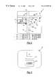
- FIG. 1is a schematic of the computer system of the present invention
- FIG. 2illustrates a first display screen of the display of FIG. 1
- FIG. 3illustrates a second display screen of the display of FIG. 1
- FIG. 4illustrates a third display screen of the display of FIG. 1 .
- the present inventionprovides a computer system 20 for creating and providing a map image according to a method of the present invention.
- the computer system 20includes first CPU 22 for creating the map image in a manner which will be discussed below.
- the first CPU 22includes a display 24 and input devices, such as a mouse 26 and/or keyboard 28 .
- the first CPU 22may be connected to a server 30 capable of operating a web site on a network, such as the Internet 32 .
- the first CPU 22is also connected to a color printer 34 .
- the first CPU 22may comprise the server 30 .
- the first CPU 22includes a microprocessor 50 accessing computer memory 52 , such as a hard drive, RAM, CD ROM, ROM, etc.
- the computer memory 52stores a value database 54 and a map program 56 .
- the value database 54associates each of a plurality of geographic locations 58 a-c with each of a plurality of values 60 a-c , respectively.
- the geographic locations 58preferably comprise street addresses, real estate parcel identification numbers, tax identification numbers, latitude/longitude or other unique identifiers for the geographic locations.
- Each value 60preferably comprises a number representing a sale price of the associated geographic location 58 . Alternatively, each value 60 could represent an appraised price, rental value or other value associated with the geographic location 58 .
- the value database 54is available from real estate listings, such as the Multiple Listing Services, local municipalities, TransAmerica or other sources.
- the map program 56associates the geographic locations 58 with coordinates 64 a-c on a digital street map image 66 .
- suitable map programs 56are available from Arcview with suitable databases and street map images 66 from ETAK or Geographic Data Technology. If the geographic location 58 is in the form of a street address, the map program 56 may first convert it to latitude/longitude information 62 a-c in order to associate it with the street map image 66 . Other known programs can directly associate street address information to coordinates on the street map image 66 .
- Information stored on the server 30is available to users via the Internet 32 utilizing a CPU 72 including a display 74 and input devices, such as a mouse 76 and/or a keyboard 78 .
- the microprocessor 50 of the first CPU 22is programmed with suitable software to perform the functions described herein, as are the server 30 , CPU 72 and ISP 44 .
- the first CPU 22is programmed to create a map image 80 shown in FIG. 2 .
- the map image 80includes a plurality of symbols 82 a-h displayed around a plurality of streets 84 , 86 and 88 from the digital street map image 66 (FIG. 1 ).
- Each of the symbols 82is associated with a sub-range of values.
- the location of the symbol 82 on the map image 80corresponds to a geographic location.
- the symbol 82 displayedindicates the value of the geographic location at which the symbol 82 is displayed.
- a legend 90is preferably displayed adjacent the map image 80 .
- the symbols 82include a plurality of shapes, each displayed in one of a plurality of colors. Although only four shapes and two colors are shown in FIG.
- Colors and shapescould be constant across all geographic areas or alternatively, colors and shapes could be assigned to ranges and subranges based upon the range of values in the geographic area. The size of each range and subrange could also vary based upon the values in the geographic area displayed.
- colors and shapescould be constant across all geographic areas or alternatively, colors and shapes could be assigned to ranges and subranges based upon the range of values in the geographic area. The size of each range and subrange could also vary based upon the values in the geographic area displayed.
- One of reasonable skill in the art and familiar with computerscould select appropriate colors.
- Each coloris associated with a range of values.
- the white symbols 82 a-dare associated with values between $170,001 to $210,000 and the black symbols 82 e-h are associated with the values of $210,001 and above.
- the ranges of valueare broken into sub-ranges, each associated with a shape.
- the white circle symbol 82 ais associated with values between $170,001 to $180,000
- the white square symbol 82 bis associated with values from $180,001 to $190,000 and so on as shown in the legend 90 of FIG. 2 .
- an observer of the map image 80 of FIG. 2quickly and efficiently ascertains general trends in values based upon colors in certain areas on the map image 80 , which includes a certain geographic area. After discerning general trends (if any) between geographic location and values, a user can discern values more specifically, i.e., into the sub-ranges, by observing the specific shapes of the symbols 82 within each color.
- map image 80could be displayed on a computer display, such as the computer displays 24 , 74 of FIG. 1 or printed on paper, such as by the printer 34 of FIG. 1 .
- a usercould select additional information about any of the geographic locations associated with a symbol 82 . For example, by moving a cursor 96 over the symbol 82 b , a pop-up display 98 appears adjacent the symbol 82 b , indicating additional information regarding the geographic location associated with symbol 82 b , such as street address, exact value and/or date of the sale.
- map image 80 of FIG. 2preferably, the user can selectively change the scale of the map image 80 and select different geographic areas in a manner similar to known computer map display programs.
- the map image 80 of FIG. 2is created by the first CPU 22 of FIG. 1 .
- the method of creating the map image 80 of the present inventionwill be described with respect to FIGS. 1 and 2.
- the first CPU 22associates each of the plurality of symbols 82 a- h with a sub-range of values, associating each color with a range and each shape within each color with a sub-range, generally as shown in the legend 90 of FIG. 2 .
- the CPU 22then reads the value database 54 and associates one of the plurality of symbols 82 with each street address 58 in the value database 54 .
- Each symbol 82may be used for more than one coordinate 64 , as more than one real estate parcel falls within the associated sub-range.
- the map program 56 and the CPU 22then convert or correlate the street addresses 58 to latitude/longitude information 62 .
- the latitude/longitude information 62is then converted or correlated to coordinates 64 on the computer street image 66 .
- the CPU 22 and map program 56may directly convert or correlate the street addresses 58 to the coordinates 64 .
- the geographic locations 58may be latitude/longitude information 62 .
- street address 58 ais associated with value 60 a , latitude/longitude information 62 a and coordinate 64 a .
- street address 58 b , value 60 b , latitude/longitude information 62 b and coordinates 64 bare also associated, and so on.
- the CPU 22then generates the map image 80 , displaying the street image 66 with the symbols 82 displayed at their associated coordinates 64 on the street image 66 , as shown in FIG. 2 .
- street address 58 a(“ 123 Oak”) is associated with a value 60 a of $186,000.
- CPU 22associates symbol 82 b ($180,001-190,000) with street address 58 a .
- CPU 22also determines that symbol 82 b should be displayed at coordinates x a ,y b . This is demonstrated in FIGS. 1 and 2. Coordinates x a ,y b on street image 66 correspond to the proper geographic location on the map image 80 relative to the streets 84 , 86 , 88 .
- the geographic area selection screendisplays a plurality of geographic areas 100 a-c , each associated with a map image, including map image 80 of FIG. 2 .
- an advertisement screen 102is preferably displayed on the user's display 74 .
- the advertisement screen 102includes an ad 104 and/or Internet link 106 .
- the ad 104 and/or link 106is for a product and/or service related to the associated geographic area 100 (FIG. 3 ).
- the ad 104 and/or link 106is also related to the purchase, sale or ownership of real estate, such as realtors, mortgage brokers, etc.
- the ad screenalso includes a link 108 to the map image screen shown in FIG. 2 .
- the usercould enter a starting address on the user's CPU 22 to select a geographic area in a manner similar to known computer map and driving instruction programs.
Landscapes
- Engineering & Computer Science (AREA)
- Business, Economics & Management (AREA)
- Theoretical Computer Science (AREA)
- Physics & Mathematics (AREA)
- Accounting & Taxation (AREA)
- General Physics & Mathematics (AREA)
- Strategic Management (AREA)
- Finance (AREA)
- Development Economics (AREA)
- Educational Technology (AREA)
- Life Sciences & Earth Sciences (AREA)
- Mathematical Physics (AREA)
- Entrepreneurship & Innovation (AREA)
- Educational Administration (AREA)
- Game Theory and Decision Science (AREA)
- Ecology (AREA)
- Economics (AREA)
- Marketing (AREA)
- General Business, Economics & Management (AREA)
- Instructional Devices (AREA)
Abstract
Description
Claims (23)
Priority Applications (4)
| Application Number | Priority Date | Filing Date | Title |
|---|---|---|---|
| US09/286,922US6323885B1 (en) | 1998-09-18 | 1999-04-06 | Real estate value map computer system |
| US10/044,583US8046715B2 (en) | 1998-09-18 | 2001-11-09 | Real estate value map computer system |
| US12/367,340US8056017B2 (en) | 1998-09-18 | 2009-02-06 | Real estate value map computer system |
| US13/235,030US20120011471A1 (en) | 1998-09-18 | 2011-09-16 | Real estate value map computer system |
Applications Claiming Priority (2)
| Application Number | Priority Date | Filing Date | Title |
|---|---|---|---|
| US10083198P | 1998-09-18 | 1998-09-18 | |
| US09/286,922US6323885B1 (en) | 1998-09-18 | 1999-04-06 | Real estate value map computer system |
Related Child Applications (1)
| Application Number | Title | Priority Date | Filing Date |
|---|---|---|---|
| US10/044,583Continuation-In-PartUS8046715B2 (en) | 1998-09-18 | 2001-11-09 | Real estate value map computer system |
Publications (1)
| Publication Number | Publication Date |
|---|---|
| US6323885B1true US6323885B1 (en) | 2001-11-27 |
Family
ID=26797593
Family Applications (2)
| Application Number | Title | Priority Date | Filing Date |
|---|---|---|---|
| US09/286,922Expired - LifetimeUS6323885B1 (en) | 1998-09-18 | 1999-04-06 | Real estate value map computer system |
| US13/235,030AbandonedUS20120011471A1 (en) | 1998-09-18 | 2011-09-16 | Real estate value map computer system |
Family Applications After (1)
| Application Number | Title | Priority Date | Filing Date |
|---|---|---|---|
| US13/235,030AbandonedUS20120011471A1 (en) | 1998-09-18 | 2011-09-16 | Real estate value map computer system |
Country Status (1)
| Country | Link |
|---|---|
| US (2) | US6323885B1 (en) |
Cited By (78)
| Publication number | Priority date | Publication date | Assignee | Title |
|---|---|---|---|---|
| US20020029226A1 (en)* | 2000-09-05 | 2002-03-07 | Gang Li | Method for combining data with maps |
| US6405129B1 (en)* | 2000-11-29 | 2002-06-11 | Alpine Electronics, Inc. | Method of displaying POI icons for navigation apparatus |
| US20020117481A1 (en)* | 2001-02-16 | 2002-08-29 | Mark Unrath | On-the-fly beam path error correction for memory link processing |
| US20020184064A1 (en)* | 2001-06-01 | 2002-12-05 | International Business Machines Corporation | Business providing a service by cross-referencing a postal address to a location provided by a position locator |
| US20030011599A1 (en)* | 2001-07-10 | 2003-01-16 | Mike Du | 3-D map data visualization |
| US6636803B1 (en)* | 2001-11-30 | 2003-10-21 | Corus Home Realty | Real-estate information search and retrieval system |
| US20030214537A1 (en)* | 2002-05-16 | 2003-11-20 | Heloise Bloxsom Lynn | Method for displaying multi-dimensional data values |
| US20040021584A1 (en)* | 2001-11-30 | 2004-02-05 | Hartz Daniel K. | Market status icons in real-estate information search and retrieval system |
| US20040122684A1 (en)* | 2002-12-18 | 2004-06-24 | Nokia Corp. | Method and apparatus for a call cost indicator |
| US20040220906A1 (en)* | 2003-04-30 | 2004-11-04 | Ullas Gargi | Systems and methods for location-based real estate service |
| US20050060299A1 (en)* | 2003-09-17 | 2005-03-17 | George Filley | Location-referenced photograph repository |
| US20050091097A1 (en)* | 2004-10-21 | 2005-04-28 | Jose De Sousa | Property Value Map System |
| US20050108025A1 (en)* | 2003-11-14 | 2005-05-19 | First American Real Estate Solutions, L.P. | Method for mortgage fraud detection |
| US20050171822A1 (en)* | 2004-02-03 | 2005-08-04 | First American Real Estate Solutions, L.P. | Responsive confidence scoring method for a proposed valuation of aproperty |
| US20050231392A1 (en)* | 2004-04-16 | 2005-10-20 | Meehan Andrew M | System and method for representation of business information |
| US20050251331A1 (en)* | 2004-04-20 | 2005-11-10 | Keith Kreft | Information mapping approaches |
| US20050288955A1 (en)* | 2004-06-29 | 2005-12-29 | Shark Hunter, L.L.C. | Real estate transaction automation system and method |
| US20060015357A1 (en)* | 2004-07-16 | 2006-01-19 | First American Real Estate Solutions, L.P. | Method and apparatus for spatiotemporal valuation of real estate |
| US20060085234A1 (en)* | 2004-09-17 | 2006-04-20 | First American Real Estate Solutions, L.P. | Method and apparatus for constructing a forecast standard deviation for automated valuation modeling |
| US7080096B1 (en)* | 1999-11-02 | 2006-07-18 | Matsushita Electric Works, Ltd. | Housing space-related commodity sale assisting system, housing space-related commodity sale assisting method, program for assisting housing space-related commodity sale, and computer-readable recorded medium on which program for assisting housing space-related commodity sale is recorded |
| US20060212577A1 (en)* | 2005-11-09 | 2006-09-21 | Axel Kohnke | Method and deivce for network operator information retrieval |
| US20060271472A1 (en)* | 2005-05-24 | 2006-11-30 | First American Real Estate Solutions, L.P. | Method and apparatus for advanced mortgage diagnostic analytics |
| US20070033122A1 (en)* | 2005-08-04 | 2007-02-08 | First American Real Estate Solutions, Lp | Method and apparatus for computing selection criteria for an automated valuation model |
| US20070050263A1 (en)* | 2003-08-26 | 2007-03-01 | Kiyoto Horimoto | Real estate sales/purchase system |
| US7207009B1 (en)* | 2000-11-01 | 2007-04-17 | Microsoft Corporation | Method and system for displaying an image instead of data |
| US20070288312A1 (en)* | 2006-03-31 | 2007-12-13 | Caliber Data, Inc. | Purchase-transaction-settled online consumer referral and reward service using real-time specific merchant sales information |
| US20080059562A1 (en)* | 2006-09-05 | 2008-03-06 | Jones Brad G | Method and system for localized information retrieval |
| US20080079808A1 (en)* | 2006-09-29 | 2008-04-03 | Jeffrey Michael Ashlock | Method and device for collection and application of photographic images related to geographic location |
| US20080109756A1 (en)* | 2006-09-29 | 2008-05-08 | Stambaugh Thomas M | Spatial organization and display of real-estate information |
| US7388519B1 (en) | 2003-07-22 | 2008-06-17 | Kreft Keith A | Displaying points of interest with qualitative information |
| US20080154785A1 (en)* | 2006-12-24 | 2008-06-26 | Narinder Pal Sandhu | Real Estate Web Platform providing intelligent guidance to investors to maximize their returns by enabling them to use tiny- simple applications that can be used standalone or mixed and matched |
| US20080168369A1 (en)* | 2006-12-27 | 2008-07-10 | Re Infolink A California Corporation | Methods and Systems of Online Mapping and Planning Driving Tours |
| US20080177671A1 (en)* | 2007-01-22 | 2008-07-24 | Narinder Pal Sandhu | Accelerated depreciation of separated assets with valuation guidance based on electronic market survey of electronic web and non-web marketplaces, tiny simple application (called a T-sap) used with a Real Estate Web Platform to provide intelligent guidance to investors to maximize their returns by enabling them to use tiny- simple applications that can be used standalone or mixed and matched. |
| US20080195554A1 (en)* | 2007-02-12 | 2008-08-14 | Narinder Pal Sandhu | Tool to find deductions from HUD settlement statement that can be used by a stand alone system or be used with a Real Estate Web Platform |
| US20080281514A1 (en)* | 2007-05-11 | 2008-11-13 | Palmetto Posting, Inc. | System and method for notice posting and verification |
| US20080319938A1 (en)* | 2007-01-22 | 2008-12-25 | Jeffrey Rabinovich | System and method for identifying prospects for mortgage refinancing |
| US20090012803A1 (en)* | 2007-07-05 | 2009-01-08 | Bishop Iii Moye Lynwood | System and method for real estate spatial data analysis |
| US20090132436A1 (en)* | 2007-04-17 | 2009-05-21 | Eagle View Technologies, Inc. | Aerial roof estimation systems and methods |
| US20090202101A1 (en)* | 2008-02-12 | 2009-08-13 | Dycom Technology, Llc | Electronic manifest of underground facility locate marks |
| US20090265285A1 (en)* | 2007-11-12 | 2009-10-22 | Balaishis David M | Apparatus, method, and computer program product for characterizing user-defined areas |
| US20100010887A1 (en)* | 2006-03-31 | 2010-01-14 | Jon Karlin | Contingent fee advertisement publishing service provider for interactive tv media system and method |
| US7680594B2 (en) | 2004-04-06 | 2010-03-16 | Honda Motor Co., Ltd. | Display method and system for a vehicle navigation system |
| US7693765B2 (en) | 2004-11-30 | 2010-04-06 | Michael Dell Orfano | System and method for creating electronic real estate registration |
| US20100114537A1 (en)* | 2008-10-31 | 2010-05-06 | Eagle View Technologies, Inc. | Concurrent display systems and methods for aerial roof estimation |
| US20100110074A1 (en)* | 2008-10-31 | 2010-05-06 | Eagle View Technologies, Inc. | Pitch determination systems and methods for aerial roof estimation |
| US20100121680A1 (en)* | 2008-09-09 | 2010-05-13 | Propel Biofuels, Inc. | Method and system for identifying installation sites of alternative fuel stations |
| US7809635B2 (en) | 2005-08-05 | 2010-10-05 | Corelogic Information Solutions, Inc. | Method and system for updating a loan portfolio with information on secondary liens |
| US7818121B2 (en) | 2004-04-06 | 2010-10-19 | Honda Motor Co., Ltd. | Route calculation method for a vehicle navigation system |
| US20110082730A1 (en)* | 2006-03-31 | 2011-04-07 | Jon Karlin | Unified subscription system and method for rewarding local shopper loyalty and platform for transitioning publishers |
| US8055578B1 (en)* | 2001-12-28 | 2011-11-08 | Fannie Mae | Geographic information system for depicting information relating to mortgage lending activity |
| US8099308B2 (en) | 2007-10-02 | 2012-01-17 | Honda Motor Co., Ltd. | Method and system for vehicle service appointments based on diagnostic trouble codes |
| US8135804B2 (en) | 2009-07-07 | 2012-03-13 | Honda Motor Co., Ltd. | Method for scheduling and rescheduling vehicle service appointments |
| US20120191571A1 (en)* | 1999-04-06 | 2012-07-26 | Robert Deans | Method and system for offering and managing an exchanging of property |
| CN101800949B (en)* | 2009-12-31 | 2012-08-15 | 华为终端有限公司 | Method for providing call tariff information, ring-back tone equipment and terminal |
| US8401222B2 (en) | 2009-05-22 | 2013-03-19 | Pictometry International Corp. | System and process for roof measurement using aerial imagery |
| US20130191295A1 (en)* | 2004-08-31 | 2013-07-25 | Mv Patents, Llc | Method of Receiving a List of Links to Street View Data of Real Estate Properties |
| US20140100893A1 (en)* | 1998-05-07 | 2014-04-10 | Empire Ip Llc | Real estate disclosure reporting method |
| US8731234B1 (en) | 2008-10-31 | 2014-05-20 | Eagle View Technologies, Inc. | Automated roof identification systems and methods |
| US8774525B2 (en) | 2012-02-03 | 2014-07-08 | Eagle View Technologies, Inc. | Systems and methods for estimation of building floor area |
| US9076185B2 (en) | 2004-11-30 | 2015-07-07 | Michael Dell Orfano | System and method for managing electronic real estate registry information |
| US9501700B2 (en) | 2012-02-15 | 2016-11-22 | Xactware Solutions, Inc. | System and method for construction estimation using aerial images |
| US9599466B2 (en) | 2012-02-03 | 2017-03-21 | Eagle View Technologies, Inc. | Systems and methods for estimation of building wall area |
| US9679227B2 (en) | 2013-08-02 | 2017-06-13 | Xactware Solutions, Inc. | System and method for detecting features in aerial images using disparity mapping and segmentation techniques |
| US9736618B1 (en) | 2005-04-04 | 2017-08-15 | X One, Inc. | Techniques for sharing relative position between mobile devices |
| US9911228B2 (en) | 2010-02-01 | 2018-03-06 | Eagle View Technologies, Inc. | Geometric correction of rough wireframe models derived from photographs |
| US9933257B2 (en) | 2012-02-03 | 2018-04-03 | Eagle View Technologies, Inc. | Systems and methods for estimation of building wall area |
| US9953370B2 (en) | 2012-02-03 | 2018-04-24 | Eagle View Technologies, Inc. | Systems and methods for performing a risk management assessment of a property |
| US9959581B2 (en) | 2013-03-15 | 2018-05-01 | Eagle View Technologies, Inc. | Property management on a smartphone |
| US10102597B1 (en) | 2006-10-30 | 2018-10-16 | The MLSOnline.com, Inc. | Internet based interactive graphical interface for real estate listings |
| US20190171685A1 (en)* | 2010-07-01 | 2019-06-06 | Visipick, Llc | Comparing items using a displayed diagram |
| US10503843B2 (en) | 2017-12-19 | 2019-12-10 | Eagle View Technologies, Inc. | Supervised automatic roof modeling |
| US10528960B2 (en) | 2007-04-17 | 2020-01-07 | Eagle View Technologies, Inc. | Aerial roof estimation system and method |
| US10663294B2 (en) | 2012-02-03 | 2020-05-26 | Eagle View Technologies, Inc. | Systems and methods for estimation of building wall area and producing a wall estimation report |
| US10909482B2 (en) | 2013-03-15 | 2021-02-02 | Pictometry International Corp. | Building materials estimation |
| US11094113B2 (en) | 2019-12-04 | 2021-08-17 | Geomni, Inc. | Systems and methods for modeling structures using point clouds derived from stereoscopic image pairs |
| US11164256B2 (en) | 2013-03-15 | 2021-11-02 | Eagle View Technologies, Inc. | Price estimation model |
| US12140419B2 (en) | 2012-02-03 | 2024-11-12 | Eagle View Technologies, Inc. | Systems and methods for estimation of building wall area and producing a wall estimation report |
| US12332660B2 (en) | 2018-11-21 | 2025-06-17 | Eagle View Technologies, Inc. | Navigating unmanned aircraft using pitch |
Families Citing this family (3)
| Publication number | Priority date | Publication date | Assignee | Title |
|---|---|---|---|---|
| TWI573087B (en)* | 2015-10-19 | 2017-03-01 | shu-zhen Lin | Housing Intermediary Service Online Ranking System |
| TWI703528B (en)* | 2018-01-15 | 2020-09-01 | 玉山商業銀行股份有限公司 | Method for visualizing operational performance of automated teller machine |
| CN109783088A (en)* | 2018-12-29 | 2019-05-21 | 北京辰安科技股份有限公司 | Based on customization emergency maps sign webgis display methods and device |
Citations (8)
| Publication number | Priority date | Publication date | Assignee | Title |
|---|---|---|---|---|
| US5032989A (en)* | 1986-03-19 | 1991-07-16 | Realpro, Ltd. | Real estate search and location system and method |
| US5559707A (en)* | 1994-06-24 | 1996-09-24 | Delorme Publishing Company | Computer aided routing system |
| US5731997A (en)* | 1996-03-19 | 1998-03-24 | Trimble Navigation Limited | Method and apparatus for collecting recording and displaying data pertaining to an artifact |
| US5781773A (en)* | 1995-05-10 | 1998-07-14 | Minnesota Mining And Manufacturing Company | Method for transforming and storing data for search and display and a searching system utilized therewith |
| US5794216A (en)* | 1995-07-14 | 1998-08-11 | Brown; Timothy Robert | Methods and system for data acquisition in a multimedia real estate database |
| US5852810A (en)* | 1996-01-29 | 1998-12-22 | Student Housing Network | Geographic specific information search system and method |
| US5991769A (en)* | 1995-02-13 | 1999-11-23 | Pulte Home Corporation | System for facilitating home construction and sales |
| US6219053B1 (en)* | 1998-02-09 | 2001-04-17 | Fujitsu Limited | Icon display and method which reflect the intuitive perspective of correlation between icons which have hierarchical relationships |
Family Cites Families (8)
| Publication number | Priority date | Publication date | Assignee | Title |
|---|---|---|---|---|
| US5479603A (en)* | 1993-07-21 | 1995-12-26 | Xerox Corporation | Method and apparatus for producing a composite second image in the spatial context of a first image |
| US5532838A (en)* | 1993-12-27 | 1996-07-02 | Barbari; Edward P. | Method & apparatus for dynamically creating and transmitting documents via facsimile equipment |
| US6025843A (en)* | 1996-09-06 | 2000-02-15 | Peter Sklar | Clustering user interface |
| US5961573A (en)* | 1996-11-22 | 1999-10-05 | Case Corporation | Height control of an agricultural tool in a site-specific farming system |
| US6029106A (en)* | 1996-11-22 | 2000-02-22 | Case Corporation | Global position correction for the electronic display of field maps |
| US6026309A (en)* | 1997-10-22 | 2000-02-15 | Ericsson Inc. | Apparatus and method for visually monitoring status of a telephone call on a portable intelligent communications device |
| AU2004201587B2 (en)* | 2004-04-16 | 2006-04-27 | Forge Research Pty Limited | A system and method for representation of business information |
| US8095434B1 (en)* | 2007-12-17 | 2012-01-10 | Zillow, Inc. | Automatically performing varying levels of summarization of geographic data points in response to a user's selection of zoom level |
- 1999
- 1999-04-06USUS09/286,922patent/US6323885B1/ennot_activeExpired - Lifetime
- 2011
- 2011-09-16USUS13/235,030patent/US20120011471A1/ennot_activeAbandoned
Patent Citations (8)
| Publication number | Priority date | Publication date | Assignee | Title |
|---|---|---|---|---|
| US5032989A (en)* | 1986-03-19 | 1991-07-16 | Realpro, Ltd. | Real estate search and location system and method |
| US5559707A (en)* | 1994-06-24 | 1996-09-24 | Delorme Publishing Company | Computer aided routing system |
| US5991769A (en)* | 1995-02-13 | 1999-11-23 | Pulte Home Corporation | System for facilitating home construction and sales |
| US5781773A (en)* | 1995-05-10 | 1998-07-14 | Minnesota Mining And Manufacturing Company | Method for transforming and storing data for search and display and a searching system utilized therewith |
| US5794216A (en)* | 1995-07-14 | 1998-08-11 | Brown; Timothy Robert | Methods and system for data acquisition in a multimedia real estate database |
| US5852810A (en)* | 1996-01-29 | 1998-12-22 | Student Housing Network | Geographic specific information search system and method |
| US5731997A (en)* | 1996-03-19 | 1998-03-24 | Trimble Navigation Limited | Method and apparatus for collecting recording and displaying data pertaining to an artifact |
| US6219053B1 (en)* | 1998-02-09 | 2001-04-17 | Fujitsu Limited | Icon display and method which reflect the intuitive perspective of correlation between icons which have hierarchical relationships |
Cited By (170)
| Publication number | Priority date | Publication date | Assignee | Title |
|---|---|---|---|---|
| US20140100893A1 (en)* | 1998-05-07 | 2014-04-10 | Empire Ip Llc | Real estate disclosure reporting method |
| US20120191571A1 (en)* | 1999-04-06 | 2012-07-26 | Robert Deans | Method and system for offering and managing an exchanging of property |
| US8515827B2 (en)* | 1999-04-06 | 2013-08-20 | Robert Deans | Method and system for offering and managing an exchanging of property |
| US7080096B1 (en)* | 1999-11-02 | 2006-07-18 | Matsushita Electric Works, Ltd. | Housing space-related commodity sale assisting system, housing space-related commodity sale assisting method, program for assisting housing space-related commodity sale, and computer-readable recorded medium on which program for assisting housing space-related commodity sale is recorded |
| US20060232605A1 (en)* | 1999-11-02 | 2006-10-19 | Matsushita Electric Works, Ltd. | Housing-related commodity sales support system, housing-related commodity sales support method, housing-related commodity sales support program, and computer-readable storage medium storing such program |
| US20020029226A1 (en)* | 2000-09-05 | 2002-03-07 | Gang Li | Method for combining data with maps |
| US20070150389A1 (en)* | 2000-11-01 | 2007-06-28 | Microsoft Corporation | Method and system for displaying an image instead of data |
| US7207009B1 (en)* | 2000-11-01 | 2007-04-17 | Microsoft Corporation | Method and system for displaying an image instead of data |
| US8429554B2 (en)* | 2000-11-01 | 2013-04-23 | Microsoft Corporation | Method and system for displaying an image instead of data |
| US6405129B1 (en)* | 2000-11-29 | 2002-06-11 | Alpine Electronics, Inc. | Method of displaying POI icons for navigation apparatus |
| US20020117481A1 (en)* | 2001-02-16 | 2002-08-29 | Mark Unrath | On-the-fly beam path error correction for memory link processing |
| US20020184064A1 (en)* | 2001-06-01 | 2002-12-05 | International Business Machines Corporation | Business providing a service by cross-referencing a postal address to a location provided by a position locator |
| US20030011599A1 (en)* | 2001-07-10 | 2003-01-16 | Mike Du | 3-D map data visualization |
| US6836270B2 (en)* | 2001-07-10 | 2004-12-28 | Geojet Information Solutions, Inc. | 3-D map data visualization |
| US20040021584A1 (en)* | 2001-11-30 | 2004-02-05 | Hartz Daniel K. | Market status icons in real-estate information search and retrieval system |
| US6636803B1 (en)* | 2001-11-30 | 2003-10-21 | Corus Home Realty | Real-estate information search and retrieval system |
| US8055578B1 (en)* | 2001-12-28 | 2011-11-08 | Fannie Mae | Geographic information system for depicting information relating to mortgage lending activity |
| US20030214537A1 (en)* | 2002-05-16 | 2003-11-20 | Heloise Bloxsom Lynn | Method for displaying multi-dimensional data values |
| US20040122684A1 (en)* | 2002-12-18 | 2004-06-24 | Nokia Corp. | Method and apparatus for a call cost indicator |
| US8051089B2 (en) | 2003-04-30 | 2011-11-01 | Hewlett-Packard Development Company, L.P. | Systems and methods for location-based real estate service |
| US20040220906A1 (en)* | 2003-04-30 | 2004-11-04 | Ullas Gargi | Systems and methods for location-based real estate service |
| US7388519B1 (en) | 2003-07-22 | 2008-06-17 | Kreft Keith A | Displaying points of interest with qualitative information |
| US20070050263A1 (en)* | 2003-08-26 | 2007-03-01 | Kiyoto Horimoto | Real estate sales/purchase system |
| US8116598B2 (en) | 2003-09-17 | 2012-02-14 | Navteq B.V. | Location-referenced photograph repository |
| US20100128935A1 (en)* | 2003-09-17 | 2010-05-27 | Navteq North America, Llc | Location-referenced Photograph Repository |
| US20050060299A1 (en)* | 2003-09-17 | 2005-03-17 | George Filley | Location-referenced photograph repository |
| US7599882B2 (en) | 2003-11-14 | 2009-10-06 | First American Corelogic, Inc. | Method for mortgage fraud detection |
| US20050108025A1 (en)* | 2003-11-14 | 2005-05-19 | First American Real Estate Solutions, L.P. | Method for mortgage fraud detection |
| US20100088242A1 (en)* | 2003-11-14 | 2010-04-08 | First American Corelogic, Inc. | Method for mortgage fraud detection |
| US20050171822A1 (en)* | 2004-02-03 | 2005-08-04 | First American Real Estate Solutions, L.P. | Responsive confidence scoring method for a proposed valuation of aproperty |
| US8204688B2 (en) | 2004-04-06 | 2012-06-19 | Honda Motor Co., Ltd. | Display method and system for a vehicle navigation system |
| US7877206B2 (en) | 2004-04-06 | 2011-01-25 | Honda Motor Co., Ltd. | Display method and system for a vehicle navigation system |
| US7881863B2 (en) | 2004-04-06 | 2011-02-01 | Honda Motor Co., Ltd. | Route calculation method for a vehicle navigation system |
| US7818121B2 (en) | 2004-04-06 | 2010-10-19 | Honda Motor Co., Ltd. | Route calculation method for a vehicle navigation system |
| US7979206B2 (en) | 2004-04-06 | 2011-07-12 | Honda Motor Co., Ltd. | Route calculation method for a vehicle navigation system |
| US8005609B2 (en) | 2004-04-06 | 2011-08-23 | Honda Motor Co., Ltd. | Route calculation method for a vehicle navigation system |
| US8046166B2 (en) | 2004-04-06 | 2011-10-25 | Honda Motor Co., Ltd. | Display method and system for a vehicle navigation system |
| US7680594B2 (en) | 2004-04-06 | 2010-03-16 | Honda Motor Co., Ltd. | Display method and system for a vehicle navigation system |
| US8055443B1 (en) | 2004-04-06 | 2011-11-08 | Honda Motor Co., Ltd. | Route calculation method for a vehicle navigation system |
| US20080238925A1 (en)* | 2004-04-16 | 2008-10-02 | Forge Information Technology Pty Ltd | System and method for representation of business information |
| US20050231392A1 (en)* | 2004-04-16 | 2005-10-20 | Meehan Andrew M | System and method for representation of business information |
| US12189666B2 (en) | 2004-04-20 | 2025-01-07 | Never-Search, Inc. | Information mapping approaches |
| US7373244B2 (en) | 2004-04-20 | 2008-05-13 | Keith Kreft | Information mapping approaches |
| US9152981B2 (en) | 2004-04-20 | 2015-10-06 | Never-Search, Inc. | Information mapping approaches |
| US8219318B2 (en) | 2004-04-20 | 2012-07-10 | Never-Search, Inc. | Information mapping approaches |
| US20090327071A1 (en)* | 2004-04-20 | 2009-12-31 | Keith Kreft | Information mapping approaches |
| US8649976B2 (en) | 2004-04-20 | 2014-02-11 | Never-Search, Inc. | Information mapping approaches |
| US11372903B2 (en) | 2004-04-20 | 2022-06-28 | Never-Search, Inc. | Systems and methods for providing mapping information |
| US9177330B2 (en) | 2004-04-20 | 2015-11-03 | Never-Search, Inc. | Information mapping approaches |
| US20050251331A1 (en)* | 2004-04-20 | 2005-11-10 | Keith Kreft | Information mapping approaches |
| US20050288955A1 (en)* | 2004-06-29 | 2005-12-29 | Shark Hunter, L.L.C. | Real estate transaction automation system and method |
| US20060015357A1 (en)* | 2004-07-16 | 2006-01-19 | First American Real Estate Solutions, L.P. | Method and apparatus for spatiotemporal valuation of real estate |
| US20130191295A1 (en)* | 2004-08-31 | 2013-07-25 | Mv Patents, Llc | Method of Receiving a List of Links to Street View Data of Real Estate Properties |
| US20060085234A1 (en)* | 2004-09-17 | 2006-04-20 | First American Real Estate Solutions, L.P. | Method and apparatus for constructing a forecast standard deviation for automated valuation modeling |
| US20050091097A1 (en)* | 2004-10-21 | 2005-04-28 | Jose De Sousa | Property Value Map System |
| US7693765B2 (en) | 2004-11-30 | 2010-04-06 | Michael Dell Orfano | System and method for creating electronic real estate registration |
| US20100198714A1 (en)* | 2004-11-30 | 2010-08-05 | Michael Dell Orfano | System and method for creating electronic real estate registration |
| US9076185B2 (en) | 2004-11-30 | 2015-07-07 | Michael Dell Orfano | System and method for managing electronic real estate registry information |
| US8160944B2 (en) | 2004-11-30 | 2012-04-17 | Michael Dell Orfano | System and method for creating electronic real estate registration |
| US10313826B2 (en) | 2005-04-04 | 2019-06-04 | X One, Inc. | Location sharing and map support in connection with services request |
| US10200811B1 (en) | 2005-04-04 | 2019-02-05 | X One, Inc. | Map presentation on cellular device showing positions of multiple other wireless device users |
| US9736618B1 (en) | 2005-04-04 | 2017-08-15 | X One, Inc. | Techniques for sharing relative position between mobile devices |
| US9749790B1 (en) | 2005-04-04 | 2017-08-29 | X One, Inc. | Rendez vous management using mobile phones or other mobile devices |
| US9854402B1 (en) | 2005-04-04 | 2017-12-26 | X One, Inc. | Formation of wireless device location sharing group |
| US9854394B1 (en) | 2005-04-04 | 2017-12-26 | X One, Inc. | Ad hoc location sharing group between first and second cellular wireless devices |
| US11778415B2 (en) | 2005-04-04 | 2023-10-03 | Xone, Inc. | Location sharing application in association with services provision |
| US9883360B1 (en) | 2005-04-04 | 2018-01-30 | X One, Inc. | Rendez vous management using mobile phones or other mobile devices |
| US9942705B1 (en) | 2005-04-04 | 2018-04-10 | X One, Inc. | Location sharing group for services provision |
| US11356799B2 (en) | 2005-04-04 | 2022-06-07 | X One, Inc. | Fleet location sharing application in association with services provision |
| US10856099B2 (en) | 2005-04-04 | 2020-12-01 | X One, Inc. | Application-based two-way tracking and mapping function with selected individuals |
| US10791414B2 (en) | 2005-04-04 | 2020-09-29 | X One, Inc. | Location sharing for commercial and proprietary content applications |
| US10750310B2 (en) | 2005-04-04 | 2020-08-18 | X One, Inc. | Temporary location sharing group with event based termination |
| US10750311B2 (en) | 2005-04-04 | 2020-08-18 | X One, Inc. | Application-based tracking and mapping function in connection with vehicle-based services provision |
| US10750309B2 (en) | 2005-04-04 | 2020-08-18 | X One, Inc. | Ad hoc location sharing group establishment for wireless devices with designated meeting point |
| US9955298B1 (en) | 2005-04-04 | 2018-04-24 | X One, Inc. | Methods, systems and apparatuses for the formation and tracking of location sharing groups |
| US10341808B2 (en) | 2005-04-04 | 2019-07-02 | X One, Inc. | Location sharing for commercial and proprietary content applications |
| US10341809B2 (en) | 2005-04-04 | 2019-07-02 | X One, Inc. | Location sharing with facilitated meeting point definition |
| US9967704B1 (en) | 2005-04-04 | 2018-05-08 | X One, Inc. | Location sharing group map management |
| US10149092B1 (en) | 2005-04-04 | 2018-12-04 | X One, Inc. | Location sharing service between GPS-enabled wireless devices, with shared target location exchange |
| US10299071B2 (en) | 2005-04-04 | 2019-05-21 | X One, Inc. | Server-implemented methods and systems for sharing location amongst web-enabled cell phones |
| US10165059B2 (en) | 2005-04-04 | 2018-12-25 | X One, Inc. | Methods, systems and apparatuses for the formation and tracking of location sharing groups |
| US20060271472A1 (en)* | 2005-05-24 | 2006-11-30 | First American Real Estate Solutions, L.P. | Method and apparatus for advanced mortgage diagnostic analytics |
| US7853518B2 (en) | 2005-05-24 | 2010-12-14 | Corelogic Information Solutions, Inc. | Method and apparatus for advanced mortgage diagnostic analytics |
| US20070033122A1 (en)* | 2005-08-04 | 2007-02-08 | First American Real Estate Solutions, Lp | Method and apparatus for computing selection criteria for an automated valuation model |
| US7809635B2 (en) | 2005-08-05 | 2010-10-05 | Corelogic Information Solutions, Inc. | Method and system for updating a loan portfolio with information on secondary liens |
| US7873570B2 (en) | 2005-08-05 | 2011-01-18 | Corelogic Information Solutions, Inc. | Method and system for updating a loan portfolio with information on secondary liens |
| US20060212577A1 (en)* | 2005-11-09 | 2006-09-21 | Axel Kohnke | Method and deivce for network operator information retrieval |
| US9009064B2 (en)* | 2006-03-31 | 2015-04-14 | Ebay Inc. | Contingent fee advertisement publishing service provider for interactive TV media system and method |
| US20110082730A1 (en)* | 2006-03-31 | 2011-04-07 | Jon Karlin | Unified subscription system and method for rewarding local shopper loyalty and platform for transitioning publishers |
| US20100010887A1 (en)* | 2006-03-31 | 2010-01-14 | Jon Karlin | Contingent fee advertisement publishing service provider for interactive tv media system and method |
| US20070288312A1 (en)* | 2006-03-31 | 2007-12-13 | Caliber Data, Inc. | Purchase-transaction-settled online consumer referral and reward service using real-time specific merchant sales information |
| US20080059562A1 (en)* | 2006-09-05 | 2008-03-06 | Jones Brad G | Method and system for localized information retrieval |
| US20080109756A1 (en)* | 2006-09-29 | 2008-05-08 | Stambaugh Thomas M | Spatial organization and display of real-estate information |
| US20080079808A1 (en)* | 2006-09-29 | 2008-04-03 | Jeffrey Michael Ashlock | Method and device for collection and application of photographic images related to geographic location |
| US10102597B1 (en) | 2006-10-30 | 2018-10-16 | The MLSOnline.com, Inc. | Internet based interactive graphical interface for real estate listings |
| US20080154785A1 (en)* | 2006-12-24 | 2008-06-26 | Narinder Pal Sandhu | Real Estate Web Platform providing intelligent guidance to investors to maximize their returns by enabling them to use tiny- simple applications that can be used standalone or mixed and matched |
| US8166410B2 (en)* | 2006-12-27 | 2012-04-24 | Mlslistings Inc. | Methods and systems of online mapping and planning driving tours |
| US20080168369A1 (en)* | 2006-12-27 | 2008-07-10 | Re Infolink A California Corporation | Methods and Systems of Online Mapping and Planning Driving Tours |
| US20080177671A1 (en)* | 2007-01-22 | 2008-07-24 | Narinder Pal Sandhu | Accelerated depreciation of separated assets with valuation guidance based on electronic market survey of electronic web and non-web marketplaces, tiny simple application (called a T-sap) used with a Real Estate Web Platform to provide intelligent guidance to investors to maximize their returns by enabling them to use tiny- simple applications that can be used standalone or mixed and matched. |
| US20080319938A1 (en)* | 2007-01-22 | 2008-12-25 | Jeffrey Rabinovich | System and method for identifying prospects for mortgage refinancing |
| US20080195554A1 (en)* | 2007-02-12 | 2008-08-14 | Narinder Pal Sandhu | Tool to find deductions from HUD settlement statement that can be used by a stand alone system or be used with a Real Estate Web Platform |
| US8670961B2 (en) | 2007-04-17 | 2014-03-11 | Eagle View Technologies, Inc. | Aerial roof estimation systems and methods |
| US10528960B2 (en) | 2007-04-17 | 2020-01-07 | Eagle View Technologies, Inc. | Aerial roof estimation system and method |
| US9514568B2 (en) | 2007-04-17 | 2016-12-06 | Eagle View Technologies, Inc. | Aerial roof estimation systems and methods |
| US8078436B2 (en) | 2007-04-17 | 2011-12-13 | Eagle View Technologies, Inc. | Aerial roof estimation systems and methods |
| US20090132436A1 (en)* | 2007-04-17 | 2009-05-21 | Eagle View Technologies, Inc. | Aerial roof estimation systems and methods |
| US20080281514A1 (en)* | 2007-05-11 | 2008-11-13 | Palmetto Posting, Inc. | System and method for notice posting and verification |
| US8799004B2 (en) | 2007-07-05 | 2014-08-05 | Map Ip One, Llc | System and method for real estate spatial data analysis |
| US20090012803A1 (en)* | 2007-07-05 | 2009-01-08 | Bishop Iii Moye Lynwood | System and method for real estate spatial data analysis |
| US8099308B2 (en) | 2007-10-02 | 2012-01-17 | Honda Motor Co., Ltd. | Method and system for vehicle service appointments based on diagnostic trouble codes |
| US20090265285A1 (en)* | 2007-11-12 | 2009-10-22 | Balaishis David M | Apparatus, method, and computer program product for characterizing user-defined areas |
| US20090202101A1 (en)* | 2008-02-12 | 2009-08-13 | Dycom Technology, Llc | Electronic manifest of underground facility locate marks |
| US8532342B2 (en)* | 2008-02-12 | 2013-09-10 | Certusview Technologies, Llc | Electronic manifest of underground facility locate marks |
| US20100121680A1 (en)* | 2008-09-09 | 2010-05-13 | Propel Biofuels, Inc. | Method and system for identifying installation sites of alternative fuel stations |
| US20130132155A1 (en)* | 2008-09-09 | 2013-05-23 | Propel Biofuels, Inc. | Method and system for identifying installation sites of alternative fuel stations |
| US20100114537A1 (en)* | 2008-10-31 | 2010-05-06 | Eagle View Technologies, Inc. | Concurrent display systems and methods for aerial roof estimation |
| US9070018B1 (en) | 2008-10-31 | 2015-06-30 | Eagle View Technologies, Inc. | Automated roof identification systems and methods |
| US20100110074A1 (en)* | 2008-10-31 | 2010-05-06 | Eagle View Technologies, Inc. | Pitch determination systems and methods for aerial roof estimation |
| US9135737B2 (en) | 2008-10-31 | 2015-09-15 | Eagle View Technologies, Inc. | Concurrent display systems and methods for aerial roof estimation |
| US8731234B1 (en) | 2008-10-31 | 2014-05-20 | Eagle View Technologies, Inc. | Automated roof identification systems and methods |
| US8995757B1 (en) | 2008-10-31 | 2015-03-31 | Eagle View Technologies, Inc. | Automated roof identification systems and methods |
| US8825454B2 (en) | 2008-10-31 | 2014-09-02 | Eagle View Technologies, Inc. | Concurrent display systems and methods for aerial roof estimation |
| US10685149B2 (en) | 2008-10-31 | 2020-06-16 | Eagle View Technologies, Inc. | Pitch determination systems and methods for aerial roof estimation |
| US9129376B2 (en) | 2008-10-31 | 2015-09-08 | Eagle View Technologies, Inc. | Pitch determination systems and methods for aerial roof estimation |
| US8170840B2 (en) | 2008-10-31 | 2012-05-01 | Eagle View Technologies, Inc. | Pitch determination systems and methods for aerial roof estimation |
| US11030358B2 (en) | 2008-10-31 | 2021-06-08 | Eagle View Technologies, Inc. | Pitch determination systems and methods for aerial roof estimation |
| US8209152B2 (en) | 2008-10-31 | 2012-06-26 | Eagleview Technologies, Inc. | Concurrent display systems and methods for aerial roof estimation |
| US11030355B2 (en) | 2008-10-31 | 2021-06-08 | Eagle View Technologies, Inc. | Concurrent display systems and methods for aerial roof estimation |
| US8818770B2 (en) | 2008-10-31 | 2014-08-26 | Eagle View Technologies, Inc. | Pitch determination systems and methods for aerial roof estimation |
| US10197391B2 (en) | 2009-05-22 | 2019-02-05 | Pictometry International Corp. | System and process for roof measurement using imagery |
| US8401222B2 (en) | 2009-05-22 | 2013-03-19 | Pictometry International Corp. | System and process for roof measurement using aerial imagery |
| US9933254B2 (en) | 2009-05-22 | 2018-04-03 | Pictometry International Corp. | System and process for roof measurement using aerial imagery |
| US11060857B2 (en) | 2009-05-22 | 2021-07-13 | Pictometry International Corp. | System and process for roof measurement using imagery |
| US10648800B2 (en) | 2009-05-22 | 2020-05-12 | Pictometry International Corp. | System and process for roof measurement using imagery |
| US8135804B2 (en) | 2009-07-07 | 2012-03-13 | Honda Motor Co., Ltd. | Method for scheduling and rescheduling vehicle service appointments |
| CN101800949B (en)* | 2009-12-31 | 2012-08-15 | 华为终端有限公司 | Method for providing call tariff information, ring-back tone equipment and terminal |
| US11423614B2 (en) | 2010-02-01 | 2022-08-23 | Eagle View Technologies, Inc. | Geometric correction of rough wireframe models derived from photographs |
| US9911228B2 (en) | 2010-02-01 | 2018-03-06 | Eagle View Technologies, Inc. | Geometric correction of rough wireframe models derived from photographs |
| US20190171685A1 (en)* | 2010-07-01 | 2019-06-06 | Visipick, Llc | Comparing items using a displayed diagram |
| US9933257B2 (en) | 2012-02-03 | 2018-04-03 | Eagle View Technologies, Inc. | Systems and methods for estimation of building wall area |
| US12140419B2 (en) | 2012-02-03 | 2024-11-12 | Eagle View Technologies, Inc. | Systems and methods for estimation of building wall area and producing a wall estimation report |
| US10515414B2 (en) | 2012-02-03 | 2019-12-24 | Eagle View Technologies, Inc. | Systems and methods for performing a risk management assessment of a property |
| US8774525B2 (en) | 2012-02-03 | 2014-07-08 | Eagle View Technologies, Inc. | Systems and methods for estimation of building floor area |
| US10663294B2 (en) | 2012-02-03 | 2020-05-26 | Eagle View Technologies, Inc. | Systems and methods for estimation of building wall area and producing a wall estimation report |
| US11620714B2 (en) | 2012-02-03 | 2023-04-04 | Eagle View Technologies, Inc. | Systems and methods for estimation of building floor area |
| US11566891B2 (en) | 2012-02-03 | 2023-01-31 | Eagle View Technologies, Inc. | Systems and methods for estimation of building wall area and producing a wall estimation report |
| US9953370B2 (en) | 2012-02-03 | 2018-04-24 | Eagle View Technologies, Inc. | Systems and methods for performing a risk management assessment of a property |
| US9599466B2 (en) | 2012-02-03 | 2017-03-21 | Eagle View Technologies, Inc. | Systems and methods for estimation of building wall area |
| US11727163B2 (en) | 2012-02-15 | 2023-08-15 | Xactware Solutions, Inc. | System and method for construction estimation using aerial images |
| US10503842B2 (en) | 2012-02-15 | 2019-12-10 | Xactware Solutions, Inc. | System and method for construction estimation using aerial images |
| US12265758B2 (en) | 2012-02-15 | 2025-04-01 | Xactware Solutions, Inc. | System and method for construction estimation using aerial images |
| US9501700B2 (en) | 2012-02-15 | 2016-11-22 | Xactware Solutions, Inc. | System and method for construction estimation using aerial images |
| US11210433B2 (en) | 2012-02-15 | 2021-12-28 | Xactware Solutions, Inc. | System and method for construction estimation using aerial images |
| US11587176B2 (en) | 2013-03-15 | 2023-02-21 | Eagle View Technologies, Inc. | Price estimation model |
| US11164256B2 (en) | 2013-03-15 | 2021-11-02 | Eagle View Technologies, Inc. | Price estimation model |
| US9959581B2 (en) | 2013-03-15 | 2018-05-01 | Eagle View Technologies, Inc. | Property management on a smartphone |
| US11941713B2 (en) | 2013-03-15 | 2024-03-26 | Eagle View Technologies, Inc. | Image analysis system |
| US11526952B2 (en) | 2013-03-15 | 2022-12-13 | Eagle View Technologies, Inc. | Image analysis system |
| US10909482B2 (en) | 2013-03-15 | 2021-02-02 | Pictometry International Corp. | Building materials estimation |
| US10839469B2 (en) | 2013-03-15 | 2020-11-17 | Eagle View Technologies, Inc. | Image analysis system |
| US9679227B2 (en) | 2013-08-02 | 2017-06-13 | Xactware Solutions, Inc. | System and method for detecting features in aerial images using disparity mapping and segmentation techniques |
| US10896353B2 (en) | 2013-08-02 | 2021-01-19 | Xactware Solutions, Inc. | System and method for detecting features in aerial images using disparity mapping and segmentation techniques |
| US10540577B2 (en) | 2013-08-02 | 2020-01-21 | Xactware Solutions, Inc. | System and method for detecting features in aerial images using disparity mapping and segmentation techniques |
| US11144795B2 (en) | 2013-08-02 | 2021-10-12 | Xactware Solutions, Inc. | System and method for detecting features in aerial images using disparity mapping and segmentation techniques |
| US12270648B2 (en) | 2013-08-02 | 2025-04-08 | Xactware Solutions, Inc. | System and method for detecting features in aerial images using disparity mapping and segmentation techniques |
| US10503843B2 (en) | 2017-12-19 | 2019-12-10 | Eagle View Technologies, Inc. | Supervised automatic roof modeling |
| US11416644B2 (en) | 2017-12-19 | 2022-08-16 | Eagle View Technologies, Inc. | Supervised automatic roof modeling |
| US12332660B2 (en) | 2018-11-21 | 2025-06-17 | Eagle View Technologies, Inc. | Navigating unmanned aircraft using pitch |
| US11094113B2 (en) | 2019-12-04 | 2021-08-17 | Geomni, Inc. | Systems and methods for modeling structures using point clouds derived from stereoscopic image pairs |
| US11915368B2 (en) | 2019-12-04 | 2024-02-27 | Insurance Services Office, Inc. | Systems and methods for modeling structures using point clouds derived from stereoscopic image pairs |
Also Published As
| Publication number | Publication date |
|---|---|
| US20120011471A1 (en) | 2012-01-12 |
Similar Documents
| Publication | Publication Date | Title |
|---|---|---|
| US6323885B1 (en) | Real estate value map computer system | |
| US8056017B2 (en) | Real estate value map computer system | |
| US8825527B2 (en) | Method, system, and software for geographically focused network advertising | |
| JP4179655B2 (en) | Information providing apparatus and method, information transmitting apparatus, and information providing system | |
| US20030101074A1 (en) | System and method for evaluating real estate and the surrounding environment and visualizing the evaluation results | |
| US20080172244A1 (en) | Systems And Methods For Displaying Current Prices, Including Hotel Room Rental Rates, With Markers Simultaneously On A Map | |
| US20110137706A1 (en) | Framework and system for procurement, identification and analysis of potential buyers of real estate | |
| WO2001073585A2 (en) | System and method for performing flood zone certifications | |
| JPH11296540A (en) | Map information providing system and method | |
| JP2005038421A (en) | Information management system and method | |
| US6643666B1 (en) | Apparatus and method for accessing a coin image compilation | |
| EP1033656A1 (en) | Internet access system | |
| JPH09330330A (en) | Information providing device and information supplying method | |
| JPWO2002029657A1 (en) | Sales method and system for individual information display products | |
| US8041607B1 (en) | Supplemental product system and method | |
| JP2000035971A (en) | Information supply method, information providing device, and information providing medium | |
| KR20030077561A (en) | Internet advertisement method and system | |
| JP2006099405A (en) | Content distribution system, content distribution method and program thereof | |
| JP2001325426A (en) | System and method for analyzing client information and recording medium | |
| US9747602B2 (en) | Method of registering advertisements on an electronic map | |
| JP2008009890A (en) | Store information retrieval system | |
| WO2001071586A1 (en) | Information providing method | |
| KR20010111899A (en) | Method of providing customized geographic information through internet | |
| JP2002183593A (en) | Signboard information retrieval system | |
| Kalliola | Quality, information and maps in the information age |
Legal Events
| Date | Code | Title | Description |
|---|---|---|---|
| REMI | Maintenance fee reminder mailed | ||
| REIN | Reinstatement after maintenance fee payment confirmed | ||
| FEPP | Fee payment procedure | Free format text:PETITION RELATED TO MAINTENANCE FEES FILED (ORIGINAL EVENT CODE: PMFP); ENTITY STATUS OF PATENT OWNER: LARGE ENTITY | |
| FEPP | Fee payment procedure | Free format text:PETITION RELATED TO MAINTENANCE FEES GRANTED (ORIGINAL EVENT CODE: PMFG); ENTITY STATUS OF PATENT OWNER: LARGE ENTITY | |
| FPAY | Fee payment | Year of fee payment:4 | |
| SULP | Surcharge for late payment | ||
| FP | Lapsed due to failure to pay maintenance fee | Effective date:20051127 | |
| PRDP | Patent reinstated due to the acceptance of a late maintenance fee | Effective date:20060221 | |
| STCF | Information on status: patent grant | Free format text:PATENTED CASE | |
| FEPP | Fee payment procedure | Free format text:PAT HOLDER NO LONGER CLAIMS SMALL ENTITY STATUS, ENTITY STATUS SET TO UNDISCOUNTED (ORIGINAL EVENT CODE: STOL); ENTITY STATUS OF PATENT OWNER: LARGE ENTITY | |
| AS | Assignment | Owner name:VEPSE TECHNOLOGY CO., LLC, DELAWARE Free format text:ASSIGNMENT OF ASSIGNORS INTEREST;ASSIGNOR:WIESE, STEVEN P;REEL/FRAME:020339/0158 Effective date:20071219 | |
| FPAY | Fee payment | Year of fee payment:8 | |
| FEPP | Fee payment procedure | Free format text:PAYER NUMBER DE-ASSIGNED (ORIGINAL EVENT CODE: RMPN); ENTITY STATUS OF PATENT OWNER: LARGE ENTITY Free format text:PAYOR NUMBER ASSIGNED (ORIGINAL EVENT CODE: ASPN); ENTITY STATUS OF PATENT OWNER: LARGE ENTITY | |
| FPAY | Fee payment | Year of fee payment:12 | |
| AS | Assignment | Owner name:F. POSZAT HU, L.L.C., DELAWARE Free format text:MERGER;ASSIGNOR:VEPSE TECHNOLOGY CO., L.L.C.;REEL/FRAME:037482/0888 Effective date:20150812 | |
| AS | Assignment | Owner name:INTELLECTUAL VENTURES ASSETS 153 LLC, DELAWARE Free format text:ASSIGNMENT OF ASSIGNORS INTEREST;ASSIGNOR:F. POSZAT HU, L.L.C.;REEL/FRAME:050924/0857 Effective date:20191031 | |
| AS | Assignment | Owner name:KIOBA PROCESSING, LLC, GEORGIA Free format text:ASSIGNMENT OF ASSIGNORS INTEREST;ASSIGNOR:INTELLECTUAL VENTURES ASSETS 153 LLC;REEL/FRAME:051464/0216 Effective date:20191115 |