US6308134B1 - Vehicle navigation system and method using multiple axes accelerometer - Google Patents
Vehicle navigation system and method using multiple axes accelerometerDownload PDFInfo
- Publication number
- US6308134B1 US6308134B1US09/091,430US9143098AUS6308134B1US 6308134 B1US6308134 B1US 6308134B1US 9143098 AUS9143098 AUS 9143098AUS 6308134 B1US6308134 B1US 6308134B1
- Authority
- US
- United States
- Prior art keywords
- acceleration information
- longitudinal
- navigation system
- vehicle navigation
- lateral
- Prior art date
- Legal status (The legal status is an assumption and is not a legal conclusion. Google has not performed a legal analysis and makes no representation as to the accuracy of the status listed.)
- Expired - Lifetime
Links
- 238000000034methodMethods0.000titleclaimsdescription18
- 230000001133accelerationEffects0.000claimsabstractdescription133
- 238000005259measurementMethods0.000claimsabstractdescription29
- 230000008859changeEffects0.000claimsabstractdescription18
- 230000001902propagating effectEffects0.000claims5
- 238000006073displacement reactionMethods0.000abstractdescription11
- 238000012937correctionMethods0.000description9
- 230000008901benefitEffects0.000description6
- 238000010586diagramMethods0.000description5
- 238000009434installationMethods0.000description5
- 238000001514detection methodMethods0.000description3
- 238000011161developmentMethods0.000description3
- 238000012986modificationMethods0.000description3
- 230000004048modificationEffects0.000description3
- 239000000243solutionSubstances0.000description3
- 230000005484gravityEffects0.000description2
- 230000010354integrationEffects0.000description2
- 238000013507mappingMethods0.000description2
- 238000012935AveragingMethods0.000description1
- 208000036119FrailtyDiseases0.000description1
- 206010003549astheniaDiseases0.000description1
- 230000005540biological transmissionEffects0.000description1
- 238000013480data collectionMethods0.000description1
- 230000001934delayEffects0.000description1
- 239000012895dilutionSubstances0.000description1
- 238000010790dilutionMethods0.000description1
- 230000000694effectsEffects0.000description1
- 230000003993interactionEffects0.000description1
- 230000007774longtermEffects0.000description1
- 239000011159matrix materialSubstances0.000description1
- HYIMSNHJOBLJNT-UHFFFAOYSA-NnifedipineChemical compoundCOC(=O)C1=C(C)NC(C)=C(C(=O)OC)C1C1=CC=CC=C1[N+]([O-])=OHYIMSNHJOBLJNT-UHFFFAOYSA-N0.000description1
- 230000010287polarizationEffects0.000description1
- 238000012545processingMethods0.000description1
- 238000005070samplingMethods0.000description1
- 238000012360testing methodMethods0.000description1
- 230000009466transformationEffects0.000description1
Images


Classifications
- G—PHYSICS
- G01—MEASURING; TESTING
- G01C—MEASURING DISTANCES, LEVELS OR BEARINGS; SURVEYING; NAVIGATION; GYROSCOPIC INSTRUMENTS; PHOTOGRAMMETRY OR VIDEOGRAMMETRY
- G01C21/00—Navigation; Navigational instruments not provided for in groups G01C1/00 - G01C19/00
- G01C21/26—Navigation; Navigational instruments not provided for in groups G01C1/00 - G01C19/00 specially adapted for navigation in a road network
- G—PHYSICS
- G01—MEASURING; TESTING
- G01C—MEASURING DISTANCES, LEVELS OR BEARINGS; SURVEYING; NAVIGATION; GYROSCOPIC INSTRUMENTS; PHOTOGRAMMETRY OR VIDEOGRAMMETRY
- G01C21/00—Navigation; Navigational instruments not provided for in groups G01C1/00 - G01C19/00
- G01C21/10—Navigation; Navigational instruments not provided for in groups G01C1/00 - G01C19/00 by using measurements of speed or acceleration
- G01C21/12—Navigation; Navigational instruments not provided for in groups G01C1/00 - G01C19/00 by using measurements of speed or acceleration executed aboard the object being navigated; Dead reckoning
- G01C21/16—Navigation; Navigational instruments not provided for in groups G01C1/00 - G01C19/00 by using measurements of speed or acceleration executed aboard the object being navigated; Dead reckoning by integrating acceleration or speed, i.e. inertial navigation
Definitions
- the present inventionrelates generally to vehicle navigation systems using accelerometers. More particularly, the present invention relates to an improved vehicle navigation system and method using multiple accelerometers mounted orthogonally to each other or an orthogonal axes accelerometer.
- Accelerometershave been used in airborne navigation systems in the past, but only in conjunction with gyros.
- the current route guidance and navigation systems that exist for automobiles todayuse the vehicle speed signal, rate gyro and a reverse gear hookup to “dead reckon” the vehicle position from a previously known position.
- This method of dead reckoningis susceptible to sensor error, and therefore requires more expensive sensors for accuracy and dependability.
- the improved vehicle navigation systemis smaller, more cost effective, potentially portable and allows for more freedom of installation.
- the zero motion detection systemtakes advantage of the recent availability of low cost micro-machined accelerometers.
- the improved vehicle navigation systemuses an orthogonal axes accelerometer, such as two or three accelerometers, which are mounted orthogonal to one another.
- the systemcan measure acceleration in the longitudinal (nose to rear bumper) axis and lateral (left to right side) axis.
- the tangential or longitudinal axis accelerationis integrated once to obtain longitudinal speed and is integrated again to produce a vehicle displacement.
- the lateral accelerometermeasures the centripetal force that the vehicle is encountering which is used to compute a centripetal or lateral acceleration.
- the lateral accelerationis used to obtain a heading change derived from the lateral acceleration information and the longitudinal speed. Using the heading change and the longitudinal acceleration, the improved vehicle navigation system propagates a previous position to a current position.
- the improved vehicle navigation systemcan operate completely independent of vehicle sensors, further increasing flexibility in mounting.
- the third accelerometerprovides pitch to assist in calibrating the other accelerometers or other sensors and in altering the longitudinal and/or lateral acceleration information by, for example, detecting a banked turn.
- FIG. 1shows an improved vehicle navigation system according to the principles of the present invention
- FIG. 2shows a block/data flow diagram of the improved vehicle navigation system of FIG. 1;
- FIGS. 3 a and 3 bshow flow charts for gathering acceleration information and orienting the multiple axis accelerometer
- FIG. 4 ashows a block diagram of a zero motion detect system according to the principles of the present invention
- FIG. 4 bshows a flow chart for the operation of the zero motion detect system of FIG. 4 a;
- FIGS. 5 a and 5 bshow a general flow chart of the operation of the improved vehicle navigation system of FIG. 1, and
- FIGS. 6 a - 6 eshow general diagrams illustrating how the improved vehicle navigation system updates the heading information with the map heading for position propagation.
- the improved vehicle navigation systemcan be used in a variety of configurations as would be understood by one of ordinary skill in the art. Such a vehicle navigation system is disclosed in copending patent application Ser. No. 08/580,150, entitled “Improved Vehicle Navigation System And Method” and filed concurrently with this application. Particular embodiments of the improved vehicle navigation system uses GPS, such as an electromagnetic wave positioning system.
- GPSsuch as an electromagnetic wave positioning system.
- GPSincludes NAVSTAR GPS and its successors, Differential GPS (DGPS), or any other electromagnetic wave positioning systems.
- DGPSDifferential GPS
- NAVSTAR GPS receiversprovide users with continuous three-dimensional position, velocity, and time data.
- FIG. 1illustrates, in block diagram form, an exemplary arrangement and use of an improved vehicle navigation system 10 for an automobile 12 .
- the improved vehicle navigation system 10uses a GPS antenna 14 to receive the GPS signals.
- the antenna 14is preferably of right-hand circular polarization, has a gain minimum of ⁇ 3 dBiC above 5 degree elevation, and has a gain maximum of +6 dBiC. Patch or Helix antennas matching these specifications can be used.
- the GPS antenna 14can be connected to a preamplifier 16 to amplify the GPS signals received by the antenna 14 .
- the pre-amplifier 16is optional, and the GPS antenna can be directly connected to a GPS receiver 16 .
- the GPS receiver 18continuously determines geographic position by measuring the ranges (the distance between a satellite with known coordinates in space and the receiver's antenna) of several satellites and computing the geometric intersection of these ranges. To determine a range, the receiver 18 measures the time required for the GPS signal to travel from the satellite to the receiver antenna. The timing code generated by each satellite is compared to an identical code generated by the receiver 18 . The receiver's code is shifted until it matches the satellite's code. The resulting time shift is multiplied by the speed of light to arrive at the apparent range measurement.
- the resulting range measurementcontains propagation delays due to atmospheric effects, and satellite and receiver clock errors, it is referred to as a “pseudorange.” Changes in each of these pseudoranges over a short period of time are also measured and processed by the receiver 18 . These measurements, referred to as “delta-pseudoranges,” are used to compute velocity. The velocity and time data is generally computed once a second. If one of the position components is known, such as altitude, only three satellite pseudorange measurements are needed for the receiver 16 to determine its velocity and time. In this case, only three satellites need to be tracked.
- the GPS receiver 18provides GPS measurements to an application unit 22 .
- the application unit 22Powered via a conventional power source 20 , the application unit 22 consists of application processing circuitry 24 , such as a processor, memory, buses, the application software and related circuitry, and interface hardware 26 .
- the application unit 22can be incorporated into the GPS receiver 18 .
- the interface hardware 26integrates the various components of the vehicle navigation system 10 with the application unit 22 .
- a 2 or 3 orthogonal axis accelerometer 28provides acceleration signals to the application unit 22 .
- An odometer 29provides information which can be used in place of the information derived from the accelerometer, but the odometer 29 is optional because it reduces the portability of the system.
- a map database 30stores map information, such as a road network, and provides map information to the application unit 22 .
- a user interface 32which includes a display and keyboard, allows interaction between the user and the improved vehicle navigation system 10 .
- FIG. 2shows a more detailed block and data flow diagram for the improved vehicle navigation system 10 of FIG. 1 .
- the GPS receiver 18provides position information, velocity information, pseudoranges and delta pseudoranges to the sensor integrator 40 .
- the sensor integrator 40uses the velocity information to determine a current position for the vehicle. In this embodiment, if GPS velocity information is not available, the sensor integrator 40 can calculate GPS velocity using the available delta range measurements to determine a current position. GPS velocity information is derived from a set of delta range measurements, and if only a subset of delta range measurements is available, the vehicle navigation system can derive GPS velocity information from the subset of delta range measurements.
- the vehicle navigation systemuses the GPS position information at start-up as a current position and during other times of operation as a check against the current position. If the current position fails the check, then the GPS position can replace the current position.
- the improved vehicle navigation systemcan propagate the vehicle position from the available information, such as GPS delta range measurement(s), the GPS velocity, or the orthogonal axes accelerometer using lateral and longitudinal acceleration information.
- Application processor 22calibrates ⁇ right arrow over (v) ⁇ a from ⁇ right arrow over (v) ⁇ G when possible.
- the GPS position informationis used as an overall check on the current position. For example, if
- all raw inputscould go into a Kalman filter arrangement which outputs the velocity vector.
- the accelerometers 28produce a voltage measure.
- FIG. 3 a for the longitudinal accelerometeralthough a similar flow chart applies to each orthogonal axis, the accelerometer data is read at step 48 , and the zero offset (set at the factory and constantly re-checked and reset by the Zero Motion Detector mentioned below) is subtracted from this measure at step 49 to produce a number of volts displacement from zero.
- This number of volts displaced from zerois then multiplied by a scale factor (set at the factory and continuously re-calibrated by the GPS) to produce a number of G's of acceleration at step 50 .
- This number of G's of accelerationis then multiplied by the number of meters per second squared per G to produce meters per second squared of acceleration at step 51 .
- the meters per second squared of accelerationis then multiplied by the delta time (integrated once) to produce a velocity at step 52 . This velocity is saved for the next second.
- This acceleration informationcan be used to determine change in distance information, ⁇ DIST, and change in turn information, ⁇ .
- the improved vehicle navigation systemrequires initial conditions for various items, such as accelerometer orientations, accelerometer zero offsets and accelerometer scale factors. Factory defaults that will be used for each of these items so that no initialization will be necessary. Those items will also need to be maintained, but not necessarily in the absence of all power (i.e. battery loss, or removal from vehicle). An option will be available to manually initialize these items. This would allow immediate use of the system, without having to wait for GPS to be acquired for calibrating these items.
- GPScan be used to calibrate all of the configurable items. It will first determine the accelerometer orientations as described in FIG. 3 c . At power on, the assignment of accelerometers to each of the lateral, longitudinal and down axes (if three axis accelerometer is used) are in the same orientation as the last power down, which will be saved in some non-volatile storage. If three accelerometers are used, one will be measuring the Earth's gravity. The accelerometer measuring one G (Earth's Gravity) will be assigned to the Down Axis. For the other two axes, as shown in FIG. 3 c , the following procedure will take place. At step 53 , the acceleration data is obtained as described in FIG. 4 b . The acceleration measurements from each of the two accelerometers will be compared until their difference reaches a pre-defined threshold at step 54 . The reason for this is to ensure that the accelerations are uneven enough that a valid compare against current vehicle conditions can be made without ambiguity.
- the acceleration from each of the accelerometerswill be compared to the lateral and longitudinal accelerations computed from the GPS and the accelerometers with the closest acceleration values for each of those axes will be assigned to those axes. Additionally, the initial vehicle orientation is determined because the vehicle heading relative to True North can be computed from the GPS velocities.
- the sensor integrator 40can use the longitudinal and lateral acceleration information as described below to determine a current position for the vehicle if GPS velocity information is not available.
- the sensor integrator 40provides the current position and a velocity (speed and heading) to a map matching block 42 .
- the map matching block 42provides road segment information for the road segment that the vehicle is determined to be travelling on, such as heading, and a suggested position.
- the sensor integrator 40can update the heading component of the velocity information with the heading provided by the map matching block 42 to update the current position. If the map matching block 42 indicates a good match, then the map matched position can replace the current position. If not, the sensor integrator 40 propagates the previous position to the current position using the velocity information. As such, the sensor integrator 40 determines the current position and provides the current position to a user interface and/or route guidance block 46 .
- the map matching block 42also provides correction data, such as a distance scale factor and/or offset and a turn rate scale factor and/or offset, to a sensor calibration block 44 .
- the sensor integrator 40also provides correction data to the sensor calibration block 44 .
- the correction data from the sensor integrator 40is based on the GPS information. Thus, accurate correction data based on the GPS information is continuously available to calibrate the sensors 28 (2 or 3 axis accelerometer) as well as for other sensors depending on the particular embodiment.
- the correction data from the map matching blockmay be ignored by the sensor calibration block 44 until a good match is found between the map information and the current position. If a highly accurate match is found by map matching 42 , most likely after a significant maneuver such as a change in direction, the map matched position is used as a reference point or starting position for position propagation according to the principles of the present invention.
- the sensor calibration block 44contains the sensor calibration parameters, such as scale factors and zero factors for the sensors 28 and 29 and provides the calibration parameters to the sensor integrator 40 to calibrate the sensors 28 and 29 .
- the systemcan combine the sensor integrator 40 and sensor calibration 44 into GPS engine 18 using its processor.
- the route guidance and user interface, the sensor integrator 40 and the sensor calibration 44is performed on an application specific integrated circuit (ASIC).
- ASICapplication specific integrated circuit
- the improved vehicle navigation system 10can update the current position with the known position. After the vehicle has moved a distance from the known position which is now a previous position, the improved vehicle navigation system must accurately propagate the vehicle position from the previous position to the current position.
- the calculations that will be performed to compute the vehicle positionwill take place in three coordinate frames.
- the vehicle positionwill be reported in geodetic coordinates (latitude, longitude, altitude).
- the non-GPS datawill be provided in body or platform coordinates.
- the GPS velocities and the equations used for velocity propagation of positionwill take place in the North, East, Down frame.
- the geodetic frameis a representation of the Earth Centered Earth Fixed (ECEF) coordinates that is based on spherical trigonometry. This is the coordinate frame that the mapping database uses. Its units are degrees and meters displacement in height above the geoid. These coordinates will be with respect to the WGS-84 Earth model, which is the Earth model used by the Global Positioning System (GPS). This is mathematically equivalent to the North American Datum 1983 (NAD 83) system which the mapping database is referenced to.
- the North East Down frameis a right-handed orthonormal coordinate system fixed to the vehicle with its axes pointing to the True North, True East, and True Down (perpendicular to the Earth) directions.
- the body coordinatesform a right-handed orthonormal coordinate system with their origin at the navigation unit, the x axis pointing toward the nose of the vehicle, the right axis pointing out the right door of the vehicle and the z axis pointing down perpendicular to the Earth.
- C N BTransformation matrix which rotates a vector from the Body coordinate frame to the North East Down coordinate frame.
- timeeither time of validity or time period of integration
- t ⁇ 1 and t ⁇ 2do not necessarily imply a one second difference, but only data collection and/or data validity times.
- GGeodetic (latitude longitude height)
- the steady state position propagation equationis based on the physical definition of velocity and acceleration.
- the current positionis equal to the previous position plus the integral of velocity plus the double integral of acceleration.
- x ⁇ tx ⁇ t - 1 + ⁇ t - 1 t ⁇ x ⁇ . ⁇ ⁇ ⁇ t + ⁇ t - 1 t ⁇ ( ⁇ t - 1 t ⁇ x ⁇ ⁇ ⁇ ⁇ t ) ⁇ ⁇ ⁇ t
- ⁇ dot over (x) ⁇ nVelocity in the True North direction (meters/second);
- the accelerationcomputed from the accelerometers, from time t ⁇ 2 to time t ⁇ 1.
- This equationis: the current position is equal to the previous position plus the GPS velocity (vector) times the delta time plus the GPS acceleration from two time periods ago minus the Accelerometer acceleration from two time periods ago (a correction factor) plus the Accelerometer acceleration from the current second.
- Each sensorneeds to have calibrations performed on it.
- the calibrationswill be performed using known good data from the GPS receiver 18 .
- the GPS receiver 18has velocity accuracy to within one meter per second.
- the GPS velocity informationbecomes less accurate in low velocity states of less than 1.5 m/s.
- the GPS velocity informationis time tagged so that it matches a particular set of accelerometer data on a per second basis. Map matching provides correction factors, but they are based on long term trends and not directly associated with any specific time interval. Accelerometer calibration using the GPS velocities involves the following.
- the lateral accelerometermeasures centripetal acceleration. It is used to compute turn angle from the equation: Turn angle in radians is equal to the quotient of centripetal acceleration and tangential velocity.
- the lateral accelerometerhas two values which need to be calibrated: The zero offset and the scale factor.
- the zero offsetis the measurement that the accelerometer outputs when a no acceleration state exists.
- the scale factoris the number that is multiplied by the difference between the accelerometer read value and the accelerometer zero offset to compute the number of G's of acceleration.
- the zero motion detect system discussed in FIGS. 5 a and 5 bwill be used to compute the accelerometer zero offset value.
- the first derivative of the GPS velocitieswill be used to compute the scale factor calibration.
- the longitudinal accelerometermeasures the acceleration along the nose/tail axis of the vehicle, with a positive acceleration being out the nose (forward) and a negative acceleration being out the rear of the vehicle.
- the longitudinal accelerometerhas two values which need to be calibrated: The zero offset and the scale factor.
- the zero offsetis the measurement that the accelerometer outputs when an no acceleration state exists.
- the scale factoris the number that is multiplied by the difference between the accelerometer read value and the accelerometer zero offset to compute the number of G's of acceleration.
- the first derivative of the GPS velocitieswill be used to compute the scale factor calibration.
- the zero motion detect system shown in FIGS. 4 a and 4 bwill be used to compute the accelerometer zero offset value.
- FIG. 4 ashows the zero motion detect system with a motion sensor 64 (an orthogonal axes accelerometer in this embodiment) providing motion signals.
- An amplifier 65amplifies the motion signals, and in this particular embodiment, the motion signals are digitized in an analog to digital converter 67 .
- the motion signalsare provided to a sensor filter block 69 which is in the application unit 22 (FIG. 1 ).
- the vehicle navigationdetermines a zero motion state by comparing samples of the motion signals from the motion sensor 64 , such as an accelerometer, a gyro, or piezoelectric sensors with a threshold (the threshold is determined by vehicle vibration characteristics for the type of vehicle that the unit is mounted in, or the threshold for motion sensor could be set using other sensors which suggest zero motion, such as odometer, GPS or DGPS).
- the vehicle navigation systemuses at least one of the samples to determine the zero offsets if the zero motion state is detected. At least two samples are preferred to compare over a time interval and averaging those samples to obtain a zero offset for the motion sensor 64 . If a zero motion state exists, the vehicle navigation system sets a zero motion flag 71 and uses at least one of the samples to determine the zero offset for the sensor providing the processed motion signals.
- the systemalso provides offset data signals 73 which reflect the zero offset for the sensor providing the motion signals or the raw data used to calculate the zero offset.
- the vehicle navigation systemcan resolve ambiguity of low velocity GPS measurements because the velocity is zero. GPS velocities do not go to zero, so ambiguities exist when in a low velocity state of less than 1.5 m/s. If a zero motion flag is on, then the ambiguities are resolved because the system is not moving. As such, the system freezes the heading and can also set the speed component of velocity to zero.
- the following high level language programshows the operation of this particular embodiment of the zero motion detect system.
- FIG. 4 bshows a flowchart of a variation of the zero motion detect system.
- the systemintializes the variables I and NOISE to zero, and at step 77 , the first value of the array is read.
- the counter Iis incremented at step 79 , and the system reads the next sample at step 81 .
- the systembegins to accumulate the differences between consecutive samples of the motion signals. The system loops through steps 81 - 87 until all the samples have been read and the difference between consecutive samples accumulated in the variable NOISE. Once all the samples have been read, the system compares the variable NOISE with the threshold value at step 89 . If the NOISE variable is greater than the threshold, then the system determines that motion has been detected in step 91 .
- the systemsets the zero motion flag and determines that the velocity is zero at step 93 .
- the setting of the zero motion flagcan set distance changes to zero, lock the heading and current position. Additionally, at step 95 , the system calculates the zero offset for the sensor being sampled.
- the systemis described as sampling the motion signals from one sensor 64 , such as one axis of the orthogonal axes accelerometer.
- the motion signals for each of the orthogonal axes of the accelerometeris sampled and zero offsets for each is determined.
- zero offsets, sensor calibration or resolving of ambiguitiescan be accomplished for other sensors using the zero motion detection system according to the principles of the present invention.
- a zero motion detect system used with a vehicle navigation systemis described in more detail in copending U.S. patent application Ser. No. 08/579,903, entitled “Zero Motion Detection System For Improved Vehicle Navigation System” and filed concurrently with this application.
- FIGS. 5 a and 5 bshow a general flowchart illustrating how the improved vehicle navigation system 10 determines vehicle positioning from a previous position to a current position.
- the improved vehicle navigation systemdetermines if the vehicle is in a zero motion state as described above. If so, the system, at step 152 , sets the change in distance to zero, locks the heading and current position, and calibrates the zero offsets.
- step 154determines if a GPS solution is available. If GPS is available, the system uses the GPS velocity information to determine the current position at step 156 .
- GPS velocity informationto propagate a vehicle position from a previous position to a current position is described in more detail in copending U.S. patent application Ser. No. 08/579,902, entitled “Improved Vehicle Navigation System And Method Using GPS Velocities” and filed concurrently with this application.
- the GPS receiverdoes not require calibration because of no inherent drift, and the GPS measurements can be used to calibrate the orthogonal axes accelerometer.
- a cheaper accelerometercan be used because there is no need to use the sensors very often, and the sensors can be calibrated very often using the GPS measurements.
- the GPS receiversupports portability because it is independent of the vehicle and does not require a link to the vehicle odometer and reverse gear.
- the systemcalibrates the sensor items, such as the accelerometer scale factors, and the system can keep the sensors well calibrated because calibrating can occur once per second (scale factors) if the vehicle speed is above 1.5 m/s.
- the systemchecks at step 158 whether any GPS measurements are available. If so, the system computes the velocity information from the available subset of delta range measurements at step 160 . If, at step 162 , the velocity information is good, the system calculates current position at step 164 but without calibrating the acceleration scale factors and the odometer distance in this embodiment. If the GPS velocity is determined not to be good at step 162 , the system checks the heading component of the GPS velocity at step 166 . If the GPS heading component is determined to be valid, then at step 168 , the change in distance is set with the odometer distance, and the heading is set with the GPS heading calculated from the GPS delta range measurements. Alternatively, an odometer is not used, and the distance is derived from the longitudinal acceleration information. With this heading and distance, the system calculates a position (lat, long) at step 170 using the equations as follows:
- n-dist⁇ Dist*cos (heading) (2).
- the systemdetermines the vehicle position using the equations:
- degrees/meterrepresents a conversion factor of meter to degrees, taking into consideration the shrinking member of meters in a degree of longitude as the distance from the equator increases. Calibration is not performed at this point in this embodiment.
- the systemdetermines at step 166 that the GPS heading is not valid (GPS blockage or low velocity) or at step 158 that the GPS measurements are insufficient, the system falls back on the orthogonal axes accelerometer.
- GPS velocity informationis subject to errors at speeds of less than 1.5 m/s, unless using a more accurate GPS system. For example, in a vehicle navigation system using DGPS, the threshold velocity is lower because of the higher accuracy of the system. As such, the vehicle navigation system proceeds to step 172 to determine the change in distance using lateral and longitudinal acceleration information from the orthogonal axes accelerometer(s).
- the systemcompares the longitudinal distance from the accelerometer with the odometer distance, and if the difference between them exceeds a threshold value, the odometer distance is used at step 176 . If the difference is less than the threshold, then the accelerometer distance or the odometer distance can be used for the distance at step 178 . According to some aspects of the present invention, the system could fall back on only the orthogonal axes accelerometer(s). As shown in dashed step 173 , if an odometer is not used, the distance is derived from the longitudinal acceleration information.
- the systemcalculates the position at step 180 using the following equations to determine heading as follows:
- ⁇a lat (lateral acceleration)/longitudinal speed (6)
- headingheading+ ⁇ (modulo 360°) (7).
- the systemuses equations 1 and 2 to determine the east and north distances and equations 3 and 4 to determine position.
- step 182the current position is compared with the GPS position. If the current position is within an acceptable distance from the GPS position, the system determines that the current position is valid at step 184 . If not, the system replaces the current position with the GPS position at step 186 . At this point, the system sends to a map matching step 188 a position and velocity, which has speed and heading components.
- the map matching block 188sends back a map matched current position, distance, heading, FOMs for each and calibration data.
- the map matching block 188interrogates the map database 30 (FIG. 1) to obtain a heading of the mapped path segment which the vehicle is determined to be traversing.
- the map matching block 188updates the heading associated with the current position, which was based on GPS and/or sensor calculations, to obtain an updated current position if the difference between the current heading and the map heading is written within a threshold.
- the map matching block 188uses the map heading to update the heading based on the GPS velocity information, the heading based on the GPS position information of step 186 , the heading from the sensors, or the heading based on a current position determined through a combination of GPS and sensor information, such as an embodiment with all raw inputs going into a Kalman filter.
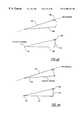
- this particular embodimentuses GPS velocity information to propagate a previous position 191 to a current position 192 (by adding displacements 194 and 196 obtained from the velocity information (integrated) to the previous position).
- the vehicle navigation systemuses sensor information to propagate the previous position 191 to current position 192 using heading and distance 198 . If the difference between the GPS heading (or current heading from the sensors if GPS is not used) and the map heading is within a threshold, then the map heading is used as the heading for position propagation.
- the vehicle navigation system 10can accomplish this in alternative ways. For example, as shown in FIG.
- the vehicle navigation system 10rotates the GPS velocity vector 200 to align with the map heading 202 if the GPS and map headings are within the threshold and integrates the rotated GPS velocity vector 204 to obtain the displacements.
- the updated current position 206is obtained by applying orthogonal displacements 208 and 210 to the previous position 191 .
- Errorsusually involve heading determinations due to drift errors in gyro or compass. Displacement is easy to test and one of the most accurate components in the GPS measurements and also in the sensors, so the system uses the entire displacements from the GPS velocity information or the dead reckoning sensors, such as the accelerometers. Thus, the improved vehicle navigation system can use low cost sensors which are less sensitive because heading can be corrected with map heading.
- FIG. 6 dif the vehicle navigation system uses sensor information to propagate the previous position 191 to current position 192 using heading and distance 198 , the map heading 202 can be used as the heading for position propagation to the updated current position 206 .
- FIG. 6 eshows an alternative way of updating the GPS heading and thus the current position by projecting the velocity vector 200 to align with the map heading 202 and integrating the projected velocity 212 to obtain displacements 214 and 216 .
- the system 10obtains the updated current position 192 by applying the displacements 214 and 216 to the previous position 191 .
- the use of map heading to update the information obtained from the non-GPS sensors or a combination of GPS and sensorscan be accomplished in a similar manner as would be understood by one of skill in the art.
- the improved vehicle navigation systemuses the GPS information for positioning and a high frequency of sensor calibration because GPS information is available a great deal of the time.
- the improved vehicle navigation systemcan use the map matching block 188 to provide an overall check on the current position and to provide position and heading correction data which is used if map matching 188 determines it is highly reliable.
- the current position(w/o map matching) is determined once per second. If the vehicle has travelled more than 15 meters since the last call to map matching 188 , then the current position is passed to map matching 188 . If the vehicle is travelling at high speed, the system will go to map matching 88 at each current position determination at the maximum rate of once per second.
- GPSis not available or unreliable, the improved vehicle navigation system has well calibrated accelerometers to rely on, and the improved vehicle navigation system can rely more on the information from the map matching block 188 for positioning and sensor calibration.
- the improved vehicle navigation systemprovides several significant advantages, such as flexibility, modularity, and accuracy at a cheaper cost because GPS information can be used to calibrate accelerometers more often and updating can be performed at a complete stop. These advantages occur because the system relies heavily on GPS velocity information to propagate vehicle position and maintain the accelerometer calibrated.
- the principles of the present inventioncan be implemented using various navigation system configurations and sensors.
- the improved vehicle navigation systemfor instance, can be implemented without using an odometer connection and obtaining distance information from the accelerometer inputs when GPS is not available to improve portability and installation costs.
- the improved vehicle navigation systemcan obtain dead reckoning information from GPS signals when a full set of GPS measurements is available, and use its accelerometers when anything less than a full set of GPS signals is available.
Landscapes
- Engineering & Computer Science (AREA)
- Radar, Positioning & Navigation (AREA)
- Remote Sensing (AREA)
- Automation & Control Theory (AREA)
- Physics & Mathematics (AREA)
- General Physics & Mathematics (AREA)
- Navigation (AREA)
Abstract
Description


| NUMSAMPLES = 16 (in filter array) | ||
| WORD | DATA[NUMSAMPLES−1] | |
| WORD | NOISE |
| FOR (I=0; I < NUMSAMPLES; I++ | ||
| NOISE = NOISE + ¦DATA[I] − DATA[I+1]¦ | ||
| If (NOISE > THRESHOLD) | ||
| ZERO_MOTION_FLAG = 0 | ||
| ELSE | ||
| ZERO_MOTION_FLAG = 1. | ||
Claims (20)
Priority Applications (1)
| Application Number | Priority Date | Filing Date | Title |
|---|---|---|---|
| US09/091,430US6308134B1 (en) | 1996-12-27 | 1996-12-27 | Vehicle navigation system and method using multiple axes accelerometer |
Applications Claiming Priority (2)
| Application Number | Priority Date | Filing Date | Title |
|---|---|---|---|
| PCT/US1996/020848WO1997024582A1 (en) | 1995-12-28 | 1996-12-27 | Improved vehicle navigation system and method using a multiple axes accelerometer |
| US09/091,430US6308134B1 (en) | 1996-12-27 | 1996-12-27 | Vehicle navigation system and method using multiple axes accelerometer |
Publications (1)
| Publication Number | Publication Date |
|---|---|
| US6308134B1true US6308134B1 (en) | 2001-10-23 |
Family
ID=22227742
Family Applications (1)
| Application Number | Title | Priority Date | Filing Date |
|---|---|---|---|
| US09/091,430Expired - LifetimeUS6308134B1 (en) | 1996-12-27 | 1996-12-27 | Vehicle navigation system and method using multiple axes accelerometer |
Country Status (1)
| Country | Link |
|---|---|
| US (1) | US6308134B1 (en) |
Cited By (129)
| Publication number | Priority date | Publication date | Assignee | Title |
|---|---|---|---|---|
| US20020022924A1 (en)* | 2000-03-07 | 2002-02-21 | Begin John David | Propagation of position with multiaxis accelerometer |
| USD461133S1 (en) | 2001-03-15 | 2002-08-06 | Satellite Devices Ltd. | Location tracking device mountable in a vehicle |
| US6466887B1 (en)* | 1999-03-03 | 2002-10-15 | Richard L. Weinbrenner | Gravimetric rotation sensors: dead reckoning, velocity, and heading sensor system for vehicle navigation systems |
| US6532419B1 (en)* | 1998-09-23 | 2003-03-11 | Magellan Dis, Inc. | Calibration of multi-axis accelerometer in vehicle navigation system |
| US6545638B2 (en)* | 2000-11-01 | 2003-04-08 | Nokia Corporation | Correcting a prior dead reckoning determined position measurement using GPS when GPS is later acquired |
| US6618683B1 (en)* | 2000-12-12 | 2003-09-09 | International Business Machines Corporation | Method and apparatus for calibrating an accelerometer-based navigation system |
| US6641090B2 (en)* | 2001-01-10 | 2003-11-04 | Lockheed Martin Corporation | Train location system and method |
| US6665611B1 (en) | 2001-06-19 | 2003-12-16 | Cisco Technology, Inc. | System for discovering and maintaining geographic location information in a computer network to enable emergency services |
| US20040005872A1 (en)* | 2002-07-03 | 2004-01-08 | Newtrax Technologies Inc. | Jamming-resistant wireless transmission of security data |
| US20040064234A1 (en)* | 2002-04-15 | 2004-04-01 | Pioneer Corporation | Correction device for correcting acceleration data, method therefor, program therefor, recording medium containing the program and navigation guide device |
| US20040083811A1 (en)* | 2002-10-30 | 2004-05-06 | Kranz Mark J. | Electronic hubodometer |
| US6741928B2 (en)* | 2000-03-07 | 2004-05-25 | Magellan Dis, Inc. | Navigation system with figure of merit determination |
| US20040107072A1 (en)* | 2002-12-03 | 2004-06-03 | Arne Dietrich | Ins-based user orientation and navigation |
| US20040245849A1 (en)* | 2003-05-20 | 2004-12-09 | Kds Controls | Brake control system and method |
| US20040252403A1 (en)* | 2000-10-02 | 2004-12-16 | Wehrenberg Paul James | Method and apparatus for detecting free fall |
| US20050049787A1 (en)* | 2003-08-25 | 2005-03-03 | Lg Electronics Inc. | GPS/dead-reckoning combination system and operating method thereof |
| US20050244259A1 (en)* | 2004-05-03 | 2005-11-03 | Chilson Gerald E | Automatic transport loading system and method |
| US20060017692A1 (en)* | 2000-10-02 | 2006-01-26 | Wehrenberg Paul J | Methods and apparatuses for operating a portable device based on an accelerometer |
| US20060080033A1 (en)* | 2004-05-10 | 2006-04-13 | Michihisa Komatsu | Method and apparatus for map matching |
| EP1677177A1 (en)* | 2004-12-29 | 2006-07-05 | STMicroelectronics S.r.l. | Pointing device for a computer system with automatic detection of the state of motion, and a relative control method |
| US20060255139A1 (en)* | 2005-05-12 | 2006-11-16 | Samsung Electronics Co., Ltd. | Portable terminal having motion-recognition capability and motion recognition method therefor |
| US20060276958A1 (en)* | 2005-06-02 | 2006-12-07 | Jervis B. Webb Company | Inertial navigational guidance system for a driverless vehicle utilizing laser obstacle sensors |
| US7149499B1 (en) | 2001-07-18 | 2006-12-12 | Cisco Technology, Inc. | System for dynamically tracking the location of network devices to enable emergency services |
| DE102005026853A1 (en)* | 2005-06-10 | 2006-12-14 | Daimlerchrysler Ag | Method and device for vehicle-side calculation of the length of a traveled distance |
| US20070067096A1 (en)* | 2005-09-06 | 2007-03-22 | Sony Corporation | Offset detection of acceleration sensor and navigation system |
| US20070102525A1 (en)* | 2005-11-10 | 2007-05-10 | Research In Motion Limited | System and method for activating an electronic device |
| JP2007155471A (en)* | 2005-12-05 | 2007-06-21 | Alpine Electronics Inc | Vehicle position estimator and vehicle position estimating method |
| US20070162223A1 (en)* | 2006-01-09 | 2007-07-12 | Thales Navigation, Inc. | Smart detour |
| US20070203647A1 (en)* | 2006-02-28 | 2007-08-30 | Seiko Epson Corporation | Positioning device, method of controlling positioning device, program for controlling positioning device, and computer-readable recording medium having program for controlling positioning device recorded thereon |
| US7278511B1 (en)* | 2003-01-27 | 2007-10-09 | Polaris Industries Inc. | Controller for steering a vehicle |
| US20070250515A1 (en)* | 2006-04-21 | 2007-10-25 | Lea David H | Method and system of securing content and destination of digital download via the internet |
| US20070260397A1 (en)* | 2006-03-02 | 2007-11-08 | Seiko Epson Corporation | Positioning device, method of controlling positioning device, positioning control program, and computer-readable recording medium having positioning control program recorded thereon |
| US7316288B1 (en)* | 2003-01-27 | 2008-01-08 | Polaris Industries Inc. | All terrain vehicle with multiple steering modes |
| US20080051995A1 (en)* | 2006-08-25 | 2008-02-28 | Magellan Navigation, Inc. | Rerouting in Vehicle Navigation Systems |
| US20080139181A1 (en)* | 2006-12-08 | 2008-06-12 | Magellan Navigation, Inc. | Methods and apparatus for measuring the effectiveness of advertisements presented on a mobile navigation device |
| US20080198162A1 (en)* | 2007-02-16 | 2008-08-21 | Magellan Navigation, Inc. | A method of generating curved baseline for map labeling |
| US20080199298A1 (en)* | 2004-05-03 | 2008-08-21 | Jervis B. Webb Company | Automatic transport loading system and method |
| US20080221787A1 (en)* | 2007-03-09 | 2008-09-11 | Magellan Navigation, Inc. | Methods and apparatus for determining a route having an estimated minimum fuel usage for a vehicle |
| US20080221776A1 (en)* | 2006-10-02 | 2008-09-11 | Mcclellan Scott | System and Method for Reconfiguring an Electronic Control Unit of a Motor Vehicle to Optimize Fuel Economy |
| US20080252487A1 (en)* | 2006-05-22 | 2008-10-16 | Mcclellan Scott | System and method for monitoring and updating speed-by-street data |
| US20080258890A1 (en)* | 2006-05-22 | 2008-10-23 | Todd Follmer | System and Method for Remotely Deactivating a Vehicle |
| US20080270468A1 (en)* | 2007-04-25 | 2008-10-30 | Magellan Navigation, Inc. | Adjusting spatial operations based on map density |
| WO2008140144A1 (en) | 2007-05-14 | 2008-11-20 | Thinkware Systems Corporation | Method for correcting map matching and navigation system implementing the method |
| US20080306687A1 (en)* | 2007-06-05 | 2008-12-11 | Gm Global Technology Operations, Inc. | GPS assisted vehicular longitudinal velocity determination |
| US20080309156A1 (en)* | 2007-06-15 | 2008-12-18 | Kds Controls | Brake control system and method |
| US20090062981A1 (en)* | 2007-08-27 | 2009-03-05 | Honda Motor Co., Ltd. | Vehicular behavior determination device and vehicular behavior determination method |
| US20090070293A1 (en)* | 2007-09-10 | 2009-03-12 | Magellan Navigation, Inc. | Nearest-Neighbor Geographic Search |
| US20090138190A1 (en)* | 2007-11-26 | 2009-05-28 | Magellan Navigation, Inc. | System and Method of Providing Traffic Data to a Mobile Device |
| US20090171584A1 (en)* | 2007-12-31 | 2009-07-02 | Magellan Navigation, Inc. | System and Method for Accessing a Navigation System |
| US20090177360A1 (en)* | 2003-07-25 | 2009-07-09 | Mario Kustosch | Method for operating a vehicle |
| US20090182498A1 (en)* | 2008-01-11 | 2009-07-16 | Magellan Navigation, Inc. | Systems and Methods to Provide Navigational Assistance Using an Online Social Network |
| US20090187340A1 (en)* | 2008-01-18 | 2009-07-23 | Magellan Navigation, Inc. | Method and apparatus for hybrid routing using breadcrumb paths |
| US20090187342A1 (en)* | 2008-01-18 | 2009-07-23 | Magellan Navigation, Inc. | Method and apparatus for access point recording using a position device |
| US20090187341A1 (en)* | 2008-01-18 | 2009-07-23 | Magellan Navigation, Inc. | Method and apparatus to search for local parking |
| US20090254274A1 (en)* | 2007-07-27 | 2009-10-08 | Kulik Victor | Navigation system for providing celestial and terrestrial information |
| US20090259424A1 (en)* | 2008-03-06 | 2009-10-15 | Texas Instruments Incorporated | Parameter estimation for accelerometers, processes, circuits, devices and systems |
| US20100035631A1 (en)* | 2008-08-07 | 2010-02-11 | Magellan Navigation, Inc. | Systems and Methods to Record and Present a Trip |
| US20100049696A1 (en)* | 2008-08-20 | 2010-02-25 | Magellan Navigation, Inc. | Systems and Methods for Smart City Search |
| US20100057359A1 (en)* | 2008-09-04 | 2010-03-04 | Ruben Caballero | Location systems for handheld electronic devices |
| US20100076674A1 (en)* | 2008-09-22 | 2010-03-25 | Magellan Navigation, Inc. | Route Navigation via a Proximity Point |
| US20100145612A1 (en)* | 2008-12-04 | 2010-06-10 | Hong Fu Jin Precision Industry (Shenzhen) Co., Ltd. | Navigation device and method |
| US20100235012A1 (en)* | 2009-03-13 | 2010-09-16 | Keith Cox | Automatic adjustment of thermal requirement |
| US20100266381A1 (en)* | 2004-05-03 | 2010-10-21 | Jervis B. Webb Company | Automatic transport loading system and method |
| US20100331010A1 (en)* | 2009-06-30 | 2010-12-30 | Qualcomm Incorporated | Trajectory-Based Location Determination |
| WO2011003462A1 (en)* | 2009-07-10 | 2011-01-13 | Tomtom International B.V. | Accelerometer system and method |
| US7876205B2 (en) | 2007-10-02 | 2011-01-25 | Inthinc Technology Solutions, Inc. | System and method for detecting use of a wireless device in a moving vehicle |
| US7908080B2 (en) | 2004-12-31 | 2011-03-15 | Google Inc. | Transportation routing |
| US20110184645A1 (en)* | 2010-01-28 | 2011-07-28 | Sirf Technology Holdings, Inc. | Use of accelerometer only data to improve gnss performance |
| US7999670B2 (en) | 2007-07-02 | 2011-08-16 | Inthinc Technology Solutions, Inc. | System and method for defining areas of interest and modifying asset monitoring in relation thereto |
| USRE42738E1 (en) | 1997-10-28 | 2011-09-27 | Apple Inc. | Portable computers |
| US8075243B2 (en) | 2004-05-03 | 2011-12-13 | Jervis B. Webb Company | Automatic transport loading system and method |
| US20120035840A1 (en)* | 2010-08-04 | 2012-02-09 | Empire Technology Development Llc | Vehicle speed monitor |
| US8192137B2 (en) | 2004-05-03 | 2012-06-05 | Jervis B. Webb Company | Automatic transport loading system and method |
| US20120158356A1 (en)* | 2010-12-17 | 2012-06-21 | Nxp. B.V. | Tamper-proof odometer system |
| US20120209516A1 (en)* | 2011-02-10 | 2012-08-16 | Telenav, Inc. | Navigation system with interactive accelerometer mechanism and method of operation thereof |
| US20120221276A1 (en)* | 2009-07-10 | 2012-08-30 | Alexander Schmidt | Accelerometer system and method |
| US8467956B2 (en) | 2010-10-18 | 2013-06-18 | Telenav, Inc. | Navigation system with lane-level mechanism and method of operation thereof |
| US8494710B2 (en) | 2011-03-31 | 2013-07-23 | Trimble Navigation Limited | System and method for identifying a spatial relationship for use in calibrating accelerometer data |
| US8554475B2 (en) | 2007-10-01 | 2013-10-08 | Mitac International Corporation | Static and dynamic contours |
| US8577703B2 (en) | 2007-07-17 | 2013-11-05 | Inthinc Technology Solutions, Inc. | System and method for categorizing driving behavior using driver mentoring and/or monitoring equipment to determine an underwriting risk |
| US8666590B2 (en) | 2007-06-22 | 2014-03-04 | Inthinc Technology Solutions, Inc. | System and method for naming, filtering, and recall of remotely monitored event data |
| US8688180B2 (en) | 2008-08-06 | 2014-04-01 | Inthinc Technology Solutions, Inc. | System and method for detecting use of a wireless device while driving |
| US20140236518A1 (en)* | 2013-02-19 | 2014-08-21 | Calamp Corp. | Systems and Methods for Low Latency 3-Axis Accelerometer Calibration |
| US8818704B2 (en) | 2010-10-18 | 2014-08-26 | Telenav, Inc. | Navigation system with road object detection mechanism and method of operation thereof |
| US8818618B2 (en) | 2007-07-17 | 2014-08-26 | Inthinc Technology Solutions, Inc. | System and method for providing a user interface for vehicle monitoring system users and insurers |
| US8825277B2 (en) | 2007-06-05 | 2014-09-02 | Inthinc Technology Solutions, Inc. | System and method for the collection, correlation and use of vehicle collision data |
| US8963702B2 (en) | 2009-02-13 | 2015-02-24 | Inthinc Technology Solutions, Inc. | System and method for viewing and correcting data in a street mapping database |
| US9002641B2 (en) | 2012-10-05 | 2015-04-07 | Hand Held Products, Inc. | Navigation system configured to integrate motion sensing device inputs |
| WO2015072896A1 (en)* | 2013-11-12 | 2015-05-21 | Husqvarna Ab | Improved navigation for a robotic working tool |
| US20150161824A1 (en)* | 2013-12-10 | 2015-06-11 | Ims Solutions, Inc. | Indirect characterization of transportation networks and vehicle health |
| US9067565B2 (en) | 2006-05-22 | 2015-06-30 | Inthinc Technology Solutions, Inc. | System and method for evaluating driver behavior |
| US9070210B1 (en) | 2013-01-31 | 2015-06-30 | Google Inc. | Computing devices and methods for navigating around a surface of three-dimensional (3D) coordinate system representations of 3D objects |
| US9075136B1 (en) | 1998-03-04 | 2015-07-07 | Gtj Ventures, Llc | Vehicle operator and/or occupant information apparatus and method |
| US9117246B2 (en) | 2007-07-17 | 2015-08-25 | Inthinc Technology Solutions, Inc. | System and method for providing a user interface for vehicle mentoring system users and insurers |
| US9129460B2 (en) | 2007-06-25 | 2015-09-08 | Inthinc Technology Solutions, Inc. | System and method for monitoring and improving driver behavior |
| US9172477B2 (en) | 2013-10-30 | 2015-10-27 | Inthinc Technology Solutions, Inc. | Wireless device detection using multiple antennas separated by an RF shield |
| US20150369614A1 (en)* | 2013-02-18 | 2015-12-24 | Denso Corporation | Vehicle orientation detection method and vehicle orientation detection apparatus |
| US20160113092A1 (en)* | 2013-11-21 | 2016-04-21 | General Electric Company | Luminaire associate |
| US9405011B2 (en) | 2012-10-05 | 2016-08-02 | Hand Held Products, Inc. | Navigation system configured to integrate motion sensing device inputs |
| US9459121B2 (en) | 2013-05-21 | 2016-10-04 | DigiPas USA, LLC | Angle measuring device and methods for calibration |
| US9568323B2 (en)* | 2011-10-17 | 2017-02-14 | Microsoft Technology Licensing, Llc | Location determination |
| WO2017042138A1 (en)* | 2015-09-10 | 2017-03-16 | Knorr-Bremse Systeme für Nutzfahrzeuge GmbH | Method and device for ascertaining an orientation of a sensor unit |
| US9621265B2 (en) | 2013-11-21 | 2017-04-11 | General Electric Company | Street lighting control, monitoring, and data transportation system and method |
| US9644977B2 (en) | 2015-05-22 | 2017-05-09 | Calamp Corp. | Systems and methods for determining vehicle operational status |
| US9646495B2 (en) | 2013-11-21 | 2017-05-09 | General Electric Company | Method and system for traffic flow reporting, forecasting, and planning |
| US9746329B2 (en) | 2006-11-08 | 2017-08-29 | Caterpillar Trimble Control Technologies Llc | Systems and methods for augmenting an inertial navigation system |
| US9758138B2 (en) | 2004-10-08 | 2017-09-12 | Horizon Global Americas Inc. | Brake control unit |
| US20170261336A1 (en)* | 2009-07-10 | 2017-09-14 | Tomtom Telematics B.V. | Accelerometer system and method |
| US10040437B2 (en) | 2004-10-08 | 2018-08-07 | Horizon Global Americas Inc. | Brake control unit |
| US10055909B2 (en) | 2016-07-08 | 2018-08-21 | Calamp Corp. | Systems and methods for crash determination |
| US10102689B2 (en) | 2012-10-18 | 2018-10-16 | Calamp Corp | Systems and methods for location reporting of detected events in vehicle operation |
| US10107831B2 (en) | 2012-11-21 | 2018-10-23 | Calamp Corp | Systems and methods for efficient characterization of acceleration events |
| US10214166B2 (en) | 2015-06-11 | 2019-02-26 | Calamp Corp. | Systems and methods for impact detection with noise attenuation of a sensor signal |
| US10219117B2 (en) | 2016-10-12 | 2019-02-26 | Calamp Corp. | Systems and methods for radio access interfaces |
| US10363910B2 (en) | 2016-12-07 | 2019-07-30 | Horizon Global Americas Inc. | Automated gain and boost for a brake controller |
| US10395438B2 (en) | 2016-08-19 | 2019-08-27 | Calamp Corp. | Systems and methods for crash determination with noise filtering |
| US10473750B2 (en) | 2016-12-08 | 2019-11-12 | Calamp Corp. | Systems and methods for tracking multiple collocated assets |
| US10509101B2 (en) | 2013-11-21 | 2019-12-17 | General Electric Company | Street lighting communications, control, and special services |
| US10599421B2 (en) | 2017-07-14 | 2020-03-24 | Calamp Corp. | Systems and methods for failsafe firmware upgrades |
| US10698408B2 (en) | 2018-08-30 | 2020-06-30 | Pony Ai Inc. | Distributed sensing for vehicle navigation |
| US10946841B2 (en) | 2016-09-16 | 2021-03-16 | Horizon Global Americas Inc. | Driver and diagnostic system for a brake controller |
| US11105633B2 (en)* | 2017-04-05 | 2021-08-31 | Novatel Inc. | Navigation system utilizing yaw rate constraint during inertial dead reckoning |
| US11187719B2 (en)* | 2019-01-08 | 2021-11-30 | Qualcomm Incorporated | In-motion initialization of accelerometer for accurate vehicle positioning |
| US11206171B2 (en) | 2017-11-07 | 2021-12-21 | Calamp Corp. | Systems and methods for dynamic device programming |
| US20220074967A1 (en)* | 2020-09-04 | 2022-03-10 | Denso Corporation | Apparatus and method for calibrating inertial sensor |
| US11541882B2 (en)* | 2019-09-24 | 2023-01-03 | Volvo Car Corporation | Low-impact collision detection |
| US20230025579A1 (en)* | 2021-07-26 | 2023-01-26 | Cyngn, Inc. | High-definition mapping |
| US20230314624A1 (en)* | 2019-08-14 | 2023-10-05 | Apple Inc. | Device orientation initialization |
| US11924303B2 (en) | 2017-11-06 | 2024-03-05 | Calamp Corp. | Systems and methods for dynamic telematics messaging |
Citations (101)
| Publication number | Priority date | Publication date | Assignee | Title |
|---|---|---|---|---|
| US3442140A (en) | 1964-12-24 | 1969-05-06 | North American Rockwell | Drift rate compensation for acceleration sensitivity of an inertial navigation platform |
| US3492465A (en) | 1965-12-13 | 1970-01-27 | Gen Electric | Redundant off-axis sensors |
| US3588478A (en)* | 1968-09-26 | 1971-06-28 | Dorn Thomas E | Dead reckoning navigation position computers |
| US3597598A (en) | 1964-12-14 | 1971-08-03 | North American Rockwell | Method and means for transforming the acceleration signals generated by accelerometers in a first coordinate system into acceleration signals in a second coordinate system |
| US3610900A (en) | 1969-11-24 | 1971-10-05 | Us Navy | Crosscoupling computer |
| US3702477A (en) | 1969-06-23 | 1972-11-07 | Univ Iowa State Res Found Inc | Inertial/doppler-satellite navigation system |
| US3749893A (en) | 1971-12-22 | 1973-07-31 | D Hileman | Vehicle navigation system |
| US3803387A (en) | 1972-09-20 | 1974-04-09 | Us Navy | Alignment error detection system |
| US3845289A (en) | 1972-07-18 | 1974-10-29 | Avon Inc | Method and apparatus employing automatic route control system |
| US3924824A (en) | 1973-10-17 | 1975-12-09 | Singer Co | Cross track strapdown inertial quidance system |
| US3984806A (en) | 1974-06-08 | 1976-10-05 | The Marconi Company Limited | Location systems |
| US4032758A (en) | 1975-11-05 | 1977-06-28 | The Boeing Company | Compensated vehicle heading system |
| US4038527A (en) | 1975-10-21 | 1977-07-26 | The Singer Company | Simplified strapped down inertial navigation utilizing bang-bang gyro torquing |
| US4070674A (en) | 1973-10-17 | 1978-01-24 | The Singer Company | Doppler heading attitude reference system |
| US4086632A (en) | 1976-09-27 | 1978-04-25 | The Boeing Company | Area navigation system including a map display unit for establishing and modifying navigation routes |
| US4107689A (en) | 1976-06-07 | 1978-08-15 | Rca Corporation | System for automatic vehicle location |
| US4135155A (en) | 1976-09-28 | 1979-01-16 | Robert Bosch Gmbh | System and method for determining vehicle ground speed |
| GB2014309A (en) | 1978-02-10 | 1979-08-22 | Teldix Gmbh | A Method of Determining the Drift of a Gyro of a Vehicle Position Determining System, and an Apparatus Operable with the Method |
| US4173784A (en) | 1977-08-29 | 1979-11-06 | The Singer Company | Inertial system having correction means for effects of gravitational anomalies |
| US4253150A (en) | 1978-09-29 | 1981-02-24 | Scovill Royal J | Pictorial navigation computer |
| US4254465A (en) | 1978-08-03 | 1981-03-03 | Dynamic Sciences International, Inc. | Strap-down attitude and heading reference system |
| US4262861A (en) | 1978-10-16 | 1981-04-21 | The Singer Company | Inertially decoupled strapdown system |
| US4301506A (en) | 1980-07-07 | 1981-11-17 | Turco Daniel J | Auto routing computer for eliminating the need for maps or travel instructions |
| US4312577A (en) | 1979-08-13 | 1982-01-26 | Fitzgerald J Vincent | Motor vehicle map display system |
| EP0059435A2 (en) | 1981-03-04 | 1982-09-08 | Nissan Motor Co., Ltd. | Image display device |
| US4351027A (en) | 1980-08-13 | 1982-09-21 | Honeywell Inc. | Adaptive riser angle position reference system |
| JPS57158875A (en) | 1981-03-27 | 1982-09-30 | Nissan Motor | Running guide for vehicle |
| US4369441A (en) | 1980-09-18 | 1983-01-18 | Louis Wohlmuth | Display control system |
| EP0069965A1 (en) | 1981-07-07 | 1983-01-19 | Nippondenso Co., Ltd. | Mobile navigator |
| JPS5827008A (en) | 1981-08-12 | 1983-02-17 | Nissan Motor Co Ltd | Vehicle travel guidance device |
| JPS58111969A (en) | 1981-12-25 | 1983-07-04 | 日産自動車株式会社 | Vehicle driving route display device |
| US4403291A (en) | 1979-10-11 | 1983-09-06 | Siemens Aktiengesellschaft | Self-sufficient navigation device for street vehicles |
| GB2115946A (en) | 1978-12-21 | 1983-09-14 | Redifon Simulation Ltd | Improvements in or relating to visual display apparatus |
| JPS5928244A (en) | 1982-07-02 | 1984-02-14 | ミネソタ・マイニング・アンド・マニユフアクチユアリング・コンパニ− | Magnetic recording medium and manufacture thereof |
| EP0103847A1 (en) | 1982-09-16 | 1984-03-28 | TELDIX GmbH | Navigation aid for vehicles |
| DE3242904A1 (en) | 1982-11-20 | 1984-05-24 | Teldix Gmbh, 6900 Heidelberg | DEVICE FOR DETERMINING THE LOCATION OF A VEHICLE |
| EP0118886A2 (en) | 1983-03-09 | 1984-09-19 | Nippondenso Co., Ltd. | Map display system |
| US4483357A (en) | 1983-02-22 | 1984-11-20 | Globe-Union Inc. | Method for two stage in-line acid mixing |
| GB2144007A (en) | 1983-06-29 | 1985-02-20 | Harris Corp | Navigation by correlation of terrain elevation |
| US4504913A (en) | 1981-06-08 | 1985-03-12 | Nippondenso Co., Ltd. | Electronic navigator for automotive vehicles |
| US4513377A (en) | 1981-06-11 | 1985-04-23 | Nippondenso Co., Ltd. | Vehicle-mounted navigator |
| US4528552A (en) | 1981-06-15 | 1985-07-09 | Toyota Jidosha Kogyo Kabushiki Kaisha | Travel locus display device |
| US4543572A (en) | 1981-05-13 | 1985-09-24 | Nissan Motor Company, Limited | Road map display system with indications of a vehicle position and destination |
| US4546439A (en) | 1982-03-10 | 1985-10-08 | Natividad Gene Esparza | Method and apparatus for determining route from a present location to a desired destination in a city |
| US4571684A (en) | 1983-03-25 | 1986-02-18 | Nippondenso Co., Ltd. | Map display system for vehicles |
| US4608656A (en) | 1981-04-13 | 1986-08-26 | Nissan Motor Company, Limited | Road map display system with indication of a vehicle position |
| US4646089A (en) | 1983-01-17 | 1987-02-24 | Nippondenso Co., Ltd. | Travel guidance system for vehicles |
| US4660037A (en) | 1982-01-28 | 1987-04-21 | Honda Giken Kogyo Kabushiki Kaisha | Current location indication apparatus for use in an automotive vehicle |
| US4692765A (en) | 1985-12-05 | 1987-09-08 | Environmental Research Institute Of Michigan | Adaptive learning controller for synthetic aperture radar |
| US4713767A (en) | 1984-05-09 | 1987-12-15 | Toyota Jidosha Kabushiki Kaisha | Apparatus for calculating position of vehicle |
| US4758959A (en)* | 1984-08-14 | 1988-07-19 | U.S. Philips Corporation | Vehicle navigation system provided with an adaptive inertial navigation system based on the measurement of the speed and lateral acceleration of the vehicle and provided with a correction unit for correcting the measured values |
| US4796191A (en) | 1984-06-07 | 1989-01-03 | Etak, Inc. | Vehicle navigational system and method |
| US4800501A (en) | 1986-11-24 | 1989-01-24 | Ivan Kinsky | Vehicle land navigating device |
| US4814989A (en) | 1985-05-30 | 1989-03-21 | Robert Bosch Gmbh | Navigation method for vehicles |
| US4819175A (en) | 1986-09-25 | 1989-04-04 | Siemens Aktiengesellschaft | Navigation equipment for a moving vehicle |
| US4823626A (en) | 1986-06-30 | 1989-04-25 | Bodenseewerk Geratetechnik Gmbh | Inertial sensor arrangement |
| US4847769A (en) | 1985-01-16 | 1989-07-11 | The General Electric Company, P.L.C. | Automated vehicle drift correction |
| US4870588A (en) | 1985-10-21 | 1989-09-26 | Sundstrand Data Control, Inc. | Signal processor for inertial measurement using coriolis force sensing accelerometer arrangements |
| US4890104A (en) | 1983-03-25 | 1989-12-26 | Nippondenso Co., Ltd. | Electronic map display system for use on vehicle |
| US4899285A (en) | 1986-06-26 | 1990-02-06 | Nissan Motor Company, Limited | System and method for measuring a position of a moving object with a hybrid navigation apparatus |
| US4930085A (en) | 1986-10-16 | 1990-05-29 | Litef Gmbh | Method for determining the heading of an aircraft |
| US4949268A (en) | 1987-09-22 | 1990-08-14 | Kabushiki Kaisha Toyota Chuo Kenkyusho | Land vehicle navigation system |
| DE3912108A1 (en) | 1989-04-13 | 1990-10-18 | Teldix Gmbh | Vehicle with orientation system - has link to weapon or radar alignment gyro for correction and improved performance |
| US4989151A (en) | 1988-02-23 | 1991-01-29 | Kabushiki Kaisha Toshiba | Navigation apparatus and matching method for navigation |
| US5001647A (en) | 1989-08-31 | 1991-03-19 | General Electric Company | Inertial transformation matrix generator |
| US5014205A (en) | 1988-05-03 | 1991-05-07 | Teldix Gmbh | Vehicle having an on-board navigation system |
| US5023798A (en) | 1987-06-06 | 1991-06-11 | Robert Bosch Gmbh | Method of and apparatus for determining a position of a land vehicle |
| US5046011A (en) | 1988-07-05 | 1991-09-03 | Mazda Motor Corporation | Apparatus for navigating vehicle |
| US5058023A (en) | 1990-07-30 | 1991-10-15 | Motorola, Inc. | Vehicle position determining apparatus |
| US5075693A (en) | 1988-10-05 | 1991-12-24 | Her Majesty The Queen In Right Of Canada, As Represented By The Minister Of National Defence Of Her Majesty's Canadian Government | Primary land arctic navigation system |
| EP0471405A1 (en) | 1990-08-13 | 1992-02-19 | Koninklijke Philips Electronics N.V. | Method of determining the position of a vehicle, arrangement for determining the position of a vehicle, as well as a vehicle provided with such an arrangement |
| US5109344A (en) | 1988-04-28 | 1992-04-28 | Mazda Motor Corporation | Vehicle navigation apparatus employing node selection, comparison and elimination techniques |
| US5111209A (en) | 1990-05-23 | 1992-05-05 | Sony Corporation | Satellite-based position determining system |
| US5119102A (en) | 1990-02-28 | 1992-06-02 | U.S. Philips Corporation | Vehicle location system |
| EP0496538A2 (en) | 1991-01-23 | 1992-07-29 | Sumitomo Electric Industries, Limited | Vehicle heading correction apparatus |
| US5166882A (en) | 1989-03-31 | 1992-11-24 | The United States Of America As Represented By The Secretary Of The Navy | System for calibrating a gyro navigator |
| EP0514887A2 (en) | 1991-05-21 | 1992-11-25 | Matsushita Electric Industrial Co., Ltd. | Vehicle position detecting apparatus |
| US5172323A (en) | 1989-06-22 | 1992-12-15 | The United States Of America As Represented By The Secretary Of The Navy | Apparatus for determining the attitude of a vehicle |
| US5185610A (en) | 1990-08-20 | 1993-02-09 | Texas Instruments Incorporated | GPS system and method for deriving pointing or attitude from a single GPS receiver |
| EP0544403A1 (en) | 1991-10-25 | 1993-06-02 | Matsushita Electric Industrial Co., Ltd. | Vehicle navigation system |
| US5233844A (en) | 1991-08-15 | 1993-08-10 | Cryo-Cell International, Inc. | Storage apparatus, particularly with automatic insertion and retrieval |
| EP0567268A1 (en) | 1992-04-20 | 1993-10-27 | Sumitomo Electric Industries, Limited | Vehicle heading correcting apparatus |
| US5276451A (en) | 1991-07-09 | 1994-01-04 | Pioneer Electronic Corporation | Navigation system with navigational data processing |
| US5278424A (en) | 1992-02-10 | 1994-01-11 | Sumitomo Electric Industries, Ltd. | Apparatus and method for correcting an offset value contained in an output of a turning angular velocity sensor |
| US5301130A (en) | 1992-10-22 | 1994-04-05 | Hughes Aircraft Company | Absoulte velocity sensor |
| US5301114A (en) | 1992-06-11 | 1994-04-05 | Allied-Signal Inc. | Inertial navigation system including self-contained performance validating arrangement |
| US5311195A (en) | 1991-08-30 | 1994-05-10 | Etak, Inc. | Combined relative and absolute positioning method and apparatus |
| US5337243A (en) | 1990-11-13 | 1994-08-09 | Matsushita Electric Industrial Co., Ltd. | Vehicle orientation calculating device |
| US5339684A (en) | 1991-12-10 | 1994-08-23 | Textron Inc. | Gravity aided inertial navigation system |
| EP0615641A1 (en) | 1991-11-22 | 1994-09-21 | Engineered Data Products Inc | Label generation apparatus. |
| US5355316A (en) | 1989-03-24 | 1994-10-11 | Northrop Grumman Corporation | Position aided evader maneuvering re-entry vehicle navigator |
| US5367463A (en) | 1991-07-15 | 1994-11-22 | Matsushita Electric Industrial Co., Ltd. | Vehicle position and azimuth computing system |
| US5383127A (en) | 1991-09-19 | 1995-01-17 | Matsushita Electric Industrial Co., Ltd. | On-vehicle position computing apparatus |
| US5442560A (en) | 1993-07-29 | 1995-08-15 | Honeywell, Inc. | Integrated guidance system and method for providing guidance to a projectile on a trajectory |
| US5450345A (en) | 1992-06-15 | 1995-09-12 | Honeywell Inc. | Terrain referenced navigation-Schuler cycle error reduction method and apparatus |
| US5479161A (en) | 1994-03-25 | 1995-12-26 | Honeywell Inc. | Automatic calibration of redundant sensors |
| US5526263A (en) | 1993-12-09 | 1996-06-11 | Sumitomo Electric Industries, Ltd. | Gravitational accelerometer provided with zero adjuster |
| US5531115A (en) | 1995-06-29 | 1996-07-02 | Erdley; Harold F. | Self-calibrating three axis angular rate sensor |
| US5570304A (en) | 1994-07-27 | 1996-10-29 | Litton Systems, Inc. | Method for thermal modeling and updating of bias errors in inertial navigation instrument outputs |
| US6029111A (en)* | 1995-12-28 | 2000-02-22 | Magellan Dis, Inc. | Vehicle navigation system and method using GPS velocities |
| US6038495A (en)* | 1998-02-06 | 2000-03-14 | Delco Electronics Corporation | Vehicle rollover sensing using short-term integration |
- 1996
- 1996-12-27USUS09/091,430patent/US6308134B1/ennot_activeExpired - Lifetime
Patent Citations (104)
| Publication number | Priority date | Publication date | Assignee | Title |
|---|---|---|---|---|
| US3597598A (en) | 1964-12-14 | 1971-08-03 | North American Rockwell | Method and means for transforming the acceleration signals generated by accelerometers in a first coordinate system into acceleration signals in a second coordinate system |
| US3442140A (en) | 1964-12-24 | 1969-05-06 | North American Rockwell | Drift rate compensation for acceleration sensitivity of an inertial navigation platform |
| US3492465A (en) | 1965-12-13 | 1970-01-27 | Gen Electric | Redundant off-axis sensors |
| US3588478A (en)* | 1968-09-26 | 1971-06-28 | Dorn Thomas E | Dead reckoning navigation position computers |
| US3702477A (en) | 1969-06-23 | 1972-11-07 | Univ Iowa State Res Found Inc | Inertial/doppler-satellite navigation system |
| US3610900A (en) | 1969-11-24 | 1971-10-05 | Us Navy | Crosscoupling computer |
| US3749893A (en) | 1971-12-22 | 1973-07-31 | D Hileman | Vehicle navigation system |
| US3845289A (en) | 1972-07-18 | 1974-10-29 | Avon Inc | Method and apparatus employing automatic route control system |
| US3803387A (en) | 1972-09-20 | 1974-04-09 | Us Navy | Alignment error detection system |
| US4070674A (en) | 1973-10-17 | 1978-01-24 | The Singer Company | Doppler heading attitude reference system |
| US3924824A (en) | 1973-10-17 | 1975-12-09 | Singer Co | Cross track strapdown inertial quidance system |
| US3984806A (en) | 1974-06-08 | 1976-10-05 | The Marconi Company Limited | Location systems |
| GB1470694A (en) | 1974-06-08 | 1977-04-21 | Marconi Co Ltd | Vehicle location systems |
| US4038527A (en) | 1975-10-21 | 1977-07-26 | The Singer Company | Simplified strapped down inertial navigation utilizing bang-bang gyro torquing |
| US4032758A (en) | 1975-11-05 | 1977-06-28 | The Boeing Company | Compensated vehicle heading system |
| US4107689A (en) | 1976-06-07 | 1978-08-15 | Rca Corporation | System for automatic vehicle location |
| US4086632A (en) | 1976-09-27 | 1978-04-25 | The Boeing Company | Area navigation system including a map display unit for establishing and modifying navigation routes |
| US4135155A (en) | 1976-09-28 | 1979-01-16 | Robert Bosch Gmbh | System and method for determining vehicle ground speed |
| US4173784A (en) | 1977-08-29 | 1979-11-06 | The Singer Company | Inertial system having correction means for effects of gravitational anomalies |
| GB2014309A (en) | 1978-02-10 | 1979-08-22 | Teldix Gmbh | A Method of Determining the Drift of a Gyro of a Vehicle Position Determining System, and an Apparatus Operable with the Method |
| US4254465A (en) | 1978-08-03 | 1981-03-03 | Dynamic Sciences International, Inc. | Strap-down attitude and heading reference system |
| US4253150A (en) | 1978-09-29 | 1981-02-24 | Scovill Royal J | Pictorial navigation computer |
| US4262861A (en) | 1978-10-16 | 1981-04-21 | The Singer Company | Inertially decoupled strapdown system |
| GB2115946A (en) | 1978-12-21 | 1983-09-14 | Redifon Simulation Ltd | Improvements in or relating to visual display apparatus |
| US4312577A (en) | 1979-08-13 | 1982-01-26 | Fitzgerald J Vincent | Motor vehicle map display system |
| US4403291A (en) | 1979-10-11 | 1983-09-06 | Siemens Aktiengesellschaft | Self-sufficient navigation device for street vehicles |
| US4301506A (en) | 1980-07-07 | 1981-11-17 | Turco Daniel J | Auto routing computer for eliminating the need for maps or travel instructions |
| US4351027A (en) | 1980-08-13 | 1982-09-21 | Honeywell Inc. | Adaptive riser angle position reference system |
| US4369441A (en) | 1980-09-18 | 1983-01-18 | Louis Wohlmuth | Display control system |
| EP0059435A2 (en) | 1981-03-04 | 1982-09-08 | Nissan Motor Co., Ltd. | Image display device |
| JPS57158875A (en) | 1981-03-27 | 1982-09-30 | Nissan Motor | Running guide for vehicle |
| US4608656A (en) | 1981-04-13 | 1986-08-26 | Nissan Motor Company, Limited | Road map display system with indication of a vehicle position |
| US4543572A (en) | 1981-05-13 | 1985-09-24 | Nissan Motor Company, Limited | Road map display system with indications of a vehicle position and destination |
| US4504913A (en) | 1981-06-08 | 1985-03-12 | Nippondenso Co., Ltd. | Electronic navigator for automotive vehicles |
| US4513377A (en) | 1981-06-11 | 1985-04-23 | Nippondenso Co., Ltd. | Vehicle-mounted navigator |
| US4528552A (en) | 1981-06-15 | 1985-07-09 | Toyota Jidosha Kogyo Kabushiki Kaisha | Travel locus display device |
| EP0069965A1 (en) | 1981-07-07 | 1983-01-19 | Nippondenso Co., Ltd. | Mobile navigator |
| JPS5827008A (en) | 1981-08-12 | 1983-02-17 | Nissan Motor Co Ltd | Vehicle travel guidance device |
| JPS58111969A (en) | 1981-12-25 | 1983-07-04 | 日産自動車株式会社 | Vehicle driving route display device |
| US4660037A (en) | 1982-01-28 | 1987-04-21 | Honda Giken Kogyo Kabushiki Kaisha | Current location indication apparatus for use in an automotive vehicle |
| US4546439A (en) | 1982-03-10 | 1985-10-08 | Natividad Gene Esparza | Method and apparatus for determining route from a present location to a desired destination in a city |
| JPS5928244A (en) | 1982-07-02 | 1984-02-14 | ミネソタ・マイニング・アンド・マニユフアクチユアリング・コンパニ− | Magnetic recording medium and manufacture thereof |
| EP0103847A1 (en) | 1982-09-16 | 1984-03-28 | TELDIX GmbH | Navigation aid for vehicles |
| DE3242904A1 (en) | 1982-11-20 | 1984-05-24 | Teldix Gmbh, 6900 Heidelberg | DEVICE FOR DETERMINING THE LOCATION OF A VEHICLE |
| EP0110171A2 (en) | 1982-11-20 | 1984-06-13 | TELDIX GmbH | Vehicle positions locating arrangement |
| US4646089A (en) | 1983-01-17 | 1987-02-24 | Nippondenso Co., Ltd. | Travel guidance system for vehicles |
| US4483357A (en) | 1983-02-22 | 1984-11-20 | Globe-Union Inc. | Method for two stage in-line acid mixing |
| EP0118886A2 (en) | 1983-03-09 | 1984-09-19 | Nippondenso Co., Ltd. | Map display system |
| US4675676A (en) | 1983-03-09 | 1987-06-23 | Nippondenso Co. Ltd. | Map display system |
| US4571684A (en) | 1983-03-25 | 1986-02-18 | Nippondenso Co., Ltd. | Map display system for vehicles |
| US4890104A (en) | 1983-03-25 | 1989-12-26 | Nippondenso Co., Ltd. | Electronic map display system for use on vehicle |
| GB2144007A (en) | 1983-06-29 | 1985-02-20 | Harris Corp | Navigation by correlation of terrain elevation |
| US4713767A (en) | 1984-05-09 | 1987-12-15 | Toyota Jidosha Kabushiki Kaisha | Apparatus for calculating position of vehicle |
| US4796191A (en) | 1984-06-07 | 1989-01-03 | Etak, Inc. | Vehicle navigational system and method |
| US4758959A (en)* | 1984-08-14 | 1988-07-19 | U.S. Philips Corporation | Vehicle navigation system provided with an adaptive inertial navigation system based on the measurement of the speed and lateral acceleration of the vehicle and provided with a correction unit for correcting the measured values |
| US4847769A (en) | 1985-01-16 | 1989-07-11 | The General Electric Company, P.L.C. | Automated vehicle drift correction |
| US4814989A (en) | 1985-05-30 | 1989-03-21 | Robert Bosch Gmbh | Navigation method for vehicles |
| US4870588A (en) | 1985-10-21 | 1989-09-26 | Sundstrand Data Control, Inc. | Signal processor for inertial measurement using coriolis force sensing accelerometer arrangements |
| US4692765A (en) | 1985-12-05 | 1987-09-08 | Environmental Research Institute Of Michigan | Adaptive learning controller for synthetic aperture radar |
| US4899285A (en) | 1986-06-26 | 1990-02-06 | Nissan Motor Company, Limited | System and method for measuring a position of a moving object with a hybrid navigation apparatus |
| US4823626A (en) | 1986-06-30 | 1989-04-25 | Bodenseewerk Geratetechnik Gmbh | Inertial sensor arrangement |
| US4819175A (en) | 1986-09-25 | 1989-04-04 | Siemens Aktiengesellschaft | Navigation equipment for a moving vehicle |
| US4930085A (en) | 1986-10-16 | 1990-05-29 | Litef Gmbh | Method for determining the heading of an aircraft |
| US4800501A (en) | 1986-11-24 | 1989-01-24 | Ivan Kinsky | Vehicle land navigating device |
| US5023798A (en) | 1987-06-06 | 1991-06-11 | Robert Bosch Gmbh | Method of and apparatus for determining a position of a land vehicle |
| US4949268A (en) | 1987-09-22 | 1990-08-14 | Kabushiki Kaisha Toyota Chuo Kenkyusho | Land vehicle navigation system |
| US4989151A (en) | 1988-02-23 | 1991-01-29 | Kabushiki Kaisha Toshiba | Navigation apparatus and matching method for navigation |
| US5109344A (en) | 1988-04-28 | 1992-04-28 | Mazda Motor Corporation | Vehicle navigation apparatus employing node selection, comparison and elimination techniques |
| US5014205A (en) | 1988-05-03 | 1991-05-07 | Teldix Gmbh | Vehicle having an on-board navigation system |
| US5046011A (en) | 1988-07-05 | 1991-09-03 | Mazda Motor Corporation | Apparatus for navigating vehicle |
| US5075693A (en) | 1988-10-05 | 1991-12-24 | Her Majesty The Queen In Right Of Canada, As Represented By The Minister Of National Defence Of Her Majesty's Canadian Government | Primary land arctic navigation system |
| US5355316A (en) | 1989-03-24 | 1994-10-11 | Northrop Grumman Corporation | Position aided evader maneuvering re-entry vehicle navigator |
| US5166882A (en) | 1989-03-31 | 1992-11-24 | The United States Of America As Represented By The Secretary Of The Navy | System for calibrating a gyro navigator |
| DE3912108A1 (en) | 1989-04-13 | 1990-10-18 | Teldix Gmbh | Vehicle with orientation system - has link to weapon or radar alignment gyro for correction and improved performance |
| US5172323A (en) | 1989-06-22 | 1992-12-15 | The United States Of America As Represented By The Secretary Of The Navy | Apparatus for determining the attitude of a vehicle |
| US5001647A (en) | 1989-08-31 | 1991-03-19 | General Electric Company | Inertial transformation matrix generator |
| US5119102A (en) | 1990-02-28 | 1992-06-02 | U.S. Philips Corporation | Vehicle location system |
| US5111209A (en) | 1990-05-23 | 1992-05-05 | Sony Corporation | Satellite-based position determining system |
| US5058023A (en) | 1990-07-30 | 1991-10-15 | Motorola, Inc. | Vehicle position determining apparatus |
| EP0471405A1 (en) | 1990-08-13 | 1992-02-19 | Koninklijke Philips Electronics N.V. | Method of determining the position of a vehicle, arrangement for determining the position of a vehicle, as well as a vehicle provided with such an arrangement |
| US5185610A (en) | 1990-08-20 | 1993-02-09 | Texas Instruments Incorporated | GPS system and method for deriving pointing or attitude from a single GPS receiver |
| US5337243A (en) | 1990-11-13 | 1994-08-09 | Matsushita Electric Industrial Co., Ltd. | Vehicle orientation calculating device |
| EP0496538A2 (en) | 1991-01-23 | 1992-07-29 | Sumitomo Electric Industries, Limited | Vehicle heading correction apparatus |
| EP0514887A2 (en) | 1991-05-21 | 1992-11-25 | Matsushita Electric Industrial Co., Ltd. | Vehicle position detecting apparatus |
| US5276451A (en) | 1991-07-09 | 1994-01-04 | Pioneer Electronic Corporation | Navigation system with navigational data processing |
| US5367463A (en) | 1991-07-15 | 1994-11-22 | Matsushita Electric Industrial Co., Ltd. | Vehicle position and azimuth computing system |
| US5233844A (en) | 1991-08-15 | 1993-08-10 | Cryo-Cell International, Inc. | Storage apparatus, particularly with automatic insertion and retrieval |
| US5311195A (en) | 1991-08-30 | 1994-05-10 | Etak, Inc. | Combined relative and absolute positioning method and apparatus |
| US5383127A (en) | 1991-09-19 | 1995-01-17 | Matsushita Electric Industrial Co., Ltd. | On-vehicle position computing apparatus |
| EP0544403A1 (en) | 1991-10-25 | 1993-06-02 | Matsushita Electric Industrial Co., Ltd. | Vehicle navigation system |
| EP0615641A1 (en) | 1991-11-22 | 1994-09-21 | Engineered Data Products Inc | Label generation apparatus. |
| US5339684A (en) | 1991-12-10 | 1994-08-23 | Textron Inc. | Gravity aided inertial navigation system |
| US5278424A (en) | 1992-02-10 | 1994-01-11 | Sumitomo Electric Industries, Ltd. | Apparatus and method for correcting an offset value contained in an output of a turning angular velocity sensor |
| EP0567268A1 (en) | 1992-04-20 | 1993-10-27 | Sumitomo Electric Industries, Limited | Vehicle heading correcting apparatus |
| US5301114A (en) | 1992-06-11 | 1994-04-05 | Allied-Signal Inc. | Inertial navigation system including self-contained performance validating arrangement |
| US5450345A (en) | 1992-06-15 | 1995-09-12 | Honeywell Inc. | Terrain referenced navigation-Schuler cycle error reduction method and apparatus |
| US5301130A (en) | 1992-10-22 | 1994-04-05 | Hughes Aircraft Company | Absoulte velocity sensor |
| US5442560A (en) | 1993-07-29 | 1995-08-15 | Honeywell, Inc. | Integrated guidance system and method for providing guidance to a projectile on a trajectory |
| US5526263A (en) | 1993-12-09 | 1996-06-11 | Sumitomo Electric Industries, Ltd. | Gravitational accelerometer provided with zero adjuster |
| US5479161A (en) | 1994-03-25 | 1995-12-26 | Honeywell Inc. | Automatic calibration of redundant sensors |
| US5570304A (en) | 1994-07-27 | 1996-10-29 | Litton Systems, Inc. | Method for thermal modeling and updating of bias errors in inertial navigation instrument outputs |
| US5531115A (en) | 1995-06-29 | 1996-07-02 | Erdley; Harold F. | Self-calibrating three axis angular rate sensor |
| US6029111A (en)* | 1995-12-28 | 2000-02-22 | Magellan Dis, Inc. | Vehicle navigation system and method using GPS velocities |
| US6038495A (en)* | 1998-02-06 | 2000-03-14 | Delco Electronics Corporation | Vehicle rollover sensing using short-term integration |
Non-Patent Citations (44)
| Title |
|---|
| Agard; No. 176; Medium Accuracy Low Cost Navigation; pp. 28-1 to 28-31. |
| Agard; W. M. Aspin Comed- A Combined Display Including a Full Electronic Facility etc.; pp. 30-1 to 30-11. |
| Article: Vehicle Positioning High Level map Matching Design Document; pp. 1-25; 195. |
| Brochure: Fleet-Trak: Fleet Management System. |
| Brochure: NavTrax 1000 Fleet Management System. |
| Brown, Low Cost Vehicle Location and Tracking using GPS; 1992. |
| Business Week Magazine; Space-age Navigation for the Family Car; pp. 82-84, 1984. |
| Buxton, et al., The Travelpilot: A Second-Generation Automative Navigation System, 1991. |
| Claussen, et al.; Status and Directions of Digital Map Databases in Europe; 1993, pp. 25-28. |
| Dittloff, et al., Veloc-A New Kind of Information System; pp 181-187; 1992. |
| Dork, Satellite Navigation Systems for Land Vehicles; 1987, pp. 2-5. |
| Edward N. Skomal; Automatic Vehicle Locating System; pp. 1-12, 65-98, 319-320. |
| Evan; Chrysler Laser Atlas Satellite System (C.L.A.S.S.).pp. 1-31. |
| French, Automobile Navigation: Where is it Going? 1987, pp. 6-12. |
| French, et al., Automative Route Control System; 1973, pp. 36-41. |
| French, The Evolving Roles of Vehicular Navigation, 1987, pp. 212, 216. |
| G. C. Larson; Evaluation of an AVM System Implemented City-Wide in St. Louis. pp. 378-383. |
| Itoh, The Development of the Drive Guide System (japanese with English summary). 1989. |
| Jarvis, et al., Cathode-Ray Tube Information Center with Automotive Navigation, pp. 123-137. |
| Journal; Nissan Technical Review; The Develpment of a New Multi-A V System, 1991. |
| K. Mitamura et. al.; SAE Technical Paper Series; The Friver Guide System; pp. 1-9. |
| K. Tagami; et. al.; New Navigaiton Technology to Advance Utilizationof Passenger Cars; pp. 413-422. |
| Krause, et al. Veloc-A Vehicle Location and Fleet Management System. |
| LaHaije, et al., Efficient Road-Map Management for a Car Navigation System, pp. 477-491. |
| Lezniak, et. al.; A Dead Reckoning/Map Correlation System for Automatic Vehicle Traking; pp. 47-60. |
| M. Shibita; et al; Curent Status and Future Plans for Digital Map Databases in Japan; 10/93 pp. 29-33. |
| May, 1973; Vehicular technology; Antartic Navigation; pp. 36-41. |
| McLellan, et al., Applicaiton of GPs Positioning to Management of Mobile Operations, pp. 1-16; 1991. |
| McLellan, et al., Fleet Mangement Trials in Western Canada; pp. 797-806. |
| Pilsak, Eva-An Electronic Traffic Pilot for Motorists, 1986. |
| R. L. French, et al.; A Comparison of IVHS Progress in the United States, Japan and Europe.etc. 3/94 pp. 17-22. |
| R. L. French; MAP Matching Origins Approaches and Applications; pp. 91-116. |
| R. L. French; The Evolution of Automobile Navigation in Japan, Jun. 21-23, 1993. |
| Sep. 1974; R. L. Fey; Automatic Vehicle Location Techniques for Law Enforcement Use; pp. 1-22. |
| Siemens, Ali-Scout System;. |
| Skomal, Comparative Analysis fo Six Commercially Available System; pp. 34-45. |
| Stanley K. Honey; A Novel Approach to Automotive Navigation and Map Display, pp. 40-43. |
| Sugie, et al., CARGuide-on-board computer for automobile route guidance, pp. 695-706. |
| T. Tsumura, et. al.; A System for Measuring Current Position and/or Heading of vehicles; pp. 3-8. |
| Tagami et. al.; SAE Technical Paper Series; "Electro Gyro-Cator" New Inertial Navigation System etc; pp. 1-15. |
| Thoone; Carin, a car information and navigation system; Philips Technical Review; vol. 43, No. 11/12, Dec. 1987; pp. 317-329. |
| Totani et. al.; Automotive Navigation System; pp. 469-477. |
| Tsumura, An Experiment System for Automatic Guidance of Ground Vehicle Following the Commanded Guidance Route on Map, pp., 2425-2430. |
| Tsumura, et al., Automatic Vehicle Guidance-Commanded Map Routing, pp. 62-67. |
Cited By (242)
| Publication number | Priority date | Publication date | Assignee | Title |
|---|---|---|---|---|
| USRE46548E1 (en) | 1997-10-28 | 2017-09-12 | Apple Inc. | Portable computers |
| USRE42738E1 (en) | 1997-10-28 | 2011-09-27 | Apple Inc. | Portable computers |
| USRE44103E1 (en) | 1997-10-28 | 2013-03-26 | Apple Inc. | Portable computers |
| USRE44855E1 (en) | 1997-10-28 | 2014-04-22 | Apple Inc. | Multi-functional cellular telephone |
| USRE45559E1 (en) | 1997-10-28 | 2015-06-09 | Apple Inc. | Portable computers |
| US9075136B1 (en) | 1998-03-04 | 2015-07-07 | Gtj Ventures, Llc | Vehicle operator and/or occupant information apparatus and method |
| US6532419B1 (en)* | 1998-09-23 | 2003-03-11 | Magellan Dis, Inc. | Calibration of multi-axis accelerometer in vehicle navigation system |
| US6466887B1 (en)* | 1999-03-03 | 2002-10-15 | Richard L. Weinbrenner | Gravimetric rotation sensors: dead reckoning, velocity, and heading sensor system for vehicle navigation systems |
| US20020022924A1 (en)* | 2000-03-07 | 2002-02-21 | Begin John David | Propagation of position with multiaxis accelerometer |
| US6741928B2 (en)* | 2000-03-07 | 2004-05-25 | Magellan Dis, Inc. | Navigation system with figure of merit determination |
| US9921666B2 (en) | 2000-10-02 | 2018-03-20 | Apple Inc. | Methods and apparatuses for operating a portable device based on an accelerometer |
| US20050235385A1 (en)* | 2000-10-02 | 2005-10-20 | Wehrenberg Paul J | Method and apparatus for detecting free fall |
| US7541551B2 (en) | 2000-10-02 | 2009-06-02 | Apple Inc. | Method and apparatus for detecting free fall |
| US7307228B2 (en) | 2000-10-02 | 2007-12-11 | Apple Inc. | Method and apparatus for detecting free fall |
| US9575569B2 (en) | 2000-10-02 | 2017-02-21 | Apple Inc. | Methods and apparatuses for operating a portable device based on an accelerometer |
| US20040252403A1 (en)* | 2000-10-02 | 2004-12-16 | Wehrenberg Paul James | Method and apparatus for detecting free fall |
| US20060017692A1 (en)* | 2000-10-02 | 2006-01-26 | Wehrenberg Paul J | Methods and apparatuses for operating a portable device based on an accelerometer |
| US8698744B2 (en) | 2000-10-02 | 2014-04-15 | Apple Inc. | Methods and apparatuses for operating a portable device based on an accelerometer |
| US7688306B2 (en) | 2000-10-02 | 2010-03-30 | Apple Inc. | Methods and apparatuses for operating a portable device based on an accelerometer |
| US9829999B2 (en) | 2000-10-02 | 2017-11-28 | Apple Inc. | Methods and apparatuses for operating a portable device based on an accelerometer |
| US20080156622A1 (en)* | 2000-10-02 | 2008-07-03 | Paul James Wehrenberg | Method and apparatus for detecting free fall |
| US7351925B2 (en) | 2000-10-02 | 2008-04-01 | Apple Inc. | Method and apparatus for detecting free fall |
| US6545638B2 (en)* | 2000-11-01 | 2003-04-08 | Nokia Corporation | Correcting a prior dead reckoning determined position measurement using GPS when GPS is later acquired |
| US6618683B1 (en)* | 2000-12-12 | 2003-09-09 | International Business Machines Corporation | Method and apparatus for calibrating an accelerometer-based navigation system |
| US6641090B2 (en)* | 2001-01-10 | 2003-11-04 | Lockheed Martin Corporation | Train location system and method |
| USD461133S1 (en) | 2001-03-15 | 2002-08-06 | Satellite Devices Ltd. | Location tracking device mountable in a vehicle |
| US7194354B1 (en) | 2001-06-19 | 2007-03-20 | Cisco Technology, Inc. | System for discovering and maintaining geographic location information in a computer network to enable emergency services |
| US6665611B1 (en) | 2001-06-19 | 2003-12-16 | Cisco Technology, Inc. | System for discovering and maintaining geographic location information in a computer network to enable emergency services |
| US20070055746A1 (en)* | 2001-07-18 | 2007-03-08 | Oran David R | System for dynamically tracking the location of network devices to enable emergency services |
| US7149499B1 (en) | 2001-07-18 | 2006-12-12 | Cisco Technology, Inc. | System for dynamically tracking the location of network devices to enable emergency services |
| US20040064234A1 (en)* | 2002-04-15 | 2004-04-01 | Pioneer Corporation | Correction device for correcting acceleration data, method therefor, program therefor, recording medium containing the program and navigation guide device |
| US6959240B2 (en)* | 2002-04-15 | 2005-10-25 | Pioneer Corporation | Correction device for correcting acceleration data, method therefor, program therefor, recording medium containing the program and navigation guide device |
| US20040005858A1 (en)* | 2002-07-03 | 2004-01-08 | Alexandre Cervinka | Detector of commercial jammer |
| US20040005872A1 (en)* | 2002-07-03 | 2004-01-08 | Newtrax Technologies Inc. | Jamming-resistant wireless transmission of security data |
| US20050017899A1 (en)* | 2002-07-03 | 2005-01-27 | Alexandre Cervinka | System and method for cargo protection |
| US7053823B2 (en) | 2002-07-03 | 2006-05-30 | Newtrak Technologies, Inc. | System and method for cargo protection |
| US6940940B2 (en) | 2002-10-30 | 2005-09-06 | Stemco Delaware Lp | Electronic hubodometer |
| US20040083811A1 (en)* | 2002-10-30 | 2004-05-06 | Kranz Mark J. | Electronic hubodometer |
| US20040107072A1 (en)* | 2002-12-03 | 2004-06-03 | Arne Dietrich | Ins-based user orientation and navigation |
| US6975959B2 (en)* | 2002-12-03 | 2005-12-13 | Robert Bosch Gmbh | Orientation and navigation for a mobile device using inertial sensors |
| US7316288B1 (en)* | 2003-01-27 | 2008-01-08 | Polaris Industries Inc. | All terrain vehicle with multiple steering modes |
| US7278511B1 (en)* | 2003-01-27 | 2007-10-09 | Polaris Industries Inc. | Controller for steering a vehicle |
| US7058499B2 (en)* | 2003-05-20 | 2006-06-06 | Kds Controls | Brake control system and method |
| US20040245849A1 (en)* | 2003-05-20 | 2004-12-09 | Kds Controls | Brake control system and method |
| US20090177360A1 (en)* | 2003-07-25 | 2009-07-09 | Mario Kustosch | Method for operating a vehicle |
| US20050049787A1 (en)* | 2003-08-25 | 2005-03-03 | Lg Electronics Inc. | GPS/dead-reckoning combination system and operating method thereof |
| US7286933B2 (en)* | 2003-08-25 | 2007-10-23 | Lg Electronics Inc. | GPS/dead-reckoning combination system and operating method thereof |
| US20100266381A1 (en)* | 2004-05-03 | 2010-10-21 | Jervis B. Webb Company | Automatic transport loading system and method |
| US7980808B2 (en) | 2004-05-03 | 2011-07-19 | Jervis B. Webb Company | Automatic transport loading system and method |
| US20050244259A1 (en)* | 2004-05-03 | 2005-11-03 | Chilson Gerald E | Automatic transport loading system and method |
| US8075243B2 (en) | 2004-05-03 | 2011-12-13 | Jervis B. Webb Company | Automatic transport loading system and method |
| US7648329B2 (en) | 2004-05-03 | 2010-01-19 | Jervis B. Webb Company | Automatic transport loading system and method |
| US20080199298A1 (en)* | 2004-05-03 | 2008-08-21 | Jervis B. Webb Company | Automatic transport loading system and method |
| US8192137B2 (en) | 2004-05-03 | 2012-06-05 | Jervis B. Webb Company | Automatic transport loading system and method |
| US8210791B2 (en) | 2004-05-03 | 2012-07-03 | Jervis B. Webb Company | Automatic transport loading system and method |
| US20060080033A1 (en)* | 2004-05-10 | 2006-04-13 | Michihisa Komatsu | Method and apparatus for map matching |
| US7548813B2 (en)* | 2004-10-05 | 2009-06-16 | Alpine Electronics, Inc. | Method and apparatus for map matching |
| US12162461B2 (en) | 2004-10-08 | 2024-12-10 | Horizon Global Americas Inc. | Brake control unit |
| US10040437B2 (en) | 2004-10-08 | 2018-08-07 | Horizon Global Americas Inc. | Brake control unit |
| US11738729B2 (en) | 2004-10-08 | 2023-08-29 | Horizon Global Americas Inc. | Brake control unit |
| US9758138B2 (en) | 2004-10-08 | 2017-09-12 | Horizon Global Americas Inc. | Brake control unit |
| US10688977B2 (en) | 2004-10-08 | 2020-06-23 | Horizon Global Americas Inc. | Brake control unit |
| US11400903B2 (en) | 2004-10-08 | 2022-08-02 | Horizon Global Americas Inc. | Brake control unit |
| US7710392B2 (en) | 2004-12-29 | 2010-05-04 | Stmicroelectronics S.R.L. | Pointing device for a computer system with automatic detection of the state of motion, and a relative control method |
| EP1677177A1 (en)* | 2004-12-29 | 2006-07-05 | STMicroelectronics S.r.l. | Pointing device for a computer system with automatic detection of the state of motion, and a relative control method |
| US20060164390A1 (en)* | 2004-12-29 | 2006-07-27 | Stmicroelectronics S.R.I. | Pointing device for a computer system with automatic detection of the state of motion, and a relative control method |
| US8606514B2 (en) | 2004-12-31 | 2013-12-10 | Google Inc. | Transportation routing |
| US9945686B2 (en) | 2004-12-31 | 2018-04-17 | Google Llc | Transportation routing |
| US7908080B2 (en) | 2004-12-31 | 2011-03-15 | Google Inc. | Transportation routing |
| US9778055B2 (en) | 2004-12-31 | 2017-10-03 | Google Inc. | Transportation routing |
| US11092455B2 (en) | 2004-12-31 | 2021-08-17 | Google Llc | Transportation routing |
| US9709415B2 (en) | 2004-12-31 | 2017-07-18 | Google Inc. | Transportation routing |
| US8798917B2 (en) | 2004-12-31 | 2014-08-05 | Google Inc. | Transportation routing |
| US20060255139A1 (en)* | 2005-05-12 | 2006-11-16 | Samsung Electronics Co., Ltd. | Portable terminal having motion-recognition capability and motion recognition method therefor |
| US7735025B2 (en)* | 2005-05-12 | 2010-06-08 | Samsung Electronics Co., Ltd | Portable terminal having motion-recognition capability and motion recognition method therefor |
| US20060276958A1 (en)* | 2005-06-02 | 2006-12-07 | Jervis B. Webb Company | Inertial navigational guidance system for a driverless vehicle utilizing laser obstacle sensors |
| DE102005026853A1 (en)* | 2005-06-10 | 2006-12-14 | Daimlerchrysler Ag | Method and device for vehicle-side calculation of the length of a traveled distance |
| US7747383B2 (en)* | 2005-09-06 | 2010-06-29 | Sony Corporation | Offset detection of acceleration sensor and navigation system |
| US20070067096A1 (en)* | 2005-09-06 | 2007-03-22 | Sony Corporation | Offset detection of acceleration sensor and navigation system |
| US8787865B2 (en) | 2005-11-10 | 2014-07-22 | Blackberry Limited | System and method for activating an electronic device |
| US8244200B2 (en) | 2005-11-10 | 2012-08-14 | Research In Motion Limited | System, circuit and method for activating an electronic device |
| US8041328B2 (en) | 2005-11-10 | 2011-10-18 | Research In Motion Limited | System and method for activating an electronic device |
| US20070102525A1 (en)* | 2005-11-10 | 2007-05-10 | Research In Motion Limited | System and method for activating an electronic device |
| US7606552B2 (en)* | 2005-11-10 | 2009-10-20 | Research In Motion Limited | System and method for activating an electronic device |
| US20100009650A1 (en)* | 2005-11-10 | 2010-01-14 | Research In Motion Limited | System and method for activating an electronic device |
| US20100003944A1 (en)* | 2005-11-10 | 2010-01-07 | Research In Motion Limited | System, circuit and method for activating an electronic device |
| JP2007155471A (en)* | 2005-12-05 | 2007-06-21 | Alpine Electronics Inc | Vehicle position estimator and vehicle position estimating method |
| US20070150192A1 (en)* | 2005-12-05 | 2007-06-28 | Kotaro Wakamatsu | Vehicle Position Estimating Apparatus And Vehicle Position Estimating Method |
| US7561961B2 (en)* | 2005-12-05 | 2009-07-14 | Alpine Electronics, Inc. | Vehicle position estimating apparatus and vehicle position estimating method |
| US20070162223A1 (en)* | 2006-01-09 | 2007-07-12 | Thales Navigation, Inc. | Smart detour |
| US7590490B2 (en) | 2006-01-09 | 2009-09-15 | Mitac International Corporation | Smart detour |
| US20070203647A1 (en)* | 2006-02-28 | 2007-08-30 | Seiko Epson Corporation | Positioning device, method of controlling positioning device, program for controlling positioning device, and computer-readable recording medium having program for controlling positioning device recorded thereon |
| US20070260397A1 (en)* | 2006-03-02 | 2007-11-08 | Seiko Epson Corporation | Positioning device, method of controlling positioning device, positioning control program, and computer-readable recording medium having positioning control program recorded thereon |
| US7720602B2 (en)* | 2006-03-02 | 2010-05-18 | Seiko Epson Corporation | Positioning device, method of controlling positioning device, positioning control program, and computer-readable recording medium having positioning control program recorded thereon |
| US20070250515A1 (en)* | 2006-04-21 | 2007-10-25 | Lea David H | Method and system of securing content and destination of digital download via the internet |
| US20080252487A1 (en)* | 2006-05-22 | 2008-10-16 | Mcclellan Scott | System and method for monitoring and updating speed-by-street data |
| US8630768B2 (en) | 2006-05-22 | 2014-01-14 | Inthinc Technology Solutions, Inc. | System and method for monitoring vehicle parameters and driver behavior |
| US9067565B2 (en) | 2006-05-22 | 2015-06-30 | Inthinc Technology Solutions, Inc. | System and method for evaluating driver behavior |
| US8890717B2 (en) | 2006-05-22 | 2014-11-18 | Inthinc Technology Solutions, Inc. | System and method for monitoring and updating speed-by-street data |
| US10522033B2 (en) | 2006-05-22 | 2019-12-31 | Inthinc LLC | Vehicle monitoring devices and methods for managing man down signals |
| US20080258890A1 (en)* | 2006-05-22 | 2008-10-23 | Todd Follmer | System and Method for Remotely Deactivating a Vehicle |
| US9847021B2 (en) | 2006-05-22 | 2017-12-19 | Inthinc LLC | System and method for monitoring and updating speed-by-street data |
| US7859392B2 (en) | 2006-05-22 | 2010-12-28 | Iwi, Inc. | System and method for monitoring and updating speed-by-street data |
| US7945386B2 (en) | 2006-08-25 | 2011-05-17 | Mitac International Corporation | Rerouting in vehicle navigation systems |
| US20080051995A1 (en)* | 2006-08-25 | 2008-02-28 | Magellan Navigation, Inc. | Rerouting in Vehicle Navigation Systems |
| US20080221776A1 (en)* | 2006-10-02 | 2008-09-11 | Mcclellan Scott | System and Method for Reconfiguring an Electronic Control Unit of a Motor Vehicle to Optimize Fuel Economy |
| US7899610B2 (en) | 2006-10-02 | 2011-03-01 | Inthinc Technology Solutions, Inc. | System and method for reconfiguring an electronic control unit of a motor vehicle to optimize fuel economy |
| US9746329B2 (en) | 2006-11-08 | 2017-08-29 | Caterpillar Trimble Control Technologies Llc | Systems and methods for augmenting an inertial navigation system |
| US20080139181A1 (en)* | 2006-12-08 | 2008-06-12 | Magellan Navigation, Inc. | Methods and apparatus for measuring the effectiveness of advertisements presented on a mobile navigation device |
| US7692655B2 (en) | 2007-02-16 | 2010-04-06 | Mitac International Corporation | Apparatus and method of generating curved baseline for map labeling |
| US20080198162A1 (en)* | 2007-02-16 | 2008-08-21 | Magellan Navigation, Inc. | A method of generating curved baseline for map labeling |
| US7783417B2 (en) | 2007-03-09 | 2010-08-24 | Mitac International Corporation | Methods and apparatus for determining a route having an estimated minimum fuel usage for a vehicle |
| US20080221787A1 (en)* | 2007-03-09 | 2008-09-11 | Magellan Navigation, Inc. | Methods and apparatus for determining a route having an estimated minimum fuel usage for a vehicle |
| US8078641B2 (en) | 2007-04-25 | 2011-12-13 | Mitac International Corporation | Adjusting spatial operations based on map density |
| US20080270468A1 (en)* | 2007-04-25 | 2008-10-30 | Magellan Navigation, Inc. | Adjusting spatial operations based on map density |
| US8321128B2 (en)* | 2007-05-14 | 2012-11-27 | Thinkware Systems Corporation | Method for correcting map matching and navigation system implementing the method |
| EP2150948A4 (en)* | 2007-05-14 | 2013-01-16 | Thinkware Systems Corp | METHOD FOR CORRECTING MAPPING AND NAVIGATION SYSTEM IMPLEMENTING THE METHOD |
| CN102607574A (en)* | 2007-05-14 | 2012-07-25 | 星克跃尔株式会社 | Method for correcting map matching and navigation system implementing the method |
| US20100241355A1 (en)* | 2007-05-14 | 2010-09-23 | Thinkware Systems Corporation | Method for correcting map matching and navigation system implementing the method |
| WO2008140144A1 (en) | 2007-05-14 | 2008-11-20 | Thinkware Systems Corporation | Method for correcting map matching and navigation system implementing the method |
| US8825277B2 (en) | 2007-06-05 | 2014-09-02 | Inthinc Technology Solutions, Inc. | System and method for the collection, correlation and use of vehicle collision data |
| US8095309B2 (en)* | 2007-06-05 | 2012-01-10 | GM Global Technology Operations LLC | GPS assisted vehicular longitudinal velocity determination |
| US20080306687A1 (en)* | 2007-06-05 | 2008-12-11 | Gm Global Technology Operations, Inc. | GPS assisted vehicular longitudinal velocity determination |
| US20080309156A1 (en)* | 2007-06-15 | 2008-12-18 | Kds Controls | Brake control system and method |
| US8666590B2 (en) | 2007-06-22 | 2014-03-04 | Inthinc Technology Solutions, Inc. | System and method for naming, filtering, and recall of remotely monitored event data |
| US9129460B2 (en) | 2007-06-25 | 2015-09-08 | Inthinc Technology Solutions, Inc. | System and method for monitoring and improving driver behavior |
| US7999670B2 (en) | 2007-07-02 | 2011-08-16 | Inthinc Technology Solutions, Inc. | System and method for defining areas of interest and modifying asset monitoring in relation thereto |
| US8577703B2 (en) | 2007-07-17 | 2013-11-05 | Inthinc Technology Solutions, Inc. | System and method for categorizing driving behavior using driver mentoring and/or monitoring equipment to determine an underwriting risk |
| US8818618B2 (en) | 2007-07-17 | 2014-08-26 | Inthinc Technology Solutions, Inc. | System and method for providing a user interface for vehicle monitoring system users and insurers |
| US9117246B2 (en) | 2007-07-17 | 2015-08-25 | Inthinc Technology Solutions, Inc. | System and method for providing a user interface for vehicle mentoring system users and insurers |
| US20090254274A1 (en)* | 2007-07-27 | 2009-10-08 | Kulik Victor | Navigation system for providing celestial and terrestrial information |
| US20090062981A1 (en)* | 2007-08-27 | 2009-03-05 | Honda Motor Co., Ltd. | Vehicular behavior determination device and vehicular behavior determination method |
| US8160816B2 (en)* | 2007-08-27 | 2012-04-17 | Honda Motor Co., Ltd. | Vehicular behavior determination device and vehicular behavior determination method |
| US20090070293A1 (en)* | 2007-09-10 | 2009-03-12 | Magellan Navigation, Inc. | Nearest-Neighbor Geographic Search |
| US7882102B2 (en) | 2007-09-10 | 2011-02-01 | Mitac International Corporation | Nearest-neighbor geographic search |
| US8554475B2 (en) | 2007-10-01 | 2013-10-08 | Mitac International Corporation | Static and dynamic contours |
| US7876205B2 (en) | 2007-10-02 | 2011-01-25 | Inthinc Technology Solutions, Inc. | System and method for detecting use of a wireless device in a moving vehicle |
| US8890673B2 (en) | 2007-10-02 | 2014-11-18 | Inthinc Technology Solutions, Inc. | System and method for detecting use of a wireless device in a moving vehicle |
| US20090138190A1 (en)* | 2007-11-26 | 2009-05-28 | Magellan Navigation, Inc. | System and Method of Providing Traffic Data to a Mobile Device |
| US20090171584A1 (en)* | 2007-12-31 | 2009-07-02 | Magellan Navigation, Inc. | System and Method for Accessing a Navigation System |
| US20090182498A1 (en)* | 2008-01-11 | 2009-07-16 | Magellan Navigation, Inc. | Systems and Methods to Provide Navigational Assistance Using an Online Social Network |
| US20090187342A1 (en)* | 2008-01-18 | 2009-07-23 | Magellan Navigation, Inc. | Method and apparatus for access point recording using a position device |
| US8498808B2 (en) | 2008-01-18 | 2013-07-30 | Mitac International Corp. | Method and apparatus for hybrid routing using breadcrumb paths |
| US8290703B2 (en) | 2008-01-18 | 2012-10-16 | Mitac International Corporation | Method and apparatus for access point recording using a position device |
| US20090187341A1 (en)* | 2008-01-18 | 2009-07-23 | Magellan Navigation, Inc. | Method and apparatus to search for local parking |
| US8700314B2 (en) | 2008-01-18 | 2014-04-15 | Mitac International Corporation | Method and apparatus to search for local parking |
| US20090187340A1 (en)* | 2008-01-18 | 2009-07-23 | Magellan Navigation, Inc. | Method and apparatus for hybrid routing using breadcrumb paths |
| US20090259424A1 (en)* | 2008-03-06 | 2009-10-15 | Texas Instruments Incorporated | Parameter estimation for accelerometers, processes, circuits, devices and systems |
| US8688180B2 (en) | 2008-08-06 | 2014-04-01 | Inthinc Technology Solutions, Inc. | System and method for detecting use of a wireless device while driving |
| US20100035631A1 (en)* | 2008-08-07 | 2010-02-11 | Magellan Navigation, Inc. | Systems and Methods to Record and Present a Trip |
| US8249804B2 (en) | 2008-08-20 | 2012-08-21 | Mitac International Corporation | Systems and methods for smart city search |
| US20100049696A1 (en)* | 2008-08-20 | 2010-02-25 | Magellan Navigation, Inc. | Systems and Methods for Smart City Search |
| US9816821B2 (en)* | 2008-09-04 | 2017-11-14 | Apple Inc. | Location systems for handheld electronic devices |
| US20100057359A1 (en)* | 2008-09-04 | 2010-03-04 | Ruben Caballero | Location systems for handheld electronic devices |
| US8219317B2 (en) | 2008-09-22 | 2012-07-10 | Mitac International Corporation | Route navigation via a proximity point |
| US20100076674A1 (en)* | 2008-09-22 | 2010-03-25 | Magellan Navigation, Inc. | Route Navigation via a Proximity Point |
| US20100145612A1 (en)* | 2008-12-04 | 2010-06-10 | Hong Fu Jin Precision Industry (Shenzhen) Co., Ltd. | Navigation device and method |
| US8963702B2 (en) | 2009-02-13 | 2015-02-24 | Inthinc Technology Solutions, Inc. | System and method for viewing and correcting data in a street mapping database |
| US20100235012A1 (en)* | 2009-03-13 | 2010-09-16 | Keith Cox | Automatic adjustment of thermal requirement |
| US8392340B2 (en) | 2009-03-13 | 2013-03-05 | Apple Inc. | Method and apparatus for detecting conditions of a peripheral device including motion, and determining/predicting temperature(S) wherein at least one temperature is weighted based on detected conditions |
| US8756176B2 (en) | 2009-03-13 | 2014-06-17 | Apple Inc. | Automatic adjustment of thermal requirement based on motion detection and frequency of disturbances |
| KR101303143B1 (en)* | 2009-06-30 | 2013-09-09 | 퀄컴 인코포레이티드 | Trajectory-based location determination |
| US20100331010A1 (en)* | 2009-06-30 | 2010-12-30 | Qualcomm Incorporated | Trajectory-Based Location Determination |
| US8792903B2 (en)* | 2009-06-30 | 2014-07-29 | Qualcomm Incorporated | Trajectory-based location determination |
| US20120221276A1 (en)* | 2009-07-10 | 2012-08-30 | Alexander Schmidt | Accelerometer system and method |
| US9658079B2 (en)* | 2009-07-10 | 2017-05-23 | Tomtom Telematics B.V. | Accelerometer system and method |
| WO2011003462A1 (en)* | 2009-07-10 | 2011-01-13 | Tomtom International B.V. | Accelerometer system and method |
| US10247575B2 (en)* | 2009-07-10 | 2019-04-02 | Tomtom Telematics B.V. | Accelerometer system and method |
| US20170261336A1 (en)* | 2009-07-10 | 2017-09-14 | Tomtom Telematics B.V. | Accelerometer system and method |
| US8311740B2 (en) | 2010-01-28 | 2012-11-13 | CSR Technology Holdings Inc. | Use of accelerometer only data to improve GNSS performance |
| US8935093B2 (en) | 2010-01-28 | 2015-01-13 | CSR Technology Holdings Inc. | GNSS performance enhancement using accelerometer-only data |
| US20110184645A1 (en)* | 2010-01-28 | 2011-07-28 | Sirf Technology Holdings, Inc. | Use of accelerometer only data to improve gnss performance |
| US8483941B2 (en)* | 2010-08-04 | 2013-07-09 | Empire Technology Development Llc | Vehicle speed monitor |
| US20120035840A1 (en)* | 2010-08-04 | 2012-02-09 | Empire Technology Development Llc | Vehicle speed monitor |
| US8467956B2 (en) | 2010-10-18 | 2013-06-18 | Telenav, Inc. | Navigation system with lane-level mechanism and method of operation thereof |
| US8818704B2 (en) | 2010-10-18 | 2014-08-26 | Telenav, Inc. | Navigation system with road object detection mechanism and method of operation thereof |
| US20120158356A1 (en)* | 2010-12-17 | 2012-06-21 | Nxp. B.V. | Tamper-proof odometer system |
| EP2487459A3 (en)* | 2011-02-10 | 2015-07-29 | TeleNav, Inc. | Navigation system comprising an accelerometer and corresponding method of operation |
| US20120209516A1 (en)* | 2011-02-10 | 2012-08-16 | Telenav, Inc. | Navigation system with interactive accelerometer mechanism and method of operation thereof |
| US8548739B2 (en)* | 2011-02-10 | 2013-10-01 | Telenav, Inc. | Navigation system with interactive accelerometer mechanism and method of operation thereof |
| US8494710B2 (en) | 2011-03-31 | 2013-07-23 | Trimble Navigation Limited | System and method for identifying a spatial relationship for use in calibrating accelerometer data |
| US9568323B2 (en)* | 2011-10-17 | 2017-02-14 | Microsoft Technology Licensing, Llc | Location determination |
| US9002641B2 (en) | 2012-10-05 | 2015-04-07 | Hand Held Products, Inc. | Navigation system configured to integrate motion sensing device inputs |
| US9405011B2 (en) | 2012-10-05 | 2016-08-02 | Hand Held Products, Inc. | Navigation system configured to integrate motion sensing device inputs |
| US10102689B2 (en) | 2012-10-18 | 2018-10-16 | Calamp Corp | Systems and methods for location reporting of detected events in vehicle operation |
| US10107831B2 (en) | 2012-11-21 | 2018-10-23 | Calamp Corp | Systems and methods for efficient characterization of acceleration events |
| US9070210B1 (en) | 2013-01-31 | 2015-06-30 | Google Inc. | Computing devices and methods for navigating around a surface of three-dimensional (3D) coordinate system representations of 3D objects |
| US9373194B2 (en) | 2013-01-31 | 2016-06-21 | Google Inc. | Computing devices and methods for navigating around a surface of three-dimensional (3D) coordinate system representations of 3D objects |
| US20150369614A1 (en)* | 2013-02-18 | 2015-12-24 | Denso Corporation | Vehicle orientation detection method and vehicle orientation detection apparatus |
| US9638529B2 (en)* | 2013-02-18 | 2017-05-02 | Denso Corporation | Vehicle orientation detection method and vehicle orientation detection apparatus |
| US11480587B2 (en)* | 2013-02-19 | 2022-10-25 | CalAmpCorp. | Systems and methods for low latency 3-axis accelerometer calibration |
| US10466269B2 (en)* | 2013-02-19 | 2019-11-05 | Calamp Corp. | Systems and methods for low latency 3-axis accelerometer calibration |
| US20140236518A1 (en)* | 2013-02-19 | 2014-08-21 | Calamp Corp. | Systems and Methods for Low Latency 3-Axis Accelerometer Calibration |
| US9459121B2 (en) | 2013-05-21 | 2016-10-04 | DigiPas USA, LLC | Angle measuring device and methods for calibration |
| US9172477B2 (en) | 2013-10-30 | 2015-10-27 | Inthinc Technology Solutions, Inc. | Wireless device detection using multiple antennas separated by an RF shield |
| US10136576B2 (en) | 2013-11-12 | 2018-11-27 | Husqvarna Ab | Navigation for a robotic working tool |
| WO2015072896A1 (en)* | 2013-11-12 | 2015-05-21 | Husqvarna Ab | Improved navigation for a robotic working tool |
| US9621265B2 (en) | 2013-11-21 | 2017-04-11 | General Electric Company | Street lighting control, monitoring, and data transportation system and method |
| US9945960B2 (en)* | 2013-11-21 | 2018-04-17 | General Electric Company | Luminaire associate |
| US20170045626A1 (en)* | 2013-11-21 | 2017-02-16 | General Electric Company | Luminaire associate |
| US9622323B2 (en)* | 2013-11-21 | 2017-04-11 | General Electric Company | Luminaire associate |
| US9646495B2 (en) | 2013-11-21 | 2017-05-09 | General Electric Company | Method and system for traffic flow reporting, forecasting, and planning |
| US9560720B2 (en) | 2013-11-21 | 2017-01-31 | General Electric Company | Emergency vehicle alert system |
| US9622324B2 (en) | 2013-11-21 | 2017-04-11 | General Electric Company | Geolocation aid and system |
| US10509101B2 (en) | 2013-11-21 | 2019-12-17 | General Electric Company | Street lighting communications, control, and special services |
| US20160113092A1 (en)* | 2013-11-21 | 2016-04-21 | General Electric Company | Luminaire associate |
| CN106171044A (en)* | 2013-11-21 | 2016-11-30 | 通用电气公司 | illuminator |
| US20150161824A1 (en)* | 2013-12-10 | 2015-06-11 | Ims Solutions, Inc. | Indirect characterization of transportation networks and vehicle health |
| US9644977B2 (en) | 2015-05-22 | 2017-05-09 | Calamp Corp. | Systems and methods for determining vehicle operational status |
| US10304264B2 (en) | 2015-05-22 | 2019-05-28 | Calamp Corp. | Systems and methods for determining vehicle operational status |
| US10214166B2 (en) | 2015-06-11 | 2019-02-26 | Calamp Corp. | Systems and methods for impact detection with noise attenuation of a sensor signal |
| CN108349469B (en)* | 2015-09-10 | 2022-09-23 | 克诺尔商用车制动系统有限公司 | Method and device for determining the orientation of a sensor unit |
| WO2017042138A1 (en)* | 2015-09-10 | 2017-03-16 | Knorr-Bremse Systeme für Nutzfahrzeuge GmbH | Method and device for ascertaining an orientation of a sensor unit |
| CN108349469A (en)* | 2015-09-10 | 2018-07-31 | 克诺尔商用车制动系统有限公司 | Method and device for determining the orientation of a sensor unit |
| US11037380B2 (en) | 2015-09-10 | 2021-06-15 | Knorr-Bremse Systeme Fuer Nutzfahrzeuge Gmbh | Method and device for ascertaining an orientation of a sensor unit |
| US11997439B2 (en) | 2016-07-08 | 2024-05-28 | Calamp Corp. | Systems and methods for crash determination |
| US11570529B2 (en) | 2016-07-08 | 2023-01-31 | CalAmpCorp. | Systems and methods for crash determination |
| US10055909B2 (en) | 2016-07-08 | 2018-08-21 | Calamp Corp. | Systems and methods for crash determination |
| US10395438B2 (en) | 2016-08-19 | 2019-08-27 | Calamp Corp. | Systems and methods for crash determination with noise filtering |
| US11731594B2 (en) | 2016-09-16 | 2023-08-22 | Horizon Global Americas Inc. | Driver and diagnostic system for a brake controller |
| US12384336B2 (en) | 2016-09-16 | 2025-08-12 | Horizon Global Americas Inc. | Driver and diagnostic system for a brake controller |
| US10946841B2 (en) | 2016-09-16 | 2021-03-16 | Horizon Global Americas Inc. | Driver and diagnostic system for a brake controller |
| US10219117B2 (en) | 2016-10-12 | 2019-02-26 | Calamp Corp. | Systems and methods for radio access interfaces |
| US10645551B2 (en) | 2016-10-12 | 2020-05-05 | Calamp Corp. | Systems and methods for radio access interfaces |
| US11440516B2 (en) | 2016-12-07 | 2022-09-13 | Horizon Global Americas Inc. | Automated gain and boost for a brake controller |
| US10363910B2 (en) | 2016-12-07 | 2019-07-30 | Horizon Global Americas Inc. | Automated gain and boost for a brake controller |
| US11022671B2 (en) | 2016-12-08 | 2021-06-01 | Calamp Corp | Systems and methods for tracking multiple collocated assets |
| US10473750B2 (en) | 2016-12-08 | 2019-11-12 | Calamp Corp. | Systems and methods for tracking multiple collocated assets |
| US11105633B2 (en)* | 2017-04-05 | 2021-08-31 | Novatel Inc. | Navigation system utilizing yaw rate constraint during inertial dead reckoning |
| US11436002B2 (en) | 2017-07-14 | 2022-09-06 | CalAmpCorp. | Systems and methods for failsafe firmware upgrades |
| US10599421B2 (en) | 2017-07-14 | 2020-03-24 | Calamp Corp. | Systems and methods for failsafe firmware upgrades |
| US11924303B2 (en) | 2017-11-06 | 2024-03-05 | Calamp Corp. | Systems and methods for dynamic telematics messaging |
| US11206171B2 (en) | 2017-11-07 | 2021-12-21 | Calamp Corp. | Systems and methods for dynamic device programming |
| US11892841B2 (en) | 2018-08-30 | 2024-02-06 | Pony Ai Inc. | Distributed sensing for vehicle navigation |
| US10698408B2 (en) | 2018-08-30 | 2020-06-30 | Pony Ai Inc. | Distributed sensing for vehicle navigation |
| US11187719B2 (en)* | 2019-01-08 | 2021-11-30 | Qualcomm Incorporated | In-motion initialization of accelerometer for accurate vehicle positioning |
| US20230314624A1 (en)* | 2019-08-14 | 2023-10-05 | Apple Inc. | Device orientation initialization |
| US11541882B2 (en)* | 2019-09-24 | 2023-01-03 | Volvo Car Corporation | Low-impact collision detection |
| US20220074967A1 (en)* | 2020-09-04 | 2022-03-10 | Denso Corporation | Apparatus and method for calibrating inertial sensor |
| US12241910B2 (en)* | 2020-09-04 | 2025-03-04 | Denso Corporation | Apparatus and method for calibrating inertial sensor |
| US20230025579A1 (en)* | 2021-07-26 | 2023-01-26 | Cyngn, Inc. | High-definition mapping |
| US12181890B2 (en)* | 2021-07-26 | 2024-12-31 | Cyngn, Inc. | High-definition mapping |
Similar Documents
| Publication | Publication Date | Title |
|---|---|---|
| US6308134B1 (en) | Vehicle navigation system and method using multiple axes accelerometer | |
| US5862511A (en) | Vehicle navigation system and method | |
| EP0870175B1 (en) | A zero motion detection system for improved vehicle navigation system | |
| EP0870174B1 (en) | Improved vehicle navigation system and method using gps velocities | |
| EP0870172B1 (en) | Improved vehicle navigation system and method using a multiple axes accelerometer | |
| US7979207B2 (en) | Systems and methods for detecting a vehicle static condition | |
| JP3062301B2 (en) | GPS navigation device | |
| EP1096230B1 (en) | Method and apparatus for inertial guidance for an automobile navigation system | |
| US8510044B2 (en) | Position sensing device and method | |
| US7355549B2 (en) | Apparatus and method for carrier phase-based relative positioning | |
| US7711483B2 (en) | Dead reckoning system | |
| US8149163B2 (en) | GPS compound navigation device | |
| JPH0926328A (en) | Position determination apparatus | |
| JP2004069536A (en) | Data verification device and method | |
| JP2001522986A (en) | Vehicle navigation equipment | |
| US5928295A (en) | Method and apparatus for automatic calibration of the wheel track of a movable vehicle | |
| JP7663475B2 (en) | Ground Vehicle Navigation Systems | |
| KR20050049071A (en) | Method for discriminating stop state of car and method and device for creating car navigation information using the same | |
| KR100341801B1 (en) | Urban vehicle navigation system using multiple antennas | |
| Hayward et al. | Two antenna GPS attitude and integer ambiguity resolution for aircraft applications | |
| JP2786309B2 (en) | Vehicle position detection device | |
| Kramlikh et al. | Estimating the Inertial Characteristics of a Nanosatellite Using a Radio Compass Based on GNSS Technology | |
| JP2603766B2 (en) | Direction detection method and direction detection device | |
| RU2230294C1 (en) | Navigational complex for flying vehicle |
Legal Events
| Date | Code | Title | Description |
|---|---|---|---|
| AS | Assignment | Owner name:MAGELLAN DIS, INC., MICHIGAN Free format text:ASSIGNMENT OF ASSIGNORS INTEREST;ASSIGNORS:CROYLE, STEVEN R.;SPENCER, LARRY E., II;SITTARO, ERNIE R.;REEL/FRAME:009705/0899;SIGNING DATES FROM 19980708 TO 19980714 | |
| STCF | Information on status: patent grant | Free format text:PATENTED CASE | |
| FPAY | Fee payment | Year of fee payment:4 | |
| AS | Assignment | Owner name:THALES NAVIGATION SOLUTIONS, INC., CALIFORNIA Free format text:CHANGE OF NAME;ASSIGNOR:MAGELLAN DIS, INC.;REEL/FRAME:019690/0798 Effective date:20050502 Owner name:THALES NAVIGATION SOLUTIONS, LLC., CALIFORNIA Free format text:CONVERSION OF A DELAWARE CORPORATION TO A DELAWARE LIMITED LIABILITY COMPANY;ASSIGNOR:THALES NAVIGATION SOLUTIONS, INC.;REEL/FRAME:019690/0639 Effective date:20060810 Owner name:MAGELLAN NAVIGATION, INC., CALIFORNIA Free format text:ASSIGNMENT OF ASSIGNORS INTEREST;ASSIGNOR:THALES NAVIGATION SOLUTIONS, LLC;REEL/FRAME:019690/0784 Effective date:20060831 | |
| AS | Assignment | Owner name:MITAC INTERNATIONAL CORP., TAIWAN Free format text:ASSIGNMENT OF ASSIGNORS INTEREST;ASSIGNOR:MAGELLAN NAVIGATION, INC.;REEL/FRAME:022343/0987 Effective date:20081214 | |
| FPAY | Fee payment | Year of fee payment:8 | |
| FPAY | Fee payment | Year of fee payment:12 |