US6292745B1 - Method and system for forming a database of geographic data for distribution to navigation system units - Google Patents
Method and system for forming a database of geographic data for distribution to navigation system unitsDownload PDFInfo
- Publication number
- US6292745B1 US6292745B1US09/624,695US62469500AUS6292745B1US 6292745 B1US6292745 B1US 6292745B1US 62469500 AUS62469500 AUS 62469500AUS 6292745 B1US6292745 B1US 6292745B1
- Authority
- US
- United States
- Prior art keywords
- data
- roads
- rank
- end user
- road
- Prior art date
- Legal status (The legal status is an assumption and is not a legal conclusion. Google has not performed a legal analysis and makes no representation as to the accuracy of the status listed.)
- Expired - Lifetime
Links
Images


Classifications
- G—PHYSICS
- G01—MEASURING; TESTING
- G01C—MEASURING DISTANCES, LEVELS OR BEARINGS; SURVEYING; NAVIGATION; GYROSCOPIC INSTRUMENTS; PHOTOGRAMMETRY OR VIDEOGRAMMETRY
- G01C21/00—Navigation; Navigational instruments not provided for in groups G01C1/00 - G01C19/00
- G01C21/38—Electronic maps specially adapted for navigation; Updating thereof
- G01C21/3804—Creation or updating of map data
- G01C21/3807—Creation or updating of map data characterised by the type of data
- G01C21/3815—Road data
- G—PHYSICS
- G01—MEASURING; TESTING
- G01C—MEASURING DISTANCES, LEVELS OR BEARINGS; SURVEYING; NAVIGATION; GYROSCOPIC INSTRUMENTS; PHOTOGRAMMETRY OR VIDEOGRAMMETRY
- G01C21/00—Navigation; Navigational instruments not provided for in groups G01C1/00 - G01C19/00
- G01C21/38—Electronic maps specially adapted for navigation; Updating thereof
- G01C21/3863—Structures of map data
- G01C21/387—Organisation of map data, e.g. version management or database structures
- G01C21/3881—Tile-based structures
- G—PHYSICS
- G01—MEASURING; TESTING
- G01C—MEASURING DISTANCES, LEVELS OR BEARINGS; SURVEYING; NAVIGATION; GYROSCOPIC INSTRUMENTS; PHOTOGRAMMETRY OR VIDEOGRAMMETRY
- G01C21/00—Navigation; Navigational instruments not provided for in groups G01C1/00 - G01C19/00
- G01C21/38—Electronic maps specially adapted for navigation; Updating thereof
- G01C21/3885—Transmission of map data to client devices; Reception of map data by client devices
- G01C21/3889—Transmission of selected map data, e.g. depending on route
- G—PHYSICS
- G01—MEASURING; TESTING
- G01C—MEASURING DISTANCES, LEVELS OR BEARINGS; SURVEYING; NAVIGATION; GYROSCOPIC INSTRUMENTS; PHOTOGRAMMETRY OR VIDEOGRAMMETRY
- G01C21/00—Navigation; Navigational instruments not provided for in groups G01C1/00 - G01C19/00
- G01C21/38—Electronic maps specially adapted for navigation; Updating thereof
- G01C21/3885—Transmission of map data to client devices; Reception of map data by client devices
- G01C21/3896—Transmission of map data from central databases
- G—PHYSICS
- G06—COMPUTING OR CALCULATING; COUNTING
- G06F—ELECTRIC DIGITAL DATA PROCESSING
- G06F16/00—Information retrieval; Database structures therefor; File system structures therefor
- G06F16/20—Information retrieval; Database structures therefor; File system structures therefor of structured data, e.g. relational data
- G06F16/29—Geographical information databases
Definitions
- the present inventionrelates to navigation systems and more particularly, the present invention relates to a database construction that facilitates the delivery of geographic information to navigation system units from a remotely located geographic database.
- Navigation systemsprovide various useful features, such as calculating routes to desired destinations, providing guidance for following calculated routes, displaying maps, and so on.
- a navigation systemuses geographic data.
- end userssuch as vehicle drivers
- These end users' navigation system unitsobtain data from a remotely located geographic database.
- the remotely located geographic databasecontains a relatively large amount of geographic data.
- a server associated with the remotely located geographic databasehandles requests for navigation-related or map-related services from end users' navigation system units.
- the serveraccesses the remotely located geographic database associated therewith to obtain the necessary data to respond to the request and then sends the data to the requesting end user's navigation system unit.
- This type of navigation system architectureprovides several advantages.
- One advantagerelates to providing updated geographic data.
- the geographic data used by a navigation systemFor example, new streets are built, road construction closes roads, detours are established, new businesses open, posted speed limits change, new turn restrictions are established at intersections, streets are renamed, and so on. These kinds of changes can affect travel through a geographic area. Accordingly, the geographic data used by a navigation system should be updated on a regular basis in order to accurately reflect changes in the represented geographic features.
- a computer architecture in which individual navigation system units obtain geographic data from a single central geographic databaseaffords an advantage with respect to the updating of the geographic data. With a computer architecture in which individual navigation system units obtain data from a single geographic database associated with a central server, updates need to be applied only to the central database.
- a consideration to be addressed in a navigation system in which data are transmitted from a central geographic database to end users' navigation system unitsrelates to the selection of data to be transmitted. If large amounts of data are sent to an end user's navigation system unit, the unit may require significant memory or data storage resources in order to handle the large amounts of data. Also, if large amounts of data are sent to each end user's navigation system unit, the communications system used to carry these data has to have a corresponding large capacity. On the other hand, if the end user's navigation system unit does not receive sufficient data or appropriate data, the end user's navigation system unit may not be able to provide the desired function, such as the displaying a map of the roads around the end user's position. Accordingly, in a navigation system in which data are transmitted from a central geographic database to end users' navigation system units, there is a need to send all the data that may be needed on an end user's system but not to send data that would not be needed.
- the present inventioncomprises a method for forming a geographic database that can be used in a navigation system in which geographic data are transmitted in portions, as needed, from the geographic database to remotely located end users' computing platforms and used by the remotely located end users' computing platforms to provide navigation-related services and features to the end users as the end users travel along roads in a geographic region.
- the methodincludes the step of forming a plurality of separate collections of data from a primary copy of the geographic database. Each separate collection includes data that represent all roads of a corresponding respective separate rank, wherein a rank of a road represents a functional classification of the road such that roads that permit generally faster travel have a higher rank than roads that permit generally slower travel.
- the methodfurther includes the step of augmenting each of the plurality of separate collections with data that represent those portions of roads having ranks other than the rank corresponding to the collection but that are accessible within a threshold of the roads of the rank associated with the given collection.
- FIG. 1is an illustration of a geographic area which is served by a navigation system that transmits geographic data to end users' portable navigation system units.
- FIG. 2is a flow chart showing a process for forming the geographic database used in the navigation system of FIG. 1 .
- FIG. 3is a map of a portion the geographic region of FIG. 2 illustrating functional classes of roads.
- FIG. 4is a map used to illustrate the step in the process of FIG. 3 of organizing geographic data spatially.
- FIG. 5is a block diagram illustrating the arrangement of geographic data according to the process of FIG. 2 .
- FIG. 6is a block diagram of a navigation system unit installed in one of the vehicles in FIG. 1 .
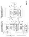
- FIG. 7is a flow chart showing the steps performed by the navigation system unit of FIG. 6 to obtain geographic data from the navigation services server.
- FIG. 8is an illustration of the actual road network located around the navigation system unit of FIG. 6 when the vehicle in which the navigation system is located is at a first position along the roads of the road network.
- FIG. 9shows the display panel of the navigation system unit when the vehicle in which the navigation system unit is located is at the position shown in FIG. 8 .
- FIG. 10is an illustration of the actual road network located around the navigation system unit of FIG. 6 when the vehicle in which the navigation system is located is at a second position along the roads of the road network.
- FIG. 11shows the display panel of the navigation system unit when the vehicle in which the navigation system unit is located is at the position shown in FIG. 10 .
- FIG. 12is similar to FIG. 11 and illustrates the display panel of the navigation system according to an alternative embodiment when the vehicle in which the navigation system unit is located is at the position shown in FIG. 10 .
- FIG. 1is a diagram illustrating a geographic region 100 .
- the geographic region 100may correspond to a metropolitan or rural area, a state, a country, or combinations thereof.
- Located in the geographic region 100is a road network 102 .
- a navigation system 105is located in the geographic region 100 .
- the navigation system 105is used by end users (e.g., vehicle drivers and passengers, as well as other persons) to obtain navigation-related and map-related features with respect to the geographic region 100 .
- the navigation-related and map-related featuresinclude information about travel along the road network 102 .
- the navigation system 105includes a geographic database 108 .
- the geographic database 108is maintained and operated by a navigation services provider 109 .
- the navigation services provider 109uses data from the geographic database 108 to provide navigation-related and map-related features to the end users.
- the end usersuse various computer platforms to request and obtain navigation-related and map-related features and geographic data from the navigation services provider 109 .
- These various platformsmay include navigation system units 112 located in vehicles 113 , personal computers 114 , personal organizers 115 , portable phones 116 , or any other types of computing devices that have the appropriate hardware and software to access the navigation services provider 109 over a data network.
- some of the navigation-related and map-related services obtained by end users from the navigation services provider 109include route calculation, route guidance, map display, point of interest searching, destination selection, and so on.
- certain functionsmay be performed remotely (i.e., away from the computing platform being used by the end user).
- a route to the destinationmay be calculated remotely on the navigation server 110 operated by the navigation services provider 109 .
- the navigation server 110may use data from the geographic database 108 .
- the data describing the routemay include a list of the road segments in the route, maneuvering instructions for following the route, and graphical maps that can be displayed on the end user's computing platform.
- the data describing the routemay be downloaded all at once or may be downloaded a portion at a time as the end user travels along the route.
- the end user's computing platforme.g., a navigation system unit in the end user's vehicle
- uses the downloaded datauses the downloaded data to provide the end user with driving instructions, graphical maps, and so on.
- the end user's computing platformmay determine the position of the end user's vehicle relative to the data describing the route that had been downloaded from the navigation services provider 109 .
- the function of determining the vehicle's position relative to the routemay be performed locally by the end user's computing platform using the data that had been downloaded from the navigation services provider 109 .
- the end userreceive additional data describing some of the roads around the route. This additional data can be used in case the end user departs from the route either intentionally or unintentionally.
- the data in the geographic database 108can be organized and arranged to facilitate the performance of these functions.
- the data in the geographic database 108can be organized into separate subsets or types based upon the navigation-related or map related function being performed. Each subset of the geographic data would include the data and associated attributes required to perform a particular navigation function but would exclude data and attributes which are not needed to perform the function.
- the geographic database 108may be organized and arranged to facilitate the performance of certain functions remotely (e.g., on the navigation server 110 ) and the performance of other functions locally (e.g., on the end user's computing platform). Because certain functions are performed locally (i.e., on the end user's computing platform), the geographic database 108 can be arranged and organized to facilitate the downloading of data in portions as needed to end users' computing platforms to perform certain navigation-related functions locally.
- FIG. 2shows a process 118 for forming part or all the geographic database 108 in FIG. 1 .
- the process 118is used to form the portion of the geographic database 108 that contains data which are downloaded to end users' computing platforms to perform certain navigation-related or map-related functions locally (i.e., on the end user's computing platform).
- the geographic database 108may also contain other portions (or refer to related databases) that are used to perform certain other navigation-related functions remotely (i.e., on the navigation server 110 operated by the navigation services provider 109 in FIG. 1 ).
- the process 118uses a primary copy 120 of a geographic database to form the geographic database 108 which is used by the navigation system 105 in FIG. 1 .
- the geographic database 108 used by the navigation system 105contains some of the same data which are contained in the primary copy 120 of the geographic database, the geographic database 108 has a different construction than the primary copy 120 .
- the geographic database 108is organized and arranged in a manner that facilitates its use for providing navigation-related services.
- the geographic database 108is organized and arranged in a manner that facilitates its use in a navigation system in which separate computing platforms operated by end users obtain geographic and other navigation-related data from a remotely-located central database that transmits geographic and other navigation-related data, as needed, to the separate computing platforms.
- the process 118 of FIG. 2is performed by an entity (e.g., an organization, person or company) that wishes to form the geographic database 108 .
- entitye.g., an organization, person or company
- the process 118may be performed by a database developer or by the entity that operates or maintains a central database of geographic data and that provides navigation services to navigation system units from the central database as needed.
- the primary copy 120contains data 121 that represent all the roads in a covered geographic region.
- the geographic regionmay correspond to the geographic region 100 of FIG. 1, which may be a metropolitan or rural area, a state, a country, or combinations thereof.
- the primary copy 120 of the geographic databaseis updated, expanded, and/or otherwise modified on a regular and continuing basis.
- the geographic data 121are collected, updated, and expanded by Navigation Technologies Corporation of Rosemont, Ill.
- the primary copy of the geographic databasemay be maintained in a format that facilitates updating and development.
- the data in the primary copy 120may be stored in an uncompressed format.
- each portion of a roadmay be represented by a separate road segment data entity.
- the data 121 contained in the primary copy 120include various attributes of the represented roads. These attributes may include data indicating locations (i.e., intersections as well as other points) along each of the roads, the names of each of the roads, highway designations of each road, address ranges along each road segment, speed limits or speed categories along the roads, turn restrictions at intersections, and so on.
- Each road (and segment thereof) represented in the primary copy 120 of the geographic databaseis associated with a rank.
- a rank of a roadrefers to a functional classification of the road. Roads that permit generally higher speeds and that allow greater volumes of traffic are assigned higher ranks than roads that permit lower speeds and lesser volumes of traffic. For example, roads having a rank of “4” include high volume, controlled access roads, such as expressways and freeways. Roads having a rank of “3” may be high volume roads with few speed changes, but are not necessarily controlled access roads. The lower ranked roads handle corresponding lower volumes and generally have more speed changes or slower speeds. Roads having a rank of “0” can handle the lowest volumes. For example, these lowest ranked roads may include side streets, alleyways, etc.
- the rank of a roadmay be determined by the geographic database developer when the data representing the road are collected and added to the primary copy of the geographic database. In alternative embodiments, the roads in a region may be assigned more or fewer than five ranks.
- FIG. 3shows a map 122 of a portion of the geographic region represented by the primary copy 120 of the geographic database.
- Each segment of each road between intersections shown in FIG. 3is represented by a data entity in the geographic database 120 in FIG. 2 .
- the portions 123 (1), 124 (1), 126 (1), and 130 (1)are represented by separate road segment data entities.
- the map 122shows roads of different ranks.
- a controlled access road 123is assigned a rank of “4.”
- a major, high volume road 124has a rank of “3.”
- a road 126 with businesses located along ithas a rank of “2”, and so on.
- Residential side streets and alleys 130have a rank of “0.”
- the primary copy 120 of the geographic databaseincludes data that indicate the rank of each represented road segment.
- the database formation process 118 in FIG. 2includes a step 138 in which the data 121 representing roads are organized into separate intermediate collections 140 based upon rank.
- Each separate intermediate collection 140is comprised of data entities that represent roads.
- the rank of a road segmentis used to determine in which of the separate intermediate collections 140 the data representing the road segment is included. For example, five separate intermediate collections of the data, e.g., 140 (0), 140 (1), 140 (2), etc., may be formed.
- the intermediate collection 140 (0)contains only the data that represent roads having a rank of 0
- the intermediate collection 140 (1)contains only the data that represent the roads having a rank of 1, and so on.
- Each of these separate intermediate collections 140may be stored temporarily in a separate file.
- the process 118includes a step 142 in which a threshold parameter 144 is specified.
- the threshold parameter 144is preferably specified as a time. In alternative embodiments, the threshold parameter 144 may be specified as a distance, a combination of time and distance, a fixed value or a calculated value.
- the threshold parameteris specified by the entity, e.g., a database developer, using the process 118 to form the database 108 . In the embodiment of FIG. 2, the threshold parameter 144 is specified as a unit of time.
- the value chosen for the threshold parametercorresponds to an estimated amount of time between successive downloads of data from a central database to a mobile navigation system unit with sufficient extra time added to ensure that the mobile navigation system has all the data needed to perform its functions.
- the threshold parameteris selected to be 30 seconds, although other values may be used.
- the process 118includes a step 150 that identifies—for all the roads represented in each given intermediate collection 140 —those portions of roads represented by data in other intermediate collections (i.e., road of other ranks) that are accessible from the roads represented by data in the given intermediate collection up to a distance related to the driving time of the threshold parameter 144 .
- a road from another intermediate collection 140is accessible from a road of a given intermediate collection 140 if the road of the other intermediate collection can be entered from the road of the given intermediate collection by a legal driving maneuver.
- those portion of roads of other ranks than can be reached from any road of the given rank within a distance related to the driving time of the threshold parameterare identified.
- a road of another rankis accessible from a road of a given rank when the road of the other rank forms an intersection with the road of the given rank and can be entered from the road of the given rank by a legal driving maneuver.
- the portions of roads having rank 0, rank 1, rank 3, and rank 4 that are accessible via a valid driving maneuver from a rank 2 road within a driving time of the threshold parameterare identified. If the threshold parameter is “30 seconds”, then those portions of roads having rank 0, rank 1, rank 3, and rank 4 that are accessible within 30 seconds of driving time from a rank 2 road are identified.
- the portions of these roads of rank 0, rank 1, rank 3 and rank 4 that are accessible within 30 seconds of driving timeis determined by taking into account the legal speed limits associated with these roads. For example, a rank 0 road may have a speed limit of 20 miles per hour.
- a rank 4 roadmay have a speed limit of 60 miles per hour and therefore the portion of the rank 4 road that is accessible from the rank 2 road extends 1 mile.
- the geographic databaserepresents speed limits along roads by speed limit categories instead of actual speed limit values, the portions of roads of that are accessible within 30 seconds of driving time is determined by taking into account the upper limits of the ranges associated with the applicable speed limit categories associated with these roads. (Adjustments may be included to account for estimated times to make turns, etc.)
- the portions of roads of other ranks that are accessible from a road of a given rankare determined, the portions are identified in whole segments.
- a rank 0 road segmentcan be accessed from an intersection with a rank 2road segment.
- the rank 0 road segmentis 2,640 feet long and is represented by a single road segment data entity.
- the distance related to the driving time of the threshold parameteris 1760 feet.
- the entire rank 0 road segmentis identified as being accessible from the rank 2 road segment because the entire distance associated with the driving time of the threshold is encompassed within the single whole road segment.
- a road segment of another rankis accessible within the distance related to the driving time of the threshold parameter from a road segment represented by data of a given intermediate collection (i.e., a road segment of the rank associated with the given collection). This may occur when the length of the road segment of the other rank that connects to the road segment of the given rank is less than the distance associated with the driving time of the threshold parameter. For example, assume that a rank 0 road segment is 1000 feet long and is accessible from an intersection with a rank 2 road. Further assume that the distance related to the driving time of the threshold parameter is 1760 feet. In this case, the successor segments of the rank 0 road segment are identified as being within the threshold. If necessary, additional successors may be identified so that all the (whole) road segments of ranks other than the given rank that are accessible within the distance related to the driving time of the threshold parameter are identified.
- the process 118then includes a step 152 in which augmented collections 154 of data are formed.
- a separate augmented collection 154is formed from each of the intermediate collections 140 of data that represent roads of a separate rank.
- An augmented collection 154is formed by adding the data entities that represent the road segments that include the portions of roads of other ranks that had been identified in the previous step (i.e., step 150 ).
- five separate augmented collections of datai.e., 154 (0), 154 (1), 154 (2), 154 (3), and 154 (4), are formed, one from each of the intermediate collections 140 (0), 140 (1), 140 (2), 140 (3), and 140 (4), respectively.
- the data entities identified in step 150are now contained in multiple augmented collections.
- Each of the data entities identified in the step 150is contained in the augmented data collection associated with its native rank as well as in another augmented data collection associated with another rank.
- each augmented collection 154is separately spatially organized.
- geographic datawhen geographic data are organized spatially, geographic features that are close together physically in the geographic region are represented by data records that are physically (or logically) close together in the database and possibly also close together on the medium upon which the data are stored.
- data that represent geographic featurescan be organized spatially.
- One of the ways that geographic data can be organized spatiallyis to first identify groups of data entities that represent geographic features that are located close together and then arrange the groups spatially. The data entities within each group may also be organized spatially or the data entities within a group may be organized according to another arrangement.
- a simple methodmay provide for separating the geographic data into a plurality of groups (or parcels) wherein the data in each group represent features encompassed within a separate one of a plurality of regular sized rectangles which together form a regular, rectangular grid over the geographic region.
- Another method for forming parcelsis to organize into separate parcels the data that represent physical geographic features encompassed within separate rectangular areas where each of the rectangular areas is formed by a bisection of rectangles encompassing parts of the region until a parcel size below a maximum threshold is obtained.
- parcelization proceduresare disclosed in the patents, U.S. Pat. Nos. 5,968,109 and 5,974,419, the entire disclosures of which is incorporated by reference herein.
- FIG. 4shows a map 211 of the geographic region 100 .
- a plurality of positions 216are shown to be located on the map 211 .
- Each of the positions 216represents a place or point in the geographic area 100 at which there is located a feature about which information is included in the geographic database 108 of FIG. 1 .
- the positions 216may correspond to the physical locations of end points of road segments, points along road segments, points-of-interest (such as hotels, civic centers, etc.), and so on, which are represented by the data in the geographic database 108 .
- Each of these locations 216has a unique physical location (latitude, longitude, and optionally absolute or relative altitude) and each of the locations 216 can be uniquely identified by its two dimensional (or three dimensional) geographic coordinates (i.e., latitude, longitude, and optionally altitude).
- a grid 217overlays the geographic region 100 represented by the map 211 .
- the grid 217divides the geographic region 100 into a plurality of rectangular areas 219 . These rectangular areas 219 may be all the same size or may have different sizes depending upon the procedure used for parcelization.
- the grid lines of the grid 217represent the boundaries of the rectangular areas 219 . The locations of the boundaries may depend on the parcelization procedure used.
- the data records of a particular type of data which represent features that are encompassed within each rectangular area 219are grouped together in a separate parcel 225 (in FIG. 5) of data. Therefore, each parcel 225 of spatially organized data (in FIG. 5) includes one or more data records which represent the geographic features encompassed within a separate one of the plurality of rectangles 219 (as shown in FIG. 4 ).
- the parcel 225is then stored to form the database 108 so that the data in each parcel 225 are logically and/or physically grouped together.
- the parcelmay represent the quantity of data that is accessed at the same time from the medium by the navigation system 105 , and therefore when a parcel of data is accessed, all of its data records are read into the memory of the navigation system 105 at the same time. With reference to the map 211 of FIG. 4, this means that all the data records that represent the features encompassed within each rectangle 219 are accessed together as a group. It can be appreciated that for certain kinds of navigation functions, it is desirable to have in memory at the same time all the data records that represent features that are physically close together in the geographic region.
- the parcels 225are ordered. Various types of ordering may be used. In general, it is preferred that the parcels be ordered in a manner that minimizes searches for data.
- One way to order spatially organized parcelsis to use a depth-first ordering from a kD-tree index within each type of data. This provides an ordering similar to Peano-key ordering. Parcels may be stored on a medium in this approximate Peano key order. This index is useful for initial location of an arbitrary position, such as when a program in a navigation system initially locates the data corresponding to a current vehicle position.
- eachmay also be assigned a unique parcel identifier (e.g., a “parcel ID”). The parcel ID may be used to identify the parcel and/or its location on the medium.
- one or more indexes 226may also be formed using the kD-tree. These indexes 226 may be stored in a global portion 227 of the geographic database 108 .
- each separate collection 154is organized spatially separately. That is, the collection 154 (0) is organized so that the data entities in contained in the collection that represent geographic features that are close together are located close together in the database. Then, the data entities in the collection 154 (1) are organized so that data entities that represent geographic features that are close together are located close together in the database, and so on.
- These separate collections 154 (0), 154 (1), etc.,are shown in FIG. 5 .
- the spatially organized augmented collectionsare stored to form the database 108 (Step 158 ).
- the databasecan be used to distribute geographic information to separate navigation system units as explained below.
- the process 118 shown in FIG. 1 for forming a geographic database that can be used for providing navigation-related and map-related data to end usersmay include additional steps and processes.
- the data in the geographic database 108may be organized into separate types to perform known navigation-related and map-related functions. Also, data may be organized to facilitate the performance of certain functions remotely (e.g., on the navigation server 110 ) and the performance of other functions locally (e.g., on the end user's computing platform).
- the geographic database 108may include other types of data 229 in addition to the data contained in the augmented collections 154 .
- FIG. 6shows components of the navigation system unit 112 installed on one of the vehicles 113 in FIG. 1 .
- the navigation system unit 112 in FIG. 6is exemplary of the navigation system units installed in some or all of the vehicles 113 in FIG. 1, i.e., the navigation system units in the other vehicles 113 include identical or similar components.
- the navigation system unit 112is comprised of hardware and software components.
- the hardware and software componentsoperate together to provide navigation-related features to an end user (e.g., the driver and/or passengers).
- the navigation system unit 112includes a processor 322 , memory 324 and a non-volatile memory storage device 326 for storing navigation system programming 328 (software, firmware, data, etc.) for operating the navigation system unit, as well as data, such as configuration parameters.
- the navigation applications 328may include a vehicle positioning application 328 (1), a map display application 328 (2), as well as other applications 328 (3).
- the vehicle positioning application 328 (1)determines the vehicle's position relative to data that represent the road network (e.g., map matching).
- the map display application 328 (2)uses data that represent the road network to render an image of a map showing the area around the vehicle on a display panel 344 .
- the navigation system unit 112includes a positioning system component 334 .
- the positioning system component 334may use GPS-type technology, a dead reckoning-type system, or combinations of these, or other systems, all of which are known in the art.
- the positioning system component 334may include suitable sensing devices 336 that measure the speed, direction, angular acceleration, and so on, of the vehicle.
- the positioning system component 334may also include appropriate technology to obtain a GPS signal, in a known manner.
- the positioning system component 334provides an output that is used to determine the location, direction, travel distance, speed, etc., of the navigation system unit 112 , and hence the vehicle 113 in which the navigation system is located.
- the navigation system unit 112also includes a user interface 340 .
- the user interface 340includes appropriate equipment 342 that allows the end user to input information into the navigation system. This input information may include a request to use the navigation features of the navigation system. For example, the input information may include a request for a route to a desired destination.
- the equipment used to input information into the navigation systemmay include a keypad, a keyboard, a microphone, etc., as well as appropriate software, such as a voice recognition program.
- the user interface 340also includes suitable equipment 344 that provides information back to the end-user. This equipment 344 may include a display 344 (D), speakers, or other means.
- the navigation system 112 in the vehicle 113is of the type that obtains some or all the geographic data needed to provide navigation-related or map-related services from the remotely located navigation services provider 109 .
- the navigation system unit 112 and the navigation services provider 109communicate with each other over a data network 350 .
- the data network 350may use any suitable technology and/or protocols that are currently available, as well as protocols that become available in the future.
- the data networkmay use WAP, TCP/IP, etc. More than one protocol may be used in the data network 350 provided that appropriate conversion is used.
- the wireless portion 352 of the data network 350enables two-way communication between the navigation system 112 and the service provider 109 while the vehicle 113 is located anywhere in the region 100 .
- the wireless portion 352may be implemented by any suitable form of wireless communications, including cellular, PCS, satellite, FM, radio, or technologies that may be developed in the future.
- the wireless portion 352may include one or more transmitters 356 , such as a transponder tower, an antenna tower, an FM tower, satellites, or other suitable means.
- the transmitters 356include an appropriate communication link 358 to the service provider 109 . This link 358 may be land-based or may be wireless.
- the transmitters 356include suitable technology that enables two-way communication between the service provider 109 and the navigation system unit 112 in the vehicle 113 .
- the navigation system units 112 in the other vehicles 113 in the region 100 that are serviced by the service provider 109may also communicate with the service provider 109 over the data network 350 .
- the other vehicles 113 in the region 100 that are serviced by the service provider 109may also use the same means of wireless communication 352 to communicate over the data network 350 with the service provider 109 .
- other vehicles 113 that are serviced by the service provider 109may use other means of wireless communication to connect to the data network 350 and/or communicate with the service provider 109 .
- the navigation system 112 in the vehicle 113includes a communications system 368 .
- the communications system 368includes the appropriate hardware and software to send and receive data messages over the data network 350 .
- the communications system 368is operatively coupled to other components of the navigation system 112 so that messages can be sent from and received by the navigation system.
- the navigation services provider 109includes appropriate hardware and software for providing navigation services to the navigation systems in the vehicles 113 .
- the navigation services provider 109may include the server 110 that includes or is associated with appropriate communications equipment 428 for receiving messages from the navigation system units 112 in the vehicles 113 and sending messages back to the navigation system units.
- the navigation services provider 109also includes message handling programming 438 that analyzes the requests for navigation-related or map-related information received from the navigation system units 112 , determines appropriate responses to the requests, and sends the responses to navigation system units 112 that sent the requests.
- the message handling programming 438may include navigation application programs 448 to perform requested navigation-related and map-related functions.
- the navigation applications 448may include a route calculation application 448 (1), a route guidance program 448 (2), as well as other programs and applications 448 (4).
- the navigation services provider 109uses data from the geographic database 108 .
- the geographic database 108 used by the navigation services provider 109is stored on appropriate storage media, e.g., one or more hard drives.
- end userscan obtain various navigation-related and map-related features using the navigation system 105 of FIG. 1 .
- geographic dataare sent from the navigation services provider 109 to the end users' computing platforms, as needed, so that sufficient data are present on the end users' computing platforms in order to perform desired functions.
- the end useris following a calculated route to a destination, sufficient data are sent from the navigation services provider 109 to the end user's computing platform (such as the navigation system unit 112 shown in FIG. 6) so that driving instructions for following the calculated route can be provided to the end user.
- the driving instructionsare provided as the locations of certain required driving maneuvers are being approached.
- the end user's computing platformis required to have data from which the end user's current position relative to data in the calculated route can be determined.
- the end user's computing platformincludes a graphical display (such as the display 344 (D) in FIG. 6 ).
- sufficient dataare sent from the navigation services provider 109 to the end user's computing platform so that a map of the end user's current location can be rendered on the graphical display of the end user's computing platform.
- sufficient dataare sent so that maps of various scales can be rendered on the display of the end user's computing platform. Maps of the end user's current location can be provided whether or not the end user is following a calculated route.
- the end user's computing platformWhen the geographic data are sent to the end user's computing platform to perform these types of functions, it is preferable that data about roads around the end user's current location are provided. These data are necessary if a graphical map of the end user's position is to be rendered on the display of the end user's computing platform. In addition, if the end user departs from a calculated route, the end user's computing platform should have sufficient data available locally so that the end user's position along a road can be determined.
- the end userreceives data that represent roads around the end user's current position that have the same rank as the road upon which the end user is traveling as well as data that represent roads of other ranks that are accessible from the roads of the same rank up to a threshold.
- the end userdoes not receive data that represent roads having ranks other than the rank of the road upon which the end user is traveling that are not accessible from roads having the same rank as the road upon which the end user is traveling.
- This method of sending needed data from a remote database to the end user's computing platformcan be used whether or not the end user is following a route calculated by the navigation system. Even if the end user is not following a route calculated by the navigation system, the end user may wish to have a graphical map of the roads around his/her current location displayed on a display screen of his/her computing platform. By sending data that represent roads of the same rank as the road upon which the end user is traveling along with data that represent roads of other ranks that are accessible within a threshold of these same rank roads, a graphical map can be displayed on the end user's computing platform that will show all the roads that the end user can reach from his/her current position.
- the end usermay want to have a graphical map that shows not only the roads that are part of the route, but also roads that are not part of the route but that can be accessed from the route. The end user may wish to observe these roads that are not part of the route as they are being passed to confirm that he/she is following the route.
- the present embodimentprovides an advantage when the end user is following a calculated route. If the end user departs from the calculated route, intentionally or otherwise, the end user's computing platform has sufficient data available locally so that the end user's position along the off-route road segment can be determined. The information identifying the end user's position along the off-route road segment can be transmitted back to the navigation services provider and used to calculate a new route.
- the new routecan be a new route to the destination, a route back to the old route, or a new route to a new destination.
- a method of operation of the navigation system of the present embodimentis described in connection with FIG. 7.
- a process 500includes steps performed by the end user's local computing platform (e.g., the navigation system unit 112 ) and another process 504 includes steps performed on the server 110 of the navigation services provider 109 .
- the process 500 performed on the end user's computing platformmay be one of several different processes that are performed on the end user's computing platform. For example, there may be another process wherein the end user's computing platform formulates a request for route guidance to a desired destination.
- the end user's computing platformmay perform another process after it receives data indicating a route calculated to the desired destination. For example, after the end user's computing platform receives data indicating the route to a desired destination, the end user may be provided with instructions for following the route.
- the navigation servermay perform processes in addition to the process 504 shown in FIG. 7 . For example, upon receiving a request from an end user's computing platform, the navigation server may calculate a route to an indicated destination. The navigation server may also formulate driving instructions for following the route.
- the end user's computing platformdetermines its position (Step 510 ).
- the positionmay indicate on which road segment the end user is currently located. This function may be performed by the vehicle positioning application ( 328 (1) in FIG. 6) located in the end user's computing platform.
- the vehicle positioning application in the end user's computing platformmay use geographic data that have previously been received from the navigation services provider 109 .
- the end usermay have been receiving driving instructions from the computing platform for following a route to a destination.
- the routemay have been calculated by the navigation server and data indicating the route downloaded to the end user's computing platform.
- the end usermay not be receiving driving instructions for following a route to a destination.
- a message 512is formed (Step 514 ).
- the message 512includes data indicating the vehicle's position.
- the messagemay also include data indicating the rank of the road upon which the vehicle is located and the direction of travel of the vehicle along the road segment upon which the vehicle is located.
- the rank of the road segmentmay be determined from the data that have previously been received from the navigation services provider 109 .
- the vehicle directionmay be determined from the sensors ( 336 in FIG. 6 ).
- the message 512may include additional information.
- the message 512is sent to the navigation server 110 (Step 518 ).
- the message 512is sent using the network ( 350 in FIGS. 1 and 6 ).
- the message 512 that is sent from the end user's computing platformis received on the navigation server 10 (Step 522 ).
- the navigation server 110obtains data 526 to send to the end user's computing platform (Step 524 ).
- the data 526 obtained by the navigation server 110represent some of the roads located around the end user's current position (as indicated by the data included in the message 512 sent by the end user).
- the data 526 obtained by the navigation server 110includes data representing the roads located around the end user's current position that have the same rank as the road upon which the end user is traveling. The rank of the road upon which the end user is traveling can be determined from the message 512 received by the navigation server 110 from the end user.
- the data 526 obtained by the navigation serveralso includes data representing portions of some of the roads located around the end user's current position that have a rank other than the rank of the road upon which the end user is traveling. These portions of roads of other ranks include portions that are accessible from the roads around the end user's position that have the same rank as the road upon which the end user is traveling. The portions of roads of other ranks include those portions of such roads that are accessible up to a distance associated with a predefined driving time of the threshold parameter.
- the navigation server 110may use the data indicating the vehicle's direction that had been included in the message 512 to obtain more data representing roads located ahead of the vehicle than data representing roads located behind the vehicle.
- the navigation server 110may use the database 108 formed according to the process described in FIG. 2 to obtain the data 526 .
- the database 108includes data organized into augmented collections based upon the rank of the represented road segment.
- the navigation services serverdoes not have to calculate which road segments are accessible from the end user's current position each time data are sent to the end user's computing platform. This facilitates sending data to the end user's computing platform quickly.
- the navigation server 110After the navigation server 110 obtains the data 526 relating to some of the roads around the end user's location, the navigation server 110 sends the data 526 to the end user's computing platform (Step 530 ).
- the datamay be sent in uniform-sized packets. For example, each packet may have a size of 16K, 32 K, 64 K, etc.
- Each packetmay correspond to a spatially-organized parcel, such as one of the parcels 225 in FIG. 5 .
- Using uniform-sized packetsmay facilitate processing of the data both at the navigation services provider and at the end user's computing platform.
- the end user's computing platformreceives the data 526 sent by the navigation server 110 relating to some of the roads located around the current position of the vehicle (Step 540 ).
- the end user's computing platformuses the data 526 sent by the navigation server 110 in a navigation application located on the end user's computing platform (Step 544 ).
- the end user's computing platformmay use the data 526 in the vehicle positioning application 328 (1) and the map display application 328 (2).
- data that represent roads of ranks other than the rank of the road upon which the end user is traveling up to a distance related to a driving time thresholdare sent to the end user's computing platform.
- the driving time thresholdis selected so that the end user's computing platform has sufficient data so that regardless of which way the end user travels, the end user's computing platform has data that represent the road upon which the end user is located.
- the driving time thresholdmay be related to the responsiveness of the navigation services server and the associated network delays which determine how quickly the end user's computing platform can receive data updates from the navigation services server.
- the driving time thresholdis selected so that all the road segments within at least a 30 second driving time distance to a connection to a road of the rank of road that the end user's position is currently on are sent to the end user's computing platform.
- a 40 second driving time thresholdmay be selected so that the end user has data for at least 30 seconds of driving time available locally in the vehicle.
- the end user's computing platformmay send other kinds of data to the navigation services provider from which the end user's location can be determined. For example, if the end user's computing platform does not have data from which the road segment upon which the end user is currently located can be determined, the end user's computing platform may send data indicating the geographic coordinates of the end user's computing platform. These data indicating the geographic coordinates of the end user's computing platform may be obtained from a GPS system associated with the end user's computing platform.
- the navigation services provideruses the data indicating the geographic coordinates of the end user's computing platform to determine upon which road segment the end user is located.
- the navigation services providermay have a vehicle positioning application, similar to the vehicle positioning application in the end user's computing platform, for this purpose.
- FIGS. 8 and 9show how the present embodiment can be used to show an end user a map of his/her current location as well as some of the roads located around the end user.
- FIG. 8is a map of illustrating the actual road network around the end user's current location.
- the end user's vehicle 113which includes the navigation system unit 112
- the end user's vehicle 113is located at a position 580 along a rank 4 road segment. The vehicle is traveling in the direction indicated by the arrow 582 .
- FIG. 9shows the display panel 344 (D) of the navigation system unit 112 .
- a graphical image 590 of a map of the end user's positionis shown on the display panel 344 (D).
- the image 590may be rendered using the map display application 328 (2) in the navigation system unit 112 .
- the map display application 328 (2)uses data representing some of the roads located around the vehicle's current location. The data were obtained from the central database 108 associated with the navigation server 110 according to the process shown in FIG. 7 .
- the graphical image 590 in FIG. 9includes roads of the same rank as the road upon which the end user is traveling and portions of roads of other ranks that are accessible from these roads up to a threshold, but does not include portions of roads of other ranks that are beyond the threshold.
- FIGS. 10 and 11further illustrate operation of the present embodiment.
- FIG. 10shows the same road network shown in FIG. 8 .
- the vehicleis at a different location 594 .
- the location 594is on a rank 0 road segment.
- FIG. 11shows the display panel 344 (D) with a graphical image 600 of a map of the end user's position.
- the image 600includes roads of the same rank as the road upon which the end user is traveling and portions of roads of other ranks that are accessible from these roads up to a threshold, but does not include portions of roads of other ranks that are beyond the threshold.
- the present embodimentprovides several advantages.
- the end userBy sending the end user data that represent roads of the same rank around the end user's current location and data that represent roads of other ranks that are accessible from these roads up to a driving time threshold, the end user should have enough data available locally at all times so that the end user cannot reach a road which is not represented by data already available locally on the end user's computing platform.
- the end usershould have the data available locally at all times that are necessary to determine upon which road segment the end user is located.
- new dataare received from the remotely located geographic database.
- An advantagefollows from not sending data that represent roads of other ranks that are not accessible from the end user's current position. Since these roads are not accessible from the end user's current position, the end user cannot travel onto these roads and therefore it is not necessary that the end user receive data that represent these roads. By not sending data that that represent these inaccessible roads, the available bandwidth of the communications network used by the navigation system can be used efficiently, i.e., more pertinent data can be sent.
- the disclosed navigation systemincludes a central geographic database from which end users can obtain geographic data and other navigation-related and map-related services using a variety of different computing platforms.
- the navigation systemcan be used by end users who access the geographic database using personal computers, networks, personal digital assistants, portable electronic devices, and so on. Some of these computing platforms may be portable or mobile and others of these computing platforms may not be portable or mobile.
- These various computing platformsmay provide various means by which navigation-related and map related information is provided back to the end user.
- navigation system units in vehicles, personal computers, and personal organizersmay have display screens on which the navigation-related and map-related information may be shown to the end user.
- Some computing platformsmay not have a display screen.
- Computing platforms without display screensmay provide navigation related and map-related information to the end user audibly.
- Some computing platformsmay provide navigation-related and map-related information both visually and audibly.
- Positioning systemmay include GPS receivers, dead-reckoning equipment, etc., that can determine the instantaneous position of the end user.
- the location of some of the computing platformscan be determined remotely using technologies like those used for determining locations of cellular phones in an area.
- technologiesthat provide this feature, e.g., cell triangulation.
- Some of the companies that provide this type of technologyinclude ArrayComm, Inc., Harris Corporation, Corsair Communications, Lockheed Martin Corporation, CELLTRAX, Inc., TruePosition, Inc., Cell-Loc Inc., KSI Inc., and U.S. Wireless Corporation.
- Some of these technologiescan be used to locate a cellular phone user who dials an emergency number, e.g., “911.” Any such technology that is presently available or that becomes available in the future may be used to determine an end user's position.
- a threshold parameteris selected for the geographic database when determining to what extent roads of other ranks are included in collections of data that represent road segments of a given rank.
- multiple versions of the geographic database 108can be formed, each using a different threshold parameter.
- one geographic databasecan be formed with a threshold parameter of 20 seconds
- another geographic databasecan be formed with a threshold parameter of 40 seconds
- a third geographic databasecan be formed with a threshold parameters of 60 seconds.
- These different databasescan be used by a single geographic database provider.
- the different databasescan be used to provide different levels of service. For example, a standard level of service provides data in response to an update request within 50 seconds. To provide this level of service, the geographic database formed with a threshold parameter of 60 seconds is used.
- a navigation service providermay also use databases formed with different threshold parameters to accommodate different demand loads. For example, when a large number of end users are accessing the navigation server to obtain navigation-related and map-related data, the amount of time between successive downloads of data to each user may increase. When this occurs, the navigation server may automatically switch to using a geographic database formed with a greater threshold.
- Some roads and intersections represented in a geographic regionmay have time of day restrictions. For example, at some intersections, left turns are prohibited during certain hours, e.g., between 4:00 PM and 6:00 PM. According to another example, parking may be prohibited along a road between certain hours, e.g., between 6:00 AM and 9:00 AM.
- Data indicating time of day restrictionsmay be included in the geographic database. These data indicating time of day restrictions may be used by the navigation system when calculating a route so that the end user is not advised to make a turn that is illegal at a certain time of day. Therefore, these time of day restrictions affect whether certain road segments are accessible from other road segments. As described above in connection with FIG.
- road segments that are accessible within a threshold of roads of a given rankare included in an augmented collection 154 .
- time of day restrictionsare ignored when performing the step 152 of forming the augmented collections. If time of day restrictions are ignored when forming the augmented collections 154 , data representing some road segments that are inaccessible during certain times of day would be included in the augmented collection. However, the number of such road segments may be relatively small. Therefore, the amount of data represented by such road segments would not significantly affect the amount of data transmitted to the end users' computing platforms from the central geographic database.
- separate geographic databasescan be formed to take into account time of day restrictions. According to this alternative embodiment, separate databases would be formed for different times of the day.
- a 600 AM version of the databasewould be formed using the time of day restrictions that apply at 600 AM, 900 AM version of the database would be formed using the time of day restrictions that apply at 900 AM, and so on. Then, the navigation server would use the appropriate version of the database corresponding to the time of day to send data to the end users' computing platforms.
- a further alternative embodimentwould be for the navigation server to remove the inaccessible segments at the time it prepares to send the data out to the navigation unit.
- the navigation serverwill determine which links are accessible and which are not.
- the links with a time-of-day restrictionsmay be included in the databases with special attributes to make the filtering process more efficient.
- a method for forming a type of layered databaseis disclosed.
- the processes 500 and 502 in FIG. 7 for sending data from a central database for use locally in end users' computing platformsare not limited to use of a geographic database formed according to the process of FIG. 2 .
- a lowest layercan include data representing road segments of all ranks
- a next higher layerwould include data representing only road segments of rank 1 and higher, and so on, until a highest layer includes data representing only roads of the highest rank.
- the geographic database used by the navigation services providermay implement logical layering.
- the display screen of the end user's computing platformshows the roads around the end user that have the same rank as the road upon which the end user is located and roads of other ranks that are accessible from the roads of the same rank.
- a rank 4 roadpasses over the rank 0 road upon which the end user is located immediately ahead of the end user's position. Comparing FIG. 11 to FIG. 10, it is noted that this rank 4 road is not shown in on the display screen because it is neither of the same rank as the road upon which the end user is located nor accessible from the rank 0 roads. Even though the end user cannot access the rank 4 road, it may be helpful to the end user to know that the rank 4 road forms an overpass over the road upon which he/she is located.
- FIG. 12shows the display panel of an end user's navigation system unit that operates according to this alternative embodiment.
- FIG. 12is similar to FIG. 11 and illustrates the display panel of the navigation system when the vehicle in which the navigation system unit is located is at the position shown in FIG. 10 .
- the display screen 344 (D)shows an image 660 of the roads around the end user including the inaccessible rank 4 road.
- the image 660includes an indication 662 that the rank 4 road is inaccessible.
- the indication 662may be a message.
- the inaccessible roadmay be in a different color, a different line style, or otherwise shown differently.
- the threshold parameter used to identify which road segments of ranks other than a the rank associated with a collection datais expressed as a driving time.
- the threshold parametermay be a driving distance to another value.
Landscapes
- Engineering & Computer Science (AREA)
- Remote Sensing (AREA)
- Radar, Positioning & Navigation (AREA)
- Physics & Mathematics (AREA)
- General Physics & Mathematics (AREA)
- Databases & Information Systems (AREA)
- Automation & Control Theory (AREA)
- Theoretical Computer Science (AREA)
- Data Mining & Analysis (AREA)
- General Engineering & Computer Science (AREA)
- Navigation (AREA)
- Instructional Devices (AREA)
Abstract
Description
Claims (19)
Priority Applications (1)
| Application Number | Priority Date | Filing Date | Title |
|---|---|---|---|
| US09/624,695US6292745B1 (en) | 2000-07-24 | 2000-07-24 | Method and system for forming a database of geographic data for distribution to navigation system units |
Applications Claiming Priority (1)
| Application Number | Priority Date | Filing Date | Title |
|---|---|---|---|
| US09/624,695US6292745B1 (en) | 2000-07-24 | 2000-07-24 | Method and system for forming a database of geographic data for distribution to navigation system units |
Publications (1)
| Publication Number | Publication Date |
|---|---|
| US6292745B1true US6292745B1 (en) | 2001-09-18 |
Family
ID=24502965
Family Applications (1)
| Application Number | Title | Priority Date | Filing Date |
|---|---|---|---|
| US09/624,695Expired - LifetimeUS6292745B1 (en) | 2000-07-24 | 2000-07-24 | Method and system for forming a database of geographic data for distribution to navigation system units |
Country Status (1)
| Country | Link |
|---|---|
| US (1) | US6292745B1 (en) |
Cited By (68)
| Publication number | Priority date | Publication date | Assignee | Title |
|---|---|---|---|---|
| WO2002077897A1 (en)* | 2001-03-13 | 2002-10-03 | Minsoo Kang | Digital map ranking system |
| US6502032B1 (en)* | 2001-06-25 | 2002-12-31 | The United States Of America As Represented By The Secretary Of The Air Force | GPS urban navigation system for the blind |
| US20030059743A1 (en)* | 2001-08-29 | 2003-03-27 | The Boeing Company | Method and apparatus for automatically generating a terrain model for display during flight simulation |
| US20030069687A1 (en)* | 1998-03-18 | 2003-04-10 | Toshio Tsuyuki | Navigation apparatus and method |
| US6601073B1 (en)* | 2000-03-22 | 2003-07-29 | Navigation Technologies Corp. | Deductive database architecture for geographic data |
| US6633809B1 (en)* | 2000-08-15 | 2003-10-14 | Hitachi, Ltd. | Wireless method and system for providing navigation information |
| US6654682B2 (en)* | 2000-03-23 | 2003-11-25 | Siemens Transportation Systems, Inc. | Transit planning system |
| WO2002097368A3 (en)* | 2001-05-31 | 2003-12-04 | Infomove Inc | Method and system for distributed navigation and automated guidance |
| US20040044466A1 (en)* | 2002-08-29 | 2004-03-04 | Nesbitt David W. | Automated route determination |
| US6704649B2 (en)* | 2001-07-31 | 2004-03-09 | Pioneer Corporation | Satellite navigation system of which map data are partially updateable |
| US20040073361A1 (en)* | 2002-10-15 | 2004-04-15 | Assimakis Tzamaloukas | Enhanced mobile communication device, and transportation application thereof |
| US20040117108A1 (en)* | 2000-12-21 | 2004-06-17 | Zoltan Nemeth | Navigation system |
| US6766248B2 (en)* | 2001-07-31 | 2004-07-20 | Pioneer Corporation | Satellite navigation system of which map data are partially updateable |
| US20040230374A1 (en)* | 2003-05-12 | 2004-11-18 | Assimakis Tzamaloukas | Enhanced dead reckoning method |
| US20040230370A1 (en)* | 2003-05-12 | 2004-11-18 | Assimakis Tzamaloukas | Enhanced mobile communication device with extended radio, and applications |
| US20040230345A1 (en)* | 2003-05-12 | 2004-11-18 | Assimakis Tzamaloukas | Methods for communicating between elements in a hierarchical floating car data network |
| US6873905B2 (en)* | 2002-03-19 | 2005-03-29 | Opnext Japan, Inc. | Communications type navigation device |
| US20050090970A1 (en)* | 2001-11-13 | 2005-04-28 | Andre Barkowski | Method for navigation of a vehicle |
| US20050090294A1 (en)* | 2003-10-24 | 2005-04-28 | Nitya Narasimhan | System and method for generating multimedia composites to track mobile events |
| US20050102098A1 (en)* | 2003-11-07 | 2005-05-12 | Montealegre Steve E. | Adaptive navigation system with artificial intelligence |
| US20050104881A1 (en)* | 2003-11-13 | 2005-05-19 | Tadashi Yoshida | Map display apparatus |
| US20050114016A1 (en)* | 2003-11-25 | 2005-05-26 | Samsung Electronics Co., Ltd. | Navigation system and method for updating map data based on map modification command |
| US20050137789A1 (en)* | 2003-12-23 | 2005-06-23 | Honda Motor Co., Ltd. | Prioritized delivery of navigation information |
| US20050159880A1 (en)* | 2003-12-23 | 2005-07-21 | Honda Motor Co., Ltd. | Smart storage and transmission of navigation information |
| US6950797B1 (en)* | 1999-09-09 | 2005-09-27 | Xanavi Informatics Corporation | Voice reference apparatus, recording medium recording voice reference control program and voice recognition navigation apparatus |
| US20050261824A1 (en)* | 2004-05-19 | 2005-11-24 | Honda Motor Co., Ltd. | System and method for varying content |
| US20050261829A1 (en)* | 2004-05-19 | 2005-11-24 | Honda Motor Co., Ltd. | System and method for off route processing |
| US20050261827A1 (en)* | 2004-05-19 | 2005-11-24 | Honda Motor Co., Ltd. | System and method for displaying information |
| US20060002590A1 (en)* | 2004-06-30 | 2006-01-05 | Borak Jason M | Method of collecting information for a geographic database for use with a navigation system |
| US20060058951A1 (en)* | 2004-09-07 | 2006-03-16 | Cooper Clive W | System and method of wireless downloads of map and geographic based data to portable computing devices |
| US7079945B1 (en)* | 2001-04-17 | 2006-07-18 | Navteq North America, Llc | Geographic database including data indicating wireless coverage and method and system for use thereof |
| US20060158330A1 (en)* | 2002-03-05 | 2006-07-20 | Andre Gueziec | Traffic information dissemination |
| US20060184315A1 (en)* | 2005-02-14 | 2006-08-17 | Liu Kunwel M | Method for initiating navigation guidance in a distributed communications system |
| US20060204039A1 (en)* | 2005-03-09 | 2006-09-14 | Mitsubishi Jidosha Kogyo Kabushiki Kaisha | Vehicle periphery monitoring apparatus |
| DE102005020154A1 (en)* | 2005-04-29 | 2006-11-02 | Volkswagen Ag | Map display control method, used in navigation system, involves displaying section of geographical road map, dividing displayed map section into different areas, and displaying assigned road classes in divided areas of displayed map section |
| US20060244661A1 (en)* | 2004-09-10 | 2006-11-02 | Worcester Polytechnic Institute | Methods and apparatus for high resolution positioning |
| US7188026B2 (en) | 2003-05-12 | 2007-03-06 | Dash Navigation, Inc. | Hierarchical floating car data network |
| US7356405B1 (en)* | 2002-08-29 | 2008-04-08 | Aol Llc | Automated route determination to avoid a particular maneuver |
| US7474960B1 (en) | 2002-12-30 | 2009-01-06 | Mapquest, Inc. | Presenting a travel route |
| US20090037103A1 (en)* | 2004-06-30 | 2009-02-05 | Navteq North America, Llc | Method of Operating a Navigation System Using Images |
| US20100075643A1 (en)* | 2004-09-07 | 2010-03-25 | Tierravision, Inc. | System and method of wireless downloads of map and geographic based data to portable computing devices |
| US7689621B1 (en)* | 2000-11-06 | 2010-03-30 | Navteq North America, Llc | Multi-dimensional spatial index for a geographic database |
| US7818116B1 (en) | 2002-12-30 | 2010-10-19 | Mapquest, Inc. | Presenting a travel route in a ground-based vehicle |
| USRE41983E1 (en) | 2000-09-22 | 2010-12-07 | Tierravision, Inc. | Method of organizing and compressing spatial data |
| US20110004400A1 (en)* | 2009-07-01 | 2011-01-06 | Samsung Electronics Co. Ltd. | Apparatus and method for providing road data in mobile communication system |
| US7904238B2 (en) | 2002-12-30 | 2011-03-08 | Mapquest, Inc. | Presenting a travel route using more than one presentation style |
| US20110093188A1 (en)* | 2009-10-18 | 2011-04-21 | International Business Machines Corporation | Method and system for visualizing shared route information |
| US7941269B2 (en) | 2005-05-06 | 2011-05-10 | Rialcardo Tice B.V. Llc | Network-based navigation system having virtual drive-thru advertisements integrated with actual imagery from along a physical route |
| US20110121993A1 (en)* | 2009-11-24 | 2011-05-26 | International Business Machines Corporation | Optimizing traffic speeds to minimize traffic pulses in an intelligent traffic system |
| US7966003B2 (en) | 2004-07-09 | 2011-06-21 | Tegic Communications, Inc. | Disambiguating ambiguous characters |
| US20110264361A1 (en)* | 2007-08-25 | 2011-10-27 | Continental Teves Ag & Co. Ohg | Apparatus and method for updating digital maps |
| WO2012026918A1 (en)* | 2010-08-23 | 2012-03-01 | Hewlett-Packard Development Company, L.P. | A navigation device with adjustable data transmission |
| US8583367B2 (en) | 2011-01-07 | 2013-11-12 | Honda Motor Co., Ltd. | System and method for displaying a route based on a vehicle state |
| US8619072B2 (en) | 2009-03-04 | 2013-12-31 | Triangle Software Llc | Controlling a three-dimensional virtual broadcast presentation |
| US8660780B2 (en) | 2003-07-25 | 2014-02-25 | Pelmorex Canada Inc. | System and method for delivering departure notifications |
| US8718910B2 (en) | 2010-11-14 | 2014-05-06 | Pelmorex Canada Inc. | Crowd sourced traffic reporting |
| US8725396B2 (en) | 2011-05-18 | 2014-05-13 | Pelmorex Canada Inc. | System for providing traffic data and driving efficiency data |
| CN103797333A (en)* | 2011-09-13 | 2014-05-14 | 罗伯特·博世有限公司 | Device and method for determining a position of a vehicle |
| US8751156B2 (en) | 2004-06-30 | 2014-06-10 | HERE North America LLC | Method of operating a navigation system using images |
| US8781718B2 (en) | 2012-01-27 | 2014-07-15 | Pelmorex Canada Inc. | Estimating time travel distributions on signalized arterials |
| US8918282B1 (en)* | 2013-08-30 | 2014-12-23 | Here Global B.V. | Turn restriction determination |
| US8982116B2 (en) | 2009-03-04 | 2015-03-17 | Pelmorex Canada Inc. | Touch screen based interaction with traffic data |
| US9046924B2 (en) | 2009-03-04 | 2015-06-02 | Pelmorex Canada Inc. | Gesture based interaction with traffic data |
| US20170131716A1 (en)* | 2015-11-06 | 2017-05-11 | The Boeing Company | Methods and apparatus to autonomously navigate a vehicle by selecting sensors from which to obtain measurements for navigation |
| US9928742B2 (en)* | 2012-12-19 | 2018-03-27 | Bayerische Motoren Werke Aktiengesellschaft | Method and system for generating traffic information for at least one vehicle |
| US10223909B2 (en) | 2012-10-18 | 2019-03-05 | Uber Technologies, Inc. | Estimating time travel distributions on signalized arterials |
| JP2019531543A (en)* | 2016-08-25 | 2019-10-31 | コーニンクレッカ フィリップス エヌ ヴェKoninklijke Philips N.V. | System, method and medium for storing or retrieving spatial data |
| US11093102B2 (en)* | 2003-09-09 | 2021-08-17 | James A. Roskind | Location-based applications |
Citations (16)
| Publication number | Priority date | Publication date | Assignee | Title |
|---|---|---|---|---|
| US5247356A (en) | 1992-02-14 | 1993-09-21 | Ciampa John A | Method and apparatus for mapping and measuring land |
| US5517419A (en) | 1993-07-22 | 1996-05-14 | Synectics Corporation | Advanced terrain mapping system |
| US5559707A (en) | 1994-06-24 | 1996-09-24 | Delorme Publishing Company | Computer aided routing system |
| US5739772A (en)* | 1995-08-25 | 1998-04-14 | Aisin Aw Co., Ltd. | Navigation system for vehicles |
| US5808566A (en) | 1994-06-24 | 1998-09-15 | Navigation Technologies Corporation | Electronic navigation system and method |
| US5874905A (en)* | 1995-08-25 | 1999-02-23 | Aisin Aw Co., Ltd. | Navigation system for vehicles |
| US5938718A (en)* | 1994-09-20 | 1999-08-17 | Aisin Aw Co., Ltd. | Vehicular navigation system providing direction data |
| US5983158A (en)* | 1995-09-08 | 1999-11-09 | Aisin Aw Co., Ltd. | Navigation system for vehicles |
| US6018697A (en)* | 1995-12-26 | 2000-01-25 | Aisin Aw Co., Ltd. | Navigation system for vehicles |
| US6108604A (en)* | 1997-08-08 | 2000-08-22 | Aisin Aw Co., Ltd. | Vehicular navigation system and storage medium |
| US6115669A (en)* | 1996-02-01 | 2000-09-05 | Aisin Aw Co., Ltd. | Navigation system for vehicles and waypoint entering and storage method |
| US6118404A (en)* | 1998-01-21 | 2000-09-12 | Navigation Technologies Corporation | Method and system for representation of overlapping features in geographic databases |
| US6128571A (en)* | 1995-10-04 | 2000-10-03 | Aisin Aw Co., Ltd. | Vehicle navigation system |
| US6144318A (en)* | 1995-10-30 | 2000-11-07 | Aisin Aw Co., Ltd. | Navigation system |
| US6173232B1 (en)* | 1997-07-08 | 2001-01-09 | Aisin Aw Co., Ltd. | Vehicle navigation system and a recording medium |
| US6202026B1 (en)* | 1997-08-07 | 2001-03-13 | Aisin Aw Co., Ltd. | Map display device and a recording medium |
- 2000
- 2000-07-24USUS09/624,695patent/US6292745B1/ennot_activeExpired - Lifetime
Patent Citations (16)
| Publication number | Priority date | Publication date | Assignee | Title |
|---|---|---|---|---|
| US5247356A (en) | 1992-02-14 | 1993-09-21 | Ciampa John A | Method and apparatus for mapping and measuring land |
| US5517419A (en) | 1993-07-22 | 1996-05-14 | Synectics Corporation | Advanced terrain mapping system |
| US5559707A (en) | 1994-06-24 | 1996-09-24 | Delorme Publishing Company | Computer aided routing system |
| US5808566A (en) | 1994-06-24 | 1998-09-15 | Navigation Technologies Corporation | Electronic navigation system and method |
| US5938718A (en)* | 1994-09-20 | 1999-08-17 | Aisin Aw Co., Ltd. | Vehicular navigation system providing direction data |
| US5739772A (en)* | 1995-08-25 | 1998-04-14 | Aisin Aw Co., Ltd. | Navigation system for vehicles |
| US5874905A (en)* | 1995-08-25 | 1999-02-23 | Aisin Aw Co., Ltd. | Navigation system for vehicles |
| US5983158A (en)* | 1995-09-08 | 1999-11-09 | Aisin Aw Co., Ltd. | Navigation system for vehicles |
| US6128571A (en)* | 1995-10-04 | 2000-10-03 | Aisin Aw Co., Ltd. | Vehicle navigation system |
| US6144318A (en)* | 1995-10-30 | 2000-11-07 | Aisin Aw Co., Ltd. | Navigation system |
| US6018697A (en)* | 1995-12-26 | 2000-01-25 | Aisin Aw Co., Ltd. | Navigation system for vehicles |
| US6115669A (en)* | 1996-02-01 | 2000-09-05 | Aisin Aw Co., Ltd. | Navigation system for vehicles and waypoint entering and storage method |
| US6173232B1 (en)* | 1997-07-08 | 2001-01-09 | Aisin Aw Co., Ltd. | Vehicle navigation system and a recording medium |
| US6202026B1 (en)* | 1997-08-07 | 2001-03-13 | Aisin Aw Co., Ltd. | Map display device and a recording medium |
| US6108604A (en)* | 1997-08-08 | 2000-08-22 | Aisin Aw Co., Ltd. | Vehicular navigation system and storage medium |
| US6118404A (en)* | 1998-01-21 | 2000-09-12 | Navigation Technologies Corporation | Method and system for representation of overlapping features in geographic databases |
Cited By (165)
| Publication number | Priority date | Publication date | Assignee | Title |
|---|---|---|---|---|
| US6928364B2 (en)* | 1998-03-18 | 2005-08-09 | Toshio Tsuyuki | Navigation apparatus and method |
| US20030069687A1 (en)* | 1998-03-18 | 2003-04-10 | Toshio Tsuyuki | Navigation apparatus and method |
| US6950797B1 (en)* | 1999-09-09 | 2005-09-27 | Xanavi Informatics Corporation | Voice reference apparatus, recording medium recording voice reference control program and voice recognition navigation apparatus |
| US6601073B1 (en)* | 2000-03-22 | 2003-07-29 | Navigation Technologies Corp. | Deductive database architecture for geographic data |
| US6654682B2 (en)* | 2000-03-23 | 2003-11-25 | Siemens Transportation Systems, Inc. | Transit planning system |
| US6633809B1 (en)* | 2000-08-15 | 2003-10-14 | Hitachi, Ltd. | Wireless method and system for providing navigation information |
| USRE41983E1 (en) | 2000-09-22 | 2010-12-07 | Tierravision, Inc. | Method of organizing and compressing spatial data |
| US7689621B1 (en)* | 2000-11-06 | 2010-03-30 | Navteq North America, Llc | Multi-dimensional spatial index for a geographic database |
| US20040117108A1 (en)* | 2000-12-21 | 2004-06-17 | Zoltan Nemeth | Navigation system |
| US7050905B2 (en)* | 2000-12-21 | 2006-05-23 | Nokia Corporation | Navigation system with updating segments |
| WO2002077897A1 (en)* | 2001-03-13 | 2002-10-03 | Minsoo Kang | Digital map ranking system |
| US20100105418A1 (en)* | 2001-04-17 | 2010-04-29 | Kaplan Lawrence M | Geographic database including data indicating wireless coverage and method and system for use thereof |
| US7079945B1 (en)* | 2001-04-17 | 2006-07-18 | Navteq North America, Llc | Geographic database including data indicating wireless coverage and method and system for use thereof |
| US7627426B2 (en) | 2001-04-17 | 2009-12-01 | Navteq North America, L.L.C. | Geographic database including data indicating wireless coverage and method and system for use thereof |
| US8010284B2 (en) | 2001-04-17 | 2011-08-30 | Navteq North America, Llc | Geographic database including data indicating wireless coverage and method and system for use thereof |
| US7305302B2 (en) | 2001-04-17 | 2007-12-04 | Navteq North America, Llc | Geographic database including data indicating wireless coverage and method and system for use thereof |
| US20060259236A1 (en)* | 2001-04-17 | 2006-11-16 | Kaplan Lawrence M | Geographic database including data indicating wireless coverage and method and system for use thereof |
| WO2002097368A3 (en)* | 2001-05-31 | 2003-12-04 | Infomove Inc | Method and system for distributed navigation and automated guidance |
| US7149625B2 (en) | 2001-05-31 | 2006-12-12 | Mathews Michael B | Method and system for distributed navigation and automated guidance |
| US6502032B1 (en)* | 2001-06-25 | 2002-12-31 | The United States Of America As Represented By The Secretary Of The Air Force | GPS urban navigation system for the blind |
| US6704649B2 (en)* | 2001-07-31 | 2004-03-09 | Pioneer Corporation | Satellite navigation system of which map data are partially updateable |
| US6766248B2 (en)* | 2001-07-31 | 2004-07-20 | Pioneer Corporation | Satellite navigation system of which map data are partially updateable |
| US6910892B2 (en) | 2001-08-29 | 2005-06-28 | The Boeing Company | Method and apparatus for automatically collecting terrain source data for display during flight simulation |
| US20030190588A1 (en)* | 2001-08-29 | 2003-10-09 | The Boeing Company | Terrain engine and method for compiling source data to build a terrain model |
| US20030059743A1 (en)* | 2001-08-29 | 2003-03-27 | The Boeing Company | Method and apparatus for automatically generating a terrain model for display during flight simulation |
| US20050090970A1 (en)* | 2001-11-13 | 2005-04-28 | Andre Barkowski | Method for navigation of a vehicle |
| US7945380B2 (en)* | 2001-11-13 | 2011-05-17 | Robert Bosch Gmbh | Method for navigation of a vehicle |
| US7508321B2 (en) | 2002-03-05 | 2009-03-24 | Triangle Software Llc | System and method for predicting travel time for a travel route |
| US7221287B2 (en) | 2002-03-05 | 2007-05-22 | Triangle Software Llc | Three-dimensional traffic report |
| US7375649B2 (en) | 2002-03-05 | 2008-05-20 | Triangle Software Llc | Traffic routing based on segment travel time |
| US9602977B2 (en) | 2002-03-05 | 2017-03-21 | Pelmorex Canada Inc. | GPS generated traffic information |
| US8786464B2 (en) | 2002-03-05 | 2014-07-22 | Pelmorex Canada Inc. | GPS generated traffic information |
| US9070291B2 (en) | 2002-03-05 | 2015-06-30 | Pelmorex Canada Inc. | Method for predicting a travel time for a traffic route |
| US7557730B2 (en) | 2002-03-05 | 2009-07-07 | Triangle Software Llc | GPS-generated traffic information |
| US8564455B2 (en) | 2002-03-05 | 2013-10-22 | Triangle Software Llc | Generating visual information associated with traffic |
| US8958988B2 (en) | 2002-03-05 | 2015-02-17 | Pelmorex Canada Inc. | Method for choosing a traffic route |
| US9640073B2 (en) | 2002-03-05 | 2017-05-02 | Pelmorex Canada Inc. | Generating visual information associated with traffic |
| US9082303B2 (en) | 2002-03-05 | 2015-07-14 | Pelmorex Canada Inc. | Generating visual information associated with traffic |
| US9489842B2 (en) | 2002-03-05 | 2016-11-08 | Pelmorex Canada Inc. | Method for choosing a traffic route |
| US7880642B2 (en) | 2002-03-05 | 2011-02-01 | Triangle Software Llc | GPS-generated traffic information |
| US9368029B2 (en) | 2002-03-05 | 2016-06-14 | Pelmorex Canada Inc. | GPS generated traffic information |
| US20060158330A1 (en)* | 2002-03-05 | 2006-07-20 | Andre Gueziec | Traffic information dissemination |
| US8358222B2 (en) | 2002-03-05 | 2013-01-22 | Triangle Software, Llc | GPS-generated traffic information |
| US9401088B2 (en) | 2002-03-05 | 2016-07-26 | Pelmorex Canada Inc. | Method for predicting a travel time for a traffic route |
| US8531312B2 (en) | 2002-03-05 | 2013-09-10 | Triangle Software Llc | Method for choosing a traffic route |
| US20070038362A1 (en)* | 2002-03-05 | 2007-02-15 | Triangle Software Llc | Traffic routing based on segment travel time |
| US20070013551A1 (en)* | 2002-03-05 | 2007-01-18 | Andre Gueziec | System and method for predicting travel time for a travel route |
| US7233862B2 (en) | 2002-03-19 | 2007-06-19 | Hitachi, Ltd. | Information center for communications-type navigation device |
| US20050234639A1 (en)* | 2002-03-19 | 2005-10-20 | Yoshinori Endo | Information center for communications-type navigation device |
| US6873905B2 (en)* | 2002-03-19 | 2005-03-29 | Opnext Japan, Inc. | Communications type navigation device |
| US10718623B2 (en) | 2002-08-29 | 2020-07-21 | Verizon Patent And Licensing, Inc. | Automated route determination |
| US10697785B2 (en) | 2002-08-29 | 2020-06-30 | Verizon Patent And Licensing, Inc. | Automated route determination |
| US10551203B2 (en) | 2002-08-29 | 2020-02-04 | Verizon Patent And Licensing Inc. | Automated route determination |
| US20100121562A1 (en)* | 2002-08-29 | 2010-05-13 | Aol Inc. | Automated route determination |
| US20040052239A1 (en)* | 2002-08-29 | 2004-03-18 | Nesbitt David W. | Automated route determination |
| US8655583B2 (en) | 2002-08-29 | 2014-02-18 | Mapquest, Inc. | Automated route determination |
| US8649975B2 (en) | 2002-08-29 | 2014-02-11 | Mapquest, Inc. | Automated route determination |
| US8560223B2 (en) | 2002-08-29 | 2013-10-15 | Mapquest, Inc. | Automated route determination |
| US20040044466A1 (en)* | 2002-08-29 | 2004-03-04 | Nesbitt David W. | Automated route determination |
| US7356405B1 (en)* | 2002-08-29 | 2008-04-08 | Aol Llc | Automated route determination to avoid a particular maneuver |
| US8510040B2 (en) | 2002-08-29 | 2013-08-13 | Mapquest, Inc. | Automated route determination |
| US8908516B2 (en) | 2002-10-15 | 2014-12-09 | Blackberry Corporation | Maintaining stability of a wireless network by adjusting transmitting period |
| US20040073361A1 (en)* | 2002-10-15 | 2004-04-15 | Assimakis Tzamaloukas | Enhanced mobile communication device, and transportation application thereof |
| US10113880B2 (en) | 2002-12-30 | 2018-10-30 | Facebook, Inc. | Custom printing of a travel route |
| US8335646B2 (en) | 2002-12-30 | 2012-12-18 | Aol Inc. | Presenting a travel route |
| US8977497B2 (en) | 2002-12-30 | 2015-03-10 | Aol Inc. | Presenting a travel route |
| US7474960B1 (en) | 2002-12-30 | 2009-01-06 | Mapquest, Inc. | Presenting a travel route |
| US9599487B2 (en) | 2002-12-30 | 2017-03-21 | Mapquest, Inc. | Presenting a travel route |
| US8296061B2 (en) | 2002-12-30 | 2012-10-23 | Facebook, Inc. | Presenting a travel route using more than one presentation style |
| US7925430B2 (en) | 2002-12-30 | 2011-04-12 | Aol Inc. | Presenting a travel route |
| US8954274B2 (en) | 2002-12-30 | 2015-02-10 | Facebook, Inc. | Indicating a travel route based on a user selection |
| US7904238B2 (en) | 2002-12-30 | 2011-03-08 | Mapquest, Inc. | Presenting a travel route using more than one presentation style |
| US7818116B1 (en) | 2002-12-30 | 2010-10-19 | Mapquest, Inc. | Presenting a travel route in a ground-based vehicle |
| US7702454B2 (en) | 2002-12-30 | 2010-04-20 | Mapquest, Inc. | Presenting a travel route |
| US6862500B2 (en) | 2003-05-12 | 2005-03-01 | Circumnav Networks, Inc. | Methods for communicating between elements in a hierarchical floating car data network |
| WO2004102986A2 (en) | 2003-05-12 | 2004-11-25 | Circumnav Networks, Inc. | Enhanced mobile communication device with extended radio, and applications |
| US20070271029A1 (en)* | 2003-05-12 | 2007-11-22 | Assimakis Tzamaloukas | Hierarchical floating car data network |
| US20040230374A1 (en)* | 2003-05-12 | 2004-11-18 | Assimakis Tzamaloukas | Enhanced dead reckoning method |
| US8965695B2 (en) | 2003-05-12 | 2015-02-24 | Google Technology Holdings LLC | Hierarchical floating car data network |
| US7188026B2 (en) | 2003-05-12 | 2007-03-06 | Dash Navigation, Inc. | Hierarchical floating car data network |
| US20040230345A1 (en)* | 2003-05-12 | 2004-11-18 | Assimakis Tzamaloukas | Methods for communicating between elements in a hierarchical floating car data network |
| WO2004102986A3 (en)* | 2003-05-12 | 2005-03-31 | Circumnav Networks Inc | Enhanced mobile communication device with extended radio, and applications |
| US6925378B2 (en) | 2003-05-12 | 2005-08-02 | Circumnav Networks, Inc. | Enhanced mobile communication device with extended radio, and applications |
| US20040230370A1 (en)* | 2003-05-12 | 2004-11-18 | Assimakis Tzamaloukas | Enhanced mobile communication device with extended radio, and applications |
| US9127959B2 (en) | 2003-07-25 | 2015-09-08 | Pelmorex Canada Inc. | System and method for delivering departure notifications |
| US9644982B2 (en) | 2003-07-25 | 2017-05-09 | Pelmorex Canada Inc. | System and method for delivering departure notifications |
| US8660780B2 (en) | 2003-07-25 | 2014-02-25 | Pelmorex Canada Inc. | System and method for delivering departure notifications |
| US11093102B2 (en)* | 2003-09-09 | 2021-08-17 | James A. Roskind | Location-based applications |
| WO2005043793A3 (en)* | 2003-10-24 | 2008-10-16 | Motorola Inc | System and method for generating multimedia composites to track mobile events |
| US20050090294A1 (en)* | 2003-10-24 | 2005-04-28 | Nitya Narasimhan | System and method for generating multimedia composites to track mobile events |
| US7929010B2 (en)* | 2003-10-24 | 2011-04-19 | Motorola Mobility, Inc. | System and method for generating multimedia composites to track mobile events |
| US20050102098A1 (en)* | 2003-11-07 | 2005-05-12 | Montealegre Steve E. | Adaptive navigation system with artificial intelligence |
| US20050104881A1 (en)* | 2003-11-13 | 2005-05-19 | Tadashi Yoshida | Map display apparatus |
| US7460120B2 (en)* | 2003-11-13 | 2008-12-02 | Panasonic Corporation | Map display apparatus |
| US20050114016A1 (en)* | 2003-11-25 | 2005-05-26 | Samsung Electronics Co., Ltd. | Navigation system and method for updating map data based on map modification command |
| US7263438B2 (en)* | 2003-12-23 | 2007-08-28 | Honda Motor Co., Ltd. | Smart storage and transmission of navigation information |
| US7512484B2 (en) | 2003-12-23 | 2009-03-31 | Honda Motor Co., Ltd. | Smart storage and transmission of navigation information |
| US7480561B2 (en) | 2003-12-23 | 2009-01-20 | Honda Motor Co., Ltd. | Prioritized delivery of navigation information |
| US20080021642A1 (en)* | 2003-12-23 | 2008-01-24 | Hideo Furukawa | Smart Storage and Transmission of Navigation Information |
| WO2005062925A3 (en)* | 2003-12-23 | 2007-04-19 | Honda Motor Co Ltd | Smart storage and transmission of navigation information |
| US20050159880A1 (en)* | 2003-12-23 | 2005-07-21 | Honda Motor Co., Ltd. | Smart storage and transmission of navigation information |
| US20050137789A1 (en)* | 2003-12-23 | 2005-06-23 | Honda Motor Co., Ltd. | Prioritized delivery of navigation information |
| US20070288162A1 (en)* | 2004-05-19 | 2007-12-13 | Honda Motor Company Ltd. | System and Method for Off Route Processing |
| US7292936B2 (en) | 2004-05-19 | 2007-11-06 | Honda Motor Co., Ltd. | System and method for displaying information |
| US7660667B2 (en) | 2004-05-19 | 2010-02-09 | Honda Motor Co., Ltd. | System and method for off route processing |
| US20050261827A1 (en)* | 2004-05-19 | 2005-11-24 | Honda Motor Co., Ltd. | System and method for displaying information |
| US20050261829A1 (en)* | 2004-05-19 | 2005-11-24 | Honda Motor Co., Ltd. | System and method for off route processing |
| US20050261824A1 (en)* | 2004-05-19 | 2005-11-24 | Honda Motor Co., Ltd. | System and method for varying content |
| US20100332299A1 (en)* | 2004-06-30 | 2010-12-30 | Herbst James M | Method of operating a navigation system using images |
| US20090037103A1 (en)* | 2004-06-30 | 2009-02-05 | Navteq North America, Llc | Method of Operating a Navigation System Using Images |
| US20060002590A1 (en)* | 2004-06-30 | 2006-01-05 | Borak Jason M | Method of collecting information for a geographic database for use with a navigation system |
| US8301372B2 (en) | 2004-06-30 | 2012-10-30 | Navteq North America Llc | Method of operating a navigation system using images |
| US7818124B2 (en) | 2004-06-30 | 2010-10-19 | Navteq North America, Llc | Method of operating a navigation system using images |
| US8751156B2 (en) | 2004-06-30 | 2014-06-10 | HERE North America LLC | Method of operating a navigation system using images |
| US10281293B2 (en) | 2004-06-30 | 2019-05-07 | Here Global B.V. | Method of operating a navigation system using images |
| US8359158B2 (en) | 2004-06-30 | 2013-01-22 | Navteq B.V. | Method of operating a navigation system using images |
| US8583087B2 (en) | 2004-07-09 | 2013-11-12 | Nuance Communications, Inc. | Disambiguating ambiguous characters |
| US7966003B2 (en) | 2004-07-09 | 2011-06-21 | Tegic Communications, Inc. | Disambiguating ambiguous characters |
| US20100075643A1 (en)* | 2004-09-07 | 2010-03-25 | Tierravision, Inc. | System and method of wireless downloads of map and geographic based data to portable computing devices |
| US8014945B2 (en) | 2004-09-07 | 2011-09-06 | Tierravision, Inc. | System and method of wireless downloads of map and geographic based data to portable computing devices |
| US9137633B2 (en) | 2004-09-07 | 2015-09-15 | Tierravision, Inc. | System and method of wireless downloads of map and geographic based data to portable computing devices |
| US10244361B1 (en) | 2004-09-07 | 2019-03-26 | Tierravision, Inc. | System and method of wireless downloads of map and geographic based data to portable computing devices |
| US8649968B2 (en) | 2004-09-07 | 2014-02-11 | Tierravision, Inc. | System and method of wireless downloads of map and geographic based data to portable computing devices |
| US20060058951A1 (en)* | 2004-09-07 | 2006-03-16 | Cooper Clive W | System and method of wireless downloads of map and geographic based data to portable computing devices |
| US7292189B2 (en) | 2004-09-10 | 2007-11-06 | Worcester Polytechnic Institute | Methods and apparatus for high resolution positioning |
| US20060244661A1 (en)* | 2004-09-10 | 2006-11-02 | Worcester Polytechnic Institute | Methods and apparatus for high resolution positioning |
| US20060184315A1 (en)* | 2005-02-14 | 2006-08-17 | Liu Kunwel M | Method for initiating navigation guidance in a distributed communications system |
| US7418339B2 (en)* | 2005-02-14 | 2008-08-26 | Motorola, Inc. | Method for initiating navigation guidance in a distributed communications system |
| US7925441B2 (en)* | 2005-03-09 | 2011-04-12 | Mitsubishi Jidosha Kogyo Kabushiki Kaisha | Vehicle periphery monitoring apparatus |
| US20060204039A1 (en)* | 2005-03-09 | 2006-09-14 | Mitsubishi Jidosha Kogyo Kabushiki Kaisha | Vehicle periphery monitoring apparatus |
| DE102005020154A1 (en)* | 2005-04-29 | 2006-11-02 | Volkswagen Ag | Map display control method, used in navigation system, involves displaying section of geographical road map, dividing displayed map section into different areas, and displaying assigned road classes in divided areas of displayed map section |
| US7941269B2 (en) | 2005-05-06 | 2011-05-10 | Rialcardo Tice B.V. Llc | Network-based navigation system having virtual drive-thru advertisements integrated with actual imagery from along a physical route |
| US8406992B2 (en) | 2005-05-06 | 2013-03-26 | Rialcardo Tice B.V. Llc | Network-based navigation system having virtual drive-thru advertisements integrated with actual imagery from along a physical route |
| US20110264361A1 (en)* | 2007-08-25 | 2011-10-27 | Continental Teves Ag & Co. Ohg | Apparatus and method for updating digital maps |
| US8554469B2 (en)* | 2007-08-25 | 2013-10-08 | Continental Teves Ag & Co. Ohg | Apparatus and method for updating digital maps |
| US8982116B2 (en) | 2009-03-04 | 2015-03-17 | Pelmorex Canada Inc. | Touch screen based interaction with traffic data |
| US9046924B2 (en) | 2009-03-04 | 2015-06-02 | Pelmorex Canada Inc. | Gesture based interaction with traffic data |
| US10289264B2 (en) | 2009-03-04 | 2019-05-14 | Uber Technologies, Inc. | Controlling a three-dimensional virtual broadcast presentation |
| US8619072B2 (en) | 2009-03-04 | 2013-12-31 | Triangle Software Llc | Controlling a three-dimensional virtual broadcast presentation |
| US9448690B2 (en) | 2009-03-04 | 2016-09-20 | Pelmorex Canada Inc. | Controlling a three-dimensional virtual broadcast presentation |
| US20110004400A1 (en)* | 2009-07-01 | 2011-01-06 | Samsung Electronics Co. Ltd. | Apparatus and method for providing road data in mobile communication system |
| US20110093188A1 (en)* | 2009-10-18 | 2011-04-21 | International Business Machines Corporation | Method and system for visualizing shared route information |
| US8417447B2 (en)* | 2009-10-18 | 2013-04-09 | International Business Machines Corporation | Method and system for visualizing shared route information |
| US8730059B2 (en)* | 2009-11-24 | 2014-05-20 | International Business Machines Corporation | Optimizing traffic speeds to minimize traffic pulses in an intelligent traffic system |
| US20110121993A1 (en)* | 2009-11-24 | 2011-05-26 | International Business Machines Corporation | Optimizing traffic speeds to minimize traffic pulses in an intelligent traffic system |
| CN103052891A (en)* | 2010-08-23 | 2013-04-17 | 惠普发展公司,有限责任合伙企业 | A navigation device with adjustable data transmission |
| US9523579B2 (en) | 2010-08-23 | 2016-12-20 | Hewlett-Packard Developement Company, L.P. | Navigation device with adjustable data transmission |
| US10746554B2 (en) | 2010-08-23 | 2020-08-18 | Hewlett-Packard Development Company, L.P. | Adjustable data transmissions by navigation devices |
| CN103052891B (en)* | 2010-08-23 | 2017-03-22 | 惠普发展公司,有限责任合伙企业 | A navigation device with adjustable data transmission |
| WO2012026918A1 (en)* | 2010-08-23 | 2012-03-01 | Hewlett-Packard Development Company, L.P. | A navigation device with adjustable data transmission |
| US8718910B2 (en) | 2010-11-14 | 2014-05-06 | Pelmorex Canada Inc. | Crowd sourced traffic reporting |
| US8583367B2 (en) | 2011-01-07 | 2013-11-12 | Honda Motor Co., Ltd. | System and method for displaying a route based on a vehicle state |
| US9390620B2 (en) | 2011-05-18 | 2016-07-12 | Pelmorex Canada Inc. | System for providing traffic data and driving efficiency data |
| US9547984B2 (en) | 2011-05-18 | 2017-01-17 | Pelmorex Canada Inc. | System for providing traffic data and driving efficiency data |
| US8725396B2 (en) | 2011-05-18 | 2014-05-13 | Pelmorex Canada Inc. | System for providing traffic data and driving efficiency data |
| CN103797333A (en)* | 2011-09-13 | 2014-05-14 | 罗伯特·博世有限公司 | Device and method for determining a position of a vehicle |
| US9293039B2 (en) | 2012-01-27 | 2016-03-22 | Pelmorex Canada Inc. | Estimating time travel distributions on signalized arterials |
| US8781718B2 (en) | 2012-01-27 | 2014-07-15 | Pelmorex Canada Inc. | Estimating time travel distributions on signalized arterials |
| US10223909B2 (en) | 2012-10-18 | 2019-03-05 | Uber Technologies, Inc. | Estimating time travel distributions on signalized arterials |
| US10971000B2 (en) | 2012-10-18 | 2021-04-06 | Uber Technologies, Inc. | Estimating time travel distributions on signalized arterials |
| US9928742B2 (en)* | 2012-12-19 | 2018-03-27 | Bayerische Motoren Werke Aktiengesellschaft | Method and system for generating traffic information for at least one vehicle |
| US8918282B1 (en)* | 2013-08-30 | 2014-12-23 | Here Global B.V. | Turn restriction determination |
| US20170131716A1 (en)* | 2015-11-06 | 2017-05-11 | The Boeing Company | Methods and apparatus to autonomously navigate a vehicle by selecting sensors from which to obtain measurements for navigation |
| US10048686B2 (en)* | 2015-11-06 | 2018-08-14 | The Boeing Company | Methods and apparatus to autonomously navigate a vehicle by selecting sensors from which to obtain measurements for navigation |
| JP2019531543A (en)* | 2016-08-25 | 2019-10-31 | コーニンクレッカ フィリップス エヌ ヴェKoninklijke Philips N.V. | System, method and medium for storing or retrieving spatial data |
Similar Documents
| Publication | Publication Date | Title |
|---|---|---|
| US6292745B1 (en) | Method and system for forming a database of geographic data for distribution to navigation system units | |
| US6278939B1 (en) | Method and system for providing data from a remotely located geographic database for use in navigation system units | |
| EP1251335B1 (en) | Navigation system with distributed computing architecture | |
| US7079945B1 (en) | Geographic database including data indicating wireless coverage and method and system for use thereof | |
| US6295502B1 (en) | Method of identifying geographical location using hierarchical grid address that includes a predefined alpha code | |
| US8010227B2 (en) | Navigation system with downloadable map data | |
| EP1643395B1 (en) | Method of operating a navigation system to report effects of updated portions of a geographic database | |
| US6480783B1 (en) | Real time vehicle guidance and forecasting system under traffic jam conditions | |
| US6381537B1 (en) | Method and system for obtaining geographic data using navigation systems | |
| EP2351987B1 (en) | Method of operating a navigation system to provide geographic location information | |
| JP3473398B2 (en) | Map application system and map display control method | |
| US6223122B1 (en) | Geographic location referencing system and method | |
| US6615130B2 (en) | Real time vehicle guidance and traffic forecasting system | |
| US6941220B2 (en) | Apparatus and method for vehicle navigation | |
| EP1202029B1 (en) | Method and system for compact representation of routes | |
| US7451040B2 (en) | Data structure of feature guidance information, recording medium storing feature guidance information, navigation device, navigation system, navigation method, navigation program and recording medium storing the navigation program | |
| WO2004036146A1 (en) | Navigation apparatus and server apparatus | |
| WO1998008055A9 (en) | Geographic location referencing system and method | |
| US8265864B1 (en) | Method of providing geographic information for a navigation system | |
| US20030182057A1 (en) | Method and system for vehicle proximity searching | |
| JP4456667B2 (en) | Navigation device | |
| US6989770B1 (en) | Navigation system that supports multiple languages and formats | |
| US6711497B1 (en) | Method for operating a navigational system | |
| JP7064463B2 (en) | Route-related information acquisition device and route-related information acquisition method | |
| VARLAN | Dynamic GPS Maps |
Legal Events
| Date | Code | Title | Description |
|---|---|---|---|
| AS | Assignment | Owner name:NAVIGATION TECHNOLOGIES CORPORATION, ILLINOIS Free format text:ASSIGNMENT OF ASSIGNORS INTEREST;ASSIGNORS:ROBARE, PHILIP;GALE, WILLIAM;REEL/FRAME:011117/0277 Effective date:20000724 | |
| STCF | Information on status: patent grant | Free format text:PATENTED CASE | |
| AS | Assignment | Owner name:NAVTEQ CORPORATION, ILLINOIS Free format text:ASSIGNMENT OF ASSIGNORS INTEREST;ASSIGNOR:NAVIGATION TECHNOLOGIES CORPORATION;REEL/FRAME:015293/0400 Effective date:20040203 Owner name:NAVTEQ NORTH AMERICA LLC, ILLINOIS Free format text:ASSIGNMENT OF ASSIGNORS INTEREST;ASSIGNOR:NAVTEQ CORPORATION;REEL/FRAME:015286/0504 Effective date:20040510 Owner name:NAVTEQ NORTH AMERICA LLC,ILLINOIS Free format text:ASSIGNMENT OF ASSIGNORS INTEREST;ASSIGNOR:NAVTEQ CORPORATION;REEL/FRAME:015286/0504 Effective date:20040510 Owner name:NAVTEQ CORPORATION,ILLINOIS Free format text:ASSIGNMENT OF ASSIGNORS INTEREST;ASSIGNOR:NAVIGATION TECHNOLOGIES CORPORATION;REEL/FRAME:015293/0400 Effective date:20040203 | |
| FPAY | Fee payment | Year of fee payment:4 | |
| FPAY | Fee payment | Year of fee payment:8 | |
| AS | Assignment | Owner name:NAVTEQ B.V., NETHERLANDS Free format text:ASSIGNMENT OF ASSIGNORS INTEREST;ASSIGNOR:NAVTEQ NORTH AMERICA, LLC;REEL/FRAME:027588/0051 Effective date:20111229 | |
| FPAY | Fee payment | Year of fee payment:12 | |
| AS | Assignment | Owner name:HERE GLOBAL B.V., NETHERLANDS Free format text:CHANGE OF NAME;ASSIGNOR:NAVTEQ B.V.;REEL/FRAME:033830/0681 Effective date:20130423 |