US6175801B1 - Navigation system map panning directional indicator - Google Patents
Navigation system map panning directional indicatorDownload PDFInfo
- Publication number
- US6175801B1 US6175801B1US09/100,683US10068398AUS6175801B1US 6175801 B1US6175801 B1US 6175801B1US 10068398 AUS10068398 AUS 10068398AUS 6175801 B1US6175801 B1US 6175801B1
- Authority
- US
- United States
- Prior art keywords
- display
- database
- navigation system
- panning
- determining
- Prior art date
- Legal status (The legal status is an assumption and is not a legal conclusion. Google has not performed a legal analysis and makes no representation as to the accuracy of the status listed.)
- Expired - Lifetime
Links
Images

Classifications
- G—PHYSICS
- G01—MEASURING; TESTING
- G01C—MEASURING DISTANCES, LEVELS OR BEARINGS; SURVEYING; NAVIGATION; GYROSCOPIC INSTRUMENTS; PHOTOGRAMMETRY OR VIDEOGRAMMETRY
- G01C21/00—Navigation; Navigational instruments not provided for in groups G01C1/00 - G01C19/00
- G01C21/26—Navigation; Navigational instruments not provided for in groups G01C1/00 - G01C19/00 specially adapted for navigation in a road network
- G01C21/34—Route searching; Route guidance
- G01C21/36—Input/output arrangements for on-board computers
- G01C21/3667—Display of a road map
- G01C21/367—Details, e.g. road map scale, orientation, zooming, illumination, level of detail, scrolling of road map or positioning of current position marker
- G—PHYSICS
- G01—MEASURING; TESTING
- G01C—MEASURING DISTANCES, LEVELS OR BEARINGS; SURVEYING; NAVIGATION; GYROSCOPIC INSTRUMENTS; PHOTOGRAMMETRY OR VIDEOGRAMMETRY
- G01C21/00—Navigation; Navigational instruments not provided for in groups G01C1/00 - G01C19/00
- G01C21/26—Navigation; Navigational instruments not provided for in groups G01C1/00 - G01C19/00 specially adapted for navigation in a road network
- G01C21/34—Route searching; Route guidance
- G01C21/36—Input/output arrangements for on-board computers
- G01C21/3664—Details of the user input interface, e.g. buttons, knobs or sliders, including those provided on a touch screen; remote controllers; input using gestures
Definitions
- This inventiongenerally relates to navigation or route guidance systems and, more particularly, to a map panning directional indicator for a navigation guidance system.
- Navigation systemsgenerally provide a recommended route from a starting point to a desired destination.
- the starting point and desired destinationare selected from a large map database having a plurality of roads stored in a mass media storage, such as a CD ROM or hard drive, which includes the roads in the area to be travelled by the user.
- the navigation systemcan be located in a personal computer or it can be installed in a vehicle. If the navigation system is installed in a vehicle, the starting point is typically the current position of the vehicle, which can be input to the navigation system by an associated position determining system that usually includes a GPS (Global Positioning System) receiver.
- GPSGlobal Positioning System
- the navigation systemdetermines a route from the starting point to the destination utilizing an algorithm well-known to those in the art and currently in use in many navigation systems. Usually there are many potential routes between the selected starting point and the desired destination. Typical navigation systems select a recommended route based upon certain “cost” values associated with each segment of road in the map database. These cost values include the length of the road segment and the estimated time of travel through the road segment. The navigation system selects the potential route with the lowest total cost to be the recommended route. Depending upon the predetermined algorithm of the navigation system, the navigation system will recommend the route with the shortest total length, the lowest total time, or some weighted average of length and time.
- the recommended routeis then displayed to the user on a map showing the starting point and desired destination and highlighting the recommended route.
- the navigation systemdisplays the current position of the vehicle and provides turn-by-turn instructions to the driver, guiding the driver to the selected destination.
- the size of a section of the map database that can be shown legiblyis limited by the size of a display device of the navigation system. Frequently, a user wishes to see areas of the map database that are not currently displayed. Thus, the typical navigation system permits a user to pan or scroll to other areas of the map database and to display the panned map section. Many times the panned map section does not include the current vehicle location. The typical navigation system does not provide any indication to the user regarding either the relative distance between the current vehicle location and the panned map section or the direction of the current vehicle position relative to the panned map section.
- map panning directional indicatorthat continuously informs the user regarding both the distance between a panned map section and the current vehicle location and the direction of the current vehicle location relative to the panned map section.
- this inventionprovides a map panning directional indicator that shows a user the distance between a first position and a panned map section and the direction of the first position relative to the panned map section.
- a userutilizes a directional user input device to pan from the first position to a second position, which may be on another portion of a map database.
- the portion of the map databaseis displayed on a display device.
- a CPUdetermines a heading from a cursor located at the second position to the first position.
- the headingis determined by computing the angle between the latitude and longitude coordinates of the first position and the latitude and longitude coordinates of the panning cursor.
- the computed angleis used to index an array of pre-rendered bitmaps that define the position of a directional arrow that is connected to the panning cursor and that points toward the first position.
- the CPUalso calculates the straight line distance between the panning cursor and the first position and displays the distance adjacent the panning cursor.
- the navigation systemis located in a vehicle and the first position is a current location of the vehicle.
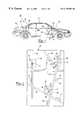
- FIG. 1is a schematic of a navigation system with a map panning directional indicator of the present invention installed in a vehicle;
- FIG. 2is a top plan view of a map section located in a map database of the navigation system and a plurality of screen sections superimposed on the map section;
- FIG. 3is a screen display of one of the screen sections shown in FIG. 2;
- FIG. 4is a top plan view of a directional user input device.
- the navigation system 20 of the present inventionis shown schematically in FIG. 1 .
- the navigation system 20includes a CPU 22 (Central Processing Unit) having a route determination system 21 and connected to a display device 24 , such as a high resolution LCD or flat panel display.
- the CPU 22is also connected to a directional user input device 26 .
- the navigation system 20further includes a map database 28 connected to the CPU 22 .
- the map database 28is a mass media storage device, such as a CD ROM or hard drive, which includes a map having all the roads in the area to be travelled by the user.
- Each road in the map database 28is divided into road segments, each having an associated set of cost values, which indicate the “cost” of traveling that road segment.
- the cost valuesmay include the length of the road segment, the estimated time to travel the road segment, and the type of road (i.e., highway, secondary road, toll road, one way, etc.).
- the navigation system 20can, but need not, be installed in a vehicle 32 .
- the navigation system 20can be used in conjunction with position determining devices, such as a GPS receiver 34 , a gyroscope 36 , a compass 38 , an orthogonal multi-axis accelerometer 40 and a wheel speed sensor 42 , all connected to the CPU 22 (connections not shown for simplicity).
- position determining devicesare well-known and are commercially available.
- a combination of these position determining devicesis utilized.
- the CPU 22 in combination with the position determining devicedetermines the current position of the navigation system 20 or the vehicle 32 relative to the map database 28 .
- the route determination system 21 in the CPU 22determines a route from a beginning point to a destination point.
- the current position of vehicle 32is preferably used as the beginning point and a user selects a destination point.
- the destination pointis the location of cursor 62 (see FIG. 2 ).
- the beginning point and destination pointare points on road segments on the map database 28 .
- the beginning point and destination pointcould be any points on the map database 28 , such as off-road points.
- the CPU 22displays at least a portion of the determined route on the display device 24 .
- FIG. 2is a top plan view of a map section 50 located in the database 28 of the navigation system 20 .
- the map section 50includes a plurality of roads 52 . Adjacent each road 52 is a name field 53 that displays the name of the road 52 .
- a current vehicle location cursor 54is located at a first position on one of the roads 52 at the current vehicle location as determined by the CPU 22 and one of the position determining devices as described above. As will be understood the cursor 54 could also be located off-road and if navigation system 20 were not in a vehicle 32 then the cursor 54 would indicate the current position of the navigation system 20 relative to the map database 28 .
- Each of the screen sections 56 - 60represent the area of the map section 50 that can be displayed at one time on the display device 24 at a given display scale. It should be recognized that the operation would be identical at any display scale.
- the second screen section 58 and the third screen section 60represent panned sections of the map section 50 to which a user could selectively pan the display device 24 .
- Each panned section, 58 and 60includes a map panning directional indicator 61 having a cursor 62 , such as a panning bullseye, which is located at a second position relative to the map database 28 in the center of the panned section.
- the map panning directional indicator 61further includes a distance field 66 located adjacent to the cursor 62 .
- Each screen section 56 - 60also includes a current road field 65 . When a screen section 56 - 60 is displayed on display device 24 , the current road field 65 displays the name of the road that cursor 54 is on.
- FIG. 3is a screen display of the second screen section 58 as shown in FIG. 2 displayed on the display device 24 .
- a screen section 56 - 60is displayed on the display device 24 it also includes a current heading field 68 that displays the current compass heading of the vehicle 32 or navigation system 20 .
- the directional arrow 64points toward the current vehicle location relative to the cursor 62 and is updated as the user pans the display device 24 to other screen sections 56 - 60 .
- the distance field 66shows the straight line distance between the cursor 62 and the current vehicle location. A user can select to have distance field 66 display the distance between cursor 62 and the current vehicle location 54 on a determined route as described below.
- FIG. 4is a top plan view of a directional user input device 26 that includes a directional input button 70 having a plurality of directional arrows 72 .
- a directional input button 70having a plurality of directional arrows 72 .
- there are eight directional arrows 72but there could be four.
- Activation of one of the directional arrows 72causes the display device 24 to pan the database 28 in the associated direction of the directional arrow 72 .
- the map panning directional indicator 61will be described as it would be used to pan the second screen section 58 described above.
- the display device 24displays the first screen section 56 as shown in FIG. 2 .
- the first screen section 56includes a road 52 and the current vehicle location cursor 54 located at a first position which is the current vehicle location relative to map database 28 , the position of the cursor 54 changes as the current vehicle location changes.
- the current heading field 68would display the current compass heading of the vehicle 32 .
- the userpresses one of the directional arrows 72 of the direction input button 70 .
- the particular directional arrow 72 chosenwould be the one oriented in the direction the user wishes to pan.
- a directional arrow 72is pressed, another panned map section is displayed, holding down a directional arrow 72 pans continuously in the associated direction.
- the cursor 62is superimposed in the center of the screen display of the panned map section at a second position relative to map database 28 .
- pan map database 28moves cursor 62 to a third position, a fourth position and so on.
- the CPU 22continuously calculates the heading between the cursor 62 and the current vehicle location cursor 54 using the latitude and longitude coordinates of each.
- the CPU 22continuously calculates the distance between the cursor 62 and the current vehicle location cursor 54 either on a straight line or on a determined route.
- the CPU 22indexes an array of pre-rendered bitmap symbols that define the position of the directional arrow 64 on the cursor 62 and displays the bitmap symbol on the panned map section.
- the array of pre-rendered bitmapsincludes at least eight bitmaps one each for the compass headings of north, northeast, east, southeast, south, southwest, west and northwest.
- a heading of approximately 315° between the cursor 62 and the current vehicle location 54is represented by a bitmap having the directional arrow 64 positioned as shown in FIG. 3 .
- each bitmapwould correspond to a range of compass headings.
- a heading between approximately 337.5° to 22.5°would correspond to a directional arrow positioned at a compass position of north on the cursor 62 .
- the number of pre-rendered bitmapscould be much larger than the eight compass headings described above to provide higher resolution of the heading.
- the distance field 66continuously updates the distance between the cursor 62 and the cursor 54 at the current vehicle location.
- the distanceis expressed in either miles or kilometers as chosen by the user.
- the location of the distance field 66 relative to the cursor 62is a function of the particular pre-rendered bitmap chosen.
- the distance field 66is positioned below the cursor 62 when the directional arrow 64 is even with or above a heading of either east or west.
- the distance field 66is positioned above the cursor 62 when the directional arrow 64 is below a heading of east or west, for example, a heading of south.
- the route determination system 21continuously determines a route from the first position or current vehicle location 54 to the cursor 62 .
- the routeis determined based on the cost factors associated with each road segment as described above.
- the navigation system 20can also determine a route that does not use any roads 52 , as when vehicle 32 is off-road.
- the determined routeis displayed on the display device 24 . Depending on the scale, display device 24 may only display a portion of the determined route.
- the usercan select to have distance field 66 display the distance between cursor 54 and cursor 62 on the determined route.
- navigation system 20need not be installed in vehicle 32 .
- the navigation system 20would operate as described above except the first position and cursor 54 would be the current navigation system 20 location relative to map database 28 and current heading field 68 would be the current heading of navigation system 20 .
- the routewould be determined between the current location of the navigation system 20 and the cursor 62 .
Landscapes
- Engineering & Computer Science (AREA)
- Radar, Positioning & Navigation (AREA)
- Remote Sensing (AREA)
- Automation & Control Theory (AREA)
- Physics & Mathematics (AREA)
- General Physics & Mathematics (AREA)
- Human Computer Interaction (AREA)
- Navigation (AREA)
Abstract
Description
Claims (22)
Priority Applications (4)
| Application Number | Priority Date | Filing Date | Title |
|---|---|---|---|
| US09/100,683US6175801B1 (en) | 1998-06-19 | 1998-06-19 | Navigation system map panning directional indicator |
| EP99921409AEP1090273B1 (en) | 1998-05-05 | 1999-04-19 | A navigation system map panning directional indicator |
| PCT/US1999/008589WO1999057519A1 (en) | 1998-05-05 | 1999-04-19 | A navigation system map panning directional indicator |
| AU38632/99AAU3863299A (en) | 1998-05-05 | 1999-04-19 | A navigation system map panning directional indicator |
Applications Claiming Priority (1)
| Application Number | Priority Date | Filing Date | Title |
|---|---|---|---|
| US09/100,683US6175801B1 (en) | 1998-06-19 | 1998-06-19 | Navigation system map panning directional indicator |
Publications (1)
| Publication Number | Publication Date |
|---|---|
| US6175801B1true US6175801B1 (en) | 2001-01-16 |
Family
ID=22281010
Family Applications (1)
| Application Number | Title | Priority Date | Filing Date |
|---|---|---|---|
| US09/100,683Expired - LifetimeUS6175801B1 (en) | 1998-05-05 | 1998-06-19 | Navigation system map panning directional indicator |
Country Status (1)
| Country | Link |
|---|---|
| US (1) | US6175801B1 (en) |
Cited By (65)
| Publication number | Priority date | Publication date | Assignee | Title |
|---|---|---|---|---|
| US6389358B2 (en)* | 1999-05-19 | 2002-05-14 | Mitsubishi Denki Kabushiki Kaisha | Vehicle-mounted navigation device |
| US6415227B1 (en)* | 1999-04-21 | 2002-07-02 | American Gnc Corporation | Enhanced global positioning system and map navigation process |
| US20020161515A1 (en)* | 2001-04-27 | 2002-10-31 | Pioneer Corporation | Navigation terminal device and navigation method |
| US6650326B1 (en) | 2001-01-22 | 2003-11-18 | Navigation Technologies Corp. | Method of handling context during scaling with a map display |
| US20040027396A1 (en)* | 2002-08-08 | 2004-02-12 | International Business Machines Corporation | System and method for configuring time related settings using a graphical interface |
| US20040027395A1 (en)* | 2002-08-12 | 2004-02-12 | International Business Machine Corporation | System and method for display views using a single stroke control |
| US6728453B2 (en)* | 2001-06-27 | 2004-04-27 | Pirelli Communications Cables And Systems Usa, Llc | Method of determining lay length of S-Z stranded buffer tubes in optical fiber cable during manufacturing |
| US6956590B1 (en)* | 2001-02-28 | 2005-10-18 | Navteq North America, Llc | Method of providing visual continuity when panning and zooming with a map display |
| US20060074553A1 (en)* | 2004-10-01 | 2006-04-06 | Foo Edwin W | Vehicle navigation display |
| EP1420226A4 (en)* | 2002-03-01 | 2006-10-04 | Nippon Seiki Co Ltd | NAVIGATION DEVICE AND METHOD |
| US20060220923A1 (en)* | 2003-08-22 | 2006-10-05 | Masaaki Tanizaki | Map display method |
| US20060262875A1 (en)* | 2005-05-17 | 2006-11-23 | Madhavan Sethu K | Data transmission method with phase shift error correction |
| US20070042790A1 (en)* | 2000-07-14 | 2007-02-22 | Norman Mohi | Locating system and method |
| US20070040800A1 (en)* | 2005-08-18 | 2007-02-22 | Forlines Clifton L | Method for stabilizing and precisely locating pointers generated by handheld direct pointing devices |
| US20070070090A1 (en)* | 2005-09-23 | 2007-03-29 | Lisa Debettencourt | Vehicle navigation system |
| US20070092024A1 (en)* | 2005-10-24 | 2007-04-26 | General Motors Corporation | Method for data communication via a voice channel of a wireless communication network |
| US20070152877A1 (en)* | 2005-12-30 | 2007-07-05 | General Motors Corporation | Method of improving a vehicle emergency call network |
| US20070162223A1 (en)* | 2006-01-09 | 2007-07-12 | Thales Navigation, Inc. | Smart detour |
| US20070190950A1 (en)* | 2006-02-15 | 2007-08-16 | General Motors Corporation | Method of configuring voice and data communication over a voice channel |
| US20070192023A1 (en)* | 1999-10-25 | 2007-08-16 | Silverbrook Research Pty Ltd | System for determining a route |
| US20070250515A1 (en)* | 2006-04-21 | 2007-10-25 | Lea David H | Method and system of securing content and destination of digital download via the internet |
| US20070258398A1 (en)* | 2005-10-24 | 2007-11-08 | General Motors Corporation | Method for data communication via a voice channel of a wireless communication network |
| US20070266344A1 (en)* | 2005-12-22 | 2007-11-15 | Andrew Olcott | Browsing Stored Information |
| US20070290837A1 (en)* | 2006-06-20 | 2007-12-20 | Microsoft Corporation | Navigation device |
| US20080051995A1 (en)* | 2006-08-25 | 2008-02-28 | Magellan Navigation, Inc. | Rerouting in Vehicle Navigation Systems |
| US20080139181A1 (en)* | 2006-12-08 | 2008-06-12 | Magellan Navigation, Inc. | Methods and apparatus for measuring the effectiveness of advertisements presented on a mobile navigation device |
| US20080198162A1 (en)* | 2007-02-16 | 2008-08-21 | Magellan Navigation, Inc. | A method of generating curved baseline for map labeling |
| US20080221787A1 (en)* | 2007-03-09 | 2008-09-11 | Magellan Navigation, Inc. | Methods and apparatus for determining a route having an estimated minimum fuel usage for a vehicle |
| US20080247484A1 (en)* | 2007-04-03 | 2008-10-09 | General Motors Corporation | Method for data communication via a voice channel of a wireless communication network using continuous signal modulation |
| US20080255828A1 (en)* | 2005-10-24 | 2008-10-16 | General Motors Corporation | Data communication via a voice channel of a wireless communication network using discontinuities |
| US20080270468A1 (en)* | 2007-04-25 | 2008-10-30 | Magellan Navigation, Inc. | Adjusting spatial operations based on map density |
| US20080273644A1 (en)* | 2007-05-03 | 2008-11-06 | Elizabeth Chesnutt | Synchronization and segment type detection method for data transmission via an audio communication system |
| US20080275229A1 (en)* | 2007-05-02 | 2008-11-06 | Spartan Bioscience, Inc. | Method for increasing the speed of nucleic acid amplification reactions |
| US20090070293A1 (en)* | 2007-09-10 | 2009-03-12 | Magellan Navigation, Inc. | Nearest-Neighbor Geographic Search |
| US20090138190A1 (en)* | 2007-11-26 | 2009-05-28 | Magellan Navigation, Inc. | System and Method of Providing Traffic Data to a Mobile Device |
| US20090171584A1 (en)* | 2007-12-31 | 2009-07-02 | Magellan Navigation, Inc. | System and Method for Accessing a Navigation System |
| US20090182498A1 (en)* | 2008-01-11 | 2009-07-16 | Magellan Navigation, Inc. | Systems and Methods to Provide Navigational Assistance Using an Online Social Network |
| US20090187342A1 (en)* | 2008-01-18 | 2009-07-23 | Magellan Navigation, Inc. | Method and apparatus for access point recording using a position device |
| US20090187341A1 (en)* | 2008-01-18 | 2009-07-23 | Magellan Navigation, Inc. | Method and apparatus to search for local parking |
| US20090187340A1 (en)* | 2008-01-18 | 2009-07-23 | Magellan Navigation, Inc. | Method and apparatus for hybrid routing using breadcrumb paths |
| US20100035631A1 (en)* | 2008-08-07 | 2010-02-11 | Magellan Navigation, Inc. | Systems and Methods to Record and Present a Trip |
| US20100049696A1 (en)* | 2008-08-20 | 2010-02-25 | Magellan Navigation, Inc. | Systems and Methods for Smart City Search |
| US20100076674A1 (en)* | 2008-09-22 | 2010-03-25 | Magellan Navigation, Inc. | Route Navigation via a Proximity Point |
| US20120032974A1 (en)* | 2010-08-04 | 2012-02-09 | Lynch Phillip C | Method and apparatus for map panning recall |
| US8160812B1 (en)* | 2007-09-06 | 2012-04-17 | Sprint Communications Company L.P. | Tracking and guidance architecture and method |
| US20120123680A1 (en)* | 2006-11-29 | 2012-05-17 | Patrick Ralf Wipplinger | System and method for electronic moving map and aeronautical context display |
| US8554475B2 (en) | 2007-10-01 | 2013-10-08 | Mitac International Corporation | Static and dynamic contours |
| US20140336785A1 (en)* | 2013-05-09 | 2014-11-13 | Rockwell Automation Technologies, Inc. | Using cloud-based data for virtualization of an industrial environment |
| US20140336786A1 (en)* | 2013-05-09 | 2014-11-13 | Rockwell Automation Technologies, Inc. | Using cloud-based data for virtualization of an industrial automation environment with information overlays |
| US20160154538A1 (en)* | 2014-11-25 | 2016-06-02 | Google Inc. | Systems and Methods for Controlling Viewport Movement in View of User Context |
| US9438648B2 (en) | 2013-05-09 | 2016-09-06 | Rockwell Automation Technologies, Inc. | Industrial data analytics in a cloud platform |
| US9477936B2 (en) | 2012-02-09 | 2016-10-25 | Rockwell Automation Technologies, Inc. | Cloud-based operator interface for industrial automation |
| US9568909B2 (en) | 2012-02-09 | 2017-02-14 | Rockwell Automation Technologies, Inc. | Industrial automation service templates for provisioning of cloud services |
| US9678660B2 (en) | 2012-11-05 | 2017-06-13 | Nokia Technologies Oy | Method and apparatus for conveying efficient map panning over a mapping user interface |
| US9703902B2 (en) | 2013-05-09 | 2017-07-11 | Rockwell Automation Technologies, Inc. | Using cloud-based data for industrial simulation |
| US9786197B2 (en) | 2013-05-09 | 2017-10-10 | Rockwell Automation Technologies, Inc. | Using cloud-based data to facilitate enhancing performance in connection with an industrial automation system |
| US9939271B1 (en)* | 2013-09-23 | 2018-04-10 | The Boeing Company | Enroute distance measuring tool |
| US10026049B2 (en) | 2013-05-09 | 2018-07-17 | Rockwell Automation Technologies, Inc. | Risk assessment for industrial systems using big data |
| US10496061B2 (en) | 2015-03-16 | 2019-12-03 | Rockwell Automation Technologies, Inc. | Modeling of an industrial automation environment in the cloud |
| US10599325B2 (en)* | 2015-04-14 | 2020-03-24 | Flying Wisdom Studios | Navigating virtual environments |
| USD904428S1 (en)* | 2019-03-07 | 2020-12-08 | Fujifilm Sonosite, Inc. | Display screen or portion thereof with a graphical user interface |
| US10896619B2 (en)* | 2018-08-29 | 2021-01-19 | ForeFlight LLC | Position reporting and navigation in an integrated flight application using bullseye |
| US11042131B2 (en) | 2015-03-16 | 2021-06-22 | Rockwell Automation Technologies, Inc. | Backup of an industrial automation plant in the cloud |
| US11243505B2 (en) | 2015-03-16 | 2022-02-08 | Rockwell Automation Technologies, Inc. | Cloud-based analytics for industrial automation |
| US11513477B2 (en) | 2015-03-16 | 2022-11-29 | Rockwell Automation Technologies, Inc. | Cloud-based industrial controller |
Citations (12)
| Publication number | Priority date | Publication date | Assignee | Title |
|---|---|---|---|---|
| US4912645A (en)* | 1987-03-26 | 1990-03-27 | Mazda Motor Corporation | Automotive navigation system |
| US4914605A (en) | 1984-10-22 | 1990-04-03 | Etak, Inc. | Apparatus and method for displaying a map |
| US5067081A (en) | 1989-08-30 | 1991-11-19 | Person Carl E | Portable electronic navigation aid |
| US5089826A (en) | 1989-10-24 | 1992-02-18 | Mitsubishi Denki Kabushiki Kaisha | Navigation system for movable body |
| US5124924A (en) | 1988-06-27 | 1992-06-23 | Pioneer Electronic Corporation | Point selecting apparatus for use in an on-board navigation system |
| US5307277A (en)* | 1991-06-18 | 1994-04-26 | Sumitomo Electric Industries, Ltd. | Location detecting apparatus |
| US5410485A (en)* | 1992-10-22 | 1995-04-25 | Alpine Electronics, Inc. | Navigation apparatus and method for exploring an optimal route based on characteristics of an exploration object zone |
| US5617319A (en) | 1992-02-18 | 1997-04-01 | Pioneer Electronic Corporation | Navigation apparatus with enhanced positional display function |
| US5646856A (en)* | 1989-06-08 | 1997-07-08 | Kaesser; Juergen | Vehicle navigation system |
| US5742923A (en)* | 1992-10-20 | 1998-04-21 | Pioneer Electronic Corporation | Method of correcting distance error of navigation apparatus and navigation apparatus |
| US5796613A (en)* | 1994-09-01 | 1998-08-18 | Aisin Aw Co., Ltd. | Navigation system for vehicles including present position calculating means |
| EP0896315A2 (en) | 1997-08-08 | 1999-02-10 | Alpine Electronics, Inc. | Display unit for navigation apparatus |
- 1998
- 1998-06-19USUS09/100,683patent/US6175801B1/ennot_activeExpired - Lifetime
Patent Citations (12)
| Publication number | Priority date | Publication date | Assignee | Title |
|---|---|---|---|---|
| US4914605A (en) | 1984-10-22 | 1990-04-03 | Etak, Inc. | Apparatus and method for displaying a map |
| US4912645A (en)* | 1987-03-26 | 1990-03-27 | Mazda Motor Corporation | Automotive navigation system |
| US5124924A (en) | 1988-06-27 | 1992-06-23 | Pioneer Electronic Corporation | Point selecting apparatus for use in an on-board navigation system |
| US5646856A (en)* | 1989-06-08 | 1997-07-08 | Kaesser; Juergen | Vehicle navigation system |
| US5067081A (en) | 1989-08-30 | 1991-11-19 | Person Carl E | Portable electronic navigation aid |
| US5089826A (en) | 1989-10-24 | 1992-02-18 | Mitsubishi Denki Kabushiki Kaisha | Navigation system for movable body |
| US5307277A (en)* | 1991-06-18 | 1994-04-26 | Sumitomo Electric Industries, Ltd. | Location detecting apparatus |
| US5617319A (en) | 1992-02-18 | 1997-04-01 | Pioneer Electronic Corporation | Navigation apparatus with enhanced positional display function |
| US5742923A (en)* | 1992-10-20 | 1998-04-21 | Pioneer Electronic Corporation | Method of correcting distance error of navigation apparatus and navigation apparatus |
| US5410485A (en)* | 1992-10-22 | 1995-04-25 | Alpine Electronics, Inc. | Navigation apparatus and method for exploring an optimal route based on characteristics of an exploration object zone |
| US5796613A (en)* | 1994-09-01 | 1998-08-18 | Aisin Aw Co., Ltd. | Navigation system for vehicles including present position calculating means |
| EP0896315A2 (en) | 1997-08-08 | 1999-02-10 | Alpine Electronics, Inc. | Display unit for navigation apparatus |
Non-Patent Citations (1)
| Title |
|---|
| Magellan, "1997 Magellan Products Anywhere To Anywhere Satellite Navigation and Communication", 1997, pp. 1-20. |
Cited By (127)
| Publication number | Priority date | Publication date | Assignee | Title |
|---|---|---|---|---|
| US6415227B1 (en)* | 1999-04-21 | 2002-07-02 | American Gnc Corporation | Enhanced global positioning system and map navigation process |
| US6389358B2 (en)* | 1999-05-19 | 2002-05-14 | Mitsubishi Denki Kabushiki Kaisha | Vehicle-mounted navigation device |
| US7421337B2 (en)* | 1999-10-25 | 2008-09-02 | Silverbrook Research Pty Ltd | System for determining a route |
| US20080285811A1 (en)* | 1999-10-25 | 2008-11-20 | Silverbrook Research Pty Ltd | System for providing information to a user via an interactive medium |
| US8121782B2 (en) | 1999-10-25 | 2012-02-21 | Silverbrook Research Pty Ltd | System for providing information through interaction with a printed page |
| US20070192023A1 (en)* | 1999-10-25 | 2007-08-16 | Silverbrook Research Pty Ltd | System for determining a route |
| US7689350B2 (en) | 1999-10-25 | 2010-03-30 | Silverbrook Research Pty Ltd | System for providing information to a user via an interactive medium |
| US20100165415A1 (en)* | 1999-10-25 | 2010-07-01 | Silverbrook Research Pty Ltd | System for providing information through interaction with a printed page |
| US20070042790A1 (en)* | 2000-07-14 | 2007-02-22 | Norman Mohi | Locating system and method |
| US6650326B1 (en) | 2001-01-22 | 2003-11-18 | Navigation Technologies Corp. | Method of handling context during scaling with a map display |
| US7023456B2 (en)* | 2001-01-22 | 2006-04-04 | Navteq North America, Llc | Method of handling context during scaling with a display |
| US20040056861A1 (en)* | 2001-01-22 | 2004-03-25 | Mark Huber | Method of handling context during scaling with a display |
| US6956590B1 (en)* | 2001-02-28 | 2005-10-18 | Navteq North America, Llc | Method of providing visual continuity when panning and zooming with a map display |
| US20080109155A1 (en)* | 2001-04-27 | 2008-05-08 | Pioneer Corporation; | Navigation terminal device and navigation method |
| US20020161515A1 (en)* | 2001-04-27 | 2002-10-31 | Pioneer Corporation | Navigation terminal device and navigation method |
| US8131457B2 (en) | 2001-04-27 | 2012-03-06 | Pioneer Corporation | Navigation terminal device and navigation method |
| US6728453B2 (en)* | 2001-06-27 | 2004-04-27 | Pirelli Communications Cables And Systems Usa, Llc | Method of determining lay length of S-Z stranded buffer tubes in optical fiber cable during manufacturing |
| EP1420226A4 (en)* | 2002-03-01 | 2006-10-04 | Nippon Seiki Co Ltd | NAVIGATION DEVICE AND METHOD |
| US10018993B2 (en) | 2002-06-04 | 2018-07-10 | Rockwell Automation Technologies, Inc. | Transformation of industrial data into useful cloud information |
| US20040027396A1 (en)* | 2002-08-08 | 2004-02-12 | International Business Machines Corporation | System and method for configuring time related settings using a graphical interface |
| US7065718B2 (en) | 2002-08-08 | 2006-06-20 | International Business Machines Corporation | System and method for configuring time related settings using a graphical interface |
| US7089507B2 (en)* | 2002-08-12 | 2006-08-08 | International Business Machines Corporation | System and method for display views using a single stroke control |
| US20040027395A1 (en)* | 2002-08-12 | 2004-02-12 | International Business Machine Corporation | System and method for display views using a single stroke control |
| US7839306B2 (en)* | 2003-08-22 | 2010-11-23 | Hitachi, Ltd. | Map display method |
| US20060220923A1 (en)* | 2003-08-22 | 2006-10-05 | Masaaki Tanizaki | Map display method |
| US20060074553A1 (en)* | 2004-10-01 | 2006-04-06 | Foo Edwin W | Vehicle navigation display |
| US7430473B2 (en) | 2004-10-01 | 2008-09-30 | Bose Corporation | Vehicle navigation display |
| US8054924B2 (en) | 2005-05-17 | 2011-11-08 | General Motors Llc | Data transmission method with phase shift error correction |
| US20060262875A1 (en)* | 2005-05-17 | 2006-11-23 | Madhavan Sethu K | Data transmission method with phase shift error correction |
| US7486274B2 (en)* | 2005-08-18 | 2009-02-03 | Mitsubishi Electric Research Laboratories, Inc. | Method for stabilizing and precisely locating pointers generated by handheld direct pointing devices |
| US20070040800A1 (en)* | 2005-08-18 | 2007-02-22 | Forlines Clifton L | Method for stabilizing and precisely locating pointers generated by handheld direct pointing devices |
| WO2007038369A3 (en)* | 2005-09-23 | 2007-08-09 | Bose Corp | Vehicle navigation system |
| US20070070090A1 (en)* | 2005-09-23 | 2007-03-29 | Lisa Debettencourt | Vehicle navigation system |
| US8194779B2 (en) | 2005-10-24 | 2012-06-05 | General Motors Llc | Method for data communication via a voice channel of a wireless communication network |
| US20070258398A1 (en)* | 2005-10-24 | 2007-11-08 | General Motors Corporation | Method for data communication via a voice channel of a wireless communication network |
| US20070092024A1 (en)* | 2005-10-24 | 2007-04-26 | General Motors Corporation | Method for data communication via a voice channel of a wireless communication network |
| US20080255828A1 (en)* | 2005-10-24 | 2008-10-16 | General Motors Corporation | Data communication via a voice channel of a wireless communication network using discontinuities |
| US8194526B2 (en) | 2005-10-24 | 2012-06-05 | General Motors Llc | Method for data communication via a voice channel of a wireless communication network |
| US8259840B2 (en) | 2005-10-24 | 2012-09-04 | General Motors Llc | Data communication via a voice channel of a wireless communication network using discontinuities |
| US20070266344A1 (en)* | 2005-12-22 | 2007-11-15 | Andrew Olcott | Browsing Stored Information |
| US20070152877A1 (en)* | 2005-12-30 | 2007-07-05 | General Motors Corporation | Method of improving a vehicle emergency call network |
| US7705775B2 (en)* | 2005-12-30 | 2010-04-27 | General Motors Llc | Method of improving a vehicle emergency call network |
| US7590490B2 (en) | 2006-01-09 | 2009-09-15 | Mitac International Corporation | Smart detour |
| US20070162223A1 (en)* | 2006-01-09 | 2007-07-12 | Thales Navigation, Inc. | Smart detour |
| US20070190950A1 (en)* | 2006-02-15 | 2007-08-16 | General Motors Corporation | Method of configuring voice and data communication over a voice channel |
| US20070250515A1 (en)* | 2006-04-21 | 2007-10-25 | Lea David H | Method and system of securing content and destination of digital download via the internet |
| US7755517B2 (en)* | 2006-06-20 | 2010-07-13 | Microsoft Corporation | Navigation device |
| US20070290837A1 (en)* | 2006-06-20 | 2007-12-20 | Microsoft Corporation | Navigation device |
| US20080051995A1 (en)* | 2006-08-25 | 2008-02-28 | Magellan Navigation, Inc. | Rerouting in Vehicle Navigation Systems |
| US7945386B2 (en) | 2006-08-25 | 2011-05-17 | Mitac International Corporation | Rerouting in vehicle navigation systems |
| US20120123680A1 (en)* | 2006-11-29 | 2012-05-17 | Patrick Ralf Wipplinger | System and method for electronic moving map and aeronautical context display |
| US8645056B2 (en)* | 2006-11-29 | 2014-02-04 | The Boeing Company | System and method for electronic moving map and aeronautical context display |
| US20080139181A1 (en)* | 2006-12-08 | 2008-06-12 | Magellan Navigation, Inc. | Methods and apparatus for measuring the effectiveness of advertisements presented on a mobile navigation device |
| US7692655B2 (en) | 2007-02-16 | 2010-04-06 | Mitac International Corporation | Apparatus and method of generating curved baseline for map labeling |
| US20080198162A1 (en)* | 2007-02-16 | 2008-08-21 | Magellan Navigation, Inc. | A method of generating curved baseline for map labeling |
| US20080221787A1 (en)* | 2007-03-09 | 2008-09-11 | Magellan Navigation, Inc. | Methods and apparatus for determining a route having an estimated minimum fuel usage for a vehicle |
| US7783417B2 (en) | 2007-03-09 | 2010-08-24 | Mitac International Corporation | Methods and apparatus for determining a route having an estimated minimum fuel usage for a vehicle |
| US9048784B2 (en) | 2007-04-03 | 2015-06-02 | General Motors Llc | Method for data communication via a voice channel of a wireless communication network using continuous signal modulation |
| US20080247484A1 (en)* | 2007-04-03 | 2008-10-09 | General Motors Corporation | Method for data communication via a voice channel of a wireless communication network using continuous signal modulation |
| US8078641B2 (en) | 2007-04-25 | 2011-12-13 | Mitac International Corporation | Adjusting spatial operations based on map density |
| US20080270468A1 (en)* | 2007-04-25 | 2008-10-30 | Magellan Navigation, Inc. | Adjusting spatial operations based on map density |
| US20080275229A1 (en)* | 2007-05-02 | 2008-11-06 | Spartan Bioscience, Inc. | Method for increasing the speed of nucleic acid amplification reactions |
| US7912149B2 (en) | 2007-05-03 | 2011-03-22 | General Motors Llc | Synchronization and segment type detection method for data transmission via an audio communication system |
| US20080273644A1 (en)* | 2007-05-03 | 2008-11-06 | Elizabeth Chesnutt | Synchronization and segment type detection method for data transmission via an audio communication system |
| US8160812B1 (en)* | 2007-09-06 | 2012-04-17 | Sprint Communications Company L.P. | Tracking and guidance architecture and method |
| US20090070293A1 (en)* | 2007-09-10 | 2009-03-12 | Magellan Navigation, Inc. | Nearest-Neighbor Geographic Search |
| US7882102B2 (en) | 2007-09-10 | 2011-02-01 | Mitac International Corporation | Nearest-neighbor geographic search |
| US8554475B2 (en) | 2007-10-01 | 2013-10-08 | Mitac International Corporation | Static and dynamic contours |
| US20090138190A1 (en)* | 2007-11-26 | 2009-05-28 | Magellan Navigation, Inc. | System and Method of Providing Traffic Data to a Mobile Device |
| US20090171584A1 (en)* | 2007-12-31 | 2009-07-02 | Magellan Navigation, Inc. | System and Method for Accessing a Navigation System |
| US20090182498A1 (en)* | 2008-01-11 | 2009-07-16 | Magellan Navigation, Inc. | Systems and Methods to Provide Navigational Assistance Using an Online Social Network |
| US8498808B2 (en) | 2008-01-18 | 2013-07-30 | Mitac International Corp. | Method and apparatus for hybrid routing using breadcrumb paths |
| US20090187341A1 (en)* | 2008-01-18 | 2009-07-23 | Magellan Navigation, Inc. | Method and apparatus to search for local parking |
| US8290703B2 (en) | 2008-01-18 | 2012-10-16 | Mitac International Corporation | Method and apparatus for access point recording using a position device |
| US20090187340A1 (en)* | 2008-01-18 | 2009-07-23 | Magellan Navigation, Inc. | Method and apparatus for hybrid routing using breadcrumb paths |
| US8700314B2 (en) | 2008-01-18 | 2014-04-15 | Mitac International Corporation | Method and apparatus to search for local parking |
| US20090187342A1 (en)* | 2008-01-18 | 2009-07-23 | Magellan Navigation, Inc. | Method and apparatus for access point recording using a position device |
| US20100035631A1 (en)* | 2008-08-07 | 2010-02-11 | Magellan Navigation, Inc. | Systems and Methods to Record and Present a Trip |
| US20100049696A1 (en)* | 2008-08-20 | 2010-02-25 | Magellan Navigation, Inc. | Systems and Methods for Smart City Search |
| US8249804B2 (en) | 2008-08-20 | 2012-08-21 | Mitac International Corporation | Systems and methods for smart city search |
| US8219317B2 (en) | 2008-09-22 | 2012-07-10 | Mitac International Corporation | Route navigation via a proximity point |
| US20100076674A1 (en)* | 2008-09-22 | 2010-03-25 | Magellan Navigation, Inc. | Route Navigation via a Proximity Point |
| US20120032974A1 (en)* | 2010-08-04 | 2012-02-09 | Lynch Phillip C | Method and apparatus for map panning recall |
| US10965760B2 (en) | 2012-02-09 | 2021-03-30 | Rockwell Automation Technologies, Inc. | Cloud-based operator interface for industrial automation |
| US10749962B2 (en) | 2012-02-09 | 2020-08-18 | Rockwell Automation Technologies, Inc. | Cloud gateway for industrial automation information and control systems |
| US10139811B2 (en) | 2012-02-09 | 2018-11-27 | Rockwell Automation Technologies, Inc. | Smart device for industrial automation |
| US9477936B2 (en) | 2012-02-09 | 2016-10-25 | Rockwell Automation Technologies, Inc. | Cloud-based operator interface for industrial automation |
| US9568909B2 (en) | 2012-02-09 | 2017-02-14 | Rockwell Automation Technologies, Inc. | Industrial automation service templates for provisioning of cloud services |
| US9568908B2 (en) | 2012-02-09 | 2017-02-14 | Rockwell Automation Technologies, Inc. | Industrial automation app-store |
| US10116532B2 (en) | 2012-02-09 | 2018-10-30 | Rockwell Automation Technologies, Inc. | Cloud-based operator interface for industrial automation |
| US11470157B2 (en) | 2012-02-09 | 2022-10-11 | Rockwell Automation Technologies, Inc. | Cloud gateway for industrial automation information and control systems |
| US9965562B2 (en) | 2012-02-09 | 2018-05-08 | Rockwell Automation Technologies, Inc. | Industrial automation app-store |
| US9678660B2 (en) | 2012-11-05 | 2017-06-13 | Nokia Technologies Oy | Method and apparatus for conveying efficient map panning over a mapping user interface |
| US9954972B2 (en) | 2013-05-09 | 2018-04-24 | Rockwell Automation Technologies, Inc. | Industrial data analytics in a cloud platform |
| US10564633B2 (en)* | 2013-05-09 | 2020-02-18 | Rockwell Automation Technologies, Inc. | Using cloud-based data for virtualization of an industrial automation environment with information overlays |
| US9786197B2 (en) | 2013-05-09 | 2017-10-10 | Rockwell Automation Technologies, Inc. | Using cloud-based data to facilitate enhancing performance in connection with an industrial automation system |
| US9989958B2 (en)* | 2013-05-09 | 2018-06-05 | Rockwell Automation Technologies, Inc. | Using cloud-based data for virtualization of an industrial automation environment |
| US9709978B2 (en)* | 2013-05-09 | 2017-07-18 | Rockwell Automation Technologies, Inc. | Using cloud-based data for virtualization of an industrial automation environment with information overlays |
| US10026049B2 (en) | 2013-05-09 | 2018-07-17 | Rockwell Automation Technologies, Inc. | Risk assessment for industrial systems using big data |
| US20180253082A1 (en)* | 2013-05-09 | 2018-09-06 | Rockwell Automation Technologies, Inc. | Using cloud-based data for virtualization of an industrial machine environment |
| US9703902B2 (en) | 2013-05-09 | 2017-07-11 | Rockwell Automation Technologies, Inc. | Using cloud-based data for industrial simulation |
| US9438648B2 (en) | 2013-05-09 | 2016-09-06 | Rockwell Automation Technologies, Inc. | Industrial data analytics in a cloud platform |
| US10984677B2 (en) | 2013-05-09 | 2021-04-20 | Rockwell Automation Technologies, Inc. | Using cloud-based data for industrial automation system training |
| US10204191B2 (en) | 2013-05-09 | 2019-02-12 | Rockwell Automation Technologies, Inc. | Using cloud-based data for industrial simulation |
| US10257310B2 (en) | 2013-05-09 | 2019-04-09 | Rockwell Automation Technologies, Inc. | Industrial data analytics in a cloud platform |
| US12417326B2 (en) | 2013-05-09 | 2025-09-16 | Rockwell Automation Technologies, Inc. | Using cloud-based data for industrial simulation |
| US20140336786A1 (en)* | 2013-05-09 | 2014-11-13 | Rockwell Automation Technologies, Inc. | Using cloud-based data for virtualization of an industrial automation environment with information overlays |
| US11676508B2 (en) | 2013-05-09 | 2023-06-13 | Rockwell Automation Technologies, Inc. | Using cloud-based data for industrial automation system training |
| US10726428B2 (en) | 2013-05-09 | 2020-07-28 | Rockwell Automation Technologies, Inc. | Industrial data analytics in a cloud platform |
| US20140336785A1 (en)* | 2013-05-09 | 2014-11-13 | Rockwell Automation Technologies, Inc. | Using cloud-based data for virtualization of an industrial environment |
| US10816960B2 (en)* | 2013-05-09 | 2020-10-27 | Rockwell Automation Technologies, Inc. | Using cloud-based data for virtualization of an industrial machine environment |
| US11295047B2 (en) | 2013-05-09 | 2022-04-05 | Rockwell Automation Technologies, Inc. | Using cloud-based data for industrial simulation |
| US9939271B1 (en)* | 2013-09-23 | 2018-04-10 | The Boeing Company | Enroute distance measuring tool |
| US10151600B2 (en)* | 2014-11-25 | 2018-12-11 | Google Llc | Systems and methods for controlling viewport movement in view of user context |
| US10928216B2 (en) | 2014-11-25 | 2021-02-23 | Google Llc | Systems and methods for controlling viewport movement in view of user context |
| US20160154538A1 (en)* | 2014-11-25 | 2016-06-02 | Google Inc. | Systems and Methods for Controlling Viewport Movement in View of User Context |
| US11409251B2 (en) | 2015-03-16 | 2022-08-09 | Rockwell Automation Technologies, Inc. | Modeling of an industrial automation environment in the cloud |
| US11042131B2 (en) | 2015-03-16 | 2021-06-22 | Rockwell Automation Technologies, Inc. | Backup of an industrial automation plant in the cloud |
| US11243505B2 (en) | 2015-03-16 | 2022-02-08 | Rockwell Automation Technologies, Inc. | Cloud-based analytics for industrial automation |
| US11513477B2 (en) | 2015-03-16 | 2022-11-29 | Rockwell Automation Technologies, Inc. | Cloud-based industrial controller |
| US11880179B2 (en) | 2015-03-16 | 2024-01-23 | Rockwell Automation Technologies, Inc. | Cloud-based analytics for industrial automation |
| US11927929B2 (en) | 2015-03-16 | 2024-03-12 | Rockwell Automation Technologies, Inc. | Modeling of an industrial automation environment in the cloud |
| US10496061B2 (en) | 2015-03-16 | 2019-12-03 | Rockwell Automation Technologies, Inc. | Modeling of an industrial automation environment in the cloud |
| US10901613B2 (en) | 2015-04-14 | 2021-01-26 | Flying Wisdom Studios | Navigating virtual environments |
| US10599325B2 (en)* | 2015-04-14 | 2020-03-24 | Flying Wisdom Studios | Navigating virtual environments |
| US10896619B2 (en)* | 2018-08-29 | 2021-01-19 | ForeFlight LLC | Position reporting and navigation in an integrated flight application using bullseye |
| USD904428S1 (en)* | 2019-03-07 | 2020-12-08 | Fujifilm Sonosite, Inc. | Display screen or portion thereof with a graphical user interface |
Similar Documents
| Publication | Publication Date | Title |
|---|---|---|
| US6175801B1 (en) | Navigation system map panning directional indicator | |
| US6178380B1 (en) | Street identification for a map zoom of a navigation system | |
| EP1078222B1 (en) | Method for displaying a current vehicle location using a navigation system | |
| EP1543294B1 (en) | Vehicle navigation system with off-road navigation | |
| US6430501B1 (en) | Navigation system with route indicators | |
| US6574551B1 (en) | Autoscaling of recommended route | |
| US8670922B2 (en) | Guiding route generation device and guiding route generation method | |
| US7519469B2 (en) | Display method and apparatus for navigation system | |
| US6529822B1 (en) | Navigation system with zoomed maneuver instruction | |
| US4924402A (en) | Method for identifying current position of vehicle | |
| US6397145B1 (en) | Navigation system with complex maneuver instruction | |
| JPH0520800B2 (en) | ||
| MX2007015345A (en) | Navigation device and method of scrolling map data displayed on a navigation device. | |
| KR20000070109A (en) | Automotive navigation system | |
| JP2000146604A (en) | Car navigation system and method therefor | |
| JP2006350953A (en) | Car navigation system | |
| EP1090273B1 (en) | A navigation system map panning directional indicator | |
| JPH04219783A (en) | On-vehicle navigation device | |
| JP3557698B2 (en) | Current position display device | |
| JPH02277200A (en) | On-vehicle navigator | |
| JP2006078293A (en) | Navigation system | |
| JPH04251284A (en) | Map selection display device used for on-vehicle navigation device | |
| JP3097377B2 (en) | Route guidance device for vehicles | |
| KR0163731B1 (en) | Displaying method in a simple way of optimal driving path in navigating apparatus for automobile | |
| JPH0553505A (en) | Position display device for mobile object |
Legal Events
| Date | Code | Title | Description |
|---|---|---|---|
| AS | Assignment | Owner name:MAGELLAN DIS, INC., MICHIGAN Free format text:ASSIGNMENT OF ASSIGNORS INTEREST;ASSIGNOR:MILLINGTON, JEFFREY ALAN;REEL/FRAME:009274/0043 Effective date:19980618 | |
| STCF | Information on status: patent grant | Free format text:PATENTED CASE | |
| CC | Certificate of correction | ||
| FPAY | Fee payment | Year of fee payment:4 | |
| AS | Assignment | Owner name:THALES NAVIGATION SOLUTIONS, LLC., CALIFORNIA Free format text:CONVERSION OF A DELAWARE CORPORATION TO A DELAWARE LIMITED LIABILITY COMPANY;ASSIGNOR:THALES NAVIGATION SOLUTIONS, INC.;REEL/FRAME:019690/0639 Effective date:20060810 Owner name:THALES NAVIGATION SOLUTIONS, INC., CALIFORNIA Free format text:CHANGE OF NAME;ASSIGNOR:MAGELLAN DIS, INC.;REEL/FRAME:019690/0798 Effective date:20050502 Owner name:MAGELLAN NAVIGATION, INC., CALIFORNIA Free format text:ASSIGNMENT OF ASSIGNORS INTEREST;ASSIGNOR:THALES NAVIGATION SOLUTIONS, LLC;REEL/FRAME:019690/0784 Effective date:20060831 | |
| FPAY | Fee payment | Year of fee payment:8 | |
| AS | Assignment | Owner name:MITAC INTERNATIONAL CORP., TAIWAN Free format text:ASSIGNMENT OF ASSIGNORS INTEREST;ASSIGNOR:MAGELLAN NAVIGATION, INC.;REEL/FRAME:022343/0987 Effective date:20081214 | |
| FPAY | Fee payment | Year of fee payment:12 | |
| AS | Assignment | Owner name:DIDI (HK) SCIENCE AND TECHNOLOGY LIMITED, CHINA Free format text:ASSIGNMENT OF ASSIGNORS INTEREST;ASSIGNOR:MITAC INTERNATIONAL CORPORATION;REEL/FRAME:040117/0651 Effective date:20161019 |