US6163749A - Method and system for scrolling a map display in a navigation application - Google Patents
Method and system for scrolling a map display in a navigation applicationDownload PDFInfo
- Publication number
- US6163749A US6163749AUS09/092,625US9262598AUS6163749AUS 6163749 AUS6163749 AUS 6163749AUS 9262598 AUS9262598 AUS 9262598AUS 6163749 AUS6163749 AUS 6163749A
- Authority
- US
- United States
- Prior art keywords
- map
- name
- data
- information
- graphics
- Prior art date
- Legal status (The legal status is an assumption and is not a legal conclusion. Google has not performed a legal analysis and makes no representation as to the accuracy of the status listed.)
- Expired - Lifetime
Links
- 238000000034methodMethods0.000titleclaimsabstractdescription51
- 239000000872bufferSubstances0.000claimsabstractdescription93
- 238000012545processingMethods0.000claimsabstractdescription78
- 230000008569processEffects0.000claimsabstractdescription36
- 238000009877renderingMethods0.000claimsdescription22
- 238000012913prioritisationMethods0.000claimsdescription15
- 230000004044responseEffects0.000claimsdescription5
- 238000004891communicationMethods0.000claimsdescription3
- 238000013500data storageMethods0.000claimsdescription3
- 230000001172regenerating effectEffects0.000claims2
- 239000010410layerSubstances0.000description156
- 230000006870functionEffects0.000description69
- 238000010586diagramMethods0.000description19
- 230000006399behaviorEffects0.000description9
- 230000008901benefitEffects0.000description5
- 238000013459approachMethods0.000description4
- 239000003086colorantSubstances0.000description4
- 238000005516engineering processMethods0.000description4
- 230000008520organizationEffects0.000description4
- 230000008859changeEffects0.000description3
- 238000004364calculation methodMethods0.000description2
- 230000001419dependent effectEffects0.000description2
- 230000006872improvementEffects0.000description2
- 238000002360preparation methodMethods0.000description2
- 238000012546transferMethods0.000description2
- 230000009466transformationEffects0.000description2
- 238000013475authorizationMethods0.000description1
- 230000005540biological transmissionEffects0.000description1
- 230000003139buffering effectEffects0.000description1
- 238000004590computer programMethods0.000description1
- AEJIMXVJZFYIHN-UHFFFAOYSA-Ncopper;dihydrateChemical compoundO.O.[Cu]AEJIMXVJZFYIHN-UHFFFAOYSA-N0.000description1
- 230000006378damageEffects0.000description1
- 238000001914filtrationMethods0.000description1
- 238000003780insertionMethods0.000description1
- 230000037431insertionEffects0.000description1
- 230000002452interceptive effectEffects0.000description1
- PWPJGUXAGUPAHP-UHFFFAOYSA-NlufenuronChemical compoundC1=C(Cl)C(OC(F)(F)C(C(F)(F)F)F)=CC(Cl)=C1NC(=O)NC(=O)C1=C(F)C=CC=C1FPWPJGUXAGUPAHP-UHFFFAOYSA-N0.000description1
- 238000007726management methodMethods0.000description1
- 230000005055memory storageEffects0.000description1
- 238000004091panningMethods0.000description1
- 238000004064recyclingMethods0.000description1
- 230000000717retained effectEffects0.000description1
- 238000012552reviewMethods0.000description1
- 239000002356single layerSubstances0.000description1
- 238000006467substitution reactionMethods0.000description1
- 230000001131transforming effectEffects0.000description1
- 230000007704transitionEffects0.000description1
Images


Classifications
- G—PHYSICS
- G01—MEASURING; TESTING
- G01C—MEASURING DISTANCES, LEVELS OR BEARINGS; SURVEYING; NAVIGATION; GYROSCOPIC INSTRUMENTS; PHOTOGRAMMETRY OR VIDEOGRAMMETRY
- G01C21/00—Navigation; Navigational instruments not provided for in groups G01C1/00 - G01C19/00
- G01C21/26—Navigation; Navigational instruments not provided for in groups G01C1/00 - G01C19/00 specially adapted for navigation in a road network
- G01C21/34—Route searching; Route guidance
- G01C21/36—Input/output arrangements for on-board computers
- G01C21/3667—Display of a road map
- G01C21/367—Details, e.g. road map scale, orientation, zooming, illumination, level of detail, scrolling of road map or positioning of current position marker
- G—PHYSICS
- G09—EDUCATION; CRYPTOGRAPHY; DISPLAY; ADVERTISING; SEALS
- G09B—EDUCATIONAL OR DEMONSTRATION APPLIANCES; APPLIANCES FOR TEACHING, OR COMMUNICATING WITH, THE BLIND, DEAF OR MUTE; MODELS; PLANETARIA; GLOBES; MAPS; DIAGRAMS
- G09B29/00—Maps; Plans; Charts; Diagrams, e.g. route diagram
- G09B29/10—Map spot or coordinate position indicators; Map reading aids
- G09B29/106—Map spot or coordinate position indicators; Map reading aids using electronic means
- G—PHYSICS
- G09—EDUCATION; CRYPTOGRAPHY; DISPLAY; ADVERTISING; SEALS
- G09G—ARRANGEMENTS OR CIRCUITS FOR CONTROL OF INDICATING DEVICES USING STATIC MEANS TO PRESENT VARIABLE INFORMATION
- G09G5/00—Control arrangements or circuits for visual indicators common to cathode-ray tube indicators and other visual indicators
- G09G5/34—Control arrangements or circuits for visual indicators common to cathode-ray tube indicators and other visual indicators for rolling or scrolling
- G09G5/346—Control arrangements or circuits for visual indicators common to cathode-ray tube indicators and other visual indicators for rolling or scrolling for systems having a bit-mapped display memory
Definitions
- the present inventionrelates to a system and method for scrolling a map display in a navigation application program.
- Computer-based navigation systemsare able to provide end-users, such as vehicle drivers as well as others, with various navigating functions and features. For example, some navigation systems are able to determine an optimum route to travel by roads between locations in a geographic region. Using input from the end-user, and optionally from equipment that can determine the end-user's physical location (such as a GPS system), a navigation system can examine various routes between two locations to determine an optimum route to travel from a starting location to a destination location in the geographic region. The navigation system may then provide the end-user with information about the optimum route in the form of instructions that identify the maneuvers required to be taken by the end-user to travel from the starting location to the destination location.
- end-userssuch as vehicle drivers as well as others, with various navigating functions and features. For example, some navigation systems are able to determine an optimum route to travel by roads between locations in a geographic region. Using input from the end-user, and optionally from equipment that can determine the end-user's physical location (such as a GPS
- the navigation systemmay be located in an automobile and the instructions may take the form of audio instructions that are provided as the end-user is driving the route. Some navigation system are able to show detailed maps on computer displays that outline routes to destinations, the types of maneuvers to be taken at various locations along the routes, locations of certain types of features, and so on.
- present navigation systemsinclude navigation application software programs and use one or more detailed databases that include data which represent physical features in geographic regions.
- the detailed database(s)includes data which represent the road network in a region, including the roads and intersections in the region and information about the roads and intersections, such as turn restrictions at intersections, speed limits along the roads, street names of the various roads, address ranges along the various roads, and so on.
- the datamay include information about points-of-interest such as museums, national parks, restaurants and the like.
- the collection of such geographic data and the provision of such data in a computer-usable database formatare provided by Navigation Technologies of Rosemont, Illinois.
- One area in which there is need for improvementrelates to providing an efficient method of implementing a smooth scrolling display feature.
- Smooth scrollinggenerally permits a user to browse the map on a map display. This feature permits the user to examine a portion of a map away from a present position of a vehicle.
- One method of generating a smooth scrolling mapis accomplished by retrieving data from a database and updating an edge of a displayed map as the map moves on the display in a given direction. This form of smooth scrolling can lead to difficulties in name placement for features shown on the map because the retrieved strip of information may not be large enough to hold the full feature name. Also, unnecessary duplication of names may occur. Further, updating a display in strips can occasionally lead to discontinuities in roads and other features and presents a less precise rendering of a map region.
- a map display toolhaving a map processing layer, a graphics interface layer, and a primitive layer that separates the graphics platform dependent tasks from graphics platform independent tasks.
- the map processing layerpreferably contains a scrolling function for providing a substantially smooth scrolling map image on a display.
- the map processing layercommunicates with a navigation application program for instructions and a map database for information necessary to carry out the map rendering instructions.
- the graphics interfacemaintains at least one table of drawing attributes required by the map processing layer.
- the primitive layerpreferably communicates directly with graphics platform and populates the tables in the graphics interface layer.
- a method of smooth scrolling map information on a navigation system displayincludes the steps of providing first and second graphics buffers.
- the first graphics buffercontains map information regarding a first location
- the second graphics bufferholds map information regarding a predicted future location. While a map area is shown and scrolled from map information in the first graphics buffer, a look-ahead process creates an auxiliary map in the second buffer. When the map area that is shown on the display reaches or approaches the edge of the map information stored in the first buffer, the map information from the second buffer is copied into the first buffer and the process repeats.
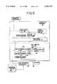
- FIG. 1is a block diagram of an exemplary navigation system.
- FIG. 2is a map illustrating geographic features in a portion of a geographic region represented by the geographic database in FIG. 1.
- FIG. 3is a block diagram illustrating the organization of a polyline data item.
- FIG. 4is a block diagram illustrating the organization of a polygon data item.
- FIG. 5is a block diagram illustrating the organization of a point data item.
- FIG. 6is a block diagram showing components of the navigation application program of FIG. 1.
- FIG. 7illustrates a relationship between a virtual map represented by data in the map database of FIG. 1 and a map rectangle shown on a display.
- FIG. 8is a diagram illustrating the map processing layer of the map display tool shown in FIG. 6.
- FIG. 9is a diagram illustrating the components of the map object shown in FIG. 8.
- FIG. 10is a diagram illustrating a component of the map object of FIG. 9.
- FIG. 11is a diagram illustrating the components of the name table in the map object of FIG. 9.
- FIG. 12is a diagram illustrating the components of the map configuration object of FIG. 8.
- FIG. 13is a diagram illustrating the multi-tasking abstraction layer shown in the map processing layer of FIG. 8.
- FIG. 14is a diagram illustrating the data structure of the graphics interface layer of FIG. 6.
- FIG. 15is a flow diagram illustrating a presently preferred method of rendering a map using the navigation application program of FIG. 6.
- FIG. 16is a flow diagram illustrating a presently preferred method of rendering a map using the navigation application program of FIG. 6.
- FIG. 17is a diagram of a roadway list generated by the map processing layer of FIG. 8.
- FIG. 18is a diagram of a roadway shield list generated by the map processing layer of FIG. 8.
- FIG. 19is an illustration of map data coverage in a first graphics buffer and a second graphics buffer according to one embodiment of the presently preferred invention.
- FIG. 20is a flow diagram illustrating an embodiment of a smooth scrolling function implemented using the navigation system of FIG. 6.
- FIG. 1there is a block diagram of a navigation system 10.
- the navigation system 10is installed in a vehicle 11, such as a car or truck, although in alternative embodiments, the navigation system 10 may be located outside of a vehicle or may be implemented in various other platforms.
- the navigation systemmay be implemented as a hand-held portable system, or may be implemented on a personal computer (such as a desktop or portable notebook) or a personal digital assistant.
- the navigation systemmay also be implemented in a networked environment or on a client-server platform.
- the navigation system 10is a combination of hardware and software components.
- the navigation system 10includes a processor 12, a drive 14 connected to the processor 12, and a non-volatile memory storage device 16 for storing a navigation software program 18, as well as other information, such as configuration parameters 19.
- the processor 12may be of any type used in navigation systems, such as 32-bit processors using a flat address space, such as a Hitachi SH1, an Intel 80386, an Intel 960, a Motorola 68020 (or other processors having similar or greater addressing space). Processor types other than these, as well as processors that may be developed in the future, are also suitable.
- the navigation system 10may also include a positioning system 24.
- the positioning system 24may utilize GPS-type technology, a dead reckoning-type system, or combinations of these, or other systems, all of which are known in the art.
- the positioning system 24may include suitable sensing devices 25 that measure the speed, direction, and so on, of the vehicle.
- the positioning system 24may also include appropriate wireless communication technology to obtain a GPS signal, in a manner which is known in the art.
- the positioning system 24outputs a signal 26 to the processor 12.
- the signal 26may be used by the navigation software program 18 that is run on the processor 12 to determine the location, direction, speed, etc., of the navigation system 10.
- the navigation system 10also includes a user interface 31.
- the user interface 31includes appropriate equipment that allows the end-user to input information into the navigation system. This input information may include a request to display a location on a map in a desired manner. The input information may also include other kinds of information, such as configuration information or vehicle information.
- the equipment used to input information into the navigation systemmay include a keypad, a keyboard, a microphone, etc., as well as appropriate software, such as a voice recognition program.
- the user interface 31also includes suitable equipment that provides information back to the end-user. This equipment may include a display 27, speakers 29, or other means.
- the navigation system 10uses a map database 30 stored on a storage medium 32.
- the storage medium 32is installed in the drive 14 so that the map database 30 can be read and used by the navigation system.
- the storage medium 32may be removable and replaceable so that a storage medium with an appropriate map database for the geographic region in which the vehicle is traveling can be used.
- the storage medium 32may be replaceable so that the map database 32 on it can be updated easily.
- the storage medium 32is a CD-ROM disc.
- the storage medium 32may be a PCMCIA card in which case the drive 14 would be substituted with a PCMCIA slot.
- Various other storage mediamay be used, including fixed or hard disks, DVD (digital video disks) or other currently available storage media, as well as storage media that may be developed in the future.
- the map database 30, or portions thereof,may also be provided to a vehicle or computer via wireless transmission.
- the map database 30contains information about geographic features, the roadway network, and points of interest in a geographic region.
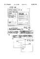
- FIG. 2shows a map illustrating features represented by information in the map database.
- Featuressuch as roads, railroads, ferries, bridges, and tunnels are represented by polyline information in the map database. Lakes, parks, airports, and other features displayed as areas are represented by polygon information in the map database. Points of interest such as museums or restaurants are represented as point information in the map database.
- Polylines, polygons and pointsare supplied by the map database in a respective one of three forms of data items.
- FIGS. 3-5illustrate these different data items that the map database supplies to represent the geographic features in FIG. 2.
- FIG. 3there is a diagram showing the structure of one of the polyline data items 400 representative of a feature shown in FIG. 2.
- a polyline data itemrepresents a continuous linear geographic feature located within a geographic area.
- Each of the polyline data items provided by the map databasemay represent a continuous linear geographic feature such as a portion of a road, a railroad track, a ferry route, a river, and so on.
- the geographic feature represented by the polyline data itemmay be straight or other-than-straight.
- Each polyline data item 400contains start position data 402 identifying the start point (latitude and longitude) of the continuous linear geographic feature.
- Each polyline data item 400also contains one or more delta shape points 403 used to calculate shape points 404 (FIG.
- a data item identifier 406that uniquely identifies the type of information (polyline, polygon, point, or other) the data item represents and its location in the map database, and other data.
- Each of the delta shape points 403provides a relative x, y distance from the previous delta shape point for calculating the shape points 404 through which the line will be drawn.
- the polyline data itemmay include information which identifies the geographic coordinates (latitude and longitude) of the starting point and the end point.
- the polyline line data item 400includes delta shape points 403 which define the shape of the continuous linear feature by relative x, y distance between delta shape points.
- each of the pointsmay be specified as the geographic coordinates (latitude and longitude) of one or more physical locations through which the continuous linear geographic feature passes.
- FIG. 2shows exemplary shape points 404 located along the portion of the road represented by a polyline data item 400.
- the curving geographic featureis reproduced on the display by using the delta shape points to generate shape points, and drawing straight lines from shape point to shape point beginning with the start position 402.
- the number of delta shape points provided for a given shapedepends on the shape of the curve and the accuracy or resolution desired in the reproduced display.
- the polyline data itemalso includes data item identifier data 406 indicating the type of data item.
- the polyline data item 400contains feature information 412 identifying the map feature that the data item is carrying.
- the feature information 412may include data indicating that the polyline data item represents a limited access expressway, a tollway, a bridge, a ferry, an alley, a side street, a railroad track, a river, and so on.
- the polyline data itemmay also contain name data 408 for the feature it represents, layer information 410 describing the database layer that the feature came from, and other information. Roads are often assembled through processing multiple polyline data items 400, each polyline data item corresponding to a road segment defined by a starting position and delta shape points.
- FIG. 4illustrates the structure of a polygon data item 414. Similar to polyline data items 400, polygon data items 414 contain start position information 416, delta shape points 418, feature name information 420, a data item identifier 422, layer information 424, and information 426 describing the feature type contained in the data item 414.
- a data itemdoes not always correspond to an entire physical feature like a lake or park. For example, a large lake such as Lake Michigan may be provided in multiple polygon data items 414.
- FIG. 5shows the point data item 428 structure.
- Point data items 428are typically displayed as an icon on a display.
- the point data itemcontains point position data 430 describing the latitude and longitude of the point of interest.
- the point data item 428does not require delta shape point information, it also contains the feature name 432, a data item identifier 434, database layer information 436, and a feature identifier 438.
- the geographic data of the map database 30is preferably organized in layers.
- the map display toolmay use data at different levels of detail; for example, the navigation application instructs the map display tool to provide information for zooming. Zooming can be done more efficiently if the data are organized into layers, with greater detail at the lower layers and less detail at the higher layers. Therefore, within some of the subsets of data types, the geographic data are provided in separate collections or groups corresponding to separate layers.
- each road segment data record in the map database 30also identifies the rank of the corresponding portion of the roadway that it represents.
- a rank of a road segmentmay correspond to its functional class.
- Road segments having a rank of "4"may include high volume, controlled access roads, such as expressways and freeways.
- Road segments having a rank of "3"may be high volume roads with few speed changes, but are not necessarily controlled access roads.
- the lower ranked roadshandle corresponding lower volumes and generally have more speed changes or slower speeds.
- Road segments having a rank of "0"can handle the lowest volumes. For example, these may include side streets, alleyways, etc.
- the rank of a road segment data entityalso specifies the highest data layer in which a road segment is included.
- the cartographic datamay include five separate layers of the data, C0, C1, C2, C3, and C4, each comprising a separate collection of the cartographic data with a different level of detail, which can be used by the map display tool.
- layer 0(“C0)" includes the road segments having a rank of "0" or higher.
- layer 0includes road segments corresponding to all the portions of all the roads in the geographic region.
- Layer 1 of the cartographic datacomprises a separate subset (or collection) of the cartographic data and includes only the cartographic data items (and some or all of their corresponding feature attributes) having a rank of "1" or higher.
- Layer 2 of the cartographic datacomprises a separate subset of the cartographic data and includes only the cartographic data (and some or all of their corresponding feature attributes) having a rank of level 2 or higher, and so on.
- a highest layer (layer n)includes only records having a rank of n.
- nis equal to 4, although in other embodiments, n may be any number greater than 0.
- Each higher layerincludes fewer records, however these records represent roads upon which travel is generally faster.
- the map display toolcan provide rapid panning and zooming. Although the organization of some of the data into layers results in some duplication of the data, the increased efficiency provided by layering generally offsets any disadvantages.
- the geographic database 30may include only one rank of road in each layer. In another alternative embodiment, the database 30 may have a single layer that includes all ranks of cartographic data.
- the navigation application software program 18is loaded from the non-volatile memory 16 into a RAM 20 associated with the processor 12 in order to operate the navigation system.
- the navigation system 10uses the map database 30 stored on the storage medium 32, possibly in conjunction with the output 26 from the positioning system 24, to provide various navigation features and functions.
- the navigation software program 18may include separate applications (or subprograms) that provide these various navigation features and functions. These functions and features may include route calculation, map display, vehicle positioning (e.g., map matching), route guidance (wherein detailed directions are provided for reaching a desired destination), destination resolution capabilities, and other functions.
- the map display tool 40is a computer program that may be used as part of the navigation software program 18.
- the map display tool 40generates maps from the map data in the map database 30 for specified locations that may either be rendered directly to a display or to a graphics buffer.
- FIG. 7illustrates the concept of a virtual map 300 in relation to the map rectangle 302 that is presented for viewing on the display 27.
- the virtual map 300represents the geographic area described by map data available in the database 30.
- the map rectangle 302is a portion of the virtual map 300 shown on the display, via the map display tool 40, by the navigation software program 18.
- the map display tool 40may be used to render and update a map illustrating the vehicle's location and immediate surroundings.
- the map display tool 40may be used in combination with the map database 30 and other programs or subprograms within the navigation program 18, or even with other programs outside the navigation program 18 or navigation system 10.
- the map display tool 40interfaces with a navigation application 47.
- the navigation application 47may include appropriate programs that provide the remainder of the navigating functions provided by the navigation system 10, such as route guidance, vehicle positioning, the user interface, and so on.
- the navigation application 47may operate as a manager that uses other tool programs, such as a geo-coding tool 90, a route guidance tool 91, a route calculation tool, and so on, to implement one or more of the other various navigation functions.
- the map display tool 40is provided as a module that is relatively portable and that can be incorporated into different kinds of systems.
- the map display tool 40employs an object oriented approach to both its programming, its use of data, and its relationship to the navigation application 47.
- Each object that forms the map display toolreceives input data and generates output data according to a predefined function and may invoke methods on other objects.
- Another version of a map display toolis described in U.S. patent application Ser. No. 09/047,141 filed Mar. 24, 1998, the entire disclosure of which is incorporated herein by reference.
- each objecthas its own private memory which is opaque to other objects.
- an objectmay be used to convey data from one object to another object or may be used to transform data received as input.
- the map display tool 40is written in the C programming language although in alternative embodiments other programming languages may be used, such as C++ or Java. In general, programming languages that support object oriented programming are preferred.
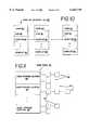
- the map display tool 40comprises a map processing layer 42, a graphics interface layer 44 and a primitive layer 46.
- Each of the three layers in the map display toolcontains data structures and/or functionality to carry out requests for creating and rendering a map.
- the map display tool 40receives input from the navigation application 47.
- the map display toolalso receives map information from a database via a map database interface 49.
- the map display toolexecutes graphics processing functions of the particular graphics platform 48 utilized by the navigation application so that the map requested by the navigation application and created from the data retrieved from the map database may be shown on the display 27, sent to a buffer, or sent to a data file.
- Suitable graphics platformsmay be X-Windows, MetaWindow, WIN32, or any of a number of existing platforms supporting graphics.
- the map processing layer 42provides the essential map display and manipulation capabilities of the map display tool 40. These capabilities include the creation, destruction and management of map data structures, preferably map objects 52 and map configuration data structures, preferably map configuration objects 54.
- the map processing layer 42includes a function set 50, at least one map object 52, at least one map configuration object 54, and a multi-tasking abstraction layer 55.
- the function set 50preferably includes a smooth scrolling function as well as other functions such as data retrieval operability, map projection, map rotation, general scrolling capability, and zooming.
- the function set 50incorporates a number of conditional statements 56 to allow the navigation application to customize operation of the map display tool 40.
- Each map object 52represents an independent map display area.
- Each map object 52is associated with a map configuration object 54.
- the multi-tasking abstraction layer 55supports objects and functions necessary to implement the smooth scrolling feature described below.
- the navigation applicationcommunicates map area information and map database search criteria to the map processing layer.
- the map processing layerretrieves data from the map database, via the map database interface 49, based on the application's instructions.
- the map area informationconsists of the center point of the desired map area, in latitude and longitude coordinates, and the map scale.
- the map scaleis the number of meters in the real world that each pixel on the display represents. With this information, the map processing layer calculates the map area to be retrieved.
- the map area calculated for retrievalpreferably comprises a rectangular area, the boundaries of the area retrieved may have other predetermined shapes.
- the information sent from the navigation applicationalso preferably includes graphics preferences and settings information such as the database layer desired, the features desired from that layer, and the feature attributes associated with the feature.
- the features in a database layermay include items such as airports, aircraft roads, cities, counties, countries, golf courses, lakes, rivers, national parks, road networks, railroads and the like.
- the feature attributesrefer to colors, fill styles, polygon border styles and other aspects of how a feature is to appear on the display.
- the map processing layerretrieves map information in the form of data items (400,414,428) and processes one data item before retrieving the next.
- the retrieved information in each data itemis processed in different ways based on several factors. These factors include the nature of the retrieved data item and information stored in the map object 52 and the map configuration object 54.
- the map object 52is best shown in FIG. 9.
- the map object 52represents a collection of map settings, preferences and retrieved data storage for a designated geographic area.
- the map objectcontains information relating to the boundaries, contents and appearance of the map to be created and rendered.
- the map processing layermay handle multiple map objects, each associated with a different geographic area.
- the navigation applicationFor each map object, the navigation application provides behavior flags 58 and map area information in the form of map rectangle information 60.
- the behavior flags 58affect how the map object will behave at various points of decision. For example, in one embodiment, a flag included in the behavior flags determines whether smooth scrolling of map information on the display has been requested. Other behavior flags include a point of interest icon flag that indicates whether point of interest icons will be rendered.
- the navigation applicationmay communicate preferences for layer choice 62, the desired feature set 64 of information retrieved from the designated layer, and other settings. Layer choice 62 refers to which database layer to select.
- the feature set 64determines the feature types (e.g., lakes) to retrieve from the layer.
- a priority list 76 in the map objectcontains a list of feature types and is used for determining the priority of placement of names for roadways, points of interest and roadway shields (e.g., the red, white, and blue shield icon of a U.S. interstate freeway) on a rendered map.
- points of interest and roadway shieldse.g., the red, white, and blue shield icon of a U.S. interstate freeway
- the map object 52also contains several dynamic data storage locations for holding specific types of retrieved information. At least two graphics buffers 67, 68 are located in the map object 52 if smooth scrolling is desired. Each of the graphics buffers is preferably configured to store the graphics information rendered from the map data retrieved from the map database.
- a point of interest list 66maintains a list of all point of interest names that are retrieved by the map display tool during a map rendering process. Points of interest may include cities, museums, government offices, national monuments, restaurants and other unique locations within the map area rendered. As shown in FIG. 10, the point of interest list 66 is preferably a singly linked list containing name 80, icon 82, and location 84 information on each retrieved point of interest. As described below with respect to the name placement functionality of the map display tool 42, a conflict indication flag 86 is also included so that points of interest that do not overlap or interfere with higher priority names or icons designated for display may be marked.
- the map objectinitially holds retrieved roadway name and roadway shield information in a separate list from the point of interest list 66.
- the roadway name and roadway shield information retrieved from the database for the designated map rectangle 60are placed in a name table 70.
- the name table 70may be a hash table having an array of name storage locations 88.
- the name storage locations 88each hold two lists 93 of information: a list of roadway name information and a list of roadway shield information.
- the location(s) of each roadway name or shield 13are also placed in the record created for the name or shield.
- the name informationis either run through a hashing function if it is a roadway name or roadway shield and placed in the name table, or placed in the point of interest list.
- the shape point information retrieved from the map databaseis directed to a shape point buffer 74 in the map object 52.
- the shape point bufferis a temporary buffer for shape point data and preferably only holds shape point data for one retrieved data item at any given time.
- Other information retained in the map object 52includes callback routines 78 provided by the navigation application to substitute for default map display tool behavior.
- the map display tooloffers flexibility through the use of conditional statements in the functions 50 of the map processing layer 42 to permit substitution or insertion of customized functionality by the navigation application 47.
- the map configuration object 54represents a template containing settings on the size of storage areas, such as tables and lists, created in the map object 52.
- the map processing layer 42may contain multiple map configuration objects 54. Each map object 52 is associated with a map configuration object 54.
- the map configuration objectpreferably includes settings that typically do not change at runtime. More than one map object 52 may be associated with the same map configuration object 54.
- the map configuration objectmay include desired feature attributes 92, layer switching distances 94, outline mode parameters 96, point of interest icon size 98, and roadway shield icon size 100.
- Feature attributes 92as mentioned above, comprise line thickness, color choice, fill styles, polygon border styles and other aspects of how a feature (e.g., road, park, lake, etc.) is to appear on the display.
- Layer switching distances 94are the points at which the map display tool adds or deletes information from the display corresponding to the next higher or lower information layer in the map database. The layer switching distances may be tied to the width of the geographic area shown in the map rectangle on the display.
- Outline mode parameters 96are data relating to the parallel line representation of roads.
- the outline mode parametersinclude information such as the threshold, in terms of the map scale being displayed, at which roads are drawn as parallel lines (as opposed to single lines).
- the outline mode parameters 96also include the width that roads of different ranks will be drawn.
- Object parameterssuch as the name table parameters 102, shape point buffer size 104, and graphics buffer size 105 are also held in the map configuration object 54.
- Each of the object parametersare size and shape settings for the memory space (tables, lists, etc.) created in a map object.
- the multi-tasking abstraction layer 55contains a list of function hooks 208 necessary from the underlying platform 48 for implementing the multiple threads (i.e., multi-tasking) used to support smooth scrolling. These function hooks 208 are preferably satisfied with platform specific routines supplied by an application programmer for the navigation application.
- an advantage of the multi-tasking abstraction layeris its usefulness in facilitating portability of the smooth scrolling function. While multi-tasking issues are generally very platform dependent, the multi-tasking abstraction layer 206 provides function definitions to a navigation application programmer. In this manner, the navigation application programmer can use any of a number of software platforms to obtain the smooth scrolling capability discussed herein.
- the multi-tasking abstraction layer 206provides a framework of functions that are recognized by the map display tool. A navigation application programmer need only supply to this framework the platform specific function calls that satisfy the function requirements of the multi-tasking abstraction layer. Thus, the need to revise and customize the entire map display to satisfy a particular platform is avoided.
- the multi-tasking abstraction layer 206also includes a synchronization object 210 created by the navigation application that is used by the various functions 208 to coordinate different threads running in the map display tool and the navigation application.
- the synchronization object 210is preferably passed between the navigation application and the map display tool depending on which of the two are actively using platform supported functions. In essence, the synchronization object 210 is an authorization to utilize the platform functions and guarantees that there are no conflicts between the navigation application and the map display tool during multi-tasking.
- the list of functions 208 in the multi-tasking abstraction layer 55includes a start thread routine 212 that initiates map rendering in the auxiliary virtual space 204 upon receipt of both the synchronization object 210 and a temporary map object.
- start thread routine 212When the start thread routine 212 is finished, it releases the synchronization object 210 and indicates completion of the successful operation.
- the wait thread routine 214is a function that determines if a background process is still running and waits to initiate another process until the synchronization object 210 is free for use by the map display tool.
- An end thread routine 216terminates any active thread and releases the synchronization object 210 held bythethread.
- a query synchronization routine 218is functional to examine the synchronization object 210 and return its status without interfering with the thread utilizing the synchronization object at the time.
- a scroll routine 220inquires as to the intent of the navigation application with regard to the smooth scrolling function. The scroll routine 220 forwards current scroll amounts (i.e., pixels) by which the screen display in the virtual space stored in the buffer is moved.
- the navigation applicationmay return a stop scrolling command that stops the scrolling of information on the display and refreshes the display with any data that has not been rendered during the scrolling process.
- the applicationmay also return a continue scrolling command that temporarily stops the scrolling and does not refresh the display with data that was rendered during scrolling.
- the continue scrolling commandindicates that the navigation application will continue scrolling in the same or a different direction.
- the user or navigation application programmermay select to omit certain data when scrolling so that unnecessary refreshing of screen data is avoided. Excessive screen refreshing can lead to discontinuities on the display.
- the continue scrolling commandmay be used to prevent refreshing the screen with omitted items until the navigation application indicates that scrolling is complete.
- the applicationmay also return an integer value of the scrolling speed to the scroll routine 220.
- a debug function 222may also be provided in the function list 208 so that the navigation application programmer has a means for debugging thread synchronization problems.
- the abstraction layer 55is designed so that an application programmer will provide the platform specific commands and routines to fulfill the function defined by the function requirements 208 so that the smooth scrolling feature is available for use with any of a number of existing graphics platforms 48.
- the graphics interface layer 44comprises look up tables 108 and conditional statements 110.
- the look up tables 108provide a graphics abstraction for the map processing layer 42 for all graphic operations.
- Each of the look up tables 108contains a drawing attribute, such as color, line style, fill styles, fonts, etc.
- the look up table 108 for colorspreferably has a first column of assigned ID numbers which serve as indices into the look up tables maintained by the graphics interface layer 44.
- the second column in the look up table 108is populated by plafform-specific data types supported by the underlying graphics platform.
- the graphics interface layer 44thus serves to create a generic graphics interface where the map processing layer 42 can request particular graphics functions by ID number and the graphics interface layer will translate the requested ID number into a supported data type.
- the map processing layerdoes not need to know how a graphics function is performed, it only requires that the function be available.
- the graphics interface layervia the look up tables 108, facilitates platform independence for the map processing layer.
- An element that provides for the graphics abstraction between the map processing layer and primitive layer/graphics platformsare a plurality of hooks, or conditional statements 110, which provide flexibility for processing drawing requests from the map processing layer and navigation application.
- the conditional statements 110 in the graphics interface layer 44act as markers for allowing the application program to substitute customized drawing routines for the default ones in the graphics interface layer.
- the conditional statements 110provide flexibility for the application to modify the way graphics are represented on the display. Examples of conditional statements which may be contained in the graphics interface layer are a polyline hook, a polygon hook, a text string hook, text string extents hook, bitblock transfer, icon, view port, and clip region.
- the polyline and polygon hookscause the graphics interface layer 44 to check whether the navigation application is providing customized routines for drawing a polygon or polyline.
- the text string hookdirects the graphics interface layer to determine if a custom text generation routine is requested by the navigation application.
- Each text string rendered in a maptakes up a certain amount of space on a display.
- a text string extents hookchecks to see if the navigation application wants to use a particular method for determining the space, i.e., the extents, the text string occupies.
- the bitblock hookcauses the graphics interface layer to determine whether the navigation application desires a special routine for transferring bits of information from a graphics buffer to a display. For example, if the map display tool is configured to first draw a map to a graphics buffer rather than directly to a display, a block of individual bits representing the map image is stored in the graphics buffer. A bitblock transfer routine is necessary to move the map image in the graphics buffer to the display.
- the graphics interface layerwill use the default routine available in the underlying platform unless the hook indicates a customized routine from the navigation application.
- the icon and viewport hooksserve to check whether customized routines for generating icons or defining the viewport area on the display are available.
- Iconsare small bitmap images representing a picture or place. Icons may be generated by the map display tool to show, for example, points of interest on a map.
- the viewportrepresents the map rectangle, or geographic area, shown on the display.
- the clip region hooklooks for a clip region routine that can inform the graphics platform of graphics output limitations within a map rectangle. Graphics platforms typically already know to limit graphics output to the edges of a window (such as a map rectangle). In some instances, however, the navigation application may require that graphics output be limited to certain boundaries within the map rectangle.
- the clip region hookallows the navigation application to supply an appropriate routine to accomplish this task.
- Each of the drawing functions represented by the conditional statements 110have default routines stored in the graphics interface layer which maybe omitted, invoked or substituted for by the navigation application.
- the primitive layer 46 of the map display tool 44is designed to communicate directly with the specific platform 48 used.
- the primitive layeris specific to the platform and performs two basic functions.
- the primitive layerfirst fills the lookup tables of the graphics interface layer 44 with platform specific information on colors, etc., and provides callback routines to the conditional statements in the graphics interface layer.
- the second function of the primitive layer 46is to carry out the instructions from the graphics interface layer 44 and draw features directly to the display or a graphics buffer.
- the navigation application 47prepares the map display tool 40 for use.
- the navigation applicationpreferably communicates with the map processing layer 42 of map display tool via a predetermined set of function calls. Each function call carries certain data parameters necessary for the map display tool to carry out the requested operation.
- An initialization function call from the navigation applicationcauses the primitive layer 46 to populate the lookup tables 108 in the graphics interface layer 44 with platform 48 supported graphics functions.
- a separate function call from the navigation applicationinstructs the map processing layer to generate a map configuration object 54.
- the navigation applicationmay send a map object function call to prepare one or more map objects 52 for later use during map rendering.
- the information passed from the navigation application to the map display toolincludes the center of the map rectangle and the map scale, the features to be processed from the database, and the database layer to retrieve data from.
- map rendering processsupported by the map display tool described above is shown in FIG. 15.
- the navigation applicationfirst specifies the center of the map rectangle, the map scale, and data retrieval criteria for each map object (at step 112).
- the map database 30stores cartographic information in geodetic (spherical) coordinates.
- the map processing layercalculates the map rectangle by transforming the center point and map scale information into geodetic coordinates. The map processing layer then calculates the additional area around the map rectangle that will fit into the graphics buffer.
- the navigation applicationUpon completion of map object preparation, the navigation application sends a map render function call to the map display tool.
- the map render function callspecifies which map object is to be rendered into a map.
- the map display toolrequests information from the map database 30, via the map database interface 49, corresponding to the navigation application's specifications (at step 114).
- the map databasereturns map information in the form of data items 400, 414, 428 (see FIGS. 3-5). According to one embodiment, each data item is retrieved one at a time such that each retrieved data item is fully processed before the next data item is obtained from the database.
- the map processing layer 42uses the instructions received from the navigation application 47 to determine the amount of map data to retrieve.
- the map processing layer 42retrieves map data that corresponds to the area within the map rectangle as well as map data for the area around the map rectangle that will fill the space available in the graphics buffer.
- the map processing layer 42communicates with the map database 30 through a map database interface 49.
- One suitable map database interfaceis the SDALTM software available from Navigation Technologies of Rosemont, Ill.
- the map processing layer 42checks to see if processing should continue, and if so, determines where the retrieved data item should be included in the map (at steps 116,118,120).
- the interrupt hook 122is a conditional statement 56 in the map processing layer that allows the navigation application to register an interrupt routine in the map rendering process. An interrupt routine may be used so that control is returned to the navigation application.
- the filter hook 124 in the map processing layerchecks to see whether the navigation application has supplied a filter callback routine that the map processing layer will use to select features from the database.
- the map display tool 40may be used to support two types of filtering. First, map features that are not desired at all (e.g., restaurants) may be filtered out by excluding the feature from the feature set 64 in the map object 52. The map display tool will then simply not retrieve any data items containing the excluded feature type. Second, through the filter hook 124, the navigation application may customize treatment of individual examples of a particular retrieved feature. For example, the navigation application may invoke the filter hook to add a routine that only processes Chinese restaurants and ignores all others. A data item containing a feature included in the feature set, and that is not filtered out, continues to be processed in the map processing layer.
- map features that are not desired at alle.g., restaurants
- the map display toolwill then simply not retrieve any data items containing the excluded feature type.
- the navigation applicationmay customize treatment of individual examples of a particular retrieved feature. For example, the navigation application may invoke the filter hook to add a routine that only processes Chinese restaurants and ignores all others. A data item containing a feature included in the
- the map display toolprocesses one data item at a time and the map processing layer does not receive another data item until processing on the previous one is complete.
- the shape point data, or icon information from each data itemis immediately processed and rendered to the appropriate graphics buffer 67, 68.
- Name informationis stored in memory until all data items have been retrieved for the designated geographic region. The name information is then processed and rendered to the graphics buffer.
- FIG. 15illustrates the process for each data item in greater detail.
- the map processing layer 42removes any shape point information from the data item and places the shape point information in the shape point buffer 74 of the map object 52 (at step 126).
- Shape point data stored in the shape point bufferis preferably in geodetic coordinates.
- the map processing layertransforms these coordinates from geodetic (spherical) to a flat world coordinate system (at step 128).
- a map projection hook 130 in the map processing layerwill first check to see if the navigation application 47 has designated an alternative transformation function.
- the flat world system coordinatesare subsequently transformed into the screen coordinate system (at step 130).
- a display projection hook 132is provided in the map processing layer so that the map processing layer may first check if an alternative routine has been designated by the navigation application.
- the featuresare rendered to the appropriate graphics buffer (at step 134).
- name informationis buffered and not rendered until after all shape point data is rendered, name position information associated with the name information is transformed along with the shape point data so that any rotation or other orientation manipulation applied to the shape point data will also be applied to the name location information.
- FIG. 16illustrates the sequence of steps carried out when the map is rendered.
- the actual drawing of each shapeis performed by the primitive layer 46 in conjunction with commands sent from the map processing layer 42 and translated in the look up tables in the graphics interface layer 44.
- the command from the map processing layer, or applicationis sent to the graphics interface layer (at step 136).
- the drawing command setcontains a set of reference ID numbers defining the drawing attribute structure that the graphics interface layer 44 can translate into instructions understandable by the primitive layer (at step 138).
- the drawing attribute structureconsists of the ID numbers in the command to select the appropriate line color, fill color, font, or etc. required for the map feature.
- the graphics interface layer 44reviews the appropriate drawing hook, or conditional statement 110, resident in the graphics interface layer to invoke the graphics functions supported by the graphics platform 48. As indicated above, the primitive layer filled in the graphics routines from the platform at startup.
- any name information associated with the data itemis placed in the name table 70 if it is a name or roadway shield, or the point of interest list 66 if it is a designated point of interest (at step 140).
- a name addition conditional statement 142again permits configurability of the map display tool so that the navigation application may replace the default name storage routine with one of its own.
- the next data itemis processed accordingly (see steps 118-140) until all items from the database within the designated area are exhausted.
- the designated areaconsists of all of the geographical data that will fit within the graphics buffer at a predetermined scale that is centered at the center point provided by the navigation application.
- the graphical featuresare immediately rendered to a graphics buffer and any name information is buffered such that a complete list of all names (roadway names, roadway shields, point of interest names, city names and other name information) are buffered in the name table 70 or point of interest list 66 of the map object 52.
- the map display tool 40After drawing all the shape data and buffering all the name information, the map display tool 40 begins a name placement routine to determine selection and placement of names on a rendered map from the name table and point of interest list.
- the map processing layerfirst looks to a start name placement hook 144 which points to a call back routine that informs the navigation application of the impending name placement processing (at step 146).
- the map processing layerthen initiates name processing (at step 148) and continues processing the buffered names until the buffered names have been exhausted.
- the map processing layerchecks an end name placement hook 150 and informs the navigation application that processing is now complete (at step 152).
- the map display toolimplements improved name placement functionality for placing names of map features in an optimal way so as to maximize content of the displayed map while supporting prioritization requirements specified by the navigation application.
- the name placement functionality of the map display toolpreferably also supports implementation of related functionality such as highlighting particular road segments and location queries for displayed point of interest icons. As explained below, a location query is made possible by tagging all point of interest items that pass a conflicts check made during processing of the buffered name information. Because the preferred name placement functionality should support name placement priorities, name placement density and other features, it is necessary that the map display tool treat the name information differently than the shape point buffer information. Thus, instead of rendering each piece of name information as it is processed, name information is buffered until all of the information, corresponding to all of the features in the designated map region in the graphics buffer, becomes available.
- a name tablein the form of a hash table.
- the size of the hash table(the number of name storage locations 88) is a prime number.
- Each name storage location 88 in the hash tablecontains two lists 93 of buffered road names and roadway shield names.
- Each list 93is made up of one or more name items 95.
- Each item 95is preferably a record containing the name or roadway shield information for the roadway and an array of alternative positions for the name element.
- the hashing functionis first used to map a name into a name storage location 88. Any of a number of commonly available hashing functions may be used.
- the appropriate list 93 in that locationis scanned to see if any of the items 95 in the list already contains the name. If a name is not already in a name storage location, an item 95 may be created in the list and assigned the first available position in the array of alternative positions. Alternatively, if the item 95 already exists in the list 93, then the map processing layer scans the array of alternative positions within the item 95 to see if a position is still vacant. If one is available, the name is placed in that position.
- the number of name storage locations 88, the density of names in the rendered map, and the number of times a roadway name or roadway shield may appearare all predetermined at startup by the navigation application and stored in the map configuration object 54.
- a least squared routineis invoked to determine whether the existing positions stored in the item yield a more optimal placement for the name than the newly retrieved position. If the new position appears to be a better location, one of the existing positions is written over with the new position. Otherwise, the newly retrieved position is discarded.
- a singly linked list 66is used to store the information for point of interest icons. Point of interest information tends not to have multiple alternative positions for each icon and does not require the more sophisticated hashing function of the roadway names and roadway shield names. If the navigation application also displays the point of interest names, the point of interest name information 82 is buffered in the linked list 66 as well.
- the entire name table and point of interest listare processed together based on name placement priorities in the priority list 76 of the map object 52.
- the point of interest listmay be presorted, before being processed for priority and conflicts with the name table as described herein, according to point of interest priority information contained in the point of interest data retrieved from the map database.
- the navigation applicationmay supply a priority list or use the default priority list of the map display tool.
- the priority list 76contains a list of feature types (names of roadways of a certain rank, airports, rivers, parks, and etc.)
- the map processing layerprocesses the name and icon information in the order designated by the priority list.
- the map processing layerscans through all the buffered name placement information, in the order in which it exists in the name table and point of interest list, for the first type of name (e.g., road names of rank 4 roads) in the priority list, scans all the buffered information for the second type of name in the priority list (e.g., river names), and so on.
- the map processing layerperforms a conflicts check to determine whether names and icons will overlap or interfere with one another on the rendered map.
- One or more new listsare created in the map object to hold data pertaining to names and icons that have passed the priority and conflicts checks.
- the conflicts checkpreferably consists of taking each name item in an order of priority and determining if the name will overlap the area of a name already selected based on priority.
- One of the new lists created in the name placement routineis a list that stores the spatial extents of each item that has passed the conflict check regardless of whether it is a roadway name, roadway shield or point of interest icon. Preferably, this list is a singly linked list.
- Each name from the name table or point of interest listis selected based on the priority list and the map display tool attempts to place the selected name or icon extents in the list of spatial extents.
- the extents of the newest nameare compared to all previous extents stored in the list. If the extents of the newest name would conflict with the area required by a name already in the list, the newest name is omitted from the list, and thus omitted from the map.
- FIG. 17illustrates the roadway name list 154 of roadway names that have passed conflicts.
- Each item in the listpreferably contains the name 156, length of the name string 158, feature type 160, screen location 162, and angle 164 of the text.
- Each of the items in the buffered roadway name list 154also may include information such as an index to the device context (“DC") cache 166 and the data type 168 information.
- the DC cacheis a set of font types, styles and colors for use in generating the text of the names.
- Data type information 168refers to the category of data contained in the map database 30. Preferably, three data types are maintained for roadways.
- the first roadway data typeconcerns all of the roadways for a given region for which the map database possesses a complete set of attributes such as speed limits, divided highway indications, direction of traffic, and so on.
- the second roadway data typeconcerns roadways for a given region that are suitable for display purposes but may be missing one or more attributes necessary for use with navigation system functions other than map display.
- the third roadway data typeconcerns major roadways that connect cities together.
- the map display toolmay draw the name/shield information in a different way based on the type of data indicated.
- the buffered list 169 of roadway shields that have passed conflictsinclude a list of information comprising the roadway name 170, screen location 172, a roadway shield icon index number 174, and the color of the text within the icon 176.
- the map databasestores a roadway shield icon index number 174 identifying the type of roadway shield needed. A separate list of instructions for each shield type may be used to create the icon for the roadway shield type indicated.
- the conflicts checkis preferably performed by comparing the spatial extents of the icon or information against all the items already placed in the temporary spatial extents list described above. If the extents of the new item do not overlap any of the existing items in the list, it is then placed on the map and the extents are added to the spatial extents list. Additionally, the item is added to the appropriate list of successful items or flagged if it is a point of interest item.
- Advantages of the name placement functionality described aboveinclude selection, prioritization and density control. Name selection is enhanced through the comparison of the buffered name table and point of interest list against the navigation application supplied priority list. If the feature type, for instance a point of interest name category, does not show up in any of the priority items of the priority list, then the name information for that feature will never get processed. Additionally, the name priority list will dictate the order in which the name information is processed and enforce name placement priorities.
- the name storage locations in the hash tableare preferably assigned a fixed number of alternative positions for any unique name to control the density. Use of a least squared heuristic, or recycling available alternative positions, assists in optimally placing names.
- the present name placement functionalityalso supports processing name information on rotated maps. Because name location information is processed in the same manner as other shape information for map features (i.e., it is put through the same sequence of projection and transformation steps), the name placement logic is transparent to the fact that the map may be rotated.
- the map display toolpossesses a smooth scrolling capability for moving items displayed on the screen rectangle smoothly across the display.
- the implementation of the smooth scrolling functioncan be visualized as overlapping map areas 200, 202 where the first map area 200 represents map data rendered in the first graphics buffer 67, and the second map area 202 represents map data rendered, or being rendered, in the second graphics buffer 68.
- the first map area 200consists of a present geographic location shown in the screen rectangle 204 and the surrounding area.
- the second map area 202consists of a predicted future area to be rendered.
- the graphics buffers 67, 68may be of different sizes.
- the graphics buffers 67, 68are sized to hold at least 25% more rendered map data than can be displayed in the map rectangle 204.
- the map rectangle 204 shown on the displaymoves within the first map area 200.
- the smooth scrolling functiontracks the movement of the map rectangle, predicts where the map rectangle will intersect the boundaries of the first map area 200, and generates a second map area 202 based on the expected intersection point of the map rectangle with the boundary of the first map area.
- the second map areapreferably includes some redundant information so that there is at least an overlap of map areas that includes the area in the first graphics buffer displayed when the map rectangle reaches the boundary.
- the map rectangleforms the corner of the second map area if the direction of travel 203 of the map rectangle 202 is not perpendicular to the boundary of the first map area. If the direction of travel 203 is perpendicular to the boundary of the first map area, the second map area in the second buffer will overlap the entire edge of the first map area. Thus, the amount of overlap is equal to the height or width of the map rectangle depending on whether the map rectangle is moving vertically or horizontally when it intersects the boundary.
- the navigation applicationprovides a smooth scrolling behavior flag to the map object 52.
- the behavior flagindicates that, after map data for the first graphics buffer 67 is obtained as described above, a look-ahead process should begin rendering a map in the second graphics buffer 68 for a predicted future position.
- the map display toolIn order for the map display tool to render a map in a graphics buffer while updating the display from a rendered map in another graphics buffer, it requires the ability to use multiple threads or processes in the underlying platform 48 (i.e., multi-tasking). Because the map processing layer is designed as substantially platform independent and because the requirements for running multiple threads or processes are highly platform specific, the map display tool implements the multi-tasking abstraction layer 55, as described above, to support this smooth scrolling function regardless of platform.
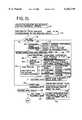
- FIG. 20illustrates one method of implementing the smooth scrolling feature described above.
- the navigation applicationsends a behavior flag indicating the desire for smooth scrolling (at step 224). If the navigation system has just been powered up, a map object is created (at step 226).
- the map processing layerthen retrieves map data and renders a map in the first graphics buffer (at step 228). After completely rendering the map in the first graphics buffer, the map display tool sets up an auxiliary object within the existing map object (at step 230).
- the auxiliary objectis preferably a pseudo-object that uses the second graphics buffer in the map object and reuses and writes over the other resources (name table, etc.) in the map object when the look-ahead process runs in the background and renders a map in the second graphics buffer.
- the auxiliary objectretains many of the settings from the map object (such as the behavior flags) with the exception of the boundary information regarding the map area to be retrieved from the map database.
- the map display toolBefore starting the look-ahead process, the map display tool first verifies that any prior map processing steps have ceased. The map display tool invokes the wait thread routine 214 and waits until the synchronization object 210 is free. Once any previous background thread is terminated, a new look-ahead process is started. The map display tool begins the look-ahead process by invoking the start thread callback function (at step 232). This function starts the map render process in the second graphics buffer for the predicted future position. The map render process is performed in the same manner as described above. As the look-ahead process progresses, the auxiliary map object is generated by writing over the memory locations of the map object containing information from map data retrieved and rendered to the first graphics buffer with the newly retrieved map data for the predicted future location.
- the map display toolmoves the screen rectangle within the map area rendered in the first buffer and updates the display (at step 234). Movement of the map rectangle is based on a scroll direction and scroll speed supplied by the navigation application. Each incremental movement of the map rectangle appears on the display as steps of one or more pixels. After each incremental movement, the scroll function is invoked to determine the scrolling intent (at step 236).
- the scrolling intentrefers to changes in speed or direction. If only the speed changes, the speed change is incorporated into the map rectangle movement and the number of pixels per movement is adjusted accordingly.
- the scrolling functionality in the map display toolmay include the option to display only a portion of the map data rendered in the first graphics buffers. For example, roads of rank 0 (e.g., alleys) may be omitted while the map scrolls and rendered when movement stops. In addition to avoiding a dense clutter of information on the display, processing time and efficiency may be increased. This feature of only drawing a selective rank of roadway to the display while scrolling and drawing more details every time the scrolling stops may be applied to any of the information rendered to the graphics buffers. This feature may be initiated through a function call originating in the navigation application or may be a default setting in the scrolling functionality in the map display tool.
- a function calloriginating in the navigation application or may be a default setting in the scrolling functionality in the map display tool.
- the auxiliary map objectis recreated based on a new predicted future position and the look-ahead process begins again(at steps 230-232). If the direction does not change, the map display tool checks to see if the map rectangle has reached the edge of the map information in the first graphics buffer (at step 240). If the edge has not been reached, the map rectangle is moved again and the process repeats (at steps 234-240). The map rendering process in the second graphics buffer proceeds as illustrated in FIGS. 15-16.
- the map display toolchecks to see if the look-ahead process rendering the map in the second graphics buffer has finished by invoking the wait thread function. When the map display tool determines that the look-ahead process is done, the contents of the second graphics buffer will be copied into the first (at step 242). The scrolling process then continues as before with a look-ahead process starting again in a background thread utilizing the multi-tasking functionality retrieved by the multi-tasking abstraction layer. Thus, the map area shown on the display is always retrieved from the first buffer and the look-ahead function always renders a map of a predicted future position to the second buffer.
- One advantage of the smooth scrolling feature described aboveis its adaptability to various platforms.
- Another advantageis the ability to provide a user with greater map accuracy and performance by avoiding the overlap problem often associated with scrolling routines that simply update a strip of a map so that previously rendered data and newly rendered data appear on the display at the same time.
- the strip approachmay lead to visible discontinuities where roads and other features are supposed to transition smoothly. Also, name placement difficulties arise where the geographic region displayed is generated using a piece-meal approach so that the display shows the result of multiple strip updates.
Landscapes
- Engineering & Computer Science (AREA)
- Radar, Positioning & Navigation (AREA)
- Remote Sensing (AREA)
- Physics & Mathematics (AREA)
- General Physics & Mathematics (AREA)
- Theoretical Computer Science (AREA)
- Automation & Control Theory (AREA)
- Mathematical Physics (AREA)
- Business, Economics & Management (AREA)
- Educational Administration (AREA)
- Educational Technology (AREA)
- Navigation (AREA)
Abstract
Description
Claims (21)
Priority Applications (2)
| Application Number | Priority Date | Filing Date | Title |
|---|---|---|---|
| US09/092,625US6163749A (en) | 1998-06-05 | 1998-06-05 | Method and system for scrolling a map display in a navigation application |
| US09/710,344US6330858B1 (en) | 1998-06-05 | 2000-11-09 | Method and system for scrolling a map display in a navigation application |
Applications Claiming Priority (1)
| Application Number | Priority Date | Filing Date | Title |
|---|---|---|---|
| US09/092,625US6163749A (en) | 1998-06-05 | 1998-06-05 | Method and system for scrolling a map display in a navigation application |
Related Child Applications (1)
| Application Number | Title | Priority Date | Filing Date |
|---|---|---|---|
| US09/710,344ContinuationUS6330858B1 (en) | 1998-06-05 | 2000-11-09 | Method and system for scrolling a map display in a navigation application |
Publications (1)
| Publication Number | Publication Date |
|---|---|
| US6163749Atrue US6163749A (en) | 2000-12-19 |
Family
ID=22234201
Family Applications (2)
| Application Number | Title | Priority Date | Filing Date |
|---|---|---|---|
| US09/092,625Expired - LifetimeUS6163749A (en) | 1998-06-05 | 1998-06-05 | Method and system for scrolling a map display in a navigation application |
| US09/710,344Expired - LifetimeUS6330858B1 (en) | 1998-06-05 | 2000-11-09 | Method and system for scrolling a map display in a navigation application |
Family Applications After (1)
| Application Number | Title | Priority Date | Filing Date |
|---|---|---|---|
| US09/710,344Expired - LifetimeUS6330858B1 (en) | 1998-06-05 | 2000-11-09 | Method and system for scrolling a map display in a navigation application |
Country Status (1)
| Country | Link |
|---|---|
| US (2) | US6163749A (en) |
Cited By (139)
| Publication number | Priority date | Publication date | Assignee | Title |
|---|---|---|---|---|
| US6320518B2 (en)* | 2000-03-01 | 2001-11-20 | Mitsubishi Denshi Kabushiki Kaisha | Map data transmitting apparatus, and computer readable recording medium having computer readable programs stored therein for causing computer to perform map data transmitting method |
| US6377210B1 (en)* | 2000-02-25 | 2002-04-23 | Grey Island Systems, Inc. | Automatic mobile object locator apparatus and method |
| US6401068B1 (en)* | 1999-06-17 | 2002-06-04 | Navigation Technologies Corp. | Method and system using voice commands for collecting data for a geographic database |
| US6493630B2 (en)* | 2001-02-16 | 2002-12-10 | Wizeguides.Com Inc. | Bundled map guide |
| US6515595B1 (en) | 1997-06-20 | 2003-02-04 | American Calcar, Inc. | Personal communication and positioning system |
| US6525768B2 (en) | 1998-10-21 | 2003-02-25 | American Calcar, Inc. | Positional camera and GPS data interchange device |
| US6529824B1 (en) | 1997-06-20 | 2003-03-04 | American Calcar, Inc. | Personal communication system for communicating voice data positioning information |
| US6587787B1 (en)* | 2000-03-15 | 2003-07-01 | Alpine Electronics, Inc. | Vehicle navigation system apparatus and method providing enhanced information regarding geographic entities |
| US20030154022A1 (en)* | 2002-02-13 | 2003-08-14 | Atsushi Tanabe | Navigation apparatus and navigation method |
| EP1347412A1 (en) | 2002-03-20 | 2003-09-24 | Airbus France | Apparatus for visualizing an airport |
| US6735516B1 (en)* | 2000-09-06 | 2004-05-11 | Horizon Navigation, Inc. | Methods and apparatus for telephoning a destination in vehicle navigation |
| US20040111213A1 (en)* | 2002-11-11 | 2004-06-10 | Kazuaki Iwamura | Map generating system and map management system |
| US20040122589A1 (en)* | 2002-12-20 | 2004-06-24 | Gibbs Michael J. | Electronic map display declutter |
| US20040138810A1 (en)* | 2003-01-10 | 2004-07-15 | Yoshihiko Sugawara | Map search system |
| US6766247B2 (en)* | 2000-05-02 | 2004-07-20 | Siemens Aktiengesellschaft | Position determination method and navigation device |
| US20040167712A1 (en)* | 2003-02-21 | 2004-08-26 | Plutowski Mark Earl | Method and apparatus for a routing agent |
| US20040193371A1 (en)* | 2003-03-24 | 2004-09-30 | Yoshikazu Koshiji | Vehicle navigation system with multi-use display |
| US20040205394A1 (en)* | 2003-03-17 | 2004-10-14 | Plutowski Mark Earl | Method and apparatus to implement an errands engine |
| US20040210386A1 (en)* | 2002-07-03 | 2004-10-21 | Terragraphix, Inc. | System for communicating and associating information with a geographic location |
| US20040215699A1 (en)* | 2003-02-26 | 2004-10-28 | Khemdut Purang | Method and apparatus for an itinerary planner |
| US6839623B1 (en)* | 2000-02-16 | 2005-01-04 | Telefonaktiebolaget Lm Ericsson (Publ) | Positioning applications for an electronic reading device |
| US6882935B2 (en)* | 2002-09-05 | 2005-04-19 | Hyundai Motor Company | Method and apparatus for communicating map data for vehicle navigation |
| US20050090970A1 (en)* | 2001-11-13 | 2005-04-28 | Andre Barkowski | Method for navigation of a vehicle |
| FR2864273A1 (en)* | 2003-12-19 | 2005-06-24 | France Telecom | Cartographic image providing method for geographic information system, involves providing images based on request, where one image is displayed on screen when another image is stored to be displayed when display control is activated |
| US20050143914A1 (en)* | 2003-12-24 | 2005-06-30 | Aisin Aw Co., Ltd. | Navigation apparatus and display method |
| US6922703B1 (en)* | 1999-09-14 | 2005-07-26 | Honeywell International Inc. | Methods and apparatus for real-time projection and rendering of geospatially organized data |
| US6937936B2 (en)* | 2002-04-25 | 2005-08-30 | Aisin Aw Co., Ltd. | Navigation system |
| US6956590B1 (en)* | 2001-02-28 | 2005-10-18 | Navteq North America, Llc | Method of providing visual continuity when panning and zooming with a map display |
| US20060028479A1 (en)* | 2004-07-08 | 2006-02-09 | Won-Suk Chun | Architecture for rendering graphics on output devices over diverse connections |
| US7096117B1 (en) | 2004-01-20 | 2006-08-22 | Navteq North America, Llc | Method and system of polyline generation for rendering a richly attributed representation of a geographic region |
| US20060212217A1 (en)* | 2004-10-01 | 2006-09-21 | Networks In Motion, Inc. | Method and system for enabling an off board navigation solution |
| US20060238380A1 (en)* | 2005-04-21 | 2006-10-26 | Microsoft Corporation | Maintaining user privacy in a virtual earth environment |
| US20070129887A1 (en)* | 2005-12-01 | 2007-06-07 | Hiroko Sakamoto | Map information system and map information processing method and program |
| US20070165030A1 (en)* | 2002-05-15 | 2007-07-19 | Masahiro Nakanishi | Content display device and method for controlling display according to complexity of content and content display program |
| US20070210937A1 (en)* | 2005-04-21 | 2007-09-13 | Microsoft Corporation | Dynamic rendering of map information |
| US20070239648A1 (en)* | 2006-03-20 | 2007-10-11 | Microsoft Corporation | Adaptive engine for processing geographic data |
| US20070273558A1 (en)* | 2005-04-21 | 2007-11-29 | Microsoft Corporation | Dynamic map rendering as a function of a user parameter |
| US20070282526A1 (en)* | 2006-05-31 | 2007-12-06 | Garmin Ltd. | Method and apparatus for utilizing geographic location information |
| EP1881294A1 (en)* | 2006-07-18 | 2008-01-23 | Harman Becker Automotive Systems GmbH | Method for displaying an object on an electronic map and corresponding storage unit and navigation system |
| US7343165B2 (en) | 2000-04-11 | 2008-03-11 | American Calcar Inc. | GPS publication application server |
| US20080071586A1 (en)* | 2001-12-31 | 2008-03-20 | Logan Andrew J | Computerized locus investigation system |
| WO2008086314A1 (en)* | 2007-01-08 | 2008-07-17 | Microsoft Corporation | Mode information displayed in a mapping application |
| GB2446167A (en)* | 2007-02-02 | 2008-08-06 | Satmap Systems Ltd | Electronic map |
| US20080198043A1 (en)* | 2001-01-29 | 2008-08-21 | Matsushita Electric Industrial Co., Ltd. | Method and apparatus for transmitting position information on a digistal map |
| US7475057B1 (en) | 1999-10-27 | 2009-01-06 | American Calcar, Inc. | System and method for user navigation |
| US20090073191A1 (en)* | 2005-04-21 | 2009-03-19 | Microsoft Corporation | Virtual earth rooftop overlay and bounding |
| US20090076719A1 (en)* | 2002-05-03 | 2009-03-19 | Pixearth Corporation | System to navigate within images spatially referenced to a computed space |
| US7522992B2 (en) | 1999-10-19 | 2009-04-21 | American Calcar Inc. | Technique for effective navigation based on user preferences |
| US20100010738A1 (en)* | 2008-07-11 | 2010-01-14 | Samsung Electronics Co. Ltd. | Navigation service system and method using mobile device |
| US20100075643A1 (en)* | 2004-09-07 | 2010-03-25 | Tierravision, Inc. | System and method of wireless downloads of map and geographic based data to portable computing devices |
| USRE41983E1 (en) | 2000-09-22 | 2010-12-07 | Tierravision, Inc. | Method of organizing and compressing spatial data |
| US20110004819A1 (en)* | 2009-07-03 | 2011-01-06 | James Hazard | Systems and methods for user-driven document assembly |
| US20110063432A1 (en)* | 2000-10-06 | 2011-03-17 | Enrico Di Bernardo | System and method for creating, storing and utilizing images of a geographic location |
| US7922606B2 (en) | 2009-06-05 | 2011-04-12 | Callaway Golf Company | GPS device |
| US8031050B2 (en) | 2000-06-07 | 2011-10-04 | Apple Inc. | System and method for situational location relevant invocable speed reference |
| US8060389B2 (en) | 2000-06-07 | 2011-11-15 | Apple Inc. | System and method for anonymous location based services |
| US8073565B2 (en) | 2000-06-07 | 2011-12-06 | Apple Inc. | System and method for alerting a first mobile data processing system nearby a second mobile data processing system |
| US20110307445A1 (en)* | 2010-06-11 | 2011-12-15 | Microsoft Corporation | Background synchronization of data objects |
| US8108144B2 (en) | 2007-06-28 | 2012-01-31 | Apple Inc. | Location based tracking |
| US8126960B2 (en) | 2000-07-28 | 2012-02-28 | Silver State Intellectual Technologies, Inc. | Technique for effective organization and communication of information |
| US8175802B2 (en) | 2007-06-28 | 2012-05-08 | Apple Inc. | Adaptive route guidance based on preferences |
| US8204684B2 (en) | 2007-06-28 | 2012-06-19 | Apple Inc. | Adaptive mobile device navigation |
| US8260320B2 (en) | 2008-11-13 | 2012-09-04 | Apple Inc. | Location specific content |
| US8275352B2 (en) | 2007-06-28 | 2012-09-25 | Apple Inc. | Location-based emergency information |
| US20120254780A1 (en)* | 2011-03-28 | 2012-10-04 | Microsoft Corporation | Predictive tiling |
| US8290513B2 (en) | 2007-06-28 | 2012-10-16 | Apple Inc. | Location-based services |
| US8311526B2 (en) | 2007-06-28 | 2012-11-13 | Apple Inc. | Location-based categorical information services |
| US8332402B2 (en) | 2007-06-28 | 2012-12-11 | Apple Inc. | Location based media items |
| US8355862B2 (en) | 2008-01-06 | 2013-01-15 | Apple Inc. | Graphical user interface for presenting location information |
| US8359643B2 (en) | 2008-09-18 | 2013-01-22 | Apple Inc. | Group formation using anonymous broadcast information |
| EP2277138A4 (en)* | 2008-04-18 | 2013-01-23 | Google Inc | Content item placement |
| US8369867B2 (en) | 2008-06-30 | 2013-02-05 | Apple Inc. | Location sharing |
| US8369967B2 (en) | 1999-02-01 | 2013-02-05 | Hoffberg Steven M | Alarm system controller and a method for controlling an alarm system |
| US8385964B2 (en) | 2005-04-04 | 2013-02-26 | Xone, Inc. | Methods and apparatuses for geospatial-based sharing of information by multiple devices |
| EP2626669A1 (en) | 2001-05-10 | 2013-08-14 | Navteq B.v. | Method and system for providing backup driving instructions with a navigation system |
| EP2463627A3 (en)* | 2002-04-30 | 2013-10-02 | Telmap Ltd. | Navigation system using corridor maps |
| US8644843B2 (en) | 2008-05-16 | 2014-02-04 | Apple Inc. | Location determination |
| US8660530B2 (en) | 2009-05-01 | 2014-02-25 | Apple Inc. | Remotely receiving and communicating commands to a mobile device for execution by the mobile device |
| CN103605462A (en)* | 2013-11-21 | 2014-02-26 | 广东威创视讯科技股份有限公司 | Map image displaying method and controller |
| US8666367B2 (en) | 2009-05-01 | 2014-03-04 | Apple Inc. | Remotely locating and commanding a mobile device |
| US8670748B2 (en) | 2009-05-01 | 2014-03-11 | Apple Inc. | Remotely locating and commanding a mobile device |
| US8676587B1 (en) | 1999-06-10 | 2014-03-18 | West View Research, Llc | Computerized information and display apparatus and methods |
| US8762056B2 (en) | 2007-06-28 | 2014-06-24 | Apple Inc. | Route reference |
| CN103902294A (en)* | 2014-04-01 | 2014-07-02 | 广东威创视讯科技股份有限公司 | Browser image display method and terminal |
| US20140189557A1 (en)* | 2010-09-29 | 2014-07-03 | Open Text S.A. | System and method for managing objects using an object map |
| US8774825B2 (en) | 2007-06-28 | 2014-07-08 | Apple Inc. | Integration of map services with user applications in a mobile device |
| US8818092B1 (en)* | 2011-09-29 | 2014-08-26 | Google, Inc. | Multi-threaded text rendering |
| US20140267282A1 (en)* | 2013-03-14 | 2014-09-18 | Robert Bosch Gmbh | System And Method For Context Dependent Level Of Detail Adjustment For Navigation Maps And Systems |
| CN104063158A (en)* | 2014-06-05 | 2014-09-24 | 北京东进航空科技股份有限公司 | Vector map drawing method and device |
| US8892495B2 (en) | 1991-12-23 | 2014-11-18 | Blanding Hovenweep, Llc | Adaptive pattern recognition based controller apparatus and method and human-interface therefore |
| US8930139B2 (en) | 2012-06-21 | 2015-01-06 | Telecommunication Systems, Inc. | Dynamically varied map labeling |
| US20150025734A1 (en)* | 2009-01-26 | 2015-01-22 | Lytx, Inc. | Driver risk assessment system and method employing selectively automatic event scoring |
| US8977294B2 (en) | 2007-10-10 | 2015-03-10 | Apple Inc. | Securely locating a device |
| EP2338152A4 (en)* | 2008-10-20 | 2015-04-29 | Blackberry Ltd | METHOD AND SYSTEM FOR REALIZING TAGS |
| US20150134247A1 (en)* | 2002-08-05 | 2015-05-14 | Sony Corporation | Electronic guide system, contents server for electronic guide system, portable electronic guide device, and information processing method for electronic guide system |
| US9066199B2 (en) | 2007-06-28 | 2015-06-23 | Apple Inc. | Location-aware mobile device |
| US9109904B2 (en) | 2007-06-28 | 2015-08-18 | Apple Inc. | Integration of map services and user applications in a mobile device |
| US9183679B2 (en) | 2007-05-08 | 2015-11-10 | Smartdrive Systems, Inc. | Distributed vehicle event recorder systems having a portable memory data transfer system |
| US9189899B2 (en) | 2009-01-26 | 2015-11-17 | Lytx, Inc. | Method and system for tuning the effect of vehicle characteristics on risk prediction |
| US9201842B2 (en) | 2006-03-16 | 2015-12-01 | Smartdrive Systems, Inc. | Vehicle event recorder systems and networks having integrated cellular wireless communications systems |
| US9213468B2 (en) | 2010-12-23 | 2015-12-15 | Microsoft Technology Licensing, Llc | Application reporting in an application-selectable user interface |
| US9217644B2 (en) | 2012-01-26 | 2015-12-22 | Telecommunication Systems, Inc. | Natural navigational guidance |
| US9226004B1 (en) | 2005-12-08 | 2015-12-29 | Smartdrive Systems, Inc. | Memory management in event recording systems |
| US9229918B2 (en) | 2010-12-23 | 2016-01-05 | Microsoft Technology Licensing, Llc | Presenting an application change through a tile |
| US9245391B2 (en) | 2009-01-26 | 2016-01-26 | Lytx, Inc. | Driver risk assessment system and method employing automated driver log |
| US9244802B2 (en) | 2011-09-10 | 2016-01-26 | Microsoft Technology Licensing, Llc | Resource user interface |
| US9250092B2 (en) | 2008-05-12 | 2016-02-02 | Apple Inc. | Map service with network-based query for search |
| US9317980B2 (en) | 2006-05-09 | 2016-04-19 | Lytx, Inc. | Driver risk assessment system and method having calibrating automatic event scoring |
| US20160169701A1 (en)* | 2014-12-11 | 2016-06-16 | Hyundai Motor Company | Audio video navigation device, vehicle having the same and method for controlling the vehicle |
| US9402060B2 (en) | 2006-03-16 | 2016-07-26 | Smartdrive Systems, Inc. | Vehicle event recorders with integrated web server |
| US9423951B2 (en) | 2010-12-31 | 2016-08-23 | Microsoft Technology Licensing, Llc | Content-based snap point |
| US9501878B2 (en) | 2013-10-16 | 2016-11-22 | Smartdrive Systems, Inc. | Vehicle event playback apparatus and methods |
| US9535597B2 (en) | 2011-05-27 | 2017-01-03 | Microsoft Technology Licensing, Llc | Managing an immersive interface in a multi-application immersive environment |
| US9554080B2 (en) | 2006-11-07 | 2017-01-24 | Smartdrive Systems, Inc. | Power management systems for automotive video event recorders |
| US9557909B2 (en) | 2011-09-09 | 2017-01-31 | Microsoft Technology Licensing, Llc | Semantic zoom linguistic helpers |
| US9594371B1 (en) | 2014-02-21 | 2017-03-14 | Smartdrive Systems, Inc. | System and method to detect execution of driving maneuvers |
| US9610955B2 (en) | 2013-11-11 | 2017-04-04 | Smartdrive Systems, Inc. | Vehicle fuel consumption monitor and feedback systems |
| US9633318B2 (en) | 2005-12-08 | 2017-04-25 | Smartdrive Systems, Inc. | Vehicle event recorder systems |
| US9658766B2 (en) | 2011-05-27 | 2017-05-23 | Microsoft Technology Licensing, Llc | Edge gesture |
| US9665384B2 (en) | 2005-08-30 | 2017-05-30 | Microsoft Technology Licensing, Llc | Aggregation of computing device settings |
| US9663127B2 (en) | 2014-10-28 | 2017-05-30 | Smartdrive Systems, Inc. | Rail vehicle event detection and recording system |
| US9696888B2 (en) | 2010-12-20 | 2017-07-04 | Microsoft Technology Licensing, Llc | Application-launching interface for multiple modes |
| US9702709B2 (en) | 2007-06-28 | 2017-07-11 | Apple Inc. | Disfavored route progressions or locations |
| US9728228B2 (en) | 2012-08-10 | 2017-08-08 | Smartdrive Systems, Inc. | Vehicle event playback apparatus and methods |
| US9738156B2 (en) | 2006-11-09 | 2017-08-22 | Smartdrive Systems, Inc. | Vehicle exception event management systems |
| US9761067B2 (en) | 2006-11-07 | 2017-09-12 | Smartdrive Systems, Inc. | Vehicle operator performance history recording, scoring and reporting systems |
| US9812013B2 (en) | 1999-01-06 | 2017-11-07 | Infogation Corporation | Mobile navigation system operating with a remote server |
| US20180066946A1 (en)* | 2016-09-07 | 2018-03-08 | Ordnance Survey Limited | Method and System for Improving Spatial Accuracy of Map Data |
| WO2018116134A1 (en)* | 2016-12-22 | 2018-06-28 | Bin Jiang | Methods, apparatus and computer program for automatically deriving small-scale maps |
| US10114865B2 (en) | 2011-09-09 | 2018-10-30 | Microsoft Technology Licensing, Llc | Tile cache |
| US10254955B2 (en) | 2011-09-10 | 2019-04-09 | Microsoft Technology Licensing, Llc | Progressively indicating new content in an application-selectable user interface |
| US10274324B2 (en)* | 2011-04-25 | 2019-04-30 | Google Llc | Dynamic highlighting of geographic entities on electronic maps |
| US10303325B2 (en) | 2011-05-27 | 2019-05-28 | Microsoft Technology Licensing, Llc | Multi-application environment |
| US10353566B2 (en) | 2011-09-09 | 2019-07-16 | Microsoft Technology Licensing, Llc | Semantic zoom animations |
| US10361802B1 (en) | 1999-02-01 | 2019-07-23 | Blanding Hovenweep, Llc | Adaptive pattern recognition based control system and method |
| US10579250B2 (en) | 2011-09-01 | 2020-03-03 | Microsoft Technology Licensing, Llc | Arranging tiles |
| US10930093B2 (en) | 2015-04-01 | 2021-02-23 | Smartdrive Systems, Inc. | Vehicle event recording system and method |
| US11069257B2 (en) | 2014-11-13 | 2021-07-20 | Smartdrive Systems, Inc. | System and method for detecting a vehicle event and generating review criteria |
| US11272017B2 (en) | 2011-05-27 | 2022-03-08 | Microsoft Technology Licensing, Llc | Application notifications manifest |
Families Citing this family (40)
| Publication number | Priority date | Publication date | Assignee | Title |
|---|---|---|---|---|
| US6565610B1 (en)* | 1999-02-11 | 2003-05-20 | Navigation Technologies Corporation | Method and system for text placement when forming maps |
| US6307573B1 (en)* | 1999-07-22 | 2001-10-23 | Barbara L. Barros | Graphic-information flow method and system for visually analyzing patterns and relationships |
| JP2001165671A (en)* | 1999-12-14 | 2001-06-22 | Pioneer Electronic Corp | Navigation system |
| AU2597801A (en) | 1999-12-29 | 2001-07-09 | Harry A. Glorikian | An internet system for connecting client-travelers with geographically-associated data |
| US20010030667A1 (en)* | 2000-04-10 | 2001-10-18 | Kelts Brett R. | Interactive display interface for information objects |
| US6622090B2 (en)* | 2000-09-26 | 2003-09-16 | American Gnc Corporation | Enhanced inertial measurement unit/global positioning system mapping and navigation process |
| US6801850B1 (en)* | 2000-10-30 | 2004-10-05 | University Of Illionis - Chicago | Method and system for tracking moving objects |
| DE60119062T2 (en) | 2000-10-31 | 2006-11-30 | Matsushita Electric Industrial Co., Ltd., Kadoma | navigation device |
| US20080060020A1 (en) | 2000-12-22 | 2008-03-06 | Hillcrest Laboratories, Inc. | Methods and systems for semantic zooming |
| US6917877B2 (en) | 2001-08-14 | 2005-07-12 | Navteq North America, Llc | Method for determining the intersection of polygons used to represent geographic features |
| JP2003067721A (en)* | 2001-08-24 | 2003-03-07 | Pioneer Electronic Corp | Map image display system and method |
| US20030132932A1 (en)* | 2001-09-17 | 2003-07-17 | Xiangheng Yang | Method for constructing polygons used to represent geographic features |
| US6567741B1 (en)* | 2001-11-01 | 2003-05-20 | General Motors Corporation | Method and system for reducing shape points for a navigation system |
| JP3933955B2 (en)* | 2002-02-19 | 2007-06-20 | 株式会社日立製作所 | In-vehicle device |
| US7308358B2 (en)* | 2002-03-07 | 2007-12-11 | Increment P Corporation | Navigator, navigation system, navigation method, data processing apparatus, data processing method, program thereof, and recording medium thereof |
| US7162338B2 (en)* | 2002-12-17 | 2007-01-09 | Evolution Robotics, Inc. | Systems and methods for computing a relative pose for global localization in a visual simultaneous localization and mapping system |
| US20040268393A1 (en) | 2003-05-08 | 2004-12-30 | Hunleth Frank A. | Control framework with a zoomable graphical user interface for organizing, selecting and launching media items |
| US8555165B2 (en)* | 2003-05-08 | 2013-10-08 | Hillcrest Laboratories, Inc. | Methods and systems for generating a zoomable graphical user interface |
| US8601396B2 (en)* | 2003-05-08 | 2013-12-03 | Hillcrest Laboratories, Inc. | Systems and methods for node tracking and notification in a control framework including a zoomable graphical user interface |
| US8046705B2 (en)* | 2003-05-08 | 2011-10-25 | Hillcrest Laboratories, Inc. | Systems and methods for resolution consistent semantic zooming |
| US7260789B2 (en)* | 2004-02-23 | 2007-08-21 | Hillcrest Laboratories, Inc. | Method of real-time incremental zooming |
| EP1834491A4 (en)* | 2005-01-05 | 2010-06-02 | Hillcrest Lab Inc | Distributed software construction for user interfaces |
| KR101190462B1 (en)* | 2005-01-05 | 2012-10-11 | 힐크레스트 래보래토리스, 인크. | Scaling and layout methods and systems for handling one-to-many objects |
| JP2008536196A (en)* | 2005-02-14 | 2008-09-04 | ヒルクレスト・ラボラトリーズ・インコーポレイテッド | Method and system for enhancing television applications using 3D pointing |
| US20070229538A1 (en)* | 2006-03-31 | 2007-10-04 | Research In Motion Limited | Methods and apparatus for dynamically labeling map objects in visually displayed maps of mobile communication devices |
| US7916142B2 (en)* | 2006-08-21 | 2011-03-29 | Geo-Softworks, LLC | Systems and methods for generating user specified information from a map |
| US20080051989A1 (en)* | 2006-08-25 | 2008-02-28 | Microsoft Corporation | Filtering of data layered on mapping applications |
| CN101558647A (en)* | 2006-08-29 | 2009-10-14 | 希尔克瑞斯特实验室公司 | Television control, playlist generation and DVR systems and methods |
| JP4850133B2 (en)* | 2007-06-06 | 2012-01-11 | アルパイン株式会社 | Map display device and map display method |
| US8203578B2 (en)* | 2007-10-30 | 2012-06-19 | Alpine Electronics, Inc. | Map scroll method and apparatus for conducting smooth map scroll operation for navigation system |
| US7970178B2 (en)* | 2007-12-21 | 2011-06-28 | Caterpillar Inc. | Visibility range estimation method and system |
| US20090244095A1 (en)* | 2008-04-01 | 2009-10-01 | Research In Motion Limited | Run-time label cache for efficient map labeling |
| US8140215B2 (en)* | 2008-07-22 | 2012-03-20 | Lockheed Martin Corporation | Method and apparatus for geospatial data sharing |
| US8085268B2 (en)* | 2009-10-20 | 2011-12-27 | Palantir Technologies, Inc. | Techniques for drawing geodetic polygons |
| JP5745067B2 (en) | 2010-09-24 | 2015-07-08 | アイロボット・コーポレーション | System and method for VSLAM optimization |
| KR101083245B1 (en)* | 2011-01-31 | 2011-11-14 | 주식회사 서전지구 | Local information extraction method, local information output method, and apparatus therefor |
| US8798840B2 (en) | 2011-09-30 | 2014-08-05 | Irobot Corporation | Adaptive mapping with spatial summaries of sensor data |
| US9080885B2 (en)* | 2012-06-05 | 2015-07-14 | Apple Inc. | Determining to display designations of points of interest within a map view |
| US9224218B2 (en)* | 2012-06-05 | 2015-12-29 | Apple Inc. | System and method for loading and rendering curved features in a map |
| CN105677818B (en)* | 2015-12-31 | 2019-08-09 | 华南师范大学 | Drawing method and system based on mobile positioning and electronic map |
Citations (43)
| Publication number | Priority date | Publication date | Assignee | Title |
|---|---|---|---|---|
| GB2102259A (en)* | 1981-05-13 | 1983-01-26 | Nissan Motor | Road map display system for automotive vehicles |
| US4511973A (en)* | 1981-08-24 | 1985-04-16 | Nippondenso Co., Ltd. | Navigator for vehicles |
| US4527155A (en)* | 1981-03-04 | 1985-07-02 | Nissan Motor Company, Limited | System for maintaining an orientation of characters displayed with a rotatable image |
| US4550317A (en)* | 1982-09-29 | 1985-10-29 | Toyota Jidosha Kabushiki Kaisha | Drive guide display system for motor vehicle |
| US4571684A (en)* | 1983-03-25 | 1986-02-18 | Nippondenso Co., Ltd. | Map display system for vehicles |
| US4638438A (en)* | 1983-05-23 | 1987-01-20 | Hitachi, Ltd. | Navigation apparatus for automotive |
| US4646089A (en)* | 1983-01-17 | 1987-02-24 | Nippondenso Co., Ltd. | Travel guidance system for vehicles |
| US4675676A (en)* | 1983-03-09 | 1987-06-23 | Nippondenso Co. Ltd. | Map display system |
| US4737916A (en)* | 1985-04-30 | 1988-04-12 | Nippondenso Co., Ltd. | Electronic map display system |
| US4744033A (en)* | 1985-04-30 | 1988-05-10 | Nippondenso Co., Ltd. | Electronic display system |
| US4757455A (en)* | 1985-03-08 | 1988-07-12 | Nissan Motor Company, Limited | Navigation system for a vehicle |
| US4760531A (en)* | 1985-05-16 | 1988-07-26 | Nippondenso Co., Ltd. | Map display system |
| US4780717A (en)* | 1983-03-25 | 1988-10-25 | Nippondenso Co., Ltd. | Electronic map display system for use on vehicle |
| US4796191A (en)* | 1984-06-07 | 1989-01-03 | Etak, Inc. | Vehicle navigational system and method |
| US4807157A (en)* | 1986-10-31 | 1989-02-21 | Pioneer Electronic Corporation | Method of displaying a map |
| US4812980A (en)* | 1985-05-16 | 1989-03-14 | Nippondenso Co., Ltd. | Map display system |
| US4825381A (en)* | 1987-03-31 | 1989-04-25 | Rockwell International Corporation | Moving map display |
| US4845631A (en)* | 1987-03-31 | 1989-07-04 | Rockwell International Corporation | Scrolling image memory for high speed avionics moving map display |
| US4876651A (en)* | 1988-05-11 | 1989-10-24 | Honeywell Inc. | Digital map system |
| US4914605A (en)* | 1984-10-22 | 1990-04-03 | Etak, Inc. | Apparatus and method for displaying a map |
| US4937570A (en)* | 1987-02-26 | 1990-06-26 | Mitsubishi Denki Kabushiki Kaisha | Route guidance display device |
| US4996645A (en)* | 1987-09-04 | 1991-02-26 | U.S. Philips Corporation | Vehicle navigation device with reproduction of a selected map element according to a predetermined representation standard |
| US5089826A (en)* | 1989-10-24 | 1992-02-18 | Mitsubishi Denki Kabushiki Kaisha | Navigation system for movable body |
| US5115398A (en)* | 1989-07-04 | 1992-05-19 | U.S. Philips Corp. | Method of displaying navigation data for a vehicle in an image of the vehicle environment, a navigation system for performing the method, and a vehicle comprising a navigation system |
| US5161886A (en)* | 1989-01-11 | 1992-11-10 | U.S. Philips Corp. | Method for the perspective display of a part of a topographic map, and device suitable for performing such a method |
| US5274387A (en)* | 1990-06-06 | 1993-12-28 | Mazda Motor Corporation | Navigation apparatus for vehicles |
| US5297051A (en)* | 1991-03-18 | 1994-03-22 | Pioneer Electronic Corporation | Map display device |
| US5323321A (en)* | 1990-06-25 | 1994-06-21 | Motorola, Inc. | Land vehicle navigation apparatus |
| US5359529A (en)* | 1992-05-15 | 1994-10-25 | Zexel Corporation | Route guidance on/off-route state filter |
| US5371497A (en)* | 1992-08-19 | 1994-12-06 | Aisin Aw Co., Ltd. | Navigation system for vehicles |
| US5381338A (en)* | 1991-06-21 | 1995-01-10 | Wysocki; David A. | Real time three dimensional geo-referenced digital orthophotograph-based positioning, navigation, collision avoidance and decision support system |
| US5383128A (en)* | 1992-05-08 | 1995-01-17 | Pioneer Electronic Corporation | Navigation device |
| US5396430A (en)* | 1991-04-25 | 1995-03-07 | Pioneer Electronic Corporation | On-board navigation apparatus |
| US5406493A (en)* | 1990-12-19 | 1995-04-11 | Mitsubishi Denki Kabushiki Kaisha | Vehicle-carried navigation system |
| US5414629A (en)* | 1993-03-31 | 1995-05-09 | Masprodenkoh Kabushikikaisha | Navigation system with route determination process capable of determining a desired route readily and correctly |
| US5448696A (en)* | 1990-11-30 | 1995-09-05 | Hitachi, Ltd. | Map information system capable of displaying layout information |
| US5559938A (en)* | 1993-11-05 | 1996-09-24 | U.S. Philips Corporation | Display system for displaying a net of interconnected geographical paths provided with associated geographical names and road vehicle with on-board road-based navigation system having such display system |
| US5573402A (en)* | 1992-05-22 | 1996-11-12 | Atari Games Corporation | System and method for coloring polygon using dithering |
| US5613055A (en)* | 1992-07-14 | 1997-03-18 | Sumitomo Electric Industries, Ltd. | Method of and apparatus for producing an animation having a series of road drawings to be watched from a driver's seat of a vehicle |
| US5629854A (en)* | 1991-09-25 | 1997-05-13 | U.S. Philips Corporation | Device for displaying cartographic information, method for displaying cartographic information, navigation system provided with the device and vehicle provided with the navigation system |
| US5754161A (en)* | 1995-01-30 | 1998-05-19 | Mitsubishi Denki Kabushiki Kaisha | Graphic display scrolling apparatus |
| US5808598A (en)* | 1995-02-07 | 1998-09-15 | Mitsubishi Electric Semiconductor Software Corporation | Display method of navigation map |
| US6016110A (en)* | 1996-03-26 | 2000-01-18 | Sony Corporation | Map display device, map display method, navigation device and automobile |
Family Cites Families (2)
| Publication number | Priority date | Publication date | Assignee | Title |
|---|---|---|---|---|
| JPH0786738B2 (en)* | 1989-12-13 | 1995-09-20 | パイオニア株式会社 | Car navigation system |
| US6092076A (en) | 1998-03-24 | 2000-07-18 | Navigation Technologies Corporation | Method and system for map display in a navigation application |
- 1998
- 1998-06-05USUS09/092,625patent/US6163749A/ennot_activeExpired - Lifetime
- 2000
- 2000-11-09USUS09/710,344patent/US6330858B1/ennot_activeExpired - Lifetime
Patent Citations (44)
| Publication number | Priority date | Publication date | Assignee | Title |
|---|---|---|---|---|
| US4527155A (en)* | 1981-03-04 | 1985-07-02 | Nissan Motor Company, Limited | System for maintaining an orientation of characters displayed with a rotatable image |
| GB2102259A (en)* | 1981-05-13 | 1983-01-26 | Nissan Motor | Road map display system for automotive vehicles |
| US4511973A (en)* | 1981-08-24 | 1985-04-16 | Nippondenso Co., Ltd. | Navigator for vehicles |
| US4550317A (en)* | 1982-09-29 | 1985-10-29 | Toyota Jidosha Kabushiki Kaisha | Drive guide display system for motor vehicle |
| US4646089A (en)* | 1983-01-17 | 1987-02-24 | Nippondenso Co., Ltd. | Travel guidance system for vehicles |
| US4675676A (en)* | 1983-03-09 | 1987-06-23 | Nippondenso Co. Ltd. | Map display system |
| US4780717A (en)* | 1983-03-25 | 1988-10-25 | Nippondenso Co., Ltd. | Electronic map display system for use on vehicle |
| US4571684A (en)* | 1983-03-25 | 1986-02-18 | Nippondenso Co., Ltd. | Map display system for vehicles |
| US4638438A (en)* | 1983-05-23 | 1987-01-20 | Hitachi, Ltd. | Navigation apparatus for automotive |
| US4796191A (en)* | 1984-06-07 | 1989-01-03 | Etak, Inc. | Vehicle navigational system and method |
| US4914605A (en)* | 1984-10-22 | 1990-04-03 | Etak, Inc. | Apparatus and method for displaying a map |
| US4757455A (en)* | 1985-03-08 | 1988-07-12 | Nissan Motor Company, Limited | Navigation system for a vehicle |
| US4737916A (en)* | 1985-04-30 | 1988-04-12 | Nippondenso Co., Ltd. | Electronic map display system |
| US4744033A (en)* | 1985-04-30 | 1988-05-10 | Nippondenso Co., Ltd. | Electronic display system |
| US4760531A (en)* | 1985-05-16 | 1988-07-26 | Nippondenso Co., Ltd. | Map display system |
| US4812980A (en)* | 1985-05-16 | 1989-03-14 | Nippondenso Co., Ltd. | Map display system |
| US4807157A (en)* | 1986-10-31 | 1989-02-21 | Pioneer Electronic Corporation | Method of displaying a map |
| US4937570A (en)* | 1987-02-26 | 1990-06-26 | Mitsubishi Denki Kabushiki Kaisha | Route guidance display device |
| US4825381A (en)* | 1987-03-31 | 1989-04-25 | Rockwell International Corporation | Moving map display |
| US4845631A (en)* | 1987-03-31 | 1989-07-04 | Rockwell International Corporation | Scrolling image memory for high speed avionics moving map display |
| US4996645A (en)* | 1987-09-04 | 1991-02-26 | U.S. Philips Corporation | Vehicle navigation device with reproduction of a selected map element according to a predetermined representation standard |
| US4876651A (en)* | 1988-05-11 | 1989-10-24 | Honeywell Inc. | Digital map system |
| US5161886C1 (en)* | 1989-01-11 | 2001-10-30 | Philips Corp | Method for the perspective display of a part of a topographic map and device suitable for performing such a method |
| US5161886A (en)* | 1989-01-11 | 1992-11-10 | U.S. Philips Corp. | Method for the perspective display of a part of a topographic map, and device suitable for performing such a method |
| US5115398A (en)* | 1989-07-04 | 1992-05-19 | U.S. Philips Corp. | Method of displaying navigation data for a vehicle in an image of the vehicle environment, a navigation system for performing the method, and a vehicle comprising a navigation system |
| US5089826A (en)* | 1989-10-24 | 1992-02-18 | Mitsubishi Denki Kabushiki Kaisha | Navigation system for movable body |
| US5274387A (en)* | 1990-06-06 | 1993-12-28 | Mazda Motor Corporation | Navigation apparatus for vehicles |
| US5323321A (en)* | 1990-06-25 | 1994-06-21 | Motorola, Inc. | Land vehicle navigation apparatus |
| US5448696A (en)* | 1990-11-30 | 1995-09-05 | Hitachi, Ltd. | Map information system capable of displaying layout information |
| US5406493A (en)* | 1990-12-19 | 1995-04-11 | Mitsubishi Denki Kabushiki Kaisha | Vehicle-carried navigation system |
| US5297051A (en)* | 1991-03-18 | 1994-03-22 | Pioneer Electronic Corporation | Map display device |
| US5396430A (en)* | 1991-04-25 | 1995-03-07 | Pioneer Electronic Corporation | On-board navigation apparatus |
| US5381338A (en)* | 1991-06-21 | 1995-01-10 | Wysocki; David A. | Real time three dimensional geo-referenced digital orthophotograph-based positioning, navigation, collision avoidance and decision support system |
| US5629854A (en)* | 1991-09-25 | 1997-05-13 | U.S. Philips Corporation | Device for displaying cartographic information, method for displaying cartographic information, navigation system provided with the device and vehicle provided with the navigation system |
| US5383128A (en)* | 1992-05-08 | 1995-01-17 | Pioneer Electronic Corporation | Navigation device |
| US5359529A (en)* | 1992-05-15 | 1994-10-25 | Zexel Corporation | Route guidance on/off-route state filter |
| US5573402A (en)* | 1992-05-22 | 1996-11-12 | Atari Games Corporation | System and method for coloring polygon using dithering |
| US5613055A (en)* | 1992-07-14 | 1997-03-18 | Sumitomo Electric Industries, Ltd. | Method of and apparatus for producing an animation having a series of road drawings to be watched from a driver's seat of a vehicle |
| US5371497A (en)* | 1992-08-19 | 1994-12-06 | Aisin Aw Co., Ltd. | Navigation system for vehicles |
| US5414629A (en)* | 1993-03-31 | 1995-05-09 | Masprodenkoh Kabushikikaisha | Navigation system with route determination process capable of determining a desired route readily and correctly |
| US5559938A (en)* | 1993-11-05 | 1996-09-24 | U.S. Philips Corporation | Display system for displaying a net of interconnected geographical paths provided with associated geographical names and road vehicle with on-board road-based navigation system having such display system |
| US5754161A (en)* | 1995-01-30 | 1998-05-19 | Mitsubishi Denki Kabushiki Kaisha | Graphic display scrolling apparatus |
| US5808598A (en)* | 1995-02-07 | 1998-09-15 | Mitsubishi Electric Semiconductor Software Corporation | Display method of navigation map |
| US6016110A (en)* | 1996-03-26 | 2000-01-18 | Sony Corporation | Map display device, map display method, navigation device and automobile |
Non-Patent Citations (8)
| Title |
|---|
| Ahn, John Kwangho, Automatic Map Name Placement System , Rensselaer Polytechnic Institute, Ph.D. Thesis, May 1984; pp. 1 84.* |
| Ahn, John Kwangho, Automatic Map Name Placement System, Rensselaer Polytechnic Institute, Ph.D. Thesis, May 1984; pp. 1-84. |
| J. Ahn and H. Freeman, A Program for Automatic Name Placement ; published in vol. II of the Proceedings of the Sixth International Symposium on Automated Cartography, ed. Barry S. Wellar, 1983.* |
| J. Ahn and H. Freeman, A Program for Automatic Name Placement; published in vol. II of the Proceedings of the Sixth International Symposium on Automated Cartography, ed. Barry S. Wellar, 1983. |
| Mark S. Monmonier, Computer Assisted Cartography Principles and Prospects ; 1982; pp. 158 185.* |
| Mark S. Monmonier, Computer Assisted Cartography Principles and Prospects; 1982; pp. 158-185. |
| Stephen A. Hirsch and Barry J. Glick,. Design Issues for an Intelligent Names Processing System , published prior to Mar. 24, 1998.* |
| Stephen A. Hirsch and Barry J. Glick,.Design Issues for an Intelligent Names Processing System, published prior to Mar. 24, 1998. |
Cited By (323)
| Publication number | Priority date | Publication date | Assignee | Title |
|---|---|---|---|---|
| US8892495B2 (en) | 1991-12-23 | 2014-11-18 | Blanding Hovenweep, Llc | Adaptive pattern recognition based controller apparatus and method and human-interface therefore |
| US6868335B2 (en) | 1997-06-20 | 2005-03-15 | American Calcar, Inc. | Personal communication system for communicating voice data positioning information |
| US7236100B2 (en) | 1997-06-20 | 2007-06-26 | American Calcar, Inc. | Personal communication and positioning system |
| US6924748B2 (en) | 1997-06-20 | 2005-08-02 | American Calcar, Inc. | Personal communication and positioning system |
| US6515595B1 (en) | 1997-06-20 | 2003-02-04 | American Calcar, Inc. | Personal communication and positioning system |
| US7702455B2 (en) | 1997-06-20 | 2010-04-20 | American Calcar, Inc. | Personal communication system to send and receive voice data positioning information |
| US6529824B1 (en) | 1997-06-20 | 2003-03-04 | American Calcar, Inc. | Personal communication system for communicating voice data positioning information |
| US8856848B2 (en) | 1998-10-21 | 2014-10-07 | Silver State Intellectual Technologies, Inc. | Positional camera and GPS data interchange device |
| US9247524B2 (en) | 1998-10-21 | 2016-01-26 | Silver State Intellectual Technologies, Inc. | Positional camera and GPS data interchange device |
| US10237439B2 (en) | 1998-10-21 | 2019-03-19 | Silver State Intellectual Technologies, Inc. | Positional camera and GPS data interchange device |
| US6525768B2 (en) | 1998-10-21 | 2003-02-25 | American Calcar, Inc. | Positional camera and GPS data interchange device |
| US9591171B2 (en) | 1998-10-21 | 2017-03-07 | Silver State Intellectual Technologies, Inc. | Positional camera and GPS data interchange device |
| US7748021B2 (en) | 1998-10-21 | 2010-06-29 | American Calcar, Inc. | Positional camera and GPS data interchange device |
| US9812013B2 (en) | 1999-01-06 | 2017-11-07 | Infogation Corporation | Mobile navigation system operating with a remote server |
| US10361802B1 (en) | 1999-02-01 | 2019-07-23 | Blanding Hovenweep, Llc | Adaptive pattern recognition based control system and method |
| US9535563B2 (en) | 1999-02-01 | 2017-01-03 | Blanding Hovenweep, Llc | Internet appliance system and method |
| US8369967B2 (en) | 1999-02-01 | 2013-02-05 | Hoffberg Steven M | Alarm system controller and a method for controlling an alarm system |
| US8712777B1 (en) | 1999-06-10 | 2014-04-29 | West View Research, Llc | Computerized information and display methods |
| US8719037B2 (en) | 1999-06-10 | 2014-05-06 | West View Research, Llc | Transport apparatus with computerized information and display apparatus |
| US9715368B2 (en) | 1999-06-10 | 2017-07-25 | West View Research, Llc | Computerized information and display apparatus with rapid convergence algorithm |
| US8682673B2 (en) | 1999-06-10 | 2014-03-25 | West View Research, Llc | Computerized information and display apparatus |
| US8719038B1 (en) | 1999-06-10 | 2014-05-06 | West View Research, Llc | Computerized information and display apparatus |
| US8706504B2 (en) | 1999-06-10 | 2014-04-22 | West View Research, Llc | Computerized information and display apparatus |
| US8781839B1 (en) | 1999-06-10 | 2014-07-15 | West View Research, Llc | Computerized information and display apparatus |
| US9709972B2 (en) | 1999-06-10 | 2017-07-18 | West View Research, Llc | Computerized information and display apparatus with remote environment control |
| US9412367B2 (en) | 1999-06-10 | 2016-08-09 | West View Research, Llc | Computerized information and display apparatus |
| US8676587B1 (en) | 1999-06-10 | 2014-03-18 | West View Research, Llc | Computerized information and display apparatus and methods |
| US9710225B2 (en) | 1999-06-10 | 2017-07-18 | West View Research, Llc | Computerized information and display apparatus with automatic context determination |
| US6401068B1 (en)* | 1999-06-17 | 2002-06-04 | Navigation Technologies Corp. | Method and system using voice commands for collecting data for a geographic database |
| US6922703B1 (en)* | 1999-09-14 | 2005-07-26 | Honeywell International Inc. | Methods and apparatus for real-time projection and rendering of geospatially organized data |
| US7650234B2 (en) | 1999-10-19 | 2010-01-19 | American Calcar Inc. | Technique for effective navigation based on user preferences |
| US8467961B2 (en) | 1999-10-19 | 2013-06-18 | Silver State Intellectual Technologies, Inc. | Technique for effective navigation based on user preferences |
| US7522992B2 (en) | 1999-10-19 | 2009-04-21 | American Calcar Inc. | Technique for effective navigation based on user preferences |
| US7739039B2 (en) | 1999-10-19 | 2010-06-15 | American Calcar, Inc. | Technique for effective navigation based on user preferences |
| US7593812B2 (en) | 1999-10-19 | 2009-09-22 | American Calcar Inc. | Technique for effective navigation based on user preferences |
| US9983015B2 (en) | 1999-10-19 | 2018-05-29 | Silver State Intellectual Technologies, Inc. | Technique for effective navigation based on user preferences |
| US7475057B1 (en) | 1999-10-27 | 2009-01-06 | American Calcar, Inc. | System and method for user navigation |
| US6839623B1 (en)* | 2000-02-16 | 2005-01-04 | Telefonaktiebolaget Lm Ericsson (Publ) | Positioning applications for an electronic reading device |
| US6377210B1 (en)* | 2000-02-25 | 2002-04-23 | Grey Island Systems, Inc. | Automatic mobile object locator apparatus and method |
| US6320518B2 (en)* | 2000-03-01 | 2001-11-20 | Mitsubishi Denshi Kabushiki Kaisha | Map data transmitting apparatus, and computer readable recording medium having computer readable programs stored therein for causing computer to perform map data transmitting method |
| US6587787B1 (en)* | 2000-03-15 | 2003-07-01 | Alpine Electronics, Inc. | Vehicle navigation system apparatus and method providing enhanced information regarding geographic entities |
| US8892117B2 (en) | 2000-04-11 | 2014-11-18 | Silver State Intellectual Technologies, Inc. | GPS publication application server |
| US7343165B2 (en) | 2000-04-11 | 2008-03-11 | American Calcar Inc. | GPS publication application server |
| US6766247B2 (en)* | 2000-05-02 | 2004-07-20 | Siemens Aktiengesellschaft | Position determination method and navigation device |
| US8930233B2 (en) | 2000-06-07 | 2015-01-06 | Apple Inc. | System and method for anonymous location based services |
| US8538685B2 (en) | 2000-06-07 | 2013-09-17 | Apple Inc. | System and method for internet connected service providing heterogeneous mobile systems with situational location relevant content |
| US9100793B2 (en) | 2000-06-07 | 2015-08-04 | Apple Inc. | System and method for alerting a first mobile data processing system nearby a second mobile data processing system |
| US8489669B2 (en) | 2000-06-07 | 2013-07-16 | Apple Inc. | Mobile data processing system moving interest radius |
| US8031050B2 (en) | 2000-06-07 | 2011-10-04 | Apple Inc. | System and method for situational location relevant invocable speed reference |
| US8060389B2 (en) | 2000-06-07 | 2011-11-15 | Apple Inc. | System and method for anonymous location based services |
| US9317867B2 (en) | 2000-06-07 | 2016-04-19 | Apple Inc. | System and method for situational location relevant invocable speed reference |
| US8073565B2 (en) | 2000-06-07 | 2011-12-06 | Apple Inc. | System and method for alerting a first mobile data processing system nearby a second mobile data processing system |
| US8984059B2 (en) | 2000-06-07 | 2015-03-17 | Apple Inc. | Mobile data processing system moving interest radius |
| US8963686B2 (en) | 2000-06-07 | 2015-02-24 | Apple Inc. | System and method for situational location relevant invocable speed reference |
| US8126960B2 (en) | 2000-07-28 | 2012-02-28 | Silver State Intellectual Technologies, Inc. | Technique for effective organization and communication of information |
| US9185068B2 (en) | 2000-07-28 | 2015-11-10 | Silver State Intellectual Technologies, Inc. | Technique for effective organization and communication of information |
| US6735516B1 (en)* | 2000-09-06 | 2004-05-11 | Horizon Navigation, Inc. | Methods and apparatus for telephoning a destination in vehicle navigation |
| USRE41983E1 (en) | 2000-09-22 | 2010-12-07 | Tierravision, Inc. | Method of organizing and compressing spatial data |
| US8818138B2 (en) | 2000-10-06 | 2014-08-26 | Enrico Di Bernardo | System and method for creating, storing and utilizing images of a geographical location |
| US10473465B2 (en) | 2000-10-06 | 2019-11-12 | Vederi, Llc | System and method for creating, storing and utilizing images of a geographical location |
| US9644968B2 (en) | 2000-10-06 | 2017-05-09 | Vederi, Llc | System and method for creating, storing and utilizing images of a geographical location |
| US8213749B2 (en)* | 2000-10-06 | 2012-07-03 | Verderi, LLC | System and method for creating, storing and utilizing images of a geographic location |
| US20110063432A1 (en)* | 2000-10-06 | 2011-03-17 | Enrico Di Bernardo | System and method for creating, storing and utilizing images of a geographic location |
| US8185306B2 (en)* | 2001-01-29 | 2012-05-22 | Panasonic Corporation | Method and apparatus for transmitting position information on a digital map |
| US20080198043A1 (en)* | 2001-01-29 | 2008-08-21 | Matsushita Electric Industrial Co., Ltd. | Method and apparatus for transmitting position information on a digistal map |
| US6493630B2 (en)* | 2001-02-16 | 2002-12-10 | Wizeguides.Com Inc. | Bundled map guide |
| US6956590B1 (en)* | 2001-02-28 | 2005-10-18 | Navteq North America, Llc | Method of providing visual continuity when panning and zooming with a map display |
| EP2626669A1 (en) | 2001-05-10 | 2013-08-14 | Navteq B.v. | Method and system for providing backup driving instructions with a navigation system |
| EP2738521A2 (en) | 2001-05-10 | 2014-06-04 | HERE Global B.V. | Method and system for providing dynamic driving instructions with a navigation system |
| US7945380B2 (en)* | 2001-11-13 | 2011-05-17 | Robert Bosch Gmbh | Method for navigation of a vehicle |
| US20050090970A1 (en)* | 2001-11-13 | 2005-04-28 | Andre Barkowski | Method for navigation of a vehicle |
| US20080071586A1 (en)* | 2001-12-31 | 2008-03-20 | Logan Andrew J | Computerized locus investigation system |
| US20030154022A1 (en)* | 2002-02-13 | 2003-08-14 | Atsushi Tanabe | Navigation apparatus and navigation method |
| EP1347412B1 (en)* | 2002-03-20 | 2009-12-09 | Airbus Operations | Apparatus for visualizing an airport |
| EP1347412A1 (en) | 2002-03-20 | 2003-09-24 | Airbus France | Apparatus for visualizing an airport |
| US6937936B2 (en)* | 2002-04-25 | 2005-08-30 | Aisin Aw Co., Ltd. | Navigation system |
| EP2463627A3 (en)* | 2002-04-30 | 2013-10-02 | Telmap Ltd. | Navigation system using corridor maps |
| US20090076719A1 (en)* | 2002-05-03 | 2009-03-19 | Pixearth Corporation | System to navigate within images spatially referenced to a computed space |
| US8635557B2 (en)* | 2002-05-03 | 2014-01-21 | 205 Ridgmont Solutions, L.L.C. | System to navigate within images spatially referenced to a computed space |
| US20070165030A1 (en)* | 2002-05-15 | 2007-07-19 | Masahiro Nakanishi | Content display device and method for controlling display according to complexity of content and content display program |
| US20040210386A1 (en)* | 2002-07-03 | 2004-10-21 | Terragraphix, Inc. | System for communicating and associating information with a geographic location |
| US20150134247A1 (en)* | 2002-08-05 | 2015-05-14 | Sony Corporation | Electronic guide system, contents server for electronic guide system, portable electronic guide device, and information processing method for electronic guide system |
| US9605973B2 (en)* | 2002-08-05 | 2017-03-28 | Sony Corporation | Electronic guide system, contents server for electronic guide system, portable electronic guide device, and information processing method for electronic guide system |
| US6882935B2 (en)* | 2002-09-05 | 2005-04-19 | Hyundai Motor Company | Method and apparatus for communicating map data for vehicle navigation |
| US20040111213A1 (en)* | 2002-11-11 | 2004-06-10 | Kazuaki Iwamura | Map generating system and map management system |
| US7107150B2 (en)* | 2002-11-11 | 2006-09-12 | Hitachi, Ltd. | Map generating system and map management system |
| US20040122589A1 (en)* | 2002-12-20 | 2004-06-24 | Gibbs Michael J. | Electronic map display declutter |
| US6973386B2 (en)* | 2002-12-20 | 2005-12-06 | Honeywell International Inc. | Electronic map display declutter |
| US20040138810A1 (en)* | 2003-01-10 | 2004-07-15 | Yoshihiko Sugawara | Map search system |
| US20040167712A1 (en)* | 2003-02-21 | 2004-08-26 | Plutowski Mark Earl | Method and apparatus for a routing agent |
| US7239962B2 (en)* | 2003-02-21 | 2007-07-03 | Sony Corporation | Method and apparatus for a routing agent |
| US8050948B2 (en) | 2003-02-26 | 2011-11-01 | Sony Corporation | Method and apparatus for an itinerary planner |
| US20110161271A1 (en)* | 2003-02-26 | 2011-06-30 | Khemdut Purang | Method and apparatus for an itinerary planner |
| US8050949B2 (en) | 2003-02-26 | 2011-11-01 | Sony Corporation | Method and apparatus for an itinerary planner |
| US7895065B2 (en) | 2003-02-26 | 2011-02-22 | Sony Corporation | Method and apparatus for an itinerary planner |
| US20110167028A1 (en)* | 2003-02-26 | 2011-07-07 | Khemdut Purang | Method and apparatus for an itinerary planner |
| US20040215699A1 (en)* | 2003-02-26 | 2004-10-28 | Khemdut Purang | Method and apparatus for an itinerary planner |
| US20040205394A1 (en)* | 2003-03-17 | 2004-10-14 | Plutowski Mark Earl | Method and apparatus to implement an errands engine |
| US7272497B2 (en)* | 2003-03-24 | 2007-09-18 | Fuji Jukogyo Kabushiki Kaisha | Vehicle navigation system with multi-use display |
| US20040193371A1 (en)* | 2003-03-24 | 2004-09-30 | Yoshikazu Koshiji | Vehicle navigation system with multi-use display |
| FR2864273A1 (en)* | 2003-12-19 | 2005-06-24 | France Telecom | Cartographic image providing method for geographic information system, involves providing images based on request, where one image is displayed on screen when another image is stored to be displayed when display control is activated |
| US20050143914A1 (en)* | 2003-12-24 | 2005-06-30 | Aisin Aw Co., Ltd. | Navigation apparatus and display method |
| US7096117B1 (en) | 2004-01-20 | 2006-08-22 | Navteq North America, Llc | Method and system of polyline generation for rendering a richly attributed representation of a geographic region |
| US20060028479A1 (en)* | 2004-07-08 | 2006-02-09 | Won-Suk Chun | Architecture for rendering graphics on output devices over diverse connections |
| US9137633B2 (en) | 2004-09-07 | 2015-09-15 | Tierravision, Inc. | System and method of wireless downloads of map and geographic based data to portable computing devices |
| US10244361B1 (en) | 2004-09-07 | 2019-03-26 | Tierravision, Inc. | System and method of wireless downloads of map and geographic based data to portable computing devices |
| US8649968B2 (en) | 2004-09-07 | 2014-02-11 | Tierravision, Inc. | System and method of wireless downloads of map and geographic based data to portable computing devices |
| US8014945B2 (en) | 2004-09-07 | 2011-09-06 | Tierravision, Inc. | System and method of wireless downloads of map and geographic based data to portable computing devices |
| US20100075643A1 (en)* | 2004-09-07 | 2010-03-25 | Tierravision, Inc. | System and method of wireless downloads of map and geographic based data to portable computing devices |
| US7856315B2 (en) | 2004-10-01 | 2010-12-21 | Telecommunication Systems, Inc. | Method and system for enabling an off board navigation solution |
| US8090534B2 (en) | 2004-10-01 | 2012-01-03 | Telecommunications Systems, Inc. | Method and system for enabling an off board navigation solution |
| US20060212217A1 (en)* | 2004-10-01 | 2006-09-21 | Networks In Motion, Inc. | Method and system for enabling an off board navigation solution |
| EP1794546A4 (en)* | 2004-10-01 | 2009-05-13 | Networks In Motion Inc | Method and system for enabling an off board navigation solution |
| AU2005292243B2 (en)* | 2004-10-01 | 2011-03-10 | Telecommunication Systems, Inc. | Off board navigation solution |
| US20110125396A1 (en)* | 2004-10-01 | 2011-05-26 | Sheha Michael A | Method and system for enabling an off board navigation solution |
| US9967704B1 (en) | 2005-04-04 | 2018-05-08 | X One, Inc. | Location sharing group map management |
| US10165059B2 (en) | 2005-04-04 | 2018-12-25 | X One, Inc. | Methods, systems and apparatuses for the formation and tracking of location sharing groups |
| US8385964B2 (en) | 2005-04-04 | 2013-02-26 | Xone, Inc. | Methods and apparatuses for geospatial-based sharing of information by multiple devices |
| US9749790B1 (en) | 2005-04-04 | 2017-08-29 | X One, Inc. | Rendez vous management using mobile phones or other mobile devices |
| US9654921B1 (en) | 2005-04-04 | 2017-05-16 | X One, Inc. | Techniques for sharing position data between first and second devices |
| US9185522B1 (en) | 2005-04-04 | 2015-11-10 | X One, Inc. | Apparatus and method to transmit content to a cellular wireless device based on proximity to other wireless devices |
| US9854394B1 (en) | 2005-04-04 | 2017-12-26 | X One, Inc. | Ad hoc location sharing group between first and second cellular wireless devices |
| US9253616B1 (en) | 2005-04-04 | 2016-02-02 | X One, Inc. | Apparatus and method for obtaining content on a cellular wireless device based on proximity |
| US8538458B2 (en) | 2005-04-04 | 2013-09-17 | X One, Inc. | Location sharing and tracking using mobile phones or other wireless devices |
| US9167558B2 (en) | 2005-04-04 | 2015-10-20 | X One, Inc. | Methods and systems for sharing position data between subscribers involving multiple wireless providers |
| US9854402B1 (en) | 2005-04-04 | 2017-12-26 | X One, Inc. | Formation of wireless device location sharing group |
| US9883360B1 (en) | 2005-04-04 | 2018-01-30 | X One, Inc. | Rendez vous management using mobile phones or other mobile devices |
| US8798593B2 (en) | 2005-04-04 | 2014-08-05 | X One, Inc. | Location sharing and tracking using mobile phones or other wireless devices |
| US9942705B1 (en) | 2005-04-04 | 2018-04-10 | X One, Inc. | Location sharing group for services provision |
| US9955298B1 (en) | 2005-04-04 | 2018-04-24 | X One, Inc. | Methods, systems and apparatuses for the formation and tracking of location sharing groups |
| US9467832B2 (en) | 2005-04-04 | 2016-10-11 | X One, Inc. | Methods and systems for temporarily sharing position data between mobile-device users |
| US9031581B1 (en) | 2005-04-04 | 2015-05-12 | X One, Inc. | Apparatus and method for obtaining content on a cellular wireless device based on proximity to other wireless devices |
| US10149092B1 (en) | 2005-04-04 | 2018-12-04 | X One, Inc. | Location sharing service between GPS-enabled wireless devices, with shared target location exchange |
| US9615204B1 (en) | 2005-04-04 | 2017-04-04 | X One, Inc. | Techniques for communication within closed groups of mobile devices |
| US9736618B1 (en) | 2005-04-04 | 2017-08-15 | X One, Inc. | Techniques for sharing relative position between mobile devices |
| US10200811B1 (en) | 2005-04-04 | 2019-02-05 | X One, Inc. | Map presentation on cellular device showing positions of multiple other wireless device users |
| US10299071B2 (en) | 2005-04-04 | 2019-05-21 | X One, Inc. | Server-implemented methods and systems for sharing location amongst web-enabled cell phones |
| US10313826B2 (en) | 2005-04-04 | 2019-06-04 | X One, Inc. | Location sharing and map support in connection with services request |
| US8712441B2 (en) | 2005-04-04 | 2014-04-29 | Xone, Inc. | Methods and systems for temporarily sharing position data between mobile-device users |
| US10341809B2 (en) | 2005-04-04 | 2019-07-02 | X One, Inc. | Location sharing with facilitated meeting point definition |
| US10341808B2 (en) | 2005-04-04 | 2019-07-02 | X One, Inc. | Location sharing for commercial and proprietary content applications |
| US10750309B2 (en) | 2005-04-04 | 2020-08-18 | X One, Inc. | Ad hoc location sharing group establishment for wireless devices with designated meeting point |
| US10750310B2 (en) | 2005-04-04 | 2020-08-18 | X One, Inc. | Temporary location sharing group with event based termination |
| US10750311B2 (en) | 2005-04-04 | 2020-08-18 | X One, Inc. | Application-based tracking and mapping function in connection with vehicle-based services provision |
| US8750898B2 (en) | 2005-04-04 | 2014-06-10 | X One, Inc. | Methods and systems for annotating target locations |
| US10791414B2 (en) | 2005-04-04 | 2020-09-29 | X One, Inc. | Location sharing for commercial and proprietary content applications |
| US10856099B2 (en) | 2005-04-04 | 2020-12-01 | X One, Inc. | Application-based two-way tracking and mapping function with selected individuals |
| US11356799B2 (en) | 2005-04-04 | 2022-06-07 | X One, Inc. | Fleet location sharing application in association with services provision |
| US8831635B2 (en) | 2005-04-04 | 2014-09-09 | X One, Inc. | Methods and apparatuses for transmission of an alert to multiple devices |
| US11778415B2 (en) | 2005-04-04 | 2023-10-03 | Xone, Inc. | Location sharing application in association with services provision |
| US9584960B1 (en) | 2005-04-04 | 2017-02-28 | X One, Inc. | Rendez vous management using mobile phones or other mobile devices |
| US8798647B1 (en) | 2005-04-04 | 2014-08-05 | X One, Inc. | Tracking proximity of services provider to services consumer |
| US8798645B2 (en) | 2005-04-04 | 2014-08-05 | X One, Inc. | Methods and systems for sharing position data and tracing paths between mobile-device users |
| US8850011B2 (en) | 2005-04-21 | 2014-09-30 | Microsoft Corporation | Obtaining and displaying virtual earth images |
| US8103445B2 (en) | 2005-04-21 | 2012-01-24 | Microsoft Corporation | Dynamic map rendering as a function of a user parameter |
| US20070210937A1 (en)* | 2005-04-21 | 2007-09-13 | Microsoft Corporation | Dynamic rendering of map information |
| US20060241859A1 (en)* | 2005-04-21 | 2006-10-26 | Microsoft Corporation | Virtual earth real-time advertising |
| US20100118025A1 (en)* | 2005-04-21 | 2010-05-13 | Microsoft Corporation | Mode information displayed in a mapping application |
| US8843309B2 (en) | 2005-04-21 | 2014-09-23 | Microsoft Corporation | Virtual earth mapping |
| US20060238381A1 (en)* | 2005-04-21 | 2006-10-26 | Microsoft Corporation | Virtual earth community based recommendations |
| US20060238380A1 (en)* | 2005-04-21 | 2006-10-26 | Microsoft Corporation | Maintaining user privacy in a virtual earth environment |
| US20060238382A1 (en)* | 2005-04-21 | 2006-10-26 | Microsoft Corporation | Real-time virtual earth driving information |
| US7920072B2 (en) | 2005-04-21 | 2011-04-05 | Microsoft Corporation | Virtual earth rooftop overlay and bounding |
| US20070273558A1 (en)* | 2005-04-21 | 2007-11-29 | Microsoft Corporation | Dynamic map rendering as a function of a user parameter |
| US7564377B2 (en) | 2005-04-21 | 2009-07-21 | Microsoft Corporation | Real-time virtual earth driving information |
| US7777648B2 (en) | 2005-04-21 | 2010-08-17 | Microsoft Corporation | Mode information displayed in a mapping application |
| US9383206B2 (en) | 2005-04-21 | 2016-07-05 | Microsoft Technology Licensing, Llc | Obtaining and displaying virtual earth images |
| US10182108B2 (en) | 2005-04-21 | 2019-01-15 | Microsoft Technology Licensing, Llc | Obtaining and displaying virtual earth images |
| US20060241860A1 (en)* | 2005-04-21 | 2006-10-26 | Microsoft Corporation | Virtual earth mapping |
| US20090073191A1 (en)* | 2005-04-21 | 2009-03-19 | Microsoft Corporation | Virtual earth rooftop overlay and bounding |
| US9665384B2 (en) | 2005-08-30 | 2017-05-30 | Microsoft Technology Licensing, Llc | Aggregation of computing device settings |
| US20070129887A1 (en)* | 2005-12-01 | 2007-06-07 | Hiroko Sakamoto | Map information system and map information processing method and program |
| US7617047B2 (en)* | 2005-12-01 | 2009-11-10 | Hitachi, Ltd. | Map information system and map information processing method and program |
| US9633318B2 (en) | 2005-12-08 | 2017-04-25 | Smartdrive Systems, Inc. | Vehicle event recorder systems |
| US10878646B2 (en) | 2005-12-08 | 2020-12-29 | Smartdrive Systems, Inc. | Vehicle event recorder systems |
| US9226004B1 (en) | 2005-12-08 | 2015-12-29 | Smartdrive Systems, Inc. | Memory management in event recording systems |
| US9911253B2 (en) | 2005-12-08 | 2018-03-06 | Smartdrive Systems, Inc. | Memory management in event recording systems |
| US9691195B2 (en) | 2006-03-16 | 2017-06-27 | Smartdrive Systems, Inc. | Vehicle event recorder systems and networks having integrated cellular wireless communications systems |
| US9402060B2 (en) | 2006-03-16 | 2016-07-26 | Smartdrive Systems, Inc. | Vehicle event recorders with integrated web server |
| US10404951B2 (en) | 2006-03-16 | 2019-09-03 | Smartdrive Systems, Inc. | Vehicle event recorders with integrated web server |
| US9472029B2 (en) | 2006-03-16 | 2016-10-18 | Smartdrive Systems, Inc. | Vehicle event recorder systems and networks having integrated cellular wireless communications systems |
| US9942526B2 (en) | 2006-03-16 | 2018-04-10 | Smartdrive Systems, Inc. | Vehicle event recorders with integrated web server |
| US9566910B2 (en) | 2006-03-16 | 2017-02-14 | Smartdrive Systems, Inc. | Vehicle event recorder systems and networks having integrated cellular wireless communications systems |
| US9545881B2 (en) | 2006-03-16 | 2017-01-17 | Smartdrive Systems, Inc. | Vehicle event recorder systems and networks having integrated cellular wireless communications systems |
| US9201842B2 (en) | 2006-03-16 | 2015-12-01 | Smartdrive Systems, Inc. | Vehicle event recorder systems and networks having integrated cellular wireless communications systems |
| US9208129B2 (en) | 2006-03-16 | 2015-12-08 | Smartdrive Systems, Inc. | Vehicle event recorder systems and networks having integrated cellular wireless communications systems |
| US7415448B2 (en)* | 2006-03-20 | 2008-08-19 | Microsoft Corporation | Adaptive engine for processing geographic data |
| US20070239648A1 (en)* | 2006-03-20 | 2007-10-11 | Microsoft Corporation | Adaptive engine for processing geographic data |
| US9317980B2 (en) | 2006-05-09 | 2016-04-19 | Lytx, Inc. | Driver risk assessment system and method having calibrating automatic event scoring |
| US8280628B2 (en) | 2006-05-31 | 2012-10-02 | Garmin Switzerland Gmbh | Method and apparatus for utilizing geographic location information |
| US20070282526A1 (en)* | 2006-05-31 | 2007-12-06 | Garmin Ltd. | Method and apparatus for utilizing geographic location information |
| US7881864B2 (en)* | 2006-05-31 | 2011-02-01 | Garmin Switzerland Gmbh | Method and apparatus for utilizing geographic location information |
| US8078400B2 (en) | 2006-07-18 | 2011-12-13 | Harman Becker Automotive Systems Gmbh | Electronic map display system |
| EP1881294A1 (en)* | 2006-07-18 | 2008-01-23 | Harman Becker Automotive Systems GmbH | Method for displaying an object on an electronic map and corresponding storage unit and navigation system |
| US20080021644A1 (en)* | 2006-07-18 | 2008-01-24 | Harman Becker Automotive Systems Gmbh | Electronic map display system |
| US10682969B2 (en) | 2006-11-07 | 2020-06-16 | Smartdrive Systems, Inc. | Power management systems for automotive video event recorders |
| US9554080B2 (en) | 2006-11-07 | 2017-01-24 | Smartdrive Systems, Inc. | Power management systems for automotive video event recorders |
| US10053032B2 (en) | 2006-11-07 | 2018-08-21 | Smartdrive Systems, Inc. | Power management systems for automotive video event recorders |
| US9761067B2 (en) | 2006-11-07 | 2017-09-12 | Smartdrive Systems, Inc. | Vehicle operator performance history recording, scoring and reporting systems |
| US10339732B2 (en) | 2006-11-07 | 2019-07-02 | Smartdrive Systems, Inc. | Vehicle operator performance history recording, scoring and reporting systems |
| US11623517B2 (en) | 2006-11-09 | 2023-04-11 | SmartDriven Systems, Inc. | Vehicle exception event management systems |
| US10471828B2 (en) | 2006-11-09 | 2019-11-12 | Smartdrive Systems, Inc. | Vehicle exception event management systems |
| US9738156B2 (en) | 2006-11-09 | 2017-08-22 | Smartdrive Systems, Inc. | Vehicle exception event management systems |
| WO2008086314A1 (en)* | 2007-01-08 | 2008-07-17 | Microsoft Corporation | Mode information displayed in a mapping application |
| GB2446167B (en)* | 2007-02-02 | 2011-08-17 | Satmap Systems Ltd | Mapping system |
| US20080189032A1 (en)* | 2007-02-02 | 2008-08-07 | Satmap Systems Ltd | Mapping system |
| GB2446167A (en)* | 2007-02-02 | 2008-08-06 | Satmap Systems Ltd | Electronic map |
| US9679424B2 (en) | 2007-05-08 | 2017-06-13 | Smartdrive Systems, Inc. | Distributed vehicle event recorder systems having a portable memory data transfer system |
| US9183679B2 (en) | 2007-05-08 | 2015-11-10 | Smartdrive Systems, Inc. | Distributed vehicle event recorder systems having a portable memory data transfer system |
| US8548735B2 (en) | 2007-06-28 | 2013-10-01 | Apple Inc. | Location based tracking |
| US8694026B2 (en) | 2007-06-28 | 2014-04-08 | Apple Inc. | Location based services |
| US8311526B2 (en) | 2007-06-28 | 2012-11-13 | Apple Inc. | Location-based categorical information services |
| US8290513B2 (en) | 2007-06-28 | 2012-10-16 | Apple Inc. | Location-based services |
| US10412703B2 (en) | 2007-06-28 | 2019-09-10 | Apple Inc. | Location-aware mobile device |
| US9414198B2 (en) | 2007-06-28 | 2016-08-09 | Apple Inc. | Location-aware mobile device |
| US8332402B2 (en) | 2007-06-28 | 2012-12-11 | Apple Inc. | Location based media items |
| US10458800B2 (en) | 2007-06-28 | 2019-10-29 | Apple Inc. | Disfavored route progressions or locations |
| US8774825B2 (en) | 2007-06-28 | 2014-07-08 | Apple Inc. | Integration of map services with user applications in a mobile device |
| US9578621B2 (en) | 2007-06-28 | 2017-02-21 | Apple Inc. | Location aware mobile device |
| US9310206B2 (en) | 2007-06-28 | 2016-04-12 | Apple Inc. | Location based tracking |
| US10508921B2 (en) | 2007-06-28 | 2019-12-17 | Apple Inc. | Location based tracking |
| US9891055B2 (en) | 2007-06-28 | 2018-02-13 | Apple Inc. | Location based tracking |
| US8275352B2 (en) | 2007-06-28 | 2012-09-25 | Apple Inc. | Location-based emergency information |
| US12228411B2 (en) | 2007-06-28 | 2025-02-18 | Apple Inc. | Location based tracking |
| US12114284B2 (en) | 2007-06-28 | 2024-10-08 | Apple Inc. | Location-aware mobile device |
| US11665665B2 (en) | 2007-06-28 | 2023-05-30 | Apple Inc. | Location-aware mobile device |
| US8204684B2 (en) | 2007-06-28 | 2012-06-19 | Apple Inc. | Adaptive mobile device navigation |
| US8175802B2 (en) | 2007-06-28 | 2012-05-08 | Apple Inc. | Adaptive route guidance based on preferences |
| US8762056B2 (en) | 2007-06-28 | 2014-06-24 | Apple Inc. | Route reference |
| US8738039B2 (en) | 2007-06-28 | 2014-05-27 | Apple Inc. | Location-based categorical information services |
| US10064158B2 (en) | 2007-06-28 | 2018-08-28 | Apple Inc. | Location aware mobile device |
| US9131342B2 (en) | 2007-06-28 | 2015-09-08 | Apple Inc. | Location-based categorical information services |
| US9109904B2 (en) | 2007-06-28 | 2015-08-18 | Apple Inc. | Integration of map services and user applications in a mobile device |
| US8924144B2 (en) | 2007-06-28 | 2014-12-30 | Apple Inc. | Location based tracking |
| US9702709B2 (en) | 2007-06-28 | 2017-07-11 | Apple Inc. | Disfavored route progressions or locations |
| US11419092B2 (en) | 2007-06-28 | 2022-08-16 | Apple Inc. | Location-aware mobile device |
| US8108144B2 (en) | 2007-06-28 | 2012-01-31 | Apple Inc. | Location based tracking |
| US9066199B2 (en) | 2007-06-28 | 2015-06-23 | Apple Inc. | Location-aware mobile device |
| US10952180B2 (en) | 2007-06-28 | 2021-03-16 | Apple Inc. | Location-aware mobile device |
| US11221221B2 (en) | 2007-06-28 | 2022-01-11 | Apple Inc. | Location based tracking |
| US8977294B2 (en) | 2007-10-10 | 2015-03-10 | Apple Inc. | Securely locating a device |
| US8355862B2 (en) | 2008-01-06 | 2013-01-15 | Apple Inc. | Graphical user interface for presenting location information |
| EP2277138A4 (en)* | 2008-04-18 | 2013-01-23 | Google Inc | Content item placement |
| US9702721B2 (en) | 2008-05-12 | 2017-07-11 | Apple Inc. | Map service with network-based query for search |
| US9250092B2 (en) | 2008-05-12 | 2016-02-02 | Apple Inc. | Map service with network-based query for search |
| US8644843B2 (en) | 2008-05-16 | 2014-02-04 | Apple Inc. | Location determination |
| US8369867B2 (en) | 2008-06-30 | 2013-02-05 | Apple Inc. | Location sharing |
| US10841739B2 (en) | 2008-06-30 | 2020-11-17 | Apple Inc. | Location sharing |
| US10368199B2 (en) | 2008-06-30 | 2019-07-30 | Apple Inc. | Location sharing |
| US20100010738A1 (en)* | 2008-07-11 | 2010-01-14 | Samsung Electronics Co. Ltd. | Navigation service system and method using mobile device |
| EP2144039B1 (en)* | 2008-07-11 | 2013-10-30 | Samsung Electronics Co., Ltd. | Navigation Service System and Method Using Mobile Device |
| US8775067B2 (en) | 2008-07-11 | 2014-07-08 | Samsung Electronics Co., Ltd. | Navigation service system and method using mobile device |
| US8359643B2 (en) | 2008-09-18 | 2013-01-22 | Apple Inc. | Group formation using anonymous broadcast information |
| EP2338152A4 (en)* | 2008-10-20 | 2015-04-29 | Blackberry Ltd | METHOD AND SYSTEM FOR REALIZING TAGS |
| US8260320B2 (en) | 2008-11-13 | 2012-09-04 | Apple Inc. | Location specific content |
| US9292980B2 (en)* | 2009-01-26 | 2016-03-22 | Lytx, Inc. | Driver risk assessment system and method employing selectively automatic event scoring |
| US9189899B2 (en) | 2009-01-26 | 2015-11-17 | Lytx, Inc. | Method and system for tuning the effect of vehicle characteristics on risk prediction |
| US9245391B2 (en) | 2009-01-26 | 2016-01-26 | Lytx, Inc. | Driver risk assessment system and method employing automated driver log |
| US20150025734A1 (en)* | 2009-01-26 | 2015-01-22 | Lytx, Inc. | Driver risk assessment system and method employing selectively automatic event scoring |
| US8660530B2 (en) | 2009-05-01 | 2014-02-25 | Apple Inc. | Remotely receiving and communicating commands to a mobile device for execution by the mobile device |
| US9979776B2 (en) | 2009-05-01 | 2018-05-22 | Apple Inc. | Remotely locating and commanding a mobile device |
| US8666367B2 (en) | 2009-05-01 | 2014-03-04 | Apple Inc. | Remotely locating and commanding a mobile device |
| US12250262B2 (en) | 2009-05-01 | 2025-03-11 | Apple Inc. | Remotely locating and commanding a mobile device |
| US8670748B2 (en) | 2009-05-01 | 2014-03-11 | Apple Inc. | Remotely locating and commanding a mobile device |
| US7922606B2 (en) | 2009-06-05 | 2011-04-12 | Callaway Golf Company | GPS device |
| US20110004819A1 (en)* | 2009-07-03 | 2011-01-06 | James Hazard | Systems and methods for user-driven document assembly |
| US20110307445A1 (en)* | 2010-06-11 | 2011-12-15 | Microsoft Corporation | Background synchronization of data objects |
| US8504520B2 (en)* | 2010-06-11 | 2013-08-06 | Microsoft Corporation | Background synchronization of data objects |
| US20140189557A1 (en)* | 2010-09-29 | 2014-07-03 | Open Text S.A. | System and method for managing objects using an object map |
| US10387524B2 (en)* | 2010-09-29 | 2019-08-20 | Open Text Sa Ulc | System and method for managing objects using an object map |
| US9696888B2 (en) | 2010-12-20 | 2017-07-04 | Microsoft Technology Licensing, Llc | Application-launching interface for multiple modes |
| US9864494B2 (en) | 2010-12-23 | 2018-01-09 | Microsoft Technology Licensing, Llc | Application reporting in an application-selectable user interface |
| US9229918B2 (en) | 2010-12-23 | 2016-01-05 | Microsoft Technology Licensing, Llc | Presenting an application change through a tile |
| US10969944B2 (en) | 2010-12-23 | 2021-04-06 | Microsoft Technology Licensing, Llc | Application reporting in an application-selectable user interface |
| US9213468B2 (en) | 2010-12-23 | 2015-12-15 | Microsoft Technology Licensing, Llc | Application reporting in an application-selectable user interface |
| US9870132B2 (en) | 2010-12-23 | 2018-01-16 | Microsoft Technology Licensing, Llc | Application reporting in an application-selectable user interface |
| US11126333B2 (en) | 2010-12-23 | 2021-09-21 | Microsoft Technology Licensing, Llc | Application reporting in an application-selectable user interface |
| US9766790B2 (en) | 2010-12-23 | 2017-09-19 | Microsoft Technology Licensing, Llc | Application reporting in an application-selectable user interface |
| US9423951B2 (en) | 2010-12-31 | 2016-08-23 | Microsoft Technology Licensing, Llc | Content-based snap point |
| US20120254780A1 (en)* | 2011-03-28 | 2012-10-04 | Microsoft Corporation | Predictive tiling |
| US9383917B2 (en)* | 2011-03-28 | 2016-07-05 | Microsoft Technology Licensing, Llc | Predictive tiling |
| US10274324B2 (en)* | 2011-04-25 | 2019-04-30 | Google Llc | Dynamic highlighting of geographic entities on electronic maps |
| US10303325B2 (en) | 2011-05-27 | 2019-05-28 | Microsoft Technology Licensing, Llc | Multi-application environment |
| US9535597B2 (en) | 2011-05-27 | 2017-01-03 | Microsoft Technology Licensing, Llc | Managing an immersive interface in a multi-application immersive environment |
| US11698721B2 (en) | 2011-05-27 | 2023-07-11 | Microsoft Technology Licensing, Llc | Managing an immersive interface in a multi-application immersive environment |
| US11272017B2 (en) | 2011-05-27 | 2022-03-08 | Microsoft Technology Licensing, Llc | Application notifications manifest |
| US9658766B2 (en) | 2011-05-27 | 2017-05-23 | Microsoft Technology Licensing, Llc | Edge gesture |
| US10579250B2 (en) | 2011-09-01 | 2020-03-03 | Microsoft Technology Licensing, Llc | Arranging tiles |
| US10353566B2 (en) | 2011-09-09 | 2019-07-16 | Microsoft Technology Licensing, Llc | Semantic zoom animations |
| US9557909B2 (en) | 2011-09-09 | 2017-01-31 | Microsoft Technology Licensing, Llc | Semantic zoom linguistic helpers |
| US10114865B2 (en) | 2011-09-09 | 2018-10-30 | Microsoft Technology Licensing, Llc | Tile cache |
| US10254955B2 (en) | 2011-09-10 | 2019-04-09 | Microsoft Technology Licensing, Llc | Progressively indicating new content in an application-selectable user interface |
| US9244802B2 (en) | 2011-09-10 | 2016-01-26 | Microsoft Technology Licensing, Llc | Resource user interface |
| US8818092B1 (en)* | 2011-09-29 | 2014-08-26 | Google, Inc. | Multi-threaded text rendering |
| US9470541B2 (en) | 2012-01-26 | 2016-10-18 | Telecommunication Systems, Inc. | Natural navigational guidance |
| US9217644B2 (en) | 2012-01-26 | 2015-12-22 | Telecommunication Systems, Inc. | Natural navigational guidance |
| US9423266B2 (en) | 2012-01-26 | 2016-08-23 | Telecommunication Systems, Inc. | Navigational lane guidance |
| US9304012B2 (en) | 2012-06-21 | 2016-04-05 | Telecommunication Systems, Inc. | Dynamically varied map labeling |
| US8930139B2 (en) | 2012-06-21 | 2015-01-06 | Telecommunication Systems, Inc. | Dynamically varied map labeling |
| US9728228B2 (en) | 2012-08-10 | 2017-08-08 | Smartdrive Systems, Inc. | Vehicle event playback apparatus and methods |
| US20140267282A1 (en)* | 2013-03-14 | 2014-09-18 | Robert Bosch Gmbh | System And Method For Context Dependent Level Of Detail Adjustment For Navigation Maps And Systems |
| US10818112B2 (en) | 2013-10-16 | 2020-10-27 | Smartdrive Systems, Inc. | Vehicle event playback apparatus and methods |
| US10019858B2 (en) | 2013-10-16 | 2018-07-10 | Smartdrive Systems, Inc. | Vehicle event playback apparatus and methods |
| US9501878B2 (en) | 2013-10-16 | 2016-11-22 | Smartdrive Systems, Inc. | Vehicle event playback apparatus and methods |
| US9610955B2 (en) | 2013-11-11 | 2017-04-04 | Smartdrive Systems, Inc. | Vehicle fuel consumption monitor and feedback systems |
| US11884255B2 (en) | 2013-11-11 | 2024-01-30 | Smartdrive Systems, Inc. | Vehicle fuel consumption monitor and feedback systems |
| US11260878B2 (en) | 2013-11-11 | 2022-03-01 | Smartdrive Systems, Inc. | Vehicle fuel consumption monitor and feedback systems |
| CN103605462A (en)* | 2013-11-21 | 2014-02-26 | 广东威创视讯科技股份有限公司 | Map image displaying method and controller |
| US11734964B2 (en) | 2014-02-21 | 2023-08-22 | Smartdrive Systems, Inc. | System and method to detect execution of driving maneuvers |
| US9594371B1 (en) | 2014-02-21 | 2017-03-14 | Smartdrive Systems, Inc. | System and method to detect execution of driving maneuvers |
| US10249105B2 (en) | 2014-02-21 | 2019-04-02 | Smartdrive Systems, Inc. | System and method to detect execution of driving maneuvers |
| US10497187B2 (en) | 2014-02-21 | 2019-12-03 | Smartdrive Systems, Inc. | System and method to detect execution of driving maneuvers |
| US11250649B2 (en) | 2014-02-21 | 2022-02-15 | Smartdrive Systems, Inc. | System and method to detect execution of driving maneuvers |
| CN103902294B (en)* | 2014-04-01 | 2017-10-10 | 广东威创视讯科技股份有限公司 | A kind of browser method for displaying image and terminal |
| CN103902294A (en)* | 2014-04-01 | 2014-07-02 | 广东威创视讯科技股份有限公司 | Browser image display method and terminal |
| CN104063158A (en)* | 2014-06-05 | 2014-09-24 | 北京东进航空科技股份有限公司 | Vector map drawing method and device |
| US9663127B2 (en) | 2014-10-28 | 2017-05-30 | Smartdrive Systems, Inc. | Rail vehicle event detection and recording system |
| US11069257B2 (en) | 2014-11-13 | 2021-07-20 | Smartdrive Systems, Inc. | System and method for detecting a vehicle event and generating review criteria |
| US20160169701A1 (en)* | 2014-12-11 | 2016-06-16 | Hyundai Motor Company | Audio video navigation device, vehicle having the same and method for controlling the vehicle |
| US10930093B2 (en) | 2015-04-01 | 2021-02-23 | Smartdrive Systems, Inc. | Vehicle event recording system and method |
| US20180066946A1 (en)* | 2016-09-07 | 2018-03-08 | Ordnance Survey Limited | Method and System for Improving Spatial Accuracy of Map Data |
| US10488206B2 (en)* | 2016-09-07 | 2019-11-26 | Ordnance Survey Limited | Method and system for improving spatial accuracy of map data |
| WO2018116134A1 (en)* | 2016-12-22 | 2018-06-28 | Bin Jiang | Methods, apparatus and computer program for automatically deriving small-scale maps |
Also Published As
| Publication number | Publication date |
|---|---|
| US6330858B1 (en) | 2001-12-18 |
Similar Documents
| Publication | Publication Date | Title |
|---|---|---|
| US6163749A (en) | Method and system for scrolling a map display in a navigation application | |
| US6092076A (en) | Method and system for map display in a navigation application | |
| US6336111B1 (en) | Support for alternative names in a geographic database used with a navigation program and methods for use and formation thereof | |
| US6122593A (en) | Method and system for providing a preview of a route calculated with a navigation system | |
| EP0945706B1 (en) | Memory management for navigation system | |
| US7023456B2 (en) | Method of handling context during scaling with a display | |
| JP4079489B2 (en) | System and method for using and storing geographic data in physical media | |
| US7096117B1 (en) | Method and system of polyline generation for rendering a richly attributed representation of a geographic region | |
| EP0943895B1 (en) | Geographic database | |
| EP0943894B1 (en) | Interleaving of data types in a geographic database and methods for use thereof in a navigation application | |
| KR100429128B1 (en) | Navigation device | |
| ES2425555T3 (en) | Navigation system that uses corridor maps | |
| US9599487B2 (en) | Presenting a travel route | |
| JP2659742B2 (en) | Navigation device | |
| US6473770B1 (en) | Segment aggregation and interleaving of data types in a geographic database and methods for use thereof in a navigation application | |
| JPH09281889A (en) | Map display device and map display method | |
| KR20050085926A (en) | System and method for advanced 3d visualization for mobile navigation units | |
| EP1798521A1 (en) | Navigation apparatus | |
| JP3335196B2 (en) | In-vehicle display device | |
| JPH0519687A (en) | Automatic generation system for road data | |
| EP2101152A2 (en) | Destination setting support device and destination setting support program | |
| JP3841776B2 (en) | Route search device | |
| JP3180104B2 (en) | Navigation device | |
| JPH0755481A (en) | Route search device | |
| JP2550208B2 (en) | Location equipment |
Legal Events
| Date | Code | Title | Description |
|---|---|---|---|
| AS | Assignment | Owner name:NAVIGATION TECHNOLOGIES CORPORATION, ILLINOIS Free format text:ASSIGNMENT OF ASSIGNORS INTEREST;ASSIGNORS:MCDONOUGH, WILLIAM;RAO, SRINIVASA;SRIVASTAVA, ASHUTOSH;REEL/FRAME:009362/0828 Effective date:19980717 | |
| STCF | Information on status: patent grant | Free format text:PATENTED CASE | |
| FPAY | Fee payment | Year of fee payment:4 | |
| AS | Assignment | Owner name:NAVTEQ CORPORATION, ILLINOIS Free format text:ASSIGNMENT OF ASSIGNORS INTEREST;ASSIGNOR:NAVIGATION TECHNOLOGIES CORPORATION;REEL/FRAME:015293/0400 Effective date:20040203 Owner name:NAVTEQ NORTH AMERICA LLC, ILLINOIS Free format text:ASSIGNMENT OF ASSIGNORS INTEREST;ASSIGNOR:NAVTEQ CORPORATION;REEL/FRAME:015286/0504 Effective date:20040510 Owner name:NAVTEQ NORTH AMERICA LLC,ILLINOIS Free format text:ASSIGNMENT OF ASSIGNORS INTEREST;ASSIGNOR:NAVTEQ CORPORATION;REEL/FRAME:015286/0504 Effective date:20040510 Owner name:NAVTEQ CORPORATION,ILLINOIS Free format text:ASSIGNMENT OF ASSIGNORS INTEREST;ASSIGNOR:NAVIGATION TECHNOLOGIES CORPORATION;REEL/FRAME:015293/0400 Effective date:20040203 | |
| FPAY | Fee payment | Year of fee payment:8 | |
| AS | Assignment | Owner name:NAVTEQ B.V., NETHERLANDS Free format text:ASSIGNMENT OF ASSIGNORS INTEREST;ASSIGNOR:NAVTEQ NORTH AMERICA, LLC;REEL/FRAME:027588/0051 Effective date:20111229 | |
| FPAY | Fee payment | Year of fee payment:12 | |
| AS | Assignment | Owner name:HERE GLOBAL B.V., NETHERLANDS Free format text:CHANGE OF NAME;ASSIGNOR:NAVTEQ B.V.;REEL/FRAME:033830/0681 Effective date:20130423 |