US6052083A - Method and apparatus for position identification - Google Patents
Method and apparatus for position identificationDownload PDFInfo
- Publication number
- US6052083A US6052083AUS09/041,857US4185798AUS6052083AUS 6052083 AUS6052083 AUS 6052083AUS 4185798 AUS4185798 AUS 4185798AUS 6052083 AUS6052083 AUS 6052083A
- Authority
- US
- United States
- Prior art keywords
- identification system
- pointing element
- signals
- location
- receiver
- Prior art date
- Legal status (The legal status is an assumption and is not a legal conclusion. Google has not performed a legal analysis and makes no representation as to the accuracy of the status listed.)
- Expired - Lifetime
Links
- 238000000034methodMethods0.000titleclaimsdescription40
- 230000003213activating effectEffects0.000claimsabstractdescription4
- 238000012937correctionMethods0.000claimsdescription15
- 230000008569processEffects0.000claimsdescription12
- 239000013307optical fiberSubstances0.000claimsdescription6
- 241001061260Emmelichthys struhsakeriSpecies0.000claimsdescription5
- 230000005686electrostatic fieldEffects0.000claimsdescription3
- 238000010408sweepingMethods0.000claims1
- 238000005516engineering processMethods0.000abstractdescription5
- 238000005259measurementMethods0.000description13
- 238000010586diagramMethods0.000description9
- 230000007246mechanismEffects0.000description5
- 238000012790confirmationMethods0.000description4
- 230000009466transformationEffects0.000description4
- 238000004364calculation methodMethods0.000description3
- 238000012545processingMethods0.000description3
- 238000013500data storageMethods0.000description2
- 230000006870functionEffects0.000description2
- 239000011159matrix materialSubstances0.000description2
- 230000007935neutral effectEffects0.000description2
- 238000000926separation methodMethods0.000description2
- 230000008685targetingEffects0.000description2
- 230000001413cellular effectEffects0.000description1
- 230000008859changeEffects0.000description1
- 238000004891communicationMethods0.000description1
- 238000013480data collectionMethods0.000description1
- 230000000694effectsEffects0.000description1
- 230000007613environmental effectEffects0.000description1
- 230000004907fluxEffects0.000description1
- 238000012804iterative processMethods0.000description1
- 238000013507mappingMethods0.000description1
- 238000012986modificationMethods0.000description1
- 230000004048modificationEffects0.000description1
- 230000000630rising effectEffects0.000description1
- 238000012546transferMethods0.000description1
- 230000000007visual effectEffects0.000description1
Images


Classifications
- G—PHYSICS
- G01—MEASURING; TESTING
- G01S—RADIO DIRECTION-FINDING; RADIO NAVIGATION; DETERMINING DISTANCE OR VELOCITY BY USE OF RADIO WAVES; LOCATING OR PRESENCE-DETECTING BY USE OF THE REFLECTION OR RERADIATION OF RADIO WAVES; ANALOGOUS ARRANGEMENTS USING OTHER WAVES
- G01S19/00—Satellite radio beacon positioning systems; Determining position, velocity or attitude using signals transmitted by such systems
- G01S19/38—Determining a navigation solution using signals transmitted by a satellite radio beacon positioning system
- G01S19/39—Determining a navigation solution using signals transmitted by a satellite radio beacon positioning system the satellite radio beacon positioning system transmitting time-stamped messages, e.g. GPS [Global Positioning System], GLONASS [Global Orbiting Navigation Satellite System] or GALILEO
- G01S19/40—Correcting position, velocity or attitude
- G01S19/41—Differential correction, e.g. DGPS [differential GPS]
- G—PHYSICS
- G01—MEASURING; TESTING
- G01C—MEASURING DISTANCES, LEVELS OR BEARINGS; SURVEYING; NAVIGATION; GYROSCOPIC INSTRUMENTS; PHOTOGRAMMETRY OR VIDEOGRAMMETRY
- G01C15/00—Surveying instruments or accessories not provided for in groups G01C1/00 - G01C13/00
- A—HUMAN NECESSITIES
- A61—MEDICAL OR VETERINARY SCIENCE; HYGIENE
- A61B—DIAGNOSIS; SURGERY; IDENTIFICATION
- A61B5/00—Measuring for diagnostic purposes; Identification of persons
- A61B5/103—Measuring devices for testing the shape, pattern, colour, size or movement of the body or parts thereof, for diagnostic purposes
- A61B5/11—Measuring movement of the entire body or parts thereof, e.g. head or hand tremor or mobility of a limb
- A61B5/1112—Global tracking of patients, e.g. by using GPS
- G—PHYSICS
- G01—MEASURING; TESTING
- G01S—RADIO DIRECTION-FINDING; RADIO NAVIGATION; DETERMINING DISTANCE OR VELOCITY BY USE OF RADIO WAVES; LOCATING OR PRESENCE-DETECTING BY USE OF THE REFLECTION OR RERADIATION OF RADIO WAVES; ANALOGOUS ARRANGEMENTS USING OTHER WAVES
- G01S19/00—Satellite radio beacon positioning systems; Determining position, velocity or attitude using signals transmitted by such systems
- G01S19/38—Determining a navigation solution using signals transmitted by a satellite radio beacon positioning system
- G01S19/39—Determining a navigation solution using signals transmitted by a satellite radio beacon positioning system the satellite radio beacon positioning system transmitting time-stamped messages, e.g. GPS [Global Positioning System], GLONASS [Global Orbiting Navigation Satellite System] or GALILEO
- G01S19/42—Determining position
- G01S19/43—Determining position using carrier phase measurements, e.g. kinematic positioning; using long or short baseline interferometry
Definitions
- the present inventionrelates to navigating to a predetermined position using positioning information from satellite navigational equipment or similar positioning technology.
- Satellite survey devicesinclude receivers that receive position signals from the global positioning system (GPS), Global Navigation Satellite System (GLONASS) receiver or other satellite or pseudolite systems.
- GPSglobal positioning system
- GLONASSGlobal Navigation Satellite System
- the position signalsare used to compute the position of the receiver.
- the satellite survey devicewhich is typically called the "rover device" includes a range pole for identifying the point for which a location is to be computed, a user input/output device for entry and display of information and data, a satellite receiver and a radio receiver.
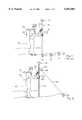
- FIG. 1A simplified drawing of a user employing prior art surveying equipment is shown in FIG. 1.
- the range pole 110has attached to it an antenna 120 for receiving GPS signals and a circular level or vial 130.
- the user 140holds the range pole 110 and moves the range pole 110 about until the level 130 indicates that the range pole 100 is vertically oriented and the bottom of the pole touches a location to be surveyed, such as location 150, 151 or 152.
- a location to be surveyedsuch as location 150, 151 or 152.
- the information received via the GPS antennacan be used to accurately compute the position of the location (150, 151 or 152).
- the userwill have a backpack 160 that includes a wireless link, such as a radio modem 170, for receiving additional data, e.g., correction signals, from a reference station, e.g., a differential GPS (DGPS) base station.
- DGPSdifferential GPS
- the backpack 160also contains equipment and circuits for generating positional information based upon the signals received through antenna 120 and wireless link 170.
- the data collection device 100enables the user to make manual entries, and also provides a visual reading of the survey measurements obtained.
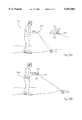
- the user 140navigates to a location of interest 152 by inputting the desired position in latitude and longitude (or any convenient x, y, z coordinate system) to the survey device and then following on screen directions such as an indication of the direction and distance from the user's current position.
- the on screen indicationsare useful while the user 140 is approaching the location of interest 152 from a distance; however, the on screen indication may change wildly when the user 140 is very close to the desired position. Therefore, once the user 140 is within a few meters, the user's pace must be slowed to assure the point 152 is not passed over.
- the process of confirming the estimated location (150, 151, 152)may begin.
- This iterative processtypically involves placing the range pole 110 over the estimated location (150, 151, 152), leveling the range pole 110, receiving a measurement, and adjusting the placement of the range pole 110.
- This confirmation processcontinues until the measurement received matches the position of the location of interest 152.
- the user 140initially estimated the desired location 152 to be at location 150.
- the user 140adjusted the placement of the range pole 110 to location 151.
- the user 140adjusted the placement of the range pole 110 to location 152 at t3.
- the present inventiondescribes a surveying device, referred to as a position identification system, that employs satellite navigational or similar positioning technology.
- the position identification systemeliminates the need for estimating the location of a desired position and iteratively adjusting the placement of a range pole.
- the position identification systemincludes an antenna/receiver for receiving position signals from a positioning system; an orientation device that is configured to rotate about a first axis and a second axis; a pointing element that operates in conjunction with the orientation device to identify a desired position; and a processor that is coupled to the antenna/receiver to receive the position signals.
- the processorcomputes a current position of the position identification system based upon the position signals and directs the orientation device based upon the current position and the desired position.
- a pointing deviceis used to identify the desired location to the user of the positioning system.
- the positioning systemreceives a first position corresponding to the desired location.
- a second positionis determined corresponding to the device's current location. Then, when the pointing element is oriented such that the pointing element is substantially aligned with the first position, the desired location may be identified by activating the pointing element.
- the need for iteratively confirming estimated locationsis eliminated.
- FIG. 1is a simplified prior art drawing of a Global Positioning System surveying device.
- FIG. 2is a simplified drawing of a survey device according to one embodiment of the present invention.
- FIGS. 3A and FIG. 3Bare simplified illustrations of embodiments of a handheld surveying device of the present invention.
- FIG. 4Ais a simplified block diagram illustrating various functional units according to one embodiment of the surveying system of the present invention.
- FIG. 4Billustrates an alternate embodiment of the surveying system of the present invention.
- FIG. 5is a simplified flow diagram illustrating the position identification processing according to one embodiment of the present invention.
- FIGS. 6A and FIG. 6Billustrate views of the handheld surveying device according to one embodiment of the present invention.
- FIG. 6Cis a diagram used to describe exemplary computations that may be performed according to one embodiment of the present invention.
- FIG. 7is a diagram used to describe exemplary computations that may be performed in another embodiment of the present invention.
- FIG. 8illustrates an exemplary transformation from a receiver coordinate system to a neutral coordinate system.
- FIG. 9is a simplified block diagram of an exemplary orientation device according to one embodiment of the present invention.
- the surveying device of the present inventionprovides an improved method of identifying a known location of interest by eliminating the iterative and time consuming confirmation process described above.
- a simplified illustration of an exemplary surveying deviceis shown in FIG. 2.
- the devicemay be used to identify the location of the position by illuminating the point 250 on the ground using a small, eye-safe, visible, fine beam laser or similar pointing device. Using the device, the user 140 can identify the location 250 of a particular position. In this manner, the device eliminates the need for the location estimation and adjustment cycle required by prior art survey devices, such as that described with respect to FIG. 1.
- the survey systemmay include a handheld device 200, a range pole 210, an orientation device 270, and a pointing device 280.
- the handheld device 200includes appropriate circuitry and software to process positioning information from the global positioning system (GPS), or similar system, as well as to process correction signals to adjust the positioning information received to determine a corrected, more accurate current position.
- the handheld device 200includes circuitry and software for controlling and commanding the orientation device 270 and the pointing device 280. For example, according to one embodiment of the present invention, upon determining the desired location 250 is within a predetermined distance of the current location, the pointing device may be activated causing it to illuminate the desired location 250 with a highly visible laser beam 290.
- the handheld device 200is an integrated controller that is mounted to the range pole 210 rather than being carried separately.
- FIG. 3A and FIG. 3BAlternate embodiments are illustrated in FIG. 3A and FIG. 3B.
- the orientation device 350 and the pointing device 355are mounted to the housing of a handheld survey device 335 and the range pole 210 may be eliminated.
- certain componentsare placed in a fanny pack 305 which hooks around the user's waist with a belt.
- the equipment for maintaining the wireless linksuch as radio modem 170 and the data storage device may be placed in the fanny pack 305, freeing up space in the handheld portion 335 of the device.
- the pointing device 355, the orientation device 350, GPS antenna and digital level and heading devicebe maintained in the handheld portion 335 of the device to allow accurate position data to be measured and facilitate position identification by the pointing device 335.
- Exemplary functional units that may be included in various embodiments and distributed among the control unit mounted to the range pole 210, the handheld device 200, and the backpack 160 or fanny pack 305(collectively referred to as the survey system) will now be described with reference to the simplified block diagram of FIG. 4A. It should be appreciated all the functional units will be distributed between the fanny pack 305 and the handheld device (300 or 335) according to the embodiments depicted in FIG. 3A and FIG. 3B.
- the survey system 400typically includes input/output elements, such as a display and keypad 405, a processor 410, and related components such as memory, controllers and the like, a positioning antenna and receiver 415, a radio receiver 420, a digital level and heading element 430, a pointing device 450, an orientation device 460, and an attitude determining device 470.
- input/output elementssuch as a display and keypad 405, a processor 410, and related components such as memory, controllers and the like, a positioning antenna and receiver 415, a radio receiver 420, a digital level and heading element 430, a pointing device 450, an orientation device 460, and an attitude determining device 470.
- the input/output display and keypad 405are used to provide feedback to the user and enable the user to enter in information, such as notes regarding the survey process performed.
- Processor 410performs the computations necessary to determine the distance and direction of the desired position, and further controls the remaining elements to acquire the data needed to perform these calculations.
- Processor 410also performs functions such as storing data in the memory for subsequent access, and displaying selective information on the display during survey, such as an indication of the distance and direction of the desired position relative to the user's current position.
- the antenna and receiver 415receive position information with respect to the location of the antenna of the device.
- equipment compatible with the Global Positioning SystemGPS
- GPSGlobal Positioning System
- Other types of positioning systemsinclude the Global Orbiting Navigation System (GLONASS), long-range navigation (LORAN-C) system, uncoordinated beacon signals, and pseudolite systems.
- GLONASSGlobal Orbiting Navigation System
- LORAN-Clong-range navigation
- uncoordinated beacon signalsand pseudolite systems.
- the digital level and heading device 430identifies the tilt (also referred to as pitch) and the heading (also referred to as yaw) at which the device is oriented. This provides data that may be used to determine the relative position and orientation of the device with respect to the desired position.
- the device 430may be embodied as two separate devices, one determining the level of the handheld device, and the other determining the heading, for example. Alternately, the device 430 may be one integrated device.
- One example of such a deviceis the TMCI which is available from Precision Navigation Ltd., Sunnyvale, Calif.
- the system 400may also include an attitude determining device 470 for determining the angular orientation of the device, such as a flux gate compass or TANS vector system.
- an attitude determining device 470for determining the angular orientation of the device, such as a flux gate compass or TANS vector system.
- this deviceprovides an indication to the user of the location of the desired position.
- a laser pointeris used.
- the laser pointerilluminates a spot on a surface of the ground corresponding to the location of the desired position input by the user.
- An exemplary laser module that may serve as the pointing device 350is the MLX-635 manufactured by RPMC of St. Charles, Mo.
- the pointing device 450is mounted to the orientation device 460.
- the orientation device 460is oriented based upon parameters, such as an indication of the desired bearing and elevation, received from the processor 410. In this manner, the orientation device 460 provides a mechanism by which the pointing device 450 may be aligned with the desired position.
- the orientation device 460may provide freedom of movement about a first and a second axis.
- the orientation device 460may be similar to a miniature turret, which rotates about a base to the appropriate heading and raises or lowers the pointing device 450 to the appropriate angle relative to the horizontal.
- the pointing device 450may remain in a fixed position and the orientation device 460 is a deflection mechanism such as a piezo-electrically controlled mirror. In this manner, the pointing device 450 may remain stationary and the orientation device 460 aligns the laser beam with the desired position by appropriately adjusting the angle of the deflection mechanism.
- the pointing device 450is preferably fixed in a vertical position perpendicular to the measurement platform (e.g., the handheld device).
- the pointing device 450 and the orientation device 460are depicted as separate functional units, they need not be physically separate components. Rather, the orientation device 460 may be integrated within the pointing device 450 to control the laser beam internal to the pointing device 450. Additionally, the orientation device 460 need not be a mechanical mechanism. Those of ordinary skill in the art will appreciate various other means for orienting the pointing device 450, are available.
- the pointing device 450may comprise one or more optical fibers that are positioned by manipulating an electrostatic field though which the one or more optical fibers pass.
- a ranging device 440may also be included to provide the user with feedback and allow for correction of a two dimensional position that may be located on a rising slope, for example.
- the ranging device 440may be used to measure the distance between the device and the indicated location of the desired position.
- the measuring element 440is any compact measuring device that functions to non-obtrusively measure the distance between the device and the location indicated by pointing device 450.
- it is preferable that the ranging device 440not require an additional device, such as a reflective object, to be placed at the indicated location.
- a measuring device 440is a sonic-based measuring system, which sonically determines the distance between the measuring device 440 and another location.
- Another device 440 that can be usedis a laser-based measuring device that uses the time of flight or performs a phase comparison in order to measure the distance. Examples of measuring element products include Criterion by Laser Technology Colorado, and Pulsar by IBEO, Hamburg, Germany.
- the system 400is also capable of performing one or more correction techniques for improving the position fix accuracy.
- the system 400may include a radio receiver 420 for receiving additional data, such as RTK data, differential GPS correction signals, or other data for increasing the accuracy of the measurements.
- Correction signalsmay be transmitted by a DGPS base station, for example, and received by the radio receiver 420. These correction signals are then used to adjust the positioning data received through the GPS antenna and receiver 415.
- a separate antenna/receiveris used, it is contemplated that one antenna/receiver can be used to receive position signals and correction signals.
- the radio receiver 420may comprise a TrimTalk 900 radio modem manufactured by Trimble Navigation Limited.
- the radio receiver 420may be any device capable of supporting a wireless link with the base station, such as a wireless or cellular modem, a radio receiver or other RF capable device. Further, when direct radio communication between the reference station and the rover device may be obscured, the radio receiver 420 may be configured to operate with one or more repeaters. Additionally, it should be appreciated that additional elements may be added to the system to provide additional functionality and application-specific features as may be required for various applications.
- FIG. 4Bis a simplified block diagram of an alternate embodiment of the system of the present invention.
- the device 460is controlled by system controller and transform calculator 462. Positioning signals are received via a GPS antenna 464 and input to GPS Receiver/Processor 466. Then, the GPS Receiver/Processor may perform differential correction using data received via a differential receiver antenna 468 and receiver 470. As is readily apparent to one skilled in the art, however, other forms of correction may be employed.
- One such methodis known in the art as the RTK method in which a reference GPS station positioned at a known location receives well known GPS observables and makes them available via a radio link, for example, in real-time to the rover device.
- the rover devicemay then processes those observables as well as its own observables to determine a more accurate position fix relative to the reference station.
- the methodis described in U.S. Pat. No. 5,519,620 of Talbot et al., which is incorporated herein by reference.
- positioning datais transferred to the system controller and transform calculator 462 by GPS receiver processor 466.
- Transformsexamples of which are described below, are applied to the positioning data received based upon the pitch, roll, yaw, and bearing of the device as indicated by various meters such as the tilt meter 472 (e.g., one or more inclinometers), heading meter 474, and others described previously.
- the resulting parametersmay be used to orient the laser pointer 478 so that it will illuminate the location of the desired position when the laser is activated.
- the system 460also may include a battery or other power source 480 used to power the device 460, a keyboard 482 to enable the user to input data such as notes or the like, and a display 484 to provide the usual feedback to the user.
- Data storage 486is also included for temporary and semi-permanent storage of data collected and computed in accordance with the teachings of the present invention.
- a positionis received from the user, for example, representing the desired position that is to be located.
- the current position of the survey deviceis determined based upon position information received from positioning system signals and additionally based upon correction signals, if available.
- the orientation parameters of the survey deviceare determined.
- the distance from the survey device to the desired positionis calculated using the current position determined in step 515.
- a comparisonis performed to determine if the distance from the desired location is within a predefined range.
- the predefined rangeis less than or equal to the range of the laser diode used in the pointing device.
- step 535parameters for aligning the pointing element with the desired position are calculated. For example, the appropriate bearing and angle of elevation to bring the pointing element in alignment with the desired position are determined.
- step 540the parameters calculated at step 535 are used to orient the pointing element.
- step 545the pointing element is activated so as to illuminate the location corresponding to the desired position. If the survey device was determined not to be within the predetermined range at step 530, then at step 550, the pointing element may be deactivated.
- step 555an on-screen indication of the direction and distance relative to the user's current heading and position may be provided to the user.
- the pointing devicemay be configured to provide the indication. For example, the pointing device may sweep or point in the appropriate direction.
- the pointing devicemay be manually activated/deactivated rather than being activated and deactivated based on the distance to the desired position.
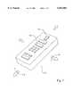
- FIG. 6Aillustrates a bottom view of the handheld surveying device 300 according to one embodiment of the present invention.
- the pointing device 355is shown before and after the orientation device 350 has been rotated ⁇ degrees in azimuth.
- FIG. 6Billustrates a side view of the handheld surveying device 300 according to one embodiment of the present invention.
- the pointing device 355is shown before and after the orientation device 350 has rotated it -.O slashed. degrees in elevation.
- exemplary bearing and elevation calculations to be performed by the survey device of the present inventionwill now be described with respect to FIG. 6C.
- the following coordinate transformis used.
- a local coordinate system in x, y, z as shown in FIG. 6Cis defined, where x corresponds to East, y corresponds to North, and altitude corresponds to z.
- the originis centered on the souce of the laser beam.
- x o , y o , z oThe coordinates of the origin are referred to by x o , y o , z o .
- the coordinates of the point 620 to be identifiedare called x o ', y o ', z o '.
- .O slashed.be the elevation of the laser beam in degrees from horizontal.
- ⁇be the angle of the laser beam projected on the local horizontal plane (x, y) representing the bearing from survey device azimuth.
- Angles .O slashed. and ⁇may be determined as follows relative to true north and relative to a level measurement platform: ##EQU1##
- the attitude of the survey deviceshould be delivered to a right and regular orientation either by holding the device true north and level in two horizontal planes or, as is well known in the art, the calculations above may be modified to incorporate the orientation of the platform by using the attitude of the survey device (the measurement platform) such as may be determined by two inclinometers mounted at right angles to each other as shown in FIG. 7. Such inclinometers may have electronic readout means coupled to the system controller and transform calculator 462 thereby allowing offsets from the two horizontal planes to be automatically taken into consideration by the system controller and transform calculator 462.
- the handheld device 705may include two inclinometers, such as bubble inclinometers 710 and 715, oriented perpendicular to one another. While in the embodiment depicted the two inclinometers 710, 715 are located in the same elevational plane, it is appreciated in alternative embodiments they may be located at any elevation ( ⁇ z) independently of one another.
- two inclinometers 710, 715are located in the same elevational plane, it is appreciated in alternative embodiments they may be located at any elevation ( ⁇ z) independently of one another.
- the first inclinometer 710measures the tilt of the device along the lengthwise axis (angle ⁇ ) in the yz plane which corresponds to "pitch.”
- the second inclinometer 715measures the tilt along the width-wise axis (angle ⁇ ) in the xz plane which corresponds to "roll.”
- the inclinometer measurementse.g., ⁇ and ⁇
- the survey device's orientation as measured by the appropriate devicemay be used in conjunction with an additional coordinate transformation to account for the attitude of the survey device 705.
- Mechanisms for targeting and pointing to objects from a given platform and making measurements on that platform to determine what the coordinates are of the distant pointare well known and are discussed in detail in U.S. Pat. No.
- FIG. 8is useful for describing an exemplary matrix transformation from a receiver coordinate system (x r , y r , z r ) to a neutral coordinate system (x rt , y rt , z rt ) to account for the attitude of the receiver 800.
- a receiver axis 825is projected onto a horizontal plane 820 to produce a projected receiver axis 805.
- a receiver-target separation vector, vis projected onto the horizontal plane 820 to produce a projection of the receiver-target separation vector 810.
- the exemplary matrix transformationis then as follows: ##EQU2##
- the orientation device 900comprises a servo controlled pointing system 925.
- a servo controlled pointing system 925Such pointing systems are well known.
- the techniques used to point the laserare similar to those used by radar or satellite antenna engineers to perform tracking of a distant object with servo control where the servo input here, however, is an arbitrary control signal (e.g., bearing and elevation values) rather than a signal from the source itself.
- the servo controlled pointing system 925includes a bearing motor 905 for rotating the pointing device about a first axis in azimuth and an elevation motor 910 for rotating the pointing device about a second axis in elevation.
- the bearing motor 905is coupled to a control/readout device 915 which controls the bearing motor 905 based upon bearing commands.
- the elevation motor 905is coupled to a control/readout device 915 which controls the elevation motor 910 based upon elevation commands.
- the control/readout devices 915, 920each include a servo motor control system to allow independent control of the attached servo motor.
- the control/readout devices 915, 920also provide an electronic means of reading out the current degree of rotation of servo motors 905, 910 (in azimuth and elevation, respectively). In this manner, the processor or system controller may monitor the progress of the pointing system.
- the inventorenvisions uses of the present invention in connection with locating buried objects.
- the survey devicemay be configured to sweep out the direction in which buried cables or utilities lie.
- the shape of the objectmay be drawn on the ground with the pointing device.
- location of physical position marksmay be located by incorporating the techniques disclosed in U.S. patent application Ser. Nos. 08/026,574 and 08/578,998, entitled “Location and Generation of High Accuracy Survey Control Marks Using Satellites” filed on May 4, 1993 and Jan. 16, 1996 respectively, which are incorporated herein by reference. While the method and apparatus described herein may be used by surveyors looking for points of interest in their business of performing stake out, they may also be used by many other people for targeting activities to point to where things might be relative to a measurement platform.
Landscapes
- Engineering & Computer Science (AREA)
- Radar, Positioning & Navigation (AREA)
- Remote Sensing (AREA)
- Physics & Mathematics (AREA)
- General Physics & Mathematics (AREA)
- Computer Networks & Wireless Communication (AREA)
- Position Fixing By Use Of Radio Waves (AREA)
Abstract
Description
1. Field of the Invention
The present invention relates to navigating to a predetermined position using positioning information from satellite navigational equipment or similar positioning technology.
2. Art Background
The art of surveying and mapping has dramatically changed through the use of satellite navigation equipment. Satellite survey devices include receivers that receive position signals from the global positioning system (GPS), Global Navigation Satellite System (GLONASS) receiver or other satellite or pseudolite systems. The position signals are used to compute the position of the receiver.
While selective availability (S/A) and environmental conditions may degrade the position signals to 100 meter accuracy, differential correction (DGPS) and real time kinematic (RTK) processes may be employed increase accuracy to the within 1 to 2 centimeter accuracy. RTK and real time computation of DGPS both require the use of an additional radio frequency receiver for reception of additional data that is used to compute a corrected, more accurate, position. Thus, the satellite survey device which is typically called the "rover device", includes a range pole for identifying the point for which a location is to be computed, a user input/output device for entry and display of information and data, a satellite receiver and a radio receiver.
A simplified drawing of a user employing prior art surveying equipment is shown in FIG. 1. Therange pole 110 has attached to it anantenna 120 for receiving GPS signals and a circular level orvial 130. Theuser 140 holds therange pole 110 and moves therange pole 110 about until thelevel 130 indicates that therange pole 100 is vertically oriented and the bottom of the pole touches a location to be surveyed, such aslocation backpack 160 that includes a wireless link, such as aradio modem 170, for receiving additional data, e.g., correction signals, from a reference station, e.g., a differential GPS (DGPS) base station. Using DGPS technology, more precise measurements are obtained. Thebackpack 160 also contains equipment and circuits for generating positional information based upon the signals received throughantenna 120 andwireless link 170. Thedata collection device 100 enables the user to make manual entries, and also provides a visual reading of the survey measurements obtained.
Referring again to FIG. 1, a typical method of navigating to a known position will now be described. Theuser 140 navigates to a location ofinterest 152 by inputting the desired position in latitude and longitude (or any convenient x, y, z coordinate system) to the survey device and then following on screen directions such as an indication of the direction and distance from the user's current position. The on screen indications are useful while theuser 140 is approaching the location ofinterest 152 from a distance; however, the on screen indication may change wildly when theuser 140 is very close to the desired position. Therefore, once theuser 140 is within a few meters, the user's pace must be slowed to assure thepoint 152 is not passed over. When theuser 140 has identified an estimated location (150, 151, 152) that is believed to be the location ofinterest 152, the process of confirming the estimated location (150, 151, 152) may begin. This iterative process typically involves placing therange pole 110 over the estimated location (150, 151, 152), leveling therange pole 110, receiving a measurement, and adjusting the placement of therange pole 110. This confirmation process continues until the measurement received matches the position of the location ofinterest 152. In the example depicted, at t1, theuser 140 initially estimated the desiredlocation 152 to be atlocation 150. After receiving feedback from the input/output device, at t2, theuser 140 adjusted the placement of therange pole 110 tolocation 151. Upon receiving the second measurement, theuser 140 adjusted the placement of therange pole 110 tolocation 152 at t3. At this point, theuser 140 received confirmation that therange pole 110 was in fact positioned over the desiredlocation 152.
In light of the foregoing, it would be advantageous to eliminate the iterative and time consuming process of receiving a position measurement and adjusting the placement of the range pole until the desired location is found. Thus, it is desirable to provide an accurate survey device with an integrated pointing device for identifying the location of interest to the user from a distance.
The present invention describes a surveying device, referred to as a position identification system, that employs satellite navigational or similar positioning technology. The position identification system eliminates the need for estimating the location of a desired position and iteratively adjusting the placement of a range pole. In one embodiment, the position identification system includes an antenna/receiver for receiving position signals from a positioning system; an orientation device that is configured to rotate about a first axis and a second axis; a pointing element that operates in conjunction with the orientation device to identify a desired position; and a processor that is coupled to the antenna/receiver to receive the position signals. The processor computes a current position of the position identification system based upon the position signals and directs the orientation device based upon the current position and the desired position.
Using the positioning system, a pointing device is used to identify the desired location to the user of the positioning system. The positioning system receives a first position corresponding to the desired location. A second position is determined corresponding to the device's current location. Then, when the pointing element is oriented such that the pointing element is substantially aligned with the first position, the desired location may be identified by activating the pointing element. Advantageously, in this manner, the need for iteratively confirming estimated locations is eliminated.
The features and advantages of the present invention will be apparent to one skilled in the art from the following detailed description in which:
FIG. 1 is a simplified prior art drawing of a Global Positioning System surveying device.
FIG. 2 is a simplified drawing of a survey device according to one embodiment of the present invention.
FIGS. 3A and FIG. 3B are simplified illustrations of embodiments of a handheld surveying device of the present invention.
FIG. 4A is a simplified block diagram illustrating various functional units according to one embodiment of the surveying system of the present invention.
FIG. 4B illustrates an alternate embodiment of the surveying system of the present invention.
FIG. 5 is a simplified flow diagram illustrating the position identification processing according to one embodiment of the present invention.
FIGS. 6A and FIG. 6B illustrate views of the handheld surveying device according to one embodiment of the present invention.
FIG. 6C is a diagram used to describe exemplary computations that may be performed according to one embodiment of the present invention.
FIG. 7 is a diagram used to describe exemplary computations that may be performed in another embodiment of the present invention.
FIG. 8 illustrates an exemplary transformation from a receiver coordinate system to a neutral coordinate system.
FIG. 9 is a simplified block diagram of an exemplary orientation device according to one embodiment of the present invention.
In the following description, for purposes of explanation, numerous details are set forth in order to provide a thorough understanding of the present invention. However, it will be apparent to one skilled in the art that these specific details are not required in order to practice the present invention. In other instances, well known electrical structures and circuits are shown in block diagram form.
The surveying device of the present invention provides an improved method of identifying a known location of interest by eliminating the iterative and time consuming confirmation process described above. A simplified illustration of an exemplary surveying device is shown in FIG. 2. As discussed further below, when theuser 140 is within a predetermined distance of the desired position, the device may be used to identify the location of the position by illuminating thepoint 250 on the ground using a small, eye-safe, visible, fine beam laser or similar pointing device. Using the device, theuser 140 can identify thelocation 250 of a particular position. In this manner, the device eliminates the need for the location estimation and adjustment cycle required by prior art survey devices, such as that described with respect to FIG. 1.
In addition to the equipment described above for accurately computing a current position, the survey system may include a handheld device 200, arange pole 210, anorientation device 270, and apointing device 280. The handheld device 200 includes appropriate circuitry and software to process positioning information from the global positioning system (GPS), or similar system, as well as to process correction signals to adjust the positioning information received to determine a corrected, more accurate current position. Additionally, the handheld device 200 includes circuitry and software for controlling and commanding theorientation device 270 and thepointing device 280. For example, according to one embodiment of the present invention, upon determining the desiredlocation 250 is within a predetermined distance of the current location, the pointing device may be activated causing it to illuminate the desiredlocation 250 with a highlyvisible laser beam 290. In alternative embodiments, the handheld device 200 is an integrated controller that is mounted to therange pole 210 rather than being carried separately.
Alternate embodiments are illustrated in FIG. 3A and FIG. 3B. In these embodiments, theorientation device 350 and thepointing device 355 are mounted to the housing of ahandheld survey device 335 and therange pole 210 may be eliminated.
In the embodiment depicted in FIG. 3B certain components are placed in afanny pack 305 which hooks around the user's waist with a belt. For example, the equipment for maintaining the wireless link, such asradio modem 170 and the data storage device may be placed in thefanny pack 305, freeing up space in thehandheld portion 335 of the device. However, it is preferred that thepointing device 355, theorientation device 350, GPS antenna and digital level and heading device be maintained in thehandheld portion 335 of the device to allow accurate position data to be measured and facilitate position identification by thepointing device 335.
Exemplary functional units that may be included in various embodiments and distributed among the control unit mounted to therange pole 210, the handheld device 200, and thebackpack 160 or fanny pack 305 (collectively referred to as the survey system) will now be described with reference to the simplified block diagram of FIG. 4A. It should be appreciated all the functional units will be distributed between thefanny pack 305 and the handheld device (300 or 335) according to the embodiments depicted in FIG. 3A and FIG. 3B. In any event, thesurvey system 400 typically includes input/output elements, such as a display andkeypad 405, aprocessor 410, and related components such as memory, controllers and the like, a positioning antenna andreceiver 415, aradio receiver 420, a digital level and headingelement 430, apointing device 450, anorientation device 460, and anattitude determining device 470.
The input/output display andkeypad 405 are used to provide feedback to the user and enable the user to enter in information, such as notes regarding the survey process performed.Processor 410 performs the computations necessary to determine the distance and direction of the desired position, and further controls the remaining elements to acquire the data needed to perform these calculations.Processor 410 also performs functions such as storing data in the memory for subsequent access, and displaying selective information on the display during survey, such as an indication of the distance and direction of the desired position relative to the user's current position.
The antenna andreceiver 415 receive position information with respect to the location of the antenna of the device. In the present embodiment, equipment compatible with the Global Positioning System (GPS) are employed. However, it is readily apparent an antenna and receiver compatible with other types of positioning systems may be employed. Other types of positioning systems include the Global Orbiting Navigation System (GLONASS), long-range navigation (LORAN-C) system, uncoordinated beacon signals, and pseudolite systems.
Once the position information is received, the difference in position between the device and the desired position may be determined. For example, in one embodiment, the digital level and headingdevice 430 identifies the tilt (also referred to as pitch) and the heading (also referred to as yaw) at which the device is oriented. This provides data that may be used to determine the relative position and orientation of the device with respect to the desired position. Thus, in embodiments incorporating the digital level and headingdevice 430, there is no need for the user to hold the handheld device in a specific orientation. Thedevice 430 may be embodied as two separate devices, one determining the level of the handheld device, and the other determining the heading, for example. Alternately, thedevice 430 may be one integrated device. One example of such a device is the TMCI which is available from Precision Navigation Ltd., Sunnyvale, Calif.
In alternative embodiments of the present invention, thesystem 400 may also include anattitude determining device 470 for determining the angular orientation of the device, such as a flux gate compass or TANS vector system.
Referring now to thepointing device 450, this device provides an indication to the user of the location of the desired position. In one embodiment, a laser pointer is used. The laser pointer illuminates a spot on a surface of the ground corresponding to the location of the desired position input by the user. An exemplary laser module that may serve as thepointing device 350 is the MLX-635 manufactured by RPMC of St. Charles, Mo.
According to one embodiment, thepointing device 450 is mounted to theorientation device 460. Theorientation device 460 is oriented based upon parameters, such as an indication of the desired bearing and elevation, received from theprocessor 410. In this manner, theorientation device 460 provides a mechanism by which thepointing device 450 may be aligned with the desired position. In one embodiment, theorientation device 460 may provide freedom of movement about a first and a second axis. For instance, theorientation device 460 may be similar to a miniature turret, which rotates about a base to the appropriate heading and raises or lowers thepointing device 450 to the appropriate angle relative to the horizontal. In an alternative embodiment, thepointing device 450 may remain in a fixed position and theorientation device 460 is a deflection mechanism such as a piezo-electrically controlled mirror. In this manner, thepointing device 450 may remain stationary and theorientation device 460 aligns the laser beam with the desired position by appropriately adjusting the angle of the deflection mechanism. In this embodiment, for the largest degree of freedom for controlling the direction of the laser beam, thepointing device 450 is preferably fixed in a vertical position perpendicular to the measurement platform (e.g., the handheld device).
Importantly, while thepointing device 450 and theorientation device 460 are depicted as separate functional units, they need not be physically separate components. Rather, theorientation device 460 may be integrated within thepointing device 450 to control the laser beam internal to thepointing device 450. Additionally, theorientation device 460 need not be a mechanical mechanism. Those of ordinary skill in the art will appreciate various other means for orienting thepointing device 450, are available. For example, in one embodiment, thepointing device 450 may comprise one or more optical fibers that are positioned by manipulating an electrostatic field though which the one or more optical fibers pass.
In alternative embodiments, a rangingdevice 440 may also be included to provide the user with feedback and allow for correction of a two dimensional position that may be located on a rising slope, for example. The rangingdevice 440 may be used to measure the distance between the device and the indicated location of the desired position. Preferably, the measuringelement 440 is any compact measuring device that functions to non-obtrusively measure the distance between the device and the location indicated by pointingdevice 450. In addition, it is preferable that the rangingdevice 440 not require an additional device, such as a reflective object, to be placed at the indicated location. One example of such ameasuring device 440 is a sonic-based measuring system, which sonically determines the distance between the measuringdevice 440 and another location. Anotherdevice 440 that can be used is a laser-based measuring device that uses the time of flight or performs a phase comparison in order to measure the distance. Examples of measuring element products include Criterion by Laser Technology Colorado, and Pulsar by IBEO, Hamburg, Germany.
Preferably, thesystem 400 is also capable of performing one or more correction techniques for improving the position fix accuracy. For example, thesystem 400 may include aradio receiver 420 for receiving additional data, such as RTK data, differential GPS correction signals, or other data for increasing the accuracy of the measurements. Correction signals may be transmitted by a DGPS base station, for example, and received by theradio receiver 420. These correction signals are then used to adjust the positioning data received through the GPS antenna andreceiver 415. Although in the present embodiment, a separate antenna/receiver is used, it is contemplated that one antenna/receiver can be used to receive position signals and correction signals. In one embodiment, theradio receiver 420 may comprise aTrimTalk 900 radio modem manufactured by Trimble Navigation Limited. Importantly, however, theradio receiver 420 may be any device capable of supporting a wireless link with the base station, such as a wireless or cellular modem, a radio receiver or other RF capable device. Further, when direct radio communication between the reference station and the rover device may be obscured, theradio receiver 420 may be configured to operate with one or more repeaters. Additionally, it should be appreciated that additional elements may be added to the system to provide additional functionality and application-specific features as may be required for various applications.
FIG. 4B is a simplified block diagram of an alternate embodiment of the system of the present invention. Thedevice 460 is controlled by system controller and transformcalculator 462. Positioning signals are received via aGPS antenna 464 and input to GPS Receiver/Processor 466. Then, the GPS Receiver/Processor may perform differential correction using data received via adifferential receiver antenna 468 andreceiver 470. As is readily apparent to one skilled in the art, however, other forms of correction may be employed. One such method is known in the art as the RTK method in which a reference GPS station positioned at a known location receives well known GPS observables and makes them available via a radio link, for example, in real-time to the rover device. The rover device may then processes those observables as well as its own observables to determine a more accurate position fix relative to the reference station. The method is described in U.S. Pat. No. 5,519,620 of Talbot et al., which is incorporated herein by reference.
In any event, positioning data is transferred to the system controller and transformcalculator 462 byGPS receiver processor 466. Transforms, examples of which are described below, are applied to the positioning data received based upon the pitch, roll, yaw, and bearing of the device as indicated by various meters such as the tilt meter 472 (e.g., one or more inclinometers), headingmeter 474, and others described previously. The resulting parameters may be used to orient thelaser pointer 478 so that it will illuminate the location of the desired position when the laser is activated.
Thesystem 460 also may include a battery orother power source 480 used to power thedevice 460, akeyboard 482 to enable the user to input data such as notes or the like, and adisplay 484 to provide the usual feedback to the user.Data storage 486 is also included for temporary and semi-permanent storage of data collected and computed in accordance with the teachings of the present invention.
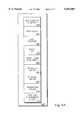
An exemplary process for performing position identification will now be described with reference to FIG. 5. Initially, a position is received from the user, for example, representing the desired position that is to be located. Atstep 515, the current position of the survey device is determined based upon position information received from positioning system signals and additionally based upon correction signals, if available. Atstep 520, the orientation parameters of the survey device are determined. Atstep 525, the distance from the survey device to the desired position is calculated using the current position determined instep 515. According to the embodiment depicted, atstep 530, a comparison is performed to determine if the distance from the desired location is within a predefined range. Preferably, the predefined range is less than or equal to the range of the laser diode used in the pointing device. At any rate, if the condition is satisfied, then processing continues withstep 535; otherwise processing continues withstep 550. Atstep 535, parameters for aligning the pointing element with the desired position are calculated. For example, the appropriate bearing and angle of elevation to bring the pointing element in alignment with the desired position are determined. Atstep 540, the parameters calculated atstep 535 are used to orient the pointing element. Finally, atstep 545, the pointing element is activated so as to illuminate the location corresponding to the desired position. If the survey device was determined not to be within the predetermined range atstep 530, then atstep 550, the pointing element may be deactivated. Atstep 555, an on-screen indication of the direction and distance relative to the user's current heading and position may be provided to the user. In alternative embodiments, rather than deactivating the pointing element and providing an on-screen indication of the distance and direction to the desired position, the pointing device may be configured to provide the indication. For example, the pointing device may sweep or point in the appropriate direction. Atstep 560, a determination is made as to whether new position information has become available. If so, the process may be repeated starting withstep 515. In this manner, while the user remains within the predetermined range, the pointing device will track the location of the desired position. In should be appreciated in alternative embodiments the pointing device may be manually activated/deactivated rather than being activated and deactivated based on the distance to the desired position.
Thus, a user can easily navigate to and locate a desired position without performing the iterative estimation and confirmation cycle required with survey devices of the prior art.
FIG. 6A illustrates a bottom view of thehandheld surveying device 300 according to one embodiment of the present invention. Thepointing device 355 is shown before and after theorientation device 350 has been rotated θ degrees in azimuth. FIG. 6B illustrates a side view of thehandheld surveying device 300 according to one embodiment of the present invention. Thepointing device 355 is shown before and after theorientation device 350 has rotated it -.O slashed. degrees in elevation.
Having illustrated how the pointing device may be positioned, exemplary bearing and elevation calculations to be performed by the survey device of the present invention will now be described with respect to FIG. 6C. To orient the pointing device at a known position given in latitude and longitude (or any x,y,z coordinate system) such that it is in alignment with the coordinates of a predetermined position, the following coordinate transform is used. For purposes of explanation, a local coordinate system in x, y, z as shown in FIG. 6C is defined, where x corresponds to East, y corresponds to North, and altitude corresponds to z. The origin is centered on the souce of the laser beam. The coordinates of the origin are referred to by xo, yo, zo. The coordinates of thepoint 620 to be identified are called xo ', yo ', zo '. Let .O slashed. be the elevation of the laser beam in degrees from horizontal. Let θ be the angle of the laser beam projected on the local horizontal plane (x, y) representing the bearing from survey device azimuth. Angles .O slashed. and θ may be determined as follows relative to true north and relative to a level measurement platform: ##EQU1##
Ultimately, the attitude of the survey device should be delivered to a right and regular orientation either by holding the device true north and level in two horizontal planes or, as is well known in the art, the calculations above may be modified to incorporate the orientation of the platform by using the attitude of the survey device (the measurement platform) such as may be determined by two inclinometers mounted at right angles to each other as shown in FIG. 7. Such inclinometers may have electronic readout means coupled to the system controller and transformcalculator 462 thereby allowing offsets from the two horizontal planes to be automatically taken into consideration by the system controller and transformcalculator 462.
As illustrated in FIG. 7, thehandheld device 705 may include two inclinometers, such asbubble inclinometers inclinometers first inclinometer 710 measures the tilt of the device along the lengthwise axis (angle α) in the yz plane which corresponds to "pitch." Thesecond inclinometer 715 measures the tilt along the width-wise axis (angle β) in the xz plane which corresponds to "roll." If thesurvey device 705 is to be handheld, then the inclinometer measurements (e.g., α and β) and the survey device's orientation as measured by the appropriate device may be used in conjunction with an additional coordinate transformation to account for the attitude of thesurvey device 705. Mechanisms for targeting and pointing to objects from a given platform and making measurements on that platform to determine what the coordinates are of the distant point are well known and are discussed in detail in U.S. Pat. No. 5,568,152 of Janky et al. entitled "Integrated Image Transfer for Remote Target Location" and U.S. Pat. No. 5,644,318 of Janky et al. entitled "SATPS Dynamic Surveying from a Moving Platform" the contents of which are hereby incorporated by reference.
FIG. 8 is useful for describing an exemplary matrix transformation from a receiver coordinate system (xr, yr, zr) to a neutral coordinate system (xrt, yrt, zrt) to account for the attitude of thereceiver 800. Areceiver axis 825 is projected onto ahorizontal plane 820 to produce a projectedreceiver axis 805. A receiver-target separation vector, v, is projected onto thehorizontal plane 820 to produce a projection of the receiver-target separation vector 810. The exemplary matrix transformation is then as follows: ##EQU2##
Referring now to FIG. 9, a simplified block diagram of anexemplary orientation device 900 will now be described. According to this embodiment, theorientation device 900 comprises a servo controlledpointing system 925. Such pointing systems are well known. For example, the techniques used to point the laser are similar to those used by radar or satellite antenna engineers to perform tracking of a distant object with servo control where the servo input here, however, is an arbitrary control signal (e.g., bearing and elevation values) rather than a signal from the source itself.
At any rate, according to the embodiment depicted, the servo controlledpointing system 925 includes abearing motor 905 for rotating the pointing device about a first axis in azimuth and anelevation motor 910 for rotating the pointing device about a second axis in elevation. The bearingmotor 905 is coupled to a control/readout device 915 which controls the bearingmotor 905 based upon bearing commands. Theelevation motor 905 is coupled to a control/readout device 915 which controls theelevation motor 910 based upon elevation commands. The control/readout devices readout devices servo motors 905, 910 (in azimuth and elevation, respectively). In this manner, the processor or system controller may monitor the progress of the pointing system.
Many alternative embodiments are contemplated by the inventor of the present invention. For example, the inventor envisions uses of the present invention in connection with locating buried objects. By way of illustration, rather than providing an indication of a fixed point, the survey device may be configured to sweep out the direction in which buried cables or utilities lie. Additionally, if the size of a buried object is known, the shape of the object may be drawn on the ground with the pointing device.
Further, the location of physical position marks may be located by incorporating the techniques disclosed in U.S. patent application Ser. Nos. 08/026,574 and 08/578,998, entitled "Location and Generation of High Accuracy Survey Control Marks Using Satellites" filed on May 4, 1993 and Jan. 16, 1996 respectively, which are incorporated herein by reference. While the method and apparatus described herein may be used by surveyors looking for points of interest in their business of performing stake out, they may also be used by many other people for targeting activities to point to where things might be relative to a measurement platform.
The invention has been described in conjunction with the preferred embodiment. It is evident that numerous alternatives, modifications, variations and uses will be apparent to those skilled in the art in light of the foregoing description.
Claims (35)
1. A position identification system comprising:
an antenna/receiver receiving position signals from a positioning system;
an orientation device configured to rotate about a first axis and a second axis;
a pointing element operating in conjunction with the orientation device to identify a desired, known position; and
a processor coupled to the antenna/receiver to receive the position signals, the processor computing a current position of the position identification system based upon the position signals, and directing the orientation device based upon the current position and the desired, known position.
2. The position identification system of claim 1, wherein the processor is further configured to determine bearing and elevation values for directing the orientation device.
3. The position identification system of claim 1, further comprising a level and heading element that determines a tilt and orientation of the position identification system.
4. The position identification system of claim 1, wherein the antenna/receiver receives Global Positioning System (GPS) signals.
5. The position identification system of claim 1, wherein the pointing element is a laser pointer.
6. The position identification system of claim 1 further comprising a ranging device for measuring the distance between the position identification system and another point.
7. The position identification system of claim 1, further comprising a second antenna/receiver for receiving correction signals to adjust the position signals.
8. A method of identifying a desired, known location to the user of a survey device, the method comprising the steps of:
receiving a first position corresponding to the desired, known location;
determining a second position corresponding to the survey device's current location; and
orienting a pointing element to an orientation in which the pointing element is substantially aligned with the first position; and
identifying the desired, known location by activating the pointing element.
9. The method of claim 8, wherein position signals are received over an antenna/receiver and the step of determining a second position corresponding to the survey device's location is based upon the position signals.
10. The method of claim 9, wherein the position signals are Global Positioning System (GPS) signals.
11. The method of claim 10, further including the step of receiving correction signals to adjust the position signals.
12. The method of claim 8, further including the steps of:
determining the distance between the first position and the second position and the direction of the first position relative to the second position; and
if the distance exceeds a predetermined threshold, then providing an on-screen indication of the direction and distance to the desired, known location.
13. The method of claim 8, wherein the survey device is a handheld device.
14. The method of claim 8, further comprising the step of determining a bearing and elevation for orienting the pointing element.
15. The method of claim 8, wherein the survey device is a handheld device, the method further comprising the step of determining the attitude, and orientation of the handheld device.
16. The method of claim 8, wherein the pointing element is a laser pointer.
17. The method of claim 16, wherein the step of identifying the desired location by activating the pointing element causes the desired location to be illuminated with a visible laser beam.
18. The method of claim 16, further including the step of sweeping out a pattern with the laser pointer.
19. The method of claim 8, wherein the step of determining a second position corresponding to the survey device's current location comprises determining the survey device's current location relative to a location of a reference station.
20. The method of claim 19, further comprising the step of receiving observables from the reference station.
21. The method of claim 8, further comprising the step of performing a correction technique to improve accuracy of the second position.
22. The method of claim 8, wherein the survey device comprises a rover configured to receive data from a reference station and the step of determining a second position corresponding to the survey device's current location includes using real time kinematic (RTK) processes to determine the second position.
23. A position identification system operated by a user comprising:
an antenna/receiver receiving position signals;
a pointing element for identifying a point corresponding to a desired, known position;
an orientation device configured to align the pointing element with the desired, known position; and
a processor coupled to the antenna/receiver to receive the position signals from which a current position is determined, the processor directing the orientation device to a bearing and elevation, the bearing and elevation being calculated based upon the desired, known position and the current position.
24. The position identification system of claim 23, wherein the pointing element comprises one or more optical fibers.
25. The position identification system of claim 24, wherein the orientation device aligns the pointing element by manipulating an electrostatic field through which the one or more optical fibers pass.
26. The position identification system of claim 23, wherein the pointing element is a laser pointer.
27. The position identification system of claim 26, wherein the pointing element is mounted to the orientation device, and wherein the orientation device provides movement about a first axis and a second axis.
28. The position identification system of claim 26, wherein the orientation device includes one or more servo motors.
29. The position identification system of claim 23, further comprising an interface configured to receive the desired, known position.
30. The position identification system of claim 23, further comprising a radio upon which observables received by a reference station are made available for determination of a position relative to the reference station.
31. A position identification system comprising:
an antenna/receiver receiving position signals;
an identification means for identifying a point corresponding to a desired,known position; and
a processor coupled to the antenna/receiver and to the identification means, the processor determining a current position based on the position signals and providing to the identification means a bearing and elevation to the desired, known position.
32. The position identification system of claim 31, wherein the identification means includes:
a pointing element; and
a means for aligning the pointing element with the desired known position based upon the bearing and elevation provided by the processor.
33. The position identification system of claim 32, wherein the pointing element comprises one or more optical fibers.
34. The position identification system of claim 32, wherein the means for aligning the pointing element comprises an electrostatic field through which the one or more optical fibers pass.
35. The position identification system of claim 31, wherein the pointing element is a laser pointer.
Priority Applications (3)
| Application Number | Priority Date | Filing Date | Title |
|---|---|---|---|
| US09/041,857US6052083A (en) | 1998-03-12 | 1998-03-12 | Method and apparatus for position identification |
| US09/252,897US6140957A (en) | 1998-03-12 | 1999-02-18 | Method and apparatus for navigation guidance |
| US09/653,740US6480148B1 (en) | 1998-03-12 | 2000-09-01 | Method and apparatus for navigation guidance |
Applications Claiming Priority (1)
| Application Number | Priority Date | Filing Date | Title |
|---|---|---|---|
| US09/041,857US6052083A (en) | 1998-03-12 | 1998-03-12 | Method and apparatus for position identification |
Related Child Applications (1)
| Application Number | Title | Priority Date | Filing Date |
|---|---|---|---|
| US09/252,897Continuation-In-PartUS6140957A (en) | 1998-03-12 | 1999-02-18 | Method and apparatus for navigation guidance |
Publications (1)
| Publication Number | Publication Date |
|---|---|
| US6052083Atrue US6052083A (en) | 2000-04-18 |
Family
ID=21918720
Family Applications (1)
| Application Number | Title | Priority Date | Filing Date |
|---|---|---|---|
| US09/041,857Expired - LifetimeUS6052083A (en) | 1998-03-12 | 1998-03-12 | Method and apparatus for position identification |
Country Status (1)
| Country | Link |
|---|---|
| US (1) | US6052083A (en) |
Cited By (47)
| Publication number | Priority date | Publication date | Assignee | Title |
|---|---|---|---|---|
| US6408178B1 (en)* | 1999-03-29 | 2002-06-18 | Ericsson Inc. | Systems and methods for resolving GPS pseudo-range ambiguity |
| US20030065446A1 (en)* | 2001-09-07 | 2003-04-03 | Kabushiki Kaisha Topcon | Operator guiding system |
| US6597988B1 (en)* | 2000-09-22 | 2003-07-22 | Sirf Technology, Inc. | Network assisted pseudolite acquisition for enhanced GPS navigation |
| WO2003019223A3 (en)* | 2001-08-24 | 2003-08-14 | Topcon Gps Llc | Methods and systems for improvement of measurement efficiency in surveying |
| US6701631B1 (en)* | 2002-12-23 | 2004-03-09 | Inco Limited | Convertible directional azimuth and dip measuring modular compass and method |
| US20040066335A1 (en)* | 2002-05-02 | 2004-04-08 | Javad Ashjaee | Moving antenna phase array systems related to multipath signals in global positioning applications, and methods of using |
| US6934629B1 (en)* | 1996-07-08 | 2005-08-23 | Trimble Navigation Ltd. | Method and apparatus for precise positioning of large structures |
| US20060271298A1 (en)* | 2005-03-10 | 2006-11-30 | Macintosh Scott | Method for correcting a 3D location measured by a tracking system assuming a vertical offset |
| US20070185617A1 (en)* | 2006-02-07 | 2007-08-09 | Samsung Electronics Co., Ltd. | Autonomous mobile robot and method of controlling the same |
| US20070211050A1 (en)* | 2006-03-09 | 2007-09-13 | Nintendo Co., Ltd. | Coordinate calculating apparatus and coordinate calculating program |
| US20080253835A1 (en)* | 2007-04-05 | 2008-10-16 | Power Curbers, Inc. | Automated stringline installation system |
| US20080275667A1 (en)* | 2006-03-28 | 2008-11-06 | Nintendo Co., Ltd. | Inclination calculation apparatus and inclination calculation program, and game apparatus and game program |
| US20090300537A1 (en)* | 2008-05-27 | 2009-12-03 | Park Kenneth J | Method and system for changing format for displaying information on handheld device |
| US7716008B2 (en) | 2007-01-19 | 2010-05-11 | Nintendo Co., Ltd. | Acceleration data processing program, and storage medium, and acceleration data processing apparatus for use with the same |
| US20100123892A1 (en)* | 2008-11-20 | 2010-05-20 | Trimble Navigation Limited | Layout method |
| US7774155B2 (en) | 2006-03-10 | 2010-08-10 | Nintendo Co., Ltd. | Accelerometer-based controller |
| US20110066375A1 (en)* | 2009-09-11 | 2011-03-17 | Trimble Navigation Limited | Methods and apparatus for providing navigational information associated with locations of objects |
| US7927216B2 (en) | 2005-09-15 | 2011-04-19 | Nintendo Co., Ltd. | Video game system with wireless modular handheld controller |
| US7931535B2 (en) | 2005-08-22 | 2011-04-26 | Nintendo Co., Ltd. | Game operating device |
| US7942745B2 (en) | 2005-08-22 | 2011-05-17 | Nintendo Co., Ltd. | Game operating device |
| CN101762271B (en)* | 2008-12-25 | 2011-12-28 | 佛山市顺德区顺达电脑厂有限公司 | Subsistence information management system and method as well as computer program product |
| US8089458B2 (en) | 2000-02-22 | 2012-01-03 | Creative Kingdoms, Llc | Toy devices and methods for providing an interactive play experience |
| US8157651B2 (en) | 2005-09-12 | 2012-04-17 | Nintendo Co., Ltd. | Information processing program |
| US8226493B2 (en) | 2002-08-01 | 2012-07-24 | Creative Kingdoms, Llc | Interactive play devices for water play attractions |
| US8267786B2 (en) | 2005-08-24 | 2012-09-18 | Nintendo Co., Ltd. | Game controller and game system |
| US8308563B2 (en) | 2005-08-30 | 2012-11-13 | Nintendo Co., Ltd. | Game system and storage medium having game program stored thereon |
| US8313379B2 (en) | 2005-08-22 | 2012-11-20 | Nintendo Co., Ltd. | Video game system with wireless modular handheld controller |
| US8325351B2 (en) | 2010-10-29 | 2012-12-04 | Trimble Navigation Limited | Layout method |
| US8409003B2 (en) | 2005-08-24 | 2013-04-02 | Nintendo Co., Ltd. | Game controller and game system |
| US8475275B2 (en) | 2000-02-22 | 2013-07-02 | Creative Kingdoms, Llc | Interactive toys and games connecting physical and virtual play environments |
| US20130214975A1 (en)* | 2011-09-30 | 2013-08-22 | Itrack, Llc | Target location positioning method and device |
| US8608535B2 (en) | 2002-04-05 | 2013-12-17 | Mq Gaming, Llc | Systems and methods for providing an interactive game |
| CN103726427A (en)* | 2012-10-12 | 2014-04-16 | 维特根有限公司 | Self-propelled civil engineering machine system with field rover |
| US8702515B2 (en) | 2002-04-05 | 2014-04-22 | Mq Gaming, Llc | Multi-platform gaming system using RFID-tagged toys |
| US8708821B2 (en) | 2000-02-22 | 2014-04-29 | Creative Kingdoms, Llc | Systems and methods for providing interactive game play |
| US8753165B2 (en) | 2000-10-20 | 2014-06-17 | Mq Gaming, Llc | Wireless toy systems and methods for interactive entertainment |
| US8758136B2 (en) | 1999-02-26 | 2014-06-24 | Mq Gaming, Llc | Multi-platform gaming systems and methods |
| US8908155B2 (en) | 2011-01-21 | 2014-12-09 | Trimble Navigation Limited | Remote positioning |
| US20150355337A1 (en)* | 2014-06-06 | 2015-12-10 | Malcolm Adair | GNSS Mobile Base Station and Data Collector with Electronic Leveling |
| US9446319B2 (en) | 2003-03-25 | 2016-09-20 | Mq Gaming, Llc | Interactive gaming toy |
| US9513120B2 (en) | 2012-09-20 | 2016-12-06 | Trimble Navigation Limited | Workflow improvements for stakeout |
| US20180292541A1 (en)* | 2017-04-07 | 2018-10-11 | Dilhar Mihidu De Silva | Apparatus and methods for geo-locating one or more objects |
| US10466050B2 (en)* | 2014-06-06 | 2019-11-05 | Carlson Software, Inc. | Hybrid total station with electronic leveling |
| US11422270B2 (en) | 2014-06-06 | 2022-08-23 | Carlson Software, Inc. | GNSS mobile base station and data collector with electronic leveling and hands-free data collection |
| CN115166793A (en)* | 2022-07-29 | 2022-10-11 | 北京京航安机场工程有限公司 | Equipment and method for automatically dividing angle and positioning for mounting VOR antenna |
| US11536857B2 (en) | 2019-12-19 | 2022-12-27 | Trimble Inc. | Surface tracking on a survey pole |
| US11662470B2 (en) | 2014-06-06 | 2023-05-30 | Carlson Software, Inc. | Survey range pole and data collector with electronic height detection, leveling and hands-free data collection |
Citations (17)
| Publication number | Priority date | Publication date | Assignee | Title |
|---|---|---|---|---|
| US3885095A (en)* | 1973-04-30 | 1975-05-20 | Hughes Aircraft Co | Combined head-up multisensor display |
| US4350969A (en)* | 1980-03-31 | 1982-09-21 | Greer William H | Vehicle identification and position signalling system in a public transportation system |
| US5159760A (en)* | 1990-03-08 | 1992-11-03 | Leica Heerbrugg Ag | Device for aligning a geodetic instrument over a defined position mark |
| US5379045A (en)* | 1993-09-01 | 1995-01-03 | Trimble Navigation Limited | SATPS mapping with angle orientation calibrator |
| US5497271A (en)* | 1993-09-07 | 1996-03-05 | Jaguar Cars Limited | Head up displays for motor vehicles |
| US5504482A (en)* | 1993-06-11 | 1996-04-02 | Rockwell International Corporation | Automobile navigation guidance, control and safety system |
| US5512905A (en)* | 1994-10-27 | 1996-04-30 | Trimble Navigation Limited | Pole-tilt sensor for surveyor range pole |
| US5519620A (en)* | 1994-02-18 | 1996-05-21 | Trimble Navigation Limited | Centimeter accurate global positioning system receiver for on-the-fly real-time kinematic measurement and control |
| US5552993A (en)* | 1994-11-07 | 1996-09-03 | The United States Of America As Represented By The Secretary Of The Navy | Audio information apparatus for providing position information |
| US5568152A (en)* | 1994-02-04 | 1996-10-22 | Trimble Navigation Limited | Integrated image transfer for remote target location |
| US5635907A (en)* | 1993-08-10 | 1997-06-03 | Bernard; Hermanus A. | Location system |
| US5644318A (en)* | 1996-02-02 | 1997-07-01 | Trimble Navigation Limited | SATPS dynamic surveying from a moving platform |
| US5672820A (en)* | 1995-05-16 | 1997-09-30 | Boeing North American, Inc. | Object location identification system for providing location data of an object being pointed at by a pointing device |
| US5684531A (en)* | 1995-04-10 | 1997-11-04 | The United States Of America As Represented By The Administrator Of The National Aeronautics And Space Administration | Ranging apparatus and method implementing stereo vision system |
| US5751576A (en)* | 1995-12-18 | 1998-05-12 | Ag-Chem Equipment Co., Inc. | Animated map display method for computer-controlled agricultural product application equipment |
| US5760909A (en)* | 1996-03-25 | 1998-06-02 | Trimble Navigation Limited | Integrated apparatus and method for EDM and GPS surveying |
| US5903235A (en)* | 1997-04-15 | 1999-05-11 | Trimble Navigation Limited | Handheld surveying device and method |
- 1998
- 1998-03-12USUS09/041,857patent/US6052083A/ennot_activeExpired - Lifetime
Patent Citations (17)
| Publication number | Priority date | Publication date | Assignee | Title |
|---|---|---|---|---|
| US3885095A (en)* | 1973-04-30 | 1975-05-20 | Hughes Aircraft Co | Combined head-up multisensor display |
| US4350969A (en)* | 1980-03-31 | 1982-09-21 | Greer William H | Vehicle identification and position signalling system in a public transportation system |
| US5159760A (en)* | 1990-03-08 | 1992-11-03 | Leica Heerbrugg Ag | Device for aligning a geodetic instrument over a defined position mark |
| US5504482A (en)* | 1993-06-11 | 1996-04-02 | Rockwell International Corporation | Automobile navigation guidance, control and safety system |
| US5635907A (en)* | 1993-08-10 | 1997-06-03 | Bernard; Hermanus A. | Location system |
| US5379045A (en)* | 1993-09-01 | 1995-01-03 | Trimble Navigation Limited | SATPS mapping with angle orientation calibrator |
| US5497271A (en)* | 1993-09-07 | 1996-03-05 | Jaguar Cars Limited | Head up displays for motor vehicles |
| US5568152A (en)* | 1994-02-04 | 1996-10-22 | Trimble Navigation Limited | Integrated image transfer for remote target location |
| US5519620A (en)* | 1994-02-18 | 1996-05-21 | Trimble Navigation Limited | Centimeter accurate global positioning system receiver for on-the-fly real-time kinematic measurement and control |
| US5512905A (en)* | 1994-10-27 | 1996-04-30 | Trimble Navigation Limited | Pole-tilt sensor for surveyor range pole |
| US5552993A (en)* | 1994-11-07 | 1996-09-03 | The United States Of America As Represented By The Secretary Of The Navy | Audio information apparatus for providing position information |
| US5684531A (en)* | 1995-04-10 | 1997-11-04 | The United States Of America As Represented By The Administrator Of The National Aeronautics And Space Administration | Ranging apparatus and method implementing stereo vision system |
| US5672820A (en)* | 1995-05-16 | 1997-09-30 | Boeing North American, Inc. | Object location identification system for providing location data of an object being pointed at by a pointing device |
| US5751576A (en)* | 1995-12-18 | 1998-05-12 | Ag-Chem Equipment Co., Inc. | Animated map display method for computer-controlled agricultural product application equipment |
| US5644318A (en)* | 1996-02-02 | 1997-07-01 | Trimble Navigation Limited | SATPS dynamic surveying from a moving platform |
| US5760909A (en)* | 1996-03-25 | 1998-06-02 | Trimble Navigation Limited | Integrated apparatus and method for EDM and GPS surveying |
| US5903235A (en)* | 1997-04-15 | 1999-05-11 | Trimble Navigation Limited | Handheld surveying device and method |
Non-Patent Citations (2)
| Title |
|---|
| Tom Logsdon, "Integrated Navigation Systems", Understanding the Navstar, pp. 110-112. |
| Tom Logsdon, Integrated Navigation Systems , Understanding the Navstar, pp. 110 112.* |
Cited By (152)
| Publication number | Priority date | Publication date | Assignee | Title |
|---|---|---|---|---|
| US6934629B1 (en)* | 1996-07-08 | 2005-08-23 | Trimble Navigation Ltd. | Method and apparatus for precise positioning of large structures |
| US8758136B2 (en) | 1999-02-26 | 2014-06-24 | Mq Gaming, Llc | Multi-platform gaming systems and methods |
| US10300374B2 (en) | 1999-02-26 | 2019-05-28 | Mq Gaming, Llc | Multi-platform gaming systems and methods |
| US9861887B1 (en) | 1999-02-26 | 2018-01-09 | Mq Gaming, Llc | Multi-platform gaming systems and methods |
| US9731194B2 (en) | 1999-02-26 | 2017-08-15 | Mq Gaming, Llc | Multi-platform gaming systems and methods |
| US9468854B2 (en) | 1999-02-26 | 2016-10-18 | Mq Gaming, Llc | Multi-platform gaming systems and methods |
| US9186585B2 (en) | 1999-02-26 | 2015-11-17 | Mq Gaming, Llc | Multi-platform gaming systems and methods |
| US8888576B2 (en) | 1999-02-26 | 2014-11-18 | Mq Gaming, Llc | Multi-media interactive play system |
| US6408178B1 (en)* | 1999-03-29 | 2002-06-18 | Ericsson Inc. | Systems and methods for resolving GPS pseudo-range ambiguity |
| US9814973B2 (en) | 2000-02-22 | 2017-11-14 | Mq Gaming, Llc | Interactive entertainment system |
| US8915785B2 (en) | 2000-02-22 | 2014-12-23 | Creative Kingdoms, Llc | Interactive entertainment system |
| US8708821B2 (en) | 2000-02-22 | 2014-04-29 | Creative Kingdoms, Llc | Systems and methods for providing interactive game play |
| US8790180B2 (en) | 2000-02-22 | 2014-07-29 | Creative Kingdoms, Llc | Interactive game and associated wireless toy |
| US8814688B2 (en) | 2000-02-22 | 2014-08-26 | Creative Kingdoms, Llc | Customizable toy for playing a wireless interactive game having both physical and virtual elements |
| US8686579B2 (en) | 2000-02-22 | 2014-04-01 | Creative Kingdoms, Llc | Dual-range wireless controller |
| US8531050B2 (en) | 2000-02-22 | 2013-09-10 | Creative Kingdoms, Llc | Wirelessly powered gaming device |
| US10307671B2 (en) | 2000-02-22 | 2019-06-04 | Mq Gaming, Llc | Interactive entertainment system |
| US8491389B2 (en) | 2000-02-22 | 2013-07-23 | Creative Kingdoms, Llc. | Motion-sensitive input device and interactive gaming system |
| US10188953B2 (en) | 2000-02-22 | 2019-01-29 | Mq Gaming, Llc | Dual-range wireless interactive entertainment device |
| US8475275B2 (en) | 2000-02-22 | 2013-07-02 | Creative Kingdoms, Llc | Interactive toys and games connecting physical and virtual play environments |
| US8089458B2 (en) | 2000-02-22 | 2012-01-03 | Creative Kingdoms, Llc | Toy devices and methods for providing an interactive play experience |
| US8164567B1 (en) | 2000-02-22 | 2012-04-24 | Creative Kingdoms, Llc | Motion-sensitive game controller with optional display screen |
| US8368648B2 (en) | 2000-02-22 | 2013-02-05 | Creative Kingdoms, Llc | Portable interactive toy with radio frequency tracking device |
| US9474962B2 (en) | 2000-02-22 | 2016-10-25 | Mq Gaming, Llc | Interactive entertainment system |
| US9149717B2 (en) | 2000-02-22 | 2015-10-06 | Mq Gaming, Llc | Dual-range wireless interactive entertainment device |
| US9713766B2 (en) | 2000-02-22 | 2017-07-25 | Mq Gaming, Llc | Dual-range wireless interactive entertainment device |
| US8184097B1 (en) | 2000-02-22 | 2012-05-22 | Creative Kingdoms, Llc | Interactive gaming system and method using motion-sensitive input device |
| US9579568B2 (en) | 2000-02-22 | 2017-02-28 | Mq Gaming, Llc | Dual-range wireless interactive entertainment device |
| US8169406B2 (en) | 2000-02-22 | 2012-05-01 | Creative Kingdoms, Llc | Motion-sensitive wand controller for a game |
| US6597988B1 (en)* | 2000-09-22 | 2003-07-22 | Sirf Technology, Inc. | Network assisted pseudolite acquisition for enhanced GPS navigation |
| US7251562B1 (en)* | 2000-09-22 | 2007-07-31 | Sirf Technology, Inc. | Network assisted pseudolite acquisition for enhanced GPS navigation |
| US8961260B2 (en) | 2000-10-20 | 2015-02-24 | Mq Gaming, Llc | Toy incorporating RFID tracking device |
| US9480929B2 (en) | 2000-10-20 | 2016-11-01 | Mq Gaming, Llc | Toy incorporating RFID tag |
| US9320976B2 (en) | 2000-10-20 | 2016-04-26 | Mq Gaming, Llc | Wireless toy systems and methods for interactive entertainment |
| US8753165B2 (en) | 2000-10-20 | 2014-06-17 | Mq Gaming, Llc | Wireless toy systems and methods for interactive entertainment |
| US9931578B2 (en) | 2000-10-20 | 2018-04-03 | Mq Gaming, Llc | Toy incorporating RFID tag |
| US10307683B2 (en) | 2000-10-20 | 2019-06-04 | Mq Gaming, Llc | Toy incorporating RFID tag |
| US8248367B1 (en) | 2001-02-22 | 2012-08-21 | Creative Kingdoms, Llc | Wireless gaming system combining both physical and virtual play elements |
| US10758818B2 (en) | 2001-02-22 | 2020-09-01 | Mq Gaming, Llc | Wireless entertainment device, system, and method |
| US9393491B2 (en) | 2001-02-22 | 2016-07-19 | Mq Gaming, Llc | Wireless entertainment device, system, and method |
| US8913011B2 (en) | 2001-02-22 | 2014-12-16 | Creative Kingdoms, Llc | Wireless entertainment device, system, and method |
| US9162148B2 (en) | 2001-02-22 | 2015-10-20 | Mq Gaming, Llc | Wireless entertainment device, system, and method |
| US9737797B2 (en) | 2001-02-22 | 2017-08-22 | Mq Gaming, Llc | Wireless entertainment device, system, and method |
| US8384668B2 (en) | 2001-02-22 | 2013-02-26 | Creative Kingdoms, Llc | Portable gaming device and gaming system combining both physical and virtual play elements |
| US8711094B2 (en) | 2001-02-22 | 2014-04-29 | Creative Kingdoms, Llc | Portable gaming device and gaming system combining both physical and virtual play elements |
| US10179283B2 (en) | 2001-02-22 | 2019-01-15 | Mq Gaming, Llc | Wireless entertainment device, system, and method |
| US6633256B2 (en)* | 2001-08-24 | 2003-10-14 | Topcon Gps Llc | Methods and systems for improvement of measurement efficiency in surveying |
| WO2003019223A3 (en)* | 2001-08-24 | 2003-08-14 | Topcon Gps Llc | Methods and systems for improvement of measurement efficiency in surveying |
| US20030065446A1 (en)* | 2001-09-07 | 2003-04-03 | Kabushiki Kaisha Topcon | Operator guiding system |
| US7222021B2 (en)* | 2001-09-07 | 2007-05-22 | Kabushiki Kaisha Topcon | Operator guiding system |
| US8827810B2 (en) | 2002-04-05 | 2014-09-09 | Mq Gaming, Llc | Methods for providing interactive entertainment |
| US10010790B2 (en) | 2002-04-05 | 2018-07-03 | Mq Gaming, Llc | System and method for playing an interactive game |
| US9616334B2 (en) | 2002-04-05 | 2017-04-11 | Mq Gaming, Llc | Multi-platform gaming system using RFID-tagged toys |
| US8608535B2 (en) | 2002-04-05 | 2013-12-17 | Mq Gaming, Llc | Systems and methods for providing an interactive game |
| US10478719B2 (en) | 2002-04-05 | 2019-11-19 | Mq Gaming, Llc | Methods and systems for providing personalized interactive entertainment |
| US10507387B2 (en) | 2002-04-05 | 2019-12-17 | Mq Gaming, Llc | System and method for playing an interactive game |
| US9272206B2 (en) | 2002-04-05 | 2016-03-01 | Mq Gaming, Llc | System and method for playing an interactive game |
| US9463380B2 (en) | 2002-04-05 | 2016-10-11 | Mq Gaming, Llc | System and method for playing an interactive game |
| US8702515B2 (en) | 2002-04-05 | 2014-04-22 | Mq Gaming, Llc | Multi-platform gaming system using RFID-tagged toys |
| US11278796B2 (en) | 2002-04-05 | 2022-03-22 | Mq Gaming, Llc | Methods and systems for providing personalized interactive entertainment |
| US20040066335A1 (en)* | 2002-05-02 | 2004-04-08 | Javad Ashjaee | Moving antenna phase array systems related to multipath signals in global positioning applications, and methods of using |
| US8226493B2 (en) | 2002-08-01 | 2012-07-24 | Creative Kingdoms, Llc | Interactive play devices for water play attractions |
| US6701631B1 (en)* | 2002-12-23 | 2004-03-09 | Inco Limited | Convertible directional azimuth and dip measuring modular compass and method |
| US8373659B2 (en) | 2003-03-25 | 2013-02-12 | Creative Kingdoms, Llc | Wirelessly-powered toy for gaming |
| US9039533B2 (en) | 2003-03-25 | 2015-05-26 | Creative Kingdoms, Llc | Wireless interactive game having both physical and virtual elements |
| US11052309B2 (en) | 2003-03-25 | 2021-07-06 | Mq Gaming, Llc | Wireless interactive game having both physical and virtual elements |
| US10583357B2 (en) | 2003-03-25 | 2020-03-10 | Mq Gaming, Llc | Interactive gaming toy |
| US10369463B2 (en) | 2003-03-25 | 2019-08-06 | Mq Gaming, Llc | Wireless interactive game having both physical and virtual elements |
| US10022624B2 (en) | 2003-03-25 | 2018-07-17 | Mq Gaming, Llc | Wireless interactive game having both physical and virtual elements |
| US9993724B2 (en) | 2003-03-25 | 2018-06-12 | Mq Gaming, Llc | Interactive gaming toy |
| US9770652B2 (en) | 2003-03-25 | 2017-09-26 | Mq Gaming, Llc | Wireless interactive game having both physical and virtual elements |
| US8961312B2 (en) | 2003-03-25 | 2015-02-24 | Creative Kingdoms, Llc | Motion-sensitive controller and associated gaming applications |
| US9707478B2 (en) | 2003-03-25 | 2017-07-18 | Mq Gaming, Llc | Motion-sensitive controller and associated gaming applications |
| US9446319B2 (en) | 2003-03-25 | 2016-09-20 | Mq Gaming, Llc | Interactive gaming toy |
| US9393500B2 (en) | 2003-03-25 | 2016-07-19 | Mq Gaming, Llc | Wireless interactive game having both physical and virtual elements |
| US9675878B2 (en) | 2004-09-29 | 2017-06-13 | Mq Gaming, Llc | System and method for playing a virtual game by sensing physical movements |
| US7526384B2 (en)* | 2005-03-10 | 2009-04-28 | Witten Technologies Inc. | Method for correcting a 3D location measured by a tracking system assuming a vertical offset |
| US20060271298A1 (en)* | 2005-03-10 | 2006-11-30 | Macintosh Scott | Method for correcting a 3D location measured by a tracking system assuming a vertical offset |
| US9498728B2 (en) | 2005-08-22 | 2016-11-22 | Nintendo Co., Ltd. | Game operating device |
| US10661183B2 (en) | 2005-08-22 | 2020-05-26 | Nintendo Co., Ltd. | Game operating device |
| US7942745B2 (en) | 2005-08-22 | 2011-05-17 | Nintendo Co., Ltd. | Game operating device |
| US10238978B2 (en) | 2005-08-22 | 2019-03-26 | Nintendo Co., Ltd. | Game operating device |
| US10155170B2 (en) | 2005-08-22 | 2018-12-18 | Nintendo Co., Ltd. | Game operating device with holding portion detachably holding an electronic device |
| US7931535B2 (en) | 2005-08-22 | 2011-04-26 | Nintendo Co., Ltd. | Game operating device |
| US9700806B2 (en) | 2005-08-22 | 2017-07-11 | Nintendo Co., Ltd. | Game operating device |
| US8313379B2 (en) | 2005-08-22 | 2012-11-20 | Nintendo Co., Ltd. | Video game system with wireless modular handheld controller |
| US9011248B2 (en) | 2005-08-22 | 2015-04-21 | Nintendo Co., Ltd. | Game operating device |
| US9227138B2 (en) | 2005-08-24 | 2016-01-05 | Nintendo Co., Ltd. | Game controller and game system |
| US10137365B2 (en) | 2005-08-24 | 2018-11-27 | Nintendo Co., Ltd. | Game controller and game system |
| US8267786B2 (en) | 2005-08-24 | 2012-09-18 | Nintendo Co., Ltd. | Game controller and game system |
| US9498709B2 (en) | 2005-08-24 | 2016-11-22 | Nintendo Co., Ltd. | Game controller and game system |
| US8834271B2 (en) | 2005-08-24 | 2014-09-16 | Nintendo Co., Ltd. | Game controller and game system |
| US8409003B2 (en) | 2005-08-24 | 2013-04-02 | Nintendo Co., Ltd. | Game controller and game system |
| US11027190B2 (en) | 2005-08-24 | 2021-06-08 | Nintendo Co., Ltd. | Game controller and game system |
| US9044671B2 (en) | 2005-08-24 | 2015-06-02 | Nintendo Co., Ltd. | Game controller and game system |
| US8870655B2 (en) | 2005-08-24 | 2014-10-28 | Nintendo Co., Ltd. | Wireless game controllers |
| US8308563B2 (en) | 2005-08-30 | 2012-11-13 | Nintendo Co., Ltd. | Game system and storage medium having game program stored thereon |
| US8157651B2 (en) | 2005-09-12 | 2012-04-17 | Nintendo Co., Ltd. | Information processing program |
| US8708824B2 (en) | 2005-09-12 | 2014-04-29 | Nintendo Co., Ltd. | Information processing program |
| USRE45905E1 (en) | 2005-09-15 | 2016-03-01 | Nintendo Co., Ltd. | Video game system with wireless modular handheld controller |
| US7927216B2 (en) | 2005-09-15 | 2011-04-19 | Nintendo Co., Ltd. | Video game system with wireless modular handheld controller |
| US8430753B2 (en) | 2005-09-15 | 2013-04-30 | Nintendo Co., Ltd. | Video game system with wireless modular handheld controller |
| US20070185617A1 (en)* | 2006-02-07 | 2007-08-09 | Samsung Electronics Co., Ltd. | Autonomous mobile robot and method of controlling the same |
| US20070211050A1 (en)* | 2006-03-09 | 2007-09-13 | Nintendo Co., Ltd. | Coordinate calculating apparatus and coordinate calculating program |
| US7786976B2 (en) | 2006-03-09 | 2010-08-31 | Nintendo Co., Ltd. | Coordinate calculating apparatus and coordinate calculating program |
| US7774155B2 (en) | 2006-03-10 | 2010-08-10 | Nintendo Co., Ltd. | Accelerometer-based controller |
| US20100309117A1 (en)* | 2006-03-28 | 2010-12-09 | Nintendo Co., Ltd | Inclination calculation apparatus and inclination calculation program, and game apparatus and game program |
| US20110238368A1 (en)* | 2006-03-28 | 2011-09-29 | Nintendo Co., Ltd. | Inclination calculation apparatus and inclination calculation program, and game apparatus and game program |
| US8473245B2 (en) | 2006-03-28 | 2013-06-25 | Nintendo Co., Ltd. | Inclination calculation apparatus and inclination calculation program, and game apparatus and game program |
| US8041536B2 (en) | 2006-03-28 | 2011-10-18 | Nintendo Co., Ltd. | Inclination calculation apparatus and inclination calculation program, and game apparatus and game program |
| US20080275667A1 (en)* | 2006-03-28 | 2008-11-06 | Nintendo Co., Ltd. | Inclination calculation apparatus and inclination calculation program, and game apparatus and game program |
| US7877224B2 (en) | 2006-03-28 | 2011-01-25 | Nintendo Co, Ltd. | Inclination calculation apparatus and inclination calculation program, and game apparatus and game program |
| US7716008B2 (en) | 2007-01-19 | 2010-05-11 | Nintendo Co., Ltd. | Acceleration data processing program, and storage medium, and acceleration data processing apparatus for use with the same |
| US8073566B2 (en) | 2007-04-05 | 2011-12-06 | Power Curbers, Inc. | Automated stringline installation system |
| US20080253834A1 (en)* | 2007-04-05 | 2008-10-16 | Power Curbers, Inc. | 3d control system for construction machines |
| US20080253835A1 (en)* | 2007-04-05 | 2008-10-16 | Power Curbers, Inc. | Automated stringline installation system |
| US8068962B2 (en) | 2007-04-05 | 2011-11-29 | Power Curbers, Inc. | 3D control system for construction machines |
| US20090300537A1 (en)* | 2008-05-27 | 2009-12-03 | Park Kenneth J | Method and system for changing format for displaying information on handheld device |
| US8031332B2 (en) | 2008-11-20 | 2011-10-04 | Trimble Navigation Limited | Layout method |
| US20100123892A1 (en)* | 2008-11-20 | 2010-05-20 | Trimble Navigation Limited | Layout method |
| CN101762271B (en)* | 2008-12-25 | 2011-12-28 | 佛山市顺德区顺达电脑厂有限公司 | Subsistence information management system and method as well as computer program product |
| US20110066375A1 (en)* | 2009-09-11 | 2011-03-17 | Trimble Navigation Limited | Methods and apparatus for providing navigational information associated with locations of objects |
| US8773465B2 (en) | 2009-09-11 | 2014-07-08 | Trimble Navigation Limited | Methods and apparatus for providing navigational information associated with locations of objects |
| US9080881B2 (en) | 2009-09-11 | 2015-07-14 | Trimble Navigation Limited | Methods and apparatus for providing navigational information associated with locations of objects |
| US8325351B2 (en) | 2010-10-29 | 2012-12-04 | Trimble Navigation Limited | Layout method |
| US8908155B2 (en) | 2011-01-21 | 2014-12-09 | Trimble Navigation Limited | Remote positioning |
| US20130214975A1 (en)* | 2011-09-30 | 2013-08-22 | Itrack, Llc | Target location positioning method and device |
| US9513120B2 (en) | 2012-09-20 | 2016-12-06 | Trimble Navigation Limited | Workflow improvements for stakeout |
| US8989968B2 (en)* | 2012-10-12 | 2015-03-24 | Wirtgen Gmbh | Self-propelled civil engineering machine system with field rover |
| US11313679B2 (en) | 2012-10-12 | 2022-04-26 | Wirtgen Gmbh | Self-propelled civil engineering machine system with field rover |
| EP2719830A1 (en)* | 2012-10-12 | 2014-04-16 | Wirtgen GmbH | A hand held field rover survey apparatus and a method of surveying using a hand held field rover |
| CN103726428A (en)* | 2012-10-12 | 2014-04-16 | 维特根有限公司 | Self-propelled civil engineering machine system with field rover |
| CN103726428B (en)* | 2012-10-12 | 2016-08-10 | 维特根有限公司 | There is the self-propelling construction machine, in particular road milling machine, recycler system of field rover |
| CN103726427A (en)* | 2012-10-12 | 2014-04-16 | 维特根有限公司 | Self-propelled civil engineering machine system with field rover |
| US11761763B2 (en) | 2012-10-12 | 2023-09-19 | Wirtgen Gmbh | Self-propelled civil engineering machine system with field rover |
| US20140107883A1 (en)* | 2012-10-12 | 2014-04-17 | Wirtgen Gmbh | Self-Propelled Civil Engineering Machine System With Field Rover |
| US10180322B2 (en) | 2012-10-12 | 2019-01-15 | Wirtgen Gmbh | Self-propelled civil engineering machine system with field rover |
| US10746546B2 (en) | 2012-10-12 | 2020-08-18 | Wirtgen Gmbh | Self-propelled civil engineering machine system with field rover |
| EP3093390A1 (en)* | 2012-10-12 | 2016-11-16 | Wirtgen GmbH | A hand held field rover survey apparatus |
| JP2014088759A (en)* | 2012-10-12 | 2014-05-15 | Wirtgen Gmbh | Automatic propelling civil engineering machine system accompanied by field rover |
| US10466050B2 (en)* | 2014-06-06 | 2019-11-05 | Carlson Software, Inc. | Hybrid total station with electronic leveling |
| US10871572B2 (en) | 2014-06-06 | 2020-12-22 | Carlson Software, Inc. | GNSS mobile base station and data collector with electronic leveling and hands-free data collection |
| US11204245B2 (en)* | 2014-06-06 | 2021-12-21 | Carlson Software, Inc. | Hybrid total station with electronic leveling |
| US20150355337A1 (en)* | 2014-06-06 | 2015-12-10 | Malcolm Adair | GNSS Mobile Base Station and Data Collector with Electronic Leveling |
| US11422270B2 (en) | 2014-06-06 | 2022-08-23 | Carlson Software, Inc. | GNSS mobile base station and data collector with electronic leveling and hands-free data collection |
| US11474257B2 (en) | 2014-06-06 | 2022-10-18 | Carlson Software, Inc. | GNSS mobile base station and data collector with electronic leveling and hands-free data collection |
| US11662470B2 (en) | 2014-06-06 | 2023-05-30 | Carlson Software, Inc. | Survey range pole and data collector with electronic height detection, leveling and hands-free data collection |
| US10101459B2 (en)* | 2014-06-06 | 2018-10-16 | Carlson Software, Inc. | GNSS mobile base station and data collector with electronic leveling |
| US11199631B2 (en)* | 2017-04-07 | 2021-12-14 | Criterionix, L.L.C. | Apparatus and methods for geo-locating one or more objects |
| US20180292541A1 (en)* | 2017-04-07 | 2018-10-11 | Dilhar Mihidu De Silva | Apparatus and methods for geo-locating one or more objects |
| US11536857B2 (en) | 2019-12-19 | 2022-12-27 | Trimble Inc. | Surface tracking on a survey pole |
| CN115166793A (en)* | 2022-07-29 | 2022-10-11 | 北京京航安机场工程有限公司 | Equipment and method for automatically dividing angle and positioning for mounting VOR antenna |
Similar Documents
| Publication | Publication Date | Title |
|---|---|---|
| US6052083A (en) | Method and apparatus for position identification | |
| US6140957A (en) | Method and apparatus for navigation guidance | |
| US5903235A (en) | Handheld surveying device and method | |
| US6067046A (en) | Handheld surveying device and method | |
| US7541974B2 (en) | Managed traverse system and method to acquire accurate survey data in absence of precise GPS data | |
| US5379045A (en) | SATPS mapping with angle orientation calibrator | |
| US6304210B1 (en) | Location and generation of high accuracy survey control marks using satellites | |
| US5471218A (en) | Integrated terrestrial survey and satellite positioning system | |
| US5929807A (en) | Method and apparatus for precision location of GPS survey tilt pole | |
| US6369755B1 (en) | Integrated SATPS total survey station | |
| US6727849B1 (en) | Seamless surveying system | |
| US20090024325A1 (en) | AINS enhanced survey instrument | |
| US5883817A (en) | Method and apparatus for precise positioning of large structures | |
| US7764365B2 (en) | Combination laser detector and global navigation satellite receiver system | |
| US6732051B1 (en) | Seamless surveying system | |
| CN101010563A (en) | Combination laser system and global navigation satellite system | |
| US6035254A (en) | GPS-aided autolock in a robotic total station system | |
| US6175328B1 (en) | Surveying method and surveying system comprising a radio navigation unit | |
| WO2014047074A1 (en) | Workflow improvements for stakeout | |
| EP2040029A1 (en) | A multi mode active surveying pole | |
| EP1726915A1 (en) | Active surveying pole | |
| Rick et al. | Total station | |
| KR20170090828A (en) | Measurement system Based on Global Navigation Satellite System | |
| JPH09218038A (en) | Method for positioning highly accurate survey control mark utilizing satellite | |
| JPH08145668A (en) | Scanning laser survey system |
Legal Events
| Date | Code | Title | Description |
|---|---|---|---|
| AS | Assignment | Owner name:TRIMBLE NAVIGATION LIMITED, CALIFORNIA Free format text:ASSIGNMENT OF ASSIGNORS INTEREST;ASSIGNOR:WILSON, RAYMOND P.;REEL/FRAME:009039/0247 Effective date:19980310 | |
| STCF | Information on status: patent grant | Free format text:PATENTED CASE | |
| AS | Assignment | Owner name:ABN AMRO BANK N.V., AS AGENT, ILLINOIS Free format text:SECURITY AGREEMENT;ASSIGNOR:TRIMBLE NAVIGATION LIMITED;REEL/FRAME:010996/0643 Effective date:20000714 | |
| FEPP | Fee payment procedure | Free format text:PAYOR NUMBER ASSIGNED (ORIGINAL EVENT CODE: ASPN); ENTITY STATUS OF PATENT OWNER: LARGE ENTITY | |
| FPAY | Fee payment | Year of fee payment:4 | |
| AS | Assignment | Owner name:TRIMBLE NAVIGATION LIMITED, CALIFORNIA Free format text:RELEASE OF SECURITY INTEREST;ASSIGNOR:ABN AMRO BANK N.V.;REEL/FRAME:016345/0177 Effective date:20050620 | |
| REMI | Maintenance fee reminder mailed | ||
| FPAY | Fee payment | Year of fee payment:8 | |
| SULP | Surcharge for late payment | Year of fee payment:7 | |
| FPAY | Fee payment | Year of fee payment:12 |