US6006021A - Device for mapping dwellings and other structures in 3D - Google Patents
Device for mapping dwellings and other structures in 3DDownload PDFInfo
- Publication number
- US6006021A US6006021AUS08/674,492US67449296AUS6006021AUS 6006021 AUS6006021 AUS 6006021AUS 67449296 AUS67449296 AUS 67449296AUS 6006021 AUS6006021 AUS 6006021A
- Authority
- US
- United States
- Prior art keywords
- radar
- global positioning
- positioning satellite
- satellite receiver
- computer
- Prior art date
- Legal status (The legal status is an assumption and is not a legal conclusion. Google has not performed a legal analysis and makes no representation as to the accuracy of the status listed.)
- Expired - Lifetime
Links
- 238000013507mappingMethods0.000titledescription2
- 238000000034methodMethods0.000claimsdescription30
- 238000004590computer programMethods0.000claimsdescription17
- 238000010276constructionMethods0.000claimsdescription2
- 238000005259measurementMethods0.000abstractdescription5
- 230000008569processEffects0.000description7
- 230000005540biological transmissionEffects0.000description3
- 238000006243chemical reactionMethods0.000description3
- 238000004891communicationMethods0.000description2
- 238000011960computer-aided designMethods0.000description2
- 238000010586diagramMethods0.000description2
- 238000002592echocardiographyMethods0.000description2
- 238000012986modificationMethods0.000description2
- 230000004048modificationEffects0.000description2
- 230000000149penetrating effectEffects0.000description2
- 230000009466transformationEffects0.000description2
- 102100022148G protein pathway suppressor 2Human genes0.000description1
- 101000900320Homo sapiens G protein pathway suppressor 2Proteins0.000description1
- 101100172132Mus musculus Eif3a geneProteins0.000description1
- 238000012937correctionMethods0.000description1
- 238000013479data entryMethods0.000description1
- 238000001514detection methodMethods0.000description1
- 230000003340mental effectEffects0.000description1
- 238000012545processingMethods0.000description1
- 239000011435rockSubstances0.000description1
- 239000007787solidSubstances0.000description1
- 239000000126substanceSubstances0.000description1
- 230000007704transitionEffects0.000description1
Images


Classifications
- G—PHYSICS
- G01—MEASURING; TESTING
- G01S—RADIO DIRECTION-FINDING; RADIO NAVIGATION; DETERMINING DISTANCE OR VELOCITY BY USE OF RADIO WAVES; LOCATING OR PRESENCE-DETECTING BY USE OF THE REFLECTION OR RERADIATION OF RADIO WAVES; ANALOGOUS ARRANGEMENTS USING OTHER WAVES
- G01S19/00—Satellite radio beacon positioning systems; Determining position, velocity or attitude using signals transmitted by such systems
- G01S19/38—Determining a navigation solution using signals transmitted by a satellite radio beacon positioning system
- G01S19/39—Determining a navigation solution using signals transmitted by a satellite radio beacon positioning system the satellite radio beacon positioning system transmitting time-stamped messages, e.g. GPS [Global Positioning System], GLONASS [Global Orbiting Navigation Satellite System] or GALILEO
- G01S19/42—Determining position
- G01S19/51—Relative positioning
- G—PHYSICS
- G01—MEASURING; TESTING
- G01S—RADIO DIRECTION-FINDING; RADIO NAVIGATION; DETERMINING DISTANCE OR VELOCITY BY USE OF RADIO WAVES; LOCATING OR PRESENCE-DETECTING BY USE OF THE REFLECTION OR RERADIATION OF RADIO WAVES; ANALOGOUS ARRANGEMENTS USING OTHER WAVES
- G01S13/00—Systems using the reflection or reradiation of radio waves, e.g. radar systems; Analogous systems using reflection or reradiation of waves whose nature or wavelength is irrelevant or unspecified
- G01S13/86—Combinations of radar systems with non-radar systems, e.g. sonar, direction finder
- G—PHYSICS
- G01—MEASURING; TESTING
- G01S—RADIO DIRECTION-FINDING; RADIO NAVIGATION; DETERMINING DISTANCE OR VELOCITY BY USE OF RADIO WAVES; LOCATING OR PRESENCE-DETECTING BY USE OF THE REFLECTION OR RERADIATION OF RADIO WAVES; ANALOGOUS ARRANGEMENTS USING OTHER WAVES
- G01S13/00—Systems using the reflection or reradiation of radio waves, e.g. radar systems; Analogous systems using reflection or reradiation of waves whose nature or wavelength is irrelevant or unspecified
- G01S13/88—Radar or analogous systems specially adapted for specific applications
- G01S13/89—Radar or analogous systems specially adapted for specific applications for mapping or imaging
- G—PHYSICS
- G01—MEASURING; TESTING
- G01S—RADIO DIRECTION-FINDING; RADIO NAVIGATION; DETERMINING DISTANCE OR VELOCITY BY USE OF RADIO WAVES; LOCATING OR PRESENCE-DETECTING BY USE OF THE REFLECTION OR RERADIATION OF RADIO WAVES; ANALOGOUS ARRANGEMENTS USING OTHER WAVES
- G01S5/00—Position-fixing by co-ordinating two or more direction or position line determinations; Position-fixing by co-ordinating two or more distance determinations
- G01S5/0009—Transmission of position information to remote stations
Definitions
- the inventionrelates to computer controlled scanning radar systems, and more particularly, to those utilized for mapping a building or other structure in three dimensions in order to capture "as built” information.
- MIR radar systemssuch as micropower impulse radar (MIR) are known that rapidly emit radio pulses (approximately one million per second) that are extremely short (less than a billionth of a second in duration) and that are in a frequency range substantially lower than convention radars. Low frequency pulses are better able to penetrate solid objects. Additionally, MIR radars are extremely selective in their range gating capabilities. It is possible to examine and record only those echoes that could have been generated by an object within a certain range from the radar unit and ignore all others. Due to the high pulse rate and low frequency, echoes from many objects that are lined up in a row may be received, thus allowing the radar to "see behind" objects, detecting other objects that would otherwise be visually hidden.
- MIR radarsmicropower impulse radar
- GPSGlobal positioning satellite
- CSMA/CDCarrier Sense Multiple Access with Collision Detection
- Radar devicesthat will detect, for example, a stud behind a sheet rock wall, are known. These devices do not provide any transmission or storage of the location of the hidden object.
- CADComputer Aided Design
- a principal problem solved by this inventionis that of capturing "as built” information about buildings or other structures. It also provides a quick and easy way of surveying the internals of walls and the content of rooms and of automatically generating a computer representation of the building.
- the present systemprovides apparatus, systems, processes and computer program products which allow the creation of digital three dimensional wire-frame models of complete buildings or portions of buildings. These models can then be manipulated using CAD software and printed as blueprints that reflect the actual status of a structure.
- one GPS receiveris placed in a fixed and known location (e.g. a corner of the building to be scanned) and a second GPS receiver is attached to a portable MIR radar unit and placed in a room to be mapped. Both GPSs send their location information to a computing device that then determines the position of the second GPS relative to the first. This, with the correction of small offset values between the second (movable) GPS and the radar unit, provides highly accurate relative position values.
- a computerinstructs the radar unit to begin a scan of the room.
- the radar unittransmits each echoed return to the computer which then converts the spherical coordinates provided by the radar unit into Cartesian coordinates centered on the scanning radar. These coordinates are then corrected for the relative offsets computed earlier to provide the Cartesian coordinates of the object being scanned, using the fixed GPS unit as a global point of reference.
- the radar unit with its attached GPSis moved to another room and the process is repeated.
- the resulting data set of coordinate information stored in the computeris then used as input to CAD software to generate a three dimensional wire-frame model of all the rooms that were scanned.
- the inventionrelates to apparatus for accurately measuring distance including a portable radar for measuring distances from the radar to one or more surfaces, a first global positioning satellite receiver, located a fixed measured distance from the radar, and a computer connected to receive information from the radar and from the portable global positioning satellite receiver and configured to calculate a distance from the radar to a surface.
- the scanning radaris controlled by the computer. All points whose distances have been determined are referenced to a common location determined by a global positioning satellite receiver. The points can then be organized into a three dimensional wireframe representing the room or building being scanned.
- the inventionalso relates to a method of accurately measuring distance by placing a portable radar and a first global positioning satellite receiver, located a fixed measured distance from the radar, in one or more rooms, linking a computer to receive information from the radar and from the global positioning satellite receiver, and using the information to calculate a distance from the radar to a surface point.
- a plurality of points measured in this wayare referenced to a common point at a locations determined by a global positioning satellite receiver, and are used to construct a wireframe of the rooms where the points were measured. Measurements from points measured in different rooms are used to construct at least a partial wireframe of the building in which the points were measured.
- the inventionsare also directed to a method of creating architectural drawings reflecting construction of a building, by surveying a plurality of points in one or more rooms of a building using a scanning radar referenced to a global positioning satellite receiver, using the location of the points to create a three dimensional wireframe of the building, and converting the three dimensional wireframe into architectural drawings using computer assisted design software.
- the inventionis also directed to a method of determining the location of objects within the wall of a building, by placing a portable radar and a first global positioning satellite receiver, located a known distance from the radar, in a room, linking a computer to receive information from the radar and from the global positioning satellite receiver, and using the information to calculate a distance from the radar to a surface point interior to a wall of the room.
- the inventionis also directed to a system for accurately measuring distance including a central computer, and a plurality of scanning units, connected to the central computer and each comprising a portable radar for measuring distances from the radar to one or more surfaces, a first global positioning satellite receiver, located a fixed measured distance from the radar, and a computer connected to receive information from the radar and from the portable global positioning satellite receiver and configured to calculate a distance from the radar to a surface and to send the distance to the central computer.
- the inventionis also directed to computer program products for carrying out the techniques of the invention.
- FIG. 1illustrates exemplary relative placement of the components of the system when taking measurements.
- FIG. 2illustrates the penetrating nature of the MIR pulses.
- FIG. 3Aillustrates a portable assembly for taking measurements in a room.
- FIG. 3Bis a block diagram of the portable assembly of FIG. 3A.
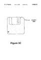
- FIG. 3Cis an illustration of exemplary memory medium used for carrying computer programs and data for carrying out the invention.
- FIG. 4illustrates the conversion of spherical coordinates to Cartesian coordinates.
- FIG. 5illustrates the computations necessary to map the coordinates of the object scanned to the fixed GPS device.
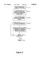
- FIG. 6is a flow chart of the process of scanning a room.
- a procedureis here, and generally, conceived to be a self-consistent sequence of steps leading to a desired result. These steps are those requiring physical manipulations of physical quantities. Usually, though not necessarily, these quantities take the form of electrical or magnetic signals capable of being stored, transferred, combined, compared, and otherwise manipulated. It proves convenient at times, principally for reasons of common usage, to refer to these signals as bits, values, elements, symbols, characters, terms, numbers, or the like. It should be noted, however, that all of these and similar terms are to be associated with the appropriate physical quantities and are merely convenient labels applied to these quantities.
- the manipulations performedare often referred to in terms, such as adding or comparing, which are commonly associated with mental operations performed by a human operator. No such capability of a human operator is necessary, or desirable in most cases, in any of the operations described herein which form part of the present invention; the operations are machine operations.
- Useful machines for performing the operation of the present inventioninclude general purpose digital computers or similar devices.
- the present inventionalso relates to apparatus for performing these operations.
- This apparatusmay be specially constructed for the required purpose or it may comprise a general purpose computer as selectively activated or reconfigured by a computer program stored in the computer.
- the procedures presented hereinare not inherently related to a particular computer or other apparatus.
- Various general purpose machinesmay be used with programs written in accordance with the teachings herein, or it may prove more convenient to construct more specialized apparatus to perform the required method steps. The required structure for a variety of these machines will appear from the description given.
- FIG. 1illustrates exemplary relative placement of the components of the system.
- the building (100)contains a number of rooms to be scanned.
- a reference fixed GPS deviceis located at the south-west corner of the building (110).
- the first room to be scannedis room 130 and the MIR device, computing device and movable GPS device are all located at 120 within the room.
- the scanning unitis moved to the subsequent rooms to be scanned (140 and 150).
- a plurality of scanning unitsmay be operative simultaneously, each feeding results to a central computer of processing of data points into a wireframe.
- FIG. 2illustrates the penetrating nature of the MIR pulses.
- the MIR device (200)sends a pulse towards the wall (290).
- the first echoreflects at the transition boundary of the inner surface of the wall 260 and is received by the MIR.
- the azimuth and elevationare known to the MIR and the round trip delay between sending a radar pulse and its return permits one to determine the radius.
- the location of the point 210is known in spherical coordinates.
- the coordinatesare then transmitted to the computing device (202).
- a pipe, contained within the wallprovides 2 reflection points: the "front" of the pipe (280) and the "rear” of the pipe (270).
- the actual reflection pointsare indicated by (220 and 230).
- the pulsereturns an echo from the outer wall surface (250) at the reflection point (240).
- each set of coordinatesis transmitted to the computer they are converted into Cartesian coordinates relative to the fixed GPS device, and a three-dimensional wire-frame model is successively built with more and more detail.
- the fixed GPS device (300)transmits (310) its location information to the computing device (334).
- a tripod (320)holds the MIR device (330), stepper or servo motor (321), the second GPS device (340) and the computing device (334).
- the tripod devicesmay be connected to each other using a hardwired connection or they may be linked over a radio or 1R wireless link.
- FIG. 3Bis a block diagram of the portable assembly of FIG. 3A.
- a BUS (378)serves as the universal connector for all the components.
- the microprocessor (344)controls each component using programming and data to be found in memory components RAM (346) and ROM (348).
- An input interface (362)is provided to allow the operation of a keyboard (364).
- a disk drive controller (354)controls a CD ROM (360), a hard disk drive (358) and a floppy disk drive (358).
- a communication portis provided at (376).
- a transceiver for GPS data (368) and its antenna (366) along with an transceiver for MIR data (372) and its antenna (370)are connected to a radio interface (374).
- the display interface (352)controls the display (350).
- the computer device 334controls the radius, azimuth and elevation of the radar scan, driving the stepper or servo motors to ensure complete coverage of the room at a desired resolution.
- the computer devicemay be connected to the radar device 385 over a hardwired interface 384 or over a radio or infrared (1R) link.
- the computer devicecan receive GPS information from the receiver GPS2 (390) via interface 389 or over a wireless link.
- FIG. 3C illustrated as a floppy disk (380)represents the types of storage media that typically contains data and programming information useful with the invention.
- FIG. 4illustrates the conversion of spherical coordinates to Cartesian coordinates.
- the basic mathematical formulas employedare shown within (400).
- the sine of the angle between the hypotenuse and either leg of a right triangleprovides the ratio of the other leg to the hypotenuse.
- the cosine of the same angleprovides the ratio of the selected leg to the hypotenuse.
- Component (410)demonstrates the first step required to map the coordinates from the spherical system to the Cartesian system.
- rthe range component from the spherical coordinates
- psithe elevation of the object described by the spherical coordinates
- dthe distance from the origin to the projection of z on the x,y plane
- the same transformationis applied using the azimuth (theta) to determine the x and y components.
- the result of the above computationsare the x, y and z coordinates of an object initially describe by r, theta and psi spherical coordinates.
- FIG. 5illustrates the computations necessary to map the coordinates of the object scanned to the fixed GPS device.
- the transformation from spherical coordinates to Cartesian coordinatesmay be easily accomplished. This provides the coordinates of the scanned object relative to the MIR device. In order to map these coordinates into the coordinate space defined by the fixed GPS device the following steps are required.
- the coordinates of the scanned object (500) relative to the MIRare denoted x3 y3 z3 (510).
- the offset to the local GPSis delta x1, delta y1 and delta z1. Adding these deltas to the coordinates at (510) yields the coordinates of the object (500) relative to the local GPS, denoted as x2 y2 z2 (530).
- the offsets from the local GPS (530) to the fixed GPS (550)are calculated by the computing device based upon the location information each GPS transmits to it.
- delta x2, delta y2, delta z2are added to the x2 y2 z2 coordinates from (530) and result in the coordinates x1 y1 z1 which represent the position of the object relative to the fixed GPS.
- FIG. 6is a flow chart of the process of scanning a room.
- the fixed GPS deviceis placed in a suitable position, normally a corner of the structure (600).
- the portable GPS device, MIR device and the computing deviceare placed in the room to be mapped (610).
- the computing deviceis initialized with the relative offsets between the two GPS devices and the offset between the MIR device and the portable GPS device prior to beginning the scan so that coordinate conversion can be performed (620).
- the scan of the roombegins or continues at (630).
- the computing devicereceives the spherical coordinates of the object being scanned from the MIR device, converts them as described in FIGS. 4 and 5 and stores them in memory or on an internal storage device (640). If the scan in not completed (650) then the process begins again at (630), otherwise the scan is complete and the process is terminated (660).
Landscapes
- Engineering & Computer Science (AREA)
- Remote Sensing (AREA)
- Radar, Positioning & Navigation (AREA)
- Physics & Mathematics (AREA)
- General Physics & Mathematics (AREA)
- Computer Networks & Wireless Communication (AREA)
- Electromagnetism (AREA)
- Position Fixing By Use Of Radio Waves (AREA)
Abstract
Description
1. Field of the Invention
The invention relates to computer controlled scanning radar systems, and more particularly, to those utilized for mapping a building or other structure in three dimensions in order to capture "as built" information.
2. Description of Related Art
Once a house, building or other structure has been constructed, the plans, architectural blueprints and engineering specifications are put into storage at some location. This location may be unknown to the building's owners. Even if the location of these documents is known, they may be difficult to retrieve or they may have been destroyed. Additionally these documents may contain significant deviations from the building "as built".
If the original documents are available, but are not in a digital format, or are in a format no longer supported by existing software systems, the architect or engineer is faced with a labor and time intensive effort to enter the data manually. An architect, engineer, builder or owner would certainly prefer to avoid a costly and error-prone data entry process and generate, directly from the building, a three dimensional model of the structure as it currently exists.
Radar systems, such as micropower impulse radar (MIR), are known that rapidly emit radio pulses (approximately one million per second) that are extremely short (less than a billionth of a second in duration) and that are in a frequency range substantially lower than convention radars. Low frequency pulses are better able to penetrate solid objects. Additionally, MIR radars are extremely selective in their range gating capabilities. It is possible to examine and record only those echoes that could have been generated by an object within a certain range from the radar unit and ignore all others. Due to the high pulse rate and low frequency, echoes from many objects that are lined up in a row may be received, thus allowing the radar to "see behind" objects, detecting other objects that would otherwise be visually hidden.
Global positioning satellite (GPS) systems are known that provide the location of a global positioning receiver by sophisticated triangulation algorithms using data provided by orbiting satellites with a high degree of accuracy. Accuracy, to millimeter tolerances may be obtained by using differential GPS.
Effective means for the digital transmission of data via radio by multiple transmitters operating on a single frequency are known. Various techniques are employed to prevent transmissions from different computing devices using the same frequency from preventing communications. Carrier Sense Multiple Access with Collision Detection (CSMA/CD) is widely employed in both wireless radio applications and in wired computer networks.
Radar devices that will detect, for example, a stud behind a sheet rock wall, are known. These devices do not provide any transmission or storage of the location of the hidden object.
Computer Aided Design (CAD) computer software packages are known that accept as input the coordinates that describe a three-dimensional structure and then generate drawings of that structure.
The Problems
A principal problem solved by this invention is that of capturing "as built" information about buildings or other structures. It also provides a quick and easy way of surveying the internals of walls and the content of rooms and of automatically generating a computer representation of the building.
The present system provides apparatus, systems, processes and computer program products which allow the creation of digital three dimensional wire-frame models of complete buildings or portions of buildings. These models can then be manipulated using CAD software and printed as blueprints that reflect the actual status of a structure.
In operation, one GPS receiver is placed in a fixed and known location (e.g. a corner of the building to be scanned) and a second GPS receiver is attached to a portable MIR radar unit and placed in a room to be mapped. Both GPSs send their location information to a computing device that then determines the position of the second GPS relative to the first. This, with the correction of small offset values between the second (movable) GPS and the radar unit, provides highly accurate relative position values.
A computer instructs the radar unit to begin a scan of the room. The radar unit transmits each echoed return to the computer which then converts the spherical coordinates provided by the radar unit into Cartesian coordinates centered on the scanning radar. These coordinates are then corrected for the relative offsets computed earlier to provide the Cartesian coordinates of the object being scanned, using the fixed GPS unit as a global point of reference.
After completing a scan of the room, the radar unit with its attached GPS is moved to another room and the process is repeated.
The resulting data set of coordinate information stored in the computer is then used as input to CAD software to generate a three dimensional wire-frame model of all the rooms that were scanned.
The invention relates to apparatus for accurately measuring distance including a portable radar for measuring distances from the radar to one or more surfaces, a first global positioning satellite receiver, located a fixed measured distance from the radar, and a computer connected to receive information from the radar and from the portable global positioning satellite receiver and configured to calculate a distance from the radar to a surface. The scanning radar is controlled by the computer. All points whose distances have been determined are referenced to a common location determined by a global positioning satellite receiver. The points can then be organized into a three dimensional wireframe representing the room or building being scanned.
The invention also relates to a method of accurately measuring distance by placing a portable radar and a first global positioning satellite receiver, located a fixed measured distance from the radar, in one or more rooms, linking a computer to receive information from the radar and from the global positioning satellite receiver, and using the information to calculate a distance from the radar to a surface point. A plurality of points measured in this way are referenced to a common point at a locations determined by a global positioning satellite receiver, and are used to construct a wireframe of the rooms where the points were measured. Measurements from points measured in different rooms are used to construct at least a partial wireframe of the building in which the points were measured.
The inventions are also directed to a method of creating architectural drawings reflecting construction of a building, by surveying a plurality of points in one or more rooms of a building using a scanning radar referenced to a global positioning satellite receiver, using the location of the points to create a three dimensional wireframe of the building, and converting the three dimensional wireframe into architectural drawings using computer assisted design software.
The invention is also directed to a method of determining the location of objects within the wall of a building, by placing a portable radar and a first global positioning satellite receiver, located a known distance from the radar, in a room, linking a computer to receive information from the radar and from the global positioning satellite receiver, and using the information to calculate a distance from the radar to a surface point interior to a wall of the room.
The invention is also directed to a system for accurately measuring distance including a central computer, and a plurality of scanning units, connected to the central computer and each comprising a portable radar for measuring distances from the radar to one or more surfaces, a first global positioning satellite receiver, located a fixed measured distance from the radar, and a computer connected to receive information from the radar and from the portable global positioning satellite receiver and configured to calculate a distance from the radar to a surface and to send the distance to the central computer.
The invention is also directed to computer program products for carrying out the techniques of the invention.
Still other objects and advantages of the present invention will become readily apparent to those skilled in the art from the following detailed description, wherein only the preferred embodiment of the invention is shown and described, simply by way of illustration of the best mode contemplated of carrying out the invention. As will be realized, the invention is capable of other and different embodiments, and its several details are capable of modifications in various obvious respects, all without departing from the invention. Accordingly, the drawing and description are to be regarded as illustrative in nature, and not as restrictive.
The object, features and advantages of the system of the present invention will be apparent from the following description, in which:
FIG. 1 illustrates exemplary relative placement of the components of the system when taking measurements.
FIG. 2 illustrates the penetrating nature of the MIR pulses.
FIG. 3A illustrates a portable assembly for taking measurements in a room.
FIG. 3B is a block diagram of the portable assembly of FIG. 3A.
FIG. 3C is an illustration of exemplary memory medium used for carrying computer programs and data for carrying out the invention.
FIG. 4 illustrates the conversion of spherical coordinates to Cartesian coordinates.
FIG. 5 illustrates the computations necessary to map the coordinates of the object scanned to the fixed GPS device.
FIG. 6 is a flow chart of the process of scanning a room.
The detailed descriptions which follow may be presented in terms of program procedures executed on a computer or network of computers. These procedural descriptions and representations are the means used by those skilled in the art to most effectively convey the substance of their work to others skilled in the art.
A procedure is here, and generally, conceived to be a self-consistent sequence of steps leading to a desired result. These steps are those requiring physical manipulations of physical quantities. Usually, though not necessarily, these quantities take the form of electrical or magnetic signals capable of being stored, transferred, combined, compared, and otherwise manipulated. It proves convenient at times, principally for reasons of common usage, to refer to these signals as bits, values, elements, symbols, characters, terms, numbers, or the like. It should be noted, however, that all of these and similar terms are to be associated with the appropriate physical quantities and are merely convenient labels applied to these quantities.
Further, the manipulations performed are often referred to in terms, such as adding or comparing, which are commonly associated with mental operations performed by a human operator. No such capability of a human operator is necessary, or desirable in most cases, in any of the operations described herein which form part of the present invention; the operations are machine operations. Useful machines for performing the operation of the present invention include general purpose digital computers or similar devices.
The present invention also relates to apparatus for performing these operations. This apparatus may be specially constructed for the required purpose or it may comprise a general purpose computer as selectively activated or reconfigured by a computer program stored in the computer. The procedures presented herein are not inherently related to a particular computer or other apparatus. Various general purpose machines may be used with programs written in accordance with the teachings herein, or it may prove more convenient to construct more specialized apparatus to perform the required method steps. The required structure for a variety of these machines will appear from the description given.
FIG. 1 illustrates exemplary relative placement of the components of the system. The building (100) contains a number of rooms to be scanned. A reference fixed GPS device is located at the south-west corner of the building (110). The first room to be scanned is room 130 and the MIR device, computing device and movable GPS device are all located at 120 within the room. After the scan of the first room (130), the scanning unit is moved to the subsequent rooms to be scanned (140 and 150). Alternatively, a plurality of scanning units may be operative simultaneously, each feeding results to a central computer of processing of data points into a wireframe.
FIG. 2 illustrates the penetrating nature of the MIR pulses. The MIR device (200) sends a pulse towards the wall (290). The first echo reflects at the transition boundary of the inner surface of thewall 260 and is received by the MIR. The azimuth and elevation are known to the MIR and the round trip delay between sending a radar pulse and its return permits one to determine the radius. Thus the location of thepoint 210 is known in spherical coordinates. The coordinates are then transmitted to the computing device (202). A pipe, contained within the wall provides 2 reflection points: the "front" of the pipe (280) and the "rear" of the pipe (270). The actual reflection points are indicated by (220 and 230). Finally, the pulse returns an echo from the outer wall surface (250) at the reflection point (240). As each set of coordinates is transmitted to the computer they are converted into Cartesian coordinates relative to the fixed GPS device, and a three-dimensional wire-frame model is successively built with more and more detail.
In FIG. 3A, the fixed GPS device (300) transmits (310) its location information to the computing device (334). A tripod (320) holds the MIR device (330), stepper or servo motor (321), the second GPS device (340) and the computing device (334). The tripod devices may be connected to each other using a hardwired connection or they may be linked over a radio or 1R wireless link.
FIG. 3B is a block diagram of the portable assembly of FIG. 3A. A BUS (378) serves as the universal connector for all the components. The microprocessor (344) controls each component using programming and data to be found in memory components RAM (346) and ROM (348). An input interface (362) is provided to allow the operation of a keyboard (364). A disk drive controller (354) controls a CD ROM (360), a hard disk drive (358) and a floppy disk drive (358). A communication port is provided at (376). A transceiver for GPS data (368) and its antenna (366) along with an transceiver for MIR data (372) and its antenna (370) are connected to a radio interface (374). The display interface (352) controls the display (350).
Thecomputer device 334 controls the radius, azimuth and elevation of the radar scan, driving the stepper or servo motors to ensure complete coverage of the room at a desired resolution. The computer device may be connected to theradar device 385 over ahardwired interface 384 or over a radio or infrared (1R) link. Similarly, the computer device can receive GPS information from the receiver GPS2 (390) via interface 389 or over a wireless link.
FIG. 3C illustrated as a floppy disk (380) represents the types of storage media that typically contains data and programming information useful with the invention.
FIG. 4 illustrates the conversion of spherical coordinates to Cartesian coordinates. The basic mathematical formulas employed are shown within (400). The sine of the angle between the hypotenuse and either leg of a right triangle provides the ratio of the other leg to the hypotenuse. The cosine of the same angle provides the ratio of the selected leg to the hypotenuse. Thus, knowing the angle and the length of the hypotenuse, the length of each leg may be calculated.
Component (410) demonstrates the first step required to map the coordinates from the spherical system to the Cartesian system. Given a right triangle with hypotenuse r (the range component from the spherical coordinates) and the angle psi, which is the elevation of the object described by the spherical coordinates, the corresponding z component of the Cartesian coordinates is given as: z=sin(psi)* r. Additionally, the computation of d, which represents the distance from the origin to the projection of z on the x,y plane is given by: d=cos(psi)* r.
Having determined z and d, the same transformation is applied using the azimuth (theta) to determine the x and y components. Given a right triangle with hypotenuse d (the distance from the origin to the projection of z on the x,y plane) and the angle theta, which is the azimuth of the object described by the spherical coordinates, the corresponding y component of the Cartesian coordinates is given as: y=sin(theta)* d. Additionally, the computation of x is given by: z=cos(theta)* d.
The result of the above computations are the x, y and z coordinates of an object initially describe by r, theta and psi spherical coordinates.
FIG. 5 illustrates the computations necessary to map the coordinates of the object scanned to the fixed GPS device. As shown in FIG. 4, the transformation from spherical coordinates to Cartesian coordinates may be easily accomplished. This provides the coordinates of the scanned object relative to the MIR device. In order to map these coordinates into the coordinate space defined by the fixed GPS device the following steps are required.
The coordinates of the scanned object (500) relative to the MIR are denoted x3 y3 z3 (510). The offset to the local GPS is delta x1, delta y1 and delta z1. Adding these deltas to the coordinates at (510) yields the coordinates of the object (500) relative to the local GPS, denoted as x2 y2 z2 (530). The offsets from the local GPS (530) to the fixed GPS (550) are calculated by the computing device based upon the location information each GPS transmits to it. The resulting deltas, delta x2, delta y2, delta z2 are added to the x2 y2 z2 coordinates from (530) and result in the coordinates x1 y1 z1 which represent the position of the object relative to the fixed GPS.
FIG. 6 is a flow chart of the process of scanning a room. The fixed GPS device is placed in a suitable position, normally a corner of the structure (600). The portable GPS device, MIR device and the computing device are placed in the room to be mapped (610). The computing device is initialized with the relative offsets between the two GPS devices and the offset between the MIR device and the portable GPS device prior to beginning the scan so that coordinate conversion can be performed (620). The scan of the room begins or continues at (630). The computing device receives the spherical coordinates of the object being scanned from the MIR device, converts them as described in FIGS. 4 and 5 and stores them in memory or on an internal storage device (640). If the scan in not completed (650) then the process begins again at (630), otherwise the scan is complete and the process is terminated (660).
In this disclosure, there is shown and described only the preferred embodiment of the invention, but, as aforementioned, it is to be understood that the invention is capable of use in various other combinations and environments and is capable of changes or modifications within the scope of the inventive concept as expressed herein.
Claims (34)
1. Apparatus for accurately measuring distance comprising:
a. a portable radar for measuring distances and directions from the radar to one or more surfaces within a structure;
b. a portable first global positioning satellite receiver, located a fixed measured distance from said radar; and
c. a computer connected to receive information from said radar and from said portable global positioning satellite receiver and configured to calculate a distance from said radar to a surface of said one or more surfaces within a structure using said information and said fixed measured distance.
2. Apparatus of claim 1, in which said portable radar is a scanning radar, the scanning of which is controlled by said computer.
3. Apparatus of claim 2, further comprising:
a second global positioning satellite receiver located a distance from said first global positioning satellite receiver and said computer is connected to receive information from said second global positioning satellite receiver.
4. Apparatus of claim 3, in which said computer calculates said distance using the location of said second global positioning satellite receiver as a reference.
5. Apparatus of claim 4, in which said computer causes said scanning radar to scan a room and to determine a plurality of distances to points in or near the room and in which said computer constructs a wireframe representation of said room referenced to the location of said second global positioning satellite receiver.
6. The apparatus of claim 3, wherein the second global positioning satellite receiver is located a second fixed measured distance from a fixed point on a building.
7. The apparatus of claim 1, wherein said portable radar is a micropower impulse radar.
8. A method of accurately measuring distance comprising the steps of:
a. placing a portable radar and portable first global positioning satellite receiver, located a fixed measured distance from said radar, in a room, the radar configured to measure distances to a surface of the room;
b. linking a computer to receive information from said radar and from said global positioning satellite receiver; and
c. using said information and said fixed measured distance to calculate a distance from said radar to a surface point on said surface.
9. The method of claim 8, further comprising the step:
d. repeating steps a-c for a plurality of points.
10. The method of claim 9, further comprising moving said portable radar and said first global positioning satellite receiver, to a different room and repeating steps a-d.
11. The method of claim 10, further comprising the step of:
referencing distances to a plurality of points measured in different rooms to the location of a second global positioning satellite receiver located in or near a building in which said rooms are located.
12. The method of claim 11, in which said plurality of points measured in different rooms are used to construct a wireframe of the rooms where the points were measured.
13. The method of claim 11, in which said plurality of points measured in different rooms are used to construct at least a partial wireframe of the building in which said points were measured.
14. The method of claim 11, wherein the second global positioning satellite receiver is located a second fixed measured distance from a fixed point on the building.
15. The method of claim 8, in which said calculated distance is in Cartesian coordinates converted from spherical coordinates.
16. The method of claim 8, wherein said portable radar is a micropower impulse radar.
17. A method of creating architectural drawings reflecting construction of a building, comprising the steps of:
a. surveying a plurality of points in one or more rooms of a building using a scanning radar referenced to a global positioning satellite receiver;
b. using the location of said points to create a three dimensional wireframe of said building;
c. converting said three dimensional wireframe into architectural drawings using computer assisted design software.
18. The method of claim 17, wherein said scanning radar is a micropower impulse radar.
19. The method of claim 17, wherein said global positioning satellite receiver is referenced to a second global positioning satellite receiver located a fixed measured distance from a fixed point on the building.
20. A method of determining the location of objects within the wall of a building, comprising the steps of:
a. placing a portable radar and a portable first global positioning satellite receiver, located a known distance from said radar, in a room, said radar configured for measuring distances to a surface;
b. linking a computer to receive information from said radar and from said global positioning satellite receiver; and
c. using said information and said known distance to calculate a distance from said radar to a surface point interior to a wall of said room.
21. The method of claim 20, wherein said portable radar is a micropower impulse radar.
22. The system of claim 20, wherein said portable is a micropower impulse radar.
23. The method of claim 20, further comprising:
aa. placing a second global positioning satellite receiver located a second known distance from a fixed point on the building, before step c, using said information; and
bb. linking the computer to receive information from said second global positioning satellite receiver, before step c, using said information.
24. A system for accurately measuring distance comprising:
a. a central computer; and
b. a plurality of scanning units, connected to said central computer and each comprising
b1. a portable radar for measuring distances from the radar to one or more surfaces of a building;
b2. a portable first global positioning satellite receiver, located a fixed measured distance from said radar; and
b3. a computer connected to receive information from said radar and from said portable global positioning satellite receivers and configured to calculate a distance from said radar to at least one surface of said surfaces using said information and said fixed measured distance and to send said calculated distance to said central computer.
25. The system of claim 24, in which said central computer organizes said distances into a three dimensional wireframe of said building.
26. The system of claim 24, in which said distances include points within a wall of said building.
27. The system of claim 24, further comprising:
c. a second global positioning satellite receiver located a second fixed measured distance from a fixed point on said building,
wherein said computer is configured to receive information from said second global positioning satellite receiver.
28. A computer program product comprising:
a. a memory medium; and
b. a computer program stored on said memory medium, said computer program containing instructions for controlling a scanning radar to scan a plurality of points in or near a room to determine distances to said points.
29. The computer program product of claim 28 in which said computer program further contains instructions for referencing all distances to the location of a global positioning satellite receiver.
30. The computer program product of claim 28, wherein said scanning radar is a micropower impulse radar.
31. A computer program product comprising:
a. a memory medium; and
b. a computer program stored on said memory medium, said computer program containing instructions for directing surveying of a plurality of points on one or more surfaces in one or more rooms of a building using a scanning radar referenced to a global positioning satellite receiver, and using the locations of said scanned points to create a three dimensional wireframe of said building.
32. The computer program product of claims 31, in which said computer program further contains instructions for converting said three dimensional wireframe into architectural drawings using computer assisted design software.
33. The computer program product of claim 31, wherein said scanning radar is a micropower impulse radar.
34. The computer program product of claim 31, wherein said program further contains instructions for using information from a second global positioning satellite receiver located a measured distance from a fixed point on said building.
Priority Applications (1)
| Application Number | Priority Date | Filing Date | Title |
|---|---|---|---|
| US08/674,492US6006021A (en) | 1996-07-01 | 1996-07-01 | Device for mapping dwellings and other structures in 3D |
Applications Claiming Priority (1)
| Application Number | Priority Date | Filing Date | Title |
|---|---|---|---|
| US08/674,492US6006021A (en) | 1996-07-01 | 1996-07-01 | Device for mapping dwellings and other structures in 3D |
Publications (1)
| Publication Number | Publication Date |
|---|---|
| US6006021Atrue US6006021A (en) | 1999-12-21 |
Family
ID=24706821
Family Applications (1)
| Application Number | Title | Priority Date | Filing Date |
|---|---|---|---|
| US08/674,492Expired - LifetimeUS6006021A (en) | 1996-07-01 | 1996-07-01 | Device for mapping dwellings and other structures in 3D |
Country Status (1)
| Country | Link |
|---|---|
| US (1) | US6006021A (en) |
Cited By (93)
| Publication number | Priority date | Publication date | Assignee | Title |
|---|---|---|---|---|
| US6285320B1 (en)* | 1999-09-03 | 2001-09-04 | Sikorsky Aircraft Corporation | Apparatus and method for mapping surfaces of an object |
| US20020008621A1 (en)* | 2000-01-06 | 2002-01-24 | Isogon Corporation | Method and system for determining the inventory and location of assets |
| US6442507B1 (en)* | 1998-12-29 | 2002-08-27 | Wireless Communications, Inc. | System for creating a computer model and measurement database of a wireless communication network |
| US6446030B1 (en)* | 1998-01-24 | 2002-09-03 | Quantapoint, Inc. | Method and apparatus for establishing the layout of a building |
| US20030014233A1 (en)* | 1999-07-14 | 2003-01-16 | Rappaport Theodore S. | System for the three-dimensional display of wireless communication system performance |
| US6512838B1 (en)* | 1999-09-22 | 2003-01-28 | Canesta, Inc. | Methods for enhancing performance and data acquired from three-dimensional image systems |
| US6522395B1 (en) | 1999-04-30 | 2003-02-18 | Canesta, Inc. | Noise reduction techniques suitable for three-dimensional information acquirable with CMOS-compatible image sensor ICS |
| US20030059314A1 (en)* | 1999-12-17 | 2003-03-27 | Michel Sagnet | Multi-piston engine, such as a pump or compressor, with improved vibrational behaviour |
| US6560560B1 (en) | 2000-04-24 | 2003-05-06 | Eric Joshua Tachner | Apparatus and method for determining the distance between two points |
| US20030171391A1 (en)* | 2002-01-25 | 2003-09-11 | Boehringer Ingelheim Pharma Gmbh & Co. Kg | Ambroxol for the treatment of chronic pain |
| US6721769B1 (en) | 1999-05-26 | 2004-04-13 | Wireless Valley Communications, Inc. | Method and system for a building database manipulator |
| US6732030B2 (en) | 2001-08-18 | 2004-05-04 | Snap-On U.K. Holdings Limited | Three-dimensional mapping systems for automotive vehicles and other articles |
| US20040122628A1 (en)* | 2002-12-03 | 2004-06-24 | Laurie Michael Stuart | Method and device for generating two-dimensional floor plans |
| KR100456625B1 (en)* | 2002-02-04 | 2004-11-10 | 한국전자통신연구원 | System for embodying the inner structure of a high-rise building through three dimension and method thereof |
| US20050015222A1 (en)* | 2003-07-14 | 2005-01-20 | Harrington Kevin J. | System and method for automated building incident response |
| US20050051707A1 (en)* | 2003-04-11 | 2005-03-10 | Cyrus Bamji | Method and system to differentially enhance sensor dynamic range |
| US20050125770A1 (en)* | 2003-11-13 | 2005-06-09 | Arsenault Stephane M. | Method and system for surveying and modeling a site |
| GB2409070A (en)* | 2003-12-09 | 2005-06-15 | Anthony Thomas Wright | Hand-held building data recording and processing device |
| US6971063B1 (en) | 2000-07-28 | 2005-11-29 | Wireless Valley Communications Inc. | System, method, and apparatus for portable design, deployment, test, and optimization of a communication network |
| US6973622B1 (en) | 2000-09-25 | 2005-12-06 | Wireless Valley Communications, Inc. | System and method for design, tracking, measurement, prediction and optimization of data communication networks |
| US20050289162A1 (en)* | 2000-12-08 | 2005-12-29 | Tracker R&D, Llc | System for dynamic and automatic building mapping |
| US20060019679A1 (en)* | 2004-07-23 | 2006-01-26 | Rappaport Theodore S | System, method, and apparatus for determining and using the position of wireless devices or infrastructure for wireless network enhancements |
| US20060027730A1 (en)* | 2003-04-11 | 2006-02-09 | Cyrus Bamji | Method and system to differentially enhance sensor dynamic range using enhanced common mode reset |
| US7019753B2 (en) | 2000-12-18 | 2006-03-28 | Wireless Valley Communications, Inc. | Textual and graphical demarcation of location from an environmental database, and interpretation of measurements including descriptive metrics and qualitative values |
| US20060095234A1 (en)* | 2004-10-29 | 2006-05-04 | Cyril Brignone | Converting between coordinate systems |
| US7055107B1 (en) | 2000-09-22 | 2006-05-30 | Wireless Valley Communications, Inc. | Method and system for automated selection of optimal communication network equipment model, position, and configuration |
| US20060139183A1 (en)* | 2000-10-21 | 2006-06-29 | Suggs Robert W Sr | Automotive picture and data acquisition center and method |
| US7085697B1 (en) | 2000-08-04 | 2006-08-01 | Motorola, Inc. | Method and system for designing or deploying a communications network which considers component attributes |
| US7096173B1 (en) | 2000-08-04 | 2006-08-22 | Motorola, Inc. | Method and system for designing or deploying a communications network which allows simultaneous selection of multiple components |
| US7155228B2 (en) | 1999-05-26 | 2006-12-26 | Wireless Valley Communications, Inc. | Method and system for analysis, design, and optimization of communication networks |
| US7164883B2 (en) | 2001-02-14 | 2007-01-16 | Motorola. Inc. | Method and system for modeling and managing terrain, buildings, and infrastructure |
| US7171208B2 (en) | 2000-08-04 | 2007-01-30 | Motorola, Inc. | Method and system, with component kits for designing or deploying a communications network which considers frequency dependent effects |
| US7224985B2 (en) | 2003-01-16 | 2007-05-29 | Lockheed Martin, Corp. | Antenna segment system |
| US7243054B2 (en) | 1999-07-14 | 2007-07-10 | Wireless Valley Communications, Inc. | Method and system for displaying network performance, cost, maintenance, and infrastructure wiring diagram |
| US7246045B1 (en) | 2000-08-04 | 2007-07-17 | Wireless Valley Communication, Inc. | System and method for efficiently visualizing and comparing communication network system performance |
| EP1504425A4 (en)* | 2002-05-14 | 2007-09-19 | Motorola Inc | System and method for inferring a set of characteristics of an environment with location-capable devices |
| US20070239551A1 (en)* | 2006-03-30 | 2007-10-11 | Zeller Michelle G | Method and apparatus for a product ordering system |
| US7295119B2 (en) | 2003-01-22 | 2007-11-13 | Wireless Valley Communications, Inc. | System and method for indicating the presence or physical location of persons or devices in a site specific representation of a physical environment |
| US20080055554A1 (en)* | 2006-08-30 | 2008-03-06 | Keith Tubin | Full Scale Plan Projection |
| GB2443856A (en)* | 2006-11-18 | 2008-05-21 | Stephen George Nunney | Distance and position measuring system for producing a model of a structure or topography |
| US20090076784A1 (en)* | 1999-07-21 | 2009-03-19 | Iopener Media Gmbh | System for simulating events in a real environment |
| US7574323B2 (en) | 2001-12-17 | 2009-08-11 | Wireless Valley Communications, Inc. | Textual and graphical demarcation of location, and interpretation of measurements |
| US7596518B2 (en) | 1999-05-26 | 2009-09-29 | Wireless Valley Communications, Inc. | Method and system for generating a real time bill of materials and evaluating network performance |
| US7680644B2 (en) | 2000-08-04 | 2010-03-16 | Wireless Valley Communications, Inc. | Method and system, with component kits, for designing or deploying a communications network which considers frequency dependent effects |
| US20110106437A1 (en)* | 2009-10-30 | 2011-05-05 | Telenav, Inc. | Navigation system with monitoring mechanism and method of operation thereof |
| US20110102173A1 (en)* | 2009-10-30 | 2011-05-05 | Telenav, Inc. | Navigation system with context boundary monitoring mechanism and method of operation thereof |
| US8284100B2 (en) | 2010-10-08 | 2012-10-09 | HJ Laboratories, LLC | Providing indoor location, position, or tracking of a mobile computer using sensors |
| WO2014110428A1 (en)* | 2013-01-13 | 2014-07-17 | Qualcomm Incorporated | Determining room dimensions and a relative layout using audio signals and motion detection |
| US10025887B1 (en)* | 2017-02-22 | 2018-07-17 | Stellar Vdc Residential, Llc | Building model with virtual capture of as built features and objective performance tracking |
| US10230326B2 (en) | 2015-03-24 | 2019-03-12 | Carrier Corporation | System and method for energy harvesting system planning and performance |
| US10254395B2 (en)* | 2013-12-04 | 2019-04-09 | Trimble Inc. | System and methods for scanning with integrated radar detection and image capture |
| US10268782B1 (en) | 2017-02-22 | 2019-04-23 | Middle Chart, LLC | System for conducting a service call with orienteering |
| US10419655B2 (en) | 2015-04-27 | 2019-09-17 | Snap-Aid Patents Ltd. | Estimating and using relative head pose and camera field-of-view |
| US10433112B2 (en) | 2017-02-22 | 2019-10-01 | Middle Chart, LLC | Methods and apparatus for orienteering |
| US10459593B2 (en) | 2015-03-24 | 2019-10-29 | Carrier Corporation | Systems and methods for providing a graphical user interface indicating intruder threat levels for a building |
| US10467353B2 (en) | 2017-02-22 | 2019-11-05 | Middle Chart, LLC | Building model with capture of as built features and experiential data |
| US10606963B2 (en) | 2015-03-24 | 2020-03-31 | Carrier Corporation | System and method for capturing and analyzing multidimensional building information |
| US10620084B2 (en) | 2017-02-22 | 2020-04-14 | Middle Chart, LLC | System for hierarchical actions based upon monitored building conditions |
| US10621527B2 (en) | 2015-03-24 | 2020-04-14 | Carrier Corporation | Integrated system for sales, installation, and maintenance of building systems |
| US10628617B1 (en) | 2017-02-22 | 2020-04-21 | Middle Chart, LLC | Method and apparatus for wireless determination of position and orientation of a smart device |
| US10671767B2 (en) | 2017-02-22 | 2020-06-02 | Middle Chart, LLC | Smart construction with automated detection of adverse structure conditions and remediation |
| US10733334B2 (en) | 2017-02-22 | 2020-08-04 | Middle Chart, LLC | Building vital conditions monitoring |
| US10740503B1 (en) | 2019-01-17 | 2020-08-11 | Middle Chart, LLC | Spatial self-verifying array of nodes |
| US10740502B2 (en) | 2017-02-22 | 2020-08-11 | Middle Chart, LLC | Method and apparatus for position based query with augmented reality headgear |
| US10756830B2 (en) | 2015-03-24 | 2020-08-25 | Carrier Corporation | System and method for determining RF sensor performance relative to a floor plan |
| US10762251B2 (en) | 2017-02-22 | 2020-09-01 | Middle Chart, LLC | System for conducting a service call with orienteering |
| US10776529B2 (en) | 2017-02-22 | 2020-09-15 | Middle Chart, LLC | Method and apparatus for enhanced automated wireless orienteering |
| US10809372B2 (en)* | 2015-05-11 | 2020-10-20 | Vayyar Imaging Ltd. | System, device and methods for imaging of objects using electromagnetic array |
| CN111801598A (en)* | 2017-12-29 | 2020-10-20 | 所尼托技术股份公司 | Location determination using acoustic context data |
| US10824774B2 (en) | 2019-01-17 | 2020-11-03 | Middle Chart, LLC | Methods and apparatus for healthcare facility optimization |
| US10872179B2 (en) | 2017-02-22 | 2020-12-22 | Middle Chart, LLC | Method and apparatus for automated site augmentation |
| US10902160B2 (en) | 2017-02-22 | 2021-01-26 | Middle Chart, LLC | Cold storage environmental control and product tracking |
| US10928785B2 (en) | 2015-03-24 | 2021-02-23 | Carrier Corporation | Floor plan coverage based auto pairing and parameter setting |
| US10944837B2 (en) | 2015-03-24 | 2021-03-09 | Carrier Corporation | Floor-plan based learning and registration of distributed devices |
| US10949579B2 (en) | 2017-02-22 | 2021-03-16 | Middle Chart, LLC | Method and apparatus for enhanced position and orientation determination |
| US10984146B2 (en) | 2017-02-22 | 2021-04-20 | Middle Chart, LLC | Tracking safety conditions of an area |
| US10984148B2 (en) | 2017-02-22 | 2021-04-20 | Middle Chart, LLC | Methods for generating a user interface based upon orientation of a smart device |
| US11036897B2 (en) | 2015-03-24 | 2021-06-15 | Carrier Corporation | Floor plan based planning of building systems |
| US11054335B2 (en) | 2017-02-22 | 2021-07-06 | Middle Chart, LLC | Method and apparatus for augmented virtual models and orienteering |
| US11194938B2 (en) | 2020-01-28 | 2021-12-07 | Middle Chart, LLC | Methods and apparatus for persistent location based digital content |
| US11255663B2 (en) | 2016-03-04 | 2022-02-22 | May Patents Ltd. | Method and apparatus for cooperative usage of multiple distance meters |
| US11436389B2 (en) | 2017-02-22 | 2022-09-06 | Middle Chart, LLC | Artificial intelligence based exchange of geospatial related digital content |
| US11468209B2 (en) | 2017-02-22 | 2022-10-11 | Middle Chart, LLC | Method and apparatus for display of digital content associated with a location in a wireless communications area |
| US11475177B2 (en) | 2017-02-22 | 2022-10-18 | Middle Chart, LLC | Method and apparatus for improved position and orientation based information display |
| US11481527B2 (en) | 2017-02-22 | 2022-10-25 | Middle Chart, LLC | Apparatus for displaying information about an item of equipment in a direction of interest |
| US11507714B2 (en) | 2020-01-28 | 2022-11-22 | Middle Chart, LLC | Methods and apparatus for secure persistent location based digital content |
| US11625510B2 (en) | 2017-02-22 | 2023-04-11 | Middle Chart, LLC | Method and apparatus for presentation of digital content |
| US11640486B2 (en) | 2021-03-01 | 2023-05-02 | Middle Chart, LLC | Architectural drawing based exchange of geospatial related digital content |
| US11900021B2 (en) | 2017-02-22 | 2024-02-13 | Middle Chart, LLC | Provision of digital content via a wearable eye covering |
| US11900022B2 (en) | 2017-02-22 | 2024-02-13 | Middle Chart, LLC | Apparatus for determining a position relative to a reference transceiver |
| US12086507B2 (en) | 2017-02-22 | 2024-09-10 | Middle Chart, LLC | Method and apparatus for construction and operation of connected infrastructure |
| US12314638B2 (en) | 2017-02-22 | 2025-05-27 | Middle Chart, LLC | Methods and apparatus for secure persistent location based digital content associated with a three-dimensional reference |
| US12400048B2 (en) | 2020-01-28 | 2025-08-26 | Middle Chart, LLC | Methods and apparatus for two dimensional location based digital content |
Citations (17)
| Publication number | Priority date | Publication date | Assignee | Title |
|---|---|---|---|---|
| US4972591A (en)* | 1990-03-20 | 1990-11-27 | Hammet E Scott | Method and device for land surveying |
| US5025150A (en)* | 1988-10-14 | 1991-06-18 | Mk-Ferguson Company | Site survey method and apparatus |
| US5091869A (en)* | 1990-04-16 | 1992-02-25 | Expert Technologies, Inc. | Computer integrated floor plan system |
| US5471218A (en)* | 1993-07-01 | 1995-11-28 | Trimble Navigation Limited | Integrated terrestrial survey and satellite positioning system |
| US5495576A (en)* | 1993-01-11 | 1996-02-27 | Ritchey; Kurtis J. | Panoramic image based virtual reality/telepresence audio-visual system and method |
| US5512834A (en)* | 1993-05-07 | 1996-04-30 | The Regents Of The University Of California | Homodyne impulse radar hidden object locator |
| US5515057A (en)* | 1994-09-06 | 1996-05-07 | Trimble Navigation Limited | GPS receiver with N-point symmetrical feed double-frequency patch antenna |
| US5589833A (en)* | 1995-04-21 | 1996-12-31 | University Corporation For Atmospheric Research | Radar acquisition system |
| US5614913A (en)* | 1995-06-07 | 1997-03-25 | Trimble Navigation | Optimization of survey coordinate transformations |
| US5644318A (en)* | 1996-02-02 | 1997-07-01 | Trimble Navigation Limited | SATPS dynamic surveying from a moving platform |
| US5652717A (en)* | 1994-08-04 | 1997-07-29 | City Of Scottsdale | Apparatus and method for collecting, analyzing and presenting geographical information |
| US5668555A (en)* | 1995-09-01 | 1997-09-16 | Starr; Jon E. | Imaging system and apparatus |
| US5673050A (en)* | 1996-06-14 | 1997-09-30 | Moussally; George | Three-dimensional underground imaging radar system |
| US5704142A (en)* | 1995-06-19 | 1998-01-06 | Vermeer Manufacturing Company | Excavator data acquisition and control system and process |
| US5734348A (en)* | 1995-08-31 | 1998-03-31 | Nikon Corporation | Surveying system using GPS |
| US5739785A (en)* | 1993-03-04 | 1998-04-14 | Trimble Navigation Limited | Location and generation of high accuracy survey control marks using satellites |
| US5796363A (en)* | 1996-03-01 | 1998-08-18 | The Regents Of The University Of California | Automatic position calculating imaging radar with low-cost synthetic aperture sensor for imaging layered media |
- 1996
- 1996-07-01USUS08/674,492patent/US6006021A/ennot_activeExpired - Lifetime
Patent Citations (17)
| Publication number | Priority date | Publication date | Assignee | Title |
|---|---|---|---|---|
| US5025150A (en)* | 1988-10-14 | 1991-06-18 | Mk-Ferguson Company | Site survey method and apparatus |
| US4972591A (en)* | 1990-03-20 | 1990-11-27 | Hammet E Scott | Method and device for land surveying |
| US5091869A (en)* | 1990-04-16 | 1992-02-25 | Expert Technologies, Inc. | Computer integrated floor plan system |
| US5495576A (en)* | 1993-01-11 | 1996-02-27 | Ritchey; Kurtis J. | Panoramic image based virtual reality/telepresence audio-visual system and method |
| US5739785A (en)* | 1993-03-04 | 1998-04-14 | Trimble Navigation Limited | Location and generation of high accuracy survey control marks using satellites |
| US5512834A (en)* | 1993-05-07 | 1996-04-30 | The Regents Of The University Of California | Homodyne impulse radar hidden object locator |
| US5471218A (en)* | 1993-07-01 | 1995-11-28 | Trimble Navigation Limited | Integrated terrestrial survey and satellite positioning system |
| US5652717A (en)* | 1994-08-04 | 1997-07-29 | City Of Scottsdale | Apparatus and method for collecting, analyzing and presenting geographical information |
| US5515057A (en)* | 1994-09-06 | 1996-05-07 | Trimble Navigation Limited | GPS receiver with N-point symmetrical feed double-frequency patch antenna |
| US5589833A (en)* | 1995-04-21 | 1996-12-31 | University Corporation For Atmospheric Research | Radar acquisition system |
| US5614913A (en)* | 1995-06-07 | 1997-03-25 | Trimble Navigation | Optimization of survey coordinate transformations |
| US5704142A (en)* | 1995-06-19 | 1998-01-06 | Vermeer Manufacturing Company | Excavator data acquisition and control system and process |
| US5734348A (en)* | 1995-08-31 | 1998-03-31 | Nikon Corporation | Surveying system using GPS |
| US5668555A (en)* | 1995-09-01 | 1997-09-16 | Starr; Jon E. | Imaging system and apparatus |
| US5644318A (en)* | 1996-02-02 | 1997-07-01 | Trimble Navigation Limited | SATPS dynamic surveying from a moving platform |
| US5796363A (en)* | 1996-03-01 | 1998-08-18 | The Regents Of The University Of California | Automatic position calculating imaging radar with low-cost synthetic aperture sensor for imaging layered media |
| US5673050A (en)* | 1996-06-14 | 1997-09-30 | Moussally; George | Three-dimensional underground imaging radar system |
Non-Patent Citations (4)
| Title |
|---|
| Kuc, "A spatial Sampling Criterion for Sonar Obstacle Detection", 1990 IEEE, pp. 686-690, Aug. 1990. |
| Kuc, A spatial Sampling Criterion for Sonar Obstacle Detection , 1990 IEEE, pp. 686 690, Aug. 1990.* |
| O Brien et al., Accuracy validation of the IFSARE Radar System , 1994 IEEE, pp. 234 238, Apr. 1994.* |
| O'Brien et al., "Accuracy validation of the IFSARE Radar System", 1994 IEEE, pp. 234-238, Apr. 1994. |
Cited By (167)
| Publication number | Priority date | Publication date | Assignee | Title |
|---|---|---|---|---|
| US7127378B2 (en)* | 1998-01-24 | 2006-10-24 | Quantapoint, Inc. | Method and apparatus for establishing the layout of a building |
| US6446030B1 (en)* | 1998-01-24 | 2002-09-03 | Quantapoint, Inc. | Method and apparatus for establishing the layout of a building |
| US20030011602A1 (en)* | 1998-01-24 | 2003-01-16 | Eric Hoffman | Method and apparatus for establishing the layout of a building |
| US6442507B1 (en)* | 1998-12-29 | 2002-08-27 | Wireless Communications, Inc. | System for creating a computer model and measurement database of a wireless communication network |
| US7096160B2 (en) | 1998-12-29 | 2006-08-22 | Wireless Valley Communications, Inc. | System and method for measuring and monitoring wireless network performance in campus and indoor environments |
| US6876951B2 (en) | 1998-12-29 | 2005-04-05 | Wireless Valley Communications, Inc. | Method for creating a computer model and measurement database of a wireless communication network |
| US6522395B1 (en) | 1999-04-30 | 2003-02-18 | Canesta, Inc. | Noise reduction techniques suitable for three-dimensional information acquirable with CMOS-compatible image sensor ICS |
| US6721769B1 (en) | 1999-05-26 | 2004-04-13 | Wireless Valley Communications, Inc. | Method and system for a building database manipulator |
| US6850946B1 (en)* | 1999-05-26 | 2005-02-01 | Wireless Valley Communications, Inc. | Method and system for a building database manipulator |
| US7155228B2 (en) | 1999-05-26 | 2006-12-26 | Wireless Valley Communications, Inc. | Method and system for analysis, design, and optimization of communication networks |
| US7596518B2 (en) | 1999-05-26 | 2009-09-29 | Wireless Valley Communications, Inc. | Method and system for generating a real time bill of materials and evaluating network performance |
| US7711687B2 (en) | 1999-05-26 | 2010-05-04 | Wireless Valley Communications, Inc. | Method and system for using raster images to create a transportable building database for communications network engineering and management |
| US7243054B2 (en) | 1999-07-14 | 2007-07-10 | Wireless Valley Communications, Inc. | Method and system for displaying network performance, cost, maintenance, and infrastructure wiring diagram |
| US20030014233A1 (en)* | 1999-07-14 | 2003-01-16 | Rappaport Theodore S. | System for the three-dimensional display of wireless communication system performance |
| US7299168B2 (en) | 1999-07-14 | 2007-11-20 | Wireless Valley Communications, Inc. | System for the three-dimensional display of wireless communication system performance |
| US8160994B2 (en) | 1999-07-21 | 2012-04-17 | Iopener Media Gmbh | System for simulating events in a real environment |
| US20090076784A1 (en)* | 1999-07-21 | 2009-03-19 | Iopener Media Gmbh | System for simulating events in a real environment |
| US6285320B1 (en)* | 1999-09-03 | 2001-09-04 | Sikorsky Aircraft Corporation | Apparatus and method for mapping surfaces of an object |
| US6512838B1 (en)* | 1999-09-22 | 2003-01-28 | Canesta, Inc. | Methods for enhancing performance and data acquired from three-dimensional image systems |
| US6674895B2 (en) | 1999-09-22 | 2004-01-06 | Canesta, Inc. | Methods for enhancing performance and data acquired from three-dimensional image systems |
| US20030059314A1 (en)* | 1999-12-17 | 2003-03-27 | Michel Sagnet | Multi-piston engine, such as a pump or compressor, with improved vibrational behaviour |
| US20020008621A1 (en)* | 2000-01-06 | 2002-01-24 | Isogon Corporation | Method and system for determining the inventory and location of assets |
| US6560560B1 (en) | 2000-04-24 | 2003-05-06 | Eric Joshua Tachner | Apparatus and method for determining the distance between two points |
| US6971063B1 (en) | 2000-07-28 | 2005-11-29 | Wireless Valley Communications Inc. | System, method, and apparatus for portable design, deployment, test, and optimization of a communication network |
| US7933605B2 (en) | 2000-08-04 | 2011-04-26 | Motorola Solutions, Inc. | Method and system, with component kits for designing or deploying a communications network which considers frequency dependent effects |
| US8290499B2 (en) | 2000-08-04 | 2012-10-16 | Wireless Valley Communications Inc. | Method and system to model frequency dependent effects of a communciations network |
| US7680644B2 (en) | 2000-08-04 | 2010-03-16 | Wireless Valley Communications, Inc. | Method and system, with component kits, for designing or deploying a communications network which considers frequency dependent effects |
| US7286971B2 (en) | 2000-08-04 | 2007-10-23 | Wireless Valley Communications, Inc. | System and method for efficiently visualizing and comparing communication network system performance |
| US7171208B2 (en) | 2000-08-04 | 2007-01-30 | Motorola, Inc. | Method and system, with component kits for designing or deploying a communications network which considers frequency dependent effects |
| US7085697B1 (en) | 2000-08-04 | 2006-08-01 | Motorola, Inc. | Method and system for designing or deploying a communications network which considers component attributes |
| US7246045B1 (en) | 2000-08-04 | 2007-07-17 | Wireless Valley Communication, Inc. | System and method for efficiently visualizing and comparing communication network system performance |
| US7096173B1 (en) | 2000-08-04 | 2006-08-22 | Motorola, Inc. | Method and system for designing or deploying a communications network which allows simultaneous selection of multiple components |
| US20070117567A1 (en)* | 2000-08-04 | 2007-05-24 | Wireless Valley Communications, Inc. | Method and system, with component kits for designing or deploying a communications network which considers frequency dependent effects |
| US7055107B1 (en) | 2000-09-22 | 2006-05-30 | Wireless Valley Communications, Inc. | Method and system for automated selection of optimal communication network equipment model, position, and configuration |
| US6973622B1 (en) | 2000-09-25 | 2005-12-06 | Wireless Valley Communications, Inc. | System and method for design, tracking, measurement, prediction and optimization of data communication networks |
| US8503336B2 (en) | 2000-09-25 | 2013-08-06 | Wireless Valley Communications, Inc | System and method for design, tracking, measurement, prediction and optimization of data communication networks |
| US20060139183A1 (en)* | 2000-10-21 | 2006-06-29 | Suggs Robert W Sr | Automotive picture and data acquisition center and method |
| US7389207B2 (en)* | 2000-12-08 | 2008-06-17 | Tracker R & D, Llc | System for dynamic and automatic building mapping |
| US20050289162A1 (en)* | 2000-12-08 | 2005-12-29 | Tracker R&D, Llc | System for dynamic and automatic building mapping |
| US7019753B2 (en) | 2000-12-18 | 2006-03-28 | Wireless Valley Communications, Inc. | Textual and graphical demarcation of location from an environmental database, and interpretation of measurements including descriptive metrics and qualitative values |
| US7164883B2 (en) | 2001-02-14 | 2007-01-16 | Motorola. Inc. | Method and system for modeling and managing terrain, buildings, and infrastructure |
| US6732030B2 (en) | 2001-08-18 | 2004-05-04 | Snap-On U.K. Holdings Limited | Three-dimensional mapping systems for automotive vehicles and other articles |
| US7574323B2 (en) | 2001-12-17 | 2009-08-11 | Wireless Valley Communications, Inc. | Textual and graphical demarcation of location, and interpretation of measurements |
| US20030171391A1 (en)* | 2002-01-25 | 2003-09-11 | Boehringer Ingelheim Pharma Gmbh & Co. Kg | Ambroxol for the treatment of chronic pain |
| KR100456625B1 (en)* | 2002-02-04 | 2004-11-10 | 한국전자통신연구원 | System for embodying the inner structure of a high-rise building through three dimension and method thereof |
| EP1504425A4 (en)* | 2002-05-14 | 2007-09-19 | Motorola Inc | System and method for inferring a set of characteristics of an environment with location-capable devices |
| US20040122628A1 (en)* | 2002-12-03 | 2004-06-24 | Laurie Michael Stuart | Method and device for generating two-dimensional floor plans |
| US7224985B2 (en) | 2003-01-16 | 2007-05-29 | Lockheed Martin, Corp. | Antenna segment system |
| US7295119B2 (en) | 2003-01-22 | 2007-11-13 | Wireless Valley Communications, Inc. | System and method for indicating the presence or physical location of persons or devices in a site specific representation of a physical environment |
| US6919549B2 (en) | 2003-04-11 | 2005-07-19 | Canesta, Inc. | Method and system to differentially enhance sensor dynamic range |
| US7176438B2 (en) | 2003-04-11 | 2007-02-13 | Canesta, Inc. | Method and system to differentially enhance sensor dynamic range using enhanced common mode reset |
| US20050051707A1 (en)* | 2003-04-11 | 2005-03-10 | Cyrus Bamji | Method and system to differentially enhance sensor dynamic range |
| US20060027730A1 (en)* | 2003-04-11 | 2006-02-09 | Cyrus Bamji | Method and system to differentially enhance sensor dynamic range using enhanced common mode reset |
| US20050015222A1 (en)* | 2003-07-14 | 2005-01-20 | Harrington Kevin J. | System and method for automated building incident response |
| US20090105995A1 (en)* | 2003-07-14 | 2009-04-23 | Kevin Harrington | System and method for automated building incident response |
| US20050125770A1 (en)* | 2003-11-13 | 2005-06-09 | Arsenault Stephane M. | Method and system for surveying and modeling a site |
| GB2409070B (en)* | 2003-12-09 | 2006-10-11 | Anthony Thomas Wright | Data processing device |
| GB2409070A (en)* | 2003-12-09 | 2005-06-15 | Anthony Thomas Wright | Hand-held building data recording and processing device |
| US20060019679A1 (en)* | 2004-07-23 | 2006-01-26 | Rappaport Theodore S | System, method, and apparatus for determining and using the position of wireless devices or infrastructure for wireless network enhancements |
| US8019352B2 (en)* | 2004-07-23 | 2011-09-13 | Wireless Valley Communications, Inc. | System, method, and apparatus for determining and using the position of wireless devices or infrastructure for wireless network enhancements |
| US20060095234A1 (en)* | 2004-10-29 | 2006-05-04 | Cyril Brignone | Converting between coordinate systems |
| US20070239551A1 (en)* | 2006-03-30 | 2007-10-11 | Zeller Michelle G | Method and apparatus for a product ordering system |
| US20080055554A1 (en)* | 2006-08-30 | 2008-03-06 | Keith Tubin | Full Scale Plan Projection |
| GB2443856A (en)* | 2006-11-18 | 2008-05-21 | Stephen George Nunney | Distance and position measuring system for producing a model of a structure or topography |
| US8232877B2 (en) | 2009-10-30 | 2012-07-31 | Telenav, Inc. | Navigation system with context boundary monitoring mechanism and method of operation thereof |
| US8433508B2 (en) | 2009-10-30 | 2013-04-30 | Televav, Inc. | Navigation system with monitoring mechanism and method of operation thereof |
| US20110106437A1 (en)* | 2009-10-30 | 2011-05-05 | Telenav, Inc. | Navigation system with monitoring mechanism and method of operation thereof |
| US20110102173A1 (en)* | 2009-10-30 | 2011-05-05 | Telenav, Inc. | Navigation system with context boundary monitoring mechanism and method of operation thereof |
| US8842496B2 (en) | 2010-10-08 | 2014-09-23 | HJ Laboratories, LLC | Providing indoor location, position, or tracking of a mobile computer using a room dimension |
| US8395968B2 (en) | 2010-10-08 | 2013-03-12 | HJ Laboratories, LLC | Providing indoor location, position, or tracking of a mobile computer using building information |
| US10107916B2 (en) | 2010-10-08 | 2018-10-23 | Samsung Electronics Co., Ltd. | Determining context of a mobile computer |
| US8284100B2 (en) | 2010-10-08 | 2012-10-09 | HJ Laboratories, LLC | Providing indoor location, position, or tracking of a mobile computer using sensors |
| US9110159B2 (en) | 2010-10-08 | 2015-08-18 | HJ Laboratories, LLC | Determining indoor location or position of a mobile computer using building information |
| US9116230B2 (en) | 2010-10-08 | 2015-08-25 | HJ Laboratories, LLC | Determining floor location and movement of a mobile computer in a building |
| US9176230B2 (en) | 2010-10-08 | 2015-11-03 | HJ Laboratories, LLC | Tracking a mobile computer indoors using Wi-Fi, motion, and environmental sensors |
| US9182494B2 (en) | 2010-10-08 | 2015-11-10 | HJ Laboratories, LLC | Tracking a mobile computer indoors using wi-fi and motion sensor information |
| US9244173B1 (en)* | 2010-10-08 | 2016-01-26 | Samsung Electronics Co. Ltd. | Determining context of a mobile computer |
| US9684079B2 (en) | 2010-10-08 | 2017-06-20 | Samsung Electronics Co., Ltd. | Determining context of a mobile computer |
| US10962652B2 (en) | 2010-10-08 | 2021-03-30 | Samsung Electronics Co., Ltd. | Determining context of a mobile computer |
| WO2014110428A1 (en)* | 2013-01-13 | 2014-07-17 | Qualcomm Incorporated | Determining room dimensions and a relative layout using audio signals and motion detection |
| US10254395B2 (en)* | 2013-12-04 | 2019-04-09 | Trimble Inc. | System and methods for scanning with integrated radar detection and image capture |
| US10230326B2 (en) | 2015-03-24 | 2019-03-12 | Carrier Corporation | System and method for energy harvesting system planning and performance |
| US11036897B2 (en) | 2015-03-24 | 2021-06-15 | Carrier Corporation | Floor plan based planning of building systems |
| US11356519B2 (en) | 2015-03-24 | 2022-06-07 | Carrier Corporation | Floor-plan based learning and registration of distributed devices |
| US10621527B2 (en) | 2015-03-24 | 2020-04-14 | Carrier Corporation | Integrated system for sales, installation, and maintenance of building systems |
| US10459593B2 (en) | 2015-03-24 | 2019-10-29 | Carrier Corporation | Systems and methods for providing a graphical user interface indicating intruder threat levels for a building |
| US10944837B2 (en) | 2015-03-24 | 2021-03-09 | Carrier Corporation | Floor-plan based learning and registration of distributed devices |
| US10928785B2 (en) | 2015-03-24 | 2021-02-23 | Carrier Corporation | Floor plan coverage based auto pairing and parameter setting |
| US10606963B2 (en) | 2015-03-24 | 2020-03-31 | Carrier Corporation | System and method for capturing and analyzing multidimensional building information |
| US10756830B2 (en) | 2015-03-24 | 2020-08-25 | Carrier Corporation | System and method for determining RF sensor performance relative to a floor plan |
| US10419655B2 (en) | 2015-04-27 | 2019-09-17 | Snap-Aid Patents Ltd. | Estimating and using relative head pose and camera field-of-view |
| US11019246B2 (en) | 2015-04-27 | 2021-05-25 | Snap-Aid Patents Ltd. | Estimating and using relative head pose and camera field-of-view |
| US10594916B2 (en) | 2015-04-27 | 2020-03-17 | Snap-Aid Patents Ltd. | Estimating and using relative head pose and camera field-of-view |
| US10809372B2 (en)* | 2015-05-11 | 2020-10-20 | Vayyar Imaging Ltd. | System, device and methods for imaging of objects using electromagnetic array |
| US11067685B2 (en)* | 2015-05-11 | 2021-07-20 | Vayyar Imaging Ltd | System, device and methods for imaging of objects using electromagnetic array |
| US12215969B2 (en) | 2016-03-04 | 2025-02-04 | May Patents Ltd. | Method and apparatus for cooperative usage of multiple distance meters |
| US11906290B2 (en) | 2016-03-04 | 2024-02-20 | May Patents Ltd. | Method and apparatus for cooperative usage of multiple distance meters |
| US11255663B2 (en) | 2016-03-04 | 2022-02-22 | May Patents Ltd. | Method and apparatus for cooperative usage of multiple distance meters |
| US11188686B2 (en) | 2017-02-22 | 2021-11-30 | Middle Chart, LLC | Method and apparatus for holographic display based upon position and direction |
| US10733334B2 (en) | 2017-02-22 | 2020-08-04 | Middle Chart, LLC | Building vital conditions monitoring |
| US10776529B2 (en) | 2017-02-22 | 2020-09-15 | Middle Chart, LLC | Method and apparatus for enhanced automated wireless orienteering |
| US10762251B2 (en) | 2017-02-22 | 2020-09-01 | Middle Chart, LLC | System for conducting a service call with orienteering |
| US12314638B2 (en) | 2017-02-22 | 2025-05-27 | Middle Chart, LLC | Methods and apparatus for secure persistent location based digital content associated with a three-dimensional reference |
| US12248737B2 (en) | 2017-02-22 | 2025-03-11 | Middle Chart, LLC | Agent supportable device indicating an item of interest in a wireless communication area |
| US10831943B2 (en) | 2017-02-22 | 2020-11-10 | Middle Chart, LLC | Orienteering system for responding to an emergency in a structure |
| US10866157B2 (en) | 2017-02-22 | 2020-12-15 | Middle Chart, LLC | Monitoring a condition within a structure |
| US10872179B2 (en) | 2017-02-22 | 2020-12-22 | Middle Chart, LLC | Method and apparatus for automated site augmentation |
| US10902160B2 (en) | 2017-02-22 | 2021-01-26 | Middle Chart, LLC | Cold storage environmental control and product tracking |
| US10620084B2 (en) | 2017-02-22 | 2020-04-14 | Middle Chart, LLC | System for hierarchical actions based upon monitored building conditions |
| US12223234B2 (en) | 2017-02-22 | 2025-02-11 | Middle Chart, LLC | Apparatus for provision of digital content associated with a radio target area |
| US10467353B2 (en) | 2017-02-22 | 2019-11-05 | Middle Chart, LLC | Building model with capture of as built features and experiential data |
| US10949579B2 (en) | 2017-02-22 | 2021-03-16 | Middle Chart, LLC | Method and apparatus for enhanced position and orientation determination |
| US10433112B2 (en) | 2017-02-22 | 2019-10-01 | Middle Chart, LLC | Methods and apparatus for orienteering |
| US10983026B2 (en) | 2017-02-22 | 2021-04-20 | Middle Chart, LLC | Methods of updating data in a virtual model of a structure |
| US10984146B2 (en) | 2017-02-22 | 2021-04-20 | Middle Chart, LLC | Tracking safety conditions of an area |
| US10984147B2 (en) | 2017-02-22 | 2021-04-20 | Middle Chart, LLC | Conducting a service call in a structure |
| US10984148B2 (en) | 2017-02-22 | 2021-04-20 | Middle Chart, LLC | Methods for generating a user interface based upon orientation of a smart device |
| US11010501B2 (en) | 2017-02-22 | 2021-05-18 | Middle Chart, LLC | Monitoring users and conditions in a structure |
| US10740502B2 (en) | 2017-02-22 | 2020-08-11 | Middle Chart, LLC | Method and apparatus for position based query with augmented reality headgear |
| US10268782B1 (en) | 2017-02-22 | 2019-04-23 | Middle Chart, LLC | System for conducting a service call with orienteering |
| US10671767B2 (en) | 2017-02-22 | 2020-06-02 | Middle Chart, LLC | Smart construction with automated detection of adverse structure conditions and remediation |
| US11054335B2 (en) | 2017-02-22 | 2021-07-06 | Middle Chart, LLC | Method and apparatus for augmented virtual models and orienteering |
| US12086508B2 (en) | 2017-02-22 | 2024-09-10 | Middle Chart, LLC | Method and apparatus for location determination of wearable smart devices |
| US11080439B2 (en) | 2017-02-22 | 2021-08-03 | Middle Chart, LLC | Method and apparatus for interacting with a tag in a cold storage area |
| US11087039B2 (en) | 2017-02-22 | 2021-08-10 | Middle Chart, LLC | Headset apparatus for display of location and direction based content |
| US12086507B2 (en) | 2017-02-22 | 2024-09-10 | Middle Chart, LLC | Method and apparatus for construction and operation of connected infrastructure |
| US11100260B2 (en) | 2017-02-22 | 2021-08-24 | Middle Chart, LLC | Method and apparatus for interacting with a tag in a wireless communication area |
| US11106837B2 (en) | 2017-02-22 | 2021-08-31 | Middle Chart, LLC | Method and apparatus for enhanced position and orientation based information display |
| US11120172B2 (en) | 2017-02-22 | 2021-09-14 | Middle Chart, LLC | Apparatus for determining an item of equipment in a direction of interest |
| US10628617B1 (en) | 2017-02-22 | 2020-04-21 | Middle Chart, LLC | Method and apparatus for wireless determination of position and orientation of a smart device |
| US12032875B2 (en) | 2017-02-22 | 2024-07-09 | Middle Chart, LLC | Methods of presenting as built data relative to an agent position in an augmented virtual model |
| US11429761B2 (en) | 2017-02-22 | 2022-08-30 | Middle Chart, LLC | Method and apparatus for interacting with a node in a storage area |
| US10760991B2 (en) | 2017-02-22 | 2020-09-01 | Middle Chart, LLC | Hierarchical actions based upon monitored building conditions |
| US10726167B2 (en) | 2017-02-22 | 2020-07-28 | Middle Chart, LLC | Method and apparatus for determining a direction of interest |
| US10025887B1 (en)* | 2017-02-22 | 2018-07-17 | Stellar Vdc Residential, Llc | Building model with virtual capture of as built features and objective performance tracking |
| US11900023B2 (en) | 2017-02-22 | 2024-02-13 | Middle Chart, LLC | Agent supportable device for pointing towards an item of interest |
| US11436389B2 (en) | 2017-02-22 | 2022-09-06 | Middle Chart, LLC | Artificial intelligence based exchange of geospatial related digital content |
| US11468209B2 (en) | 2017-02-22 | 2022-10-11 | Middle Chart, LLC | Method and apparatus for display of digital content associated with a location in a wireless communications area |
| US11475177B2 (en) | 2017-02-22 | 2022-10-18 | Middle Chart, LLC | Method and apparatus for improved position and orientation based information display |
| US11481527B2 (en) | 2017-02-22 | 2022-10-25 | Middle Chart, LLC | Apparatus for displaying information about an item of equipment in a direction of interest |
| US11900022B2 (en) | 2017-02-22 | 2024-02-13 | Middle Chart, LLC | Apparatus for determining a position relative to a reference transceiver |
| US11514207B2 (en) | 2017-02-22 | 2022-11-29 | Middle Chart, LLC | Tracking safety conditions of an area |
| US11900021B2 (en) | 2017-02-22 | 2024-02-13 | Middle Chart, LLC | Provision of digital content via a wearable eye covering |
| US11610032B2 (en) | 2017-02-22 | 2023-03-21 | Middle Chart, LLC | Headset apparatus for display of location and direction based content |
| US11610033B2 (en) | 2017-02-22 | 2023-03-21 | Middle Chart, LLC | Method and apparatus for augmented reality display of digital content associated with a location |
| US11625510B2 (en) | 2017-02-22 | 2023-04-11 | Middle Chart, LLC | Method and apparatus for presentation of digital content |
| US11893317B2 (en) | 2017-02-22 | 2024-02-06 | Middle Chart, LLC | Method and apparatus for associating digital content with wireless transmission nodes in a wireless communication area |
| CN111801598A (en)* | 2017-12-29 | 2020-10-20 | 所尼托技术股份公司 | Location determination using acoustic context data |
| CN111801598B (en)* | 2017-12-29 | 2023-07-14 | 所尼托技术股份公司 | Position determination using acoustic context data |
| US11042672B2 (en) | 2019-01-17 | 2021-06-22 | Middle Chart, LLC | Methods and apparatus for healthcare procedure tracking |
| US11100261B2 (en) | 2019-01-17 | 2021-08-24 | Middle Chart, LLC | Method of wireless geolocated information communication in self-verifying arrays |
| US11636236B2 (en) | 2019-01-17 | 2023-04-25 | Middle Chart, LLC | Methods and apparatus for procedure tracking |
| US11593536B2 (en) | 2019-01-17 | 2023-02-28 | Middle Chart, LLC | Methods and apparatus for communicating geolocated data |
| US10824774B2 (en) | 2019-01-17 | 2020-11-03 | Middle Chart, LLC | Methods and apparatus for healthcare facility optimization |
| US11436388B2 (en) | 2019-01-17 | 2022-09-06 | Middle Chart, LLC | Methods and apparatus for procedure tracking |
| US11361122B2 (en) | 2019-01-17 | 2022-06-14 | Middle Chart, LLC | Methods of communicating geolocated data based upon a self-verifying array of nodes |
| US10943034B2 (en) | 2019-01-17 | 2021-03-09 | Middle Chart, LLC | Method of wireless determination of a position of a node |
| US10740503B1 (en) | 2019-01-17 | 2020-08-11 | Middle Chart, LLC | Spatial self-verifying array of nodes |
| US11861269B2 (en) | 2019-01-17 | 2024-01-02 | Middle Chart, LLC | Methods of determining location with self-verifying array of nodes |
| US12014450B2 (en) | 2020-01-28 | 2024-06-18 | Middle Chart, LLC | Methods and apparatus for secure persistent location based digital content associated with a two-dimensional reference |
| US11194938B2 (en) | 2020-01-28 | 2021-12-07 | Middle Chart, LLC | Methods and apparatus for persistent location based digital content |
| US12045545B2 (en) | 2020-01-28 | 2024-07-23 | Middle Chart, LLC | Methods and apparatus for secure persistent location based digital content associated with a two-dimensional reference |
| US11507714B2 (en) | 2020-01-28 | 2022-11-22 | Middle Chart, LLC | Methods and apparatus for secure persistent location based digital content |
| US12400048B2 (en) | 2020-01-28 | 2025-08-26 | Middle Chart, LLC | Methods and apparatus for two dimensional location based digital content |
| US12086509B2 (en) | 2021-03-01 | 2024-09-10 | Middle Chart, LLC | Apparatus for exchange of geospatial related digital content |
| US11640486B2 (en) | 2021-03-01 | 2023-05-02 | Middle Chart, LLC | Architectural drawing based exchange of geospatial related digital content |
| US11809787B2 (en) | 2021-03-01 | 2023-11-07 | Middle Chart, LLC | Architectural drawing aspect based exchange of geospatial related digital content |
Similar Documents
| Publication | Publication Date | Title |
|---|---|---|
| US6006021A (en) | Device for mapping dwellings and other structures in 3D | |
| US6662103B1 (en) | Method and system for creating a user-selectable arbitrary coordinate frame | |
| US9001121B2 (en) | Method and apparatus for generating data for three-dimensional models from x-rays | |
| US20190202067A1 (en) | Method and device for localizing robot and robot | |
| RU2363010C2 (en) | Method of determining coordinates of radio-frequency radiation source and device to this end | |
| CN1218177A (en) | Portable Laser Digitization System for Large Parts | |
| CN111638487B (en) | Automatic parking test equipment and method | |
| CN105682225A (en) | Method and system for ultra wideband indoor positioning | |
| Cho et al. | Target-focused local workspace modeling for construction automation applications | |
| WO2008059279A1 (en) | Distance measuring device and method | |
| JP2020186994A (en) | Buried object measuring equipment, methods, and programs | |
| JP2021068205A (en) | Information processing device, method, and program | |
| Ureña et al. | Classification of reflectors with an ultrasonic sensor for mobile robot applications | |
| US6028823A (en) | Geodetic position estimation for underwater acoustic sensors | |
| Ureña et al. | Ultrasonic local positioning system for mobile robot navigation: From low to high level processing | |
| CN116719053A (en) | Laser point cloud generation device and calibration method thereof, point cloud data generation method | |
| Jiménez et al. | Precise localisation of archaeological findings with a new ultrasonic 3D positioning sensor | |
| Sellers et al. | Ultrasonic cave mapping | |
| CN116068503A (en) | Combined calibration method and device for millimeter wave radar and laser radar and terminal equipment | |
| CN113985375B (en) | Millimeter wave radar calibration method and device, nonvolatile storage medium and processor | |
| CN112526523B (en) | Improved multi-base sound localization method | |
| Moita et al. | Multi-echo technique for feature detection and identification using simple sonar configurations | |
| CN115587479A (en) | Error identification method and device for multi-beacon long-baseline positioning system | |
| Kodagoda et al. | Obstacle detection and map building with a rotating ultrasonic range sensor using bayesian combination | |
| Achour et al. | Building an environment map using a sweeping system based on a single ultrasonic sensor |
Legal Events
| Date | Code | Title | Description |
|---|---|---|---|
| AS | Assignment | Owner name:SUN MICROSYSTEMS, INC., CALIFORNIA Free format text:ASSIGNMENT OF ASSIGNORS INTEREST;ASSIGNOR:TOGNAZZINI, BRUCE;REEL/FRAME:008099/0140 Effective date:19960627 | |
| STCF | Information on status: patent grant | Free format text:PATENTED CASE | |
| CC | Certificate of correction | ||
| FPAY | Fee payment | Year of fee payment:4 | |
| REMI | Maintenance fee reminder mailed | ||
| FPAY | Fee payment | Year of fee payment:8 | |
| FPAY | Fee payment | Year of fee payment:12 | |
| AS | Assignment | Owner name:ORACLE AMERICA, INC., CALIFORNIA Free format text:MERGER AND CHANGE OF NAME;ASSIGNORS:ORACLE USA, INC.;SUN MICROSYSTEMS, INC.;ORACLE AMERICA, INC.;REEL/FRAME:037270/0742 Effective date:20100212 |