US5999882A - Method and system of providing weather information along a travel route - Google Patents
Method and system of providing weather information along a travel routeDownload PDFInfo
- Publication number
- US5999882A US5999882AUS08/869,187US86918797AUS5999882AUS 5999882 AUS5999882 AUS 5999882AUS 86918797 AUS86918797 AUS 86918797AUS 5999882 AUS5999882 AUS 5999882A
- Authority
- US
- United States
- Prior art keywords
- travel route
- weather
- weather data
- point
- receiving
- Prior art date
- Legal status (The legal status is an assumption and is not a legal conclusion. Google has not performed a legal analysis and makes no representation as to the accuracy of the status listed.)
- Expired - Lifetime
Links
Images


Classifications
- G—PHYSICS
- G06—COMPUTING OR CALCULATING; COUNTING
- G06Q—INFORMATION AND COMMUNICATION TECHNOLOGY [ICT] SPECIALLY ADAPTED FOR ADMINISTRATIVE, COMMERCIAL, FINANCIAL, MANAGERIAL OR SUPERVISORY PURPOSES; SYSTEMS OR METHODS SPECIALLY ADAPTED FOR ADMINISTRATIVE, COMMERCIAL, FINANCIAL, MANAGERIAL OR SUPERVISORY PURPOSES, NOT OTHERWISE PROVIDED FOR
- G06Q10/00—Administration; Management
- G06Q10/04—Forecasting or optimisation specially adapted for administrative or management purposes, e.g. linear programming or "cutting stock problem"
- G06Q10/047—Optimisation of routes or paths, e.g. travelling salesman problem
Definitions
- This inventionrelates generally to travel planning, and more particularly to a method and system of providing weather information along a travel route.
- Modern weather forecasting and planningutilizes a wide variety of weather information from a plurality of sources.
- weather informationmay include satellite imagery, radar imagery, alpha-numeric text such as temperatures, rainfall, barometer readings, and the like. This information may be collected by orbiting satellites, regional and ground stations, and direct observations.
- the method and system of the present inventionprovide weather information along a travel route that substantially reduce or eliminate disadvantages and problems associated with prior weather systems.
- a servermay provide weather information along a travel route.
- the servermay comprise a server application, a display engine, and a rendering engine.
- the server applicationmay receive a travel route over a network.
- the display enginemay automatically retrieve weather data associated with the travel route.
- the rendering enginemay automatically generate a visualization of weather along the travel route using the weather data.
- the weather datamay include alpha-numeric data, satellite imagery, radar imagery, and weather observations along the travel route.
- the weather visualizationmay include two and three-dimensional fly-throughs of the travel route.
- a client systemmay connect to the server system via the network.
- the client systemmay receive and upload the travel route over the network to the server system.
- the server systemmay obtain and download the weather data and visualization to the client system for display.
- the client systemmay include a user interface to receive the travel route.
- the user interfacemay comprise an interactive map having a plurality of travel points.
- the travel routemay be received by a selection of a first travel point as a departure point and a second travel point as a destination point. One or more way points between the departure and destination points may also be received.
- Important technical advantages of the present inventioninclude providing weather information along a travel route and/or for a selected location.
- the travel routemay be a flight path, a shipping lane, a truck route and the like.
- a plurality of pointsmay be generated along a travel route or for the location entered by a client.
- Weather datamay then be retrieved for each point. Accordingly, a client may easily and conveniently obtain weather information along a travel route or for a selected location.
- weather visualizations along the travel route or for the selected locationmay be generated using the weather data associated with the travel route or selected location.
- the weather visualizationsmay include two and three-dimensional fly-throughs. Accordingly, the present invention provides visualizations that simulate weather conditions along the travel route or for the selected location.
- Still another technical advantage of the present inventionincludes providing a weather information system that can be remotely accessed by a client.
- a client systemmay receive and upload the travel route or selected location over a network to a server system.
- the server systemmay automatically retrieve the weather data associated with the travel route or selected location and generate the weather visualizations using the weather data.
- the server systemmay download the weather data and visualizations over the network to the client system for display.
- a clientmay remotely enter a travel route or location and receive weather data and weather visualizations along that travel route or for the selected location.
- Yet another technical advantage of the present inventionincludes providing a user interface with which a client may intuitively enter the travel route or select a location.
- the interfacemay comprise an interactive map having a plurality of points.
- the clientmay select a first travel point as a departure point and a second travel point as a destination point.
- the clientmay also select points between the departure and destination points as way points.
- the clientmay select one or more points. Accordingly, the client may intuitively enter the travel route or location by simply selecting points on a map.
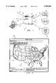
- FIG. 1is a schematic diagram illustrating a distributed weather information system in accordance with one embodiment of the present invention
- FIG. 2is a schematic block diagram illustrating client and server components of the weather information system of FIG. 1 in accordance with one embodiment of the present invention
- FIG. 3is a screen display illustrating an interactive map with which a client may intuitively enter a travel route in accordance with one embodiment of the present invention
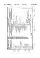
- FIG. 4is a flow diagram from a client's perspective illustrating the process of obtaining weather information along a travel route in accordance with one embodiment of the present invention
- FIG. 5is a screen display illustrating weather data products including alpha-numeric data in accordance with one embodiment of the present invention
- FIG. 6is a screen display illustrating mapped weather data in accordance with one embodiment of the present invention.
- FIG. 7is a screen display illustrating a scene of a dynamic two-dimensional (2D) fly-through in accordance with one embodiment of the present invention.
- FIG. 8is a screen display illustrating a scene of a three-dimensional (3D) fly-through in accordance with one embodiment of the present invention.
- FIG. 9is a flow diagram illustrating a method of providing weather data and weather visualizations along a travel route in accordance with one embodiment of the present invention.
- FIGS. 1-9illustrate a method and system of providing weather data along a travel route or at a selected location.
- a travel routemay be a flight path, a shipping lane, a truck route or the like.
- the systemmay be a distributed system having client and server components.
- the clientmay receive and upload a travel route or selected location over a network to the server.
- the servermay automatically retrieve weather data associated with the travel route or selected location and generate visualization of weather along the travel route or for the selected location using the weather data.
- the servermay download the weather data and visualizations over the network to the client for display. Accordingly, graphical information and visualizations that stimulate the formation of mental images of weather conditions and other weather data along a travel route or for a selected location may be easily and conveniently obtained by a remote client.
- the travel route or selected locationmay be intuitively entered by simply selecting departure and destination points on an interactive map.
- FIG. 1illustrates a distributed weather information system 10 in accordance with one embodiment of the present invention. It will be understood that the weather system 10 may be otherwise configured within the scope of the present invention. For example, the weather system 10 may be configured as a stand alone system.
- the weather information system 10may comprise a server system 12 connected to one or more client systems 14 through communication links 16.
- the server system 12may be a computer such as a personal computer, file server, workstation, minicomputer, mainframe or any other computer capable of communicating and interconnecting with other computers.
- the server system 12may include an input/output system, processor and memory.
- the input/output systemmay connect the communication links 16 and other input and output devices to the server system 12.
- the communication links 16may be directly connected to the server system 12 or may be connected through a data transmission device such as a modem or the like.
- the input devicesmay include a pointing device such as a mouse or trackpad, a keyboard, or the like.
- the output devicesmay include a monitor, a printer, or the like.
- the server system 12may be connected to a plurality of other server systems through communication links 18. As previously described in connection with the communication links 16, the input/output system may connect the communication links 18 to the server system 12.
- the communication links 18may be directly connected to the server system 12 or may be connected through a data transmission device such as a modem or the like. It will be understood that communication links 16 and 18 may be otherwise connected to the server system 12 within the scope of the present invention.
- the server system 12may communicate and obtain weather data over communication links 18.
- the server system 12may be connected to the National Weather Service (NWC) 20, other weather provider servers and/or networks 22, and the like.
- NWCNational Weather Service
- the server system 12may also be connected to an expert station 24. It will be understood that additional or different systems may be connected to the server system 12 through communication links 18 within the scope of the present invention.
- Communication links 16 and 18may be any type of communication link capable of supporting data transfer.
- the communication links 16 and 18may include any combination of an Integrated Services Digital Network (ISDN) communication line, a hardwire line, or a telephone link. It will be understood that the communication links 16 and 18 may comprise other types of links, including wireless links such as microwave, radio frequency (RF) and the like, within the scope of the present invention.
- ISDNIntegrated Services Digital Network
- RFradio frequency
- the communication links 16 and 18may form one or more networks 26.
- the network 26may be the Internet in which information may be transmitted and retrieved using the World Wide Web (WWW) or similar system. It will be understood that the present invention is not limited to network implementations using the Internet.
- the network 26may be any interconnection found on any computer network such as a local area network (LAN), a wide area network (WAN), a corporate or other intranet, or any other communications and data exchange systems created by connecting two or more computers.
- LANlocal area network
- WANwide area network
- corporate or other intranetor any other communications and data exchange systems created by connecting two or more computers.
- the server system 12may be remote from the client system 14 and located anywhere in the world.
- communication links 16may connect to intermediate servers between the server system 12 and the client system 14.
- a plurality of intermediate serversmay be disposed between the client system 14 and the server system 12 along communication links 16.
- the client system 14may communicate over the Internet with the server system 12 using a Web browser or other application that provides an address or Uniform Resource Locator (URL) of the server system 12.
- the client system 14may access the server system 12 through a plurality of other server systems using HyperText Transfer Protocol (HTTP) and providing the URL to the other server systems.
- HTTPis an application network protocol that governs how content is obtained across the World Wide Web.
- HTTPis stateless in a sense that the server does not store or record any information about the history or status of its interaction with a given client.
- TCP/IPTransmission Control Protocol/Internet Protocol
- client system 14may otherwise communicate and/or interact with the server system 12 within the scope of the present invention.
- the client system 14 and the server system 12may communicate using Virtual Reality Modeling Language (VRML) or the like.
- VRMLVirtual Reality Modeling Language
- the client system 14may be similar to the server system 12 and may be implemented using virtually any type of computer.
- the client system 12is preferably a personal computer having an input/output system, a processor, and a memory.
- the input/output systemmay connect the communication links 16 and other input and output devices to the client system 14.
- FIG. 2is a schematic block diagram illustrating components of the server system 12 and client system 14 in accordance with the one embodiment of the present invention.
- the server system 12may comprise an input/output system 30, a processor 32 and a memory 34.
- the input/output system 30may connect communication links 16 and 18 and other input and output devices to the server system 12.
- the server system 12includes computer software that may be loaded into the memory 34 and executed by the processor 32.
- the computer softwaremay generally be identified by modules, engines and similar types of systems in the memory 34. It will be understood that the computer software may be otherwise combined and/or segregated for processing within the scope of the present invention. Accordingly, labels of the software systems are for illustrative purposes and may be varied within the scope of the present invention.
- Disk storagemay include a variety of types of storage media.
- disk storagemay include floppy disk drives, hard disk drives, CD/ROM drives, or magnetic tape drives.
- the memory 34may include an operating system 36, a database 38, a server application 40 and a rendering engine 44. It will be understood that these systems may be otherwise stored within the scope of the present invention.
- the database 38 and other systemsmay be stored on a separate, remote server and accessed via the network 26.
- the operating system 36may comprise a graphical user interface (GUI) 48.
- GUIgraphical user interface
- the operating system 36may be Macintosh OS, WINDOWS NT, WINDOWS 95, OS/2, or any other type of graphical operating system. It will be understood that other types of operating systems, including non-graphical operating systems, may be used within the scope of the present invention.
- the database 38may store weather information obtained from various local, regional, and continental databases of weather providers such as the National Weather Service.
- databasesmay include Regional Satellite, Regional Forecasts, Continental Radar, Continental Satellite, Continental Forecasts, Winds Aloft, Surface OB, METAR, TAF, NOTAMS, PWWs, AIREPs, AIRMETs, NWS Watches, Warnings and Advisories, SIGMETs, NWS Zone Forecasts, Local Radar, Analysis and Forecast, Maps and other Travel Advisories, Regional Radar Images and the like.
- Weather information from such databasesmay be downloaded to the database 38 of the server system 12 via the network 26. It will be understood that the weather information of the database 38 may be otherwise obtained and/or stored within in scope of the present invention.
- the database 38may include satellite imagery 50, radar imagery 52, alpha-numeric weather 54 information and weather maps 56.
- the satellite imagery 50may comprise infrared and visual satellite imagery.
- the radar imagery 52may comprise regional and composite radar imagery, including local radar.
- the alpha-numeric weather information 54may comprise weather observations, forecasts and warnings.
- the weather maps 56may comprise mapped weather patterns, formations and the like. It will be understood that the server system 12 and/or database 38 may comprise additional or different types of weather information within the scope of the present invention.
- the server application 40may operate as a dispatcher of requests and a conduit for data transfer.
- the server application 40may be an HTTP server.
- the server application 40may comprise NETSCAPE ENTERPRISE manufactured by Netscape Communication Corporation, MICROSOFT EXPLORER manufactured by MicroSoft Corporation and the like. It will be understood that the server application 40 may comprise other types of applications within the scope of the present invention.
- the server applicationmay be a VRML server.
- the server application 40may receive requests for weather products associated with a travel route or selected location from the client systems 14.
- weather productsmay be associated with a selected location, other point or groups of points of interest within the scope of the present invention.
- Such weather productsmay be provided by the system and methods described below in connection with providing weather products associated with the travel route.
- the travel routemay be uploaded as a route plan file 62.
- the uploaded route plan file 62may include a departure point 64, a destination point 66, and way points 68 defining the travel route.
- the requests and route plan file 62may include additional or different information within the scope of the present invention.
- the request for weather products associated with the travel routemay be otherwise received by the server application within the scope of the present invention.
- the requestsmay include product parameters listing the types of weather products selected by the client for the travel route.
- the product parametersmay include a preset client profile and/or presently set parameters listing weather products desired by the client.
- the product parametersmay also include architectural information about the client system 14 and the communication path between client system 14 and the server system 12. As is described in more detail below, this information may be used to determine products that should be downloaded to the client system 14 based on the capability of the client system 14 and the communication path between the client system 14 and the server system 12.
- the server application 40may invoke a delivery engine 70 to retrieve and/or generate the selected weather products for the travel route.
- the delivery engine 70may in combination with the rendering engine 44 retrieve weather data 74 associated with the travel route, generate visualizations 76 of forecast weather along the travel route using the weather data 74 and package the weather data and visualizations 74 and 76 for delivery to the client. It will be understood that the weather data 74 and visualization 76 may be otherwise retrieved, generated and/or packaged within the scope of the present invention.
- the delivery engine 70may include a set of handlers 80 to retrieve weather data and carry out other functions of the delivery engine 70.
- the handlers 80may include a route plan handler to generate a route points file 82 from the route plan file 62.
- the route points file 82may include a plurality of route points along the travel route.
- Route point query handlersmay conduct queries of weather databases for each route point to retrieve weather data associated with each route point. It will be understood that the delivery engine 70 may comprise other handlers 80 within the scope of the present invention. It will be further understood that the delivery engine 70 may otherwise carry out the functionality of the handlers 80 within the scope of the present invention.
- the delivery engine 70may translate or otherwise configure retrieved data to a format that may be used within the weather information system 10.
- the datamay be historical, current and/or forecasted data.
- the delivery engine 70may include a text converter to convert alpha-numeric weather data.
- the text convertermay be programmed in "C" language.
- Converted textmay pass through a HyperText Markup Language (HTML) generator to be converted to the HTML language for compatibility with the Web environment of the Internet.
- HTML generatormay be programmed in Pearl language.
- the handlers 80may then prepare hyperlinks with which a client may conveniently access the retrieved weather data upon download.
- the handlers 80may also prepare hyperlinks for satellite, radar and other imagery information. It will be understood that retrieved data may be otherwise translated, configured and/or processed within the scope of the present invention.
- the rendering engine 44may generate the visualizations 76 of forecasted weather along the travel route using the weather data 74 retrieved for each of the route points of the travel route.
- the visualizations 76may be dynamic fly-through simulations of forecasted or observed weather along the travel route.
- the visualizations 76 generated by the rendering engine 44may comprise a dynamic 2-dimensional (2D) fly-through and/or a dynamic 3-dimensional (3D) fly-through.
- the fly-throughsmay be bit-mapped movies.
- the visualizations 76may comprise additional or different representations of forecasted or observed weather and formats within the scope of the present invention.
- the visualizationsmay be drive-through, on-location or other simulations of forecasted weather along the travel route.
- the weather data 74 and visualization 76may be packaged by the delivery engine 70 for delivery to the client system 14.
- the delivery engine 70may also compress the weather package 84 to reduce the time and/or bandwidth required for delivery of the weather products to the client.
- the weather data 74 and visualization 76may be otherwise compressed and/or packaged within the scope of the present invention.
- the rendering engine 44may compress the weather visualization 76 using MPEG or other video compression techniques within the scope of the present invention.
- the delivery engine 70may comprise a common gateway interface (CGI) script.
- CGIis the standard interface for calling or executing programs on an HTTP server.
- the rendering engine 44may comprise REALITY 3-D manufactured by Earthwatch Communications, Inc. of Minnetonka, Minn. Further description of the operation of the rendering engine 44 to generate these weather visualizations 76 may be found in U.S. Pat. No. 5,379,215 to Kruhoeffer, et al., entitled "Method for Creating a 3-D Image of Terrain and Associated Weather" and assigned to Earthwatch Communications, Inc. It will be understood that the delivery engine 70 and rendering engine 44 may comprise other types of scripts and/or programs within the scope of the present invention.
- the client system 14may be similar to the server system 12 and may be implemented using virtually any type of computer.
- the client system 14may be a personal computer, file server, work station, minicomputer, mainframe, or any other computer capable of communicating and interacting with other computers.
- the client system 14may be a portable laptop computer having a 486, Pentium or other fast processor.
- the client systems 14may each comprise an input/output system 100, a processor 102, and a memory 104. As previously described, the input/output system 100 may connect the communication links 16 and other input and output devices to the client system 14.
- the client system 14includes computer software that may be loaded and/or downloaded into the memory 104 and executed by the processor 102.
- the computer softwaremay generally be identified by modules, tables, files and similar systems in memory 104. It will be understood that the computer software may be otherwise combined and/or segregated for processing within the scope of the present invention. Accordingly, the labels of the software systems are for illustrative purposes and may be varied within the scope of the present invention.
- Disk storagemay include a variety of types of storage media.
- disk storagemay include floppy disk drives, hard disk drives, CD/ROM drives, or magnetic tape drives.
- the memory 104may include an operating system 110, a travel points table 112, a browser 114 and a viewer 116.
- the operating system 110may include a graphical user interface (GUI) 118.
- GUIgraphical user interface
- the operating system 110may be Macintosh OS, WINDOWS NT, WINDOWS 95, OS/2, or any other graphical operating system. It will be understood that the operating system 110 may be any type of system capable of allowing graphics to be displayed on the client system 14.
- the travel points table 112may be used in conjunction with the browser 114 to assist the client in entering a travel route.
- the travel routemay be a flight path, a shipping lane, a truck route or the like.
- the travel routewill be described as a flight path. It will be understood that the travel route may be any type of route used in connection with a form of transportation effected by the weather.
- the travel points table 112may comprise a plurality of travel points 120.
- the travel points 120may be departure and destination points of the travel route. Where the travel route is a flight plan, the travel points may be airports at which the client may depart and arrive.
- each airport travel point 120may include an International Civil Aviation Organization (ICAO) designation and positioning information such as a latitude 122, longitude 124 and altitude 126 of that airport.
- IICAOInternational Civil Aviation Organization
- the travel points table 112may include additional or different information within the scope of the present invention.
- the departure and destination travel pointsmay be terminals for truckers.
- the browser 114may receive a travel route and product selections from the client and upload the travel route and product selections to the server system 12.
- the browser 114may include a route planner 132 to assist the client in entering the travel route.
- the route planner 132may display an interface 134 including a plurality of selectable travel points. Each travel point of the interface 134 may be linked or otherwise associated with a travel point 120 of the travel points table 112. Accordingly, the route planner 132 and interface 134 may assist the client in entering a travel route by displaying selectable departure and destination points and retrieving information associated with selected departure and destination points. As a result, the client need not remember, look up, or manually enter departure and destination points and information associated with those points.
- the interface 134may comprise an interactive map 136 as shown by FIG. 3.
- the map 136may graphically display travel points 138.
- the clientmay select travel points 138 using an input device such as a mouse, trackpad, or the like.
- the interface 134may comprise other displays from which the client may select travel points.
- interface 134may be a list of selectable travel points.
- the interface 134may display a dialog box for the client to enter departure and/or arrival times at that travel point. Additionally, interface 134 may display a dialog box for the client to enter way points and times between the departure and destination points. Where the travel route is a flight plan, the way points may include altitude information. It will be understood that the interface may otherwise interact with the client within the scope of the present invention.
- the route planner 132may store the travel route entered by the client into the route plan file 140.
- the route plan file 140may include a departure point 142, a destination point 144 and way points 146 of a travel route.
- the route plan file 140may be uploaded by the browser 114 to the server system 12 as the travel route. It will be understood that the route plan file 140 may comprise additional or different information within the scope of the present invention. It will be further understood that the travel route may be otherwise uploaded to the server system 12 within the scope of the present invention.
- the browser 114may also receive a download weather package 148 from the server system 12.
- the downloaded weather package 148may comprise weather data 150 associated with the travel route and visualizations 152 along the travel route uploaded to the server system 12.
- the weather datamay comprise satellite and radar imagery, weather maps, and alpha-numeric information retrieved by the server system 12.
- the weather visualizations 152may comprise dynamic fly-throughs generated by the server system 12. It will be understood that the visualizations 152 may comprise dynamic drive-throughs and the like within the scope of the present invention.
- the browser 114may also in connection with the server application 40 establish an audio link between the client system 14 and the expert station 24.
- the browser 114 and server application 40may transmit and receive audio information between the client system 14 and expert station 24 while the audio link is in place.
- the browser 114 and server application 40may further cooperate to upload a displayed weather hazard from the client system 14 to the expert station 24 to enable a meteorologist or other expert to view the weather hazard that the client wishes to discuss.
- the weather hazardmay be a dangerous weather formation or any other type of weather phenomena.
- the browser 114may be NETSCAPE NAVIGATOR, version 3.0 manufactured by Netscape Communication Corporation, MICROSOFT EXPLORER manufactured by MicroSoft Corporation and the like.
- the route planner 132may comprise a Java applet loaded into the browser 114 each time the browser 114 is used.
- the map 136may comprise a MAPIORI application manufactured by PlexStar. It will be understood that other browsers, route planner and/or interface may be used within the scope of the present invention.
- the viewer 116may be called by the browser 114 to display the weather data 150 and/or visualizations 152 of the downloaded weather package 148.
- the viewer 116may decompress compressed files such as the bit map movies generated by the rendering engine 44.
- the viewer 116may comprise QUICK TIME manufactured by Apple Corporation. It will be understood that the viewer 116 may comprise other applications, programs, and/or extensions capable of displaying the weather data 150 and/or visualizations 152 of the downloaded weather package 148.
- FIG. 4illustrates a client process for entering a travel route and viewing weather products associated with that travel route in accordance with one embodiment of the present invention.
- the processbegins at step 200 in which the client invokes the browser 114. It will be understood that the user may invoke another application or program to begin the process within the scope of the present invention.
- the browser 114may invoke the route planner 132 to display the interface 134 including selectable travel points.
- the interface 134may be the interactive map 136 of FIG. 3.
- the interactive map 136may graphically display travel points 138 for selection by the client.
- the clientmay select a departure point.
- the clientmay select the departure point by clicking or otherwise activating the appropriate travel point 138 on the interactive map 136 using an input device such as mouse, trackpad or the like.
- the route planner 132may display a dialog box in which the client may enter a scheduled departure time and/or other related information. It will be understood that the client may otherwise select or enter a departure point within the scope of the present invention.
- the clientmay select a destination point.
- the clientmay select a destination point by clicking or otherwise activating the appropriate travel point 138 on interactive map 136 using an input device.
- the route planner 132may display a dialog box in which the client may enter a scheduled arrival time and/or other related information. It will be understood that the client may otherwise select or enter a destination point within the scope of the present invention.
- the clientmay input one or more way points.
- the way pointsmay include position and time information. Additionally, for a flight plan, the way points may include altitude information. It will be understood that way points may comprise other information or be otherwise entered by the client within the scope of the present invention.
- the clientmay input other travel route information.
- this informationmay include the type of aircraft to be flown. This information may be used to determine automatic climb and descent rates and thus obtain altitude information for way points between the departure and destination points.
- the clientmay select desired weather products.
- the weather productsmay include weather data such as satellite and radar imagery, alpha-numeric information and weather maps and weather visualizations such as 2-D and 3-D fly-throughs. This information may be selected on-the-fly by the client each time a travel route is entered. It will be understood that weather products may be otherwise selected by the client within the scope of the present invention.
- the product informationmay be stored as a product parameters file, in which case products need not be reselected in connection with each travel route.
- the clientmay submit the travel route.
- the browser 114may upload the travel route to the server system 12 as the route plan file 62.
- the server system 12may process the travel route, retrieve and/or generate selected weather products and download the weather products to the client system 14.
- the browser 114 of the client system 14may display a list of the downloaded weather products for selection and viewing by the client.
- the clientmay select weather products for viewing.
- the WEATHER DATA branch of state 214may lead to state 216.
- the browser 114may display the weather data 150 downloaded from the server system 12 for viewing by the client.
- the weather data 150may include satellite and radar imagery, alpha-numeric weather information and weather maps. It will be understood that the weather data 150 may comprise other types of information within the scope of the present invention.
- FIG. 5is a screen display 130 of weather data products in accordance with one embodiment of the present invention.
- the display 130may include a listing 132 of available weather data products 134.
- the clientmay select these products 134 to view the associated information in the remaining portion of the screen 136.
- the weather datamay be otherwise displayed and/or viewed within the scope of the present invention.
- surface observation weather datais selected for display in the main portion of the screen 136.
- the surface observation weather datais alpha-numeric data and includes a location identifier, time, sky condition and ceiling, visibility, present weather, obstructions to vision, sea-level pressure, temperature, dew point, wind direction, speed and character, altimeter setting, density altitude and remarks. It will be understood that the surface observation and other weather data may comprise other information within the scope of the present invention.
- FIG. 6is a screen display illustrating mapped weather data 138 in accordance with one embodiment of the present invention.
- the mapped weather data 138may comprise forecasted weather conditions such as cloud cover. It will be understood that the mapped weather data 138 may also comprise current weather conditions. It will be further understood that mapped weather data may comprise other types of weather information such as current or forecasted weather patterns within the scope of the present invention.
- the QUIT branch of state 216may return to state 214 wherein the list 132 of downloaded weather products 136 is displayed by the browser 114 for selection by the client.
- the 2-D FLY-THROUGH branchmay lead to state 218.
- the browser 114may in connection with the viewer 116 display the 2-D fly-through to the client.
- the 2-D fly-throughmay comprise a bit-mapped movie. It will be understood that the 2-D fly-through may be otherwise viewed by the client within the scope of the present invention.
- FIG. 7is a screen display illustrating a scene of the 2-D fly-through in accordance with one embodiment of the present invention.
- the 2-D fly-throughmay include a visualization 140 of forecasted weather along the travel route and associated information 142.
- the associated information 142may include heading, altitude, wind speed and direction, and the like. It will be understood that the 2-D fly-through may include other information and be otherwise displayed within the scope of the present invention.
- the QUIT branch of state 218may return to state 214 wherein the list 132 of downloaded weather products 136 is displayed by the browser 114 for selection by the client.
- the 3-D FLY-THROUGH branch of state 214may lead to state 220.
- the browser 114may in connection with the viewer 116 display the 3-D fly-through to the client.
- the 3-D fly-throughmay be a bit-mapped movie. It will be understood that the 3-D fly-through may be otherwise selected by the client within the scope of the present invention.
- FIG. 8is a screen display illustrating a scene of a 3-D fly-through in accordance with one embodiment of the present invention.
- the 3-D fly-throughmay include a visualization 144 of forecasted weather along the travel route.
- the visualization 144may show weather formations, rain and other information along the travel route as it would appear to a pilot in a cockpit. It will be understood that the 3-D fly-through may include other information and be otherwise displayed within the scope of the present invention.
- the QUIT branch of state 220may return to state 214 wherein the list 132 of downloaded weather products 136 is displayed by the browser 114 for selection by the client.
- the EXPERT INFORMATION branchmay lead to state 222.
- the browser 114may in connection with the server application 40 establish an audio link between the client system 14 and the expert station 24.
- the browser 114may also upload a displayed weather hazard to the expert station 24 to allow a meteorologist or other expert to view the weather hazard that the client wishes to discuss.
- the clientWhile the audio link is in place at state 222, the client may converse with the expert about the displayed weather hazard.
- the QUIT branch of state 222may return to state 214 wherein the list 132 of downloaded weather products 136 is displayed by the browser 114 for selection by the client.
- the clientmay at decisional step 224 determine whether the travel route is acceptable. A travel route may not be acceptable if the weather hazards are too great to fly or otherwise travel through. If the travel route is not acceptable, the NO branch of decisional step 224 may return to step 202 from which the client may enter an alternate travel route. If the travel route is acceptable, the YES branch of decisional step 224 may lead to step 226.
- the clientmay submit the flight plan travel route to the Federal Aviation Administration (FAA) for approval. It will be understood that the flight plan may be otherwise submitted to the FAA within the scope of the present invention. Step 226 leads to the end of the process.
- FAAFederal Aviation Administration
- FIG. 9is a flow diagram illustrating a method of providing weather data and weather visualizations along a travel route in accordance with one embodiment of the present invention.
- the methodbegins at step 250 when the weather information system 10 receives an initiation event.
- the initiation eventmay be the activation of the browser 114 by the client. It will be understood that the method of providing weather data and weather visualizations along the travel route may be otherwise invoked within the scope of the present invention.
- the browser 114may invoke the route planner 132 to display the interactive map 126.
- the route planner 132may use the interactive map 126 to receive a destination point.
- the route planner 132may again use the interactive map 126 to receive a destination point. As previously described, the route planner 132 may receive the departure and destination points from selections on the interactive map 126 by the client.
- the route planner 132may receive way points between the departure and destination points.
- the way pointsmay include time and altitude information for a flight path.
- the route planner 132may receive other travel route information. For a flight path, this information may include the type of aircraft to be flown along the travel route.
- the route planner 132may store the departure, destination and way points in the route plan file 140.
- the route planner 132may retrieve information associated with the travel points from the travel points table 112. As previously described, this may include positioning information such as latitude 122 and longitude 124 and altitude information 126. The associated information may be stored at step 265 in the route plan file 140. It will be understood that the travel points and associated information may be otherwise stored within the scope of the present invention.
- the browser 114may receive a selection of weather products.
- the weather productsmay be selected on-the-fly by the client or may be part of a preset product parameters file. It will be understood that the weather products may be otherwise received within the scope of the present invention.
- the browser 114may upload the route plan file 140 and products parameters to the server system 12 as the travel route.
- the server application 40 of the server system 12may invoke the delivery engine 70 to process the request for weather products associated with the travel route.
- the delivery engine 70may use the handlers 80 to generate the route points file 78 using the uploaded route plan file 62.
- the route points file 78may comprise a plurality of points along the travel route.
- the route points file 78includes a route point for each 50 nautical mile section of the travel route. It will be understood that the route points file 78 may be otherwise generated within the scope of the present invention. It will be further understood that the route points file 78 may include different distributions of route points within the scope of the present invention. For example, the distribution may vary depending on the resolution of the weather data and the form of travel.
- the delivery engine 70may use the handlers 80 to query the database 38 and/or weather databases to other retrieved weather data 78 associated with each route point of the route points file 78. As previously described, the delivery engine may translate alpha-numeric and/or imagery weather data for compatibility with the weather information system 10.
- the delivery engine 70may determine if the client selected a 2-D fly-through for the travel route. This may be determined by the product parameters. If the client selected a 2-D fly-through, the YES branch of decisional step 274 leads to step 276.
- the rendering engine 44may generate the 2-D fly-through along the travel route. In one embodiment, the rendering engine 44 may use the weather data 74 retrieved for each of the route points to generate the 2-D fly-through. In this embodiment, the rendering engine 44 may comprise REALITY 3-D manufactured by Earthwatch Communications, Inc. It will be understood that the 2-D fly-through may be otherwise generated within the scope of the present invention. Step 276 leads to decisional step 278. Returning to decisional step 274, if a 2-D fly-through was not selected by the client, the NO branch of decisional step 274 also leads to decisional step 278.
- the delivery engine 70may determine if the client selected a 3-D fly-through for the travel route. As previously described, this may be determined by the product parameters. If the client selected a 3-D fly-through, the YES branch of decisional step 278 leads to step 280.
- the rendering engine 44may generate the 3-D fly-through along the travel route. In one embodiment, the rendering engine 44 may use the weather data 74 associated with each of the route points to generate the 3-D fly-through. In this embodiment, the rendering engine 44 may comprise REALITY 3-D manufactured by Earthwatch Communications, Inc. It will be understood that the 3-D fly-through may be otherwise generated within the scope of the present invention. Step 280 leads to step 282. Returning to decisional step 278, if a 3-D fly-through was not selected by the client, the NO branch of decisional step 278 also leads to step 282.
- the delivery engine 70may package the weather products 74 and 76 to be downloaded over the network 26 to the client system 14.
- the weather products 74 and 76may include weather data such as satellite and radar imagery and alpha-numeric weather information and weather visualizations such as 2-D and 3-D fly-throughs.
- the delivery engine 70may compress the weather package 84 to minimize time and resources required to deliver the products to the client over the network 26.
- the server application 40may download the weather package 82 to the browser 114 of the client system 14.
- the weather package 82may be downloaded over the Internet using standard Internet protocols such as HTTP, VRML, TCP/IP and the like.
- the browser 114may uncompress the downloaded weather package 148.
- the browser 114may receive a request to display the downloaded weather products.
- the browser 114in connection with the viewer 116 may display the weather products downloaded from the server system 12.
- the clientmay review the downloaded weather products to determine weather conditions along the travel route and to view those conditions.
- the clientmay at step 294, in the case of a flight path, file a flight plan with the FAA.
- the browser 114may transmit the flight plan to the DUATS system currently used by the FAA. It will be understood that the flight plan may be otherwise filed within the scope of the present invention.
- Step 294leads to the end of the process.
- graphical information and visualizations that stimulate the formation of mental images of weather conditions and other weather data along a travel routemay be easily and conveniently obtained by remote client. Additionally, the travel route may be intuitively entered by simply selecting departure and destination points on an interactive map.
- a client systemmay be an interactive TV.
- the client systemmay receive and upload the selected location over a network to the server.
- the networkmay include part of an interactive TV network and the server may be capable of interacting with an interactive TV network. It will be understood that another type of system may be used within the scope of the present invention.
- the servermay automatically retrieve weather data associated with the selected location and generate visualizations of weather at the selected location using the weather data.
- the weather datamay be historical, current and/or forecasted data.
- the visualizationsmay be simulations of historical, current, forecasted or observed weather at the location.
- the servermay download the weather data and visualizations over the network to the client system for display.
- graphical information and visualizations that stimulate the formation of mental images of weather conditions and other weather data at the selected locationmay be easily and conveniently obtained by a remote client using interactive TV.
- the locationmay be intuitively entered by simply selecting one or more points on an interactive map as previously described in connection with a travel route.
Landscapes
- Business, Economics & Management (AREA)
- Human Resources & Organizations (AREA)
- Engineering & Computer Science (AREA)
- Strategic Management (AREA)
- Economics (AREA)
- Marketing (AREA)
- Game Theory and Decision Science (AREA)
- Entrepreneurship & Innovation (AREA)
- Development Economics (AREA)
- Operations Research (AREA)
- Quality & Reliability (AREA)
- Tourism & Hospitality (AREA)
- Physics & Mathematics (AREA)
- General Business, Economics & Management (AREA)
- General Physics & Mathematics (AREA)
- Theoretical Computer Science (AREA)
- Navigation (AREA)
Abstract
Description
Claims (73)
Priority Applications (1)
| Application Number | Priority Date | Filing Date | Title |
|---|---|---|---|
| US08/869,187US5999882A (en) | 1997-06-04 | 1997-06-04 | Method and system of providing weather information along a travel route |
Applications Claiming Priority (1)
| Application Number | Priority Date | Filing Date | Title |
|---|---|---|---|
| US08/869,187US5999882A (en) | 1997-06-04 | 1997-06-04 | Method and system of providing weather information along a travel route |
Publications (1)
| Publication Number | Publication Date |
|---|---|
| US5999882Atrue US5999882A (en) | 1999-12-07 |
Family
ID=25353084
Family Applications (1)
| Application Number | Title | Priority Date | Filing Date |
|---|---|---|---|
| US08/869,187Expired - LifetimeUS5999882A (en) | 1997-06-04 | 1997-06-04 | Method and system of providing weather information along a travel route |
Country Status (1)
| Country | Link |
|---|---|
| US (1) | US5999882A (en) |
Cited By (133)
| Publication number | Priority date | Publication date | Assignee | Title |
|---|---|---|---|---|
| WO2000042521A1 (en)* | 1999-01-15 | 2000-07-20 | Palatian Enterprises | Method and system for estimating earth environmental effects in relation to planetary orbital dynamics |
| US6104392A (en)* | 1997-11-13 | 2000-08-15 | The Santa Cruz Operation, Inc. | Method of displaying an application on a variety of client devices in a client/server network |
| US6154143A (en)* | 1999-09-16 | 2000-11-28 | Belfort Instrument, Inc. | Portable meteorological information system |
| US6208307B1 (en) | 2000-04-07 | 2001-03-27 | Live Tv, Inc. | Aircraft in-flight entertainment system having wideband antenna steering and associated methods |
| US6209026B1 (en)* | 1997-03-07 | 2001-03-27 | Bin Ran | Central processing and combined central and local processing of personalized real-time traveler information over internet/intranet |
| US6269309B1 (en)* | 2000-01-12 | 2001-07-31 | James M. Buckingham | System for collection dissemination and presentation of near real-time images of weather and runway conditions at distant locations |
| US6289277B1 (en)* | 1999-10-07 | 2001-09-11 | Honeywell International Inc. | Interfaces for planning vehicle routes |
| US6317686B1 (en) | 2000-07-21 | 2001-11-13 | Bin Ran | Method of providing travel time |
| US6339747B1 (en) | 2000-04-05 | 2002-01-15 | Weather Central, Inc. | Weather tracking and display system and method |
| WO2002023462A1 (en)* | 2000-09-12 | 2002-03-21 | Wsi Corporation | Systems and methods for conveying weather reports |
| US6381538B1 (en) | 2000-05-26 | 2002-04-30 | Aerotech Research (U.S.A.), Inc. | Vehicle specific hazard estimation, presentation, and route planning based on meteorological and other environmental data |
| US6397163B1 (en)* | 1999-12-02 | 2002-05-28 | Eastman Kodak Company | Method for determining thermal exposure of a product |
| US20020069020A1 (en)* | 1999-08-13 | 2002-06-06 | Digital Cyclone, Inc. | Generation and distribution of personalized multimedia natural phenomenological information |
| US6498987B1 (en) | 2000-04-12 | 2002-12-24 | Weather Central, Inc. | System and method for providing personalized weather reports and the like |
| US20030004817A1 (en)* | 2001-06-27 | 2003-01-02 | Conoco Inc | Visual database for linking geography to seismic data |
| US20030036844A1 (en)* | 2001-08-15 | 2003-02-20 | Senaka Balasuriya | System and method for bookmarking a route |
| DE10139668A1 (en)* | 2001-08-11 | 2003-02-20 | Bayerische Motoren Werke Ag | Provision of forthcoming or imminent weather details to a motor vehicle driver using an onboard navigation system to guide him to a target destination, whereby dual information sources are used to improve prediction reliability |
| US20030050757A1 (en)* | 2001-09-12 | 2003-03-13 | Moore John S. | System and method for processing weather information |
| WO2003041032A1 (en)* | 2001-11-06 | 2003-05-15 | Volvo Trucks North America, Inc. | Integrated vehicle communications display |
| US6590529B2 (en) | 2000-02-14 | 2003-07-08 | Mysky Communications | Individualized, location specific weather forecasting system |
| US6619555B2 (en) | 2002-02-13 | 2003-09-16 | Howard B. Rosen | Thermostat system communicating with a remote correspondent for receiving and displaying diverse information |
| US20030192052A1 (en)* | 2000-04-07 | 2003-10-09 | Live Tv, Inc. | Aircraft in-flight entertainment system generating a pricing structure for available features, and associated methods |
| US20030200546A1 (en)* | 2000-04-07 | 2003-10-23 | Live Tv, Inc. | Aircraft system providing passenger entertainment and surveillance features, and associated methods |
| US20030200547A1 (en)* | 2000-04-07 | 2003-10-23 | Live Tv, Inc. | Aircraft in-flight entertainment system receiving terrestrial television broadcast signals and associated methods |
| US6650972B1 (en) | 2000-05-26 | 2003-11-18 | Aerotech Research (U.S.A.), Inc. | Estimation, transmission, receipt, and presentation of vehicle specific environmental conditions and hazards information |
| US6654689B1 (en) | 2000-11-06 | 2003-11-25 | Weather Central, Inc. | System and method for providing personalized storm warnings |
| US20030229897A1 (en)* | 2000-04-07 | 2003-12-11 | Live Tv, Inc. | Aircraft in-flight entertainment system providing passenger specific advertisements, and associated methods |
| US20030233658A1 (en)* | 2000-04-07 | 2003-12-18 | Live Tv, Inc. | Aircraft in-flight entertainment system providing weather information and associated methods |
| US6711617B1 (en)* | 2000-02-09 | 2004-03-23 | International Business Machines Corporation | Method and apparatus for providing automatic configuration of a computer system based on its physical location using an electronically read schedule |
| US20040078821A1 (en)* | 2000-04-07 | 2004-04-22 | Live Tv, Inc. | Aircraft in-flight entertainment system with soft fail and flight information features and associated methods |
| US20040098175A1 (en)* | 2002-11-19 | 2004-05-20 | Amir Said | Methods and apparatus for imaging and displaying a navigable path |
| US20040102895A1 (en)* | 2002-11-27 | 2004-05-27 | Thayer Peter A. | Vehicle passive alert system and method |
| US6748597B1 (en) | 2000-04-07 | 2004-06-08 | Live Tv, Inc. | Upgradable aircraft in-flight entertainment system and associated upgrading methods |
| US6751801B1 (en) | 2000-04-07 | 2004-06-15 | Live Tv, Inc. | Aircraft in-flight entertainment system having enhanced antenna steering and associated methods |
| US6789739B2 (en) | 2002-02-13 | 2004-09-14 | Howard Rosen | Thermostat system with location data |
| US20040218895A1 (en)* | 2003-04-30 | 2004-11-04 | Ramin Samadani | Apparatus and method for recording "path-enhanced" multimedia |
| US20040218910A1 (en)* | 2003-04-30 | 2004-11-04 | Chang Nelson L. | Enabling a three-dimensional simulation of a trip through a region |
| US20040244476A1 (en)* | 2003-06-05 | 2004-12-09 | International Business Machines Corporation | System and method to update weather forecasting using on-board sensing equipment |
| US6832153B2 (en) | 2002-11-27 | 2004-12-14 | Mobilearia | Method and apparatus for providing information pertaining to vehicles located along a predetermined travel route |
| US20050001743A1 (en)* | 2003-07-02 | 2005-01-06 | Haemerle Richard R. | Information retrieval and display device and system |
| US6842737B1 (en)* | 2000-07-19 | 2005-01-11 | Ijet Travel Intelligence, Inc. | Travel information method and associated system |
| US20050055308A1 (en)* | 2000-07-19 | 2005-03-10 | Meyer Mark Gregory | Global asset risk management system and methods |
| US20050102104A1 (en)* | 2003-11-10 | 2005-05-12 | Tap Publishing Company | Providing custom locations and custom color scales for online weather radar displays |
| US6925606B2 (en) | 1997-11-13 | 2005-08-02 | Tarantella, Inc. | Color quality and packet shaping features for displaying an application on a variety of client devices |
| US20050187704A1 (en)* | 2001-10-25 | 2005-08-25 | Peters William H. | Toy travel clock |
| US20060031006A1 (en)* | 2001-07-31 | 2006-02-09 | Stenbock Roger M | Process for generating computer flight plans on the internet |
| US7027898B1 (en)* | 2000-10-30 | 2006-04-11 | Honeywell International Inc. | Weather information network including graphical display |
| US7031927B1 (en) | 2000-04-12 | 2006-04-18 | Strategic Weather Services | System, method, and computer program product for weather and terrestrial vegetation-based water renovation and management forecasting |
| US7039505B1 (en)* | 2002-07-19 | 2006-05-02 | Avidyne Corporation | Method for digital transmission and display of weather imagery |
| US20060142944A1 (en)* | 2004-12-23 | 2006-06-29 | France Telecom | Technique for creating, directing, storing, and automatically delivering a message to an intended recipient based on climatic conditions |
| US20060158330A1 (en)* | 2002-03-05 | 2006-07-20 | Andre Gueziec | Traffic information dissemination |
| US20060209090A1 (en)* | 2001-07-20 | 2006-09-21 | Kelly Terence F | Synchronized graphical information and time-lapse photography for weather presentations and the like |
| US20070027616A1 (en)* | 1999-11-05 | 2007-02-01 | Angela Masson | Electronic kit bag |
| US7184965B2 (en) | 2003-10-29 | 2007-02-27 | Planalytics, Inc. | Systems and methods for recommending business decisions utilizing weather driven demand data and opportunity and confidence measures |
| US20070100515A1 (en)* | 2005-07-01 | 2007-05-03 | Mcclure Donald H | Full Flight Phase Video Familiarization |
| US20070155416A1 (en)* | 2005-12-29 | 2007-07-05 | Donnellan Kevin G | Method and apparatus for an up-to-date transportation notification system |
| US20070153752A1 (en)* | 2005-12-29 | 2007-07-05 | Donnellan Kevin G | Method and apparatus for provisioning contacts for PTT over cellular (PoC) communication |
| US20070162328A1 (en)* | 2004-01-20 | 2007-07-12 | Nooly Technologies, Ltd. | Lbs nowcasting sensitive advertising and promotion system and method |
| US7250945B1 (en) | 2001-09-07 | 2007-07-31 | Scapeware3D, Llc | Three dimensional weather forecast rendering |
| US20070192159A1 (en)* | 2005-01-14 | 2007-08-16 | Root Steven A | Interactive advisory system |
| US7260094B1 (en)* | 1998-12-22 | 2007-08-21 | Aol Llc | Localization of clients and servers |
| US7268703B1 (en) | 2003-09-18 | 2007-09-11 | Garmin Ltd. | Methods, systems, and devices for cartographic alerts |
| US7289904B2 (en) | 2004-04-06 | 2007-10-30 | Honda Motor Co., Ltd. | Vehicle navigation system and methods for incorporating user preferences into same |
| US20070280229A1 (en)* | 1997-12-24 | 2007-12-06 | Aol Llc | Localization of Clients and Servers |
| US7319931B2 (en) | 2004-04-06 | 2008-01-15 | Honda Motor Co., Ltd. | Methods for filtering and providing traffic information |
| US7366606B2 (en) | 2004-04-06 | 2008-04-29 | Honda Motor Co., Ltd. | Method for refining traffic flow data |
| US7386392B1 (en) | 2003-09-18 | 2008-06-10 | Garmin Ltd. | Methods, systems, and devices for condition specific alerts |
| US20080140288A1 (en)* | 2000-07-12 | 2008-06-12 | Continental Automotive Systems Us, Inc. | Hardware Independent Mapping of Multiple Sensor Configurations for Classification of Persons |
| US20080167885A1 (en)* | 2007-01-10 | 2008-07-10 | Honeywell International Inc. | Method and system to automatically generate a clearance request to deivate from a flight plan |
| DE102007016978A1 (en)* | 2007-04-10 | 2008-10-16 | Bayerische Motoren Werke Aktiengesellschaft | Method for displaying a weather event and display system |
| US7451042B2 (en) | 2004-04-06 | 2008-11-11 | Honda Motor Co., Ltd. | Bandwidth and memory conserving methods for a vehicle navigation system |
| US7463955B1 (en) | 2000-05-26 | 2008-12-09 | Aerotech Research (Usa), Inc. | Transmission, receipt, combination, sorting, and presentation of vehicle specific environmental conditions and hazards information |
| US7471995B1 (en) | 2000-05-26 | 2008-12-30 | Aerotech Research (Usa), Inc. | Transmission, receipt, combination, sorting, and presentation of vehicle specific environmental conditions and hazards information |
| US7518530B2 (en) | 2004-07-19 | 2009-04-14 | Honda Motor Co., Ltd. | Method and system for broadcasting audio and visual display messages to a vehicle |
| WO2006083966A3 (en)* | 2005-02-02 | 2009-04-30 | Accuweather Inc | Location-based data communications system and method |
| US20090112377A1 (en)* | 2007-10-29 | 2009-04-30 | The Boeing Company | System and Method for Virtual Information |
| US7546206B1 (en) | 2005-06-02 | 2009-06-09 | Wsi, Corporation | System and method for suggesting transportation routes |
| US7562049B2 (en) | 2005-03-29 | 2009-07-14 | Honda Motor Co., Ltd. | Payment system and method for data broadcasted from a remote location to vehicles |
| US20090197685A1 (en)* | 2008-01-29 | 2009-08-06 | Gary Stephen Shuster | Entertainment system for performing human intelligence tasks |
| US7643788B2 (en) | 2004-09-22 | 2010-01-05 | Honda Motor Co., Ltd. | Method and system for broadcasting data messages to a vehicle |
| US7668653B2 (en) | 2007-05-31 | 2010-02-23 | Honda Motor Co., Ltd. | System and method for selectively filtering and providing event program information |
| US7680594B2 (en) | 2004-04-06 | 2010-03-16 | Honda Motor Co., Ltd. | Display method and system for a vehicle navigation system |
| US20100109861A1 (en)* | 2008-10-31 | 2010-05-06 | Rupal Bhavin Shah | Methods and systems for providing departure notification from a travel assistance system |
| US7752106B1 (en) | 2005-07-19 | 2010-07-06 | Planalytics, Inc. | System, method, and computer program product for predicting a weather-based financial index value |
| US20100229101A1 (en)* | 2007-02-16 | 2010-09-09 | Sony Ericsson Mobile Communications Ab | Weather information in a calendar |
| US7818380B2 (en) | 2003-12-15 | 2010-10-19 | Honda Motor Co., Ltd. | Method and system for broadcasting safety messages to a vehicle |
| US7818121B2 (en) | 2004-04-06 | 2010-10-19 | Honda Motor Co., Ltd. | Route calculation method for a vehicle navigation system |
| US7844517B2 (en) | 1996-01-18 | 2010-11-30 | Planalytics, Inc. | System, method, and computer program product for forecasting weather-based demand using proxy data |
| US7849149B2 (en) | 2004-04-06 | 2010-12-07 | Honda Motor Co., Ltd. | Method and system for controlling the exchange of vehicle related messages |
| US20100324958A1 (en)* | 2000-07-19 | 2010-12-23 | Ijet International, Inc. | Systems and methods for travel, asset, and personnel information and risk management |
| US7885599B2 (en) | 2003-03-27 | 2011-02-08 | Honda Motor Co., Ltd. | System, method and computer program product for receiving data from a satellite radio network |
| EP2290636A1 (en)* | 2009-08-26 | 2011-03-02 | The Boeing Company | Dynamic weather selection |
| US20110050458A1 (en)* | 2009-08-26 | 2011-03-03 | The Boeing Company | Dynamic environmental information transmission |
| US7908080B2 (en) | 2004-12-31 | 2011-03-15 | Google Inc. | Transportation routing |
| US20110102637A1 (en)* | 2009-11-03 | 2011-05-05 | Sony Ericsson Mobile Communications Ab | Travel videos |
| US20110102192A1 (en)* | 2009-11-03 | 2011-05-05 | The Boeing Company | Method, Apparatus And Computer Program Product For Displaying Forecast Weather Products With Actual And Predicted Ownship |
| US7949330B2 (en) | 2005-08-25 | 2011-05-24 | Honda Motor Co., Ltd. | System and method for providing weather warnings and alerts |
| US8024111B1 (en) | 2008-04-02 | 2011-09-20 | Strategic Design Federation W, Inc. | Travel route system and method |
| EP2372671A1 (en)* | 2010-04-01 | 2011-10-05 | Honeywell International Inc. | System and method for providing pre-flight briefing information to a user device |
| US8041779B2 (en) | 2003-12-15 | 2011-10-18 | Honda Motor Co., Ltd. | Method and system for facilitating the exchange of information between a vehicle and a remote location |
| US8046162B2 (en) | 2005-11-04 | 2011-10-25 | Honda Motor Co., Ltd. | Data broadcast method for traffic information |
| US8099308B2 (en) | 2007-10-02 | 2012-01-17 | Honda Motor Co., Ltd. | Method and system for vehicle service appointments based on diagnostic trouble codes |
| US8131407B1 (en) | 2000-05-26 | 2012-03-06 | Aerotech Research (Usa), Inc. | Transmission, receipt, combination, sorting, reporting, and presentation of vehicle specific environmental conditions and hazards information utilizing a ground station |
| US8135500B1 (en) | 2000-05-26 | 2012-03-13 | Aerotech Research (Usa), Inc. | Wake vortex detection and reporting system |
| US8229467B2 (en) | 2006-01-19 | 2012-07-24 | Locator IP, L.P. | Interactive advisory system |
| US8600588B2 (en)* | 2011-07-01 | 2013-12-03 | General Electric Company | Meteorological data selection along an aircraft trajectory |
| US8606517B1 (en) | 2008-04-02 | 2013-12-10 | Strategic Design Federaton W, Inc. | Travel route system and method |
| US20130332890A1 (en)* | 2012-06-06 | 2013-12-12 | Google Inc. | System and method for providing content for a point of interest |
| US8619072B2 (en) | 2009-03-04 | 2013-12-31 | Triangle Software Llc | Controlling a three-dimensional virtual broadcast presentation |
| US8634814B2 (en) | 2007-02-23 | 2014-01-21 | Locator IP, L.P. | Interactive advisory system for prioritizing content |
| US8660780B2 (en) | 2003-07-25 | 2014-02-25 | Pelmorex Canada Inc. | System and method for delivering departure notifications |
| US20140100779A1 (en)* | 2004-11-16 | 2014-04-10 | Microsoft Corporation | Methods for automated and semiautomated composition of visual sequences, flows, and flyovers based on content and context |
| US8718910B2 (en) | 2010-11-14 | 2014-05-06 | Pelmorex Canada Inc. | Crowd sourced traffic reporting |
| US8725396B2 (en) | 2011-05-18 | 2014-05-13 | Pelmorex Canada Inc. | System for providing traffic data and driving efficiency data |
| US20140163772A1 (en)* | 2012-09-19 | 2014-06-12 | The Boeing Company | Aerial Forest Inventory System |
| US20140188311A1 (en)* | 2006-08-09 | 2014-07-03 | Angela Masson | Electronic kit bag |
| US8781718B2 (en) | 2012-01-27 | 2014-07-15 | Pelmorex Canada Inc. | Estimating time travel distributions on signalized arterials |
| US8909679B2 (en) | 2000-07-24 | 2014-12-09 | Locator Ip, Lp | Interactive advisory system |
| US8982116B2 (en) | 2009-03-04 | 2015-03-17 | Pelmorex Canada Inc. | Touch screen based interaction with traffic data |
| US20150123837A1 (en)* | 2012-06-15 | 2015-05-07 | Lufthansa Technik Ag | Method and passenger information system for providing flight information data |
| US9046924B2 (en) | 2009-03-04 | 2015-06-02 | Pelmorex Canada Inc. | Gesture based interaction with traffic data |
| US20150379875A1 (en)* | 2014-06-27 | 2015-12-31 | The Boeing Company | Automatic aircraft monitoring and operator preferred rerouting system and method |
| US9406238B2 (en)* | 2014-11-13 | 2016-08-02 | The Boeing Company | Aviation weather and performance optimization system and method |
| CN108286998A (en)* | 2004-12-17 | 2018-07-17 | 耐克创新有限合伙公司 | The multi-sensor monitoring of motor behavior |
| US10026324B2 (en) | 2014-11-04 | 2018-07-17 | Honeywell International Inc. | Systems and methods for enhanced adoptive validation of ATC clearance requests |
| US10223909B2 (en) | 2012-10-18 | 2019-03-05 | Uber Technologies, Inc. | Estimating time travel distributions on signalized arterials |
| US10473781B2 (en) | 2016-09-14 | 2019-11-12 | Garmin Switzerland Gmbh | Determining a boundary enclosing a region of interest for a body of water |
| US20200334995A1 (en)* | 2019-04-19 | 2020-10-22 | Thales | Distributed registers for the management of weather data in aeronautics |
| US11144868B1 (en)* | 2012-12-05 | 2021-10-12 | Stamps.Com Inc. | Visual graphic tracking of item shipment and delivery |
| US11225144B2 (en)* | 2005-11-17 | 2022-01-18 | Invently Automotive Inc. | Vehicle power management system |
| CN113947952A (en)* | 2020-07-17 | 2022-01-18 | 华风爱科气象科技(北京)有限公司 | Method and device for querying meteorological information |
| US11254211B2 (en)* | 2005-11-17 | 2022-02-22 | Invently Automotive Inc. | Electric vehicle power management system |
| US20220281318A1 (en)* | 2005-11-17 | 2022-09-08 | Invently Automotive Inc. | Vehicle Power Management Systems and Related Methods |
Citations (7)
| Publication number | Priority date | Publication date | Assignee | Title |
|---|---|---|---|---|
| US4521857A (en)* | 1982-05-17 | 1985-06-04 | Avimage, Inc. | Aviation weather information dissemination system |
| US5220507A (en)* | 1990-11-08 | 1993-06-15 | Motorola, Inc. | Land vehicle multiple navigation route apparatus |
| US5379215A (en)* | 1991-02-25 | 1995-01-03 | Douglas P. Kruhoeffer | Method for creating a 3-D image of terrain and associated weather |
| US5568385A (en)* | 1994-06-01 | 1996-10-22 | Shelton; William A. | Software system for collecting and displaying weather information |
| US5598359A (en)* | 1993-10-29 | 1997-01-28 | Southwest Research Institute | Weather effects generator for simulation systems |
| US5648768A (en)* | 1994-12-30 | 1997-07-15 | Mapsys, Inc. | System and method for identifying, tabulating and presenting information of interest along a travel route |
| US5802526A (en)* | 1995-11-15 | 1998-09-01 | Microsoft Corporation | System and method for graphically displaying and navigating through an interactive voice response menu |
- 1997
- 1997-06-04USUS08/869,187patent/US5999882A/ennot_activeExpired - Lifetime
Patent Citations (8)
| Publication number | Priority date | Publication date | Assignee | Title |
|---|---|---|---|---|
| US4521857A (en)* | 1982-05-17 | 1985-06-04 | Avimage, Inc. | Aviation weather information dissemination system |
| US5220507A (en)* | 1990-11-08 | 1993-06-15 | Motorola, Inc. | Land vehicle multiple navigation route apparatus |
| US5379215A (en)* | 1991-02-25 | 1995-01-03 | Douglas P. Kruhoeffer | Method for creating a 3-D image of terrain and associated weather |
| US5598359A (en)* | 1993-10-29 | 1997-01-28 | Southwest Research Institute | Weather effects generator for simulation systems |
| US5568385A (en)* | 1994-06-01 | 1996-10-22 | Shelton; William A. | Software system for collecting and displaying weather information |
| US5568385B1 (en)* | 1994-06-01 | 1999-07-20 | Int Weather Network | Software system for collecting and displaying weather information |
| US5648768A (en)* | 1994-12-30 | 1997-07-15 | Mapsys, Inc. | System and method for identifying, tabulating and presenting information of interest along a travel route |
| US5802526A (en)* | 1995-11-15 | 1998-09-01 | Microsoft Corporation | System and method for graphically displaying and navigating through an interactive voice response menu |
Non-Patent Citations (6)
| Title |
|---|
| Emery et al., "Online Access to Weather Satellite Imagery and Image Manipulation Software", IEEE Pacific Rim Conference on Communications, Computers, and Signal Processing, May 17-19, 1995, pp. 2-10. |
| Emery et al., Online Access to Weather Satellite Imagery and Image Manipulation Software , IEEE Pacific Rim Conference on Communications, Computers, and Signal Processing, May 17 19, 1995, pp. 2 10.* |
| Gilhousen, D.B., "Methods of Obtaining Weather Data in Real Time", IEEE Proceedings Oceans' 88. A Partnership of Marine Interests, pp. 1341-1343 vol. 4, Conference held Oct. 31-Nov. 2, 1988. |
| Gilhousen, D.B., Methods of Obtaining Weather Data in Real Time , IEEE Proceedings Oceans 88. A Partnership of Marine Interests, pp. 1341 1343 vol. 4, Conference held Oct. 31 Nov. 2, 1988.* |
| Whitehouse, K., "Weather Without The Weatherman [on the World Wide Web]", IEEE Computer Graphics and Applications, vol. 16, Iss. 2, Mar. 1996, pp. 12-15. |
| Whitehouse, K., Weather Without The Weatherman on the World Wide Web , IEEE Computer Graphics and Applications, vol. 16, Iss. 2, Mar. 1996, pp. 12 15.* |
Cited By (270)
| Publication number | Priority date | Publication date | Assignee | Title |
|---|---|---|---|---|
| US7844517B2 (en) | 1996-01-18 | 2010-11-30 | Planalytics, Inc. | System, method, and computer program product for forecasting weather-based demand using proxy data |
| US6209026B1 (en)* | 1997-03-07 | 2001-03-27 | Bin Ran | Central processing and combined central and local processing of personalized real-time traveler information over internet/intranet |
| US6104392A (en)* | 1997-11-13 | 2000-08-15 | The Santa Cruz Operation, Inc. | Method of displaying an application on a variety of client devices in a client/server network |
| US6925606B2 (en) | 1997-11-13 | 2005-08-02 | Tarantella, Inc. | Color quality and packet shaping features for displaying an application on a variety of client devices |
| US20100017756A1 (en)* | 1997-12-24 | 2010-01-21 | Aol Llc | Managing navigation and history information |
| US9444875B2 (en) | 1997-12-24 | 2016-09-13 | Microsoft Technology Licensing, Llc | Managing navigation and history information |
| US9894139B2 (en) | 1997-12-24 | 2018-02-13 | Oath Inc. | Asynchronous data protocol |
| US7962570B2 (en) | 1997-12-24 | 2011-06-14 | Aol Inc. | Localization of clients and servers |
| US20070280229A1 (en)* | 1997-12-24 | 2007-12-06 | Aol Llc | Localization of Clients and Servers |
| US9009345B1 (en) | 1997-12-24 | 2015-04-14 | Aol Inc. | Asynchronous data protocol |
| US7617458B1 (en) | 1997-12-24 | 2009-11-10 | Aol Llc | Managing navigation and history information |
| US7260094B1 (en)* | 1998-12-22 | 2007-08-21 | Aol Llc | Localization of clients and servers |
| WO2000042521A1 (en)* | 1999-01-15 | 2000-07-20 | Palatian Enterprises | Method and system for estimating earth environmental effects in relation to planetary orbital dynamics |
| US7720606B2 (en) | 1999-08-13 | 2010-05-18 | Digital Cyclone, Inc. | Generation and distribution of personalized multimedia natural phenomenological information |
| US20020069020A1 (en)* | 1999-08-13 | 2002-06-06 | Digital Cyclone, Inc. | Generation and distribution of personalized multimedia natural phenomenological information |
| US6154143A (en)* | 1999-09-16 | 2000-11-28 | Belfort Instrument, Inc. | Portable meteorological information system |
| USRE38584E1 (en) | 1999-09-16 | 2004-09-14 | Belfort Instrument, Inc. | Portable meteorological information system |
| US6289277B1 (en)* | 1999-10-07 | 2001-09-11 | Honeywell International Inc. | Interfaces for planning vehicle routes |
| US8645006B1 (en)* | 1999-11-05 | 2014-02-04 | Angela Masson | Electronic kit bag |
| US7970531B2 (en)* | 1999-11-05 | 2011-06-28 | Angela Masson | Electronic kit bag |
| US7974775B1 (en)* | 1999-11-05 | 2011-07-05 | Angela Masson | Electronic kit bag |
| US20070027616A1 (en)* | 1999-11-05 | 2007-02-01 | Angela Masson | Electronic kit bag |
| US6397163B1 (en)* | 1999-12-02 | 2002-05-28 | Eastman Kodak Company | Method for determining thermal exposure of a product |
| US6269309B1 (en)* | 2000-01-12 | 2001-07-31 | James M. Buckingham | System for collection dissemination and presentation of near real-time images of weather and runway conditions at distant locations |
| US6711617B1 (en)* | 2000-02-09 | 2004-03-23 | International Business Machines Corporation | Method and apparatus for providing automatic configuration of a computer system based on its physical location using an electronically read schedule |
| US6590529B2 (en) | 2000-02-14 | 2003-07-08 | Mysky Communications | Individualized, location specific weather forecasting system |
| US6339747B1 (en) | 2000-04-05 | 2002-01-15 | Weather Central, Inc. | Weather tracking and display system and method |
| US7587733B2 (en) | 2000-04-07 | 2009-09-08 | Livetv, Llc | Aircraft in-flight entertainment system providing weather information and associated methods |
| US8803971B2 (en) | 2000-04-07 | 2014-08-12 | Livetv, Llc | Aircraft system providing passenger entertainment and surveillance features, and associated methods |
| US20030233658A1 (en)* | 2000-04-07 | 2003-12-18 | Live Tv, Inc. | Aircraft in-flight entertainment system providing weather information and associated methods |
| US6208307B1 (en) | 2000-04-07 | 2001-03-27 | Live Tv, Inc. | Aircraft in-flight entertainment system having wideband antenna steering and associated methods |
| US20040078821A1 (en)* | 2000-04-07 | 2004-04-22 | Live Tv, Inc. | Aircraft in-flight entertainment system with soft fail and flight information features and associated methods |
| US20030200547A1 (en)* | 2000-04-07 | 2003-10-23 | Live Tv, Inc. | Aircraft in-flight entertainment system receiving terrestrial television broadcast signals and associated methods |
| US20030229897A1 (en)* | 2000-04-07 | 2003-12-11 | Live Tv, Inc. | Aircraft in-flight entertainment system providing passenger specific advertisements, and associated methods |
| US6748597B1 (en) | 2000-04-07 | 2004-06-08 | Live Tv, Inc. | Upgradable aircraft in-flight entertainment system and associated upgrading methods |
| US6751801B1 (en) | 2000-04-07 | 2004-06-15 | Live Tv, Inc. | Aircraft in-flight entertainment system having enhanced antenna steering and associated methods |
| US20030200546A1 (en)* | 2000-04-07 | 2003-10-23 | Live Tv, Inc. | Aircraft system providing passenger entertainment and surveillance features, and associated methods |
| US7707612B2 (en) | 2000-04-07 | 2010-04-27 | Live Tv, Inc. | Aircraft in-flight entertainment system with soft fail and flight information features and associated methods |
| US20030192052A1 (en)* | 2000-04-07 | 2003-10-09 | Live Tv, Inc. | Aircraft in-flight entertainment system generating a pricing structure for available features, and associated methods |
| US6823263B1 (en) | 2000-04-12 | 2004-11-23 | Weather Central, Inc. | System and method for providing personalized weather reports and the like |
| US7031927B1 (en) | 2000-04-12 | 2006-04-18 | Strategic Weather Services | System, method, and computer program product for weather and terrestrial vegetation-based water renovation and management forecasting |
| US6498987B1 (en) | 2000-04-12 | 2002-12-24 | Weather Central, Inc. | System and method for providing personalized weather reports and the like |
| US7471995B1 (en) | 2000-05-26 | 2008-12-30 | Aerotech Research (Usa), Inc. | Transmission, receipt, combination, sorting, and presentation of vehicle specific environmental conditions and hazards information |
| US8135500B1 (en) | 2000-05-26 | 2012-03-13 | Aerotech Research (Usa), Inc. | Wake vortex detection and reporting system |
| US6650972B1 (en) | 2000-05-26 | 2003-11-18 | Aerotech Research (U.S.A.), Inc. | Estimation, transmission, receipt, and presentation of vehicle specific environmental conditions and hazards information |
| US6381538B1 (en) | 2000-05-26 | 2002-04-30 | Aerotech Research (U.S.A.), Inc. | Vehicle specific hazard estimation, presentation, and route planning based on meteorological and other environmental data |
| US8131407B1 (en) | 2000-05-26 | 2012-03-06 | Aerotech Research (Usa), Inc. | Transmission, receipt, combination, sorting, reporting, and presentation of vehicle specific environmental conditions and hazards information utilizing a ground station |
| US7463955B1 (en) | 2000-05-26 | 2008-12-09 | Aerotech Research (Usa), Inc. | Transmission, receipt, combination, sorting, and presentation of vehicle specific environmental conditions and hazards information |
| US6917860B1 (en) | 2000-05-26 | 2005-07-12 | Aerotech Research (Usa), Inc. | Transmission, receipt, and presentation of vehicle specific environmental conditions and hazards information |
| US20080140288A1 (en)* | 2000-07-12 | 2008-06-12 | Continental Automotive Systems Us, Inc. | Hardware Independent Mapping of Multiple Sensor Configurations for Classification of Persons |
| US20090281856A1 (en)* | 2000-07-19 | 2009-11-12 | Ijet International, Inc. | Global asset risk management systems and methods |
| US20050086088A1 (en)* | 2000-07-19 | 2005-04-21 | Stiles Paul W. | Travel information method and associated system |
| US8775195B2 (en) | 2000-07-19 | 2014-07-08 | Ijet International, Inc. | Systems and methods for assets, personnel, and travel information and risk management |
| US20050055308A1 (en)* | 2000-07-19 | 2005-03-10 | Meyer Mark Gregory | Global asset risk management system and methods |
| US6842737B1 (en)* | 2000-07-19 | 2005-01-11 | Ijet Travel Intelligence, Inc. | Travel information method and associated system |
| US7343303B2 (en) | 2000-07-19 | 2008-03-11 | Ijet International, Inc. | Global asset risk management system and methods |
| US8805698B2 (en) | 2000-07-19 | 2014-08-12 | Ijet International, Inc. | Systems and methods for travel, asset, and personnel information and risk management |
| US8249886B2 (en) | 2000-07-19 | 2012-08-21 | Ijet International, Inc. | Global asset risk management systems and methods |
| US7269568B2 (en) | 2000-07-19 | 2007-09-11 | Ijet International, Inc. | Travel information method and associated system |
| US20100324958A1 (en)* | 2000-07-19 | 2010-12-23 | Ijet International, Inc. | Systems and methods for travel, asset, and personnel information and risk management |
| US6317686B1 (en) | 2000-07-21 | 2001-11-13 | Bin Ran | Method of providing travel time |
| US9560480B2 (en) | 2000-07-24 | 2017-01-31 | Locator Ip, Lp | Interactive advisory system |
| US9204252B2 (en) | 2000-07-24 | 2015-12-01 | Locator IP, L.P. | Interactive advisory system |
| US9998295B2 (en) | 2000-07-24 | 2018-06-12 | Locator IP, L.P. | Interactive advisory system |
| US10021525B2 (en) | 2000-07-24 | 2018-07-10 | Locator IP, L.P. | Interactive weather advisory system |
| US9191776B2 (en) | 2000-07-24 | 2015-11-17 | Locator Ip, Lp | Interactive advisory system |
| US9197990B2 (en) | 2000-07-24 | 2015-11-24 | Locator Ip, Lp | Interactive advisory system |
| US8909679B2 (en) | 2000-07-24 | 2014-12-09 | Locator Ip, Lp | Interactive advisory system |
| US9554246B2 (en) | 2000-07-24 | 2017-01-24 | Locator Ip, Lp | Interactive weather advisory system |
| US11108582B2 (en) | 2000-07-24 | 2021-08-31 | Locator IP, L.P. | Interactive weather advisory system |
| US9668091B2 (en) | 2000-07-24 | 2017-05-30 | Locator IP, L.P. | Interactive weather advisory system |
| US10411908B2 (en) | 2000-07-24 | 2019-09-10 | Locator IP, L.P. | Interactive advisory system |
| US9661457B2 (en) | 2000-07-24 | 2017-05-23 | Locator Ip, Lp | Interactive advisory system |
| US6496780B1 (en)* | 2000-09-12 | 2002-12-17 | Wsi Corporation | Systems and methods for conveying weather reports |
| WO2002023462A1 (en)* | 2000-09-12 | 2002-03-21 | Wsi Corporation | Systems and methods for conveying weather reports |
| US7027898B1 (en)* | 2000-10-30 | 2006-04-11 | Honeywell International Inc. | Weather information network including graphical display |
| US6654689B1 (en) | 2000-11-06 | 2003-11-25 | Weather Central, Inc. | System and method for providing personalized storm warnings |
| US7340418B2 (en) | 2001-06-27 | 2008-03-04 | Conocophillips Company | Visual database for linking geography to seismic data |
| US20070067226A1 (en)* | 2001-06-27 | 2007-03-22 | Caine Bobby J | Visual database for linking geography to seismic data |
| WO2003003151A3 (en)* | 2001-06-27 | 2009-06-11 | Conocophillips Co | Visual database for linking geography to seismic data |
| US20030004817A1 (en)* | 2001-06-27 | 2003-01-02 | Conoco Inc | Visual database for linking geography to seismic data |
| US20060209090A1 (en)* | 2001-07-20 | 2006-09-21 | Kelly Terence F | Synchronized graphical information and time-lapse photography for weather presentations and the like |
| US8793070B2 (en)* | 2001-07-31 | 2014-07-29 | Roger M. Stenbock | Process for generating computer flight plans on the internet |
| US8447512B2 (en)* | 2001-07-31 | 2013-05-21 | Roger Maria Stenbock | Process for generating computer flight plans on the Internet |
| US20100217520A1 (en)* | 2001-07-31 | 2010-08-26 | Roger Maria Stenbock | Process For Generating Computer Flight Plans on the Internet |
| US7640098B2 (en)* | 2001-07-31 | 2009-12-29 | Stenbock & Everson, Inc. | Process for generating travel plans on the internet |
| US20060031006A1 (en)* | 2001-07-31 | 2006-02-09 | Stenbock Roger M | Process for generating computer flight plans on the internet |
| DE10139668A1 (en)* | 2001-08-11 | 2003-02-20 | Bayerische Motoren Werke Ag | Provision of forthcoming or imminent weather details to a motor vehicle driver using an onboard navigation system to guide him to a target destination, whereby dual information sources are used to improve prediction reliability |
| WO2003017120A1 (en)* | 2001-08-15 | 2003-02-27 | Motorola Inc., A Corporation Of The State Of Delaware | System and method for bookmarking a route |
| US20030036844A1 (en)* | 2001-08-15 | 2003-02-20 | Senaka Balasuriya | System and method for bookmarking a route |
| US7250945B1 (en) | 2001-09-07 | 2007-07-31 | Scapeware3D, Llc | Three dimensional weather forecast rendering |
| US20030050757A1 (en)* | 2001-09-12 | 2003-03-13 | Moore John S. | System and method for processing weather information |
| US6829536B2 (en) | 2001-09-12 | 2004-12-07 | Weather Central, Inc. | System and method for processing weather information |
| US20050187704A1 (en)* | 2001-10-25 | 2005-08-25 | Peters William H. | Toy travel clock |
| WO2003041032A1 (en)* | 2001-11-06 | 2003-05-15 | Volvo Trucks North America, Inc. | Integrated vehicle communications display |
| US6828924B2 (en)* | 2001-11-06 | 2004-12-07 | Volvo Trucks North America, Inc. | Integrated vehicle communications display |
| US6619555B2 (en) | 2002-02-13 | 2003-09-16 | Howard B. Rosen | Thermostat system communicating with a remote correspondent for receiving and displaying diverse information |
| US6789739B2 (en) | 2002-02-13 | 2004-09-14 | Howard Rosen | Thermostat system with location data |
| US9489842B2 (en) | 2002-03-05 | 2016-11-08 | Pelmorex Canada Inc. | Method for choosing a traffic route |
| US20070013551A1 (en)* | 2002-03-05 | 2007-01-18 | Andre Gueziec | System and method for predicting travel time for a travel route |
| US7557730B2 (en) | 2002-03-05 | 2009-07-07 | Triangle Software Llc | GPS-generated traffic information |
| US8531312B2 (en) | 2002-03-05 | 2013-09-10 | Triangle Software Llc | Method for choosing a traffic route |
| US9368029B2 (en) | 2002-03-05 | 2016-06-14 | Pelmorex Canada Inc. | GPS generated traffic information |
| US20060158330A1 (en)* | 2002-03-05 | 2006-07-20 | Andre Gueziec | Traffic information dissemination |
| US8564455B2 (en) | 2002-03-05 | 2013-10-22 | Triangle Software Llc | Generating visual information associated with traffic |
| US7880642B2 (en) | 2002-03-05 | 2011-02-01 | Triangle Software Llc | GPS-generated traffic information |
| US7221287B2 (en) | 2002-03-05 | 2007-05-22 | Triangle Software Llc | Three-dimensional traffic report |
| US7508321B2 (en) | 2002-03-05 | 2009-03-24 | Triangle Software Llc | System and method for predicting travel time for a travel route |
| US8958988B2 (en) | 2002-03-05 | 2015-02-17 | Pelmorex Canada Inc. | Method for choosing a traffic route |
| US8786464B2 (en) | 2002-03-05 | 2014-07-22 | Pelmorex Canada Inc. | GPS generated traffic information |
| US9401088B2 (en) | 2002-03-05 | 2016-07-26 | Pelmorex Canada Inc. | Method for predicting a travel time for a traffic route |
| US9070291B2 (en) | 2002-03-05 | 2015-06-30 | Pelmorex Canada Inc. | Method for predicting a travel time for a traffic route |
| US7375649B2 (en) | 2002-03-05 | 2008-05-20 | Triangle Software Llc | Traffic routing based on segment travel time |
| US9640073B2 (en) | 2002-03-05 | 2017-05-02 | Pelmorex Canada Inc. | Generating visual information associated with traffic |
| US9082303B2 (en) | 2002-03-05 | 2015-07-14 | Pelmorex Canada Inc. | Generating visual information associated with traffic |
| US9602977B2 (en) | 2002-03-05 | 2017-03-21 | Pelmorex Canada Inc. | GPS generated traffic information |
| US8358222B2 (en) | 2002-03-05 | 2013-01-22 | Triangle Software, Llc | GPS-generated traffic information |
| US7379816B2 (en) | 2002-07-19 | 2008-05-27 | Avidyne Corporation | Method for digital transmission and display of weather imagery |
| US20080158049A1 (en)* | 2002-07-19 | 2008-07-03 | Southard David A | Method for digital transmission and display of weather imagery |
| US7668656B2 (en) | 2002-07-19 | 2010-02-23 | Avidyne Corporation | Method for digital transmission and display of weather imagery |
| US7039505B1 (en)* | 2002-07-19 | 2006-05-02 | Avidyne Corporation | Method for digital transmission and display of weather imagery |
| US20080040038A1 (en)* | 2002-07-19 | 2008-02-14 | Southard David A | Method for digital transmission and display of weather imagery |
| US20040098175A1 (en)* | 2002-11-19 | 2004-05-20 | Amir Said | Methods and apparatus for imaging and displaying a navigable path |
| US8797402B2 (en) | 2002-11-19 | 2014-08-05 | Hewlett-Packard Development Company, L.P. | Methods and apparatus for imaging and displaying a navigable path |
| US6832153B2 (en) | 2002-11-27 | 2004-12-14 | Mobilearia | Method and apparatus for providing information pertaining to vehicles located along a predetermined travel route |
| US7065445B2 (en)* | 2002-11-27 | 2006-06-20 | Mobilearia | Vehicle passive alert system and method |
| US20040102895A1 (en)* | 2002-11-27 | 2004-05-27 | Thayer Peter A. | Vehicle passive alert system and method |
| WO2004086076A3 (en)* | 2003-03-24 | 2004-12-23 | Mobilaria Inc | Vehicle passive alert system and method |
| US7885599B2 (en) | 2003-03-27 | 2011-02-08 | Honda Motor Co., Ltd. | System, method and computer program product for receiving data from a satellite radio network |
| US7526718B2 (en) | 2003-04-30 | 2009-04-28 | Hewlett-Packard Development Company, L.P. | Apparatus and method for recording “path-enhanced” multimedia |
| US20040218895A1 (en)* | 2003-04-30 | 2004-11-04 | Ramin Samadani | Apparatus and method for recording "path-enhanced" multimedia |
| US20040218910A1 (en)* | 2003-04-30 | 2004-11-04 | Chang Nelson L. | Enabling a three-dimensional simulation of a trip through a region |
| US20040244476A1 (en)* | 2003-06-05 | 2004-12-09 | International Business Machines Corporation | System and method to update weather forecasting using on-board sensing equipment |
| US20050001743A1 (en)* | 2003-07-02 | 2005-01-06 | Haemerle Richard R. | Information retrieval and display device and system |
| US8660780B2 (en) | 2003-07-25 | 2014-02-25 | Pelmorex Canada Inc. | System and method for delivering departure notifications |
| US9127959B2 (en) | 2003-07-25 | 2015-09-08 | Pelmorex Canada Inc. | System and method for delivering departure notifications |
| US9644982B2 (en) | 2003-07-25 | 2017-05-09 | Pelmorex Canada Inc. | System and method for delivering departure notifications |
| US7386392B1 (en) | 2003-09-18 | 2008-06-10 | Garmin Ltd. | Methods, systems, and devices for condition specific alerts |
| US7268703B1 (en) | 2003-09-18 | 2007-09-11 | Garmin Ltd. | Methods, systems, and devices for cartographic alerts |
| US8775069B1 (en) | 2003-09-18 | 2014-07-08 | Garmin Switzerland Gmbh | Methods, systems, and devices for condition specific alerts |
| US7184965B2 (en) | 2003-10-29 | 2007-02-27 | Planalytics, Inc. | Systems and methods for recommending business decisions utilizing weather driven demand data and opportunity and confidence measures |
| US20050102104A1 (en)* | 2003-11-10 | 2005-05-12 | Tap Publishing Company | Providing custom locations and custom color scales for online weather radar displays |
| US7818380B2 (en) | 2003-12-15 | 2010-10-19 | Honda Motor Co., Ltd. | Method and system for broadcasting safety messages to a vehicle |
| US8495179B2 (en) | 2003-12-15 | 2013-07-23 | Honda Motor Co., Ltd. | Method and system for facilitating the exchange of information between a vehicle and a remote location |
| US8041779B2 (en) | 2003-12-15 | 2011-10-18 | Honda Motor Co., Ltd. | Method and system for facilitating the exchange of information between a vehicle and a remote location |
| US20110004511A1 (en)* | 2004-01-20 | 2011-01-06 | Yaron Reich | Lbs nowcasting sensitive advertising and promotion system and method |
| US20070162328A1 (en)* | 2004-01-20 | 2007-07-12 | Nooly Technologies, Ltd. | Lbs nowcasting sensitive advertising and promotion system and method |
| US7818121B2 (en) | 2004-04-06 | 2010-10-19 | Honda Motor Co., Ltd. | Route calculation method for a vehicle navigation system |
| US7451042B2 (en) | 2004-04-06 | 2008-11-11 | Honda Motor Co., Ltd. | Bandwidth and memory conserving methods for a vehicle navigation system |
| US7979206B2 (en) | 2004-04-06 | 2011-07-12 | Honda Motor Co., Ltd. | Route calculation method for a vehicle navigation system |
| US8005609B2 (en) | 2004-04-06 | 2011-08-23 | Honda Motor Co., Ltd. | Route calculation method for a vehicle navigation system |
| US8046166B2 (en) | 2004-04-06 | 2011-10-25 | Honda Motor Co., Ltd. | Display method and system for a vehicle navigation system |
| US8055443B1 (en) | 2004-04-06 | 2011-11-08 | Honda Motor Co., Ltd. | Route calculation method for a vehicle navigation system |
| US7680594B2 (en) | 2004-04-06 | 2010-03-16 | Honda Motor Co., Ltd. | Display method and system for a vehicle navigation system |
| US7366606B2 (en) | 2004-04-06 | 2008-04-29 | Honda Motor Co., Ltd. | Method for refining traffic flow data |
| US7319931B2 (en) | 2004-04-06 | 2008-01-15 | Honda Motor Co., Ltd. | Methods for filtering and providing traffic information |
| US7289904B2 (en) | 2004-04-06 | 2007-10-30 | Honda Motor Co., Ltd. | Vehicle navigation system and methods for incorporating user preferences into same |
| US8204688B2 (en) | 2004-04-06 | 2012-06-19 | Honda Motor Co., Ltd. | Display method and system for a vehicle navigation system |
| US7881863B2 (en) | 2004-04-06 | 2011-02-01 | Honda Motor Co., Ltd. | Route calculation method for a vehicle navigation system |
| US7877206B2 (en) | 2004-04-06 | 2011-01-25 | Honda Motor Co., Ltd. | Display method and system for a vehicle navigation system |
| US7849149B2 (en) | 2004-04-06 | 2010-12-07 | Honda Motor Co., Ltd. | Method and system for controlling the exchange of vehicle related messages |
| US7518530B2 (en) | 2004-07-19 | 2009-04-14 | Honda Motor Co., Ltd. | Method and system for broadcasting audio and visual display messages to a vehicle |
| US7965992B2 (en) | 2004-09-22 | 2011-06-21 | Honda Motor Co., Ltd. | Method and system for broadcasting data messages to a vehicle |
| US7643788B2 (en) | 2004-09-22 | 2010-01-05 | Honda Motor Co., Ltd. | Method and system for broadcasting data messages to a vehicle |
| US20140100779A1 (en)* | 2004-11-16 | 2014-04-10 | Microsoft Corporation | Methods for automated and semiautomated composition of visual sequences, flows, and flyovers based on content and context |
| US10184803B2 (en) | 2004-11-16 | 2019-01-22 | Microsoft Technology Licensing, Llc | Methods for automated and semiautomated composition of visual sequences, flows, and flyovers based on content and context |
| US9243928B2 (en) | 2004-11-16 | 2016-01-26 | Microsoft Technology Licensing, Llc | Methods for automated and semiautomated composition of visual sequences, flows, and flyovers based on content and context |
| US9267811B2 (en)* | 2004-11-16 | 2016-02-23 | Microsoft Technology Licensing, Llc | Methods for automated and semiautomated composition of visual sequences, flows, and flyovers based on content and context |
| CN108286998A (en)* | 2004-12-17 | 2018-07-17 | 耐克创新有限合伙公司 | The multi-sensor monitoring of motor behavior |
| US20060142944A1 (en)* | 2004-12-23 | 2006-06-29 | France Telecom | Technique for creating, directing, storing, and automatically delivering a message to an intended recipient based on climatic conditions |
| US9778055B2 (en) | 2004-12-31 | 2017-10-03 | Google Inc. | Transportation routing |
| US9709415B2 (en) | 2004-12-31 | 2017-07-18 | Google Inc. | Transportation routing |
| US8606514B2 (en) | 2004-12-31 | 2013-12-10 | Google Inc. | Transportation routing |
| US7908080B2 (en) | 2004-12-31 | 2011-03-15 | Google Inc. | Transportation routing |
| US11092455B2 (en) | 2004-12-31 | 2021-08-17 | Google Llc | Transportation routing |
| US9945686B2 (en) | 2004-12-31 | 2018-04-17 | Google Llc | Transportation routing |
| US8798917B2 (en) | 2004-12-31 | 2014-08-05 | Google Inc. | Transportation routing |
| US11150378B2 (en) | 2005-01-14 | 2021-10-19 | Locator IP, L.P. | Method of outputting weather/environmental information from weather/environmental sensors |
| US20070192159A1 (en)* | 2005-01-14 | 2007-08-16 | Root Steven A | Interactive advisory system |
| WO2006083966A3 (en)* | 2005-02-02 | 2009-04-30 | Accuweather Inc | Location-based data communications system and method |
| US8832121B2 (en) | 2005-02-02 | 2014-09-09 | Accuweather, Inc. | Location-based data communications system and method |
| US7562049B2 (en) | 2005-03-29 | 2009-07-14 | Honda Motor Co., Ltd. | Payment system and method for data broadcasted from a remote location to vehicles |
| US7546206B1 (en) | 2005-06-02 | 2009-06-09 | Wsi, Corporation | System and method for suggesting transportation routes |
| US7720630B1 (en) | 2005-06-02 | 2010-05-18 | Wsi Corporation | Personalized transportation information system |
| US20070100515A1 (en)* | 2005-07-01 | 2007-05-03 | Mcclure Donald H | Full Flight Phase Video Familiarization |
| US7752106B1 (en) | 2005-07-19 | 2010-07-06 | Planalytics, Inc. | System, method, and computer program product for predicting a weather-based financial index value |
| US7949330B2 (en) | 2005-08-25 | 2011-05-24 | Honda Motor Co., Ltd. | System and method for providing weather warnings and alerts |
| US8046162B2 (en) | 2005-11-04 | 2011-10-25 | Honda Motor Co., Ltd. | Data broadcast method for traffic information |
| US20220281318A1 (en)* | 2005-11-17 | 2022-09-08 | Invently Automotive Inc. | Vehicle Power Management Systems and Related Methods |
| US11254211B2 (en)* | 2005-11-17 | 2022-02-22 | Invently Automotive Inc. | Electric vehicle power management system |
| US11225144B2 (en)* | 2005-11-17 | 2022-01-18 | Invently Automotive Inc. | Vehicle power management system |
| US20070155416A1 (en)* | 2005-12-29 | 2007-07-05 | Donnellan Kevin G | Method and apparatus for an up-to-date transportation notification system |
| US20070153752A1 (en)* | 2005-12-29 | 2007-07-05 | Donnellan Kevin G | Method and apparatus for provisioning contacts for PTT over cellular (PoC) communication |
| US7743985B2 (en) | 2005-12-29 | 2010-06-29 | Motorola, Inc. | Method and apparatus for an up-to-date transportation notification system |
| US9215554B2 (en) | 2006-01-19 | 2015-12-15 | Locator IP, L.P. | Interactive advisory system |
| US9210541B2 (en) | 2006-01-19 | 2015-12-08 | Locator IP, L.P. | Interactive advisory system |
| US8229467B2 (en) | 2006-01-19 | 2012-07-24 | Locator IP, L.P. | Interactive advisory system |
| US8611927B2 (en) | 2006-01-19 | 2013-12-17 | Locator Ip, Lp | Interactive advisory system |
| US10362435B2 (en) | 2006-01-19 | 2019-07-23 | Locator IP, L.P. | Interactive advisory system |
| US9094798B2 (en) | 2006-01-19 | 2015-07-28 | Locator IP, L.P. | Interactive advisory system |
| US20140188311A1 (en)* | 2006-08-09 | 2014-07-03 | Angela Masson | Electronic kit bag |
| US9511877B2 (en)* | 2006-08-09 | 2016-12-06 | Angela Masson | Electronic kit bag |
| US7979199B2 (en) | 2007-01-10 | 2011-07-12 | Honeywell International Inc. | Method and system to automatically generate a clearance request to deviate from a flight plan |
| US8423272B2 (en) | 2007-01-10 | 2013-04-16 | Honeywell International Inc. | Method and system to automatically generate a clearance request to deviate from a flight plan |
| US20080167885A1 (en)* | 2007-01-10 | 2008-07-10 | Honeywell International Inc. | Method and system to automatically generate a clearance request to deivate from a flight plan |
| US8229659B2 (en) | 2007-01-10 | 2012-07-24 | Honeywell International Inc. | Method and system to automatically generate a clearance request to deviate from a flight plan |
| US20100229101A1 (en)* | 2007-02-16 | 2010-09-09 | Sony Ericsson Mobile Communications Ab | Weather information in a calendar |
| US7930283B2 (en)* | 2007-02-16 | 2011-04-19 | Sony Ericsson Mobile Communications Ab | Weather information in a calendar |
| US10616708B2 (en) | 2007-02-23 | 2020-04-07 | Locator Ip, Lp | Interactive advisory system for prioritizing content |
| US10021514B2 (en) | 2007-02-23 | 2018-07-10 | Locator IP, L.P. | Interactive advisory system for prioritizing content |
| US9237416B2 (en) | 2007-02-23 | 2016-01-12 | Locator IP, L.P. | Interactive advisory system for prioritizing content |
| US8634814B2 (en) | 2007-02-23 | 2014-01-21 | Locator IP, L.P. | Interactive advisory system for prioritizing content |
| DE102007016978A1 (en)* | 2007-04-10 | 2008-10-16 | Bayerische Motoren Werke Aktiengesellschaft | Method for displaying a weather event and display system |
| US7668653B2 (en) | 2007-05-31 | 2010-02-23 | Honda Motor Co., Ltd. | System and method for selectively filtering and providing event program information |
| US8099308B2 (en) | 2007-10-02 | 2012-01-17 | Honda Motor Co., Ltd. | Method and system for vehicle service appointments based on diagnostic trouble codes |
| US8543259B2 (en)* | 2007-10-29 | 2013-09-24 | The Boeing Company | System and method for virtual information |
| US20090112377A1 (en)* | 2007-10-29 | 2009-04-30 | The Boeing Company | System and Method for Virtual Information |
| US9579575B2 (en) | 2008-01-29 | 2017-02-28 | Gary Stephen Shuster | Entertainment system for performing human intelligence tasks |
| US8206222B2 (en)* | 2008-01-29 | 2012-06-26 | Gary Stephen Shuster | Entertainment system for performing human intelligence tasks |
| US9937419B2 (en) | 2008-01-29 | 2018-04-10 | Gary Stephen Shuster | Entertainment system for performing human intelligence tasks |
| US20090197685A1 (en)* | 2008-01-29 | 2009-08-06 | Gary Stephen Shuster | Entertainment system for performing human intelligence tasks |
| US10449442B2 (en) | 2008-01-29 | 2019-10-22 | Gary Stephen Shuster | Entertainment system for performing human intelligence tasks |
| US8024111B1 (en) | 2008-04-02 | 2011-09-20 | Strategic Design Federation W, Inc. | Travel route system and method |
| US8606517B1 (en) | 2008-04-02 | 2013-12-10 | Strategic Design Federaton W, Inc. | Travel route system and method |
| US8362894B2 (en)* | 2008-10-31 | 2013-01-29 | Hewlett-Packard Development Company, L.P. | Methods and systems for providing departure notification from a travel assistance system |
| US20100109861A1 (en)* | 2008-10-31 | 2010-05-06 | Rupal Bhavin Shah | Methods and systems for providing departure notification from a travel assistance system |
| US8982116B2 (en) | 2009-03-04 | 2015-03-17 | Pelmorex Canada Inc. | Touch screen based interaction with traffic data |
| US9448690B2 (en) | 2009-03-04 | 2016-09-20 | Pelmorex Canada Inc. | Controlling a three-dimensional virtual broadcast presentation |
| US10289264B2 (en) | 2009-03-04 | 2019-05-14 | Uber Technologies, Inc. | Controlling a three-dimensional virtual broadcast presentation |
| US8619072B2 (en) | 2009-03-04 | 2013-12-31 | Triangle Software Llc | Controlling a three-dimensional virtual broadcast presentation |
| US9046924B2 (en) | 2009-03-04 | 2015-06-02 | Pelmorex Canada Inc. | Gesture based interaction with traffic data |
| US20110050458A1 (en)* | 2009-08-26 | 2011-03-03 | The Boeing Company | Dynamic environmental information transmission |
| US8416099B2 (en) | 2009-08-26 | 2013-04-09 | The Boeing Company | Dynamic environmental information transmission |
| US8165790B2 (en) | 2009-08-26 | 2012-04-24 | The Boeing Company | Dynamic weather selection |
| EP2290636A1 (en)* | 2009-08-26 | 2011-03-02 | The Boeing Company | Dynamic weather selection |
| US20110054718A1 (en)* | 2009-08-26 | 2011-03-03 | The Boeing Company | Dynamic weather selection |
| US8788188B1 (en)* | 2009-08-26 | 2014-07-22 | The Boeing Company | Dynamic weather selection |
| US20110102192A1 (en)* | 2009-11-03 | 2011-05-05 | The Boeing Company | Method, Apparatus And Computer Program Product For Displaying Forecast Weather Products With Actual And Predicted Ownship |
| EP2320406A1 (en)* | 2009-11-03 | 2011-05-11 | The Boeing Company | Displaying weather forecast for own air vehicle |
| US20110102637A1 (en)* | 2009-11-03 | 2011-05-05 | Sony Ericsson Mobile Communications Ab | Travel videos |
| US8471727B2 (en)* | 2009-11-03 | 2013-06-25 | The Boeing Company | Method, apparatus and computer program product for displaying forecast weather products with actual and predicted ownship |
| US20110246176A1 (en)* | 2010-04-01 | 2011-10-06 | Honeywell International Inc. | System and method for providing pre-flight briefing information to a user device |
| EP2372671A1 (en)* | 2010-04-01 | 2011-10-05 | Honeywell International Inc. | System and method for providing pre-flight briefing information to a user device |
| US8751242B2 (en)* | 2010-04-01 | 2014-06-10 | Honeywell International Inc. | System and method for providing pre-flight briefing information to a user device |
| US8718910B2 (en) | 2010-11-14 | 2014-05-06 | Pelmorex Canada Inc. | Crowd sourced traffic reporting |
| US9390620B2 (en) | 2011-05-18 | 2016-07-12 | Pelmorex Canada Inc. | System for providing traffic data and driving efficiency data |
| US8725396B2 (en) | 2011-05-18 | 2014-05-13 | Pelmorex Canada Inc. | System for providing traffic data and driving efficiency data |
| US9547984B2 (en) | 2011-05-18 | 2017-01-17 | Pelmorex Canada Inc. | System for providing traffic data and driving efficiency data |
| US8600588B2 (en)* | 2011-07-01 | 2013-12-03 | General Electric Company | Meteorological data selection along an aircraft trajectory |
| US9293039B2 (en) | 2012-01-27 | 2016-03-22 | Pelmorex Canada Inc. | Estimating time travel distributions on signalized arterials |
| US8781718B2 (en) | 2012-01-27 | 2014-07-15 | Pelmorex Canada Inc. | Estimating time travel distributions on signalized arterials |
| US20130332890A1 (en)* | 2012-06-06 | 2013-12-12 | Google Inc. | System and method for providing content for a point of interest |
| WO2013184838A3 (en)* | 2012-06-06 | 2014-04-03 | Google Inc. | System and method for providing content for a point of interest |
| US9964638B2 (en)* | 2012-06-15 | 2018-05-08 | Lufthansa Technik Ag | Method and passenger information system for providing flight information data |
| US20150123837A1 (en)* | 2012-06-15 | 2015-05-07 | Lufthansa Technik Ag | Method and passenger information system for providing flight information data |
| US20140163772A1 (en)* | 2012-09-19 | 2014-06-12 | The Boeing Company | Aerial Forest Inventory System |
| US9063544B2 (en)* | 2012-09-19 | 2015-06-23 | The Boeing Company | Aerial forest inventory system |
| US10223909B2 (en) | 2012-10-18 | 2019-03-05 | Uber Technologies, Inc. | Estimating time travel distributions on signalized arterials |
| US10971000B2 (en) | 2012-10-18 | 2021-04-06 | Uber Technologies, Inc. | Estimating time travel distributions on signalized arterials |
| US11651323B1 (en)* | 2012-12-05 | 2023-05-16 | Auctane, Inc. | Visual graphic tracking of item shipment and delivery |
| US11144868B1 (en)* | 2012-12-05 | 2021-10-12 | Stamps.Com Inc. | Visual graphic tracking of item shipment and delivery |
| KR20140076481A (en)* | 2012-12-12 | 2014-06-20 | 더 보잉 컴파니 | Aerial forest inventory system |
| CN103869374A (en)* | 2012-12-12 | 2014-06-18 | 波音公司 | Aerial Forest Inventory System |
| US20150379875A1 (en)* | 2014-06-27 | 2015-12-31 | The Boeing Company | Automatic aircraft monitoring and operator preferred rerouting system and method |
| US10339816B2 (en)* | 2014-06-27 | 2019-07-02 | The Boeing Company | Automatic aircraft monitoring and operator preferred rerouting system and method |
| US10026324B2 (en) | 2014-11-04 | 2018-07-17 | Honeywell International Inc. | Systems and methods for enhanced adoptive validation of ATC clearance requests |
| US9406238B2 (en)* | 2014-11-13 | 2016-08-02 | The Boeing Company | Aviation weather and performance optimization system and method |
| US10473781B2 (en) | 2016-09-14 | 2019-11-12 | Garmin Switzerland Gmbh | Determining a boundary enclosing a region of interest for a body of water |
| US20200334995A1 (en)* | 2019-04-19 | 2020-10-22 | Thales | Distributed registers for the management of weather data in aeronautics |
| CN113947952A (en)* | 2020-07-17 | 2022-01-18 | 华风爱科气象科技(北京)有限公司 | Method and device for querying meteorological information |
Similar Documents
| Publication | Publication Date | Title |
|---|---|---|
| US5999882A (en) | Method and system of providing weather information along a travel route | |
| US11521499B2 (en) | Interactive and customizable flight planning tool | |
| US6995686B2 (en) | Weather information dissemination system for mobile vehicles | |
| US6501392B2 (en) | Aircraft weather information system | |
| US7742847B2 (en) | Method and system for context sensitive aircraft navigation | |
| US6353794B1 (en) | Air travel information and computer data compilation, retrieval and display method and system | |
| US6992596B2 (en) | Simplified flight track display system | |
| US6828922B1 (en) | Synthetic airborne hazard display | |
| US7027898B1 (en) | Weather information network including graphical display | |
| US20100217520A1 (en) | Process For Generating Computer Flight Plans on the Internet | |
| US20080278311A1 (en) | Advanced Emergency Geographical Information System | |
| WO2000016230A9 (en) | Aviation, terrain and weather display system | |
| EP1907793A1 (en) | System and method for data mapping and map discrepancy reporting | |
| EP1875265A2 (en) | Situation awareness display | |
| CN104282177A (en) | System and method for producing and submitting a PIREP | |
| US20020098800A1 (en) | Mobile weather reporting systems, apparatus and methods | |
| Lewis et al. | Weather design considerations for the TASAR traffic aware planner | |
| US20200242947A1 (en) | Four-Dimensional Trajectory Uplinking System for Aircraft | |
| US6269309B1 (en) | System for collection dissemination and presentation of near real-time images of weather and runway conditions at distant locations | |
| Spirkovska et al. | AWE: Aviation weather data visualization environment | |
| Rautenhaus et al. | A web service based tool to plan atmospheric research flights | |
| Ambrosia et al. | Integrating sensor data and geospatial tools to enhance real-time disaster management capabilities: Wildfire observations | |
| US9342206B1 (en) | Fingerprint location indicator | |
| Blakeslee et al. | The real time mission monitor: A situational awareness tool for managing experiment assets | |
| Tu | Cockpit weather information (CWIN) system |
Legal Events
| Date | Code | Title | Description |
|---|---|---|---|
| AS | Assignment | Owner name:STERLING SOFTWARE, INC., A DELAWARE CORPORATION, T Free format text:ASSIGNMENT OF ASSIGNORS INTEREST;ASSIGNORS:SIMPSON, DANNY L.;TASCIONE, THOMAS F.;REAGAN, RICK P.;AND OTHERS;REEL/FRAME:008970/0770;SIGNING DATES FROM 19970902 TO 19970916 | |
| STCF | Information on status: patent grant | Free format text:PATENTED CASE | |
| FEPP | Fee payment procedure | Free format text:PAYOR NUMBER ASSIGNED (ORIGINAL EVENT CODE: ASPN); ENTITY STATUS OF PATENT OWNER: LARGE ENTITY | |
| FPAY | Fee payment | Year of fee payment:4 | |
| AS | Assignment | Owner name:COMPUTER ASSOCIATES THINK, INC., NEW YORK Free format text:ASSIGNMENT OF ASSIGNORS INTEREST;ASSIGNOR:STERLING SOFTWARE, INC.;REEL/FRAME:014863/0798 Effective date:20031120 | |
| FPAY | Fee payment | Year of fee payment:8 | |
| FPAY | Fee payment | Year of fee payment:12 | |
| FEPP | Fee payment procedure | Free format text:PAYOR NUMBER ASSIGNED (ORIGINAL EVENT CODE: ASPN); ENTITY STATUS OF PATENT OWNER: LARGE ENTITY Free format text:PAYER NUMBER DE-ASSIGNED (ORIGINAL EVENT CODE: RMPN); ENTITY STATUS OF PATENT OWNER: LARGE ENTITY | |
| AS | Assignment | Owner name:CA, INC., NEW YORK Free format text:MERGER;ASSIGNOR:COMPUTER ASSOCIATES THINK, INC.;REEL/FRAME:030578/0637 Effective date:20120328 |