US5987380A - Hand-held GPS-mapping device - Google Patents
Hand-held GPS-mapping deviceDownload PDFInfo
- Publication number
- US5987380A US5987380AUS09/237,152US23715299AUS5987380AUS 5987380 AUS5987380 AUS 5987380AUS 23715299 AUS23715299 AUS 23715299AUS 5987380 AUS5987380 AUS 5987380A
- Authority
- US
- United States
- Prior art keywords
- image
- data
- tile
- image data
- user
- Prior art date
- Legal status (The legal status is an assumption and is not a legal conclusion. Google has not performed a legal analysis and makes no representation as to the accuracy of the status listed.)
- Expired - Lifetime
Links
- 238000013507mappingMethods0.000titleabstractdescription3
- 230000006870functionEffects0.000abstractdescription4
- 238000004091panningMethods0.000abstractdescription3
- 238000013144data compressionMethods0.000abstractdescription2
- 238000013500data storageMethods0.000description7
- 230000003287optical effectEffects0.000description7
- 238000000034methodMethods0.000description6
- 238000010586diagramMethods0.000description5
- 238000007906compressionMethods0.000description4
- 230000008569processEffects0.000description4
- 230000006835compressionEffects0.000description3
- 230000006837decompressionEffects0.000description3
- 230000003466anti-cipated effectEffects0.000description2
- 238000013459approachMethods0.000description2
- 238000013461designMethods0.000description2
- 238000003384imaging methodMethods0.000description2
- 239000004033plasticSubstances0.000description2
- 239000004417polycarbonateSubstances0.000description2
- 238000003491arrayMethods0.000description1
- 230000008901benefitEffects0.000description1
- 230000015572biosynthetic processEffects0.000description1
- 238000004891communicationMethods0.000description1
- 238000009833condensationMethods0.000description1
- 230000005494condensationEffects0.000description1
- 239000000356contaminantSubstances0.000description1
- 238000012937correctionMethods0.000description1
- 238000011161developmentMethods0.000description1
- 238000005516engineering processMethods0.000description1
- 239000007789gasSubstances0.000description1
- 239000011521glassSubstances0.000description1
- 239000000383hazardous chemicalSubstances0.000description1
- 239000011261inert gasSubstances0.000description1
- 230000008520organizationEffects0.000description1
- 238000004806packaging method and processMethods0.000description1
- 238000012856packingMethods0.000description1
- 230000035515penetrationEffects0.000description1
- 229920000515polycarbonatePolymers0.000description1
- 238000012805post-processingMethods0.000description1
- 150000003839saltsChemical class0.000description1
- 239000004576sandSubstances0.000description1
- XLYOFNOQVPJJNP-UHFFFAOYSA-NwaterSubstancesOXLYOFNOQVPJJNP-UHFFFAOYSA-N0.000description1
Images


Classifications
- G—PHYSICS
- G01—MEASURING; TESTING
- G01C—MEASURING DISTANCES, LEVELS OR BEARINGS; SURVEYING; NAVIGATION; GYROSCOPIC INSTRUMENTS; PHOTOGRAMMETRY OR VIDEOGRAMMETRY
- G01C15/00—Surveying instruments or accessories not provided for in groups G01C1/00 - G01C13/00
- G—PHYSICS
- G01—MEASURING; TESTING
- G01C—MEASURING DISTANCES, LEVELS OR BEARINGS; SURVEYING; NAVIGATION; GYROSCOPIC INSTRUMENTS; PHOTOGRAMMETRY OR VIDEOGRAMMETRY
- G01C21/00—Navigation; Navigational instruments not provided for in groups G01C1/00 - G01C19/00
- G01C21/20—Instruments for performing navigational calculations
- G—PHYSICS
- G01—MEASURING; TESTING
- G01S—RADIO DIRECTION-FINDING; RADIO NAVIGATION; DETERMINING DISTANCE OR VELOCITY BY USE OF RADIO WAVES; LOCATING OR PRESENCE-DETECTING BY USE OF THE REFLECTION OR RERADIATION OF RADIO WAVES; ANALOGOUS ARRANGEMENTS USING OTHER WAVES
- G01S19/00—Satellite radio beacon positioning systems; Determining position, velocity or attitude using signals transmitted by such systems
- G01S19/38—Determining a navigation solution using signals transmitted by a satellite radio beacon positioning system
- G01S19/39—Determining a navigation solution using signals transmitted by a satellite radio beacon positioning system the satellite radio beacon positioning system transmitting time-stamped messages, e.g. GPS [Global Positioning System], GLONASS [Global Orbiting Navigation Satellite System] or GALILEO
- G01S19/42—Determining position
- G—PHYSICS
- G09—EDUCATION; CRYPTOGRAPHY; DISPLAY; ADVERTISING; SEALS
- G09B—EDUCATIONAL OR DEMONSTRATION APPLIANCES; APPLIANCES FOR TEACHING, OR COMMUNICATING WITH, THE BLIND, DEAF OR MUTE; MODELS; PLANETARIA; GLOBES; MAPS; DIAGRAMS
- G09B29/00—Maps; Plans; Charts; Diagrams, e.g. route diagram
- G09B29/003—Maps
- G—PHYSICS
- G09—EDUCATION; CRYPTOGRAPHY; DISPLAY; ADVERTISING; SEALS
- G09B—EDUCATIONAL OR DEMONSTRATION APPLIANCES; APPLIANCES FOR TEACHING, OR COMMUNICATING WITH, THE BLIND, DEAF OR MUTE; MODELS; PLANETARIA; GLOBES; MAPS; DIAGRAMS
- G09B29/00—Maps; Plans; Charts; Diagrams, e.g. route diagram
- G09B29/10—Map spot or coordinate position indicators; Map reading aids
- G09B29/106—Map spot or coordinate position indicators; Map reading aids using electronic means
- Y—GENERAL TAGGING OF NEW TECHNOLOGICAL DEVELOPMENTS; GENERAL TAGGING OF CROSS-SECTIONAL TECHNOLOGIES SPANNING OVER SEVERAL SECTIONS OF THE IPC; TECHNICAL SUBJECTS COVERED BY FORMER USPC CROSS-REFERENCE ART COLLECTIONS [XRACs] AND DIGESTS
- Y10—TECHNICAL SUBJECTS COVERED BY FORMER USPC
- Y10S—TECHNICAL SUBJECTS COVERED BY FORMER USPC CROSS-REFERENCE ART COLLECTIONS [XRACs] AND DIGESTS
- Y10S707/00—Data processing: database and file management or data structures
- Y10S707/99931—Database or file accessing
- Y10S707/99932—Access augmentation or optimizing
Definitions
- This inventionrelates generally to navigation and tracking and specifically to providing real-time positioning on a map image.
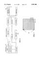
- FIG. 1is a block diagram representation of the entire system.
- FIG. 2illustrated the mechanical concept, showing a likeness of the anticipated packaging of the hand-held portion of the system.
- FIG. 3illustrates the mechanical concept of the optical viewport which shows how the optics are oriented relative to the display and electronic cabling.
- FIG. 4illustrates the arrangement of lenses relative to the display and details aspects important to shielding the display from ambient light.
- FIG. 5illustrates the basic concept behind the organization of a TIFF format data file.
- FIG. 6is a flow diagram of the encoding/decoding process for georeferenced data storage.
- FIG. 7describes the approach used to attach geographic significance to the stored data file.
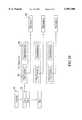
- FIG. 8is a flow diagram of a tile-based compression process embodying the principles of the present invention.
- FIG. 9portrays an approach to providing geographical referencing for each image tile within an image.
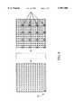
- FIG. 10illustrates the concept of a tile-based image data file embodying the principles of the present invention.
- FIG. 1A block diagram of the system is provided in FIG. 1.
- the system 10contains an optical viewport 11 which takes a small (nominally 18 mm diagonal) LCD or equivalent display and expands the image such that it appears to the user as a full-size computer display.
- the imageis controlled by an embedded processor 12 which retrieves georeferenced map data from a non-volatile storage system.
- the processoruses position information received from the GPS receiver 13 and creates an image showing the user's position on the color display.
- the host interface 14is used to load map data into the handheld unit and the user interface 15 contains pushbuttons for the user to pan and zoom and which allow setting up and configuring the unit.
- This deviceis to allow a user to store maps and other information in a small, portable device that also provides position information using a GPS receiver.
- a userWhen using this device, a user would typically obtain raster-format digitized maps which would be edited using companion software on a personal computer. Edits might include the addition of points of interest, waypoints, trails, or other pertinent data. This information would then be uploaded to the device, which would store it in non-volatile memory. Non-volatile storage may also reside on removable memory cards which the user inserts into the handheld unit.
- the devicethen becomes self-contained, housing a GPS receiver, internal rechargable batteries, map data, and a user display.
- a menu driven interfacethe user can see where they are on the map and perform other functions such as calculating the distance to a particular point, or panning and zooming the image to investigate map details.
- the designshall also allow the user to purchase memory cards that are pre-programmed with map data covering specific geographical regions to which the user can add waypoints, trails, and other information using the device's user interface.
- optical viewportIn this device there are two areas which required the development of new technology: the optical viewport and the georeferenced data storage/access.
- FIG. 2illustrates the anticipated mechanical configuration of the device.
- the devicewill be housed in a high-impact plastic case 16 that is sufficiently conductive internally to shield the internal electronics.
- On the left side(as viewed from the top) is an optical viewing port 11 that allows the user to see an internal display.
- the viewport housingmay be movable to allow the user additional flexibility when operating the device.
- buttonsare provided along the top of the device.
- a hexagonal paddominates the user interface and provides the user the ability to scroll the display right, left, up, down, or along a diagonal. Additional buttons are provided to allow the user to zoom in or out, turn the unit on or off, and to provide additional functions.
- the front of the unitwill hold jacks for communications with an external PC, memory cards, and power for using an external battery and recharging the internal batteries.
- the antenna for the GPS receiverwill be contained internally.
- the housingsshall be designed in a manner that minimizes penetration by water, salt, sand, and other environmental hazards.
- FIG. 3A mechanical overview of the optical viewport is illustrated in FIG. 3.
- a rubber bellows similar in nature to a camera light shieldreduces the amount of external light which enters the viewport.
- a system of plastic, polycarbonate, or glass lensesgives the user the illusion that they are viewing a much larger screen than physically exists in the device.
- the goalis to have the image appear to be approximately 22 ⁇ 30 centimeters as viewed from a distance of about 40-60 centimeters.
- the displayinterfaces to the electronics using a flexible cable which passes from the viewport housing into the electronics area of the main housing.
- the viewport housing halvesmay include a compression gasket.
- the mechanical supports for the optical componentsmay be designed to provide a gas proof seal. Nothing in the design shall prohibit using techniques such as filling the optical area with an inert gas to inhibit the formation of condensation if the device is subjected to temperature and humidity extremes.
- Novel characteristics of the viewportinclude a lack of movable components and sufficient shielding of ambient light that the display becomes usable in direct sunlight. Conversely, provision for backlighting the display allows use of the device in low ambient light conditions. If a focus control proves necessary, it would be integrated between the eyepiece bellows and the first lens of the imaging system.
- a typical USGS quad sheetmay require as much as 40-60 Mbytes of storage in uncompressed format. With compression, the data storage requirement drops to approximately 10-15 Mbytes.
- the devicebe able to decompress .tif (or equivalent) images and do pan/zoom in real-time without having to load the entire (decompressed) image in memory.
- TIFF, GEOTIFF, and other standard image storage formatsare twofold.
- FIG. 5illustrates the manner in which a TIFF file stores image data.
- Each TIFF filebegins with a predefined header which describes certain essential characteristics of the file such as the byte order, the number of images in the file, and so on.
- At the end of the headerthere is a pointer to the first of possibly many directory entries, each of which contains information describing where the data for the component images is stored in the file.
- These directoriescontain pointers to the file locations where lines of image data are stored. Since each line of image data is compressed, each record may be of different length.
- the decompression processworks in a manner similar to that shown in FIG. 6.
- the decompression algorithmuses the TIFF header information to determine how many data pointers exist in the file, how long each image data line should be, and the start address of the data pointers.
- each lineis decompressed in sequence to construct the uncompressed image. Only when the image is fully decompressed is the spatial relationship between pixels fully known since the compression algorithm terminates only when it has decompressed a full line of pixels.
- the proposed solution to this problemis outlined in FIG. 8.
- the first stepinvolves recovering the original scanned image by decoding it from its original storage format into a complete, uncompressed pixel image.
- the second stepinvolves post-processing the image by dividing it into more useful square arrays, or tiles, of georeferenced pixel data.
- An output fileis created which contains header information describing size and geographical location of each tile, pointers to the tile data, and compressed tile data.
- the major steps required to post process the databegin with georeferencing the original image followed by tiling.
- This georeferencingis done by appending geographical coordinates (latitude, longitude, and altitude) to one or more pixels in the uncompressed image and by providing a suitable mathematical expression to relate pixel spacing to geographical spacing.
- a typical 1:25,000 scale topographic mapspans an area of approximately 15 ⁇ 20 kilometers. Since a land user is typically concerned with only a small portion of this data at any given time, the full image is divided into tiles, each of which contains the data for a significantly smaller region (for example 1 square kilometer). The size of the tiles is governed by a tradeoff between the number of tiles which must be stored uncompressed in memory and the speed of decompression. In general, it is expected that a land user will require at least 4 active tiles in memory to allow seamless panning in the event that the user is located at the intersection of four tiles.
- Providing geographical referencing for each tileis accomplished, as illustrated in FIG. 9, by computing the geographic location of each tile. Knowing this information, along with the orientation of the tile relative to the full-image geographical reference point and the size of the tile, allows directly determining which tile contains any possible location on the map.
- a header fieldcontains information about the file structure such as the number of tiles, tile size, number of pixels, aspect ratio, and the required geographic interpolation parameters to calculate position.
- a variable length fieldconsisting of fixed length records which include a pointer to the start of the image data in each tile and the geographical reference for the tile.
- the remaining fieldsare variable length fields which contain compressed image data for each tile.
Landscapes
- Engineering & Computer Science (AREA)
- Remote Sensing (AREA)
- Physics & Mathematics (AREA)
- Radar, Positioning & Navigation (AREA)
- General Physics & Mathematics (AREA)
- Theoretical Computer Science (AREA)
- Educational Technology (AREA)
- Educational Administration (AREA)
- Business, Economics & Management (AREA)
- Mathematical Physics (AREA)
- Computer Networks & Wireless Communication (AREA)
- Automation & Control Theory (AREA)
- Instructional Devices (AREA)
- Navigation (AREA)
Abstract
Description
This Appln. is a con't of Ser. No. 08/835,037 Filed Mar. 27, 1997. This Appln. also claims the benefit of U.S. Provisional No. 60/031,655 filed Nov. 19, 1996.
This invention relates generally to navigation and tracking and specifically to providing real-time positioning on a map image.
Most personal navigation systems exist as hand-held devices which report position in terms of latitude, longitude, and altitude. Primitive mapping functions are usually provided that display the path that a user has followed or provide a simple steering indication to facilitate taking a straight line path towards a desired coordinate. More sophisticated systems may include low resolution map information upon which the users coordinates are overlaid.
There are several problems with these existing systems. First, the use of LCD-type displays makes these devices virtually unusable in direct sunlight because of insufficient display contrast. Second, because the storage of detailed images requires large amounts of data storage, map resolution is limited. Third, because of these storage limitations and because of the difficulty of obtaining accurate map data, the selection of maps for users to exploit is very small.
Addressing these issues requires a device which makes improvements in two fundamental areas. First, a new display system is needed which will allow the user to see presented images clearly in all lighting conditions. Second, improvements in data storage must be made to allow the user to store a meaningful amount of high accuracy data.
The elements of the device described in the following paragraphs which constitute the invention are established in the appended claims. However, understanding the nature of the invention is aided by fully disclosing the characteristics of the device. The following diagrams and illustrations are provided to aid in this understanding:
FIG. 1 is a block diagram representation of the entire system.
FIG. 2 illustrated the mechanical concept, showing a likeness of the anticipated packaging of the hand-held portion of the system.
FIG. 3 illustrates the mechanical concept of the optical viewport which shows how the optics are oriented relative to the display and electronic cabling.
FIG. 4 illustrates the arrangement of lenses relative to the display and details aspects important to shielding the display from ambient light.
FIG. 5 illustrates the basic concept behind the organization of a TIFF format data file.
FIG. 6 is a flow diagram of the encoding/decoding process for georeferenced data storage.
FIG. 7 describes the approach used to attach geographic significance to the stored data file.
FIG. 8 is a flow diagram of a tile-based compression process embodying the principles of the present invention.
FIG. 9 portrays an approach to providing geographical referencing for each image tile within an image.
FIG. 10 illustrates the concept of a tile-based image data file embodying the principles of the present invention.
A block diagram of the system is provided in FIG. 1. As illustrated in the figure, thesystem 10 contains anoptical viewport 11 which takes a small (nominally 18 mm diagonal) LCD or equivalent display and expands the image such that it appears to the user as a full-size computer display. The image is controlled by an embeddedprocessor 12 which retrieves georeferenced map data from a non-volatile storage system. The processor uses position information received from theGPS receiver 13 and creates an image showing the user's position on the color display. Thehost interface 14 is used to load map data into the handheld unit and theuser interface 15 contains pushbuttons for the user to pan and zoom and which allow setting up and configuring the unit.
The purpose of this device is to allow a user to store maps and other information in a small, portable device that also provides position information using a GPS receiver. When using this device, a user would typically obtain raster-format digitized maps which would be edited using companion software on a personal computer. Edits might include the addition of points of interest, waypoints, trails, or other pertinent data. This information would then be uploaded to the device, which would store it in non-volatile memory. Non-volatile storage may also reside on removable memory cards which the user inserts into the handheld unit.
In operation, the device then becomes self-contained, housing a GPS receiver, internal rechargable batteries, map data, and a user display. Using a menu driven interface, the user can see where they are on the map and perform other functions such as calculating the distance to a particular point, or panning and zooming the image to investigate map details. To support users without access to a person computer, the design shall also allow the user to purchase memory cards that are pre-programmed with map data covering specific geographical regions to which the user can add waypoints, trails, and other information using the device's user interface.
In this device there are two areas which required the development of new technology: the optical viewport and the georeferenced data storage/access.
FIG. 2 illustrates the anticipated mechanical configuration of the device. The device will be housed in a high-impactplastic case 16 that is sufficiently conductive internally to shield the internal electronics. On the left side (as viewed from the top) is anoptical viewing port 11 that allows the user to see an internal display. In general, the viewport housing may be movable to allow the user additional flexibility when operating the device.
Along the top of the device are user interface buttons. A hexagonal pad dominates the user interface and provides the user the ability to scroll the display right, left, up, down, or along a diagonal. Additional buttons are provided to allow the user to zoom in or out, turn the unit on or off, and to provide additional functions. The front of the unit will hold jacks for communications with an external PC, memory cards, and power for using an external battery and recharging the internal batteries. The antenna for the GPS receiver will be contained internally.
The housings shall be designed in a manner that minimizes penetration by water, salt, sand, and other environmental hazards.
A mechanical overview of the optical viewport is illustrated in FIG. 3. At the front end of the device, a rubber bellows similar in nature to a camera light shield reduces the amount of external light which enters the viewport. A system of plastic, polycarbonate, or glass lenses gives the user the illusion that they are viewing a much larger screen than physically exists in the device. The goal is to have the image appear to be approximately 22×30 centimeters as viewed from a distance of about 40-60 centimeters. The display interfaces to the electronics using a flexible cable which passes from the viewport housing into the electronics area of the main housing.
To prevent the entry of contaminants, the viewport housing halves may include a compression gasket. Similarly, the mechanical supports for the optical components may be designed to provide a gas proof seal. Nothing in the design shall prohibit using techniques such as filling the optical area with an inert gas to inhibit the formation of condensation if the device is subjected to temperature and humidity extremes.
The details of the actual imaging system are provided in FIG. 4. Novel characteristics of the viewport include a lack of movable components and sufficient shielding of ambient light that the display becomes usable in direct sunlight. Conversely, provision for backlighting the display allows use of the device in low ambient light conditions. If a focus control proves necessary, it would be integrated between the eyepiece bellows and the first lens of the imaging system.
Data storage and retrieval is a major problem when handling geographic data. A typical USGS quad sheet may require as much as 40-60 Mbytes of storage in uncompressed format. With compression, the data storage requirement drops to approximately 10-15 Mbytes.
In most graphical applications, a 10-15 Mbyte compressed image is decompressed into virtual memory to its original size at which point it can be accessed as if it was a single large array. Since the total memory available in the handheld device will generally be far less than the uncompressed image requires, a more novel data compression, retrieval, and storage scheme is required.
It is essential that the device be able to decompress .tif (or equivalent) images and do pan/zoom in real-time without having to load the entire (decompressed) image in memory.
The problem with TIFF, GEOTIFF, and other standard image storage formats is twofold. First, these file formats generally allow storing information randomly in memory. Second, the data in the files is compressed into variable length records using a technique such as Bit Packing, LZW or Huffman coding. This results in a file that is encoded in a manner that makes it difficult to directly access an arbitrary portion of the compressed image (as would be common when doing pan and zoom).
As an example, FIG. 5 illustrates the manner in which a TIFF file stores image data. Each TIFF file begins with a predefined header which describes certain essential characteristics of the file such as the byte order, the number of images in the file, and so on. At the end of the header there is a pointer to the first of possibly many directory entries, each of which contains information describing where the data for the component images is stored in the file. These directories contain pointers to the file locations where lines of image data are stored. Since each line of image data is compressed, each record may be of different length.
The decompression process works in a manner similar to that shown in FIG. 6. The decompression algorithm uses the TIFF header information to determine how many data pointers exist in the file, how long each image data line should be, and the start address of the data pointers. Next, each line is decompressed in sequence to construct the uncompressed image. Only when the image is fully decompressed is the spatial relationship between pixels fully known since the compression algorithm terminates only when it has decompressed a full line of pixels.
As illustrated in FIG. 7, once the image is fully decompressed, precise spatial relationships can be determined. This is accomplished by georeferencing the image data by correlating pixel locations with land features. By knowing the geographic location of one or more reference pixels, the orientation of the pixel image, and distance represented by adjacent pixels (dx and dy) good correspondence between the image and the mapped features is obtained.
The proposed solution to this problem is outlined in FIG. 8. As shown in the figure, there are two main steps required to process the original TIFF (or other) format image data. The first step involves recovering the original scanned image by decoding it from its original storage format into a complete, uncompressed pixel image. The second step involves post-processing the image by dividing it into more useful square arrays, or tiles, of georeferenced pixel data. An output file is created which contains header information describing size and geographical location of each tile, pointers to the tile data, and compressed tile data.
As shown in FIG. 8, the major steps required to post process the data begin with georeferencing the original image followed by tiling. This georeferencing is done by appending geographical coordinates (latitude, longitude, and altitude) to one or more pixels in the uncompressed image and by providing a suitable mathematical expression to relate pixel spacing to geographical spacing. This mathematical expression may be as simple as a scaling factor such as 1 pixel=50 feet, or it may be a more complicated expression which accounts for spherical corrections.
A typical 1:25,000 scale topographic map spans an area of approximately 15×20 kilometers. Since a land user is typically concerned with only a small portion of this data at any given time, the full image is divided into tiles, each of which contains the data for a significantly smaller region (for example 1 square kilometer). The size of the tiles is governed by a tradeoff between the number of tiles which must be stored uncompressed in memory and the speed of decompression. In general, it is expected that a land user will require at least 4 active tiles in memory to allow seamless panning in the event that the user is located at the intersection of four tiles.
Providing geographical referencing for each tile is accomplished, as illustrated in FIG. 9, by computing the geographic location of each tile. Knowing this information, along with the orientation of the tile relative to the full-image geographical reference point and the size of the tile, allows directly determining which tile contains any possible location on the map.
To facilitate efficient use of the tiled data, a file structure such as the one illustrated in FIG. 10 is proposed. A header field contains information about the file structure such as the number of tiles, tile size, number of pixels, aspect ratio, and the required geographic interpolation parameters to calculate position. Following the header, is a variable length field consisting of fixed length records which include a pointer to the start of the image data in each tile and the geographical reference for the tile. The remaining fields are variable length fields which contain compressed image data for each tile.
Given this format, both the location of the tile data in the file and the geographic location of the file reference are both known. Because this is true, variable length data fields no longer pose a problem, since each tile covers a minimum acceptable geographic region. Thus, given a user location, the tiles needed by the user can be directly identified. Since the starting location of the data is known both geographically and in terms of data storage only the desired tile need be decompressed. This format also facilitates caching uncompressed tiles based on user movement to facilitate smooth pan and zoom without requiring that the entire image be decompressed in memory.
Claims (1)
1. A system for storing an image and viewing a portion of the image, comprising the steps of:
a) selecting an image,
b) dividing the image into tiles,
c) establishing geographical referencing of each tile in its physical relationship within the image,
d) compressing the image of each tile,
e) forming an output file of image data of all of the tiles, which, taken together, represent said image, said image data including;
i) header data describing the size and geographical location of each tile,
ii) pointers to the location, in the storage unit, of the data for each tile,
iii) compressed tile data for each tile,
f) storing the image data in the output file in an image storage unit adapted to store image data and to provide the image data to a computer,
g) selecting a tile to view using the geographical referencing data,
h) locating the tile image data of the said tile using the pointer, and
i) decompressing the tile image data of the said tile.
Priority Applications (1)
| Application Number | Priority Date | Filing Date | Title |
|---|---|---|---|
| US09/237,152US5987380A (en) | 1996-11-19 | 1999-01-25 | Hand-held GPS-mapping device |
Applications Claiming Priority (3)
| Application Number | Priority Date | Filing Date | Title |
|---|---|---|---|
| US3165596P | 1996-11-19 | 1996-11-19 | |
| US08/835,037US5902347A (en) | 1996-11-19 | 1997-03-27 | Hand-held GPS-mapping device |
| US09/237,152US5987380A (en) | 1996-11-19 | 1999-01-25 | Hand-held GPS-mapping device |
Related Parent Applications (1)
| Application Number | Title | Priority Date | Filing Date |
|---|---|---|---|
| US08/835,037ContinuationUS5902347A (en) | 1996-11-19 | 1997-03-27 | Hand-held GPS-mapping device |
Publications (1)
| Publication Number | Publication Date |
|---|---|
| US5987380Atrue US5987380A (en) | 1999-11-16 |
Family
ID=26707487
Family Applications (2)
| Application Number | Title | Priority Date | Filing Date |
|---|---|---|---|
| US08/835,037Expired - LifetimeUS5902347A (en) | 1996-11-19 | 1997-03-27 | Hand-held GPS-mapping device |
| US09/237,152Expired - LifetimeUS5987380A (en) | 1996-11-19 | 1999-01-25 | Hand-held GPS-mapping device |
Family Applications Before (1)
| Application Number | Title | Priority Date | Filing Date |
|---|---|---|---|
| US08/835,037Expired - LifetimeUS5902347A (en) | 1996-11-19 | 1997-03-27 | Hand-held GPS-mapping device |
Country Status (4)
| Country | Link |
|---|---|
| US (2) | US5902347A (en) |
| EP (1) | EP0941485A4 (en) |
| AU (1) | AU5587398A (en) |
| WO (1) | WO1998022831A1 (en) |
Cited By (62)
| Publication number | Priority date | Publication date | Assignee | Title |
|---|---|---|---|---|
| US6198431B1 (en) | 1998-08-27 | 2001-03-06 | Maptrek Llc | Compact GPS tracker and customized mapping system |
| US20010026271A1 (en)* | 2000-03-29 | 2001-10-04 | Higgins Darin Wayne | System and method for synchronizing raster and vector map images |
| US20010033292A1 (en)* | 2000-03-29 | 2001-10-25 | Scott Dan Martin | System and method for georeferencing digital raster maps |
| US6317689B1 (en)* | 2000-02-09 | 2001-11-13 | Garmin Corporation | Method and device for displaying animated navigation information |
| WO2002001484A1 (en)* | 2000-06-26 | 2002-01-03 | Datria Systems, Inc. | Relational and spatial database management system and method |
| US20020073331A1 (en)* | 2000-12-08 | 2002-06-13 | Brant Candelore | Interacting automatically with a personal service device to customize services |
| US20020097894A1 (en)* | 2001-01-24 | 2002-07-25 | David Staas | System and method for geographical indexing of images |
| US6515673B1 (en) | 2000-02-16 | 2003-02-04 | Enroute, Inc. | Displaying immersive videos using tiled decompression |
| US6559853B1 (en) | 2000-02-16 | 2003-05-06 | Enroute, Inc. | Environment map creation using texture projections with polygonal curved surfaces |
| US20030171391A1 (en)* | 2002-01-25 | 2003-09-11 | Boehringer Ingelheim Pharma Gmbh & Co. Kg | Ambroxol for the treatment of chronic pain |
| US20030190158A1 (en)* | 2002-04-09 | 2003-10-09 | Roth James M. | End-user-navigable set of zoomed-in images derived from a high-resolution master image |
| US6810323B1 (en)* | 2000-09-25 | 2004-10-26 | Motorola, Inc. | System and method for storing and using information associated with geographic locations of interest to a mobile user |
| US20050050575A1 (en)* | 2001-05-22 | 2005-03-03 | Marc Arseneau | Multi-video receiving method and apparatus |
| US20050073532A1 (en)* | 2000-03-29 | 2005-04-07 | Scott Dan Martin | System and method for georeferencing maps |
| US6897858B1 (en) | 2000-02-16 | 2005-05-24 | Enroute, Inc. | Partial image decompression of a tiled image |
| US20050159882A1 (en)* | 2000-03-29 | 2005-07-21 | Howard John W. | System and method for performing flood zone certicifications |
| US6986463B2 (en) | 2000-12-11 | 2006-01-17 | Sony Corporation | Method and system of broadcasting item location |
| US6988049B1 (en) | 2004-01-28 | 2006-01-17 | The United States Of America As Represented By The Secretary Of The Navy | Apparatus and method for providing true geodetic coordinates |
| US20060094426A1 (en)* | 2004-10-29 | 2006-05-04 | Donaho Ralph W | Wireless communication system and method |
| US20060287816A1 (en)* | 2005-06-17 | 2006-12-21 | Bardsley Jeffrey S | Methods, systems, and computer program products for indicating a return route in a mobile device |
| US20070009863A1 (en)* | 2004-10-14 | 2007-01-11 | Hart Alan S | Off-highway vehicle trail map directory |
| US7224985B2 (en) | 2003-01-16 | 2007-05-29 | Lockheed Martin, Corp. | Antenna segment system |
| US7259760B1 (en) | 2000-02-16 | 2007-08-21 | Be Here Corporation | Polygonal curvature mapping to increase texture efficiency |
| US20070253639A1 (en)* | 2006-05-01 | 2007-11-01 | The United States Of America As Represented By The Secretary Of The Navy | Imagery analysis tool |
| US20080082258A1 (en)* | 2006-09-05 | 2008-04-03 | Honeywell International Inc. | Portable Positioning and Navigation System |
| GB2446167A (en)* | 2007-02-02 | 2008-08-06 | Satmap Systems Ltd | Electronic map |
| US7440610B1 (en) | 2004-01-28 | 2008-10-21 | The United States Of America As Represented By The Secretary Of The Navy | Apparatus and method for image based coordinate determination |
| US20090201022A1 (en)* | 2008-02-11 | 2009-08-13 | Ralph Oppelt | Control apparatus for a magnetic resonance imaging antenna arrangement |
| US20090254867A1 (en)* | 2008-04-03 | 2009-10-08 | Microsoft Corporation | Zoom for annotatable margins |
| US20090307618A1 (en)* | 2008-06-05 | 2009-12-10 | Microsoft Corporation | Annotate at multiple levels |
| US20100077441A1 (en)* | 2005-07-22 | 2010-03-25 | Genevieve Thomas | Buffering content on a handheld electronic device |
| US7698061B2 (en) | 2005-09-23 | 2010-04-13 | Scenera Technologies, Llc | System and method for selecting and presenting a route to a user |
| US20100161214A1 (en)* | 2006-04-14 | 2010-06-24 | Mona Singh | System And Method For Presenting A Computed Route |
| US7908080B2 (en) | 2004-12-31 | 2011-03-15 | Google Inc. | Transportation routing |
| US20110135163A1 (en)* | 2008-03-18 | 2011-06-09 | Certusview Technologies, Llc | Methods and apparatus for providing unbuffered dig area indicators on aerial images to delimit planned excavation sites |
| US8051452B2 (en) | 2005-07-22 | 2011-11-01 | Kangaroo Media, Inc. | System and methods for enhancing the experience of spectators attending a live sporting event, with contextual information distribution capability |
| US8122341B1 (en) | 2006-06-17 | 2012-02-21 | Google Inc. | Sharing geographical information between users |
| US8265344B2 (en) | 2008-02-12 | 2012-09-11 | Certusview Technologies, Llc | Electronic manifest of underground facility locate operation |
| US8270666B2 (en) | 2008-02-12 | 2012-09-18 | Certusview Technologies, Llc | Searchable electronic records of underground facility locate marking operations |
| US8280117B2 (en) | 2008-03-18 | 2012-10-02 | Certusview Technologies, Llc | Virtual white lines for indicating planned excavation sites on electronic images |
| US8296308B2 (en) | 2009-02-11 | 2012-10-23 | Certusview Technologies, Llc | Methods and apparatus for associating a virtual white line (VWL) image with corresponding ticket information for an excavation project |
| US8311765B2 (en) | 2009-08-11 | 2012-11-13 | Certusview Technologies, Llc | Locating equipment communicatively coupled to or equipped with a mobile/portable device |
| US8361543B2 (en) | 2008-10-02 | 2013-01-29 | Certusview Technologies, Llc | Methods and apparatus for displaying an electronic rendering of a marking operation based on an electronic record of marking information |
| US8374789B2 (en) | 2007-04-04 | 2013-02-12 | Certusview Technologies, Llc | Systems and methods for using marking information to electronically display dispensing of markers by a marking system or marking tool |
| US8400155B2 (en) | 2008-10-02 | 2013-03-19 | Certusview Technologies, Llc | Methods and apparatus for displaying an electronic rendering of a locate operation based on an electronic record of locate information |
| US8407001B2 (en) | 2007-03-13 | 2013-03-26 | Certusview Technologies, Llc | Systems and methods for using location data to electronically display dispensing of markers by a marking system or marking tool |
| US8442766B2 (en) | 2008-10-02 | 2013-05-14 | Certusview Technologies, Llc | Marking apparatus having enhanced features for underground facility marking operations, and associated methods and systems |
| US8566737B2 (en) | 2009-02-11 | 2013-10-22 | Certusview Technologies, Llc | Virtual white lines (VWL) application for indicating an area of planned excavation |
| US8572193B2 (en) | 2009-02-10 | 2013-10-29 | Certusview Technologies, Llc | Methods, apparatus, and systems for providing an enhanced positive response in underground facility locate and marking operations |
| US8583372B2 (en) | 2009-12-07 | 2013-11-12 | Certusview Technologies, Llc | Methods, apparatus, and systems for facilitating compliance with marking specifications for dispensing marking material |
| US8620532B2 (en) | 2009-03-25 | 2013-12-31 | Waldeck Technology, Llc | Passive crowd-sourced map updates and alternate route recommendations |
| US8620572B2 (en) | 2009-08-20 | 2013-12-31 | Certusview Technologies, Llc | Marking device with transmitter for triangulating location during locate operations |
| US8620616B2 (en) | 2009-08-20 | 2013-12-31 | Certusview Technologies, Llc | Methods and apparatus for assessing marking operations based on acceleration information |
| US8626571B2 (en) | 2009-02-11 | 2014-01-07 | Certusview Technologies, Llc | Management system, and associated methods and apparatus, for dispatching tickets, receiving field information, and performing a quality assessment for underground facility locate and/or marking operations |
| US8721502B2 (en) | 2001-02-20 | 2014-05-13 | Adidas Ag | Systems and methods for displaying performance information |
| US8830265B2 (en) | 2009-07-07 | 2014-09-09 | Certusview Technologies, Llc | Methods, apparatus and systems for generating searchable electronic records of underground facility marking operations and assessing aspects of same |
| US8902251B2 (en) | 2009-02-10 | 2014-12-02 | Certusview Technologies, Llc | Methods, apparatus and systems for generating limited access files for searchable electronic records of underground facility locate and/or marking operations |
| US8930836B2 (en) | 2008-10-02 | 2015-01-06 | Certusview Technologies, Llc | Methods and apparatus for displaying an electronic rendering of a locate and/or marking operation using display layers |
| US20150065178A1 (en)* | 2013-09-03 | 2015-03-05 | Qualcomm Incorporated | Methods and apparatuses for providing positioning assistance data |
| US8977558B2 (en) | 2010-08-11 | 2015-03-10 | Certusview Technologies, Llc | Methods, apparatus and systems for facilitating generation and assessment of engineering plans |
| US9097522B2 (en) | 2009-08-20 | 2015-08-04 | Certusview Technologies, Llc | Methods and marking devices with mechanisms for indicating and/or detecting marking material color |
| US9280269B2 (en) | 2008-02-12 | 2016-03-08 | Certusview Technologies, Llc | Electronic manifest of underground facility locate marks |
Families Citing this family (123)
| Publication number | Priority date | Publication date | Assignee | Title |
|---|---|---|---|---|
| US6535210B1 (en) | 1995-06-07 | 2003-03-18 | Geovector Corp. | Vision system computer modeling apparatus including interaction with real scenes with respect to perspective and spatial relationship as measured in real-time |
| US6016606A (en)* | 1997-04-25 | 2000-01-25 | Navitrak International Corporation | Navigation device having a viewer for superimposing bearing, GPS position and indexed map information |
| JP3535724B2 (en)* | 1997-12-25 | 2004-06-07 | キヤノン株式会社 | Image capturing apparatus and method, and storage medium |
| WO1999042946A2 (en)* | 1998-02-18 | 1999-08-26 | Geovector Corporation | Apparatus and methods for presentation of information relating to objects being addressed |
| DE19841262C2 (en)* | 1998-09-09 | 2000-12-28 | Ibs Integrierte Business Syste | Electronic circuit for recording geographic position data on the sound channel of a camcorder |
| US6393149B2 (en)* | 1998-09-17 | 2002-05-21 | Navigation Technologies Corp. | Method and system for compressing data and a geographic database formed therewith and methods for use thereof in a navigation application program |
| US6173239B1 (en)* | 1998-09-30 | 2001-01-09 | Geo Vector Corporation | Apparatus and methods for presentation of information relating to objects being addressed |
| JP2000194726A (en)* | 1998-10-19 | 2000-07-14 | Sony Corp | Device, method and system for processing information and providing medium |
| US6801223B1 (en) | 1998-12-18 | 2004-10-05 | Tangis Corporation | Managing interactions between computer users' context models |
| US7055101B2 (en)* | 1998-12-18 | 2006-05-30 | Tangis Corporation | Thematic response to a computer user's context, such as by a wearable personal computer |
| US6747675B1 (en)* | 1998-12-18 | 2004-06-08 | Tangis Corporation | Mediating conflicts in computer user's context data |
| US6920616B1 (en)* | 1998-12-18 | 2005-07-19 | Tangis Corporation | Interface for exchanging context data |
| US7231439B1 (en) | 2000-04-02 | 2007-06-12 | Tangis Corporation | Dynamically swapping modules for determining a computer user's context |
| US7080322B2 (en)* | 1998-12-18 | 2006-07-18 | Tangis Corporation | Thematic response to a computer user's context, such as by a wearable personal computer |
| US6842877B2 (en)* | 1998-12-18 | 2005-01-11 | Tangis Corporation | Contextual responses based on automated learning techniques |
| US7076737B2 (en)* | 1998-12-18 | 2006-07-11 | Tangis Corporation | Thematic response to a computer user's context, such as by a wearable personal computer |
| US6466232B1 (en)* | 1998-12-18 | 2002-10-15 | Tangis Corporation | Method and system for controlling presentation of information to a user based on the user's condition |
| US7779015B2 (en)* | 1998-12-18 | 2010-08-17 | Microsoft Corporation | Logging and analyzing context attributes |
| US7046263B1 (en)* | 1998-12-18 | 2006-05-16 | Tangis Corporation | Requesting computer user's context data |
| US8225214B2 (en) | 1998-12-18 | 2012-07-17 | Microsoft Corporation | Supplying enhanced computer user's context data |
| US7107539B2 (en)* | 1998-12-18 | 2006-09-12 | Tangis Corporation | Thematic response to a computer user's context, such as by a wearable personal computer |
| US6513046B1 (en)* | 1999-12-15 | 2003-01-28 | Tangis Corporation | Storing and recalling information to augment human memories |
| US8181113B2 (en)* | 1998-12-18 | 2012-05-15 | Microsoft Corporation | Mediating conflicts in computer users context data |
| US6812937B1 (en) | 1998-12-18 | 2004-11-02 | Tangis Corporation | Supplying enhanced computer user's context data |
| US7225229B1 (en)* | 1998-12-18 | 2007-05-29 | Tangis Corporation | Automated pushing of computer user's context data to clients |
| US9183306B2 (en) | 1998-12-18 | 2015-11-10 | Microsoft Technology Licensing, Llc | Automated selection of appropriate information based on a computer user's context |
| US7073129B1 (en) | 1998-12-18 | 2006-07-04 | Tangis Corporation | Automated selection of appropriate information based on a computer user's context |
| US6791580B1 (en)* | 1998-12-18 | 2004-09-14 | Tangis Corporation | Supplying notifications related to supply and consumption of user context data |
| US7330150B1 (en) | 1999-05-07 | 2008-02-12 | Garmin Corporation | Combined global positioning system receiver and radio |
| US7196659B1 (en) | 1999-05-07 | 2007-03-27 | Garmin Corporation | Combined global positioning system receiver and radio |
| US6373430B1 (en) | 1999-05-07 | 2002-04-16 | Gamin Corporation | Combined global positioning system receiver and radio |
| US6285320B1 (en) | 1999-09-03 | 2001-09-04 | Sikorsky Aircraft Corporation | Apparatus and method for mapping surfaces of an object |
| US6323807B1 (en) | 2000-02-17 | 2001-11-27 | Mitsubishi Electric Research Laboratories, Inc. | Indoor navigation with wearable passive sensors |
| US7403972B1 (en) | 2002-04-24 | 2008-07-22 | Ip Venture, Inc. | Method and system for enhanced messaging |
| US7366522B2 (en) | 2000-02-28 | 2008-04-29 | Thomas C Douglass | Method and system for location tracking |
| US6975941B1 (en) | 2002-04-24 | 2005-12-13 | Chung Lau | Method and apparatus for intelligent acquisition of position information |
| US7218938B1 (en) | 2002-04-24 | 2007-05-15 | Chung Lau | Methods and apparatus to analyze and present location information |
| US7212829B1 (en) | 2000-02-28 | 2007-05-01 | Chung Lau | Method and system for providing shipment tracking and notifications |
| US7170518B1 (en)* | 2000-03-27 | 2007-01-30 | Magellan Dis, Inc. | Selective rendering of cartographic entities for a navigation system |
| US6631326B1 (en) | 2000-03-29 | 2003-10-07 | Sourceprose Corporation | System and method for performing flood zone certifications |
| US7464153B1 (en) | 2000-04-02 | 2008-12-09 | Microsoft Corporation | Generating and supplying user context data |
| WO2001075676A2 (en) | 2000-04-02 | 2001-10-11 | Tangis Corporation | Soliciting information based on a computer user's context |
| US20020054130A1 (en) | 2000-10-16 | 2002-05-09 | Abbott Kenneth H. | Dynamically displaying current status of tasks |
| US6898559B2 (en)* | 2000-12-08 | 2005-05-24 | Tracker R&D, Llc | System for dynamic and automatic building mapping |
| US7031875B2 (en) | 2001-01-24 | 2006-04-18 | Geo Vector Corporation | Pointing systems for addressing objects |
| US6718176B2 (en)* | 2001-03-01 | 2004-04-06 | Nokia Corporation | Apparatus, and associated method, for displaying positional data associated with mobile stations of a radio communication system |
| US6622088B2 (en)* | 2001-03-02 | 2003-09-16 | Hill-Rom Services, Inc. | Ambulatory navigation system |
| FR2823391A1 (en)* | 2001-04-05 | 2002-10-11 | Patrick Jean Jacques Segur | NEW SYSTEM OF UNITS APPLYING BASE 3 AND CORRESPONDING APPLICATIONS (MAPPING) |
| US20020145617A1 (en)* | 2001-04-06 | 2002-10-10 | Kennard Robert M. | Methods of marketing maps depicting the location of real property and geographic characteristics in the vicinity thereof |
| US20020147613A1 (en)* | 2001-04-10 | 2002-10-10 | Kennard Robert M. | Methods of marketing summary maps depicting the location of real property and certain traits in the vicinity thereof |
| US7142900B1 (en)* | 2001-11-01 | 2006-11-28 | Garmin Ltd. | Combined global positioning system receiver and radio |
| US6985903B2 (en)* | 2002-01-25 | 2006-01-10 | Qualcomm, Incorporated | Method and system for storage and fast retrieval of digital terrain model elevations for use in positioning systems |
| US9049571B2 (en) | 2002-04-24 | 2015-06-02 | Ipventure, Inc. | Method and system for enhanced messaging |
| US9182238B2 (en) | 2002-04-24 | 2015-11-10 | Ipventure, Inc. | Method and apparatus for intelligent acquisition of position information |
| US7398209B2 (en) | 2002-06-03 | 2008-07-08 | Voicebox Technologies, Inc. | Systems and methods for responding to natural language speech utterance |
| US7599983B2 (en) | 2002-06-18 | 2009-10-06 | Wireless Ink Corporation | Method, apparatus and system for management of information content for enhanced accessibility over wireless communication networks |
| US6873329B2 (en)* | 2002-07-05 | 2005-03-29 | Spatial Data Technologies, Inc. | System and method for caching and rendering images |
| US7068819B1 (en)* | 2002-07-12 | 2006-06-27 | The United States Of America As Represented By The Secretary Of The Navy | System for storing geospecific data |
| US7693720B2 (en) | 2002-07-15 | 2010-04-06 | Voicebox Technologies, Inc. | Mobile systems and methods for responding to natural language speech utterance |
| US6748323B2 (en) | 2002-07-31 | 2004-06-08 | Thales North America, Inc. | Displaying data |
| JP4136517B2 (en)* | 2002-07-31 | 2008-08-20 | 株式会社日立製作所 | Mobile terminal |
| US7002551B2 (en)* | 2002-09-25 | 2006-02-21 | Hrl Laboratories, Llc | Optical see-through augmented reality modified-scale display |
| US20070035562A1 (en)* | 2002-09-25 | 2007-02-15 | Azuma Ronald T | Method and apparatus for image enhancement |
| US20040066391A1 (en)* | 2002-10-02 | 2004-04-08 | Mike Daily | Method and apparatus for static image enhancement |
| US20040068758A1 (en)* | 2002-10-02 | 2004-04-08 | Mike Daily | Dynamic video annotation |
| GB0303888D0 (en)* | 2003-02-19 | 2003-03-26 | Sec Dep Acting Through Ordnanc | Image streaming |
| US20040189027A1 (en)* | 2003-03-26 | 2004-09-30 | Warn Ian H. | Animal feces pick-up device |
| US20040219961A1 (en)* | 2003-04-08 | 2004-11-04 | Ellenby Thomas William | Computer games having variable execution dependence with respect to spatial properties of a mobile unit. |
| US6989753B1 (en) | 2003-12-12 | 2006-01-24 | Hewlett-Packard Development Company, L.P. | Method of and computer for identifying reminder event |
| CN100535601C (en) | 2004-03-19 | 2009-09-02 | 日本先锋公司 | Portable information processor |
| US7865301B2 (en)* | 2004-03-23 | 2011-01-04 | Google Inc. | Secondary map in digital mapping system |
| WO2005104039A2 (en)* | 2004-03-23 | 2005-11-03 | Google, Inc. | A digital mapping system |
| US7599790B2 (en)* | 2004-03-23 | 2009-10-06 | Google Inc. | Generating and serving tiles in a digital mapping system |
| KR100712966B1 (en)* | 2004-12-27 | 2007-05-02 | 주식회사 엔지스테크널러지 | Navigation service method and terminal accordingly |
| US20060190812A1 (en)* | 2005-02-22 | 2006-08-24 | Geovector Corporation | Imaging systems including hyperlink associations |
| US7640160B2 (en)* | 2005-08-05 | 2009-12-29 | Voicebox Technologies, Inc. | Systems and methods for responding to natural language speech utterance |
| US7620549B2 (en) | 2005-08-10 | 2009-11-17 | Voicebox Technologies, Inc. | System and method of supporting adaptive misrecognition in conversational speech |
| US7949529B2 (en) | 2005-08-29 | 2011-05-24 | Voicebox Technologies, Inc. | Mobile systems and methods of supporting natural language human-machine interactions |
| US7634409B2 (en) | 2005-08-31 | 2009-12-15 | Voicebox Technologies, Inc. | Dynamic speech sharpening |
| US7712670B2 (en)* | 2005-09-28 | 2010-05-11 | Sauerwein Jr James T | Data collection device and network having radio signal responsive mode switching |
| US7933897B2 (en) | 2005-10-12 | 2011-04-26 | Google Inc. | Entity display priority in a distributed geographic information system |
| US8942483B2 (en) | 2009-09-14 | 2015-01-27 | Trimble Navigation Limited | Image-based georeferencing |
| US7925320B2 (en) | 2006-03-06 | 2011-04-12 | Garmin Switzerland Gmbh | Electronic device mount |
| US7577516B2 (en)* | 2006-05-09 | 2009-08-18 | Hand Held Products, Inc. | Power management apparatus and methods for portable data terminals |
| US20070276592A1 (en)* | 2006-05-26 | 2007-11-29 | States Pride, Llc. | Method for deep mapping |
| US7879846B2 (en)* | 2006-09-21 | 2011-02-01 | Kyorin Pharmaceutical Co.., Ltd. | Serine hydrolase inhibitors |
| US8073681B2 (en) | 2006-10-16 | 2011-12-06 | Voicebox Technologies, Inc. | System and method for a cooperative conversational voice user interface |
| US7818176B2 (en) | 2007-02-06 | 2010-10-19 | Voicebox Technologies, Inc. | System and method for selecting and presenting advertisements based on natural language processing of voice-based input |
| US20090012707A1 (en)* | 2007-07-06 | 2009-01-08 | Krage Mark K | Position data entry and route planning entry for portable navigation systems |
| US8554475B2 (en) | 2007-10-01 | 2013-10-08 | Mitac International Corporation | Static and dynamic contours |
| US8140335B2 (en) | 2007-12-11 | 2012-03-20 | Voicebox Technologies, Inc. | System and method for providing a natural language voice user interface in an integrated voice navigation services environment |
| US9305548B2 (en) | 2008-05-27 | 2016-04-05 | Voicebox Technologies Corporation | System and method for an integrated, multi-modal, multi-device natural language voice services environment |
| US8589161B2 (en)* | 2008-05-27 | 2013-11-19 | Voicebox Technologies, Inc. | System and method for an integrated, multi-modal, multi-device natural language voice services environment |
| FR2941319B1 (en)* | 2009-01-20 | 2011-05-27 | Alcatel Lucent | CARTOGRAPHIC DISPLAY METHOD. |
| US8326637B2 (en) | 2009-02-20 | 2012-12-04 | Voicebox Technologies, Inc. | System and method for processing multi-modal device interactions in a natural language voice services environment |
| US9324003B2 (en) | 2009-09-14 | 2016-04-26 | Trimble Navigation Limited | Location of image capture device and object features in a captured image |
| US8897541B2 (en)* | 2009-09-14 | 2014-11-25 | Trimble Navigation Limited | Accurate digitization of a georeferenced image |
| WO2011041618A2 (en)* | 2009-09-30 | 2011-04-07 | Darby George Derrick Jr | Visual organization of information via associated geospatial data |
| US9171541B2 (en) | 2009-11-10 | 2015-10-27 | Voicebox Technologies Corporation | System and method for hybrid processing in a natural language voice services environment |
| WO2011059997A1 (en) | 2009-11-10 | 2011-05-19 | Voicebox Technologies, Inc. | System and method for providing a natural language content dedication service |
| US9497581B2 (en)* | 2009-12-16 | 2016-11-15 | Trimble Navigation Limited | Incident reporting |
| US9058633B2 (en) | 2010-10-25 | 2015-06-16 | Trimble Navigation Limited | Wide-area agricultural monitoring and prediction |
| US9846848B2 (en) | 2010-10-25 | 2017-12-19 | Trimble Inc. | Exchanging water allocation credits |
| US8855937B2 (en) | 2010-10-25 | 2014-10-07 | Trimble Navigation Limited | Crop characteristic estimation |
| US10115158B2 (en) | 2010-10-25 | 2018-10-30 | Trimble Inc. | Generating a crop recommendation |
| US20120101784A1 (en) | 2010-10-25 | 2012-04-26 | Trimble Navigation Limited | Wide-area agricultural monitoring and prediction |
| US8768667B2 (en) | 2010-10-25 | 2014-07-01 | Trimble Navigation Limited | Water erosion management incorporating topography, soil type, and weather statistics |
| US9213905B2 (en) | 2010-10-25 | 2015-12-15 | Trimble Navigation Limited | Automatic obstacle location mapping |
| US8671741B2 (en) | 2011-06-29 | 2014-03-18 | Trimble Navigation Limited | Extendable moisture content sensing system |
| US9383448B2 (en) | 2012-07-05 | 2016-07-05 | Deca System Co., Ltd. | Golf GPS device with automatic hole recognition and playing hole selection |
| US9201898B2 (en)* | 2013-05-15 | 2015-12-01 | Google Inc. | Efficient fetching of map tile data |
| WO2016044321A1 (en) | 2014-09-16 | 2016-03-24 | Min Tang | Integration of domain information into state transitions of a finite state transducer for natural language processing |
| WO2016044290A1 (en) | 2014-09-16 | 2016-03-24 | Kennewick Michael R | Voice commerce |
| CN107003999B (en) | 2014-10-15 | 2020-08-21 | 声钰科技 | System and method for subsequent response to a user's prior natural language input |
| US10431214B2 (en) | 2014-11-26 | 2019-10-01 | Voicebox Technologies Corporation | System and method of determining a domain and/or an action related to a natural language input |
| US10614799B2 (en) | 2014-11-26 | 2020-04-07 | Voicebox Technologies Corporation | System and method of providing intent predictions for an utterance prior to a system detection of an end of the utterance |
| US9972125B2 (en) | 2015-12-16 | 2018-05-15 | Google Inc. | Split tile map rendering |
| US11081608B2 (en) | 2016-03-03 | 2021-08-03 | Solaredge Technologies Ltd. | Apparatus and method for determining an order of power devices in power generation systems |
| CN107153212B (en) | 2016-03-03 | 2023-07-28 | 太阳能安吉科技有限公司 | Method for mapping a power generation facility |
| US10599113B2 (en) | 2016-03-03 | 2020-03-24 | Solaredge Technologies Ltd. | Apparatus and method for determining an order of power devices in power generation systems |
| RU2644996C2 (en)* | 2016-06-01 | 2018-02-15 | Федеральное государственное бюджетное военное образовательное учреждение высшего образования "Военно-космическая академия имени А.Ф. Можайского" Министерства обороны Российской Федерации | Method of estimating accuracy of geometric terrain model at its automatic construction |
| US10331784B2 (en) | 2016-07-29 | 2019-06-25 | Voicebox Technologies Corporation | System and method of disambiguating natural language processing requests |
| RU2657337C1 (en)* | 2017-01-18 | 2018-06-13 | Открытое акционерное общество "Завод им. В.А. Дегтярева" | Method of receiving and transmitting differential corrections by the topographic survey vehicle |
Citations (9)
| Publication number | Priority date | Publication date | Assignee | Title |
|---|---|---|---|---|
| US4550317A (en)* | 1982-09-29 | 1985-10-29 | Toyota Jidosha Kabushiki Kaisha | Drive guide display system for motor vehicle |
| US4598372A (en)* | 1983-12-28 | 1986-07-01 | Motorola, Inc. | Apparatus and method of smoothing MAPS compressed image data |
| US4815012A (en)* | 1986-02-05 | 1989-03-21 | Allied-Signal Inc. | Apparatus and method for real time reconstruction of digital map data |
| US4888698A (en)* | 1986-10-23 | 1989-12-19 | U.S. Philips Corporation | Method for storing a parcelwise divided digital data base as well as of addressing a data parcel in a mass memory, and apparatus for carrying out the method |
| US5129011A (en)* | 1989-01-25 | 1992-07-07 | Hitachi, Ltd. | Method and apparatus for retrieving image data |
| US5315298A (en)* | 1991-10-29 | 1994-05-24 | Clarion Co., Ltd. | Apparatus and method of displaying car-navigating map |
| US5381338A (en)* | 1991-06-21 | 1995-01-10 | Wysocki; David A. | Real time three dimensional geo-referenced digital orthophotograph-based positioning, navigation, collision avoidance and decision support system |
| US5422814A (en)* | 1993-10-25 | 1995-06-06 | Trimble Navigation Limited | Global position system receiver with map coordinate system outputs |
| US5699244A (en)* | 1994-03-07 | 1997-12-16 | Monsanto Company | Hand-held GUI PDA with GPS/DGPS receiver for collecting agronomic and GPS position data |
Family Cites Families (25)
| Publication number | Priority date | Publication date | Assignee | Title |
|---|---|---|---|---|
| US3668403A (en)* | 1969-05-05 | 1972-06-06 | Goodyear Aerospace Corp | Method and apparatus for vehicle traffic control |
| US4660037A (en)* | 1982-01-28 | 1987-04-21 | Honda Giken Kogyo Kabushiki Kaisha | Current location indication apparatus for use in an automotive vehicle |
| US4516125A (en)* | 1982-09-20 | 1985-05-07 | General Signal Corporation | Method and apparatus for monitoring vehicle ground movement in the vicinity of an airport |
| GB8324318D0 (en)* | 1983-09-12 | 1983-10-12 | British Telecomm | Video map display |
| JPS6077271A (en)* | 1983-10-03 | 1985-05-01 | Fuji Xerox Co Ltd | Picture file device |
| US5281957A (en)* | 1984-11-14 | 1994-01-25 | Schoolman Scientific Corp. | Portable computer and head mounted display |
| US4890233A (en)* | 1986-10-27 | 1989-12-26 | Pioneer Electronic Corporation | Vehicle bearing detection and data processing methods applicable to vehicle navigation system |
| US4827418A (en)* | 1986-11-18 | 1989-05-02 | UFA Incorporation | Expert system for air traffic control and controller training |
| US4979137A (en)* | 1986-11-18 | 1990-12-18 | Ufa Inc. | Air traffic control training system |
| US4949267A (en)* | 1986-11-18 | 1990-08-14 | Ufa, Inc. | Site-selectable air traffic control system |
| US4975696A (en)* | 1987-03-23 | 1990-12-04 | Asinc, Inc. | Real-time flight and destination display for aircraft passengers |
| GB8715184D0 (en)* | 1987-06-29 | 1987-10-21 | Gec Avionics | Stereoscopic presentation of data |
| US4896154A (en)* | 1987-10-28 | 1990-01-23 | Eventide Inc. | Map display system for vehicle navigation |
| US4949089A (en)* | 1989-08-24 | 1990-08-14 | General Dynamics Corporation | Portable target locator system |
| US5025382A (en)* | 1989-12-12 | 1991-06-18 | The Mitre Corporation | Datalink controller interface |
| JPH03241392A (en)* | 1990-02-20 | 1991-10-28 | Casio Comput Co Ltd | Mounting structure of display panel |
| FR2683355A1 (en)* | 1991-10-30 | 1993-05-07 | Bertrand Georges | PORTABLE DIGITAL CARD READER. |
| US5412573A (en)* | 1993-05-20 | 1995-05-02 | Motorola Inc. | Multi-mode route guidance system and method therefor |
| US5504684A (en)* | 1993-12-10 | 1996-04-02 | Trimble Navigation Limited | Single-chip GPS receiver digital signal processing and microcomputer |
| US5568152A (en)* | 1994-02-04 | 1996-10-22 | Trimble Navigation Limited | Integrated image transfer for remote target location |
| US5699115A (en)* | 1994-05-10 | 1997-12-16 | Sony Corporation | Electronic viewfinder having means for turning off a display device |
| US5528248A (en)* | 1994-08-19 | 1996-06-18 | Trimble Navigation, Ltd. | Personal digital location assistant including a memory cartridge, a GPS smart antenna and a personal computing device |
| US5550743A (en)* | 1995-02-15 | 1996-08-27 | Eaton Corporation | Geographic locator of a vehicle using GPS and angles between pairs of adjacent boundary coordinate points |
| JPH08292063A (en)* | 1995-04-20 | 1996-11-05 | Shozo Hagiwara | Portable guide apparatus |
| FR2741732B1 (en)* | 1995-11-28 | 1998-01-09 | Coris | APPARATUS FORMING A PORTABLE SYSTEM ALLOWING AN ISOLATED PERSON TO RECORD AND RECORD MODIFICATIONS |
- 1997
- 1997-03-27USUS08/835,037patent/US5902347A/ennot_activeExpired - Lifetime
- 1997-11-19AUAU55873/98Apatent/AU5587398A/ennot_activeAbandoned
- 1997-11-19EPEP97952203Apatent/EP0941485A4/ennot_activeWithdrawn
- 1997-11-19WOPCT/US1997/021119patent/WO1998022831A1/ennot_activeApplication Discontinuation
- 1999
- 1999-01-25USUS09/237,152patent/US5987380A/ennot_activeExpired - Lifetime
Patent Citations (9)
| Publication number | Priority date | Publication date | Assignee | Title |
|---|---|---|---|---|
| US4550317A (en)* | 1982-09-29 | 1985-10-29 | Toyota Jidosha Kabushiki Kaisha | Drive guide display system for motor vehicle |
| US4598372A (en)* | 1983-12-28 | 1986-07-01 | Motorola, Inc. | Apparatus and method of smoothing MAPS compressed image data |
| US4815012A (en)* | 1986-02-05 | 1989-03-21 | Allied-Signal Inc. | Apparatus and method for real time reconstruction of digital map data |
| US4888698A (en)* | 1986-10-23 | 1989-12-19 | U.S. Philips Corporation | Method for storing a parcelwise divided digital data base as well as of addressing a data parcel in a mass memory, and apparatus for carrying out the method |
| US5129011A (en)* | 1989-01-25 | 1992-07-07 | Hitachi, Ltd. | Method and apparatus for retrieving image data |
| US5381338A (en)* | 1991-06-21 | 1995-01-10 | Wysocki; David A. | Real time three dimensional geo-referenced digital orthophotograph-based positioning, navigation, collision avoidance and decision support system |
| US5315298A (en)* | 1991-10-29 | 1994-05-24 | Clarion Co., Ltd. | Apparatus and method of displaying car-navigating map |
| US5422814A (en)* | 1993-10-25 | 1995-06-06 | Trimble Navigation Limited | Global position system receiver with map coordinate system outputs |
| US5699244A (en)* | 1994-03-07 | 1997-12-16 | Monsanto Company | Hand-held GUI PDA with GPS/DGPS receiver for collecting agronomic and GPS position data |
Non-Patent Citations (4)
| Title |
|---|
| "Microslate" product brochure, Jun. 1997. |
| Advertisement for "Eagle Map Guide Pro GPS", SKY Magazine, (No Date). |
| Advertisement for Eagle Map Guide Pro GPS , SKY Magazine, (No Date).* |
| Microslate product brochure, Jun. 1997.* |
Cited By (152)
| Publication number | Priority date | Publication date | Assignee | Title |
|---|---|---|---|---|
| US6198431B1 (en) | 1998-08-27 | 2001-03-06 | Maptrek Llc | Compact GPS tracker and customized mapping system |
| US6397148B1 (en) | 2000-02-09 | 2002-05-28 | Garmin Corporation | Method and device for displaying animated navigation information |
| US6434484B1 (en)* | 2000-02-09 | 2002-08-13 | Garmin Corporation | Method and device for displaying animated navigation information |
| US6317689B1 (en)* | 2000-02-09 | 2001-11-13 | Garmin Corporation | Method and device for displaying animated navigation information |
| US6897858B1 (en) | 2000-02-16 | 2005-05-24 | Enroute, Inc. | Partial image decompression of a tiled image |
| US6559853B1 (en) | 2000-02-16 | 2003-05-06 | Enroute, Inc. | Environment map creation using texture projections with polygonal curved surfaces |
| US6515673B1 (en) | 2000-02-16 | 2003-02-04 | Enroute, Inc. | Displaying immersive videos using tiled decompression |
| US7259760B1 (en) | 2000-02-16 | 2007-08-21 | Be Here Corporation | Polygonal curvature mapping to increase texture efficiency |
| US20010033290A1 (en)* | 2000-03-29 | 2001-10-25 | Scott Dan Martin | System and method for georeferencing digial raster maps |
| US7167187B2 (en)* | 2000-03-29 | 2007-01-23 | Sourceprose Corporation | System and method for georeferencing digital raster maps using a georeferencing function |
| US7038681B2 (en) | 2000-03-29 | 2006-05-02 | Sourceprose Corporation | System and method for georeferencing maps |
| US20010033291A1 (en)* | 2000-03-29 | 2001-10-25 | Scott Dan Martin | System and method for georeferencing digital raster maps |
| US20010033292A1 (en)* | 2000-03-29 | 2001-10-25 | Scott Dan Martin | System and method for georeferencing digital raster maps |
| US20010028348A1 (en)* | 2000-03-29 | 2001-10-11 | Higgins Darin Wayne | System and method for synchronizing raster and vector map images |
| US20030052896A1 (en)* | 2000-03-29 | 2003-03-20 | Higgins Darin Wayne | System and method for synchronizing map images |
| US20010026270A1 (en)* | 2000-03-29 | 2001-10-04 | Higgins Darin Wayne | System and method for synchronizing raster and vector map images |
| US7190377B2 (en) | 2000-03-29 | 2007-03-13 | Sourceprose Corporation | System and method for georeferencing digital raster maps with resistance to potential errors |
| US7142217B2 (en) | 2000-03-29 | 2006-11-28 | Sourceprose Corporation | System and method for synchronizing raster and vector map images |
| US20050159882A1 (en)* | 2000-03-29 | 2005-07-21 | Howard John W. | System and method for performing flood zone certicifications |
| US20010026271A1 (en)* | 2000-03-29 | 2001-10-04 | Higgins Darin Wayne | System and method for synchronizing raster and vector map images |
| US7161604B2 (en) | 2000-03-29 | 2007-01-09 | Sourceprose Corporation | System and method for synchronizing raster and vector map images |
| US7148898B1 (en) | 2000-03-29 | 2006-12-12 | Sourceprose Corporation | System and method for synchronizing raster and vector map images |
| US20050073532A1 (en)* | 2000-03-29 | 2005-04-07 | Scott Dan Martin | System and method for georeferencing maps |
| US6728708B1 (en) | 2000-06-26 | 2004-04-27 | Datria Systems, Inc. | Relational and spatial database management system and method for applications having speech controlled data input displayable in a form and a map having spatial and non-spatial data |
| WO2002001484A1 (en)* | 2000-06-26 | 2002-01-03 | Datria Systems, Inc. | Relational and spatial database management system and method |
| US6810323B1 (en)* | 2000-09-25 | 2004-10-26 | Motorola, Inc. | System and method for storing and using information associated with geographic locations of interest to a mobile user |
| US20020073331A1 (en)* | 2000-12-08 | 2002-06-13 | Brant Candelore | Interacting automatically with a personal service device to customize services |
| US6986463B2 (en) | 2000-12-11 | 2006-01-17 | Sony Corporation | Method and system of broadcasting item location |
| US20020097894A1 (en)* | 2001-01-24 | 2002-07-25 | David Staas | System and method for geographical indexing of images |
| US6868169B2 (en)* | 2001-01-24 | 2005-03-15 | Hewlett-Packard Development Company, L.P. | System and method for geographical indexing of images |
| US8721502B2 (en) | 2001-02-20 | 2014-05-13 | Adidas Ag | Systems and methods for displaying performance information |
| US20050050575A1 (en)* | 2001-05-22 | 2005-03-03 | Marc Arseneau | Multi-video receiving method and apparatus |
| US7966636B2 (en) | 2001-05-22 | 2011-06-21 | Kangaroo Media, Inc. | Multi-video receiving method and apparatus |
| US20030171391A1 (en)* | 2002-01-25 | 2003-09-11 | Boehringer Ingelheim Pharma Gmbh & Co. Kg | Ambroxol for the treatment of chronic pain |
| US20080166067A1 (en)* | 2002-04-09 | 2008-07-10 | Sonic Solutions | End-user-navigable set of zoomed-in images derived from a high-resolution master image |
| US20030190158A1 (en)* | 2002-04-09 | 2003-10-09 | Roth James M. | End-user-navigable set of zoomed-in images derived from a high-resolution master image |
| US7343052B2 (en)* | 2002-04-09 | 2008-03-11 | Sonic Solutions | End-user-navigable set of zoomed-in images derived from a high-resolution master image |
| US7224985B2 (en) | 2003-01-16 | 2007-05-29 | Lockheed Martin, Corp. | Antenna segment system |
| US7440610B1 (en) | 2004-01-28 | 2008-10-21 | The United States Of America As Represented By The Secretary Of The Navy | Apparatus and method for image based coordinate determination |
| US6988049B1 (en) | 2004-01-28 | 2006-01-17 | The United States Of America As Represented By The Secretary Of The Navy | Apparatus and method for providing true geodetic coordinates |
| US20070009863A1 (en)* | 2004-10-14 | 2007-01-11 | Hart Alan S | Off-highway vehicle trail map directory |
| US20060094426A1 (en)* | 2004-10-29 | 2006-05-04 | Donaho Ralph W | Wireless communication system and method |
| US9945686B2 (en) | 2004-12-31 | 2018-04-17 | Google Llc | Transportation routing |
| US8798917B2 (en) | 2004-12-31 | 2014-08-05 | Google Inc. | Transportation routing |
| US8606514B2 (en) | 2004-12-31 | 2013-12-10 | Google Inc. | Transportation routing |
| US9709415B2 (en) | 2004-12-31 | 2017-07-18 | Google Inc. | Transportation routing |
| US11092455B2 (en) | 2004-12-31 | 2021-08-17 | Google Llc | Transportation routing |
| US9778055B2 (en) | 2004-12-31 | 2017-10-03 | Google Inc. | Transportation routing |
| US7908080B2 (en) | 2004-12-31 | 2011-03-15 | Google Inc. | Transportation routing |
| US20060287816A1 (en)* | 2005-06-17 | 2006-12-21 | Bardsley Jeffrey S | Methods, systems, and computer program products for indicating a return route in a mobile device |
| US8391774B2 (en) | 2005-07-22 | 2013-03-05 | Kangaroo Media, Inc. | System and methods for enhancing the experience of spectators attending a live sporting event, with automated video stream switching functions |
| US8051452B2 (en) | 2005-07-22 | 2011-11-01 | Kangaroo Media, Inc. | System and methods for enhancing the experience of spectators attending a live sporting event, with contextual information distribution capability |
| US9065984B2 (en) | 2005-07-22 | 2015-06-23 | Fanvision Entertainment Llc | System and methods for enhancing the experience of spectators attending a live sporting event |
| US20100077441A1 (en)* | 2005-07-22 | 2010-03-25 | Genevieve Thomas | Buffering content on a handheld electronic device |
| US8701147B2 (en) | 2005-07-22 | 2014-04-15 | Kangaroo Media Inc. | Buffering content on a handheld electronic device |
| US8432489B2 (en) | 2005-07-22 | 2013-04-30 | Kangaroo Media, Inc. | System and methods for enhancing the experience of spectators attending a live sporting event, with bookmark setting capability |
| US8391825B2 (en) | 2005-07-22 | 2013-03-05 | Kangaroo Media, Inc. | System and methods for enhancing the experience of spectators attending a live sporting event, with user authentication capability |
| US8391773B2 (en) | 2005-07-22 | 2013-03-05 | Kangaroo Media, Inc. | System and methods for enhancing the experience of spectators attending a live sporting event, with content filtering function |
| USRE43601E1 (en) | 2005-07-22 | 2012-08-21 | Kangaroo Media, Inc. | System and methods for enhancing the experience of spectators attending a live sporting event, with gaming capability |
| US8042140B2 (en) | 2005-07-22 | 2011-10-18 | Kangaroo Media, Inc. | Buffering content on a handheld electronic device |
| US8051453B2 (en) | 2005-07-22 | 2011-11-01 | Kangaroo Media, Inc. | System and method for presenting content on a wireless mobile computing device using a buffer |
| US20100152999A1 (en)* | 2005-09-23 | 2010-06-17 | Mona Singh | System And Method For Selecting And Presenting A Route To A User |
| US7991544B2 (en) | 2005-09-23 | 2011-08-02 | Scenera Technologies, Llc | System and method for selecting and presenting a route to a user |
| US8589064B2 (en) | 2005-09-23 | 2013-11-19 | Scenera Technologies, Llc | System and method for selecting and presenting a route to a user |
| US7698061B2 (en) | 2005-09-23 | 2010-04-13 | Scenera Technologies, Llc | System and method for selecting and presenting a route to a user |
| US7991548B2 (en) | 2006-04-14 | 2011-08-02 | Scenera Technologies, Llc | System and method for presenting a computed route |
| US8577598B2 (en) | 2006-04-14 | 2013-11-05 | Scenera Technologies, Llc | System and method for presenting a computed route |
| US20100161214A1 (en)* | 2006-04-14 | 2010-06-24 | Mona Singh | System And Method For Presenting A Computed Route |
| US9228850B2 (en) | 2006-04-14 | 2016-01-05 | Scenera Technologies, Llc | System and method for presenting a computed route |
| US20070253639A1 (en)* | 2006-05-01 | 2007-11-01 | The United States Of America As Represented By The Secretary Of The Navy | Imagery analysis tool |
| US9099014B2 (en) | 2006-06-17 | 2015-08-04 | Google Inc. | Sharing geographical information between users |
| US9436666B1 (en) | 2006-06-17 | 2016-09-06 | Google Inc. | Sharing geographical information between users |
| US8122341B1 (en) | 2006-06-17 | 2012-02-21 | Google Inc. | Sharing geographical information between users |
| US7584048B2 (en) | 2006-09-05 | 2009-09-01 | Honeywell International Inc. | Portable positioning and navigation system |
| US20080082258A1 (en)* | 2006-09-05 | 2008-04-03 | Honeywell International Inc. | Portable Positioning and Navigation System |
| US20080189032A1 (en)* | 2007-02-02 | 2008-08-07 | Satmap Systems Ltd | Mapping system |
| GB2446167A (en)* | 2007-02-02 | 2008-08-06 | Satmap Systems Ltd | Electronic map |
| GB2446167B (en)* | 2007-02-02 | 2011-08-17 | Satmap Systems Ltd | Mapping system |
| US8775077B2 (en) | 2007-03-13 | 2014-07-08 | Certusview Technologies, Llc | Systems and methods for using location data to electronically display dispensing of markers by a marking system or marking tool |
| US8407001B2 (en) | 2007-03-13 | 2013-03-26 | Certusview Technologies, Llc | Systems and methods for using location data to electronically display dispensing of markers by a marking system or marking tool |
| US8903643B2 (en) | 2007-03-13 | 2014-12-02 | Certusview Technologies, Llc | Hand-held marking apparatus with location tracking system and methods for logging geographic location of same |
| US8374789B2 (en) | 2007-04-04 | 2013-02-12 | Certusview Technologies, Llc | Systems and methods for using marking information to electronically display dispensing of markers by a marking system or marking tool |
| US20090201022A1 (en)* | 2008-02-11 | 2009-08-13 | Ralph Oppelt | Control apparatus for a magnetic resonance imaging antenna arrangement |
| US8416995B2 (en) | 2008-02-12 | 2013-04-09 | Certusview Technologies, Llc | Electronic manifest of underground facility locate marks |
| US8270666B2 (en) | 2008-02-12 | 2012-09-18 | Certusview Technologies, Llc | Searchable electronic records of underground facility locate marking operations |
| US8907978B2 (en) | 2008-02-12 | 2014-12-09 | Certusview Technologies, Llc | Methods, apparatus and systems for generating searchable electronic records of underground facility locate and/or marking operations |
| US9183646B2 (en) | 2008-02-12 | 2015-11-10 | Certusview Technologies, Llc | Apparatus, systems and methods to generate electronic records of underground facility marking operations performed with GPS-enabled marking devices |
| US8994749B2 (en) | 2008-02-12 | 2015-03-31 | Certusview Technologies, Llc | Methods, apparatus and systems for generating searchable electronic records of underground facility locate and/or marking operations |
| US9280269B2 (en) | 2008-02-12 | 2016-03-08 | Certusview Technologies, Llc | Electronic manifest of underground facility locate marks |
| US9471835B2 (en) | 2008-02-12 | 2016-10-18 | Certusview Technologies, Llc | Electronic manifest of underground facility locate marks |
| US9256964B2 (en) | 2008-02-12 | 2016-02-09 | Certusview Technologies, Llc | Electronically documenting locate operations for underground utilities |
| US8290204B2 (en) | 2008-02-12 | 2012-10-16 | Certusview Technologies, Llc | Searchable electronic records of underground facility locate marking operations |
| US8532341B2 (en) | 2008-02-12 | 2013-09-10 | Certusview Technologies, Llc | Electronically documenting locate operations for underground utilities |
| US8532342B2 (en)* | 2008-02-12 | 2013-09-10 | Certusview Technologies, Llc | Electronic manifest of underground facility locate marks |
| US8543937B2 (en) | 2008-02-12 | 2013-09-24 | Certusview Technologies, Llc | Methods and apparatus employing a reference grid for generating electronic manifests of underground facility marking operations |
| US8630463B2 (en) | 2008-02-12 | 2014-01-14 | Certusview Technologies, Llc | Searchable electronic records of underground facility locate marking operations |
| US8340359B2 (en) | 2008-02-12 | 2012-12-25 | Certusview Technologies, Llc | Electronic manifest of underground facility locate marks |
| US8265344B2 (en) | 2008-02-12 | 2012-09-11 | Certusview Technologies, Llc | Electronic manifest of underground facility locate operation |
| US8355542B2 (en) | 2008-03-18 | 2013-01-15 | Certusview Technologies, Llc | Virtual white lines for delimiting planned excavation sites |
| US8218827B2 (en) | 2008-03-18 | 2012-07-10 | Certusview Technologies, Llc | Virtual white lines for delimiting planned excavation sites |
| US8861795B2 (en) | 2008-03-18 | 2014-10-14 | Certusview Technologies, Llc | Virtual white lines for delimiting planned excavation sites |
| US8934678B2 (en) | 2008-03-18 | 2015-01-13 | Certusview Technologies, Llc | Virtual white lines for delimiting planned excavation sites |
| US9830338B2 (en) | 2008-03-18 | 2017-11-28 | Certusview Technologies, Inc. | Virtual white lines for indicating planned excavation sites on electronic images |
| US20110135163A1 (en)* | 2008-03-18 | 2011-06-09 | Certusview Technologies, Llc | Methods and apparatus for providing unbuffered dig area indicators on aerial images to delimit planned excavation sites |
| US8155390B2 (en) | 2008-03-18 | 2012-04-10 | Certusview Technologies, Llc | Methods and apparatus for providing unbuffered dig area indicators on aerial images to delimit planned excavation sites |
| US8861794B2 (en) | 2008-03-18 | 2014-10-14 | Certusview Technologies, Llc | Virtual white lines for indicating planned excavation sites on electronic images |
| US8249306B2 (en) | 2008-03-18 | 2012-08-21 | Certusview Technologies, Llc | Virtual white lines for delimiting planned excavation sites |
| US8280117B2 (en) | 2008-03-18 | 2012-10-02 | Certusview Technologies, Llc | Virtual white lines for indicating planned excavation sites on electronic images |
| US8290215B2 (en) | 2008-03-18 | 2012-10-16 | Certusview Technologies, Llc | Virtual white lines for delimiting planned excavation sites |
| US8300895B2 (en) | 2008-03-18 | 2012-10-30 | Certusview Technologies, Llc | Virtual white lines for delimiting planned excavation sites |
| US20090254867A1 (en)* | 2008-04-03 | 2009-10-08 | Microsoft Corporation | Zoom for annotatable margins |
| US20090307618A1 (en)* | 2008-06-05 | 2009-12-10 | Microsoft Corporation | Annotate at multiple levels |
| US8930836B2 (en) | 2008-10-02 | 2015-01-06 | Certusview Technologies, Llc | Methods and apparatus for displaying an electronic rendering of a locate and/or marking operation using display layers |
| US8478525B2 (en) | 2008-10-02 | 2013-07-02 | Certusview Technologies, Llc | Methods, apparatus, and systems for analyzing use of a marking device by a technician to perform an underground facility marking operation |
| US8731830B2 (en) | 2008-10-02 | 2014-05-20 | Certusview Technologies, Llc | Marking apparatus for receiving environmental information regarding underground facility marking operations, and associated methods and systems |
| US8478524B2 (en) | 2008-10-02 | 2013-07-02 | Certusview Technologies, Llc | Methods and apparatus for dispensing marking material in connection with underground facility marking operations based on environmental information and/or operational information |
| US8770140B2 (en) | 2008-10-02 | 2014-07-08 | Certusview Technologies, Llc | Marking apparatus having environmental sensors and operations sensors for underground facility marking operations, and associated methods and systems |
| US8467969B2 (en) | 2008-10-02 | 2013-06-18 | Certusview Technologies, Llc | Marking apparatus having operational sensors for underground facility marking operations, and associated methods and systems |
| US8361543B2 (en) | 2008-10-02 | 2013-01-29 | Certusview Technologies, Llc | Methods and apparatus for displaying an electronic rendering of a marking operation based on an electronic record of marking information |
| US8400155B2 (en) | 2008-10-02 | 2013-03-19 | Certusview Technologies, Llc | Methods and apparatus for displaying an electronic rendering of a locate operation based on an electronic record of locate information |
| US8612148B2 (en) | 2008-10-02 | 2013-12-17 | Certusview Technologies, Llc | Marking apparatus configured to detect out-of-tolerance conditions in connection with underground facility marking operations, and associated methods and systems |
| US8442766B2 (en) | 2008-10-02 | 2013-05-14 | Certusview Technologies, Llc | Marking apparatus having enhanced features for underground facility marking operations, and associated methods and systems |
| US8902251B2 (en) | 2009-02-10 | 2014-12-02 | Certusview Technologies, Llc | Methods, apparatus and systems for generating limited access files for searchable electronic records of underground facility locate and/or marking operations |
| US9177280B2 (en) | 2009-02-10 | 2015-11-03 | Certusview Technologies, Llc | Methods, apparatus, and systems for acquiring an enhanced positive response for underground facility locate and marking operations based on an electronic manifest documenting physical locate marks on ground, pavement, or other surface |
| US9773217B2 (en) | 2009-02-10 | 2017-09-26 | Certusview Technologies, Llc | Methods, apparatus, and systems for acquiring an enhanced positive response for underground facility locate and marking operations |
| US9235821B2 (en) | 2009-02-10 | 2016-01-12 | Certusview Technologies, Llc | Methods, apparatus, and systems for providing an enhanced positive response for underground facility locate and marking operations based on an electronic manifest documenting physical locate marks on ground, pavement or other surface |
| US8572193B2 (en) | 2009-02-10 | 2013-10-29 | Certusview Technologies, Llc | Methods, apparatus, and systems for providing an enhanced positive response in underground facility locate and marking operations |
| US8626571B2 (en) | 2009-02-11 | 2014-01-07 | Certusview Technologies, Llc | Management system, and associated methods and apparatus, for dispatching tickets, receiving field information, and performing a quality assessment for underground facility locate and/or marking operations |
| US8566737B2 (en) | 2009-02-11 | 2013-10-22 | Certusview Technologies, Llc | Virtual white lines (VWL) application for indicating an area of planned excavation |
| US8356255B2 (en) | 2009-02-11 | 2013-01-15 | Certusview Technologies, Llc | Virtual white lines (VWL) for delimiting planned excavation sites of staged excavation projects |
| US8296308B2 (en) | 2009-02-11 | 2012-10-23 | Certusview Technologies, Llc | Methods and apparatus for associating a virtual white line (VWL) image with corresponding ticket information for an excavation project |
| US8384742B2 (en) | 2009-02-11 | 2013-02-26 | Certusview Technologies, Llc | Virtual white lines (VWL) for delimiting planned excavation sites of staged excavation projects |
| US8731999B2 (en) | 2009-02-11 | 2014-05-20 | Certusview Technologies, Llc | Management system, and associated methods and apparatus, for providing improved visibility, quality control and audit capability for underground facility locate and/or marking operations |
| US9185176B2 (en) | 2009-02-11 | 2015-11-10 | Certusview Technologies, Llc | Methods and apparatus for managing locate and/or marking operations |
| US8832565B2 (en) | 2009-02-11 | 2014-09-09 | Certusview Technologies, Llc | Methods and apparatus for controlling access to a virtual white line (VWL) image for an excavation project |
| US9410814B2 (en) | 2009-03-25 | 2016-08-09 | Waldeck Technology, Llc | Passive crowd-sourced map updates and alternate route recommendations |
| US9140566B1 (en) | 2009-03-25 | 2015-09-22 | Waldeck Technology, Llc | Passive crowd-sourced map updates and alternative route recommendations |
| US8620532B2 (en) | 2009-03-25 | 2013-12-31 | Waldeck Technology, Llc | Passive crowd-sourced map updates and alternate route recommendations |
| US8917288B2 (en) | 2009-07-07 | 2014-12-23 | Certusview Technologies, Llc | Methods, apparatus and systems for generating accuracy-annotated searchable electronic records of underground facility locate and/or marking operations |
| US9189821B2 (en) | 2009-07-07 | 2015-11-17 | Certusview Technologies, Llc | Methods, apparatus and systems for generating digital-media-enhanced searchable electronic records of underground facility locate and/or marking operations |
| US9165331B2 (en) | 2009-07-07 | 2015-10-20 | Certusview Technologies, Llc | Methods, apparatus and systems for generating searchable electronic records of underground facility locate and/or marking operations and assessing aspects of same |
| US9159107B2 (en) | 2009-07-07 | 2015-10-13 | Certusview Technologies, Llc | Methods, apparatus and systems for generating location-corrected searchable electronic records of underground facility locate and/or marking operations |
| US8830265B2 (en) | 2009-07-07 | 2014-09-09 | Certusview Technologies, Llc | Methods, apparatus and systems for generating searchable electronic records of underground facility marking operations and assessing aspects of same |
| US8907980B2 (en) | 2009-07-07 | 2014-12-09 | Certus View Technologies, LLC | Methods, apparatus and systems for generating searchable electronic records of underground facility locate and/or marking operations |
| US8928693B2 (en) | 2009-07-07 | 2015-01-06 | Certusview Technologies, Llc | Methods, apparatus and systems for generating image-processed searchable electronic records of underground facility locate and/or marking operations |
| US8311765B2 (en) | 2009-08-11 | 2012-11-13 | Certusview Technologies, Llc | Locating equipment communicatively coupled to or equipped with a mobile/portable device |
| US8620572B2 (en) | 2009-08-20 | 2013-12-31 | Certusview Technologies, Llc | Marking device with transmitter for triangulating location during locate operations |
| US8620616B2 (en) | 2009-08-20 | 2013-12-31 | Certusview Technologies, Llc | Methods and apparatus for assessing marking operations based on acceleration information |
| US9097522B2 (en) | 2009-08-20 | 2015-08-04 | Certusview Technologies, Llc | Methods and marking devices with mechanisms for indicating and/or detecting marking material color |
| US8583372B2 (en) | 2009-12-07 | 2013-11-12 | Certusview Technologies, Llc | Methods, apparatus, and systems for facilitating compliance with marking specifications for dispensing marking material |
| US8977558B2 (en) | 2010-08-11 | 2015-03-10 | Certusview Technologies, Llc | Methods, apparatus and systems for facilitating generation and assessment of engineering plans |
| US20150065178A1 (en)* | 2013-09-03 | 2015-03-05 | Qualcomm Incorporated | Methods and apparatuses for providing positioning assistance data |
Also Published As
| Publication number | Publication date |
|---|---|
| EP0941485A4 (en) | 2001-06-13 |
| US5902347A (en) | 1999-05-11 |
| AU5587398A (en) | 1998-06-10 |
| EP0941485A1 (en) | 1999-09-15 |
| WO1998022831A1 (en) | 1998-05-28 |
Similar Documents
| Publication | Publication Date | Title |
|---|---|---|
| US5987380A (en) | Hand-held GPS-mapping device | |
| US6912462B2 (en) | Information processing apparatus, information processing method and program storage media | |
| US5552989A (en) | Portable digital map reader | |
| US5528518A (en) | System and method for collecting data used to form a geographic information system database | |
| US7526718B2 (en) | Apparatus and method for recording “path-enhanced” multimedia | |
| US9454847B2 (en) | System and method of indicating transition between street level images | |
| Baltsavias | Digital ortho-images—a powerful tool for the extraction of spatial-and geo-information | |
| US6083353A (en) | Handheld portable digital geographic data manager | |
| US6930715B1 (en) | Method, system and program product for augmenting an image of a scene with information about the scene | |
| KR101285360B1 (en) | Point of interest displaying apparatus and method for using augmented reality | |
| US10191635B1 (en) | System and method of generating a view for a point of interest | |
| EP1540281B1 (en) | Method and device for displaying topographical data | |
| US9286624B2 (en) | System and method of displaying annotations on geographic object surfaces | |
| US8712689B2 (en) | Method for computer-based determination of a position in a map, navigation device and mobile radio telephone | |
| EP1748370A1 (en) | Real-time geographic information system and method | |
| JP2005518005A (en) | Method and apparatus for displaying an image on a display | |
| Brown et al. | An automated laser scan survey of the Upper Palaeolithic rock shelter of Cap Blanc | |
| Campbell et al. | Combining positional information with visual media | |
| KR20020067366A (en) | Attribute information memory system |
Legal Events
| Date | Code | Title | Description |
|---|---|---|---|
| STCF | Information on status: patent grant | Free format text:PATENTED CASE | |
| FPAY | Fee payment | Year of fee payment:4 | |
| FPAY | Fee payment | Year of fee payment:8 | |
| FPAY | Fee payment | Year of fee payment:12 |