US5928309A - Navigation/guidance system for a land-based vehicle - Google Patents
Navigation/guidance system for a land-based vehicleDownload PDFInfo
- Publication number
- US5928309A US5928309AUS08/596,957US59695796AUS5928309AUS 5928309 AUS5928309 AUS 5928309AUS 59695796 AUS59695796 AUS 59695796AUS 5928309 AUS5928309 AUS 5928309A
- Authority
- US
- United States
- Prior art keywords
- vehicle
- navigation system
- attitude
- antenna
- heading
- Prior art date
- Legal status (The legal status is an assumption and is not a legal conclusion. Google has not performed a legal analysis and makes no representation as to the accuracy of the status listed.)
- Expired - Lifetime
Links
Images


Classifications
- G—PHYSICS
- G01—MEASURING; TESTING
- G01S—RADIO DIRECTION-FINDING; RADIO NAVIGATION; DETERMINING DISTANCE OR VELOCITY BY USE OF RADIO WAVES; LOCATING OR PRESENCE-DETECTING BY USE OF THE REFLECTION OR RERADIATION OF RADIO WAVES; ANALOGOUS ARRANGEMENTS USING OTHER WAVES
- G01S19/00—Satellite radio beacon positioning systems; Determining position, velocity or attitude using signals transmitted by such systems
- G01S19/38—Determining a navigation solution using signals transmitted by a satellite radio beacon positioning system
- G01S19/39—Determining a navigation solution using signals transmitted by a satellite radio beacon positioning system the satellite radio beacon positioning system transmitting time-stamped messages, e.g. GPS [Global Positioning System], GLONASS [Global Orbiting Navigation Satellite System] or GALILEO
- G01S19/42—Determining position
- G01S19/45—Determining position by combining measurements of signals from the satellite radio beacon positioning system with a supplementary measurement
- G01S19/47—Determining position by combining measurements of signals from the satellite radio beacon positioning system with a supplementary measurement the supplementary measurement being an inertial measurement, e.g. tightly coupled inertial
- G—PHYSICS
- G01—MEASURING; TESTING
- G01C—MEASURING DISTANCES, LEVELS OR BEARINGS; SURVEYING; NAVIGATION; GYROSCOPIC INSTRUMENTS; PHOTOGRAMMETRY OR VIDEOGRAMMETRY
- G01C21/00—Navigation; Navigational instruments not provided for in groups G01C1/00 - G01C19/00
- G01C21/10—Navigation; Navigational instruments not provided for in groups G01C1/00 - G01C19/00 by using measurements of speed or acceleration
- G01C21/12—Navigation; Navigational instruments not provided for in groups G01C1/00 - G01C19/00 by using measurements of speed or acceleration executed aboard the object being navigated; Dead reckoning
- G01C21/16—Navigation; Navigational instruments not provided for in groups G01C1/00 - G01C19/00 by using measurements of speed or acceleration executed aboard the object being navigated; Dead reckoning by integrating acceleration or speed, i.e. inertial navigation
- G01C21/165—Navigation; Navigational instruments not provided for in groups G01C1/00 - G01C19/00 by using measurements of speed or acceleration executed aboard the object being navigated; Dead reckoning by integrating acceleration or speed, i.e. inertial navigation combined with non-inertial navigation instruments
- G01C21/1652—Navigation; Navigational instruments not provided for in groups G01C1/00 - G01C19/00 by using measurements of speed or acceleration executed aboard the object being navigated; Dead reckoning by integrating acceleration or speed, i.e. inertial navigation combined with non-inertial navigation instruments with ranging devices, e.g. LIDAR or RADAR
- G—PHYSICS
- G01—MEASURING; TESTING
- G01S—RADIO DIRECTION-FINDING; RADIO NAVIGATION; DETERMINING DISTANCE OR VELOCITY BY USE OF RADIO WAVES; LOCATING OR PRESENCE-DETECTING BY USE OF THE REFLECTION OR RERADIATION OF RADIO WAVES; ANALOGOUS ARRANGEMENTS USING OTHER WAVES
- G01S13/00—Systems using the reflection or reradiation of radio waves, e.g. radar systems; Analogous systems using reflection or reradiation of waves whose nature or wavelength is irrelevant or unspecified
- G01S13/02—Systems using reflection of radio waves, e.g. primary radar systems; Analogous systems
- G01S13/50—Systems of measurement based on relative movement of target
- G01S13/58—Velocity or trajectory determination systems; Sense-of-movement determination systems
- G01S13/60—Velocity or trajectory determination systems; Sense-of-movement determination systems wherein the transmitter and receiver are mounted on the moving object, e.g. for determining ground speed, drift angle, ground track
- G—PHYSICS
- G01—MEASURING; TESTING
- G01S—RADIO DIRECTION-FINDING; RADIO NAVIGATION; DETERMINING DISTANCE OR VELOCITY BY USE OF RADIO WAVES; LOCATING OR PRESENCE-DETECTING BY USE OF THE REFLECTION OR RERADIATION OF RADIO WAVES; ANALOGOUS ARRANGEMENTS USING OTHER WAVES
- G01S13/00—Systems using the reflection or reradiation of radio waves, e.g. radar systems; Analogous systems using reflection or reradiation of waves whose nature or wavelength is irrelevant or unspecified
- G01S13/86—Combinations of radar systems with non-radar systems, e.g. sonar, direction finder
Definitions
- the present inventionrelates to inertial navigation systems. More particularly, though not exclusively, the present invention relates to an inertial navigation/guidance system using a radio navigation receiver to correct the navigation errors.
- DGPSDifferential global positioning system
- the pilotgenerally has a large part of the area involved to be sprayed in view and the GPS antenna (mounted on top of the canopy) follows a relatively straight line when in an application swath. This provides for the required cross track position stability to obtain a well controlled application process.
- ground rig applicatorssuch as tractors and floaters.
- ground rig applicatorshave several disadvantages. Since the application of agrochemicals is a seasonal process (3-4 months per year), the workers hired to operate the floaters are seasonal workers. As a result, the seasonal workers are often inexperienced or unreliable in the operation of the floaters. This increases the probability that the operator will skip areas of the field or apply double coverage to overlapping areas.
- These problemscost the seller of the chemicals and the farmer thousands of dollars. A typical floater will cost $100,000 and will apply $500,000-$1 million dollars worth of chemicals per year. It can therefore be seen that efficient operating of a floater is very important.
- Typical prior art floatersare guided through a field by following a trail of foam markers which are marked on the field on the previous swath.
- a needcan therefore be seen which would allow the floaters to operate accurately day or night throughout the season.
- Such a solutionwould allow a chemical applier to operate half as many machines.
- An accurate, real-time inexpensive navigation/guidance systemwould remedy these problems.
- Prior art systems navigating by GPSalso have disadvantages.
- Prior art systems using GPSuse GPS as the primary navigator. This intensifies the problems found with GPS.
- a GPS position calculationhas a lag time. As a result, the position solution provided by a GPS receiver tells a user where the vehicle was a moment ago not in real time.
- Another problem with GPS systemsare the errors resulting from the antenna lever arm problem.
- a GPS antennatypically is a certain distance away from the GPS receiver. Since the GPS antenna is the collection point of the GPS signals received, the position solution will not accurately describe the position of the GPS receiver or some other reference point. If the geometrical distance between the GPS receiver or reference point and the GPS antenna is known, the position of the reference point may be calculated. However, as a ground based vehicle travels over uneven terrain such as terraces, slopes, ruts, bumps, etc., the actual position of the GPS antenna cannot be determined resulting in erratic GPS position solutions.
- GPS systemsAnother problem with GPS systems is that a GPS system cannot accurately supply guidance data for a curved path. This problem relates to the lag time involved with GPS. A GPS system can only do linear interpolation of GPS position solutions which is inadequate for navigating a curved path. A GPS system also will not provide high quality heading information. Finally, the altitude calculated by a GPS receiver is inaccurate and unusable for certain applications.
- a general feature of the present inventionis the provision of an inertial navigation/guidance system.
- a further feature of the present inventionis the provision of an inertial navigation/guidance system for use on a land-based vehicle.
- a further feature of the present inventionis the provision of an inertial navigation/guidance system that senses the attitude of the vehicle.
- a further feature of the present inventionis the provision of an inertial navigation/guidance system which uses a radio navigation receiver to correct the drift errors of the inertial system.
- a further feature of the present inventionis the provision of an inertial navigation/guidance system which uses inexpensive sensors to achieve a highly accurate result.
- a further feature of the present inventionis the provision of an inertial attitude determination system which is stand alone.
- a further feature of the present inventionis the provision of an inertial navigation/guidance system which uses gyro information to compute the attitude and heading of the vehicle and a position change sensor to sense the speed of the vehicle.
- a further feature of the present inventionis the provision of an inertial navigation/guidance system which uses accelerometers to measure the pitch and roll of the vehicle to refine the sensed attitude of the vehicle.
- a further feature of the present inventionis the provision of an inertial navigation/guidance system which includes software to control the functions of the system.
- a further feature of the present inventionis the provision of an inertial navigation/guidance system which uses the sensed attitude of the vehicle to determine the position of the radio navigation antenna in order to correct the lever-arm error.
- a further feature of the present inventionis the provision of a system for use on a boat or ship.
- a further feature of the present inventionis the provision of a system which is part of a surveying system.
- the navigation and guidance system of the present inventionprovides accurate navigation data in real time using a dead reckoning navigator with periodic radio navigation fixes to correct for the drift of the inertial system.
- the systemsenses the speed, heading and attitude of the vehicle to determine a position of the vehicle.
- An external position reference provided by the radio navigation systemis used to correct any error in the determined position.
- the systemis capable of correcting for the radio navigation antenna lever arm errors by using the attitude of the vehicle.
- the systemmay optionally be used on a ground or water based vehicle to provide navigation data and guidance commands to an automatic steering system.
- the system of the present inventionmay also be used on a agricultural vehicle to guide the vehicle through a field in a number of ways.
- FIG. 1shows a block diagram of the primary hardware elements of the navigation/guidance system of the present invention.
- FIG. 2shows a functional block diagram of the attitude/heading portion of the present invention.
- FIG. 3shows a functional block diagram of the position correction function of the present invention.
- FIG. 4shows a functional block diagram of the dead reckoning navigation function of the present invention.
- FIG. 5shows a functional block diagram of the guidance function of the present invention.
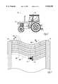
- FIG. 6shows a tractor using the system of the present invention.
- FIG. 7is an aerial view of a field being worked by the tractor shown in FIG. 6.
- the navigation/guidance system of the present inventionis a dead reckoning navigator which uses periodic GPS fixes to correct the drift of the inertial system.
- the systemuses GPS antenna attitude compensation to improve the accuracy of the GPS fixes.
- the systemprimarily uses speed sensed by Doppler radar and attitude and heading sensed by a set of gyros. As discussed above, systems using a Doppler sensor and gyros have the problem of errors in the sensors. In addition, in order to use inexpensive sensors, very large errors are encountered.
- the systemuses various processes to compensate for the errors.
- the heading sensed by the gyrosis aided by a magnetic heading compass and a GPS receiver.
- the speed sensed by the Doppler radaris also aided by the GPS receiver.
- the systemalso uses accelerometers to improve the accuracy of the system.
- a set of horizontal accelerometersmeasure the roll and pitch of the vehicle. This is used to provide the attitude integration algorithm (discussed below) with the vehicle horizontal rotations to more accurately calculate the attitude and
- FIG. 1shows the primary hardware elements of the inertial navigation/guidance system 10 of the present invention.
- the system 10is comprised of a personal computer (PC) 12 which includes a CPU, memory and input/output electronics.
- PCpersonal computer
- the inventioncould use a processor circuit that includes a CPU, memory, and input/output electronics on a single processor card.
- a GPS receiver 14plugs directly into an open PC expansion slot. Any GPS receiver suitable for use with the present invention may be used, however the preferred GPS receiver is the NovAtel GPS receiver card #951R.
- the system 10could simply have a connector that would receive GPS data from any existing GPS receiver.
- a keyboard or keypad 16is connected to the PC 12 and is used as a user interface to input data or control the system 10.
- a display unit 18is also connected to the PC 12. The display unit 18 is used to display various information to a user.
- the display unit 18could take on many forms, but is preferably comprised of a CRT display.
- the display unitcould even be comprised of a display screen that shows the operator a graphic of a field or portion of the field and could indicate where the vehicle has been and where it is going. All sensor input data to the PC 12 will be digital serial.
- FIG. 1Also shown in FIG. 1 is a block diagram of the power supply circuit used by the present invention.
- the power supply circuitincludes a 12 volt battery 32, a voltage converter 34 and a power supply 36.
- the power supply circuitprovides the system 10 with 110 volts AC and a regulated DC voltage.
- a portable DGPS receiver 20is also connected to the PC 12.
- the DGPS radio receiver 20receives DGPS data for use by the PC to overcome the effects of Selective Availability (SA) as well as other imperfections in the time-coded signals broadcast by the NAVSTAR satellites.
- SASelective Availability
- the use of DGPSprovides a more accurate location solution than GPS alone.
- the DGPS radio receiver 20may be any type of DGPS receiver suitable for use with the present invention but is preferably the Smartbase model number 10, manufactured by Premier GPS Inc. Also note that the present invention would work without using DGPS, although the accuracy may be less.
- One alternative to the preferred embodimentis to use a receiver that uses a combination of GPS and GLONASS signals to produce a more accurate radio navigation system.
- a GPS antenna 22is connected to the GPS receiver 14 to provide the GPS receiver 14 with GPS signals from the NAVSTAR satellites.
- the GPS antenna 22acts as the collection point for GPS signals received by the GPS receiver 14.
- the GPS antenna 22is mounted to the host vehicle at a known location such that the location of the antenna 22 is always known relative to the GPS receiver 14 or some other reference point.
- a number of sensorsare also connected to the PC 12.
- Three rate gyros 24, three accelerometers 26, and a magnetic heading compass 28are connected to the PC 12 to provide the system with various data.
- the gyros 24, accelerometers 26 and the magnetic heading compass 28are assembled together in a single unit.
- a position change sensor 30, preferably comprised of a Doppler radaris also connected to the PC 12 to provide the system with speed data.
- the preferred embodimentuses three each of the gyros 24 and accelerometers 26, more or less could be used. The choice of using two or three accelerometers depends on such factors as the level of accuracy desired, the application of the system, and the sophistication of the Kalman filter, etc.
- the gyros 24act as angular change sensors, so therefore, any device with the same function could be substituted for the gyros 24.
- the preferred gyrosare the model ENV-05H-02 manufactured by Murata Erie Co., Ltd.
- the accelerometers 26could be substituted by an equivalent device such an inclinometer, tilt sensors, etc.
- the preferred accelerometeris the model 02753-01 manufactured by Lucas Control System Products.
- the magnetic heading compasscould also be substituted by any other heading sensor, for example, a fluxgate compass.
- the preferred magnetic heading compassis the model C100 manufactured by KVH Industries, Inc. Also note that the magnetic heading compass 28 is optional.
- the magnetic heading compass 28may not be needed by the system.
- the Doppler radar 30functions as a position change sensor, so therefore any equivalent device could be substituted for the Doppler radar such as an odometer or any other device used to derive the vehicle speed.
- the preferred Doppler radaris the model Radar II manufactured by Dickey-John.
- FIG. 2shows a functional block diagram of the attitude/heading portion of the invention.
- the navigation/guidance system 10uses software which performs the functions described and outlined in the figures.
- the attitude integration algorithm 42uses the angular rates from the gyros 24, horizontal accelerations from the horizontal accelerometers 26, and heading and attitude error estimates from the other sensors to calculate a value for the vehicle's attitude (pitch and roll) and heading.
- the attitude and headingare primarily sensed by the gyros 24.
- the various sensorsare used together as shown in the figures to obtain a more accurate value for attitude (pitch and roll) and heading.
- the data from the gyros 24is applied the gyro compensator function 40 which applies constant values such as a scale factor, misalignment and fixed bias to the data and also applies changing values such as an estimated dynamic bias to the data.
- the datais then provided to the attitude integration algorithm 42 to calculate the attitude and heading.
- the horizontal accelerometers 26provide data to the accelerometer compensation function 46 which applies constant values such as scale factor, bias, and misalignments to the data.
- the compensated data from the accelerometers 26is then provided to a direction cosine matrix (shown in FIG. 2 as the body to navigation frame transformation function 48) and a platform leveling/damping function 50.
- the yaw attitudeis slaved to the magnetic heading reference supplied by the magnetic heading compass 28.
- a blending filter 44This, along with data from the GPS position are used by a blending filter 44 to provide a heading error estimate to the attitude integration algorithm 42.
- a pitch and roll error estimateis also provided to the attitude integration algorithm 42.
- the pitch and roll error estimateis derived from data from the Doppler radar 30, the horizontal accelerometers 26, and the gyros 24.
- attitude, heading and corresponding timeare saved in a data table for interpolation to the GPS data time.
- This interpolated datais required to provide position corrections to the GPS position fix (see discussion of FIG. 3 below) for use in the dead reckoning navigation function shown in FIG. 4 (discussed below).
- FIG. 3is a block diagram of the position correction function.
- the GPS receiver 14is connected to the GPS antenna 22 to receive GPS data signals from the NAVSTAR satellites.
- the GPS receiver 14also receives DGPS data from the DGPS radio receiver 20 to improve the GPS accuracy.
- the position corrections lc, Lcare calculated based on the latest position lr, Lr provided by the GPS receiver 14, the saved/interpolated dead reckoned position ls, Ls, and the GPS antenna moment arm (lever arm) corrections (discussed below) la, La based on the saved/interpolated attitude data corresponding to the GPS data time.
- the systemuses the attitude data from the navigation system 10 for GPS antenna lever arm corrections.
- An antenna mounted on top of a vehiclesuch as a tractor or floater would be about 13 feet from the ground and will experience large attitude excursions as the vehicle swaths a field.
- the systemtakes this into account by using the attitude data to make GPS position corrections based on the current attitude of the vehicle and the known position of the GPS antenna relative to the vehicle.
- the position calculated by the systemcan be transferred to any part of the vehicle, for example to the end of a sprayer boom.
- FIG. 4shows a block diagram of the dead reckoning navigation function.
- the velocity sensed by the Doppler velocity sensor 30is transformed from mount to body axes, then transformed from body to local level axes using the attitude (pitch and roll) and heading data from the attitude integration algorithm 42 shown in FIG. 2.
- the velocityis then transformed from local level to north referenced navigation axes.
- the datais provided to the position integration function 52 which is reset according to the available position correction values lc, Lc coming from the position correction function shown in FIG. 3.
- FIG. 5shows a block diagram of the guidance function of the present invention.
- the position of the vehicle determined by the position integration(FIG. 4) is supplied to a guidance algorithm 54 along with the vehicle's heading and the desired path.
- the guidance algorithm 54uses this data to determine the cross track error and the heading error. From the cross track and heading errors, the system creates guidance commands.
- the guidance commandsare provided to an operator perceivable display 56 and/or an automatic steering mechanism 58 (see discussion below).
- the display 56may take on any form.
- the display 56could be display unit 18 (discussed above), a light bar (discussed below), or any other type of operator perceivable indicator.
- the automatic steering mechanism 58could also take on any form.
- the steering mechanismcould be a hydraulic steering mechanism.
- the navigation/guidance system of the present inventionoperates as follows. Before the host vehicle moves, the navigation system will initialize itself. The attitude (pitch and roll) is initialized by the accelerometers 26. The heading is initialized by the magnetic heading compass 28. The heading initialization is the most important initialization step. If the vehicle is moving the magnetic heading compass 28 will not be used to initialize the heading. The system is initialized based on where the operator of the vehicle indicates the vehicle is located and/or by GPS data. In other words, the operator can manually enter in the initial location and/or the system can use the GPS location.
- the system 10uses the various sensors to sense the movement of the vehicle.
- the attitude (pitch and roll) and heading of the host vehicleis sensed by the gyros 24.
- the speed of the vehicleis sensed by the Doppler radar 30.
- the system 10calculates the velocity of the vehicle.
- the velocity of the vehicleis then integrated to determine the position of the vehicle.
- the systemuses a process to correct for errors in the system (see FIG. 3).
- the speed, heading and dead reckoning position errorsare corrected by periodic GPS fixes.
- the attitude pitch and roll errorsare corrected by sensing the acceleration caused by the motion of the vehicle. This is done via the accelerometers 26 and the knowledge of the vehicle speed and rotation rate.
- the accelerometers 26sense the specific force accelerations acting on the vehicle including gravity, the acceleration of the vehicle, and centrifugal force.
- the gravity forceis a known value and can be subtracted out.
- the remaining accelerationsare then integrated to get a velocity.
- the velocity and rotation rate of the vehicleare known and can be subtracted out. The remaining values can be used to correct the attitude errors.
- a vehicle using the navigation system 10 to help control a guidance systemoperates as follows and as described with FIG. 5 above.
- the primary information used by the guidance system from the navigation system 10is the position of the host vehicle.
- the guidance systemreceives a position signal from the navigation system 10 at a rate of 10 Hz.
- the guidance systemalso receives a vehicle heading signal from the navigation system 10 at a 10 Hz rate.
- the position and heading datacould be received at any other suitable rate, but 10 Hz is the preferred rate.
- the desired path of the vehicleis provided to the guidance system from the processor memory, user input, or any other source.
- the guidance systemcomputes cross track and heading error. Cross track error is the distance the vehicle is off from the desired path.
- Heading erroris defined as the angular difference between the vehicle velocity and the desired path.
- the goal of the guidance systemis to drive the cross track error to zero by guiding the vehicle along a desired path.
- the guidance algorithm 54 described abovecalculates the cross track error and the heading error to create guidance commands. These guidance commands are the steering signal used by the operator or by an automatic steering mechanism to steer the vehicle along the desired path.
- a vehicle equipped with the navigation system 10 of the present inventionis capable of very accurately keeping track of where the vehicle is and where it has already been. This information can be used for any number of purposes or applications.
- the navigation systemprovides accurate, real time data sufficient to allow a guidance system to navigate along a curved path.
- the vehiclewould have many capabilities.
- An operator of the vehiclecould manually steer through a path in the field and then use the system to guide the vehicle almost exactly parallel to the path on the next swath (see FIG. 7, discussed below). This would maximize the efficiency of the vehicle and make the operator's tasks easier and more reliable.
- an operator of the vehiclecould manually navigate the vehicle around the edge of a field and command the vehicle to automatically cover the remainder of the field within the outside path. Since the system would have the previous paths in memory, the system would know what portions of the field remain and would be able to cover the remainder of the field.
- the operatorcould also manually navigate around waterways and allow the system to automatically navigate around the waterways when they are encountered.
- the systemcould also be used to help control the operation of machinery such as sprayers, disks, etc. connected to the vehicles. For example, when a vehicle is turning around at the end of a field and is traveling over areas already sprayed, the sprayers could be automatically turned off until they reach a portion of the field not previously sprayed.
- the navigation information obtainedcould be saved and stored for subsequent operations in the same field. For example, once the system knows the locations of borders, obstacles, etc. in a field, that information can be used later to automatically navigate around a field without "relearning" that information. That would make the system even more efficient after the initial operation in a particular field.
- FIG. 6shows a tractor 60 incorporating the present invention.
- a GPS antenna 22is mounted to the top of the tractor 60.
- the Doppler sensor 30is mounted on the front of the tractor 60.
- the remaining components of the system 10are also mounted to the tractor 60.
- FIG. 7shows an aerial view of a field being worked by the tractor 60.
- the tractoris shown pulling a sprayer 62 through the field.
- the tractor 60first sprayed the end rows 64.
- the tractorwas guided along a first swath 66A which followed the shape of the edge of the field.
- Dashed line 68Ashows the path of the tractor 60 during the first swath 66A.
- the swath 66Ais shaded to show that it was sprayed.
- the guidance systemknowing the location of the end rows 64 and knowing the location of the first swath 66A is able to cause the tractor 60 to turn around and follow the path 68B to start the second swath 66B.
- FIG. 7shows the tractor 60 as it is making a fourth swath 66D following the path 68D.
- the sprayer 62can be automatically turned off at the end of each swath 66 as the sprayers pass over portions of the field already sprayed
- the system 10is capable of navigating in a curved or uneven path.
- An agricultural floater equipped with the present inventionwould have many capabilities not found in the prior art.
- the guidance system on the floaterwould enable the floater to automatically move through the field, for example with an automatic hydraulic steering system.
- the guidance systemcould assist the operator in moving through the field via a light bar or other display device.
- the entire fieldwould be covered with the proper amount of chemicals giving the farmer higher yields and saving the chemical supplier money from less wasted chemicals.
- the floaterscould operate at night since the operator would not need to watch for the foam markers or other external indictors required by prior art systems.
- the chemical appliercould use and maintain fewer floaters to spray the same amount of land.
- This datacould be transmitted or downloaded to a computer to be interpreted and used.
- Softwaresuch as CAD could then be used to create three dimensional maps of the surveyed land.
- Lawn servicescould use the navigation/guidance system with lawn sprayers or mowers as described above.
- Excavating machinerysuch as bulldozers could use the system to automatically excavate land.
- the navigation systemis also capable of use on boats or ships. Vehicles traveling through water encounter similar problems as do vehicles traveling on the ground. For example, waves and strong winds as well as other forces can dramatically manipulate the attitude of ship causing problems described above such as the GPS antenna lever arm errors.
- the navigation systemcould also be used on boats to survey the bottom of bodies of water.
- An additional sensorsuch as sonar could be used to sense the depth of the water at every location that the boat traveled over.
- This datacould be used to determine where silt build-up exists around dams for example.
- the rail industrycould use the navigation/guidance system to keep track of and control trains.
- the navigation systemwill continue to operate even while the trains go trough tunnels or under foliage, etc.
- the railroadscould fit more trains on a given track if they knew precisely where each train was. Also, the system is accurate enough to indicate which track a train is on, even where two tracks run parallel in close proximity. Regardless of how the present invention is used, the user will save time, labor, cost, etc.
- the preferred embodiment of the navigation system 10 of the present inventionmay be configured as follows.
- a sensor packageis contained within a single enclosure.
- the sensor packageincludes the rate gyros 24, the accelerometers 26 and the magnetic heading compass 28.
- the sensor packagecould act as a stand-alone inertial measurement unit with the capability of connecting to a vehicle and any other sensors desired.
- the Doppler radar position sensor 30is attached to the vehicle and preferably pointed downward toward the ground at an angle of about 30°.
- a display headincludes the display unit 18, the processor 12, the GPS receiver 14, a tactile device (e.g., a keypad or keyboard), the DGPS radio receiver and the required power supplies. Two antennas (one GPS and one DGPS) are attached to the vehicle and connected to the appropriate receiver.
- a light baris installed on the vehicle in view of the operator and also connected to the display head.
- the light baris comprised of a row of lights that indicate the magnitude and direction of the cross track error to the operator.
- the system 10may provide guidance commands to an automatic steering mechanism.
Landscapes
- Engineering & Computer Science (AREA)
- Radar, Positioning & Navigation (AREA)
- Remote Sensing (AREA)
- Physics & Mathematics (AREA)
- General Physics & Mathematics (AREA)
- Automation & Control Theory (AREA)
- Computer Networks & Wireless Communication (AREA)
- Navigation (AREA)
- Position Fixing By Use Of Radio Waves (AREA)
Abstract
Description
1. Field of the Invention
The present invention relates to inertial navigation systems. More particularly, though not exclusively, the present invention relates to an inertial navigation/guidance system using a radio navigation receiver to correct the navigation errors.
2. Problems in the Art
Differential global positioning system (DGPS) based guidance systems for airborne application of agrochemicals has met with huge success and it follows that this technology could be used with ground rig applicators if certain technical problems can be overcome. The primary differences between air and ground application processes are associated with the operators view of the land and the operational dynamic environment.
During airborne applications, the pilot generally has a large part of the area involved to be sprayed in view and the GPS antenna (mounted on top of the canopy) follows a relatively straight line when in an application swath. This provides for the required cross track position stability to obtain a well controlled application process.
With ground rig applicators, such as tractors or floaters, the operator may have a limited view of the involved spray area and depending on the size/shape of the field and of the local ground cover it can be very difficult to determine where the previous swath coverage ends in order to proceed with the ensuing swath. A GPS antenna mounted on top of the ground vehicle (where it would be exposed to the GPS satellites) will experience large attitude excursions as the rig swaths the field. This results in GPS derived cross track position excursions relative to the vehicle ground track which would contaminate any attempt to parallel a defined field line. It can therefore be seen that there is a need for a better navigation/guidance system for use with a ground-based vehicle.
There is a need for a solution to various problems relating to ground rig applicators such as tractors and floaters. These ground rig applicators have several disadvantages. Since the application of agrochemicals is a seasonal process (3-4 months per year), the workers hired to operate the floaters are seasonal workers. As a result, the seasonal workers are often inexperienced or unreliable in the operation of the floaters. This increases the probability that the operator will skip areas of the field or apply double coverage to overlapping areas. These problems cost the seller of the chemicals and the farmer thousands of dollars. A typical floater will cost $100,000 and will apply $500,000-$1 million dollars worth of chemicals per year. It can therefore be seen that efficient operating of a floater is very important. Typical prior art floaters are guided through a field by following a trail of foam markers which are marked on the field on the previous swath. As a result, there is a lot of room for human error and the floaters cannot be operated at night. A need can therefore be seen which would allow the floaters to operate accurately day or night throughout the season. Such a solution would allow a chemical applier to operate half as many machines. An accurate, real-time inexpensive navigation/guidance system would remedy these problems.
Various prior art navigation systems for ground-based vehicles have several disadvantages. Systems using Doppler radar will encounter errors with the radar. Similarly, gyros will encounter drift errors which will continue to increase unless the drift error is corrected. Gyros that are inexpensive enough to be feasible to use may have drift rates high enough to make them unusable. For example, a typical inexpensive gyro sensor may have a drift rate uncertainty as high as 3600° per hour which makes the gyro unusable for most applications. As a result, gyros have good short term characteristics but bad long term characteristics as the drift error becomes larger as time goes on.
When navigating using dead reckoning you need a very high fidelity heading measurement which has not been achieved adequately using low costs sensors.
Various prior art systems navigating by GPS also have disadvantages. Prior art systems using GPS use GPS as the primary navigator. This intensifies the problems found with GPS. A GPS position calculation has a lag time. As a result, the position solution provided by a GPS receiver tells a user where the vehicle was a moment ago not in real time. Another problem with GPS systems are the errors resulting from the antenna lever arm problem. A GPS antenna typically is a certain distance away from the GPS receiver. Since the GPS antenna is the collection point of the GPS signals received, the position solution will not accurately describe the position of the GPS receiver or some other reference point. If the geometrical distance between the GPS receiver or reference point and the GPS antenna is known, the position of the reference point may be calculated. However, as a ground based vehicle travels over uneven terrain such as terraces, slopes, ruts, bumps, etc., the actual position of the GPS antenna cannot be determined resulting in erratic GPS position solutions.
Most prior art attempts to use a GPS navigation system attempted to deal with problems by correcting GPS drift and lag time. However no prior art system navigating by GPS has achieved the high accuracy and real time solutions required for applications requiring a high level of accuracy. The prior art attempts have not provided an adequate solution because GPS does not provide a continuous navigation solution. A GPS system will update its position periodically, not in real time, and a lag time is still involved. Another problem with a GPS system is the possibility of a signal dropout of the satellite signals. The accuracy of a GPS system is also limited due to the errors caused by the ionosphere. Another problem with GPS systems is that altitude data provided by a GPS receiver is not precise.
Another problem with GPS systems is that a GPS system cannot accurately supply guidance data for a curved path. This problem relates to the lag time involved with GPS. A GPS system can only do linear interpolation of GPS position solutions which is inadequate for navigating a curved path. A GPS system also will not provide high quality heading information. Finally, the altitude calculated by a GPS receiver is inaccurate and unusable for certain applications.
A general feature of the present invention is the provision of an inertial navigation/guidance system.
A further feature of the present invention is the provision of an inertial navigation/guidance system for use on a land-based vehicle.
A further feature of the present invention is the provision of an inertial navigation/guidance system that senses the attitude of the vehicle.
A further feature of the present invention is the provision of an inertial navigation/guidance system which uses a radio navigation receiver to correct the drift errors of the inertial system.
A further feature of the present invention is the provision of an inertial navigation/guidance system which uses inexpensive sensors to achieve a highly accurate result.
A further feature of the present invention is the provision of an inertial attitude determination system which is stand alone.
A further feature of the present invention is the provision of an inertial navigation/guidance system which uses gyro information to compute the attitude and heading of the vehicle and a position change sensor to sense the speed of the vehicle.
A further feature of the present invention is the provision of an inertial navigation/guidance system which uses accelerometers to measure the pitch and roll of the vehicle to refine the sensed attitude of the vehicle.
A further feature of the present invention is the provision of an inertial navigation/guidance system which includes software to control the functions of the system.
A further feature of the present invention is the provision of an inertial navigation/guidance system which uses the sensed attitude of the vehicle to determine the position of the radio navigation antenna in order to correct the lever-arm error.
A further feature of the present invention is the provision of a system for use on a boat or ship.
A further feature of the present invention is the provision of a system which is part of a surveying system.
These as well as other features of the present invention will become apparent from the following specification and claims.
The navigation and guidance system of the present invention provides accurate navigation data in real time using a dead reckoning navigator with periodic radio navigation fixes to correct for the drift of the inertial system. The system senses the speed, heading and attitude of the vehicle to determine a position of the vehicle. An external position reference provided by the radio navigation system is used to correct any error in the determined position.
The system is capable of correcting for the radio navigation antenna lever arm errors by using the attitude of the vehicle. The system may optionally be used on a ground or water based vehicle to provide navigation data and guidance commands to an automatic steering system. The system of the present invention may also be used on a agricultural vehicle to guide the vehicle through a field in a number of ways.
FIG. 1 shows a block diagram of the primary hardware elements of the navigation/guidance system of the present invention.
FIG. 2 shows a functional block diagram of the attitude/heading portion of the present invention.
FIG. 3 shows a functional block diagram of the position correction function of the present invention.
FIG. 4 shows a functional block diagram of the dead reckoning navigation function of the present invention.
FIG. 5 shows a functional block diagram of the guidance function of the present invention.
FIG. 6 shows a tractor using the system of the present invention.
FIG. 7 is an aerial view of a field being worked by the tractor shown in FIG. 6.
The present invention will be described as it applies to its preferred embodiment. It is not intended that the present invention be limited to the described embodiment. It is intended that the invention cover all alternatives, modifications, and equivalences which may be included within the spirit and scope of the invention. While the present invention is described as being used on a land based vehicle, it is intended that the invention cover other applications. Also, the term land-based vehicle is meant to include vehicles on the ground or in the water, "land-based" is meant only to distinguish from airborne applications.
The navigation/guidance system of the present invention is a dead reckoning navigator which uses periodic GPS fixes to correct the drift of the inertial system. The system uses GPS antenna attitude compensation to improve the accuracy of the GPS fixes. The system primarily uses speed sensed by Doppler radar and attitude and heading sensed by a set of gyros. As discussed above, systems using a Doppler sensor and gyros have the problem of errors in the sensors. In addition, in order to use inexpensive sensors, very large errors are encountered. The system uses various processes to compensate for the errors. The heading sensed by the gyros is aided by a magnetic heading compass and a GPS receiver. The speed sensed by the Doppler radar is also aided by the GPS receiver. The system also uses accelerometers to improve the accuracy of the system. A set of horizontal accelerometers measure the roll and pitch of the vehicle. This is used to provide the attitude integration algorithm (discussed below) with the vehicle horizontal rotations to more accurately calculate the attitude and heading.
FIG. 1 shows the primary hardware elements of the inertial navigation/guidance system 10 of the present invention. Thesystem 10 is comprised of a personal computer (PC) 12 which includes a CPU, memory and input/output electronics. Although the embodiment shown in the drawings shows a personal computer, the invention could use a processor circuit that includes a CPU, memory, and input/output electronics on a single processor card. AGPS receiver 14 plugs directly into an open PC expansion slot. Any GPS receiver suitable for use with the present invention may be used, however the preferred GPS receiver is the NovAtel GPS receiver card #951R. Alternatively, thesystem 10 could simply have a connector that would receive GPS data from any existing GPS receiver. Any other type of radio navigation system or combination of systems could be substituted for the GPS system such as LORAN, GLONASS, etc. A keyboard orkeypad 16 is connected to thePC 12 and is used as a user interface to input data or control thesystem 10. Adisplay unit 18 is also connected to thePC 12. Thedisplay unit 18 is used to display various information to a user. Thedisplay unit 18 could take on many forms, but is preferably comprised of a CRT display. The display unit could even be comprised of a display screen that shows the operator a graphic of a field or portion of the field and could indicate where the vehicle has been and where it is going. All sensor input data to thePC 12 will be digital serial. If any of the selected sensors provide only analog outputs, A/D converters will be used where required to obtain the appropriate input data formats. Also shown in FIG. 1 is a block diagram of the power supply circuit used by the present invention. The power supply circuit includes a 12volt battery 32, avoltage converter 34 and apower supply 36. The power supply circuit provides thesystem 10 with 110 volts AC and a regulated DC voltage.
Aportable DGPS receiver 20 is also connected to thePC 12. TheDGPS radio receiver 20 receives DGPS data for use by the PC to overcome the effects of Selective Availability (SA) as well as other imperfections in the time-coded signals broadcast by the NAVSTAR satellites. The use of DGPS provides a more accurate location solution than GPS alone. TheDGPS radio receiver 20 may be any type of DGPS receiver suitable for use with the present invention but is preferably theSmartbase model number 10, manufactured by Premier GPS Inc. Also note that the present invention would work without using DGPS, although the accuracy may be less. One alternative to the preferred embodiment is to use a receiver that uses a combination of GPS and GLONASS signals to produce a more accurate radio navigation system.
AGPS antenna 22 is connected to theGPS receiver 14 to provide theGPS receiver 14 with GPS signals from the NAVSTAR satellites. TheGPS antenna 22 acts as the collection point for GPS signals received by theGPS receiver 14. TheGPS antenna 22 is mounted to the host vehicle at a known location such that the location of theantenna 22 is always known relative to theGPS receiver 14 or some other reference point.
As shown in FIG. 1, a number of sensors are also connected to thePC 12. Threerate gyros 24, threeaccelerometers 26, and a magnetic headingcompass 28 are connected to thePC 12 to provide the system with various data. Preferably, thegyros 24,accelerometers 26 and the magnetic headingcompass 28 are assembled together in a single unit. Aposition change sensor 30, preferably comprised of a Doppler radar is also connected to thePC 12 to provide the system with speed data. Although the preferred embodiment uses three each of thegyros 24 andaccelerometers 26, more or less could be used. The choice of using two or three accelerometers depends on such factors as the level of accuracy desired, the application of the system, and the sophistication of the Kalman filter, etc. Thegyros 24 act as angular change sensors, so therefore, any device with the same function could be substituted for thegyros 24. The preferred gyros are the model ENV-05H-02 manufactured by Murata Erie Co., Ltd. Similarly, theaccelerometers 26 could be substituted by an equivalent device such an inclinometer, tilt sensors, etc. The preferred accelerometer is the model 02753-01 manufactured by Lucas Control System Products. The magnetic heading compass could also be substituted by any other heading sensor, for example, a fluxgate compass. The preferred magnetic heading compass is the model C100 manufactured by KVH Industries, Inc. Also note that the magnetic headingcompass 28 is optional. Depending on the sophistication of the Kalman filter and other factors, the magnetic headingcompass 28 may not be needed by the system. TheDoppler radar 30 functions as a position change sensor, so therefore any equivalent device could be substituted for the Doppler radar such as an odometer or any other device used to derive the vehicle speed. The preferred Doppler radar is the model Radar II manufactured by Dickey-John.
FIG. 2 shows a functional block diagram of the attitude/heading portion of the invention. The navigation/guidance system 10 uses software which performs the functions described and outlined in the figures. As described below, theattitude integration algorithm 42 uses the angular rates from thegyros 24, horizontal accelerations from thehorizontal accelerometers 26, and heading and attitude error estimates from the other sensors to calculate a value for the vehicle's attitude (pitch and roll) and heading. The attitude and heading are primarily sensed by thegyros 24. The various sensors are used together as shown in the figures to obtain a more accurate value for attitude (pitch and roll) and heading. The data from thegyros 24 is applied thegyro compensator function 40 which applies constant values such as a scale factor, misalignment and fixed bias to the data and also applies changing values such as an estimated dynamic bias to the data. The data is then provided to theattitude integration algorithm 42 to calculate the attitude and heading. Thehorizontal accelerometers 26 provide data to theaccelerometer compensation function 46 which applies constant values such as scale factor, bias, and misalignments to the data. The compensated data from theaccelerometers 26 is then provided to a direction cosine matrix (shown in FIG. 2 as the body to navigation frame transformation function 48) and a platform leveling/damping function 50. The yaw attitude is slaved to the magnetic heading reference supplied by the magnetic headingcompass 28. This, along with data from the GPS position are used by a blendingfilter 44 to provide a heading error estimate to theattitude integration algorithm 42. A pitch and roll error estimate is also provided to theattitude integration algorithm 42. The pitch and roll error estimate is derived from data from theDoppler radar 30, thehorizontal accelerometers 26, and thegyros 24.
The attitude, heading and corresponding time are saved in a data table for interpolation to the GPS data time. This interpolated data is required to provide position corrections to the GPS position fix (see discussion of FIG. 3 below) for use in the dead reckoning navigation function shown in FIG. 4 (discussed below).
FIG. 3 is a block diagram of the position correction function. As described above, theGPS receiver 14 is connected to theGPS antenna 22 to receive GPS data signals from the NAVSTAR satellites. TheGPS receiver 14 also receives DGPS data from theDGPS radio receiver 20 to improve the GPS accuracy. The position corrections lc, Lc are calculated based on the latest position lr, Lr provided by theGPS receiver 14, the saved/interpolated dead reckoned position ls, Ls, and the GPS antenna moment arm (lever arm) corrections (discussed below) la, La based on the saved/interpolated attitude data corresponding to the GPS data time.
The system uses the attitude data from thenavigation system 10 for GPS antenna lever arm corrections. An antenna mounted on top of a vehicle such as a tractor or floater would be about 13 feet from the ground and will experience large attitude excursions as the vehicle swaths a field. As shown in FIG. 3, the system takes this into account by using the attitude data to make GPS position corrections based on the current attitude of the vehicle and the known position of the GPS antenna relative to the vehicle. As a result, as the vehicle travels over terraces, ruts, bumps, etc., the relatively large swings of the GPS antenna will not effect the accuracy of the GPS position. Using similar techniques, the position calculated by the system can be transferred to any part of the vehicle, for example to the end of a sprayer boom.
FIG. 4 shows a block diagram of the dead reckoning navigation function. The velocity sensed by theDoppler velocity sensor 30 is transformed from mount to body axes, then transformed from body to local level axes using the attitude (pitch and roll) and heading data from theattitude integration algorithm 42 shown in FIG. 2. After the body to local level transform, the velocity is then transformed from local level to north referenced navigation axes. Finally, the data is provided to theposition integration function 52 which is reset according to the available position correction values lc, Lc coming from the position correction function shown in FIG. 3.
FIG. 5 shows a block diagram of the guidance function of the present invention. As shown in FIG. 5, the position of the vehicle determined by the position integration (FIG. 4) is supplied to aguidance algorithm 54 along with the vehicle's heading and the desired path. Theguidance algorithm 54 uses this data to determine the cross track error and the heading error. From the cross track and heading errors, the system creates guidance commands. The guidance commands are provided to an operatorperceivable display 56 and/or an automatic steering mechanism 58 (see discussion below). Thedisplay 56 may take on any form. Thedisplay 56 could be display unit 18 (discussed above), a light bar (discussed below), or any other type of operator perceivable indicator. Theautomatic steering mechanism 58 could also take on any form. For example, the steering mechanism could be a hydraulic steering mechanism.
The navigation/guidance system of the present invention operates as follows. Before the host vehicle moves, the navigation system will initialize itself. The attitude (pitch and roll) is initialized by theaccelerometers 26. The heading is initialized by the magnetic headingcompass 28. The heading initialization is the most important initialization step. If the vehicle is moving the magnetic headingcompass 28 will not be used to initialize the heading. The system is initialized based on where the operator of the vehicle indicates the vehicle is located and/or by GPS data. In other words, the operator can manually enter in the initial location and/or the system can use the GPS location.
Once the host vehicle begins moving thesystem 10 uses the various sensors to sense the movement of the vehicle. The attitude (pitch and roll) and heading of the host vehicle is sensed by thegyros 24. The speed of the vehicle is sensed by theDoppler radar 30. After sensing the attitude, heading, and speed, thesystem 10 calculates the velocity of the vehicle. The velocity of the vehicle is then integrated to determine the position of the vehicle. The system then uses a process to correct for errors in the system (see FIG. 3). The speed, heading and dead reckoning position errors are corrected by periodic GPS fixes. The attitude pitch and roll errors are corrected by sensing the acceleration caused by the motion of the vehicle. This is done via theaccelerometers 26 and the knowledge of the vehicle speed and rotation rate. Theaccelerometers 26 sense the specific force accelerations acting on the vehicle including gravity, the acceleration of the vehicle, and centrifugal force. The gravity force is a known value and can be subtracted out. The remaining accelerations are then integrated to get a velocity. Similarly, the velocity and rotation rate of the vehicle are known and can be subtracted out. The remaining values can be used to correct the attitude errors.
A vehicle using thenavigation system 10 to help control a guidance system operates as follows and as described with FIG. 5 above. The primary information used by the guidance system from thenavigation system 10 is the position of the host vehicle. As shown in FIG. 5, the guidance system receives a position signal from thenavigation system 10 at a rate of 10 Hz. The guidance system also receives a vehicle heading signal from thenavigation system 10 at a 10 Hz rate. Of course, the position and heading data could be received at any other suitable rate, but 10 Hz is the preferred rate. The desired path of the vehicle is provided to the guidance system from the processor memory, user input, or any other source. The guidance system computes cross track and heading error. Cross track error is the distance the vehicle is off from the desired path. Heading error is defined as the angular difference between the vehicle velocity and the desired path. The goal of the guidance system is to drive the cross track error to zero by guiding the vehicle along a desired path. Theguidance algorithm 54 described above calculates the cross track error and the heading error to create guidance commands. These guidance commands are the steering signal used by the operator or by an automatic steering mechanism to steer the vehicle along the desired path.
A vehicle equipped with thenavigation system 10 of the present invention is capable of very accurately keeping track of where the vehicle is and where it has already been. This information can be used for any number of purposes or applications. The navigation system provides accurate, real time data sufficient to allow a guidance system to navigate along a curved path.
With thenavigation system 10 of the present invention used on an agricultural vehicle such as a tractor or floater, the vehicle would have many capabilities. An operator of the vehicle could manually steer through a path in the field and then use the system to guide the vehicle almost exactly parallel to the path on the next swath (see FIG. 7, discussed below). This would maximize the efficiency of the vehicle and make the operator's tasks easier and more reliable. Similarly, an operator of the vehicle could manually navigate the vehicle around the edge of a field and command the vehicle to automatically cover the remainder of the field within the outside path. Since the system would have the previous paths in memory, the system would know what portions of the field remain and would be able to cover the remainder of the field. The operator could also manually navigate around waterways and allow the system to automatically navigate around the waterways when they are encountered. The system could also be used to help control the operation of machinery such as sprayers, disks, etc. connected to the vehicles. For example, when a vehicle is turning around at the end of a field and is traveling over areas already sprayed, the sprayers could be automatically turned off until they reach a portion of the field not previously sprayed. Whatever the system is used for, the navigation information obtained could be saved and stored for subsequent operations in the same field. For example, once the system knows the locations of borders, obstacles, etc. in a field, that information can be used later to automatically navigate around a field without "relearning" that information. That would make the system even more efficient after the initial operation in a particular field.
FIG. 6 shows atractor 60 incorporating the present invention. AGPS antenna 22 is mounted to the top of thetractor 60. TheDoppler sensor 30 is mounted on the front of thetractor 60. The remaining components of thesystem 10 are also mounted to thetractor 60.
FIG. 7 shows an aerial view of a field being worked by thetractor 60. The tractor is shown pulling asprayer 62 through the field. As shown in FIG. 7, thetractor 60 first sprayed theend rows 64. Next, the tractor was guided along afirst swath 66A which followed the shape of the edge of the field. Dashedline 68A shows the path of thetractor 60 during thefirst swath 66A. Theswath 66A is shaded to show that it was sprayed. At the end of thefirst swath 66A, the guidance system, knowing the location of theend rows 64 and knowing the location of thefirst swath 66A is able to cause thetractor 60 to turn around and follow thepath 68B to start thesecond swath 66B. FIG. 7 shows thetractor 60 as it is making afourth swath 66D following thepath 68D. Also note that thesprayer 62 can be automatically turned off at the end of each swath 66 as the sprayers pass over portions of the field already sprayed As discussed above, thesystem 10 is capable of navigating in a curved or uneven path.
An agricultural floater equipped with the present invention would have many capabilities not found in the prior art. First, the reliability of the operators hired to operate the floaters would be less important. The guidance system on the floater would enable the floater to automatically move through the field, for example with an automatic hydraulic steering system. Alternatively, the guidance system could assist the operator in moving through the field via a light bar or other display device. As a result, the entire field would be covered with the proper amount of chemicals giving the farmer higher yields and saving the chemical supplier money from less wasted chemicals. Second, the floaters could operate at night since the operator would not need to watch for the foam markers or other external indictors required by prior art systems. As a result, the chemical applier could use and maintain fewer floaters to spray the same amount of land.
Other applications of the present invention can be seen as well. For example, when the navigation/guidance system is applied to any other vehicle, many of the same advantages are found. In addition, given a typical $90,000 tractor, $60,000 of that cost goes toward the creature comforts such as a cab, air conditioning, etc. With a fully automatic guidance system, the operator and hence the creature comforts are not needed and $60,000 could be cut from the price of the tractor. The navigation/guidance system could also be used to quickly and efficiently survey land. With the system installed on a vehicle, for example a 4-wheeler, a user could simply drive over a given piece of land while the system keeps a record of precisely where the vehicle has been and the elevation at each point. This data could be transmitted or downloaded to a computer to be interpreted and used. Software such as CAD could then be used to create three dimensional maps of the surveyed land. Lawn services could use the navigation/guidance system with lawn sprayers or mowers as described above. Excavating machinery such as bulldozers could use the system to automatically excavate land. The navigation system is also capable of use on boats or ships. Vehicles traveling through water encounter similar problems as do vehicles traveling on the ground. For example, waves and strong winds as well as other forces can dramatically manipulate the attitude of ship causing problems described above such as the GPS antenna lever arm errors. The navigation system could also be used on boats to survey the bottom of bodies of water. An additional sensor such as sonar could be used to sense the depth of the water at every location that the boat traveled over. This data could be used to determine where silt build-up exists around dams for example. The rail industry could use the navigation/guidance system to keep track of and control trains. The navigation system will continue to operate even while the trains go trough tunnels or under foliage, etc. The railroads could fit more trains on a given track if they knew precisely where each train was. Also, the system is accurate enough to indicate which track a train is on, even where two tracks run parallel in close proximity. Regardless of how the present invention is used, the user will save time, labor, cost, etc.
The preferred embodiment of thenavigation system 10 of the present invention may be configured as follows. A sensor package is contained within a single enclosure. The sensor package includes therate gyros 24, theaccelerometers 26 and the magnetic headingcompass 28. The sensor package could act as a stand-alone inertial measurement unit with the capability of connecting to a vehicle and any other sensors desired. The Dopplerradar position sensor 30 is attached to the vehicle and preferably pointed downward toward the ground at an angle of about 30°. A display head includes thedisplay unit 18, theprocessor 12, theGPS receiver 14, a tactile device (e.g., a keypad or keyboard), the DGPS radio receiver and the required power supplies. Two antennas (one GPS and one DGPS) are attached to the vehicle and connected to the appropriate receiver. Finally, a light bar is installed on the vehicle in view of the operator and also connected to the display head. The light bar is comprised of a row of lights that indicate the magnitude and direction of the cross track error to the operator. In response to the light bar indication the operator could steer left or right in order to continue on a desired path. Optionally, thesystem 10 may provide guidance commands to an automatic steering mechanism.
The preferred embodiment of the present invention has been set forth in the drawings and specification, and although specific terms are employed, these are used in a generic or descriptive sense only and are not used for purposes of limitation. Changes in the form and proportion of parts as well as in the substitution of equivalents are contemplated as circumstances may suggest or render expedient without departing from the spirit and scope of the invention as further defined in the following claims.
Claims (51)
1. A method of navigating a non-airborne vehicle comprising the steps of:
providing a position change sensor;
sensing the speed of the vehicle using the position change sensor;
providing an angular change sensor;
sensing the heading and attitude of the vehicle using the angular change sensor;
providing an accelerometer;
correcting the sensed attitude of the vehicle using data from the accelerometer, position change sensor and angular change sensor;
determining the position of the vehicle based on a known previous position and the sensed speed, heading, and attitude of the vehicle;
providing a radio navigation system;
storing positions of the vehicle each relative to a given point in time;
determining an external position reference for a given point in time using data from the radio navigation system; and
correcting any error in the determined position of the vehicle using the determined external position reference and comparing it to the stored position of the vehicle for the same point in time.
2. The method of claim 1 wherein said position change sensor is comprised of a Doppler radar.
3. The method of claim 1 wherein said angular change sensor is comprised of a gyro.
4. The method of claim 1 wherein said accelerometer is comprised of a tilt sensor.
5. The method of claim 1 wherein said accelerometer is comprised of a inclinometer.
6. The method of claim 1 wherein said radio navigation system is comprised of a GPS system.
7. The method of claim 1 wherein said radio navigation system is comprised of a LORAN system.
8. The method of claim 1 wherein said radio navigation system is comprised of a GLONASS system.
9. The method of claim 1 further comprising the steps of:
providing a radio navigation antenna for use with the radio navigation system, said antenna having a known location relative to a reference point on the vehicle;
determining the position of the radio navigation antenna based on the attitude of the vehicle and the known location of the antenna relative to the reference point; and
determining the external position reference using data from the radio navigation system and using the determined position of the radio navigation antenna.
10. The method of claim 1 wherein the navigating comprises autonomous steering of the vehicle.
11. The method of claim 1 wherein the navigating comprises surveying or mapping of an area.
12. The method of claim 1 wherein the navigating comprises controlling location and travel of trains.
13. A navigation system for a non-airborne vehicle comprising:
a position change sensor for sensing the speed of the vehicle;
a set of gyros for sensing the attitude and heading of the vehicle;
a set of accelerometers for sensing the forces acting on the vehicle;
a radio navigation system for sensing an external position reference for a given point in time, said radio navigation system including an antenna coupled to said vehicle at a known location relative to the vehicle; and
a processor connected to each of said sensors and radio navigation system, said processor performing the processing steps of:
correcting the sensed attitude of the vehicle using the sensed forces acting on the vehicle;
determining the velocity of the vehicle using the sensed speed, heading and attitude of the vehicle,
determining a first position of the vehicle by integrating the determined velocity,
storing said first position of the vehicle each relative to a given point in time;
determining the position of the antenna based on the attitude of the vehicle and the known location of the antenna relative to the vehicle,
correcting the external position reference based on the determined position of the antenna, and
correcting the determined first position using the corrected external position reference by comparing it to the stored first position of the vehicle for the same point in time.
14. The navigation system of claim 13 wherein said position change sensor is comprised of a Doppler radar.
15. The navigation system of claim 13 wherein said set of gyros is comprised of two gyro sensors.
16. The navigation system of claim 13 wherein said set of gyros is comprised of three gyro sensors.
17. The navigation system of claim 13 wherein said radio navigation system is a GPS system.
18. The method of claim 17 wherein said radio navigation system further comprises a DGPS receiver.
19. The system of claim 13 wherein the navigating comprises autonomous steering of the vehicle.
20. The system of claim 13 wherein the navigating comprises surveying or mapping of an area.
21. The navigation system of claim 13 further comprising a guidance system port for providing data to a vehicle steering system.
22. The navigation system of claim 21 wherein said data provided to a vehicle guidance system relates to the vehicle position and heading.
23. The navigation system of claim 22 wherein said data also relates to a desired path.
24. The navigation system of claim 22 wherein said data comprises a steering command signal.
25. The navigation system of claim 21 wherein said data provided to a vehicle guidance system includes the cross track error and heading error.
26. A method of navigating a land-based agricultural vehicle through a field comprising the steps of:
sensing the speed of the vehicle;
providing an inertial sensor system;
sensing the heading and attitude of the vehicle using the inertial sensor system;
determining the position of the vehicle based on a known previous position and the sensed speed, heading, and attitude of the vehicle;
storing positions of the vehicle each relative to a given point in time;
providing a radio navigation system;
determining an external position reference for a given point in time using data from the radio navigation system;
producing true position data by correcting any error in the determined position of the vehicle using the external position reference and comparing it to the stored position of the vehicle for the same point in time; and
using the true position data to accurately navigate through a field.
27. The method of claim 26 further comprising the steps of:
providing a radio navigation system antenna coupled to the vehicle at a known location relative to the vehicle;
determining the position of the antenna based on the attitude of the vehicle and the location of the antenna relative to the vehicle; and
refining the determined external position reference based on the determined position of the antenna.
28. The method of claim 26 wherein said position change sensor is comprised of a Doppler radar.
29. The method of claim 26 wherein said heading and attitude are sensed using an angular change sensor.
30. The method of claim 29 wherein said angular change sensor is comprised of a plurality of gyros.
31. The method of claim 26 further comprising the steps of:
sensing the acceleration caused by the vehicle;
using the sensed acceleration caused by the vehicle to refine the determined position of the vehicle.
32. The method of claim 26 wherein said radio navigation system is comprised of a GPS.
33. The method of claim 26 further comprising the steps of determining the cross track error and heading error based on the true position data and a desired navigation path.
34. The method of claim 33 further comprising the step of creating a guidance command signal based on the determined cross track error and heading error.
35. The method of claim 34 further comprising the step of displaying information based on the guidance control signal.
36. The method of claim 26 further comprising the step of displaying information based on the true position data.
37. The method of claim 26 wherein said land based agricultural vehicle is comprised of a chemical sprayer.
38. The method of claim 26 wherein the navigating comprises autonomous steering of the vehicle.
39. The method of claim 26 wherein the navigating comprises surveying or mapping of an area.
40. The method of claim 26 wherein the navigating comprises controlling location and travel of trains.
41. A method of compensating for a radio navigation system antenna lever arm for a non-airborne vehicle comprising the steps of:
providing a radio navigation system antenna having a known location relative to a reference point on the vehicle;
providing an inertial system for sensing the angular changes of the vehicle;
determining the attitude of the vehicle using data from the inertial system; and
determining the position of the radio navigation system antenna based on the attitude of the vehicle and the known location of the radio navigation system antenna relative to the reference point.
42. A navigation system for a tractor comprising:
a position change sensor for sensing the speed of the tractor;
a set of gyros for sensing the attitude and heading of the tractor;
a set of angular change sensors for sensing the pitch and roll of the tractor;
a radio navigation system for sensing an external position reference for a given point in time, said radio navigation system including an antenna coupled to said tractor at a known location relative to the tractor;
a processor connected to each of said sensors and radio navigation system, said processor performing the processing steps of:
correcting the sensed attitude of the tractor using the sensed pitch and roll of the tractor;
determining the velocity of the tractor using the sensed speed, heading and attitude of the tractor,
determining a first position of the tractor by integrating the determined velocity,
storing said first positions of the vehicle each relative to a given point in time;
determining the position of the antenna based on the attitude of the tractor and the known location of the antenna relative to the tractor,
correcting the external position reference based on the determined position of the antenna, and
correcting the determined first position using the corrected external position reference by comparing it to the stored position of the vehicle for the same point in time;
an output port connected to said processor for providing data to a tractor guidance system.
43. The navigation system of claim 42 further comprising a user perceivable display connected to said processor for displaying information.
44. The navigation system of claim 43 wherein said display is comprised of a light bar mounted on the tractor.
45. The navigation system of claim 42 wherein said data is comprised of the cross track error and the heading error.
46. The navigation system of claim 42 wherein said tractor guidance system is comprised of an automatic steering system.
47. The navigation system of claim 46 wherein said data is comprised of guidance commands for the automatic steering system.
48. The method of claim 42 wherein the navigating comprises surveying or mapping of an area.
49. A method of navigating a moving non-airborne vehicle comprising the steps of:
(a) sensing the speed of a vehicle;
(b) sensing the heading and attitude of the vehicle from a known initialization position using an inertial sensor system having inherent drift that increases over time;
(c) estimating in real time the position of the vehicle for discrete points in time based on steps (a) and (b);
(d) storing the estimates correlated to the discrete points in time;
(e) correcting error between estimated position and actual position by periodically determining actual position correlated to discrete points in time of the vehicle, comparing a stored estimated position with an actual position for the radio navigation system, and adjusting estimated position if the comparison falls outside a predetermined range;
thus periodically producing real-time true position data for navigation of the vehicle by correcting for the inherent drift of the inertial sensor system, by periodically, if needed, comparing past estimated and past actual position and adjusting, if, needed, therebetween.
50. The method of claim 49 wherein the navigating comprises autonomous steering of the vehicle.
51. The method of claim 49 wherein the navigating comprises surveying or mapping of an area.
Priority Applications (2)
| Application Number | Priority Date | Filing Date | Title |
|---|---|---|---|
| US08/596,957US5928309A (en) | 1996-02-05 | 1996-02-05 | Navigation/guidance system for a land-based vehicle |
| CA002279877ACA2279877C (en) | 1996-02-05 | 1997-02-14 | A navigation/guidance system for a land-based vehicle |
Applications Claiming Priority (1)
| Application Number | Priority Date | Filing Date | Title |
|---|---|---|---|
| US08/596,957US5928309A (en) | 1996-02-05 | 1996-02-05 | Navigation/guidance system for a land-based vehicle |
Publications (1)
| Publication Number | Publication Date |
|---|---|
| US5928309Atrue US5928309A (en) | 1999-07-27 |
Family
ID=24389444
Family Applications (1)
| Application Number | Title | Priority Date | Filing Date |
|---|---|---|---|
| US08/596,957Expired - LifetimeUS5928309A (en) | 1996-02-05 | 1996-02-05 | Navigation/guidance system for a land-based vehicle |
Country Status (2)
| Country | Link |
|---|---|
| US (1) | US5928309A (en) |
| CA (1) | CA2279877C (en) |
Cited By (184)
| Publication number | Priority date | Publication date | Assignee | Title |
|---|---|---|---|---|
| WO2000024239A1 (en)* | 1998-10-27 | 2000-05-04 | Agsystems Pty. Ltd. | Vehicle positioning apparatus and method |
| US6070673A (en)* | 1996-11-22 | 2000-06-06 | Case Corporation | Location based tractor control |
| US6141613A (en)* | 1998-03-18 | 2000-10-31 | Caterpillar Inc. | Apparatus and method for controlling the steering of a tracked machine |
| US6205400B1 (en)* | 1998-11-27 | 2001-03-20 | Ching-Fang Lin | Vehicle positioning and data integrating method and system thereof |
| DE19945120A1 (en)* | 1999-09-21 | 2001-04-12 | Mannesmann Vdo Ag | Method of navigating a vehicle |
| US6236924B1 (en)* | 1999-06-21 | 2001-05-22 | Caterpillar Inc. | System and method for planning the operations of an agricultural machine in a field |
| DE19958761A1 (en)* | 1999-12-08 | 2001-06-28 | Egon Fueglein | Positioning- and processing system for cultivation of root-crops and vegetables, includes GPS- or DGPS-controlled positioning and processing system mounted on trolley for placing crops in rows on ground |
| WO2001050088A1 (en)* | 2000-01-05 | 2001-07-12 | The Johns Hopkins University | Global positioning system roadside integrated precision positioning system |
| US6282496B1 (en)* | 1999-10-29 | 2001-08-28 | Visteon Technologies, Llc | Method and apparatus for inertial guidance for an automobile navigation system |
| WO2001061271A3 (en)* | 2000-02-15 | 2001-12-20 | Prolink Inc | Map-matching golf navigation system |
| US6373403B1 (en) | 1997-03-03 | 2002-04-16 | Kelvin Korver | Apparatus and method for improving the safety of railroad systems |
| US6389785B1 (en) | 1997-06-24 | 2002-05-21 | Claas Selbstfahrende Erntemaschinen Gmbh | Contour scanning apparatus for agricultural machinery |
| US6427122B1 (en)* | 2000-12-23 | 2002-07-30 | American Gnc Corporation | Positioning and data integrating method and system thereof |
| US6445983B1 (en)* | 2000-07-07 | 2002-09-03 | Case Corporation | Sensor-fusion navigator for automated guidance of off-road vehicles |
| US6445990B1 (en) | 2001-03-19 | 2002-09-03 | Caterpillar Inc. | Method and apparatus for controlling straight line travel of a tracked machine |
| US6453238B1 (en)* | 1999-09-16 | 2002-09-17 | Sirf Technology, Inc. | Navigation system and method for tracking the position of an object |
| US6463374B1 (en)* | 1997-04-28 | 2002-10-08 | Trimble Navigation Ltd. | Form line following guidance system |
| US6473689B1 (en)* | 1999-09-21 | 2002-10-29 | Mannesmann Vdo Ag | Method for navigating a vehicle |
| US20020158805A1 (en)* | 1999-02-16 | 2002-10-31 | Turnbull Robert R. | Rearview mirror with integrated microwave receiver |
| US20020189220A1 (en)* | 2001-06-16 | 2002-12-19 | Deere & Company, A Delaware Corporation | System for automatically steering a utility vehicle |
| US6512976B1 (en) | 2001-04-27 | 2003-01-28 | Honeywell International Inc. | Method and system for terrain aided navigation |
| US6593875B2 (en)* | 2001-06-29 | 2003-07-15 | Information Systems Laboratories, Inc. | Site-specific doppler navigation system for back-up and verification of GPS |
| US6593879B1 (en) | 2000-08-10 | 2003-07-15 | The United States Of America As Represented By The Administrator Of The National Aeronautics And Space Administration | Using the global positioning satellite system to determine attitude rates using doppler effects |
| WO2003071692A2 (en) | 2002-02-19 | 2003-08-28 | Motorola, Inc. | Device for use with a portable inertial navigation system (pins) and method for processing pins signals |
| US6615108B1 (en)* | 1998-05-11 | 2003-09-02 | F. Robotics Acquisitions Ltd. | Area coverage with an autonomous robot |
| US20030187560A1 (en)* | 1998-07-15 | 2003-10-02 | Keller Russell J. | Methods and apparatus for precision agriculture operations utilizing real time kinematic global positioning system systems |
| US6641090B2 (en)* | 2001-01-10 | 2003-11-04 | Lockheed Martin Corporation | Train location system and method |
| US20030216865A1 (en)* | 2002-04-12 | 2003-11-20 | Ensco, Inc. | Inertial navigation system for mobile objects with constraints |
| US20040010343A1 (en)* | 2002-03-28 | 2004-01-15 | Dean Jason A. | Programmable lawn mower |
| US6684157B2 (en)* | 2001-12-06 | 2004-01-27 | Yazaki North America, Inc. | Method and system for interfacing a global positioning system, other navigational equipment and wireless networks with a digital data network |
| US6694260B1 (en) | 2003-05-09 | 2004-02-17 | Deere & Company | Inertial augmentation for GPS navigation on ground vehicles |
| US6694233B1 (en)* | 1999-07-23 | 2004-02-17 | Commonwealth Scientific And Industrial Research Organisation | System for relative vehicle navigation |
| US6697752B1 (en) | 2000-05-19 | 2004-02-24 | K&L Technologies, Inc. | System, apparatus and method for testing navigation or guidance equipment |
| US20040056182A1 (en)* | 2002-09-20 | 2004-03-25 | Jamieson James R. | Railway obstacle detection system and method |
| US6711838B2 (en) | 2002-07-29 | 2004-03-30 | Caterpillar Inc | Method and apparatus for determining machine location |
| US6721656B2 (en) | 2001-03-21 | 2004-04-13 | Honda Giken Kogyo Kabushiki Kaisha | GPS receiving apparatus |
| US20040102900A1 (en)* | 2002-11-21 | 2004-05-27 | Ford Global Technologies, Inc. | Systems and method for estimating speed and pitch sensor errors |
| US6789014B1 (en) | 2003-05-09 | 2004-09-07 | Deere & Company | Direct modification of DGPS information with inertial measurement data |
| US20040212533A1 (en)* | 2003-04-23 | 2004-10-28 | Whitehead Michael L. | Method and system for satellite based phase measurements for relative positioning of fixed or slow moving points in close proximity |
| EP1475609A2 (en) | 2003-05-09 | 2004-11-10 | Deere & Company | Reference system compensation system of a land vehicle |
| US20040244660A1 (en)* | 2003-05-15 | 2004-12-09 | Robert Gabriel | Planting apparatus and method |
| US20050015189A1 (en)* | 2003-07-14 | 2005-01-20 | New Holland North America, Inc. | Guidance system for towed farm implements |
| US20050055147A1 (en)* | 2002-10-31 | 2005-03-10 | Oliver Hrazdera | Agricultural utility vehicle and method of controlling same |
| US20050060093A1 (en)* | 2003-09-05 | 2005-03-17 | Ford Thomas John | Inertial GPS navigation system using injected alignment data for the inertial system |
| WO2005029001A1 (en)* | 2003-09-23 | 2005-03-31 | Hydro-Quebec | Method and apparatus for determining the position of an underwater object in real-time |
| US20050096802A1 (en)* | 2003-10-30 | 2005-05-05 | Deere & Company, A Delaware Corporation | Vehicular guidance system having compensation for variations in ground elevation |
| US20050176443A1 (en)* | 2004-02-09 | 2005-08-11 | J. Doss Halsey | Cellular phone geolocation system |
| US20050187731A1 (en)* | 1997-11-28 | 2005-08-25 | Lars Ericsson | Device and method for determining the position of a working part |
| US20050288834A1 (en)* | 2004-03-19 | 2005-12-29 | Rhs, Inc. | Automatic steering system and method |
| US20060064222A1 (en)* | 2004-09-21 | 2006-03-23 | Accurtrak Systems Limited | Kit for providing an automatic steering system |
| US20060116798A1 (en)* | 2004-11-30 | 2006-06-01 | Mark Gibson | Method and system for implementing automatic vehicle control with parameter-driven disengagement |
| US20060122754A1 (en)* | 2004-12-04 | 2006-06-08 | Cnh America Llc | Vehicle direction estimation using transmission control information |
| US7103457B2 (en)* | 2002-03-28 | 2006-09-05 | Dean Technologies, Inc. | Programmable lawn mower |
| US20060201007A1 (en)* | 2005-03-14 | 2006-09-14 | Piekutowski Richard P | Method and apparatus for machine element control |
| US7129889B1 (en)* | 2005-10-10 | 2006-10-31 | The Boeing Company | User segment-based lever arm correction via prescribed maneuver for high-accuracy navigation |
| US20060282205A1 (en)* | 2005-06-09 | 2006-12-14 | Lange Arthur F | System for guiding a farm implement between swaths |
| US20060287824A1 (en)* | 2005-01-29 | 2006-12-21 | American Gnc Corporation | Interruption free navigator |
| EP1744269A1 (en)* | 2005-07-12 | 2007-01-17 | Data Tron Co., Ltd | Vehicle-mounted information indication device and vehicle information communication system using the same |
| US20070021913A1 (en)* | 2003-03-20 | 2007-01-25 | Satloc Llc | Adaptive guidance system and method |
| US20070080858A1 (en)* | 2005-10-10 | 2007-04-12 | The Boeing Company | Control segment-based lever-arm correction via curve fitting for high accuracy navigation |
| US20070106462A1 (en)* | 2004-09-23 | 2007-05-10 | Michel Blain | Method and apparatus for determining the position of an underwater object in real-time |
| US7221317B2 (en)* | 2005-10-10 | 2007-05-22 | The Boeing Company | Space-based lever arm correction in navigational systems employing spot beams |
| CN1322311C (en)* | 2005-07-13 | 2007-06-20 | 李俊峰 | vehicle-carrying quick positioning and orienting method |
| US20080086249A1 (en)* | 2006-10-05 | 2008-04-10 | Trimble Navigation Limited | Farm apparatus having implement sidehill drift compensation |
| US20080109141A1 (en)* | 2006-11-08 | 2008-05-08 | Caterpillar Trimble Control Technologies Llc. | Systems and methods for augmenting an inertial navigation system |
| US7373231B2 (en) | 2002-12-11 | 2008-05-13 | Hemisphere Gps Llc | Articulated equipment position control system and method |
| US7388539B2 (en) | 2005-10-19 | 2008-06-17 | Hemisphere Gps Inc. | Carrier track loop for GNSS derived attitude |
| US7400956B1 (en) | 2003-03-20 | 2008-07-15 | Hemisphere Gps Inc. | Satellite position and heading sensor for vehicle steering control |
| US20080224445A1 (en)* | 2006-01-31 | 2008-09-18 | Jean Viaud | Tractor And Baler Combination With Automatic Baling And Steering Control |
| US20080269988A1 (en)* | 2003-03-20 | 2008-10-30 | Feller Walter J | Combined gnss gyroscope control system and method |
| US20080294309A1 (en)* | 2007-05-23 | 2008-11-27 | Kaprielian Craig L | Autonomous Agriculture Platform Guidance System |
| US20090118904A1 (en)* | 2006-02-27 | 2009-05-07 | Denis Allan Birnie | Method and system for planning the path of an agricultural vehicle |
| US20090121932A1 (en)* | 2003-03-20 | 2009-05-14 | Whitehead Michael L | Multi-antenna gnss positioning method and system |
| US20090204323A1 (en)* | 2004-03-29 | 2009-08-13 | Northrop Grumman Corporation | Inertial navigation system error correction |
| US20090254279A1 (en)* | 2007-06-28 | 2009-10-08 | Shaowei Han | Compensation for mounting misalignment of a navigation device |
| US20090266664A1 (en)* | 2008-04-29 | 2009-10-29 | Caterpillar Inc. | Cable guide having a signaling instrument |
| US20090265962A1 (en)* | 2008-04-29 | 2009-10-29 | Caterpillar Inc. | Avoidance system for locating electric cables |
| US20090312948A1 (en)* | 2008-06-17 | 2009-12-17 | Agco Corporation | Methods and apparatus for using position/attitude information to enhance a vehicle guidance system |
| US20100018726A1 (en)* | 2008-07-22 | 2010-01-28 | Trimble Navigation Limited | System and Method for Machine Guidance Control |
| US20100023229A1 (en)* | 2008-07-22 | 2010-01-28 | Trimble Navigation Limited | System and Method for Configuring a Guidance Controller |
| US20100023222A1 (en)* | 2008-07-22 | 2010-01-28 | Trimble Navigation Limited | System and Method for Location Based Guidance Controller Configuration |
| US20100057359A1 (en)* | 2008-09-04 | 2010-03-04 | Ruben Caballero | Location systems for handheld electronic devices |
| US20100076681A1 (en)* | 2005-11-15 | 2010-03-25 | Colley Jaime B | Dead reckoning system |
| US20100084147A1 (en)* | 2008-10-02 | 2010-04-08 | Trimble Navigation Ltd. | Automatic Control of Passive, Towed Implements |
| US7835832B2 (en) | 2007-01-05 | 2010-11-16 | Hemisphere Gps Llc | Vehicle control system |
| CN101900573A (en)* | 2010-07-15 | 2010-12-01 | 北京理工大学 | A Method for Realizing Motion Alignment of Land-Used Inertial Navigation System |
| US20100312461A1 (en)* | 2009-06-08 | 2010-12-09 | Haynie Michael B | System and method for vitally determining position and position uncertainty of a railroad vehicle employing diverse sensors including a global positioning system sensor |
| US20100324772A1 (en)* | 2008-10-02 | 2010-12-23 | Trimble Navigation Ltd. | Automatic Control of Passive, Towed Implements |
| CN101949955A (en)* | 2010-08-11 | 2011-01-19 | 北京交通大学 | State self-checking method of combined speed measuring and positioning system for train |
| US20110025559A1 (en)* | 2009-07-31 | 2011-02-03 | Mangesh Chansarkar | Method and apparatus for using gps satellite state computations in glonass measurement processing |
| US7885745B2 (en) | 2002-12-11 | 2011-02-08 | Hemisphere Gps Llc | GNSS control system and method |
| WO2011046461A1 (en)* | 2009-10-13 | 2011-04-21 | Universidade De Aveiro | High precision positioning system suitable for a mobile land platform |
| US20110093170A1 (en)* | 2009-10-21 | 2011-04-21 | Caterpillar Inc. | Tether tracking system and method for mobile machine |
| US20110106449A1 (en)* | 2009-10-30 | 2011-05-05 | Mahesh Chowdhary | Methods and applications for altitude measurement and fusion of user context detection with elevation motion for personal navigation systems |
| US20110117903A1 (en)* | 2009-11-19 | 2011-05-19 | James Roy Bradley | Device and method for disabling mobile devices |
| US7948769B2 (en) | 2007-09-27 | 2011-05-24 | Hemisphere Gps Llc | Tightly-coupled PCB GNSS circuit and manufacturing method |
| US8000381B2 (en) | 2007-02-27 | 2011-08-16 | Hemisphere Gps Llc | Unbiased code phase discriminator |
| US8010261B2 (en) | 2007-05-23 | 2011-08-30 | Cnh America Llc | Automatic steering correction of an agricultural harvester using integration of harvester header row sensors and harvester auto guidance system |
| US8018376B2 (en) | 2008-04-08 | 2011-09-13 | Hemisphere Gps Llc | GNSS-based mobile communication system and method |
| US8085196B2 (en) | 2009-03-11 | 2011-12-27 | Hemisphere Gps Llc | Removing biases in dual frequency GNSS receivers using SBAS |
| WO2012009758A1 (en)* | 2010-07-20 | 2012-01-26 | Leica Geosystems Ag | A system and method of determining an unambiguous heading direction of a vehicle |
| US8140223B2 (en) | 2003-03-20 | 2012-03-20 | Hemisphere Gps Llc | Multiple-antenna GNSS control system and method |
| US8138970B2 (en) | 2003-03-20 | 2012-03-20 | Hemisphere Gps Llc | GNSS-based tracking of fixed or slow-moving structures |
| US8174437B2 (en) | 2009-07-29 | 2012-05-08 | Hemisphere Gps Llc | System and method for augmenting DGNSS with internally-generated differential correction |
| US8190337B2 (en) | 2003-03-20 | 2012-05-29 | Hemisphere GPS, LLC | Satellite based vehicle guidance control in straight and contour modes |
| US8214111B2 (en)* | 2005-07-19 | 2012-07-03 | Hemisphere Gps Llc | Adaptive machine control system and method |
| US8217833B2 (en) | 2008-12-11 | 2012-07-10 | Hemisphere Gps Llc | GNSS superband ASIC with simultaneous multi-frequency down conversion |
| CN102589569A (en)* | 2012-01-17 | 2012-07-18 | 北京理工大学 | Method for calibrating data of two point positions of marine aided inertial navigation system |
| WO2012048287A3 (en)* | 2010-10-08 | 2012-07-26 | Loctronix Corporation | Doppler aided inertial navigation |
| WO2012121819A1 (en)* | 2011-03-04 | 2012-09-13 | Mine Safety Appliances Company | Inertial navigation system and initialization/correction method therefor |
| US8271194B2 (en) | 2004-03-19 | 2012-09-18 | Hemisphere Gps Llc | Method and system using GNSS phase measurements for relative positioning |
| US8311696B2 (en) | 2009-07-17 | 2012-11-13 | Hemisphere Gps Llc | Optical tracking vehicle control system and method |
| US8334804B2 (en) | 2009-09-04 | 2012-12-18 | Hemisphere Gps Llc | Multi-frequency GNSS receiver baseband DSP |
| US20120323491A1 (en)* | 2010-06-16 | 2012-12-20 | Topcon Positioning Systems, Inc. | Method and Apparatus for Determining Direction of the Beginning of Vehicle Movement |
| US8386129B2 (en) | 2009-01-17 | 2013-02-26 | Hemipshere GPS, LLC | Raster-based contour swathing for guidance and variable-rate chemical application |
| US8395542B2 (en) | 2010-08-27 | 2013-03-12 | Trimble Navigation Limited | Systems and methods for computing vertical position |
| US8401704B2 (en) | 2009-07-22 | 2013-03-19 | Hemisphere GPS, LLC | GNSS control system and method for irrigation and related applications |
| WO2013037850A1 (en)* | 2011-09-12 | 2013-03-21 | Continental Teves Ag & Co. Ohg | Time-corrected sensor system |
| US20130083631A1 (en)* | 2011-09-30 | 2013-04-04 | Microsoft Corporation | Sound-based positioning |
| US20130085666A1 (en)* | 2011-09-30 | 2013-04-04 | O2Micro, Inc. | Method, Apparatus and System with Error Correction for an Inertial Navigation System |
| US8456356B2 (en) | 2007-10-08 | 2013-06-04 | Hemisphere Gnss Inc. | GNSS receiver and external storage device system and GNSS data processing method |
| US8494726B2 (en) | 2011-05-16 | 2013-07-23 | Trimble Navigation Ltd. | Agricultural autopilot path adjustment |
| US8548649B2 (en) | 2009-10-19 | 2013-10-01 | Agjunction Llc | GNSS optimized aircraft control system and method |
| US20130282448A1 (en)* | 2012-04-23 | 2013-10-24 | Nils Rydbeck | Methods and Systems for Electronic Payment for Parking using Autonomous Position Sensing |
| US8583326B2 (en) | 2010-02-09 | 2013-11-12 | Agjunction Llc | GNSS contour guidance path selection |
| US8583315B2 (en) | 2004-03-19 | 2013-11-12 | Agjunction Llc | Multi-antenna GNSS control system and method |
| US8594879B2 (en) | 2003-03-20 | 2013-11-26 | Agjunction Llc | GNSS guidance and machine control |
| US8649930B2 (en) | 2009-09-17 | 2014-02-11 | Agjunction Llc | GNSS integrated multi-sensor control system and method |
| US20140214322A1 (en)* | 2013-01-31 | 2014-07-31 | GM Global Technology Operations LLC | Adaptive user guidance for navigation and location-based services |
| US8825263B1 (en) | 2013-03-12 | 2014-09-02 | Raven Industries, Inc. | Vehicle guidance based on tractor position |
| US8924099B2 (en) | 2013-03-12 | 2014-12-30 | Raven Industries, Inc. | System and method for determining implement train position |
| US8972166B2 (en) | 2012-07-17 | 2015-03-03 | Lockheed Martin Corporation | Proactive mitigation of navigational uncertainty |
| US9002566B2 (en) | 2008-02-10 | 2015-04-07 | AgJunction, LLC | Visual, GNSS and gyro autosteering control |
| US20150366130A1 (en)* | 2013-02-20 | 2015-12-24 | Husqvarna Ab | A Robotic Work Tool Configured for Improved Turning in a Slope, a Robotic Work Tool System, and a Method for Use in the Robot Work Tool |
| US20160025863A1 (en)* | 2002-04-24 | 2016-01-28 | Ipventure, Inc. | Method and apparatus for intelligent acquisition of position information |
| US9354069B2 (en) | 2002-04-10 | 2016-05-31 | Bluestone Ventures, Inc. | Method and system for dynamic estimation and predictive route generation |
| US9373197B2 (en) | 2012-04-23 | 2016-06-21 | Transparent Wireless Systems, Llc | Methods and systems for electronic payment for on-street parking |
| US9380741B2 (en) | 2011-12-28 | 2016-07-05 | Husqvarna Ab | Yard maintenance vehicle route and orientation mapping system |
| US9400502B2 (en) | 2004-09-13 | 2016-07-26 | Deka Products Limited Partnership | Control of a personal transporter based on user position |
| US9454153B2 (en) | 2014-11-24 | 2016-09-27 | Trimble Navigation Limited | Farm vehicle autopilot with automatic calibration, tuning and diagnostics |
| CN106123926A (en)* | 2016-08-25 | 2016-11-16 | 哈尔滨工程大学 | A kind of UUV off-line based on GPS information correction inertial navigation site error is marked on a map method |
| KR20160143438A (en)* | 2015-06-05 | 2016-12-14 | 한국전자통신연구원 | Tightly-coupled localization method and apparatus in dead-reckoning system |
| US20160375583A1 (en)* | 2015-06-23 | 2016-12-29 | Electronics And Telecommunications Research Institute | Apparatus and method for providing accuracy of robot location information by using sensor |
| US9545963B2 (en) | 2002-07-12 | 2017-01-17 | DEKA Products Limited Partnership LLP | Control of a transporter based on attitude |
| US9596579B2 (en) | 2002-04-24 | 2017-03-14 | Ipventure, Inc. | Method and system for enhanced messaging |
| US20170153313A1 (en)* | 2013-05-08 | 2017-06-01 | Cm Hk Limited | Hybrid positioning method, electronic apparatus and computer-readable recording medium thereof |
| US9723442B2 (en) | 2000-02-28 | 2017-08-01 | Ipventure, Inc. | Method and apparatus for identifying and presenting location and location-related information |
| US9733643B2 (en) | 2013-12-20 | 2017-08-15 | Agjunction Llc | Hydraulic interrupter safety system and method |
| CN107462242A (en)* | 2016-06-06 | 2017-12-12 | 千寻位置网络有限公司 | Vehicle speed measuring method and its device |
| US9880562B2 (en) | 2003-03-20 | 2018-01-30 | Agjunction Llc | GNSS and optical guidance and machine control |
| US10068386B2 (en) | 2012-04-23 | 2018-09-04 | Transparent Wireless Systems, Llc | Methods and systems for electronic payment for parking in gated garages |
| USRE47101E1 (en) | 2003-03-20 | 2018-10-30 | Agjunction Llc | Control for dispensing material from vehicle |
| US10220843B2 (en) | 2016-02-23 | 2019-03-05 | Deka Products Limited Partnership | Mobility device control system |
| RU2684994C1 (en)* | 2015-12-07 | 2019-04-16 | Бэйцзин Юнистронг Сайенс Энд Текнолоджи Ко., Лтд. | System and method of navigation of land-day vehicle |
| USD846452S1 (en) | 2017-05-20 | 2019-04-23 | Deka Products Limited Partnership | Display housing |
| US10365109B2 (en)* | 2014-06-04 | 2019-07-30 | Denso Corporation | Travel distance estimation device |
| EP3396316A4 (en)* | 2015-12-21 | 2019-08-07 | Shanghai Huace Navigation Technology Ltd. | METHOD FOR DETERMINING VEHICLE ATTITUDE BY GNSS-INS BASED ON ONE ANTENNA |
| US10384709B2 (en) | 2016-10-17 | 2019-08-20 | Agjuntion Llc | Actuator for turning a steering wheel in automatic steering systems |
| CN110793514A (en)* | 2018-08-02 | 2020-02-14 | 菜鸟智能物流控股有限公司 | Position measuring method and position measuring device |
| US10579068B2 (en) | 2016-10-03 | 2020-03-03 | Agjunction Llc | Using optical sensors to resolve vehicle heading issues |
| RU2718131C1 (en)* | 2019-08-08 | 2020-03-30 | Федеральное государственное бюджетное военное образовательное учреждение высшего образования "Черноморское высшее военно-морское ордена Красной Звезды училище имени П.С. Нахимова" Министерства обороны Российской Федерации | Method for radar measurement of sea vehicle (ship) hull vibration |
| US10609516B2 (en) | 2000-02-28 | 2020-03-31 | Ipventure, Inc. | Authorized location monitoring and notifications therefor |
| US10614408B2 (en) | 2002-04-24 | 2020-04-07 | Ipventure, Inc. | Method and system for providing shipment tracking and notifications |
| US10628783B2 (en) | 2000-02-28 | 2020-04-21 | Ipventure, Inc. | Method and system for providing shipment tracking and notifications |
| USRE48154E1 (en) | 2012-07-17 | 2020-08-11 | Agjunction Llc | System and method for integrating automatic electrical steering with GNSS guidance |
| US10783506B2 (en) | 2015-08-28 | 2020-09-22 | Transparent Wireless Systems, Llc | Methods and systems for access control to secure facilities |
| US10802495B2 (en) | 2016-04-14 | 2020-10-13 | Deka Products Limited Partnership | User control device for a transporter |
| EP2559332B2 (en)† | 2011-08-15 | 2021-01-13 | Amazonen-Werke H. Dreyer GmbH & Co. KG | Agricultural distributor |
| US10908045B2 (en) | 2016-02-23 | 2021-02-02 | Deka Products Limited Partnership | Mobility device |
| US10926756B2 (en) | 2016-02-23 | 2021-02-23 | Deka Products Limited Partnership | Mobility device |
| USD915248S1 (en) | 2017-05-20 | 2021-04-06 | Deka Products Limited Partnership | Set of toggles |
| USRE48527E1 (en) | 2007-01-05 | 2021-04-20 | Agjunction Llc | Optical tracking vehicle control system and method |
| US11002536B2 (en) | 2017-01-19 | 2021-05-11 | Agjunction Llc | Low cost implement positioning |
| US20220039309A1 (en)* | 2019-07-05 | 2022-02-10 | Deere & Company | Apparatus and methods for vehicle steering to follow a curved path |
| US11280896B2 (en) | 2017-06-16 | 2022-03-22 | FLIR Belgium BVBA | Doppler GNSS systems and methods |
| US11399995B2 (en) | 2016-02-23 | 2022-08-02 | Deka Products Limited Partnership | Mobility device |
| US20220412455A1 (en)* | 2019-11-29 | 2022-12-29 | Zf Friedrichshafen Ag | Method, control device and computer program product for determining a position of a motor vehicle |
| US11681293B2 (en) | 2018-06-07 | 2023-06-20 | Deka Products Limited Partnership | System and method for distributed utility service execution |
| US11686836B2 (en)* | 2020-01-13 | 2023-06-27 | Pony Ai Inc. | Real-time and dynamic localization using active doppler sensing systems for vehicles |
| US11914379B2 (en) | 2020-12-23 | 2024-02-27 | Deere & Company | Methods and apparatus to generate a path plan |
| USD1047785S1 (en) | 2017-05-20 | 2024-10-22 | Deka Products Limited Partnership | Toggle control device |
| US20250028054A1 (en)* | 2023-07-21 | 2025-01-23 | International Business Machines Corporation | Proactive Mitigation of GPS Accuracy Errors |
| US20250092642A1 (en)* | 2011-04-14 | 2025-03-20 | Joy Global Surface Mining Inc | Swing automation for rope shovel |
| US12442930B2 (en)* | 2023-07-21 | 2025-10-14 | International Business Machines Corporation | Proactive mitigation of GPS accuracy errors |
Families Citing this family (1)
| Publication number | Priority date | Publication date | Assignee | Title |
|---|---|---|---|---|
| JP7426508B2 (en)* | 2020-05-21 | 2024-02-01 | ハイ ロボティクス カンパニー リミテッド | Navigation method, navigation device, storage medium and program |
Citations (64)
| Publication number | Priority date | Publication date | Assignee | Title |
|---|---|---|---|---|
| US4599620A (en)* | 1984-12-04 | 1986-07-08 | The United States Of America As Represented By The Secretary Of The Navy | Method for determining the orientation of a moving platform |
| US4667203A (en)* | 1982-03-01 | 1987-05-19 | Aero Service Div, Western Geophysical | Method and system for determining position using signals from satellites |
| US4796191A (en)* | 1984-06-07 | 1989-01-03 | Etak, Inc. | Vehicle navigational system and method |
| US4860018A (en)* | 1982-03-01 | 1989-08-22 | Western Atlas International, Inc. | Continuous wave interference rejection for reconstructed carrier receivers |
| US4878170A (en)* | 1987-03-17 | 1989-10-31 | Zeevi Eliahu I | Vehicle navigation system |
| US4949268A (en)* | 1987-09-22 | 1990-08-14 | Kabushiki Kaisha Toyota Chuo Kenkyusho | Land vehicle navigation system |
| EP0406877A2 (en)* | 1989-07-07 | 1991-01-09 | Deutsches Zentrum für Luft- und Raumfahrt e.V. | Method for extracting movement errors of a carrier transporting a coherent imaging radar system from radar raw data and device for carrying out this method |
| JPH034704A (en)* | 1989-06-01 | 1991-01-10 | Yanmar Agricult Equip Co Ltd | steering control device |
| SU1624449A1 (en)* | 1988-12-07 | 1991-01-30 | Пушкинское высшее училище радиоэлектроники противовоздушной обороны | Device for connecting data sources to a common bus |
| US5014066A (en)* | 1982-03-01 | 1991-05-07 | Western Atlas International, Inc. | System for simultaneously deriving position information from a plurality of satellite transmissions |
| WO1991009375A1 (en)* | 1989-12-11 | 1991-06-27 | Caterpillar Inc. | Integrated vehicle positioning and navigation system, apparatus and method |
| SU1661826A1 (en)* | 1989-07-03 | 1991-07-07 | Научно-исследовательский институт авиационного оборудования | Graphic data tv display unit |
| US5030957A (en)* | 1991-02-26 | 1991-07-09 | The United States Of America As Represented By The Secretary Of The Navy | Method of simultaneously measuring orthometric and geometric heights |
| US5043902A (en)* | 1987-12-28 | 1991-08-27 | Aisin Aw Co., Ltd. | Vehicular navigation apparatus |
| SU1693602A1 (en)* | 1988-11-04 | 1991-11-23 | Ю.А. Ганушкин, К.И. Кучеренко и А.В. Никити | Device for computing modulus of difference of two numbers |
| US5075693A (en)* | 1988-10-05 | 1991-12-24 | Her Majesty The Queen In Right Of Canada, As Represented By The Minister Of National Defence Of Her Majesty's Canadian Government | Primary land arctic navigation system |
| US5093839A (en)* | 1990-09-06 | 1992-03-03 | Sokkisha Co., Ltd. | Frequency diversity receiving system based on cancellation of C/A code in GPS |
| FR2669118A1 (en)* | 1990-11-13 | 1992-05-15 | Geophysique Cie Gle | DEVICE FOR RECORDING AND PROCESSING MARINE MAGNETISM DATA. |
| US5132695A (en)* | 1988-02-01 | 1992-07-21 | Thomson Csf | Radio navigation system |
| US5143073A (en)* | 1983-12-14 | 1992-09-01 | Edap International, S.A. | Wave apparatus system |
| US5150712A (en)* | 1983-12-14 | 1992-09-29 | Edap International, S.A. | Apparatus for examining and localizing tumors using ultra sounds, comprising a device for localized hyperthermia treatment |
| US5155490A (en)* | 1990-10-15 | 1992-10-13 | Gps Technology Corp. | Geodetic surveying system using multiple GPS base stations |
| US5177489A (en)* | 1989-09-26 | 1993-01-05 | Magnavox Electronic Systems Company | Pseudolite-aided method for precision kinematic positioning |
| US5194871A (en)* | 1982-03-01 | 1993-03-16 | Western Atlas International, Inc. | System for simultaneously deriving position information from a plurality of satellite transmissions |
| US5202829A (en)* | 1991-06-10 | 1993-04-13 | Trimble Navigation Limited | Exploration system and method for high-accuracy and high-confidence level relative position and velocity determinations |
| US5214757A (en)* | 1990-08-07 | 1993-05-25 | Georesearch, Inc. | Interactive automated mapping system |
| US5220876A (en)* | 1992-06-22 | 1993-06-22 | Ag-Chem Equipment Co., Inc. | Variable rate application system |
| US5274329A (en)* | 1989-04-29 | 1993-12-28 | Bruker Medizintechnik Gmbh | Method for recording spin resonance spectra and for spin resonance imaging |
| US5291412A (en)* | 1992-03-24 | 1994-03-01 | Zexel Corporation | Navigation system |
| US5299130A (en)* | 1989-05-01 | 1994-03-29 | Toyoichi Ono | Apparatus for controlling movement of vehicle |
| EP0595685A1 (en)* | 1992-10-30 | 1994-05-04 | Société Anonyme dite: REGIE NATIONALE DES USINES RENAULT | Method and device for vehicle guidance on roads |
| DE4342171A1 (en)* | 1993-07-17 | 1994-05-19 | Georg Duerrstein | Agricultural land treatment using controlled fertiliser and manure spreading - using satellite global positioning system to determine instantaneous position of tractor for storage in and delivery from control computer |
| US5323322A (en)* | 1992-03-05 | 1994-06-21 | Trimble Navigation Limited | Networked differential GPS system |
| US5325302A (en)* | 1990-10-15 | 1994-06-28 | Bvr Technologies, Ltd. | GPS-based anti-collision warning system |
| GB2274170A (en)* | 1993-01-08 | 1994-07-13 | Short Brothers Plc | Aerodynamic pressure sensor system |
| JPH06225231A (en)* | 1993-01-26 | 1994-08-12 | Toshiba Corp | In-vehicle display device |
| DE4304561A1 (en)* | 1993-02-16 | 1994-08-18 | Deutsche Aerospace | Device for preventing aircraft from accidentally coming into contact with the ground and obstructions in the close vicinity of airports |
| US5344144A (en)* | 1990-09-27 | 1994-09-06 | Mikohn, Inc. | Progressive jackpot gaming system with enhanced accumulator |
| US5347286A (en)* | 1992-02-13 | 1994-09-13 | Trimble Navigation Limited | Automatic antenna pointing system based on global positioning system (GPS) attitude information |
| WO1994020886A1 (en)* | 1993-03-12 | 1994-09-15 | Citizen Watch Co., Ltd. | Electronic appliance equipped with function of measurung water depth |
| FR2703200A1 (en)* | 1993-03-26 | 1994-09-30 | Obadia Alain | Communications method and installation for a taxi fleet |
| US5375059A (en)* | 1990-02-05 | 1994-12-20 | Caterpillar Inc. | Vehicle position determination system and method |
| US5379320A (en)* | 1993-03-11 | 1995-01-03 | Southern California Edison Company | Hitless ultra small aperture terminal satellite communication network |
| US5382957A (en)* | 1989-12-19 | 1995-01-17 | The United States Of America As Represented By The Secretary Of The Navy | System and method |
| FR2708117A1 (en)* | 1993-06-10 | 1995-01-27 | Israel Aircraft Ind Ltd | System for monitoring aerial combat and methods and apparatuses intended for its implementation |
| US5390124A (en)* | 1992-12-01 | 1995-02-14 | Caterpillar Inc. | Method and apparatus for improving the accuracy of position estimates in a satellite based navigation system |
| US5392052A (en)* | 1993-04-28 | 1995-02-21 | Eberwine; Mark A. | Position reporting emergency location system |
| WO1995008778A1 (en)* | 1993-09-24 | 1995-03-30 | Grumman Aerospace Corporation | Navigation system using re-transmitted gps |
| US5420593A (en)* | 1993-04-09 | 1995-05-30 | Trimble Navigation Limited | Method and apparatus for accelerating code correlation searches in initial acquisition and doppler and code phase in re-acquisition of GPS satellite signals |
| US5422814A (en)* | 1993-10-25 | 1995-06-06 | Trimble Navigation Limited | Global position system receiver with map coordinate system outputs |
| US5430654A (en)* | 1992-12-01 | 1995-07-04 | Caterpillar Inc. | Method and apparatus for improving the accuracy of position estimates in a satellite based navigation system |
| WO1995018432A1 (en)* | 1993-12-30 | 1995-07-06 | Concord, Inc. | Field navigation system |
| US5442558A (en)* | 1992-08-06 | 1995-08-15 | Caterpillar Inc. | Method and system for determining vehicle position based on a projected position of a satellite |
| DE19504475A1 (en)* | 1994-02-16 | 1995-08-17 | Fuji Heavy Ind Ltd | Independent cruise control system and method for vehicles |
| US5517419A (en)* | 1993-07-22 | 1996-05-14 | Synectics Corporation | Advanced terrain mapping system |
| US5523951A (en)* | 1991-09-06 | 1996-06-04 | The United States Of America As Represented By The Secretary Of The Navy | System and method for automatic ship steering |
| EP0716315A1 (en)* | 1992-04-20 | 1996-06-12 | Sumitomo Electric Industries, Ltd. | Vehicle heading correcting apparatus |
| US5534875A (en)* | 1993-06-18 | 1996-07-09 | Adroit Systems, Inc. | Attitude determining system for use with global positioning system |
| EP0736441A1 (en)* | 1995-04-07 | 1996-10-09 | Honeywell Ag | Fault tolerant train platform |
| DE19604812C1 (en)* | 1995-12-13 | 1996-12-12 | Hoelzl Hans | Automatic spreading machine for manure and sewage |
| US5592382A (en)* | 1995-03-10 | 1997-01-07 | Rockwell International Corporation | Directional steering and navigation indicator |
| US5606506A (en)* | 1993-04-05 | 1997-02-25 | Caterpillar Inc. | Method and apparatus for improving the accuracy of position estimates in a satellite based navigation system using velocity data from an inertial reference unit |
| US5617317A (en)* | 1995-01-24 | 1997-04-01 | Honeywell Inc. | True north heading estimator utilizing GPS output information and inertial sensor system output information |
| US5657025A (en)* | 1995-08-07 | 1997-08-12 | Litton Systems, Inc. | Integrated GPS/inertial navigation apparatus providing improved heading estimates |
- 1996
- 1996-02-05USUS08/596,957patent/US5928309A/ennot_activeExpired - Lifetime
- 1997
- 1997-02-14CACA002279877Apatent/CA2279877C/ennot_activeExpired - Fee Related
Patent Citations (70)
| Publication number | Priority date | Publication date | Assignee | Title |
|---|---|---|---|---|
| US5384574A (en)* | 1982-03-01 | 1995-01-24 | Western Atlas International, Inc. | System for determining position from suppressed carrier radio waves |
| US4667203A (en)* | 1982-03-01 | 1987-05-19 | Aero Service Div, Western Geophysical | Method and system for determining position using signals from satellites |
| US4860018A (en)* | 1982-03-01 | 1989-08-22 | Western Atlas International, Inc. | Continuous wave interference rejection for reconstructed carrier receivers |
| US5014066B1 (en)* | 1982-03-01 | 1996-01-30 | Western Atlas Int Inc | System for simultaneously deriving position information from a plurality of satellite transmissions |
| US5014066A (en)* | 1982-03-01 | 1991-05-07 | Western Atlas International, Inc. | System for simultaneously deriving position information from a plurality of satellite transmissions |
| US5194871A (en)* | 1982-03-01 | 1993-03-16 | Western Atlas International, Inc. | System for simultaneously deriving position information from a plurality of satellite transmissions |
| US5150712A (en)* | 1983-12-14 | 1992-09-29 | Edap International, S.A. | Apparatus for examining and localizing tumors using ultra sounds, comprising a device for localized hyperthermia treatment |
| US5143073A (en)* | 1983-12-14 | 1992-09-01 | Edap International, S.A. | Wave apparatus system |
| US4796191A (en)* | 1984-06-07 | 1989-01-03 | Etak, Inc. | Vehicle navigational system and method |
| US4599620A (en)* | 1984-12-04 | 1986-07-08 | The United States Of America As Represented By The Secretary Of The Navy | Method for determining the orientation of a moving platform |
| US4878170A (en)* | 1987-03-17 | 1989-10-31 | Zeevi Eliahu I | Vehicle navigation system |
| US4949268A (en)* | 1987-09-22 | 1990-08-14 | Kabushiki Kaisha Toyota Chuo Kenkyusho | Land vehicle navigation system |
| US5043902A (en)* | 1987-12-28 | 1991-08-27 | Aisin Aw Co., Ltd. | Vehicular navigation apparatus |
| US5132695A (en)* | 1988-02-01 | 1992-07-21 | Thomson Csf | Radio navigation system |
| US5075693A (en)* | 1988-10-05 | 1991-12-24 | Her Majesty The Queen In Right Of Canada, As Represented By The Minister Of National Defence Of Her Majesty's Canadian Government | Primary land arctic navigation system |
| SU1693602A1 (en)* | 1988-11-04 | 1991-11-23 | Ю.А. Ганушкин, К.И. Кучеренко и А.В. Никити | Device for computing modulus of difference of two numbers |
| SU1624449A1 (en)* | 1988-12-07 | 1991-01-30 | Пушкинское высшее училище радиоэлектроники противовоздушной обороны | Device for connecting data sources to a common bus |
| US5274329A (en)* | 1989-04-29 | 1993-12-28 | Bruker Medizintechnik Gmbh | Method for recording spin resonance spectra and for spin resonance imaging |
| US5299130A (en)* | 1989-05-01 | 1994-03-29 | Toyoichi Ono | Apparatus for controlling movement of vehicle |
| JPH034704A (en)* | 1989-06-01 | 1991-01-10 | Yanmar Agricult Equip Co Ltd | steering control device |
| SU1661826A1 (en)* | 1989-07-03 | 1991-07-07 | Научно-исследовательский институт авиационного оборудования | Graphic data tv display unit |
| EP0406877A2 (en)* | 1989-07-07 | 1991-01-09 | Deutsches Zentrum für Luft- und Raumfahrt e.V. | Method for extracting movement errors of a carrier transporting a coherent imaging radar system from radar raw data and device for carrying out this method |
| US5166688A (en)* | 1989-07-07 | 1992-11-24 | Deutsche Forschungsanstalt Fur Luft -Und Raumfahrt E.V. | Method for extracting motion errors of a platform carrying a coherent imaging radar system from the raw radar data and device for executing the method |
| US5177489A (en)* | 1989-09-26 | 1993-01-05 | Magnavox Electronic Systems Company | Pseudolite-aided method for precision kinematic positioning |
| WO1991009375A1 (en)* | 1989-12-11 | 1991-06-27 | Caterpillar Inc. | Integrated vehicle positioning and navigation system, apparatus and method |
| US5382957A (en)* | 1989-12-19 | 1995-01-17 | The United States Of America As Represented By The Secretary Of The Navy | System and method |
| US5390125A (en)* | 1990-02-05 | 1995-02-14 | Caterpillar Inc. | Vehicle position determination system and method |
| US5438517A (en)* | 1990-02-05 | 1995-08-01 | Caterpillar Inc. | Vehicle position determination system and method |
| US5375059A (en)* | 1990-02-05 | 1994-12-20 | Caterpillar Inc. | Vehicle position determination system and method |
| US5214757A (en)* | 1990-08-07 | 1993-05-25 | Georesearch, Inc. | Interactive automated mapping system |
| US5093839A (en)* | 1990-09-06 | 1992-03-03 | Sokkisha Co., Ltd. | Frequency diversity receiving system based on cancellation of C/A code in GPS |
| US5344144A (en)* | 1990-09-27 | 1994-09-06 | Mikohn, Inc. | Progressive jackpot gaming system with enhanced accumulator |
| US5155490A (en)* | 1990-10-15 | 1992-10-13 | Gps Technology Corp. | Geodetic surveying system using multiple GPS base stations |
| US5325302A (en)* | 1990-10-15 | 1994-06-28 | Bvr Technologies, Ltd. | GPS-based anti-collision warning system |
| FR2669118A1 (en)* | 1990-11-13 | 1992-05-15 | Geophysique Cie Gle | DEVICE FOR RECORDING AND PROCESSING MARINE MAGNETISM DATA. |
| US5030957A (en)* | 1991-02-26 | 1991-07-09 | The United States Of America As Represented By The Secretary Of The Navy | Method of simultaneously measuring orthometric and geometric heights |
| US5202829A (en)* | 1991-06-10 | 1993-04-13 | Trimble Navigation Limited | Exploration system and method for high-accuracy and high-confidence level relative position and velocity determinations |
| US5523951A (en)* | 1991-09-06 | 1996-06-04 | The United States Of America As Represented By The Secretary Of The Navy | System and method for automatic ship steering |
| US5347286A (en)* | 1992-02-13 | 1994-09-13 | Trimble Navigation Limited | Automatic antenna pointing system based on global positioning system (GPS) attitude information |
| US5323322A (en)* | 1992-03-05 | 1994-06-21 | Trimble Navigation Limited | Networked differential GPS system |
| US5291412A (en)* | 1992-03-24 | 1994-03-01 | Zexel Corporation | Navigation system |
| EP0716315A1 (en)* | 1992-04-20 | 1996-06-12 | Sumitomo Electric Industries, Ltd. | Vehicle heading correcting apparatus |
| US5220876A (en)* | 1992-06-22 | 1993-06-22 | Ag-Chem Equipment Co., Inc. | Variable rate application system |
| US5442558A (en)* | 1992-08-06 | 1995-08-15 | Caterpillar Inc. | Method and system for determining vehicle position based on a projected position of a satellite |
| EP0595685A1 (en)* | 1992-10-30 | 1994-05-04 | Société Anonyme dite: REGIE NATIONALE DES USINES RENAULT | Method and device for vehicle guidance on roads |
| US5390124A (en)* | 1992-12-01 | 1995-02-14 | Caterpillar Inc. | Method and apparatus for improving the accuracy of position estimates in a satellite based navigation system |
| US5430654A (en)* | 1992-12-01 | 1995-07-04 | Caterpillar Inc. | Method and apparatus for improving the accuracy of position estimates in a satellite based navigation system |
| GB2274170A (en)* | 1993-01-08 | 1994-07-13 | Short Brothers Plc | Aerodynamic pressure sensor system |
| JPH06225231A (en)* | 1993-01-26 | 1994-08-12 | Toshiba Corp | In-vehicle display device |
| DE4304561A1 (en)* | 1993-02-16 | 1994-08-18 | Deutsche Aerospace | Device for preventing aircraft from accidentally coming into contact with the ground and obstructions in the close vicinity of airports |
| US5379320A (en)* | 1993-03-11 | 1995-01-03 | Southern California Edison Company | Hitless ultra small aperture terminal satellite communication network |
| WO1994020886A1 (en)* | 1993-03-12 | 1994-09-15 | Citizen Watch Co., Ltd. | Electronic appliance equipped with function of measurung water depth |
| FR2703200A1 (en)* | 1993-03-26 | 1994-09-30 | Obadia Alain | Communications method and installation for a taxi fleet |
| US5606506A (en)* | 1993-04-05 | 1997-02-25 | Caterpillar Inc. | Method and apparatus for improving the accuracy of position estimates in a satellite based navigation system using velocity data from an inertial reference unit |
| US5420593A (en)* | 1993-04-09 | 1995-05-30 | Trimble Navigation Limited | Method and apparatus for accelerating code correlation searches in initial acquisition and doppler and code phase in re-acquisition of GPS satellite signals |
| US5392052A (en)* | 1993-04-28 | 1995-02-21 | Eberwine; Mark A. | Position reporting emergency location system |
| FR2708117A1 (en)* | 1993-06-10 | 1995-01-27 | Israel Aircraft Ind Ltd | System for monitoring aerial combat and methods and apparatuses intended for its implementation |
| US5534875A (en)* | 1993-06-18 | 1996-07-09 | Adroit Systems, Inc. | Attitude determining system for use with global positioning system |
| DE4342171A1 (en)* | 1993-07-17 | 1994-05-19 | Georg Duerrstein | Agricultural land treatment using controlled fertiliser and manure spreading - using satellite global positioning system to determine instantaneous position of tractor for storage in and delivery from control computer |
| US5517419A (en)* | 1993-07-22 | 1996-05-14 | Synectics Corporation | Advanced terrain mapping system |
| US5438337A (en)* | 1993-09-24 | 1995-08-01 | Northrop Grumman Corporation | Navigation system using re-transmitted GPS |
| WO1995008778A1 (en)* | 1993-09-24 | 1995-03-30 | Grumman Aerospace Corporation | Navigation system using re-transmitted gps |
| US5422814A (en)* | 1993-10-25 | 1995-06-06 | Trimble Navigation Limited | Global position system receiver with map coordinate system outputs |
| WO1995018432A1 (en)* | 1993-12-30 | 1995-07-06 | Concord, Inc. | Field navigation system |
| DE19504475A1 (en)* | 1994-02-16 | 1995-08-17 | Fuji Heavy Ind Ltd | Independent cruise control system and method for vehicles |
| US5617317A (en)* | 1995-01-24 | 1997-04-01 | Honeywell Inc. | True north heading estimator utilizing GPS output information and inertial sensor system output information |
| US5592382A (en)* | 1995-03-10 | 1997-01-07 | Rockwell International Corporation | Directional steering and navigation indicator |
| EP0736441A1 (en)* | 1995-04-07 | 1996-10-09 | Honeywell Ag | Fault tolerant train platform |
| US5657025A (en)* | 1995-08-07 | 1997-08-12 | Litton Systems, Inc. | Integrated GPS/inertial navigation apparatus providing improved heading estimates |
| DE19604812C1 (en)* | 1995-12-13 | 1996-12-12 | Hoelzl Hans | Automatic spreading machine for manure and sewage |
Non-Patent Citations (6)
| Title |
|---|
| Ash et al., "GPS/Inertial Mapping (GIM) System for Real Time Mapping of Roadways Using WADGPS", 1995, pp. 1825-1828, ION Fall Meeting, Palm Springs, CA. |
| Ash et al., GPS/Inertial Mapping (GIM) System for Real Time Mapping of Roadways Using WADGPS , 1995, pp. 1825 1828, ION Fall Meeting, Palm Springs, CA.* |
| P. Daum et al., Aided Intertial Land Navigation System (ILANA) with a Minimum Set of Inertial Sennsors, Position Location and Navigation Symposium (PLANS), Las Vegas, Apr. 11 15, 1994, 11 Apr. 1994, Institute of Electrical and Electronics Engineers, pp. 284 291, XP000489353 (see p. 284, right hand column).* |
| P. Daum et al., Aided Intertial Land Navigation System (ILANA) with a Minimum Set of Inertial Sennsors, Position Location and Navigation Symposium (PLANS), Las Vegas, Apr. 11-15, 1994, 11 Apr. 1994, Institute of Electrical and Electronics Engineers, pp. 284-291, XP000489353 (see p. 284, right hand column). |
| Patents Abstracts of Japan,; EPO Patent Office; Pub. No. 04164277; Dated Sep. 6, 1990; Appl. Honda Motor Co. Ltd; Inventor IIboshi Akira; Int.* |
| Patents Abstracts of Japan,; EPO Patent Office; Pub. No. 04164277; Dated Sep. 6, 1990; Appl. Honda Motor Co. Ltd; Inventor--IIboshi Akira; Int. |
Cited By (339)
| Publication number | Priority date | Publication date | Assignee | Title |
|---|---|---|---|---|
| US6070673A (en)* | 1996-11-22 | 2000-06-06 | Case Corporation | Location based tractor control |
| US6373403B1 (en) | 1997-03-03 | 2002-04-16 | Kelvin Korver | Apparatus and method for improving the safety of railroad systems |
| US6463374B1 (en)* | 1997-04-28 | 2002-10-08 | Trimble Navigation Ltd. | Form line following guidance system |
| US6389785B1 (en) | 1997-06-24 | 2002-05-21 | Claas Selbstfahrende Erntemaschinen Gmbh | Contour scanning apparatus for agricultural machinery |
| US20050187731A1 (en)* | 1997-11-28 | 2005-08-25 | Lars Ericsson | Device and method for determining the position of a working part |
| US7003386B1 (en)* | 1997-11-28 | 2006-02-21 | Trimble Ab | Device and method for determining the position of a working part |
| US7139662B2 (en)* | 1997-11-28 | 2006-11-21 | Trimble Ab | Device and method for determining the position of a working part |
| US6141613A (en)* | 1998-03-18 | 2000-10-31 | Caterpillar Inc. | Apparatus and method for controlling the steering of a tracked machine |
| US7349759B2 (en) | 1998-05-11 | 2008-03-25 | F Robotics Acquisitions Ltd. | Area coverage with an autonomous robot |
| US20050113990A1 (en)* | 1998-05-11 | 2005-05-26 | Ehud Peless | Area coverage with an autonomous robot |
| US6885912B2 (en) | 1998-05-11 | 2005-04-26 | F Robotics Acquistions Ltd. | Area coverage with an autonomous robot |
| US20070150109A1 (en)* | 1998-05-11 | 2007-06-28 | Ehud Peless | Area coverage with an autonomous robot |
| US7155309B2 (en) | 1998-05-11 | 2006-12-26 | F Robotics Ltd. | Area coverage with an autonomous robot |
| US6615108B1 (en)* | 1998-05-11 | 2003-09-02 | F. Robotics Acquisitions Ltd. | Area coverage with an autonomous robot |
| US20080167753A1 (en)* | 1998-05-11 | 2008-07-10 | Ehud Peless | Area Coverage With An Autonomous Robot |
| US20030187560A1 (en)* | 1998-07-15 | 2003-10-02 | Keller Russell J. | Methods and apparatus for precision agriculture operations utilizing real time kinematic global positioning system systems |
| WO2000024239A1 (en)* | 1998-10-27 | 2000-05-04 | Agsystems Pty. Ltd. | Vehicle positioning apparatus and method |
| US6876920B1 (en)* | 1998-10-27 | 2005-04-05 | Beeline Technologies Pty Ltd | Vehicle positioning apparatus and method |
| US6205400B1 (en)* | 1998-11-27 | 2001-03-20 | Ching-Fang Lin | Vehicle positioning and data integrating method and system thereof |
| US6750823B2 (en) | 1999-02-16 | 2004-06-15 | Gentex Corporation | Rearview mirror with integrated microwave receiver |
| US20020158805A1 (en)* | 1999-02-16 | 2002-10-31 | Turnbull Robert R. | Rearview mirror with integrated microwave receiver |
| US9442491B2 (en) | 1999-06-04 | 2016-09-13 | Deka Products Limited Partnership | Control of a personal transporter based on user position |
| US9442492B2 (en) | 1999-06-04 | 2016-09-13 | Deka Products Limited Partnership | Control of a personal transporter based on user position |
| US9411336B2 (en) | 1999-06-04 | 2016-08-09 | Deka Products Limited Partnership | Control of a personal transporter based on user position |
| US9411340B2 (en) | 1999-06-04 | 2016-08-09 | Deka Products Limited Partnership | Control of a personal transporter based on user position |
| US10118661B2 (en) | 1999-06-04 | 2018-11-06 | Deka Products Limited Partnership | Control of a personal transporter based on user position |
| US6236924B1 (en)* | 1999-06-21 | 2001-05-22 | Caterpillar Inc. | System and method for planning the operations of an agricultural machine in a field |
| US6694233B1 (en)* | 1999-07-23 | 2004-02-17 | Commonwealth Scientific And Industrial Research Organisation | System for relative vehicle navigation |
| US6643587B2 (en) | 1999-09-16 | 2003-11-04 | Sirf Technology, Inc. | Navigation system and method for tracking the position of an object |
| EP1218694A4 (en)* | 1999-09-16 | 2002-11-20 | Sirf Tech Inc | Navigation system and method for tracking the position of an object |
| US6453238B1 (en)* | 1999-09-16 | 2002-09-17 | Sirf Technology, Inc. | Navigation system and method for tracking the position of an object |
| DE19945120A1 (en)* | 1999-09-21 | 2001-04-12 | Mannesmann Vdo Ag | Method of navigating a vehicle |
| US6366850B1 (en) | 1999-09-21 | 2002-04-02 | Mannesmann Vdo Ag | Method for navigating a vehicle |
| US6473689B1 (en)* | 1999-09-21 | 2002-10-29 | Mannesmann Vdo Ag | Method for navigating a vehicle |
| DE19945120C2 (en)* | 1999-09-21 | 2001-12-06 | Mannesmann Vdo Ag | Method of navigating a vehicle |
| US6282496B1 (en)* | 1999-10-29 | 2001-08-28 | Visteon Technologies, Llc | Method and apparatus for inertial guidance for an automobile navigation system |
| DE19958761A1 (en)* | 1999-12-08 | 2001-06-28 | Egon Fueglein | Positioning- and processing system for cultivation of root-crops and vegetables, includes GPS- or DGPS-controlled positioning and processing system mounted on trolley for placing crops in rows on ground |
| WO2001050088A1 (en)* | 2000-01-05 | 2001-07-12 | The Johns Hopkins University | Global positioning system roadside integrated precision positioning system |
| US6560535B2 (en)* | 2000-01-05 | 2003-05-06 | The Johns Hopkins University | Global positioning system roadside integrated precision positioning system |
| WO2001061271A3 (en)* | 2000-02-15 | 2001-12-20 | Prolink Inc | Map-matching golf navigation system |
| US10873828B2 (en) | 2000-02-28 | 2020-12-22 | Ipventure, Inc. | Method and apparatus identifying and presenting location and location-related information |
| US11330419B2 (en) | 2000-02-28 | 2022-05-10 | Ipventure, Inc. | Method and system for authorized location monitoring |
| US10827298B2 (en) | 2000-02-28 | 2020-11-03 | Ipventure, Inc. | Method and apparatus for location identification and presentation |
| US10628783B2 (en) | 2000-02-28 | 2020-04-21 | Ipventure, Inc. | Method and system for providing shipment tracking and notifications |
| US10609516B2 (en) | 2000-02-28 | 2020-03-31 | Ipventure, Inc. | Authorized location monitoring and notifications therefor |
| US10652690B2 (en) | 2000-02-28 | 2020-05-12 | Ipventure, Inc. | Method and apparatus for identifying and presenting location and location-related information |
| US9723442B2 (en) | 2000-02-28 | 2017-08-01 | Ipventure, Inc. | Method and apparatus for identifying and presenting location and location-related information |
| US6697752B1 (en) | 2000-05-19 | 2004-02-24 | K&L Technologies, Inc. | System, apparatus and method for testing navigation or guidance equipment |
| US6445983B1 (en)* | 2000-07-07 | 2002-09-03 | Case Corporation | Sensor-fusion navigator for automated guidance of off-road vehicles |
| US6593879B1 (en) | 2000-08-10 | 2003-07-15 | The United States Of America As Represented By The Administrator Of The National Aeronautics And Space Administration | Using the global positioning satellite system to determine attitude rates using doppler effects |
| US6427122B1 (en)* | 2000-12-23 | 2002-07-30 | American Gnc Corporation | Positioning and data integrating method and system thereof |
| US6641090B2 (en)* | 2001-01-10 | 2003-11-04 | Lockheed Martin Corporation | Train location system and method |
| US6445990B1 (en) | 2001-03-19 | 2002-09-03 | Caterpillar Inc. | Method and apparatus for controlling straight line travel of a tracked machine |
| US6721656B2 (en) | 2001-03-21 | 2004-04-13 | Honda Giken Kogyo Kabushiki Kaisha | GPS receiving apparatus |
| US6512976B1 (en) | 2001-04-27 | 2003-01-28 | Honeywell International Inc. | Method and system for terrain aided navigation |
| US7350343B2 (en)* | 2001-06-16 | 2008-04-01 | Deere & Company | System for automatically steering a utility vehicle |
| US20020189220A1 (en)* | 2001-06-16 | 2002-12-19 | Deere & Company, A Delaware Corporation | System for automatically steering a utility vehicle |
| US6593875B2 (en)* | 2001-06-29 | 2003-07-15 | Information Systems Laboratories, Inc. | Site-specific doppler navigation system for back-up and verification of GPS |
| US6684157B2 (en)* | 2001-12-06 | 2004-01-27 | Yazaki North America, Inc. | Method and system for interfacing a global positioning system, other navigational equipment and wireless networks with a digital data network |
| EP1478903A4 (en)* | 2002-02-19 | 2010-01-13 | Motorola Inc | Device for use with a portable inertial navigation system (pins) and method for processing pins signals |
| WO2003071692A2 (en) | 2002-02-19 | 2003-08-28 | Motorola, Inc. | Device for use with a portable inertial navigation system (pins) and method for processing pins signals |
| US7107132B2 (en)* | 2002-03-28 | 2006-09-12 | Dean Technologies, Inc. | Programmable lawn mower |
| US7103457B2 (en)* | 2002-03-28 | 2006-09-05 | Dean Technologies, Inc. | Programmable lawn mower |
| US20040010343A1 (en)* | 2002-03-28 | 2004-01-15 | Dean Jason A. | Programmable lawn mower |
| US9354069B2 (en) | 2002-04-10 | 2016-05-31 | Bluestone Ventures, Inc. | Method and system for dynamic estimation and predictive route generation |
| US20030216865A1 (en)* | 2002-04-12 | 2003-11-20 | Ensco, Inc. | Inertial navigation system for mobile objects with constraints |
| US6826478B2 (en) | 2002-04-12 | 2004-11-30 | Ensco, Inc. | Inertial navigation system for mobile objects with constraints |
| US11238398B2 (en) | 2002-04-24 | 2022-02-01 | Ipventure, Inc. | Tracking movement of objects and notifications therefor |
| US11218848B2 (en) | 2002-04-24 | 2022-01-04 | Ipventure, Inc. | Messaging enhancement with location information |
| US10034150B2 (en) | 2002-04-24 | 2018-07-24 | Ipventure, Inc. | Audio enhanced messaging |
| US9998886B2 (en) | 2002-04-24 | 2018-06-12 | Ipventure, Inc. | Method and system for enhanced messaging using emotional and locational information |
| US11368808B2 (en) | 2002-04-24 | 2022-06-21 | Ipventure, Inc. | Method and apparatus for identifying and presenting location and location-related information |
| US9930503B2 (en) | 2002-04-24 | 2018-03-27 | Ipventure, Inc. | Method and system for enhanced messaging using movement information |
| US9769630B2 (en) | 2002-04-24 | 2017-09-19 | Ipventure, Inc. | Method and system for enhanced messaging using emotional information |
| US9759817B2 (en)* | 2002-04-24 | 2017-09-12 | Ipventure, Inc. | Method and apparatus for intelligent acquisition of position information |
| US11308441B2 (en) | 2002-04-24 | 2022-04-19 | Ipventure, Inc. | Method and system for tracking and monitoring assets |
| US11249196B2 (en) | 2002-04-24 | 2022-02-15 | Ipventure, Inc. | Method and apparatus for intelligent acquisition of position information |
| US10614408B2 (en) | 2002-04-24 | 2020-04-07 | Ipventure, Inc. | Method and system for providing shipment tracking and notifications |
| US10516975B2 (en) | 2002-04-24 | 2019-12-24 | Ipventure, Inc. | Enhanced messaging using environmental information |
| US10664789B2 (en) | 2002-04-24 | 2020-05-26 | Ipventure, Inc. | Method and system for personalized medical monitoring and notifications therefor |
| US11418905B2 (en) | 2002-04-24 | 2022-08-16 | Ipventure, Inc. | Method and apparatus for identifying and presenting location and location-related information |
| US10715970B2 (en) | 2002-04-24 | 2020-07-14 | Ipventure, Inc. | Method and system for enhanced messaging using direction of travel |
| US11067704B2 (en) | 2002-04-24 | 2021-07-20 | Ipventure, Inc. | Method and apparatus for intelligent acquisition of position information |
| US9706374B2 (en) | 2002-04-24 | 2017-07-11 | Ipventure, Inc. | Method and system for enhanced messaging using temperature information |
| US9596579B2 (en) | 2002-04-24 | 2017-03-14 | Ipventure, Inc. | Method and system for enhanced messaging |
| US11054527B2 (en) | 2002-04-24 | 2021-07-06 | Ipventure, Inc. | Method and apparatus for intelligent acquisition of position information |
| US11041960B2 (en) | 2002-04-24 | 2021-06-22 | Ipventure, Inc. | Method and apparatus for intelligent acquisition of position information |
| US10761214B2 (en) | 2002-04-24 | 2020-09-01 | Ipventure, Inc. | Method and apparatus for intelligent acquisition of position information |
| US11915186B2 (en) | 2002-04-24 | 2024-02-27 | Ipventure, Inc. | Personalized medical monitoring and notifications therefor |
| US11032677B2 (en) | 2002-04-24 | 2021-06-08 | Ipventure, Inc. | Method and system for enhanced messaging using sensor input |
| US20160025863A1 (en)* | 2002-04-24 | 2016-01-28 | Ipventure, Inc. | Method and apparatus for intelligent acquisition of position information |
| US10327115B2 (en) | 2002-04-24 | 2019-06-18 | Ipventure, Inc. | Method and system for enhanced messaging using movement information |
| US10848932B2 (en) | 2002-04-24 | 2020-11-24 | Ipventure, Inc. | Enhanced electronic messaging using location related data |
| US10356568B2 (en) | 2002-04-24 | 2019-07-16 | Ipventure, Inc. | Method and system for enhanced messaging using presentation information |
| US10227098B2 (en) | 2002-07-12 | 2019-03-12 | Deka Products Limited Partnership | Control of a transporter based on attitude |
| US9545963B2 (en) | 2002-07-12 | 2017-01-17 | DEKA Products Limited Partnership LLP | Control of a transporter based on attitude |
| US11648995B2 (en) | 2002-07-12 | 2023-05-16 | Deka Products Limited Partnership | Control of a transporter based on attitude |
| US6711838B2 (en) | 2002-07-29 | 2004-03-30 | Caterpillar Inc | Method and apparatus for determining machine location |
| WO2004026660A1 (en)* | 2002-09-20 | 2004-04-01 | Rosemount Aerospace Inc. | Railway obstacle detection system and method |
| US20040056182A1 (en)* | 2002-09-20 | 2004-03-25 | Jamieson James R. | Railway obstacle detection system and method |
| US6990399B2 (en)* | 2002-10-31 | 2006-01-24 | Cnh America Llc | Agricultural utility vehicle and method of controlling same |
| US20050055147A1 (en)* | 2002-10-31 | 2005-03-10 | Oliver Hrazdera | Agricultural utility vehicle and method of controlling same |
| US6907347B2 (en) | 2002-11-21 | 2005-06-14 | Ford Global Technologies, Llc | Systems and method for estimating speed and pitch sensor errors |
| US20040102900A1 (en)* | 2002-11-21 | 2004-05-27 | Ford Global Technologies, Inc. | Systems and method for estimating speed and pitch sensor errors |
| US7885745B2 (en) | 2002-12-11 | 2011-02-08 | Hemisphere Gps Llc | GNSS control system and method |
| US7373231B2 (en) | 2002-12-11 | 2008-05-13 | Hemisphere Gps Llc | Articulated equipment position control system and method |
| US20090121932A1 (en)* | 2003-03-20 | 2009-05-14 | Whitehead Michael L | Multi-antenna gnss positioning method and system |
| US7400956B1 (en) | 2003-03-20 | 2008-07-15 | Hemisphere Gps Inc. | Satellite position and heading sensor for vehicle steering control |
| US8140223B2 (en) | 2003-03-20 | 2012-03-20 | Hemisphere Gps Llc | Multiple-antenna GNSS control system and method |
| US7689354B2 (en) | 2003-03-20 | 2010-03-30 | Hemisphere Gps Llc | Adaptive guidance system and method |
| US8265826B2 (en) | 2003-03-20 | 2012-09-11 | Hemisphere GPS, LLC | Combined GNSS gyroscope control system and method |
| US20070021913A1 (en)* | 2003-03-20 | 2007-01-25 | Satloc Llc | Adaptive guidance system and method |
| USRE47101E1 (en) | 2003-03-20 | 2018-10-30 | Agjunction Llc | Control for dispensing material from vehicle |
| US8594879B2 (en) | 2003-03-20 | 2013-11-26 | Agjunction Llc | GNSS guidance and machine control |
| US9880562B2 (en) | 2003-03-20 | 2018-01-30 | Agjunction Llc | GNSS and optical guidance and machine control |
| US20080269988A1 (en)* | 2003-03-20 | 2008-10-30 | Feller Walter J | Combined gnss gyroscope control system and method |
| US9886038B2 (en) | 2003-03-20 | 2018-02-06 | Agjunction Llc | GNSS and optical guidance and machine control |
| USRE41358E1 (en)* | 2003-03-20 | 2010-05-25 | Hemisphere Gps Llc | Automatic steering system and method |
| US8190337B2 (en) | 2003-03-20 | 2012-05-29 | Hemisphere GPS, LLC | Satellite based vehicle guidance control in straight and contour modes |
| US8138970B2 (en) | 2003-03-20 | 2012-03-20 | Hemisphere Gps Llc | GNSS-based tracking of fixed or slow-moving structures |
| US10168714B2 (en) | 2003-03-20 | 2019-01-01 | Agjunction Llc | GNSS and optical guidance and machine control |
| US8686900B2 (en) | 2003-03-20 | 2014-04-01 | Hemisphere GNSS, Inc. | Multi-antenna GNSS positioning method and system |
| US20040212533A1 (en)* | 2003-04-23 | 2004-10-28 | Whitehead Michael L. | Method and system for satellite based phase measurements for relative positioning of fixed or slow moving points in close proximity |
| EP1475609A3 (en)* | 2003-05-09 | 2009-03-04 | Deere & Company | Reference system compensation system of a land vehicle |
| EP1475609A2 (en) | 2003-05-09 | 2004-11-10 | Deere & Company | Reference system compensation system of a land vehicle |
| AU2004201910B2 (en)* | 2003-05-09 | 2007-05-24 | Deere & Company | Inertial augmentation for GPS navigation on ground vehicles |
| US6789014B1 (en) | 2003-05-09 | 2004-09-07 | Deere & Company | Direct modification of DGPS information with inertial measurement data |
| US6694260B1 (en) | 2003-05-09 | 2004-02-17 | Deere & Company | Inertial augmentation for GPS navigation on ground vehicles |
| US7472659B2 (en) | 2003-05-15 | 2009-01-06 | Robert Gabriel | Planting apparatus and method |
| US20060118015A1 (en)* | 2003-05-15 | 2006-06-08 | Robert Gabriel | Planting apparatus and method |
| US7197992B2 (en) | 2003-05-15 | 2007-04-03 | Robert Gabriel | Planting apparatus and method |
| US6997120B2 (en)* | 2003-05-15 | 2006-02-14 | Robert Gabriel | Planting apparatus and method |
| US20070131152A1 (en)* | 2003-05-15 | 2007-06-14 | Robert Gabriel | Planting apparatus and method |
| US20040244660A1 (en)* | 2003-05-15 | 2004-12-09 | Robert Gabriel | Planting apparatus and method |
| US20050015189A1 (en)* | 2003-07-14 | 2005-01-20 | New Holland North America, Inc. | Guidance system for towed farm implements |
| US7346452B2 (en) | 2003-09-05 | 2008-03-18 | Novatel, Inc. | Inertial GPS navigation system using injected alignment data for the inertial system |
| EP1668381A4 (en)* | 2003-09-05 | 2007-05-16 | Novatel Inc | Inertial gps navigation system using injected alignment data for the inertial system |
| US20050060093A1 (en)* | 2003-09-05 | 2005-03-17 | Ford Thomas John | Inertial GPS navigation system using injected alignment data for the inertial system |
| WO2005029001A1 (en)* | 2003-09-23 | 2005-03-31 | Hydro-Quebec | Method and apparatus for determining the position of an underwater object in real-time |
| US7844380B2 (en) | 2003-10-30 | 2010-11-30 | Deere & Company | Vehicular guidance system having compensation for variations in ground elevation |
| US7593798B2 (en)* | 2003-10-30 | 2009-09-22 | Deere & Company | Vehicular guidance system having compensation for variations in ground elevation |
| US20090292412A1 (en)* | 2003-10-30 | 2009-11-26 | Shufeng Han | Vehicular Guidance System Having Compensation for Variations in Ground Elevation |
| US20050096802A1 (en)* | 2003-10-30 | 2005-05-05 | Deere & Company, A Delaware Corporation | Vehicular guidance system having compensation for variations in ground elevation |
| US20050176443A1 (en)* | 2004-02-09 | 2005-08-11 | J. Doss Halsey | Cellular phone geolocation system |
| US8271194B2 (en) | 2004-03-19 | 2012-09-18 | Hemisphere Gps Llc | Method and system using GNSS phase measurements for relative positioning |
| US7142956B2 (en)* | 2004-03-19 | 2006-11-28 | Hemisphere Gps Llc | Automatic steering system and method |
| US8583315B2 (en) | 2004-03-19 | 2013-11-12 | Agjunction Llc | Multi-antenna GNSS control system and method |
| US20050288834A1 (en)* | 2004-03-19 | 2005-12-29 | Rhs, Inc. | Automatic steering system and method |
| US20090204323A1 (en)* | 2004-03-29 | 2009-08-13 | Northrop Grumman Corporation | Inertial navigation system error correction |
| US8311739B2 (en)* | 2004-03-29 | 2012-11-13 | Northrop Grumman Guidance And Electronics Company, Inc. | Inertial navigation system error correction |
| US9400502B2 (en) | 2004-09-13 | 2016-07-26 | Deka Products Limited Partnership | Control of a personal transporter based on user position |
| US9411339B2 (en) | 2004-09-13 | 2016-08-09 | Deka Products Limited Partnership | Control of a personal transporter based on user position |
| US9429955B2 (en) | 2004-09-13 | 2016-08-30 | Deka Products Limited Partnership | Control of a personal transporter based on user position |
| US9442486B2 (en) | 2004-09-13 | 2016-09-13 | Deka Products Limited Partnership | Control of a personal transporter based on user position |
| US9459627B2 (en) | 2004-09-13 | 2016-10-04 | Deka Products Limited Partership | Control of a personal transporter based on user position |
| US9529365B2 (en) | 2004-09-13 | 2016-12-27 | Deka Products Limited Partnership | Control of a personal transporter based on user position |
| US9983587B2 (en) | 2004-09-13 | 2018-05-29 | Deka Products Limited Partnership | Control of a personal transporter based on user position |
| US10370052B2 (en) | 2004-09-13 | 2019-08-06 | Deka Products Limited Partnership | Control of a personal transporter based on user position |
| US20060064222A1 (en)* | 2004-09-21 | 2006-03-23 | Accurtrak Systems Limited | Kit for providing an automatic steering system |
| US20070106462A1 (en)* | 2004-09-23 | 2007-05-10 | Michel Blain | Method and apparatus for determining the position of an underwater object in real-time |
| US7257483B2 (en) | 2004-09-23 | 2007-08-14 | HYDRO-QUéBEC | Method and apparatus for determining the position of an underwater object in real-time |
| US7574290B2 (en) | 2004-11-30 | 2009-08-11 | Trimble Navigation Limited | Method and system for implementing automatic vehicle control with parameter-driven disengagement |
| US20060116798A1 (en)* | 2004-11-30 | 2006-06-01 | Mark Gibson | Method and system for implementing automatic vehicle control with parameter-driven disengagement |
| US20060195238A1 (en)* | 2004-11-30 | 2006-08-31 | Mark Gibson | Method and system for preventing automatic re-engagement of automatic vehicle control |
| US7451029B2 (en) | 2004-12-04 | 2008-11-11 | Cnh America Llc | Vehicle direction estimation using transmission control information |
| US20060122754A1 (en)* | 2004-12-04 | 2006-06-08 | Cnh America Llc | Vehicle direction estimation using transmission control information |
| US20060287824A1 (en)* | 2005-01-29 | 2006-12-21 | American Gnc Corporation | Interruption free navigator |
| US7168174B2 (en) | 2005-03-14 | 2007-01-30 | Trimble Navigation Limited | Method and apparatus for machine element control |
| US20060201007A1 (en)* | 2005-03-14 | 2006-09-14 | Piekutowski Richard P | Method and apparatus for machine element control |
| US7860628B2 (en)* | 2005-06-09 | 2010-12-28 | Trimble Navigation Limited | System for guiding a farm implement between swaths |
| US20060282205A1 (en)* | 2005-06-09 | 2006-12-14 | Lange Arthur F | System for guiding a farm implement between swaths |
| US8359141B1 (en) | 2005-06-09 | 2013-01-22 | Trimble Navigation Limited | Calibrated farming system |
| EP1744269A1 (en)* | 2005-07-12 | 2007-01-17 | Data Tron Co., Ltd | Vehicle-mounted information indication device and vehicle information communication system using the same |
| CN1322311C (en)* | 2005-07-13 | 2007-06-20 | 李俊峰 | vehicle-carrying quick positioning and orienting method |
| US8214111B2 (en)* | 2005-07-19 | 2012-07-03 | Hemisphere Gps Llc | Adaptive machine control system and method |
| US7129889B1 (en)* | 2005-10-10 | 2006-10-31 | The Boeing Company | User segment-based lever arm correction via prescribed maneuver for high-accuracy navigation |
| US7221317B2 (en)* | 2005-10-10 | 2007-05-22 | The Boeing Company | Space-based lever arm correction in navigational systems employing spot beams |
| US7221316B2 (en)* | 2005-10-10 | 2007-05-22 | The Boeing Company | Control segment-based lever-arm correction via curve fitting for high accuracy navigation |
| US20070080858A1 (en)* | 2005-10-10 | 2007-04-12 | The Boeing Company | Control segment-based lever-arm correction via curve fitting for high accuracy navigation |
| US7388539B2 (en) | 2005-10-19 | 2008-06-17 | Hemisphere Gps Inc. | Carrier track loop for GNSS derived attitude |
| US7711483B2 (en)* | 2005-11-15 | 2010-05-04 | Sirf Technology, Inc. | Dead reckoning system |
| US20100076681A1 (en)* | 2005-11-15 | 2010-03-25 | Colley Jaime B | Dead reckoning system |
| US7640721B2 (en)* | 2006-01-31 | 2010-01-05 | Deere & Company | Tractor and baler combination with automatic baling and steering control |
| US20080224445A1 (en)* | 2006-01-31 | 2008-09-18 | Jean Viaud | Tractor And Baler Combination With Automatic Baling And Steering Control |
| US20090118904A1 (en)* | 2006-02-27 | 2009-05-07 | Denis Allan Birnie | Method and system for planning the path of an agricultural vehicle |
| US10378896B2 (en)* | 2006-02-27 | 2019-08-13 | Trimble Inc. | Method and system for planning the path of an agricultural vehicle |
| US20080086249A1 (en)* | 2006-10-05 | 2008-04-10 | Trimble Navigation Limited | Farm apparatus having implement sidehill drift compensation |
| US7844378B2 (en) | 2006-10-05 | 2010-11-30 | Trimble Navigation Limited | Farm apparatus having implement sidehill drift compensation |
| US8489290B1 (en) | 2006-10-05 | 2013-07-16 | Trimble Navigation Limited | Farm sidehill compensation |
| US9746329B2 (en)* | 2006-11-08 | 2017-08-29 | Caterpillar Trimble Control Technologies Llc | Systems and methods for augmenting an inertial navigation system |
| US20080109141A1 (en)* | 2006-11-08 | 2008-05-08 | Caterpillar Trimble Control Technologies Llc. | Systems and methods for augmenting an inertial navigation system |
| JP2008164590A (en)* | 2006-11-08 | 2008-07-17 | Caterpillar Trimble Control Technologies Llc | System and method for augmenting inertial navigation system |
| US7835832B2 (en) | 2007-01-05 | 2010-11-16 | Hemisphere Gps Llc | Vehicle control system |
| USRE48527E1 (en) | 2007-01-05 | 2021-04-20 | Agjunction Llc | Optical tracking vehicle control system and method |
| US8000381B2 (en) | 2007-02-27 | 2011-08-16 | Hemisphere Gps Llc | Unbiased code phase discriminator |
| US20080294309A1 (en)* | 2007-05-23 | 2008-11-27 | Kaprielian Craig L | Autonomous Agriculture Platform Guidance System |
| US8180514B2 (en) | 2007-05-23 | 2012-05-15 | Rocona, Inc. | Autonomous agriculture platform guidance system |
| US8010261B2 (en) | 2007-05-23 | 2011-08-30 | Cnh America Llc | Automatic steering correction of an agricultural harvester using integration of harvester header row sensors and harvester auto guidance system |
| US20090254279A1 (en)* | 2007-06-28 | 2009-10-08 | Shaowei Han | Compensation for mounting misalignment of a navigation device |
| US8086405B2 (en) | 2007-06-28 | 2011-12-27 | Sirf Technology Holdings, Inc. | Compensation for mounting misalignment of a navigation device |
| US7948769B2 (en) | 2007-09-27 | 2011-05-24 | Hemisphere Gps Llc | Tightly-coupled PCB GNSS circuit and manufacturing method |
| US8456356B2 (en) | 2007-10-08 | 2013-06-04 | Hemisphere Gnss Inc. | GNSS receiver and external storage device system and GNSS data processing method |
| US9002566B2 (en) | 2008-02-10 | 2015-04-07 | AgJunction, LLC | Visual, GNSS and gyro autosteering control |
| US8018376B2 (en) | 2008-04-08 | 2011-09-13 | Hemisphere Gps Llc | GNSS-based mobile communication system and method |
| US7958982B2 (en) | 2008-04-29 | 2011-06-14 | Caterpilar Inc. | Cable guide having a signaling instrument |
| US20090265962A1 (en)* | 2008-04-29 | 2009-10-29 | Caterpillar Inc. | Avoidance system for locating electric cables |
| US20090266664A1 (en)* | 2008-04-29 | 2009-10-29 | Caterpillar Inc. | Cable guide having a signaling instrument |
| US7793442B2 (en) | 2008-04-29 | 2010-09-14 | Caterpillar Inc | Avoidance system for locating electric cables |
| US20090312948A1 (en)* | 2008-06-17 | 2009-12-17 | Agco Corporation | Methods and apparatus for using position/attitude information to enhance a vehicle guidance system |
| US8626441B2 (en)* | 2008-06-17 | 2014-01-07 | Agco Corporation | Methods and apparatus for using position/attitude information to enhance a vehicle guidance system |
| US20100023222A1 (en)* | 2008-07-22 | 2010-01-28 | Trimble Navigation Limited | System and Method for Location Based Guidance Controller Configuration |
| US8401744B2 (en)* | 2008-07-22 | 2013-03-19 | Trimble Navigation Limited | System and method for configuring a guidance controller |
| US20100023229A1 (en)* | 2008-07-22 | 2010-01-28 | Trimble Navigation Limited | System and Method for Configuring a Guidance Controller |
| US20100018726A1 (en)* | 2008-07-22 | 2010-01-28 | Trimble Navigation Limited | System and Method for Machine Guidance Control |
| US8515626B2 (en) | 2008-07-22 | 2013-08-20 | Trimble Navigation Limited | System and method for machine guidance control |
| US9816821B2 (en) | 2008-09-04 | 2017-11-14 | Apple Inc. | Location systems for handheld electronic devices |
| US20100057359A1 (en)* | 2008-09-04 | 2010-03-04 | Ruben Caballero | Location systems for handheld electronic devices |
| US20100084147A1 (en)* | 2008-10-02 | 2010-04-08 | Trimble Navigation Ltd. | Automatic Control of Passive, Towed Implements |
| US8116977B2 (en) | 2008-10-02 | 2012-02-14 | Trimble Navigation Limited | Automatic control of passive, towed implements |
| US8112201B2 (en) | 2008-10-02 | 2012-02-07 | Trimble Navigation Limited | Automatic control of passive, towed implements |
| US20100324772A1 (en)* | 2008-10-02 | 2010-12-23 | Trimble Navigation Ltd. | Automatic Control of Passive, Towed Implements |
| US8217833B2 (en) | 2008-12-11 | 2012-07-10 | Hemisphere Gps Llc | GNSS superband ASIC with simultaneous multi-frequency down conversion |
| USRE47055E1 (en) | 2009-01-17 | 2018-09-25 | Agjunction Llc | Raster-based contour swathing for guidance and variable-rate chemical application |
| USRE48509E1 (en)* | 2009-01-17 | 2021-04-13 | Agjunction Llc | Raster-based contour swathing for guidance and variable-rate chemical application |
| US8386129B2 (en) | 2009-01-17 | 2013-02-26 | Hemipshere GPS, LLC | Raster-based contour swathing for guidance and variable-rate chemical application |
| US8085196B2 (en) | 2009-03-11 | 2011-12-27 | Hemisphere Gps Llc | Removing biases in dual frequency GNSS receivers using SBAS |
| US20100312461A1 (en)* | 2009-06-08 | 2010-12-09 | Haynie Michael B | System and method for vitally determining position and position uncertainty of a railroad vehicle employing diverse sensors including a global positioning system sensor |
| US8296065B2 (en)* | 2009-06-08 | 2012-10-23 | Ansaldo Sts Usa, Inc. | System and method for vitally determining position and position uncertainty of a railroad vehicle employing diverse sensors including a global positioning system sensor |
| US8311696B2 (en) | 2009-07-17 | 2012-11-13 | Hemisphere Gps Llc | Optical tracking vehicle control system and method |
| US8401704B2 (en) | 2009-07-22 | 2013-03-19 | Hemisphere GPS, LLC | GNSS control system and method for irrigation and related applications |
| US8174437B2 (en) | 2009-07-29 | 2012-05-08 | Hemisphere Gps Llc | System and method for augmenting DGNSS with internally-generated differential correction |
| US8248301B2 (en) | 2009-07-31 | 2012-08-21 | CSR Technology Holdings Inc. | Method and apparatus for using GPS satellite state computations in GLONASS measurement processing |
| US20110025559A1 (en)* | 2009-07-31 | 2011-02-03 | Mangesh Chansarkar | Method and apparatus for using gps satellite state computations in glonass measurement processing |
| US8334804B2 (en) | 2009-09-04 | 2012-12-18 | Hemisphere Gps Llc | Multi-frequency GNSS receiver baseband DSP |
| US8649930B2 (en) | 2009-09-17 | 2014-02-11 | Agjunction Llc | GNSS integrated multi-sensor control system and method |
| USRE47648E1 (en) | 2009-09-17 | 2019-10-15 | Agjunction Llc | Integrated multi-sensor control system and method |
| WO2011046461A1 (en)* | 2009-10-13 | 2011-04-21 | Universidade De Aveiro | High precision positioning system suitable for a mobile land platform |
| US8548649B2 (en) | 2009-10-19 | 2013-10-01 | Agjunction Llc | GNSS optimized aircraft control system and method |
| US8332106B2 (en) | 2009-10-21 | 2012-12-11 | Caterpillar Inc. | Tether tracking system and method for mobile machine |
| US20110093170A1 (en)* | 2009-10-21 | 2011-04-21 | Caterpillar Inc. | Tether tracking system and method for mobile machine |
| US8566032B2 (en) | 2009-10-30 | 2013-10-22 | CSR Technology Holdings Inc. | Methods and applications for altitude measurement and fusion of user context detection with elevation motion for personal navigation systems |
| US20110106449A1 (en)* | 2009-10-30 | 2011-05-05 | Mahesh Chowdhary | Methods and applications for altitude measurement and fusion of user context detection with elevation motion for personal navigation systems |
| US20110117903A1 (en)* | 2009-11-19 | 2011-05-19 | James Roy Bradley | Device and method for disabling mobile devices |
| US8583326B2 (en) | 2010-02-09 | 2013-11-12 | Agjunction Llc | GNSS contour guidance path selection |
| US9534898B2 (en)* | 2010-06-16 | 2017-01-03 | Topcon Positioning Systems, Inc. | Method and apparatus for determining direction of the beginning of vehicle movement |
| US20120323491A1 (en)* | 2010-06-16 | 2012-12-20 | Topcon Positioning Systems, Inc. | Method and Apparatus for Determining Direction of the Beginning of Vehicle Movement |
| US10026311B2 (en)* | 2010-06-16 | 2018-07-17 | Topcon Positioning Sytems, Inc. | Method and apparatus for determining direction of the beginning of vehicle movement |
| CN101900573A (en)* | 2010-07-15 | 2010-12-01 | 北京理工大学 | A Method for Realizing Motion Alignment of Land-Used Inertial Navigation System |
| CN101900573B (en)* | 2010-07-15 | 2011-12-07 | 北京理工大学 | Method for realizing landtype inertial navigation system movement aiming |
| CN103026260A (en)* | 2010-07-20 | 2013-04-03 | 莱卡地球系统公开股份有限公司 | A system and method of determining an unambiguous heading direction of a vehicle |
| CN103026260B (en)* | 2010-07-20 | 2015-05-13 | 莱卡地球系统公开股份有限公司 | A system and method of determining an unambiguous heading direction of a vehicle |
| WO2012009758A1 (en)* | 2010-07-20 | 2012-01-26 | Leica Geosystems Ag | A system and method of determining an unambiguous heading direction of a vehicle |
| US8798925B2 (en) | 2010-07-20 | 2014-08-05 | Leica Geosystems Ag | System and method of determining an unambiguous heading direction of a vehicle |
| CN101949955A (en)* | 2010-08-11 | 2011-01-19 | 北京交通大学 | State self-checking method of combined speed measuring and positioning system for train |
| US8395542B2 (en) | 2010-08-27 | 2013-03-12 | Trimble Navigation Limited | Systems and methods for computing vertical position |
| WO2012048287A3 (en)* | 2010-10-08 | 2012-07-26 | Loctronix Corporation | Doppler aided inertial navigation |
| US10371806B2 (en)* | 2010-10-08 | 2019-08-06 | Telecommunications Systems, Inc. | Doppler aided inertial navigation |
| US8903677B2 (en) | 2011-03-04 | 2014-12-02 | Msa Technology, Llc | Inertial navigation units, systems, and methods |
| WO2012121819A1 (en)* | 2011-03-04 | 2012-09-13 | Mine Safety Appliances Company | Inertial navigation system and initialization/correction method therefor |
| US20250092642A1 (en)* | 2011-04-14 | 2025-03-20 | Joy Global Surface Mining Inc | Swing automation for rope shovel |
| US8494726B2 (en) | 2011-05-16 | 2013-07-23 | Trimble Navigation Ltd. | Agricultural autopilot path adjustment |
| US8655559B2 (en) | 2011-05-16 | 2014-02-18 | Trimble Navigation Limited | Agricultural autopilot path adjustment |
| EP2559332B2 (en)† | 2011-08-15 | 2021-01-13 | Amazonen-Werke H. Dreyer GmbH & Co. KG | Agricultural distributor |
| US10628707B2 (en) | 2011-09-12 | 2020-04-21 | Continental Teves Ag & Co. Ohg | Time-corrected sensor system |
| CN103930797B (en)* | 2011-09-12 | 2016-07-06 | 大陆-特韦斯贸易合伙股份公司及两合公司 | Sensing system through time adjustment |
| WO2013037850A1 (en)* | 2011-09-12 | 2013-03-21 | Continental Teves Ag & Co. Ohg | Time-corrected sensor system |
| CN103930797A (en)* | 2011-09-12 | 2014-07-16 | 大陆-特韦斯贸易合伙股份公司及两合公司 | Time-corrected sensor system |
| US20130085666A1 (en)* | 2011-09-30 | 2013-04-04 | O2Micro, Inc. | Method, Apparatus and System with Error Correction for an Inertial Navigation System |
| US8644113B2 (en)* | 2011-09-30 | 2014-02-04 | Microsoft Corporation | Sound-based positioning |
| TWI476428B (en)* | 2011-09-30 | 2015-03-11 | Maishi Electronic Shanghai Ltd | Error correction method, device and system for inertial navigation system |
| US20130083631A1 (en)* | 2011-09-30 | 2013-04-04 | Microsoft Corporation | Sound-based positioning |
| US9380741B2 (en) | 2011-12-28 | 2016-07-05 | Husqvarna Ab | Yard maintenance vehicle route and orientation mapping system |
| CN102589569A (en)* | 2012-01-17 | 2012-07-18 | 北京理工大学 | Method for calibrating data of two point positions of marine aided inertial navigation system |
| US10068386B2 (en) | 2012-04-23 | 2018-09-04 | Transparent Wireless Systems, Llc | Methods and systems for electronic payment for parking in gated garages |
| US9123034B2 (en)* | 2012-04-23 | 2015-09-01 | Transparent Wireless Systems, Llc | Methods and systems for electronic payment for parking using autonomous position sensing |
| US10096172B2 (en) | 2012-04-23 | 2018-10-09 | Transparent Wireless Systems, Llc | Methods and systems for electronic payment for on-street parking |
| US20130282448A1 (en)* | 2012-04-23 | 2013-10-24 | Nils Rydbeck | Methods and Systems for Electronic Payment for Parking using Autonomous Position Sensing |
| US9373197B2 (en) | 2012-04-23 | 2016-06-21 | Transparent Wireless Systems, Llc | Methods and systems for electronic payment for on-street parking |
| US10235816B2 (en) | 2012-04-23 | 2019-03-19 | Transparent Wireless Systems, Llc | Methods and systems for electronic payment for parking in gated garages |
| US8972166B2 (en) | 2012-07-17 | 2015-03-03 | Lockheed Martin Corporation | Proactive mitigation of navigational uncertainty |
| USRE48154E1 (en) | 2012-07-17 | 2020-08-11 | Agjunction Llc | System and method for integrating automatic electrical steering with GNSS guidance |
| US9127955B2 (en)* | 2013-01-31 | 2015-09-08 | GM Global Technology Operations LLC | Adaptive user guidance for navigation and location-based services |
| CN103968853A (en)* | 2013-01-31 | 2014-08-06 | 通用汽车环球科技运作有限责任公司 | Adaptive user guidance for navigation and location-based services |
| US20140214322A1 (en)* | 2013-01-31 | 2014-07-31 | GM Global Technology Operations LLC | Adaptive user guidance for navigation and location-based services |
| US20150366130A1 (en)* | 2013-02-20 | 2015-12-24 | Husqvarna Ab | A Robotic Work Tool Configured for Improved Turning in a Slope, a Robotic Work Tool System, and a Method for Use in the Robot Work Tool |
| US10149430B2 (en)* | 2013-02-20 | 2018-12-11 | Husqvarna Ab | Robotic work tool configured for improved turning in a slope, a robotic work tool system, and a method for use in the robot work tool |
| US9380738B2 (en) | 2013-03-12 | 2016-07-05 | Raven Industries, Inc. | System and method for determining implement train position |
| US8924099B2 (en) | 2013-03-12 | 2014-12-30 | Raven Industries, Inc. | System and method for determining implement train position |
| US8825263B1 (en) | 2013-03-12 | 2014-09-02 | Raven Industries, Inc. | Vehicle guidance based on tractor position |
| US20170153313A1 (en)* | 2013-05-08 | 2017-06-01 | Cm Hk Limited | Hybrid positioning method, electronic apparatus and computer-readable recording medium thereof |
| US11971498B2 (en) | 2013-05-08 | 2024-04-30 | Cm Hk Limited | Hybrid positioning method, electronic apparatus and computer-readable recording medium thereof |
| US10845452B2 (en)* | 2013-05-08 | 2020-11-24 | Cm Hk Limited | Hybrid positioning method, electronic apparatus and computer-readable recording medium thereof |
| US9733643B2 (en) | 2013-12-20 | 2017-08-15 | Agjunction Llc | Hydraulic interrupter safety system and method |
| US10539958B2 (en) | 2013-12-20 | 2020-01-21 | Agjunction Llc | Hydraulic interrupter safety system and method |
| US10365109B2 (en)* | 2014-06-04 | 2019-07-30 | Denso Corporation | Travel distance estimation device |
| US9454153B2 (en) | 2014-11-24 | 2016-09-27 | Trimble Navigation Limited | Farm vehicle autopilot with automatic calibration, tuning and diagnostics |
| KR20160143438A (en)* | 2015-06-05 | 2016-12-14 | 한국전자통신연구원 | Tightly-coupled localization method and apparatus in dead-reckoning system |
| KR102172145B1 (en) | 2015-06-05 | 2020-10-30 | 한국전자통신연구원 | Tightly-coupled localization method and apparatus in dead-reckoning system |
| US20160375583A1 (en)* | 2015-06-23 | 2016-12-29 | Electronics And Telecommunications Research Institute | Apparatus and method for providing accuracy of robot location information by using sensor |
| US10783506B2 (en) | 2015-08-28 | 2020-09-22 | Transparent Wireless Systems, Llc | Methods and systems for access control to secure facilities |
| RU2684994C1 (en)* | 2015-12-07 | 2019-04-16 | Бэйцзин Юнистронг Сайенс Энд Текнолоджи Ко., Лтд. | System and method of navigation of land-day vehicle |
| AU2019268055B2 (en)* | 2015-12-07 | 2022-01-06 | Beijing Unistrong Science & Technology Co., Ltd. | System and method for terrestrial vehicle navigation |
| EP3396316A4 (en)* | 2015-12-21 | 2019-08-07 | Shanghai Huace Navigation Technology Ltd. | METHOD FOR DETERMINING VEHICLE ATTITUDE BY GNSS-INS BASED ON ONE ANTENNA |
| US10908045B2 (en) | 2016-02-23 | 2021-02-02 | Deka Products Limited Partnership | Mobility device |
| US11679044B2 (en) | 2016-02-23 | 2023-06-20 | Deka Products Limited Partnership | Mobility device |
| US12240440B2 (en) | 2016-02-23 | 2025-03-04 | Deka Products Limited Partnership | Mobility device |
| US11399995B2 (en) | 2016-02-23 | 2022-08-02 | Deka Products Limited Partnership | Mobility device |
| US10752243B2 (en) | 2016-02-23 | 2020-08-25 | Deka Products Limited Partnership | Mobility device control system |
| US10926756B2 (en) | 2016-02-23 | 2021-02-23 | Deka Products Limited Partnership | Mobility device |
| US10220843B2 (en) | 2016-02-23 | 2019-03-05 | Deka Products Limited Partnership | Mobility device control system |
| US12023285B2 (en) | 2016-02-23 | 2024-07-02 | Deka Products Limited Partnership | Mobility device |
| US11794722B2 (en) | 2016-02-23 | 2023-10-24 | Deka Products Limited Partnership | Mobility device |
| US12117842B2 (en) | 2016-04-14 | 2024-10-15 | Deka Products Limited Partnership | User control device for a transporter |
| US10802495B2 (en) | 2016-04-14 | 2020-10-13 | Deka Products Limited Partnership | User control device for a transporter |
| US11720115B2 (en) | 2016-04-14 | 2023-08-08 | Deka Products Limited Partnership | User control device for a transporter |
| CN107462242A (en)* | 2016-06-06 | 2017-12-12 | 千寻位置网络有限公司 | Vehicle speed measuring method and its device |
| CN107462242B (en)* | 2016-06-06 | 2020-09-29 | 千寻位置网络有限公司 | Vehicle speed measuring method and device |
| CN106123926A (en)* | 2016-08-25 | 2016-11-16 | 哈尔滨工程大学 | A kind of UUV off-line based on GPS information correction inertial navigation site error is marked on a map method |
| US10579068B2 (en) | 2016-10-03 | 2020-03-03 | Agjunction Llc | Using optical sensors to resolve vehicle heading issues |
| US10384709B2 (en) | 2016-10-17 | 2019-08-20 | Agjuntion Llc | Actuator for turning a steering wheel in automatic steering systems |
| US11002536B2 (en) | 2017-01-19 | 2021-05-11 | Agjunction Llc | Low cost implement positioning |
| USD915248S1 (en) | 2017-05-20 | 2021-04-06 | Deka Products Limited Partnership | Set of toggles |
| USD876994S1 (en) | 2017-05-20 | 2020-03-03 | Deka Products Limited Partnership | Display housing |
| USD846452S1 (en) | 2017-05-20 | 2019-04-23 | Deka Products Limited Partnership | Display housing |
| USD1047785S1 (en) | 2017-05-20 | 2024-10-22 | Deka Products Limited Partnership | Toggle control device |
| US11280896B2 (en) | 2017-06-16 | 2022-03-22 | FLIR Belgium BVBA | Doppler GNSS systems and methods |
| US11681293B2 (en) | 2018-06-07 | 2023-06-20 | Deka Products Limited Partnership | System and method for distributed utility service execution |
| CN110793514A (en)* | 2018-08-02 | 2020-02-14 | 菜鸟智能物流控股有限公司 | Position measuring method and position measuring device |
| CN110793514B (en)* | 2018-08-02 | 2024-03-01 | 菜鸟智能物流控股有限公司 | Position measuring method and position measuring device |
| US11778936B2 (en)* | 2019-07-05 | 2023-10-10 | Deere & Company | Apparatus and methods for vehicle steering to follow a curved path |
| US20220039309A1 (en)* | 2019-07-05 | 2022-02-10 | Deere & Company | Apparatus and methods for vehicle steering to follow a curved path |
| RU2718131C1 (en)* | 2019-08-08 | 2020-03-30 | Федеральное государственное бюджетное военное образовательное учреждение высшего образования "Черноморское высшее военно-морское ордена Красной Звезды училище имени П.С. Нахимова" Министерства обороны Российской Федерации | Method for radar measurement of sea vehicle (ship) hull vibration |
| US11892075B2 (en)* | 2019-11-29 | 2024-02-06 | Zf Friedrichshafen Ag | Method, control device and computer program product for determining a position of a motor vehicle |
| US20220412455A1 (en)* | 2019-11-29 | 2022-12-29 | Zf Friedrichshafen Ag | Method, control device and computer program product for determining a position of a motor vehicle |
| US11686836B2 (en)* | 2020-01-13 | 2023-06-27 | Pony Ai Inc. | Real-time and dynamic localization using active doppler sensing systems for vehicles |
| US11914379B2 (en) | 2020-12-23 | 2024-02-27 | Deere & Company | Methods and apparatus to generate a path plan |
| US20250028054A1 (en)* | 2023-07-21 | 2025-01-23 | International Business Machines Corporation | Proactive Mitigation of GPS Accuracy Errors |
| US12442930B2 (en)* | 2023-07-21 | 2025-10-14 | International Business Machines Corporation | Proactive mitigation of GPS accuracy errors |
| US12440401B2 (en) | 2024-05-22 | 2025-10-14 | Deka Products Limited Partnership | Mobility device |
Also Published As
| Publication number | Publication date |
|---|---|
| CA2279877A1 (en) | 1998-08-20 |
| CA2279877C (en) | 2005-09-06 |
Similar Documents
| Publication | Publication Date | Title |
|---|---|---|
| US5928309A (en) | Navigation/guidance system for a land-based vehicle | |
| EP0975989B1 (en) | A navigation/guidance system for a land-based vehicle | |
| US10168714B2 (en) | GNSS and optical guidance and machine control | |
| US8639416B2 (en) | GNSS guidance and machine control | |
| US5987383A (en) | Form line following guidance system | |
| US6140957A (en) | Method and apparatus for navigation guidance | |
| US5986547A (en) | Apparatus and method for improving the safety of railroad systems | |
| USRE47648E1 (en) | Integrated multi-sensor control system and method | |
| EP3826902B1 (en) | Vehicle manual guidance systems with steering wheel angle sensors and road wheel angle sensors | |
| US6876920B1 (en) | Vehicle positioning apparatus and method | |
| US8594879B2 (en) | GNSS guidance and machine control | |
| US20080039991A1 (en) | Methods and systems for providing accurate vehicle positioning | |
| AU730035B2 (en) | System and method for determining an operating point | |
| US8190337B2 (en) | Satellite based vehicle guidance control in straight and contour modes | |
| US20090024325A1 (en) | AINS enhanced survey instrument | |
| GB2323989A (en) | Monitoring combined inertial/GPS system | |
| US20240215473A1 (en) | Work vehicle, control system for work vehicle, and control method | |
| KR102715626B1 (en) | Agricuktural machinery autonomous driving device and same method | |
| KR102772637B1 (en) | Autonomous agricultural vehicle with LiDAR sensor | |
| Kiriy | A Localization System for Autonomous Golf Course Mowers. | |
| FI116919B (en) | Automatic steering system for unmanned vehicle, e.g. agricultural machine - uses global navigation system to provide position information for comparison with predetermined path information programmed on board | |
| KR20250049581A (en) | GNSS and INS based autonomous unmanned pest control device | |
| Scherzinger et al. | POS/MV-handling GPS outages with tightly coupled inertial/GPS integration |
Legal Events
| Date | Code | Title | Description |
|---|---|---|---|
| STCF | Information on status: patent grant | Free format text:PATENTED CASE | |
| REMI | Maintenance fee reminder mailed | ||
| FPAY | Fee payment | Year of fee payment:4 | |
| SULP | Surcharge for late payment | ||
| FPAY | Fee payment | Year of fee payment:8 | |
| REMI | Maintenance fee reminder mailed | ||
| FPAY | Fee payment | Year of fee payment:12 | |
| SULP | Surcharge for late payment | Year of fee payment:11 |