US5899945A - Attitude control and navigation system for high resolution imaging - Google Patents
Attitude control and navigation system for high resolution imagingDownload PDFInfo
- Publication number
- US5899945A US5899945AUS08/926,266US92626697AUS5899945AUS 5899945 AUS5899945 AUS 5899945AUS 92626697 AUS92626697 AUS 92626697AUS 5899945 AUS5899945 AUS 5899945A
- Authority
- US
- United States
- Prior art keywords
- attitude
- image
- target
- space craft
- signal
- Prior art date
- Legal status (The legal status is an assumption and is not a legal conclusion. Google has not performed a legal analysis and makes no representation as to the accuracy of the status listed.)
- Expired - Lifetime
Links
Images


Classifications
- G—PHYSICS
- G01—MEASURING; TESTING
- G01S—RADIO DIRECTION-FINDING; RADIO NAVIGATION; DETERMINING DISTANCE OR VELOCITY BY USE OF RADIO WAVES; LOCATING OR PRESENCE-DETECTING BY USE OF THE REFLECTION OR RERADIATION OF RADIO WAVES; ANALOGOUS ARRANGEMENTS USING OTHER WAVES
- G01S19/00—Satellite radio beacon positioning systems; Determining position, velocity or attitude using signals transmitted by such systems
- G01S19/38—Determining a navigation solution using signals transmitted by a satellite radio beacon positioning system
- G01S19/39—Determining a navigation solution using signals transmitted by a satellite radio beacon positioning system the satellite radio beacon positioning system transmitting time-stamped messages, e.g. GPS [Global Positioning System], GLONASS [Global Orbiting Navigation Satellite System] or GALILEO
- G01S19/53—Determining attitude
- B—PERFORMING OPERATIONS; TRANSPORTING
- B64—AIRCRAFT; AVIATION; COSMONAUTICS
- B64G—COSMONAUTICS; VEHICLES OR EQUIPMENT THEREFOR
- B64G1/00—Cosmonautic vehicles
- B64G1/22—Parts of, or equipment specially adapted for fitting in or to, cosmonautic vehicles
- B64G1/24—Guiding or controlling apparatus, e.g. for attitude control
- B64G1/244—Spacecraft control systems
- G—PHYSICS
- G01—MEASURING; TESTING
- G01C—MEASURING DISTANCES, LEVELS OR BEARINGS; SURVEYING; NAVIGATION; GYROSCOPIC INSTRUMENTS; PHOTOGRAMMETRY OR VIDEOGRAMMETRY
- G01C11/00—Photogrammetry or videogrammetry, e.g. stereogrammetry; Photographic surveying
- G01C11/02—Picture taking arrangements specially adapted for photogrammetry or photographic surveying, e.g. controlling overlapping of pictures
- G—PHYSICS
- G01—MEASURING; TESTING
- G01S—RADIO DIRECTION-FINDING; RADIO NAVIGATION; DETERMINING DISTANCE OR VELOCITY BY USE OF RADIO WAVES; LOCATING OR PRESENCE-DETECTING BY USE OF THE REFLECTION OR RERADIATION OF RADIO WAVES; ANALOGOUS ARRANGEMENTS USING OTHER WAVES
- G01S19/00—Satellite radio beacon positioning systems; Determining position, velocity or attitude using signals transmitted by such systems
- G01S19/01—Satellite radio beacon positioning systems transmitting time-stamped messages, e.g. GPS [Global Positioning System], GLONASS [Global Orbiting Navigation Satellite System] or GALILEO
- G01S19/13—Receivers
- G01S19/14—Receivers specially adapted for specific applications
Definitions
- the quality of the imagedepends on the systems ability to point to the target and the stability of the satellite platform during the relatively short duration image generation process.
- the imageconsists of a swath across the target and must be assembled as a mosaic by the image processing software.
- a constellation of satellites orbiting in the same orbital planecan be used to provide a complete scan of the target area.
- the optical system on each satelliteis adjusted by attitude control or other means to scan overlapping swaths.
- the pointing functionrequires instantaneous position and attitude data which are, in prior art systems, provided through the use of precision star and earth sensors requiring expensive and complex systems.
- the image generation processis of short duration in the range of between 40 to 60 seconds. During this process it is desirable to hold the aimed optical system steady to prevent smearing, distortion or other image problems. A great deal of effort has been invested to maintain the positional stability of the satellite platform resulting in increased complexity in the associated attitude control system.
- attitude control systemof the prior art used for satellite imaging is described in U.S. Pat. No. 4,837,699.
- space craft attitudeis adjusted by activating axial and radial thrusters in response to an attitude correction signal.
- the attitude erroris sensed by reference to sensors monitoring the relative position of the sun and earth.
- sun sensors or other celestial means to monitor attitudeis complex and costly.
- the attitudeis adjusted to its mission orientation in which the imaging system is pointed at its predetermined target and is maintained in this orientation during orbital flight. During flight the satellite is subject to motions induced by solar torques, on board mechanisms or other sources and the attitude control system must continuously monitor and adjust attitude.
- the image datais captured, it is transmitted in raw form to a receiving station where it is processed, enhanced and coded for assembly.
- Complex computer algorithmsallow the assembly of the processed images into a mosaic depicting the target area for analysis.
- Image qualityis effected by the relative movement between the imaging system and the target. Accordingly the prior art has focused on stabilization through attitude control. Current tolerances for pointing accuracy and movement accommodation are demanding and are a function of the image post-processing as well as the optical payload field of view and resolution. It is the purpose of this invention to adapt the advanced distortion reducing algorithms to allow wider tolerance in pointing accuracy and stability and then to use these increased tolerances to simplify and lower the cost of the system.
- the system of this inventionrelies on powerful image processing algorithms to filter or compensate for distortions due to ground motion and platform attitude oscillations.
- landmark recognitionThrough the use of landmark recognition, the assembly of the mosaic becomes less reliant on precise data and eliminates the need for continuous star and earth sensing. This increases the range of tolerance allowed for the pointing system.
- a Global Positioning System receiveris used as an attitude reference to determine the instantaneous attitude of the satellite and through the employment of a simple three axis control system, the attitude of the satellite can be adjusted to point the imaging system at the target.
- This pointing systemis sufficiently accurate to allow the image processing software to assemble the images utilizing landmark recognition.
- attitude oscillations caused by the attitude control systemis the source of the most significant distortion.
- meansare provided to deactivate the attitude control system to avoid disturbances during the image generating process. Any distortions due to drift during imaging are compensated for by the post processing software and by enlarging the field of view to reduce the effect of motion.
- the systemconsists of a satellite position and attitude reference system utilizing Global Positioning System data, an on board computer to analyze and generate position and attitude dependent instructions, an attitude control system to adjust the attitude of the space craft in response to instructions from the computer, an imaging system responsive to the computer to generate image data and transmit it, and a ground based, image data receiver and post processing system to assemble the image data, code the data and compile sequential images into a mosaic depicting the target.
- the on board computerdelays the generation of attitude control instructions, during the process of capturing image data, in order to avoid image distortion due to attitude adjustment movement of the spacecraft.
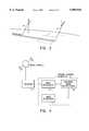
- FIG. 1is an illustration of the orbiting space craft of this invention and its components:
- FIG. 2is an illustration of the orbiting space craft of this invention showing the imaging process
- FIG. 3is a block diagram of the space craft control system of this invention.
- FIG. 4is a block diagram of the ground control system of this invention.
- the space craft 1 of this inventionis designed to carry an imaging system 2 to capture data from a target 3 and transmit the data to a ground receiving station 5 for processing.
- the imaging space craft 1In order to accomplish its mission the imaging space craft 1 is placed in orbit in a predetermined path 6 , as shown in FIG. 2, consistent with the geographical location of the target.
- the basic components of the systeminvolve the on board system comprising: imaging system 2, an attitude control system 8, a position and attitude data receiver 9, and an on board computer 10.
- the output of the imaging system 2is transmitted to the ground receiving station 5 which includes: receiver 14, image processor 15, location identifier 16, and image generator 17.
- the on board computer 10Central to the operation of the system is the on board computer 10 which, after launch and orbit has been achieved, is adapted to control the attitude of the space craft and to monitor its position. This is accomplished by installing the capability of receiving actual position and attitude data from a remote reference system and comparing such data to predetermined data. The computer 10 is then able to generate attitude control instructions to adjust the position of the space craft to its mission attitude i.e. the image system 2 is pointed at the target.
- the system of this inventionuses as its remote reference system the Global Positioning system (GPS) currently installed in space for use by ships and planes for monitoring their position.
- GPSGlobal Positioning system
- the GPSis a constellation of orbiting satellites 11 which transmit timed signals indicative of their position in the constellation.
- Receiving stations on the vehiclecan identify the signals and location of multiple satellites and, using the timing of the transmission, establish the position of the receiving station with considerable accuracy and simplicity.
- each GPS signalin addition to carrying the identity of the specific GPS satellite 11 from which the signal emanates, also carries the time of transmission of the GPS signal from each of the respective GPS satellites 11.
- Each GPS receiver 9includes well-known computational circuitry which, upon observation of the time delays of the respective GPS signals from the respective satellites, computes its own position.
- the position and attitude data receiver 9 of the space craft 1is constructed with multiple antennae 12 in fixed location relative to the space craft reference coordinates. The pattern of relative receiving times of each antenna in the group enables calculation of the relative position of each antenna. From this information the instantaneous attitude of the space craft 1 can be determined. In this manner the data relative to actual position and attitude can be collected and sent to the computer 10.
- Attitude controlis accomplished through reference to the orthogonal axis x, y, z as shown in FIG. 1.
- the nominal orientation of these axisare with respect to a plane defined by a line connecting the earth's center of mass with the center of mass of the space craft and the direction of orbital movement, i.e.. the orbital plane.
- a mission attitude x', y', z'is established in which the line of sight 4 of the image data sensor 7 is directed at the target during image data collection.
- the attitude control system 8is an active system employing reaction jets to generate incremental movement of the space craft to adjust roll, yaw, and pitch identified with the reference axis as shown in FIG. 1. This three axis control system is well established and described in the prior art, such as U.S. Pat. Nos. 3,567,155 and 3,984,071.
- the attitude control system 8is activated by adjustment signals generated by computer 10.
- Imaging system 2can utilize any suitable optical apparatus 12 such as a telescope that can provide image data to the photosensitive sensor element 7.
- the sensor 7converts the image data collected into electrical signals which are processed by image processor 18 for transmission by imaging transmitter 19 to the receiving station 5.
- image processor 18for transmission by imaging transmitter 19 to the receiving station 5.
- the system 2is mounted on the space craft in either a fixed or adjustable position. In the fixed position, alignment of the line of sight 4 of the image sensor 7 is accomplished solely by attitude adjustment.
- An adjustable mountcan provide supplemental adjustment of the line of sight 4 to obtain alignment with the target 3.
- the position of the line of sight 4is always known with respect to the reference coordinates of the space craft.
- the computer 10is programmed with a predetermined mission attitude (x', y', z') at which the line of sight 4 is aligned with the target 3 during the image data collection process.
- the ground receiving station 5consists of tracking antennae 20 adapted to receive the image data signals and deliver the data signals to ground station computer 13.
- the ground station computeris programmed to process the image signals, compensating for distortion. Each image is identified relative to their location within the target 3 and then assembled into a composite mosaic of the complete target 3.
- Ground station computer 13utilizes advanced distortion reducing modeling algorithms such as those described in U.S. Pat. No. 4,688,092 to compensate for relative movement between the optical system 2 and the target 3. This allows the use of the less accurate GPS reference data system and eliminates the complex star sighting systems of the prior art. In prior art systems, each image was located by reference to the celestial data and then assembled. When the advanced algorithms are used, it has been found that the dominant cause of image distortion is the abrupt motion initiated by the attitude control system 8.
- ground station computer 13is provided with a data base of known landmarks which are continuously compared to the image data received from the space craft 1. Each image is identified through the map coordinates of the known landmark and the position of the image relative to its contiguous image is established.
- landmark recognition techniquesas described in the '092 patent cited above, the image mosaic can be accurately assembled by the computer 13.
- the image generation processis initiated by the on board computer 10 after the attitude of the space craft is adjusted so that the line of sight 4 is aligned for target interception and the position of the space craft is over the target.
- FIG. 2shows the sweep of the image capture and illustrates how multiple passes or multiple space craft can obtain segments of the target image for assembly.
- the imaging system 2is only activated for a short period of time. An imaging period of between 50 to 60 seconds would cover approximately 350 km on the ground if the space craft is orbiting at an altitude of 500 to 600 km.
- computer 10Since the image capture process is only of limited duration, computer 10 is programmed to delay attitude adjustments while the imaging system 2 is activated. This prevents the distortion generating motions of the attitude control system 8 during image capture. During this period, the space craft 1 will drift from its mission attitude under the influence of solar torque and other factors, but the image processing algorithms of the ground computer 13 will compensate for this motion. The result is a high quality image with an overall system simplification.
Landscapes
- Engineering & Computer Science (AREA)
- Remote Sensing (AREA)
- Radar, Positioning & Navigation (AREA)
- Physics & Mathematics (AREA)
- General Physics & Mathematics (AREA)
- Computer Networks & Wireless Communication (AREA)
- Multimedia (AREA)
- Automation & Control Theory (AREA)
- Chemical & Material Sciences (AREA)
- Combustion & Propulsion (AREA)
- Aviation & Aerospace Engineering (AREA)
- Control Of Position, Course, Altitude, Or Attitude Of Moving Bodies (AREA)
- Position Fixing By Use Of Radio Waves (AREA)
- Image Processing (AREA)
Abstract
Description
Claims (2)
Priority Applications (1)
| Application Number | Priority Date | Filing Date | Title |
|---|---|---|---|
| US08/926,266US5899945A (en) | 1995-04-17 | 1997-09-05 | Attitude control and navigation system for high resolution imaging |
Applications Claiming Priority (2)
| Application Number | Priority Date | Filing Date | Title |
|---|---|---|---|
| US42374995A | 1995-04-17 | 1995-04-17 | |
| US08/926,266US5899945A (en) | 1995-04-17 | 1997-09-05 | Attitude control and navigation system for high resolution imaging |
Related Parent Applications (1)
| Application Number | Title | Priority Date | Filing Date |
|---|---|---|---|
| US42374995AContinuation | 1995-04-17 | 1995-04-17 |
Publications (1)
| Publication Number | Publication Date |
|---|---|
| US5899945Atrue US5899945A (en) | 1999-05-04 |
Family
ID=23680034
Family Applications (1)
| Application Number | Title | Priority Date | Filing Date |
|---|---|---|---|
| US08/926,266Expired - LifetimeUS5899945A (en) | 1995-04-17 | 1997-09-05 | Attitude control and navigation system for high resolution imaging |
Country Status (4)
| Country | Link |
|---|---|
| US (1) | US5899945A (en) |
| EP (1) | EP0738947B1 (en) |
| DE (1) | DE69604722T2 (en) |
| RU (1) | RU2153700C2 (en) |
Cited By (49)
| Publication number | Priority date | Publication date | Assignee | Title |
|---|---|---|---|---|
| US6023291A (en)* | 1996-10-16 | 2000-02-08 | Space Systems/Loral, Inc. | Satellite camera attitude determination and image navigation by means of earth edge and landmark measurement |
| US6038499A (en)* | 1996-12-10 | 2000-03-14 | Kabushiki Kaisha Toshiba | Direction detecting device for detecting direction of space vehicle |
| US6072524A (en)* | 1997-04-07 | 2000-06-06 | The Boeing Company | Electronic observation post with communications relay |
| US6108593A (en)* | 1997-07-09 | 2000-08-22 | Hughes Electronics Corporation | Method and apparatus for estimating attitude sensor bias in a satellite |
| US6324473B1 (en)* | 1997-08-04 | 2001-11-27 | Trimble Navigation Limited | Method and apparatus for collecting, processing and distributing differential global positioning system information using the internet |
| US6463366B2 (en) | 2000-03-10 | 2002-10-08 | Schafer Corp | Attitude determination and alignment using electro-optical sensors and global navigation satellites |
| US6529830B1 (en) | 1997-08-04 | 2003-03-04 | Trimble Navigation Ltd. | Method and system for providing wide area augmentation systems (WAAS) like corrections using a server and processor on the internet |
| US20030065922A1 (en)* | 2001-09-28 | 2003-04-03 | Fredlund John R. | System and method of authenticating a digitally captured image |
| US20030065722A1 (en)* | 2001-10-01 | 2003-04-03 | Ieperen Taco Van | Method and system for creating and managing secure shared workspaces |
| US6754584B2 (en) | 2001-02-28 | 2004-06-22 | Enpoint, Llc | Attitude measurement using a single GPS receiver with two closely-spaced antennas |
| US20080123994A1 (en)* | 2006-08-30 | 2008-05-29 | Stephen Schultz | Mosaic Oblique Images and Methods of Making and Using Same |
| US20080204570A1 (en)* | 2007-02-15 | 2008-08-28 | Stephen Schultz | Event Multiplexer For Managing The Capture of Images |
| US20080231700A1 (en)* | 2007-02-01 | 2008-09-25 | Stephen Schultz | Computer System for Continuous Oblique Panning |
| US20080273753A1 (en)* | 2007-05-01 | 2008-11-06 | Frank Giuffrida | System for Detecting Image Abnormalities |
| US20090096884A1 (en)* | 2002-11-08 | 2009-04-16 | Schultz Stephen L | Method and Apparatus for Capturing, Geolocating and Measuring Oblique Images |
| US20090097744A1 (en)* | 2007-10-12 | 2009-04-16 | Stephen Schultz | System and Process for Color-Balancing a Series of Oblique Images |
| US20090141020A1 (en)* | 2007-12-03 | 2009-06-04 | Freund Joseph G | Systems and methods for rapid three-dimensional modeling with real facade texture |
| US20090295633A1 (en)* | 2008-06-02 | 2009-12-03 | Pinto Robert W | Attitude estimation using intentional translation of a global navigation satellite system (GNSS) antenna |
| US20090326816A1 (en)* | 2006-05-30 | 2009-12-31 | Choon Bae Park | Attitude correction apparatus and method for inertial navigation system using camera-type solar sensor |
| US20100042274A1 (en)* | 2006-09-27 | 2010-02-18 | Electronics And Telecommunications Research Institute | Attitude control method using target track approximation |
| US20100296693A1 (en)* | 2009-05-22 | 2010-11-25 | Thornberry Dale R | System and process for roof measurement using aerial imagery |
| US20110096083A1 (en)* | 2009-10-26 | 2011-04-28 | Stephen Schultz | Method for the automatic material classification and texture simulation for 3d models |
| US20120109425A1 (en)* | 2010-11-03 | 2012-05-03 | The Aerospace Corporation | Systems, methods, and apparatus for sensing flight direction of a spacecraft |
| US8379087B1 (en)* | 2007-05-01 | 2013-02-19 | The United States Of America As Represented By The Secretary Of The Navy | Attitude estimation using ground imagery |
| CN103019099A (en)* | 2012-12-14 | 2013-04-03 | 北京航空航天大学 | Parameter optimization method for satellite attitude fuzzy controller |
| US8477190B2 (en) | 2010-07-07 | 2013-07-02 | Pictometry International Corp. | Real-time moving platform management system |
| US20130275036A1 (en)* | 2011-07-26 | 2013-10-17 | Lawrence Livermore National Security, Llc | Scheduler for monitoring objects orbiting earth using satellite-based telescopes |
| US8588547B2 (en) | 2008-08-05 | 2013-11-19 | Pictometry International Corp. | Cut-line steering methods for forming a mosaic image of a geographical area |
| CN103983250A (en)* | 2014-05-19 | 2014-08-13 | 上海微小卫星工程中心 | Space target space-based imaging method and space target space-based imaging device |
| US8823732B2 (en) | 2010-12-17 | 2014-09-02 | Pictometry International Corp. | Systems and methods for processing images with edge detection and snap-to feature |
| CN104034314A (en)* | 2014-05-19 | 2014-09-10 | 上海微小卫星工程中心 | Guide imaging method, and space target space-based imaging method and device |
| US9183538B2 (en) | 2012-03-19 | 2015-11-10 | Pictometry International Corp. | Method and system for quick square roof reporting |
| US9189451B1 (en)* | 2011-10-06 | 2015-11-17 | RKF Engineering Solutions, LLC | Detecting orbital debris |
| US20150348264A1 (en)* | 2012-12-28 | 2015-12-03 | Korea Aerospace Research Institute | Method for calibrating absolute misalignment between linear array image sensor and attitude control sensor |
| US9262818B2 (en) | 2007-05-01 | 2016-02-16 | Pictometry International Corp. | System for detecting image abnormalities |
| US9275080B2 (en) | 2013-03-15 | 2016-03-01 | Pictometry International Corp. | System and method for early access to captured images |
| US9292913B2 (en) | 2014-01-31 | 2016-03-22 | Pictometry International Corp. | Augmented three dimensional point collection of vertical structures |
| CN105416616A (en)* | 2015-11-19 | 2016-03-23 | 南京航空航天大学 | Novel space station extravehicular inspection maintenance unit |
| US9612598B2 (en) | 2014-01-10 | 2017-04-04 | Pictometry International Corp. | Unmanned aircraft structure evaluation system and method |
| US9753950B2 (en) | 2013-03-15 | 2017-09-05 | Pictometry International Corp. | Virtual property reporting for automatic structure detection |
| US9881163B2 (en) | 2013-03-12 | 2018-01-30 | Pictometry International Corp. | System and method for performing sensitive geo-spatial processing in non-sensitive operator environments |
| US9953112B2 (en) | 2014-02-08 | 2018-04-24 | Pictometry International Corp. | Method and system for displaying room interiors on a floor plan |
| US10325350B2 (en) | 2011-06-10 | 2019-06-18 | Pictometry International Corp. | System and method for forming a video stream containing GIS data in real-time |
| US10402676B2 (en) | 2016-02-15 | 2019-09-03 | Pictometry International Corp. | Automated system and methodology for feature extraction |
| US10502813B2 (en) | 2013-03-12 | 2019-12-10 | Pictometry International Corp. | LiDAR system producing multiple scan paths and method of making and using same |
| CN110851232A (en)* | 2019-09-30 | 2020-02-28 | 南京航空航天大学 | A kind of space mission demonstration device based on special-shaped screen |
| US10671648B2 (en) | 2016-02-22 | 2020-06-02 | Eagle View Technologies, Inc. | Integrated centralized property database systems and methods |
| US12079013B2 (en) | 2016-01-08 | 2024-09-03 | Pictometry International Corp. | Systems and methods for taking, processing, retrieving, and displaying images from unmanned aerial vehicles |
| US12332660B2 (en) | 2018-11-21 | 2025-06-17 | Eagle View Technologies, Inc. | Navigating unmanned aircraft using pitch |
Families Citing this family (3)
| Publication number | Priority date | Publication date | Assignee | Title |
|---|---|---|---|---|
| WO1998049514A2 (en)* | 1997-04-29 | 1998-11-05 | Glynn Shannon, Llc | System and method for enabling digital pursuit of natural and artificial targets |
| DE19907235A1 (en)* | 1999-02-19 | 2000-09-14 | Daimler Chrysler Ag | GPS navigation system for space applications |
| CN102736633B (en)* | 2012-06-28 | 2014-11-19 | 航天东方红卫星有限公司 | A navigation, control and imaging system for an extravehicular mobile monitor on a space station |
Citations (13)
| Publication number | Priority date | Publication date | Assignee | Title |
|---|---|---|---|---|
| US3567155A (en)* | 1968-12-20 | 1971-03-02 | James A Gatlin | Gravity gradient attitude control system |
| US3984071A (en)* | 1974-08-29 | 1976-10-05 | Trw Inc. | Satellite nutation attenuation apparatus |
| US4682300A (en)* | 1983-01-20 | 1987-07-21 | Hitachi, Ltd. | Image correction processing method and apparatus |
| US4688092A (en)* | 1986-05-06 | 1987-08-18 | Ford Aerospace & Communications Corporation | Satellite camera image navigation |
| US4688091A (en)* | 1986-05-06 | 1987-08-18 | Ford Aerospace & Communications Corporation | Spacecraft camera image registration |
| US4837699A (en)* | 1985-07-18 | 1989-06-06 | Hughes Aircraft Company | Method for controlling the spin axis attitude of a spinning spacecraft |
| EP0361297A1 (en)* | 1988-09-20 | 1990-04-04 | Nec Corporation | Image pickup system capable of obtaining a plurality of stereo images with different base height ratios |
| EP0383114A1 (en)* | 1989-02-13 | 1990-08-22 | Hughes Aircraft Company | Measurement and control system for scanning sensors |
| US5101356A (en)* | 1989-11-21 | 1992-03-31 | Unisys Corporation | Moving vehicle attitude measuring system |
| US5134473A (en)* | 1990-04-12 | 1992-07-28 | Nec Corporation | Image pickup system comprising a memory of a small capacity |
| US5204818A (en)* | 1990-05-22 | 1993-04-20 | The United States Of America As Represented By The Secretary Of The Air Force | Surveying satellite apparatus |
| US5353055A (en)* | 1991-04-16 | 1994-10-04 | Nec Corporation | Image pickup system with an image pickup device for control |
| US5543804A (en)* | 1994-09-13 | 1996-08-06 | Litton Systems, Inc. | Navagation apparatus with improved attitude determination |
- 1996
- 1996-01-03RURU96100752/09Apatent/RU2153700C2/ennot_activeIP Right Cessation
- 1996-04-17EPEP96302660Apatent/EP0738947B1/ennot_activeExpired - Lifetime
- 1996-04-17DEDE69604722Tpatent/DE69604722T2/ennot_activeExpired - Fee Related
- 1997
- 1997-09-05USUS08/926,266patent/US5899945A/ennot_activeExpired - Lifetime
Patent Citations (14)
| Publication number | Priority date | Publication date | Assignee | Title |
|---|---|---|---|---|
| US3567155A (en)* | 1968-12-20 | 1971-03-02 | James A Gatlin | Gravity gradient attitude control system |
| US3984071A (en)* | 1974-08-29 | 1976-10-05 | Trw Inc. | Satellite nutation attenuation apparatus |
| US4682300A (en)* | 1983-01-20 | 1987-07-21 | Hitachi, Ltd. | Image correction processing method and apparatus |
| US4837699A (en)* | 1985-07-18 | 1989-06-06 | Hughes Aircraft Company | Method for controlling the spin axis attitude of a spinning spacecraft |
| US4688092A (en)* | 1986-05-06 | 1987-08-18 | Ford Aerospace & Communications Corporation | Satellite camera image navigation |
| US4688091A (en)* | 1986-05-06 | 1987-08-18 | Ford Aerospace & Communications Corporation | Spacecraft camera image registration |
| EP0361297A1 (en)* | 1988-09-20 | 1990-04-04 | Nec Corporation | Image pickup system capable of obtaining a plurality of stereo images with different base height ratios |
| US5027199A (en)* | 1988-09-20 | 1991-06-25 | Nec Corporation | Image pickup system capable of obtaining a plurality of stereo images with different base height ratios |
| EP0383114A1 (en)* | 1989-02-13 | 1990-08-22 | Hughes Aircraft Company | Measurement and control system for scanning sensors |
| US5101356A (en)* | 1989-11-21 | 1992-03-31 | Unisys Corporation | Moving vehicle attitude measuring system |
| US5134473A (en)* | 1990-04-12 | 1992-07-28 | Nec Corporation | Image pickup system comprising a memory of a small capacity |
| US5204818A (en)* | 1990-05-22 | 1993-04-20 | The United States Of America As Represented By The Secretary Of The Air Force | Surveying satellite apparatus |
| US5353055A (en)* | 1991-04-16 | 1994-10-04 | Nec Corporation | Image pickup system with an image pickup device for control |
| US5543804A (en)* | 1994-09-13 | 1996-08-06 | Litton Systems, Inc. | Navagation apparatus with improved attitude determination |
Non-Patent Citations (6)
| Title |
|---|
| Brock et al., "GPS Attitude and Orbit Determination for Space". Presented at the ION GPS-94 Conference, Salt Lake City, UT, Sep. 20-23, 1994, pp. 1-8. |
| Brock et al., GPS Attitude and Orbit Determination for Space . Presented at the ION GPS 94 Conference, Salt Lake City, UT, Sep. 20 23, 1994, pp. 1 8.* |
| Martin Neira et al., Attitude Determination with GPS: Experimental Results , IEEE Sep. 1990, pp. 24 29.* |
| Martin-Neira et al., "Attitude Determination with GPS: Experimental Results", IEEE Sep. 1990, pp. 24-29. |
| Rosborough et al., "Precise AVARR Image Navigation", IEEE May 1994, pp. 644-657. |
| Rosborough et al., Precise AVARR Image Navigation , IEEE May 1994, pp. 644 657.* |
Cited By (131)
| Publication number | Priority date | Publication date | Assignee | Title |
|---|---|---|---|---|
| US6023291A (en)* | 1996-10-16 | 2000-02-08 | Space Systems/Loral, Inc. | Satellite camera attitude determination and image navigation by means of earth edge and landmark measurement |
| US6038499A (en)* | 1996-12-10 | 2000-03-14 | Kabushiki Kaisha Toshiba | Direction detecting device for detecting direction of space vehicle |
| US6072524A (en)* | 1997-04-07 | 2000-06-06 | The Boeing Company | Electronic observation post with communications relay |
| US6108593A (en)* | 1997-07-09 | 2000-08-22 | Hughes Electronics Corporation | Method and apparatus for estimating attitude sensor bias in a satellite |
| US6324473B1 (en)* | 1997-08-04 | 2001-11-27 | Trimble Navigation Limited | Method and apparatus for collecting, processing and distributing differential global positioning system information using the internet |
| US6529830B1 (en) | 1997-08-04 | 2003-03-04 | Trimble Navigation Ltd. | Method and system for providing wide area augmentation systems (WAAS) like corrections using a server and processor on the internet |
| US6741935B1 (en) | 1997-08-04 | 2004-05-25 | Trimble Navigation Ltd. | Method and system for providing wide area augmentation system (WAAS) like corrections using a server and processor on the internet |
| US6463366B2 (en) | 2000-03-10 | 2002-10-08 | Schafer Corp | Attitude determination and alignment using electro-optical sensors and global navigation satellites |
| US20050004748A1 (en)* | 2001-02-28 | 2005-01-06 | Enpoint, Llc. | Attitude measurement using a single GPS receiver with two closely-spaced antennas |
| US7136751B2 (en) | 2001-02-28 | 2006-11-14 | Enpoint, Llc | Attitude measurement using a GPS receiver with two closely-spaced antennas |
| US6754584B2 (en) | 2001-02-28 | 2004-06-22 | Enpoint, Llc | Attitude measurement using a single GPS receiver with two closely-spaced antennas |
| US20030065922A1 (en)* | 2001-09-28 | 2003-04-03 | Fredlund John R. | System and method of authenticating a digitally captured image |
| US20030065722A1 (en)* | 2001-10-01 | 2003-04-03 | Ieperen Taco Van | Method and system for creating and managing secure shared workspaces |
| US7787659B2 (en) | 2002-11-08 | 2010-08-31 | Pictometry International Corp. | Method and apparatus for capturing, geolocating and measuring oblique images |
| US10607357B2 (en) | 2002-11-08 | 2020-03-31 | Pictometry International Corp. | Method and apparatus for capturing, geolocating and measuring oblique images |
| US11069077B2 (en) | 2002-11-08 | 2021-07-20 | Pictometry International Corp. | Method and apparatus for capturing, geolocating and measuring oblique images |
| US20090096884A1 (en)* | 2002-11-08 | 2009-04-16 | Schultz Stephen L | Method and Apparatus for Capturing, Geolocating and Measuring Oblique Images |
| US20100302243A1 (en)* | 2002-11-08 | 2010-12-02 | Schultz Stephen L | Method and apparatus for capturing geolocating and measuring oblique images |
| US9443305B2 (en) | 2002-11-08 | 2016-09-13 | Pictometry International Corp. | Method and apparatus for capturing, geolocating and measuring oblique images |
| US7995799B2 (en) | 2002-11-08 | 2011-08-09 | Pictometry International Corporation | Method and apparatus for capturing geolocating and measuring oblique images |
| US9811922B2 (en) | 2002-11-08 | 2017-11-07 | Pictometry International Corp. | Method and apparatus for capturing, geolocating and measuring oblique images |
| US20090326816A1 (en)* | 2006-05-30 | 2009-12-31 | Choon Bae Park | Attitude correction apparatus and method for inertial navigation system using camera-type solar sensor |
| US7805244B2 (en)* | 2006-05-30 | 2010-09-28 | Inha University | Attitude correction apparatus and method for inertial navigation system using camera-type solar sensor |
| US10489953B2 (en) | 2006-08-30 | 2019-11-26 | Pictometry International Corp. | Mosaic oblique images and methods of making and using same |
| US20080123994A1 (en)* | 2006-08-30 | 2008-05-29 | Stephen Schultz | Mosaic Oblique Images and Methods of Making and Using Same |
| US9437029B2 (en) | 2006-08-30 | 2016-09-06 | Pictometry International Corp. | Mosaic oblique images and methods of making and using same |
| US11080911B2 (en) | 2006-08-30 | 2021-08-03 | Pictometry International Corp. | Mosaic oblique images and systems and methods of making and using same |
| US9805489B2 (en) | 2006-08-30 | 2017-10-31 | Pictometry International Corp. | Mosaic oblique images and methods of making and using same |
| US7873238B2 (en) | 2006-08-30 | 2011-01-18 | Pictometry International Corporation | Mosaic oblique images and methods of making and using same |
| US9959653B2 (en) | 2006-08-30 | 2018-05-01 | Pictometry International Corporation | Mosaic oblique images and methods of making and using same |
| US20100042274A1 (en)* | 2006-09-27 | 2010-02-18 | Electronics And Telecommunications Research Institute | Attitude control method using target track approximation |
| US8593518B2 (en) | 2007-02-01 | 2013-11-26 | Pictometry International Corp. | Computer system for continuous oblique panning |
| US20080231700A1 (en)* | 2007-02-01 | 2008-09-25 | Stephen Schultz | Computer System for Continuous Oblique Panning |
| US8520079B2 (en) | 2007-02-15 | 2013-08-27 | Pictometry International Corp. | Event multiplexer for managing the capture of images |
| US20080204570A1 (en)* | 2007-02-15 | 2008-08-28 | Stephen Schultz | Event Multiplexer For Managing The Capture of Images |
| US20080273753A1 (en)* | 2007-05-01 | 2008-11-06 | Frank Giuffrida | System for Detecting Image Abnormalities |
| US11514564B2 (en) | 2007-05-01 | 2022-11-29 | Pictometry International Corp. | System for detecting image abnormalities |
| US9633425B2 (en) | 2007-05-01 | 2017-04-25 | Pictometry International Corp. | System for detecting image abnormalities |
| US9959609B2 (en) | 2007-05-01 | 2018-05-01 | Pictometry International Corporation | System for detecting image abnormalities |
| US9262818B2 (en) | 2007-05-01 | 2016-02-16 | Pictometry International Corp. | System for detecting image abnormalities |
| US10198803B2 (en) | 2007-05-01 | 2019-02-05 | Pictometry International Corp. | System for detecting image abnormalities |
| US10679331B2 (en) | 2007-05-01 | 2020-06-09 | Pictometry International Corp. | System for detecting image abnormalities |
| US8385672B2 (en) | 2007-05-01 | 2013-02-26 | Pictometry International Corp. | System for detecting image abnormalities |
| US8379087B1 (en)* | 2007-05-01 | 2013-02-19 | The United States Of America As Represented By The Secretary Of The Navy | Attitude estimation using ground imagery |
| US11100625B2 (en) | 2007-05-01 | 2021-08-24 | Pictometry International Corp. | System for detecting image abnormalities |
| US7991226B2 (en) | 2007-10-12 | 2011-08-02 | Pictometry International Corporation | System and process for color-balancing a series of oblique images |
| US11087506B2 (en) | 2007-10-12 | 2021-08-10 | Pictometry International Corp. | System and process for color-balancing a series of oblique images |
| US10580169B2 (en) | 2007-10-12 | 2020-03-03 | Pictometry International Corp. | System and process for color-balancing a series of oblique images |
| US20090097744A1 (en)* | 2007-10-12 | 2009-04-16 | Stephen Schultz | System and Process for Color-Balancing a Series of Oblique Images |
| US9503615B2 (en) | 2007-10-12 | 2016-11-22 | Pictometry International Corp. | System and process for color-balancing a series of oblique images |
| US11263808B2 (en) | 2007-12-03 | 2022-03-01 | Pictometry International Corp. | Systems and methods for rapid three-dimensional modeling with real façade texture |
| US8531472B2 (en) | 2007-12-03 | 2013-09-10 | Pictometry International Corp. | Systems and methods for rapid three-dimensional modeling with real façade texture |
| US9972126B2 (en) | 2007-12-03 | 2018-05-15 | Pictometry International Corp. | Systems and methods for rapid three-dimensional modeling with real facade texture |
| US9275496B2 (en) | 2007-12-03 | 2016-03-01 | Pictometry International Corp. | Systems and methods for rapid three-dimensional modeling with real facade texture |
| US10573069B2 (en) | 2007-12-03 | 2020-02-25 | Pictometry International Corp. | Systems and methods for rapid three-dimensional modeling with real facade texture |
| US9836882B2 (en) | 2007-12-03 | 2017-12-05 | Pictometry International Corp. | Systems and methods for rapid three-dimensional modeling with real facade texture |
| US20090141020A1 (en)* | 2007-12-03 | 2009-06-04 | Freund Joseph G | Systems and methods for rapid three-dimensional modeling with real facade texture |
| US10896540B2 (en) | 2007-12-03 | 2021-01-19 | Pictometry International Corp. | Systems and methods for rapid three-dimensional modeling with real façade texture |
| US9520000B2 (en) | 2007-12-03 | 2016-12-13 | Pictometry International Corp. | Systems and methods for rapid three-dimensional modeling with real facade texture |
| US10229532B2 (en) | 2007-12-03 | 2019-03-12 | Pictometry International Corporation | Systems and methods for rapid three-dimensional modeling with real facade texture |
| US7671794B2 (en) | 2008-06-02 | 2010-03-02 | Enpoint, Llc | Attitude estimation using intentional translation of a global navigation satellite system (GNSS) antenna |
| US20090295633A1 (en)* | 2008-06-02 | 2009-12-03 | Pinto Robert W | Attitude estimation using intentional translation of a global navigation satellite system (GNSS) antenna |
| US10424047B2 (en) | 2008-08-05 | 2019-09-24 | Pictometry International Corp. | Cut line steering methods for forming a mosaic image of a geographical area |
| US8588547B2 (en) | 2008-08-05 | 2013-11-19 | Pictometry International Corp. | Cut-line steering methods for forming a mosaic image of a geographical area |
| US11551331B2 (en) | 2008-08-05 | 2023-01-10 | Pictometry International Corp. | Cut-line steering methods for forming a mosaic image of a geographical area |
| US10839484B2 (en) | 2008-08-05 | 2020-11-17 | Pictometry International Corp. | Cut-line steering methods for forming a mosaic image of a geographical area |
| US9898802B2 (en) | 2008-08-05 | 2018-02-20 | Pictometry International Corp. | Cut line steering methods for forming a mosaic image of a geographical area |
| US8401222B2 (en) | 2009-05-22 | 2013-03-19 | Pictometry International Corp. | System and process for roof measurement using aerial imagery |
| US20100296693A1 (en)* | 2009-05-22 | 2010-11-25 | Thornberry Dale R | System and process for roof measurement using aerial imagery |
| US9933254B2 (en) | 2009-05-22 | 2018-04-03 | Pictometry International Corp. | System and process for roof measurement using aerial imagery |
| US9959667B2 (en) | 2009-10-26 | 2018-05-01 | Pictometry International Corp. | Method for the automatic material classification and texture simulation for 3D models |
| US20110096083A1 (en)* | 2009-10-26 | 2011-04-28 | Stephen Schultz | Method for the automatic material classification and texture simulation for 3d models |
| US9330494B2 (en) | 2009-10-26 | 2016-05-03 | Pictometry International Corp. | Method for the automatic material classification and texture simulation for 3D models |
| US10198857B2 (en) | 2009-10-26 | 2019-02-05 | Pictometry International Corp. | Method for the automatic material classification and texture simulation for 3D models |
| US8477190B2 (en) | 2010-07-07 | 2013-07-02 | Pictometry International Corp. | Real-time moving platform management system |
| US11483518B2 (en) | 2010-07-07 | 2022-10-25 | Pictometry International Corp. | Real-time moving platform management system |
| US8538606B2 (en)* | 2010-11-03 | 2013-09-17 | The Aerospace Corporation | Systems, methods, and apparatus for sensing flight direction of a spacecraft |
| US20120109425A1 (en)* | 2010-11-03 | 2012-05-03 | The Aerospace Corporation | Systems, methods, and apparatus for sensing flight direction of a spacecraft |
| US8823732B2 (en) | 2010-12-17 | 2014-09-02 | Pictometry International Corp. | Systems and methods for processing images with edge detection and snap-to feature |
| US11003943B2 (en) | 2010-12-17 | 2021-05-11 | Pictometry International Corp. | Systems and methods for processing images with edge detection and snap-to feature |
| US10621463B2 (en) | 2010-12-17 | 2020-04-14 | Pictometry International Corp. | Systems and methods for processing images with edge detection and snap-to feature |
| US10325350B2 (en) | 2011-06-10 | 2019-06-18 | Pictometry International Corp. | System and method for forming a video stream containing GIS data in real-time |
| US20130275036A1 (en)* | 2011-07-26 | 2013-10-17 | Lawrence Livermore National Security, Llc | Scheduler for monitoring objects orbiting earth using satellite-based telescopes |
| US9020748B2 (en)* | 2011-07-26 | 2015-04-28 | Lawrence Livermore National Security, Llc | Scheduler for monitoring objects orbiting earth using satellite-based telescopes |
| US9189451B1 (en)* | 2011-10-06 | 2015-11-17 | RKF Engineering Solutions, LLC | Detecting orbital debris |
| US9916507B1 (en)* | 2011-10-06 | 2018-03-13 | Rkf Engineering Solutions Llc | Detecting orbital debris |
| US9183538B2 (en) | 2012-03-19 | 2015-11-10 | Pictometry International Corp. | Method and system for quick square roof reporting |
| US10346935B2 (en) | 2012-03-19 | 2019-07-09 | Pictometry International Corp. | Medium and method for quick square roof reporting |
| CN103019099A (en)* | 2012-12-14 | 2013-04-03 | 北京航空航天大学 | Parameter optimization method for satellite attitude fuzzy controller |
| US20150348264A1 (en)* | 2012-12-28 | 2015-12-03 | Korea Aerospace Research Institute | Method for calibrating absolute misalignment between linear array image sensor and attitude control sensor |
| US9672624B2 (en)* | 2012-12-28 | 2017-06-06 | Korea Aerospace Research Institute | Method for calibrating absolute misalignment between linear array image sensor and attitude control sensor |
| US10502813B2 (en) | 2013-03-12 | 2019-12-10 | Pictometry International Corp. | LiDAR system producing multiple scan paths and method of making and using same |
| US9881163B2 (en) | 2013-03-12 | 2018-01-30 | Pictometry International Corp. | System and method for performing sensitive geo-spatial processing in non-sensitive operator environments |
| US10311238B2 (en) | 2013-03-12 | 2019-06-04 | Pictometry International Corp. | System and method for performing sensitive geo-spatial processing in non-sensitive operator environments |
| US11525897B2 (en) | 2013-03-12 | 2022-12-13 | Pictometry International Corp. | LiDAR system producing multiple scan paths and method of making and using same |
| US9753950B2 (en) | 2013-03-15 | 2017-09-05 | Pictometry International Corp. | Virtual property reporting for automatic structure detection |
| US9805059B2 (en) | 2013-03-15 | 2017-10-31 | Pictometry International Corp. | System and method for early access to captured images |
| US10311089B2 (en) | 2013-03-15 | 2019-06-04 | Pictometry International Corp. | System and method for early access to captured images |
| US9275080B2 (en) | 2013-03-15 | 2016-03-01 | Pictometry International Corp. | System and method for early access to captured images |
| US10204269B2 (en) | 2014-01-10 | 2019-02-12 | Pictometry International Corp. | Unmanned aircraft obstacle avoidance |
| US9612598B2 (en) | 2014-01-10 | 2017-04-04 | Pictometry International Corp. | Unmanned aircraft structure evaluation system and method |
| US11747486B2 (en) | 2014-01-10 | 2023-09-05 | Pictometry International Corp. | Unmanned aircraft structure evaluation system and method |
| US10318809B2 (en) | 2014-01-10 | 2019-06-11 | Pictometry International Corp. | Unmanned aircraft structure evaluation system and method |
| US10181080B2 (en) | 2014-01-10 | 2019-01-15 | Pictometry International Corp. | Unmanned aircraft structure evaluation system and method |
| US10181081B2 (en) | 2014-01-10 | 2019-01-15 | Pictometry International Corp. | Unmanned aircraft structure evaluation system and method |
| US11120262B2 (en) | 2014-01-10 | 2021-09-14 | Pictometry International Corp. | Unmanned aircraft structure evaluation system and method |
| US10037463B2 (en) | 2014-01-10 | 2018-07-31 | Pictometry International Corp. | Unmanned aircraft structure evaluation system and method |
| US12123959B2 (en) | 2014-01-10 | 2024-10-22 | Pictometry International Corp. | Unmanned aircraft structure evaluation system and method |
| US10037464B2 (en) | 2014-01-10 | 2018-07-31 | Pictometry International Corp. | Unmanned aircraft structure evaluation system and method |
| US10032078B2 (en) | 2014-01-10 | 2018-07-24 | Pictometry International Corp. | Unmanned aircraft structure evaluation system and method |
| US11087131B2 (en) | 2014-01-10 | 2021-08-10 | Pictometry International Corp. | Unmanned aircraft structure evaluation system and method |
| US9542738B2 (en) | 2014-01-31 | 2017-01-10 | Pictometry International Corp. | Augmented three dimensional point collection of vertical structures |
| US10571575B2 (en) | 2014-01-31 | 2020-02-25 | Pictometry International Corp. | Augmented three dimensional point collection of vertical structures |
| US10942276B2 (en) | 2014-01-31 | 2021-03-09 | Pictometry International Corp. | Augmented three dimensional point collection of vertical structures |
| US10338222B2 (en) | 2014-01-31 | 2019-07-02 | Pictometry International Corp. | Augmented three dimensional point collection of vertical structures |
| US11686849B2 (en) | 2014-01-31 | 2023-06-27 | Pictometry International Corp. | Augmented three dimensional point collection of vertical structures |
| US9292913B2 (en) | 2014-01-31 | 2016-03-22 | Pictometry International Corp. | Augmented three dimensional point collection of vertical structures |
| US9953112B2 (en) | 2014-02-08 | 2018-04-24 | Pictometry International Corp. | Method and system for displaying room interiors on a floor plan |
| US11100259B2 (en) | 2014-02-08 | 2021-08-24 | Pictometry International Corp. | Method and system for displaying room interiors on a floor plan |
| CN103983250A (en)* | 2014-05-19 | 2014-08-13 | 上海微小卫星工程中心 | Space target space-based imaging method and space target space-based imaging device |
| CN104034314A (en)* | 2014-05-19 | 2014-09-10 | 上海微小卫星工程中心 | Guide imaging method, and space target space-based imaging method and device |
| CN105416616B (en)* | 2015-11-19 | 2017-08-25 | 南京航空航天大学 | New spatial station inspection maintenance unit out of my cabin |
| CN105416616A (en)* | 2015-11-19 | 2016-03-23 | 南京航空航天大学 | Novel space station extravehicular inspection maintenance unit |
| US12079013B2 (en) | 2016-01-08 | 2024-09-03 | Pictometry International Corp. | Systems and methods for taking, processing, retrieving, and displaying images from unmanned aerial vehicles |
| US11417081B2 (en) | 2016-02-15 | 2022-08-16 | Pictometry International Corp. | Automated system and methodology for feature extraction |
| US10402676B2 (en) | 2016-02-15 | 2019-09-03 | Pictometry International Corp. | Automated system and methodology for feature extraction |
| US10796189B2 (en) | 2016-02-15 | 2020-10-06 | Pictometry International Corp. | Automated system and methodology for feature extraction |
| US10671648B2 (en) | 2016-02-22 | 2020-06-02 | Eagle View Technologies, Inc. | Integrated centralized property database systems and methods |
| US12332660B2 (en) | 2018-11-21 | 2025-06-17 | Eagle View Technologies, Inc. | Navigating unmanned aircraft using pitch |
| CN110851232A (en)* | 2019-09-30 | 2020-02-28 | 南京航空航天大学 | A kind of space mission demonstration device based on special-shaped screen |
| CN110851232B (en)* | 2019-09-30 | 2023-10-31 | 南京航空航天大学 | Space mission presentation device based on dysmorphism screen |
Also Published As
| Publication number | Publication date |
|---|---|
| EP0738947B1 (en) | 1999-10-20 |
| DE69604722T2 (en) | 2000-06-15 |
| RU2153700C2 (en) | 2000-07-27 |
| EP0738947A1 (en) | 1996-10-23 |
| DE69604722D1 (en) | 1999-11-25 |
Similar Documents
| Publication | Publication Date | Title |
|---|---|---|
| US5899945A (en) | Attitude control and navigation system for high resolution imaging | |
| US5963166A (en) | Precise spacecraft camera image navigation and registration | |
| US5809457A (en) | Inertial pointing and positioning system | |
| JP2598820Y2 (en) | Image navigation support system for satellite with camera | |
| US4489322A (en) | Radar calibration using direct measurement equipment and oblique photometry | |
| EP0245562B1 (en) | Spacecraft camera image registration | |
| US5107434A (en) | Three-axis spacecraft attitude control using polar star sensor | |
| US4679753A (en) | Surveying satellite incorporating star-sensing attitude determination subsystem | |
| CN113701753B (en) | Phased array antenna-based positioning and orientation device and method | |
| RU96100752A (en) | SPACE CONTROL SYSTEM AND NAVIGATION SYSTEM FOR FORMING HIGH DEFINITION IMAGES | |
| JP2578422B2 (en) | Calibration device for elevation and azimuth of scanning axis of antenna | |
| US6012000A (en) | Simplified onboard attitude control based on star sensing | |
| JPH08190161A (en) | Satellite focal plane array imager | |
| US5978716A (en) | Satellite imaging control system for non-repeatable error | |
| JPH08253200A (en) | Attitude control method of spacecraft by scanning of earth sensor | |
| CA1265225A (en) | Pointing compensation system for spacecraft instruments | |
| Kamel | GOES image navigation and registration system | |
| KR102539003B1 (en) | Operating method for satellite and operating system for satellite | |
| US20240019588A1 (en) | Onboard geolocation for images | |
| JPH0780480B2 (en) | Earth observation device | |
| JPS63278179A (en) | earth observation equipment | |
| JP2803638B2 (en) | Alignment displacement detector | |
| Fujita et al. | On-orbit Calibration of a Telescope Alignment for Earth Observation using Stars and QUEST | |
| CN120141451B (en) | A method of astronomical positioning and navigation based on optical observation | |
| Kamel et al. | Spacecraft camera image registration |
Legal Events
| Date | Code | Title | Description |
|---|---|---|---|
| FEPP | Fee payment procedure | Free format text:PAYOR NUMBER ASSIGNED (ORIGINAL EVENT CODE: ASPN); ENTITY STATUS OF PATENT OWNER: LARGE ENTITY | |
| STCF | Information on status: patent grant | Free format text:PATENTED CASE | |
| AS | Assignment | Owner name:BANK OF AMERICA, N.A., AS COLLATERAL AGENT, NORTH Free format text:NOTICE OF GRANT OF SECURITY INTEREST;ASSIGNOR:SPACE SYSTEMS/LORAL INC.;REEL/FRAME:012946/0061 Effective date:20011221 | |
| FPAY | Fee payment | Year of fee payment:4 | |
| AS | Assignment | Owner name:SPACE SYSTEMS/LORAL, INC., CALIFORNIA Free format text:RELEASE OF SECURITY INTEREST;ASSIGNOR:BANK OF AMERICA, N.A.;REEL/FRAME:016153/0507 Effective date:20040802 | |
| FPAY | Fee payment | Year of fee payment:8 | |
| AS | Assignment | Owner name:JPMORGAN CHASE BANK, N.A., AS ADMINISTRATIVE AGENT Free format text:SECURITY AGREEMENT;ASSIGNOR:SPACE SYSTEMS/LORAL, INC.;REEL/FRAME:021965/0173 Effective date:20081016 | |
| FPAY | Fee payment | Year of fee payment:12 | |
| AS | Assignment | Owner name:SPACE SYSTEMS/LORAL, INC., CALIFORNIA Free format text:TERMINATION AND RELEASE OF SECURITY INTEREST IN PATENT RIGHTS;ASSIGNOR:JPMORGAN CHASE BANK, N.A.;REEL/FRAME:029228/0203 Effective date:20121102 | |
| AS | Assignment | Owner name:SPACE SYSTEMS/LORAL, LLC, CALIFORNIA Free format text:CHANGE OF NAME;ASSIGNOR:SPACE SYSTEMS/LORAL, INC.;REEL/FRAME:030276/0257 Effective date:20121102 | |
| AS | Assignment | Owner name:ROYAL BANK OF CANADA, CANADA Free format text:SECURITY AGREEMENT;ASSIGNOR:SPACE SYSTEMS/LORAL, LLC;REEL/FRAME:030311/0961 Effective date:20121102 | |
| AS | Assignment | Owner name:ROYAL BANK OF CANADA, AS THE COLLATERAL AGENT, CANADA Free format text:SECURITY INTEREST;ASSIGNORS:DIGITALGLOBE, INC.;MACDONALD, DETTWILER AND ASSOCIATES LTD.;MACDONALD, DETTWILER AND ASSOCIATES CORPORATION;AND OTHERS;REEL/FRAME:044167/0396 Effective date:20171005 Owner name:ROYAL BANK OF CANADA, AS THE COLLATERAL AGENT, CAN Free format text:SECURITY INTEREST;ASSIGNORS:DIGITALGLOBE, INC.;MACDONALD, DETTWILER AND ASSOCIATES LTD.;MACDONALD, DETTWILER AND ASSOCIATES CORPORATION;AND OTHERS;REEL/FRAME:044167/0396 Effective date:20171005 | |
| AS | Assignment | Owner name:MAXAR SPACE LLC, CALIFORNIA Free format text:TERMINATION AND RELEASE OF SECURITY INTEREST IN PATENTS AND TRADEMARKS - RELEASE OF REEL/FRAME 044167/0396;ASSIGNOR:ROYAL BANK OF CANADA, AS AGENT;REEL/FRAME:063543/0001 Effective date:20230503 Owner name:MAXAR INTELLIGENCE INC., COLORADO Free format text:TERMINATION AND RELEASE OF SECURITY INTEREST IN PATENTS AND TRADEMARKS - RELEASE OF REEL/FRAME 044167/0396;ASSIGNOR:ROYAL BANK OF CANADA, AS AGENT;REEL/FRAME:063543/0001 Effective date:20230503 |