US5867110A - Information reporting system - Google Patents
Information reporting systemDownload PDFInfo
- Publication number
- US5867110A US5867110AUS08/696,028US69602896AUS5867110AUS 5867110 AUS5867110 AUS 5867110AUS 69602896 AUS69602896 AUS 69602896AUS 5867110 AUS5867110 AUS 5867110A
- Authority
- US
- United States
- Prior art keywords
- data
- portable terminal
- disaster
- database
- information
- Prior art date
- Legal status (The legal status is an assumption and is not a legal conclusion. Google has not performed a legal analysis and makes no representation as to the accuracy of the status listed.)
- Expired - Lifetime
Links
Images


Classifications
- G—PHYSICS
- G08—SIGNALLING
- G08G—TRAFFIC CONTROL SYSTEMS
- G08G1/00—Traffic control systems for road vehicles
- G08G1/20—Monitoring the location of vehicles belonging to a group, e.g. fleet of vehicles, countable or determined number of vehicles
- G08G1/205—Indicating the location of the monitored vehicles as destination, e.g. accidents, stolen, rental
- G—PHYSICS
- G08—SIGNALLING
- G08G—TRAFFIC CONTROL SYSTEMS
- G08G1/00—Traffic control systems for road vehicles
- G08G1/09—Arrangements for giving variable traffic instructions
- G08G1/0962—Arrangements for giving variable traffic instructions having an indicator mounted inside the vehicle, e.g. giving voice messages
- G08G1/0968—Systems involving transmission of navigation instructions to the vehicle
Definitions
- This inventionis related to a communication system in which a host computer communicates various information to portable terminals. More specifically, it is related to an information reporting system which provides portable terminals with information suitable in light of circumstances at their locations.
- Japanese Patent Application laid open No. 4-295995discloses a system capable of transmitting position information provided by a navigation system through a telephone terminal to a predetermined receiving equipment
- Japanese Patent Application laid open No. 5-327604discloses a system which automatically sends to a control office in control of a radio communication network information including data indicative of the current position of a mobile station at predetermined time intervals
- Japanese Patent Application laid open No. 6-338848discloses a system which transmits position information of a telecommunication device to an emergency information receiving center in case of emergency.
- the portable terminalsuch as telecommunication devices, merely transmits information indicative of its position and the user of the portable terminal cannot obtain information related to the circumstances at his or her location.
- the object of the present inventionis to provide an information reporting system which allows a user of a portable terminal to obtain information regarding circumstances at his of her current position.
- an information reporting systemcomprising a communication host apparatus including a database storing a plurality of data sets each concerning a predetermined position, and a host computer capable of accessing the database and connecting with the communication network, and at least one portable terminal including communication means capable of connecting with the communication network, data processing means for executing predetermined processing based upon data received through the communication means, and display means for displaying images based upon data obtained by the data processing, the portable terminal further including current position detecting means for detecting its current position and being adapted to cause the communication means to transmit the position information data indicative of the current position detected by the current position detecting means to the communication host apparatus via the communication network, and the host computer of the communication host apparatus being responsive to the position information data received from the portable terminal to retrieve from the database a data set concerning the position and supplying it to the portable terminal via the communication network.
- the position information data indicative of the current position of the portable terminal detected by the current position detecting meansare supplied to the communication host apparatus by the communication means, and in response to the position information data the host computer of the communication host apparatus transmits appropriate data to the portable terminal.
- the data processing meansexecutes predetermined data processing based upon the information received from the host computer, and the display means displays an image corresponding to data obtained by the data processing on the screen thereof. Consequently, the user of the portable terminal can obtain appropriate information regarding circumstances at his or her location.
- the portable terminalfurther includes a timer which outputs a time-up signal at predetermined intervals, and the communication means is responsive to the time-up signal to transmit the position information data indicative of the current position of the portable terminal to the communication host apparatus.
- the user of the portable terminalsince the position information data are transmitted to the communication host apparatus at predetermined intervals, the user of the portable terminal can obtain appropriate information without any complicated input operation or the like.
- the communication host apparatusis adapted to request that the communication means of the portable terminal be connected to a telecommunication circuit of the communication network, and the portable terminal is adapted to transmit the position information data indicative of the current position thereof after being connected to the telecommunication circuit in response to the request.
- the usersince the position information data are transmitted when the communication host apparatus requests that the communication means of the portable terminal be connected to the telecommunication circuit, the user can, in an emergency or when otherwise necessary, obtain the appropriate information without any complicated input or the like.
- each of the data sets stored in the databaseincludes disaster classification data indicative of disaster class, and one of the data sets including the disaster classification data is transmitted to the portable terminal.
- each of the data sets stored in the databaseincludes text data.
- each of the data sets stored in the databaseincludes road section data for specifying a road on a map.
- the road section dataindicate at least one road which is impassable owing to a disaster.
- each of the data sets stored in the databaseincludes route specifying data for specifying at least one route between two predetermined points on a map.
- one end of the routecorresponds to a position based upon the position information data indicative of the current position of the portable terminal.
- the route specifying dataat least indicate a route toward a shelter appropriate in light of a disaster.
- each data set concerning a particular positionis associated with a particular area, and the host computer is adapted to determine, based upon the received position information data, which area the current position of the portable terminal falls within.
- the areacorresponds to a substantially circular area of a predetermined radius whose center is a particular point.
- the areamay be defined by two longitude lines and two latitude lines.
- the portable terminalincludes a first database storing data items concerning disaster type for each disaster class, the data processing means reads out from the first database one of the data items corresponding to the disaster class received by the communication means, and the display means displays an image based upon the read-out data.
- the portable terminalincludes a second database storing map data, and the display means displays an image based upon the road section data and portions of the map data corresponding to a map of a predetermined area.
- the portable terminalincludes a second database storing map data, and the display means displays an image based upon the route specifying data and portions of the map data corresponding to a map of a predetermined area.
- each data set in the databaseincludes geographic data concerning geographic features around the position, and one of the data sets including the geographic data is transmitted to the portable terminal.
- each data set in the databaseincludes weather data each concerning weather around the position, and one of the data sets including the weather data is transmitted to the portable terminal.
- FIG. 1is a block diagram of an information reporting system in accordance with a first embodiment of the present invention
- FIG. 2is a schematic illustration showing the structure of a data base in a communication host apparatus in accordance with the first embodiment
- FIG. 3is a schematic illustration showing the structure of a first database in accordance with the first embodiment
- FIG. 4is a schematic illustration showing the structure of a second database in accordance with the first embodiment
- FIGS. 5A, 5B and 5Care schematic illustrations for explaining the structure of the second database and a map with roads displayed based thereon;
- FIG. 6is a flowchart showing processing in a portable terminal 12 in accordance with the first embodiment
- FIG. 7is a flowchart showing processing in the communication host apparatus 16 in accordance with the first embodiment
- FIG. 8is an illustration showing an image displayed on a screen of a display unit
- FIG. 9is a block diagram of an information reporting system in accordance with a second embodiment of the present invention.
- FIG. 10is a flowchart showing processing in a portable terminal 12 in accordance with the second embodiment
- FIG. 11is an illustration of a system to which the present invention is applied.
- FIG. 12is an illustration showing an image displayed on a screen of a display unit in the system of FIG. 11.
- An information reporting system in accordance with a first embodiment of the present inventionis configured to report information concerning a disaster such as an earthquake or a fire to users having portable terminals when the disaster occurs.
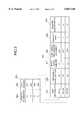
- the information reporting system 10comprises a portable terminal 12, a communication network system 14, and a communication host apparatus 16. Although there are a plurality of portable terminals in the system, for simplicity, only a single portable terminal is shown in FIG. 1. The structures of the above mentioned elements will now be explained.
- the portable terminal 12comprises a input device 20 having a touch panel or the like for enabling the user to input desired information, a display unit 22 including a liquid crystal display panel, a data processing unit 24 including a data processing device such as a central processing unit (CPU) and a storage device such as a random access memory (RAM), a radio telecommunication unit 26 including a cellular terminal device, a personal handy phone system (PHS) terminal or the like for communication between it and a radio communication base station (described later) provided at the communication network system 14, a current position detecting unit 28 including a global positioning system (GPS) receiving device for detecting the current position of the portable terminal 12, and a database 32, constituted by a read only memory (ROM), an IC card or the like, which stores predetermined information.
- GPSis a system for detecting current position used by "a vehicle management apparatus" disclosed in Japanese Patent Application laid open No. 6-236211
- PHSis a radio telecommunication system of Nippon Telegraph and Telephone Corporation (NTT).
- the input device 20detects the operation and provides the data processing unit 24 with instructions or data input by the user.
- the display unit 22displays on a display screen thereof images corresponding to the results of data processing by the data processing unit 24, data received by the radio telecommunication unit 26, or position information data indicative of the current position detected by the current position detecting unit 28.
- the data processing unit 24executes predetermined types of data processing including retrieval from the database 32 based upon data or instructions received from the input device 20, the received data or the position information data as described above.
- the data processing unit 24provides the radio telecommunication unit 26 with the position information data indicative of the current position detected by the current position detecting unit 28.
- the data processing unit 24outputs the position information data or the like to the radio telecommunication unit 26 when it has received a signal indicating completion of connection to a circuit line from the radio telecommunication unit 26.
- the radio telecommunication unit 26establishes the connection to the radio circuit line when it has received a signal requesting connection with the circuit line from the outside via radio telecommunication.
- the radio telecommunication unit 26sends to the data processing unit 24 a signal indicating completion of connection to the circuit line.
- the radio telecommunication unit 26then transmits the current position data from the data processing unit 24 via the connected circuit line.
- the current position detecting unit 28receives a signal from an artificial satellite, generates position information data indicative of the current position of the portable terminal based on the signal and sends the data to the data processing unit 24.
- the database 32is arranged to enable the desired data stored therein to be retrieved by the execution of retrieval processing by the data processing unit 24.
- the communication network system 14will now be explained.
- the communication network system 14comprises a plurality of radio communication base stations 40 such as cellular base stations or PHS base stations.
- Each of the radio communication base stations 40is adapted to receive a signal emitted from the radio telecommunication unit 26 in the portable terminal 12 when it is within a predetermined distance thereof, and to transfer the received signal to the communication host apparatus 16 via a telecommunication circuit 42. Since the distance over which circuit lines can be established using radio telecommunication is limited in this embodiment, the plurality of radio communication base stations 40 are spaced at predetermined intervals so as to expand the overall area within which signals from the portable terminal 12 can be received.
- the communication host apparatus 16will now be explained.
- the communication host apparatus 16comprises a host computer 50 connected to the communication network system 14 via the telecommunication circuit 42, and a database 52 connected to the host computer 50.
- the host computer 50transmits/receives data to/from the portable terminal 12 via the communication network system 14, retrieves predetermined data from the database 52 based upon the position information data received from the portable terminal 12 and writes appropriate data to the database 52.
- the database 52may be at a different location from the host computer 50 and be connected to the host computer 50 via another communication network.
- the host computer 50may be connected to the communication network system 14 via other network such as a Local Area Network (LAN).
- LANLocal Area Network
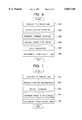
- FIG. 2shows the data structure of the database 52 in this embodiment.
- the database 52stores position information data corresponding to current positions of the portable terminal 12 and disaster information data to be reported to the user of a portable terminal 12 who is at the position concerned upon occurrence of a disaster.
- the database 52comprises a retrieval key table 201 including a list of retrieval keys and a retrieval data table 202 which is data sets to be retrieved.
- the retrieval key table 201includes a list of the position information data 203, which are the retrieval keys, and retrieval data pointers 204 each indicating a storage position of a retrieval data set corresponding to one item of the position information data 203.
- one item of the position information data 203comprises data indicative of an area defined by two longitude lines and two latitude lines.
- each item of the position information data 203may comprise data concerning a longitude range and a latitude range, data indicative of a center and a radius for defining a substantially circular area on a map, or data concerning a number of a particular area such as an administrative district (e.g. city, town, village).
- each item of the position information data itemmay comprise data indicative of a single point such as an intersection of longitude and latitude lines, or an identification number specifying a particular point on a map.
- the retrieval data pointer 204indicates one of the data sets in the retrieval data table 202, and comprises data numbers each indicating one of the data sets.
- the retrieval data pointer 204may comprise addresses of a memory which stores the data sets. In this way, the data pointers 204 associate each item of the position information data 203 with a data set stored in the retrieval data table 202.
- an item of the position information data 203may have the same retrieval data pointer value as another item thereof, whereby they may correspond to the same data set.
- the retrieval data table 202comprises the plurality of data sets, each including text information data 205 including disaster news indicative of the kind of disaster which occurred, the scale of the disaster and the like, impassable road section information data 206 which indicate road sections which have become impassable due to the disaster, shelter route information data 207 indicative of routes toward a predetermined shelter, disaster point information data 208 indicative of the point where the disaster occurred, disaster area information data 209 which indicate the area affected by the disaster, and disaster classification information data 210 indicative of the kind of disaster such as an earth quake or a fire.
- the retrieval data setscan be specified by the data pointer.
- the text information data 205includes character code data consisting of JIS (Japan Industrial Standard) codes.
- the systemmay comprise another database storing a plurality of character code data sets so that the text information data item 205 is associated with one of the addresses of the character code data sets so as to designate character codes.
- the impassable road section information data 206include road section identification numbers used for designating road sections which have become impassable.
- the impassable road section information data 206may include positions of end points between which the roads are impassable. Further, if a plurality of road sections have become impassable, one impassable road section information data item 206 includes the plurality of road section identification numbers.
- the shelter route information data 207include data concerning the routes toward the shelter appropriate in light of the disaster.
- one data itemcorresponds to one or more road section identification numbers indicative of road sections constituting the route toward the shelter.
- the shelter route information data 207may be position data indicative of a plurality of predetermined points on the routes toward the shelter. Further, if a plurality of routes toward the shelter exist, one data item may include a plurality of road section identification numbers for each route.
- the disaster point information data 208include data indicative of the longitude and latitude of the point where the disaster occurred.
- the disaster point information data 208may include position data indicative of particular points on a map such as identification numbers.
- the disaster area information data 209indicate areas affected by the disaster.
- the disaster area information data 209include data concerning pairs of the longitude and latitude ranges each pair defining an area.
- the disaster area information data 209may include data indicative of the radii of circles whose centers coincide with points identified by the disaster point information data 208, or identification number data indicative of administration districts such as cities, towns, villages or the like affected by the disaster.
- the disaster classification information data 210include disaster identification numbers which indicate the kind of disaster, such as an earthquake, a tidal wave, an explosion, pollution.
- earthquakein this embodiment values corresponding to the magnitude of the earth quake and the district where it occurred (bay area, mountainous district etc.) are assigned to the disaster identification numbers.
- pollutiondifferent values in accordance with the pollution level, and regarding fire, different values in accordance with a scale of the fire, are assigned to the disaster identification number. The above mentioned features allow the kind of disaster to be more specifically identified.
- the retrieval data table 202includes the plurality of retrieval data sets corresponded to the position information data 203, and each of the retrieval data sets includes various information data 205 to 210 concerning the disaster.
- the database 32includes a first database, a second database and a map database containing map data.
- the map databasemay be installed in the portable terminal or may be provided in an external storage medium such as a CD-ROM, a memory card.
- the first databasewill be explained.
- the first databasestores predetermined information corresponding to disaster classification data described later.
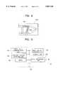
- FIG. 3shows a structure of the first data base. As shown in FIG. 3, the first database includes disaster classification information data 301 and second text information data 302, each item of which corresponds to an item of the disaster classification information data 301.
- the disaster classification information data 301correspond to the disaster classification information data 210 stored in the retrieval data table 202 of the database 52 shown in FIG. 2. Namely, the disaster classification information data 301 are provided such that the items thereof are the same as those of the disaster classification information data 210 in the retrieval data table 202.
- the second text information data 302include text information, such as character code data consisting of JIS code sets corresponding to each item of the disaster classification information data 301.
- text informationsuch as character code data consisting of JIS code sets corresponding to each item of the disaster classification information data 301.
- the second text information data 302might consist of data indicating that "the area within a radius 500 meters of the point where the fire occurred is dangerous.”
- the second text information data 302consist of data indicating that "a landslide or a rock slide may occur” or "a tidal wave may occur.”
- the second databaseis provided in order to display an appropriate road map on the screen of the display unit 22 of the portable terminal 12.
- FIG. 4shows the structure of the second database.
- the second databaseincludes road identification number information data 401 and intersection position data 402, 403 indicative of the positions of two intersections of the road corresponding to the road identification number.
- the road identification number information data 401include road section identification numbers which are the same as those contained in the impassable road section information data 206 in the retrieval data table 202. Namely, if the road section identification number contained in the impassable road section information data 206 coincides with that contained in the road identification number information data 401, both of them designate the same road.
- intersection position data 402, 403indicate the coordinates of the end points of the road sections identified by the road identification numbers 401 in the map corresponding to the map data.
- FIG. 5Ais a road map based upon the map data, which is displayed on the screen of the display unit 22 of the portable terminal 12.
- the numeral 503designates a particular road.
- FIGS. 5B and 5Cshow the above mentioned road using a network in which intersections are defined as nodes and road sections between adjacent intersections are defined as links. For example, as shown in FIG. 5B, the intersections are represented by nodes 504 to 508, while, as shown in FIG. 5C, the road sections are represented by links 509 to 514.
- the intersections A 501 and B 502correspond to the nodes 504 and 508, while the road 503 corresponds to the link 511 between the nodes 505 and 507.
- the road section number L1is assigned to the road corresponding to the link 511.
- the appropriate road 503(corresponding to the link 511) can be specified on the screen of the display unit 22 based upon the position data c1 and c2.
- the various information shown in FIG. 2is stored in the database 52 of the communication host apparatus 16. This is accomplished by arranging for the various data to be automatically generated from information concerning the disaster collected by the police, fire department, weather bureau, government offices and the like by another program executed by the host computer 50 and stored in the database 52. Alternatively, it may be accomplished by having an operator of the host computer 50 operate an input device (not shown) to store the appropriate data in the data base 52. After the appropriate information is stored to the database 52 as described above, the communication host apparatus 16 attempts to connect with the portable terminal 12 via the communication network system 14. The subsequent operation of the communication host apparatus 16 will be described later.
- FIG. 6is a flowchart showing the processing operations of the portable terminal 12 in accordance with this embodiment.
- the radio telecommunication unit 26When the radio telecommunication unit 26 receives an instruction to connect with the host computer 50 from a particular radio communication base station 40, it establishes a telecommunication circuit between the portable terminal 12 and the host computer 50 via the radio communication base station 40, and after completion of the connection, it sends a signal indicating that the circuit has been established to the data processing unit 24 (STEP 601).
- the current position detecting unit 28receives a radio signal from the GPS satellite and provides the data processing unit 24 with position information data indicative of the current position of the portable terminal 12 detected based on the signal (STEP 602).
- the data processing unit 24provides the radio telecommunication unit 26 with the received position information data, and in response thereto, the radio telecommunication unit 26 transmits the position information data, as well as ID number data for identifying itself, to the host computer 50 via the appropriate radio telecommunication base station 40 of the communication network system 14 (STEP 603).
- the portable terminal 12transmits or receives other data than the position information data, or data in response to the position information data and obtained from the communication host apparatus 16 until it receives information from the communication host apparatus 16 as described later.
- FIG. 7is a flowchart showing the processing operation of the communication host apparatus 16.
- the communication host apparatus 16After the communication host apparatus 16 has established a connection to the appropriate portable terminal 12 via the communication network system 14 (STEP 701) as mentioned above and received the position information data from the portable terminal 12 (STEP 702), it refers to the retrieval key table 201 in the database 52 to determine the longitude and latitude ranges defining an area in which the position corresponding to the received position information data falls, namely, one item of the position information data 203 to read out the appropriate retrieval data set based upon the data pointer corresponding thereto (STEP 703). Assuming that the data value of the position information data of the portable terminal 12 falls within the range "p1" shown in FIG.
- the data set corresponding theretoincluding the text information data Mmsg1, the impassable road section information data rd1, the shelter route information data rt1, the disaster point information data pos1, the disaster area information data r1 and the disaster classification information data s1 is read out.
- the host computer 50then transmits to the appropriate portable terminal 12 via the communication network system 40 the retrieval data set including the text information data 205 to the disaster classification information data 210 read out in STEP 703 (STEP 704), and thereafter disconnects from the telecommunication circuit (STEP 705) to conclude the processing.
- the radio telecommunication unit 26 of the portable terminal 12After the radio telecommunication unit 26 of the portable terminal 12 has received the retrieval data set via the communication network system 14, it provides the data processing unit 24 with the data set (STEP 604). Then, the data processing unit 24 executes the data processing based upon the received retrieval data set (STEP 605). More specifically, the data processing unit 24 reads out the second text information data 302 from the first database in the database 32, based upon the disaster classification information data 210 in the retrieval data set. Assuming that the data value of disaster classification data contained in the received retrieval data set is s1, the related second text information data Smsg1 are read out. Furthermore, the first text information data 205 contained in the retrieval data set and the read-out second text information data 302 are output to the display unit 22.
- the data processing unit 24refers to the position information data indicative of its own current position of the portable terminal 12, the disaster point information data 208 and the like to specify an area in the map to be displayed on the screen of the display unit 22 so as to read out appropriate map data from the map database. Furthermore, the data processing unit 24 retrieves the data in the second database of the database 32 based upon the impassable road section information data 206 to obtain the intersection position data 402, 403 in association with the road identification number contained in the impassable road section information data 206, and searches the data in the second database of the database 32 based upon the shelter route information data 207 to obtain the intersection position data 402, 403 in association with the road identification number contained in the shelter route information data 207.
- map data of the appropriate area, the intersection position data in association with the impassable road section information data, and the intersection position data in association with the shelter route information dataare supplied to the display unit 22.
- the display unit 22Based upon the supplied first and second text information data, the display unit 22 displays on the screen thereof a text corresponding to the text information data, and, based upon the supplied intersection position data, displays on the screen thereof an image of a map in which the impassable road sections and the route toward the shelter are specified.
- the map displayed on the screen of the display unit 22one end of the route towards the shelter is assigned to the current position of the portable terminal or position near thereto based of the shelter route information data 207. As a result the user of the portable terminal 12 can more easily understand the route towards the shelter.
- the radio telecommunication unit 26disconnects from the communication host apparatus 16 (STEP 606).
- the host computer 50 of the communication host apparatus 16updates the contents of the database 52 based upon new information concerning the disaster. This may be accomplished by arranging for new data to be automatically generated and stored in the predetermined area of the database 52. Alternatively, it may be accomplished by having the operator of the host computer 50 operate an input device to store the appropriate data.
- the communication host apparatus 16when a disaster occurs, the communication host apparatus 16 requests the portable terminal 16 to connect with the circuit line, and when the telecommunication circuit between the communication host apparatus and the portable terminal 12 is established, the position information data indicative of the current position of the portable terminal 12 are transferred to the communication host apparatus 16.
- the communication host apparatus 16provides the portable terminal 12 with suitable information for the current position of the portable terminal. As a result, the provided information is displayed on the screen of the display unit 22. Consequently, the user of the portable terminal 12 can obtain appropriate information without complicated operations.
- the host computer 50transfers the data set including the text information data, the impassable road section data and the like to the portable terminal, the user of the portable terminal can specifically and definitely grasp the situation caused by the disaster.
- the portable terminal 12comprises, in addition to the features provided in the portable terminal of the first embodiment, a timer 30 including a clock or the like.
- the timer 30send a time-up signal to a data processing unit 24 when a predetermined time has passed.
- the usercan change the time interval at which the timer 30 outputs the time-up signal by entering a new interval through the input device 20.
- FIG. 2Various information shown in FIG. 2 is stored in a database 52 of a communication host apparatus 16 when an earthquake, a fire or the like occurs.
- FIG. 10is a flowchart of the portable terminal 12 in accordance with the second embodiment.
- the timer 30outputs the time-up signal to the data processing unit 24 at predetermined intervals of a length designated by the user through the input device 20.
- the processing unit 24checks whether or not a time-up signal has been output by the timer 30 (STEP 1001). If the processing unit 24 determines that a time-up signal was output (i.e. the result is "Yes" in STEP 1002), the program proceeds to STEP 1003 in which the appropriate processing is conducted. On the other hand, when the result is "No" in STEP 1002, the program returns to STEP 1001.
- the processing in STEP 1003is substantially the same as that shown in FIG. 6. Namely, the portable terminal 12 establishes a telecommunication circuit to the communication host apparatus 16 via the communication network system 14, and transfers the position information data to the communication host apparatus 16. It then receives appropriate information from the host computer 50 of the communication host apparatus 16 is received and conducts appropriate data processing based thereon.
- the host computer 50 of the communication host apparatus 16ascertains the situation from the position information data received from the portable terminal 12 via the communication network system 14 and sends to the portable terminal 12 data indicating that no change occurred in the information.
- the portable terminal receiving such datadisconnects from the telecommunication circuit between it and the communication host apparatus without executing new data processing.
- the portable terminal 12supplies the communication host apparatus 16 with position information data indicative of the current position of the portable terminal via the communication network system 14 at regular fixed intervals, and the host computer 50 of the communication host apparatus 16 transfers necessary information to the portable terminal 12 in predetermined cases. Accordingly, the host computer 50 need not instruct the portable terminal 12 to establish a telecommunication circuit. As a result, the load on the host computer 50 can be reduced, particularly in cases where it is required to transfer/receive information to/from multiple portable terminals 12.
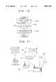
- a computer(not shown) at the police department or other facilities 90 responsible for responding to disasters transfers disaster information data to the communication host apparatus 16 via the telecommunication circuit 42.
- the host computer 50 of the communication host apparatus 16After the host computer 50 of the communication host apparatus 16 (see FIG. 1) receives the disaster information data, it updates the contents of the database 52 based on the received information.
- the communication host apparatus 16is preferably provided at the facility 90 in charge of disaster response because this makes it possible to save the time otherwise required for transferring/receiving information to/from the facility.
- the portable terminal 12determines its current position by GPS using signals from satellites 92 and sends the position information data to the communication host apparatus 16 via a radio communication base station 40 and the telecommunication network 42.
- the processing for transferring the position information datacan be accomplished by the portable terminal 12 without any operation by the user to get the information, when the telecommunication circuit is established by a request of the host computer 50 of the communication host apparatus 16 or when a predetermined time has passed.
- the position information dataare transferred via the radio communication base station 40 and the telecommunication circuit 42 to the communication host apparatus 16.
- the host computer 50 of the communication host apparatus 16uses the received position information data as a retrieval key to retrieve data from a database 52 (see FIG. 1).
- the retrieval data set including disaster classification data, impossible road section information data and the like obtained as a result of the retrievalis transferred to the portable terminal 12 from the communication host apparatus 16 via the telecommunication circuit 42 and the radio communication base station 40.
- the user of the portable terminal 12can obtain information on the disaster suitable for his or her current position without conducting any operation to obtain the information.
- FIG. 12is an illustration showing the screen of a display unit 22 displaying an image based upon the information received by the portable terminal 12.
- the screen 1201 of the display unit 22displays an image including a text 1202 based upon the text information data received from the communication host apparatus 16, and a map 1203 including a route 1204 toward a shelter highlighted in black and an impassable road 1205 designated by hatching.
- the retrieval data set in the database 52 provided in the communication host apparatus 16includes the text information data 205, the impassable road section information data 206, the shelter route information data 207, the disaster point information data 208, the disaster area information data 209 and the disaster classification information data 210, and the host computer 50 transmits these data to the portable terminal 12.
- This inventionis not limited to this arrangement, and it is possible to transmit portions of the above mentioned data as the retrieval data set.
- the portable terminalsent at least the disaster area information data and the disaster classification information data.
- information of a general nature useful in conjunction with the disaster area information data or the disaster classification information datais stored in the first database in advance.
- Such general purpose informationwould include data indicating that "roads and railways within the area may be impassable," which is to be read out when the area affected by the disaster is larger than a particular area defined by predetermined longitude and latitude ranges.
- the portable terminalcan generate suitable data, while reducing the quantity of data transmitted from the host computer 50 to the portable terminal, namely reducing the communication time therebetween, so as to display appropriate information on the screen of the display unit 22.
- the first databasemay store road control information data for specifying roads which are likely to be impassible when a disaster occurs, each item thereof corresponding to one item of the disaster classification information data.
- the road control information datamight include data indicating that "roads narrower than 3.5 m are impassable" in response to an item of the disaster classification information data indicating an earthquake of above a predetermined magnitude.
- the first databaseis provided in the database 32 of the portable terminal 12, and the appropriate second text information data are read out from the first database in accordance with the disaster classification information data provided by the communication host apparatus 16 so as to display a text or the like based thereon on the screen of the display unit 22.
- the communication host apparatus 16specifically supplies the retrieval data set including the first text information data 205, it is not necessary to provide the first database in the database 32.
- the portable terminal 12comprises the map database
- the inventionis not limited to this arrangement, and instead, the communication host apparatus may transmit map data in accordance with the current position of the portable terminal.
- the portable terminaltransmits the position information data indicative of its current position in response to the request for connection from the communication host apparatus or when a predetermined time has passed
- the inventionis not limited to this arrangement, and instead, the system can be configured so that the user of the portable terminal can transmit the position information data by operating the input device and the communication host apparatus responds by providing the portable terminal with the appropriate information.
- the portable terminalwhen a disaster occurs, the portable terminal is sent appropriate data in response to the position information data indicative of its current position, this invention is not limited to this arrangement, it is instead possible to have the communication host apparatus send the portable terminal information appropriate in light of the current position of the portable terminal in specified cases. Possible arrangements include (1) a system configured to send the portable terminal auxiliary information concerning geographical features around its current position, and (2) a system configured to provide the portable terminal with information regarding the weather at its current position.
- the database 52 of the communication host apparatus 16is supplied, in advance, with retrieval data sets each including image data indicative of a map for a predetermined area, and/or guidance information including an accommodations list, a restaurant list, a list of refugees going, sightseeing or the like. If the portable terminal 12 transmits the position information data indicative of the current position when the predetermined time has passed, the host computer 50 of the communication host apparatus 16 reads out from the database 52 the appropriate retrieval data set based upon the received position information data and transmits the data set to the portable terminal 12.
- the information to be suppliedis stored in the database 52 of the communication host apparatus 16, it is possible to update the information easily. For example, regarding the accommodations list, it is possible to report new information to the user of the portable terminal by updating information on vacant rooms and the like in real-time.
- a plurality of portable terminalscan be provided with new and appropriate information.
- the user of the portable terminaltherefore need not buy a recorded medium such as a CD-ROM storing a predetermined information.
- the database 52 of the communication host apparatus 16stores retrieval data sets each consisting of weather information including a weather forecast, temperature, wind force velocity and wave height for a predetermined area.
- the host computer 50 of the communication host apparatus 16reads from the database 52 the appropriate retrieval data set based upon the received position information data and transmits it to the portable terminal 12.
- the user of the portable terminalcan obtain weather information for the current position of the portable terminal at predetermined intervals, he or she can easily learn of changes in the weather, whether or not a warning has been announced and the like.
- the respective meansneed not necessarily be physical means and arrangements whereby the function of the respective means is accomplished by software fall within the scope of the present invention.
- the function of a single meansmay be accomplished by two or more physical means and the function of two or more means may be accomplished by a single physical means.
- an information reporting systemwhich allows a user of a portable terminal to obtain information relating to circumstances at his or her current position.
Landscapes
- Physics & Mathematics (AREA)
- General Physics & Mathematics (AREA)
- Mobile Radio Communication Systems (AREA)
- Telephonic Communication Services (AREA)
- Alarm Systems (AREA)
- Navigation (AREA)
- Information Transfer Between Computers (AREA)
- Information Retrieval, Db Structures And Fs Structures Therefor (AREA)
- Small-Scale Networks (AREA)
- Traffic Control Systems (AREA)
Abstract
Description
Claims (10)
Applications Claiming Priority (2)
| Application Number | Priority Date | Filing Date | Title |
|---|---|---|---|
| JP7-205989 | 1995-08-11 | ||
| JP20598995AJP3425276B2 (en) | 1995-08-11 | 1995-08-11 | Information notification system |
Publications (1)
| Publication Number | Publication Date |
|---|---|
| US5867110Atrue US5867110A (en) | 1999-02-02 |
Family
ID=16516066
Family Applications (1)
| Application Number | Title | Priority Date | Filing Date |
|---|---|---|---|
| US08/696,028Expired - LifetimeUS5867110A (en) | 1995-08-11 | 1996-08-09 | Information reporting system |
Country Status (2)
| Country | Link |
|---|---|
| US (1) | US5867110A (en) |
| JP (1) | JP3425276B2 (en) |
Cited By (104)
| Publication number | Priority date | Publication date | Assignee | Title |
|---|---|---|---|---|
| US6073076A (en)* | 1998-03-27 | 2000-06-06 | Navigation Technologies Corporation | Memory management for navigation system |
| US6122520A (en)* | 1998-02-13 | 2000-09-19 | Xerox Corporation | System and method for obtaining and using location specific information |
| US6167464A (en)* | 1998-09-23 | 2000-12-26 | Rockwell Technologies, Llc | Mobile human/machine interface for use with industrial control systems for controlling the operation of process executed on spatially separate machines |
| US6175800B1 (en)* | 1998-04-22 | 2001-01-16 | Xanavi Informatics Corporation | Route searching device |
| WO2001008120A1 (en)* | 1999-07-24 | 2001-02-01 | Robert Bosch Gmbh | Navigation method and navigation system for motor vehicles |
| US6256580B1 (en)* | 1996-12-16 | 2001-07-03 | Mannesmann Ag | Process for transmitting route information which defines a proposed route for a vehicle in a road network and serves as a navigation aid from a traffic information center to a terminal in a vehicle, traffic information center and terminal |
| US6334090B1 (en)* | 1999-08-24 | 2001-12-25 | Nec Corporation | GPS terminal, position measuring system, and map display method using the same |
| US20020010000A1 (en)* | 2000-01-25 | 2002-01-24 | Vincent Chern | Knowledge-based information retrieval system and method for wireless communication device |
| US20020059211A1 (en)* | 2000-10-05 | 2002-05-16 | International Business Machines Corporation | System for managing objects based on position data |
| US20020069020A1 (en)* | 1999-08-13 | 2002-06-06 | Digital Cyclone, Inc. | Generation and distribution of personalized multimedia natural phenomenological information |
| US6459460B1 (en)* | 1998-04-03 | 2002-10-01 | Nec Corporation | Information display window of electronic appliance |
| US6480121B1 (en) | 1998-09-25 | 2002-11-12 | William Reimann | Comprehensive information and service providing system |
| US6505123B1 (en) | 2000-07-24 | 2003-01-07 | Weatherbank, Inc. | Interactive weather advisory system |
| US20030050040A1 (en)* | 2001-09-12 | 2003-03-13 | Nec Corporation | Emergency notification system and emergency notification device |
| US6611751B2 (en) | 2001-03-23 | 2003-08-26 | 981455 Alberta Ltd. | Method and apparatus for providing location based data services |
| GB2386488A (en)* | 2002-03-13 | 2003-09-17 | Hewlett Packard Co | Displaying location related information with view of location |
| US20030186708A1 (en)* | 2002-03-26 | 2003-10-02 | Parulski Kenneth A. | Portable imaging device employing geographic information to facilitate image access and viewing |
| US20030193603A1 (en)* | 2002-03-26 | 2003-10-16 | Parulski Kenneth A. | Method for providing enhanced image access and viewing using a portable imaging device |
| US20030200027A1 (en)* | 2000-07-24 | 2003-10-23 | Root Steven A. | Interactive weather advisory system |
| US20030214397A1 (en)* | 2002-05-14 | 2003-11-20 | Perkins Matthew R. | System and method for inferring an electronic rendering of an environment |
| US20030214410A1 (en)* | 2002-05-14 | 2003-11-20 | Johnson Mark J. | System and method for inferring a set of characteristics of an environment with location-capable devices |
| US6674357B1 (en) | 1999-11-12 | 2004-01-06 | The Transit Grapewine, Llc | Informational messages display system for mass transit systems and method for same |
| US20040009926A1 (en)* | 2002-02-07 | 2004-01-15 | Sigma-Tau Industrie Farmaceutiche Riunite S.P.A. | Carnitine in the treatment of depression |
| US20040044553A1 (en)* | 2001-03-30 | 2004-03-04 | Lambert J. David | Modular architecture for rapid deployment and coordination of emergency event field surveillance |
| US20040181340A1 (en)* | 2003-03-01 | 2004-09-16 | User-Centric Enterprises, Inc. | Rotating map and user-centric weather prediction |
| US20040186661A1 (en)* | 2000-06-08 | 2004-09-23 | Mark Barton | Method and system for obtaining user feedback regarding geographic data |
| US6823263B1 (en)* | 2000-04-12 | 2004-11-23 | Weather Central, Inc. | System and method for providing personalized weather reports and the like |
| US20040254698A1 (en)* | 2003-05-15 | 2004-12-16 | Jonathan Hubbard | System and method for evaluating vehicle and operator performance |
| US20040260518A1 (en)* | 2001-02-16 | 2004-12-23 | Andreas Polz | Device and process for operation of automation components |
| US20050021225A1 (en)* | 2003-07-25 | 2005-01-27 | Christopher Kantarjiev | System and method for determining recommended departure time |
| US20050080757A1 (en)* | 2003-10-08 | 2005-04-14 | Dinesh Sharma | Management of hierarchical reference data |
| US20050140500A1 (en)* | 2003-12-24 | 2005-06-30 | Samsung Electronics Co., Ltd. | System and method for providing regional information using radio paging network |
| US20050169228A1 (en)* | 2000-10-27 | 2005-08-04 | Dowling Eric M. | Federated multiprotocol communication |
| US20050181807A1 (en)* | 1998-11-17 | 2005-08-18 | Dowling Eric M. | Geographical web browser, methods, apparatus and systems |
| US20050197775A1 (en)* | 2003-03-01 | 2005-09-08 | User-Centric Enterprises, Inc. | User-centric event reporting |
| US20050207405A1 (en)* | 1998-07-21 | 2005-09-22 | Dowling Eric M | Method and apparatus for co-socket telephony |
| US20050267685A1 (en)* | 2000-04-18 | 2005-12-01 | Intriligator Devrie S | Space weather prediction system and method |
| US20060015254A1 (en)* | 2003-03-01 | 2006-01-19 | User-Centric Enterprises, Inc. | User-centric event reporting |
| US20060022048A1 (en)* | 2000-06-07 | 2006-02-02 | Johnson William J | System and method for anonymous location based services |
| US7010306B1 (en) | 1999-07-29 | 2006-03-07 | Ntt Docomo, Inc. | Location information notifying method and location information notifying apparatus |
| US20060069722A1 (en)* | 2000-10-27 | 2006-03-30 | Dowling Eric M | Negotiated wireless peripheral systems |
| US20060079200A1 (en)* | 2003-07-04 | 2006-04-13 | Kiyoshi Hirouchi | Disaster system control method and disaster system control apparatus |
| US7031842B1 (en)* | 2003-02-26 | 2006-04-18 | 3Dgeo Development, Inc. | Systems and methods for collaboratively viewing and editing seismic data |
| US20060105781A1 (en)* | 2000-10-11 | 2006-05-18 | Mitsubishi Denki Kabushiki Kaisha | Location-based information intermediation and acquisition method, intermediation computer system, and mobile communication terminal |
| US20060161469A1 (en)* | 2005-01-14 | 2006-07-20 | Weatherbank, Inc. | Interactive advisory system |
| US20060178140A1 (en)* | 2005-02-02 | 2006-08-10 | Steven Smith | Location-based data communications system and method |
| US20070005188A1 (en)* | 2000-06-07 | 2007-01-04 | Johnson William J | System and method for proactive content delivery by situational location |
| US7209946B2 (en) | 2000-10-27 | 2007-04-24 | Eric Morgan Dowling | Negotiated wireless peripheral security systems |
| US20070168131A1 (en) | 2006-01-19 | 2007-07-19 | Weatherbank, Inc. | Interactive advisory system |
| US20070210983A1 (en)* | 1999-02-12 | 2007-09-13 | Fisher-Rosemount Systems, Inc. | Wearable Computer in a Process Control Environment |
| US20070255492A1 (en)* | 2004-02-26 | 2007-11-01 | Holger Listle | Method for Enabling Useful Data, in Particular Navigation Data |
| US20080167083A1 (en)* | 2007-01-07 | 2008-07-10 | Wyld Jeremy A | Method, Device, and Graphical User Interface for Location-Based Dialing |
| US20080207183A1 (en)* | 2007-02-23 | 2008-08-28 | Weatherbank, Inc. | Interactive advisory system for prioritizing content |
| US20080294476A1 (en)* | 2007-04-27 | 2008-11-27 | Dupre William J | Methods and apparatus to monitor in-store media and consumer traffic related to retail environments |
| US20090005082A1 (en)* | 2007-06-28 | 2009-01-01 | Apple Inc. | Disfavored route progressions or locations |
| US20090005978A1 (en)* | 2007-06-28 | 2009-01-01 | Apple Inc. | Route Reference |
| US20090006336A1 (en)* | 2007-06-28 | 2009-01-01 | Apple Inc. | Location based media items |
| US20090005080A1 (en)* | 2007-06-28 | 2009-01-01 | Apple Inc. | Location-Aware Mobile Device |
| US20090005965A1 (en)* | 2007-06-28 | 2009-01-01 | Apple Inc. | Adaptive Route Guidance Based on Preferences |
| US20090005018A1 (en)* | 2007-06-28 | 2009-01-01 | Apple Inc. | Route Sharing and Location |
| US20090005068A1 (en)* | 2007-06-28 | 2009-01-01 | Apple Inc. | Location-Based Emergency Information |
| US20090005076A1 (en)* | 2007-06-28 | 2009-01-01 | Scott Forstall | Location-Based Information Services |
| US20090005072A1 (en)* | 2007-06-28 | 2009-01-01 | Apple Inc. | Integration of User Applications in a Mobile Device |
| US20090003659A1 (en)* | 2007-06-28 | 2009-01-01 | Apple Inc. | Location based tracking |
| US20090005077A1 (en)* | 2007-06-28 | 2009-01-01 | Apple Inc. | Location-Based Services |
| US20090005975A1 (en)* | 2007-06-28 | 2009-01-01 | Apple Inc. | Adaptive Mobile Device Navigation |
| US20090005981A1 (en)* | 2007-06-28 | 2009-01-01 | Apple Inc. | Integration of Map Services and User Applications in a Mobile Device |
| US20090005005A1 (en)* | 2007-06-28 | 2009-01-01 | Apple Inc. | Mobile Device Base Station |
| US20090089706A1 (en)* | 2007-10-01 | 2009-04-02 | Apple Inc. | Varying User Interface Element Based on Movement |
| US20090098857A1 (en)* | 2007-10-10 | 2009-04-16 | Dallas De Atley | Securely Locating a Device |
| US20090150217A1 (en)* | 2007-11-02 | 2009-06-11 | Luff Robert A | Methods and apparatus to perform consumer surveys |
| US7558584B2 (en) | 2000-03-31 | 2009-07-07 | Ntt Docomo, Inc. | Location reporting method and related mobile communication terminal |
| US20090182492A1 (en)* | 2008-01-10 | 2009-07-16 | Apple Inc. | Adaptive Navigation System for Estimating Travel Times |
| US20090281724A1 (en)* | 2008-05-12 | 2009-11-12 | Apple Inc. | Map service with network-based query for search |
| US20090286549A1 (en)* | 2008-05-16 | 2009-11-19 | Apple Inc. | Location Determination |
| US20090326815A1 (en)* | 2008-05-02 | 2009-12-31 | Apple Inc. | Position Fix Indicator |
| US20090325603A1 (en)* | 2008-06-30 | 2009-12-31 | Apple Inc. | Location sharing |
| US20100225643A1 (en)* | 2009-03-04 | 2010-09-09 | Andre Gueziec | Controlling a Three-Dimensional Virtual Broadcast Presentation |
| US20100279673A1 (en)* | 2009-05-01 | 2010-11-04 | Apple Inc. | Remotely Locating and Commanding a Mobile Device |
| US20100279652A1 (en)* | 2009-05-01 | 2010-11-04 | Apple Inc. | Remotely Locating and Commanding a Mobile Device |
| US20100279675A1 (en)* | 2009-05-01 | 2010-11-04 | Apple Inc. | Remotely Locating and Commanding a Mobile Device |
| US20100312462A1 (en)* | 2009-03-04 | 2010-12-09 | Gueziec Andre | Touch Screen Based Interaction with Traffic Data |
| US20100333045A1 (en)* | 2009-03-04 | 2010-12-30 | Gueziec Andre | Gesture Based Interaction with Traffic Data |
| US8073565B2 (en) | 2000-06-07 | 2011-12-06 | Apple Inc. | System and method for alerting a first mobile data processing system nearby a second mobile data processing system |
| US8180379B2 (en) | 2007-06-28 | 2012-05-15 | Apple Inc. | Synchronizing mobile and vehicle devices |
| US8311526B2 (en) | 2007-06-28 | 2012-11-13 | Apple Inc. | Location-based categorical information services |
| US8355862B2 (en) | 2008-01-06 | 2013-01-15 | Apple Inc. | Graphical user interface for presenting location information |
| US8359643B2 (en) | 2008-09-18 | 2013-01-22 | Apple Inc. | Group formation using anonymous broadcast information |
| US8385964B2 (en) | 2005-04-04 | 2013-02-26 | Xone, Inc. | Methods and apparatuses for geospatial-based sharing of information by multiple devices |
| US8423290B1 (en)* | 2012-03-29 | 2013-04-16 | Mitac International Corp. | Method of providing emergency route guidance and related portable electronic device |
| US8531312B2 (en) | 2002-03-05 | 2013-09-10 | Triangle Software Llc | Method for choosing a traffic route |
| US8718910B2 (en) | 2010-11-14 | 2014-05-06 | Pelmorex Canada Inc. | Crowd sourced traffic reporting |
| US8725396B2 (en) | 2011-05-18 | 2014-05-13 | Pelmorex Canada Inc. | System for providing traffic data and driving efficiency data |
| US8781718B2 (en) | 2012-01-27 | 2014-07-15 | Pelmorex Canada Inc. | Estimating time travel distributions on signalized arterials |
| US20150120715A1 (en)* | 2013-10-30 | 2015-04-30 | Fuji Xerox Co., Ltd. | Non-transitory computer readable medium, document recommending apparatus, and document recommending method |
| US20160373908A1 (en)* | 2013-07-03 | 2016-12-22 | Nec Corporation | Delivery device, communication terminal, delivery method, receiving method, and non-transitory computer-readable medium storing program |
| CN107004001A (en)* | 2014-09-09 | 2017-08-01 | 林筱玫 | Pointer of escaping shows that system and its read method, escape pointer image are produced and display methods |
| US9823080B2 (en)* | 2011-12-22 | 2017-11-21 | At&T Intellectual Property I, L.P. | Method, system, and computer program product for providing a facility map |
| US10083459B2 (en) | 2014-02-11 | 2018-09-25 | The Nielsen Company (Us), Llc | Methods and apparatus to generate a media rank |
| US10223909B2 (en) | 2012-10-18 | 2019-03-05 | Uber Technologies, Inc. | Estimating time travel distributions on signalized arterials |
| US10322302B2 (en)* | 2014-09-09 | 2019-06-18 | Shuo hong CHEN | Intelligent disaster prevention and escape method and system |
| USRE47986E1 (en)* | 2003-05-15 | 2020-05-12 | Speedgauge, Inc. | System and method for evaluating vehicle and operator performance |
| US11143791B2 (en) | 2014-12-22 | 2021-10-12 | User-Centric Ip, L.P. | Mesoscale modeling |
| US20220083060A1 (en)* | 2017-11-01 | 2022-03-17 | Toyota Jidosha Kabushiki Kaisha | Autonomous driving vehicle |
Families Citing this family (46)
| Publication number | Priority date | Publication date | Assignee | Title |
|---|---|---|---|---|
| JP4588128B2 (en)* | 1996-03-22 | 2010-11-24 | ソニー株式会社 | Display apparatus and method |
| US5905866A (en)* | 1996-04-30 | 1999-05-18 | A.I. Soft Corporation | Data-update monitoring in communications network |
| JP2007087427A (en)* | 1996-04-30 | 2007-04-05 | Seiko Epson Corp | Server and communication terminal device |
| JP2901544B2 (en)* | 1996-06-19 | 1999-06-07 | 日本電気情報サービス株式会社 | Car navigation system |
| JPH10322436A (en)* | 1997-05-16 | 1998-12-04 | Kokusai Electric Co Ltd | Phone number search system |
| GB2327564A (en)* | 1997-07-16 | 1999-01-27 | Ibm | Apparatus and method for accessing a data file in a data communication network |
| JP3558838B2 (en)* | 1997-08-29 | 2004-08-25 | 日本電信電話株式会社 | Location support information providing system |
| JP4008076B2 (en)* | 1997-09-22 | 2007-11-14 | 三菱電機株式会社 | Physician dispatch system and centralized management device for doctor dispatch system |
| JP3546659B2 (en)* | 1997-09-25 | 2004-07-28 | トヨタ自動車株式会社 | Vehicle data processing system, in-vehicle terminal device and navigation device constituting the system |
| JPH11261592A (en)* | 1998-03-06 | 1999-09-24 | Ntt Data Corp | Position dependent information providing system |
| JP2000010892A (en)* | 1998-06-19 | 2000-01-14 | Nippon Telegr & Teleph Corp <Ntt> | Information providing method, system, and recording medium recording information providing program |
| JP3593459B2 (en)* | 1998-07-27 | 2004-11-24 | 株式会社日立製作所 | Moving object monitoring method and system |
| JP2000099442A (en)* | 1998-09-25 | 2000-04-07 | Casio Comput Co Ltd | Advice device and its program recording medium |
| JP2000155884A (en)* | 1998-11-19 | 2000-06-06 | Funai Electric Co Ltd | Multipurpose display device for monitor camera |
| US6806847B2 (en)* | 1999-02-12 | 2004-10-19 | Fisher-Rosemount Systems Inc. | Portable computer in a process control environment |
| JP2001091288A (en)* | 1999-09-17 | 2001-04-06 | Casio Comput Co Ltd | Portable route guidance device and route input method |
| JP3697373B2 (en)* | 1999-12-10 | 2005-09-21 | 株式会社東芝 | Wireless terminal and information reception control method |
| US6678684B1 (en)* | 1999-12-30 | 2004-01-13 | Makio Koga | Worldwide early warning network and method of use |
| JP2001216591A (en)* | 2000-02-01 | 2001-08-10 | Shimizu Corp | Emergency information system using portable telephone set |
| JP4041941B2 (en)* | 2000-03-24 | 2008-02-06 | 裕二 澤栗 | Earthquake arrival prediction system |
| JP2001359162A (en)* | 2000-06-12 | 2001-12-26 | Nec Corp | Information distributing device using mobile telephone set and method for the same |
| JP2002111872A (en)* | 2000-09-27 | 2002-04-12 | Hitachi Kokusai Electric Inc | Mobile phone system |
| JP2002116263A (en)* | 2000-10-05 | 2002-04-19 | Shimizu Corp | System and method for processing/transmitting earthquake information |
| JP2002125072A (en)* | 2000-10-16 | 2002-04-26 | Nippon Telegr & Teleph Corp <Ntt> | Peripheral information guidance system and method, recording medium recording operation method and operation program of stationary terminal, and recording medium recording operation method and operation program of guidance information center |
| JP2002135844A (en)* | 2000-10-24 | 2002-05-10 | Seiko Epson Corp | Information distribution system, control method of information distribution system, and information distribution server |
| US7259694B2 (en) | 2001-02-26 | 2007-08-21 | International Business Machines Corporation | Wireless communication system and method to provide geo-spatial related event data |
| JP3685393B2 (en) | 2001-03-22 | 2005-08-17 | 日本アイ・ビー・エム株式会社 | Information distribution apparatus, information distribution method, and program |
| JP2002344403A (en)* | 2001-05-16 | 2002-11-29 | Mitsubishi Electric Corp | Information browsing apparatus, information browsing method, and program for causing computer to execute the method |
| US6463265B1 (en)* | 2001-06-05 | 2002-10-08 | International Business Machines Corp. | Data source hand-off in a broadcast-based data dissemination environment |
| JP3907974B2 (en)* | 2001-06-29 | 2007-04-18 | 松下電器産業株式会社 | Program receiving system, information processing apparatus, and program receiving apparatus |
| JP2003044969A (en)* | 2001-08-01 | 2003-02-14 | Marubeni Energy Corp | Network system for emergency countermeasure |
| JP2003067477A (en)* | 2001-08-24 | 2003-03-07 | Cdan:Kk | Area-oriented information providing system and computer readable recording medium with area-oriented information providing program recorded thereon |
| JP2003303254A (en)* | 2002-04-10 | 2003-10-24 | Ntt Docomo Inc | Safety confirmation system, safety confirmation method, safety confirmation program, and computer-readable recording medium |
| JP3994027B2 (en)* | 2002-05-23 | 2007-10-17 | 松下電器産業株式会社 | Information providing system and apparatus and method thereof |
| JP3845724B2 (en)* | 2002-06-13 | 2006-11-15 | 独立行政法人産業技術総合研究所 | Guidance system and method |
| JP3739736B2 (en)* | 2002-08-26 | 2006-01-25 | 東芝プラントシステム株式会社 | Tour information provision system |
| JP2004201117A (en)* | 2002-12-19 | 2004-07-15 | Mitsubishi Electric Corp | Broadcast channel information providing system and device, and mobile communication device |
| JP2005157744A (en)* | 2003-11-26 | 2005-06-16 | Mitsubishi Electric Corp | Building management system |
| WO2007018305A1 (en)* | 2005-08-08 | 2007-02-15 | Nec Corporation | Evacuation route information providing system, evacuation route information providing apparatus, evacuation route information providing method, and evacuation route information providing program |
| JP4704939B2 (en)* | 2006-03-14 | 2011-06-22 | シャープ株式会社 | Navigation device |
| JP4197053B2 (en)* | 2006-12-11 | 2008-12-17 | パナソニック株式会社 | Program receiving system, information processing apparatus, program receiving apparatus |
| JP4872812B2 (en)* | 2007-06-06 | 2012-02-08 | 住友電気工業株式会社 | Traffic signal control apparatus and method |
| JP4986980B2 (en)* | 2008-11-25 | 2012-07-25 | 中国電力株式会社 | Meter reading terminal and meter reading system using the same |
| JP2010262490A (en)* | 2009-05-08 | 2010-11-18 | Hitachi Ltd | Emergency information notification system |
| JP5985243B2 (en)* | 2012-05-09 | 2016-09-06 | 株式会社東芝 | Disaster information notification control device, control method, and control program |
| US11016868B2 (en)* | 2017-04-10 | 2021-05-25 | Ntt Docomo, Inc. | Application usage estimation device and rule formulation device |
Citations (12)
| Publication number | Priority date | Publication date | Assignee | Title |
|---|---|---|---|---|
| US4359733A (en)* | 1980-09-23 | 1982-11-16 | Neill Gerard K O | Satellite-based vehicle position determining system |
| US4608656A (en)* | 1981-04-13 | 1986-08-26 | Nissan Motor Company, Limited | Road map display system with indication of a vehicle position |
| US5122959A (en)* | 1988-10-28 | 1992-06-16 | Automated Dispatch Services, Inc. | Transportation dispatch and delivery tracking system |
| JPH04295995A (en)* | 1991-03-25 | 1992-10-20 | Sony Corp | Position informing system |
| US5170353A (en)* | 1988-11-17 | 1992-12-08 | U.S. Philips Corporation | Bucket-oriented route planning method, and navigation system comprising a route planner for carrying out such a method |
| JPH05327604A (en)* | 1992-05-18 | 1993-12-10 | Toshiba Corp | Mobile station for radio network |
| US5272638A (en)* | 1991-05-31 | 1993-12-21 | Texas Instruments Incorporated | Systems and methods for planning the scheduling travel routes |
| JPH06338848A (en)* | 1993-05-28 | 1994-12-06 | Nec Commun Syst Ltd | Communication device position reporting method |
| US5513110A (en)* | 1993-07-09 | 1996-04-30 | Xanavi Informatics Corporation | Navigation system and path search method using hierarchized road data |
| US5543789A (en)* | 1994-06-24 | 1996-08-06 | Shields Enterprises, Inc. | Computerized navigation system |
| US5602564A (en)* | 1991-11-14 | 1997-02-11 | Hitachi, Ltd. | Graphic data processing system |
| US5628050A (en)* | 1994-12-09 | 1997-05-06 | Scientific And Commercial Systems Corporation | Disaster warning communications system |
- 1995
- 1995-08-11JPJP20598995Apatent/JP3425276B2/ennot_activeExpired - Lifetime
- 1996
- 1996-08-09USUS08/696,028patent/US5867110A/ennot_activeExpired - Lifetime
Patent Citations (12)
| Publication number | Priority date | Publication date | Assignee | Title |
|---|---|---|---|---|
| US4359733A (en)* | 1980-09-23 | 1982-11-16 | Neill Gerard K O | Satellite-based vehicle position determining system |
| US4608656A (en)* | 1981-04-13 | 1986-08-26 | Nissan Motor Company, Limited | Road map display system with indication of a vehicle position |
| US5122959A (en)* | 1988-10-28 | 1992-06-16 | Automated Dispatch Services, Inc. | Transportation dispatch and delivery tracking system |
| US5170353A (en)* | 1988-11-17 | 1992-12-08 | U.S. Philips Corporation | Bucket-oriented route planning method, and navigation system comprising a route planner for carrying out such a method |
| JPH04295995A (en)* | 1991-03-25 | 1992-10-20 | Sony Corp | Position informing system |
| US5272638A (en)* | 1991-05-31 | 1993-12-21 | Texas Instruments Incorporated | Systems and methods for planning the scheduling travel routes |
| US5602564A (en)* | 1991-11-14 | 1997-02-11 | Hitachi, Ltd. | Graphic data processing system |
| JPH05327604A (en)* | 1992-05-18 | 1993-12-10 | Toshiba Corp | Mobile station for radio network |
| JPH06338848A (en)* | 1993-05-28 | 1994-12-06 | Nec Commun Syst Ltd | Communication device position reporting method |
| US5513110A (en)* | 1993-07-09 | 1996-04-30 | Xanavi Informatics Corporation | Navigation system and path search method using hierarchized road data |
| US5543789A (en)* | 1994-06-24 | 1996-08-06 | Shields Enterprises, Inc. | Computerized navigation system |
| US5628050A (en)* | 1994-12-09 | 1997-05-06 | Scientific And Commercial Systems Corporation | Disaster warning communications system |
Cited By (353)
| Publication number | Priority date | Publication date | Assignee | Title |
|---|---|---|---|---|
| US6256580B1 (en)* | 1996-12-16 | 2001-07-03 | Mannesmann Ag | Process for transmitting route information which defines a proposed route for a vehicle in a road network and serves as a navigation aid from a traffic information center to a terminal in a vehicle, traffic information center and terminal |
| US6122520A (en)* | 1998-02-13 | 2000-09-19 | Xerox Corporation | System and method for obtaining and using location specific information |
| USRE42927E1 (en) | 1998-02-13 | 2011-11-15 | Apple Inc. | System and method for obtaining and using location specific information |
| US6073076A (en)* | 1998-03-27 | 2000-06-06 | Navigation Technologies Corporation | Memory management for navigation system |
| US6459460B1 (en)* | 1998-04-03 | 2002-10-01 | Nec Corporation | Information display window of electronic appliance |
| US6175800B1 (en)* | 1998-04-22 | 2001-01-16 | Xanavi Informatics Corporation | Route searching device |
| US7778237B2 (en) | 1998-07-21 | 2010-08-17 | RPX-NW Aquistion LLC | Method and apparatus for co-socket telephony |
| US7508777B2 (en) | 1998-07-21 | 2009-03-24 | Rpx-Nw Acquisition Llc | Method and apparatus for co-socket telephony |
| US7277424B1 (en) | 1998-07-21 | 2007-10-02 | Dowling Eric M | Method and apparatus for co-socket telephony |
| US7813334B2 (en) | 1998-07-21 | 2010-10-12 | RPX - NW Acquisition, LLC | Method and apparatus for co-socket telephony |
| US20050226229A1 (en)* | 1998-07-21 | 2005-10-13 | Dowling Eric M | Method and apparatus for co-socket telephony |
| US7813333B2 (en) | 1998-07-21 | 2010-10-12 | RPX-NW Acquisition, LLC | Method and apparatus for co-socket telephony |
| US20050226228A1 (en)* | 1998-07-21 | 2005-10-13 | Dowling Eric M | Method and apparatus for co-socket telephony |
| US20050220087A1 (en)* | 1998-07-21 | 2005-10-06 | Dowling Eric M | Method and apparatus for co-socket telephony |
| US20050207405A1 (en)* | 1998-07-21 | 2005-09-22 | Dowling Eric M | Method and apparatus for co-socket telephony |
| US20050220086A1 (en)* | 1998-07-21 | 2005-10-06 | Dowling Eric M | Method and apparatus for co-socket telephony |
| US8451822B2 (en) | 1998-07-21 | 2013-05-28 | Rpx Corporation | Method and apparatus for co-socket telephony |
| US20050232246A1 (en)* | 1998-07-21 | 2005-10-20 | Dowling Eric M | Method and apparatus for co-socket telephony |
| US6167464A (en)* | 1998-09-23 | 2000-12-26 | Rockwell Technologies, Llc | Mobile human/machine interface for use with industrial control systems for controlling the operation of process executed on spatially separate machines |
| US6480121B1 (en) | 1998-09-25 | 2002-11-12 | William Reimann | Comprehensive information and service providing system |
| US20070155406A1 (en)* | 1998-11-17 | 2007-07-05 | Dowling Eric M | Geographical web browser, methods, apparatus and systems |
| US8369263B2 (en) | 1998-11-17 | 2013-02-05 | E.O. Communication Fund, Llc | Geographical web browser, methods, apparatus and systems |
| US20070064644A1 (en)* | 1998-11-17 | 2007-03-22 | Dowling Eric M | Geographical web browser, methods, apparatus and systems |
| US20050227739A1 (en)* | 1998-11-17 | 2005-10-13 | Dowling Eric M | Geographical web browser, methods, apparatus and systems |
| US20080194240A1 (en)* | 1998-11-17 | 2008-08-14 | Eric Morgan Dowling | Geographical web browser, methods, apparatus and systems |
| US20050181807A1 (en)* | 1998-11-17 | 2005-08-18 | Dowling Eric M. | Geographical web browser, methods, apparatus and systems |
| US7212811B2 (en) | 1998-11-17 | 2007-05-01 | Eric Morgan Dowling | Geographical web browser, methods, apparatus and systems |
| US8190170B2 (en)* | 1998-11-17 | 2012-05-29 | E.O. Communication Fund, Llc | Geographical web browser, methods, apparatus and systems |
| US7215947B2 (en) | 1998-11-17 | 2007-05-08 | Eric Morgan Dowling | Geographical web browser, methods, apparatus and systems |
| US7292844B2 (en) | 1998-11-17 | 2007-11-06 | Geobrowser Innovations, Lp | Geographical web browser, methods, apparatus and systems |
| US8125405B2 (en) | 1999-02-12 | 2012-02-28 | Fisher-Rosemount Systems, Inc. | Wearable computer in a process control environment |
| US20070210983A1 (en)* | 1999-02-12 | 2007-09-13 | Fisher-Rosemount Systems, Inc. | Wearable Computer in a Process Control Environment |
| US6889137B1 (en)* | 1999-07-24 | 2005-05-03 | Robert Bosch Gmbh | Navigation method and navigation system for motor vehicles |
| WO2001008120A1 (en)* | 1999-07-24 | 2001-02-01 | Robert Bosch Gmbh | Navigation method and navigation system for motor vehicles |
| US7010306B1 (en) | 1999-07-29 | 2006-03-07 | Ntt Docomo, Inc. | Location information notifying method and location information notifying apparatus |
| US7720606B2 (en)* | 1999-08-13 | 2010-05-18 | Digital Cyclone, Inc. | Generation and distribution of personalized multimedia natural phenomenological information |
| US20020069020A1 (en)* | 1999-08-13 | 2002-06-06 | Digital Cyclone, Inc. | Generation and distribution of personalized multimedia natural phenomenological information |
| US6334090B1 (en)* | 1999-08-24 | 2001-12-25 | Nec Corporation | GPS terminal, position measuring system, and map display method using the same |
| US6674357B1 (en) | 1999-11-12 | 2004-01-06 | The Transit Grapewine, Llc | Informational messages display system for mass transit systems and method for same |
| US20020010000A1 (en)* | 2000-01-25 | 2002-01-24 | Vincent Chern | Knowledge-based information retrieval system and method for wireless communication device |
| US7558584B2 (en) | 2000-03-31 | 2009-07-07 | Ntt Docomo, Inc. | Location reporting method and related mobile communication terminal |
| US6823263B1 (en)* | 2000-04-12 | 2004-11-23 | Weather Central, Inc. | System and method for providing personalized weather reports and the like |
| US7103480B2 (en)* | 2000-04-18 | 2006-09-05 | Intriligator Devrie S | Non-space weather prediction and notification system and method |
| US20050267685A1 (en)* | 2000-04-18 | 2005-12-01 | Intriligator Devrie S | Space weather prediction system and method |
| US7710290B2 (en) | 2000-06-07 | 2010-05-04 | Apple Inc. | System and method for situational location relevant invocable speed reference |
| US9317867B2 (en) | 2000-06-07 | 2016-04-19 | Apple Inc. | System and method for situational location relevant invocable speed reference |
| US8489669B2 (en) | 2000-06-07 | 2013-07-16 | Apple Inc. | Mobile data processing system moving interest radius |
| US8930233B2 (en) | 2000-06-07 | 2015-01-06 | Apple Inc. | System and method for anonymous location based services |
| US8963686B2 (en) | 2000-06-07 | 2015-02-24 | Apple Inc. | System and method for situational location relevant invocable speed reference |
| US8984059B2 (en) | 2000-06-07 | 2015-03-17 | Apple Inc. | Mobile data processing system moving interest radius |
| US9100793B2 (en) | 2000-06-07 | 2015-08-04 | Apple Inc. | System and method for alerting a first mobile data processing system nearby a second mobile data processing system |
| US8538685B2 (en) | 2000-06-07 | 2013-09-17 | Apple Inc. | System and method for internet connected service providing heterogeneous mobile systems with situational location relevant content |
| US8031050B2 (en) | 2000-06-07 | 2011-10-04 | Apple Inc. | System and method for situational location relevant invocable speed reference |
| US20060022048A1 (en)* | 2000-06-07 | 2006-02-02 | Johnson William J | System and method for anonymous location based services |
| US8060389B2 (en) | 2000-06-07 | 2011-11-15 | Apple Inc. | System and method for anonymous location based services |
| US20080030308A1 (en)* | 2000-06-07 | 2008-02-07 | Johnson William J | System and method for situational location relevant invocable speed reference |
| US20070005188A1 (en)* | 2000-06-07 | 2007-01-04 | Johnson William J | System and method for proactive content delivery by situational location |
| US20070276587A1 (en)* | 2000-06-07 | 2007-11-29 | Johnson William J | System and method for internet connected service providing heterogeneous mobile systems with situational location relevant content |
| US20070233387A1 (en)* | 2000-06-07 | 2007-10-04 | Johnson William J | System and method for situational location informative shopping cart |
| US8073565B2 (en) | 2000-06-07 | 2011-12-06 | Apple Inc. | System and method for alerting a first mobile data processing system nearby a second mobile data processing system |
| US6853905B2 (en)* | 2000-06-08 | 2005-02-08 | Navteq North America, Llc | Method and system for obtaining user feedback regarding geographic data |
| US20040186661A1 (en)* | 2000-06-08 | 2004-09-23 | Mark Barton | Method and system for obtaining user feedback regarding geographic data |
| US9197990B2 (en) | 2000-07-24 | 2015-11-24 | Locator Ip, Lp | Interactive advisory system |
| US9204252B2 (en) | 2000-07-24 | 2015-12-01 | Locator IP, L.P. | Interactive advisory system |
| US6988037B2 (en) | 2000-07-24 | 2006-01-17 | Weatherbank, Inc. | Interactive weather forecast system and method of using same |
| US6980909B2 (en) | 2000-07-24 | 2005-12-27 | Weatherbank, Inc. | Interactive advisory system |
| US20050119830A1 (en)* | 2000-07-24 | 2005-06-02 | Root Steven A. | Interactive advisory system |
| US8909679B2 (en) | 2000-07-24 | 2014-12-09 | Locator Ip, Lp | Interactive advisory system |
| US20050071085A1 (en)* | 2000-07-24 | 2005-03-31 | Root Steven A. | Interactive weather advisory system |
| US20050050008A1 (en)* | 2000-07-24 | 2005-03-03 | Root Steven A. | Interactive advisory system |
| US7024310B2 (en) | 2000-07-24 | 2006-04-04 | Weatherbank, Inc. | Interactive weather forecast system and method of using same |
| US20050043889A1 (en)* | 2000-07-24 | 2005-02-24 | Root Steven A. | Interactive weather advisory system |
| US20060080039A1 (en)* | 2000-07-24 | 2006-04-13 | Root Steven A | Interactive weather advisory system |
| US6836730B2 (en) | 2000-07-24 | 2004-12-28 | Weatherbank, Inc. | Interactive weather advisory system |
| US6826481B2 (en) | 2000-07-24 | 2004-11-30 | Weatherbank, Inc. | Interactive advisory system |
| US20070162234A1 (en)* | 2000-07-24 | 2007-07-12 | Root Steven A | Interactive weather advisory system |
| US11108582B2 (en) | 2000-07-24 | 2021-08-31 | Locator IP, L.P. | Interactive weather advisory system |
| US20040220739A1 (en)* | 2000-07-24 | 2004-11-04 | Root Steven A. | Interactive weather advisory system |
| US9191776B2 (en) | 2000-07-24 | 2015-11-17 | Locator Ip, Lp | Interactive advisory system |
| US6754585B2 (en) | 2000-07-24 | 2004-06-22 | Weatherbank, Inc. | Interactive weather advisory system |
| US20040058640A1 (en)* | 2000-07-24 | 2004-03-25 | Root Steven A. | Interactive advisory system |
| US6985813B2 (en) | 2000-07-24 | 2006-01-10 | Weatherbank, Inc. | Interactive weather advisory system |
| US9554246B2 (en) | 2000-07-24 | 2017-01-24 | Locator Ip, Lp | Interactive weather advisory system |
| US6505123B1 (en) | 2000-07-24 | 2003-01-07 | Weatherbank, Inc. | Interactive weather advisory system |
| US9560480B2 (en) | 2000-07-24 | 2017-01-31 | Locator Ip, Lp | Interactive advisory system |
| US7315782B2 (en) | 2000-07-24 | 2008-01-01 | Spatial Content Services, Lp | Interactive weather advisory system |
| US20060294147A1 (en)* | 2000-07-24 | 2006-12-28 | Root Steven A | Interactive weather advisory system |
| US20030200027A1 (en)* | 2000-07-24 | 2003-10-23 | Root Steven A. | Interactive weather advisory system |
| US7289908B2 (en) | 2000-07-24 | 2007-10-30 | Spatial Content Services, L.P. | Interactive weather advisory system |
| US7191065B2 (en) | 2000-07-24 | 2007-03-13 | Weatherbank, Inc. | Interactive weather advisory system |
| US9661457B2 (en) | 2000-07-24 | 2017-05-23 | Locator Ip, Lp | Interactive advisory system |
| US9668091B2 (en) | 2000-07-24 | 2017-05-30 | Locator IP, L.P. | Interactive weather advisory system |
| US9998295B2 (en) | 2000-07-24 | 2018-06-12 | Locator IP, L.P. | Interactive advisory system |
| US10021525B2 (en) | 2000-07-24 | 2018-07-10 | Locator IP, L.P. | Interactive weather advisory system |
| US20070112519A1 (en)* | 2000-07-24 | 2007-05-17 | Root Steven A | Interactive weather advisory system |
| US10411908B2 (en) | 2000-07-24 | 2019-09-10 | Locator IP, L.P. | Interactive advisory system |
| US20020059211A1 (en)* | 2000-10-05 | 2002-05-16 | International Business Machines Corporation | System for managing objects based on position data |
| US7164924B2 (en) | 2000-10-11 | 2007-01-16 | Mitsubishi Denki Kabushiki Kaisha | Location-based information and acquisition method |
| US7127259B2 (en) | 2000-10-11 | 2006-10-24 | Mitsubishi Denki Kabushiki Kaisha | Intermediation computer system |
| US20060105780A1 (en)* | 2000-10-11 | 2006-05-18 | Mitsubishi Denki Kabushiki Kaisha | Location-based information intermediation and acquisition method, intermediation computer system, and mobile communication terminal |
| US20060105781A1 (en)* | 2000-10-11 | 2006-05-18 | Mitsubishi Denki Kabushiki Kaisha | Location-based information intermediation and acquisition method, intermediation computer system, and mobile communication terminal |
| US7937498B2 (en) | 2000-10-27 | 2011-05-03 | RPX - NW Aquisition, LLC | Federated multiprotocol communication |
| US20070260709A1 (en)* | 2000-10-27 | 2007-11-08 | Dowling Eric M | Federated multiprotocol communication |
| US7424512B2 (en) | 2000-10-27 | 2008-09-09 | Nextwave Solutions, Lp | Negotiated wireless peripheral systems |
| US7631105B2 (en) | 2000-10-27 | 2009-12-08 | Rpx-Nw Acquisition Llc | Federated multiprotocol communication |
| US7246149B2 (en) | 2000-10-27 | 2007-07-17 | Eric Morgan Dowling | Negotiated wireless peripheral systems |
| US20070156906A1 (en)* | 2000-10-27 | 2007-07-05 | Dowling Eric M | Negotiated wireless peripheral security systems |
| US20070244991A1 (en)* | 2000-10-27 | 2007-10-18 | Dowling Eric M | Negotiated wireless peripheral systems |
| US7228355B2 (en) | 2000-10-27 | 2007-06-05 | Eric Morgan Dowling | Federated multiprotocol communication |
| US20050169228A1 (en)* | 2000-10-27 | 2005-08-04 | Dowling Eric M. | Federated multiprotocol communication |
| US7293061B2 (en) | 2000-10-27 | 2007-11-06 | Eric Morgan Dowling | Negotiated wireless peripheral security systems |
| US7293110B2 (en) | 2000-10-27 | 2007-11-06 | Eric Morgan Dowling | Federated multiprotocol communication |
| US7222154B2 (en) | 2000-10-27 | 2007-05-22 | Eric Morgan Dowling | Negotiated wireless peripheral systems |
| US20070260710A1 (en)* | 2000-10-27 | 2007-11-08 | Dowling Eric M | Federated multiprotocol communication |
| US20090077258A1 (en)* | 2000-10-27 | 2009-03-19 | Eric Morgan Dowling | Negotiated wireless peripheral systems |
| US7209946B2 (en) | 2000-10-27 | 2007-04-24 | Eric Morgan Dowling | Negotiated wireless peripheral security systems |
| US20050170825A1 (en)* | 2000-10-27 | 2005-08-04 | Dowling Eric M. | Federated multiprotocol communication |
| US7822865B2 (en) | 2000-10-27 | 2010-10-26 | Rpx-Nw Acquisition Llc | Federated multiprotocol communication |
| US7581030B2 (en) | 2000-10-27 | 2009-08-25 | Eric Morgan Dowling | Federated multiprotocol communication |
| US7856508B2 (en) | 2000-10-27 | 2010-12-21 | Rpx-Nw Acquisition Llc | Accessing vended products or services using a wireless device |
| US20080090613A1 (en)* | 2000-10-27 | 2008-04-17 | Dowling Eric M | Negotiated wireless peripheral security systems |
| US20060069722A1 (en)* | 2000-10-27 | 2006-03-30 | Dowling Eric M | Negotiated wireless peripheral systems |
| US7490172B2 (en) | 2000-10-27 | 2009-02-10 | Rpx-Nw Acquisition Llc | Federated multiprotocol communication |
| US20090119417A1 (en)* | 2000-10-27 | 2009-05-07 | Rpx-Nw Acquisition Llc | Federated multiprotocol communication |
| US8103745B2 (en) | 2000-10-27 | 2012-01-24 | Rpx Corporation | Negotiated wireless peripheral security systems |
| US7424511B2 (en) | 2000-10-27 | 2008-09-09 | Nextwave Solutions, Llp | Negotiated wireless peripheral systems |
| WO2002059792A1 (en)* | 2001-01-25 | 2002-08-01 | Leap Wireless International, Inc. | Knowledge-based information retrieval system and method for wireless communication device |
| US7043310B2 (en)* | 2001-02-16 | 2006-05-09 | Siemens Aktiengesellschaft | Device and process for operation of automation components |
| US20040260518A1 (en)* | 2001-02-16 | 2004-12-23 | Andreas Polz | Device and process for operation of automation components |
| US6611751B2 (en) | 2001-03-23 | 2003-08-26 | 981455 Alberta Ltd. | Method and apparatus for providing location based data services |
| US6999876B2 (en)* | 2001-03-30 | 2006-02-14 | University Of North Florida | Modular architecture for rapid deployment and coordination of emergency event field surveillance |
| US20040044553A1 (en)* | 2001-03-30 | 2004-03-04 | Lambert J. David | Modular architecture for rapid deployment and coordination of emergency event field surveillance |
| US7308246B2 (en) | 2001-09-12 | 2007-12-11 | Nec Corporation | Emergency notification system and emergency notification device |
| US8103239B2 (en) | 2001-09-12 | 2012-01-24 | Nec Corporation | Emergency notification system and emergency notification device |
| US20060128356A1 (en)* | 2001-09-12 | 2006-06-15 | Nec Corporation | Emergency notification system and emergency notification |
| US20030050040A1 (en)* | 2001-09-12 | 2003-03-13 | Nec Corporation | Emergency notification system and emergency notification device |
| US20040009926A1 (en)* | 2002-02-07 | 2004-01-15 | Sigma-Tau Industrie Farmaceutiche Riunite S.P.A. | Carnitine in the treatment of depression |
| US8958988B2 (en) | 2002-03-05 | 2015-02-17 | Pelmorex Canada Inc. | Method for choosing a traffic route |
| US9489842B2 (en) | 2002-03-05 | 2016-11-08 | Pelmorex Canada Inc. | Method for choosing a traffic route |
| US8564455B2 (en) | 2002-03-05 | 2013-10-22 | Triangle Software Llc | Generating visual information associated with traffic |
| US8531312B2 (en) | 2002-03-05 | 2013-09-10 | Triangle Software Llc | Method for choosing a traffic route |
| US9368029B2 (en) | 2002-03-05 | 2016-06-14 | Pelmorex Canada Inc. | GPS generated traffic information |
| US9401088B2 (en) | 2002-03-05 | 2016-07-26 | Pelmorex Canada Inc. | Method for predicting a travel time for a traffic route |
| US9640073B2 (en) | 2002-03-05 | 2017-05-02 | Pelmorex Canada Inc. | Generating visual information associated with traffic |
| US8786464B2 (en) | 2002-03-05 | 2014-07-22 | Pelmorex Canada Inc. | GPS generated traffic information |
| US9070291B2 (en) | 2002-03-05 | 2015-06-30 | Pelmorex Canada Inc. | Method for predicting a travel time for a traffic route |
| US9602977B2 (en) | 2002-03-05 | 2017-03-21 | Pelmorex Canada Inc. | GPS generated traffic information |
| US9082303B2 (en) | 2002-03-05 | 2015-07-14 | Pelmorex Canada Inc. | Generating visual information associated with traffic |
| US6965828B2 (en) | 2002-03-13 | 2005-11-15 | Hewlett-Packard Development Company, L.P. | Image-based computer interface |
| GB2386488A (en)* | 2002-03-13 | 2003-09-17 | Hewlett Packard Co | Displaying location related information with view of location |
| GB2386488B (en)* | 2002-03-13 | 2005-10-26 | Hewlett Packard Co | Image based computer interfaces |
| US20030193603A1 (en)* | 2002-03-26 | 2003-10-16 | Parulski Kenneth A. | Method for providing enhanced image access and viewing using a portable imaging device |
| US20030186708A1 (en)* | 2002-03-26 | 2003-10-02 | Parulski Kenneth A. | Portable imaging device employing geographic information to facilitate image access and viewing |
| EP1357753A3 (en)* | 2002-03-26 | 2003-11-12 | Eastman Kodak Company | A portable imaging device employing geographic information to facilitate image access and viewing |
| US7146179B2 (en) | 2002-03-26 | 2006-12-05 | Parulski Kenneth A | Portable imaging device employing geographic information to facilitate image access and viewing |
| US7064660B2 (en) | 2002-05-14 | 2006-06-20 | Motorola, Inc. | System and method for inferring an electronic rendering of an environment |
| US20030214397A1 (en)* | 2002-05-14 | 2003-11-20 | Perkins Matthew R. | System and method for inferring an electronic rendering of an environment |
| US20030214410A1 (en)* | 2002-05-14 | 2003-11-20 | Johnson Mark J. | System and method for inferring a set of characteristics of an environment with location-capable devices |
| US7031842B1 (en)* | 2003-02-26 | 2006-04-18 | 3Dgeo Development, Inc. | Systems and methods for collaboratively viewing and editing seismic data |
| US7248159B2 (en) | 2003-03-01 | 2007-07-24 | User-Centric Ip, Lp | User-centric event reporting |
| US20060015254A1 (en)* | 2003-03-01 | 2006-01-19 | User-Centric Enterprises, Inc. | User-centric event reporting |
| US20050197775A1 (en)* | 2003-03-01 | 2005-09-08 | User-Centric Enterprises, Inc. | User-centric event reporting |
| US6845324B2 (en)* | 2003-03-01 | 2005-01-18 | User-Centric Enterprises, Inc. | Rotating map and user-centric weather prediction |
| US7089116B2 (en) | 2003-03-01 | 2006-08-08 | User-Centric Ip, L.P. | User-centric event reporting |
| US10522022B2 (en) | 2003-03-01 | 2019-12-31 | User-Centric Ip, L.P. | User-centric event reporting with follow-up information |
| US20050086004A1 (en)* | 2003-03-01 | 2005-04-21 | User-Center Enterprises, Inc. | User-centric event reporting |
| US20050240378A1 (en)* | 2003-03-01 | 2005-10-27 | User-Centric Enterprises, Inc. | User-centric event reporting with follow-up information |
| US7411493B2 (en) | 2003-03-01 | 2008-08-12 | User-Centric Ip, L.P. | User-centric event reporting |
| US20040181340A1 (en)* | 2003-03-01 | 2004-09-16 | User-Centric Enterprises, Inc. | Rotating map and user-centric weather prediction |
| US20060241865A1 (en)* | 2003-03-01 | 2006-10-26 | User-Centric Ip, L.P. | Audio hazard warning system |
| USRE47986E1 (en)* | 2003-05-15 | 2020-05-12 | Speedgauge, Inc. | System and method for evaluating vehicle and operator performance |
| US7356392B2 (en)* | 2003-05-15 | 2008-04-08 | Landsonar, Inc. | System and method for evaluating vehicle and operator performance |
| US20040254698A1 (en)* | 2003-05-15 | 2004-12-16 | Jonathan Hubbard | System and method for evaluating vehicle and operator performance |
| US20060079200A1 (en)* | 2003-07-04 | 2006-04-13 | Kiyoshi Hirouchi | Disaster system control method and disaster system control apparatus |
| US20100268456A1 (en)* | 2003-07-25 | 2010-10-21 | Christopher Kantarjiev | System and method for delivering departure notifications |
| US20050021225A1 (en)* | 2003-07-25 | 2005-01-27 | Christopher Kantarjiev | System and method for determining recommended departure time |
| US9644982B2 (en) | 2003-07-25 | 2017-05-09 | Pelmorex Canada Inc. | System and method for delivering departure notifications |
| US7702452B2 (en) | 2003-07-25 | 2010-04-20 | Triangle Software Llc | System and method for determining a prediction of average speed for a segment of roadway |
| US9127959B2 (en) | 2003-07-25 | 2015-09-08 | Pelmorex Canada Inc. | System and method for delivering departure notifications |
| US7610145B2 (en) | 2003-07-25 | 2009-10-27 | Triangle Software Llc | System and method for determining recommended departure time |
| US8103443B2 (en) | 2003-07-25 | 2012-01-24 | Triangle Software Llc | System and method for delivering departure notifications |
| US8660780B2 (en) | 2003-07-25 | 2014-02-25 | Pelmorex Canada Inc. | System and method for delivering departure notifications |
| US8522345B2 (en) | 2003-10-08 | 2013-08-27 | Fmr Llc | Management of hierarchical reference data |
| US7827591B2 (en)* | 2003-10-08 | 2010-11-02 | Fmr Llc | Management of hierarchical reference data |
| US20050080757A1 (en)* | 2003-10-08 | 2005-04-14 | Dinesh Sharma | Management of hierarchical reference data |
| US20050140500A1 (en)* | 2003-12-24 | 2005-06-30 | Samsung Electronics Co., Ltd. | System and method for providing regional information using radio paging network |
| US20070255492A1 (en)* | 2004-02-26 | 2007-11-01 | Holger Listle | Method for Enabling Useful Data, in Particular Navigation Data |
| US20070192159A1 (en)* | 2005-01-14 | 2007-08-16 | Root Steven A | Interactive advisory system |
| US11150378B2 (en) | 2005-01-14 | 2021-10-19 | Locator IP, L.P. | Method of outputting weather/environmental information from weather/environmental sensors |
| US20060161469A1 (en)* | 2005-01-14 | 2006-07-20 | Weatherbank, Inc. | Interactive advisory system |
| US8832121B2 (en) | 2005-02-02 | 2014-09-09 | Accuweather, Inc. | Location-based data communications system and method |
| US20060178140A1 (en)* | 2005-02-02 | 2006-08-10 | Steven Smith | Location-based data communications system and method |
| US9967704B1 (en) | 2005-04-04 | 2018-05-08 | X One, Inc. | Location sharing group map management |
| US9942705B1 (en) | 2005-04-04 | 2018-04-10 | X One, Inc. | Location sharing group for services provision |
| US11778415B2 (en) | 2005-04-04 | 2023-10-03 | Xone, Inc. | Location sharing application in association with services provision |
| US11356799B2 (en) | 2005-04-04 | 2022-06-07 | X One, Inc. | Fleet location sharing application in association with services provision |
| US10856099B2 (en) | 2005-04-04 | 2020-12-01 | X One, Inc. | Application-based two-way tracking and mapping function with selected individuals |
| US10791414B2 (en) | 2005-04-04 | 2020-09-29 | X One, Inc. | Location sharing for commercial and proprietary content applications |
| US10750310B2 (en) | 2005-04-04 | 2020-08-18 | X One, Inc. | Temporary location sharing group with event based termination |
| US10750309B2 (en) | 2005-04-04 | 2020-08-18 | X One, Inc. | Ad hoc location sharing group establishment for wireless devices with designated meeting point |
| US10750311B2 (en) | 2005-04-04 | 2020-08-18 | X One, Inc. | Application-based tracking and mapping function in connection with vehicle-based services provision |
| US8385964B2 (en) | 2005-04-04 | 2013-02-26 | Xone, Inc. | Methods and apparatuses for geospatial-based sharing of information by multiple devices |
| US9031581B1 (en) | 2005-04-04 | 2015-05-12 | X One, Inc. | Apparatus and method for obtaining content on a cellular wireless device based on proximity to other wireless devices |
| US9167558B2 (en) | 2005-04-04 | 2015-10-20 | X One, Inc. | Methods and systems for sharing position data between subscribers involving multiple wireless providers |
| US9185522B1 (en) | 2005-04-04 | 2015-11-10 | X One, Inc. | Apparatus and method to transmit content to a cellular wireless device based on proximity to other wireless devices |
| US10341808B2 (en) | 2005-04-04 | 2019-07-02 | X One, Inc. | Location sharing for commercial and proprietary content applications |
| US10341809B2 (en) | 2005-04-04 | 2019-07-02 | X One, Inc. | Location sharing with facilitated meeting point definition |
| US9253616B1 (en) | 2005-04-04 | 2016-02-02 | X One, Inc. | Apparatus and method for obtaining content on a cellular wireless device based on proximity |
| US9467832B2 (en) | 2005-04-04 | 2016-10-11 | X One, Inc. | Methods and systems for temporarily sharing position data between mobile-device users |
| US10313826B2 (en) | 2005-04-04 | 2019-06-04 | X One, Inc. | Location sharing and map support in connection with services request |
| US8538458B2 (en) | 2005-04-04 | 2013-09-17 | X One, Inc. | Location sharing and tracking using mobile phones or other wireless devices |
| US10299071B2 (en) | 2005-04-04 | 2019-05-21 | X One, Inc. | Server-implemented methods and systems for sharing location amongst web-enabled cell phones |
| US10200811B1 (en) | 2005-04-04 | 2019-02-05 | X One, Inc. | Map presentation on cellular device showing positions of multiple other wireless device users |
| US10165059B2 (en) | 2005-04-04 | 2018-12-25 | X One, Inc. | Methods, systems and apparatuses for the formation and tracking of location sharing groups |
| US8831635B2 (en) | 2005-04-04 | 2014-09-09 | X One, Inc. | Methods and apparatuses for transmission of an alert to multiple devices |
| US10149092B1 (en) | 2005-04-04 | 2018-12-04 | X One, Inc. | Location sharing service between GPS-enabled wireless devices, with shared target location exchange |
| US8798645B2 (en) | 2005-04-04 | 2014-08-05 | X One, Inc. | Methods and systems for sharing position data and tracing paths between mobile-device users |
| US8798647B1 (en) | 2005-04-04 | 2014-08-05 | X One, Inc. | Tracking proximity of services provider to services consumer |
| US9955298B1 (en) | 2005-04-04 | 2018-04-24 | X One, Inc. | Methods, systems and apparatuses for the formation and tracking of location sharing groups |
| US8798593B2 (en) | 2005-04-04 | 2014-08-05 | X One, Inc. | Location sharing and tracking using mobile phones or other wireless devices |
| US9883360B1 (en) | 2005-04-04 | 2018-01-30 | X One, Inc. | Rendez vous management using mobile phones or other mobile devices |
| US9854394B1 (en) | 2005-04-04 | 2017-12-26 | X One, Inc. | Ad hoc location sharing group between first and second cellular wireless devices |
| US9854402B1 (en) | 2005-04-04 | 2017-12-26 | X One, Inc. | Formation of wireless device location sharing group |
| US8712441B2 (en) | 2005-04-04 | 2014-04-29 | Xone, Inc. | Methods and systems for temporarily sharing position data between mobile-device users |
| US9749790B1 (en) | 2005-04-04 | 2017-08-29 | X One, Inc. | Rendez vous management using mobile phones or other mobile devices |
| US9736618B1 (en) | 2005-04-04 | 2017-08-15 | X One, Inc. | Techniques for sharing relative position between mobile devices |
| US9584960B1 (en) | 2005-04-04 | 2017-02-28 | X One, Inc. | Rendez vous management using mobile phones or other mobile devices |
| US8750898B2 (en) | 2005-04-04 | 2014-06-10 | X One, Inc. | Methods and systems for annotating target locations |
| US9654921B1 (en) | 2005-04-04 | 2017-05-16 | X One, Inc. | Techniques for sharing position data between first and second devices |
| US9615204B1 (en) | 2005-04-04 | 2017-04-04 | X One, Inc. | Techniques for communication within closed groups of mobile devices |
| US8229467B2 (en) | 2006-01-19 | 2012-07-24 | Locator IP, L.P. | Interactive advisory system |
| US20070168131A1 (en) | 2006-01-19 | 2007-07-19 | Weatherbank, Inc. | Interactive advisory system |
| US9094798B2 (en) | 2006-01-19 | 2015-07-28 | Locator IP, L.P. | Interactive advisory system |
| US10362435B2 (en) | 2006-01-19 | 2019-07-23 | Locator IP, L.P. | Interactive advisory system |
| US9210541B2 (en) | 2006-01-19 | 2015-12-08 | Locator IP, L.P. | Interactive advisory system |
| US9215554B2 (en) | 2006-01-19 | 2015-12-15 | Locator IP, L.P. | Interactive advisory system |
| US8611927B2 (en) | 2006-01-19 | 2013-12-17 | Locator Ip, Lp | Interactive advisory system |
| US20080167083A1 (en)* | 2007-01-07 | 2008-07-10 | Wyld Jeremy A | Method, Device, and Graphical User Interface for Location-Based Dialing |
| US9237416B2 (en) | 2007-02-23 | 2016-01-12 | Locator IP, L.P. | Interactive advisory system for prioritizing content |
| US8634814B2 (en) | 2007-02-23 | 2014-01-21 | Locator IP, L.P. | Interactive advisory system for prioritizing content |
| US10021514B2 (en) | 2007-02-23 | 2018-07-10 | Locator IP, L.P. | Interactive advisory system for prioritizing content |
| US20080207183A1 (en)* | 2007-02-23 | 2008-08-28 | Weatherbank, Inc. | Interactive advisory system for prioritizing content |
| US10616708B2 (en) | 2007-02-23 | 2020-04-07 | Locator Ip, Lp | Interactive advisory system for prioritizing content |
| US8229781B2 (en) | 2007-04-27 | 2012-07-24 | The Nielson Company (Us), Llc | Systems and apparatus to determine shopper traffic in retail environments |
| US20080294475A1 (en)* | 2007-04-27 | 2008-11-27 | Michael John Zenor | Systems and apparatus to determine shopper traffic in retail environments |
| US20080294487A1 (en)* | 2007-04-27 | 2008-11-27 | Kamal Nasser | Methods and apparatus to monitor in-store media and consumer traffic related to retail environments |
| US20080294476A1 (en)* | 2007-04-27 | 2008-11-27 | Dupre William J | Methods and apparatus to monitor in-store media and consumer traffic related to retail environments |
| US8818841B2 (en) | 2007-04-27 | 2014-08-26 | The Nielsen Company (Us), Llc | Methods and apparatus to monitor in-store media and consumer traffic related to retail environments |
| US9414198B2 (en) | 2007-06-28 | 2016-08-09 | Apple Inc. | Location-aware mobile device |
| US8694026B2 (en) | 2007-06-28 | 2014-04-08 | Apple Inc. | Location based services |
| US20090005018A1 (en)* | 2007-06-28 | 2009-01-01 | Apple Inc. | Route Sharing and Location |
| US20090005965A1 (en)* | 2007-06-28 | 2009-01-01 | Apple Inc. | Adaptive Route Guidance Based on Preferences |
| US12228411B2 (en) | 2007-06-28 | 2025-02-18 | Apple Inc. | Location based tracking |
| US12114284B2 (en) | 2007-06-28 | 2024-10-08 | Apple Inc. | Location-aware mobile device |
| US9109904B2 (en) | 2007-06-28 | 2015-08-18 | Apple Inc. | Integration of map services and user applications in a mobile device |
| US9131342B2 (en) | 2007-06-28 | 2015-09-08 | Apple Inc. | Location-based categorical information services |
| US8290513B2 (en) | 2007-06-28 | 2012-10-16 | Apple Inc. | Location-based services |
| US11665665B2 (en) | 2007-06-28 | 2023-05-30 | Apple Inc. | Location-aware mobile device |
| US20090005068A1 (en)* | 2007-06-28 | 2009-01-01 | Apple Inc. | Location-Based Emergency Information |
| US11419092B2 (en) | 2007-06-28 | 2022-08-16 | Apple Inc. | Location-aware mobile device |
| US20090005080A1 (en)* | 2007-06-28 | 2009-01-01 | Apple Inc. | Location-Aware Mobile Device |
| US20090006336A1 (en)* | 2007-06-28 | 2009-01-01 | Apple Inc. | Location based media items |
| US8311526B2 (en) | 2007-06-28 | 2012-11-13 | Apple Inc. | Location-based categorical information services |
| US11221221B2 (en) | 2007-06-28 | 2022-01-11 | Apple Inc. | Location based tracking |
| US8108144B2 (en) | 2007-06-28 | 2012-01-31 | Apple Inc. | Location based tracking |
| US10952180B2 (en) | 2007-06-28 | 2021-03-16 | Apple Inc. | Location-aware mobile device |
| US20090005076A1 (en)* | 2007-06-28 | 2009-01-01 | Scott Forstall | Location-Based Information Services |
| US8332402B2 (en) | 2007-06-28 | 2012-12-11 | Apple Inc. | Location based media items |
| US9310206B2 (en) | 2007-06-28 | 2016-04-12 | Apple Inc. | Location based tracking |
| US20090005978A1 (en)* | 2007-06-28 | 2009-01-01 | Apple Inc. | Route Reference |
| US20090005082A1 (en)* | 2007-06-28 | 2009-01-01 | Apple Inc. | Disfavored route progressions or locations |
| US20090005981A1 (en)* | 2007-06-28 | 2009-01-01 | Apple Inc. | Integration of Map Services and User Applications in a Mobile Device |
| US20090005005A1 (en)* | 2007-06-28 | 2009-01-01 | Apple Inc. | Mobile Device Base Station |
| US8275352B2 (en) | 2007-06-28 | 2012-09-25 | Apple Inc. | Location-based emergency information |
| US8385946B2 (en) | 2007-06-28 | 2013-02-26 | Apple Inc. | Disfavored route progressions or locations |
| US8924144B2 (en) | 2007-06-28 | 2014-12-30 | Apple Inc. | Location based tracking |
| US9066199B2 (en) | 2007-06-28 | 2015-06-23 | Apple Inc. | Location-aware mobile device |
| US10508921B2 (en) | 2007-06-28 | 2019-12-17 | Apple Inc. | Location based tracking |
| US10458800B2 (en) | 2007-06-28 | 2019-10-29 | Apple Inc. | Disfavored route progressions or locations |
| US8175802B2 (en) | 2007-06-28 | 2012-05-08 | Apple Inc. | Adaptive route guidance based on preferences |
| US20090005072A1 (en)* | 2007-06-28 | 2009-01-01 | Apple Inc. | Integration of User Applications in a Mobile Device |
| US9578621B2 (en) | 2007-06-28 | 2017-02-21 | Apple Inc. | Location aware mobile device |
| US10412703B2 (en) | 2007-06-28 | 2019-09-10 | Apple Inc. | Location-aware mobile device |
| US20090005975A1 (en)* | 2007-06-28 | 2009-01-01 | Apple Inc. | Adaptive Mobile Device Navigation |
| US8774825B2 (en) | 2007-06-28 | 2014-07-08 | Apple Inc. | Integration of map services with user applications in a mobile device |
| US8463238B2 (en) | 2007-06-28 | 2013-06-11 | Apple Inc. | Mobile device base station |
| US20090005077A1 (en)* | 2007-06-28 | 2009-01-01 | Apple Inc. | Location-Based Services |
| US8762056B2 (en) | 2007-06-28 | 2014-06-24 | Apple Inc. | Route reference |
| US8738039B2 (en) | 2007-06-28 | 2014-05-27 | Apple Inc. | Location-based categorical information services |
| US8204684B2 (en) | 2007-06-28 | 2012-06-19 | Apple Inc. | Adaptive mobile device navigation |
| US9702709B2 (en) | 2007-06-28 | 2017-07-11 | Apple Inc. | Disfavored route progressions or locations |
| US8548735B2 (en) | 2007-06-28 | 2013-10-01 | Apple Inc. | Location based tracking |
| US20090003659A1 (en)* | 2007-06-28 | 2009-01-01 | Apple Inc. | Location based tracking |
| US10064158B2 (en) | 2007-06-28 | 2018-08-28 | Apple Inc. | Location aware mobile device |
| US8180379B2 (en) | 2007-06-28 | 2012-05-15 | Apple Inc. | Synchronizing mobile and vehicle devices |
| US9891055B2 (en) | 2007-06-28 | 2018-02-13 | Apple Inc. | Location based tracking |
| US8127246B2 (en) | 2007-10-01 | 2012-02-28 | Apple Inc. | Varying user interface element based on movement |
| US20090089706A1 (en)* | 2007-10-01 | 2009-04-02 | Apple Inc. | Varying User Interface Element Based on Movement |
| US8977294B2 (en) | 2007-10-10 | 2015-03-10 | Apple Inc. | Securely locating a device |
| US20090098857A1 (en)* | 2007-10-10 | 2009-04-16 | Dallas De Atley | Securely Locating a Device |
| US20090150217A1 (en)* | 2007-11-02 | 2009-06-11 | Luff Robert A | Methods and apparatus to perform consumer surveys |
| US11227291B2 (en) | 2007-11-02 | 2022-01-18 | The Nielsen Company (Us), Llc | Methods and apparatus to perform consumer surveys |
| US8355862B2 (en) | 2008-01-06 | 2013-01-15 | Apple Inc. | Graphical user interface for presenting location information |
| US20090182492A1 (en)* | 2008-01-10 | 2009-07-16 | Apple Inc. | Adaptive Navigation System for Estimating Travel Times |
| US8452529B2 (en) | 2008-01-10 | 2013-05-28 | Apple Inc. | Adaptive navigation system for estimating travel times |
| US20090326815A1 (en)* | 2008-05-02 | 2009-12-31 | Apple Inc. | Position Fix Indicator |
| US9702721B2 (en) | 2008-05-12 | 2017-07-11 | Apple Inc. | Map service with network-based query for search |
| US9250092B2 (en) | 2008-05-12 | 2016-02-02 | Apple Inc. | Map service with network-based query for search |
| US20090281724A1 (en)* | 2008-05-12 | 2009-11-12 | Apple Inc. | Map service with network-based query for search |
| US8644843B2 (en) | 2008-05-16 | 2014-02-04 | Apple Inc. | Location determination |
| US20090286549A1 (en)* | 2008-05-16 | 2009-11-19 | Apple Inc. | Location Determination |
| US10841739B2 (en) | 2008-06-30 | 2020-11-17 | Apple Inc. | Location sharing |
| US8369867B2 (en) | 2008-06-30 | 2013-02-05 | Apple Inc. | Location sharing |
| US20090325603A1 (en)* | 2008-06-30 | 2009-12-31 | Apple Inc. | Location sharing |
| US10368199B2 (en) | 2008-06-30 | 2019-07-30 | Apple Inc. | Location sharing |
| US8359643B2 (en) | 2008-09-18 | 2013-01-22 | Apple Inc. | Group formation using anonymous broadcast information |
| US8619072B2 (en) | 2009-03-04 | 2013-12-31 | Triangle Software Llc | Controlling a three-dimensional virtual broadcast presentation |
| US8982116B2 (en) | 2009-03-04 | 2015-03-17 | Pelmorex Canada Inc. | Touch screen based interaction with traffic data |
| US20100312462A1 (en)* | 2009-03-04 | 2010-12-09 | Gueziec Andre | Touch Screen Based Interaction with Traffic Data |
| US20100333045A1 (en)* | 2009-03-04 | 2010-12-30 | Gueziec Andre | Gesture Based Interaction with Traffic Data |
| US9046924B2 (en) | 2009-03-04 | 2015-06-02 | Pelmorex Canada Inc. | Gesture based interaction with traffic data |
| US10289264B2 (en) | 2009-03-04 | 2019-05-14 | Uber Technologies, Inc. | Controlling a three-dimensional virtual broadcast presentation |
| US9448690B2 (en) | 2009-03-04 | 2016-09-20 | Pelmorex Canada Inc. | Controlling a three-dimensional virtual broadcast presentation |
| US20100225643A1 (en)* | 2009-03-04 | 2010-09-09 | Andre Gueziec | Controlling a Three-Dimensional Virtual Broadcast Presentation |
| US20100279673A1 (en)* | 2009-05-01 | 2010-11-04 | Apple Inc. | Remotely Locating and Commanding a Mobile Device |
| US8666367B2 (en) | 2009-05-01 | 2014-03-04 | Apple Inc. | Remotely locating and commanding a mobile device |
| US8670748B2 (en) | 2009-05-01 | 2014-03-11 | Apple Inc. | Remotely locating and commanding a mobile device |
| US8660530B2 (en) | 2009-05-01 | 2014-02-25 | Apple Inc. | Remotely receiving and communicating commands to a mobile device for execution by the mobile device |
| US9979776B2 (en) | 2009-05-01 | 2018-05-22 | Apple Inc. | Remotely locating and commanding a mobile device |
| US12250262B2 (en) | 2009-05-01 | 2025-03-11 | Apple Inc. | Remotely locating and commanding a mobile device |
| US20100279675A1 (en)* | 2009-05-01 | 2010-11-04 | Apple Inc. | Remotely Locating and Commanding a Mobile Device |
| US20100279652A1 (en)* | 2009-05-01 | 2010-11-04 | Apple Inc. | Remotely Locating and Commanding a Mobile Device |
| US8718910B2 (en) | 2010-11-14 | 2014-05-06 | Pelmorex Canada Inc. | Crowd sourced traffic reporting |
| US9390620B2 (en) | 2011-05-18 | 2016-07-12 | Pelmorex Canada Inc. | System for providing traffic data and driving efficiency data |
| US8725396B2 (en) | 2011-05-18 | 2014-05-13 | Pelmorex Canada Inc. | System for providing traffic data and driving efficiency data |
| US9547984B2 (en) | 2011-05-18 | 2017-01-17 | Pelmorex Canada Inc. | System for providing traffic data and driving efficiency data |
| US9823080B2 (en)* | 2011-12-22 | 2017-11-21 | At&T Intellectual Property I, L.P. | Method, system, and computer program product for providing a facility map |
| US9293039B2 (en) | 2012-01-27 | 2016-03-22 | Pelmorex Canada Inc. | Estimating time travel distributions on signalized arterials |
| US8781718B2 (en) | 2012-01-27 | 2014-07-15 | Pelmorex Canada Inc. | Estimating time travel distributions on signalized arterials |
| US8423290B1 (en)* | 2012-03-29 | 2013-04-16 | Mitac International Corp. | Method of providing emergency route guidance and related portable electronic device |
| US10971000B2 (en) | 2012-10-18 | 2021-04-06 | Uber Technologies, Inc. | Estimating time travel distributions on signalized arterials |
| US10223909B2 (en) | 2012-10-18 | 2019-03-05 | Uber Technologies, Inc. | Estimating time travel distributions on signalized arterials |
| US20160373908A1 (en)* | 2013-07-03 | 2016-12-22 | Nec Corporation | Delivery device, communication terminal, delivery method, receiving method, and non-transitory computer-readable medium storing program |
| US20150120715A1 (en)* | 2013-10-30 | 2015-04-30 | Fuji Xerox Co., Ltd. | Non-transitory computer readable medium, document recommending apparatus, and document recommending method |
| US10083459B2 (en) | 2014-02-11 | 2018-09-25 | The Nielsen Company (Us), Llc | Methods and apparatus to generate a media rank |
| US20170309254A1 (en)* | 2014-09-09 | 2017-10-26 | Xiao mei LIN | Escape indicator display system, reading method thereof, and escape indicator image generation and display method |
| US10322302B2 (en)* | 2014-09-09 | 2019-06-18 | Shuo hong CHEN | Intelligent disaster prevention and escape method and system |
| CN107004001A (en)* | 2014-09-09 | 2017-08-01 | 林筱玫 | Pointer of escaping shows that system and its read method, escape pointer image are produced and display methods |
| US11143791B2 (en) | 2014-12-22 | 2021-10-12 | User-Centric Ip, L.P. | Mesoscale modeling |
| US20220083059A1 (en)* | 2017-11-01 | 2022-03-17 | Toyota Jidosha Kabushiki Kaisha | Autonomous driving vehicle |
| US11914371B2 (en)* | 2017-11-01 | 2024-02-27 | Toyota Jidosha Kabushiki Kaisha | Autonomous driving vehicle that avoids natural disasters |
| US11927959B2 (en)* | 2017-11-01 | 2024-03-12 | Toyota Jidosha Kabushiki Kaisha | Autonomous driving vehicle that avoids natural disasters |
| US20220083060A1 (en)* | 2017-11-01 | 2022-03-17 | Toyota Jidosha Kabushiki Kaisha | Autonomous driving vehicle |
Also Published As
| Publication number | Publication date |
|---|---|
| JP3425276B2 (en) | 2003-07-14 |
| JPH0954895A (en) | 1997-02-25 |
Similar Documents
| Publication | Publication Date | Title |
|---|---|---|
| US5867110A (en) | Information reporting system | |
| US6525768B2 (en) | Positional camera and GPS data interchange device | |
| US6924748B2 (en) | Personal communication and positioning system | |
| US6622082B1 (en) | Location-related WAP traffic jam map by associating map excerpts in a traffic information center | |
| US7676534B2 (en) | Coordinate mutual converting module | |
| US20040225436A1 (en) | Map information processing device, its system, its method, its program, recording medium storing the program, position information display device, its method, its program and recording medium storing the program | |
| US20030158657A1 (en) | Navigation system | |
| JP2863118B2 (en) | Map-related information distribution system | |
| EP1503180A1 (en) | Vehicle navigation device | |
| EP1484580B1 (en) | Apparatus and method for providing travel route in navigation system | |
| JPH098917A (en) | Information service system using mobile communication terminal equipment | |
| JP5160391B2 (en) | Earthquake distribution system | |
| JP5204734B2 (en) | Navigation system, navigation device, navigation server, and navigation method | |
| JP2003044969A (en) | Network system for emergency countermeasure | |
| EP1095361B1 (en) | Personal communication and positioning system | |
| JP3910548B2 (en) | Mobile device | |
| JP4576757B2 (en) | Dispatch team formation method and dispatch team formation system using polygon | |
| JP3591456B2 (en) | Location information providing system | |
| JPH09167300A (en) | Parking lot information offer system | |
| JP2022037505A (en) | Navigation equipment, programs | |
| JP2004228903A (en) | Recording medium recording map information, map information processing apparatus, system, method, program thereof, and recording medium recording the program | |
| EP1626382B1 (en) | Personal communication and positioning system | |
| GB2374763A (en) | Road navigation system using electronic map route calculating software satellite positioning devices and the mobile telephone network | |
| JP2007316522A (en) | Network system and mesh code distribution method | |
| JPH08180295A (en) | Destination information acquisition system |
Legal Events
| Date | Code | Title | Description |
|---|---|---|---|
| AS | Assignment | Owner name:HITACHI, LTD., JAPAN Free format text:ASSIGNMENT OF ASSIGNORS INTEREST;ASSIGNORS:NAITO, AKIRA;SHIMIZU, HIROSHI;AKAMATSU, CHIYO;AND OTHERS;REEL/FRAME:008137/0209 Effective date:19960801 | |
| STCF | Information on status: patent grant | Free format text:PATENTED CASE | |
| FEPP | Fee payment procedure | Free format text:PAYOR NUMBER ASSIGNED (ORIGINAL EVENT CODE: ASPN); ENTITY STATUS OF PATENT OWNER: LARGE ENTITY | |
| FPAY | Fee payment | Year of fee payment:4 | |
| FPAY | Fee payment | Year of fee payment:8 | |
| FPAY | Fee payment | Year of fee payment:12 | |
| AS | Assignment | Owner name:HITACHI CONSUMER ELECTRONICS CO., LTD., JAPAN Free format text:ASSIGNMENT OF ASSIGNORS INTEREST;ASSIGNOR:HITACHI, LTD.;REEL/FRAME:030802/0610 Effective date:20130607 | |
| AS | Assignment | Owner name:HITACHI MAXELL, LTD., JAPAN Free format text:ASSIGNMENT OF ASSIGNORS INTEREST;ASSIGNORS:HITACHI CONSUMER ELECTRONICS CO., LTD.;HITACHI CONSUMER ELECTRONICS CO, LTD.;REEL/FRAME:033694/0745 Effective date:20140826 |