US5793813A - Communication system employing space-based and terrestrial telecommunications equipment - Google Patents
Communication system employing space-based and terrestrial telecommunications equipmentDownload PDFInfo
- Publication number
- US5793813A US5793813AUS08/659,317US65931796AUS5793813AUS 5793813 AUS5793813 AUS 5793813AUS 65931796 AUS65931796 AUS 65931796AUS 5793813 AUS5793813 AUS 5793813A
- Authority
- US
- United States
- Prior art keywords
- computer
- coupled
- data
- telestation
- transceiver
- Prior art date
- Legal status (The legal status is an assumption and is not a legal conclusion. Google has not performed a legal analysis and makes no representation as to the accuracy of the status listed.)
- Expired - Lifetime
Links
Images


Classifications
- G—PHYSICS
- G01—MEASURING; TESTING
- G01S—RADIO DIRECTION-FINDING; RADIO NAVIGATION; DETERMINING DISTANCE OR VELOCITY BY USE OF RADIO WAVES; LOCATING OR PRESENCE-DETECTING BY USE OF THE REFLECTION OR RERADIATION OF RADIO WAVES; ANALOGOUS ARRANGEMENTS USING OTHER WAVES
- G01S19/00—Satellite radio beacon positioning systems; Determining position, velocity or attitude using signals transmitted by such systems
- G01S19/01—Satellite radio beacon positioning systems transmitting time-stamped messages, e.g. GPS [Global Positioning System], GLONASS [Global Orbiting Navigation Satellite System] or GALILEO
- G01S19/13—Receivers
- G01S19/14—Receivers specially adapted for specific applications
- H—ELECTRICITY
- H04—ELECTRIC COMMUNICATION TECHNIQUE
- H04B—TRANSMISSION
- H04B7/00—Radio transmission systems, i.e. using radiation field
- H04B7/14—Relay systems
- H04B7/15—Active relay systems
- H04B7/185—Space-based or airborne stations; Stations for satellite systems
- H04B7/1853—Satellite systems for providing telephony service to a mobile station, i.e. mobile satellite service
- H04B7/18567—Arrangements for providing additional services to the basic mobile satellite telephony service
- G—PHYSICS
- G01—MEASURING; TESTING
- G01S—RADIO DIRECTION-FINDING; RADIO NAVIGATION; DETERMINING DISTANCE OR VELOCITY BY USE OF RADIO WAVES; LOCATING OR PRESENCE-DETECTING BY USE OF THE REFLECTION OR RERADIATION OF RADIO WAVES; ANALOGOUS ARRANGEMENTS USING OTHER WAVES
- G01S2205/00—Position-fixing by co-ordinating two or more direction or position line determinations; Position-fixing by co-ordinating two or more distance determinations
- G01S2205/001—Transmission of position information to remote stations
- G01S2205/002—Transmission of position information to remote stations for traffic control, mobile tracking, guidance, surveillance or anti-collision
- G—PHYSICS
- G01—MEASURING; TESTING
- G01S—RADIO DIRECTION-FINDING; RADIO NAVIGATION; DETERMINING DISTANCE OR VELOCITY BY USE OF RADIO WAVES; LOCATING OR PRESENCE-DETECTING BY USE OF THE REFLECTION OR RERADIATION OF RADIO WAVES; ANALOGOUS ARRANGEMENTS USING OTHER WAVES
- G01S5/00—Position-fixing by co-ordinating two or more direction or position line determinations; Position-fixing by co-ordinating two or more distance determinations
- G01S5/0009—Transmission of position information to remote stations
- G01S5/0081—Transmission between base stations
Definitions
- the present inventionrelates generally to communications systems, and more particularly, to a communications system that employs both space-based and terrestrial telecommunications equipment.
- GPSGlobal Positioning System
- the planned Big LEO (low earth orbiting) satellite networksinclude systems that will become fully operational by the turn of the century.
- FCC-approved Big-LEO satellitesinclude the Globalstar, Iridium, and Odyssey satellites, which are located in both low- and medium-earth orbits. These satellite systems will provide global connectivity with hand-held devices for two-way digital voice and data transfer.
- Hertzoffers rental cars with digitized city maps and GPS receivers on-board, providing drivers essential information needed to navigate streets of an unfamiliar city or region.
- a tour bus companywho can replace their tour guides with a CD-ROM activated video display system residing within the bus. As the bus travels around a city, software in the CD-ROM causes various multimedia "shows" to play based upon inputs from the GPS receiver.
- the present inventionis directed to integrating these technologies into a single system that provides for global telecommunications capability for data capture and/or robotic control in both terrestrial and orbital applications.
- the present inventionhas been termed a telestation, whose name is derived from the notions of telepresence and remote station. Telepresence is the ability to non-physically extend oneself to another location in real time. For years the science community has envisioned telepresence in planetary exploration, whereby scientists can operate instruments from the safety of an orbiting space station. With this capability, a robotic payload sent to a planetary surface may be made smaller and less complicated than a payload containing life support equipment. Further, scientific instruments need not operate autonomously since a human is "in the loop". As a result, data can be collected with simpler and less costly designs.
- the present inventionprovides for a communications system employing a terrestrial telestation that includes an advanced microprocessor computer that provides command and data handling, a GPS receiver to provide position, time, and attitude information, and a transceiver, such as a Globalstar transceiver, to provide two-way wireless digital communications.
- An instrument, or payloadis coupled to the computer and is controlled thereby to relay data generated thereby to a user.
- Commands and dataare uplinked and downlinked to the telestation by way of a satellite network, such as the Globalstar network.
- the telestationprovides a user with real-time command and control of globally distributed instruments.
- This capabilitycan be applied terrestrially for gathering information (e.g., science, environmental, etc.) in remote or inhospitable locations, or where logistical support is inadequate.
- An in-orbit versionmay be used for spacecraft or satellite payloads, allowing investigators instant access to the payloads during all phases of a mission.
- the telestationprovides for command of, control of, and communications with static and dynamic robotic instruments (including surface and airborne devices) located at any point around the Earth using satellites in low earth orbit.
- the telestationsimplifies data gathering operations while simultaneously extending ones' presence. For example, seismometers can be attached to the telestation and placed near volcanoes. As a volcano erupts, the telestation can monitor events without endangering human life. Further, the telestation can provide a signal indicating when the volcano erupts, thus capturing the eruption in its earliest stages.
- the telestationtakes advantage of wireless communication technologies provided by a low earth orbiting satellite system, such as the Big LEO satellite system. This system provides for an order of magnitude reduction in operational costs. Comparable conventional systems use geosynchronous spacecraft that are costly to set up, and use VSAT terminals, for example, that do not provide the same level of coverage.
- the present inventionallows users to extend their presence to nearly any point on the globe in a real-time, in an interactive manner.
- the advantages provided by the present inventionare that (a) travel is greatly reduced since users need not be physically collocated with their equipment, (b) the sampling and monitoring capability is greatly increased since one "person" can have a presence in multiple locales, (c) more samples or monitoring stations reduce risk while increasing the value of the end product (e.g., governmental policy, forewarning of natural dangers such as volcanic eruptions, etc.), and (d) data distribution augments existing data infrastructures, such as the National Information Infrastructure.
- FIG. 1shows a system block diagram of a terrestrial telestation in accordance with the principles of the present invention
- FIG. 1ashows a more detailed block diagram of the telestation of FIG. 1;
- FIG. 2illustrates a first embodiment of communications apparatus employing the terrestrial telestation of FIG. 1;
- FIG. 3illustrates a second embodiment of communications apparatus employing an orbital telestation.
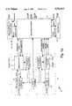
- FIG. 1shows a system block diagram of communications telestation 10 in accordance with the principles of the present invention.
- the telestation 10comprises three modules or subsystems, including a transceiver 11 coupled to an RF antenna 11a that provides for wireless communication of data and commands, a computer 12 (or central processing unit 12) that may be optionally coupled to a data recorder 13 that provides for command and data handling, and a GPS receiver 14 coupled to a GPS antenna 14a that generates position, attitude and time data derived from satellites of the Global Positioning System (not shown). Instruments 15, measuring devices 15a, or payloads 15b are coupled to the computer 12 which are controlled thereby.
- a transceiver 11coupled to an RF antenna 11a that provides for wireless communication of data and commands
- a computer 12or central processing unit 12
- a GPS receiver 14coupled to a GPS antenna 14a that generates position, attitude and time data derived from satellites of the Global Positioning System (not shown).
- the telestation 10has a data interface 16 that permits it to be coupled to an external computer or a bus of a spacecraft in which it is disposed.
- An AC or DC power supply 17that may include solar panels 18 (FIG. 2) or a battery 18, for example, is provided to power the components of the telestation 10.
- the computer 12may be implemented using commercially available computer, for example, available from Intel, Motorola, or Texas Instruments, for example, and provides processing to implement command and control operations and data processing for the payload 15b, or for general communications purposes.
- the data processing provided by the computer 12minimizes bandwidth requirements for transmitting data and commands by using compression software.
- the data recorder 13may be an optical or hard disk system or tape system, for example, that interfaces to the computer 12 in a conventional way.
- the data recorder 13is controlled to store data from the transceiver 11, raw data from the instruments 15, and compressed data including GPS information that is used for subsequent analysis and post processing.
- the raw data from the instrumentation 15is converted to formatted data that is transmitted by way of the transceiver to the user.
- the GPS receiver 14provides state vector and timing to the payload 15b and thus provides precise position location and time references.
- the GPS receiver 14is used to accurately ascertain the location of the telestation 10 in order to post-process the raw data derived from the payload 15b.
- the GPS receiver 14calculates state vector information to provide for Doppler correction and gain control in orbital applications only.
- the GPS receiver 14also calculates the attitude of the telestation 10 to provide for autonomous instrument pointing and control when this is required for the instrumentation 15.
- FIG. 1ait shows a more detailed block diagram of the telestation 10 of FIG. 1 illustrating details of the transceiver 11 and the GPS receiver 14.
- the transceiver 11comprises an RF converter 22 that is coupled between the RF antenna 11a and a signal processor 23.
- a local oscillator 21is coupled to a first frequency synthesizer 24 that has outputs that are coupled to the RF converter 22 and the signal processor 23.
- the local oscillator 21is also coupled to computer 12.
- the signal processor 23outputs commands uplinked by the user to the computer 12 and receives a power on signal from the computer 12, and data from the instrument 15 that is processed by the computer 12 that is downlinked to the user.
- the GPS receiver 14comprises an RF downconverter 25 that is coupled between the GPS antenna 14a and a signal/navigation processor 27.
- the local oscillator 21is coupled to a second frequency synthesizer 26 that has outputs that are coupled to the RF downconverter 25 and the signal/navigation processor 27.
- the signal/navigation processor 27receives a power on signal from the computer 12 and outputs position velocity and time data to the computer 12.
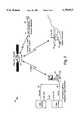
- FIG. 2it illustrates a first embodiment of communications apparatus 20 employing a variety of telestations 10 shown in FIG. 1.
- the communications apparatus 20is used for communication between a user or users and terrestrial and airborne based telestations 10.
- Each useremploys a user terminal 21 to communicate with the terrestrial or airborne based telestations 10 by way of a communication link, such as a public service telephone network (PSTN) 22 or an Internet link 23 that are coupled to a gateway 24.
- PSTNpublic service telephone network
- the user terminals 21comprise dual mode handsets 21 that have cellular and Globalstar transceivers 21a, 21b therein.
- the dual mode handsets 21are digitally controlled, and require very little power.
- the gateway 24provides a communications link to a low earth orbiting satellite system 30, such as the Globalstar satellite system 30 or network 30 developed by the assignee of the present invention.
- the satellite system 30provides a wireless communication link between the user terminal 21 via the gateway 24, and the terrestrial or airborne based telestations 10.
- the satellite system 30includes both cellular and data transceivers 31a, 31b.
- the satellite system 30relays commands and data to and from the user terminal 21 to the terrestrial or airborne based telestations 10.
- a userusing the user terminal 21, "calls" the terrestrial based telestation 10 to communicate with the payload 15b coupled thereto.
- the wireless communication link provided by the Globalstar satellite system 30,allows the terrestrial based telestation 10 to be placed at nearly any point around the Earth without encountering communication interference with existing systems.
- GPS receivers 14are widely used in commercial industries, and commercially available handheld GPS receivers provide precise position location and time references.
- the present invention used for orbital applicationsemploys a GPS receiver 14 developed by the assignee of the present invention, known as a Tansor, that generates attitude data in addition to position and time reference data.
- a GPS receiver 14developed by the assignee of the present invention, known as a Tansor, that generates attitude data in addition to position and time reference data.
- other commercially available GPS receivers 14may be adapted for use in the present invention, such a GPS receiver manufactured by Trimble, Ashtech, or Rockwell-Collins, for example, which is embodied in a computer chip, and which may be modified to provide all functions provided by the Tansor GPS receiver 14.
- Wireless communications provided by the telestation 10are implemented using the low earth orbit satellite transceiver network 30, which may be provided by a 48 satellite constellation Globalstar telecommunications satellite system 30 developed by the assignee of the present invention, and dual mode (cellular and Globalstar) handsets 21 (user terminals 21) operated by users.
- the Globalstar system 30provides a real-time communications link covering about 90% of the surface of the Earth using the wireless transceivers 31a, 31b. Both the cellular transceivers 31a and Globalstar data transceivers 31b are compatible with the Globalstar satellite transceiver system 30.
- the Globalstar system 30enables users to call nearly anywhere in the world at any time using cellular transceivers located on spacecraft of the system 30.
- the Globalstar system 30employs Code Division Multiple Access (CDMA) technology that uses a limited bandwidth while increasing the quality of transmitted information.
- CDMACode Division Multiple Access
- the Globalstar transceivers 31a, 31b on the spacecraftare used to interconnect the user terminal 21 to the payload 15b or instrument 15 coupled to the telestation 10 in a manner analogous to a modem operating at 2.4 kbps.
- This modest data rateis more than adequate for many instruments 15b existing today, and a compression algorithm implemented in the computer 12, such as Fractals, for example, may be used to ease bandwidth requirements.
- the GPS receiver 14provides position and time data. Orbital applications require information from the GPS receiver 14 to determine Doppler correction factors, and to adjust the signal strength for operation using the Globalstar system 30.
- the computer 12provides command and data handling functions that are required to operate the instruments 15 and process the data for subsequent transmission to the user terminal 21.
- the computer 12may be implemented using a RISC 6000 microprocessor, to provide 32-bit addressing and a 27 MIPS processing rate using less than 15 Watts of power.
- the optional data recorder 16may be used to ensure that information generated by the instrument 15 is not lost.
- a telestation 10In operation, once a telestation 10 is in place, its operation depends entirely upon user requirements. Two scenarios are described below, one driven by events, and one that provides for continuous operation. In both scenarios, the telestation 10 is free to move.
- the event driven scenariois as follows, and this situation is illustrated in FIG. 2.
- the telestation 10is commanded to passively wait for an event to occur, and monitors the environment at a low level and low frequency.
- the computer 12activates the telestation 10, logs the time and position at which the event occurred, which is derived from the GPS receiver 14, and begins collecting data.
- the computer 12also initiates a phone call notifying the user that an event has occurred. Examples include unpredictable events such as tectonic movement, volcanic eruptions, encounters with wildlife, or a dynamic change in a given parameter beyond a predetermined threshold.
- the continuous operation scenariois as follows.
- the user terminal 21is employed to continuously monitor and download data from the telestation 10.
- the userinitiates communications using a coded command set, for example, which either turns on and off the instrument 15, adjusts control parameters of the instrument 15 (such as gain, signal to noise ratio, frequency, etc.), and requests data to be sent in a bit-stream to the user terminal 21.
- a coded command setfor example, which either turns on and off the instrument 15, adjusts control parameters of the instrument 15 (such as gain, signal to noise ratio, frequency, etc.), and requests data to be sent in a bit-stream to the user terminal 21.
- the telestation 10communicates with transceivers 31a, 31b in a Globalstar satellite system 30 in either S- or L-band (forward- and return-link, respectively).
- the Globalstar transceiver 31broutes the data to the gateway 21, which uses the public switched telephone network (PSTN) 22 to further route the data to the user terminal 21.
- PSTNpublic switched telephone network
- the exact routingis transparent to the user.
- FIG. 2The operational scenario for the terrestrial application is illustrated in FIG. 2, which may employ telestations 10 on the ground, in the water, or in the aircraft 23.
- Typical terrestrial applications of the telestation 10are described below. These applications include science and education, civil and governmental, and entertainment applications.
- the telestation 10is useful for a variety of science disciplines, as well as fostering education in a multitude of categories.
- seismometer instruments 15are positioned to triangulate and derive the source and magnitude of tectonic activity. These long-lived, passive instruments 15 remain dormant over great periods of time, and become active once an event occurs. The placement of these instruments 15 is primarily driven by the tectonic features of the planet, and are typically positioned near faults. Accessibility secondarily drives the placement of these instruments 15, since they require moderate maintenance for data retrieval and power regeneration or replacement.
- the use of the telestation 10greatly simplifies the operational requirements while providing a potential for increased science return and prediction capability.
- the telestation 10may be configured such that, when an event occurs, it calls a scientist and transmits data regarding the magnitude, duration, and frequency of tectonic activity. Further, the scientist may adjust the parameters of the instrument 15 in real-time, to capture secondary transients to increase the value of the data.
- Solar cells 18 on the telestation 10provide power for long life, negating the need for maintenance of the power supply 17.
- the computer 12compresses the data by a factor of 10, for example, to minimize bandwidth requirements, while the data recorder stores the raw data. There are no restrictions on the number of seismic telestations that may be employed, thereby allowing finer resolution. Two seismic telestations 10 may be collocated to sample different wavelengths without interference.
- Meteorological sciencerequires a network of stations longitudinally spaced to provide ground truth for remote sensing satellites.
- physical constraintslimit the number of meteorology stations.
- Most citiesuse meteorological instruments 15, but a widely distributed set of instruments 15 enables a finer resolution to ascertain the micro climates and transient events associated with the Earth's weather.
- the wide distribution of meteorological telestations 10may be shared among many entities (e.g., governments, news groups, etc.), to provide data to anyone who has access.
- Meteorological telestations 10contain instruments 15 that determine temperature, humidity, wind speed and direction, and barometric pressure.
- the computer 12is used to post-process the data to minimize bandwidth requirements or to provide the data in a user-friendly format, such as automatically graphing the data, for example.
- the meteorological telestations 10can be placed on buoys to deliver the same type of data. Currently, buoys are placed close to land masses, and are serviced once a year. Meteorological telestations 10 provide a means for transmitting the data to a ground station to provide continuous monitoring.
- An imaging instrument 15may be coupled to the telestation 10 and placed at areas known to have volcanic activity, that is activated when a volcano erupts. Also, a telestation 10 may be air dropped in the vicinity of a volcano once an eruption has occurred. The data that the telestation 10 provides is useful in understanding the processes involved with an eruption, while allowing the observer to be a safe distance from the event. The volcano will typically destroy the telestation 10, but measurements can be taken until the last possible moment without the threat to human life.
- Instrumented telestations 10may be dropped using a buoy in the vicinity of carcinogenic oil spills to determine the hazardous fallout.
- the buoy and oilwill travel with the currents, leading researchers and policy makers to take evasive action ensuring minimal environmental damage.
- a microminiaturized beacon devicemay be attached to the tag, which would set off an alarm on a telestation 10.
- the beacon on the animaltriggers the telestation 10, which then notes the tag's identifier and time.
- This datais then automatically logged and transmitted via the Globalstar system 30 to scientists who then can determine the animal traffic and other physiological features.
- telestationsmay be deployed to detect wildfires in bush country, for example. Many fires occur in these remote areas, and often go undetected for some time, allowing the fire to grow.
- Attaching the telestation to an icebergallows scientists and ocean-going vessels to monitor the paths of icebergs.
- the path of an icebergis important to the military as well, since they pose a danger to submarines.
- the telestation 10may be used for military communications. During war games, for example, the telestation can be attached to various vehicles, and can relay battlefield information back to the commander.
- a UHF-based systembuilt by the assignee of the present invention, known as TAPER, may be coupled to the telestation 10 to provide battlefield information with limited coverage.
- Remotely piloted vehicleshave limited in range because they must remain within the line-of-sight of a tower-based pilot.
- RPV'scan be flown nearly anywhere in the world with the pilot located at a fixed location.
- the receiver 14also eliminates beacon interferometry currently used by RPV's.
- a telestation 10 having infrared motion detectors as instruments 15can be located near borders to notify law enforcement officials when motion is detected, such as when a small plane flies overhead. Multiple small, inconspicuous telestations 10 may be deployed to monitor the border. An imager instrument 15 may be coupled to the telestation 10 and commanded to turn on when motion is detected. The imagery can then be used to capture suspects.
- FIG. 3it illustrates a second embodiment of communications apparatus 20a employing an orbital telestation 10.
- the orbital telestation 10operates in a manner similar to the terrestrial telestation 10, but is disposed on a spacecraft 35.
- the payload 15b or instrument 15 on the spacecraft 35functions like a node on a computer network.
- Instrument commandsare uplinked via the Globalstar system 30 and the orbital telestation 10 to the instrument 15.
- Data collected by the instrument 15is returned to the user via the Globalstar system 30, gateway 24 and PSTN 22 or Internet 23, which eliminates the need for a dedicated communications link and supporting ground infrastructure for many payloads 15b. Continuous payload monitoring may be eliminated, because the payload 15b has the ability to call the user when an event occurs using its transceiver 11.
- the 2.4 kbps data rate of the Globalstar system 30is more than adequate for commanding an instrument 15, which typically contains only a dozen instructions totaling 1-2 kilobits. This data rate does not necessarily meet all return data rate requirements in all cases, but is adequate to provide a preview of the data from the instruments 15 (metadata files), which is sometimes essential to successful operation. In this case, the user would continue to use an existing infrastructure to downlink data from the instrument 15.
Landscapes
- Engineering & Computer Science (AREA)
- Radar, Positioning & Navigation (AREA)
- Remote Sensing (AREA)
- Computer Networks & Wireless Communication (AREA)
- Physics & Mathematics (AREA)
- General Physics & Mathematics (AREA)
- Astronomy & Astrophysics (AREA)
- Aviation & Aerospace Engineering (AREA)
- Signal Processing (AREA)
- Mobile Radio Communication Systems (AREA)
- Position Fixing By Use Of Radio Waves (AREA)
Abstract
Description
Claims (18)
Priority Applications (1)
| Application Number | Priority Date | Filing Date | Title |
|---|---|---|---|
| US08/659,317US5793813A (en) | 1996-06-06 | 1996-06-06 | Communication system employing space-based and terrestrial telecommunications equipment |
Applications Claiming Priority (1)
| Application Number | Priority Date | Filing Date | Title |
|---|---|---|---|
| US08/659,317US5793813A (en) | 1996-06-06 | 1996-06-06 | Communication system employing space-based and terrestrial telecommunications equipment |
Publications (1)
| Publication Number | Publication Date |
|---|---|
| US5793813Atrue US5793813A (en) | 1998-08-11 |
Family
ID=24644935
Family Applications (1)
| Application Number | Title | Priority Date | Filing Date |
|---|---|---|---|
| US08/659,317Expired - LifetimeUS5793813A (en) | 1996-06-06 | 1996-06-06 | Communication system employing space-based and terrestrial telecommunications equipment |
Country Status (1)
| Country | Link |
|---|---|
| US (1) | US5793813A (en) |
Cited By (51)
| Publication number | Priority date | Publication date | Assignee | Title |
|---|---|---|---|---|
| US5963166A (en)* | 1998-07-23 | 1999-10-05 | Space Systems/Loral, Inc. | Precise spacecraft camera image navigation and registration |
| US6014606A (en)* | 1996-10-07 | 2000-01-11 | Mcdonnell Douglas Corporation | Cockpit weather information system |
| WO2000007126A1 (en)* | 1998-07-30 | 2000-02-10 | Teledyne Technologies Incorporated | Aircraft flight data acquisition and transmission system |
| US6067453A (en)* | 1996-10-25 | 2000-05-23 | Pt Pasifik Satelit Nusantara | Satellite-based direct access telecommunications systems |
| DE19856231A1 (en)* | 1998-12-04 | 2000-06-21 | Daimler Chrysler Ag | Satellite constellation and system and method for monitoring aircraft |
| US6257526B1 (en)* | 1998-11-09 | 2001-07-10 | Hughes Electronics Corporation | Satellite system and method of deploying same |
| US6298307B1 (en)* | 1997-10-29 | 2001-10-02 | University Corporation For Atmospheric Research | User specific real-time weather information source for compiling time varying weather conditions relating to future event |
| US6317688B1 (en)* | 2000-01-31 | 2001-11-13 | Rockwell Collins | Method and apparatus for achieving sole means navigation from global navigation satelite systems |
| US6397063B1 (en) | 2001-03-30 | 2002-05-28 | Bellsouth Intellectual Property Corporation | Air-surface test system and method to evaluate potential wireless base station sites |
| US20020133398A1 (en)* | 2001-01-31 | 2002-09-19 | Microsoft Corporation | System and method for delivering media |
| US20020152053A1 (en)* | 1999-04-30 | 2002-10-17 | Veritas Dgc, Inc. | Satelite-based seismic mobile information and control system |
| US20020196843A1 (en)* | 1999-03-23 | 2002-12-26 | Itzik Ben-Bassat | Satellite communication card |
| US6510380B1 (en)* | 1999-03-31 | 2003-01-21 | C2 Global Technologies, Inc. | Security and tracking system |
| US6515619B1 (en)* | 1998-07-30 | 2003-02-04 | Mckay, Jr. Nicholas D. | Object location system |
| US6546259B1 (en) | 2000-06-20 | 2003-04-08 | Lockheed Martin Corporation | Method and system for autonomous two-way radio frequency communication |
| US6606556B2 (en) | 1999-03-31 | 2003-08-12 | C2 Global Technologies, Inc. | Security and tracking system |
| US20040073365A1 (en)* | 2002-10-08 | 2004-04-15 | Nokia Corporation | Method in positioning, a system, and an electronic device |
| US6726152B2 (en)* | 2000-01-07 | 2004-04-27 | The Boeing Company | Satellite communications system |
| US6735521B1 (en)* | 1999-03-31 | 2004-05-11 | Alcatel | Onboard system in a vehicle and central system for locating the vehicle accurately |
| US20040192197A1 (en)* | 2000-04-21 | 2004-09-30 | Lockheed Martin Corporation | Geostationary satellite system with satellite clusters having intra-cluster local area networks and inter-cluster wide area network |
| US20040252053A1 (en)* | 2003-06-13 | 2004-12-16 | Harvey A. Stephen | Security system including a method and system for acquiring GPS satellite position |
| US6889135B2 (en) | 1999-03-31 | 2005-05-03 | C2 Global Technologies, Inc. | Security and tracking system |
| US20050136912A1 (en)* | 1999-03-31 | 2005-06-23 | Curatolo Benedict S. | Security and tracking system |
| US20060064726A1 (en)* | 2004-09-21 | 2006-03-23 | Loner Patrick J | Method of using feedback from consumer terminals to adaptively control a satellite system |
| US7027898B1 (en) | 2000-10-30 | 2006-04-11 | Honeywell International Inc. | Weather information network including graphical display |
| US7184761B1 (en) | 2000-03-27 | 2007-02-27 | The Directv Group, Inc. | Satellite communications system |
| US7369809B1 (en) | 2000-10-30 | 2008-05-06 | The Directv Group, Inc. | System and method for continuous broadcast service from non-geostationary orbits |
| WO2007146918A3 (en)* | 2006-06-12 | 2008-06-19 | R & R Business Services Divisi | Wireless communication device |
| US20080205324A1 (en)* | 2007-01-26 | 2008-08-28 | Woosnam Calvin H | Networked Communications and Early Warning System |
| US7574215B1 (en)* | 2000-11-06 | 2009-08-11 | Trimble Navigation Limited | System and method for distribution of GPS satellite information |
| US20090234585A1 (en)* | 2008-03-17 | 2009-09-17 | Ross Allan A | Satellite communications with cableless seismographs |
| US7653349B1 (en) | 2003-06-18 | 2010-01-26 | The Directv Group, Inc. | Adaptive return link for two-way satellite communication systems |
| US7774112B2 (en) | 2004-09-27 | 2010-08-10 | Teledyne Technologies Incorporated | System and method for flight data recording |
| CN102651162A (en)* | 2011-02-28 | 2012-08-29 | 波音公司 | Alternative communications for an air vehicle |
| WO2012148989A3 (en)* | 2011-04-25 | 2013-01-10 | Saudi Arabian Oil Company | Method, system, and machine to track and anticipate the movement of fluid spills when moving with water flow |
| WO2012148982A3 (en)* | 2011-04-25 | 2013-01-17 | Saudi Arabian Oil Company | Method and tracking device for tracking movement in a marine environment with tactical adjustments to an emergency response |
| US8369967B2 (en) | 1999-02-01 | 2013-02-05 | Hoffberg Steven M | Alarm system controller and a method for controlling an alarm system |
| US8612129B2 (en) | 2011-05-23 | 2013-12-17 | Ion Geophysical Corporation | Marine threat monitoring and defense system |
| US8892495B2 (en) | 1991-12-23 | 2014-11-18 | Blanding Hovenweep, Llc | Adaptive pattern recognition based controller apparatus and method and human-interface therefore |
| US20150351369A1 (en)* | 2014-06-05 | 2015-12-10 | Trax Right, LLC | Apparatus and method to identify morbid animals |
| US9485010B1 (en) | 2001-09-10 | 2016-11-01 | The Directv Group, Inc. | Adaptive coding and modulation for spot beam satellite broadcast |
| GB2557572A (en)* | 2016-09-20 | 2018-06-27 | Subsea 7 Ltd | Performing remote inspection at subsea locations |
| US20180201348A1 (en)* | 2017-01-17 | 2018-07-19 | Harris Corporation | System for monitoring marine vessels and determining rendezvouses therebetween and related methods |
| US10071791B2 (en) | 2013-11-12 | 2018-09-11 | Ion Geophysical Corporation | Comparative ice drift and tow model analysis for target marine structure |
| CN108631854A (en)* | 2017-03-24 | 2018-10-09 | 波音公司 | Method and apparatus for the RF performances for testing satellite harness and signal processing unit |
| US10200113B2 (en) | 2017-01-17 | 2019-02-05 | Harris Corporation | System for monitoring marine vessels providing expected passenger determination features and related methods |
| US10302769B2 (en)* | 2017-01-17 | 2019-05-28 | Harris Corporation | System for monitoring marine vessels using fractal processing of aerial imagery and related methods |
| US10361802B1 (en) | 1999-02-01 | 2019-07-23 | Blanding Hovenweep, Llc | Adaptive pattern recognition based control system and method |
| US20220416572A1 (en)* | 2021-06-23 | 2022-12-29 | Amplified Design Solutions, LLC | Software-defined electrical power management and distribution controller for remote systems |
| CN117118495A (en)* | 2023-08-23 | 2023-11-24 | 中国科学院微小卫星创新研究院 | Space-based general calculation integrated network system and remote sensing data on-orbit processing method |
| CN120101809A (en)* | 2025-03-05 | 2025-06-06 | 上海太驿微行航天科技有限公司 | A method and system for ultra-low orbit space-based ground measurement and control tracking |
Citations (5)
| Publication number | Priority date | Publication date | Assignee | Title |
|---|---|---|---|---|
| US5491473A (en)* | 1993-03-31 | 1996-02-13 | Euro Cp S.A.R.L. | System for remote data collecting, method implemented in this system and data collector device |
| US5519403A (en)* | 1993-11-29 | 1996-05-21 | Motorola, Inc. | Global positioning system communications multi-interface |
| US5559496A (en)* | 1993-05-19 | 1996-09-24 | Dubats; William C. | Remote patrol system |
| US5594454A (en)* | 1994-04-13 | 1997-01-14 | The Johns Hopkins University | Global positioning system (GPS) linked satellite and missile communication systems |
| US5634190A (en)* | 1995-06-06 | 1997-05-27 | Globalstar L.P. | Low earth orbit communication satellite gateway-to-gateway relay system |
- 1996
- 1996-06-06USUS08/659,317patent/US5793813A/ennot_activeExpired - Lifetime
Patent Citations (5)
| Publication number | Priority date | Publication date | Assignee | Title |
|---|---|---|---|---|
| US5491473A (en)* | 1993-03-31 | 1996-02-13 | Euro Cp S.A.R.L. | System for remote data collecting, method implemented in this system and data collector device |
| US5559496A (en)* | 1993-05-19 | 1996-09-24 | Dubats; William C. | Remote patrol system |
| US5519403A (en)* | 1993-11-29 | 1996-05-21 | Motorola, Inc. | Global positioning system communications multi-interface |
| US5594454A (en)* | 1994-04-13 | 1997-01-14 | The Johns Hopkins University | Global positioning system (GPS) linked satellite and missile communication systems |
| US5634190A (en)* | 1995-06-06 | 1997-05-27 | Globalstar L.P. | Low earth orbit communication satellite gateway-to-gateway relay system |
Cited By (88)
| Publication number | Priority date | Publication date | Assignee | Title |
|---|---|---|---|---|
| US8892495B2 (en) | 1991-12-23 | 2014-11-18 | Blanding Hovenweep, Llc | Adaptive pattern recognition based controller apparatus and method and human-interface therefore |
| US6014606A (en)* | 1996-10-07 | 2000-01-11 | Mcdonnell Douglas Corporation | Cockpit weather information system |
| US6067453A (en)* | 1996-10-25 | 2000-05-23 | Pt Pasifik Satelit Nusantara | Satellite-based direct access telecommunications systems |
| US6298307B1 (en)* | 1997-10-29 | 2001-10-02 | University Corporation For Atmospheric Research | User specific real-time weather information source for compiling time varying weather conditions relating to future event |
| US5963166A (en)* | 1998-07-23 | 1999-10-05 | Space Systems/Loral, Inc. | Precise spacecraft camera image navigation and registration |
| US6515619B1 (en)* | 1998-07-30 | 2003-02-04 | Mckay, Jr. Nicholas D. | Object location system |
| WO2000007126A1 (en)* | 1998-07-30 | 2000-02-10 | Teledyne Technologies Incorporated | Aircraft flight data acquisition and transmission system |
| US6181990B1 (en)* | 1998-07-30 | 2001-01-30 | Teledyne Technologies, Inc. | Aircraft flight data acquisition and transmission system |
| US6766987B2 (en) | 1998-11-09 | 2004-07-27 | Hughes Electronics Corporation | Satellite system and method of deploying same |
| US20040056148A1 (en)* | 1998-11-09 | 2004-03-25 | Hughes Electronics Corporation | Satellite system and method of deploying same |
| US6460808B2 (en) | 1998-11-09 | 2002-10-08 | Hughes Electronics Corporation | Satellite system and method of deploying same |
| US6257526B1 (en)* | 1998-11-09 | 2001-07-10 | Hughes Electronics Corporation | Satellite system and method of deploying same |
| US6336612B1 (en) | 1998-11-09 | 2002-01-08 | Hughes Electronics Corporation | Satellite system and method of deploying same |
| DE19856231A1 (en)* | 1998-12-04 | 2000-06-21 | Daimler Chrysler Ag | Satellite constellation and system and method for monitoring aircraft |
| US8369967B2 (en) | 1999-02-01 | 2013-02-05 | Hoffberg Steven M | Alarm system controller and a method for controlling an alarm system |
| US9535563B2 (en) | 1999-02-01 | 2017-01-03 | Blanding Hovenweep, Llc | Internet appliance system and method |
| US10361802B1 (en) | 1999-02-01 | 2019-07-23 | Blanding Hovenweep, Llc | Adaptive pattern recognition based control system and method |
| US20020196843A1 (en)* | 1999-03-23 | 2002-12-26 | Itzik Ben-Bassat | Satellite communication card |
| US6889135B2 (en) | 1999-03-31 | 2005-05-03 | C2 Global Technologies, Inc. | Security and tracking system |
| US6510380B1 (en)* | 1999-03-31 | 2003-01-21 | C2 Global Technologies, Inc. | Security and tracking system |
| US8862378B2 (en) | 1999-03-31 | 2014-10-14 | C2 Global Technologies, Inc. | Security and tracking system |
| US6735521B1 (en)* | 1999-03-31 | 2004-05-11 | Alcatel | Onboard system in a vehicle and central system for locating the vehicle accurately |
| US8321124B2 (en) | 1999-03-31 | 2012-11-27 | C2 Global Technologies, Inc. | Security and tracking system |
| US6606556B2 (en) | 1999-03-31 | 2003-08-12 | C2 Global Technologies, Inc. | Security and tracking system |
| US20050136912A1 (en)* | 1999-03-31 | 2005-06-23 | Curatolo Benedict S. | Security and tracking system |
| US9111433B2 (en) | 1999-03-31 | 2015-08-18 | C2 Global Technologies, Inc. | Security and tracking system |
| US6560565B2 (en)* | 1999-04-30 | 2003-05-06 | Veritas Dgc Inc. | Satellite-based seismic mobile information and control system |
| US20020152053A1 (en)* | 1999-04-30 | 2002-10-17 | Veritas Dgc, Inc. | Satelite-based seismic mobile information and control system |
| US6726152B2 (en)* | 2000-01-07 | 2004-04-27 | The Boeing Company | Satellite communications system |
| US6317688B1 (en)* | 2000-01-31 | 2001-11-13 | Rockwell Collins | Method and apparatus for achieving sole means navigation from global navigation satelite systems |
| US7184761B1 (en) | 2000-03-27 | 2007-02-27 | The Directv Group, Inc. | Satellite communications system |
| US20070117509A1 (en)* | 2000-03-27 | 2007-05-24 | Wang Arthur W | Satellite communication system |
| US7480506B2 (en) | 2000-03-27 | 2009-01-20 | The Directv Group, Inc. | Satellite communication system |
| US20040192197A1 (en)* | 2000-04-21 | 2004-09-30 | Lockheed Martin Corporation | Geostationary satellite system with satellite clusters having intra-cluster local area networks and inter-cluster wide area network |
| US6546259B1 (en) | 2000-06-20 | 2003-04-08 | Lockheed Martin Corporation | Method and system for autonomous two-way radio frequency communication |
| US7027898B1 (en) | 2000-10-30 | 2006-04-11 | Honeywell International Inc. | Weather information network including graphical display |
| US7369809B1 (en) | 2000-10-30 | 2008-05-06 | The Directv Group, Inc. | System and method for continuous broadcast service from non-geostationary orbits |
| US7574215B1 (en)* | 2000-11-06 | 2009-08-11 | Trimble Navigation Limited | System and method for distribution of GPS satellite information |
| US20020133398A1 (en)* | 2001-01-31 | 2002-09-19 | Microsoft Corporation | System and method for delivering media |
| US6397063B1 (en) | 2001-03-30 | 2002-05-28 | Bellsouth Intellectual Property Corporation | Air-surface test system and method to evaluate potential wireless base station sites |
| US9485010B1 (en) | 2001-09-10 | 2016-11-01 | The Directv Group, Inc. | Adaptive coding and modulation for spot beam satellite broadcast |
| US7246010B2 (en) | 2002-10-08 | 2007-07-17 | Nokia Corporation | Method in positioning, a system, and an electronic device |
| US20040073365A1 (en)* | 2002-10-08 | 2004-04-15 | Nokia Corporation | Method in positioning, a system, and an electronic device |
| US7196661B2 (en)* | 2003-06-13 | 2007-03-27 | Harvey A Stephen | Security system including a method and system for acquiring GPS satellite position |
| US20040252053A1 (en)* | 2003-06-13 | 2004-12-16 | Harvey A. Stephen | Security system including a method and system for acquiring GPS satellite position |
| US7653349B1 (en) | 2003-06-18 | 2010-01-26 | The Directv Group, Inc. | Adaptive return link for two-way satellite communication systems |
| US7532860B2 (en)* | 2004-09-21 | 2009-05-12 | The Directv Group, Inc. | Method of using feedback from consumer terminals to adaptively control a satellite system |
| US20060064726A1 (en)* | 2004-09-21 | 2006-03-23 | Loner Patrick J | Method of using feedback from consumer terminals to adaptively control a satellite system |
| US20100256868A1 (en)* | 2004-09-27 | 2010-10-07 | Armen Nahapetian | Cost reduction system and method for flight data recording |
| US7945360B2 (en) | 2004-09-27 | 2011-05-17 | Teledyne Technologies Incorporated | Cost reduction system and method for flight data recording |
| US7774112B2 (en) | 2004-09-27 | 2010-08-10 | Teledyne Technologies Incorporated | System and method for flight data recording |
| WO2007146918A3 (en)* | 2006-06-12 | 2008-06-19 | R & R Business Services Divisi | Wireless communication device |
| US20080205324A1 (en)* | 2007-01-26 | 2008-08-28 | Woosnam Calvin H | Networked Communications and Early Warning System |
| US10055955B2 (en) | 2007-01-26 | 2018-08-21 | Technology Mining Company, LLC | Networked communications and early warning system |
| US8296067B2 (en) | 2008-03-17 | 2012-10-23 | Bp Corporation North America Inc. | Satellite communications with cableless seismographs |
| US20090234585A1 (en)* | 2008-03-17 | 2009-09-17 | Ross Allan A | Satellite communications with cableless seismographs |
| CN102651162A (en)* | 2011-02-28 | 2012-08-29 | 波音公司 | Alternative communications for an air vehicle |
| US9766337B2 (en)* | 2011-02-28 | 2017-09-19 | The Boeing Company | Alternative communications for an air vehicle |
| JP2012214216A (en)* | 2011-02-28 | 2012-11-08 | Boeing Co:The | Alternative communication for air vehicle |
| US20170154538A1 (en)* | 2011-02-28 | 2017-06-01 | The Boeing Company | Alternative communications for an air vehicle |
| US20120221175A1 (en)* | 2011-02-28 | 2012-08-30 | The Boeing Company | Alternative communications for an air vehicle |
| US10249201B2 (en)* | 2011-02-28 | 2019-04-02 | The Boeing Company | Alternative communications for an air vehicle |
| CN102651162B (en)* | 2011-02-28 | 2016-12-14 | 波音公司 | Substituting communication for transatmospheric vehicle |
| US9013352B2 (en) | 2011-04-25 | 2015-04-21 | Saudi Arabian Oil Company | Method, system, and machine to track and anticipate the movement of fluid spills when moving with water flow |
| WO2012148982A3 (en)* | 2011-04-25 | 2013-01-17 | Saudi Arabian Oil Company | Method and tracking device for tracking movement in a marine environment with tactical adjustments to an emergency response |
| US9250329B2 (en) | 2011-04-25 | 2016-02-02 | Saudi Arabian Oil Company | Method and tracking device for tracking movement in a marine environment with tactical adjustments to an emergency response |
| US8917175B2 (en) | 2011-04-25 | 2014-12-23 | Saudi Arabian Oil Company | Method and tracking device for tracking movement in a marine environment with tactical adjustments to an emergency response |
| US9435892B2 (en) | 2011-04-25 | 2016-09-06 | Saudi Arabian Oil Company | Method and tracking device for tracking movement in a marine environment with tactical adjustments to an emergency response |
| WO2012148989A3 (en)* | 2011-04-25 | 2013-01-10 | Saudi Arabian Oil Company | Method, system, and machine to track and anticipate the movement of fluid spills when moving with water flow |
| DK178136B1 (en)* | 2011-05-23 | 2015-06-15 | Ion Geophysical Corp | Marine Danger Monitoring and Defense System |
| US10032381B2 (en) | 2011-05-23 | 2018-07-24 | Ion Geophysical Corporation | Marine threat monitoring and defense system |
| US8612129B2 (en) | 2011-05-23 | 2013-12-17 | Ion Geophysical Corporation | Marine threat monitoring and defense system |
| US10071791B2 (en) | 2013-11-12 | 2018-09-11 | Ion Geophysical Corporation | Comparative ice drift and tow model analysis for target marine structure |
| US20150351369A1 (en)* | 2014-06-05 | 2015-12-10 | Trax Right, LLC | Apparatus and method to identify morbid animals |
| US9949461B2 (en)* | 2014-06-05 | 2018-04-24 | Trax Right, LLC | Apparatus and method to identify morbid animals |
| US10764342B2 (en) | 2016-09-20 | 2020-09-01 | Subsea 7 Limited | Performing remote inspection at subsea locations |
| GB2557572B (en)* | 2016-09-20 | 2020-02-12 | Subsea 7 Ltd | Performing remote inspection at subsea locations |
| GB2557572A (en)* | 2016-09-20 | 2018-06-27 | Subsea 7 Ltd | Performing remote inspection at subsea locations |
| US10200113B2 (en) | 2017-01-17 | 2019-02-05 | Harris Corporation | System for monitoring marine vessels providing expected passenger determination features and related methods |
| US10302769B2 (en)* | 2017-01-17 | 2019-05-28 | Harris Corporation | System for monitoring marine vessels using fractal processing of aerial imagery and related methods |
| US20180201348A1 (en)* | 2017-01-17 | 2018-07-19 | Harris Corporation | System for monitoring marine vessels and determining rendezvouses therebetween and related methods |
| US10399650B2 (en)* | 2017-01-17 | 2019-09-03 | Harris Corporation | System for monitoring marine vessels and determining rendezvouses therebetween and related methods |
| CN108631854A (en)* | 2017-03-24 | 2018-10-09 | 波音公司 | Method and apparatus for the RF performances for testing satellite harness and signal processing unit |
| CN108631854B (en)* | 2017-03-24 | 2022-03-15 | 波音公司 | Apparatus and method for testing design of satellite payload transponder |
| US20220416572A1 (en)* | 2021-06-23 | 2022-12-29 | Amplified Design Solutions, LLC | Software-defined electrical power management and distribution controller for remote systems |
| CN117118495A (en)* | 2023-08-23 | 2023-11-24 | 中国科学院微小卫星创新研究院 | Space-based general calculation integrated network system and remote sensing data on-orbit processing method |
| CN117118495B (en)* | 2023-08-23 | 2024-05-28 | 中国科学院微小卫星创新研究院 | Space-based general calculation integrated network system and remote sensing data on-orbit processing method |
| CN120101809A (en)* | 2025-03-05 | 2025-06-06 | 上海太驿微行航天科技有限公司 | A method and system for ultra-low orbit space-based ground measurement and control tracking |
Similar Documents
| Publication | Publication Date | Title |
|---|---|---|
| US5793813A (en) | Communication system employing space-based and terrestrial telecommunications equipment | |
| CA3067604C (en) | System and method for widespread low cost orbital satellite access | |
| US7150430B2 (en) | Internet linked environmental data collection system and method | |
| CN114827952A (en) | Aircraft and emergency navigation communication system based on Beidou short message | |
| US7035585B2 (en) | System and method for interfacing satellite communications with aircraft | |
| Bailey et al. | Experimental validation: Subscale aircraft ground facilities and integrated test capability | |
| US20020173305A1 (en) | System and method for interfacing satellite communications with aircraft | |
| Tan | Remote sensing applications and innovations via small satellite constellations | |
| Borky | Payload technologies and applications for uninhabited air vehicles (UAVs) | |
| Flanegan et al. | NASA lunar communication and navigation architecture | |
| Ilčev | Global Satellite Meteorological Observation (GSMO) Applications: Volume 2 | |
| Schier | NASA's Lunar Space Communication and Navigation Architecture | |
| Ilcev | Space positioning and tracking solutions for military applications | |
| Vallerani et al. | 3U Cubesat" Eaglet-1": Towards a Functional Nano-Sat Leo Constellation | |
| De Lisle et al. | RADARSAT constellation mission for disaster management | |
| Ginati et al. | New trends and capabilities of satellites for bird tracking and monitoring | |
| Cheng | Space 201: Thinking about the space domain | |
| Madry et al. | Ground systems for satellite application systems for navigation, remote sensing, and meteorology | |
| Doyle | Satellite systems for cartography | |
| Works et al. | Satellite Internet Explained | |
| Parfitt et al. | Infrastructure that enables small and low-cost Mars missions | |
| Rosenberg et al. | Polar communications: Status and recommendations. Report of the Science Working Group | |
| Ilčev | Integration in space meteorology | |
| Deutsch | Mars telecommunication orbiter mission operations concepts | |
| Lautenschläger et al. | Sentinel-2: next generation satellites for optical land observation from space |
Legal Events
| Date | Code | Title | Description |
|---|---|---|---|
| AS | Assignment | Owner name:SPACE SYSTEMS/LORAL, INC., CALIFORNIA Free format text:ASSIGNMENT OF ASSIGNORS INTEREST;ASSIGNOR:CLEAVE, ROBERT R.;REEL/FRAME:008121/0010 Effective date:19960729 | |
| FEPP | Fee payment procedure | Free format text:PAYOR NUMBER ASSIGNED (ORIGINAL EVENT CODE: ASPN); ENTITY STATUS OF PATENT OWNER: LARGE ENTITY | |
| AS | Assignment | Owner name:SPACE SYSTEMS/LORAL, INC., CALIFORNIA Free format text:ASSIGNMENT OF ASSIGNORS INTEREST;ASSIGNORS:CLEAVE, ROBERT R.;HOEBER, CHRISTOPHER F.;REEL/FRAME:009167/0639 Effective date:19980212 | |
| STCF | Information on status: patent grant | Free format text:PATENTED CASE | |
| FPAY | Fee payment | Year of fee payment:4 | |
| REMI | Maintenance fee reminder mailed | ||
| AS | Assignment | Owner name:BANK OF AMERICA, N.A., AS COLLATERAL AGENT, NORTH Free format text:NOTICE OF GRANT OF SECURITY INTEREST;ASSIGNOR:SPACE SYSTEMS/LORAL INC.;REEL/FRAME:012946/0061 Effective date:20011221 | |
| AS | Assignment | Owner name:SPACE SYSTEMS/LORAL, INC., CALIFORNIA Free format text:RELEASE OF SECURITY INTEREST;ASSIGNOR:BANK OF AMERICA, N.A.;REEL/FRAME:016153/0507 Effective date:20040802 | |
| FPAY | Fee payment | Year of fee payment:8 | |
| AS | Assignment | Owner name:JPMORGAN CHASE BANK, N.A., AS ADMINISTRATIVE AGENT Free format text:SECURITY AGREEMENT;ASSIGNOR:SPACE SYSTEMS/LORAL, INC.;REEL/FRAME:021965/0173 Effective date:20081016 | |
| FPAY | Fee payment | Year of fee payment:12 | |
| AS | Assignment | Owner name:SPACE SYSTEMS/LORAL, INC., CALIFORNIA Free format text:TERMINATION AND RELEASE OF SECURITY INTEREST IN PATENT RIGHTS;ASSIGNOR:JPMORGAN CHASE BANK, N.A.;REEL/FRAME:029228/0203 Effective date:20121102 | |
| AS | Assignment | Owner name:SPACE SYSTEMS/LORAL, LLC, CALIFORNIA Free format text:CHANGE OF NAME;ASSIGNOR:SPACE SYSTEMS/LORAL, INC.;REEL/FRAME:030291/0536 Effective date:20121102 | |
| AS | Assignment | Owner name:ROYAL BANK OF CANADA, CANADA Free format text:SECURITY AGREEMENT;ASSIGNOR:SPACE SYSTEMS/LORAL, LLC;REEL/FRAME:030311/0961 Effective date:20121102 | |
| AS | Assignment | Owner name:ROYAL BANK OF CANADA, AS THE COLLATERAL AGENT, CANADA Free format text:SECURITY INTEREST;ASSIGNORS:DIGITALGLOBE, INC.;MACDONALD, DETTWILER AND ASSOCIATES LTD.;MACDONALD, DETTWILER AND ASSOCIATES CORPORATION;AND OTHERS;REEL/FRAME:044167/0396 Effective date:20171005 Owner name:ROYAL BANK OF CANADA, AS THE COLLATERAL AGENT, CAN Free format text:SECURITY INTEREST;ASSIGNORS:DIGITALGLOBE, INC.;MACDONALD, DETTWILER AND ASSOCIATES LTD.;MACDONALD, DETTWILER AND ASSOCIATES CORPORATION;AND OTHERS;REEL/FRAME:044167/0396 Effective date:20171005 | |
| AS | Assignment | Owner name:MAXAR SPACE LLC, CALIFORNIA Free format text:TERMINATION AND RELEASE OF SECURITY INTEREST IN PATENTS AND TRADEMARKS - RELEASE OF REEL/FRAME 044167/0396;ASSIGNOR:ROYAL BANK OF CANADA, AS AGENT;REEL/FRAME:063543/0001 Effective date:20230503 Owner name:MAXAR INTELLIGENCE INC., COLORADO Free format text:TERMINATION AND RELEASE OF SECURITY INTEREST IN PATENTS AND TRADEMARKS - RELEASE OF REEL/FRAME 044167/0396;ASSIGNOR:ROYAL BANK OF CANADA, AS AGENT;REEL/FRAME:063543/0001 Effective date:20230503 |