US5467271A - Mapping and analysis system for precision farming applications - Google Patents
Mapping and analysis system for precision farming applicationsDownload PDFInfo
- Publication number
- US5467271A US5467271AUS08/169,853US16985393AUS5467271AUS 5467271 AUS5467271 AUS 5467271AUS 16985393 AUS16985393 AUS 16985393AUS 5467271 AUS5467271 AUS 5467271A
- Authority
- US
- United States
- Prior art keywords
- sub
- image data
- spectral image
- mapping
- analysis system
- Prior art date
- Legal status (The legal status is an assumption and is not a legal conclusion. Google has not performed a legal analysis and makes no representation as to the accuracy of the status listed.)
- Expired - Fee Related
Links
- 238000009313farmingMethods0.000titleclaimsabstractdescription66
- 238000004458analytical methodMethods0.000titleclaimsabstractdescription55
- 238000013507mappingMethods0.000titleclaimsabstractdescription55
- 230000003595spectral effectEffects0.000claimsabstractdescription96
- 239000002689soilSubstances0.000claimsabstractdescription51
- 238000000034methodMethods0.000claimsdescription24
- 238000005259measurementMethods0.000claimsdescription14
- 238000012545processingMethods0.000claimsdescription11
- 230000003044adaptive effectEffects0.000claimsdescription5
- 230000000007visual effectEffects0.000claimsdescription3
- 238000004364calculation methodMethods0.000description16
- 238000013459approachMethods0.000description15
- 239000011159matrix materialSubstances0.000description12
- 230000003287optical effectEffects0.000description11
- 239000011800void materialSubstances0.000description11
- 239000000523sampleSubstances0.000description8
- 239000000126substanceSubstances0.000description8
- 230000009466transformationEffects0.000description8
- 230000006870functionEffects0.000description7
- 230000003068static effectEffects0.000description7
- 238000003860storageMethods0.000description6
- 238000011161developmentMethods0.000description5
- 230000002596correlated effectEffects0.000description4
- 230000001419dependent effectEffects0.000description4
- 238000010586diagramMethods0.000description4
- 238000003384imaging methodMethods0.000description4
- 238000003973irrigationMethods0.000description4
- 230000002262irrigationEffects0.000description4
- 238000001228spectrumMethods0.000description4
- 230000007480spreadingEffects0.000description4
- 238000003892spreadingMethods0.000description4
- 238000012800visualizationMethods0.000description4
- XLYOFNOQVPJJNP-UHFFFAOYSA-NwaterSubstancesOXLYOFNOQVPJJNP-UHFFFAOYSA-N0.000description4
- 230000008901benefitEffects0.000description3
- 230000008859changeEffects0.000description3
- 239000003337fertilizerSubstances0.000description3
- 239000002917insecticideSubstances0.000description3
- 235000015097nutrientsNutrition0.000description3
- 230000008569processEffects0.000description3
- 238000005070samplingMethods0.000description3
- 206010069747Burkholderia mallei infectionDiseases0.000description2
- 239000002131composite materialSubstances0.000description2
- 230000006835compressionEffects0.000description2
- 238000007906compressionMethods0.000description2
- 238000006073displacement reactionMethods0.000description2
- 230000007613environmental effectEffects0.000description2
- 230000009467reductionEffects0.000description2
- 101100102516Clonostachys rogersoniana vern geneProteins0.000description1
- 101100386054Saccharomyces cerevisiae (strain ATCC 204508 / S288c) CYS3 geneProteins0.000description1
- 238000010521absorption reactionMethods0.000description1
- 238000013528artificial neural networkMethods0.000description1
- 230000005540biological transmissionEffects0.000description1
- 238000012512characterization methodMethods0.000description1
- 238000007405data analysisMethods0.000description1
- 238000013480data collectionMethods0.000description1
- 238000001514detection methodMethods0.000description1
- 238000009826distributionMethods0.000description1
- 230000004907fluxEffects0.000description1
- 238000009432framingMethods0.000description1
- 238000003306harvestingMethods0.000description1
- 239000000383hazardous chemicalSubstances0.000description1
- 238000010348incorporationMethods0.000description1
- 239000004973liquid crystal related substanceSubstances0.000description1
- 238000012544monitoring processMethods0.000description1
- 235000021049nutrient contentNutrition0.000description1
- 235000016709nutritionNutrition0.000description1
- 230000035764nutritionEffects0.000description1
- 235000003715nutritional statusNutrition0.000description1
- 238000005457optimizationMethods0.000description1
- 230000000737periodic effectEffects0.000description1
- 230000004044responseEffects0.000description1
- 238000012552reviewMethods0.000description1
- 101150035983str1 geneProteins0.000description1
- 238000001931thermographyMethods0.000description1
- 238000012546transferMethods0.000description1
- 238000000844transformationMethods0.000description1
- 230000003442weekly effectEffects0.000description1
Images


Classifications
- A—HUMAN NECESSITIES
- A01—AGRICULTURE; FORESTRY; ANIMAL HUSBANDRY; HUNTING; TRAPPING; FISHING
- A01B—SOIL WORKING IN AGRICULTURE OR FORESTRY; PARTS, DETAILS, OR ACCESSORIES OF AGRICULTURAL MACHINES OR IMPLEMENTS, IN GENERAL
- A01B79/00—Methods for working soil
- A01B79/005—Precision agriculture
- Y—GENERAL TAGGING OF NEW TECHNOLOGICAL DEVELOPMENTS; GENERAL TAGGING OF CROSS-SECTIONAL TECHNOLOGIES SPANNING OVER SEVERAL SECTIONS OF THE IPC; TECHNICAL SUBJECTS COVERED BY FORMER USPC CROSS-REFERENCE ART COLLECTIONS [XRACs] AND DIGESTS
- Y02—TECHNOLOGIES OR APPLICATIONS FOR MITIGATION OR ADAPTATION AGAINST CLIMATE CHANGE
- Y02A—TECHNOLOGIES FOR ADAPTATION TO CLIMATE CHANGE
- Y02A40/00—Adaptation technologies in agriculture, forestry, livestock or agroalimentary production
- Y02A40/10—Adaptation technologies in agriculture, forestry, livestock or agroalimentary production in agriculture
Definitions
- This inventionrelates to farming and, more particularly, to apparatus and methods for producing georeferenced agricultural maps of farming fields and for analyzing the maps to match farm inputs, such as chemicals and water, to current soil and vegetation characteristics to optimize productivity of the farming field.
- Specific soil characteristicscan vary significantly within a farming field. Particular regions of the farming field can receive too much or too little fertilizer, water and/or insecticide. Environmental damage can occur due to excess inputs and sub-optimal crop yield can occur in farming regions receiving insufficient farming inputs.
- Precision farminghas been proposed to provide farming inputs which are varied to match specific soil characteristics of each region of a farming field to prevent environmental damage and to allow crop yield optimization.
- Conventional chemical spreading machinerycan currently spread chemicals at variable rates based upon an input soil map.
- conventional irrigation systemsallow chemicals and water to be controlled and varied over time and location based upon an input soil map.
- conventional prescription farming approachesare limited with respect to the type and/or extent of data provided. In other words, current approaches do not generate sufficiently competent data for incorporation into the input soil maps which control the chemical spreading machinery and the irrigation systems.
- One approachgenerates soil maps from aerial photographs. While the photographs provides some indication of soil conditions, little or no information relating to crop development and/or yield is provided. Spectral image data provided is limited and difficult to correlate to quantifiable conditions.
- a second approachgenerates soil maps from manual measurements made using soil probes.
- the second approachalso provide some indication of soil conditions but does not provide information relating to crop development and/or yield.
- the second approachis labor intensive and provides limited or discrete data samples which do not adequately represent soil and vegetation characteristics.
- a third approachrelated to the second approach, generates soil maps from "on-the-move" soil probes. While the third approach is more comprehensive than the second approach, similar disadvantages are present.
- the third approachprovides some indication of soil conditions but does not provide information relating to crop development and/or yield.
- the third approachis similarly labor intensive and provides limited or discrete data samples which, as above, do not adequately represent soil and vegetation characteristics.
- a fourth approachgenerates spectral images or maps from airborne or spaceborne multispectral sensors which generate spectral signals related to soil type and crop stress. Vegetation indices are calculated from the spectral signals generated from a limited number of spectral bands, typically less than four spectral bands.
- Data generated using the fourth approachhas not been used for generating input soil maps for chemical spreading machinery and/or irrigation systems because the spectral images are not georeferenced and therefore do not provide sufficient precision.
- the vegetation indices calculated from the spectral signalsare not calibrated with nutrient contents of the soil and/or vegetation.
- Calibrating spectral imagery generated by the fourth approach from day to dayhas been difficult since the magnitude of spectral reflectance is related to light intensity and atmospheric conditions.
- databases which summarize soil and vegetation characteristics and other related data for the farming fieldhave been either unobtainable or imprecise.
- a mapping and analysis systemgenerates agricultural maps and analyzes the agricultural maps to match farm inputs of a farming field to current soil and vegetation characteristics to optimize the productivity of the farming field.
- the mapping and analysis systemincludes an air-based device for generating spectral image data related to at least one of vegetation stress and soil characteristics for a portion of the farming field.
- a position devicegenerates position data related to the position of said air-based device with respect to said portion of the farming field.
- a georeferencing devicesynchronizes said position data with said spectral image data to generate georeferenced spectral image data.
- a databaseis generated using the georeferenced data to monitor and analyze the farming field for a growing season and over multiple growing seasons to improve productivity thereof.
- ground-based measurementsare correlated with georeferenced spectral image data in said database. Over time, data contained in said database allows crop and soil status categories to be determined from said collected and georeferenced spectral image data.
- visualization, image processing, mathematical techniques, and/or adaptive signal processingare used to classify collected georeferenced spectral image data in said crop and soil status categories.
- FIG. 1illustrates a mapping and analysis system including an air-based station and a ground station according to the invention in use over a farming field;
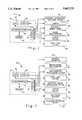
- FIG. 2is a functional block diagram of portions of said air-based station
- FIG. 3is a functional block diagram of portions of said ground station
- FIG. 4is a detailed functional block diagram of both the air-based station and the ground station;
- FIG. 5illustrates data acquisition hardware interfaces which can be incorporated in the air-based station
- FIG. 6is a block diagram illustrating footprint generation and image rectification
- FIG. 7illustrates world and image coordinate systems
- FIG. 8illustrates non-planar terrain calculations.
- mapping and analysis system 10for precision farming applications is illustrated and produces agricultural maps for precision farming from a combination of high resolution airborne and ground-based sensors.
- Mapping and analysis system 10utilizes databases which include information relating to current as well as prior aerial-based imaging, ground-based imaging, other ground-based sampling, etc. and generates electronic maps or hardcopy reports for use in optimizing productivity, by chemical (for example fertilizer, insecticide, etc.) and/or water distribution control systems, etc.
- mapping and analysis system 10is described in conjunction with mapping and analyzing productivity of farming fields, one can appreciate that mapping and analysis system 10 has other applications such as monitoring and analyzing wetlands, exploring, evaluating lands containing hazardous materials, land mapping forests and ranges, etc. Other applications will be readily apparent.
- Mapping and analysis system 10includes an air-based station 14 (further illustrated in FIG. 2) carried by an aircraft 16 and a ground-based station 18. While aircraft 16 is shown as an airplane, other aircraft, satellites, etc. are contemplated.
- Air-based station 14includes image sensing devices 22 for measuring spatial and spectral resolution data of a farming field 24 under study.
- Sensing devices 22can include an image spectrometer 26 which collects spectral image data across a wide spectrum and a camera 30 for providing visual images of farming field 24 under study.
- camera 30is a high resolution color and/or thermal imaging camera.
- the camera 30can be attached to aircraft 14 using a steerable mount 32.
- Spectrometer 26can also include a steerable mount.
- Air-based station 14can communicate with ground-based station 18 using a transmit/receive antenna 34.
- air-based station 14includes an airborne computer 40 with a microprocessor 42, memory 44 which can include external and internal RAM, ROM, etc., input/output (I/O) interface 46, an input device 47 and display device 48, such as a keyboard and a cathode ray tube (CRT), respectively.
- Air-based station 14includes an airborne navigation/position system 50 which provides signals indicative of aircraft position (longitude, latitude, and altitude), heading, pitch, roll, and yaw in real-time to aircraft computer 40 via I/O interface 46.
- a datalink device 54 connected to antenna 34receives and transmits data to ground station 18, as will be described further below.
- Aircraft computer 40can include an elevation database including digital data related to the elevation of farming field 24 under study. The elevation data can be generated under control of and in synchronization with the aircraft position signals provided by airborne navigation/position system 50.
- Airborne computer 40records collected spectral and visual image data generated by image spectrometer 26 and camera 30 in memory 44. Airborne computer 40 georeferences image data generated by image spectrometer 26 and camera 30 in real time using the real-time navigation/position signals generated by aircraft navigation/position system 50, pointing signals generated by steerable mount 32, and the elevation database.
- Automated control of actuation and scanning field size for image spectrometer 26is controlled by airborne computer 40 in accordance with operator input and/or preprogrammed flight plans.
- Airborne computer 40automates control of pointing, zooming (image enlargement and reduction), and actuation of camera 30 according to operator input and/or the preprogrammed flight plan.
- Airborne computer 40cues steerable camera mount 32 by analyzing spectral image data generated by image spectrometer 26 and by generating a camera pointing signal. Airborne computer 40 can automatically capture and associate image data with geographical coordinates generated by navigation/position system 50. Airborne computer 40 outputs in real-time spectral image data generated by image spectrometer 26 and camera 30 to display device 48 for review by an optional operator. Airborne computer 40 can output in real time georeferenced image data to display device 48 for data collection management by the operator. An output device 52 such as a disk drive, a printer, a video cassette recorder, digital tape, etc. may also be provided.
- Airborne computer 40provides automatic and/or operator assisted (via input device 47) mosaicking and overlapping of georeferenced images to create digital maps for large farming fields 24.
- the digital mapscan be stored in memory 44 for later retrieval or transmitted via data link device 54 to ground station 18 for further analysis and/or output to farming machinery, etc.
- Airborne computer 40can also overlay georeferenced image data onto registered vector and raster map backgrounds.
- Airborne computer 40also allows annotation of the digital maps with additional text and graphics with imagery/map products, for example "tick marking" of an exact georeferenced position of an object within georeference oblique or nadir imagery and storage of the additional text and graphics.
- ground-based station 18can include a ground-based computer 70 with a microprocessor 72, memory 74 which can include external and internal RAM, ROM, etc., input/output (I/O) interface 76, an input device 78 and display device 82, such as a keyboard (and/or diskdrive, etc.) and a cathode ray tube (CRT), respectively.
- Ground-based station 18communicates with airborne computer 40 via datalink device 88.
- Ground-based computer 70also can include an output device 98 such as a modem, digital tape, or CD-ROM drive, a map/image scanner 92, and a computer network interface 94.
- a playback/recording device 89allows video or digital input from tapes generated by air-based station 14.
- a ground-based spectrometer 90collects detailed spectral image data at ground-level for vegetation and soil regions of interest. The spectral image data collected by ground-based spectrometer 90 is collected over several hundred channels over the same spectrum as the air-borne spectrometer 26.
- a spectrometer positioning system 94guides and positions ground-based spectrometer 90 for recording the spectral image data for specific regions of interest.
- Ground-based computer 70 and/or airborne computer 40can perform data analysis, historical database development, and playback of airborne-collected data.
- Ground-based computer 70 and/or airborne computer 40can store, retrieve, and associate airborne collected spectral image data with ground-collected spectral image data according to geographical location and date/time.
- Ground-based computer 70 and/or airborne computer 40can store, retrieve, and associate ground-based soil and vegetation measurements according to geographical location and date/time.
- Ground-based computer 70 and/or airborne computer 40can correlate measurable crop characteristics, such as greenness, leaf area index and productivity with collected spectral image, nutrient, and moisture data for a growing season.
- Ground-based computer 70 and/or airborne computer 40can classify collected spectral data from the camera 30 and the spectrometer 26 into crop and soil status categories using visualization (by an operator or automated), image processing, mathematical techniques, and/or an adaptive signal processing using device 99 (such as a neural network using historical spectral, vegetation and soil data).
- Adaptive signal processing device 99can be executed using firmware or software and can be executed by a separate microprocessor or microprocessor 72.
- Ground-based computer 70 and/or airborne computer 40can generate digital maps in hard copy and/or electronic formats for transmission via network, modem or storage on magnetic tape, disk, or CD-ROM.
- Datalink devices 54 and 88allow quick dissemination of the digital maps directly to precision farming equipment, and/or to ground station 18 which can output the digital maps or appropriate control signals to output devices 98 such as precision farming equipment, printers, and/or electronic interfaces.
- the digital mapscan be transmitted in a variety of formats including raw images, images overlaid on raster maps, image annotation, or images with overlaid annotation.
- Datalink devices 54 and 88can use image compression to achieve acceptable transfer time and digital map quality. For example, Joint Photographic Experts Group (JPEG) image compression has been found to have acceptable performance.
- JPEGJoint Photographic Experts Group
- aircraft computer 40 of FIG. 2can include an airborne computer 100 connected to a monitor 102, a keyboard 106, a mouse 110, and a printer 114.
- Airborne computer 100can include memory 116, for example internal RAM and ROM (not shown) and external memory such as CD ROM 118, tape 120, and/or a hard drive 122. Other types of internal and external memory are contemplated.
- Camera 30 of FIG. 2can be a high resolution color and/or thermal camera 130 connected to a steerable camera mount 32 which can be actuated using manual camera controller 134 and/or automated camera control signals can be provided by the airborne computer 100 via data bus 136 and digital interface 138.
- Camera 130generates and outputs image data to a video recorder 142 which records a video signal.
- the video signalis transmitted by video bus 144 to a video digitizer 148 which digitizes the video signal for storage in memory 44.
- the camera 130may provide direct digital output. Alternately, the camera 130 may provide analog film output that is digitized by the map/image scanner 92 at the ground station 18.
- the airborne computer 100modifies the digitized video signal by adding georeferencing, mosaicking, etc., for storage to memory, disk 122, or tape 120.
- the airborne computer 100outputs position, attitude, and sensor/mount status on data bus 136 to video encoder 150 which generates an analog video signal.
- the analog video signalcan be recorded by video recorder 142.
- the videotapecan be transferred to a video playback device 160 associated with ground-based station 18, as will be described further below.
- Video bus 144can also be connected to a LCD monitor 162 and a cockpit display 163 if desired.
- the data link device 54 of FIG. 2can include an antenna 172, an ultra high frequency radio (UHF) radio 174, and data radio modem 178 which are connected to data bus 136 by digital interface 180.
- Aircraft station 14can also be in audio contact with ground station 18 using an antenna 184, a very high frequency (VHF) radio 186, headset 188 and speaker 190.
- VHFvery high frequency
- Airborne computer 100can include a database in internal or external memory.
- the databasecan include elevation data, past vegetation and soil characteristics, etc. for the farming field under study.
- an on-line database accessed via a computer networkcan be used, for example via Ethernet®.
- the databasecan also be associated with a ground-based computer 230, described below.
- the aircraft navigation/position system 50 of FIG. 2can include a flux gate sensor 194 connected to an attitude heading reference system 196 which is connected by a digital interface 200 to data bus 136 of airborne computer 100.
- the aircraft navigation/positioning system 50further includes a global positioning satellite (GPS) unit 204 and an antenna 206 for receiving a first positioning signal from a GPS.
- the first positioning signalprovides longitude, latitude and altitude data for the aircraft 16.
- a long-range navigation (LORAN) interface 210 and antenna 212generates a second positioning signal which provides longitude, latitude and altitude data.
- GPS unit (or position/attitude unit) 204 and LORAN interface 210are connected by digital interface 220 to the data bus 136.
- a linescanner 224generates and collects spectral data across a wide spectrum and is connected by a digital interface 228 to the data bus 136 and computer 100.
- the linescannergenerates and outputs spectral image data to a digital interface 228.
- the digital datais stored in memory 44 and/or on magnetic tape 120.
- Airborne computer 100modifies the digital data by adding georeferencing, mosaicking, etc., for storage to memory, disk 122, or tape 120.
- the airborne computer 100outputs position, attitude, and sensor/mount status for storage along with the digital linescanner data to memory, disk 122, or tape 120.
- the digital tapecan be transferred to playback/recording device 89 associated with ground-based station 18, as will be described further below.
- the digital input streamcan be displayed directly on to the monitor 162 from memory.
- Monitor 168can be a liquid crystal diode (LCD) monitor.
- LCDliquid crystal diode
- Ground-based station 18includes a ground-based computer 230 connected to a monitor 232, a keyboard 236, a mouse 240, and a printer 244.
- Ground-based computer 100can include memory 246, for example internal RAM and ROM (not shown) and external memory such as CD ROM 248, tape 250, a hard disk drive 252, and/or floppy disk drive 256. Other types of internal and external memory are contemplated.
- the data link device 98 of FIG. 3can include an antenna 272, an ultra high frequency radio (UHF) radio 274, and data radio modem 278 which can include digital interfacing for direct connection to computer 230.
- Ground-based station 18can also be in audio contact with air-based station 14 using an antenna 284, a very high frequency (VHF) radio 286, headset 288 and speaker 290.
- VHFvery high frequency
- Ground-based station 18can include a database in internal or external memory.
- the databasecan include elevation data, past vegetation and soil characteristics, etc. for the farming field under study.
- an on-line database accessed via a computer networkcan be used, for example via Ethernet®.
- Ground-based station 18can interface with air-based station 14 via the computer network if desired.
- airborne station 18collects high resolution spectral image data over farming fields located using a preprogrammed flight plan or interactively selected by an operator. Airborne station 18 georeferences the collected spectral image data. Unusual soil surface characteristics and regions of vegetative stress are identified using vegetative stress, temperature and color indicators. Camera 30 provides zoom color image data for areas of interest by cueing based upon automated imagery analysis cues, a programmed plan, and/or operator direction.
- Zoom color and/or thermal imagesare collected for areas of interest by cueing based on automated imagery analysis, a programmed plan, and/or operator direction. Large areas are mapped by automatic or operator-assisted mosaicking of adjacent captured images. The locations of unusual characteristics are used to direct ground-based spectral measurements and nutrition/moisture measurements. The location of the ground measurement points and other processed data can be transmitted to the ground within a few minutes of collection through datalink devices 54 and 88. Ground measurements can also be made at "normal" areas in the field.
- This processis repeated on a periodic basis (daily, weekly, monthly) through the course of the growing season, with the data being stored and correlated based upon geographic location at ground-based computer 230 and/or airborne computer 100.
- Known conditions and/or problemsare characterized and stored with the data.
- Crop growth trendsare charted with the measured data and models are updated.
- Field maps showing crop and soil statusare developed using manual and/or automated visualization, image processing, and mathematical techniques. The maps are output in paper or electronic form for dissemination via modem, tape, or CD-ROM.
- ground-based spectral signatureis characterized by the positions of minimum (absorption) and maximum (reflection) values (2nd derivative) and rates of change (1st derivative) between selected minima and maxima. These characteristics are generally invariant of light intensity and atmospheric factors and therefore can be correlated over time. Collected spectral image data, known conditions, and collected plant and soil data for multiple fields (and for different times) are used to build up a large sample set to develop the spectral characteristics for various stages of crop development.
- the prescription farming system 10learns the spectral signature trends associated with normal crop growth, nutrient/moisture status, and specific crop problems on a crop-by-crop, region-by-region, and field-by-field basis.
- ground-based spectral databasealgorithms for more precise detection of soil and vegetation characteristics are developed and are incorporated in airborne computer 100 along with the classification techniques for crop conditions and nutrient status. These are used to generate real-time status maps of the field directly by airborne computer 100 which can be datalinked to precision farming equipment or ground-based computers using the optional datalink. Maps can also be produced at the ground-station for hardcopy or electronic dissemination. Automated collection plans for future airborne missions are created at the ground computer and downloaded to the airborne computer system.
- FIGS. 5 and 6the following sections illustrate a data acquisition interface 400 for mapping and analysis system 10 according to the inventor.
- a scanner hardware interface (HWIF) 402reads input data from image spectrometer 26 (e.g. linescanner 224) such as scan lines of imagery pixels and roll values.
- Scanner HWIF 402can be a parallel interface.
- Input datais read in as scan line-size blocks and placed into a shared memory 406.
- a position/attitude HWIF 410reads data from an input port (which can be serial) connected to position/attitude unit 204.
- Position/attitude unit 204can be a Trimble Navigation GPS unit which generates data in ASCII format.
- a state tablecan be constructed and, based on the input data, a branch can be taken to read a specific token.
- the Latitude, Longitude, Altitude, Attitude, and Track(used for heading) are linked with appropriate scan lines in shared memory 406.
- a ball HWIF 414(for example associated with steerable sensor mount 32) points a ball with a sensor mounted inside to a target specified either by the user or automatically computed by the system.
- the ballcan be used with the camera or the image spectrometer.
- Directional parameterse.g. azimuth and elevation
- the ball HWIF 414must continuously send commands to the hardware to keep the ball pointed in the proper location.
- Decoder HWIF 420decodes the navigation, attitude and camera angle measurements as previously described.
- a decoder HWIF 420decodes all navigation, attitude, and camera angle measurements from the video signal and stores the data in shared memory 406.
- a tape HWIF 428is used during collection and playback modes.
- the tape 124stores all data written to shared memory 406 by GPS HWIF 410 and scanner HWIF 402.
- tape HWIF 428restores the contents of shared memory 406 to the same state as during collection.
- the GPS and scanner HWIF 410 and 402are not running during playback.
- a video capture display 432captures a video signal from the real-time video display and saves the frame (or multiframe) along with navigation, attitude, and camera angle parameters to a snap shot. This data is output to a map display 436 for image rectification.
- a real-time waterfall display 440reads imagery data from shared memory 406 and displays the imagery data to the user in a window where the scan lines are scrolled from the top of the display to the bottom.
- the snapshot datais sent to the map display 436 along with its navigation data used for image rectification.
- the mapping and analysis system 10has the ability to display, in real-time, a footprint (FIGS. 6 and 7) that is an indication of a sensor's field of view on the ground.
- a footprint(FIGS. 6 and 7) that is an indication of a sensor's field of view on the ground.
- the real-time nature of the sensor footprintis extremely useful when producing a mosaic of imagery by providing the operator with the ability to optimize ground coverage.
- the sensor image datamay be projected within the footprint onto a map to provide image geo-referencing.
- Two suitable map projectionsare Mercator and Universal Transverse Mercator (UTM), representing planar or elevation mapping.
- UDMUniversal Transverse Mercator
- mapping and analysis system 10operates with three different sensor types: framing camera, scanning camera and single line scanner. Each of these sensors is parameterized so that a database may be created to support sensors of varying specifications.
- the sensor footprintis calculated using the sensor type, the sensor's orientation relative to the aircraft, and the aircraft's orientation relative to the ground.
- the sensor footprintis initially calculated relative to a point directly below the aircraft.
- the aircraft's position along with the map projectiondetermines where the footprint points are rendered on the map display.
- Image rectification parametersare determined from the sensor footprint calculation and are then used to project the image onto the map.
- a transformation that describes the relationship between points in the image and points on the groundmust be defined to calculate the sensor footprint and perform image rectification.
- Sensor footprint calculation and image rectificationare inverse functions.
- the location of the boundary points (four corners) of the image on the groundare located.
- the projection of the sensor image onto the groundrequires the transformation of each point within the footprint to the image point (or pixel) that projects to that point.
- a world coordinate systemis chosen with the origin at sea level directly below the aircraft navigation/position system 50 (or GPS unit 204) of the aircraft.
- the axes of the world coordinate systemare defined as follows:
- the axes of the image coordinate systemare defined as follows:
- the following datais provided dynamically from the aircraft navigation/position system 50 and the sensor (or sensor mounting system, e.g., steerable camera mount 32):
- Equations defining the transformation between world and image coordinatesare given by the following:
- equations (1) and (2)are parametric equations of a line in world coordinates originating at the sensor location.
- the rotation matrix Ris a composite of the aircraft and sensor rotations defined as follows:
- Equations (1) and (2)form the basis for the rectification and footprint algorithms respectively.
- footprint calculationconsists of projecting the four corner points of the image onto the ground. These calculations are based on equation (2) and are recomputed for each navigational update, sensor movement, or image snapshot. To illustrate the footprint calculation process we will consider the frame camera model. The equations for the remaining sensor types are analogous to those of the frame camera.
- equation (2)may be rewritten as:
- Equations (32) and (33)may now be evaluated at each of the four corner points of the image as follows: ##EQU14## to determine the world coordinates of the footprint. These coordinates are the offsets in the meters of the corners of the footprint from the point on the ground directly below the aircraft position sensor (GPS). Now, based on the aircraft position, (in latitude and longitude), and the map projection, the footprint is plotted in the map coordinate system.
- FIG. 8is a graphical illustration of the iteration scheme. Once the world coordinates of the footprint have been determined, the footprint may be projected onto the map as in the planar case. Note that this is only an approximation of the footprint since we have only considered the corner points of the image. To be more precise, each point along the footprint boundary must be calculated in a manner similar to the corner calculations.
- image rectificationinvolves selecting an area on the ground, and then determining which image pixels (if any) project to the points in that area.
- the image rectification calculationsare based on equation (1) and are computed for each image snapshot.
- the values of M and Eare known from the footprint calculation. Additionally, the bounding rectangle of the footprint is used to limit the ground area of the image projection.
- Equation (1)may be rewritten as: ##EQU15## Solving for S and L gives: ##EQU16## To perform the rectification, (S i , L i ) are calculated for each point (W x , W y ) in the bounding rectangle. The choice of sampling of the bounding rectangle is based on the sampling in the map display. If a given (S i , L i ) is within the image area, [O, NS] and [O, N L ], then (W x , W y ) is set to a value proportional to the image pixel value at (S i , L i ). Note that the above calculation does not result in discrete values for S i and L i therefore bi-cubic interpolation of the pixel values is performed in the neighborhood of (S i , L i ) to determine the value.
- the terrain elevationis given for each point within the bounding area. This may be expressed as:
- Equations (35) and (36)now become: ##EQU17## At this point, the rectification procedure is the same as the planar case.
- the following pseudo-codeillustrates the implementation of the footprint calculation and image rectification algorithms for the frame camera model on planar terrain.
- Image -- Footprintcalculates the four corner ground points of the image footprint based on the aircraft and sensor position and orientation.
- Image -- To -- World -- XY()is a function called by Image -- Footprint() to convert an image pixel coordinate to a point on the ground.
- Image -- Rectify()is used to rectify a src array of pixels onto the dst array based on the rectification parameters computed in Image -- Footprint().
- the image spectrometer 26(also linescanner 224) preferably has a spectrum which includes wavelengths between 400 nanometers (nm) and 12,000 nm. A minimum of 32-35 bands should be used for accurate spectral representation of the farming field under study. In contrast, spectrometer 90 should use significantly higher number of bands, preferably several hundred bands. In other words, the spectrometer 26 collects spectral image data over a wide spatial area on relatively few bands while spectrometer 90 collects spectral image data over a narrow spatial area for a relatively high number of bands. Additional bands can be utilized for higher spectral resolution.
Landscapes
- Life Sciences & Earth Sciences (AREA)
- Engineering & Computer Science (AREA)
- Mechanical Engineering (AREA)
- Soil Sciences (AREA)
- Environmental Sciences (AREA)
- Image Processing (AREA)
Abstract
Description
__________________________________________________________________________static void scan.sub.-- collect (DEVICE.sub.-- CMD state) while ((state 32 32 new.sub.-- state) && (!quit)) { /* If it is the right time to sync with the scanner, get the status and then poll for a change in status*/ if (--sync.sub.-- reset21 32 O) { sync.sub.-- to.sub.-- scanner(); sync.sub.-- reset 32 READS.sub.-- PER.sub.-- SYNC; } /* set dst to the proper spot in shared memory to copy the new data to */ dst 32 (SCAN.sub.-- PIXEL *) shm.sub.-- line.sub.-- start (shmbuf, ShmInfo, dst.sub.-- line); /* read data from scanner */b 32 read(scan.sub.-- fd, (u.sub.-- char *) dst, BUFSIZE); /* insert nav data into housekeeping channel */ insert.sub.-- nav.sub.-- data.sub.-- in.sub.-- hk.sub.-- channel(); /* adjust shared memory pointers and get more data from scanner */ shmbuf-22 current 32 dst.sub.-- line; shmbuf-22 cycle = dst.sub.-- cycle; } } __________________________________________________________________________
__________________________________________________________________________ /* define a large parse table which has an entry for every ASCII value between 0 and 127. Each table entry is a pointer to a function which parses out the specific entry. */ /* (*func)( ) */ static Boolean (*Item.sub.-- Designator[128])( ) 32 { /* 0 */ Parse.sub.-- Unknown, Parse.sub.-- Unknown, Parse.sub.-- Start, Parse.sub.-- End, Parse.sub.-- Unknown, Parse.sub.-- Unknown, Parse.sub.-- Unknown, Parse.sub.-- Unknown, Parse.sub.-- Unknown, Parse.sub.-- Unknown, Parse.sub.-- Unknown, Parse.sub.-- Unknown, Parse.sub.-- Unknown, Parse.sub.-- Unknown, Parse.sub.-- Unknown, Parse.sub.-- Unknown, Parse.sub.-- Unknown, Parse.sub.-- Unknown, Parse.sub.-- Unknown, Parse.sub.-- Unknown, /* 20 */ Parse.sub.-- Unknown, Parse.sub.-- Unknown, Parse.sub.-- Unknown, Parse.sub.-- Unknown, Parse.sub.-- Unknown, Parse.sub.-- Unknown, Parse.sub.-- Unknown, Parse.sub.-- Unknown, Parse.sub.-- Unknown, Parse.sub.-- Unknown, Parse.sub.-- Unknown, Parse.sub.-- Unknown, Parse.sub.-- Unknown, Parse.sub.-- Unknown, Parse.sub.-- Unknown, Parse.sub.-- Unknown, Parse.sub.-- Unknown, Parse.sub.-- Unknown, Parse.sub.-- Unknown, Parse.sub.-- Unknown, /* 40 */ Parse.sub.-- Unknown, Parse.sub.-- Unknown, Parse.sub.-- Unknown, Parse.sub.-- Unknown, Parse.sub.-- Unknown, Parse.sub.-- Unknown, Parse.sub.-- Unknown, Parse.sub.-- Unknown, Parse.sub.-- Unknown, Parse.sub.-- Unknown, Parse.sub.-- Unknown, Parse.sub.-- Unknown, Parse.sub.-- Unknown, Parse.sub.-- Unknown, Parse.sub.-- Unknown, Parse.sub.-- Unknown, Parse.sub.-- Unknown, Parse.sub.-- Unknown, Parse.sub.-- Unknown, Parse.sub.-- Unknown, /* 60 (A32 63) */ Parse.sub.-- Unknown, Parse.sub.-- Unknown, Parse.sub.-- Unknown, Parse.sub.-- Unknown, Parse.sub.-- Unknown, Parse.sub.-- R.sub.-- LAT, Parse.sub.-- R.sub.-- LON, Parse.sub.-- R.sub.-- TK, Parse.sub.-- R.sub.-- GS, Parse.sub.-- R.sub.-- DIS, Parse.sub.-- R.sub.-- ETE, Parse.sub.-- R.sub.-- XTK, Parse.sub.-- R.sub.-- TKE, Parse.sub.-- R.sub.-- DTK, Parse.sub.-- R.sub.-- LEG, Parse.sub.-- R.sub.-- IDENT, Parse.sub.-- R.sub.-- BRG, Parse.sub.-- R.sub.-- PTK, Parse.sub.-- Unknown, Parse.sub.-- Unknown, /* 80 P */ Parse.sub.-- R.sub.-- EPE, Parse.sub.-- R.sub.-- VAR, Parse.sub.-- Unknown, Parse.sub.-- Unknown, Parse.sub.-- R.sub.-- WARN, Parse.sub.-- Unknown, Parse.sub.-- Unkwn, Parse.sub.-- Unknown, Parse.sub.-- Unknown, Parse.sub.-- Unknown, Parse.sub.-- Unknown, Parse.sub.-- Unknown, Parse.sub.-- Unknown, Parse-Unknown, Parse.sub.-- Unknown, Parse.sub.-- Unknown, Parse.sub.-- Unknown, Parse.sub.-- R.sub.-- TSLS, /*100 d */ Parse.sub.-- R.sub.-- MSA, Parse.sub.-- R.sub.-- MESA, Parse.sub.-- Unknown, Parse.sub.-- Unknown, Parse.sub.-- Unknown, Parse-R.sub.-- DATE, Parse.sub.-- R.sub.-- TIME, Parse.sub.-- X.sub.-- PS, Parse.sub.-- X-ALT, Parse.sub.-- X.sub.-- TRK, Parse.sub.-- X.sub.-- VERN, Parse.sub.-- X.sub.-- DBTWP, Parse.sub.-- TAG, Parse.sub.-- X.sub.-- POFF, Parse.sub.-- X.sub.-- ETIME, Parse.sub.-- R.sub.-- CODE, Parse.sub.-- K.sub.-- WPTYP, Parse.sub.-- X.sub.-- ETSOL, Parse.sub.-- Unknown, Parse.sub.-- K.sub.-- WP, /*120 x */ Parse.sub.-- Unknown, Parse.sub.-- Unknown, Parse.sub.-- X.sub.-- MODE, Parse.sub.-- Unknown, Parse.sub.-- Unknown, Parse.sub.-- Unknown, Parse.sub.-- Unknown, Parse.sub.-- Unknown }; /*****/ void trimble.sub.-- main (char *prog, char *file, int delay) /* initialize serial port connection with GPS */ GPS.sub.-- init( ); /* loop thru endlessly reading data from GPS */ for (;;) { Read.sub.-- Trimble ( ); passes 32 0; while (End22 Current) { ID 32 *Current30 30 ; Item.sub.-- Designator[(int) ID]( ); Skip.sub.-- Line(); passes30 30 ; } /* format everything to send it out */ utl.sub.-- cvt.sub.-- deg.sub.-- to.sub.-- dms (&msg.lat.decgree, &msg.lat.minute, &msg.lat.hundred, msg.lon.raw); utl.sub.-- cvt.sub.-- deg.sub.-- to.sub.-- dms (&msg.lon.degree, &msg.lon.minute, &msg.lon.hundred, msg.lon.raw); /* put nav info into shared memory */ shmbuf-22 current.sub.-- nav.lat = Nav.lat; shmbuf-22 current.sub.-- nav.lon = Nav.lon; shmbuf-22 current.sub.-- nav.hed 32 Nav.hed; if (Nav.alt!=O) shmbuf-22 current.sub.-- nav.alt = Nav.alt; rap.sub.-- send (&msg); ____________________________________________________________________________________________________________________________________________________void Skyball::Point(void) float az, el; float mode 32 shmbuf-22 skyball.mode; if ((mode 32 32 STOWMODE) || (mode == NADIRMODE) || (mode FORWARDMODE)) az 32 shmbuf-22 sensors.units[SENSOR FLIR].azm; el 32 shmbuf-22 sensors.units(SENSOR-FLIR].ele; } else //search mode { searchazel(az, el); shmbuf-22 sensors.units[SENSOR.sub.-- FLIR].azm 32 az; shmbuf-22 sensors.units(SENSOR.sub.-- FLIR].ele 32 el; shmbuf-22 sensors.units(SENSOR.sub.-- COLOR].azm 32 az; shmbuf-22 sensors.units(SENSOR.sub.-- COLOR].ele 32 el; } // process command int sum 32 167; // 167 is ascii sum for `GOO` // convert float to hex3 char azbuf[3]; sum 32 convert2hex(azbuf, az, POSSCALE); char elbuf[3]; stun 30 32 convert2hex(elbuf, el, POSSCALE); // calculate checksum sum 32 ((( sum & OxfO ) 22 22 4 ) 30 ( sum & OxOf )) & OxOf; char chksum 32 itoh(sum); // send instruction to gimbal (void)sprintf(outputbuf, "GOO%.3s%.3s%c r", azbuf, elbuf, chksum); int nwrite 32 port.Write(outputbuf, GOBUFSIZE); // Read response from gimbal int nread 32 port.Read(inputbuf, GIBUFSIZE); if (nread 22 0) { shmbuf-22 sensors.units[SENSOR.sub.-- FLIR].alive 32 1; shmbuf-22 sensors.units[SENSOR.sub.-- COLOR).alive 32 1; } }; ____________________________________________________________________________________________________________________________________________________void Encoder::MainLoop ( ) char junk[JUNK.sub.-- LEN]; NAV.sub.-- DATA nav; NAV.sub.-- DATA jimnav; ENCODED.sub.-- DATA codedata; // hand-shaking buffer[O] 32 `$`; buffer[1] 32 BUFFER.sub.-- LEN - 2; // data length for (;;) { int count 32 port-22 Read(junk, JUNK.sub.-- LEN); // get systemnav data nav 32 shmbuf-22 current.sub.-- nav; // get sensor-dependent data nav.azm 32 shmbuf-22 sensors.units[.sub.-- unit].azm; nav.ele 32 shmbuf-22 sensors.units[.sub. -- unit].ele; // optimize here, we only need hfov to encode nav.hfov 32 shmbuf-22 sensors.units[.sub.-- unit).hfov; nav.vfov 32 shmbuf-22 sensors.units[.sub.-- unit].vfov; encode(&codedata, &nav, .sub.-- hfov.sub.-- avg, .sub.-- wideflag, .sub.-- narrowflag); memcpy(&buffer[2], &codedata, BUFFER.sub.-- LEN - 2); port-22 Write(buffer, BUFFER.sub.-- LEN); sleep(l); } } ____________________________________________________________________________________________________________________________________________________void Decoder::MainLoop() for (;;) { port-22 Write(outbuf, 3); usleep(500000); count 32 port-22 Read(inbuf, TMPLEN); for (n 32 0 n 21 BUFFER.sub.-- LEN; n30 30 ) { buffer[n] 32 tmpnum[n]; } decode((ENCODED.sub.-- DATA*)buffer, &nav); // set system nav data nav.yaw 32 0.0; shmbuf-22 current nav = nav;nav.yaw 32 0.0; shmbuf-22 current.sub.--nav 32 nav; // get sensor-dependent data kludge, fill in data for all sensors, change if we have more than 1 decoder // more than 1 decoder for (.sub.--unit 32 0 ; .sub.-- unit 21 ACTIVE.sub.-- SENSORS; .sub.-- unit30 30 ) { shmbuf->sensors.units[.sub.-- unit].azm 32 nav.azm; shmbuf->sensors.units[.sub.-- unit].ele 32 nav.ele; shmbuf->sensors.units[.sub.-- unit].hfov 32 nav.hfov; shmbuf->sensors.units[.sub.-- unit].vfov 32 nav.vfov; } } } ____________________________________________________________________________________________________________________________________________________static void tape.sub.-- record (DEVICE.sub.-- CMD prev.sub.-- cmd) set.sub.-- tape.sub.-- state (TAPE.sub.-- STATE.sub.-- RECORDING,NO.sub.-- MSG,""); new.sub.-- cmd 32 prev.sub.-- cmd; while ((new.sub.-- cmd 32 32 prev.sub.-- cmd) && (!quit)) { /* set pointers to the current shared memory data */ shm.sub.--cycle 32 shmbuf->cycle; shm.sub.--line 32 shmbuf->current; /* Copy from shared memory to the tape, wrap around the buffer as necessary. */ for (i32 new.sub.-- full.sub.-- lines; i22 O ; i--) memcpy (blk 30 (ShmInfo->bpl*blk.sub.-- In), shm line start (shmbuf, ShmInfo, local.sub.-- line), ShmInfo->bpl); usleep(RECORD.sub.-- DELAY); } /*****/ static void tape.sub.-- play (DEVICE.sub.-- CMD prev.sub.-- cmd, int delay) { set.sub.-- tape.sub.-- state (TAPE.sub.-- STATE.sub.-- PLAYING.sub.-- FAST,NO.sub.-- MSG,""); while ((new.sub.-- cmd 32 = prev.sub.-- cmd) && (!quit)) { /* get buffer from tape */ tape.sub.-- dev.sub.-- read (tape.sub.-- fd, blk, (LINES.sub.-- PER.sub.-- BLK*Shmlnfo->bpl), errbuf);- /* write buffer to shared memory */ if (! quit) { memcpy (shm.sub.-- line.sub.-- start (shmbuf, ShmInfo, dst.sub.-- line), blk 30 (blk.sub.-- In*ShmInfo->bpl), ShmInfo->bpl); /* update shared memory pointers */ shmbuf->current = dst.sub.-- line; shmbuf->cycle = dst.sub.-- cycle; } /* delay for the specified time */ usleep (delay); } } } ____________________________________________________________________________________________________________________________________________________static void colorsaveit(...) XtVaSetValues(...); image = XGetImage(...); XtVaSetValues(...); */ strip the top and bottom of the picture */ stripdata = beautify(...); newimage = XCreateImage(...); sprintf(name, "%s/%s.xwd", utl.sub.-- env.sub.-- value("ACCSNAP","."), fname) ; if (! (file = fopen (name, "w"))) { fprintf (stderr, "videosave : error in fopen : %s n", name); return; } Window.sub.-- Dump(..); fclose(file); XDestroyImage(newimage); XDestroyImage(image); postprocess(fname); savenavfile(fname, SENSOR.sub.-- COLOR); } ____________________________________________________________________________________________________________________________________________________static void wf.sub.-- data.sub.-- cb() /* check to see how much data should be copied from the shared memory buffer */ shm.sub.-- cycle = shmbuf->cycle; shm.sub.-- line = shmbuf->current; /* extract the channels which are used in the waterfall from the shared memory and put them in the raw.sub.-- buffer */ for (i32 new.sub.-- raw.sub.-- lines ; i22 O ; i--) { for (ch32 0; ch21 RAW.sub.-- CHANNELS; ch30 30 ) { copy.sub.-- channel(); } } /* Check if there are more lines than what will fit in the Ximage update buffer. If there are, skip the ones which don't fit. */ if (new.sub.-- raw.sub.--lines 22 WF.sub.-- UPDATE.sub.-- LINES*WF.sub.-- REDUCTION) { skip.sub.-- lines ( ); } fill.sub.-- ximage.sub.-- buffer( ); if (upd.sub.--lines 22 0) { /* There are new lines in the Ximage which need to be added to the Pixmap and screen. Be sure to wrap if necessary. */ XPutImage(XtDisplay(wf.sub.-- draw.sub.-- w), wf.sub.-- frame->pixmap, cgc, upd.sub.-- buf->Ximage, 0, 0, 0, scan.sub.-- line, WF.sub.-- PIXELS,lines.sub.-- to.sub.-- copy); /* copy data in 2nd frame to 1st frame of pixmap */ XCopyArea(XtDisplay(wf.sub.-- draw.sub.-- w), wf.sub.-- frame->pixmap, wf-frame->pixmap, cgc, 0, scan.sub.-- line, WF.sub.-- PIXELS, line.sub.-- to.sub.-- copy, 0, copy.sub.-- line); /* update screen (window) */ XCopyArea(XtDisplay(wf.sub.-- draw.sub.-- w), wf.sub.-- frame->pixmap, XtWindow(wf.sub.-- draw.sub.-- w), wgc, 0, copy.sub.-- line, WF.sub.-- PIXELS, WF.sub.-- FRAME.sub.-- LINES, 0, 0); draw-snap.sub.-- foot( ); /* if at the start of frame 2, go back to bottom of frame 2 */ if (lines.sub.-- to.sub.-- copy != upd.sub.-- lines) lines.sub.-- to.sub.-- copy = upd.sub.-- lines - lines.sub.-- to.sub.-- copy; } } data.sub.-- timer = Add.sub.-- Timeout (DATA.sub.-- INTERVAL,wf.sub.-- data.sub.-- cb,NULL); } ________________________________________________________________________________________________________________ W.sub.x distance in meters East; W.sub.y distance in meters North; and W.sub.z altitude in meters. ______________________________________
______________________________________ I.sub.x distance in meters horizontal from optical center; I.sub.y distance in meters along the optical axis; and I.sub.z distance in meters vertical from optical center. ______________________________________
______________________________________ β Aircraft Heading (30 is CW from North); φ Aircraft Pitch (30 is Nose Up); ω Aircraft Roll (30 is CW rotation); A.sub.z Aircraft Altitude in meters; α Sensor Azimuth (30 is CW rotation); ε Sensor Elevation (- is Sensor Down); π Sensor Mount Pitch (30 is Sensor Up); ρ Sensor Mount Roll (30 is CW rotation); δ Magnetic Declination; and V offset of the Sensor from the GPS as measured with respect to the aircraft coordinate system (static). ______________________________________
______________________________________ A Aircraft Position in World Coordinates; C Aircraft Rotation Center in World Coordinates; E Sensor Position in World Coordinates; W Arbitrary Point in World Coordinates; I Arbitrary Point in Image Coordinates; P Arbitrary Point in Pixel Coordinates; R.sub.a Rotation matrix due to aircraft orientation; R.sub.s Rotation Matrix due to sensor orientation; R.sub.(x,y,z) Rotation Transformation about the (x,y,z) axes; R Composite Rotation Matrix; M R.sup.T ; λ Constant (distance along the optical axis); and ##STR1## ##STR2## ______________________________________
I=κR(W-E), and (1)
W=E+λMI. (2)
R.sub.a =R.sub.y (-ω)R.sub.x (-φ)R.sub.z (β+δ)(3)
R.sub.s =R.sub.x (-ε)R.sub.z (α)R.sub.y (-ρ)R.sub.x (-π) (4)
R=R.sub.s R.sub.a (5)
V≡R.sub.a (E-A) (9)
E≡A+MR.sub.s V (10)
______________________________________ f Sensor Focal Length in meters; S.sub.s Sensor Pixel Spacing in meters; and N.sub.S, N.sub.L Sensor Image Size in pixels (samples, lines). ______________________________________
______________________________________ (S,L) Arbitrary Pixel (sample, line); I Arbitrary Point in image coordinates; and (S.sub.o, L.sub.o) Optical Center in pixel coordinates (sample, line). ______________________________________
I=JP and P=KI (13)
M=MJ and R=KR (14)
P=κR(W-E) (15)
W=E+λMP (16)
______________________________________ C Radius of Imaging Surface; N.sub.S,N.sub.L Sensor Image Size in pixels (samples, lines); and FOV.sub.H,FOV.sub.V Horizontal and Vertical Field of View. ______________________________________
______________________________________ θ,φ Angular Displacement from optical center (horizontal, vertical); I Arbitrary Point in image coordinates; IFOV.sub.H Horizontal Instantaneous fov(= FOV.sub.H /N.sub.S); IFOV.sub.V Vertical Instantaneous fov(= FOV.sub.V /N.sub.L); (So,Lo) Optical Center in pixel coordinates; and R.sub.n Row n of the R Matrix. ______________________________________
θ=(S-S.sub.o)IFOV.sub.H, and (18)
φ=-(L-L.sub.o)IFOV.sub.H (19)
______________________________________ C Radius of Imaging Surface; N.sub.S Sensor Image Size in pixels (samples, lines); and FOV.sub.H Horizontal and Vertical Field of View. ______________________________________
______________________________________ θ Angular Displacement from optical center (horizontal); I Arbitrary Point in image coordinates; IFOV.sub.H Horizontal Instantaneous fov(= HFOV.sub.H /N.sub.S); S.sub.o Optical Center Sample in pixel coordinates; and R.sub.n Row n of the R Matrix. ______________________________________
θ=(S-S.sub.o)IFOV.sub.H (24)
W.sub.x =E.sub.x +λ(M.sub.00 S+M.sub.01 +M.sub.02 L);(28)
W.sub.y =E.sub.y +λ(M.sub.10 S+M.sub.11 +M.sub.12 L);(29)
Z.sub.T =E.sub.z +λ(M.sub.20 S+M.sub.21 +M.sub.22 L).(30)
W.sub.z =Z(W.sub.x,W.sub.y). (37)
______________________________________ MATRIX R, Ra, Rs, M, J, K; VECTOR V, E, A; CONSTANT MATRIX Identity; Identity Matrix CONSTANT MATRIX Zero; Zero Matrix ______________________________________
__________________________________________________________________________function Image.sub.-- Footprint(FP, So, Lo, Ss, Ls, Ns, Nl, spx, spy, spz, alt, hed, pit, rol, spt, srl, azm, ele) FP : sensor focal point So Lo : optical center Ss Ls : sensor pixel spacing Ns Nl : sensor number of samples lines spx spy spz : position of sensor relative to gps alt : aircraft altitude hed : aircraft heading pit : aircraft pitch rol : aircraft roll spt : sensor mount pitch srl : sensor mount roll azm : sensor azimuth ele : sensor elevation return(sc, yc, x1, y1, x2, y2, x3, y3, x4, y4) xc yc : position of optical center relative to aircraft position xn yn : coordinates of four image corners relative to aircraft position begin V = (spx, spy, spz); A = (0.0, 0.0, alt); Ra = Identity; Rotz(hed, Ra); Rotx(pit, Ra); Roty(rol, Ra); Rs = Identity Rotx(spt, Rs); Roty(srl, Rs); Rotz(azm, Rs); Rotx(ele, Rs); R = Rs * Ra; M = Transpose(R); E = V; E = Rs * E; E = M * E; E = A 30 E; J = Zero; J(0,0) = Ss; J(0,1) = -So*Ss; J(1,1) = FP; J(2,1) = Lo*LS; J(2,2) = -LS; M = M * J; (xc, yc) = Image.sub.-- To.sub.-- World.sub.-- XY( So, Lo, 0.0); (x1, y1) = Image.sub.-- To.sub.-- World.sub.-- XY( 0.0, Nl-1.0, 0.0); (x2, y2) = Image.sub.-- To.sub.-- World.sub.-- XY(Ns-1.0, Nl-1.0, 0.0); (x3, y3) = Image.sub.-- To.sub.-- World.sub.-- XY(Ns-1.0, 0.0, 0.0); (x4, y4) = Image.sub.-- To.sub.-- World.sub.-- XY( 0.0, 0.0 0.0); K = Zero; K(0, 0) = 1.0/Ss K(0, 0) = So/FP K(1, 1) = 1.0/FP K(2, 1) = Lo/FP K(2, 2) = -1.0/LS R = R * K; end __________________________________________________________________________
______________________________________ function Image.sub.-- To.sub.-- World.sub.-- XY(xi, yi, zt) xi yi : image coordinate zt : terrain elevation return(xw, yw) xw yw : world coordinate begin xw = 0.0; yw = 0.0; den = M(2, 0) * xi 30 M(0, 1) 30 M(2, 2) * yi; if (den 32 = 0.0) return; lambda 30 (zt - v.sub.-- elem(E, 2))/den; xw = E(0) 30 lambda * (M(0, 0) * xi 30 M(0, 1) 30 M(0, 2) * yi); = E(1) 30 lambda * (M(1, 0) * xi 30 M(1, 1) 30 M(1, 2) * yi); end ______________________________________
__________________________________________________________________________function Image.sub.-- Rectify(src[], src.sub.-- xs, src.sub.-- ys, dst.sub.-- xs, dst.sub.-- ys, x0, y0, x1, y1) src[] : array of src image pixels src.sub.-- xs.sub.-- src.sub.-- ys : src image pixel xs ys dst.sub.-- xs.sub.-- dst.sub.-- ys : dst image pixel xs ys x0 y0 x1 y1 : ground area of projection Zt[] : array of elevation values return(dst[]) dst[] : array of rectified pixels ddx = (x1-x0)/dst.sub.-- xs; ddy = (y1-y0)/dst.sub.-- ys; XDx = R(0, 0) * ddx; Xdy = -R(0, 1) * ddy; Xo = R(0, 0) * (x0-E(0)) 30 R(0, 1) * (y0-E(1)) - R(0, 2) * E(2); YDx = R(2, 0) * ddx; Ydy = -R(2, 1) * ddy; Yo = R(2, 0) * (x0-E(0)) 30 R(2, 1) * (y0-E(1)) - R(2, 2) * E(2); Ddx = R(1, 0) * ddx; Ddy = -R(1, 1) * ddy; Do = R(1, 0) * (x0-E(0)) 30 R(1, 1) * (y0-E(1)) - R(1, 2) * E(2); Xy = Xo; Yy = Yo; Dy = Do; for (dy = 0; dy < dst.sub.-- ys; dy30 30 ) { Xx = 0.0; Yx = 0.0; Dx = 0.0; for (dx = 0; dx < dst.sub.-- xs; dx30 30 ) { X = Xx + Xy + R(0, 2) * Zt[dx, dy]; Y = Yx + Yy + R(2, 2) * Zt[dx, dy]; D = Dx + Dy + R(1, 2) * Zt[dx, dy]; IX = X/D IY = Y/D sx = Floor(IX); sy = Floor(IY); if (sx < 0 || sx > src.sub.-- xs-1 || sy < 0 || sy > src.sub.-- ys-1) -- outside { dst[dx, sy] = 0; } else { if (sx == src.sub.-- xs-1 || sy == src.sub.-- ys-1) -- border { dst[dx, dy] = src[sx, sy]; } else -- bicubic interpolation { xx = IX - sx; yy = IY - sy; bi = (src[sx, sy ] * (1.0-xx) * (1.0-yy)); bi *= (src[sx30 1, sy ] * (xx) * (1.0-yy)); bi *= (src[sx, sy32 1] * ( xx) * ( yy)); bi *= (src[sx30 1, sy30 1] * (1.0-xx) * ( yy)); dst[ dx, dy] = bi; } } Xx 30 = Xdx; Yx 30 = Ydx; Dx 30 = Ddx; } Xy 30 = Xdy; Yy 30 = Ydy; Dy 30 = Ddy; } end __________________________________________________________________________Claims (47)
Priority Applications (1)
| Application Number | Priority Date | Filing Date | Title |
|---|---|---|---|
| US08/169,853US5467271A (en) | 1993-12-17 | 1993-12-17 | Mapping and analysis system for precision farming applications |
Applications Claiming Priority (1)
| Application Number | Priority Date | Filing Date | Title |
|---|---|---|---|
| US08/169,853US5467271A (en) | 1993-12-17 | 1993-12-17 | Mapping and analysis system for precision farming applications |
Publications (1)
| Publication Number | Publication Date |
|---|---|
| US5467271Atrue US5467271A (en) | 1995-11-14 |
Family
ID=22617468
Family Applications (1)
| Application Number | Title | Priority Date | Filing Date |
|---|---|---|---|
| US08/169,853Expired - Fee RelatedUS5467271A (en) | 1993-12-17 | 1993-12-17 | Mapping and analysis system for precision farming applications |
Country Status (1)
| Country | Link |
|---|---|
| US (1) | US5467271A (en) |
Cited By (205)
| Publication number | Priority date | Publication date | Assignee | Title |
|---|---|---|---|---|
| WO1996014641A1 (en)* | 1994-11-04 | 1996-05-17 | Kelly Shawn L | Modular binocular electronic imaging system |
| US5596494A (en)* | 1994-11-14 | 1997-01-21 | Kuo; Shihjong | Method and apparatus for acquiring digital maps |
| US5684476A (en)* | 1993-12-30 | 1997-11-04 | Concord, Inc. | Field navigation system |
| US5689418A (en)* | 1993-07-22 | 1997-11-18 | Ag-Chem Equipment Co., Inc. | Agricultural communication network |
| WO1998013780A1 (en)* | 1996-09-26 | 1998-04-02 | Hergert C David | System and method for optimized control of moving irrigation systems |
| US5771169A (en)* | 1996-08-29 | 1998-06-23 | Case Corporation | Site-specific harvest statistics analyzer |
| US5845229A (en)* | 1996-10-28 | 1998-12-01 | Appropriate Systems | Method and apparatus for mapping crop quality |
| US5870689A (en)* | 1996-11-22 | 1999-02-09 | Case Corporation | Scouting system for an agricultural field |
| US5878371A (en)* | 1996-11-22 | 1999-03-02 | Case Corporation | Method and apparatus for synthesizing site-specific farming data |
| US5884224A (en)* | 1997-03-07 | 1999-03-16 | J.R. Simplot Company | Mobile mounted remote sensing/application apparatus for interacting with selected areas of interest within a field |
| US5887491A (en)* | 1997-05-14 | 1999-03-30 | Ag-Chem Equipment, Co., Inc. | Soil analysis assembly and system |
| DE19742463A1 (en)* | 1997-09-26 | 1999-04-01 | Claas Selbstfahr Erntemasch | Mapping values |
| US5894323A (en)* | 1996-03-22 | 1999-04-13 | Tasc, Inc, | Airborne imaging system using global positioning system (GPS) and inertial measurement unit (IMU) data |
| WO1999018732A1 (en)* | 1997-10-06 | 1999-04-15 | Ciampa John A | Digital-image mapping |
| US5902343A (en)* | 1996-11-22 | 1999-05-11 | Case Corporation | Automatic scaling of GPS field maps |
| EP0841534A3 (en)* | 1996-11-07 | 1999-07-14 | Ingenieurbüro für Elektro-Mechanische Technologien Dipl.-Ing. Hartmut Euer | Apparatus for producing images which are normalised to maps |
| US5938709A (en)* | 1996-11-22 | 1999-08-17 | Case Corporation | Panning display of GPS field maps |
| WO1999046703A1 (en)* | 1998-03-10 | 1999-09-16 | Lockheed Martin Idaho Technologies Company | Optimization of a recipe for a spatial environment |
| US5961573A (en)* | 1996-11-22 | 1999-10-05 | Case Corporation | Height control of an agricultural tool in a site-specific farming system |
| US5978723A (en)* | 1996-11-22 | 1999-11-02 | Case Corporation | Automatic identification of field boundaries in a site-specific farming system |
| US5991694A (en)* | 1995-11-13 | 1999-11-23 | Caterpillar Inc. | Method and apparatus for determining the location of seedlings during agricultural production |
| US5995895A (en)* | 1997-07-15 | 1999-11-30 | Case Corporation | Control of vehicular systems in response to anticipated conditions predicted using predetermined geo-referenced maps |
| US6016713A (en)* | 1998-07-29 | 2000-01-25 | Case Corporation | Soil sampling "on the fly" |
| US6020587A (en)* | 1998-01-06 | 2000-02-01 | United States Of America As Represented By The Administrator Of The National Aeronautics And Space Administration | Plant chlorophyll content meter |
| WO2000008590A1 (en)* | 1998-08-05 | 2000-02-17 | Case Corporation | A method of determining and treating the health of a crop |
| US6029106A (en)* | 1996-11-22 | 2000-02-22 | Case Corporation | Global position correction for the electronic display of field maps |
| WO2000014714A1 (en)* | 1998-09-04 | 2000-03-16 | Innovative Solutions And Support Inc. | Flat panel display using dual cpu's for an aircraft cockpit |
| US6052187A (en)* | 1998-08-31 | 2000-04-18 | Containerless Research, Inc. | Hyperspectral polarization profiler for remote sensing |
| US6114683A (en)* | 1998-03-02 | 2000-09-05 | The United States Of Ameria As Represented By The Administrator Of The National Aeronautics And Space Administration | Plant chlorophyll content imager with reference detection signals |
| US6118885A (en)* | 1996-06-03 | 2000-09-12 | Institut Francais Du Petrole | Airborne image acquisition and processing system with variable characteristics |
| US6119069A (en)* | 1999-03-01 | 2000-09-12 | Case Corporation | System and method for deriving field boundaries using alpha shapes |
| US6141614A (en)* | 1998-07-16 | 2000-10-31 | Caterpillar Inc. | Computer-aided farming system and method |
| US6160902A (en)* | 1997-10-10 | 2000-12-12 | Case Corporation | Method for monitoring nitrogen status using a multi-spectral imaging system |
| EP1076873A4 (en)* | 1998-05-04 | 2001-02-28 | Timothy A Aughenbaugh | Method and system for enabling use of current information about farming data |
| WO2001016870A1 (en)* | 1999-09-02 | 2001-03-08 | West Virginia University | Method and apparatus for determining document authenticity |
| US6286106B1 (en) | 1997-07-30 | 2001-09-04 | Gateway, Inc. | Computer power down upon emergency network notification |
| US20010026270A1 (en)* | 2000-03-29 | 2001-10-04 | Higgins Darin Wayne | System and method for synchronizing raster and vector map images |
| US20010033291A1 (en)* | 2000-03-29 | 2001-10-25 | Scott Dan Martin | System and method for georeferencing digital raster maps |
| US6327569B1 (en) | 1998-10-15 | 2001-12-04 | Milestone Technology, Inc. | System and methods for real time linkage between harvest environment and marketplace |
| US6336062B1 (en)* | 1999-12-10 | 2002-01-01 | Nec Corporation | Attitude angle sensor correcting apparatus for an artificial satellite |
| EP1189021A1 (en)* | 2000-09-13 | 2002-03-20 | Roke Manor Research Limited | Improvements in or relating to camera systems |
| US6401041B1 (en) | 2000-05-11 | 2002-06-04 | Clayton Petersen | Automated graphical representation of agricutural information |
| WO2002029983A3 (en)* | 2000-10-06 | 2002-06-13 | Rochester Inst Tech | A data-efficient and self adapting imaging spectrometry method and an apparatus thereof |
| WO2002017540A3 (en)* | 2000-08-22 | 2002-06-13 | Gary M Schneider | System and method for developing a farm management plan for production agriculture |
| US6421000B1 (en)* | 2000-06-08 | 2002-07-16 | Rockwell Collins, Inc. | GPS multipath mitigation using a multi-element antenna array |
| US6421610B1 (en)* | 2000-09-15 | 2002-07-16 | Ernest A. Carroll | Method of preparing and disseminating digitized geospatial data |
| US6437708B1 (en) | 1999-10-21 | 2002-08-20 | Top Link Ltd. | System and method of land marking |
| US20020145617A1 (en)* | 2001-04-06 | 2002-10-10 | Kennard Robert M. | Methods of marketing maps depicting the location of real property and geographic characteristics in the vicinity thereof |
| US20020147613A1 (en)* | 2001-04-10 | 2002-10-10 | Kennard Robert M. | Methods of marketing summary maps depicting the location of real property and certain traits in the vicinity thereof |
| US6469628B1 (en) | 1998-03-23 | 2002-10-22 | Time Domain Corporation | System and method for using impulse radio technology in the farming field |
| US6484101B1 (en) | 2000-08-16 | 2002-11-19 | Imagelinks, Inc. | 3-dimensional interactive image modeling system |
| US6529615B2 (en) | 1997-10-10 | 2003-03-04 | Case Corporation | Method of determining and treating the health of a crop |
| US6563532B1 (en) | 1999-01-05 | 2003-05-13 | Internal Research Corporation | Low attention recording unit for use by vigorously active recorder |
| US6567537B1 (en)* | 2000-01-13 | 2003-05-20 | Virginia Commonwealth University | Method to assess plant stress using two narrow red spectral bands |
| US6570999B1 (en) | 1998-08-17 | 2003-05-27 | Ag-Chem Equipment Co., Inc. | Soil particle and soil analysis system |
| US20030130767A1 (en)* | 2002-01-07 | 2003-07-10 | Carroll Ernest A. | Method of and apparatus for acquiring aerial imagery for precision farming |
| US6597992B2 (en) | 2001-11-01 | 2003-07-22 | Soil And Topography Information, Llc | Soil and topography surveying |
| US6631326B1 (en)* | 2000-03-29 | 2003-10-07 | Sourceprose Corporation | System and method for performing flood zone certifications |
| US6650360B1 (en) | 1993-12-23 | 2003-11-18 | Wells & Verne Investments Limited | Camera guidance system |
| US20040039621A1 (en)* | 2002-06-07 | 2004-02-26 | Wood James C. | Resource management planning |
| US20040073556A1 (en)* | 2002-06-07 | 2004-04-15 | Wood James C. | Resource management planning |
| US20040105090A1 (en)* | 2002-11-08 | 2004-06-03 | Schultz Stephen L. | Method and apparatus for capturing, geolocating and measuring oblique images |
| US20040156616A1 (en)* | 1999-01-05 | 2004-08-12 | Strub Henry B. | Low attention recording with particular application to social recording |
| US20040167709A1 (en)* | 2002-09-20 | 2004-08-26 | M7 Visual Intelligence, Lp | Vehicle based data collection and processing system |
| US20040213459A1 (en)* | 2003-03-28 | 2004-10-28 | Nobuhiro Ishimaru | Multispectral photographed image analyzing apparatus |
| US6813544B2 (en)* | 2002-08-19 | 2004-11-02 | Institute Of Technology Development | Method and apparatus for spatially variable rate application of agricultural chemicals based on remotely sensed vegetation data |
| US6865582B2 (en)* | 2000-01-03 | 2005-03-08 | Bechtel Bwxt Idaho, Llc | Systems and methods for knowledge discovery in spatial data |
| US20050073532A1 (en)* | 2000-03-29 | 2005-04-07 | Scott Dan Martin | System and method for georeferencing maps |
| US20050096802A1 (en)* | 2003-10-30 | 2005-05-05 | Deere & Company, A Delaware Corporation | Vehicular guidance system having compensation for variations in ground elevation |
| US20050096849A1 (en)* | 2003-11-04 | 2005-05-05 | Sorrells Robert J. | System and method for managing geospatially-enhanced agronomic data |
| US20050149235A1 (en)* | 2002-08-19 | 2005-07-07 | Seal Michael R. | [method and system for spatially variable rate application of agricultural chemicals based on remotely sensed vegetation data] |
| US20050150160A1 (en)* | 2003-10-28 | 2005-07-14 | Norgaard Daniel G. | Method for selecting crop varieties |
| US20050159882A1 (en)* | 2000-03-29 | 2005-07-21 | Howard John W. | System and method for performing flood zone certicifications |
| US6930715B1 (en) | 2000-07-21 | 2005-08-16 | The Research Foundation Of The State University Of New York | Method, system and program product for augmenting an image of a scene with information about the scene |
| US6937939B1 (en)* | 1999-07-08 | 2005-08-30 | Tokyo University Of Agriculture And Technology Tlo Co., Ltd. | Soil measuring instrument, soil measurement assisting device and method, recorded medium on which a program is recorded, recorded medium on which data is recorded, application amount controller, application amount determining device, method for them, and farm working determination assisting system |
| US20060025927A1 (en)* | 2004-07-27 | 2006-02-02 | Hoskinson Reed L | Method of optimally producing and harvesting agricultural products |
| US6999877B1 (en) | 2003-01-31 | 2006-02-14 | Deere & Company | Method and system of evaluating performance of a crop |
| US20060074560A1 (en)* | 2003-01-31 | 2006-04-06 | Dyer James S | Method and system of evaluating performance of a crop |
| US20060106539A1 (en)* | 2004-11-12 | 2006-05-18 | Choate Paul H | System and method for electronically recording task-specific and location-specific information, including farm-related information |
| US20060196158A1 (en)* | 2005-03-07 | 2006-09-07 | Deere & Company, A Delaware Corporation | Method of predicting suitability for a crop harvesting operation |
| US20060200334A1 (en)* | 2005-03-07 | 2006-09-07 | Deere & Company, A Delaware Corporation | Method of predicting suitability for a soil engaging operation |
| WO2007004798A1 (en) | 2005-07-01 | 2007-01-11 | Moon-Jeong Kim | System and method for designing landscape architecture based on real image |
| US7184892B1 (en) | 2003-01-31 | 2007-02-27 | Deere & Company | Method and system of evaluating performance of a crop |
| US7188029B1 (en) | 2002-08-30 | 2007-03-06 | Dido, Llc | System and method for determining and presenting differences in plant productivity in variable locations and environments |
| US20070065857A1 (en)* | 2005-09-16 | 2007-03-22 | U.S. Environmental Protection Agency | Optical system for plant characterization |
| US7212670B1 (en) | 2002-05-03 | 2007-05-01 | Imagetree Corp. | Method of feature identification and analysis |
| US20070118283A1 (en)* | 2005-11-21 | 2007-05-24 | Magnus Jendbro | Mobile terminals, methods and computer program products for map scanning and calibration |
| US20070208510A1 (en)* | 2006-03-02 | 2007-09-06 | Deere & Company, A Delaware Corporation | Method of identifying and localizing drainage tile problems |
| US7280134B1 (en) | 1998-01-26 | 2007-10-09 | Thales Avionics, Inc. | Landscape camera system with electronic field of view switching |
| US20070282812A1 (en)* | 2006-03-08 | 2007-12-06 | Superior Edge, Inc. | Process execution support system |
| US20070288167A1 (en)* | 2006-06-08 | 2007-12-13 | Deere & Company, A Delaware Corporation | Method for determining field readiness using soil moisture modeling |
| US20070289207A1 (en)* | 2005-12-21 | 2007-12-20 | May George A | Expert system for controlling plant growth in a contained environment |
| US20080211912A1 (en)* | 2004-01-23 | 2008-09-04 | Rafael-Armament Development Authority Ltd. | Airborne reconnaissance system |
| US20080228542A1 (en)* | 2006-12-26 | 2008-09-18 | Katsumi Iwai | Method and apparatus for cultured sea algae |
| US20080291280A1 (en)* | 2002-08-28 | 2008-11-27 | Peters Iii Leo J | Retinal array compound camera system having at least three imaging sensors |
| US20080312829A1 (en)* | 2007-06-15 | 2008-12-18 | Allen David W | Navigation system with swivel sensor mount |
| US7480446B2 (en) | 1996-12-05 | 2009-01-20 | Vulcan Patents Llc | Variable rate video playback with synchronized audio |
| WO2009049151A1 (en)* | 2007-10-12 | 2009-04-16 | Pictometry International Corp. | System and process for color-balancing a series of oblique images |
| WO2007067579A3 (en)* | 2005-12-05 | 2009-05-14 | Oneimage Llc | System for integrated utilization of data to identify, characterize, and support successful farm and land use operations |
| US7565681B2 (en) | 1999-10-08 | 2009-07-21 | Vulcan Patents Llc | System and method for the broadcast dissemination of time-ordered data |
| US20090271719A1 (en)* | 2007-04-27 | 2009-10-29 | Lpa Systems, Inc. | System and method for analysis and display of geo-referenced imagery |
| US7639842B2 (en) | 2002-05-03 | 2009-12-29 | Imagetree Corp. | Remote sensing and probabilistic sampling based forest inventory method |
| US7849475B2 (en) | 1995-03-07 | 2010-12-07 | Interval Licensing Llc | System and method for selective recording of information |
| US7873238B2 (en) | 2006-08-30 | 2011-01-18 | Pictometry International Corporation | Mosaic oblique images and methods of making and using same |
| US20110075886A1 (en)* | 2009-09-30 | 2011-03-31 | Javad Gnss, Inc. | Graphics-aided remote position measurement with handheld geodesic device |
| WO2011160159A1 (en)* | 2010-06-25 | 2011-12-29 | Cambium Land & Water Management Pty. Ltd. | A system and a method for generating a spectral image for a plot of land |
| US8176515B2 (en) | 1996-12-05 | 2012-05-08 | Interval Licensing Llc | Browser for use in navigating a body of information, with particular application to browsing information represented by audiovisual data |
| US8280631B2 (en) | 2008-10-02 | 2012-10-02 | Certusview Technologies, Llc | Methods and apparatus for generating an electronic record of a marking operation based on marking device actuations |
| US8311765B2 (en) | 2009-08-11 | 2012-11-13 | Certusview Technologies, Llc | Locating equipment communicatively coupled to or equipped with a mobile/portable device |
| US8374789B2 (en) | 2007-04-04 | 2013-02-12 | Certusview Technologies, Llc | Systems and methods for using marking information to electronically display dispensing of markers by a marking system or marking tool |
| US8385672B2 (en) | 2007-05-01 | 2013-02-26 | Pictometry International Corp. | System for detecting image abnormalities |
| US8401791B2 (en) | 2007-03-13 | 2013-03-19 | Certusview Technologies, Llc | Methods for evaluating operation of marking apparatus |
| US8401222B2 (en) | 2009-05-22 | 2013-03-19 | Pictometry International Corp. | System and process for roof measurement using aerial imagery |
| US8416995B2 (en) | 2008-02-12 | 2013-04-09 | Certusview Technologies, Llc | Electronic manifest of underground facility locate marks |
| US8424486B2 (en) | 2008-07-10 | 2013-04-23 | Certusview Technologies, Llc | Marker detection mechanisms for use in marking devices and methods of using same |
| US8429244B2 (en) | 2000-01-28 | 2013-04-23 | Interval Licensing Llc | Alerting users to items of current interest |
| US20130113831A1 (en)* | 2010-07-07 | 2013-05-09 | Pictometry International Corp. | Real-Time Moving Platform Management System |
| US8442766B2 (en) | 2008-10-02 | 2013-05-14 | Certusview Technologies, Llc | Marking apparatus having enhanced features for underground facility marking operations, and associated methods and systems |
| US8473209B2 (en) | 2007-03-13 | 2013-06-25 | Certusview Technologies, Llc | Marking apparatus and marking methods using marking dispenser with machine-readable ID mechanism |
| US8478523B2 (en) | 2007-03-13 | 2013-07-02 | Certusview Technologies, Llc | Marking apparatus and methods for creating an electronic record of marking apparatus operations |
| US8478617B2 (en) | 2008-10-02 | 2013-07-02 | Certusview Technologies, Llc | Methods and apparatus for generating alerts on a locate device, based on comparing electronic locate information to facilities map information and/or other image information |
| US8483960B2 (en) | 2002-09-20 | 2013-07-09 | Visual Intelligence, LP | Self-calibrated, remote imaging and data processing system |
| US8489291B2 (en) | 2010-07-12 | 2013-07-16 | Hemisphere Gps Llc | System and method for collecting soil samples |
| US8510141B2 (en) | 2008-10-02 | 2013-08-13 | Certusview Technologies, Llc | Methods and apparatus for generating alerts on a marking device, based on comparing electronic marking information to facilities map information and/or other image information |
| US8520079B2 (en) | 2007-02-15 | 2013-08-27 | Pictometry International Corp. | Event multiplexer for managing the capture of images |
| US8527308B2 (en) | 2008-10-02 | 2013-09-03 | Certusview Technologies, Llc | Methods and apparatus for overlaying electronic locate information on facilities map information and/or other image information displayed on a locate device |
| US8531472B2 (en) | 2007-12-03 | 2013-09-10 | Pictometry International Corp. | Systems and methods for rapid three-dimensional modeling with real façade texture |
| US8583264B2 (en) | 2008-10-02 | 2013-11-12 | Certusview Technologies, Llc | Marking device docking stations and methods of using same |
| US8588547B2 (en) | 2008-08-05 | 2013-11-19 | Pictometry International Corp. | Cut-line steering methods for forming a mosaic image of a geographical area |
| US8589202B2 (en) | 2008-10-02 | 2013-11-19 | Certusview Technologies, Llc | Methods and apparatus for displaying and processing facilities map information and/or other image information on a marking device |
| US8593518B2 (en) | 2007-02-01 | 2013-11-26 | Pictometry International Corp. | Computer system for continuous oblique panning |
| CN103412574A (en)* | 2013-08-23 | 2013-11-27 | 无锡汉和航空技术有限公司 | Job management device of unmanned helicopter |
| US8620572B2 (en) | 2009-08-20 | 2013-12-31 | Certusview Technologies, Llc | Marking device with transmitter for triangulating location during locate operations |
| US8620616B2 (en) | 2009-08-20 | 2013-12-31 | Certusview Technologies, Llc | Methods and apparatus for assessing marking operations based on acceleration information |
| US8626571B2 (en) | 2009-02-11 | 2014-01-07 | Certusview Technologies, Llc | Management system, and associated methods and apparatus, for dispatching tickets, receiving field information, and performing a quality assessment for underground facility locate and/or marking operations |
| WO2012021898A3 (en)* | 2010-08-13 | 2014-03-20 | Certusview Technologies, Llc | Methods, apparatus and systems for surface type detection in connection with locate and marking operations |
| US8823732B2 (en) | 2010-12-17 | 2014-09-02 | Pictometry International Corp. | Systems and methods for processing images with edge detection and snap-to feature |
| WO2014189791A1 (en)* | 2013-05-20 | 2014-11-27 | Elwha Llc | Systems and methods for detecting soil characteristics |
| US8965700B2 (en) | 2008-10-02 | 2015-02-24 | Certusview Technologies, Llc | Methods and apparatus for generating an electronic record of environmental landmarks based on marking device actuations |
| US8994822B2 (en) | 2002-08-28 | 2015-03-31 | Visual Intelligence Lp | Infrastructure mapping system and method |
| US20150130936A1 (en)* | 2013-11-08 | 2015-05-14 | Dow Agrosciences Llc | Crop monitoring system |
| US9058560B2 (en) | 2011-02-17 | 2015-06-16 | Superior Edge, Inc. | Methods, apparatus and systems for generating, updating and executing an invasive species control plan |
| US9097522B2 (en) | 2009-08-20 | 2015-08-04 | Certusview Technologies, Llc | Methods and marking devices with mechanisms for indicating and/or detecting marking material color |
| US9113590B2 (en) | 2012-08-06 | 2015-08-25 | Superior Edge, Inc. | Methods, apparatus, and systems for determining in-season crop status in an agricultural crop and alerting users |
| US9177403B2 (en) | 2008-10-02 | 2015-11-03 | Certusview Technologies, Llc | Methods and apparatus for overlaying electronic marking information on facilities map information and/or other image information displayed on a marking device |
| US9183538B2 (en) | 2012-03-19 | 2015-11-10 | Pictometry International Corp. | Method and system for quick square roof reporting |
| US9208458B2 (en) | 2008-10-02 | 2015-12-08 | Certusview Technologies, Llc | Methods and apparatus for analyzing locate and marking operations with respect to facilities maps |
| WO2015188251A1 (en)* | 2014-06-12 | 2015-12-17 | Precisionhawk Inc. | Method and system for processing image data from unmanned aerial vehicles |
| US20160003790A1 (en)* | 2014-08-19 | 2016-01-07 | Iteris, Inc. | Continual crop development profiling using dynamical extended range weather forecasting with routine remotely-sensed validation imagery |
| US9262818B2 (en) | 2007-05-01 | 2016-02-16 | Pictometry International Corp. | System for detecting image abnormalities |
| US9265187B2 (en) | 2013-11-20 | 2016-02-23 | Rowbot Systems Llc | Robotic platform and method for performing multiple functions in agricultural systems |
| US9275080B2 (en) | 2013-03-15 | 2016-03-01 | Pictometry International Corp. | System and method for early access to captured images |
| US20160063415A1 (en)* | 2014-06-18 | 2016-03-03 | North Central Cooperative | Crop production system |
| US9292913B2 (en) | 2014-01-31 | 2016-03-22 | Pictometry International Corp. | Augmented three dimensional point collection of vertical structures |
| US9288938B2 (en) | 2012-06-01 | 2016-03-22 | Rowbot Systems Llc | Robotic platform and method for performing multiple functions in agricultural systems |
| US9330494B2 (en) | 2009-10-26 | 2016-05-03 | Pictometry International Corp. | Method for the automatic material classification and texture simulation for 3D models |
| GB2531908A (en)* | 2014-09-22 | 2016-05-04 | Deere & Co | Method and system for collecting image data |
| WO2016086035A1 (en)* | 2014-11-24 | 2016-06-02 | Precision Planting Llc | System and methods for identifying fields and tasks |
| US9392743B2 (en) | 2013-08-14 | 2016-07-19 | Rowbot Systems Llc | Agricultural autonomous vehicle platform with articulated base |
| US20160232621A1 (en)* | 2015-02-06 | 2016-08-11 | The Climate Corporation | Methods and systems for recommending agricultural activities |
| US9489576B2 (en) | 2014-03-26 | 2016-11-08 | F12 Solutions, LLC. | Crop stand analysis |
| US20160325832A1 (en)* | 2015-04-06 | 2016-11-10 | Manu Shukla | Distributed drone flight path builder system |
| RU2612326C2 (en)* | 2015-02-24 | 2017-03-07 | Частное образовательное учреждение высшего образования "ЮЖНЫЙ УНИВЕРСИТЕТ"(ИУБиП)" | Method of forming digital plan-scheme of agricultural facilities and system for realising said method |
| US9612598B2 (en) | 2014-01-10 | 2017-04-04 | Pictometry International Corp. | Unmanned aircraft structure evaluation system and method |
| WO2017099570A1 (en)* | 2015-12-11 | 2017-06-15 | Pacheco Sanchez José Antonio | System and method for precision agriculture by means of multispectral and hyperspectral aerial image analysis using unmanned aerial vehicles |
| WO2017099568A1 (en)* | 2015-12-11 | 2017-06-15 | Jose Antonio Pacheco Sanchez | Method for planning overflight of irregular polygons using two or more unmanned aerial vehicles for precision agriculture using multispectral and hyperspectral aerial image analysis |
| WO2017131809A1 (en)* | 2015-01-23 | 2017-08-03 | Brian Harold Sutton | Method and systems for analyzing a field |
| US9753950B2 (en) | 2013-03-15 | 2017-09-05 | Pictometry International Corp. | Virtual property reporting for automatic structure detection |
| EP2633460A4 (en)* | 2010-10-25 | 2017-09-13 | Trimble Navigation Ltd. | System and method for calibrating agricultural measurements |
| US9784615B1 (en)* | 2016-10-14 | 2017-10-10 | Bayspec, Inc. | Adjustment for irregular sensor movement during spectral imaging |
| US9881163B2 (en) | 2013-03-12 | 2018-01-30 | Pictometry International Corp. | System and method for performing sensitive geo-spatial processing in non-sensitive operator environments |
| US9953112B2 (en) | 2014-02-08 | 2018-04-24 | Pictometry International Corp. | Method and system for displaying room interiors on a floor plan |
| IT201600106926A1 (en)* | 2016-10-24 | 2018-04-24 | Innova Tech S R L | PROCEDURE FOR THE APPLICATION OF AT LEAST A SPECIFIC TREATMENT TO A TERRITORY SUBJECT TO AGRICULTURAL CULTIVATIONS OR RURAL AREAS. |
| US10012735B1 (en)* | 2017-05-04 | 2018-07-03 | Loveland Innovations, LLC | GPS offset calibrations for UAVs |
| US10028426B2 (en) | 2015-04-17 | 2018-07-24 | 360 Yield Center, Llc | Agronomic systems, methods and apparatuses |
| US20180315100A1 (en)* | 2017-04-27 | 2018-11-01 | Lindsay Corporation | Computer-implemented method and computer program for designing and cost-estimating irrigation systems |
| WO2018198125A1 (en)* | 2017-04-28 | 2018-11-01 | Saturas Ltd | Method and system for installing water potential detectors in plant stems, and for evaluating plant irrigation conditions |
| US10161795B2 (en) | 2016-10-14 | 2018-12-25 | Bayspec, Inc. | Irregular motion compensation for three-dimensional spectroscopy |
| CN109475080A (en)* | 2016-06-09 | 2019-03-15 | 巴斯夫欧洲公司 | The method for determining the attributes of vegetation of useful plant |
| EP3467702A1 (en)* | 2017-10-04 | 2019-04-10 | Kws Saat Se | Method and system for performing data analysis for plant phenotyping |
| US10325350B2 (en) | 2011-06-10 | 2019-06-18 | Pictometry International Corp. | System and method for forming a video stream containing GIS data in real-time |
| US20190220964A1 (en)* | 2018-01-15 | 2019-07-18 | The Boeing Company | System and method for monitoring crops |
| US20190253673A1 (en)* | 2015-01-11 | 2019-08-15 | A.A.A Taranis Visual Ltd | Systems and methods for agricultural monitoring |
| US10402676B2 (en) | 2016-02-15 | 2019-09-03 | Pictometry International Corp. | Automated system and methodology for feature extraction |
| US10474975B1 (en)* | 2010-03-31 | 2019-11-12 | SWIIM System, Ltd. | System and method for conserving water and optimizing land and water use |
| US10502813B2 (en) | 2013-03-12 | 2019-12-10 | Pictometry International Corp. | LiDAR system producing multiple scan paths and method of making and using same |
| US10671648B2 (en) | 2016-02-22 | 2020-06-02 | Eagle View Technologies, Inc. | Integrated centralized property database systems and methods |
| WO2020117847A1 (en) | 2018-12-03 | 2020-06-11 | Micasense, Inc. | Image sensor and thermal camera device, system and method |
| US20200245525A1 (en)* | 2017-08-22 | 2020-08-06 | Basf Agro Trademarks Gmbh | Yield estimation in the cultivation of crop plants |
| CN111814529A (en)* | 2019-04-10 | 2020-10-23 | 迪尔公司 | Mechanically Controlled Image Selection |
| EP3417690B1 (en)* | 2017-06-19 | 2020-11-25 | DINAMICA GENERALE S.p.A | A self-propelled apparatus for optimally analysing and managing fields intended for agricultural cultivation |
| CN113347875A (en)* | 2019-02-04 | 2021-09-03 | 精密种植有限责任公司 | System, apparatus and method for monitoring soil characteristics and determining soil color |
| US11113649B2 (en) | 2014-09-12 | 2021-09-07 | The Climate Corporation | Methods and systems for recommending agricultural activities |
| US11126937B2 (en) | 2013-09-23 | 2021-09-21 | Farmobile, Llc | Farming data collection and exchange system |
| US20220078964A1 (en)* | 2019-06-28 | 2022-03-17 | Kubota Corporation | Agriculture assistance system |
| USRE49105E1 (en) | 2002-09-20 | 2022-06-14 | Vi Technologies, Llc | Self-calibrated, remote imaging and data processing system |
| US20220338429A1 (en)* | 2021-04-22 | 2022-10-27 | Reinke Manufacturing Co., Inc. | Data collection system for irrigation systems |
| US11526935B1 (en) | 2018-06-13 | 2022-12-13 | Wells Fargo Bank, N.A. | Facilitating audit related activities |
| US20220408666A1 (en)* | 2018-09-23 | 2022-12-29 | Marvin Nash | Method of Processing By-Product Water for Optimal Beneficial Use |
| US11544296B1 (en)* | 2016-09-15 | 2023-01-03 | Winfield Solutions, Llc | Systems and methods for spatially-indexing agricultural content |
| US11947355B2 (en) | 2020-10-15 | 2024-04-02 | Topcon Positioning Systems, Inc. | Method and apparatus for zone mapping |
| US12008744B2 (en)* | 2018-12-10 | 2024-06-11 | Climate Llc | Mapping field anomalies using digital images and machine learning models |
| US12079013B2 (en) | 2016-01-08 | 2024-09-03 | Pictometry International Corp. | Systems and methods for taking, processing, retrieving, and displaying images from unmanned aerial vehicles |
| US12295299B2 (en) | 2018-09-06 | 2025-05-13 | Marvin Nash | Method of processing by-product water for optimal beneficial use |
| US12332660B2 (en) | 2018-11-21 | 2025-06-17 | Eagle View Technologies, Inc. | Navigating unmanned aircraft using pitch |
- 1993
- 1993-12-17USUS08/169,853patent/US5467271A/ennot_activeExpired - Fee Related
Non-Patent Citations (2)
| Title |
|---|
| S. E. Marsh et al., "Multeemporal analysuis of hazardous waste sites through the use of a new bi-spectral video remote sensing system and standard color photography", Proceedings of the eighth thematic conference on geologic remote sensing, May 2, 1991, pp. 239-252 (Abstract only). |
| S. E. Marsh et al., Multeemporal analysuis of hazardous waste sites through the use of a new bi spectral video remote sensing system and standard color photography , Proceedings of the eighth thematic conference on geologic remote sensing, May 2, 1991, pp. 239 252 (Abstract only).* |
Cited By (420)
| Publication number | Priority date | Publication date | Assignee | Title |
|---|---|---|---|---|
| US5689418A (en)* | 1993-07-22 | 1997-11-18 | Ag-Chem Equipment Co., Inc. | Agricultural communication network |
| US6650360B1 (en) | 1993-12-23 | 2003-11-18 | Wells & Verne Investments Limited | Camera guidance system |
| US5684476A (en)* | 1993-12-30 | 1997-11-04 | Concord, Inc. | Field navigation system |
| US5955973A (en)* | 1993-12-30 | 1999-09-21 | Concord, Inc. | Field navigation system |
| US5861994A (en)* | 1994-11-04 | 1999-01-19 | Kelly; Shawn L. | Modular binocular electronic imaging system |
| WO1996014641A1 (en)* | 1994-11-04 | 1996-05-17 | Kelly Shawn L | Modular binocular electronic imaging system |
| US5596494A (en)* | 1994-11-14 | 1997-01-21 | Kuo; Shihjong | Method and apparatus for acquiring digital maps |
| US8584158B2 (en) | 1995-03-07 | 2013-11-12 | Interval Licensing Llc | System and method for selective recording of information |
| US7849475B2 (en) | 1995-03-07 | 2010-12-07 | Interval Licensing Llc | System and method for selective recording of information |
| US5991694A (en)* | 1995-11-13 | 1999-11-23 | Caterpillar Inc. | Method and apparatus for determining the location of seedlings during agricultural production |
| US5894323A (en)* | 1996-03-22 | 1999-04-13 | Tasc, Inc, | Airborne imaging system using global positioning system (GPS) and inertial measurement unit (IMU) data |
| US6118885A (en)* | 1996-06-03 | 2000-09-12 | Institut Francais Du Petrole | Airborne image acquisition and processing system with variable characteristics |
| US5771169A (en)* | 1996-08-29 | 1998-06-23 | Case Corporation | Site-specific harvest statistics analyzer |
| US6108590A (en)* | 1996-09-26 | 2000-08-22 | Hergert; C. David | Integrated irrigation optimization power control system |
| US5740038A (en)* | 1996-09-26 | 1998-04-14 | Hergert; C. David | System and method for optimized control of moving irrigation systems |
| WO1998013780A1 (en)* | 1996-09-26 | 1998-04-02 | Hergert C David | System and method for optimized control of moving irrigation systems |
| US5845229A (en)* | 1996-10-28 | 1998-12-01 | Appropriate Systems | Method and apparatus for mapping crop quality |
| USRE37574E1 (en)* | 1996-10-28 | 2002-03-05 | Stephen L. Rawlins | Method and apparatus for mapping crop quality |
| EP0841534A3 (en)* | 1996-11-07 | 1999-07-14 | Ingenieurbüro für Elektro-Mechanische Technologien Dipl.-Ing. Hartmut Euer | Apparatus for producing images which are normalised to maps |
| US5938709A (en)* | 1996-11-22 | 1999-08-17 | Case Corporation | Panning display of GPS field maps |
| US5961573A (en)* | 1996-11-22 | 1999-10-05 | Case Corporation | Height control of an agricultural tool in a site-specific farming system |
| US5978723A (en)* | 1996-11-22 | 1999-11-02 | Case Corporation | Automatic identification of field boundaries in a site-specific farming system |
| US5870689A (en)* | 1996-11-22 | 1999-02-09 | Case Corporation | Scouting system for an agricultural field |
| US5878371A (en)* | 1996-11-22 | 1999-03-02 | Case Corporation | Method and apparatus for synthesizing site-specific farming data |
| US5902343A (en)* | 1996-11-22 | 1999-05-11 | Case Corporation | Automatic scaling of GPS field maps |
| US6061618A (en)* | 1996-11-22 | 2000-05-09 | Case Corporation | Panning display of GPS field maps |
| US6029106A (en)* | 1996-11-22 | 2000-02-22 | Case Corporation | Global position correction for the electronic display of field maps |
| US8176515B2 (en) | 1996-12-05 | 2012-05-08 | Interval Licensing Llc | Browser for use in navigating a body of information, with particular application to browsing information represented by audiovisual data |
| US7480446B2 (en) | 1996-12-05 | 2009-01-20 | Vulcan Patents Llc | Variable rate video playback with synchronized audio |
| US8238722B2 (en) | 1996-12-05 | 2012-08-07 | Interval Licensing Llc | Variable rate video playback with synchronized audio |
| US5884224A (en)* | 1997-03-07 | 1999-03-16 | J.R. Simplot Company | Mobile mounted remote sensing/application apparatus for interacting with selected areas of interest within a field |
| US5887491A (en)* | 1997-05-14 | 1999-03-30 | Ag-Chem Equipment, Co., Inc. | Soil analysis assembly and system |
| US5995895A (en)* | 1997-07-15 | 1999-11-30 | Case Corporation | Control of vehicular systems in response to anticipated conditions predicted using predetermined geo-referenced maps |
| US6412074B1 (en) | 1997-07-30 | 2002-06-25 | Gateway, Inc. | Computer power down upon emergency network notification |
| US6286106B1 (en) | 1997-07-30 | 2001-09-04 | Gateway, Inc. | Computer power down upon emergency network notification |
| DE19742463A1 (en)* | 1997-09-26 | 1999-04-01 | Claas Selbstfahr Erntemasch | Mapping values |
| DE19742463B4 (en)* | 1997-09-26 | 2007-06-21 | Claas Selbstfahrende Erntemaschinen Gmbh | Measurements mapping procedure |
| US6131069A (en)* | 1997-09-26 | 2000-10-10 | Claas Selbstfahrende Erntemaschinen Gmbh | Method for computer-aided mapping |
| WO1999018732A1 (en)* | 1997-10-06 | 1999-04-15 | Ciampa John A | Digital-image mapping |
| US6178253B1 (en) | 1997-10-10 | 2001-01-23 | Case Corporation | Method of determining and treating the health of a crop |
| US6529615B2 (en) | 1997-10-10 | 2003-03-04 | Case Corporation | Method of determining and treating the health of a crop |
| US6160902A (en)* | 1997-10-10 | 2000-12-12 | Case Corporation | Method for monitoring nitrogen status using a multi-spectral imaging system |
| US6020587A (en)* | 1998-01-06 | 2000-02-01 | United States Of America As Represented By The Administrator Of The National Aeronautics And Space Administration | Plant chlorophyll content meter |
| US7280134B1 (en) | 1998-01-26 | 2007-10-09 | Thales Avionics, Inc. | Landscape camera system with electronic field of view switching |
| US6114683A (en)* | 1998-03-02 | 2000-09-05 | The United States Of Ameria As Represented By The Administrator Of The National Aeronautics And Space Administration | Plant chlorophyll content imager with reference detection signals |
| WO1999046703A1 (en)* | 1998-03-10 | 1999-09-16 | Lockheed Martin Idaho Technologies Company | Optimization of a recipe for a spatial environment |
| US6469628B1 (en) | 1998-03-23 | 2002-10-22 | Time Domain Corporation | System and method for using impulse radio technology in the farming field |
| EP1076873A4 (en)* | 1998-05-04 | 2001-02-28 | Timothy A Aughenbaugh | Method and system for enabling use of current information about farming data |
| US6141614A (en)* | 1998-07-16 | 2000-10-31 | Caterpillar Inc. | Computer-aided farming system and method |
| US6016713A (en)* | 1998-07-29 | 2000-01-25 | Case Corporation | Soil sampling "on the fly" |
| WO2000008590A1 (en)* | 1998-08-05 | 2000-02-17 | Case Corporation | A method of determining and treating the health of a crop |
| US6570999B1 (en) | 1998-08-17 | 2003-05-27 | Ag-Chem Equipment Co., Inc. | Soil particle and soil analysis system |
| US6052187A (en)* | 1998-08-31 | 2000-04-18 | Containerless Research, Inc. | Hyperspectral polarization profiler for remote sensing |
| US6977666B1 (en)* | 1998-09-04 | 2005-12-20 | Innovative Solutions And Support Inc. | Flat panel display using dual CPU's for an aircraft cockpit |
| WO2000014714A1 (en)* | 1998-09-04 | 2000-03-16 | Innovative Solutions And Support Inc. | Flat panel display using dual cpu's for an aircraft cockpit |
| US6327569B1 (en) | 1998-10-15 | 2001-12-04 | Milestone Technology, Inc. | System and methods for real time linkage between harvest environment and marketplace |
| US6934461B1 (en) | 1999-01-05 | 2005-08-23 | Interval Research Corporation | Low attention recording, with particular application to social recording |
| US7519271B2 (en) | 1999-01-05 | 2009-04-14 | Vulcan Patents Llc | Low attention recording with particular application to social recording |
| US20040156616A1 (en)* | 1999-01-05 | 2004-08-12 | Strub Henry B. | Low attention recording with particular application to social recording |
| US6825875B1 (en) | 1999-01-05 | 2004-11-30 | Interval Research Corporation | Hybrid recording unit including portable video recorder and auxillary device |
| US6563532B1 (en) | 1999-01-05 | 2003-05-13 | Internal Research Corporation | Low attention recording unit for use by vigorously active recorder |
| US6119069A (en)* | 1999-03-01 | 2000-09-12 | Case Corporation | System and method for deriving field boundaries using alpha shapes |
| US6937939B1 (en)* | 1999-07-08 | 2005-08-30 | Tokyo University Of Agriculture And Technology Tlo Co., Ltd. | Soil measuring instrument, soil measurement assisting device and method, recorded medium on which a program is recorded, recorded medium on which data is recorded, application amount controller, application amount determining device, method for them, and farm working determination assisting system |
| US6621916B1 (en)* | 1999-09-02 | 2003-09-16 | West Virginia University | Method and apparatus for determining document authenticity |
| WO2001016870A1 (en)* | 1999-09-02 | 2001-03-08 | West Virginia University | Method and apparatus for determining document authenticity |
| US7565681B2 (en) | 1999-10-08 | 2009-07-21 | Vulcan Patents Llc | System and method for the broadcast dissemination of time-ordered data |
| US8341688B2 (en) | 1999-10-08 | 2012-12-25 | Interval Licensing Llc | System and method for the broadcast dissemination of time-ordered data |
| US8046818B2 (en) | 1999-10-08 | 2011-10-25 | Interval Licensing Llc | System and method for the broadcast dissemination of time-ordered data |
| US8726331B2 (en) | 1999-10-08 | 2014-05-13 | Interval Licensing Llc | System and method for the broadcast dissemination of time-ordered data |
| US6437708B1 (en) | 1999-10-21 | 2002-08-20 | Top Link Ltd. | System and method of land marking |
| US6336062B1 (en)* | 1999-12-10 | 2002-01-01 | Nec Corporation | Attitude angle sensor correcting apparatus for an artificial satellite |
| US6865582B2 (en)* | 2000-01-03 | 2005-03-08 | Bechtel Bwxt Idaho, Llc | Systems and methods for knowledge discovery in spatial data |
| US6567537B1 (en)* | 2000-01-13 | 2003-05-20 | Virginia Commonwealth University | Method to assess plant stress using two narrow red spectral bands |
| US8429244B2 (en) | 2000-01-28 | 2013-04-23 | Interval Licensing Llc | Alerting users to items of current interest |
| US9317560B2 (en) | 2000-01-28 | 2016-04-19 | Interval Licensing Llc | Alerting users to items of current interest |
| US7161604B2 (en) | 2000-03-29 | 2007-01-09 | Sourceprose Corporation | System and method for synchronizing raster and vector map images |
| US20010026271A1 (en)* | 2000-03-29 | 2001-10-04 | Higgins Darin Wayne | System and method for synchronizing raster and vector map images |
| US6678615B2 (en) | 2000-03-29 | 2004-01-13 | Sourceprose Corporation | System and method for performing flood zone certifications |
| US20050159882A1 (en)* | 2000-03-29 | 2005-07-21 | Howard John W. | System and method for performing flood zone certicifications |
| US20010033290A1 (en)* | 2000-03-29 | 2001-10-25 | Scott Dan Martin | System and method for georeferencing digial raster maps |
| US20040078143A1 (en)* | 2000-03-29 | 2004-04-22 | Sourceprose Corporation | System and method for performing flood zone certifications |
| US20010033292A1 (en)* | 2000-03-29 | 2001-10-25 | Scott Dan Martin | System and method for georeferencing digital raster maps |
| US20010033291A1 (en)* | 2000-03-29 | 2001-10-25 | Scott Dan Martin | System and method for georeferencing digital raster maps |
| US20010028348A1 (en)* | 2000-03-29 | 2001-10-11 | Higgins Darin Wayne | System and method for synchronizing raster and vector map images |
| US7190377B2 (en)* | 2000-03-29 | 2007-03-13 | Sourceprose Corporation | System and method for georeferencing digital raster maps with resistance to potential errors |
| US7167187B2 (en)* | 2000-03-29 | 2007-01-23 | Sourceprose Corporation | System and method for georeferencing digital raster maps using a georeferencing function |
| US6631326B1 (en)* | 2000-03-29 | 2003-10-07 | Sourceprose Corporation | System and method for performing flood zone certifications |
| US6842698B2 (en) | 2000-03-29 | 2005-01-11 | Sourceprose Corporation | System and method for performing flood zone certifications |
| US20010026270A1 (en)* | 2000-03-29 | 2001-10-04 | Higgins Darin Wayne | System and method for synchronizing raster and vector map images |
| US20030052896A1 (en)* | 2000-03-29 | 2003-03-20 | Higgins Darin Wayne | System and method for synchronizing map images |
| US20050073532A1 (en)* | 2000-03-29 | 2005-04-07 | Scott Dan Martin | System and method for georeferencing maps |
| US7148898B1 (en) | 2000-03-29 | 2006-12-12 | Sourceprose Corporation | System and method for synchronizing raster and vector map images |
| US7142217B2 (en) | 2000-03-29 | 2006-11-28 | Sourceprose Corporation | System and method for synchronizing raster and vector map images |
| US7038681B2 (en) | 2000-03-29 | 2006-05-02 | Sourceprose Corporation | System and method for georeferencing maps |
| US6401041B1 (en) | 2000-05-11 | 2002-06-04 | Clayton Petersen | Automated graphical representation of agricutural information |
| US6421000B1 (en)* | 2000-06-08 | 2002-07-16 | Rockwell Collins, Inc. | GPS multipath mitigation using a multi-element antenna array |
| US6930715B1 (en) | 2000-07-21 | 2005-08-16 | The Research Foundation Of The State University Of New York | Method, system and program product for augmenting an image of a scene with information about the scene |
| US6484101B1 (en) | 2000-08-16 | 2002-11-19 | Imagelinks, Inc. | 3-dimensional interactive image modeling system |
| US20020103688A1 (en)* | 2000-08-22 | 2002-08-01 | Schneider Gary M. | System and method for developing a farm management plan for production agriculture |
| US6990459B2 (en)* | 2000-08-22 | 2006-01-24 | Deere & Company | System and method for developing a farm management plan for production agriculture |
| WO2002017540A3 (en)* | 2000-08-22 | 2002-06-13 | Gary M Schneider | System and method for developing a farm management plan for production agriculture |
| US20020054223A1 (en)* | 2000-09-13 | 2002-05-09 | Spriggs Timothy John | Camera systems |
| EP1189021A1 (en)* | 2000-09-13 | 2002-03-20 | Roke Manor Research Limited | Improvements in or relating to camera systems |
| US6421610B1 (en)* | 2000-09-15 | 2002-07-16 | Ernest A. Carroll | Method of preparing and disseminating digitized geospatial data |
| WO2002029983A3 (en)* | 2000-10-06 | 2002-06-13 | Rochester Inst Tech | A data-efficient and self adapting imaging spectrometry method and an apparatus thereof |
| US6920244B2 (en) | 2000-10-06 | 2005-07-19 | Rochester Institute Of Technology | Data-efficient and self adapting imaging spectrometry method and an apparatus thereof |
| US20020145617A1 (en)* | 2001-04-06 | 2002-10-10 | Kennard Robert M. | Methods of marketing maps depicting the location of real property and geographic characteristics in the vicinity thereof |
| US20020147613A1 (en)* | 2001-04-10 | 2002-10-10 | Kennard Robert M. | Methods of marketing summary maps depicting the location of real property and certain traits in the vicinity thereof |
| US20030200028A1 (en)* | 2001-11-01 | 2003-10-23 | Soil And Topography Information, Llc, A Wisconsin Corporation | Soil and topography surveying |
| US6959245B2 (en) | 2001-11-01 | 2005-10-25 | Soil And Topography Information, Llc | Soil and topography surveying |
| US7254485B2 (en) | 2001-11-01 | 2007-08-07 | Deere & Company | Soil and topography surveying |
| US6597992B2 (en) | 2001-11-01 | 2003-07-22 | Soil And Topography Information, Llc | Soil and topography surveying |
| US20050192752A1 (en)* | 2001-11-01 | 2005-09-01 | Soil And Topography Information, Llc, A Wisconsin Corporation | Soil and topography surveying |
| US20030130767A1 (en)* | 2002-01-07 | 2003-07-10 | Carroll Ernest A. | Method of and apparatus for acquiring aerial imagery for precision farming |
| US7212670B1 (en) | 2002-05-03 | 2007-05-01 | Imagetree Corp. | Method of feature identification and analysis |
| US7639842B2 (en) | 2002-05-03 | 2009-12-29 | Imagetree Corp. | Remote sensing and probabilistic sampling based forest inventory method |
| US20040073556A1 (en)* | 2002-06-07 | 2004-04-15 | Wood James C. | Resource management planning |
| US20040039621A1 (en)* | 2002-06-07 | 2004-02-26 | Wood James C. | Resource management planning |
| US20050038568A1 (en)* | 2002-08-19 | 2005-02-17 | Hood Kenneth Brown | Method and system for spatially variable rate application of agricultural chemicals based on remotely sensed vegetation data |
| US7103451B2 (en)* | 2002-08-19 | 2006-09-05 | Intime, Inc. | Method and system for spatially variable rate application of agricultural chemicals based on remotely sensed vegetation data |
| US6813544B2 (en)* | 2002-08-19 | 2004-11-02 | Institute Of Technology Development | Method and apparatus for spatially variable rate application of agricultural chemicals based on remotely sensed vegetation data |
| US7184859B2 (en) | 2002-08-19 | 2007-02-27 | Intime, Inc. | Method and system for spatially variable rate application of agricultural chemicals based on remotely sensed vegetation data |
| US20050149235A1 (en)* | 2002-08-19 | 2005-07-07 | Seal Michael R. | [method and system for spatially variable rate application of agricultural chemicals based on remotely sensed vegetation data] |
| US20090322883A1 (en)* | 2002-08-28 | 2009-12-31 | Visual Intelligence Systems, Inc. | Method of producing a remote imaging array |
| US20080291280A1 (en)* | 2002-08-28 | 2008-11-27 | Peters Iii Leo J | Retinal array compound camera system having at least three imaging sensors |
| US8471907B2 (en) | 2002-08-28 | 2013-06-25 | Visual Intelligence, LP | Method of producing a remote imaging array |
| US8896695B2 (en) | 2002-08-28 | 2014-11-25 | Visual Intelligence Lp | Retinal concave array compound camera system |
| US8334903B2 (en) | 2002-08-28 | 2012-12-18 | Visual Intelligence, L.P. | Retinal array compound camera system having at least three imaging sensors |
| US8994822B2 (en) | 2002-08-28 | 2015-03-31 | Visual Intelligence Lp | Infrastructure mapping system and method |
| US7188029B1 (en) | 2002-08-30 | 2007-03-06 | Dido, Llc | System and method for determining and presenting differences in plant productivity in variable locations and environments |
| US9797980B2 (en) | 2002-09-20 | 2017-10-24 | Visual Intelligence Lp | Self-calibrated, remote imaging and data processing system |
| US7127348B2 (en)* | 2002-09-20 | 2006-10-24 | M7 Visual Intelligence, Lp | Vehicle based data collection and processing system |
| US20040167709A1 (en)* | 2002-09-20 | 2004-08-26 | M7 Visual Intelligence, Lp | Vehicle based data collection and processing system |
| US9389298B2 (en) | 2002-09-20 | 2016-07-12 | Visual Intelligence Lp | Self-calibrated, remote imaging and data processing system |
| US8483960B2 (en) | 2002-09-20 | 2013-07-09 | Visual Intelligence, LP | Self-calibrated, remote imaging and data processing system |
| USRE49105E1 (en) | 2002-09-20 | 2022-06-14 | Vi Technologies, Llc | Self-calibrated, remote imaging and data processing system |
| US7995799B2 (en) | 2002-11-08 | 2011-08-09 | Pictometry International Corporation | Method and apparatus for capturing geolocating and measuring oblique images |
| US11069077B2 (en) | 2002-11-08 | 2021-07-20 | Pictometry International Corp. | Method and apparatus for capturing, geolocating and measuring oblique images |
| US9182657B2 (en)* | 2002-11-08 | 2015-11-10 | Pictometry International Corp. | Method and apparatus for capturing, geolocating and measuring oblique images |
| US8634594B2 (en)* | 2002-11-08 | 2014-01-21 | Pictometry International Corp. | Method and apparatus for capturing, geolocating and measuring oblique images |
| US20120288158A1 (en)* | 2002-11-08 | 2012-11-15 | Schultz Stephen L | Method and Apparatus for Capturing, Geolocating and Measuring Oblique Images |
| US9443305B2 (en)* | 2002-11-08 | 2016-09-13 | Pictometry International Corp. | Method and apparatus for capturing, geolocating and measuring oblique images |
| US9811922B2 (en) | 2002-11-08 | 2017-11-07 | Pictometry International Corp. | Method and apparatus for capturing, geolocating and measuring oblique images |
| US10607357B2 (en) | 2002-11-08 | 2020-03-31 | Pictometry International Corp. | Method and apparatus for capturing, geolocating and measuring oblique images |
| US7787659B2 (en) | 2002-11-08 | 2010-08-31 | Pictometry International Corp. | Method and apparatus for capturing, geolocating and measuring oblique images |
| US7424133B2 (en)* | 2002-11-08 | 2008-09-09 | Pictometry International Corporation | Method and apparatus for capturing, geolocating and measuring oblique images |
| US20040105090A1 (en)* | 2002-11-08 | 2004-06-03 | Schultz Stephen L. | Method and apparatus for capturing, geolocating and measuring oblique images |
| US20060074560A1 (en)* | 2003-01-31 | 2006-04-06 | Dyer James S | Method and system of evaluating performance of a crop |
| US7184892B1 (en) | 2003-01-31 | 2007-02-27 | Deere & Company | Method and system of evaluating performance of a crop |
| US7047133B1 (en) | 2003-01-31 | 2006-05-16 | Deere & Company | Method and system of evaluating performance of a crop |
| US6999877B1 (en) | 2003-01-31 | 2006-02-14 | Deere & Company | Method and system of evaluating performance of a crop |
| US7047135B2 (en) | 2003-01-31 | 2006-05-16 | Deere & Company | Method and system of evaluating performance of a crop |
| US20040213459A1 (en)* | 2003-03-28 | 2004-10-28 | Nobuhiro Ishimaru | Multispectral photographed image analyzing apparatus |
| US20050150160A1 (en)* | 2003-10-28 | 2005-07-14 | Norgaard Daniel G. | Method for selecting crop varieties |
| US20090164281A1 (en)* | 2003-10-28 | 2009-06-25 | New Vision Coop | Method for selecting crop varieties |
| US20050096802A1 (en)* | 2003-10-30 | 2005-05-05 | Deere & Company, A Delaware Corporation | Vehicular guidance system having compensation for variations in ground elevation |
| US20090292412A1 (en)* | 2003-10-30 | 2009-11-26 | Shufeng Han | Vehicular Guidance System Having Compensation for Variations in Ground Elevation |
| US7844380B2 (en) | 2003-10-30 | 2010-11-30 | Deere & Company | Vehicular guidance system having compensation for variations in ground elevation |
| US7593798B2 (en)* | 2003-10-30 | 2009-09-22 | Deere & Company | Vehicular guidance system having compensation for variations in ground elevation |
| US20050096849A1 (en)* | 2003-11-04 | 2005-05-05 | Sorrells Robert J. | System and method for managing geospatially-enhanced agronomic data |
| US20080211912A1 (en)* | 2004-01-23 | 2008-09-04 | Rafael-Armament Development Authority Ltd. | Airborne reconnaissance system |
| US8527115B2 (en)* | 2004-01-23 | 2013-09-03 | Rafael Armament Development Authority Ltd. | Airborne reconnaissance system |
| US20060025927A1 (en)* | 2004-07-27 | 2006-02-02 | Hoskinson Reed L | Method of optimally producing and harvesting agricultural products |
| US20060106539A1 (en)* | 2004-11-12 | 2006-05-18 | Choate Paul H | System and method for electronically recording task-specific and location-specific information, including farm-related information |
| US7167797B2 (en) | 2005-03-07 | 2007-01-23 | Deere & Company | Method of predicting suitability for a crop harvesting operation |
| US20060200334A1 (en)* | 2005-03-07 | 2006-09-07 | Deere & Company, A Delaware Corporation | Method of predicting suitability for a soil engaging operation |
| US20060196158A1 (en)* | 2005-03-07 | 2006-09-07 | Deere & Company, A Delaware Corporation | Method of predicting suitability for a crop harvesting operation |
| JP2009500715A (en)* | 2005-07-01 | 2009-01-08 | ムンチョン キム | Landscape design system and method based on live-action image |
| WO2007004798A1 (en) | 2005-07-01 | 2007-01-11 | Moon-Jeong Kim | System and method for designing landscape architecture based on real image |
| EP1902398A4 (en)* | 2005-07-01 | 2009-11-04 | Moon-Jeong Kim | System and method for designing landscape architecture based on real image |
| US7715013B2 (en) | 2005-09-16 | 2010-05-11 | The United States Of America As Represented By The Administrator Of The United States Environmental Protection Agency | Optical system for plant characterization |
| US20070065857A1 (en)* | 2005-09-16 | 2007-03-22 | U.S. Environmental Protection Agency | Optical system for plant characterization |
| US20070118283A1 (en)* | 2005-11-21 | 2007-05-24 | Magnus Jendbro | Mobile terminals, methods and computer program products for map scanning and calibration |
| US7634358B2 (en)* | 2005-11-21 | 2009-12-15 | Sony Ericsson Mobile Communications Ab | Mobile terminals, methods and computer program products for map scanning and calibration |
| US7991754B2 (en) | 2005-12-05 | 2011-08-02 | Oneimage, Llc | System for integrated utilization of data to identify, characterize, and support successful farm and land use operations |
| US20090313215A1 (en)* | 2005-12-05 | 2009-12-17 | Oneimage, Llc | System for Integrated Utilization of Data to Identify, Characterize, and Support Successful Farm and Land Use Operations |
| WO2007067579A3 (en)* | 2005-12-05 | 2009-05-14 | Oneimage Llc | System for integrated utilization of data to identify, characterize, and support successful farm and land use operations |
| US7617057B2 (en) | 2005-12-21 | 2009-11-10 | Inst Technology Development | Expert system for controlling plant growth in a contained environment |
| US20100042234A1 (en)* | 2005-12-21 | 2010-02-18 | Innovative Imaging & Research | Expert System for Controlling Plant Growth in a Contained Environment |
| US20070289207A1 (en)* | 2005-12-21 | 2007-12-20 | May George A | Expert system for controlling plant growth in a contained environment |
| US7987632B2 (en) | 2005-12-21 | 2011-08-02 | The Institute For Technology Development | Expert system for controlling plant growth in a contained environment |
| US20070208510A1 (en)* | 2006-03-02 | 2007-09-06 | Deere & Company, A Delaware Corporation | Method of identifying and localizing drainage tile problems |
| US20070282812A1 (en)* | 2006-03-08 | 2007-12-06 | Superior Edge, Inc. | Process execution support system |
| US20070288167A1 (en)* | 2006-06-08 | 2007-12-13 | Deere & Company, A Delaware Corporation | Method for determining field readiness using soil moisture modeling |
| US7313478B1 (en)* | 2006-06-08 | 2007-12-25 | Deere & Company | Method for determining field readiness using soil moisture modeling |
| US7873238B2 (en) | 2006-08-30 | 2011-01-18 | Pictometry International Corporation | Mosaic oblique images and methods of making and using same |
| US9959653B2 (en) | 2006-08-30 | 2018-05-01 | Pictometry International Corporation | Mosaic oblique images and methods of making and using same |
| US10489953B2 (en) | 2006-08-30 | 2019-11-26 | Pictometry International Corp. | Mosaic oblique images and methods of making and using same |
| US9437029B2 (en) | 2006-08-30 | 2016-09-06 | Pictometry International Corp. | Mosaic oblique images and methods of making and using same |
| US9805489B2 (en) | 2006-08-30 | 2017-10-31 | Pictometry International Corp. | Mosaic oblique images and methods of making and using same |
| US11080911B2 (en) | 2006-08-30 | 2021-08-03 | Pictometry International Corp. | Mosaic oblique images and systems and methods of making and using same |
| US8126780B2 (en)* | 2006-12-26 | 2012-02-28 | Katsumi Iwai | Method for cultured sea algae |
| US20080228542A1 (en)* | 2006-12-26 | 2008-09-18 | Katsumi Iwai | Method and apparatus for cultured sea algae |
| US8593518B2 (en) | 2007-02-01 | 2013-11-26 | Pictometry International Corp. | Computer system for continuous oblique panning |
| US8520079B2 (en) | 2007-02-15 | 2013-08-27 | Pictometry International Corp. | Event multiplexer for managing the capture of images |
| US8903643B2 (en) | 2007-03-13 | 2014-12-02 | Certusview Technologies, Llc | Hand-held marking apparatus with location tracking system and methods for logging geographic location of same |
| US8775077B2 (en) | 2007-03-13 | 2014-07-08 | Certusview Technologies, Llc | Systems and methods for using location data to electronically display dispensing of markers by a marking system or marking tool |
| US8473209B2 (en) | 2007-03-13 | 2013-06-25 | Certusview Technologies, Llc | Marking apparatus and marking methods using marking dispenser with machine-readable ID mechanism |
| US8478523B2 (en) | 2007-03-13 | 2013-07-02 | Certusview Technologies, Llc | Marking apparatus and methods for creating an electronic record of marking apparatus operations |
| US8700325B2 (en) | 2007-03-13 | 2014-04-15 | Certusview Technologies, Llc | Marking apparatus and methods for creating an electronic record of marking operations |
| US9086277B2 (en) | 2007-03-13 | 2015-07-21 | Certusview Technologies, Llc | Electronically controlled marking apparatus and methods |
| US8407001B2 (en) | 2007-03-13 | 2013-03-26 | Certusview Technologies, Llc | Systems and methods for using location data to electronically display dispensing of markers by a marking system or marking tool |
| US8401791B2 (en) | 2007-03-13 | 2013-03-19 | Certusview Technologies, Llc | Methods for evaluating operation of marking apparatus |
| US8374789B2 (en) | 2007-04-04 | 2013-02-12 | Certusview Technologies, Llc | Systems and methods for using marking information to electronically display dispensing of markers by a marking system or marking tool |
| US8386178B2 (en) | 2007-04-04 | 2013-02-26 | Certusview Technologies, Llc | Marking system and method |
| US20090271719A1 (en)* | 2007-04-27 | 2009-10-29 | Lpa Systems, Inc. | System and method for analysis and display of geo-referenced imagery |
| US11100625B2 (en) | 2007-05-01 | 2021-08-24 | Pictometry International Corp. | System for detecting image abnormalities |
| US10198803B2 (en) | 2007-05-01 | 2019-02-05 | Pictometry International Corp. | System for detecting image abnormalities |
| US9262818B2 (en) | 2007-05-01 | 2016-02-16 | Pictometry International Corp. | System for detecting image abnormalities |
| US10679331B2 (en) | 2007-05-01 | 2020-06-09 | Pictometry International Corp. | System for detecting image abnormalities |
| US8385672B2 (en) | 2007-05-01 | 2013-02-26 | Pictometry International Corp. | System for detecting image abnormalities |
| US9959609B2 (en) | 2007-05-01 | 2018-05-01 | Pictometry International Corporation | System for detecting image abnormalities |
| US11514564B2 (en) | 2007-05-01 | 2022-11-29 | Pictometry International Corp. | System for detecting image abnormalities |
| US9633425B2 (en) | 2007-05-01 | 2017-04-25 | Pictometry International Corp. | System for detecting image abnormalities |
| US20080312829A1 (en)* | 2007-06-15 | 2008-12-18 | Allen David W | Navigation system with swivel sensor mount |
| US8315797B2 (en)* | 2007-06-15 | 2012-11-20 | Navigation Solutions, Llc | Navigation system with swivel sensor mount |
| US10580169B2 (en) | 2007-10-12 | 2020-03-03 | Pictometry International Corp. | System and process for color-balancing a series of oblique images |
| US9503615B2 (en) | 2007-10-12 | 2016-11-22 | Pictometry International Corp. | System and process for color-balancing a series of oblique images |
| AU2008310726B2 (en)* | 2007-10-12 | 2013-02-07 | Pictometry International Corp. | System and process for color-balancing a series of oblique images |
| US11087506B2 (en) | 2007-10-12 | 2021-08-10 | Pictometry International Corp. | System and process for color-balancing a series of oblique images |
| WO2009049151A1 (en)* | 2007-10-12 | 2009-04-16 | Pictometry International Corp. | System and process for color-balancing a series of oblique images |
| US7991226B2 (en) | 2007-10-12 | 2011-08-02 | Pictometry International Corporation | System and process for color-balancing a series of oblique images |
| US10896540B2 (en) | 2007-12-03 | 2021-01-19 | Pictometry International Corp. | Systems and methods for rapid three-dimensional modeling with real façade texture |
| US8531472B2 (en) | 2007-12-03 | 2013-09-10 | Pictometry International Corp. | Systems and methods for rapid three-dimensional modeling with real façade texture |
| US9836882B2 (en) | 2007-12-03 | 2017-12-05 | Pictometry International Corp. | Systems and methods for rapid three-dimensional modeling with real facade texture |
| US11263808B2 (en) | 2007-12-03 | 2022-03-01 | Pictometry International Corp. | Systems and methods for rapid three-dimensional modeling with real façade texture |
| US9520000B2 (en) | 2007-12-03 | 2016-12-13 | Pictometry International Corp. | Systems and methods for rapid three-dimensional modeling with real facade texture |
| US10573069B2 (en) | 2007-12-03 | 2020-02-25 | Pictometry International Corp. | Systems and methods for rapid three-dimensional modeling with real facade texture |
| US9972126B2 (en) | 2007-12-03 | 2018-05-15 | Pictometry International Corp. | Systems and methods for rapid three-dimensional modeling with real facade texture |
| US10229532B2 (en) | 2007-12-03 | 2019-03-12 | Pictometry International Corporation | Systems and methods for rapid three-dimensional modeling with real facade texture |
| US9275496B2 (en) | 2007-12-03 | 2016-03-01 | Pictometry International Corp. | Systems and methods for rapid three-dimensional modeling with real facade texture |
| US8416995B2 (en) | 2008-02-12 | 2013-04-09 | Certusview Technologies, Llc | Electronic manifest of underground facility locate marks |
| US9004004B2 (en) | 2008-07-10 | 2015-04-14 | Certusview Technologies, Llc | Optical sensing methods and apparatus for detecting a color of a marking substance |
| US8424486B2 (en) | 2008-07-10 | 2013-04-23 | Certusview Technologies, Llc | Marker detection mechanisms for use in marking devices and methods of using same |
| US8588547B2 (en) | 2008-08-05 | 2013-11-19 | Pictometry International Corp. | Cut-line steering methods for forming a mosaic image of a geographical area |
| US9898802B2 (en) | 2008-08-05 | 2018-02-20 | Pictometry International Corp. | Cut line steering methods for forming a mosaic image of a geographical area |
| US10424047B2 (en) | 2008-08-05 | 2019-09-24 | Pictometry International Corp. | Cut line steering methods for forming a mosaic image of a geographical area |
| US11551331B2 (en) | 2008-08-05 | 2023-01-10 | Pictometry International Corp. | Cut-line steering methods for forming a mosaic image of a geographical area |
| US10839484B2 (en) | 2008-08-05 | 2020-11-17 | Pictometry International Corp. | Cut-line steering methods for forming a mosaic image of a geographical area |
| US8577707B2 (en) | 2008-10-02 | 2013-11-05 | Certusview Technologies, Llc | Methods and apparatus for overlaying electronic locate information on facilities map information and/or other image information displayed on a locate device |
| US8478524B2 (en) | 2008-10-02 | 2013-07-02 | Certusview Technologies, Llc | Methods and apparatus for dispensing marking material in connection with underground facility marking operations based on environmental information and/or operational information |
| US8510141B2 (en) | 2008-10-02 | 2013-08-13 | Certusview Technologies, Llc | Methods and apparatus for generating alerts on a marking device, based on comparing electronic marking information to facilities map information and/or other image information |
| US8361543B2 (en) | 2008-10-02 | 2013-01-29 | Certusview Technologies, Llc | Methods and apparatus for displaying an electronic rendering of a marking operation based on an electronic record of marking information |
| US8527308B2 (en) | 2008-10-02 | 2013-09-03 | Certusview Technologies, Llc | Methods and apparatus for overlaying electronic locate information on facilities map information and/or other image information displayed on a locate device |
| US9177403B2 (en) | 2008-10-02 | 2015-11-03 | Certusview Technologies, Llc | Methods and apparatus for overlaying electronic marking information on facilities map information and/or other image information displayed on a marking device |
| US8612148B2 (en) | 2008-10-02 | 2013-12-17 | Certusview Technologies, Llc | Marking apparatus configured to detect out-of-tolerance conditions in connection with underground facility marking operations, and associated methods and systems |
| US9542863B2 (en) | 2008-10-02 | 2017-01-10 | Certusview Technologies, Llc | Methods and apparatus for generating output data streams relating to underground utility marking operations |
| US8731830B2 (en) | 2008-10-02 | 2014-05-20 | Certusview Technologies, Llc | Marking apparatus for receiving environmental information regarding underground facility marking operations, and associated methods and systems |
| US9208458B2 (en) | 2008-10-02 | 2015-12-08 | Certusview Technologies, Llc | Methods and apparatus for analyzing locate and marking operations with respect to facilities maps |
| US8478617B2 (en) | 2008-10-02 | 2013-07-02 | Certusview Technologies, Llc | Methods and apparatus for generating alerts on a locate device, based on comparing electronic locate information to facilities map information and/or other image information |
| US8280631B2 (en) | 2008-10-02 | 2012-10-02 | Certusview Technologies, Llc | Methods and apparatus for generating an electronic record of a marking operation based on marking device actuations |
| US8478525B2 (en) | 2008-10-02 | 2013-07-02 | Certusview Technologies, Llc | Methods, apparatus, and systems for analyzing use of a marking device by a technician to perform an underground facility marking operation |
| US8770140B2 (en) | 2008-10-02 | 2014-07-08 | Certusview Technologies, Llc | Marking apparatus having environmental sensors and operations sensors for underground facility marking operations, and associated methods and systems |
| US8965700B2 (en) | 2008-10-02 | 2015-02-24 | Certusview Technologies, Llc | Methods and apparatus for generating an electronic record of environmental landmarks based on marking device actuations |
| US8583264B2 (en) | 2008-10-02 | 2013-11-12 | Certusview Technologies, Llc | Marking device docking stations and methods of using same |
| US8644965B2 (en) | 2008-10-02 | 2014-02-04 | Certusview Technologies, Llc | Marking device docking stations having security features and methods of using same |
| US8589201B2 (en) | 2008-10-02 | 2013-11-19 | Certusview Technologies, Llc | Methods and apparatus for generating alerts on a locate device, based on comparing electronic locate information to facilities map information and/or other image information |
| US8589202B2 (en) | 2008-10-02 | 2013-11-19 | Certusview Technologies, Llc | Methods and apparatus for displaying and processing facilities map information and/or other image information on a marking device |
| US8442766B2 (en) | 2008-10-02 | 2013-05-14 | Certusview Technologies, Llc | Marking apparatus having enhanced features for underground facility marking operations, and associated methods and systems |
| US8467969B2 (en) | 2008-10-02 | 2013-06-18 | Certusview Technologies, Llc | Marking apparatus having operational sensors for underground facility marking operations, and associated methods and systems |
| US8457893B2 (en) | 2008-10-02 | 2013-06-04 | Certusview Technologies, Llc | Methods and apparatus for generating an electronic record of a marking operation including service-related information and/or ticket information |
| US8600526B2 (en) | 2008-10-02 | 2013-12-03 | Certusview Technologies, Llc | Marking device docking stations having mechanical docking and methods of using same |
| US9185176B2 (en) | 2009-02-11 | 2015-11-10 | Certusview Technologies, Llc | Methods and apparatus for managing locate and/or marking operations |
| US8731999B2 (en) | 2009-02-11 | 2014-05-20 | Certusview Technologies, Llc | Management system, and associated methods and apparatus, for providing improved visibility, quality control and audit capability for underground facility locate and/or marking operations |
| US8626571B2 (en) | 2009-02-11 | 2014-01-07 | Certusview Technologies, Llc | Management system, and associated methods and apparatus, for dispatching tickets, receiving field information, and performing a quality assessment for underground facility locate and/or marking operations |
| US9933254B2 (en) | 2009-05-22 | 2018-04-03 | Pictometry International Corp. | System and process for roof measurement using aerial imagery |
| US8401222B2 (en) | 2009-05-22 | 2013-03-19 | Pictometry International Corp. | System and process for roof measurement using aerial imagery |
| US8311765B2 (en) | 2009-08-11 | 2012-11-13 | Certusview Technologies, Llc | Locating equipment communicatively coupled to or equipped with a mobile/portable device |
| US8620572B2 (en) | 2009-08-20 | 2013-12-31 | Certusview Technologies, Llc | Marking device with transmitter for triangulating location during locate operations |
| US8620616B2 (en) | 2009-08-20 | 2013-12-31 | Certusview Technologies, Llc | Methods and apparatus for assessing marking operations based on acceleration information |
| US9097522B2 (en) | 2009-08-20 | 2015-08-04 | Certusview Technologies, Llc | Methods and marking devices with mechanisms for indicating and/or detecting marking material color |
| US20110075886A1 (en)* | 2009-09-30 | 2011-03-31 | Javad Gnss, Inc. | Graphics-aided remote position measurement with handheld geodesic device |
| US9250328B2 (en)* | 2009-09-30 | 2016-02-02 | Javad Gnss, Inc. | Graphics-aided remote position measurement with handheld geodesic device |
| US9330494B2 (en) | 2009-10-26 | 2016-05-03 | Pictometry International Corp. | Method for the automatic material classification and texture simulation for 3D models |
| US9959667B2 (en) | 2009-10-26 | 2018-05-01 | Pictometry International Corp. | Method for the automatic material classification and texture simulation for 3D models |
| US10198857B2 (en) | 2009-10-26 | 2019-02-05 | Pictometry International Corp. | Method for the automatic material classification and texture simulation for 3D models |
| US11373253B1 (en)* | 2010-03-31 | 2022-06-28 | SWIIM System, Ltd. | System and method for conserving water and optimizing land and water use |
| US10474975B1 (en)* | 2010-03-31 | 2019-11-12 | SWIIM System, Ltd. | System and method for conserving water and optimizing land and water use |
| WO2011160159A1 (en)* | 2010-06-25 | 2011-12-29 | Cambium Land & Water Management Pty. Ltd. | A system and a method for generating a spectral image for a plot of land |
| US20130113831A1 (en)* | 2010-07-07 | 2013-05-09 | Pictometry International Corp. | Real-Time Moving Platform Management System |
| US9743046B2 (en)* | 2010-07-07 | 2017-08-22 | Pictometry International Corp. | Real-time moving platform management system |
| US10455197B2 (en) | 2010-07-07 | 2019-10-22 | Pictometry International Corp. | Real-time moving platform management system |
| US8477190B2 (en) | 2010-07-07 | 2013-07-02 | Pictometry International Corp. | Real-time moving platform management system |
| US9723269B2 (en)* | 2010-07-07 | 2017-08-01 | Pictometry International Corp. | Real-time moving platform management system |
| US11483518B2 (en) | 2010-07-07 | 2022-10-25 | Pictometry International Corp. | Real-time moving platform management system |
| US20130135471A1 (en)* | 2010-07-07 | 2013-05-30 | Pictometry International Corp. | Real-Time Moving Platform Management System |
| US8489291B2 (en) | 2010-07-12 | 2013-07-16 | Hemisphere Gps Llc | System and method for collecting soil samples |
| US9046413B2 (en) | 2010-08-13 | 2015-06-02 | Certusview Technologies, Llc | Methods, apparatus and systems for surface type detection in connection with locate and marking operations |
| WO2012021898A3 (en)* | 2010-08-13 | 2014-03-20 | Certusview Technologies, Llc | Methods, apparatus and systems for surface type detection in connection with locate and marking operations |
| EP2633460A4 (en)* | 2010-10-25 | 2017-09-13 | Trimble Navigation Ltd. | System and method for calibrating agricultural measurements |
| US8823732B2 (en) | 2010-12-17 | 2014-09-02 | Pictometry International Corp. | Systems and methods for processing images with edge detection and snap-to feature |
| US11003943B2 (en) | 2010-12-17 | 2021-05-11 | Pictometry International Corp. | Systems and methods for processing images with edge detection and snap-to feature |
| US10621463B2 (en) | 2010-12-17 | 2020-04-14 | Pictometry International Corp. | Systems and methods for processing images with edge detection and snap-to feature |
| US9058560B2 (en) | 2011-02-17 | 2015-06-16 | Superior Edge, Inc. | Methods, apparatus and systems for generating, updating and executing an invasive species control plan |
| US10325350B2 (en) | 2011-06-10 | 2019-06-18 | Pictometry International Corp. | System and method for forming a video stream containing GIS data in real-time |
| US10346935B2 (en) | 2012-03-19 | 2019-07-09 | Pictometry International Corp. | Medium and method for quick square roof reporting |
| US9183538B2 (en) | 2012-03-19 | 2015-11-10 | Pictometry International Corp. | Method and system for quick square roof reporting |
| US10123473B2 (en) | 2012-06-01 | 2018-11-13 | Rowbot Systems Llc | Robotic platform and method for performing multiple functions in agricultural systems |
| US9288938B2 (en) | 2012-06-01 | 2016-03-22 | Rowbot Systems Llc | Robotic platform and method for performing multiple functions in agricultural systems |
| US9113590B2 (en) | 2012-08-06 | 2015-08-25 | Superior Edge, Inc. | Methods, apparatus, and systems for determining in-season crop status in an agricultural crop and alerting users |
| US10234439B2 (en) | 2012-11-07 | 2019-03-19 | Airscout Inc. | Methods and systems for analyzing a field |
| US9881163B2 (en) | 2013-03-12 | 2018-01-30 | Pictometry International Corp. | System and method for performing sensitive geo-spatial processing in non-sensitive operator environments |
| US11525897B2 (en) | 2013-03-12 | 2022-12-13 | Pictometry International Corp. | LiDAR system producing multiple scan paths and method of making and using same |
| US10502813B2 (en) | 2013-03-12 | 2019-12-10 | Pictometry International Corp. | LiDAR system producing multiple scan paths and method of making and using same |
| US10311238B2 (en) | 2013-03-12 | 2019-06-04 | Pictometry International Corp. | System and method for performing sensitive geo-spatial processing in non-sensitive operator environments |
| US9275080B2 (en) | 2013-03-15 | 2016-03-01 | Pictometry International Corp. | System and method for early access to captured images |
| US10311089B2 (en) | 2013-03-15 | 2019-06-04 | Pictometry International Corp. | System and method for early access to captured images |
| US9753950B2 (en) | 2013-03-15 | 2017-09-05 | Pictometry International Corp. | Virtual property reporting for automatic structure detection |
| US9805059B2 (en) | 2013-03-15 | 2017-10-31 | Pictometry International Corp. | System and method for early access to captured images |
| US10371814B2 (en) | 2013-05-20 | 2019-08-06 | Elwha Llc | Systems and methods for detecting soil characteristics |
| US9265192B2 (en) | 2013-05-20 | 2016-02-23 | Elwha Llc | Systems and methods for detecting soil characteristics |
| CN105246319A (en)* | 2013-05-20 | 2016-01-13 | 埃尔瓦有限公司 | Systems and methods for detecting soil characteristics |
| US9733355B2 (en) | 2013-05-20 | 2017-08-15 | Elwha Llc | Systems and methods for detecting soil characteristics |
| WO2014189791A1 (en)* | 2013-05-20 | 2014-11-27 | Elwha Llc | Systems and methods for detecting soil characteristics |
| US9618614B2 (en) | 2013-05-20 | 2017-04-11 | Elwha Llc | Systems and methods for detecting soil characteristics |
| US10006994B2 (en) | 2013-05-20 | 2018-06-26 | Elwha Llc | Systems and methods for detecting soil characteristics |
| US9392743B2 (en) | 2013-08-14 | 2016-07-19 | Rowbot Systems Llc | Agricultural autonomous vehicle platform with articulated base |
| CN103412574A (en)* | 2013-08-23 | 2013-11-27 | 无锡汉和航空技术有限公司 | Job management device of unmanned helicopter |
| US11507899B2 (en) | 2013-09-23 | 2022-11-22 | Farmobile, Llc | Farming data collection and exchange system |
| US12271840B2 (en) | 2013-09-23 | 2025-04-08 | AGI Suretrack LLC | Farming data collection and exchange system |
| US11941554B2 (en) | 2013-09-23 | 2024-03-26 | AGI Suretrack LLC | Farming data collection and exchange system |
| US11126937B2 (en) | 2013-09-23 | 2021-09-21 | Farmobile, Llc | Farming data collection and exchange system |
| US20150130936A1 (en)* | 2013-11-08 | 2015-05-14 | Dow Agrosciences Llc | Crop monitoring system |
| US9488630B2 (en) | 2013-11-08 | 2016-11-08 | Dow Agrosciences Llc | Integrated remote aerial sensing system |
| US10890912B2 (en) | 2013-11-20 | 2021-01-12 | Rowbot Systems Llc | Robotic platform and method for performing multiple functions in agricultural systems |
| US10528048B2 (en) | 2013-11-20 | 2020-01-07 | Rowbot Systems Llc | Robotic platform and method for performing multiple functions in agricultural systems |
| US9265187B2 (en) | 2013-11-20 | 2016-02-23 | Rowbot Systems Llc | Robotic platform and method for performing multiple functions in agricultural systems |
| US10318809B2 (en) | 2014-01-10 | 2019-06-11 | Pictometry International Corp. | Unmanned aircraft structure evaluation system and method |
| US10037463B2 (en) | 2014-01-10 | 2018-07-31 | Pictometry International Corp. | Unmanned aircraft structure evaluation system and method |
| US11087131B2 (en) | 2014-01-10 | 2021-08-10 | Pictometry International Corp. | Unmanned aircraft structure evaluation system and method |
| US12123959B2 (en) | 2014-01-10 | 2024-10-22 | Pictometry International Corp. | Unmanned aircraft structure evaluation system and method |
| US10032078B2 (en) | 2014-01-10 | 2018-07-24 | Pictometry International Corp. | Unmanned aircraft structure evaluation system and method |
| US10204269B2 (en) | 2014-01-10 | 2019-02-12 | Pictometry International Corp. | Unmanned aircraft obstacle avoidance |
| US11747486B2 (en) | 2014-01-10 | 2023-09-05 | Pictometry International Corp. | Unmanned aircraft structure evaluation system and method |
| US10181080B2 (en) | 2014-01-10 | 2019-01-15 | Pictometry International Corp. | Unmanned aircraft structure evaluation system and method |
| US9612598B2 (en) | 2014-01-10 | 2017-04-04 | Pictometry International Corp. | Unmanned aircraft structure evaluation system and method |
| US10037464B2 (en) | 2014-01-10 | 2018-07-31 | Pictometry International Corp. | Unmanned aircraft structure evaluation system and method |
| US10181081B2 (en) | 2014-01-10 | 2019-01-15 | Pictometry International Corp. | Unmanned aircraft structure evaluation system and method |
| US11120262B2 (en) | 2014-01-10 | 2021-09-14 | Pictometry International Corp. | Unmanned aircraft structure evaluation system and method |
| US9542738B2 (en) | 2014-01-31 | 2017-01-10 | Pictometry International Corp. | Augmented three dimensional point collection of vertical structures |
| US9292913B2 (en) | 2014-01-31 | 2016-03-22 | Pictometry International Corp. | Augmented three dimensional point collection of vertical structures |
| US11686849B2 (en) | 2014-01-31 | 2023-06-27 | Pictometry International Corp. | Augmented three dimensional point collection of vertical structures |
| US10571575B2 (en) | 2014-01-31 | 2020-02-25 | Pictometry International Corp. | Augmented three dimensional point collection of vertical structures |
| US10338222B2 (en) | 2014-01-31 | 2019-07-02 | Pictometry International Corp. | Augmented three dimensional point collection of vertical structures |
| US10942276B2 (en) | 2014-01-31 | 2021-03-09 | Pictometry International Corp. | Augmented three dimensional point collection of vertical structures |
| US9953112B2 (en) | 2014-02-08 | 2018-04-24 | Pictometry International Corp. | Method and system for displaying room interiors on a floor plan |
| US11100259B2 (en) | 2014-02-08 | 2021-08-24 | Pictometry International Corp. | Method and system for displaying room interiors on a floor plan |
| US9489576B2 (en) | 2014-03-26 | 2016-11-08 | F12 Solutions, LLC. | Crop stand analysis |
| WO2015188251A1 (en)* | 2014-06-12 | 2015-12-17 | Precisionhawk Inc. | Method and system for processing image data from unmanned aerial vehicles |
| US20160063415A1 (en)* | 2014-06-18 | 2016-03-03 | North Central Cooperative | Crop production system |
| US20160003790A1 (en)* | 2014-08-19 | 2016-01-07 | Iteris, Inc. | Continual crop development profiling using dynamical extended range weather forecasting with routine remotely-sensed validation imagery |
| US9880140B2 (en)* | 2014-08-19 | 2018-01-30 | Clearag, Inc. | Continual crop development profiling using dynamical extended range weather forecasting with routine remotely-sensed validation imagery |
| US11113649B2 (en) | 2014-09-12 | 2021-09-07 | The Climate Corporation | Methods and systems for recommending agricultural activities |
| GB2531908A (en)* | 2014-09-22 | 2016-05-04 | Deere & Co | Method and system for collecting image data |
| US9916505B2 (en) | 2014-09-22 | 2018-03-13 | Deere & Company | Method and system for collecting image data |
| GB2531908B (en)* | 2014-09-22 | 2020-09-16 | Deere & Co | Method and system for collecting agricultural image data |
| WO2016086035A1 (en)* | 2014-11-24 | 2016-06-02 | Precision Planting Llc | System and methods for identifying fields and tasks |
| US10817812B2 (en) | 2014-11-24 | 2020-10-27 | The Climate Corporation | System and methods for identifying fields and tasks |
| US11050979B2 (en)* | 2015-01-11 | 2021-06-29 | A.A.A. Taranis Visual Ltd | Systems and methods for agricultural monitoring |
| US20190253673A1 (en)* | 2015-01-11 | 2019-08-15 | A.A.A Taranis Visual Ltd | Systems and methods for agricultural monitoring |
| US11035837B2 (en)* | 2015-01-23 | 2021-06-15 | Airscout Inc. | Methods and systems for analyzing a field |
| US11181516B2 (en)* | 2015-01-23 | 2021-11-23 | Airscout Inc. | Methods and systems for analyzing a field |
| US20220057376A1 (en)* | 2015-01-23 | 2022-02-24 | Airscout Inc. | Methods and systems for analyzing a field |
| US11719680B2 (en)* | 2015-01-23 | 2023-08-08 | Airscout Inc. | Methods and systems for analyzing a field |
| WO2017131809A1 (en)* | 2015-01-23 | 2017-08-03 | Brian Harold Sutton | Method and systems for analyzing a field |
| US11893648B2 (en) | 2015-02-06 | 2024-02-06 | Climate Llc | Methods and systems for recommending agricultural activities |
| US20160232621A1 (en)* | 2015-02-06 | 2016-08-11 | The Climate Corporation | Methods and systems for recommending agricultural activities |
| RU2612326C2 (en)* | 2015-02-24 | 2017-03-07 | Частное образовательное учреждение высшего образования "ЮЖНЫЙ УНИВЕРСИТЕТ"(ИУБиП)" | Method of forming digital plan-scheme of agricultural facilities and system for realising said method |
| US20160325832A1 (en)* | 2015-04-06 | 2016-11-10 | Manu Shukla | Distributed drone flight path builder system |
| US10035593B2 (en)* | 2015-04-06 | 2018-07-31 | Omniscience Corporation | Distributed drone flight path builder system |
| US10028426B2 (en) | 2015-04-17 | 2018-07-24 | 360 Yield Center, Llc | Agronomic systems, methods and apparatuses |
| WO2017099570A1 (en)* | 2015-12-11 | 2017-06-15 | Pacheco Sanchez José Antonio | System and method for precision agriculture by means of multispectral and hyperspectral aerial image analysis using unmanned aerial vehicles |
| WO2017099568A1 (en)* | 2015-12-11 | 2017-06-15 | Jose Antonio Pacheco Sanchez | Method for planning overflight of irregular polygons using two or more unmanned aerial vehicles for precision agriculture using multispectral and hyperspectral aerial image analysis |
| US12079013B2 (en) | 2016-01-08 | 2024-09-03 | Pictometry International Corp. | Systems and methods for taking, processing, retrieving, and displaying images from unmanned aerial vehicles |
| US10402676B2 (en) | 2016-02-15 | 2019-09-03 | Pictometry International Corp. | Automated system and methodology for feature extraction |
| US11417081B2 (en) | 2016-02-15 | 2022-08-16 | Pictometry International Corp. | Automated system and methodology for feature extraction |
| US10796189B2 (en) | 2016-02-15 | 2020-10-06 | Pictometry International Corp. | Automated system and methodology for feature extraction |
| US10671648B2 (en) | 2016-02-22 | 2020-06-02 | Eagle View Technologies, Inc. | Integrated centralized property database systems and methods |
| CN109475080B (en)* | 2016-06-09 | 2022-07-01 | 巴斯夫欧洲公司 | Method for determining plant attributes of useful plants |
| CN109475080A (en)* | 2016-06-09 | 2019-03-15 | 巴斯夫欧洲公司 | The method for determining the attributes of vegetation of useful plant |
| US11544296B1 (en)* | 2016-09-15 | 2023-01-03 | Winfield Solutions, Llc | Systems and methods for spatially-indexing agricultural content |
| US10161795B2 (en) | 2016-10-14 | 2018-12-25 | Bayspec, Inc. | Irregular motion compensation for three-dimensional spectroscopy |
| US9784615B1 (en)* | 2016-10-14 | 2017-10-10 | Bayspec, Inc. | Adjustment for irregular sensor movement during spectral imaging |
| IT201600106926A1 (en)* | 2016-10-24 | 2018-04-24 | Innova Tech S R L | PROCEDURE FOR THE APPLICATION OF AT LEAST A SPECIFIC TREATMENT TO A TERRITORY SUBJECT TO AGRICULTURAL CULTIVATIONS OR RURAL AREAS. |
| US20180315100A1 (en)* | 2017-04-27 | 2018-11-01 | Lindsay Corporation | Computer-implemented method and computer program for designing and cost-estimating irrigation systems |
| US10902483B2 (en)* | 2017-04-27 | 2021-01-26 | Lindsay Corporation | Computer-implemented method and computer program for designing and cost-estimating irrigation systems |
| WO2018198125A1 (en)* | 2017-04-28 | 2018-11-01 | Saturas Ltd | Method and system for installing water potential detectors in plant stems, and for evaluating plant irrigation conditions |
| US11726020B2 (en) | 2017-04-28 | 2023-08-15 | Saturas Ltd. | Method and system for installing water potential detectors in plant stems, and for evaluating plant irrigation conditions |
| US10012735B1 (en)* | 2017-05-04 | 2018-07-03 | Loveland Innovations, LLC | GPS offset calibrations for UAVs |
| EP3417690B1 (en)* | 2017-06-19 | 2020-11-25 | DINAMICA GENERALE S.p.A | A self-propelled apparatus for optimally analysing and managing fields intended for agricultural cultivation |
| US20200245525A1 (en)* | 2017-08-22 | 2020-08-06 | Basf Agro Trademarks Gmbh | Yield estimation in the cultivation of crop plants |
| CN111357009B (en)* | 2017-10-04 | 2024-06-14 | 科沃施种子欧洲股份两合公司 | Method and system for performing plant phenotyping data analysis |
| CN111357009A (en)* | 2017-10-04 | 2020-06-30 | 科沃施种子欧洲股份两合公司 | Methods and systems for performing plant phenotyping data analysis |
| EP3467702A1 (en)* | 2017-10-04 | 2019-04-10 | Kws Saat Se | Method and system for performing data analysis for plant phenotyping |
| EP4527175A1 (en)* | 2017-10-04 | 2025-03-26 | KWS SAAT SE & Co. KGaA | Method and system for performing data analysis for plant phenotyping |
| US12119086B2 (en)* | 2017-10-04 | 2024-10-15 | KWS SAAT SE & Co. KGaA | Method and system for performing data analysis for plant phenotyping |
| US20200294620A1 (en)* | 2017-10-04 | 2020-09-17 | KWS SAAT SE & Co. KGaA | Method and system for performing data analysis for plant phenotyping |
| WO2019068835A1 (en)* | 2017-10-04 | 2019-04-11 | Kws Saat Se | Method and system for performing data analysis for plant phenotyping |
| US20190220964A1 (en)* | 2018-01-15 | 2019-07-18 | The Boeing Company | System and method for monitoring crops |
| US10937148B2 (en)* | 2018-01-15 | 2021-03-02 | The Boeing Company | System and method for monitoring crops |
| US11526935B1 (en) | 2018-06-13 | 2022-12-13 | Wells Fargo Bank, N.A. | Facilitating audit related activities |
| US11823262B1 (en) | 2018-06-13 | 2023-11-21 | Wells Fargo Bank, N.A. | Facilitating audit related activities |
| US12295299B2 (en) | 2018-09-06 | 2025-05-13 | Marvin Nash | Method of processing by-product water for optimal beneficial use |
| US20220408666A1 (en)* | 2018-09-23 | 2022-12-29 | Marvin Nash | Method of Processing By-Product Water for Optimal Beneficial Use |
| US11844316B2 (en)* | 2018-09-23 | 2023-12-19 | Marvin Nash | Method of processing by-product water for optimal beneficial use |
| US12332660B2 (en) | 2018-11-21 | 2025-06-17 | Eagle View Technologies, Inc. | Navigating unmanned aircraft using pitch |
| CN113226007A (en)* | 2018-12-03 | 2021-08-06 | 迈卡赛斯公司 | Image sensor and thermal imager device and systems and methods thereof |
| EP3890466A4 (en)* | 2018-12-03 | 2022-09-14 | Micasense, Inc. | IMAGE SENSOR AND THERMAL CAMERA DEVICE, SYSTEM AND METHOD |
| WO2020117847A1 (en) | 2018-12-03 | 2020-06-11 | Micasense, Inc. | Image sensor and thermal camera device, system and method |
| US20220038644A1 (en)* | 2018-12-03 | 2022-02-03 | Micasense, Inc. | Image sensor and thermal camera device, system and method |
| US12028588B2 (en)* | 2018-12-03 | 2024-07-02 | Micasense, Inc. | Image sensor and thermal camera device, system and method |
| US12279028B2 (en)* | 2018-12-03 | 2025-04-15 | Ageagle Aerial, Inc. | Image sensor and thermal camera device, system and method |
| US12008744B2 (en)* | 2018-12-10 | 2024-06-11 | Climate Llc | Mapping field anomalies using digital images and machine learning models |
| CN113347875B (en)* | 2019-02-04 | 2023-08-22 | 精密种植有限责任公司 | System, apparatus and method for monitoring soil characteristics and determining soil color |
| CN113347875A (en)* | 2019-02-04 | 2021-09-03 | 精密种植有限责任公司 | System, apparatus and method for monitoring soil characteristics and determining soil color |
| CN111814529A (en)* | 2019-04-10 | 2020-10-23 | 迪尔公司 | Mechanically Controlled Image Selection |
| US20220078964A1 (en)* | 2019-06-28 | 2022-03-17 | Kubota Corporation | Agriculture assistance system |
| US12302774B2 (en)* | 2019-06-28 | 2025-05-20 | Kubota Corporation | Agriculture assistance system |
| US11947355B2 (en) | 2020-10-15 | 2024-04-02 | Topcon Positioning Systems, Inc. | Method and apparatus for zone mapping |
| US20220338429A1 (en)* | 2021-04-22 | 2022-10-27 | Reinke Manufacturing Co., Inc. | Data collection system for irrigation systems |
Similar Documents
| Publication | Publication Date | Title |
|---|---|---|
| US5467271A (en) | Mapping and analysis system for precision farming applications | |
| US5878356A (en) | Aircraft based infrared mapping system for earth based resources | |
| US10996055B2 (en) | Integrated aerial photogrammetry surveys | |
| Lunetta et al. | Remote sensing and geographic information system data integration- Error sources and research issues | |
| Star et al. | Integration of geographic information systems and remote sensing | |
| US5124915A (en) | Computer-aided data collection system for assisting in analyzing critical situations | |
| Habib et al. | Improving orthorectification of UAV-based push-broom scanner imagery using derived orthophotos from frame cameras | |
| US5555018A (en) | Large-scale mapping of parameters of multi-dimensional structures in natural environments | |
| Congalton | Remote sensing and geographic information system data integration: error sources and | |
| US20150022656A1 (en) | System for collecting & processing aerial imagery with enhanced 3d & nir imaging capability | |
| Gugan | Practical aspects of topographic mapping from SPOT imagery | |
| CN1149916A (en) | Method for collecting, analyzing, measuring and storing geographic data | |
| CN114942013B (en) | Remote sensing unmanned aerial vehicle for collecting topographic information | |
| Hein et al. | An integrated rapid mapping system for disaster management | |
| Meyer | A parametric approach for the Geocoding of Airborne visible/infrared Imaging Spectrometer (AVIRIS) Data in rugged terrain | |
| Slaymaker | Using georeferenced large-scale aerial videography as a surrogate for ground validation data | |
| Gibson | Photogrammetric calibration of a digital electro-optical stereo imaging system | |
| Linden | Automated digital mosaicking of airborne videography | |
| EP4483339B1 (en) | Improved drone monitoring method and system | |
| Abd-Elrahman et al. | Detection of positional errors in systems utilizing small-format digital aerial imagery and navigation sensors using area-based matching techniques | |
| Schläpfer et al. | Parametric geocoding of AVIRIS data using a ground control point derived flightpath | |
| CN120411144B (en) | Automatic crop segmentation method based on multi-source remote sensing images | |
| Lee et al. | Fast autonomous registration of Landsat, SPOT, and digital map imagery | |
| Phillips et al. | Thematic mapper data: a new land planning tool | |
| Lukes | Computer-assisted photo interpretation research at United States Army Engineer Topographic Laboratories (USAETL) |
Legal Events
| Date | Code | Title | Description |
|---|---|---|---|
| AS | Assignment | Owner name:TRW INC., CALIFORNIA Free format text:ASSIGNMENT OF ASSIGNORS INTEREST;ASSIGNORS:ABEL, ROBERTJOHN;MACDONALD, MICHAEL C.;WANG, PETER SI-SHENG;REEL/FRAME:006824/0839 Effective date:19931215 | |
| FPAY | Fee payment | Year of fee payment:4 | |
| AS | Assignment | Owner name:NORTHROP GRUMMAN CORPORATION, CALIFORNIA Free format text:ASSIGNMENT OF ASSIGNORS INTEREST;ASSIGNOR:TRW, INC. N/K/A NORTHROP GRUMMAN SPACE AND MISSION SYSTEMS CORPORATION, AN OHIO CORPORATION;REEL/FRAME:013751/0849 Effective date:20030122 Owner name:NORTHROP GRUMMAN CORPORATION,CALIFORNIA Free format text:ASSIGNMENT OF ASSIGNORS INTEREST;ASSIGNOR:TRW, INC. N/K/A NORTHROP GRUMMAN SPACE AND MISSION SYSTEMS CORPORATION, AN OHIO CORPORATION;REEL/FRAME:013751/0849 Effective date:20030122 | |
| REMI | Maintenance fee reminder mailed | ||
| LAPS | Lapse for failure to pay maintenance fees | ||
| FP | Lapsed due to failure to pay maintenance fee | Effective date:20031114 | |
| STCH | Information on status: patent discontinuation | Free format text:PATENT EXPIRED DUE TO NONPAYMENT OF MAINTENANCE FEES UNDER 37 CFR 1.362 |