US5345245A - Differential data signal transmission technique - Google Patents
Differential data signal transmission techniqueDownload PDFInfo
- Publication number
- US5345245A US5345245AUS08/082,006US8200693AUS5345245AUS 5345245 AUS5345245 AUS 5345245AUS 8200693 AUS8200693 AUS 8200693AUS 5345245 AUS5345245 AUS 5345245A
- Authority
- US
- United States
- Prior art keywords
- gps
- fixed reference
- differential data
- signals
- reference station
- Prior art date
- Legal status (The legal status is an assumption and is not a legal conclusion. Google has not performed a legal analysis and makes no representation as to the accuracy of the status listed.)
- Expired - Lifetime
Links
Images


Classifications
- G—PHYSICS
- G01—MEASURING; TESTING
- G01S—RADIO DIRECTION-FINDING; RADIO NAVIGATION; DETERMINING DISTANCE OR VELOCITY BY USE OF RADIO WAVES; LOCATING OR PRESENCE-DETECTING BY USE OF THE REFLECTION OR RERADIATION OF RADIO WAVES; ANALOGOUS ARRANGEMENTS USING OTHER WAVES
- G01S19/00—Satellite radio beacon positioning systems; Determining position, velocity or attitude using signals transmitted by such systems
- G01S19/01—Satellite radio beacon positioning systems transmitting time-stamped messages, e.g. GPS [Global Positioning System], GLONASS [Global Orbiting Navigation Satellite System] or GALILEO
- G01S19/03—Cooperating elements; Interaction or communication between different cooperating elements or between cooperating elements and receivers
- G01S19/07—Cooperating elements; Interaction or communication between different cooperating elements or between cooperating elements and receivers providing data for correcting measured positioning data, e.g. DGPS [differential GPS] or ionosphere corrections
- G01S19/071—DGPS corrections
Definitions
- This inventionrelates to the data signal transmission technique for differential ranging systems using Global Positioning System (hereinafter referred to as GPS) satellites, said differential ranging systems having applications including a navigation system for such mobile terminals mounted on as automobiles, vessels, and aircraft and for the exploration of underground resources and maritime resources.
- GPSGlobal Positioning System
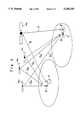
- FIG. 5shows the configuration of a commonly used differential ranging system
- FIG. 6the configuration of a differential ranging system available from Racal Survey Corporation.
- Ais a fixed reference station
- Bis a mobile station
- Sa to Scare GPS satellite orbit information received from GPS satellites 4a to 4c
- 1is a GPS receiver installed at fixed reference station A and mobile station B
- 2is a data processing interface
- 3is a radio that links by radio channel fixed reference station A and mobile station B
- 4a to 4care GPS satellites
- 5is a radio channel.
- INMARSAT satellite 4 ⁇is INMARSAT satellite made available by International Maritime Satellite Organization (hereinafter referred to as INMARSAT satellite), C is the mobile bodies like a vessel, 6 and 7 are links of INMARSAT satellite 4 ⁇ , D is a GPS receiver, E is a transmitter/receiver for using INMARSAT satellite 4 ⁇ , and F is an earth station for transmitting data to INMARSAT satellite 4 ⁇ .
- INMARSAT satelliteInternational Maritime Satellite Organization
- a commonly used differential ranging systemsuch as the one shown in FIG. 5 achieves the differential ranging function by deriving the correcting factor at fixed reference station A by using GPS receiver 1 and data processing interface 2, and sending the error information from radio 3 installed at fixed reference station A to mobile station B via radio channel 5.
- fixed reference station Auses INMARSAT satellite 4 ⁇ to transmit differential data signals over circuits 6 and 7 to user C on a vessel, etc.
- the inventionto solve said problems with conventional differential ranging systems, provides a differential data signal transmission technique inclusive of the correcting factor that requires no transmitter/receiver other than the GPS receiver.
- a differential data signal transmission techniquesaid technique having exclusive properties comprising: the use of a differential ranging system where spread spectrum signals (SS signals) are multiplied at the same frequency, transmission rate, and modulation method used by GPS satellites, but with different codes from those used by said GPS satellites, said SS signals being used to transmit the correcting factor from an earth station on the ground to a mobile station on the ground carrying a GPS receiver via a geostationary orbit satellite or a low earth orbit satellite; wherein said differential ranging system entails, as part of a GPS satellite ranging system employing more than one GPS satellite: installing a GPS receiver at a fixed reference station with a known position; transmitting the correcting factor from the fixed reference station to a mobile station carrying a GPS receiver in the service area, said correcting factor being the difference between the measured range from a GPS satellite to the fixed reference station and the true range from the GPS satellite to the fixed reference station, which is calculated from the orbit information of the GPS satellite and the true position of the fixed reference station; and the mobile station
- the inventiona differential data signal transmission technique, has the second exclusive properties of such that in the first exclusive properties of the invention: the code spreading technique generates spread spectrum signals with as many spread codes (pseudo random noise codes), each corresponding to a service area, as there are service areas in each of which a fixed reference station is installed, said code spreading technique multiplexing the multiple spread spectrum signals and transmitting differential data signals.
- the code spreading techniquegenerates spread spectrum signals with as many spread codes (pseudo random noise codes), each corresponding to a service area, as there are service areas in each of which a fixed reference station is installed, said code spreading technique multiplexing the multiple spread spectrum signals and transmitting differential data signals.
- the inventiona differential data signal transmission technique, has the third exclusive properties of such that in the first exclusive properties of the invention: the code spreading technique multiplexes with area identity numbers over a time axis as many differential data signals, each corresponding to a service area, as there are service areas in each of which a fixed reference station is installed, said code spreading technique transmitting differential data signals as time division multiplexed waves (TDM)-SS.
- TDMtime division multiplexed waves
- the inventionemploys the embodiment technique such as that mentioned above.
- the differential data signals composed of the correcting factor derived at a number of fixed reference stationsare transmitted as spectral spread signals spread at the same frequency, transmission rate, and modulation method used by the GPS satellites, but with different codes from those used by said GPS satellites, from an earth station to a mobile station on the ground carrying a GPS receiver via a geostationary orbit satellite or a low earth orbit satellite other than a GPS satellite. Therefore, the invention allows the mobile station carrying a GPS receiver to perform high-precision ranging using a simple, compact GPS receiver composed of an existing GPS receiver incorporating a processor for processing the differential data signals.
- the differential data signalsare transmitted at the same frequency signals as those of GPS satellites, the differential data signals can be received with existing GPS antennas.
- the differential data signalsemploy the same modulation method and are of the same transmission rate as the GPS satellite frequency signals, they can be demodulated with existing GPS receivers.
- FIG. 1is a figure showing a sample system to which the embodiment example of the invented technique is applied;
- FIG. 2is a figure showing a sample frame format of the invented technique, differential data signal
- FIG. 3is a sample configuration of a data frame employing the invented technique of multiplexing SS signals with as many spread codes, each corresponding to a service area, as there are service areas where a fixed reference station is installed;
- FIG. 4is a sample configuration of a data frame employing the invented TDM technique
- FIG. 5is a figure showing the configuration of a differential ranging system that has been commonly used.
- FIG. 6is a figure showing the configuration of a differential ranging system available from Rascal Survey Corporation.
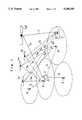
- FIG. 1shows a sample system to which the invention is applied.
- C'is a mobile user carrying a GPS receiver on a vessel, etc.
- Gis a terrestrial line or radio link that connects fixed reference station A with earth station F
- 4 ⁇is a geostationary orbit satellite such as INMARSAT or a low earth orbit satellite that is different from GPS satellite (hereinafter referred to as a non-GPS satellite).
- Facilities that are the same as those used in prior descriptionsare denoted by the same symbols.
- the groundis divided into a number of differential range effective areas (radius of 1,000 km or less), and fixed reference station A for differential ranging is installed in each service area.
- Fixed reference station Atransmits error information to ground station F over terrestrial line or radio link G, where said the correcting factor is the propagation range error or the difference between the true range from a GPS satellite to the fixed reference station, which is derived from the orbit information obtained from GPS satellites 4a through 4c and the position of the fixed reference station, and the measured range from a GPS satellite to the fixed reference station, which is derived by receiving transmitted signals Sa through Sc obtained from GPS satellites 4a through 4c.
- each fixed reference station Atransmits the correcting factor to earth station F, where said the correcting factor includes the service area number where the fixed reference station is located, the area identity numbers of GPS satellites 4a through 4c the fixed reference station derived, and the propagation range error of said GPS satellites 4a through 4c.
- the correcting factor transmitted from each fixed reference station A over terrestrial link Gis converted into data matching the differential data format at earth station F. Then, the data is transmitted to non-GPS satellite 4 ⁇ as SS signals spread at different pseudo random noise codes (gold codes of 1,023 in spread code length) at the frequency of 1,575.42 MHz, which is the same frequency used by GPS satellites 4a through 4c, and at the spread rate of 1.023 Mbps.
- pseudo random noise codesgold codes of 1,023 in spread code length
- the signals received from earth station Fare amplified, then transmitted to mobile user C' on a seagoing vessel, etc., as differential data signals.
- mobile user C'uses GPS receiver D' on its mobile station to derive the orbit information from each of GPS satellites 4a through 4c included in the SS signals Sa through Sc received from each of GPS satellites 4a through 4c by correlating the spread codes corresponding to each of GPS satellites 4a through 4c.
- GPS receiver D'is able to detect the differential data signals included in the SS signals received from non-GPS satellite 4 ⁇ by performing a correlation with the spread codes allocated for the differential data signals.
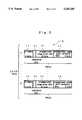
- FIG. 2show a sample frame format for the differential data signals.
- one framecomprises for each GPS satellite 5 bits of ID number ⁇ , 16 bits of propagational range error data ⁇ 1, 8 bits of propagational range error variation rate ⁇ 1, and 1 bit of error data resolution ⁇ 1, for a total of 30 bits of sub-frame H.
- one information framewould contain 30 ⁇ N bits.
- This methodentails generating SS signals with M number of different spread codes, where M is also the number of areas where fixed reference station A is installed, then multiplexing the SS signals and sending the signals via non-GPS satellite 4 ⁇ .
- FIG. 3shows a sample configuration of this data frame.
- the basic frame for each areacomprises N number of sub-frames J, and a different spread code is allocated to each area.
- this methodwould entail transmitting M number of multiplexed SS signals from earth station F.
- Mobile user C'is able to know the differential range service area that he is in by first performing a conventional independent GPS ranging using GPS satellites 4a through 4c. As each service area is allocated a spread code to distinguish itself from other service areas, mobile user C' is able to derive the differential data signals for range calculation corresponding to his own station by using the spread code corresponding to the service area he is in to correlate the received signals.
- This techniqueentails multiplexing with area identity numbers over a time axis as many differential data signals as there are service areas where fixed reference station A is installed. After the information signals are spread using differential data signal transmission spread codes, they are transmitted via non-GPS satellite 4 ⁇ as SS-TDM signals.
- FIG. 4shows a sample configuration of this data frame.
- differential data signalsare updated for every long frame L, making it possible to constantly provide users with updated information.
- Mobile user C'is able to know the differential range service area that he is in by first performing a conventional independent GPS ranging using GPS satellites 4a through 4c.
- Each service areais allocated an ID number for identifying the area.
- Mobile user C'is able to derive the differential data signals for range calculation corresponding to his own station by correlating the received signals with differential data signal spread codes to derive the information data series, then detecting basic frames K1 through KM corresponding to the identity number of the service area he is in.
- differential data signal transmission techniquewill provide GPS ranging system users with an extremely high-precision ranging service at a cost that is similar to that of current independent ranging systems.
- the incorporation of a processor for performing differential ranging into an existing GPS receiverwill provide high-precision ranging that is superior both in terms of size and cost when compared to current differential ranging systems.
Landscapes
- Engineering & Computer Science (AREA)
- Radar, Positioning & Navigation (AREA)
- Remote Sensing (AREA)
- Computer Networks & Wireless Communication (AREA)
- Physics & Mathematics (AREA)
- General Physics & Mathematics (AREA)
- Position Fixing By Use Of Radio Waves (AREA)
- Radio Relay Systems (AREA)
- Time-Division Multiplex Systems (AREA)
Abstract
Description
Claims (3)
Applications Claiming Priority (2)
| Application Number | Priority Date | Filing Date | Title |
|---|---|---|---|
| JP4-174275 | 1992-07-01 | ||
| JP17427592AJP2904241B2 (en) | 1992-07-01 | 1992-07-01 | Transmission method of differential data signal |
Publications (1)
| Publication Number | Publication Date |
|---|---|
| US5345245Atrue US5345245A (en) | 1994-09-06 |
Family
ID=15975815
Family Applications (1)
| Application Number | Title | Priority Date | Filing Date |
|---|---|---|---|
| US08/082,006Expired - LifetimeUS5345245A (en) | 1992-07-01 | 1993-06-24 | Differential data signal transmission technique |
Country Status (2)
| Country | Link |
|---|---|
| US (1) | US5345245A (en) |
| JP (1) | JP2904241B2 (en) |
Cited By (69)
| Publication number | Priority date | Publication date | Assignee | Title |
|---|---|---|---|---|
| WO1995008779A1 (en)* | 1993-09-22 | 1995-03-30 | The Board Of Trustees Of The Leland Stanford Junior University | System and method for generating precise code based and carrier phase position determinations |
| US5436632A (en)* | 1994-06-02 | 1995-07-25 | Trimble Navigation Limited | Integrity monitoring of differential satellite positioning system signals |
| GB2293710A (en)* | 1994-09-27 | 1996-04-03 | Toshiba Kk | GPS apparatus |
| US5526291A (en)* | 1994-09-08 | 1996-06-11 | Trimble Navigation Limited | Compensation for receiver and satellite signal differences |
| US5576973A (en)* | 1994-04-18 | 1996-11-19 | Radiodetection Limited | Apparatus and method for obtaining geographical positional data for an object located underground |
| DE19538876A1 (en)* | 1995-09-01 | 1997-03-06 | Westdeutscher Rundfunk | System for determining the position of moving objects |
| WO1997016745A1 (en)* | 1995-10-30 | 1997-05-09 | Honeywell Inc. | Differential ground station repeater |
| US5644318A (en)* | 1996-02-02 | 1997-07-01 | Trimble Navigation Limited | SATPS dynamic surveying from a moving platform |
| WO1997028455A1 (en)* | 1996-02-01 | 1997-08-07 | Stanford Telecommunications, Inc. | Radio navigation system using out-of-band pseudolites |
| US5691723A (en)* | 1995-09-11 | 1997-11-25 | E-Systems, Inc. | Apparatus and method for encoding and decoding data on tactical air navigation and distance measuring equipment signals |
| DE19634529A1 (en)* | 1996-08-27 | 1998-03-12 | Rohde & Schwarz | DGPS tracking system |
| US5752218A (en)* | 1995-05-31 | 1998-05-12 | General Electric Company | Reduced-power GPS-based system for tracking multiple objects from a central location |
| EP0844492A1 (en)* | 1996-11-20 | 1998-05-27 | Space Systems/Loral, Inc. | Integrated navigation and communication satellite system |
| US6018313A (en)* | 1995-09-01 | 2000-01-25 | Tilmar Konle | System for determining the location of mobile objects |
| US6040798A (en)* | 1995-10-24 | 2000-03-21 | International Mobile Satellite Organization | Satellite radiodetermination |
| US6061388A (en)* | 1996-06-07 | 2000-05-09 | General Electric Company | Spread spectrum communication system with frequency-separated message and reference signals |
| US6104746A (en)* | 1996-09-25 | 2000-08-15 | Kokusai Denshin Denwa Co., Ltd. | Spread spectrum communication system |
| US6169497B1 (en) | 1993-04-01 | 2001-01-02 | Bruno G. Robert | Mobile tracking and positioning system |
| US6397147B1 (en) | 2000-06-06 | 2002-05-28 | Csi Wireless Inc. | Relative GPS positioning using a single GPS receiver with internally generated differential correction terms |
| US6501424B1 (en)* | 2000-01-28 | 2002-12-31 | Rockwell Collins | Use of GPS correction data on trans-oceanic routes |
| US6862526B2 (en) | 2000-12-15 | 2005-03-01 | Trimble Navigation Limited | GPS correction methods, apparatus and signals |
| US20050101346A1 (en)* | 2003-11-07 | 2005-05-12 | Steve Wozniak | Receiver device and method using GPS baseband correlator circuitry for despreading both GPS and local wireless baseband signals |
| WO2005019855A3 (en)* | 2003-07-21 | 2005-06-02 | Wheels Of Zeus Inc | Receiver device and method using gps baseband circuitry for recovering both gps and local wireless baseband signals |
| US20050159891A1 (en)* | 2004-01-15 | 2005-07-21 | Clark Cohen | Real-time data aiding for enhanced GPS performance |
| US20060064244A1 (en)* | 1994-01-03 | 2006-03-23 | Robbins James E | Differential GPS corrections using virtual stations |
| FR2877437A1 (en)* | 2004-11-04 | 2006-05-05 | Thales Sa | POSITIONING DEVICE |
| DE19539302B4 (en)* | 1995-10-23 | 2007-01-11 | T-Mobile Deutschland Gmbh | Positioning method using Differential GPS (DGPS) |
| US20080165840A1 (en)* | 2007-01-08 | 2008-07-10 | Viasat, Inc. | Modulation and coding adjustment based on slant range characteristics for satellite downlinks |
| US20090182502A1 (en)* | 2008-01-10 | 2009-07-16 | Riter Bruce D | Refining a position estimate of a low earth orbiting satellite |
| US7835832B2 (en) | 2007-01-05 | 2010-11-16 | Hemisphere Gps Llc | Vehicle control system |
| US7853579B2 (en) | 2003-08-14 | 2010-12-14 | Oracle International Corporation | Methods, systems and software for identifying and managing database work |
| US7853252B1 (en)* | 1992-12-02 | 2010-12-14 | Voxson Pty Ltd. | Positioning systems utilizing mobile telephone system for correction signals |
| US7885745B2 (en) | 2002-12-11 | 2011-02-08 | Hemisphere Gps Llc | GNSS control system and method |
| US7948769B2 (en) | 2007-09-27 | 2011-05-24 | Hemisphere Gps Llc | Tightly-coupled PCB GNSS circuit and manufacturing method |
| US8000381B2 (en) | 2007-02-27 | 2011-08-16 | Hemisphere Gps Llc | Unbiased code phase discriminator |
| US8018376B2 (en) | 2008-04-08 | 2011-09-13 | Hemisphere Gps Llc | GNSS-based mobile communication system and method |
| US8085196B2 (en) | 2009-03-11 | 2011-12-27 | Hemisphere Gps Llc | Removing biases in dual frequency GNSS receivers using SBAS |
| US8140223B2 (en) | 2003-03-20 | 2012-03-20 | Hemisphere Gps Llc | Multiple-antenna GNSS control system and method |
| US8138970B2 (en) | 2003-03-20 | 2012-03-20 | Hemisphere Gps Llc | GNSS-based tracking of fixed or slow-moving structures |
| US8174437B2 (en) | 2009-07-29 | 2012-05-08 | Hemisphere Gps Llc | System and method for augmenting DGNSS with internally-generated differential correction |
| US8190337B2 (en) | 2003-03-20 | 2012-05-29 | Hemisphere GPS, LLC | Satellite based vehicle guidance control in straight and contour modes |
| US8214111B2 (en) | 2005-07-19 | 2012-07-03 | Hemisphere Gps Llc | Adaptive machine control system and method |
| US8217833B2 (en) | 2008-12-11 | 2012-07-10 | Hemisphere Gps Llc | GNSS superband ASIC with simultaneous multi-frequency down conversion |
| US8265826B2 (en) | 2003-03-20 | 2012-09-11 | Hemisphere GPS, LLC | Combined GNSS gyroscope control system and method |
| US8271194B2 (en) | 2004-03-19 | 2012-09-18 | Hemisphere Gps Llc | Method and system using GNSS phase measurements for relative positioning |
| US8311696B2 (en) | 2009-07-17 | 2012-11-13 | Hemisphere Gps Llc | Optical tracking vehicle control system and method |
| US8334804B2 (en) | 2009-09-04 | 2012-12-18 | Hemisphere Gps Llc | Multi-frequency GNSS receiver baseband DSP |
| US8386129B2 (en) | 2009-01-17 | 2013-02-26 | Hemipshere GPS, LLC | Raster-based contour swathing for guidance and variable-rate chemical application |
| US8401704B2 (en) | 2009-07-22 | 2013-03-19 | Hemisphere GPS, LLC | GNSS control system and method for irrigation and related applications |
| US8456356B2 (en) | 2007-10-08 | 2013-06-04 | Hemisphere Gnss Inc. | GNSS receiver and external storage device system and GNSS data processing method |
| US8548649B2 (en) | 2009-10-19 | 2013-10-01 | Agjunction Llc | GNSS optimized aircraft control system and method |
| US8583326B2 (en) | 2010-02-09 | 2013-11-12 | Agjunction Llc | GNSS contour guidance path selection |
| US8583315B2 (en) | 2004-03-19 | 2013-11-12 | Agjunction Llc | Multi-antenna GNSS control system and method |
| US8594879B2 (en) | 2003-03-20 | 2013-11-26 | Agjunction Llc | GNSS guidance and machine control |
| US8649930B2 (en) | 2009-09-17 | 2014-02-11 | Agjunction Llc | GNSS integrated multi-sensor control system and method |
| US8686900B2 (en) | 2003-03-20 | 2014-04-01 | Hemisphere GNSS, Inc. | Multi-antenna GNSS positioning method and system |
| US8994591B2 (en) | 1996-09-09 | 2015-03-31 | Tracbeam Llc | Locating a mobile station and applications therefor |
| US9002566B2 (en) | 2008-02-10 | 2015-04-07 | AgJunction, LLC | Visual, GNSS and gyro autosteering control |
| US9060341B2 (en) | 1996-09-09 | 2015-06-16 | Tracbeam, Llc | System and method for hybriding wireless location techniques |
| US9121932B2 (en) | 2008-01-10 | 2015-09-01 | Trimble Navigation Limited | Refining a position estimate of a low earth orbiting satellite |
| US9134398B2 (en) | 1996-09-09 | 2015-09-15 | Tracbeam Llc | Wireless location using network centric location estimators |
| US9538493B2 (en) | 2010-08-23 | 2017-01-03 | Finetrak, Llc | Locating a mobile station and applications therefor |
| US9875492B2 (en) | 2001-05-22 | 2018-01-23 | Dennis J. Dupray | Real estate transaction system |
| US9880562B2 (en) | 2003-03-20 | 2018-01-30 | Agjunction Llc | GNSS and optical guidance and machine control |
| USRE47101E1 (en) | 2003-03-20 | 2018-10-30 | Agjunction Llc | Control for dispensing material from vehicle |
| US10641861B2 (en) | 2000-06-02 | 2020-05-05 | Dennis J. Dupray | Services and applications for a communications network |
| US10684350B2 (en) | 2000-06-02 | 2020-06-16 | Tracbeam Llc | Services and applications for a communications network |
| USRE48527E1 (en) | 2007-01-05 | 2021-04-20 | Agjunction Llc | Optical tracking vehicle control system and method |
| CN113093160A (en)* | 2021-03-25 | 2021-07-09 | 北京机电工程研究所 | Wireless ranging verification method between unmanned aerial vehicles |
Families Citing this family (5)
| Publication number | Priority date | Publication date | Assignee | Title |
|---|---|---|---|---|
| JP2777328B2 (en)* | 1994-03-11 | 1998-07-16 | 運輸省船舶技術研究所長 | Controlled target monitoring system |
| KR20030094545A (en)* | 2002-06-04 | 2003-12-18 | 한국항공우주연구원 | a |
| JP5923077B2 (en)* | 2013-10-16 | 2016-05-24 | 三菱電機株式会社 | Positioning device |
| JP6029707B2 (en)* | 2015-04-20 | 2016-11-24 | 三菱電機株式会社 | Positioning device |
| CN111045053B (en)* | 2019-12-26 | 2022-03-08 | 广东星舆科技有限公司 | Differential positioning method and system under VRS data interruption |
Citations (3)
| Publication number | Priority date | Publication date | Assignee | Title |
|---|---|---|---|---|
| US5222099A (en)* | 1991-01-21 | 1993-06-22 | Sony Corporation | Spread spectrum signal receiving apparatus |
| US5225842A (en)* | 1991-05-09 | 1993-07-06 | Navsys Corporation | Vehicle tracking system employing global positioning system (gps) satellites |
| US5245628A (en)* | 1991-03-29 | 1993-09-14 | Texas Instruments Incorporated | Enhanced l1/l2 code channel for global positioning system receivers |
- 1992
- 1992-07-01JPJP17427592Apatent/JP2904241B2/ennot_activeExpired - Lifetime
- 1993
- 1993-06-24USUS08/082,006patent/US5345245A/ennot_activeExpired - Lifetime
Patent Citations (3)
| Publication number | Priority date | Publication date | Assignee | Title |
|---|---|---|---|---|
| US5222099A (en)* | 1991-01-21 | 1993-06-22 | Sony Corporation | Spread spectrum signal receiving apparatus |
| US5245628A (en)* | 1991-03-29 | 1993-09-14 | Texas Instruments Incorporated | Enhanced l1/l2 code channel for global positioning system receivers |
| US5225842A (en)* | 1991-05-09 | 1993-07-06 | Navsys Corporation | Vehicle tracking system employing global positioning system (gps) satellites |
Non-Patent Citations (1)
| Title |
|---|
| Sky Fix and Delta Fix SR, Differential GPS Products, Racal Positioning Systems Limited, New Malden, Surrey KT3 4NR, England (six pages of descriptive material and specification).* |
Cited By (98)
| Publication number | Priority date | Publication date | Assignee | Title |
|---|---|---|---|---|
| US7853252B1 (en)* | 1992-12-02 | 2010-12-14 | Voxson Pty Ltd. | Positioning systems utilizing mobile telephone system for correction signals |
| US5583513A (en)* | 1993-03-24 | 1996-12-10 | Board Of Trustees Of The Leland Stanford Junior University | System and method for generating precise code based and carrier phase position determinations |
| US6169497B1 (en) | 1993-04-01 | 2001-01-02 | Bruno G. Robert | Mobile tracking and positioning system |
| AU689507B2 (en)* | 1993-09-22 | 1998-04-02 | Board Of Trustees Of The Leland Stanford Junior University | System and method for generating precise code based and carrier phase position determinations |
| WO1995008779A1 (en)* | 1993-09-22 | 1995-03-30 | The Board Of Trustees Of The Leland Stanford Junior University | System and method for generating precise code based and carrier phase position determinations |
| US7711480B2 (en) | 1994-01-03 | 2010-05-04 | Trimble Navigation Limited | Differential GPS corrections using virtual stations |
| US20060282216A1 (en)* | 1994-01-03 | 2006-12-14 | Robbins James E | Differential GPS corrections using virtual stations |
| US20060064244A1 (en)* | 1994-01-03 | 2006-03-23 | Robbins James E | Differential GPS corrections using virtual stations |
| EP1321779A3 (en)* | 1994-04-18 | 2004-03-24 | Radiodetection Limited | Locating device |
| US5576973A (en)* | 1994-04-18 | 1996-11-19 | Radiodetection Limited | Apparatus and method for obtaining geographical positional data for an object located underground |
| US5436632A (en)* | 1994-06-02 | 1995-07-25 | Trimble Navigation Limited | Integrity monitoring of differential satellite positioning system signals |
| US5757677A (en)* | 1994-09-08 | 1998-05-26 | Trimble Navigation Limited | Compensation for differences in receiver signals and in satellite signals |
| US5526291A (en)* | 1994-09-08 | 1996-06-11 | Trimble Navigation Limited | Compensation for receiver and satellite signal differences |
| GB2293710A (en)* | 1994-09-27 | 1996-04-03 | Toshiba Kk | GPS apparatus |
| DE19621225B4 (en)* | 1995-05-31 | 2011-12-29 | Asset Intelligence, Llc | Low-power GPS-based system for tracking multiple objects from a central location |
| US5752218A (en)* | 1995-05-31 | 1998-05-12 | General Electric Company | Reduced-power GPS-based system for tracking multiple objects from a central location |
| USRE40642E1 (en)* | 1995-05-31 | 2009-02-17 | General Electric Company | Reduced-power GPS-based system for tracking multiple objects from a central location |
| DE19538876A1 (en)* | 1995-09-01 | 1997-03-06 | Westdeutscher Rundfunk | System for determining the position of moving objects |
| US6018313A (en)* | 1995-09-01 | 2000-01-25 | Tilmar Konle | System for determining the location of mobile objects |
| US5929783A (en)* | 1995-09-11 | 1999-07-27 | Raytheon Company | Method for decoding and error correcting data of tactical air navigation and distance measuring equipment signals |
| US5691723A (en)* | 1995-09-11 | 1997-11-25 | E-Systems, Inc. | Apparatus and method for encoding and decoding data on tactical air navigation and distance measuring equipment signals |
| DE19539302B4 (en)* | 1995-10-23 | 2007-01-11 | T-Mobile Deutschland Gmbh | Positioning method using Differential GPS (DGPS) |
| US6040798A (en)* | 1995-10-24 | 2000-03-21 | International Mobile Satellite Organization | Satellite radiodetermination |
| US20040145517A1 (en)* | 1995-10-24 | 2004-07-29 | Inmarsat, Ltd. | Method and apparatus for a satellite payload and radiodetermination |
| US5852412A (en)* | 1995-10-30 | 1998-12-22 | Honeywell Inc. | Differential ground station repeater |
| WO1997016745A1 (en)* | 1995-10-30 | 1997-05-09 | Honeywell Inc. | Differential ground station repeater |
| WO1997028455A1 (en)* | 1996-02-01 | 1997-08-07 | Stanford Telecommunications, Inc. | Radio navigation system using out-of-band pseudolites |
| US5644318A (en)* | 1996-02-02 | 1997-07-01 | Trimble Navigation Limited | SATPS dynamic surveying from a moving platform |
| US6061388A (en)* | 1996-06-07 | 2000-05-09 | General Electric Company | Spread spectrum communication system with frequency-separated message and reference signals |
| DE19634529A1 (en)* | 1996-08-27 | 1998-03-12 | Rohde & Schwarz | DGPS tracking system |
| US9134398B2 (en) | 1996-09-09 | 2015-09-15 | Tracbeam Llc | Wireless location using network centric location estimators |
| US9237543B2 (en) | 1996-09-09 | 2016-01-12 | Tracbeam, Llc | Wireless location using signal fingerprinting and other location estimators |
| US9060341B2 (en) | 1996-09-09 | 2015-06-16 | Tracbeam, Llc | System and method for hybriding wireless location techniques |
| US9277525B2 (en) | 1996-09-09 | 2016-03-01 | Tracbeam, Llc | Wireless location using location estimators |
| US8994591B2 (en) | 1996-09-09 | 2015-03-31 | Tracbeam Llc | Locating a mobile station and applications therefor |
| US6104746A (en)* | 1996-09-25 | 2000-08-15 | Kokusai Denshin Denwa Co., Ltd. | Spread spectrum communication system |
| US5841398A (en)* | 1996-11-20 | 1998-11-24 | Space Systems/Loral, Inc. | Integrated navigation and communication satellite system |
| EP0844492A1 (en)* | 1996-11-20 | 1998-05-27 | Space Systems/Loral, Inc. | Integrated navigation and communication satellite system |
| US6501424B1 (en)* | 2000-01-28 | 2002-12-31 | Rockwell Collins | Use of GPS correction data on trans-oceanic routes |
| US10641861B2 (en) | 2000-06-02 | 2020-05-05 | Dennis J. Dupray | Services and applications for a communications network |
| US10684350B2 (en) | 2000-06-02 | 2020-06-16 | Tracbeam Llc | Services and applications for a communications network |
| US11971491B2 (en) | 2000-06-02 | 2024-04-30 | Mobile Maven Llc | Services and applications for a communications network |
| US6397147B1 (en) | 2000-06-06 | 2002-05-28 | Csi Wireless Inc. | Relative GPS positioning using a single GPS receiver with internally generated differential correction terms |
| US6862526B2 (en) | 2000-12-15 | 2005-03-01 | Trimble Navigation Limited | GPS correction methods, apparatus and signals |
| US9875492B2 (en) | 2001-05-22 | 2018-01-23 | Dennis J. Dupray | Real estate transaction system |
| US11610241B2 (en) | 2001-05-22 | 2023-03-21 | Mobile Maven Llc | Real estate transaction system |
| US7885745B2 (en) | 2002-12-11 | 2011-02-08 | Hemisphere Gps Llc | GNSS control system and method |
| US8686900B2 (en) | 2003-03-20 | 2014-04-01 | Hemisphere GNSS, Inc. | Multi-antenna GNSS positioning method and system |
| US8265826B2 (en) | 2003-03-20 | 2012-09-11 | Hemisphere GPS, LLC | Combined GNSS gyroscope control system and method |
| US10168714B2 (en) | 2003-03-20 | 2019-01-01 | Agjunction Llc | GNSS and optical guidance and machine control |
| USRE47101E1 (en) | 2003-03-20 | 2018-10-30 | Agjunction Llc | Control for dispensing material from vehicle |
| US8140223B2 (en) | 2003-03-20 | 2012-03-20 | Hemisphere Gps Llc | Multiple-antenna GNSS control system and method |
| US8138970B2 (en) | 2003-03-20 | 2012-03-20 | Hemisphere Gps Llc | GNSS-based tracking of fixed or slow-moving structures |
| US9886038B2 (en) | 2003-03-20 | 2018-02-06 | Agjunction Llc | GNSS and optical guidance and machine control |
| US8190337B2 (en) | 2003-03-20 | 2012-05-29 | Hemisphere GPS, LLC | Satellite based vehicle guidance control in straight and contour modes |
| US9880562B2 (en) | 2003-03-20 | 2018-01-30 | Agjunction Llc | GNSS and optical guidance and machine control |
| US8594879B2 (en) | 2003-03-20 | 2013-11-26 | Agjunction Llc | GNSS guidance and machine control |
| WO2005019855A3 (en)* | 2003-07-21 | 2005-06-02 | Wheels Of Zeus Inc | Receiver device and method using gps baseband circuitry for recovering both gps and local wireless baseband signals |
| US7853579B2 (en) | 2003-08-14 | 2010-12-14 | Oracle International Corporation | Methods, systems and software for identifying and managing database work |
| US20050101346A1 (en)* | 2003-11-07 | 2005-05-12 | Steve Wozniak | Receiver device and method using GPS baseband correlator circuitry for despreading both GPS and local wireless baseband signals |
| US7904243B2 (en)* | 2004-01-15 | 2011-03-08 | The Boeing Company | Real-time data aiding for enhanced GPS performance |
| US8019541B2 (en)* | 2004-01-15 | 2011-09-13 | The Boeing Company | Real-time data aiding for enhanced GPS performance |
| US20050159891A1 (en)* | 2004-01-15 | 2005-07-21 | Clark Cohen | Real-time data aiding for enhanced GPS performance |
| US20110032144A1 (en)* | 2004-01-15 | 2011-02-10 | The Boeing Company | Real-time data aiding for enhanced gps performance |
| US8583315B2 (en) | 2004-03-19 | 2013-11-12 | Agjunction Llc | Multi-antenna GNSS control system and method |
| US8271194B2 (en) | 2004-03-19 | 2012-09-18 | Hemisphere Gps Llc | Method and system using GNSS phase measurements for relative positioning |
| FR2877437A1 (en)* | 2004-11-04 | 2006-05-05 | Thales Sa | POSITIONING DEVICE |
| US8214111B2 (en) | 2005-07-19 | 2012-07-03 | Hemisphere Gps Llc | Adaptive machine control system and method |
| USRE48527E1 (en) | 2007-01-05 | 2021-04-20 | Agjunction Llc | Optical tracking vehicle control system and method |
| US7835832B2 (en) | 2007-01-05 | 2010-11-16 | Hemisphere Gps Llc | Vehicle control system |
| US7724698B2 (en)* | 2007-01-08 | 2010-05-25 | Viasat, Inc. | Modulation and coding adjustment based on slant range characteristics for satellite downlinks |
| US20080165840A1 (en)* | 2007-01-08 | 2008-07-10 | Viasat, Inc. | Modulation and coding adjustment based on slant range characteristics for satellite downlinks |
| US8000381B2 (en) | 2007-02-27 | 2011-08-16 | Hemisphere Gps Llc | Unbiased code phase discriminator |
| US7948769B2 (en) | 2007-09-27 | 2011-05-24 | Hemisphere Gps Llc | Tightly-coupled PCB GNSS circuit and manufacturing method |
| US8456356B2 (en) | 2007-10-08 | 2013-06-04 | Hemisphere Gnss Inc. | GNSS receiver and external storage device system and GNSS data processing method |
| US9121932B2 (en) | 2008-01-10 | 2015-09-01 | Trimble Navigation Limited | Refining a position estimate of a low earth orbiting satellite |
| US8260551B2 (en) | 2008-01-10 | 2012-09-04 | Trimble Navigation Limited | System and method for refining a position estimate of a low earth orbiting satellite |
| US8515670B2 (en) | 2008-01-10 | 2013-08-20 | Trimble Navigation Limited | System and method for refining a position estimate of a low earth orbiting satellite |
| US20090182502A1 (en)* | 2008-01-10 | 2009-07-16 | Riter Bruce D | Refining a position estimate of a low earth orbiting satellite |
| US9002566B2 (en) | 2008-02-10 | 2015-04-07 | AgJunction, LLC | Visual, GNSS and gyro autosteering control |
| US8018376B2 (en) | 2008-04-08 | 2011-09-13 | Hemisphere Gps Llc | GNSS-based mobile communication system and method |
| US8217833B2 (en) | 2008-12-11 | 2012-07-10 | Hemisphere Gps Llc | GNSS superband ASIC with simultaneous multi-frequency down conversion |
| USRE48509E1 (en) | 2009-01-17 | 2021-04-13 | Agjunction Llc | Raster-based contour swathing for guidance and variable-rate chemical application |
| USRE47055E1 (en) | 2009-01-17 | 2018-09-25 | Agjunction Llc | Raster-based contour swathing for guidance and variable-rate chemical application |
| US8386129B2 (en) | 2009-01-17 | 2013-02-26 | Hemipshere GPS, LLC | Raster-based contour swathing for guidance and variable-rate chemical application |
| US8085196B2 (en) | 2009-03-11 | 2011-12-27 | Hemisphere Gps Llc | Removing biases in dual frequency GNSS receivers using SBAS |
| US8311696B2 (en) | 2009-07-17 | 2012-11-13 | Hemisphere Gps Llc | Optical tracking vehicle control system and method |
| US8401704B2 (en) | 2009-07-22 | 2013-03-19 | Hemisphere GPS, LLC | GNSS control system and method for irrigation and related applications |
| US8174437B2 (en) | 2009-07-29 | 2012-05-08 | Hemisphere Gps Llc | System and method for augmenting DGNSS with internally-generated differential correction |
| US8334804B2 (en) | 2009-09-04 | 2012-12-18 | Hemisphere Gps Llc | Multi-frequency GNSS receiver baseband DSP |
| USRE47648E1 (en) | 2009-09-17 | 2019-10-15 | Agjunction Llc | Integrated multi-sensor control system and method |
| US8649930B2 (en) | 2009-09-17 | 2014-02-11 | Agjunction Llc | GNSS integrated multi-sensor control system and method |
| US8548649B2 (en) | 2009-10-19 | 2013-10-01 | Agjunction Llc | GNSS optimized aircraft control system and method |
| US8583326B2 (en) | 2010-02-09 | 2013-11-12 | Agjunction Llc | GNSS contour guidance path selection |
| US9538493B2 (en) | 2010-08-23 | 2017-01-03 | Finetrak, Llc | Locating a mobile station and applications therefor |
| US10849089B2 (en) | 2010-08-23 | 2020-11-24 | Finetrak, Llc | Resource allocation according to geolocation of mobile communication units |
| US12156165B2 (en) | 2010-08-23 | 2024-11-26 | Finetrak, Llc | Resource allocation according to geolocation of mobile communication units related applications |
| CN113093160A (en)* | 2021-03-25 | 2021-07-09 | 北京机电工程研究所 | Wireless ranging verification method between unmanned aerial vehicles |
Also Published As
| Publication number | Publication date |
|---|---|
| JP2904241B2 (en) | 1999-06-14 |
| JPH0618649A (en) | 1994-01-28 |
Similar Documents
| Publication | Publication Date | Title |
|---|---|---|
| US5345245A (en) | Differential data signal transmission technique | |
| US4751512A (en) | Differential navigation system for remote mobile users | |
| US6178195B1 (en) | Method and apparatus for detecting spread spectrum signals using a signal from a secondary source | |
| US6101178A (en) | Pseudolite-augmented GPS for locating wireless telephones | |
| US5153598A (en) | Global Positioning System telecommand link | |
| US6252543B1 (en) | Location system combining ranging measurements from GPS and cellular networks | |
| AU2008330599B2 (en) | Position information providing system, indoor transmitter, and method for providing position information | |
| KR100327035B1 (en) | Telecommunications-assisted satellite positioning system | |
| JP4489227B2 (en) | Jamming detection and blanking for GPS receivers | |
| KR100323156B1 (en) | An auxiliary system for assisting a wireless terminal in determining its position from signals transmitted from a navigation satellite | |
| US6538600B1 (en) | Wireless assisted GPS using a reference location | |
| US8451166B2 (en) | Distributed distance measurement system for locating a geostationary satellite | |
| Stansell Jr | RTCM SC‐104 recommended pseudolite signal specification | |
| CN100478701C (en) | System and method for enhancing a satellite positioning system | |
| EP0174540A2 (en) | Satetellite-based position determination and message transfer system with monitoring of link quality | |
| US20040080454A1 (en) | Methods and systems for determining the position of a mobile terminal using digital television signals | |
| RU2018855C1 (en) | Aircraft radio navigation system | |
| GB2180425A (en) | Navigation system and method | |
| JP4514953B2 (en) | System and apparatus for determining frequency and timing uncertainty in access channel acquisition of a spread spectrum communication system | |
| US5852412A (en) | Differential ground station repeater | |
| Van Willigen | Eurofix | |
| KR100518898B1 (en) | Method for searching user terminal position using broadcasting satellite, gap filler And Dummy pilot gap filler for only searching user terminal position | |
| US6643509B1 (en) | Civil aviation communication system | |
| Parness et al. | Satellite systems for extended range coverage-Applications in law enforcement | |
| RU93004788A (en) | PORTABLE RADIO TRANSMITTING RADIO, COMMUNICATION SYSTEM, METHOD FOR INDICATING ALARM STATE AND METHOD OF USING PORTABLE RADIO STATION IN THE SATELLITE COMMUNICATION SYSTEM |
Legal Events
| Date | Code | Title | Description |
|---|---|---|---|
| AS | Assignment | Owner name:KOKUSAI DENSHIN DENWA COMPANY, LIMITED Free format text:ASSIGNMENT OF ASSIGNORS INTEREST;ASSIGNORS:ISHIKAWA, HIROYASU;KOBAYASHI, HIDEO;MIZUNO, TOSHIO;REEL/FRAME:006594/0285 Effective date:19930427 | |
| STPP | Information on status: patent application and granting procedure in general | Free format text:APPLICATION UNDERGOING PREEXAM PROCESSING | |
| FPAY | Fee payment | Year of fee payment:4 | |
| FEPP | Fee payment procedure | Free format text:PAYOR NUMBER ASSIGNED (ORIGINAL EVENT CODE: ASPN); ENTITY STATUS OF PATENT OWNER: LARGE ENTITY | |
| FPAY | Fee payment | Year of fee payment:8 | |
| AS | Assignment | Owner name:KDD CORPORATION, JAPAN Free format text:CHANGE OF NAME;ASSIGNOR:KOKUSAI DENSHIN DENWA COMPANY, LIMITED;REEL/FRAME:013774/0474 Effective date:19981201 | |
| AS | Assignment | Owner name:DDI CORPORATION, JAPAN Free format text:MERGER;ASSIGNOR:KDD CORPORATION;REEL/FRAME:013957/0664 Effective date:20001001 | |
| AS | Assignment | Owner name:KDDI CORPORATION, JAPAN Free format text:CHANGE OF NAME;ASSIGNOR:DDI CORPORATION;REEL/FRAME:014083/0804 Effective date:20010401 | |
| FPAY | Fee payment | Year of fee payment:12 |