US5317316A - Method of altitude track initialization in an aircraft tracking system - Google Patents
Method of altitude track initialization in an aircraft tracking systemDownload PDFInfo
- Publication number
- US5317316A US5317316AUS07/995,274US99527492AUS5317316AUS 5317316 AUS5317316 AUS 5317316AUS 99527492 AUS99527492 AUS 99527492AUS 5317316 AUS5317316 AUS 5317316A
- Authority
- US
- United States
- Prior art keywords
- altitude
- replies
- adjacent
- binary
- track
- Prior art date
- Legal status (The legal status is an assumption and is not a legal conclusion. Google has not performed a legal analysis and makes no representation as to the accuracy of the status listed.)
- Expired - Lifetime
Links
Images


Classifications
- G—PHYSICS
- G01—MEASURING; TESTING
- G01S—RADIO DIRECTION-FINDING; RADIO NAVIGATION; DETERMINING DISTANCE OR VELOCITY BY USE OF RADIO WAVES; LOCATING OR PRESENCE-DETECTING BY USE OF THE REFLECTION OR RERADIATION OF RADIO WAVES; ANALOGOUS ARRANGEMENTS USING OTHER WAVES
- G01S13/00—Systems using the reflection or reradiation of radio waves, e.g. radar systems; Analogous systems using reflection or reradiation of waves whose nature or wavelength is irrelevant or unspecified
- G01S13/74—Systems using reradiation of radio waves, e.g. secondary radar systems; Analogous systems
- G01S13/76—Systems using reradiation of radio waves, e.g. secondary radar systems; Analogous systems wherein pulse-type signals are transmitted
- G01S13/765—Systems using reradiation of radio waves, e.g. secondary radar systems; Analogous systems wherein pulse-type signals are transmitted with exchange of information between interrogator and responder
- G—PHYSICS
- G01—MEASURING; TESTING
- G01S—RADIO DIRECTION-FINDING; RADIO NAVIGATION; DETERMINING DISTANCE OR VELOCITY BY USE OF RADIO WAVES; LOCATING OR PRESENCE-DETECTING BY USE OF THE REFLECTION OR RERADIATION OF RADIO WAVES; ANALOGOUS ARRANGEMENTS USING OTHER WAVES
- G01S13/00—Systems using the reflection or reradiation of radio waves, e.g. radar systems; Analogous systems using reflection or reradiation of waves whose nature or wavelength is irrelevant or unspecified
- G01S13/74—Systems using reradiation of radio waves, e.g. secondary radar systems; Analogous systems
- G01S13/76—Systems using reradiation of radio waves, e.g. secondary radar systems; Analogous systems wherein pulse-type signals are transmitted
- G01S13/78—Systems using reradiation of radio waves, e.g. secondary radar systems; Analogous systems wherein pulse-type signals are transmitted discriminating between different kinds of targets, e.g. IFF-radar, i.e. identification of friend or foe
- G01S13/781—Secondary Surveillance Radar [SSR] in general
- G01S13/784—Coders or decoders therefor; Degarbling systems; Defruiting systems
- G—PHYSICS
- G01—MEASURING; TESTING
- G01S—RADIO DIRECTION-FINDING; RADIO NAVIGATION; DETERMINING DISTANCE OR VELOCITY BY USE OF RADIO WAVES; LOCATING OR PRESENCE-DETECTING BY USE OF THE REFLECTION OR RERADIATION OF RADIO WAVES; ANALOGOUS ARRANGEMENTS USING OTHER WAVES
- G01S13/00—Systems using the reflection or reradiation of radio waves, e.g. radar systems; Analogous systems using reflection or reradiation of waves whose nature or wavelength is irrelevant or unspecified
- G01S13/88—Radar or analogous systems specially adapted for specific applications
- G01S13/93—Radar or analogous systems specially adapted for specific applications for anti-collision purposes
- G01S13/933—Radar or analogous systems specially adapted for specific applications for anti-collision purposes of aircraft or spacecraft
Definitions
- the present inventionrelates to surveillance of aircraft traffic in a Traffic Alert and Collision Avoidance System (TCAS). More particularly, the present invention pertains to an altitude track initialization method for initializing altitude tracks representative of target aircraft for use in a TCAS.
- TCASTraffic Alert and Collision Avoidance System
- the determination of tracks representative of target aircraft from the processing of such repliesis more difficult.
- the information obtained from the replies provided by the target aircraft in response to periodic interrogation of target aircraft by the surveillance aircraft during surveillance periodsmay contain range, altitude and bearing information.
- Such informationis subjected to algorithms in a TCAS to provide a target aircraft track. Once a track is identified and initialized, then the track can be updated and stabilized while continually monitoring the track to determine if the target aircraft represented by the track is a threat to the surveillance aircraft.
- a surveillance aircrafttransmits an interrogation signal to target aircraft whereupon a transponder in the target aircraft provides a reply signal containing encoded data.
- Numerous replies from a single target aircraftcan be received by the surveillance aircraft due to ground reflection and other replies may be false due to electromagnetic interference or other effects.
- Three replies in consecutive surveillance periods meeting various requirements, such as range requirements and altitude requirements,are utilized to initiate a track.
- Mode S transponder equipped target aircraftsuch Mode S aircraft are identified by reception of squitters therefrom.
- target aircraft track initialization processes utilizing reply information as opposed to Mode S identifiersrelate only to the initialization of tracks for target aircraft utilizing ATCRBS transponders.
- MOPSMinimum Operational Performance Standards
- TCASTraffic Alert and Collision Avoidance System
- RTCARadio Technical Commission for Aeronautics
- the MOPS methodincludes use of an altitude correlation table to determine whether three replies from three consecutive surveillance periods correlate such that the altitude requirements for initializing a track are satisfied and for determining the initial altitude of such a track if initialized.
- the repliescontain eleven bits of Gilham altitude data.
- the three altitude repliesare said to correlate if they meet certain requirements implying that they are likely to be from the same intruder.
- the eleven bits of Gilham altitude dataare used to determine the altitude from each reply of a target aircraft.
- Each altitude bit from each replyalso has an associated confidence level, either high or low.
- the MOPS initialization tablegroups corresponding altitude bits from each of the three replies, one from each surveillance period, along with their confidence levels to produce a table of 64 possible output combinations of altitude bits and bit agreement.
- the 11 bitsare D2, D4, A1, A2, A4, B1, B2, B4, C1, C2, and C4. If the table produces bit agreement on all eight D, A and B bits or if it produces bit agreement on seven of the D, A and B bits and on at least one of the C bits, then the three replies correlate and according to the altitude requirements, a track may be initialized if other requirements such as range requirements are satisfied. Since each group of three bits, one from each reply, are handled independently of the other ten bits in the Gilham altitude code, strange altitude initializations occur.
- the initial altitude of the trackis set at or near the altitude of one of the replies which is significantly different than the other two replies which have matching altitudes.
- the present inventionis directed to a method of processing a plurality of replies of target aircraft provided in response to interrogation signals from a surveillance aircraft during surveillance periods to determine whether an altitude track may be initialized for use in traffic alert and collision avoidance systems.
- the methodincludes the step of selecting three replies, one from each of three consecutive surveillance periods.
- the replieshave binary or coded altitude data of high or low confidence.
- the binary or coded altitude data of non-adjacent and adjacent replies of the selected repliesare compared and an altitude difference value for each of the comparisons is generated. Further efforts to initialize a track are discarded if any of the altitude difference values are greater than first predetermined separated altitudes and only if such non-adjacent and adjacent replies have binary or coded altitude data of high confidence.
- the binary or coded altitude data of the non-adjacent and the adjacent repliesare further compared whether or not the replies have binary data of low or high confidence to determine whether an altitude track may be initialized.
- the further comparison stepincludes the step of correlating the selected replies such that the selected replies may be utilized to initiate an altitude track regardless of whether the replies have binary or coded altitude data of high or low confidence if the altitude difference values of compared adjacent replies are less than second predetermined separated altitudes.
- the selected repliesare correlated regardless of whether the replies have binary or coded altitude data of high or low confidence if the altitude difference value of one of the compared adjacent replies or the non-adjacent replies is less than third predetermined separated altitudes and only if the binary or coded altitude data of the replies of the one of the compared adjacent replies or the non-adjacent replies is not more than one bit different than the binary or coded altitude of the reply which is not a part of the one of the compared adjacent replies or the non-adjacent replies which were less than the third predetermined separated altitudes.
- the methodincludes the step of selecting an initial altitude of an altitude track allowed to be initialized upon correlation of the selected replies.
- the selecting stepincludes the step of choosing the altitude of the reply of the most recent surveillance period in which the reply has binary or coded altitude data of high confidence. Otherwise, the altitude of the reply in the most recent surveillance period of the one of compared adjacent replies or non-adjacent replies leading to the initialization of a track is selected if all the selected replies have binary or coded altitude data of low confidence.
- FIG. 1shows a diagram of possible signal paths of target aircraft replies in response to surveillance aircraft interrogation signals.
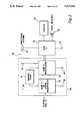
- FIG. 2is a block diagram of a TCAS/transponder system in which the present invention is utilized.
- FIGS. 3A and 3Bshow a block diagram of primary TCAS processes for a TCAS/transponder system as shown in FIG. 2.
- FIG. 4is a charted illustration of reply altitudes during a period of time.
- FIGS. 5A-5Eis a flow diagram of an ATCRBS altitude initialization process of the primary TCAS processes shown in FIG. 3.
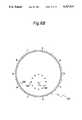
- FIG. 6A-6Bare diagrams of TCAS displays before and after implementation of the altitude initialization process of FIG. 5.
- FIG. 1there is shown a surveillance aircraft 10 engaged in an interrogation-reply process with target aircraft 12.
- the surveillance aircraft 10having a TCAS/transponder system 22, FIG. 2, interrogates all target aircraft, including target aircraft 12, in the vicinity of the surveillance aircraft 10 in order to determine potentially dangerous situations.
- the TCAS/transponder system 22includes transponder system 26, TCAS computer unit 24, TCAS displays 28, means for presenting aural messages 30, a top directional antenna 32 and a bottom omni-directional or directional antenna 34.
- TCAS/transponder system 22, installed on the surveillance aircraft 10,utilizes ATCRBS transponders and Mode S transponders installed in target aircraft to provide locations of such target aircraft, including target aircraft 12, in the immediate vicinity of the TCAS/transponder equipped surveillance aircraft.
- TCAS/transponder system 22provides surveillance of ATCRBS equipped target aircraft by transmitting interrogation signals 16 to the ATCRBS equipped target aircraft and measuring the relative range, altitude and bearing, if available, from the replies, such as reply 18 from the ATCRBS transponder of the target aircraft 12.
- the measured data and the rate of change of this datais utilized by TCAS computer unit 24 to provide a prediction of target aircraft penetration into a predetermined TCAS protection volume for a subsequent flight time. When target aircraft penetration is predicted within this volume and time, an advisory is given to the flight crew to take corrective action.
- TCAS computer unit 24 of surveillance aircraft 10interfaces to the top directional antenna 32 and to the bottom directional antenna 34.
- the bottom directional antenna 34may instead be an omni-directional antenna.
- the TCAS computer unit 24outputs interrogations and listens for replies from target aircraft provided in response to these interrogations through top and bottom directional antennas 32, 34.
- the interrogation signal 16 transmitted by surveillance aircraft 10may result in another interrogation signal 17 which is reflected off ground 14 to target aircraft 12.
- a direct reply 18is provided by target aircraft 12 in response to interrogation 16.
- Such a direct reply 18may also result in another reply 19 which is reflected off ground 14 to surveillance aircraft 10.
- an additional reply 20may be reflected off the ground representative of a reply to the interrogation signal 17 reflected off ground 14.
- Such multiple replies from a single target aircraftcommonly referred to as multipath replies, complicate the identification of a target aircraft track by the TCAS computer unit 24.
- spurious repliesmay be provided by target aircraft 12 due to electromagnetic interference, a target aircraft responding to ATCRBS interrogations from other ground or airborne interrogators, or other effects. Such spurious replies further complicate the identification of target aircraft tracks.
- the TCAS computer unit 24works in cooperation with transponder system 26.
- the dual transponder system 26includes a Mode S transponder 39, a Mode S or an ATCRBS transponder 35 and a control panel 41 used to control the transponders 35, 39 and TCAS system 22.
- the transponder system 26 as shown in FIG. 2is the transponder system of the surveillance aircraft 10 and is not the transponder system of the target aircraft 12.
- the transponder system of target aircraft 12is not shown and may include either a Mode S transponder, an ATCRBS transponder or both.
- Mode S transponder 39interfaces with omni-directional antenna 42 and omni-directional antenna 40 to provide and receive Mode S interrogations and replies.
- the Mode S transponder 39directly interfaces with the TCAS computer unit 24.
- transponder 35is a Mode S transponder
- the Mode S transponder 35also interfaces with TCAS computer unit 24 and is associated with omni-directional antenna 36 and omni-directional antenna 38.
- transponder 35is an ATCRBS transponder
- omni-directional antenna 36is unnecessary and the local ATCRBS transponder 35 does not interface to computer unit 24 and the TCAS computer unit 24 is not operational if the ATCRBS transponder is selected.
- the local ATCRBS transponder 35 of surveillance aircraft 10would be for providing replies from the surveillance aircraft 10 to other surveillance aircrafts or ground stations which have transmitted interrogation signals thereto.
- the TCAS computer unit 24processes replies of target aircraft with two types of transponders, ATCRBS and Mode S transponders.
- ATCRBS equipped target aircraftthere is no unique aircraft identifier, so the process of identifying and tracking target aircraft is complicated since it is necessary for a surveillance process to determine which replies belong to which target aircraft and to reject multiple replies, as discussed above, from a single target aircraft.
- Mode S equipped target aircraftthere is a unique aircraft identifier, so each target aircraft is interrogated separately and each reply is stamped with the identity of the responding aircraft simplifying the tracking process.
- the TCAS computer unit 24 of the surveillance aircraft 10includes algorithms for executing primary TCAS processes 46, FIG. 3, utilizing information from the interrogation-reply method.
- the primary TCAS processes 46include surveillance process 48 which identifies target aircraft and provides collision avoidance system (CAS) process 50 with target aircraft data.
- Collision avoidance system process 50determines the threat level of the target aircraft from the data supplied by the surveillance process 48 and furnishes such threat level information to display preprocessing 52 such that the threat level information can then be furnished to the pilot through display devices 28 and means for presenting aural messages 30.
- CAScollision avoidance system
- FIG. 3shows in block diagram form, an overview of the primary TCAS processes 46. It should be indicated that FIG. 3 is simplified and does not show the exact sequence of processing events.
- the TCAS/transponder system 22interrogates ATCRBS equipped target aircraft using an interrogation sequence consisting of approximately 100 steps. After each step, the TCAS/transponder system listens for replies.
- the TCAS computer unit 24by means of the TCAS primary processes 46 processes the ATCRBS replies and tracks of target aircraft resulting therefrom. Some of the ATCRBS processing takes place concurrently with Mode S processing.
- Surveillance process 48interrogates each qualified Mode S target aircraft. After each Mode S interrogation, TCAS system 22 listens for replies, processes replies, and updates the tracks. Timing for such concurrent processing is not shown in FIG. 3.
- Surveillance process 48 of the primary TCAS processes 46includes the execution of various program processes.
- Surveillance process 48interrogates target aircraft (Block 54) by performing a predetermined interrogation sequence transmitting interrogation signals such as interrogation signal 16 to target aircraft 12.
- the surveillance process 48listens for replies from target aircraft (Block 56).
- the replies provided by target aircraftare then processed (Block 58) to eliminate duplicate replies and false replies.
- the duplicate replieswould be replies such as reply 18 and reply 19, of FIG. 1, wherein reply 19 is made in response to the same interrogation signal 16 as reply 18 only provided off of ground 14.
- False repliesmay include reply signals which are a result of electromagnetic interference, or any other uncertainty or effect.
- surveillance process 48selects the replies for which tracks have been previously identified for particular target aircraft (Block 60) such that the previously identified tracks can be updated with new information. If a reply for a previously identified track cannot be located, this previously identified track is coasted (Block 60). Such coasted tracks if not updated for a sufficient period of time, for example six surveillance periods, are dropped and no longer followed or updated. When all the previously identified tracks of target aircraft are updated, the surveillance process 48 proceeds to determining and initiating new tracks having particular range, altitude and bearing, (Block 62) if available.
- the altitude track initialization process 100forms a part of the track initialization process (Block 62) and shall be discussed further below in detail.
- the replies from such aircraftwhich are remaining after reply processing (Block 58) and track updating (Block 60) are used to initiate new tracks.
- the altitude track initialization process 100relates only to ATCRBS altitude reporting target aircraft and not Mode S transponder equipped target aircraft because in the case of Mode S equipped target aircraft, target aircraft are identified by reception of their squitters. If the received squitters indicate that a Mode S equipped target aircraft should be tracked, then tracking interrogations are made and the replies in response thereto are processed.
- the altitude track initialization process 100 of the present inventionrelates only to ATCRBS altitude reporting target aircraft.
- false tracks and duplicate tracksare identified (Block 64). For example, algorithms are applied to the identified tracks and updated tracks to indicate whether two duplicate tracks of the same target aircraft should be merged and therefore one of the tracks duplicate thereof is dropped. Following the identification of the duplicate and false tracks and merging thereof, coasting tracks which have not been updated for a certain period of time, as discussed above, are dropped (Block 66) and tracks containing substantially good information are sent to CAS process 50 (Block 68).
- Collision avoidance system process 50receives the data concerning the tracks from surveillance process 48.
- the CAS process 50tracks its own altitude, i.e. surveillance aircraft altitude, and selects CAS parameters such as threat protection volume parameters based on selected sensitivity levels, altitude bands, etc. (Block 70).
- the tracks from the surveillance process 48 along with the tracking data for itselfare used to track the target aircraft represented by the tracks (Block 72).
- the CAS process 50determines which target aircraft qualify as threats to the surveillance aircraft 10 (Block 74). If there are any qualifying threats from target aircraft, then a resolution advisory is determined for the threats (Block 76). If there are multiple threats, all the threats are considered and a single, composite resolution advisory is issued (Block 76).
- the resolution advisory intentis communicated to the target aircraft to assure complementary advisories (Block 78).
- the target aircraft which pose threats to the surveillance aircraft 10are identified by various advisory levels, including resolution advisories, traffic advisories, proximate traffic advisories, and other traffic advisories (Block 80).
- the advisory levels of the target aircraft which pose potential threats to the surveillance aircraft 10are then sorted by advisory level (Block 82) and sent to display preprocessing 52 (Block 84).
- Display preprocessing 52receives the list of tracks sorted by advisory level for display on display device 28, and processes the tracks (Block 86) utilizing such apparatuses as a graphics processor.
- the display preprocessing 52outputs N number of advisory level tracks representing threatening target aircraft (Block 88) to the display devices 28 and may issue an aural message for particular advisory level target aircraft by means of aural presenting device 30 which may be any appropriate annunciation device.
- the display devicemay further limit the number of target aircraft displayed.
- the surveillance process 48 and CAS process 50are further described in U.S. Pat. No. 5,107,268 to Sturm et al issued Apr. 21, 1992 and entirely incorporated herein by reference thereto.
- the altitude track initialization process 100 of the present inventionpertains to the initialization of new tracks (Block 62) for ATCRBS altitude reporting target aircraft.
- the altitude track initialization process 100shall be further described in detail with reference to FIGS. 4-6.
- the interrogation of target aircraft (Block 54) of surveillance process 48performs a predetermined interrogation sequence during surveillance periods. Such surveillance periods are illustrated in FIG. 4 at numeral 90. After the interrogation sequence of a surveillance period is completed, reply data received in response to the interrogation by surveillance aircraft 10 is stored and the previously identified tracks of target aircraft are updated (Block 60).
- the altitude track initialization process 100 of the present inventionis used to determine whether three replies from consecutive surveillance periods can be used to initiate a track for a target aircraft.
- Predetermined track initiation criteriamust be met by replies from three consecutive surveillance periods in order to initiate a new track.
- Such predetermined conditionsinclude altitude conditions and range conditions.
- the altitude track initialization process 100relates only to the altitude conditions for altitude track initialization. Therefore, even if the altitude initialization process 100 indicates that three replies from consecutive surveillance periods correlate in terms of the predetermined altitude conditions, range conditions may dictate that a track not be initiated.
- the three replieseach contain encoded altitude data.
- the altitude dataincludes eleven bits of Gilham code. Each altitude bit from the Gilham code for each reply has an associated confidence level, either high confidence or low confidence. If any of the eleven altitude bits are of low confidence, then the altitude reply is a garbled reply. If all of the altitude bits are of high confidence, then the altitude reply is an ungarbled reply.
- the altitude track initialization processapplies if the altitude data is Gilham code, binary, or other encoded data with single bit errors.
- the altitude track initialization process 100is entered into with three altitude replies, one from a current surveillance period (latest reply) and one from each of two previous surveillance periods (middle and earliest replies). At the beginning of the altitude track initialization process 100, all the altitude replies are assumed to be ungarbled.
- the altitude track initialization process 100can be separated into five steps: altitude garble determination 102, first correlation criterion 104, second correlation criterion 106, third correlation criterion 108, and initial altitude determination 110.
- the altitude garble determination 102is performed by determining whether any altitude bits of the earliest reply are of low confidence, whether any of the altitude bits of the middle reply are of low confidence and whether any of the altitude bits of the latest reply are low confidence. If any of the bits of each of these replies are of low confidence, then the replies which contain the low confidence bits are labeled as garbled for use in the rest of the initialization process 100. If none of the altitude bits of a reply are low confidence, or in other words all are high confidence, then the reply is labeled non-garbled for use in the rest of the process 100.
- Correlating repliesrefers to a set of three replies which may be used to initiate a track upon the satisfaction of any other requirements necessary for initiating a track and non-correlating replies refers to a set of replies which cannot be utilized to form a track.
- the correlation criteriainclude:
- the first correlation criterion 104includes determining whether the earliest and middle replies are ungarbled. If they are ungarbled, and the altitudes represented by the Gilham code of the earliest and middle replies are more than 200 feet apart, then an altitude track is not allowed to be initiated from these replies. Likewise, if the middle and latest replies are ungarbled and the middle and latest replies are more than two hundred feet apart, an altitude track cannot be initiated. Moreover, if the earliest and latest replies are ungarbled and the earliest and latest replies have an altitude of more than 400 feet apart, an altitude track cannot be initiated.
- the initialization table of MOPS as described in the Background of the Invention section herein,does not provide for early discarding of track initiating efforts based on replies with ungarbled, but greatly separated altitudes.
- the second correlation criterion 106is applied regardless of the garble status of the altitude replies. If the earliest and middle replies are within 200 feet of each other and if the middle and latest replies are within 200 feet of each other, the three replies correlate and a track may be initialized depending upon whether the other conditions necessary for initiating a track are satisfied.
- the third correlation criterion 108is also applied regardless of the garble status of the altitude replies.
- the third correlation criterion 108can be separated into two separate steps.
- the first stepis applicable to adjacent replies or replies from consecutive surveillance periods; for example, the latest and middle replies.
- the second stepis applicable to non-adjacent replies or replies from non-consecutive surveillance periods; for example, the earliest and latest replies. It is first determined whether the adjacent replies correspond or in other words, whether the adjacent replies have binary measured altitudes no more than b 200 feet apart.
- the three repliesare said to correlate and the altitude conditions for initializing an altitude track is satisfied.
- the non-adjacent repliesare within 400 feet of each other, then they correspond. If the non-adjacent replies correspond and the reply which is not a part of the corresponding non-adjacent replies, i.e.
- the middle replyis no more than one bit different from the Gilham code of the replies of the corresponding non-adjacent replies, then once again, the three replies correlate and the altitude requirements for initializing a track are satisfied. Otherwise, the altitude conditions for initializing a track are not met.
- the initial altitude determination 110be used to determine the initial altitude of a track allowed to be formed from the three replies processed in accordance with the rest of the altitude initialization process 100.
- the altitude from the most recent ungarbled replyis the altitude used as the initial altitude of the track allowed to be initialized. For example, if the latest reply is ungarbled, then the initial altitude is the altitude of the latest reply. If all of the replies are garbled, then the initial altitude is the altitude of the most recent reply of the pair of corresponding altitude replies, whether adjacent or non-adjacent.
- corresponding repliesare either adjacent replies which have binary measured altitudes no more than 200 feet apart or non-adjacent replies which have binary measured altitudes of no more than 400 feet apart. If, for example, all three replies are garbled and the earliest and middle replies are within 200 feet of each other and thus are corresponding adjacent replies, the altitude of the middle reply is the initial altitude of the track allowed to be initialized if the three replies are said to correlate.
- the altitude track initialization process 100is applied to three replies 94, 96, and 98 in three consecutive surveillance periods 90, FIG. 4.
- the altitude replieshave the following Gilham code associated therewith:
- Altitude reply 94is ungarbled and shows an altitude of 5300 feet
- altitude reply 96is garbled and shows an altitude of 5400 feet
- altitude reply 98is garbled and shows an altitude of 24,100 feet.
- the black box 126represents the target aircraft and the -02 represents the altitude of the target aircraft with respect to the surveillance aircraft 128. The display of this target aircraft when such track representing such aircraft is false, distracts the pilot from more meaningful pursuits and may cause an unsafe maneuver command.
- the initial altitude of a track allowed to be initializedis at 5300 feet rather than 24,200 feet and does not show on display 120, FIG. 6B, as the target aircraft is outside the display limits of the surveillance aircraft in altitude, the altitude difference being over 15,000 feet. Therefore, the pilot is not distracted by a false altitude track and no incorrect or unnecessary maneuvering is commanded.
- a resolution advisory ring 129 associated only with a resolution advisorywould not be displayed to the flight crew as no resolution advisory actually exists.
- the ring of dots 122is a range ring which may be used by the flight crew as a range reference.
Landscapes
- Engineering & Computer Science (AREA)
- Radar, Positioning & Navigation (AREA)
- Remote Sensing (AREA)
- Physics & Mathematics (AREA)
- Computer Networks & Wireless Communication (AREA)
- General Physics & Mathematics (AREA)
- Aviation & Aerospace Engineering (AREA)
- Electromagnetism (AREA)
- Radar Systems Or Details Thereof (AREA)
Abstract
Description
______________________________________ Gilham Code Garble Bits Altitude [DABC Octal] [DABC Octal] [feet] ______________________________________ earliest 0134 0000 5300 middle 0136 0002 5400 latest 0536 0002 24100 ______________________________________
Claims (7)
Priority Applications (1)
| Application Number | Priority Date | Filing Date | Title |
|---|---|---|---|
| US07/995,274US5317316A (en) | 1992-12-22 | 1992-12-22 | Method of altitude track initialization in an aircraft tracking system |
Applications Claiming Priority (1)
| Application Number | Priority Date | Filing Date | Title |
|---|---|---|---|
| US07/995,274US5317316A (en) | 1992-12-22 | 1992-12-22 | Method of altitude track initialization in an aircraft tracking system |
Publications (1)
| Publication Number | Publication Date |
|---|---|
| US5317316Atrue US5317316A (en) | 1994-05-31 |
Family
ID=25541606
Family Applications (1)
| Application Number | Title | Priority Date | Filing Date |
|---|---|---|---|
| US07/995,274Expired - LifetimeUS5317316A (en) | 1992-12-22 | 1992-12-22 | Method of altitude track initialization in an aircraft tracking system |
Country Status (1)
| Country | Link |
|---|---|
| US (1) | US5317316A (en) |
Cited By (40)
| Publication number | Priority date | Publication date | Assignee | Title |
|---|---|---|---|---|
| US5381140A (en)* | 1992-02-18 | 1995-01-10 | Kabushiki Kaisha Toshiba | Aircraft position monitoring system |
| US5515286A (en)* | 1994-03-24 | 1996-05-07 | Sextant Avionique | Method and device for preventing aerodynes from colliding with relief obstacles |
| EP0735382A1 (en)* | 1995-03-31 | 1996-10-02 | Cardion, Inc. | Improved processing for mode-S signals suffering multipath distortion |
| US5566074A (en)* | 1995-08-07 | 1996-10-15 | The Mitre Corporation | Horizontal miss distance filter system for suppressing false resolution alerts |
| US5712628A (en)* | 1995-08-31 | 1998-01-27 | Northrop Grumman Corporation | Digitally programmable radio modules for transponder systems |
| US5859878A (en)* | 1995-08-31 | 1999-01-12 | Northrop Grumman Corporation | Common receive module for a programmable digital radio |
| US5867535A (en)* | 1995-08-31 | 1999-02-02 | Northrop Grumman Corporation | Common transmit module for a programmable digital radio |
| US5909193A (en)* | 1995-08-31 | 1999-06-01 | Northrop Grumman Corporation | Digitally programmable radio modules for navigation systems |
| US6072994A (en)* | 1995-08-31 | 2000-06-06 | Northrop Grumman Corporation | Digitally programmable multifunction radio system architecture |
| WO2001011389A1 (en)* | 1999-08-06 | 2001-02-15 | Honeywell International Inc. | Transponder having directional antennas |
| US6222480B1 (en)* | 1999-03-24 | 2001-04-24 | Alliedsignal | Multifunction aircraft transponder |
| US6252525B1 (en)* | 2000-01-19 | 2001-06-26 | Precise Flight, Inc. | Anti-collision system |
| WO2002010792A3 (en)* | 2000-07-10 | 2002-08-22 | United Parcel Service Inc | Detection and removal of self-alerts in a tracking system |
| US6483453B2 (en)* | 2000-08-31 | 2002-11-19 | Honeywell International Inc. | Method for reducing transmit power for traffic alert and collision avoidance systems and airborne collision avoidance systems |
| US6604028B2 (en)* | 2001-09-26 | 2003-08-05 | Raytheon Company | Vertical motion detector for air traffic control |
| US6617997B2 (en) | 2002-01-03 | 2003-09-09 | Aviation Communication & Surveillance Systems, Llc | Method of determining radio frequency link reliability in an aircraft tracking system |
| US20040222916A1 (en)* | 1999-03-05 | 2004-11-11 | Smith Alexander E. | Minimum safe altitude warning |
| US20050200501A1 (en)* | 1999-03-05 | 2005-09-15 | Smith Alexander E. | Aircraft boundary transition warnings and auto alerting |
| US20060036378A1 (en)* | 1999-03-05 | 2006-02-16 | Smith Alexander E | Airport pavement management system |
| US20060085236A1 (en)* | 1999-03-05 | 2006-04-20 | Smith Alexander E | Automated management of airport revenues |
| US20060191326A1 (en)* | 1999-03-05 | 2006-08-31 | Smith Alexander E | Multilateration enhancements for noise and operations management |
| US20070001903A1 (en)* | 1999-03-05 | 2007-01-04 | Smith Alexander E | Use of geo-stationary satellites to augment wide_area multilateration synchronization |
| US20070040734A1 (en)* | 1999-03-05 | 2007-02-22 | Evers Carl A | Method and system for elliptical-based surveillance |
| US20080036659A1 (en)* | 1999-03-05 | 2008-02-14 | Smith Alexander E | Correlation of flight track data with other data sources |
| US20080191942A1 (en)* | 1999-03-05 | 2008-08-14 | Smith Alexander E | Method and apparatus to extend ads performance metrics |
| US20080198039A1 (en)* | 2007-02-16 | 2008-08-21 | Precise Flight, Inc. | Optical system for detecting an object |
| US7423590B2 (en) | 1999-03-05 | 2008-09-09 | Era Systems Corporation | Method and apparatus for improving ADS-B security |
| US7495612B2 (en) | 1999-03-05 | 2009-02-24 | Era Systems Corporation | Method and apparatus to improve ADS-B security |
| US7570214B2 (en) | 1999-03-05 | 2009-08-04 | Era Systems, Inc. | Method and apparatus for ADS-B validation, active and passive multilateration, and elliptical surviellance |
| US7667647B2 (en) | 1999-03-05 | 2010-02-23 | Era Systems Corporation | Extension of aircraft tracking and positive identification from movement areas into non-movement areas |
| US7777675B2 (en) | 1999-03-05 | 2010-08-17 | Era Systems Corporation | Deployable passive broadband aircraft tracking |
| US20100211302A1 (en)* | 2008-12-30 | 2010-08-19 | Thales-Raytheon Systems Company Llc | Airspace Deconfliction System |
| US7782256B2 (en) | 1999-03-05 | 2010-08-24 | Era Systems Corporation | Enhanced passive coherent location techniques to track and identify UAVs, UCAVs, MAVs, and other objects |
| US7889133B2 (en) | 1999-03-05 | 2011-02-15 | Itt Manufacturing Enterprises, Inc. | Multilateration enhancements for noise and operations management |
| US7908077B2 (en) | 2003-06-10 | 2011-03-15 | Itt Manufacturing Enterprises, Inc. | Land use compatibility planning software |
| US7965227B2 (en) | 2006-05-08 | 2011-06-21 | Era Systems, Inc. | Aircraft tracking using low cost tagging as a discriminator |
| US8035549B1 (en)* | 2009-10-13 | 2011-10-11 | Lockheed Martin Corporation | Drop track time selection using systems approach |
| US8203486B1 (en) | 1999-03-05 | 2012-06-19 | Omnipol A.S. | Transmitter independent techniques to extend the performance of passive coherent location |
| US8446321B2 (en) | 1999-03-05 | 2013-05-21 | Omnipol A.S. | Deployable intelligence and tracking system for homeland security and search and rescue |
| US20220082685A1 (en)* | 2020-09-11 | 2022-03-17 | Aviation Communication & Surveillance Systems, Llc | Systems and methods for adaptive whisper-shout for enhanced degarble capability |
Citations (2)
| Publication number | Priority date | Publication date | Assignee | Title |
|---|---|---|---|---|
| US5081457A (en)* | 1989-11-30 | 1992-01-14 | Honeywell Inc. | Apparatus for reducing synchronous fruit in tcas surveillance systems |
| US5107268A (en)* | 1990-09-20 | 1992-04-21 | Honeywell Inc. | Method of multipath track reduction in an aircraft tracking system |
- 1992
- 1992-12-22USUS07/995,274patent/US5317316A/ennot_activeExpired - Lifetime
Patent Citations (2)
| Publication number | Priority date | Publication date | Assignee | Title |
|---|---|---|---|---|
| US5081457A (en)* | 1989-11-30 | 1992-01-14 | Honeywell Inc. | Apparatus for reducing synchronous fruit in tcas surveillance systems |
| US5107268A (en)* | 1990-09-20 | 1992-04-21 | Honeywell Inc. | Method of multipath track reduction in an aircraft tracking system |
Non-Patent Citations (12)
| Title |
|---|
| "Airworthiness Approval of Traffic Alert and Collision Avoidance Systems (TCAS II) and Mode S Transponders", Advisory Circular, U.S. Department of Transportation, Federal Aviation Administration, Apr. 27, 1990. |
| Airworthiness Approval of Traffic Alert and Collision Avoidance Systems (TCAS II) and Mode S Transponders , Advisory Circular, U.S. Department of Transportation, Federal Aviation Administration, Apr. 27, 1990.* |
| ATA Standard for TCAS II Displays, Symbology and Controls, Revision A, Sep. 1, 1989, Air Transport Association of America.* |
| Minimum Operational Performance Standards for Traffic Alert and Collision Avoidance System (TCAS) Airborne Equipment, vol. I and II, Consolidated Edition, Document No. RTCA/DO 185, Sep. 23, 1983, Consolidated Sep. 6, 1990, Radio Technical Commission for Aeronautics.* |
| Minimum Operational Performance Standards for Traffic Alert and Collision Avoidance System (TCAS) Airborne Equipment, vol. I and II, Consolidated Edition, Document No. RTCA/DO-185, Sep. 23, 1983, Consolidated Sep. 6, 1990, Radio Technical Commission for Aeronautics. |
| U.S. patent application Ser. No. 07/687,965, Ybarra, et al., Improved Track Extension for Use with ATCRBS Surveillance Procedures.* |
| U.S. patent application Ser. No. 07/767,007 "Method of Bearing Determination Utilizing a Bottom Antenna in an Aircraft Tracking System". |
| U.S. patent application Ser. No. 07/767,007 Method of Bearing Determination Utilizing a Bottom Antenna in an Aircraft Tracking System .* |
| U.S. patent application Ser. No. 07/968,100 "A Method of Reducing False Track Due to Suppression Pulse Replies in an Aircraft Tracking System". |
| U.S. patent application Ser. No. 07/968,100 A Method of Reducing False Track Due to Suppression Pulse Replies in an Aircraft Tracking System .* |
| U.S. patent application Ser. No. 07/976,150 "A Method of Improved Initial Transmission of Acquisition and Tracking Interrogations in an Aircraft Tracking System". |
| U.S. patent application Ser. No. 07/976,150 A Method of Improved Initial Transmission of Acquisition and Tracking Interrogations in an Aircraft Tracking System .* |
Cited By (54)
| Publication number | Priority date | Publication date | Assignee | Title |
|---|---|---|---|---|
| US5381140A (en)* | 1992-02-18 | 1995-01-10 | Kabushiki Kaisha Toshiba | Aircraft position monitoring system |
| US5515286A (en)* | 1994-03-24 | 1996-05-07 | Sextant Avionique | Method and device for preventing aerodynes from colliding with relief obstacles |
| EP0735382A1 (en)* | 1995-03-31 | 1996-10-02 | Cardion, Inc. | Improved processing for mode-S signals suffering multipath distortion |
| US5566074A (en)* | 1995-08-07 | 1996-10-15 | The Mitre Corporation | Horizontal miss distance filter system for suppressing false resolution alerts |
| US5712628A (en)* | 1995-08-31 | 1998-01-27 | Northrop Grumman Corporation | Digitally programmable radio modules for transponder systems |
| US5859878A (en)* | 1995-08-31 | 1999-01-12 | Northrop Grumman Corporation | Common receive module for a programmable digital radio |
| US5867535A (en)* | 1995-08-31 | 1999-02-02 | Northrop Grumman Corporation | Common transmit module for a programmable digital radio |
| US5909193A (en)* | 1995-08-31 | 1999-06-01 | Northrop Grumman Corporation | Digitally programmable radio modules for navigation systems |
| US6072994A (en)* | 1995-08-31 | 2000-06-06 | Northrop Grumman Corporation | Digitally programmable multifunction radio system architecture |
| US20080191942A1 (en)* | 1999-03-05 | 2008-08-14 | Smith Alexander E | Method and apparatus to extend ads performance metrics |
| US20070001903A1 (en)* | 1999-03-05 | 2007-01-04 | Smith Alexander E | Use of geo-stationary satellites to augment wide_area multilateration synchronization |
| US7612716B2 (en) | 1999-03-05 | 2009-11-03 | Era Systems Corporation | Correlation of flight track data with other data sources |
| US7576695B2 (en) | 1999-03-05 | 2009-08-18 | Era Systems Corporation | Multilateration enhancements for noise and operations management |
| US8446321B2 (en) | 1999-03-05 | 2013-05-21 | Omnipol A.S. | Deployable intelligence and tracking system for homeland security and search and rescue |
| US8203486B1 (en) | 1999-03-05 | 2012-06-19 | Omnipol A.S. | Transmitter independent techniques to extend the performance of passive coherent location |
| US8072382B2 (en) | 1999-03-05 | 2011-12-06 | Sra International, Inc. | Method and apparatus for ADS-B validation, active and passive multilateration, and elliptical surveillance |
| US7889133B2 (en) | 1999-03-05 | 2011-02-15 | Itt Manufacturing Enterprises, Inc. | Multilateration enhancements for noise and operations management |
| US7782256B2 (en) | 1999-03-05 | 2010-08-24 | Era Systems Corporation | Enhanced passive coherent location techniques to track and identify UAVs, UCAVs, MAVs, and other objects |
| US20040222916A1 (en)* | 1999-03-05 | 2004-11-11 | Smith Alexander E. | Minimum safe altitude warning |
| US20050200501A1 (en)* | 1999-03-05 | 2005-09-15 | Smith Alexander E. | Aircraft boundary transition warnings and auto alerting |
| US20060036378A1 (en)* | 1999-03-05 | 2006-02-16 | Smith Alexander E | Airport pavement management system |
| US20060085236A1 (en)* | 1999-03-05 | 2006-04-20 | Smith Alexander E | Automated management of airport revenues |
| US20060191326A1 (en)* | 1999-03-05 | 2006-08-31 | Smith Alexander E | Multilateration enhancements for noise and operations management |
| US7126534B2 (en)* | 1999-03-05 | 2006-10-24 | Rannoch Corporation | Minimum safe altitude warning |
| US7570214B2 (en) | 1999-03-05 | 2009-08-04 | Era Systems, Inc. | Method and apparatus for ADS-B validation, active and passive multilateration, and elliptical surviellance |
| US20070040734A1 (en)* | 1999-03-05 | 2007-02-22 | Evers Carl A | Method and system for elliptical-based surveillance |
| US7495612B2 (en) | 1999-03-05 | 2009-02-24 | Era Systems Corporation | Method and apparatus to improve ADS-B security |
| US7777675B2 (en) | 1999-03-05 | 2010-08-17 | Era Systems Corporation | Deployable passive broadband aircraft tracking |
| US20080036659A1 (en)* | 1999-03-05 | 2008-02-14 | Smith Alexander E | Correlation of flight track data with other data sources |
| US7375683B2 (en) | 1999-03-05 | 2008-05-20 | Era Systems Corporation | Use of geo-stationary satellites to augment wide— area multilateration synchronization |
| US7667647B2 (en) | 1999-03-05 | 2010-02-23 | Era Systems Corporation | Extension of aircraft tracking and positive identification from movement areas into non-movement areas |
| US7739167B2 (en) | 1999-03-05 | 2010-06-15 | Era Systems Corporation | Automated management of airport revenues |
| US7423590B2 (en) | 1999-03-05 | 2008-09-09 | Era Systems Corporation | Method and apparatus for improving ADS-B security |
| US7429950B2 (en) | 1999-03-05 | 2008-09-30 | Era Systems Corporation | Method and apparatus to extend ADS performance metrics |
| US7437250B2 (en) | 1999-03-05 | 2008-10-14 | Era Systems Corporation | Airport pavement management system |
| US7477193B2 (en) | 1999-03-05 | 2009-01-13 | Era Systems Corporation | Method and system for elliptical-based surveillance |
| US6222480B1 (en)* | 1999-03-24 | 2001-04-24 | Alliedsignal | Multifunction aircraft transponder |
| US6313783B1 (en) | 1999-03-24 | 2001-11-06 | Honeywell International, Inc. | Transponder having directional antennas |
| WO2001011389A1 (en)* | 1999-08-06 | 2001-02-15 | Honeywell International Inc. | Transponder having directional antennas |
| US6252525B1 (en)* | 2000-01-19 | 2001-06-26 | Precise Flight, Inc. | Anti-collision system |
| US20070069950A1 (en)* | 2000-02-29 | 2007-03-29 | Smith Alexander E | Correlation of flight track data with other data sources |
| US7248219B2 (en) | 2000-02-29 | 2007-07-24 | Era Systems Corporation | Correlation of flight track data with other data sources |
| US6594578B2 (en) | 2000-07-10 | 2003-07-15 | United Parcel Service Of America | Detection and removal of self-alerts in a tracking system |
| WO2002010792A3 (en)* | 2000-07-10 | 2002-08-22 | United Parcel Service Inc | Detection and removal of self-alerts in a tracking system |
| US6483453B2 (en)* | 2000-08-31 | 2002-11-19 | Honeywell International Inc. | Method for reducing transmit power for traffic alert and collision avoidance systems and airborne collision avoidance systems |
| US6604028B2 (en)* | 2001-09-26 | 2003-08-05 | Raytheon Company | Vertical motion detector for air traffic control |
| US6617997B2 (en) | 2002-01-03 | 2003-09-09 | Aviation Communication & Surveillance Systems, Llc | Method of determining radio frequency link reliability in an aircraft tracking system |
| US7908077B2 (en) | 2003-06-10 | 2011-03-15 | Itt Manufacturing Enterprises, Inc. | Land use compatibility planning software |
| US7965227B2 (en) | 2006-05-08 | 2011-06-21 | Era Systems, Inc. | Aircraft tracking using low cost tagging as a discriminator |
| US7701362B2 (en) | 2007-02-16 | 2010-04-20 | Precise Flight, Inc. | Optical system for detecting an object |
| US20080198039A1 (en)* | 2007-02-16 | 2008-08-21 | Precise Flight, Inc. | Optical system for detecting an object |
| US20100211302A1 (en)* | 2008-12-30 | 2010-08-19 | Thales-Raytheon Systems Company Llc | Airspace Deconfliction System |
| US8035549B1 (en)* | 2009-10-13 | 2011-10-11 | Lockheed Martin Corporation | Drop track time selection using systems approach |
| US20220082685A1 (en)* | 2020-09-11 | 2022-03-17 | Aviation Communication & Surveillance Systems, Llc | Systems and methods for adaptive whisper-shout for enhanced degarble capability |
Similar Documents
| Publication | Publication Date | Title |
|---|---|---|
| US5317316A (en) | Method of altitude track initialization in an aircraft tracking system | |
| US5321406A (en) | Method of track merging in an aircraft tracking system | |
| US6810322B2 (en) | Multisource target correlation | |
| US6545632B1 (en) | Radar systems and methods | |
| US7043355B2 (en) | Multisource target correlation | |
| US6799114B2 (en) | Systems and methods for correlation in an air traffic control system of interrogation-based target positional data and GPS-based intruder positional data | |
| EP1704549B1 (en) | Integrated traffic surveillance apparatus | |
| US5334982A (en) | Airport surface vehicle identification | |
| US5933099A (en) | Collision avoidance system | |
| US6433729B1 (en) | System and method for displaying vertical profile of intruding traffic in two dimensions | |
| CA1139410A (en) | Airport-surveillance system | |
| AU763833B2 (en) | TCAS display and system for intra-formation control with vertical speed indicator | |
| US8130135B2 (en) | Bi-static radar processing for ADS-B sensors | |
| US5264853A (en) | Method of reducing false tracks due to suppression pulse replies in an aircraft tracking system | |
| US5107268A (en) | Method of multipath track reduction in an aircraft tracking system | |
| KR20010099988A (en) | Close/intra-formation positioning collision avoidance system and method | |
| US7383124B1 (en) | ADS-B broadcast monitoring system and method | |
| US4486755A (en) | Collision avoidance system | |
| US5235336A (en) | Method of bearing determination utilizing a bottom antenna in an aircraft tracking system | |
| US5477225A (en) | Method and apparatus for associating target replies with target signatures | |
| US5463398A (en) | Method and apparatus for multiple reply rejection when decoding transponder replay signals | |
| US6563453B1 (en) | Usage of second mode S address for TCAS broadcast interrogation messages | |
| US6766250B2 (en) | System and method for inhibiting transponder replies | |
| US20240412644A1 (en) | Enhanced processing to discriminate between ads b traffic/tracks with duplicate aircraft addresses | |
| Honda et al. | Estimation of 1090MHz Signal Types Used in Aircraft Surveillance System |
Legal Events
| Date | Code | Title | Description |
|---|---|---|---|
| AS | Assignment | Owner name:HONEYWELL INC., MINNESOTA Free format text:ASSIGNMENT OF ASSIGNORS INTEREST.;ASSIGNORS:STURM, PATRICIA K.;YBARRA, KATHRYN W.;MOTISHER, LEWIS R.;REEL/FRAME:006471/0646 Effective date:19930218 | |
| FEPP | Fee payment procedure | Free format text:PAYOR NUMBER ASSIGNED (ORIGINAL EVENT CODE: ASPN); ENTITY STATUS OF PATENT OWNER: LARGE ENTITY | |
| STCF | Information on status: patent grant | Free format text:PATENTED CASE | |
| FPAY | Fee payment | Year of fee payment:4 | |
| AS | Assignment | Owner name:L-3 COMMUNICATIONS CORPORATION, NEW YORK Free format text:ASSIGNMENT OF ASSIGNORS INTEREST;ASSIGNOR:HONEYWELL INC.;REEL/FRAME:010937/0632 Effective date:20000428 | |
| AS | Assignment | Owner name:L-3 COMMUNICATIONS CORPORATION, ARIZONA Free format text:ASSIGNMENT OF ASSIGNORS INTEREST;ASSIGNOR:HONEYWELL, INC.;REEL/FRAME:011497/0087 Effective date:20000428 | |
| REMI | Maintenance fee reminder mailed | ||
| FPAY | Fee payment | Year of fee payment:8 | |
| SULP | Surcharge for late payment | Year of fee payment:7 | |
| FPAY | Fee payment | Year of fee payment:12 |