US5247356A - Method and apparatus for mapping and measuring land - Google Patents
Method and apparatus for mapping and measuring landDownload PDFInfo
- Publication number
- US5247356A US5247356AUS07/836,880US83688092AUS5247356AUS 5247356 AUS5247356 AUS 5247356AUS 83688092 AUS83688092 AUS 83688092AUS 5247356 AUS5247356 AUS 5247356A
- Authority
- US
- United States
- Prior art keywords
- coordinates
- corners
- image
- digital image
- images
- Prior art date
- Legal status (The legal status is an assumption and is not a legal conclusion. Google has not performed a legal analysis and makes no representation as to the accuracy of the status listed.)
- Expired - Lifetime
Links
Images

Classifications
- G—PHYSICS
- G06—COMPUTING OR CALCULATING; COUNTING
- G06T—IMAGE DATA PROCESSING OR GENERATION, IN GENERAL
- G06T17/00—Three dimensional [3D] modelling, e.g. data description of 3D objects
- G06T17/05—Geographic models
- G—PHYSICS
- G01—MEASURING; TESTING
- G01C—MEASURING DISTANCES, LEVELS OR BEARINGS; SURVEYING; NAVIGATION; GYROSCOPIC INSTRUMENTS; PHOTOGRAMMETRY OR VIDEOGRAMMETRY
- G01C11/00—Photogrammetry or videogrammetry, e.g. stereogrammetry; Photographic surveying
- G01C11/02—Picture taking arrangements specially adapted for photogrammetry or photographic surveying, e.g. controlling overlapping of pictures
- G—PHYSICS
- G06—COMPUTING OR CALCULATING; COUNTING
- G06T—IMAGE DATA PROCESSING OR GENERATION, IN GENERAL
- G06T7/00—Image analysis
- G06T7/60—Analysis of geometric attributes
- G—PHYSICS
- G09—EDUCATION; CRYPTOGRAPHY; DISPLAY; ADVERTISING; SEALS
- G09B—EDUCATIONAL OR DEMONSTRATION APPLIANCES; APPLIANCES FOR TEACHING, OR COMMUNICATING WITH, THE BLIND, DEAF OR MUTE; MODELS; PLANETARIA; GLOBES; MAPS; DIAGRAMS
- G09B29/00—Maps; Plans; Charts; Diagrams, e.g. route diagram
- G09B29/003—Maps
- G—PHYSICS
- G09—EDUCATION; CRYPTOGRAPHY; DISPLAY; ADVERTISING; SEALS
- G09B—EDUCATIONAL OR DEMONSTRATION APPLIANCES; APPLIANCES FOR TEACHING, OR COMMUNICATING WITH, THE BLIND, DEAF OR MUTE; MODELS; PLANETARIA; GLOBES; MAPS; DIAGRAMS
- G09B29/00—Maps; Plans; Charts; Diagrams, e.g. route diagram
- G09B29/10—Map spot or coordinate position indicators; Map reading aids
- G09B29/106—Map spot or coordinate position indicators; Map reading aids using electronic means
Definitions
- the present inventionrelates to a method and apparatus for mapping and measuring land, and more particularly, to a method and apparatus for generating electronic, overlapping images of portions of land, calculating on the fly geographic coordinates associated with those portions and storing in real time the images and coordinates in a randomly accessible storage medium.
- a mapping and land measurement method and apparatus embodying the present inventioninvolves creating first, second and subsequent, sequential overlapping analog or digital video images depicting portions of a continuous strip of land, wherein a stationary object depicted in a unique portion of the image, reflected in the unique chrominance and/or luminance digital codes representing the object, is located in the leading edge of the first image of an image set. Coordinates of the corners of the first image are determined, as is the stationary object's position with respect to the corners of the first image.
- the object's position with respect to the corners of the second and subsequent images in the set of images which contains the objectis calculated in an X-Y coordinate system by a computer with digital image processing capabilities, by adjusting the four corner coordinates of the first image by an amount proportional to the scaled distance and direction of a line drawn between the object's first, second and subsequent positions in the X-Y coordinate system superimposed on the digital image.
- the corner coordinates of the first imageare electronically stored in the first image to create a first coordinated image, and the first coordinated image is then stored in computer memory.
- the calculated coordinatesare stored in the second image and the resulting second coordinated image is stored in computer memory.
- a data word describing the coordinatesis stored in unused lines of analog video frames or the digital image file of the first or second images, respectively.
- geographic information obtained from other sourcesis written into the common memory location.
- Landis measured by calculating the distance between points within the scaled image of that land in the manner described above for calculating distance between the changed position of the stationary object in the image set. Elevation of a point on a portion of the imaged land is determined trigonometrically by the computer, based upon altimeter and rangefinder inputs.
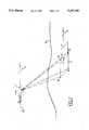
- FIG. 1is a view of a vehicle to which the apparatus of the present invention is attached while creating a map;
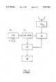
- FIG. 2is a block diagram of the apparatus of the present invention.
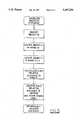
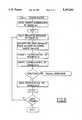
- FIG. 3is a flowchart depicting the program for determining the distance between the stationary object with respect to corner coordinates of the first image and with respect to corner coordinates of the second image;
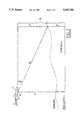
- FIG. 4depicts a first and second image superimposed on an X-Y coordinate system and the changed locations of a selected stationary object in each image
- FIG. 5is a flowchart depicting the algorithm used to compare calculated coordinates with geographic coordinates received from external sources
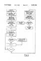
- FIG. 6is a flowchart of the algorithm used to adjust corner coordinates of the first image to arrive at corner coordinates of the second image.
- FIG. 7is a diagram showing the trigonometric method for determining the elevation of a target portion of land.
- FIG. 1shows a moving vehicle, which can either be manned or unmanned, carrying the apparatus of the present invention and its orientation with portions of the land to be mapped.
- vehicle 1must travel in a straight path.
- Video camera 10creates an analog or digital video signal of the first image.
- video camera 10is a video CCD Camera.
- An ordinary video cameramay also be used, provided an analog to digital conversion card is in place in the computer 16 to convert the analog video signal to a digital representation.
- the image of the first portion of landincludes the four corners 8.
- a precalculated digital image template electronically overlaid on the first imagecontains cross-hairs to be matched with registration marks on the land depicted.
- Corner coordinates, in latitude and longitude, of the four corners of first portion 2can either be determined in advance or after the first image is captured in post production. In either case, the coordinates of the first portion can be determined by traditional surveying techniques or by comparison of the created first image with pre-existing tax maps.
- the digitized first imageis sent to computer 16, where it is processed by an adapted, commercially available "registration" program such as "Meridian,” by MacDonald Detwiler, Vancouver, B.C., which program can match and register subsequent images containing the same stationary object and/or cross-hairs.
- Other softwaresuch as ERDAS, can also be adapted for this purpose.
- the processed image with calculated geographic coordinatesis then written to memory 14, which is preferably an optical disc unit, but can be a magnetic hard disc, magneto-optic drive or other storage device.
- a digital code depicting a stationary object 7 on the groundis selected on the basis of its uniqueness from the leading edge 9 of the first image.
- DIEdiscrete image element
- a second video image of a second portion of land, which overlaps the first image,is also created.
- the first and second imageshave two sides in common.
- the second imageis created while object 7 is within the field of view of camera 10, and therefore, in the overlapping region of the first and second images.
- Video camera 10captures the second video image and sends it to computer 16, where it is digitized, formatted, coordinated and then stored in memory 14, as described above.
- the computer 16calculates the distance between the changed locations of the DIE in the first and subsequent images in the set of images containing the DIE. This is accomplished by computing the distance between the two locations (13 and 15 in FIG. 4) of the DIE relative to the first image's corners 21 and the second image's corners 23 in an X-Y plane, with the Y axis being the path of travel of vehicle 1.
- Scaleis determined by the following relations: ##EQU1## where S is scale factor,
- ⁇is the angle formed by the longitudinal axis 25 of vehicle 1 and its path of travel, also known as the angle of rotation,
- fis the focal length of lens 11
- Tis the angle of the camera 10 and lens 11 with respect to the plane in which vehicle 1 travels, also known as tilt angle.
- Y' i ,jis the pixel location in an image rotated about an axis orthogonal to an X-Y plane
- P xis the distance from center to center of pixels on the X axis
- P yis the distance from center to center of pixels on the Y axis
- His altitude above the land (datum) of vehicle 1 under camera center, which can be obtained from a laser altimeter or by subtracting known topographical data from a barometric altimeter read out,
- his altitude above datum of a point on a portion of land in an image, which can be obtained in the same manner as H, and
- iis the number of pixels in the X direction
- jis the number of pixels in the Y direction.
- computer 16can determine the distance in feet or meters between the appearances of the DIE reflected in the unique chromanance and/or luminance code in the set of images in which it is contained, such as images 1 and 2. This process can be referred to as "picotmetric reckoning.” The algorithm for this process is shown in FIG. 3. First, the DIE is identified and located in each image. Next, the relative distance is calculated in pixels. Using scale, the relative distance in pixels is converted to meters, or any other desired standard.
- the four coordinates corresponding to the corners of image 2can be determined by computer 16 by adjusting the latitude and longitude of the corners by an amount proportional to this distance in the direction of travel of vehicle 1.
- This distance and the bearing of vehicle 1are used along with data contained in zone tables stored in memory 14 to compute new coordinates.
- the algorithm for this processis shown in FIG. 6.
- computer 16When these new corner coordinates have been determined, computer 16 writes a data word representing the new coordinates within the image and then stores the image in memory 14.
- a suitable method for imbedding data into video linesis discussed in U.S. Pat. No. 4,814,896, issued Mar. 22, 1989 to Heitzman, et al., incorporated herein by reference.
- the mapping apparatus of the present inventionhas coordinate verification capability.
- This capabilityis implemented by a rack of receivers 20 A-n (FIG. 2) capable of receiving external geographic signals from such sources as a global positioning satellite network, LORAN, radio navigation signals, radar, microwave, cellular phone signals, laser altimeter, dead reckoning devices, range finders, gyroscopes, pitch, roll, crab and yaw indication devices, barometric altimeters, speedometers, odometers, and auto focus and/or auto iris devices.
- Suitable receiversare available from Autohelm, B&G "Network" and Signet.
- the calculated coordinates for a particular imageare compared to geographic signals received from the external geographic signal sources for the same interval.
- the algorithm for polling instruments and excluding radical departuresis shown below and in FIG. 5:
- ⁇ X 1is the first average of instrument readouts
- SDis standard deviation
- ⁇ xrefers to read out from any single instrument
- ⁇ X 2is adjusted average with extremes excluded.
- the above steps for calculating (or pictometrically reckoning) coordinates for the imagecan in turn be repeated by locating within the second four corners of a second image another DIE at the leading edge of that image, tracking that DIE in a third image and calculating the change of corner coordinates from image two to image three, and assigning them to the third image.
- a complete map with accurately determined corner coordinates of constituent imagescan be created and stored in memory in real time.
- Each imagecan be retrieved from memory at random, and used to compile a map of the surveyed strip of land. This method obviates the need for manual assignment of geographic coordinates to the images before compiling.
- the apparatus of the present inventionis also capable of determining the elevation of a point on any portion of the strip of land and imbedding a data word representing the elevation in the digital image representing that portion.
- readingsare taken from an onboard rangefinder, which measures the distance between vehicle 1 and a point on the portion of land to be imaged, an onboard barometric altimeter and an onboard laser altimeter.
- the elevation, e, of a point on a portioncan be determined as follows:
- tis the barometric altitude over the portion of land (datum) being imaged
Landscapes
- Engineering & Computer Science (AREA)
- Physics & Mathematics (AREA)
- Theoretical Computer Science (AREA)
- General Physics & Mathematics (AREA)
- Geometry (AREA)
- Educational Technology (AREA)
- Software Systems (AREA)
- Mathematical Physics (AREA)
- Business, Economics & Management (AREA)
- Educational Administration (AREA)
- Remote Sensing (AREA)
- Computer Graphics (AREA)
- Computer Vision & Pattern Recognition (AREA)
- Multimedia (AREA)
- Radar, Positioning & Navigation (AREA)
- Processing Or Creating Images (AREA)
Abstract
Description
e=t-h
Claims (16)
Priority Applications (1)
| Application Number | Priority Date | Filing Date | Title |
|---|---|---|---|
| US07/836,880US5247356A (en) | 1992-02-14 | 1992-02-14 | Method and apparatus for mapping and measuring land |
Applications Claiming Priority (1)
| Application Number | Priority Date | Filing Date | Title |
|---|---|---|---|
| US07/836,880US5247356A (en) | 1992-02-14 | 1992-02-14 | Method and apparatus for mapping and measuring land |
Publications (1)
| Publication Number | Publication Date |
|---|---|
| US5247356Atrue US5247356A (en) | 1993-09-21 |
Family
ID=25272956
Family Applications (1)
| Application Number | Title | Priority Date | Filing Date |
|---|---|---|---|
| US07/836,880Expired - LifetimeUS5247356A (en) | 1992-02-14 | 1992-02-14 | Method and apparatus for mapping and measuring land |
Country Status (1)
| Country | Link |
|---|---|
| US (1) | US5247356A (en) |
Cited By (124)
| Publication number | Priority date | Publication date | Assignee | Title |
|---|---|---|---|---|
| US5414462A (en)* | 1993-02-11 | 1995-05-09 | Veatch; John W. | Method and apparatus for generating a comprehensive survey map |
| US5488558A (en)* | 1993-10-20 | 1996-01-30 | Daishin Instrument Co., Ltd. | Handy computer with built-in digital camera and spot state recording method using the same |
| US5517419A (en)* | 1993-07-22 | 1996-05-14 | Synectics Corporation | Advanced terrain mapping system |
| WO1996038003A1 (en)* | 1995-05-24 | 1996-11-28 | Omni Solutions Inernational, Ltd. | Direct digital airborne panoramic camera system and method |
| US5668593A (en)* | 1995-06-07 | 1997-09-16 | Recon/Optical, Inc. | Method and camera system for step frame reconnaissance with motion compensation |
| US5751345A (en)* | 1995-02-10 | 1998-05-12 | Dozier Financial Corporation | Image retention and information security system |
| US5790188A (en)* | 1995-09-07 | 1998-08-04 | Flight Landata, Inc. | Computer controlled, 3-CCD camera, airborne, variable interference filter imaging spectrometer system |
| US5878356A (en)* | 1995-06-14 | 1999-03-02 | Agrometrics, Inc. | Aircraft based infrared mapping system for earth based resources |
| US5894323A (en)* | 1996-03-22 | 1999-04-13 | Tasc, Inc, | Airborne imaging system using global positioning system (GPS) and inertial measurement unit (IMU) data |
| US5995970A (en)* | 1997-08-01 | 1999-11-30 | Garmin Corporation | Method and apparatus for geographic coordinate data storage |
| US6009359A (en)* | 1996-09-18 | 1999-12-28 | National Research Council Of Canada | Mobile system for indoor 3-D mapping and creating virtual environments |
| US6243483B1 (en)* | 1998-09-23 | 2001-06-05 | Pii North America, Inc. | Mapping system for the integration and graphical display of pipeline information that enables automated pipeline surveillance |
| US6278939B1 (en) | 2000-07-24 | 2001-08-21 | Navigation Technologies Corp. | Method and system for providing data from a remotely located geographic database for use in navigation system units |
| US6292745B1 (en) | 2000-07-24 | 2001-09-18 | Navigation Technologies Corp. | Method and system for forming a database of geographic data for distribution to navigation system units |
| US20010026270A1 (en)* | 2000-03-29 | 2001-10-04 | Higgins Darin Wayne | System and method for synchronizing raster and vector map images |
| US20010033291A1 (en)* | 2000-03-29 | 2001-10-25 | Scott Dan Martin | System and method for georeferencing digital raster maps |
| WO2002012830A1 (en)* | 2000-08-07 | 2002-02-14 | Bae Systems Plc | Height measurement apparatus |
| US20020033832A1 (en)* | 2000-09-18 | 2002-03-21 | Rafail Glatman | Method for computer modeling of visual images and wave propagation |
| US20020101847A1 (en)* | 1994-09-06 | 2002-08-01 | Interdigital Technology Corporation | Wireless telephone system with diversity transmission and method |
| US20020147613A1 (en)* | 2001-04-10 | 2002-10-10 | Kennard Robert M. | Methods of marketing summary maps depicting the location of real property and certain traits in the vicinity thereof |
| US20020145617A1 (en)* | 2001-04-06 | 2002-10-10 | Kennard Robert M. | Methods of marketing maps depicting the location of real property and geographic characteristics in the vicinity thereof |
| US6504571B1 (en) | 1998-05-18 | 2003-01-07 | International Business Machines Corporation | System and methods for querying digital image archives using recorded parameters |
| US20030146985A1 (en)* | 2000-12-26 | 2003-08-07 | Shiro Miyagi | Data recording device and method, data reproducing device and method, data recording/reproducing device and method, map image data format |
| US6631326B1 (en) | 2000-03-29 | 2003-10-07 | Sourceprose Corporation | System and method for performing flood zone certifications |
| US6687606B1 (en) | 2002-02-21 | 2004-02-03 | Lockheed Martin Corporation | Architecture for automatic evaluation of team reconnaissance and surveillance plans |
| US20040057633A1 (en)* | 2002-09-19 | 2004-03-25 | Mai Tuy Vu | System for mosaicing digital ortho-images |
| US6718261B2 (en) | 2002-02-21 | 2004-04-06 | Lockheed Martin Corporation | Architecture for real-time maintenance of distributed mission plans |
| US6725152B2 (en) | 2002-02-21 | 2004-04-20 | Lockheed Martin Corporation | Real-time route and sensor planning system with variable mission objectives |
| US20040105090A1 (en)* | 2002-11-08 | 2004-06-03 | Schultz Stephen L. | Method and apparatus for capturing, geolocating and measuring oblique images |
| US6747686B1 (en) | 2001-10-05 | 2004-06-08 | Recon/Optical, Inc. | High aspect stereoscopic mode camera and method |
| US20040220906A1 (en)* | 2003-04-30 | 2004-11-04 | Ullas Gargi | Systems and methods for location-based real estate service |
| US20050073532A1 (en)* | 2000-03-29 | 2005-04-07 | Scott Dan Martin | System and method for georeferencing maps |
| US20050159882A1 (en)* | 2000-03-29 | 2005-07-21 | Howard John W. | System and method for performing flood zone certicifications |
| US7015967B1 (en)* | 1999-05-10 | 2006-03-21 | Kabushiki Kaisha Topcon | Image formation system |
| US7084903B2 (en) | 1998-05-18 | 2006-08-01 | International Business Machines Corporation | Image capturing system and method for automatically watermarking recorded parameters for providing digital image verification |
| US7170518B1 (en)* | 2000-03-27 | 2007-01-30 | Magellan Dis, Inc. | Selective rendering of cartographic entities for a navigation system |
| US20070297683A1 (en)* | 2006-06-26 | 2007-12-27 | Eastman Kodak Company | Classifying image regions based on picture location |
| US20080123994A1 (en)* | 2006-08-30 | 2008-05-29 | Stephen Schultz | Mosaic Oblique Images and Methods of Making and Using Same |
| US20080262789A1 (en)* | 2007-04-17 | 2008-10-23 | Chris Pershing | Aerial roof estimation system and method |
| US20080279447A1 (en)* | 2004-10-15 | 2008-11-13 | Ofek Aerial Photography International Ltd. | Computational Solution Of A Building Of Three Dimensional Virtual Models From Aerial Photographs |
| US20090087034A1 (en)* | 2007-10-01 | 2009-04-02 | Magellan Navigation, Inc. | Static and dynamic contours |
| US20090222237A1 (en)* | 2008-03-03 | 2009-09-03 | Kabushiki Kaisha Topcon | Geographical data collecting device |
| US20090225161A1 (en)* | 2008-03-04 | 2009-09-10 | Kabushiki Kaisha Topcon | Geographical data collecting device |
| US20090256909A1 (en)* | 2008-04-11 | 2009-10-15 | Nixon Stuart | Systems and methods of capturing large area images in detail including cascaded cameras and/or calibration features |
| US20090271719A1 (en)* | 2007-04-27 | 2009-10-29 | Lpa Systems, Inc. | System and method for analysis and display of geo-referenced imagery |
| US20090276711A1 (en)* | 2008-05-05 | 2009-11-05 | Microsoft Corporation | Scene-granular geographical-based video footage visualizatons |
| US7647232B2 (en) | 2002-02-21 | 2010-01-12 | Lockheed Martin Corporation | Real-time team coordination system for reconnaissance and surveillance missions |
| US20100013927A1 (en)* | 2008-04-11 | 2010-01-21 | Nearmap Pty Ltd. | Systems and Methods of Capturing Large Area Images in Detail Including Cascaded Cameras and/or Calibration Features |
| US20100114537A1 (en)* | 2008-10-31 | 2010-05-06 | Eagle View Technologies, Inc. | Concurrent display systems and methods for aerial roof estimation |
| US20100110074A1 (en)* | 2008-10-31 | 2010-05-06 | Eagle View Technologies, Inc. | Pitch determination systems and methods for aerial roof estimation |
| US20100235095A1 (en)* | 2002-09-20 | 2010-09-16 | M7 Visual Intelligence, L.P. | Self-calibrated, remote imaging and data processing system |
| US7908080B2 (en) | 2004-12-31 | 2011-03-15 | Google Inc. | Transportation routing |
| US20110064312A1 (en)* | 2009-09-14 | 2011-03-17 | Janky James M | Image-based georeferencing |
| US20110087662A1 (en)* | 2009-09-30 | 2011-04-14 | Darby Jr George Derrick | Visual organization of information via associated geospatial data |
| US20110096319A1 (en)* | 2005-07-11 | 2011-04-28 | Kabushiki Kaisha Topcon | Geographic data collecting system |
| US20110143707A1 (en)* | 2009-12-16 | 2011-06-16 | Darby Jr George Derrick | Incident reporting |
| US7991226B2 (en) | 2007-10-12 | 2011-08-02 | Pictometry International Corporation | System and process for color-balancing a series of oblique images |
| US20110235923A1 (en)* | 2009-09-14 | 2011-09-29 | Weisenburger Shawn D | Accurate digitization of a georeferenced image |
| US8385672B2 (en) | 2007-05-01 | 2013-02-26 | Pictometry International Corp. | System for detecting image abnormalities |
| US8401222B2 (en) | 2009-05-22 | 2013-03-19 | Pictometry International Corp. | System and process for roof measurement using aerial imagery |
| WO2013082280A1 (en) | 2011-11-29 | 2013-06-06 | Pictometry International Corp. | System for automatic structure footprint detection from oblique imagery |
| US8477190B2 (en) | 2010-07-07 | 2013-07-02 | Pictometry International Corp. | Real-time moving platform management system |
| WO2013106080A2 (en) | 2011-06-10 | 2013-07-18 | Pictometry International Corp. | System and method for forming a video stream containing gis data in real-time |
| US20130191295A1 (en)* | 2004-08-31 | 2013-07-25 | Mv Patents, Llc | Method of Receiving a List of Links to Street View Data of Real Estate Properties |
| US8505847B2 (en) | 2011-03-01 | 2013-08-13 | John Ciampa | Lighter-than-air systems, methods, and kits for obtaining aerial images |
| US8520079B2 (en) | 2007-02-15 | 2013-08-27 | Pictometry International Corp. | Event multiplexer for managing the capture of images |
| US8527115B2 (en) | 2004-01-23 | 2013-09-03 | Rafael Armament Development Authority Ltd. | Airborne reconnaissance system |
| US8531472B2 (en) | 2007-12-03 | 2013-09-10 | Pictometry International Corp. | Systems and methods for rapid three-dimensional modeling with real façade texture |
| US8588547B2 (en) | 2008-08-05 | 2013-11-19 | Pictometry International Corp. | Cut-line steering methods for forming a mosaic image of a geographical area |
| US8593518B2 (en) | 2007-02-01 | 2013-11-26 | Pictometry International Corp. | Computer system for continuous oblique panning |
| US8638375B2 (en) | 2011-05-17 | 2014-01-28 | Trimble Navigation Limited | Recording data with an integrated field-portable device |
| US8670961B2 (en) | 2007-04-17 | 2014-03-11 | Eagle View Technologies, Inc. | Aerial roof estimation systems and methods |
| US8671741B2 (en) | 2011-06-29 | 2014-03-18 | Trimble Navigation Limited | Extendable moisture content sensing system |
| US8687062B1 (en) | 2011-08-31 | 2014-04-01 | Google Inc. | Step-stare oblique aerial camera system |
| US8731234B1 (en) | 2008-10-31 | 2014-05-20 | Eagle View Technologies, Inc. | Automated roof identification systems and methods |
| US8731836B2 (en) | 2010-10-25 | 2014-05-20 | Trimble Navigation Limited | Wide-area agricultural monitoring and prediction |
| US8768667B2 (en) | 2010-10-25 | 2014-07-01 | Trimble Navigation Limited | Water erosion management incorporating topography, soil type, and weather statistics |
| US8774525B2 (en) | 2012-02-03 | 2014-07-08 | Eagle View Technologies, Inc. | Systems and methods for estimation of building floor area |
| US20140236400A1 (en)* | 2013-02-19 | 2014-08-21 | Chengdu Haicun Ip Technology Llc | Laser Landing Altimeter for Precision Aircraft Landing Aid |
| US8823732B2 (en) | 2010-12-17 | 2014-09-02 | Pictometry International Corp. | Systems and methods for processing images with edge detection and snap-to feature |
| US8855937B2 (en) | 2010-10-25 | 2014-10-07 | Trimble Navigation Limited | Crop characteristic estimation |
| US8896695B2 (en) | 2002-08-28 | 2014-11-25 | Visual Intelligence Lp | Retinal concave array compound camera system |
| US8934009B2 (en) | 2010-09-02 | 2015-01-13 | Kabushiki Kaisha Topcon | Measuring method and measuring device |
| US8989434B1 (en)* | 2010-04-05 | 2015-03-24 | Google Inc. | Interactive geo-referenced source imagery viewing system and method |
| US8994822B2 (en) | 2002-08-28 | 2015-03-31 | Visual Intelligence Lp | Infrastructure mapping system and method |
| US9046996B2 (en) | 2013-10-17 | 2015-06-02 | Google Inc. | Techniques for navigation among multiple images |
| US9058633B2 (en) | 2010-10-25 | 2015-06-16 | Trimble Navigation Limited | Wide-area agricultural monitoring and prediction |
| US9183538B2 (en) | 2012-03-19 | 2015-11-10 | Pictometry International Corp. | Method and system for quick square roof reporting |
| US9213905B2 (en) | 2010-10-25 | 2015-12-15 | Trimble Navigation Limited | Automatic obstacle location mapping |
| US9262818B2 (en) | 2007-05-01 | 2016-02-16 | Pictometry International Corp. | System for detecting image abnormalities |
| US9275080B2 (en) | 2013-03-15 | 2016-03-01 | Pictometry International Corp. | System and method for early access to captured images |
| US9292913B2 (en) | 2014-01-31 | 2016-03-22 | Pictometry International Corp. | Augmented three dimensional point collection of vertical structures |
| US9324003B2 (en) | 2009-09-14 | 2016-04-26 | Trimble Navigation Limited | Location of image capture device and object features in a captured image |
| US9330494B2 (en) | 2009-10-26 | 2016-05-03 | Pictometry International Corp. | Method for the automatic material classification and texture simulation for 3D models |
| US9501700B2 (en) | 2012-02-15 | 2016-11-22 | Xactware Solutions, Inc. | System and method for construction estimation using aerial images |
| US9599466B2 (en) | 2012-02-03 | 2017-03-21 | Eagle View Technologies, Inc. | Systems and methods for estimation of building wall area |
| US9612598B2 (en) | 2014-01-10 | 2017-04-04 | Pictometry International Corp. | Unmanned aircraft structure evaluation system and method |
| US9679227B2 (en) | 2013-08-02 | 2017-06-13 | Xactware Solutions, Inc. | System and method for detecting features in aerial images using disparity mapping and segmentation techniques |
| US9753950B2 (en) | 2013-03-15 | 2017-09-05 | Pictometry International Corp. | Virtual property reporting for automatic structure detection |
| US9846848B2 (en) | 2010-10-25 | 2017-12-19 | Trimble Inc. | Exchanging water allocation credits |
| US9881163B2 (en) | 2013-03-12 | 2018-01-30 | Pictometry International Corp. | System and method for performing sensitive geo-spatial processing in non-sensitive operator environments |
| US9911228B2 (en) | 2010-02-01 | 2018-03-06 | Eagle View Technologies, Inc. | Geometric correction of rough wireframe models derived from photographs |
| US9933257B2 (en) | 2012-02-03 | 2018-04-03 | Eagle View Technologies, Inc. | Systems and methods for estimation of building wall area |
| US9953370B2 (en) | 2012-02-03 | 2018-04-24 | Eagle View Technologies, Inc. | Systems and methods for performing a risk management assessment of a property |
| US9953112B2 (en) | 2014-02-08 | 2018-04-24 | Pictometry International Corp. | Method and system for displaying room interiors on a floor plan |
| US9959581B2 (en) | 2013-03-15 | 2018-05-01 | Eagle View Technologies, Inc. | Property management on a smartphone |
| US10115158B2 (en) | 2010-10-25 | 2018-10-30 | Trimble Inc. | Generating a crop recommendation |
| US10217283B2 (en) | 2015-12-17 | 2019-02-26 | Google Llc | Navigation through multidimensional images spaces |
| US10402676B2 (en) | 2016-02-15 | 2019-09-03 | Pictometry International Corp. | Automated system and methodology for feature extraction |
| US10502813B2 (en) | 2013-03-12 | 2019-12-10 | Pictometry International Corp. | LiDAR system producing multiple scan paths and method of making and using same |
| US10503843B2 (en) | 2017-12-19 | 2019-12-10 | Eagle View Technologies, Inc. | Supervised automatic roof modeling |
| US10663294B2 (en) | 2012-02-03 | 2020-05-26 | Eagle View Technologies, Inc. | Systems and methods for estimation of building wall area and producing a wall estimation report |
| US10671648B2 (en) | 2016-02-22 | 2020-06-02 | Eagle View Technologies, Inc. | Integrated centralized property database systems and methods |
| US10740608B2 (en)* | 2012-06-13 | 2020-08-11 | San Diego State University Research Foundation | Wide area intermittent video using non-orthorectified feature matching in long period aerial image capture with pixel-based georeferencing |
| US10909482B2 (en) | 2013-03-15 | 2021-02-02 | Pictometry International Corp. | Building materials estimation |
| US11094113B2 (en) | 2019-12-04 | 2021-08-17 | Geomni, Inc. | Systems and methods for modeling structures using point clouds derived from stereoscopic image pairs |
| US11164256B2 (en) | 2013-03-15 | 2021-11-02 | Eagle View Technologies, Inc. | Price estimation model |
| CN114240360A (en)* | 2021-12-15 | 2022-03-25 | 湖南天湘和信息科技有限公司 | Multi-measurement-in-one geographic information management system |
| USRE49105E1 (en) | 2002-09-20 | 2022-06-14 | Vi Technologies, Llc | Self-calibrated, remote imaging and data processing system |
| US12038952B1 (en) | 2022-12-19 | 2024-07-16 | Rockwell Collins, Inc. | Aerial image geo-registration via aeronautical database content as ground control points |
| US12079013B2 (en) | 2016-01-08 | 2024-09-03 | Pictometry International Corp. | Systems and methods for taking, processing, retrieving, and displaying images from unmanned aerial vehicles |
| US12140419B2 (en) | 2012-02-03 | 2024-11-12 | Eagle View Technologies, Inc. | Systems and methods for estimation of building wall area and producing a wall estimation report |
| NL2035685B1 (en) | 2023-08-28 | 2025-03-11 | Ingb Geodelta B V | Method for determining accurate coordinates from images with human supervision using a virtual three-dimensional marker |
| US12332660B2 (en) | 2018-11-21 | 2025-06-17 | Eagle View Technologies, Inc. | Navigating unmanned aircraft using pitch |
Citations (15)
| Publication number | Priority date | Publication date | Assignee | Title |
|---|---|---|---|---|
| US3594556A (en)* | 1969-01-08 | 1971-07-20 | Us Navy | Optical sight with electronic image stabilization |
| US3725563A (en)* | 1971-12-23 | 1973-04-03 | Singer Co | Method of perspective transformation in scanned raster visual display |
| US3864513A (en)* | 1972-09-11 | 1975-02-04 | Grumman Aerospace Corp | Computerized polarimetric terrain mapping system |
| US4015080A (en)* | 1973-04-30 | 1977-03-29 | Elliott Brothers (London) Limited | Display devices |
| US4240108A (en)* | 1977-10-03 | 1980-12-16 | Grumman Aerospace Corporation | Vehicle controlled raster display system |
| US4360876A (en)* | 1979-07-06 | 1982-11-23 | Thomson-Csf | Cartographic indicator system |
| US4463380A (en)* | 1981-09-25 | 1984-07-31 | Vought Corporation | Image processing system |
| US4543603A (en)* | 1982-11-30 | 1985-09-24 | Societe Nationale Industrielle Et Aerospatiale | Reconnaissance system comprising an air-borne vehicle rotating about its longitudinal axis |
| US4635136A (en)* | 1984-02-06 | 1987-01-06 | Rochester Institute Of Technology | Method and apparatus for storing a massive inventory of labeled images |
| US4686474A (en)* | 1984-04-05 | 1987-08-11 | Deseret Research, Inc. | Survey system for collection and real time processing of geophysical data |
| US4688092A (en)* | 1986-05-06 | 1987-08-18 | Ford Aerospace & Communications Corporation | Satellite camera image navigation |
| US4707698A (en)* | 1976-03-04 | 1987-11-17 | Constant James N | Coordinate measurement and radar device using image scanner |
| US4814711A (en)* | 1984-04-05 | 1989-03-21 | Deseret Research, Inc. | Survey system and method for real time collection and processing of geophysicals data using signals from a global positioning satellite network |
| US4814896A (en)* | 1987-03-06 | 1989-03-21 | Heitzman Edward F | Real time video data acquistion systems |
| US5034812A (en)* | 1988-11-14 | 1991-07-23 | Smiths Industries Public Limited Company | Image processing utilizing an object data store to determine information about a viewed object |
- 1992
- 1992-02-14USUS07/836,880patent/US5247356A/ennot_activeExpired - Lifetime
Patent Citations (15)
| Publication number | Priority date | Publication date | Assignee | Title |
|---|---|---|---|---|
| US3594556A (en)* | 1969-01-08 | 1971-07-20 | Us Navy | Optical sight with electronic image stabilization |
| US3725563A (en)* | 1971-12-23 | 1973-04-03 | Singer Co | Method of perspective transformation in scanned raster visual display |
| US3864513A (en)* | 1972-09-11 | 1975-02-04 | Grumman Aerospace Corp | Computerized polarimetric terrain mapping system |
| US4015080A (en)* | 1973-04-30 | 1977-03-29 | Elliott Brothers (London) Limited | Display devices |
| US4707698A (en)* | 1976-03-04 | 1987-11-17 | Constant James N | Coordinate measurement and radar device using image scanner |
| US4240108A (en)* | 1977-10-03 | 1980-12-16 | Grumman Aerospace Corporation | Vehicle controlled raster display system |
| US4360876A (en)* | 1979-07-06 | 1982-11-23 | Thomson-Csf | Cartographic indicator system |
| US4463380A (en)* | 1981-09-25 | 1984-07-31 | Vought Corporation | Image processing system |
| US4543603A (en)* | 1982-11-30 | 1985-09-24 | Societe Nationale Industrielle Et Aerospatiale | Reconnaissance system comprising an air-borne vehicle rotating about its longitudinal axis |
| US4635136A (en)* | 1984-02-06 | 1987-01-06 | Rochester Institute Of Technology | Method and apparatus for storing a massive inventory of labeled images |
| US4686474A (en)* | 1984-04-05 | 1987-08-11 | Deseret Research, Inc. | Survey system for collection and real time processing of geophysical data |
| US4814711A (en)* | 1984-04-05 | 1989-03-21 | Deseret Research, Inc. | Survey system and method for real time collection and processing of geophysicals data using signals from a global positioning satellite network |
| US4688092A (en)* | 1986-05-06 | 1987-08-18 | Ford Aerospace & Communications Corporation | Satellite camera image navigation |
| US4814896A (en)* | 1987-03-06 | 1989-03-21 | Heitzman Edward F | Real time video data acquistion systems |
| US5034812A (en)* | 1988-11-14 | 1991-07-23 | Smiths Industries Public Limited Company | Image processing utilizing an object data store to determine information about a viewed object |
Cited By (299)
| Publication number | Priority date | Publication date | Assignee | Title |
|---|---|---|---|---|
| US5414462A (en)* | 1993-02-11 | 1995-05-09 | Veatch; John W. | Method and apparatus for generating a comprehensive survey map |
| US5517419A (en)* | 1993-07-22 | 1996-05-14 | Synectics Corporation | Advanced terrain mapping system |
| US5488558A (en)* | 1993-10-20 | 1996-01-30 | Daishin Instrument Co., Ltd. | Handy computer with built-in digital camera and spot state recording method using the same |
| US8248988B2 (en) | 1994-09-06 | 2012-08-21 | Interdigital Technology Corporation | Locating a wireless user |
| US20020101847A1 (en)* | 1994-09-06 | 2002-08-01 | Interdigital Technology Corporation | Wireless telephone system with diversity transmission and method |
| US8130696B2 (en) | 1994-09-06 | 2012-03-06 | Interdigital Technology Corporation | Transmitting an information signal over antennas |
| US20040062220A1 (en)* | 1994-09-06 | 2004-04-01 | Interdigital Technology Corporation | Locating a wireless user |
| US8432867B2 (en) | 1994-09-06 | 2013-04-30 | Intel Corporation | Method and apparatus for receiving code transmissions over timeslots and antennas |
| US8228886B2 (en) | 1994-09-06 | 2012-07-24 | Interdigital Technology Corporation | Code transmission over timeslots and antennas |
| US20020105962A1 (en)* | 1994-09-06 | 2002-08-08 | Interdigital Technology Corporation | Transmitting station for wireless telephone system with diversity transmission and method |
| US8155017B2 (en) | 1994-09-06 | 2012-04-10 | Interdigital Technology Corporation | Method and apparatus for locating a wireless user |
| US7554964B2 (en) | 1994-09-06 | 2009-06-30 | Interdigital Technology Corporation | Wireless telephone system with diversity transmission and method |
| US7463608B2 (en) | 1994-09-06 | 2008-12-09 | Interdigital Technology Corporation | Transmitting station for wireless telephone system with diversity transmission and method |
| US20080219234A1 (en)* | 1994-09-06 | 2008-09-11 | Interdigital Technology Corporation | Method and apparatus for receiving code transmissions over timeslots and antennas |
| US20080219233A1 (en)* | 1994-09-06 | 2008-09-11 | Interdigital Technology Corporation | Method and apparatus for locating a wireless user |
| US20050249178A1 (en)* | 1994-09-06 | 2005-11-10 | Interdigital Technology Corporation | Code transmission over timeslots and antennas |
| US20050185627A1 (en)* | 1994-09-06 | 2005-08-25 | Interdigital Technology Corporation | Transmitting an information signal over antennas |
| US5751345A (en)* | 1995-02-10 | 1998-05-12 | Dozier Financial Corporation | Image retention and information security system |
| WO1996038003A1 (en)* | 1995-05-24 | 1996-11-28 | Omni Solutions Inernational, Ltd. | Direct digital airborne panoramic camera system and method |
| US5604534A (en)* | 1995-05-24 | 1997-02-18 | Omni Solutions International, Ltd. | Direct digital airborne panoramic camera system and method |
| US5668593A (en)* | 1995-06-07 | 1997-09-16 | Recon/Optical, Inc. | Method and camera system for step frame reconnaissance with motion compensation |
| US5878356A (en)* | 1995-06-14 | 1999-03-02 | Agrometrics, Inc. | Aircraft based infrared mapping system for earth based resources |
| US5790188A (en)* | 1995-09-07 | 1998-08-04 | Flight Landata, Inc. | Computer controlled, 3-CCD camera, airborne, variable interference filter imaging spectrometer system |
| US5894323A (en)* | 1996-03-22 | 1999-04-13 | Tasc, Inc, | Airborne imaging system using global positioning system (GPS) and inertial measurement unit (IMU) data |
| US6009359A (en)* | 1996-09-18 | 1999-12-28 | National Research Council Of Canada | Mobile system for indoor 3-D mapping and creating virtual environments |
| US5995970A (en)* | 1997-08-01 | 1999-11-30 | Garmin Corporation | Method and apparatus for geographic coordinate data storage |
| US7084903B2 (en) | 1998-05-18 | 2006-08-01 | International Business Machines Corporation | Image capturing system and method for automatically watermarking recorded parameters for providing digital image verification |
| US6504571B1 (en) | 1998-05-18 | 2003-01-07 | International Business Machines Corporation | System and methods for querying digital image archives using recorded parameters |
| US6243483B1 (en)* | 1998-09-23 | 2001-06-05 | Pii North America, Inc. | Mapping system for the integration and graphical display of pipeline information that enables automated pipeline surveillance |
| US7015967B1 (en)* | 1999-05-10 | 2006-03-21 | Kabushiki Kaisha Topcon | Image formation system |
| US7170518B1 (en)* | 2000-03-27 | 2007-01-30 | Magellan Dis, Inc. | Selective rendering of cartographic entities for a navigation system |
| US20010033291A1 (en)* | 2000-03-29 | 2001-10-25 | Scott Dan Martin | System and method for georeferencing digital raster maps |
| US6678615B2 (en) | 2000-03-29 | 2004-01-13 | Sourceprose Corporation | System and method for performing flood zone certifications |
| US6631326B1 (en) | 2000-03-29 | 2003-10-07 | Sourceprose Corporation | System and method for performing flood zone certifications |
| US7142217B2 (en)* | 2000-03-29 | 2006-11-28 | Sourceprose Corporation | System and method for synchronizing raster and vector map images |
| US6842698B2 (en) | 2000-03-29 | 2005-01-11 | Sourceprose Corporation | System and method for performing flood zone certifications |
| US7038681B2 (en) | 2000-03-29 | 2006-05-02 | Sourceprose Corporation | System and method for georeferencing maps |
| US20040078143A1 (en)* | 2000-03-29 | 2004-04-22 | Sourceprose Corporation | System and method for performing flood zone certifications |
| US7148898B1 (en) | 2000-03-29 | 2006-12-12 | Sourceprose Corporation | System and method for synchronizing raster and vector map images |
| US7161604B2 (en) | 2000-03-29 | 2007-01-09 | Sourceprose Corporation | System and method for synchronizing raster and vector map images |
| US20010033292A1 (en)* | 2000-03-29 | 2001-10-25 | Scott Dan Martin | System and method for georeferencing digital raster maps |
| US20030052896A1 (en)* | 2000-03-29 | 2003-03-20 | Higgins Darin Wayne | System and method for synchronizing map images |
| US20050073532A1 (en)* | 2000-03-29 | 2005-04-07 | Scott Dan Martin | System and method for georeferencing maps |
| US20050159882A1 (en)* | 2000-03-29 | 2005-07-21 | Howard John W. | System and method for performing flood zone certicifications |
| US20010028348A1 (en)* | 2000-03-29 | 2001-10-11 | Higgins Darin Wayne | System and method for synchronizing raster and vector map images |
| US20010026271A1 (en)* | 2000-03-29 | 2001-10-04 | Higgins Darin Wayne | System and method for synchronizing raster and vector map images |
| US20010026270A1 (en)* | 2000-03-29 | 2001-10-04 | Higgins Darin Wayne | System and method for synchronizing raster and vector map images |
| US7190377B2 (en) | 2000-03-29 | 2007-03-13 | Sourceprose Corporation | System and method for georeferencing digital raster maps with resistance to potential errors |
| US7167187B2 (en)* | 2000-03-29 | 2007-01-23 | Sourceprose Corporation | System and method for georeferencing digital raster maps using a georeferencing function |
| US6278939B1 (en) | 2000-07-24 | 2001-08-21 | Navigation Technologies Corp. | Method and system for providing data from a remotely located geographic database for use in navigation system units |
| US6292745B1 (en) | 2000-07-24 | 2001-09-18 | Navigation Technologies Corp. | Method and system for forming a database of geographic data for distribution to navigation system units |
| US7123749B2 (en) | 2000-08-07 | 2006-10-17 | Bae Systems Plc | Height measurement apparatus |
| US20030118213A1 (en)* | 2000-08-07 | 2003-06-26 | Parker David R | Height measurement apparatus |
| WO2002012830A1 (en)* | 2000-08-07 | 2002-02-14 | Bae Systems Plc | Height measurement apparatus |
| US20020033832A1 (en)* | 2000-09-18 | 2002-03-21 | Rafail Glatman | Method for computer modeling of visual images and wave propagation |
| US20030146985A1 (en)* | 2000-12-26 | 2003-08-07 | Shiro Miyagi | Data recording device and method, data reproducing device and method, data recording/reproducing device and method, map image data format |
| US7184611B2 (en)* | 2000-12-26 | 2007-02-27 | Sony Corporation | Data recording apparatus and method, data reproducing apparatus and method, data recording and reproducing apparatus and method, and map image data format |
| US20020145617A1 (en)* | 2001-04-06 | 2002-10-10 | Kennard Robert M. | Methods of marketing maps depicting the location of real property and geographic characteristics in the vicinity thereof |
| US20020147613A1 (en)* | 2001-04-10 | 2002-10-10 | Kennard Robert M. | Methods of marketing summary maps depicting the location of real property and certain traits in the vicinity thereof |
| US6747686B1 (en) | 2001-10-05 | 2004-06-08 | Recon/Optical, Inc. | High aspect stereoscopic mode camera and method |
| US6687606B1 (en) | 2002-02-21 | 2004-02-03 | Lockheed Martin Corporation | Architecture for automatic evaluation of team reconnaissance and surveillance plans |
| US6718261B2 (en) | 2002-02-21 | 2004-04-06 | Lockheed Martin Corporation | Architecture for real-time maintenance of distributed mission plans |
| US6985810B2 (en) | 2002-02-21 | 2006-01-10 | Lockheed Martin Corporation | Real-time route and sensor planning system with variable mission objectives |
| US7647232B2 (en) | 2002-02-21 | 2010-01-12 | Lockheed Martin Corporation | Real-time team coordination system for reconnaissance and surveillance missions |
| US6725152B2 (en) | 2002-02-21 | 2004-04-20 | Lockheed Martin Corporation | Real-time route and sensor planning system with variable mission objectives |
| US8994822B2 (en) | 2002-08-28 | 2015-03-31 | Visual Intelligence Lp | Infrastructure mapping system and method |
| US8896695B2 (en) | 2002-08-28 | 2014-11-25 | Visual Intelligence Lp | Retinal concave array compound camera system |
| US20040057633A1 (en)* | 2002-09-19 | 2004-03-25 | Mai Tuy Vu | System for mosaicing digital ortho-images |
| US6928194B2 (en) | 2002-09-19 | 2005-08-09 | M7 Visual Intelligence, Lp | System for mosaicing digital ortho-images |
| US8483960B2 (en) | 2002-09-20 | 2013-07-09 | Visual Intelligence, LP | Self-calibrated, remote imaging and data processing system |
| US9797980B2 (en) | 2002-09-20 | 2017-10-24 | Visual Intelligence Lp | Self-calibrated, remote imaging and data processing system |
| US9389298B2 (en) | 2002-09-20 | 2016-07-12 | Visual Intelligence Lp | Self-calibrated, remote imaging and data processing system |
| US20100235095A1 (en)* | 2002-09-20 | 2010-09-16 | M7 Visual Intelligence, L.P. | Self-calibrated, remote imaging and data processing system |
| USRE49105E1 (en) | 2002-09-20 | 2022-06-14 | Vi Technologies, Llc | Self-calibrated, remote imaging and data processing system |
| US10607357B2 (en) | 2002-11-08 | 2020-03-31 | Pictometry International Corp. | Method and apparatus for capturing, geolocating and measuring oblique images |
| US7424133B2 (en)* | 2002-11-08 | 2008-09-09 | Pictometry International Corporation | Method and apparatus for capturing, geolocating and measuring oblique images |
| US20120288158A1 (en)* | 2002-11-08 | 2012-11-15 | Schultz Stephen L | Method and Apparatus for Capturing, Geolocating and Measuring Oblique Images |
| US9811922B2 (en) | 2002-11-08 | 2017-11-07 | Pictometry International Corp. | Method and apparatus for capturing, geolocating and measuring oblique images |
| US20040105090A1 (en)* | 2002-11-08 | 2004-06-03 | Schultz Stephen L. | Method and apparatus for capturing, geolocating and measuring oblique images |
| US8634594B2 (en)* | 2002-11-08 | 2014-01-21 | Pictometry International Corp. | Method and apparatus for capturing, geolocating and measuring oblique images |
| US7787659B2 (en) | 2002-11-08 | 2010-08-31 | Pictometry International Corp. | Method and apparatus for capturing, geolocating and measuring oblique images |
| US9443305B2 (en)* | 2002-11-08 | 2016-09-13 | Pictometry International Corp. | Method and apparatus for capturing, geolocating and measuring oblique images |
| US20100302243A1 (en)* | 2002-11-08 | 2010-12-02 | Schultz Stephen L | Method and apparatus for capturing geolocating and measuring oblique images |
| US11069077B2 (en) | 2002-11-08 | 2021-07-20 | Pictometry International Corp. | Method and apparatus for capturing, geolocating and measuring oblique images |
| US9182657B2 (en)* | 2002-11-08 | 2015-11-10 | Pictometry International Corp. | Method and apparatus for capturing, geolocating and measuring oblique images |
| US7995799B2 (en) | 2002-11-08 | 2011-08-09 | Pictometry International Corporation | Method and apparatus for capturing geolocating and measuring oblique images |
| US8051089B2 (en)* | 2003-04-30 | 2011-11-01 | Hewlett-Packard Development Company, L.P. | Systems and methods for location-based real estate service |
| US20040220906A1 (en)* | 2003-04-30 | 2004-11-04 | Ullas Gargi | Systems and methods for location-based real estate service |
| US8527115B2 (en) | 2004-01-23 | 2013-09-03 | Rafael Armament Development Authority Ltd. | Airborne reconnaissance system |
| US20130191295A1 (en)* | 2004-08-31 | 2013-07-25 | Mv Patents, Llc | Method of Receiving a List of Links to Street View Data of Real Estate Properties |
| US20080279447A1 (en)* | 2004-10-15 | 2008-11-13 | Ofek Aerial Photography International Ltd. | Computational Solution Of A Building Of Three Dimensional Virtual Models From Aerial Photographs |
| US8798917B2 (en) | 2004-12-31 | 2014-08-05 | Google Inc. | Transportation routing |
| US11092455B2 (en) | 2004-12-31 | 2021-08-17 | Google Llc | Transportation routing |
| US7908080B2 (en) | 2004-12-31 | 2011-03-15 | Google Inc. | Transportation routing |
| US8606514B2 (en) | 2004-12-31 | 2013-12-10 | Google Inc. | Transportation routing |
| US9778055B2 (en) | 2004-12-31 | 2017-10-03 | Google Inc. | Transportation routing |
| US9945686B2 (en) | 2004-12-31 | 2018-04-17 | Google Llc | Transportation routing |
| US9709415B2 (en) | 2004-12-31 | 2017-07-18 | Google Inc. | Transportation routing |
| US20110096319A1 (en)* | 2005-07-11 | 2011-04-28 | Kabushiki Kaisha Topcon | Geographic data collecting system |
| US8319952B2 (en) | 2005-07-11 | 2012-11-27 | Kabushiki Kaisha Topcon | Geographic data collecting system |
| US7860320B2 (en) | 2006-06-26 | 2010-12-28 | Eastman Kodak Company | Classifying image regions based on picture location |
| US20070297683A1 (en)* | 2006-06-26 | 2007-12-27 | Eastman Kodak Company | Classifying image regions based on picture location |
| WO2008002396A2 (en) | 2006-06-26 | 2008-01-03 | Eastman Kodak Company | Classifying image regions based on picture location |
| US9437029B2 (en) | 2006-08-30 | 2016-09-06 | Pictometry International Corp. | Mosaic oblique images and methods of making and using same |
| US10489953B2 (en) | 2006-08-30 | 2019-11-26 | Pictometry International Corp. | Mosaic oblique images and methods of making and using same |
| US9959653B2 (en) | 2006-08-30 | 2018-05-01 | Pictometry International Corporation | Mosaic oblique images and methods of making and using same |
| US7873238B2 (en) | 2006-08-30 | 2011-01-18 | Pictometry International Corporation | Mosaic oblique images and methods of making and using same |
| US9805489B2 (en) | 2006-08-30 | 2017-10-31 | Pictometry International Corp. | Mosaic oblique images and methods of making and using same |
| US20080123994A1 (en)* | 2006-08-30 | 2008-05-29 | Stephen Schultz | Mosaic Oblique Images and Methods of Making and Using Same |
| US11080911B2 (en) | 2006-08-30 | 2021-08-03 | Pictometry International Corp. | Mosaic oblique images and systems and methods of making and using same |
| US8593518B2 (en) | 2007-02-01 | 2013-11-26 | Pictometry International Corp. | Computer system for continuous oblique panning |
| US8520079B2 (en) | 2007-02-15 | 2013-08-27 | Pictometry International Corp. | Event multiplexer for managing the capture of images |
| US8145578B2 (en) | 2007-04-17 | 2012-03-27 | Eagel View Technologies, Inc. | Aerial roof estimation system and method |
| US10528960B2 (en) | 2007-04-17 | 2020-01-07 | Eagle View Technologies, Inc. | Aerial roof estimation system and method |
| US9514568B2 (en) | 2007-04-17 | 2016-12-06 | Eagle View Technologies, Inc. | Aerial roof estimation systems and methods |
| US20080262789A1 (en)* | 2007-04-17 | 2008-10-23 | Chris Pershing | Aerial roof estimation system and method |
| US8670961B2 (en) | 2007-04-17 | 2014-03-11 | Eagle View Technologies, Inc. | Aerial roof estimation systems and methods |
| US20100179787A2 (en)* | 2007-04-17 | 2010-07-15 | Eagle View Technologies, Inc. | Aerial roof estimation system and method |
| US20090271719A1 (en)* | 2007-04-27 | 2009-10-29 | Lpa Systems, Inc. | System and method for analysis and display of geo-referenced imagery |
| US8385672B2 (en) | 2007-05-01 | 2013-02-26 | Pictometry International Corp. | System for detecting image abnormalities |
| US10198803B2 (en) | 2007-05-01 | 2019-02-05 | Pictometry International Corp. | System for detecting image abnormalities |
| US11100625B2 (en) | 2007-05-01 | 2021-08-24 | Pictometry International Corp. | System for detecting image abnormalities |
| US11514564B2 (en) | 2007-05-01 | 2022-11-29 | Pictometry International Corp. | System for detecting image abnormalities |
| US10679331B2 (en) | 2007-05-01 | 2020-06-09 | Pictometry International Corp. | System for detecting image abnormalities |
| US9262818B2 (en) | 2007-05-01 | 2016-02-16 | Pictometry International Corp. | System for detecting image abnormalities |
| US9633425B2 (en) | 2007-05-01 | 2017-04-25 | Pictometry International Corp. | System for detecting image abnormalities |
| US9959609B2 (en) | 2007-05-01 | 2018-05-01 | Pictometry International Corporation | System for detecting image abnormalities |
| EP3428847A1 (en) | 2007-05-01 | 2019-01-16 | Pictometry International Corp. | System for detecting image abnormalities |
| US20090087034A1 (en)* | 2007-10-01 | 2009-04-02 | Magellan Navigation, Inc. | Static and dynamic contours |
| US8554475B2 (en) | 2007-10-01 | 2013-10-08 | Mitac International Corporation | Static and dynamic contours |
| US7991226B2 (en) | 2007-10-12 | 2011-08-02 | Pictometry International Corporation | System and process for color-balancing a series of oblique images |
| US9503615B2 (en) | 2007-10-12 | 2016-11-22 | Pictometry International Corp. | System and process for color-balancing a series of oblique images |
| US11087506B2 (en) | 2007-10-12 | 2021-08-10 | Pictometry International Corp. | System and process for color-balancing a series of oblique images |
| US10580169B2 (en) | 2007-10-12 | 2020-03-03 | Pictometry International Corp. | System and process for color-balancing a series of oblique images |
| US10573069B2 (en) | 2007-12-03 | 2020-02-25 | Pictometry International Corp. | Systems and methods for rapid three-dimensional modeling with real facade texture |
| US10229532B2 (en) | 2007-12-03 | 2019-03-12 | Pictometry International Corporation | Systems and methods for rapid three-dimensional modeling with real facade texture |
| US9520000B2 (en) | 2007-12-03 | 2016-12-13 | Pictometry International Corp. | Systems and methods for rapid three-dimensional modeling with real facade texture |
| US11263808B2 (en) | 2007-12-03 | 2022-03-01 | Pictometry International Corp. | Systems and methods for rapid three-dimensional modeling with real façade texture |
| US8531472B2 (en) | 2007-12-03 | 2013-09-10 | Pictometry International Corp. | Systems and methods for rapid three-dimensional modeling with real façade texture |
| US9275496B2 (en) | 2007-12-03 | 2016-03-01 | Pictometry International Corp. | Systems and methods for rapid three-dimensional modeling with real facade texture |
| US9836882B2 (en) | 2007-12-03 | 2017-12-05 | Pictometry International Corp. | Systems and methods for rapid three-dimensional modeling with real facade texture |
| US9972126B2 (en) | 2007-12-03 | 2018-05-15 | Pictometry International Corp. | Systems and methods for rapid three-dimensional modeling with real facade texture |
| US10896540B2 (en) | 2007-12-03 | 2021-01-19 | Pictometry International Corp. | Systems and methods for rapid three-dimensional modeling with real façade texture |
| US8280677B2 (en)* | 2008-03-03 | 2012-10-02 | Kabushiki Kaisha Topcon | Geographical data collecting device |
| US20090222237A1 (en)* | 2008-03-03 | 2009-09-03 | Kabushiki Kaisha Topcon | Geographical data collecting device |
| US8717432B2 (en) | 2008-03-04 | 2014-05-06 | Kabushiki Kaisha Topcon | Geographical data collecting device |
| US20090225161A1 (en)* | 2008-03-04 | 2009-09-10 | Kabushiki Kaisha Topcon | Geographical data collecting device |
| US10358235B2 (en) | 2008-04-11 | 2019-07-23 | Nearmap Australia Pty Ltd | Method and system for creating a photomap using a dual-resolution camera system |
| US20090256909A1 (en)* | 2008-04-11 | 2009-10-15 | Nixon Stuart | Systems and methods of capturing large area images in detail including cascaded cameras and/or calibration features |
| US8497905B2 (en) | 2008-04-11 | 2013-07-30 | nearmap australia pty ltd. | Systems and methods of capturing large area images in detail including cascaded cameras and/or calibration features |
| US8675068B2 (en) | 2008-04-11 | 2014-03-18 | Nearmap Australia Pty Ltd | Systems and methods of capturing large area images in detail including cascaded cameras and/or calibration features |
| US10358234B2 (en) | 2008-04-11 | 2019-07-23 | Nearmap Australia Pty Ltd | Systems and methods of capturing large area images in detail including cascaded cameras and/or calibration features |
| US20100013927A1 (en)* | 2008-04-11 | 2010-01-21 | Nearmap Pty Ltd. | Systems and Methods of Capturing Large Area Images in Detail Including Cascaded Cameras and/or Calibration Features |
| US9507499B2 (en)* | 2008-05-05 | 2016-11-29 | Microsoft Technology Licensing, Llc | System for viewing image frames based on geographical location |
| US8522143B2 (en)* | 2008-05-05 | 2013-08-27 | Microsoft Corporation | Scene-granular geographical-based video footage visualizations |
| US20090276711A1 (en)* | 2008-05-05 | 2009-11-05 | Microsoft Corporation | Scene-granular geographical-based video footage visualizatons |
| US20130305157A1 (en)* | 2008-05-05 | 2013-11-14 | Microsoft Corporation | System for viewing image frames based on geographical location |
| US11551331B2 (en) | 2008-08-05 | 2023-01-10 | Pictometry International Corp. | Cut-line steering methods for forming a mosaic image of a geographical area |
| US9898802B2 (en) | 2008-08-05 | 2018-02-20 | Pictometry International Corp. | Cut line steering methods for forming a mosaic image of a geographical area |
| US10839484B2 (en) | 2008-08-05 | 2020-11-17 | Pictometry International Corp. | Cut-line steering methods for forming a mosaic image of a geographical area |
| US8588547B2 (en) | 2008-08-05 | 2013-11-19 | Pictometry International Corp. | Cut-line steering methods for forming a mosaic image of a geographical area |
| US10424047B2 (en) | 2008-08-05 | 2019-09-24 | Pictometry International Corp. | Cut line steering methods for forming a mosaic image of a geographical area |
| US8818770B2 (en) | 2008-10-31 | 2014-08-26 | Eagle View Technologies, Inc. | Pitch determination systems and methods for aerial roof estimation |
| US11030355B2 (en) | 2008-10-31 | 2021-06-08 | Eagle View Technologies, Inc. | Concurrent display systems and methods for aerial roof estimation |
| US11030358B2 (en) | 2008-10-31 | 2021-06-08 | Eagle View Technologies, Inc. | Pitch determination systems and methods for aerial roof estimation |
| US8825454B2 (en) | 2008-10-31 | 2014-09-02 | Eagle View Technologies, Inc. | Concurrent display systems and methods for aerial roof estimation |
| US8731234B1 (en) | 2008-10-31 | 2014-05-20 | Eagle View Technologies, Inc. | Automated roof identification systems and methods |
| US9070018B1 (en) | 2008-10-31 | 2015-06-30 | Eagle View Technologies, Inc. | Automated roof identification systems and methods |
| US9129376B2 (en) | 2008-10-31 | 2015-09-08 | Eagle View Technologies, Inc. | Pitch determination systems and methods for aerial roof estimation |
| US8995757B1 (en) | 2008-10-31 | 2015-03-31 | Eagle View Technologies, Inc. | Automated roof identification systems and methods |
| US20100110074A1 (en)* | 2008-10-31 | 2010-05-06 | Eagle View Technologies, Inc. | Pitch determination systems and methods for aerial roof estimation |
| US9135737B2 (en) | 2008-10-31 | 2015-09-15 | Eagle View Technologies, Inc. | Concurrent display systems and methods for aerial roof estimation |
| US8209152B2 (en) | 2008-10-31 | 2012-06-26 | Eagleview Technologies, Inc. | Concurrent display systems and methods for aerial roof estimation |
| US8170840B2 (en) | 2008-10-31 | 2012-05-01 | Eagle View Technologies, Inc. | Pitch determination systems and methods for aerial roof estimation |
| US20100114537A1 (en)* | 2008-10-31 | 2010-05-06 | Eagle View Technologies, Inc. | Concurrent display systems and methods for aerial roof estimation |
| US10685149B2 (en) | 2008-10-31 | 2020-06-16 | Eagle View Technologies, Inc. | Pitch determination systems and methods for aerial roof estimation |
| US8401222B2 (en) | 2009-05-22 | 2013-03-19 | Pictometry International Corp. | System and process for roof measurement using aerial imagery |
| US9933254B2 (en) | 2009-05-22 | 2018-04-03 | Pictometry International Corp. | System and process for roof measurement using aerial imagery |
| US8989502B2 (en) | 2009-09-14 | 2015-03-24 | Trimble Navigation Limited | Image-based georeferencing |
| US9471986B2 (en) | 2009-09-14 | 2016-10-18 | Trimble Navigation Limited | Image-based georeferencing |
| US20110064312A1 (en)* | 2009-09-14 | 2011-03-17 | Janky James M | Image-based georeferencing |
| US20110235923A1 (en)* | 2009-09-14 | 2011-09-29 | Weisenburger Shawn D | Accurate digitization of a georeferenced image |
| US8942483B2 (en) | 2009-09-14 | 2015-01-27 | Trimble Navigation Limited | Image-based georeferencing |
| US9042657B2 (en) | 2009-09-14 | 2015-05-26 | Trimble Navigation Limited | Image-based georeferencing |
| US9324003B2 (en) | 2009-09-14 | 2016-04-26 | Trimble Navigation Limited | Location of image capture device and object features in a captured image |
| US8897541B2 (en) | 2009-09-14 | 2014-11-25 | Trimble Navigation Limited | Accurate digitization of a georeferenced image |
| US20110087662A1 (en)* | 2009-09-30 | 2011-04-14 | Darby Jr George Derrick | Visual organization of information via associated geospatial data |
| US8788496B2 (en) | 2009-09-30 | 2014-07-22 | Trimble Navigation Limited | Visual organization of information via associated geospatial data |
| US9959667B2 (en) | 2009-10-26 | 2018-05-01 | Pictometry International Corp. | Method for the automatic material classification and texture simulation for 3D models |
| US10198857B2 (en) | 2009-10-26 | 2019-02-05 | Pictometry International Corp. | Method for the automatic material classification and texture simulation for 3D models |
| US9330494B2 (en) | 2009-10-26 | 2016-05-03 | Pictometry International Corp. | Method for the automatic material classification and texture simulation for 3D models |
| EP3693931A1 (en) | 2009-10-26 | 2020-08-12 | Pictometry International Corp. | Method for the automatic material classification and texture simulation for 3d models |
| US9497581B2 (en) | 2009-12-16 | 2016-11-15 | Trimble Navigation Limited | Incident reporting |
| US20110143707A1 (en)* | 2009-12-16 | 2011-06-16 | Darby Jr George Derrick | Incident reporting |
| US11423614B2 (en) | 2010-02-01 | 2022-08-23 | Eagle View Technologies, Inc. | Geometric correction of rough wireframe models derived from photographs |
| US9911228B2 (en) | 2010-02-01 | 2018-03-06 | Eagle View Technologies, Inc. | Geometric correction of rough wireframe models derived from photographs |
| US9025810B1 (en)* | 2010-04-05 | 2015-05-05 | Google Inc. | Interactive geo-referenced source imagery viewing system and method |
| US9990750B1 (en) | 2010-04-05 | 2018-06-05 | Google Llc | Interactive geo-referenced source imagery viewing system and method |
| US8989434B1 (en)* | 2010-04-05 | 2015-03-24 | Google Inc. | Interactive geo-referenced source imagery viewing system and method |
| US11483518B2 (en) | 2010-07-07 | 2022-10-25 | Pictometry International Corp. | Real-time moving platform management system |
| EP3653990A1 (en) | 2010-07-07 | 2020-05-20 | Pictometry International Corp. | Real-time moving platform management system |
| US8477190B2 (en) | 2010-07-07 | 2013-07-02 | Pictometry International Corp. | Real-time moving platform management system |
| US20140063243A1 (en)* | 2010-07-07 | 2014-03-06 | Pictometry International Corp. | Real-Time Moving Platform Management System |
| US10455197B2 (en)* | 2010-07-07 | 2019-10-22 | Pictometry International Corp. | Real-time moving platform management system |
| US8934009B2 (en) | 2010-09-02 | 2015-01-13 | Kabushiki Kaisha Topcon | Measuring method and measuring device |
| US9846848B2 (en) | 2010-10-25 | 2017-12-19 | Trimble Inc. | Exchanging water allocation credits |
| US8731836B2 (en) | 2010-10-25 | 2014-05-20 | Trimble Navigation Limited | Wide-area agricultural monitoring and prediction |
| US9213905B2 (en) | 2010-10-25 | 2015-12-15 | Trimble Navigation Limited | Automatic obstacle location mapping |
| US9058633B2 (en) | 2010-10-25 | 2015-06-16 | Trimble Navigation Limited | Wide-area agricultural monitoring and prediction |
| US8768667B2 (en) | 2010-10-25 | 2014-07-01 | Trimble Navigation Limited | Water erosion management incorporating topography, soil type, and weather statistics |
| US8855937B2 (en) | 2010-10-25 | 2014-10-07 | Trimble Navigation Limited | Crop characteristic estimation |
| US10115158B2 (en) | 2010-10-25 | 2018-10-30 | Trimble Inc. | Generating a crop recommendation |
| US10621463B2 (en) | 2010-12-17 | 2020-04-14 | Pictometry International Corp. | Systems and methods for processing images with edge detection and snap-to feature |
| US8823732B2 (en) | 2010-12-17 | 2014-09-02 | Pictometry International Corp. | Systems and methods for processing images with edge detection and snap-to feature |
| US11003943B2 (en) | 2010-12-17 | 2021-05-11 | Pictometry International Corp. | Systems and methods for processing images with edge detection and snap-to feature |
| US9126669B2 (en) | 2011-03-01 | 2015-09-08 | John Ciampa | Lighter-than-air systems, methods, and kits for obtaining aerial images |
| US8505847B2 (en) | 2011-03-01 | 2013-08-13 | John Ciampa | Lighter-than-air systems, methods, and kits for obtaining aerial images |
| US8622338B2 (en) | 2011-03-01 | 2014-01-07 | John Ciampa | Lighter-than-air systems, methods, and kits for obtaining aerial images |
| US8638375B2 (en) | 2011-05-17 | 2014-01-28 | Trimble Navigation Limited | Recording data with an integrated field-portable device |
| WO2013106080A2 (en) | 2011-06-10 | 2013-07-18 | Pictometry International Corp. | System and method for forming a video stream containing gis data in real-time |
| US10325350B2 (en) | 2011-06-10 | 2019-06-18 | Pictometry International Corp. | System and method for forming a video stream containing GIS data in real-time |
| US8671741B2 (en) | 2011-06-29 | 2014-03-18 | Trimble Navigation Limited | Extendable moisture content sensing system |
| US8687062B1 (en) | 2011-08-31 | 2014-04-01 | Google Inc. | Step-stare oblique aerial camera system |
| US9374561B1 (en) | 2011-08-31 | 2016-06-21 | Google Inc. | Step-stare oblique aerial camera system |
| WO2013082280A1 (en) | 2011-11-29 | 2013-06-06 | Pictometry International Corp. | System for automatic structure footprint detection from oblique imagery |
| US10515414B2 (en) | 2012-02-03 | 2019-12-24 | Eagle View Technologies, Inc. | Systems and methods for performing a risk management assessment of a property |
| US9599466B2 (en) | 2012-02-03 | 2017-03-21 | Eagle View Technologies, Inc. | Systems and methods for estimation of building wall area |
| US12140419B2 (en) | 2012-02-03 | 2024-11-12 | Eagle View Technologies, Inc. | Systems and methods for estimation of building wall area and producing a wall estimation report |
| US9933257B2 (en) | 2012-02-03 | 2018-04-03 | Eagle View Technologies, Inc. | Systems and methods for estimation of building wall area |
| US10663294B2 (en) | 2012-02-03 | 2020-05-26 | Eagle View Technologies, Inc. | Systems and methods for estimation of building wall area and producing a wall estimation report |
| US9953370B2 (en) | 2012-02-03 | 2018-04-24 | Eagle View Technologies, Inc. | Systems and methods for performing a risk management assessment of a property |
| US11566891B2 (en) | 2012-02-03 | 2023-01-31 | Eagle View Technologies, Inc. | Systems and methods for estimation of building wall area and producing a wall estimation report |
| US11620714B2 (en) | 2012-02-03 | 2023-04-04 | Eagle View Technologies, Inc. | Systems and methods for estimation of building floor area |
| US8774525B2 (en) | 2012-02-03 | 2014-07-08 | Eagle View Technologies, Inc. | Systems and methods for estimation of building floor area |
| US10503842B2 (en) | 2012-02-15 | 2019-12-10 | Xactware Solutions, Inc. | System and method for construction estimation using aerial images |
| US12265758B2 (en) | 2012-02-15 | 2025-04-01 | Xactware Solutions, Inc. | System and method for construction estimation using aerial images |
| US9501700B2 (en) | 2012-02-15 | 2016-11-22 | Xactware Solutions, Inc. | System and method for construction estimation using aerial images |
| US11727163B2 (en) | 2012-02-15 | 2023-08-15 | Xactware Solutions, Inc. | System and method for construction estimation using aerial images |
| US11210433B2 (en) | 2012-02-15 | 2021-12-28 | Xactware Solutions, Inc. | System and method for construction estimation using aerial images |
| US9183538B2 (en) | 2012-03-19 | 2015-11-10 | Pictometry International Corp. | Method and system for quick square roof reporting |
| US10346935B2 (en) | 2012-03-19 | 2019-07-09 | Pictometry International Corp. | Medium and method for quick square roof reporting |
| US10740608B2 (en)* | 2012-06-13 | 2020-08-11 | San Diego State University Research Foundation | Wide area intermittent video using non-orthorectified feature matching in long period aerial image capture with pixel-based georeferencing |
| US20140236400A1 (en)* | 2013-02-19 | 2014-08-21 | Chengdu Haicun Ip Technology Llc | Laser Landing Altimeter for Precision Aircraft Landing Aid |
| US9091538B2 (en)* | 2013-02-19 | 2015-07-28 | Chengdu Haicun Ip Technology Llc | Laser landing altimeter for precision aircraft landing aid |
| US9881163B2 (en) | 2013-03-12 | 2018-01-30 | Pictometry International Corp. | System and method for performing sensitive geo-spatial processing in non-sensitive operator environments |
| US10502813B2 (en) | 2013-03-12 | 2019-12-10 | Pictometry International Corp. | LiDAR system producing multiple scan paths and method of making and using same |
| US11525897B2 (en) | 2013-03-12 | 2022-12-13 | Pictometry International Corp. | LiDAR system producing multiple scan paths and method of making and using same |
| US10311238B2 (en) | 2013-03-12 | 2019-06-04 | Pictometry International Corp. | System and method for performing sensitive geo-spatial processing in non-sensitive operator environments |
| US10839469B2 (en) | 2013-03-15 | 2020-11-17 | Eagle View Technologies, Inc. | Image analysis system |
| US9275080B2 (en) | 2013-03-15 | 2016-03-01 | Pictometry International Corp. | System and method for early access to captured images |
| US9959581B2 (en) | 2013-03-15 | 2018-05-01 | Eagle View Technologies, Inc. | Property management on a smartphone |
| US11526952B2 (en) | 2013-03-15 | 2022-12-13 | Eagle View Technologies, Inc. | Image analysis system |
| US9805059B2 (en) | 2013-03-15 | 2017-10-31 | Pictometry International Corp. | System and method for early access to captured images |
| US9753950B2 (en) | 2013-03-15 | 2017-09-05 | Pictometry International Corp. | Virtual property reporting for automatic structure detection |
| US11941713B2 (en) | 2013-03-15 | 2024-03-26 | Eagle View Technologies, Inc. | Image analysis system |
| US10909482B2 (en) | 2013-03-15 | 2021-02-02 | Pictometry International Corp. | Building materials estimation |
| US10311089B2 (en) | 2013-03-15 | 2019-06-04 | Pictometry International Corp. | System and method for early access to captured images |
| US11164256B2 (en) | 2013-03-15 | 2021-11-02 | Eagle View Technologies, Inc. | Price estimation model |
| US11587176B2 (en) | 2013-03-15 | 2023-02-21 | Eagle View Technologies, Inc. | Price estimation model |
| US11144795B2 (en) | 2013-08-02 | 2021-10-12 | Xactware Solutions, Inc. | System and method for detecting features in aerial images using disparity mapping and segmentation techniques |
| US10540577B2 (en) | 2013-08-02 | 2020-01-21 | Xactware Solutions, Inc. | System and method for detecting features in aerial images using disparity mapping and segmentation techniques |
| US10896353B2 (en) | 2013-08-02 | 2021-01-19 | Xactware Solutions, Inc. | System and method for detecting features in aerial images using disparity mapping and segmentation techniques |
| US12270648B2 (en) | 2013-08-02 | 2025-04-08 | Xactware Solutions, Inc. | System and method for detecting features in aerial images using disparity mapping and segmentation techniques |
| US9679227B2 (en) | 2013-08-02 | 2017-06-13 | Xactware Solutions, Inc. | System and method for detecting features in aerial images using disparity mapping and segmentation techniques |
| US9046996B2 (en) | 2013-10-17 | 2015-06-02 | Google Inc. | Techniques for navigation among multiple images |
| US10204269B2 (en) | 2014-01-10 | 2019-02-12 | Pictometry International Corp. | Unmanned aircraft obstacle avoidance |
| US10037464B2 (en) | 2014-01-10 | 2018-07-31 | Pictometry International Corp. | Unmanned aircraft structure evaluation system and method |
| US9612598B2 (en) | 2014-01-10 | 2017-04-04 | Pictometry International Corp. | Unmanned aircraft structure evaluation system and method |
| US11120262B2 (en) | 2014-01-10 | 2021-09-14 | Pictometry International Corp. | Unmanned aircraft structure evaluation system and method |
| US12123959B2 (en) | 2014-01-10 | 2024-10-22 | Pictometry International Corp. | Unmanned aircraft structure evaluation system and method |
| US11087131B2 (en) | 2014-01-10 | 2021-08-10 | Pictometry International Corp. | Unmanned aircraft structure evaluation system and method |
| US11747486B2 (en) | 2014-01-10 | 2023-09-05 | Pictometry International Corp. | Unmanned aircraft structure evaluation system and method |
| US10032078B2 (en) | 2014-01-10 | 2018-07-24 | Pictometry International Corp. | Unmanned aircraft structure evaluation system and method |
| US10037463B2 (en) | 2014-01-10 | 2018-07-31 | Pictometry International Corp. | Unmanned aircraft structure evaluation system and method |
| US10318809B2 (en) | 2014-01-10 | 2019-06-11 | Pictometry International Corp. | Unmanned aircraft structure evaluation system and method |
| US10181080B2 (en) | 2014-01-10 | 2019-01-15 | Pictometry International Corp. | Unmanned aircraft structure evaluation system and method |
| US10181081B2 (en) | 2014-01-10 | 2019-01-15 | Pictometry International Corp. | Unmanned aircraft structure evaluation system and method |
| US10338222B2 (en) | 2014-01-31 | 2019-07-02 | Pictometry International Corp. | Augmented three dimensional point collection of vertical structures |
| US10942276B2 (en) | 2014-01-31 | 2021-03-09 | Pictometry International Corp. | Augmented three dimensional point collection of vertical structures |
| US9542738B2 (en) | 2014-01-31 | 2017-01-10 | Pictometry International Corp. | Augmented three dimensional point collection of vertical structures |
| US10571575B2 (en) | 2014-01-31 | 2020-02-25 | Pictometry International Corp. | Augmented three dimensional point collection of vertical structures |
| US9292913B2 (en) | 2014-01-31 | 2016-03-22 | Pictometry International Corp. | Augmented three dimensional point collection of vertical structures |
| US11686849B2 (en) | 2014-01-31 | 2023-06-27 | Pictometry International Corp. | Augmented three dimensional point collection of vertical structures |
| US11100259B2 (en) | 2014-02-08 | 2021-08-24 | Pictometry International Corp. | Method and system for displaying room interiors on a floor plan |
| US9953112B2 (en) | 2014-02-08 | 2018-04-24 | Pictometry International Corp. | Method and system for displaying room interiors on a floor plan |
| US10217283B2 (en) | 2015-12-17 | 2019-02-26 | Google Llc | Navigation through multidimensional images spaces |
| US12079013B2 (en) | 2016-01-08 | 2024-09-03 | Pictometry International Corp. | Systems and methods for taking, processing, retrieving, and displaying images from unmanned aerial vehicles |
| US10796189B2 (en) | 2016-02-15 | 2020-10-06 | Pictometry International Corp. | Automated system and methodology for feature extraction |
| US10402676B2 (en) | 2016-02-15 | 2019-09-03 | Pictometry International Corp. | Automated system and methodology for feature extraction |
| US11417081B2 (en) | 2016-02-15 | 2022-08-16 | Pictometry International Corp. | Automated system and methodology for feature extraction |
| US10671648B2 (en) | 2016-02-22 | 2020-06-02 | Eagle View Technologies, Inc. | Integrated centralized property database systems and methods |
| US10503843B2 (en) | 2017-12-19 | 2019-12-10 | Eagle View Technologies, Inc. | Supervised automatic roof modeling |
| US11416644B2 (en) | 2017-12-19 | 2022-08-16 | Eagle View Technologies, Inc. | Supervised automatic roof modeling |
| US12332660B2 (en) | 2018-11-21 | 2025-06-17 | Eagle View Technologies, Inc. | Navigating unmanned aircraft using pitch |
| US11094113B2 (en) | 2019-12-04 | 2021-08-17 | Geomni, Inc. | Systems and methods for modeling structures using point clouds derived from stereoscopic image pairs |
| US11915368B2 (en) | 2019-12-04 | 2024-02-27 | Insurance Services Office, Inc. | Systems and methods for modeling structures using point clouds derived from stereoscopic image pairs |
| CN114240360A (en)* | 2021-12-15 | 2022-03-25 | 湖南天湘和信息科技有限公司 | Multi-measurement-in-one geographic information management system |
| US12038952B1 (en) | 2022-12-19 | 2024-07-16 | Rockwell Collins, Inc. | Aerial image geo-registration via aeronautical database content as ground control points |
| NL2035685B1 (en) | 2023-08-28 | 2025-03-11 | Ingb Geodelta B V | Method for determining accurate coordinates from images with human supervision using a virtual three-dimensional marker |
Similar Documents
| Publication | Publication Date | Title |
|---|---|---|
| US5247356A (en) | Method and apparatus for mapping and measuring land | |
| JP7398506B2 (en) | Methods and systems for generating and using localization reference data | |
| US5642106A (en) | Visual incremental turn detector | |
| CN110927708B (en) | Calibration method, device and equipment of intelligent road side unit | |
| Brenner | Extraction of features from mobile laser scanning data for future driver assistance systems | |
| US8693806B2 (en) | Method and apparatus of taking aerial surveys | |
| US7233691B2 (en) | Any aspect passive volumetric image processing method | |
| US5596494A (en) | Method and apparatus for acquiring digital maps | |
| CA2821602C (en) | Oblique geolocation and measurement system | |
| US5051906A (en) | Mobile robot navigation employing retroreflective ceiling features | |
| US9465129B1 (en) | Image-based mapping locating system | |
| US8422736B2 (en) | Method of and apparatus for producing lane information | |
| CN105358937B (en) | Geodetic surveying instrument, method for determining position data of geodetic surveying instrument, and storage medium | |
| US20210342620A1 (en) | Geographic object detection apparatus and geographic object detection method | |
| US20090154793A1 (en) | Digital photogrammetric method and apparatus using intergrated modeling of different types of sensors | |
| US5774826A (en) | Optimization of survey coordinate transformations | |
| US20060167648A1 (en) | 3-Dimensional measurement device and electronic storage medium | |
| CN113139031B (en) | Method and related device for generating traffic sign for automatic driving | |
| CN101563581A (en) | Method and apparatus for identification and position determination of planar objects in images | |
| CN106461402A (en) | Method and system for determining position relative to a digital map | |
| US20240069211A1 (en) | Method for determining, using an optronic system, positions in a scene, and associated optronic system | |
| JP4986883B2 (en) | Orientation device, orientation method and orientation program | |
| US8965053B2 (en) | Method for remotely determining an absolute azimuth of a target point | |
| JP5225542B2 (en) | MAP INFORMATION GENERATION METHOD, MAP INFORMATION GENERATION PROGRAM, AND MAP INFORMATION COLLECTION DEVICE | |
| JP2806187B2 (en) | Absolute bearing orientation device |
Legal Events
| Date | Code | Title | Description |
|---|---|---|---|
| STCF | Information on status: patent grant | Free format text:PATENTED CASE | |
| FPAY | Fee payment | Year of fee payment:4 | |
| AS | Assignment | Owner name:PICTOMETRY, INC., NEW YORK Free format text:ASSIGNMENT OF ASSIGNORS INTEREST;ASSIGNOR:CIAMPA, JOHN A.;REEL/FRAME:008744/0376 Effective date:19970905 | |
| AS | Assignment | Owner name:ROBERTSON & PARTNERS, L.L.C., FLORIDA Free format text:SECURITY AGREEMENT;ASSIGNOR:PICTOMETRY, INC.;REEL/FRAME:008753/0067 Effective date:19971008 | |
| AS | Assignment | Owner name:RYAN, WILLIAM D., NEW YORK Free format text:SECURITY INTEREST;ASSIGNOR:PICTOMETRY, INC.;REEL/FRAME:008800/0238 Effective date:19971020 | |
| AS | Assignment | Owner name:PICTROMETRY, INC., NEW YORK Free format text:RELEASE;ASSIGNOR:ROBERTSON & PARTNERS, INC.;REEL/FRAME:009463/0460 Effective date:19980730 | |
| AS | Assignment | Owner name:PICTOMETRY INTERNATIONAL, LLC, NEW YORK Free format text:ASSIGNMENT OF ASSIGNORS INTEREST;ASSIGNOR:PICTOMETRY, INC.;REEL/FRAME:011449/0772 Effective date:20010111 | |
| FPAY | Fee payment | Year of fee payment:8 | |
| AS | Assignment | Owner name:PICTOMETRY INTERNATIONAL CORP., NEW YORK Free format text:CORRECTIVE ASSIGNMENT TO CORRECT THE ASSIGNEE'S NAME PREVIOUSLY RECORDED ON REEL 011449, FRAME 0772;ASSIGNOR:PICTOMETRY, INC.;REEL/FRAME:011763/0023 Effective date:20010111 | |
| AS | Assignment | Owner name:PICTOMETRY INTERNATIONAL CORP., NEW YORK Free format text:ASSIGNMENT OF ASSIGNORS INTEREST;ASSIGNOR:PICTOMETRY, INC.;REEL/FRAME:011770/0616 Effective date:20010111 | |
| AS | Assignment | Owner name:PICTOMETRY INTERNATIONAL CORP., NEW YORK Free format text:SECURITY INTEREST;ASSIGNORS:RYAN, WILLIAM D.;LOSS, ROBERT W.;MEAD, ROBERT W.;REEL/FRAME:011796/0493;SIGNING DATES FROM 20010426 TO 20010427 | |
| REMI | Maintenance fee reminder mailed | ||
| FPAY | Fee payment | Year of fee payment:12 | |
| SULP | Surcharge for late payment | Year of fee payment:11 | |
| AS | Assignment | Owner name:JPMORGAN CHASE BANK, N.A., NEW YORK Free format text:NOTICE OF SECURITY INTEREST;ASSIGNOR:PICTOMETRY INTERNATIONAL CORP.;REEL/FRAME:025674/0723 Effective date:20110114 | |
| AS | Assignment | Owner name:PICTOMETRY INTERNATIONAL CORPORATION, NEW YORK Free format text:RELEASE BY SECURED PARTY;ASSIGNOR:JPMORGAN CHASE BANK, N.A.;REEL/FRAME:035972/0938 Effective date:20150630 |