US5214757A - Interactive automated mapping system - Google Patents
Interactive automated mapping systemDownload PDFInfo
- Publication number
- US5214757A US5214757AUS07/953,761US95376192AUS5214757AUS 5214757 AUS5214757 AUS 5214757AUS 95376192 AUS95376192 AUS 95376192AUS 5214757 AUS5214757 AUS 5214757A
- Authority
- US
- United States
- Prior art keywords
- information
- attribute
- geographic
- position information
- attribute information
- Prior art date
- Legal status (The legal status is an assumption and is not a legal conclusion. Google has not performed a legal analysis and makes no representation as to the accuracy of the status listed.)
- Expired - Lifetime
Links
Images


Classifications
- G—PHYSICS
- G06—COMPUTING OR CALCULATING; COUNTING
- G06T—IMAGE DATA PROCESSING OR GENERATION, IN GENERAL
- G06T17/00—Three dimensional [3D] modelling, e.g. data description of 3D objects
- G06T17/05—Geographic models
- G—PHYSICS
- G01—MEASURING; TESTING
- G01C—MEASURING DISTANCES, LEVELS OR BEARINGS; SURVEYING; NAVIGATION; GYROSCOPIC INSTRUMENTS; PHOTOGRAMMETRY OR VIDEOGRAMMETRY
- G01C21/00—Navigation; Navigational instruments not provided for in groups G01C1/00 - G01C19/00
- G01C21/38—Electronic maps specially adapted for navigation; Updating thereof
- G01C21/3804—Creation or updating of map data
- G01C21/3833—Creation or updating of map data characterised by the source of data
- G01C21/3844—Data obtained from position sensors only, e.g. from inertial navigation
- G—PHYSICS
- G01—MEASURING; TESTING
- G01C—MEASURING DISTANCES, LEVELS OR BEARINGS; SURVEYING; NAVIGATION; GYROSCOPIC INSTRUMENTS; PHOTOGRAMMETRY OR VIDEOGRAMMETRY
- G01C21/00—Navigation; Navigational instruments not provided for in groups G01C1/00 - G01C19/00
- G01C21/38—Electronic maps specially adapted for navigation; Updating thereof
- G01C21/3863—Structures of map data
- G01C21/3867—Geometry of map features, e.g. shape points, polygons or for simplified maps
- G—PHYSICS
- G09—EDUCATION; CRYPTOGRAPHY; DISPLAY; ADVERTISING; SEALS
- G09B—EDUCATIONAL OR DEMONSTRATION APPLIANCES; APPLIANCES FOR TEACHING, OR COMMUNICATING WITH, THE BLIND, DEAF OR MUTE; MODELS; PLANETARIA; GLOBES; MAPS; DIAGRAMS
- G09B29/00—Maps; Plans; Charts; Diagrams, e.g. route diagram
- G09B29/10—Map spot or coordinate position indicators; Map reading aids
- G09B29/106—Map spot or coordinate position indicators; Map reading aids using electronic means
Definitions
- the present inventionpertains to the creation and generation of maps of geographic features.
- this inventionpertains to an automated mapping system which utilizes global positioning satellite information to generate or update a geographic information database in real time, or to collect and store in real time positioning and other geographic information for subsequent automatic creation or updating of a geographic information database.
- GISGeographic Information System
- ARC/INFOis a commonly used geographic information database system, or a Computer Aided Drafting (CAD) system employed for cartography.
- CADComputer Aided Drafting
- ARC/INFOprovides storage management for both graphical and tabular information. From such a database, maps of geographic areas can be displayed on a computer screen, or can be printed on a computer printer or plotter.
- geographic featuressuch as roads, boundaries, and other spatially dispersed objects are represented within the system as symbolic entities described by one or more sets of coordinates and descriptive information regarding the attributes of the geographic feature represented.
- These symbolic entitiesmay be generally classified into the following types: point entities, linear entities (including line segments or contiguous groups of line segments referred to in the art as arcs or polylines), area entities (areas bounded by linear entities, referred to in the art as polygons), and annotative entities (text information not attached to a particular spatial entity, although located on the map at a particular spatial coordinate).
- ARC/INFO and other GIS or CAD systemshas greatly eased the task of maintaining an existing map of a geographic area by automating the process of drawing a map from the survey data.
- use of such a systemdoes not address the inefficiencies involved in obtaining the survey information in the first place. If traditional manual survey techniques are used, the information obtained in the survey must still be manually entered into a computer for inclusion in the GIS database. Besides being tedious, time consuming, and expensive, this process is fraught with the potential for erroneous input of data.
- An alternate survey techniqueinvolves the use of aerial photography of the geographic area to be mapped, followed by the digitization of the information from the photographs into the database. This process is more efficient than manual survey techniques in that aerial photography gathers information in photographic form quickly, and the digitization process eliminates much of the manual entry of information.
- digitization of aerial photographsstill involves the manual effort of tracing the geographic features to be mapped on the photographs, and still requires a substantial expenditure of time and effort.
- the aerial methodis ill suited to annotation of existing maps with attribute information such as the location of fire hydrants, or street addresses since this information is not readily discernable from an aerial photograph.
- GPSGlobal Positioning Satellites
- GPSGlobal Positioning Satellites
- a path to be mappedcan be driven by the vehicle, with the GPS receiver capturing position information at specified time intervals along the path.
- informationcan be quickly obtained on the location of points along the path, and such information can be used for the generation of maps.
- the information obtained from a GPS receiveris not in a form which is usable by a GIS database manager such as ARC/INFO.
- Prior art systemhave solved this problem by having the surveyors return to the laboratory or office with the captured GPS data, and executing a computer program which converts the data from the GPS format to a GIS format.
- prior art GPS data systemsstore only location and time information. Mapping involves much more than merely plotting the location of streets or paths. Other geographic features are often equally important, such as street addresses, the locations of fire hydrants or street signs, or any other information which could conceivably be included in a map. There is no facility in existing GPS systems for annotating or updating an existing map database with new attribute information.
- Another difficulty with present GPS systemsis the lack of a real time operator interface with the system. For example, when mapping a complicated grid of paths such as that formed by city streets, it is necessary to keep track of where the mapping vehicle has been in order to avoid retracing paths and to ensure that no paths are missed. It is difficult and inconvenient to manually keep track of the traced path, and existing GPS data capture systems provide no facility for automatically documenting traced paths and displaying this information to the operator.
- an automated and real time interactive mapping systemin which a GPS receiver is used to capture position information as the receiver is moved along the path to be mapped, and wherein the captured information is provided as input to a GIS database in real time and without operator intervention. Attribute data is also gathered in real time for subsequent inclusion in the GIS database, or may be entered directly into the GIS database in real time if the particular GIS database employed will so allow.
- the interactive mapping system of the present inventionuses a GPS receiver for receiving signals from global positioning satellites, a computer connected to the GPS receiver for storing incoming GPS position information, and a second computer connected to the first computer which executes a GIS database program and receives information in real time from the GPS computer.
- Mapping a geographic areainvolves installing the interactive mapping system into a vehicle, and driving the vehicle over a particular path to be mapped. Alternately, the system could be carried or otherwise transported along the path to be mapped.
- the GPS receiversends data packets to the GPS computer which contain position information as derived through communications with the global positioning satellites. This information can be stored in a raw data file on the GPS computer, and can also be processed into a form for use by the GIS database.
- the GIS databaseis managed by any one of a number of commonly available geographic information database programs such as ARC/INFO, wherein the database is capable of storing both graphical and tabular data.
- a common means of data entry into a GIS databaseis via a digitizer tablet.
- the GIS database programis instructed to accept digitizer input, and the GPS computer converts captured GPS data into appropriate GIS entities for inclusion in the GIS database, and enters them into the GIS database by emulating a digitizer.
- an existing map in the GIS databasecan be annotated by displaying the existing map as a background while the path being travelled is displayed in the foreground using the GPS. Attributes are gathered in real time to be post processed into the GIS database at a later time.
- the forground displayprovides a real-time display of what portions of the existing map have been travelled.
- Another object of the present inventionis to convert captured GPS position information into signals emulating a conventional digitizer, thereby allowing real-time creation or update of a GIS database.
- Yet another object of the present inventionis to provide a real-time display of the path followed by the receiver as it is moved along the area to be mapped.
- a further object of the present inventionis to provide a facility for real-time capture of geographic attributes to be added to a new or pre-existing GIS map database.
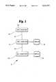
- FIG. 1shows a block diagram of the various components that comprise an interactive mapping system in accordance with the preferred embodiment of the present invention.
- FIG. 2shows a flow chart of a GPS capture program of the present invention.
- FIGS. 3A and 3Bshow a flow chart of the process keyboard data portion of the GPS capture program of FIG. 2.
- a GPS receiver 12 receiverradio signals from positioning satellites and derives from these signals time, position and operating condition information.
- Position informationincludes latitude, longitude, altitude, and is associated with the time at which such a position fix was obtained.
- Operating condition informationincludes the identities of of the satellites being employed for the calculation of position, their respective signal to noise ratios (SNRs), the orbital parameters of the satellites, known as the ephemeras and almanac, and parameters indicating the probable uncertainty in the calculated position.
- SNRssignal to noise ratios
- GPS communication link 16Information from the GPS receiver 12 is sent to a GPS computer 14 through a GPS communication link 16 between the GPS receiver 12 and the GPS computer 14.
- the GPS communication link 16is a standard RS-232 serial line, but could be any of a variety of other communication means such as RS-422.
- a GPS capture program executing in the GPS computer 14processes position information received from the GPS receiver 12, displays the position information on a display screen 18 numerically, graphically, or both, and sends the position information to a second communication port 20.
- This communication port 20is also a standard RS-232 serial line, or other communication means, and is connected to a GIS computer 22.
- the GIS computer 22includes a display screen 24, and executes a standard GIS database management program.
- GIS database programsare typically used with manual information entry methods such as digitizing tablets, and thus it is advantageous for the GPS computer 14 to communicate with the GIS computer 22 in a manner that emulates a digitizing tablet. In this way, information can be entered into the GIS database without manual intervention being required.
- both the GPS capture program and the GIS database programcould be run on a single computer under a multi-tasking operating system such as UNIX®. Communication between the programs would be via a shared file, an inter-program data exchange path, or other methods as known in the art. In this way, both programs would execute on a single physical computer due to the ability of the multi-tasking operating system to simulate the action of two or more separate computers.
- a multi-tasking operating systemsuch as UNIX®.
- the capture programbegins by checking whether incoming GPS data has been received through the GPS communication port at step 32. If GPS data has been received through the GPS communication port at step 32. If GPS data is present, the data is interpreted as to its respective type, and is displayed, stored, or transmitted in a manner as described below. If no GPS data is present, then the program checks for keyboard data, also as described below.
- the programWhen GPS data is detected by the program at the communication port at step 32, the program builds the data into a string until a complete packet of information is received at step 38. Next the program checks the type of information contained in this packet and processes it according to its type. If position data has been received at step 40, the position data is saved to the GPS data file at step 42 along with its time stamp, the screen display is updated at step 44, and according to the operator's selection of program parameters, may emulate a digitizer at step 46, allowing the GPS data to be converted and sent to a GIS database at step 48 in a manner to be described below. In the event that real time GIS interaction is not desired, the GPS program loops back to the beginning to repeat the process. If the packet does not contain position data at step 40, it contains operating condition data, which is displayed and/or stored at step 50 according to the operator's selection of program parameters. The program then loops back to the beginning as above.
- various operating condition dataare treated differently, with satellite selection and dilution of precision data (measures of positional uncertainty) being both displayed and stored, ephemeras data being stored but not displayed, velocity, GPS system time, and mode of position fix calculation being displayed but not stored, and command acknowledgments being neither displayed nor stored.
- precision datameasures of positional uncertainty
- ephemeras databeing stored but not displayed
- velocity, GPS system time, and mode of position fix calculationbeing displayed but not stored
- command acknowledgmentsbeing neither displayed nor stored.
- the programchecks to see whether data has been received from the keyboard at step 34, which would indicate to the program that attribute data or command data is being entered.
- attribute datais virtually unlimited, depending only upon the desired features to be included in the map. Typical examples include the names of geographic features being traversed, their descriptions (such as addresses or other observable descriptors), the beginning and ending points of line-type features, the presence of point-type features (such as manholes, fire hydrants and pavement defects), and the character of area-type features (such as soils, crops, and land usage).
- Attribute informationis processed and stored at step 36 together with its respective type information, and the position and time at which the attribute information was received in the GPS attribute file. Entry of an attribute may also define the extent or location of a GIS entity. For example, if a "fire hydrant" attribute is entered, the attribute is stored as described above. In addition, a point-type entity is created in the GIS database through the digitizer emulation interface 46, 48, and to which the attribute will be attached in the database. If mapping city streets, a "node" attribute is inserted at every intersection. The node entry causes the current line-type entity to be terminated, and informs the GIS database that subsequent position information will be part of a new line-type entity.
- Command datacomprises directives regarding operation of the GPS capture program, such as starting and stopping of GPS capture operation, names of files to employ, aspects of captured data to be displayed to the operator, and any other matters necessary to the operation of the program in accord with the wishes of the operator. Commands are executed by the program at step 36, and since there is no digitizing associated with command execution 46, the program returns to the start position (or may terminate, depending upon the specific command executed).
- Character data received from the keyboardis classified as to the category of key pressed: text keys, cursor control keys, control keys or function keys.
- any cursor control characters received at step 70cause an adjustment to the position of the text entry cursor within the text string being constructed, so as to allow editing of the text string at step 80 in a manner known in the art.
- An escape character ( ⁇ ESC>) at step 72terminates string entry without saving any attribute information.
- the programUpon completion of the line of attribute text, the program asks the operator to indicate the type of entity at step 74 to which the attribute just entered is to apply.
- An entityis a graphical element stored in a GIS database, and entity types include arcs (linear or segmented linear entity), points, polygons (an area enclosed by linear or segmented linear entities), nodes (an endpoint of a linear or segmented linear entity), and comments (an annotation applying to no particular GIS entity).
- the entity typehaving been received, the program asks the operator for the data base field destination at step 76, which is the number of the column in the attribute database into which the particular text item is to be placed in constructing the attribute database entry regarding the present GIS entity. This having been received, the program then builds and stores an attribute data packet.
- the information contained within the packetincludes the geographic position at the time of attribute creation, the time of attribute creation, the text of the attribute item, the entity type, the database field destination code, and an identifying attribute serial number.
- the data packetis then saved in a GPS data file, an attribute data file, or both, as determined by program operating parameters.
- the attribute input meansmay be a measuring instrument measuring some aspect of the conditions at various intervals along the path to be mapped, which transmits these as digital values to the GPS capture program. The GPS capture program then records these as attributes along the path being mapped.
- the attribute input meansmay be a voice encoding device which translates spoken words into digitally encoded text, which is then transmitted to the GPS capture program. Again, the GPS capture program records these as attributes along the path being mapped.
- attribute shorthandsmay be prepared in advance and assigned to function keys, allowing most or all of certain attribute information to be entered with a single keystroke.
- Function key assignmentsare defined in a function key definition table, and may include attribute text, entity type, database field destination, and may also include a numerical variable which may be automatically incremented or decremented on each successive attribute entry by a predetermined amount.
- the programWhen a function key is received at step 80, the program reads the function key definition corresponding to the pressed function key from the function key definition table at step 82. The attribute is then saved in the GPS data file or attribute data file at step 84 according to the definition in the function key definition table.
- a shorthand symbol such as "[1]"is placed in the function key definition string, and indicates to the program that a number is required from the operator, and that the program is to offer a prompting value to the operator equal to the previous entry increased by one. If the operator should then respond with the minus key, the program should then decrease the number, and upon subsequent uses of that function key offer the previous entry decreased by one, so that when the highway is traveled in either the direction of increasing or decreasing milepost, the most likely next value is always offered as a prompt.
- ⁇ ctrl>Acauses the program to display the amount of remaining space available on the current data storage disc
- ⁇ ctrl>Bcauses the program to refresh the display of the map background
- ⁇ ctrl>Dcauses the program to display the map graphically on the full screen, omitting the numerical information heading, or to return to the shared numerical and graphical display, and so forth
- ⁇ ctrl>Fcauses the function key definition table to be displayed and changes to be accepted.
- the control character ⁇ ESC>the program loop is suspended and the command menu system is activated to allow the operator to alter program parameters, or to terminate the program.
- keyboard processingdepend upon the GIS database being used, and the specific application of the mapping system. Many variations may be made, including control character assignment and function key assignment, without departing from the scope of the present invention. In addition, the types of entities may vary, depending upon the GIS database being used.
- GPS datais in the form of point coordinates. While some map features may indeed be "points" (such as a fire hydrant), map features are more typically lines or areas (such as streets or open areas). It is therefore necessary to treat a set of GIS points in such a way as to create the appropriate graphical entity when entered into the GIS database.
- the preferred embodimentuses the ARC/INFO GIS database system, with the GPS program emulating a Calcomp 9000 series digitizing tablet.
- point type entitiestheir creation is accomplished in the preferred embodiment of the present invention simply by entry of an attribute of point type with or without accompanying text. This is because the entry of an attribute includes the coordinates at the time attribute entry which, along with the entity type code, is sufficient to define the presence of a point-type entity in the GIS database. Normally, however, text describing the type of geographic object represented by the point accompanies the coordinates so that in the GIS various classes of point type features may be represented simultaneously in a single map without confusion.
- manholes, light poles, fire hydrants and street signsare all point-type entities, and could be present in a GIS map database, distinguished either by a word or by code numbers, and plotted on the resultant map with distinct symbols automatically selected to correspond with the code word or numbers.
- linear type entitiestheir creation is accomplished in the preferred embodiment of the present invention by collecting a series of position fixes while traveling along the path of the geographic feature to be represented, such as a street or river, and entering a node type attribute when the end of the entity is reached. This is sufficient to define the entity because the starting point of the traverse may be presumed to be the intended starting point of the entity, and the entry of a node type attribute forces the system to indicate to the GIS that the entity has ended, and that the next point transmitted will belong to a different entity.
- the start and end of the entityare indicated by prefixing the coordinates by a node code 2D.
- the GPS programsaves the entity information in a GIS entity file, indicating the start and end of entities by using a delimiter as may be conventional according to the specific GIS database employed. For example, when constructing ARC/INFO entity files, the entity delimiter is indicated an END line stored in the file.
- linear entitiesmay be described by one or more attribute items, which in the preferred embodiment of the present invention may be entered by the operator at any time between the beginning and ending nodes of the entity. This is sufficient because the attributes of a linear entity apply to the entire entity, rather than to specific points within it.
- the entityis assigned an identifying serial number, and the attributes of linear type acquired between the beginning and ending nodes of the entity are collected together into a single line of information according to the respective database field destination code numbers associated with the various attribute entries, and this line of information is assigned the same identifying number as the entity so that the entity and attribute information are respectively associated.
- linear entitiesare connected to one another, as for example blocks of a particular road may be described as having different address attributes, but are nonetheless continuous with one another. Therefore in the preferred embodiment of the automated mapping system, the entry of a node type entity causes both the ending of one linear entity and the beginning of the next linear entity simultaneously. If linear entities are not of interest, or if a segment traversed does not pertain to any feature of interest, the recording of linear type data may also be paused by the operator by entering the control character ⁇ ctrl>P command.
- Area entitiescannot be entered into the ARC/INFO GIS database directly, but rather the boundary of the entity must be defined by one or more linear entities, which may be created by automated mapping or by conventional GIS data entry means. Post processing by the GIS program causes the area entity to be created. Assignment of attributes to area entities requires that descriptive information be associated with a point which is within the boundaries of that entity. If the boundaries of the entity are created in the GIS by means other than the automated mapping system, or with a separate session with the automated mapping system, then ascription of attribute information to the area type entity may be accomplished by moving to a position within the geographic feature of interest and entering one or more area type attributes with a common identifying number and proper assignment to respective database field destinations. In the creation of GIS database files the attribute entries will be collected into a single line according to the identifying number and the respective field destinations, and the GIS database will recognize that the label point within that area describes the attributes of the area entity.
- the preferred embodiment of the present inventionpermits the operator to indicate that the location of an area type attribute is offset from the actual location of the automated mapping system by some distance given by the operator and in a relative direction either according to the compass, or according to the right or left of the direction of travel of the mapping system. This offset is applied to the coordinates associated with the attribute, so that when the data stored are transformed into GIS data files, there is no ambiguity as to the area to which the attribute applies.
- Annotations not associated with any particular spatial entitymay also be entered into the GIS database.
- the automated mapping systemrecords the text of that annotation along with the coordinates and time at which it was entered, and a type code indicating that it is of annotation type.
- itis translated into the annotation layer of the GIS database which contains only text, or may be used by the operator as an aid to memory, but not entered into the GIS database at all.
- this type of informationmay include supplemental observations, notes as to difficulties encountered, and so forth.
- the GPS capture programPrior to initiating a GIS data capture session, certain setup procedures are required.
- the GPS capture programtransmits coordinates relating to the approximate boundaries of the area to be mapped, and numerical coordinates of convenience establishing reference tic marks to be included in the GIS database for alignment of various map datasets as is conventional to the practice of digitization of map data for GIS databases. These values are established by the operator entering them into the program prior to initiation of digitizer emulation, and are preferred to be saved by the GPS capture program from session to session so as to minimize repetitive entry.
- the GPS capture programtransmits a line of data in the form of
- the 2D prefixindicates that the coordinates x and y are the coordinates of a node point.
- the GPS capture programtransmits a line of data in the form of
- the 1D prefixindicates that the coordinates x and y are the coordinates of a vertex point.
- the GPS capture programtransmits a line of data in the form of
- the 0D prefixindicates that no entity is to be created, but that the cursor is to be moved.
- the coordinatesare transmitted in degrees of longitude as x and latitude as y, in decimal value with preferably at least six significant digits after the decimal point, whether the decimal point is implicit as in the preferred embodiment or explicit in alternate embodiments.
- the digitizer input programis unable to accept negative values for coordinates, therefore in the western or southern hemispheres where conventionally coordinate values of longitude or latitude respectively are represented as negative, the GPS capture program transmits only the absolute values of the coordinates, and the operator informs the GIS database program of the actual quadrant of the globe represented, so that the GIS database is constructed with appropriately signed coordinates.
- this correction of coordinate signis performed as a separate process subsequent to collection of digitizer information, and is a conventional activity known in that art.
- the automated mapping system of the preferred embodimentgraphically displays the paths travelled by the system to the operator, and adds each newly received coordinate point to the display as it is received.
- the systemIn the event that the system is transported to a point which is outside the boundary of the graphic image displayed on the display screen, the system recalculates the boundaries of the area to be displayed so that the new position is located in the center of the display, and redraws the map image.
- This background map informationmay derive from previous automatic mapping activity, or from GIS information obtained by traditional GIS information gathering means such as digitization of paper map documents.
- the automated mapping systemthus provides the operator with the ability, through the menu command system, to cause a GPS map data file or a GIS map data file to be graphically displayed on the screen as background to the display of currently collected data.
- the background display boundariesare also automatically recalculated and the map image redrawn.
- this redrawing featuremay be disabled by execution of program control commands.
- the preferred embodiment described abovecontemplates the installation of the entire system within a vehicle.
- the entire systemcould be manually carried, or otherwise transported along the path to be mapped without departing from the scope of the invention.
- the GPS receivercould be carried along the path to be mapped, with the remainder of the system remaining at the lab or office, and GPS information relayed from the receiver to the GPS computer by way of radio or mobile telephone communication.
Landscapes
- Engineering & Computer Science (AREA)
- Remote Sensing (AREA)
- Physics & Mathematics (AREA)
- Radar, Positioning & Navigation (AREA)
- General Physics & Mathematics (AREA)
- Theoretical Computer Science (AREA)
- Geometry (AREA)
- Automation & Control Theory (AREA)
- Software Systems (AREA)
- Computer Graphics (AREA)
- Mathematical Physics (AREA)
- Business, Economics & Management (AREA)
- Educational Administration (AREA)
- Educational Technology (AREA)
- Information Retrieval, Db Structures And Fs Structures Therefor (AREA)
- Instructional Devices (AREA)
- Position Fixing By Use Of Radio Waves (AREA)
Abstract
Description
This is a continuation of application Ser. No. 07/564,018 filed Aug. 7, 1990, now abandoned.
The present invention pertains to the creation and generation of maps of geographic features. In particular, this invention pertains to an automated mapping system which utilizes global positioning satellite information to generate or update a geographic information database in real time, or to collect and store in real time positioning and other geographic information for subsequent automatic creation or updating of a geographic information database.
Creation and update maintenance of maps has traditionally been an expensive and time consuming process. Hand-drawn maps generated from manual survey information are expensive to produce and difficult to maintain and correct. Every feature of the geographic area to be mapped must be surveyed, generating enormous quantities of information. This information is then analyzed, and map drawings corresponding to the survey information are created. Since the survey information is gathered manually, there is ample opportunity for the introduction of errors, such as by erroneous recording of survey information by the surveyors or misinterpretation of survey information by the map drawers. In the event that an error is introduced into a map, that portion of the map containing the error must be manually redrawn, which in itself is a time consuming and expensive process. This is equally true of changes in the geographic area resulting, for example, from changes in street location or direction.
Some of these inefficiencies in the map generation and maintenance process are addressed through the use of a Geographic Information System (GIS) such as ARC/INFO, which is a commonly used geographic information database system, or a Computer Aided Drafting (CAD) system employed for cartography. ARC/INFO provides storage management for both graphical and tabular information. From such a database, maps of geographic areas can be displayed on a computer screen, or can be printed on a computer printer or plotter.
In a Geographic Information System, geographic features such as roads, boundaries, and other spatially dispersed objects are represented within the system as symbolic entities described by one or more sets of coordinates and descriptive information regarding the attributes of the geographic feature represented. These symbolic entities may be generally classified into the following types: point entities, linear entities (including line segments or contiguous groups of line segments referred to in the art as arcs or polylines), area entities (areas bounded by linear entities, referred to in the art as polygons), and annotative entities (text information not attached to a particular spatial entity, although located on the map at a particular spatial coordinate).
The use of ARC/INFO and other GIS or CAD systems has greatly eased the task of maintaining an existing map of a geographic area by automating the process of drawing a map from the survey data. However, use of such a system does not address the inefficiencies involved in obtaining the survey information in the first place. If traditional manual survey techniques are used, the information obtained in the survey must still be manually entered into a computer for inclusion in the GIS database. Besides being tedious, time consuming, and expensive, this process is fraught with the potential for erroneous input of data.
An alternate survey technique involves the use of aerial photography of the geographic area to be mapped, followed by the digitization of the information from the photographs into the database. This process is more efficient than manual survey techniques in that aerial photography gathers information in photographic form quickly, and the digitization process eliminates much of the manual entry of information. However, digitization of aerial photographs still involves the manual effort of tracing the geographic features to be mapped on the photographs, and still requires a substantial expenditure of time and effort. In addition, the aerial method is ill suited to annotation of existing maps with attribute information such as the location of fire hydrants, or street addresses since this information is not readily discernable from an aerial photograph.
A more recent technology capable of increased efficiency over traditional survey techniques involves the use of Global Positioning Satellites (GPS). These satellites can be used with an appropriate GPS receiver to determine the location of the receiver in latitude, longitude, and altitude. By placing such a receiver in a vehicle, a path to be mapped can be driven by the vehicle, with the GPS receiver capturing position information at specified time intervals along the path. In this way, information can be quickly obtained on the location of points along the path, and such information can be used for the generation of maps. Unfortunately, the information obtained from a GPS receiver is not in a form which is usable by a GIS database manager such as ARC/INFO. Prior art system have solved this problem by having the surveyors return to the laboratory or office with the captured GPS data, and executing a computer program which converts the data from the GPS format to a GIS format.
While the above improvements to traditional mapping techniques have significantly increased the efficiency of map creation and maintenance, several inefficient and cumbersome areas remain. For example, existing GPS systems process captured GPS data after returning from the field. If after processing the data into the GIS database it is learned that additional information is needed, a second trip to the field is necessary to gather the missing information. This could occur, for example, during the mapping of city streets if the surveyors fail to travel down all of the streets in the survey area.
In addition, prior art GPS data systems store only location and time information. Mapping involves much more than merely plotting the location of streets or paths. Other geographic features are often equally important, such as street addresses, the locations of fire hydrants or street signs, or any other information which could conceivably be included in a map. There is no facility in existing GPS systems for annotating or updating an existing map database with new attribute information.
Another difficulty with present GPS systems is the lack of a real time operator interface with the system. For example, when mapping a complicated grid of paths such as that formed by city streets, it is necessary to keep track of where the mapping vehicle has been in order to avoid retracing paths and to ensure that no paths are missed. It is difficult and inconvenient to manually keep track of the traced path, and existing GPS data capture systems provide no facility for automatically documenting traced paths and displaying this information to the operator.
In accordance with the present invention, an automated and real time interactive mapping system is provided, in which a GPS receiver is used to capture position information as the receiver is moved along the path to be mapped, and wherein the captured information is provided as input to a GIS database in real time and without operator intervention. Attribute data is also gathered in real time for subsequent inclusion in the GIS database, or may be entered directly into the GIS database in real time if the particular GIS database employed will so allow.
The interactive mapping system of the present invention uses a GPS receiver for receiving signals from global positioning satellites, a computer connected to the GPS receiver for storing incoming GPS position information, and a second computer connected to the first computer which executes a GIS database program and receives information in real time from the GPS computer.
Mapping a geographic area involves installing the interactive mapping system into a vehicle, and driving the vehicle over a particular path to be mapped. Alternately, the system could be carried or otherwise transported along the path to be mapped. At regular intervals, the GPS receiver sends data packets to the GPS computer which contain position information as derived through communications with the global positioning satellites. This information can be stored in a raw data file on the GPS computer, and can also be processed into a form for use by the GIS database.
The GIS database is managed by any one of a number of commonly available geographic information database programs such as ARC/INFO, wherein the database is capable of storing both graphical and tabular data. A common means of data entry into a GIS database is via a digitizer tablet. In the present invention, the GIS database program is instructed to accept digitizer input, and the GPS computer converts captured GPS data into appropriate GIS entities for inclusion in the GIS database, and enters them into the GIS database by emulating a digitizer.
In addition to using the system of the present invention for creating new maps, an existing map in the GIS database can be annotated by displaying the existing map as a background while the path being travelled is displayed in the foreground using the GPS. Attributes are gathered in real time to be post processed into the GIS database at a later time. The forground display provides a real-time display of what portions of the existing map have been travelled.
Accordingly, it is an object of the present invention to provide a system and method for automatically creating or updating a geographic information database by capturing GPS position information using a mobile GPS receiver and generating appropriate GIS information in real time as the geographic feature is travelled.
Another object of the present invention is to convert captured GPS position information into signals emulating a conventional digitizer, thereby allowing real-time creation or update of a GIS database.
Yet another object of the present invention is to provide a real-time display of the path followed by the receiver as it is moved along the area to be mapped.
A further object of the present invention is to provide a facility for real-time capture of geographic attributes to be added to a new or pre-existing GIS map database.
These and other objectives of the present invention will become apparent with reference to the drawings, the detailed description of the preferred embodiment, and the appended claims.
FIG. 1 shows a block diagram of the various components that comprise an interactive mapping system in accordance with the preferred embodiment of the present invention.
FIG. 2 shows a flow chart of a GPS capture program of the present invention.
FIGS. 3A and 3B show a flow chart of the process keyboard data portion of the GPS capture program of FIG. 2.
Referring now to FIG. 1, anautomated mapping system 10 is shown according to the preferred embodiment of the present invention. AGPS receiver 12 receiver radio signals from positioning satellites and derives from these signals time, position and operating condition information. Position information includes latitude, longitude, altitude, and is associated with the time at which such a position fix was obtained. Operating condition information includes the identities of of the satellites being employed for the calculation of position, their respective signal to noise ratios (SNRs), the orbital parameters of the satellites, known as the ephemeras and almanac, and parameters indicating the probable uncertainty in the calculated position.
Information from theGPS receiver 12 is sent to aGPS computer 14 through aGPS communication link 16 between theGPS receiver 12 and theGPS computer 14. In the preferred embodiment, theGPS communication link 16 is a standard RS-232 serial line, but could be any of a variety of other communication means such as RS-422. A GPS capture program executing in theGPS computer 14 processes position information received from theGPS receiver 12, displays the position information on adisplay screen 18 numerically, graphically, or both, and sends the position information to asecond communication port 20. Thiscommunication port 20 is also a standard RS-232 serial line, or other communication means, and is connected to aGIS computer 22. TheGIS computer 22 includes adisplay screen 24, and executes a standard GIS database management program.
GIS database programs are typically used with manual information entry methods such as digitizing tablets, and thus it is advantageous for theGPS computer 14 to communicate with theGIS computer 22 in a manner that emulates a digitizing tablet. In this way, information can be entered into the GIS database without manual intervention being required.
In an alternate embodiment, both the GPS capture program and the GIS database program could be run on a single computer under a multi-tasking operating system such as UNIX®. Communication between the programs would be via a shared file, an inter-program data exchange path, or other methods as known in the art. In this way, both programs would execute on a single physical computer due to the ability of the multi-tasking operating system to simulate the action of two or more separate computers.
Referring now to FIG. 2, a flow chart of aGPS capture program 30 executing on theGPS computer 14 is shown. In the preferred embodiment of the present invention, the capture program begins by checking whether incoming GPS data has been received through the GPS communication port atstep 32. If GPS data has been received through the GPS communication port atstep 32. If GPS data is present, the data is interpreted as to its respective type, and is displayed, stored, or transmitted in a manner as described below. If no GPS data is present, then the program checks for keyboard data, also as described below.
When GPS data is detected by the program at the communication port atstep 32, the program builds the data into a string until a complete packet of information is received atstep 38. Next the program checks the type of information contained in this packet and processes it according to its type. If position data has been received atstep 40, the position data is saved to the GPS data file atstep 42 along with its time stamp, the screen display is updated atstep 44, and according to the operator's selection of program parameters, may emulate a digitizer atstep 46, allowing the GPS data to be converted and sent to a GIS database atstep 48 in a manner to be described below. In the event that real time GIS interaction is not desired, the GPS program loops back to the beginning to repeat the process. If the packet does not contain position data atstep 40, it contains operating condition data, which is displayed and/or stored atstep 50 according to the operator's selection of program parameters. The program then loops back to the beginning as above.
In normal operation of the preferred embodiment of this invention, various operating condition data are treated differently, with satellite selection and dilution of precision data (measures of positional uncertainty) being both displayed and stored, ephemeras data being stored but not displayed, velocity, GPS system time, and mode of position fix calculation being displayed but not stored, and command acknowledgments being neither displayed nor stored. Those skilled in the art will recognize that the treatment of operating condition data is not critical to the operation of the present invention, but may be varied according to specific requirements, while remaining within the scope of the present invention.
If no GPS data is present atstep 32, the program checks to see whether data has been received from the keyboard atstep 34, which would indicate to the program that attribute data or command data is being entered. The type of attribute data is virtually unlimited, depending only upon the desired features to be included in the map. Typical examples include the names of geographic features being traversed, their descriptions (such as addresses or other observable descriptors), the beginning and ending points of line-type features, the presence of point-type features (such as manholes, fire hydrants and pavement defects), and the character of area-type features (such as soils, crops, and land usage).
Attribute information is processed and stored atstep 36 together with its respective type information, and the position and time at which the attribute information was received in the GPS attribute file. Entry of an attribute may also define the extent or location of a GIS entity. For example, if a "fire hydrant" attribute is entered, the attribute is stored as described above. In addition, a point-type entity is created in the GIS database through thedigitizer emulation interface GIS database 48, the program returns to the start position and resumes checking for GPS data from the GPS communication port atstep 32.
Command data comprises directives regarding operation of the GPS capture program, such as starting and stopping of GPS capture operation, names of files to employ, aspects of captured data to be displayed to the operator, and any other matters necessary to the operation of the program in accord with the wishes of the operator. Commands are executed by the program atstep 36, and since there is no digitizing associated withcommand execution 46, the program returns to the start position (or may terminate, depending upon the specific command executed).
Referring now to FIG. 3, a flow chart of the keyboard data processing portion atstep 36 of theGPS capture program 30 is shown. Character data received from the keyboard is classified as to the category of key pressed: text keys, cursor control keys, control keys or function keys.
If a text character is detected, the data received is interpreted as belonging to the descriptive text portion of an attribute to be entered in the database. Therefore, the program proceeds to accept characters atstep 62 and poll for keyboard entry atstep 64 as long as text characters are entered atstep 66. Completion of a line of text is signaled by the receipt of a carriage return character atstep 68. During this process, any cursor control characters received atstep 70 cause an adjustment to the position of the text entry cursor within the text string being constructed, so as to allow editing of the text string atstep 80 in a manner known in the art. An escape character (<ESC>) atstep 72 terminates string entry without saving any attribute information.
Upon completion of the line of attribute text, the program asks the operator to indicate the type of entity atstep 74 to which the attribute just entered is to apply. An entity is a graphical element stored in a GIS database, and entity types include arcs (linear or segmented linear entity), points, polygons (an area enclosed by linear or segmented linear entities), nodes (an endpoint of a linear or segmented linear entity), and comments (an annotation applying to no particular GIS entity). The entity type having been received, the program asks the operator for the data base field destination atstep 76, which is the number of the column in the attribute database into which the particular text item is to be placed in constructing the attribute database entry regarding the present GIS entity. This having been received, the program then builds and stores an attribute data packet. The information contained within the packet includes the geographic position at the time of attribute creation, the time of attribute creation, the text of the attribute item, the entity type, the database field destination code, and an identifying attribute serial number. The data packet is then saved in a GPS data file, an attribute data file, or both, as determined by program operating parameters.
In an alternate embodiment of the present invention, the attribute input means may be a measuring instrument measuring some aspect of the conditions at various intervals along the path to be mapped, which transmits these as digital values to the GPS capture program. The GPS capture program then records these as attributes along the path being mapped. In another alternate embodiment of the present invention, the attribute input means may be a voice encoding device which translates spoken words into digitally encoded text, which is then transmitted to the GPS capture program. Again, the GPS capture program records these as attributes along the path being mapped.
One difficulty with manual typing of attribute information, is that depending upon the attributes being captured and how frequently they occur, the typing speed of the operator may place a limit on how fast the vehicle containing the mapping system may travel along the path to be mapped. For example, if the attributes to be captured were the street addresses of every house on a typical city block, the vehicle would have to drive very slowly in order to allow the operator to manually type in the address of each house as it is passed by the vehicle. In order to alleviate this problem, attribute shorthands may be prepared in advance and assigned to function keys, allowing most or all of certain attribute information to be entered with a single keystroke. Function key assignments are defined in a function key definition table, and may include attribute text, entity type, database field destination, and may also include a numerical variable which may be automatically incremented or decremented on each successive attribute entry by a predetermined amount.
When a function key is received atstep 80, the program reads the function key definition corresponding to the pressed function key from the function key definition table atstep 82. The attribute is then saved in the GPS data file or attribute data file atstep 84 according to the definition in the function key definition table.
In practical operation of the creation of GIS map databases, it often occurs that attributes are highly similar within a particular mapping project and therefore only part of the information changes from entry to entry, therefore, special codes may be embedded within the function key text definition which cause the program to prompt the operator for specific types of information which constitute the variable position of the attribute information. For example, addresses along the street are all different whereas the name of the street is constant, therefore the text may contain the name of the street traversed, along with a "#" symbol which causes the program to ask the operator for the numerical address, while freeing him from repetitive typing of the street name. As a further example, along the highways, mile posts are normally numbered sequentially. Therefore a shorthand symbol such as "[1]" is placed in the function key definition string, and indicates to the program that a number is required from the operator, and that the program is to offer a prompting value to the operator equal to the previous entry increased by one. If the operator should then respond with the minus key, the program should then decrease the number, and upon subsequent uses of that function key offer the previous entry decreased by one, so that when the highway is traveled in either the direction of increasing or decreasing milepost, the most likely next value is always offered as a prompt.
If a control character is received, the program executes a command function that has previously been assigned to that control character. For example, in the preferred embodiment of the present invention, <ctrl>A causes the program to display the amount of remaining space available on the current data storage disc, <ctrl>B causes the program to refresh the display of the map background, <ctrl>D causes the program to display the map graphically on the full screen, omitting the numerical information heading, or to return to the shared numerical and graphical display, and so forth, and <ctrl>F causes the function key definition table to be displayed and changes to be accepted. In the special case of the control character <ESC> the program loop is suspended and the command menu system is activated to allow the operator to alter program parameters, or to terminate the program.
Those skilled in the art will recognize that the details of keyboard processing depend upon the GIS database being used, and the specific application of the mapping system. Many variations may be made, including control character assignment and function key assignment, without departing from the scope of the present invention. In addition, the types of entities may vary, depending upon the GIS database being used.
Referring again to FIG. 2, some details concerning the process of converting GPS data into a GIS usable form atstep 48 will be discussed. All GPS data is in the form of point coordinates. While some map features may indeed be "points" (such as a fire hydrant), map features are more typically lines or areas (such as streets or open areas). It is therefore necessary to treat a set of GIS points in such a way as to create the appropriate graphical entity when entered into the GIS database. The preferred embodiment uses the ARC/INFO GIS database system, with the GPS program emulating a Calcomp 9000 series digitizing tablet.
In the case of point type entities, their creation is accomplished in the preferred embodiment of the present invention simply by entry of an attribute of point type with or without accompanying text. This is because the entry of an attribute includes the coordinates at the time attribute entry which, along with the entity type code, is sufficient to define the presence of a point-type entity in the GIS database. Normally, however, text describing the type of geographic object represented by the point accompanies the coordinates so that in the GIS various classes of point type features may be represented simultaneously in a single map without confusion. For example, manholes, light poles, fire hydrants and street signs are all point-type entities, and could be present in a GIS map database, distinguished either by a word or by code numbers, and plotted on the resultant map with distinct symbols automatically selected to correspond with the code word or numbers.
In the case of linear type entities, their creation is accomplished in the preferred embodiment of the present invention by collecting a series of position fixes while traveling along the path of the geographic feature to be represented, such as a street or river, and entering a node type attribute when the end of the entity is reached. This is sufficient to define the entity because the starting point of the traverse may be presumed to be the intended starting point of the entity, and the entry of a node type attribute forces the system to indicate to the GIS that the entity has ended, and that the next point transmitted will belong to a different entity. When transmitting data to the ARC/INFO GIS by emulation of a digitizing tablet, the start and end of the entity are indicated by prefixing the coordinates by a node code 2D. In the event that real time GIS interaction is not desired, the GPS program saves the entity information in a GIS entity file, indicating the start and end of entities by using a delimiter as may be conventional according to the specific GIS database employed. For example, when constructing ARC/INFO entity files, the entity delimiter is indicated an END line stored in the file.
Normally, linear entities may be described by one or more attribute items, which in the preferred embodiment of the present invention may be entered by the operator at any time between the beginning and ending nodes of the entity. This is sufficient because the attributes of a linear entity apply to the entire entity, rather than to specific points within it. When constructing GIS database files, the entity is assigned an identifying serial number, and the attributes of linear type acquired between the beginning and ending nodes of the entity are collected together into a single line of information according to the respective database field destination code numbers associated with the various attribute entries, and this line of information is assigned the same identifying number as the entity so that the entity and attribute information are respectively associated.
In typical mapping, linear entities are connected to one another, as for example blocks of a particular road may be described as having different address attributes, but are nonetheless continuous with one another. Therefore in the preferred embodiment of the automated mapping system, the entry of a node type entity causes both the ending of one linear entity and the beginning of the next linear entity simultaneously. If linear entities are not of interest, or if a segment traversed does not pertain to any feature of interest, the recording of linear type data may also be paused by the operator by entering the control character <ctrl>P command.
Area entities cannot be entered into the ARC/INFO GIS database directly, but rather the boundary of the entity must be defined by one or more linear entities, which may be created by automated mapping or by conventional GIS data entry means. Post processing by the GIS program causes the area entity to be created. Assignment of attributes to area entities requires that descriptive information be associated with a point which is within the boundaries of that entity. If the boundaries of the entity are created in the GIS by means other than the automated mapping system, or with a separate session with the automated mapping system, then ascription of attribute information to the area type entity may be accomplished by moving to a position within the geographic feature of interest and entering one or more area type attributes with a common identifying number and proper assignment to respective database field destinations. In the creation of GIS database files the attribute entries will be collected into a single line according to the identifying number and the respective field destinations, and the GIS database will recognize that the label point within that area describes the attributes of the area entity.
However, in the case that an area entity is to be assigned attributes while in the same automated mapping session during which the bounding linear entities are simultaneously being created by a traverse of the perimeter of the area entity or a portion of the perimeter, the points traversed will not be clearly ascribed to either the area on the right nor the area on the left of the path traversed. Assignment of the attribute would then be ambiguous as to which area was being described. In order to resolve this ambiguity, the preferred embodiment of the present invention permits the operator to indicate that the location of an area type attribute is offset from the actual location of the automated mapping system by some distance given by the operator and in a relative direction either according to the compass, or according to the right or left of the direction of travel of the mapping system. This offset is applied to the coordinates associated with the attribute, so that when the data stored are transformed into GIS data files, there is no ambiguity as to the area to which the attribute applies.
Annotations not associated with any particular spatial entity may also be entered into the GIS database. The automated mapping system records the text of that annotation along with the coordinates and time at which it was entered, and a type code indicating that it is of annotation type. In creation of GIS database files, it is translated into the annotation layer of the GIS database which contains only text, or may be used by the operator as an aid to memory, but not entered into the GIS database at all. For example, this type of information may include supplemental observations, notes as to difficulties encountered, and so forth.
Prior to initiating a GIS data capture session, certain setup procedures are required. The GPS capture program transmits coordinates relating to the approximate boundaries of the area to be mapped, and numerical coordinates of convenience establishing reference tic marks to be included in the GIS database for alignment of various map datasets as is conventional to the practice of digitization of map data for GIS databases. These values are established by the operator entering them into the program prior to initiation of digitizer emulation, and are preferred to be saved by the GPS capture program from session to session so as to minimize repetitive entry.
When a node point is to be transmitted, the GPS capture program transmits a line of data in the form of
2Dxxxxxxxxxxyyyyyyyyyy<cr>
in which the 2D prefix indicates that the coordinates x and y are the coordinates of a node point.
When a vertex point, being the endpoint of two adjacent segments within a segmented line-type entity (arc entity) or the label point of a point type entity or of an area type entity is to be transmitted, the GPS capture program transmits a line of data in the form of
1Dxxxxxxxxxxyyyyyyyyyy<cr>
in which the 1D prefix indicates that the coordinates x and y are the coordinates of a vertex point.
When the cursor of the GIS computer is to be moved to a point, but no entity is being created at that point, then the GPS capture program transmits a line of data in the form of
0Dxxxxxxxxxyyyyyyyyyyy<cr>
in which the 0D prefix indicates that no entity is to be created, but that the cursor is to be moved.
When other functions are assigned to digitizer keypad buttons, these are emulated by transmission of a line of data of the form
nD<cr>
in which the number n indicates which keypad button function is to be executed.
In the transmission of digitizer emulation data, the coordinates are transmitted in degrees of longitude as x and latitude as y, in decimal value with preferably at least six significant digits after the decimal point, whether the decimal point is implicit as in the preferred embodiment or explicit in alternate embodiments.
It will be noted that in certain commercial GIS database programs, the digitizer input program is unable to accept negative values for coordinates, therefore in the western or southern hemispheres where conventionally coordinate values of longitude or latitude respectively are represented as negative, the GPS capture program transmits only the absolute values of the coordinates, and the operator informs the GIS database program of the actual quadrant of the globe represented, so that the GIS database is constructed with appropriately signed coordinates. In certain commercial database programs this correction of coordinate sign is performed as a separate process subsequent to collection of digitizer information, and is a conventional activity known in that art.
While in the process of collecting data for the creation of new maps or for the updating of existing maps, it is helpful to the operator of the automated mapping system to see a graphic presentation of the previously travelled path or paths, in order to avoid omission of features or duplication of effort. Therefor, the automated mapping system of the preferred embodiment graphically displays the paths travelled by the system to the operator, and adds each newly received coordinate point to the display as it is received. In the event that the system is transported to a point which is outside the boundary of the graphic image displayed on the display screen, the system recalculates the boundaries of the area to be displayed so that the new position is located in the center of the display, and redraws the map image.
In addition to display of the currently collected path data, it is also helpful to the operator to view other map information as a supplemental background. This background map information may derive from previous automatic mapping activity, or from GIS information obtained by traditional GIS information gathering means such as digitization of paper map documents. The automated mapping system thus provides the operator with the ability, through the menu command system, to cause a GPS map data file or a GIS map data file to be graphically displayed on the screen as background to the display of currently collected data. Upon recalculation display area boundaries due to travel outside the boundaries, the background display boundaries are also automatically recalculated and the map image redrawn.
In the event that the operator does not desire the background map image or the currently collected foreground map image to be redrawn upon each recalculation of the boundaries of the viewed portion, as may occur if the operator finds this operation to be too slow, or finds the combined map image to be too complex, then this redrawing feature may be disabled by execution of program control commands.
The preferred embodiment described above contemplates the installation of the entire system within a vehicle. However, those skilled in the art will recognize that the entire system could be manually carried, or otherwise transported along the path to be mapped without departing from the scope of the invention. In addition, the GPS receiver could be carried along the path to be mapped, with the remainder of the system remaining at the lab or office, and GPS information relayed from the receiver to the GPS computer by way of radio or mobile telephone communication.
Although the description of the preferred embodiment has been presented, it is contemplated that various changes could be made without deviating from the spirit of the present invention. Accordingly, it is intended that the scope of the present invention be dictated by the appended claims, rather than by the description of the preferred embodiment.
Claims (10)
1. A mobile mapping system, comprising:
means for transporting the mapping system along a path to be mapped;
input means for capturing satellite based position information at various positions of the mapping system along the path to be mapped;
means for storing the position information;
means for entering and encoding attribute information into a plurality of attribute data packets, and recording the attribute data packets into the mapping system in real time as the input means is moved along the path to be mapped;
means for storing the attribute information;
means for representing a plurality of geographic features and the spatial relationships of the features through the encoding of graphical entities selected from a set of graphical entities including points, lines, arcs, polygons, and nodes, and relating the position information and the plurality of attributes to the graphical entities to further characterize and distinguish between the plurality of geographic features;
means for managing and organizing data in a geographic information system;
conversion means for conversion of the position information, the graphical entities, and the attribute information into a form for use by the geographic information system; and
means for accessing the position information, the graphical entities, and the attribute information in the geographic information system so that previously entered geographic information can be updated.
2. A mobile mapping system according to claim 1, further comprising display means for displaying in real time a graphical representation of captured position information and attribute information as the input means is moved along the path to be mapped.
3. A mobile mapping system in accordance with claim 1, further comprising means for assigning and relating attributes to graphical entities representing geographical area features located at a coordinated offset distance from the location of the transporting means.
4. A mobile mapping system, comprising:
means for transporting the mapping system along a path to be mapped;
input means for capturing satellite based position information at various positions along the path to be mapped;
first computing means connected to the input means comprising:
means for storing the position information;
means for conversion of the position information into a form for use by a geographic information system;
means for entering and encoding attribute information into a plurality of attribute data packets, and recording the attribute data packets into the mapping system in real time, wherein the attribute data packets are related to the position information;
means for storing the attribute information;
means for conversion of the attribute information into a form for use by the geographic information system; and
means for encoding entities symbolizing a plurality of geographic features and the spatial relationships of the features through the encoding of graphical entities selected from a set of graphical entities including points, lines, arcs, polygons, and nodes, and relating the position information and the plurality of attributes to the graphical entities to further characterize and distinguish between the plurality of geographical features; and
second computing means operably connected to the first computing means for receiving the position information, the graphical entities, and the attribute information from the first computing means and for storing the position information, the graphical entities, and the attribute information in the geographic information system.
5. In a mobile mapping system containing a computer, data storage, a geographic information system, a display, and a position sensor, a method for mapping comprising the steps of:
moving the position sensor along a path to be mapped, while sensing position at various intervals;
storing position information from the position sensor in data storage;
receiving attribute information entered in real time;
encoding attribute information into a plurality of data packets;
storing the attribute packets in data storage;
encoding graphical entities to represent a plurality of geographical features;
relating the position information and the plurality of attributes to the graphical entities;
converting the position information, the graphical entities, and the attribute information into a format for use by the geographic information system;
storing the position information, the graphical entities, and the attribute information in the geographic information system to create a new map; and
displaying the new map on the display so that the attribute information can be interactively entered in relation to the position information.
6. A mobile mapping system, comprising:
means for transporting the mapping system along a path to be mapped;
input means for capturing satellite based position information at various positions of the mapping system along the path to be mapped;
means for recording the position information;
means for managing and organizing data in a geographic information system;
means for encoding graphical entities to be mapped such as points, lines and polygons, symbolizing geographic feature types, including location, graphic and spatial relationships of the physical characteristics of geographic features;
means for entering and recording unlimited attribute information into the mapping system and relating the position and the attribute information to the graphical entities in real time as the input means is moved along the path to be mapped;
means for storing the attribute information; and
conversion means for real time conversion of the position information, the entities, and the attribute information into a form for use by the geographic information system to create a map while the transportable mapping system is transported along the path to be mapped.
7. A mobile mapping system according to claim 6, further comprising display means for displaying in real time a graphical representation of the captured position and the attribute information as the input means is moved along the path to be mapped.
8. In a mobile mapping system containing a computer, data storage, a display, and a position sensor, a method for updating a map comprising the steps of:
moving the position sensor along a path to be mapped, while sensing position at various intervals;
storing position information from the position sensor in data storage;
receiving attribute information entered in real time;
encoding attribute information into a plurality of data packets;
storing the attribute packets in data storage;
encoding graphical entities to represent a plurality of geographical features;
relating the position information and the plurality of attribute data packets to the graphical entities;
converting the position information, the graphical entities, and the attribute information into a format for use by a geographic information system;
sending the position information, the entities, and the attribute information to the geographic information system to update a previously created map; and
displaying on the display the updated map.
9. In a mobile mapping system containing an operator controlled computer, data storage, a geographic information system, a display, and a position sensor, a method for updating a map comprising the steps of:
displaying on the display a previously created map stored in the geographic information system;
moving the position sensor along a path to be mapped, while sensing position information at various intervals;
storing position information from the position sensor in data storage;
displaying on the display the position information by overlaying the position information on the previously created map;
encoding graphical entities to be mapped such as points, lines and polygons, symbolizing geographic feature types, including location, graphic and spatial relationships of the physical characteristics of geographic features;
storing the graphical entities in data storage;
receiving unlimited attribute information entered in real time;
relating the position information and attribute information to the graphical entities;
storing the attribute information in data storage;
displaying on the display the attribute information and the graphical entities by overlaying the attribute information and the graphical entities on the previously created map;
converting the position information, the graphical entities, and the attribute information into a format for use by the geographic information system; and
sending the position information, the graphical entities, and the attribute information to the geographic information system to update the previously created map.
10. In a mobile mapping system comprising an operator controlled computer, data storage, a geographic information system, a display, and a position sensor, a method for creating a map consisting of a plurality of entities comprising the steps of:
designating each entity and geographic feature of each entity to be mapped;
encoding entry commands with computer function keys;
collecting position information from the position sensor;
associating initial position information to an attribute corresponding to the time of the attribute creation;
entering textual attribute information describing each entity;
indicating a database field destination;
achieving the entry of the entity and attribute information with the computer function keys wherein an operator dialog is established for entry of the entity and attribute information which maintains correspondence with feature type and database field destination for each entry;
building attribute data packets comprising the geographic position at the time of the attribute creation with each attribute data packet comprising an identification number, text of attribute item, the entity type, and the database field destination code;
storing attribute data packets in data storage; and
converting the position information geographic feature and attribute data packets to a form for use by the geographic information system.
Priority Applications (1)
| Application Number | Priority Date | Filing Date | Title |
|---|---|---|---|
| US07/953,761US5214757A (en) | 1990-08-07 | 1992-09-29 | Interactive automated mapping system |
Applications Claiming Priority (2)
| Application Number | Priority Date | Filing Date | Title |
|---|---|---|---|
| US56401890A | 1990-08-07 | 1990-08-07 | |
| US07/953,761US5214757A (en) | 1990-08-07 | 1992-09-29 | Interactive automated mapping system |
Related Parent Applications (1)
| Application Number | Title | Priority Date | Filing Date |
|---|---|---|---|
| US56401890AContinuation | 1990-08-07 | 1990-08-07 |
Publications (1)
| Publication Number | Publication Date |
|---|---|
| US5214757Atrue US5214757A (en) | 1993-05-25 |
Family
ID=27073439
Family Applications (1)
| Application Number | Title | Priority Date | Filing Date |
|---|---|---|---|
| US07/953,761Expired - LifetimeUS5214757A (en) | 1990-08-07 | 1992-09-29 | Interactive automated mapping system |
Country Status (1)
| Country | Link |
|---|---|
| US (1) | US5214757A (en) |
Cited By (270)
| Publication number | Priority date | Publication date | Assignee | Title |
|---|---|---|---|---|
| WO1994028379A1 (en)* | 1993-05-28 | 1994-12-08 | Trimble Navigation Limited | Combined pc/104 and satellite positioning system |
| US5420795A (en)* | 1992-12-08 | 1995-05-30 | Greene; Leonard M. | Navigational system for determining and displaying the position of a vessel on a navigational chart |
| US5450344A (en)* | 1994-04-22 | 1995-09-12 | Trimble Navigation Limited | GPS receivers with data ports for the uploading and downloading of absolute position information |
| US5450329A (en)* | 1993-12-22 | 1995-09-12 | Tanner; Jesse H. | Vehicle location method and system |
| US5517419A (en)* | 1993-07-22 | 1996-05-14 | Synectics Corporation | Advanced terrain mapping system |
| US5524202A (en)* | 1991-03-01 | 1996-06-04 | Fuji Xerox Co., Ltd. | Method for forming graphic database and system utilizing the method |
| US5528248A (en)* | 1994-08-19 | 1996-06-18 | Trimble Navigation, Ltd. | Personal digital location assistant including a memory cartridge, a GPS smart antenna and a personal computing device |
| US5528518A (en)* | 1994-10-25 | 1996-06-18 | Laser Technology, Inc. | System and method for collecting data used to form a geographic information system database |
| US5539398A (en)* | 1994-01-07 | 1996-07-23 | Minnesota Mining And Manufacturing Company | GPS-based traffic control preemption system |
| US5557524A (en)* | 1991-10-18 | 1996-09-17 | Maki; Stanley C. | GPS/GLONASS travel recorder |
| US5628050A (en)* | 1994-12-09 | 1997-05-06 | Scientific And Commercial Systems Corporation | Disaster warning communications system |
| US5633946A (en)* | 1994-05-19 | 1997-05-27 | Geospan Corporation | Method and apparatus for collecting and processing visual and spatial position information from a moving platform |
| US5640297A (en)* | 1995-10-23 | 1997-06-17 | Labaze; Ducarmel | Airline seat back computer for providing travel information |
| US5644692A (en)* | 1991-12-06 | 1997-07-01 | Lucent Technologies Inc. | Information display apparatus and methods |
| US5646629A (en)* | 1994-05-16 | 1997-07-08 | Trimble Navigation Limited | Memory cartridge for a handheld electronic video game |
| US5682525A (en)* | 1995-01-11 | 1997-10-28 | Civix Corporation | System and methods for remotely accessing a selected group of items of interest from a database |
| US5689431A (en)* | 1995-04-18 | 1997-11-18 | Leading Edge Technologies, Inc. | Golf course yardage and information system |
| US5699244A (en)* | 1994-03-07 | 1997-12-16 | Monsanto Company | Hand-held GUI PDA with GPS/DGPS receiver for collecting agronomic and GPS position data |
| US5721685A (en)* | 1995-06-29 | 1998-02-24 | Holland; Robert E. | Digi-track digital roadway and railway analyzer |
| US5731997A (en)* | 1996-03-19 | 1998-03-24 | Trimble Navigation Limited | Method and apparatus for collecting recording and displaying data pertaining to an artifact |
| US5748867A (en)* | 1992-02-18 | 1998-05-05 | Evans & Sutherland Computer Corp. | Image texturing system having theme cells |
| US5757646A (en)* | 1994-02-18 | 1998-05-26 | Trimble Navigation Limited | Centimeter accurate global positioning system receiver for on-the-fly real-time kinematic measurement and control |
| US5760742A (en)* | 1995-05-12 | 1998-06-02 | Trimble Navigation Limited | Integrated mobile GIS/GPS/AVL with wireless messaging capability |
| US5771169A (en)* | 1996-08-29 | 1998-06-23 | Case Corporation | Site-specific harvest statistics analyzer |
| US5774826A (en)* | 1995-11-30 | 1998-06-30 | Trimble Navigation Limited | Optimization of survey coordinate transformations |
| US5794258A (en)* | 1994-07-29 | 1998-08-11 | Tokyo Gas Co., Ltd. | System for transmitting figure data within a retrievable range according to the date and time of update |
| US5832187A (en)* | 1995-11-03 | 1998-11-03 | Lemelson Medical, Education & Research Foundation, L.P. | Fire detection systems and methods |
| US5848373A (en)* | 1994-06-24 | 1998-12-08 | Delorme Publishing Company | Computer aided map location system |
| US5870741A (en)* | 1995-10-20 | 1999-02-09 | Fuji Xerox Co., Ltd. | Information management device |
| US5870689A (en)* | 1996-11-22 | 1999-02-09 | Case Corporation | Scouting system for an agricultural field |
| US5878371A (en)* | 1996-11-22 | 1999-03-02 | Case Corporation | Method and apparatus for synthesizing site-specific farming data |
| WO1999018410A1 (en)* | 1997-10-02 | 1999-04-15 | Ibs Integrierte Business Systeme Gmbh | Method for collecting and linking position data from satellite positioning with additional data |
| US5902343A (en)* | 1996-11-22 | 1999-05-11 | Case Corporation | Automatic scaling of GPS field maps |
| US5928309A (en)* | 1996-02-05 | 1999-07-27 | Korver; Kelvin | Navigation/guidance system for a land-based vehicle |
| US5938709A (en)* | 1996-11-22 | 1999-08-17 | Case Corporation | Panning display of GPS field maps |
| US5946479A (en)* | 1995-05-25 | 1999-08-31 | Matsushita Electric Industrial Co., Ltd. | Method and device for generating mesh for use in numerical analysis |
| US5948042A (en)* | 1995-07-03 | 1999-09-07 | Mannesmann Aktiengesellschaft | Method and system for updating digital road maps |
| US5961573A (en)* | 1996-11-22 | 1999-10-05 | Case Corporation | Height control of an agricultural tool in a site-specific farming system |
| US5978723A (en)* | 1996-11-22 | 1999-11-02 | Case Corporation | Automatic identification of field boundaries in a site-specific farming system |
| US5986547A (en)* | 1997-03-03 | 1999-11-16 | Korver; Kelvin | Apparatus and method for improving the safety of railroad systems |
| US5999878A (en)* | 1997-04-11 | 1999-12-07 | Navigation Technologies Corp. | System and method for acquiring geographic data for forming a digital database of road geometry in a geographic region |
| US6029106A (en)* | 1996-11-22 | 2000-02-22 | Case Corporation | Global position correction for the electronic display of field maps |
| US6064943A (en)* | 1994-03-07 | 2000-05-16 | Clark, Jr.; Louis George | Computer network for collecting and analyzing agronomic data |
| US6085177A (en)* | 1995-01-11 | 2000-07-04 | Civic-Ddi, Llc | Systems for accessing the internet and geo-defined data and associated methods |
| US6091816A (en)* | 1995-11-07 | 2000-07-18 | Trimble Navigation Limited | Integrated audio recording and GPS system |
| US6092022A (en)* | 1997-02-28 | 2000-07-18 | Trimble Navigation | Optimal survey map projection system |
| US6104316A (en)* | 1994-06-24 | 2000-08-15 | Navigation Technologies Corporation | Computerized navigation system |
| US6119069A (en)* | 1999-03-01 | 2000-09-12 | Case Corporation | System and method for deriving field boundaries using alpha shapes |
| US6131183A (en)* | 1993-05-24 | 2000-10-10 | Raytheon Company | Computer and method for enabling graphic user interface (GUI) control and command line (TTY) control of a computer program |
| US6169476B1 (en) | 1997-02-18 | 2001-01-02 | John Patrick Flanagan | Early warning system for natural and manmade disasters |
| WO2001001295A1 (en)* | 1999-06-30 | 2001-01-04 | Telia Ab | Mobile information service |
| US6232985B1 (en)* | 1998-06-15 | 2001-05-15 | Autodesk, Inc. | Interactive, dynamic, automatic dimension arrangement generator for computer-aided drafting programs |
| US6236907B1 (en) | 1995-05-30 | 2001-05-22 | Ag-Chem Equipment Co., Inc. | System and method for creating agricultural decision and application maps for automated agricultural machines |
| WO2001055679A1 (en)* | 2000-01-26 | 2001-08-02 | Franz Huber | Interactive road map |
| US6272457B1 (en) | 1996-09-16 | 2001-08-07 | Datria Systems, Inc. | Spatial asset management system that time-tags and combines captured speech data and captured location data using a predifed reference grammar with a semantic relationship structure |
| US20010040590A1 (en)* | 1998-12-18 | 2001-11-15 | Abbott Kenneth H. | Thematic response to a computer user's context, such as by a wearable personal computer |
| US20010040591A1 (en)* | 1998-12-18 | 2001-11-15 | Abbott Kenneth H. | Thematic response to a computer user's context, such as by a wearable personal computer |
| US20010043232A1 (en)* | 1998-12-18 | 2001-11-22 | Abbott Kenneth H. | Thematic response to a computer user's context, such as by a wearable personal computer |
| WO2001095152A1 (en)* | 2000-06-08 | 2001-12-13 | Cellpoint Systems Ab | Method and system relating to positioning |
| US20010052873A1 (en)* | 2000-06-14 | 2001-12-20 | Rezai Ahmad (Dulce) | Global positioning system stamp machine |
| US6343301B1 (en) | 1999-02-24 | 2002-01-29 | Navigation Technologies Corp. | Method and system for collecting data for updating a geographic database |
| US6356836B1 (en) | 1997-06-12 | 2002-03-12 | Michael Adolph | Method and device for generating, merging and updating of destination tracking data |
| US6366851B1 (en) | 1999-10-25 | 2002-04-02 | Navigation Technologies Corp. | Method and system for automatic centerline adjustment of shape point data for a geographic database |
| EP0660660B2 (en)† | 1993-07-17 | 2002-04-03 | Georg Dürrstein | Process for working exploitable territories |
| US6381537B1 (en)* | 2000-06-02 | 2002-04-30 | Navigation Technologies Corp. | Method and system for obtaining geographic data using navigation systems |
| US20020052930A1 (en)* | 1998-12-18 | 2002-05-02 | Abbott Kenneth H. | Managing interactions between computer users' context models |
| US6385533B1 (en) | 2001-01-03 | 2002-05-07 | Navigation Technologies Corp. | Method and system using dynamic profiling in a mobile environment for collecting data for a geographic database |
| US20020054174A1 (en)* | 1998-12-18 | 2002-05-09 | Abbott Kenneth H. | Thematic response to a computer user's context, such as by a wearable personal computer |
| US20020055926A1 (en)* | 2000-11-06 | 2002-05-09 | Meir Dan | Open platform information on universal maps |
| US20020065739A1 (en)* | 2000-10-23 | 2002-05-30 | Florance Andrew C. | System and method for collection, distribution, and use of information in connection with commercial real estate |
| US6401068B1 (en) | 1999-06-17 | 2002-06-04 | Navigation Technologies Corp. | Method and system using voice commands for collecting data for a geographic database |
| US20020078204A1 (en)* | 1998-12-18 | 2002-06-20 | Dan Newell | Method and system for controlling presentation of information to a user based on the user's condition |
| US20020080156A1 (en)* | 1998-12-18 | 2002-06-27 | Abbott Kenneth H. | Supplying notifications related to supply and consumption of user context data |
| US6421659B1 (en)* | 1996-12-12 | 2002-07-16 | Xanavi Informatics Corporation | Map database apparatus |
| US20020124171A1 (en)* | 2001-03-05 | 2002-09-05 | Rhoads Geoffrey B. | Geo-referencing of aerial imagery using embedded image identifiers and cross-referenced data sets |
| US20020124024A1 (en)* | 2001-03-05 | 2002-09-05 | Patterson Philip R. | Image management system and methods using digital watermarks |
| US20020122564A1 (en)* | 2001-03-05 | 2002-09-05 | Rhoads Geoffrey B. | Using embedded identifiers with images |
| US6456938B1 (en) | 1999-07-23 | 2002-09-24 | Kent Deon Barnard | Personal dGPS golf course cartographer, navigator and internet web site with map exchange and tutor |
| US20020135600A1 (en)* | 2001-03-05 | 2002-09-26 | Rhoads Geoffrey B. | Geographically watermarked imagery and methods |
| US20020147910A1 (en)* | 2001-03-05 | 2002-10-10 | Brundage Trent J. | Digitally watermarked maps and signs and related navigational tools |
| US20020184236A1 (en)* | 2000-07-18 | 2002-12-05 | Max Donath | Real time high accuracy geospatial database for onboard intelligent vehicle applications |
| US6513046B1 (en) | 1999-12-15 | 2003-01-28 | Tangis Corporation | Storing and recalling information to augment human memories |
| US20030023614A1 (en)* | 2001-07-18 | 2003-01-30 | Newstrom Bryan J. | Populating geospatial database for onboard intelligent vehicle applications |
| US20030053654A1 (en)* | 1994-03-17 | 2003-03-20 | Patterson Philip R. | Hiding geo-location data through arrangement of objects |
| US20030078720A1 (en)* | 2000-12-08 | 2003-04-24 | Shinya Adachi | Method for transmitting information on position on digital map and device used for the same |
| US20030093221A1 (en)* | 2001-05-01 | 2003-05-15 | Shinya Adachi | Digital map shape vector encoding method and position information transfer method |
| US20030154019A1 (en)* | 1999-08-27 | 2003-08-14 | Matsushita Electric Industrial Co., Ltd. | Method for transmitting location information on a digital map |
| US6622085B1 (en)* | 1999-01-25 | 2003-09-16 | Hitachi Software Engineering Co., Ltd. | Device and method for creating and using data on road map expressed by polygons |
| US20030215110A1 (en)* | 2001-03-05 | 2003-11-20 | Rhoads Geoffrey B. | Embedding location data in video |
| US6662101B2 (en) | 2001-01-29 | 2003-12-09 | Matsushita Electric Industrial Co., Ltd. | Method and apparatus for transmitting position information on a digital map |
| US6664976B2 (en) | 2001-04-18 | 2003-12-16 | Digimarc Corporation | Image management system and methods using digital watermarks |
| US6674434B1 (en) | 1999-10-25 | 2004-01-06 | Navigation Technologies Corp. | Method and system for automatic generation of shape and curvature data for a geographic database |
| US20040008866A1 (en)* | 2001-03-05 | 2004-01-15 | Rhoads Geoffrey B. | Geographic information systems using digital watermarks |
| US6697752B1 (en) | 2000-05-19 | 2004-02-24 | K&L Technologies, Inc. | System, apparatus and method for testing navigation or guidance equipment |
| US20040036649A1 (en)* | 1993-05-18 | 2004-02-26 | Taylor William Michael Frederick | GPS explorer |
| US6698447B1 (en)* | 1999-11-19 | 2004-03-02 | Darrell G. B. Cline | Hydrant monument |
| US6704654B2 (en)* | 2000-09-15 | 2004-03-09 | Ernest A. Carroll | Preparing and disseminating digitized geospatial data over communications networks |
| US20040046774A1 (en)* | 2001-03-05 | 2004-03-11 | Rhoads Geoffrey B. | Image management system and methods using digital watermarks |
| EP1321779A3 (en)* | 1994-04-18 | 2004-03-24 | Radiodetection Limited | Locating device |
| US20040066376A1 (en)* | 2000-07-18 | 2004-04-08 | Max Donath | Mobility assist device |
| US6732120B1 (en)* | 1998-09-03 | 2004-05-04 | Geojet Information Solutions Inc. | System and method for processing and display of geographical data |
| US6747675B1 (en) | 1998-12-18 | 2004-06-08 | Tangis Corporation | Mediating conflicts in computer user's context data |
| US20040128215A1 (en)* | 2000-10-23 | 2004-07-01 | Florance Andrew C. | System and method for accessing geographic-based data |
| US20040147329A1 (en)* | 2000-06-16 | 2004-07-29 | Meadows James W. | Personal golfing assistant and method and system for graphically displaying golf related information and for collection, processing and distribution of golf related data |
| US20040189464A1 (en)* | 2003-03-26 | 2004-09-30 | Maximus, Inc. | Methods and systems for performing search-and-rescue using a GPS transceiver |
| US20040192343A1 (en)* | 2003-01-28 | 2004-09-30 | Kentaro Toyama | System and method for location annotation employing time synchronization |
| US6810323B1 (en) | 2000-09-25 | 2004-10-26 | Motorola, Inc. | System and method for storing and using information associated with geographic locations of interest to a mobile user |
| US6812937B1 (en) | 1998-12-18 | 2004-11-02 | Tangis Corporation | Supplying enhanced computer user's context data |
| US6842877B2 (en) | 1998-12-18 | 2005-01-11 | Tangis Corporation | Contextual responses based on automated learning techniques |
| US6847883B1 (en)* | 1999-10-25 | 2005-01-25 | Silverbrook Research Pty Ltd | Method and system for map and globe navigation |
| US20050034062A1 (en)* | 2003-06-18 | 2005-02-10 | Bufkin Michael P. | Methods and systems for encoding geographic coordinates and features in a portable document format file |
| US6871140B1 (en) | 2000-02-25 | 2005-03-22 | Costar Group, Inc. | System and method for collection, distribution, and use of information in connection with commercial real estate |
| US20050066282A1 (en)* | 1998-12-18 | 2005-03-24 | Tangis Corporation | Requesting computer user's context data |
| US20050086243A1 (en)* | 1998-12-18 | 2005-04-21 | Tangis Corporation | Logging and analyzing computer user's context data |
| US20050104745A1 (en)* | 2002-08-15 | 2005-05-19 | Bachelder Aaron D. | Emergency vehicle traffic signal preemption system |
| US20050113994A1 (en)* | 2003-11-21 | 2005-05-26 | Harris Corporation | Mobile data collection and processing system and methods |
| US20050114018A1 (en)* | 2003-03-25 | 2005-05-26 | Mitsubishi Denki Kabushiki Kaisha | Map data processing unit |
| US20050116838A1 (en)* | 2003-10-06 | 2005-06-02 | Aaron Bachelder | Detection and enforcement of failure-to-yield in an emergency vehicle preemption system |
| US6904361B1 (en)* | 2004-01-06 | 2005-06-07 | Bonar & Associates, Inc. | Municipal utility mapping system and method |
| US20050131632A1 (en)* | 2001-04-27 | 2005-06-16 | Matsushita Electric Industrial Co., Ltd. | Digital map position information transfer method |
| US20050128103A1 (en)* | 2002-08-15 | 2005-06-16 | Bachelder Aaron D. | Traffic preemption system |
| US20050149251A1 (en)* | 2000-07-18 | 2005-07-07 | University Of Minnesota | Real time high accuracy geospatial database for onboard intelligent vehicle applications |
| WO2005062069A1 (en)* | 2003-12-22 | 2005-07-07 | Abb Research Ltd | A method for positioning and a positioning system |
| US6920616B1 (en) | 1998-12-18 | 2005-07-19 | Tangis Corporation | Interface for exchanging context data |
| US20050174257A1 (en)* | 2002-03-05 | 2005-08-11 | The University Of Minnesota | Intersection assistance system and method |
| US20050192720A1 (en)* | 2004-02-27 | 2005-09-01 | Christie W. B. | Geographic information system and method for monitoring dynamic train positions |
| US20050203768A1 (en)* | 2000-10-23 | 2005-09-15 | Florance Andrew C. | System and method for associating aerial images, map features, and information |
| US20050206562A1 (en)* | 2004-03-17 | 2005-09-22 | Willson Corey M | GPS interface for locating device |
| WO2005094955A1 (en)* | 2004-03-29 | 2005-10-13 | Sports Analysis Limited | A process and system for producing or generating a map |
| US20050234642A1 (en)* | 2004-04-15 | 2005-10-20 | International Business Machines Corporation | Location responsive application development and system |
| US20050264431A1 (en)* | 2002-04-09 | 2005-12-01 | Bachelder Aaron D | Forwarding system for long-range preemption and corridor clearance for emergency response |
| US20050273725A1 (en)* | 2004-06-07 | 2005-12-08 | Russon Virgil K | Method, system, and computer-readable medium for user-assignment of geographic data to an image file |
| WO2005036199A3 (en)* | 2003-10-06 | 2005-12-22 | Marshall University | Railroad surveying and monitoring system |
| US20060017562A1 (en)* | 2004-07-20 | 2006-01-26 | Bachelder Aaron D | Distributed, roadside-based real-time ID recognition system and method |
| US20060052090A1 (en)* | 1994-06-24 | 2006-03-09 | Behr David A | Electronic navigation system and method |
| US20060058002A1 (en)* | 2004-08-18 | 2006-03-16 | Bachelder Aaron D | Roadside-based communication system and method |
| WO2006014724A3 (en)* | 2004-07-20 | 2006-04-06 | Global Prec Solutions Llp | Precision gps driven utility asset management and utility damage prevention system and method |
| US7049981B2 (en) | 1994-06-24 | 2006-05-23 | Navteq North America, Llc | Electronic navigation system and method |
| US20060136090A1 (en)* | 2004-12-22 | 2006-06-22 | Hntb Corporation | Method and system for presenting traffic-related information |
| US7073129B1 (en) | 1998-12-18 | 2006-07-04 | Tangis Corporation | Automated selection of appropriate information based on a computer user's context |
| US20060187017A1 (en)* | 2002-07-19 | 2006-08-24 | Kulesz James J | Method and system for monitoring environmental conditions |
| US7113108B1 (en) | 2002-04-09 | 2006-09-26 | California Institute Of Technology | Emergency vehicle control system traffic loop preemption |
| US7116245B1 (en) | 2002-11-08 | 2006-10-03 | California Institute Of Technology | Method and system for beacon/heading emergency vehicle intersection preemption |
| US20060230351A1 (en)* | 2004-12-22 | 2006-10-12 | Hntb Corporation | Geometry creation tool |
| US20060282215A1 (en)* | 2005-06-10 | 2006-12-14 | Ling-Yan Bao | Global positioning system with real-time updating |
| US20060284767A1 (en)* | 1995-11-14 | 2006-12-21 | Taylor William M F | GPS explorer |
| US20070050143A1 (en)* | 2005-08-23 | 2007-03-01 | Jones Robert S | High accuracy survey grade gis system |
| US20070061072A1 (en)* | 2005-09-12 | 2007-03-15 | Markus Wuersch | System and method for the selection of a unique geographic feature |
| US7225229B1 (en) | 1998-12-18 | 2007-05-29 | Tangis Corporation | Automated pushing of computer user's context data to clients |
| US20070123249A1 (en)* | 2005-11-30 | 2007-05-31 | Hao Sun | Field device management |
| US20070129082A1 (en)* | 2005-12-01 | 2007-06-07 | Discrete Wireless | Auto mapping through location based triggers |
| US7231439B1 (en) | 2000-04-02 | 2007-06-12 | Tangis Corporation | Dynamically swapping modules for determining a computer user's context |
| US20070282560A1 (en)* | 2006-05-30 | 2007-12-06 | Anderson Steven P | Methods and Systems for Integrating Environmental Data with Mobile Asset Tracking |
| US20070288164A1 (en)* | 2006-06-08 | 2007-12-13 | Microsoft Corporation | Interactive map application |
| US20070288196A1 (en)* | 2003-11-20 | 2007-12-13 | Intelligent Spatial Technologies, Inc. | Mobile device and geographic information system background and summary of the related art |
| US20080004993A1 (en)* | 2006-05-08 | 2008-01-03 | Horspool Jason A | System and method for managing physical and logical assets |
| US20080021657A1 (en)* | 2006-07-21 | 2008-01-24 | International Business Machines Corporation | Utilizing rapid water displacement detection systems and satellite imagery data to predict tsunamis |
| US20080030403A1 (en)* | 2006-08-04 | 2008-02-07 | Seiko Epson Corporation | Electronic Device and Time Adjustment Method |
| US20080030376A1 (en)* | 2006-07-27 | 2008-02-07 | Vmatter Technologies, Llc | Vehicle trip logger |
| US20080031095A1 (en)* | 2006-08-04 | 2008-02-07 | Seiko Epson Corporation | Timepiece and Time Correction Method for a Timepiece |
| US20080097689A1 (en)* | 2004-08-04 | 2008-04-24 | Speedalert Pty Ltd | An information apparatus for an operator of a land or water based motor driven conveyance |
| US20080125145A1 (en)* | 1992-11-09 | 2008-05-29 | Adc Technology Inc. | Portable communicator |
| US20080154675A1 (en)* | 2006-12-19 | 2008-06-26 | Celeritasworks, Llc | Campaign awareness management systems and methods |
| US20080162032A1 (en)* | 2006-06-30 | 2008-07-03 | Markus Wuersch | Mobile geographic information system and method |
| US20080163073A1 (en)* | 2006-11-13 | 2008-07-03 | Tele Atlas North America, Inc. | System and method for providing multiple participants with a central access portal to geographic point of interest data |
| US7408838B1 (en) | 2007-01-22 | 2008-08-05 | Scale Master Technologies, Llc | Digitizing planimeter |
| US20080201073A1 (en)* | 1999-07-28 | 2008-08-21 | Matsushita Electric Industrial Co., Ltd. | Method for transmitting location information on a digital map, apparatus for implementing the method and traffic information provision/reception system |
| EP1962057A1 (en) | 2007-02-26 | 2008-08-27 | Deutsches Zentrum für Luft- und Raumfahrt e.V. | Method for determining the high-precision position of drive paths and/or objects |
| US20080228294A1 (en)* | 2007-03-13 | 2008-09-18 | Dycom Identity, Llc | Marking system and method with location and/or time tracking |
| US20080245299A1 (en)* | 2007-04-04 | 2008-10-09 | Dycom Identity, Llc | Marking system and method |
| US7464153B1 (en) | 2000-04-02 | 2008-12-09 | Microsoft Corporation | Generating and supplying user context data |
| US20090015569A1 (en)* | 2007-07-10 | 2009-01-15 | Fuji Xerox Co., Ltd. | Image forming apparatus, information processing apparatus and display control method |
| US20090037465A1 (en)* | 2007-07-31 | 2009-02-05 | Lukas Michael Marti | Method of improving database integrity for driver assistance applications |
| US20090055752A1 (en)* | 1998-12-18 | 2009-02-26 | Microsoft Corporation | Mediating conflicts in computer users context data |
| US20090052806A1 (en)* | 2007-08-21 | 2009-02-26 | Airbus France | Process and apparatus for annotating electronic map data |
| US20090132316A1 (en)* | 2000-10-23 | 2009-05-21 | Costar Group, Inc. | System and method for associating aerial images, map features, and information |
| US20090138497A1 (en)* | 2007-11-06 | 2009-05-28 | Walter Bruno Zavoli | Method and system for the use of probe data from multiple vehicles to detect real world changes for use in updating a map |
| US20090160676A1 (en)* | 2004-12-22 | 2009-06-25 | Hntb Corporation | Retrieving and Presenting Dynamic Traffic Information |
| US20090276450A1 (en)* | 2008-05-05 | 2009-11-05 | West Corporation | Method and system for establishing a spatial street address data set |
| US7640204B2 (en) | 2000-10-23 | 2009-12-29 | Costar Group, Inc. | System and method for collection, distribution, and use of information in connection with commercial real estate |
| US20100045517A1 (en)* | 2004-07-20 | 2010-02-25 | Global Precision Solutions, Llp | Precision GPS Driven Utility Asset Management and Utility Damage Prevention System and Method |
| US20100069092A1 (en)* | 2008-09-16 | 2010-03-18 | Avaya Inc. | Scalable Geo-location Event Processing |
| US20100085701A1 (en)* | 2008-10-02 | 2010-04-08 | Certusview Technologies, Llc | Marking device docking stations having security features and methods of using same |
| US20100085185A1 (en)* | 2008-10-02 | 2010-04-08 | Certusview Technologies, Llc | Methods and apparatus for generating electronic records of locate operations |
| US20100114475A1 (en)* | 2008-10-30 | 2010-05-06 | Korea Electric Power Corporation | System for power facility navigation |
| US20100151885A1 (en)* | 2008-12-17 | 2010-06-17 | Avaya Inc. | Location Privacy Enforcement in a Location-Based Services Platform |
| US20100188088A1 (en)* | 2008-10-02 | 2010-07-29 | Certusview Technologies, Llc | Methods and apparatus for displaying and processing facilities map information and/or other image information on a locate device |
| US20100189312A1 (en)* | 2008-10-02 | 2010-07-29 | Certusview Technologies, Llc | Methods and apparatus for overlaying electronic locate information on facilities map information and/or other image information displayed on a locate device |
| US20100188407A1 (en)* | 2008-10-02 | 2010-07-29 | Certusview Technologies, Llc | Methods and apparatus for displaying and processing facilities map information and/or other image information on a marking device |
| US20100188215A1 (en)* | 2008-10-02 | 2010-07-29 | Certusview Technologies, Llc | Methods and apparatus for generating alerts on a marking device, based on comparing electronic marking information to facilities map information and/or other image information |
| US20100188216A1 (en)* | 2008-10-02 | 2010-07-29 | Certusview Technologies, Llc | Methods and apparatus for generating alerts on a locate device, based on comparing electronic locate information to facilities map information and/or other image information |
| US20100198663A1 (en)* | 2008-10-02 | 2010-08-05 | Certusview Technologies, Llc | Methods and apparatus for overlaying electronic marking information on facilities map information and/or other image information displayed on a marking device |
| US20100253513A1 (en)* | 2008-10-02 | 2010-10-07 | Certusview Technologies, Llc | Locate transmitter having enhanced features for underground facility locate operations, and associated methods and systems |
| US20100272885A1 (en)* | 2006-08-16 | 2010-10-28 | SeekTech, Inc., a California corporation | Marking Paint Applicator for Portable Locator |
| US20100306200A1 (en)* | 2008-12-22 | 2010-12-02 | Frank Christopher Edward | Mobile Image Search and Indexing System and Method |
| US20100303293A1 (en)* | 2008-12-22 | 2010-12-02 | David Caduff | System and Method for Linking Real-World Objects and Object Representations by Pointing |
| US20100306707A1 (en)* | 2008-12-22 | 2010-12-02 | David Caduff | System and Method for Exploring 3D Scenes by Pointing at a Reference Object |
| US20100303339A1 (en)* | 2008-12-22 | 2010-12-02 | David Caduff | System and Method for Initiating Actions and Providing Feedback by Pointing at Object of Interest |
| US20100312474A1 (en)* | 2009-06-05 | 2010-12-09 | Callaway Golf Company | Gps device |
| US20100311523A1 (en)* | 2009-06-05 | 2010-12-09 | Callaway Golf Company | Gps device |
| US20100311522A1 (en)* | 2009-06-05 | 2010-12-09 | Callaway Golf Company | Gps device |
| US20100318588A1 (en)* | 2009-06-12 | 2010-12-16 | Avaya Inc. | Spatial-Temporal Event Correlation for Location-Based Services |
| US7877686B2 (en) | 2000-10-16 | 2011-01-25 | Microsoft Corporation | Dynamically displaying current status of tasks |
| US7890117B1 (en)* | 2000-03-09 | 2011-02-15 | Nortel Networks Limited | Automatic remote communication using network telephony |
| US7891818B2 (en) | 2006-12-12 | 2011-02-22 | Evans & Sutherland Computer Corporation | System and method for aligning RGB light in a single modulator projector |
| US20110046880A1 (en)* | 2009-08-20 | 2011-02-24 | Callaway Golf Company | Golf gps device |
| USD634656S1 (en) | 2010-03-01 | 2011-03-22 | Certusview Technologies, Llc | Shaft of a marking device |
| USD634655S1 (en) | 2010-03-01 | 2011-03-22 | Certusview Technologies, Llc | Handle of a marking device |
| USD634657S1 (en) | 2010-03-01 | 2011-03-22 | Certusview Technologies, Llc | Paint holder of a marking device |
| US20110103595A1 (en)* | 2009-11-03 | 2011-05-05 | Arun Ramaswamy | Methods and apparatus to monitor media exposure in vehicles |
| US20110106592A1 (en)* | 2004-12-22 | 2011-05-05 | Hntb Holdings Ltd. | Optimizing Traffic Predictions and Enhancing Notifications |
| WO2011053388A1 (en)* | 2009-10-29 | 2011-05-05 | Tele Atlas North America Inc. | Method and apparatus for temporal slicing of datasets including mobile gps traces |
| US20110109478A1 (en)* | 2009-09-04 | 2011-05-12 | Williamson William A | System and method for expanding preemption and bus priority signals |
| US20110124351A1 (en)* | 2003-11-20 | 2011-05-26 | Intelligent Spatial Technologies, Inc. | Mobile Device and Geographic Information System Background and Summary of the Related Art |
| US20110153266A1 (en)* | 2009-12-23 | 2011-06-23 | Regents Of The University Of Minnesota | Augmented vehicle location system |
| US20110187599A1 (en)* | 2010-02-02 | 2011-08-04 | Graybeal John M | Technique For Effectively Communicating Location Information In A Wireless Communication Service |
| USD643321S1 (en) | 2010-03-01 | 2011-08-16 | Certusview Technologies, Llc | Marking device |
| US20110205111A1 (en)* | 2010-02-22 | 2011-08-25 | Callaway Golf Company | Golf gps device |
| US20110224011A1 (en)* | 2010-03-09 | 2011-09-15 | Callaway Golf Company | Method and system for shot tracking |
| US8023691B2 (en) | 2001-04-24 | 2011-09-20 | Digimarc Corporation | Methods involving maps, imagery, video and steganography |
| US8077378B1 (en) | 2008-11-12 | 2011-12-13 | Evans & Sutherland Computer Corporation | Calibration system and method for light modulation device |
| ES2371972A1 (en)* | 2009-06-30 | 2012-01-12 | Consejo Superior De Investigaciones Científicas (Csic) | SYSTEM AND METHOD OF DIGITAL VEGETATION CARTOGRAPHY. |
| US8103665B2 (en) | 2000-04-02 | 2012-01-24 | Microsoft Corporation | Soliciting information based on a computer user's context |
| US8126819B1 (en) | 2008-03-14 | 2012-02-28 | Happy Lawn of America, Inc. | Online lawn care estimate process |
| US8172702B2 (en) | 2000-06-16 | 2012-05-08 | Skyhawke Technologies, Llc. | Personal golfing assistant and method and system for graphically displaying golf related information and for collection, processing and distribution of golf related data |
| US8225214B2 (en) | 1998-12-18 | 2012-07-17 | Microsoft Corporation | Supplying enhanced computer user's context data |
| US8280631B2 (en) | 2008-10-02 | 2012-10-02 | Certusview Technologies, Llc | Methods and apparatus for generating an electronic record of a marking operation based on marking device actuations |
| US8311765B2 (en) | 2009-08-11 | 2012-11-13 | Certusview Technologies, Llc | Locating equipment communicatively coupled to or equipped with a mobile/portable device |
| US8358317B2 (en) | 2008-05-23 | 2013-01-22 | Evans & Sutherland Computer Corporation | System and method for displaying a planar image on a curved surface |
| CN101308029B (en)* | 2007-05-16 | 2013-03-27 | 科进英华(北京)智能交通技术有限公司 | Road network grid matching, road status messages and introduction route information acquisition method |
| US8416995B2 (en) | 2008-02-12 | 2013-04-09 | Certusview Technologies, Llc | Electronic manifest of underground facility locate marks |
| US8442766B2 (en) | 2008-10-02 | 2013-05-14 | Certusview Technologies, Llc | Marking apparatus having enhanced features for underground facility marking operations, and associated methods and systems |
| USD684067S1 (en) | 2012-02-15 | 2013-06-11 | Certusview Technologies, Llc | Modular marking device |
| US8473209B2 (en) | 2007-03-13 | 2013-06-25 | Certusview Technologies, Llc | Marking apparatus and marking methods using marking dispenser with machine-readable ID mechanism |
| US8478523B2 (en) | 2007-03-13 | 2013-07-02 | Certusview Technologies, Llc | Marking apparatus and methods for creating an electronic record of marking apparatus operations |
| US8620572B2 (en) | 2009-08-20 | 2013-12-31 | Certusview Technologies, Llc | Marking device with transmitter for triangulating location during locate operations |
| US8620616B2 (en) | 2009-08-20 | 2013-12-31 | Certusview Technologies, Llc | Methods and apparatus for assessing marking operations based on acceleration information |
| US8626571B2 (en) | 2009-02-11 | 2014-01-07 | Certusview Technologies, Llc | Management system, and associated methods and apparatus, for dispatching tickets, receiving field information, and performing a quality assessment for underground facility locate and/or marking operations |
| US8625890B1 (en)* | 2011-10-17 | 2014-01-07 | Google Inc. | Stylizing geographic features in photographic images based on image content |
| US8702248B1 (en) | 2008-06-11 | 2014-04-22 | Evans & Sutherland Computer Corporation | Projection method for reducing interpixel gaps on a viewing surface |
| US20140137644A1 (en)* | 2005-01-14 | 2014-05-22 | Locator IP, L.P. | Interactive advisory system |
| USRE44925E1 (en) | 1995-01-31 | 2014-06-03 | Transcenic, Inc. | Spatial referenced photographic system with navigation arrangement |
| US8965700B2 (en) | 2008-10-02 | 2015-02-24 | Certusview Technologies, Llc | Methods and apparatus for generating an electronic record of environmental landmarks based on marking device actuations |
| US9004004B2 (en) | 2008-07-10 | 2015-04-14 | Certusview Technologies, Llc | Optical sensing methods and apparatus for detecting a color of a marking substance |
| US9047384B1 (en)* | 2007-01-12 | 2015-06-02 | University Of South Florida | System and method for automatically determining purpose information for travel behavior |
| US9097522B2 (en) | 2009-08-20 | 2015-08-04 | Certusview Technologies, Llc | Methods and marking devices with mechanisms for indicating and/or detecting marking material color |
| US9183306B2 (en) | 1998-12-18 | 2015-11-10 | Microsoft Technology Licensing, Llc | Automated selection of appropriate information based on a computer user's context |
| US9208458B2 (en) | 2008-10-02 | 2015-12-08 | Certusview Technologies, Llc | Methods and apparatus for analyzing locate and marking operations with respect to facilities maps |
| US20150363074A1 (en)* | 2014-06-12 | 2015-12-17 | Environmental Protection Administration, R.O.C. (Taiwan) | Real-time interactive mobile device for on-site investigation |
| EP2469233B1 (en)* | 2010-12-27 | 2016-05-18 | Deutsche Post AG | Route detecting system |
| US9472030B2 (en) | 2008-09-09 | 2016-10-18 | United Parcel Service Of America, Inc. | Systems and methods for utilizing telematics data to improve fleet management operations |
| WO2016182619A1 (en)* | 2015-05-11 | 2016-11-17 | United Parcel Service Of America, Inc. | Determining street segment headings |
| US9554246B2 (en) | 2000-07-24 | 2017-01-24 | Locator Ip, Lp | Interactive weather advisory system |
| US9551588B2 (en) | 2014-08-29 | 2017-01-24 | The Nielsen Company, LLC | Methods and systems to determine consumer locations based on navigational voice cues |
| US9613470B2 (en) | 2011-03-31 | 2017-04-04 | United Parcel Service Of America, Inc. | Systems and methods for forecasting travel delays |
| US9626642B2 (en) | 2011-03-31 | 2017-04-18 | United Parcel Service Of America, Inc. | Calculating speed and travel times with travel delays |
| US9641826B1 (en) | 2011-10-06 | 2017-05-02 | Evans & Sutherland Computer Corporation | System and method for displaying distant 3-D stereo on a dome surface |
| US9778049B2 (en) | 2011-03-31 | 2017-10-03 | United Parcel Service Of America, Inc. | Calculating speed and travel times with travel delays |
| US9805521B1 (en) | 2013-12-03 | 2017-10-31 | United Parcel Service Of America, Inc. | Systems and methods for assessing turns made by a vehicle |
| US9881429B2 (en) | 2011-03-31 | 2018-01-30 | United Parcel Service Of America, Inc. | Segmenting operational data |
| US10021514B2 (en) | 2007-02-23 | 2018-07-10 | Locator IP, L.P. | Interactive advisory system for prioritizing content |
| US10121212B1 (en)* | 2005-03-25 | 2018-11-06 | University Of South Florida | System and method for transportation demand management |
| US10362435B2 (en) | 2006-01-19 | 2019-07-23 | Locator IP, L.P. | Interactive advisory system |
| US20200080852A1 (en)* | 2018-09-06 | 2020-03-12 | Uber Technologies, Inc. | Identifying incorrect coordinate prediction using route information |
| CN111222226A (en)* | 2019-12-25 | 2020-06-02 | 中国南方电网有限责任公司 | EMS (energy management system) to GIS (geographic information System) model conversion and access system and method based on scheduling application visual angle |
| WO2020176850A1 (en)* | 2019-02-28 | 2020-09-03 | BetterGIS, Inc. | System and methods for mapping infrastructure information |
| US10783526B2 (en) | 2006-12-19 | 2020-09-22 | Celeritasworks, Llc | Campaign awareness management systems and methods |
| US20220035972A1 (en)* | 2020-07-28 | 2022-02-03 | Verizon Patent And Licensing Inc. | Systems and methods for denoising gps signals using simulated models |
| US11482058B2 (en) | 2008-09-09 | 2022-10-25 | United Parcel Service Of America, Inc. | Systems and methods for utilizing telematics data to improve fleet management operations |
| US20250012603A1 (en)* | 2023-07-05 | 2025-01-09 | Xipcode, Ltd | Geolocation process and system |
Citations (13)
| Publication number | Priority date | Publication date | Assignee | Title |
|---|---|---|---|---|
| US4428057A (en)* | 1981-06-09 | 1984-01-24 | Texas Instruments Incorporated | Electronic chart system |
| US4584646A (en)* | 1983-06-29 | 1986-04-22 | Harris Corporation | System for correlation and recognition of terrain elevation |
| US4590569A (en)* | 1983-10-14 | 1986-05-20 | Navigation Sciences Inc. | Navigation system including an integrated electronic chart display |
| USRE32357E (en)* | 1979-04-27 | 1987-02-17 | Furuno Electric Co., Ltd. | Moving body track indicator system |
| US4731613A (en)* | 1984-12-07 | 1988-03-15 | Nissan Motor Company, Limited | Positioning system for a vehicle |
| US4743913A (en)* | 1986-02-19 | 1988-05-10 | Nissan Motor Company, Limited | Hybrid navigation system for determining a relative position and direction of a vehicle and method therefor |
| US4791572A (en)* | 1985-11-20 | 1988-12-13 | Mets, Inc. | Method for accurately displaying positional information on a map |
| US4796190A (en)* | 1986-06-04 | 1989-01-03 | Cummings Elihu C | Navigation system |
| US4815012A (en)* | 1986-02-05 | 1989-03-21 | Allied-Signal Inc. | Apparatus and method for real time reconstruction of digital map data |
| US4814711A (en)* | 1984-04-05 | 1989-03-21 | Deseret Research, Inc. | Survey system and method for real time collection and processing of geophysicals data using signals from a global positioning satellite network |
| US4891761A (en)* | 1988-03-31 | 1990-01-02 | Mets, Inc. | Method for accurately updating positional information provided on a digital map |
| US4982332A (en)* | 1988-06-27 | 1991-01-01 | Pioneer Electronic Corporation | Road data generating method for use in an on-board navigation system |
| US4994974A (en)* | 1986-06-04 | 1991-02-19 | Cummings Elihu C | Touch sensitive navigation system |
- 1992
- 1992-09-29USUS07/953,761patent/US5214757A/ennot_activeExpired - Lifetime
Patent Citations (13)
| Publication number | Priority date | Publication date | Assignee | Title |
|---|---|---|---|---|
| USRE32357E (en)* | 1979-04-27 | 1987-02-17 | Furuno Electric Co., Ltd. | Moving body track indicator system |
| US4428057A (en)* | 1981-06-09 | 1984-01-24 | Texas Instruments Incorporated | Electronic chart system |
| US4584646A (en)* | 1983-06-29 | 1986-04-22 | Harris Corporation | System for correlation and recognition of terrain elevation |
| US4590569A (en)* | 1983-10-14 | 1986-05-20 | Navigation Sciences Inc. | Navigation system including an integrated electronic chart display |
| US4814711A (en)* | 1984-04-05 | 1989-03-21 | Deseret Research, Inc. | Survey system and method for real time collection and processing of geophysicals data using signals from a global positioning satellite network |
| US4731613A (en)* | 1984-12-07 | 1988-03-15 | Nissan Motor Company, Limited | Positioning system for a vehicle |
| US4791572A (en)* | 1985-11-20 | 1988-12-13 | Mets, Inc. | Method for accurately displaying positional information on a map |
| US4815012A (en)* | 1986-02-05 | 1989-03-21 | Allied-Signal Inc. | Apparatus and method for real time reconstruction of digital map data |
| US4743913A (en)* | 1986-02-19 | 1988-05-10 | Nissan Motor Company, Limited | Hybrid navigation system for determining a relative position and direction of a vehicle and method therefor |
| US4796190A (en)* | 1986-06-04 | 1989-01-03 | Cummings Elihu C | Navigation system |
| US4994974A (en)* | 1986-06-04 | 1991-02-19 | Cummings Elihu C | Touch sensitive navigation system |
| US4891761A (en)* | 1988-03-31 | 1990-01-02 | Mets, Inc. | Method for accurately updating positional information provided on a digital map |
| US4982332A (en)* | 1988-06-27 | 1991-01-01 | Pioneer Electronic Corporation | Road data generating method for use in an on-board navigation system |
Non-Patent Citations (2)
| Title |
|---|
| 3 D Real Time Scanning, GPS Digitizing Device Can Be Used With ARC/INFO, ARC News, Winter 1989, p. 33.* |
| 3-D Real Time Scanning, GPS Digitizing Device Can Be Used With ARC/INFO, ARC News, Winter 1989, p. 33. |
Cited By (587)
| Publication number | Priority date | Publication date | Assignee | Title |
|---|---|---|---|---|
| US5524202A (en)* | 1991-03-01 | 1996-06-04 | Fuji Xerox Co., Ltd. | Method for forming graphic database and system utilizing the method |
| US5557524A (en)* | 1991-10-18 | 1996-09-17 | Maki; Stanley C. | GPS/GLONASS travel recorder |
| US5644692A (en)* | 1991-12-06 | 1997-07-01 | Lucent Technologies Inc. | Information display apparatus and methods |
| US5748867A (en)* | 1992-02-18 | 1998-05-05 | Evans & Sutherland Computer Corp. | Image texturing system having theme cells |
| US20080125145A1 (en)* | 1992-11-09 | 2008-05-29 | Adc Technology Inc. | Portable communicator |
| US20110191205A1 (en)* | 1992-11-09 | 2011-08-04 | Adc Technology Inc. | Portable communicator |
| US20080132276A1 (en)* | 1992-11-09 | 2008-06-05 | Adc Technology Inc. | Portable communicator |
| US20110053610A1 (en)* | 1992-11-09 | 2011-03-03 | Adc Technology Inc. | Portable communicator |
| US8103313B2 (en) | 1992-11-09 | 2012-01-24 | Adc Technology Inc. | Portable communicator |
| US5420795A (en)* | 1992-12-08 | 1995-05-30 | Greene; Leonard M. | Navigational system for determining and displaying the position of a vessel on a navigational chart |
| US20080024360A1 (en)* | 1993-05-18 | 2008-01-31 | Taylor William M F | GPS explorer |
| US20040036649A1 (en)* | 1993-05-18 | 2004-02-26 | Taylor William Michael Frederick | GPS explorer |
| US20080024364A1 (en)* | 1993-05-18 | 2008-01-31 | Frederick Taylor William M | GPS explorer |
| US6131183A (en)* | 1993-05-24 | 2000-10-10 | Raytheon Company | Computer and method for enabling graphic user interface (GUI) control and command line (TTY) control of a computer program |
| US5633799A (en)* | 1993-05-28 | 1997-05-27 | Trimble Navigation Limited | Combined PC/104 and satellite positioning system |
| WO1994028379A1 (en)* | 1993-05-28 | 1994-12-08 | Trimble Navigation Limited | Combined pc/104 and satellite positioning system |
| EP0660660B2 (en)† | 1993-07-17 | 2002-04-03 | Georg Dürrstein | Process for working exploitable territories |
| US5517419A (en)* | 1993-07-22 | 1996-05-14 | Synectics Corporation | Advanced terrain mapping system |
| US5450329A (en)* | 1993-12-22 | 1995-09-12 | Tanner; Jesse H. | Vehicle location method and system |
| US5539398A (en)* | 1994-01-07 | 1996-07-23 | Minnesota Mining And Manufacturing Company | GPS-based traffic control preemption system |
| US5757646A (en)* | 1994-02-18 | 1998-05-26 | Trimble Navigation Limited | Centimeter accurate global positioning system receiver for on-the-fly real-time kinematic measurement and control |
| US5699244A (en)* | 1994-03-07 | 1997-12-16 | Monsanto Company | Hand-held GUI PDA with GPS/DGPS receiver for collecting agronomic and GPS position data |
| US6064943A (en)* | 1994-03-07 | 2000-05-16 | Clark, Jr.; Louis George | Computer network for collecting and analyzing agronomic data |
| US20030053654A1 (en)* | 1994-03-17 | 2003-03-20 | Patterson Philip R. | Hiding geo-location data through arrangement of objects |
| US6993152B2 (en) | 1994-03-17 | 2006-01-31 | Digimarc Corporation | Hiding geo-location data through arrangement of objects |
| EP1321779A3 (en)* | 1994-04-18 | 2004-03-24 | Radiodetection Limited | Locating device |
| US5450344A (en)* | 1994-04-22 | 1995-09-12 | Trimble Navigation Limited | GPS receivers with data ports for the uploading and downloading of absolute position information |
| US5646629A (en)* | 1994-05-16 | 1997-07-08 | Trimble Navigation Limited | Memory cartridge for a handheld electronic video game |
| US5633946A (en)* | 1994-05-19 | 1997-05-27 | Geospan Corporation | Method and apparatus for collecting and processing visual and spatial position information from a moving platform |
| US20030112156A1 (en)* | 1994-06-24 | 2003-06-19 | Behr David A. | Electronic navigation system and method |
| US7049981B2 (en) | 1994-06-24 | 2006-05-23 | Navteq North America, Llc | Electronic navigation system and method |
| US7432830B2 (en) | 1994-06-24 | 2008-10-07 | Navteq North America, Llc | Electronic navigation system and method |
| US6107944A (en)* | 1994-06-24 | 2000-08-22 | Navigation Technologies Corporation | Electronic navigation system and method |
| US7737830B2 (en) | 1994-06-24 | 2010-06-15 | Navteq North America, Llc | Electronic navigation system and method |
| US20080068223A1 (en)* | 1994-06-24 | 2008-03-20 | Behr David A | Electronic navigation system and method |
| US6614363B1 (en) | 1994-06-24 | 2003-09-02 | Navigation Technologies Corp. | Electronic navigation system and method |
| US7924173B2 (en) | 1994-06-24 | 2011-04-12 | Navteq North America, Llc | Electronic navigation system and method |
| US20090191901A1 (en)* | 1994-06-24 | 2009-07-30 | Behr David A | Electronic navigation system and method |
| US5848373A (en)* | 1994-06-24 | 1998-12-08 | Delorme Publishing Company | Computer aided map location system |
| US20080070559A1 (en)* | 1994-06-24 | 2008-03-20 | Behr David A | Electronic navigation system and method |
| US6104316A (en)* | 1994-06-24 | 2000-08-15 | Navigation Technologies Corporation | Computerized navigation system |
| US20060052090A1 (en)* | 1994-06-24 | 2006-03-09 | Behr David A | Electronic navigation system and method |
| US8325064B2 (en) | 1994-06-24 | 2012-12-04 | Navteq B.V. | Electronic navigation system and method |
| US5794258A (en)* | 1994-07-29 | 1998-08-11 | Tokyo Gas Co., Ltd. | System for transmitting figure data within a retrievable range according to the date and time of update |
| US5528248A (en)* | 1994-08-19 | 1996-06-18 | Trimble Navigation, Ltd. | Personal digital location assistant including a memory cartridge, a GPS smart antenna and a personal computing device |
| US5528518A (en)* | 1994-10-25 | 1996-06-18 | Laser Technology, Inc. | System and method for collecting data used to form a geographic information system database |
| US5628050A (en)* | 1994-12-09 | 1997-05-06 | Scientific And Commercial Systems Corporation | Disaster warning communications system |
| US8296335B2 (en) | 1995-01-11 | 2012-10-23 | Civix-Ddi, Llc | Method for advertising information |
| US5682525A (en)* | 1995-01-11 | 1997-10-28 | Civix Corporation | System and methods for remotely accessing a selected group of items of interest from a database |
| US6085177A (en)* | 1995-01-11 | 2000-07-04 | Civic-Ddi, Llc | Systems for accessing the internet and geo-defined data and associated methods |
| US20020169541A1 (en)* | 1995-01-11 | 2002-11-14 | Bouve W. Lincoln | System and methods for remotely accessing a selected group of items of interest from a database |
| US6385622B2 (en)* | 1995-01-11 | 2002-05-07 | W. Lincoln Bouve | System and methods for remotely accessing a selected group of items of interest from a database |
| US6415291B2 (en) | 1995-01-11 | 2002-07-02 | Civix-Ddi, Llc | System and methods for remotely accessing a selected group of items of interest from a database |
| US6408307B1 (en) | 1995-01-11 | 2002-06-18 | Civix-Ddi, Llc | System and methods for remotely accessing a selected group of items of interest from a database |
| USRE44925E1 (en) | 1995-01-31 | 2014-06-03 | Transcenic, Inc. | Spatial referenced photographic system with navigation arrangement |
| US5689431A (en)* | 1995-04-18 | 1997-11-18 | Leading Edge Technologies, Inc. | Golf course yardage and information system |
| US5878369A (en)* | 1995-04-18 | 1999-03-02 | Leading Edge Technologies, Inc. | Golf course yardage and information system |
| US5760742A (en)* | 1995-05-12 | 1998-06-02 | Trimble Navigation Limited | Integrated mobile GIS/GPS/AVL with wireless messaging capability |
| US6732077B1 (en)* | 1995-05-12 | 2004-05-04 | Trimble Navigation Limited | Speech recognizing GIS/GPS/AVL system |
| US5946479A (en)* | 1995-05-25 | 1999-08-31 | Matsushita Electric Industrial Co., Ltd. | Method and device for generating mesh for use in numerical analysis |
| US6236907B1 (en) | 1995-05-30 | 2001-05-22 | Ag-Chem Equipment Co., Inc. | System and method for creating agricultural decision and application maps for automated agricultural machines |
| US6606542B2 (en) | 1995-05-30 | 2003-08-12 | Agco Corporation | System and method for creating agricultural decision and application maps for automated agricultural machines |
| US5721685A (en)* | 1995-06-29 | 1998-02-24 | Holland; Robert E. | Digi-track digital roadway and railway analyzer |
| US5948042A (en)* | 1995-07-03 | 1999-09-07 | Mannesmann Aktiengesellschaft | Method and system for updating digital road maps |
| US5870741A (en)* | 1995-10-20 | 1999-02-09 | Fuji Xerox Co., Ltd. | Information management device |
| US5640297A (en)* | 1995-10-23 | 1997-06-17 | Labaze; Ducarmel | Airline seat back computer for providing travel information |
| US6289331B1 (en) | 1995-11-03 | 2001-09-11 | Robert D. Pedersen | Fire detection systems using artificial intelligence |
| US5832187A (en)* | 1995-11-03 | 1998-11-03 | Lemelson Medical, Education & Research Foundation, L.P. | Fire detection systems and methods |
| US6556981B2 (en) | 1995-11-03 | 2003-04-29 | Robert D. Pedersen | Fire detection systems and methods |
| US6091816A (en)* | 1995-11-07 | 2000-07-18 | Trimble Navigation Limited | Integrated audio recording and GPS system |
| US20070001875A1 (en)* | 1995-11-14 | 2007-01-04 | Taylor William M F | GPS explorer |
| US20060284767A1 (en)* | 1995-11-14 | 2006-12-21 | Taylor William M F | GPS explorer |
| US5774826A (en)* | 1995-11-30 | 1998-06-30 | Trimble Navigation Limited | Optimization of survey coordinate transformations |
| US5928309A (en)* | 1996-02-05 | 1999-07-27 | Korver; Kelvin | Navigation/guidance system for a land-based vehicle |
| US5731997A (en)* | 1996-03-19 | 1998-03-24 | Trimble Navigation Limited | Method and apparatus for collecting recording and displaying data pertaining to an artifact |
| US6038522A (en)* | 1996-03-19 | 2000-03-14 | Trimble Navigation Limited | Method and apparatus for collecting recording and displaying data pertaining to an artifact |
| US5771169A (en)* | 1996-08-29 | 1998-06-23 | Case Corporation | Site-specific harvest statistics analyzer |
| US6272457B1 (en) | 1996-09-16 | 2001-08-07 | Datria Systems, Inc. | Spatial asset management system that time-tags and combines captured speech data and captured location data using a predifed reference grammar with a semantic relationship structure |
| US7003443B2 (en) | 1996-09-16 | 2006-02-21 | Datria Systems, Inc. | Spatial asset management system and method |
| US6711535B2 (en) | 1996-09-16 | 2004-03-23 | Datria Systems, Inc. | Method and apparatus for performing field data collection |
| US20010039489A1 (en)* | 1996-09-16 | 2001-11-08 | Ford Terry Edward | Spatial asset management system and method |
| US5961573A (en)* | 1996-11-22 | 1999-10-05 | Case Corporation | Height control of an agricultural tool in a site-specific farming system |
| US5870689A (en)* | 1996-11-22 | 1999-02-09 | Case Corporation | Scouting system for an agricultural field |
| US5878371A (en)* | 1996-11-22 | 1999-03-02 | Case Corporation | Method and apparatus for synthesizing site-specific farming data |
| US6061618A (en)* | 1996-11-22 | 2000-05-09 | Case Corporation | Panning display of GPS field maps |
| US5978723A (en)* | 1996-11-22 | 1999-11-02 | Case Corporation | Automatic identification of field boundaries in a site-specific farming system |
| US6029106A (en)* | 1996-11-22 | 2000-02-22 | Case Corporation | Global position correction for the electronic display of field maps |
| US5902343A (en)* | 1996-11-22 | 1999-05-11 | Case Corporation | Automatic scaling of GPS field maps |
| US5938709A (en)* | 1996-11-22 | 1999-08-17 | Case Corporation | Panning display of GPS field maps |
| US6751609B2 (en)* | 1996-12-12 | 2004-06-15 | Xanavi Informatics Corporation | Map database apparatus |
| US6421659B1 (en)* | 1996-12-12 | 2002-07-16 | Xanavi Informatics Corporation | Map database apparatus |
| US6169476B1 (en) | 1997-02-18 | 2001-01-02 | John Patrick Flanagan | Early warning system for natural and manmade disasters |
| US6092022A (en)* | 1997-02-28 | 2000-07-18 | Trimble Navigation | Optimal survey map projection system |
| US5986547A (en)* | 1997-03-03 | 1999-11-16 | Korver; Kelvin | Apparatus and method for improving the safety of railroad systems |
| US6373403B1 (en) | 1997-03-03 | 2002-04-16 | Kelvin Korver | Apparatus and method for improving the safety of railroad systems |
| US5999878A (en)* | 1997-04-11 | 1999-12-07 | Navigation Technologies Corp. | System and method for acquiring geographic data for forming a digital database of road geometry in a geographic region |
| US6356836B1 (en) | 1997-06-12 | 2002-03-12 | Michael Adolph | Method and device for generating, merging and updating of destination tracking data |
| US6233523B1 (en) | 1997-10-02 | 2001-05-15 | Ibs Integrierte Business Systeme Gmbh | Method of collection and linking of positional data from satellite localization and other data |
| WO1999018410A1 (en)* | 1997-10-02 | 1999-04-15 | Ibs Integrierte Business Systeme Gmbh | Method for collecting and linking position data from satellite positioning with additional data |
| US6232985B1 (en)* | 1998-06-15 | 2001-05-15 | Autodesk, Inc. | Interactive, dynamic, automatic dimension arrangement generator for computer-aided drafting programs |
| US6732120B1 (en)* | 1998-09-03 | 2004-05-04 | Geojet Information Solutions Inc. | System and method for processing and display of geographical data |
| US7779015B2 (en) | 1998-12-18 | 2010-08-17 | Microsoft Corporation | Logging and analyzing context attributes |
| US7203906B2 (en) | 1998-12-18 | 2007-04-10 | Tangis Corporation | Supplying notifications related to supply and consumption of user context data |
| US20060053377A1 (en)* | 1998-12-18 | 2006-03-09 | Tangis Corporation | Method and system for controlling presentation of information to a user based on the user's condition |
| US8020104B2 (en) | 1998-12-18 | 2011-09-13 | Microsoft Corporation | Contextual responses based on automated learning techniques |
| US8181113B2 (en) | 1998-12-18 | 2012-05-15 | Microsoft Corporation | Mediating conflicts in computer users context data |
| US6466232B1 (en) | 1998-12-18 | 2002-10-15 | Tangis Corporation | Method and system for controlling presentation of information to a user based on the user's condition |
| US20060031181A1 (en)* | 1998-12-18 | 2006-02-09 | Tangis Corporation | Interface for exchanging context data |
| US7945859B2 (en) | 1998-12-18 | 2011-05-17 | Microsoft Corporation | Interface for exchanging context data |
| US8225214B2 (en) | 1998-12-18 | 2012-07-17 | Microsoft Corporation | Supplying enhanced computer user's context data |
| US7046263B1 (en) | 1998-12-18 | 2006-05-16 | Tangis Corporation | Requesting computer user's context data |
| US20060004680A1 (en)* | 1998-12-18 | 2006-01-05 | Robarts James O | Contextual responses based on automated learning techniques |
| US8489997B2 (en) | 1998-12-18 | 2013-07-16 | Microsoft Corporation | Supplying notifications related to supply and consumption of user context data |
| US9906474B2 (en) | 1998-12-18 | 2018-02-27 | Microsoft Technology Licensing, Llc | Automated selection of appropriate information based on a computer user's context |
| US20020099817A1 (en)* | 1998-12-18 | 2002-07-25 | Abbott Kenneth H. | Managing interactions between computer users' context models |
| US20020080155A1 (en)* | 1998-12-18 | 2002-06-27 | Abbott Kenneth H. | Supplying notifications related to supply and consumption of user context data |
| US7739607B2 (en) | 1998-12-18 | 2010-06-15 | Microsoft Corporation | Supplying notifications related to supply and consumption of user context data |
| US20020083158A1 (en)* | 1998-12-18 | 2002-06-27 | Abbott Kenneth H. | Managing interactions between computer users' context models |
| US7734780B2 (en) | 1998-12-18 | 2010-06-08 | Microsoft Corporation | Automated response to computer users context |
| US7055101B2 (en) | 1998-12-18 | 2006-05-30 | Tangis Corporation | Thematic response to a computer user's context, such as by a wearable personal computer |
| US7689919B2 (en) | 1998-12-18 | 2010-03-30 | Microsoft Corporation | Requesting computer user's context data |
| US20020080156A1 (en)* | 1998-12-18 | 2002-06-27 | Abbott Kenneth H. | Supplying notifications related to supply and consumption of user context data |
| US7058893B2 (en) | 1998-12-18 | 2006-06-06 | Tangis Corporation | Managing interactions between computer users' context models |
| US7058894B2 (en) | 1998-12-18 | 2006-06-06 | Tangis Corporation | Managing interactions between computer users' context models |
| US7614001B2 (en) | 1998-12-18 | 2009-11-03 | Tangis Corporation Microsoft Corporation | Thematic response to a computer user's context, such as by a wearable personal computer |
| US20020078204A1 (en)* | 1998-12-18 | 2002-06-20 | Dan Newell | Method and system for controlling presentation of information to a user based on the user's condition |
| US7062715B2 (en) | 1998-12-18 | 2006-06-13 | Tangis Corporation | Supplying notifications related to supply and consumption of user context data |
| US8626712B2 (en) | 1998-12-18 | 2014-01-07 | Microsoft Corporation | Logging and analyzing computer user's context data |
| US8677248B2 (en) | 1998-12-18 | 2014-03-18 | Microsoft Corporation | Requesting computer user's context data |
| US20020054174A1 (en)* | 1998-12-18 | 2002-05-09 | Abbott Kenneth H. | Thematic response to a computer user's context, such as by a wearable personal computer |
| US6747675B1 (en) | 1998-12-18 | 2004-06-08 | Tangis Corporation | Mediating conflicts in computer user's context data |
| US20020052963A1 (en)* | 1998-12-18 | 2002-05-02 | Abbott Kenneth H. | Managing interactions between computer users' context models |
| US20090094524A1 (en)* | 1998-12-18 | 2009-04-09 | Microsoft Corporation | Interface for exchanging context data |
| US7512889B2 (en) | 1998-12-18 | 2009-03-31 | Microsoft Corporation | Method and system for controlling presentation of information to a user based on the user's condition |
| US20090055752A1 (en)* | 1998-12-18 | 2009-02-26 | Microsoft Corporation | Mediating conflicts in computer users context data |
| US7496849B2 (en) | 1998-12-18 | 2009-02-24 | Microsoft Corporation | Supplying enhanced computer user's context data |
| US6791580B1 (en) | 1998-12-18 | 2004-09-14 | Tangis Corporation | Supplying notifications related to supply and consumption of user context data |
| US20020052930A1 (en)* | 1998-12-18 | 2002-05-02 | Abbott Kenneth H. | Managing interactions between computer users' context models |
| US7478331B2 (en) | 1998-12-18 | 2009-01-13 | Microsoft Corporation | Interface for exchanging context data |
| US6801223B1 (en) | 1998-12-18 | 2004-10-05 | Tangis Corporation | Managing interactions between computer users' context models |
| US20080313271A1 (en)* | 1998-12-18 | 2008-12-18 | Microsoft Corporation | Automated reponse to computer users context |
| US6812937B1 (en) | 1998-12-18 | 2004-11-02 | Tangis Corporation | Supplying enhanced computer user's context data |
| US6842877B2 (en) | 1998-12-18 | 2005-01-11 | Tangis Corporation | Contextual responses based on automated learning techniques |
| US7444594B2 (en) | 1998-12-18 | 2008-10-28 | Microsoft Corporation | Mediating conflicts in computer user's context data |
| US7073129B1 (en) | 1998-12-18 | 2006-07-04 | Tangis Corporation | Automated selection of appropriate information based on a computer user's context |
| US20050034078A1 (en)* | 1998-12-18 | 2005-02-10 | Abbott Kenneth H. | Mediating conflicts in computer user's context data |
| US7076737B2 (en) | 1998-12-18 | 2006-07-11 | Tangis Corporation | Thematic response to a computer user's context, such as by a wearable personal computer |
| US20050066281A1 (en)* | 1998-12-18 | 2005-03-24 | Tangis Corporation | Supplying enhanced computer user's context data |
| US20050066282A1 (en)* | 1998-12-18 | 2005-03-24 | Tangis Corporation | Requesting computer user's context data |
| US6874127B2 (en) | 1998-12-18 | 2005-03-29 | Tangis Corporation | Method and system for controlling presentation of information to a user based on the user's condition |
| US7395507B2 (en) | 1998-12-18 | 2008-07-01 | Microsoft Corporation | Automated selection of appropriate information based on a computer user's context |
| US20050086243A1 (en)* | 1998-12-18 | 2005-04-21 | Tangis Corporation | Logging and analyzing computer user's context data |
| US9183306B2 (en) | 1998-12-18 | 2015-11-10 | Microsoft Technology Licensing, Llc | Automated selection of appropriate information based on a computer user's context |
| US7080322B2 (en) | 1998-12-18 | 2006-07-18 | Tangis Corporation | Thematic response to a computer user's context, such as by a wearable personal computer |
| US9372555B2 (en) | 1998-12-18 | 2016-06-21 | Microsoft Technology Licensing, Llc | Managing interactions between computer users' context models |
| US9559917B2 (en) | 1998-12-18 | 2017-01-31 | Microsoft Technology Licensing, Llc | Supplying notifications related to supply and consumption of user context data |
| US7346663B2 (en) | 1998-12-18 | 2008-03-18 | Microsoft Corporation | Automated response to computer user's context |
| US20010043231A1 (en)* | 1998-12-18 | 2001-11-22 | Abbott Kenneth H. | Thematic response to a computer user's context, such as by a wearable personal computer |
| US20010043232A1 (en)* | 1998-12-18 | 2001-11-22 | Abbott Kenneth H. | Thematic response to a computer user's context, such as by a wearable personal computer |
| US20070156891A1 (en)* | 1998-12-18 | 2007-07-05 | Tangis Corporation | Automated response to computer user's context |
| US20070130524A1 (en)* | 1998-12-18 | 2007-06-07 | Tangis Corporation | Supplying notifications related to supply and consumption of user context data |
| US7225229B1 (en) | 1998-12-18 | 2007-05-29 | Tangis Corporation | Automated pushing of computer user's context data to clients |
| US8126979B2 (en) | 1998-12-18 | 2012-02-28 | Microsoft Corporation | Automated response to computer users context |
| US6920616B1 (en) | 1998-12-18 | 2005-07-19 | Tangis Corporation | Interface for exchanging context data |
| US20070022384A1 (en)* | 1998-12-18 | 2007-01-25 | Tangis Corporation | Thematic response to a computer user's context, such as by a wearable personal computer |
| US20010040591A1 (en)* | 1998-12-18 | 2001-11-15 | Abbott Kenneth H. | Thematic response to a computer user's context, such as by a wearable personal computer |
| US20010040590A1 (en)* | 1998-12-18 | 2001-11-15 | Abbott Kenneth H. | Thematic response to a computer user's context, such as by a wearable personal computer |
| US7137069B2 (en) | 1998-12-18 | 2006-11-14 | Tangis Corporation | Thematic response to a computer user's context, such as by a wearable personal computer |
| US7107539B2 (en) | 1998-12-18 | 2006-09-12 | Tangis Corporation | Thematic response to a computer user's context, such as by a wearable personal computer |
| US7089497B2 (en) | 1998-12-18 | 2006-08-08 | Tangis Corporation | Managing interactions between computer users' context models |
| US6622085B1 (en)* | 1999-01-25 | 2003-09-16 | Hitachi Software Engineering Co., Ltd. | Device and method for creating and using data on road map expressed by polygons |
| US6343301B1 (en) | 1999-02-24 | 2002-01-29 | Navigation Technologies Corp. | Method and system for collecting data for updating a geographic database |
| US6119069A (en)* | 1999-03-01 | 2000-09-12 | Case Corporation | System and method for deriving field boundaries using alpha shapes |
| US6401068B1 (en) | 1999-06-17 | 2002-06-04 | Navigation Technologies Corp. | Method and system using voice commands for collecting data for a geographic database |
| WO2001001295A1 (en)* | 1999-06-30 | 2001-01-04 | Telia Ab | Mobile information service |
| US6456938B1 (en) | 1999-07-23 | 2002-09-24 | Kent Deon Barnard | Personal dGPS golf course cartographer, navigator and internet web site with map exchange and tutor |
| US20100106410A1 (en)* | 1999-07-28 | 2010-04-29 | Panasonic Corporation | Method for transmitting location information on a digital map, apparatus for implementing the method, and traffic information provision/reception system |
| US8838386B2 (en) | 1999-07-28 | 2014-09-16 | Panasonic Intellectual Property Corporation Of America | Method for transmitting location information on a digital map, apparatus for implementing the method, and traffic information provision/reception system |
| US8219314B2 (en) | 1999-07-28 | 2012-07-10 | Panasonic Corporation | Method for transmitting location information on a digital map, apparatus for implementing the method and traffic information provision/reception system |
| US20080201073A1 (en)* | 1999-07-28 | 2008-08-21 | Matsushita Electric Industrial Co., Ltd. | Method for transmitting location information on a digital map, apparatus for implementing the method and traffic information provision/reception system |
| US20100070170A1 (en)* | 1999-08-27 | 2010-03-18 | Panasonic Corporation | Method for locating road shapes using erroneous map data |
| US7634452B2 (en) | 1999-08-27 | 2009-12-15 | Panasonic Corporation | Method for locating road shapes using erroneous map data |
| US20030154019A1 (en)* | 1999-08-27 | 2003-08-14 | Matsushita Electric Industrial Co., Ltd. | Method for transmitting location information on a digital map |
| US8078563B2 (en) | 1999-08-27 | 2011-12-13 | Panasonic Corporation | Method for locating road shapes using erroneous map data |
| US7477987B2 (en) | 1999-10-25 | 2009-01-13 | Silverbrook Research Pty Ltd | Method for performing games |
| US7295922B2 (en) | 1999-10-25 | 2007-11-13 | Silverbrook Research Pty Ltd | Interactive map production |
| US20090088251A1 (en)* | 1999-10-25 | 2009-04-02 | Selverbrook Research Pty Ltd | System for Performing Games |
| US6674434B1 (en) | 1999-10-25 | 2004-01-06 | Navigation Technologies Corp. | Method and system for automatic generation of shape and curvature data for a geographic database |
| US6847883B1 (en)* | 1999-10-25 | 2005-01-25 | Silverbrook Research Pty Ltd | Method and system for map and globe navigation |
| US6366851B1 (en) | 1999-10-25 | 2002-04-02 | Navigation Technologies Corp. | Method and system for automatic centerline adjustment of shape point data for a geographic database |
| US20050086585A1 (en)* | 1999-10-25 | 2005-04-21 | Robert Walmsley S. | Interactive map production |
| US20040123903A1 (en)* | 1999-11-19 | 2004-07-01 | Cline Darell G.B. | Hydrant monument |
| US6874238B2 (en) | 1999-11-19 | 2005-04-05 | Darrell G. B. Cline | Hydrant monument |
| US6698447B1 (en)* | 1999-11-19 | 2004-03-02 | Darrell G. B. Cline | Hydrant monument |
| US6513046B1 (en) | 1999-12-15 | 2003-01-28 | Tangis Corporation | Storing and recalling information to augment human memories |
| US6549915B2 (en) | 1999-12-15 | 2003-04-15 | Tangis Corporation | Storing and recalling information to augment human memories |
| US9443037B2 (en) | 1999-12-15 | 2016-09-13 | Microsoft Technology Licensing, Llc | Storing and recalling information to augment human memories |
| US20070043459A1 (en)* | 1999-12-15 | 2007-02-22 | Tangis Corporation | Storing and recalling information to augment human memories |
| US7155456B2 (en) | 1999-12-15 | 2006-12-26 | Tangis Corporation | Storing and recalling information to augment human memories |
| US20030154476A1 (en)* | 1999-12-15 | 2003-08-14 | Abbott Kenneth H. | Storing and recalling information to augment human memories |
| WO2001055679A1 (en)* | 2000-01-26 | 2001-08-02 | Franz Huber | Interactive road map |
| US6871140B1 (en) | 2000-02-25 | 2005-03-22 | Costar Group, Inc. | System and method for collection, distribution, and use of information in connection with commercial real estate |
| US8886159B2 (en) | 2000-03-09 | 2014-11-11 | Rockstar Consortium Us Lp | Automatic remote communication using network telephony |
| US8265653B2 (en) | 2000-03-09 | 2012-09-11 | Rockstar Bidco, L.P. | Automatic remote communication using network telephony |
| US20110111725A1 (en)* | 2000-03-09 | 2011-05-12 | Nortel Networks Limited | Automatic remote communication using network telephony |
| US7890117B1 (en)* | 2000-03-09 | 2011-02-15 | Nortel Networks Limited | Automatic remote communication using network telephony |
| US8478296B2 (en) | 2000-03-09 | 2013-07-02 | Rockstar Consortium Us Lp | Automatic remote communication using network telephony |
| US7827281B2 (en) | 2000-04-02 | 2010-11-02 | Microsoft Corporation | Dynamically determining a computer user's context |
| US8103665B2 (en) | 2000-04-02 | 2012-01-24 | Microsoft Corporation | Soliciting information based on a computer user's context |
| US7647400B2 (en) | 2000-04-02 | 2010-01-12 | Microsoft Corporation | Dynamically exchanging computer user's context |
| US8346724B2 (en) | 2000-04-02 | 2013-01-01 | Microsoft Corporation | Generating and supplying user context data |
| US7464153B1 (en) | 2000-04-02 | 2008-12-09 | Microsoft Corporation | Generating and supplying user context data |
| US7231439B1 (en) | 2000-04-02 | 2007-06-12 | Tangis Corporation | Dynamically swapping modules for determining a computer user's context |
| US6697752B1 (en) | 2000-05-19 | 2004-02-24 | K&L Technologies, Inc. | System, apparatus and method for testing navigation or guidance equipment |
| US6381537B1 (en)* | 2000-06-02 | 2002-04-30 | Navigation Technologies Corp. | Method and system for obtaining geographic data using navigation systems |
| WO2001095152A1 (en)* | 2000-06-08 | 2001-12-13 | Cellpoint Systems Ab | Method and system relating to positioning |
| US20010052873A1 (en)* | 2000-06-14 | 2001-12-20 | Rezai Ahmad (Dulce) | Global positioning system stamp machine |
| US8556752B2 (en) | 2000-06-16 | 2013-10-15 | Skyhawke Technologies, Llc. | Personal golfing assistant and method and system for graphically displaying golf related information and for collection, processing and distribution of golf related data |
| US8172702B2 (en) | 2000-06-16 | 2012-05-08 | Skyhawke Technologies, Llc. | Personal golfing assistant and method and system for graphically displaying golf related information and for collection, processing and distribution of golf related data |
| US20040147329A1 (en)* | 2000-06-16 | 2004-07-29 | Meadows James W. | Personal golfing assistant and method and system for graphically displaying golf related information and for collection, processing and distribution of golf related data |
| US8523711B2 (en) | 2000-06-16 | 2013-09-03 | Skyhawke Technologies, Llc. | Personal golfing assistant and method and system for graphically displaying golf related information and for collection, processing and distribution of golf related data |
| US9656134B2 (en) | 2000-06-16 | 2017-05-23 | Skyhawke Technologies, Llc. | Personal golfing assistant and method and system for graphically displaying golf related information and for collection, processing and distribution of golf related data |
| US20070087866A1 (en)* | 2000-06-16 | 2007-04-19 | Meadows James W | Personal golfing assistant and method and system for graphically displaying golf related information and for collection, processing and distribution of golf related data |
| US7118498B2 (en) | 2000-06-16 | 2006-10-10 | Skyhawke Technologies, Llc | Personal golfing assistant and method and system for graphically displaying golf related information and for collection, processing and distribution of golf related data |
| US8221269B2 (en) | 2000-06-16 | 2012-07-17 | Skyhawke Technologies, Llc | Personal golfing assistant and method and system for graphically displaying golf related information and for collection, processing and distribution of golf related data |
| US20050149251A1 (en)* | 2000-07-18 | 2005-07-07 | University Of Minnesota | Real time high accuracy geospatial database for onboard intelligent vehicle applications |
| US6977630B1 (en)* | 2000-07-18 | 2005-12-20 | University Of Minnesota | Mobility assist device |
| US20020184236A1 (en)* | 2000-07-18 | 2002-12-05 | Max Donath | Real time high accuracy geospatial database for onboard intelligent vehicle applications |
| US7072764B2 (en) | 2000-07-18 | 2006-07-04 | University Of Minnesota | Real time high accuracy geospatial database for onboard intelligent vehicle applications |
| US20040066376A1 (en)* | 2000-07-18 | 2004-04-08 | Max Donath | Mobility assist device |
| US9554246B2 (en) | 2000-07-24 | 2017-01-24 | Locator Ip, Lp | Interactive weather advisory system |
| US9560480B2 (en) | 2000-07-24 | 2017-01-31 | Locator Ip, Lp | Interactive advisory system |
| US9668091B2 (en) | 2000-07-24 | 2017-05-30 | Locator IP, L.P. | Interactive weather advisory system |
| US9661457B2 (en) | 2000-07-24 | 2017-05-23 | Locator Ip, Lp | Interactive advisory system |
| US6704654B2 (en)* | 2000-09-15 | 2004-03-09 | Ernest A. Carroll | Preparing and disseminating digitized geospatial data over communications networks |
| US6810323B1 (en) | 2000-09-25 | 2004-10-26 | Motorola, Inc. | System and method for storing and using information associated with geographic locations of interest to a mobile user |
| US7877686B2 (en) | 2000-10-16 | 2011-01-25 | Microsoft Corporation | Dynamically displaying current status of tasks |
| US20090132316A1 (en)* | 2000-10-23 | 2009-05-21 | Costar Group, Inc. | System and method for associating aerial images, map features, and information |
| US20050203768A1 (en)* | 2000-10-23 | 2005-09-15 | Florance Andrew C. | System and method for associating aerial images, map features, and information |
| US20020065739A1 (en)* | 2000-10-23 | 2002-05-30 | Florance Andrew C. | System and method for collection, distribution, and use of information in connection with commercial real estate |
| US7487114B2 (en) | 2000-10-23 | 2009-02-03 | Costar Group, Inc. | System and method for associating aerial images, map features, and information |
| US20040128215A1 (en)* | 2000-10-23 | 2004-07-01 | Florance Andrew C. | System and method for accessing geographic-based data |
| US7174301B2 (en) | 2000-10-23 | 2007-02-06 | Costar Group, Inc. | System and method for accessing geographic-based data |
| US7640204B2 (en) | 2000-10-23 | 2009-12-29 | Costar Group, Inc. | System and method for collection, distribution, and use of information in connection with commercial real estate |
| US7076452B2 (en) | 2000-10-23 | 2006-07-11 | Costar Group, Inc. | System and method for collection, distribution, and use of information in connection with commercial real estate |
| US20020055926A1 (en)* | 2000-11-06 | 2002-05-09 | Meir Dan | Open platform information on universal maps |
| US6931319B2 (en) | 2000-12-08 | 2005-08-16 | Matsushita Electric Industrial Co., Ltd. | Method for transmitting information on position on digital map and device used for the same |
| US20030078720A1 (en)* | 2000-12-08 | 2003-04-24 | Shinya Adachi | Method for transmitting information on position on digital map and device used for the same |
| US20050216189A1 (en)* | 2000-12-08 | 2005-09-29 | Matsushita Electric Industrial Co., Ltd. | Method for transmitting information on position on digital map and device used for the same |
| US8086401B2 (en) | 2000-12-08 | 2011-12-27 | Panasonic Corporation | Method for transmitting information on position on digital map and device used for the same |
| US8655580B2 (en) | 2000-12-08 | 2014-02-18 | Panasonic Corporation | Method for transmitting information on position on digital map and device used for the same |
| US6385533B1 (en) | 2001-01-03 | 2002-05-07 | Navigation Technologies Corp. | Method and system using dynamic profiling in a mobile environment for collecting data for a geographic database |
| US8185306B2 (en) | 2001-01-29 | 2012-05-22 | Panasonic Corporation | Method and apparatus for transmitting position information on a digital map |
| US7353108B2 (en) | 2001-01-29 | 2008-04-01 | Matsushita Electric Industrial Co., Ltd. | Method and apparatus for transmitting position information on a digital map |
| US20040039524A1 (en)* | 2001-01-29 | 2004-02-26 | Matsushita Electric Industrial Co., Ltd | Method and apparatus for transmitting position information on a digital map |
| US6662101B2 (en) | 2001-01-29 | 2003-12-09 | Matsushita Electric Industrial Co., Ltd. | Method and apparatus for transmitting position information on a digital map |
| US7184572B2 (en) | 2001-03-05 | 2007-02-27 | Digimarc Corporation | Using steganographic encoded information with maps |
| US20090238403A1 (en)* | 2001-03-05 | 2009-09-24 | Rhoads Geoffrey B | Systems and Methods Using Identifying Data Derived or Extracted from Video, Audio or Images |
| US8027506B2 (en) | 2001-03-05 | 2011-09-27 | Digimarc Corporation | Geographical encoding imagery and video |
| US20040008866A1 (en)* | 2001-03-05 | 2004-01-15 | Rhoads Geoffrey B. | Geographic information systems using digital watermarks |
| US20060072783A1 (en)* | 2001-03-05 | 2006-04-06 | Rhoads Geoffrey B | Geographically watermarked imagery and methods |
| US20020124171A1 (en)* | 2001-03-05 | 2002-09-05 | Rhoads Geoffrey B. | Geo-referencing of aerial imagery using embedded image identifiers and cross-referenced data sets |
| US8023694B2 (en) | 2001-03-05 | 2011-09-20 | Digimarc Corporation | Systems and methods using identifying data derived or extracted from video, audio or images |
| US8085976B2 (en) | 2001-03-05 | 2011-12-27 | Digimarc Corporation | Digital watermarking video captured from airborne platforms |
| US7042470B2 (en) | 2001-03-05 | 2006-05-09 | Digimarc Corporation | Using embedded steganographic identifiers in segmented areas of geographic images and characteristics corresponding to imagery data derived from aerial platforms |
| US20100016016A1 (en)* | 2001-03-05 | 2010-01-21 | Trent Brundage | Handheld Devices and Methods for Extracting Data |
| US7650008B2 (en) | 2001-03-05 | 2010-01-19 | Digimarc Corporation | Digital watermarking compressed video captured from aerial sensors |
| US20080123154A1 (en)* | 2001-03-05 | 2008-05-29 | Trent Brundage | Digital Watermarking Maps and Signs, and Related Navigational Tools |
| US20050276440A1 (en)* | 2001-03-05 | 2005-12-15 | Rhoads Geoffrey B | Using steganographic encoded information with maps |
| US8127139B2 (en) | 2001-03-05 | 2012-02-28 | Digimarc Corporation | Handheld devices and methods for extracting data |
| US7254249B2 (en) | 2001-03-05 | 2007-08-07 | Digimarc Corporation | Embedding location data in video |
| US20020124024A1 (en)* | 2001-03-05 | 2002-09-05 | Patterson Philip R. | Image management system and methods using digital watermarks |
| US7061510B2 (en)* | 2001-03-05 | 2006-06-13 | Digimarc Corporation | Geo-referencing of aerial imagery using embedded image identifiers and cross-referenced data sets |
| US7992004B2 (en) | 2001-03-05 | 2011-08-02 | Digimarc Corporation | Digital watermarked imagery, video, maps and signs |
| US7249257B2 (en) | 2001-03-05 | 2007-07-24 | Digimarc Corporation | Digitally watermarked maps and signs and related navigational tools |
| US20040046774A1 (en)* | 2001-03-05 | 2004-03-11 | Rhoads Geoffrey B. | Image management system and methods using digital watermarks |
| US20040161131A1 (en)* | 2001-03-05 | 2004-08-19 | Rhoads Geoffrey B. | Geo-referencing of aerial imagery using embedded image identifiers |
| US20020122564A1 (en)* | 2001-03-05 | 2002-09-05 | Rhoads Geoffrey B. | Using embedded identifiers with images |
| US8135166B2 (en) | 2001-03-05 | 2012-03-13 | Digimarc Corporation | Embedding geo-location information in media |
| US8447064B2 (en) | 2001-03-05 | 2013-05-21 | Digimarc Corporation | Providing travel-logs based geo-locations relative to a graphical map |
| US6950519B2 (en) | 2001-03-05 | 2005-09-27 | Digimarc Corporation | Geographically watermarked imagery and methods |
| US7098931B2 (en) | 2001-03-05 | 2006-08-29 | Digimarc Corporation | Image management system and methods using digital watermarks |
| US7099492B2 (en)* | 2001-03-05 | 2006-08-29 | Digimarc Corporation | Method of steganographically embedding geo-location data in media |
| US20020135600A1 (en)* | 2001-03-05 | 2002-09-26 | Rhoads Geoffrey B. | Geographically watermarked imagery and methods |
| US20070116325A1 (en)* | 2001-03-05 | 2007-05-24 | Rhoads Geoffrey B | Embedding Geo-Location Information In Media |
| US20030215110A1 (en)* | 2001-03-05 | 2003-11-20 | Rhoads Geoffrey B. | Embedding location data in video |
| US7506169B2 (en) | 2001-03-05 | 2009-03-17 | Digimarc Corporation | Digital watermarking maps and signs, and related navigational tools |
| US7502489B2 (en) | 2001-03-05 | 2009-03-10 | Digimarc Corporation | Geographically watermarked imagery and methods |
| US7197160B2 (en) | 2001-03-05 | 2007-03-27 | Digimarc Corporation | Geographic information systems using digital watermarks |
| US20070052727A1 (en)* | 2001-03-05 | 2007-03-08 | Rhoads Geoffrey B | Digital Watermarking Compressed Video Captured From Aerial Sensors |
| US20070052730A1 (en)* | 2001-03-05 | 2007-03-08 | Patterson Phillip R | Image management system and methods using digital watermarks |
| US7502490B2 (en) | 2001-03-05 | 2009-03-10 | Digimarc Corporation | Geographic information systems using digital watermarks |
| US20020147910A1 (en)* | 2001-03-05 | 2002-10-10 | Brundage Trent J. | Digitally watermarked maps and signs and related navigational tools |
| US20080025561A1 (en)* | 2001-03-05 | 2008-01-31 | Rhoads Geoffrey B | Embedding Location Data in Video |
| US20070025591A1 (en)* | 2001-03-05 | 2007-02-01 | Rhoads Geoffrey B | Geographic information systems using digital watermarks |
| US9363409B2 (en) | 2001-03-05 | 2016-06-07 | Digimarc Corporation | Image management system and methods using digital watermarks |
| US8045749B2 (en) | 2001-03-05 | 2011-10-25 | Digimarc Corporation | Embedding location data in video |
| US6664976B2 (en) | 2001-04-18 | 2003-12-16 | Digimarc Corporation | Image management system and methods using digital watermarks |
| US8023691B2 (en) | 2001-04-24 | 2011-09-20 | Digimarc Corporation | Methods involving maps, imagery, video and steganography |
| US9792661B2 (en) | 2001-04-24 | 2017-10-17 | Digimarc Corporation | Methods involving maps, imagery, video and steganography |
| US8976998B2 (en) | 2001-04-24 | 2015-03-10 | Digimarc Corporation | Methods involving maps, imagery, video and steganography |
| US20050131632A1 (en)* | 2001-04-27 | 2005-06-16 | Matsushita Electric Industrial Co., Ltd. | Digital map position information transfer method |
| US6920392B2 (en) | 2001-04-27 | 2005-07-19 | Matsushita Electric Industrial Co., Ltd. | Digital map position transfer method |
| US20070150181A1 (en)* | 2001-04-27 | 2007-06-28 | Matsushita Electric Industrial Co., Ltd. | Digital map position information transfer method |
| US9177487B2 (en) | 2001-04-27 | 2015-11-03 | Panasonic Intellectual Property Corporation Of America | Digital map position information transfer method |
| US7539348B2 (en) | 2001-05-01 | 2009-05-26 | Panasonic Corporation | Digital map shape vector encoding method and position information transfer method |
| US7333666B2 (en) | 2001-05-01 | 2008-02-19 | Matsushita Electric Industrial Co., Ltd. | Digital map shape vector encoding method and position information transfer method |
| US20030093221A1 (en)* | 2001-05-01 | 2003-05-15 | Shinya Adachi | Digital map shape vector encoding method and position information transfer method |
| US20030023614A1 (en)* | 2001-07-18 | 2003-01-30 | Newstrom Bryan J. | Populating geospatial database for onboard intelligent vehicle applications |
| US7552008B2 (en) | 2001-07-18 | 2009-06-23 | Regents Of The University Of Minnesota | Populating geospatial database for onboard intelligent vehicle applications |
| US7375728B2 (en) | 2001-10-01 | 2008-05-20 | University Of Minnesota | Virtual mirror |
| US20030128182A1 (en)* | 2001-10-01 | 2003-07-10 | Max Donath | Virtual mirror |
| US20050174257A1 (en)* | 2002-03-05 | 2005-08-11 | The University Of Minnesota | Intersection assistance system and method |
| US7209051B2 (en) | 2002-03-05 | 2007-04-24 | University Of Minnesota | Intersection assistance system and method |
| US20050264431A1 (en)* | 2002-04-09 | 2005-12-01 | Bachelder Aaron D | Forwarding system for long-range preemption and corridor clearance for emergency response |
| US7113108B1 (en) | 2002-04-09 | 2006-09-26 | California Institute Of Technology | Emergency vehicle control system traffic loop preemption |
| US20060187017A1 (en)* | 2002-07-19 | 2006-08-24 | Kulesz James J | Method and system for monitoring environmental conditions |
| US7834754B2 (en) | 2002-07-19 | 2010-11-16 | Ut-Battelle, Llc | Method and system for monitoring environmental conditions |
| US7864071B2 (en) | 2002-08-15 | 2011-01-04 | California Institute Of Technology | Emergency vehicle traffic signal preemption system |
| US20080316055A1 (en)* | 2002-08-15 | 2008-12-25 | California Institute Of Technology | Emergency Vehicle Traffic Signal Preemption System |
| US20050128103A1 (en)* | 2002-08-15 | 2005-06-16 | Bachelder Aaron D. | Traffic preemption system |
| US7098806B2 (en) | 2002-08-15 | 2006-08-29 | California Institute Of Technology | Traffic preemption system |
| US20050104745A1 (en)* | 2002-08-15 | 2005-05-19 | Bachelder Aaron D. | Emergency vehicle traffic signal preemption system |
| US20060261977A1 (en)* | 2002-08-15 | 2006-11-23 | Bachelder Aaron D | Traffic preemption system |
| US7327280B2 (en) | 2002-08-15 | 2008-02-05 | California Institute Of Technology | Emergency vehicle traffic signal preemption system |
| US7116245B1 (en) | 2002-11-08 | 2006-10-03 | California Institute Of Technology | Method and system for beacon/heading emergency vehicle intersection preemption |
| US20040192343A1 (en)* | 2003-01-28 | 2004-09-30 | Kentaro Toyama | System and method for location annotation employing time synchronization |
| US7610147B2 (en)* | 2003-03-25 | 2009-10-27 | Mitsubishi Denki Kabushiki Kaisha | Map data processing unit |
| US20050114018A1 (en)* | 2003-03-25 | 2005-05-26 | Mitsubishi Denki Kabushiki Kaisha | Map data processing unit |
| US20040189464A1 (en)* | 2003-03-26 | 2004-09-30 | Maximus, Inc. | Methods and systems for performing search-and-rescue using a GPS transceiver |
| US7562289B2 (en)* | 2003-06-18 | 2009-07-14 | Layton Geo-Science, Inc. | Methods and systems for encoding geographic coordinates and features in a portable document format file |
| US20050034062A1 (en)* | 2003-06-18 | 2005-02-10 | Bufkin Michael P. | Methods and systems for encoding geographic coordinates and features in a portable document format file |
| WO2005036199A3 (en)* | 2003-10-06 | 2005-12-22 | Marshall University | Railroad surveying and monitoring system |
| US8180590B2 (en)* | 2003-10-06 | 2012-05-15 | Marshall University Research Corporation | Railroad surveying and monitoring system |
| US20100026551A1 (en)* | 2003-10-06 | 2010-02-04 | Marshall University | Railroad surveying and monitoring system |
| US7248149B2 (en) | 2003-10-06 | 2007-07-24 | California Institute Of Technology | Detection and enforcement of failure-to-yield in an emergency vehicle preemption system |
| US20050116838A1 (en)* | 2003-10-06 | 2005-06-02 | Aaron Bachelder | Detection and enforcement of failure-to-yield in an emergency vehicle preemption system |
| US8929911B2 (en) | 2003-11-20 | 2015-01-06 | Ipointer Inc. | Mobile device and geographic information system background and summary of the related art |
| US9913098B2 (en) | 2003-11-20 | 2018-03-06 | Intel Corporation | Mobile device and geographic information system background and summary of the related art |
| US20070288196A1 (en)* | 2003-11-20 | 2007-12-13 | Intelligent Spatial Technologies, Inc. | Mobile device and geographic information system background and summary of the related art |
| US8023962B2 (en) | 2003-11-20 | 2011-09-20 | Intelligent Spatial Technologies, Inc. | Mobile device and geographic information system background and summary of the related art |
| US9237420B2 (en) | 2003-11-20 | 2016-01-12 | Intel Corporation | Mobile device and geographic information system background and summary of the related art |
| US8060112B2 (en) | 2003-11-20 | 2011-11-15 | Intellient Spatial Technologies, Inc. | Mobile device and geographic information system background and summary of the related art |
| US20110124351A1 (en)* | 2003-11-20 | 2011-05-26 | Intelligent Spatial Technologies, Inc. | Mobile Device and Geographic Information System Background and Summary of the Related Art |
| US20050113994A1 (en)* | 2003-11-21 | 2005-05-26 | Harris Corporation | Mobile data collection and processing system and methods |
| US7415335B2 (en) | 2003-11-21 | 2008-08-19 | Harris Corporation | Mobile data collection and processing system and methods |
| US20080284649A1 (en)* | 2003-12-22 | 2008-11-20 | Abb Research Ltd. | Method for Positioning and a Positioning System |
| US7944393B2 (en) | 2003-12-22 | 2011-05-17 | Abb Research Ltd. | Method for positioning and a positioning system |
| WO2005062069A1 (en)* | 2003-12-22 | 2005-07-07 | Abb Research Ltd | A method for positioning and a positioning system |
| US6904361B1 (en)* | 2004-01-06 | 2005-06-07 | Bonar & Associates, Inc. | Municipal utility mapping system and method |
| US20080158017A1 (en)* | 2004-02-27 | 2008-07-03 | Christie W Brian | Geographic information system and method for monitoring dynamic train positions |
| US20050192720A1 (en)* | 2004-02-27 | 2005-09-01 | Christie W. B. | Geographic information system and method for monitoring dynamic train positions |
| US7542831B2 (en) | 2004-02-27 | 2009-06-02 | Ansaldo Sts Usa, Inc. | Geographic information system and method for monitoring dynamic train positions |
| US7395140B2 (en) | 2004-02-27 | 2008-07-01 | Union Switch & Signal, Inc. | Geographic information system and method for monitoring dynamic train positions |
| US20050206562A1 (en)* | 2004-03-17 | 2005-09-22 | Willson Corey M | GPS interface for locating device |
| US7319387B2 (en) | 2004-03-17 | 2008-01-15 | 3M Innovaative Properties Company | GPS interface for locating device |
| WO2005094955A1 (en)* | 2004-03-29 | 2005-10-13 | Sports Analysis Limited | A process and system for producing or generating a map |
| US20080268984A1 (en)* | 2004-03-29 | 2008-10-30 | Stephen Mair | Process and System for Producing or Generating a Map |
| US20050234642A1 (en)* | 2004-04-15 | 2005-10-20 | International Business Machines Corporation | Location responsive application development and system |
| US20050273725A1 (en)* | 2004-06-07 | 2005-12-08 | Russon Virgil K | Method, system, and computer-readable medium for user-assignment of geographic data to an image file |
| US20090121933A1 (en)* | 2004-07-20 | 2009-05-14 | Global Precision Solutions, Llp. | Precision gps driven utility asset management and utility damage prevention system and method |
| US7834806B2 (en) | 2004-07-20 | 2010-11-16 | Global Precision Solutions, Llp | System and method for utility asset data collection and management |
| US8081112B2 (en) | 2004-07-20 | 2011-12-20 | Global Precision Solutions, Llp. | System and method for collecting information related to utility assets |
| US7482973B2 (en) | 2004-07-20 | 2009-01-27 | Global Precision Solutions, Llp. | Precision GPS driven utility asset management and utility damage prevention system and method |
| US20100045517A1 (en)* | 2004-07-20 | 2010-02-25 | Global Precision Solutions, Llp | Precision GPS Driven Utility Asset Management and Utility Damage Prevention System and Method |
| US20060017562A1 (en)* | 2004-07-20 | 2006-01-26 | Bachelder Aaron D | Distributed, roadside-based real-time ID recognition system and method |
| US20060077095A1 (en)* | 2004-07-20 | 2006-04-13 | Tucker Layne D | Precision GPS driven utility asset management and utility damage prevention system and method |
| WO2006014724A3 (en)* | 2004-07-20 | 2006-04-06 | Global Prec Solutions Llp | Precision gps driven utility asset management and utility damage prevention system and method |
| US20080097689A1 (en)* | 2004-08-04 | 2008-04-24 | Speedalert Pty Ltd | An information apparatus for an operator of a land or water based motor driven conveyance |
| US7265683B2 (en) | 2004-08-18 | 2007-09-04 | California Institute Of Technology | Roadside-based communication system and method |
| US20060058002A1 (en)* | 2004-08-18 | 2006-03-16 | Bachelder Aaron D | Roadside-based communication system and method |
| US7847807B2 (en)* | 2004-12-22 | 2010-12-07 | Hntb Holdings Ltd | Geometry creation tool |
| US7902997B2 (en) | 2004-12-22 | 2011-03-08 | Hntb Corporation | Retrieving and presenting dynamic traffic information |
| US8041660B2 (en) | 2004-12-22 | 2011-10-18 | Hntb Holdings Ltd | Optimizing traffic predictions and enhancing notifications |
| US7711699B2 (en) | 2004-12-22 | 2010-05-04 | Hntb Holdings Ltd. | Method and system for presenting traffic-related information |
| US20060230351A1 (en)* | 2004-12-22 | 2006-10-12 | Hntb Corporation | Geometry creation tool |
| US20110106592A1 (en)* | 2004-12-22 | 2011-05-05 | Hntb Holdings Ltd. | Optimizing Traffic Predictions and Enhancing Notifications |
| US20090160676A1 (en)* | 2004-12-22 | 2009-06-25 | Hntb Corporation | Retrieving and Presenting Dynamic Traffic Information |
| US20060136090A1 (en)* | 2004-12-22 | 2006-06-22 | Hntb Corporation | Method and system for presenting traffic-related information |
| US20140137644A1 (en)* | 2005-01-14 | 2014-05-22 | Locator IP, L.P. | Interactive advisory system |
| US11150378B2 (en)* | 2005-01-14 | 2021-10-19 | Locator IP, L.P. | Method of outputting weather/environmental information from weather/environmental sensors |
| US10121212B1 (en)* | 2005-03-25 | 2018-11-06 | University Of South Florida | System and method for transportation demand management |
| US20060282215A1 (en)* | 2005-06-10 | 2006-12-14 | Ling-Yan Bao | Global positioning system with real-time updating |
| US20070050143A1 (en)* | 2005-08-23 | 2007-03-01 | Jones Robert S | High accuracy survey grade gis system |
| US7376516B2 (en) | 2005-08-23 | 2008-05-20 | R.A. Smith National | High accuracy survey grade GIS system |
| US20080262723A1 (en)* | 2005-09-12 | 2008-10-23 | Intelligent Spatial Technologies, Inc. | System and method for the selection of a unique geographic feature |
| US7418341B2 (en)* | 2005-09-12 | 2008-08-26 | Intelligent Spatial Technologies | System and method for the selection of a unique geographic feature |
| US8560225B2 (en)* | 2005-09-12 | 2013-10-15 | IPointer, Inc. | System and method for the selection of a unique geographic feature |
| US20070061072A1 (en)* | 2005-09-12 | 2007-03-15 | Markus Wuersch | System and method for the selection of a unique geographic feature |
| EP1793239A1 (en)* | 2005-11-30 | 2007-06-06 | Leica Geosystems AG | Field device management |
| US20070123249A1 (en)* | 2005-11-30 | 2007-05-31 | Hao Sun | Field device management |
| US20070129082A1 (en)* | 2005-12-01 | 2007-06-07 | Discrete Wireless | Auto mapping through location based triggers |
| US7606579B2 (en)* | 2005-12-01 | 2009-10-20 | Discrete Wireless, Inc. | Auto mapping through location based triggers |
| US10362435B2 (en) | 2006-01-19 | 2019-07-23 | Locator IP, L.P. | Interactive advisory system |
| US20080004993A1 (en)* | 2006-05-08 | 2008-01-03 | Horspool Jason A | System and method for managing physical and logical assets |
| US7440848B2 (en) | 2006-05-30 | 2008-10-21 | Horizon Marine | Methods and systems for integrating environmental data with mobile asset tracking |
| US20070282560A1 (en)* | 2006-05-30 | 2007-12-06 | Anderson Steven P | Methods and Systems for Integrating Environmental Data with Mobile Asset Tracking |
| US20070288164A1 (en)* | 2006-06-08 | 2007-12-13 | Microsoft Corporation | Interactive map application |
| US20080162032A1 (en)* | 2006-06-30 | 2008-07-03 | Markus Wuersch | Mobile geographic information system and method |
| US8538676B2 (en) | 2006-06-30 | 2013-09-17 | IPointer, Inc. | Mobile geographic information system and method |
| US20080021657A1 (en)* | 2006-07-21 | 2008-01-24 | International Business Machines Corporation | Utilizing rapid water displacement detection systems and satellite imagery data to predict tsunamis |
| US20080030376A1 (en)* | 2006-07-27 | 2008-02-07 | Vmatter Technologies, Llc | Vehicle trip logger |
| US7522069B2 (en) | 2006-07-27 | 2009-04-21 | Vmatter Holdings, Llc | Vehicle trip logger |
| US20080031095A1 (en)* | 2006-08-04 | 2008-02-07 | Seiko Epson Corporation | Timepiece and Time Correction Method for a Timepiece |
| US20080030403A1 (en)* | 2006-08-04 | 2008-02-07 | Seiko Epson Corporation | Electronic Device and Time Adjustment Method |
| US7616153B2 (en) | 2006-08-04 | 2009-11-10 | Seiko Epson Corporation | Electronic device and time adjustment method |
| US20100272885A1 (en)* | 2006-08-16 | 2010-10-28 | SeekTech, Inc., a California corporation | Marking Paint Applicator for Portable Locator |
| US20080163073A1 (en)* | 2006-11-13 | 2008-07-03 | Tele Atlas North America, Inc. | System and method for providing multiple participants with a central access portal to geographic point of interest data |
| US7891818B2 (en) | 2006-12-12 | 2011-02-22 | Evans & Sutherland Computer Corporation | System and method for aligning RGB light in a single modulator projector |
| US20080154675A1 (en)* | 2006-12-19 | 2008-06-26 | Celeritasworks, Llc | Campaign awareness management systems and methods |
| US10783526B2 (en) | 2006-12-19 | 2020-09-22 | Celeritasworks, Llc | Campaign awareness management systems and methods |
| US10339539B2 (en)* | 2006-12-19 | 2019-07-02 | Celeritasworks, Llc | Campaign awareness management systems and methods |
| US9047384B1 (en)* | 2007-01-12 | 2015-06-02 | University Of South Florida | System and method for automatically determining purpose information for travel behavior |
| US7408838B1 (en) | 2007-01-22 | 2008-08-05 | Scale Master Technologies, Llc | Digitizing planimeter |
| US10616708B2 (en) | 2007-02-23 | 2020-04-07 | Locator Ip, Lp | Interactive advisory system for prioritizing content |
| US10021514B2 (en) | 2007-02-23 | 2018-07-10 | Locator IP, L.P. | Interactive advisory system for prioritizing content |
| EP1962057A1 (en) | 2007-02-26 | 2008-08-27 | Deutsches Zentrum für Luft- und Raumfahrt e.V. | Method for determining the high-precision position of drive paths and/or objects |
| US8401791B2 (en) | 2007-03-13 | 2013-03-19 | Certusview Technologies, Llc | Methods for evaluating operation of marking apparatus |
| US7640105B2 (en) | 2007-03-13 | 2009-12-29 | Certus View Technologies, LLC | Marking system and method with location and/or time tracking |
| US8473209B2 (en) | 2007-03-13 | 2013-06-25 | Certusview Technologies, Llc | Marking apparatus and marking methods using marking dispenser with machine-readable ID mechanism |
| US20080228294A1 (en)* | 2007-03-13 | 2008-09-18 | Dycom Identity, Llc | Marking system and method with location and/or time tracking |
| US9086277B2 (en) | 2007-03-13 | 2015-07-21 | Certusview Technologies, Llc | Electronically controlled marking apparatus and methods |
| US8478523B2 (en) | 2007-03-13 | 2013-07-02 | Certusview Technologies, Llc | Marking apparatus and methods for creating an electronic record of marking apparatus operations |
| US8775077B2 (en) | 2007-03-13 | 2014-07-08 | Certusview Technologies, Llc | Systems and methods for using location data to electronically display dispensing of markers by a marking system or marking tool |
| US8903643B2 (en) | 2007-03-13 | 2014-12-02 | Certusview Technologies, Llc | Hand-held marking apparatus with location tracking system and methods for logging geographic location of same |
| US20100094553A1 (en)* | 2007-03-13 | 2010-04-15 | Certusview Technologies, Llc | Systems and methods for using location data and/or time data to electronically display dispensing of markers by a marking system or marking tool |
| US8407001B2 (en) | 2007-03-13 | 2013-03-26 | Certusview Technologies, Llc | Systems and methods for using location data to electronically display dispensing of markers by a marking system or marking tool |
| US8700325B2 (en) | 2007-03-13 | 2014-04-15 | Certusview Technologies, Llc | Marking apparatus and methods for creating an electronic record of marking operations |
| US20080245299A1 (en)* | 2007-04-04 | 2008-10-09 | Dycom Identity, Llc | Marking system and method |
| US8386178B2 (en) | 2007-04-04 | 2013-02-26 | Certusview Technologies, Llc | Marking system and method |
| US8374789B2 (en) | 2007-04-04 | 2013-02-12 | Certusview Technologies, Llc | Systems and methods for using marking information to electronically display dispensing of markers by a marking system or marking tool |
| US8060304B2 (en) | 2007-04-04 | 2011-11-15 | Certusview Technologies, Llc | Marking system and method |
| CN101308029B (en)* | 2007-05-16 | 2013-03-27 | 科进英华(北京)智能交通技术有限公司 | Road network grid matching, road status messages and introduction route information acquisition method |
| US20090015569A1 (en)* | 2007-07-10 | 2009-01-15 | Fuji Xerox Co., Ltd. | Image forming apparatus, information processing apparatus and display control method |
| US20090037465A1 (en)* | 2007-07-31 | 2009-02-05 | Lukas Michael Marti | Method of improving database integrity for driver assistance applications |
| US10007675B2 (en)* | 2007-07-31 | 2018-06-26 | Robert Bosch Gmbh | Method of improving database integrity for driver assistance applications |
| US20090052806A1 (en)* | 2007-08-21 | 2009-02-26 | Airbus France | Process and apparatus for annotating electronic map data |
| US8126214B2 (en)* | 2007-08-21 | 2012-02-28 | Airbus Operations Sas | Process and apparatus for annotating electronic map data |
| US20090138497A1 (en)* | 2007-11-06 | 2009-05-28 | Walter Bruno Zavoli | Method and system for the use of probe data from multiple vehicles to detect real world changes for use in updating a map |
| US8532342B2 (en) | 2008-02-12 | 2013-09-10 | Certusview Technologies, Llc | Electronic manifest of underground facility locate marks |
| US8416995B2 (en) | 2008-02-12 | 2013-04-09 | Certusview Technologies, Llc | Electronic manifest of underground facility locate marks |
| US8126819B1 (en) | 2008-03-14 | 2012-02-28 | Happy Lawn of America, Inc. | Online lawn care estimate process |
| US7987218B2 (en) | 2008-05-05 | 2011-07-26 | West Corporation | Method and system for establishing a spatial street address data set |
| US20090276450A1 (en)* | 2008-05-05 | 2009-11-05 | West Corporation | Method and system for establishing a spatial street address data set |
| US8358317B2 (en) | 2008-05-23 | 2013-01-22 | Evans & Sutherland Computer Corporation | System and method for displaying a planar image on a curved surface |
| US8702248B1 (en) | 2008-06-11 | 2014-04-22 | Evans & Sutherland Computer Corporation | Projection method for reducing interpixel gaps on a viewing surface |
| US9004004B2 (en) | 2008-07-10 | 2015-04-14 | Certusview Technologies, Llc | Optical sensing methods and apparatus for detecting a color of a marking substance |
| US11482058B2 (en) | 2008-09-09 | 2022-10-25 | United Parcel Service Of America, Inc. | Systems and methods for utilizing telematics data to improve fleet management operations |
| US9472030B2 (en) | 2008-09-09 | 2016-10-18 | United Parcel Service Of America, Inc. | Systems and methods for utilizing telematics data to improve fleet management operations |
| US9704303B2 (en) | 2008-09-09 | 2017-07-11 | United Parcel Service Of America, Inc. | Systems and methods for utilizing telematics data to improve fleet management operations |
| US10192370B2 (en) | 2008-09-09 | 2019-01-29 | United Parcel Service Of America, Inc. | Systems and methods for utilizing telematics data to improve fleet management operations |
| US10540830B2 (en) | 2008-09-09 | 2020-01-21 | United Parcel Service Of America, Inc. | Systems and methods for utilizing telematics data to improve fleet management operations |
| US20100069092A1 (en)* | 2008-09-16 | 2010-03-18 | Avaya Inc. | Scalable Geo-location Event Processing |
| US8155672B2 (en) | 2008-09-16 | 2012-04-10 | Avaya Inc. | Scalable geo-location event processing |
| US8749239B2 (en) | 2008-10-02 | 2014-06-10 | Certusview Technologies, Llc | Locate apparatus having enhanced features for underground facility locate operations, and associated methods and systems |
| US20100188407A1 (en)* | 2008-10-02 | 2010-07-29 | Certusview Technologies, Llc | Methods and apparatus for displaying and processing facilities map information and/or other image information on a marking device |
| US8361543B2 (en) | 2008-10-02 | 2013-01-29 | Certusview Technologies, Llc | Methods and apparatus for displaying an electronic rendering of a marking operation based on an electronic record of marking information |
| US8478524B2 (en) | 2008-10-02 | 2013-07-02 | Certusview Technologies, Llc | Methods and apparatus for dispensing marking material in connection with underground facility marking operations based on environmental information and/or operational information |
| US9069094B2 (en) | 2008-10-02 | 2015-06-30 | Certusview Technologies, Llc | Locate transmitter configured to detect out-of-tolerance conditions in connection with underground facility locate operations, and associated methods and systems |
| US8478617B2 (en)* | 2008-10-02 | 2013-07-02 | Certusview Technologies, Llc | Methods and apparatus for generating alerts on a locate device, based on comparing electronic locate information to facilities map information and/or other image information |
| US20110095885A9 (en)* | 2008-10-02 | 2011-04-28 | Certusview Technologies, Llc | Methods and apparatus for generating electronic records of locate operations |
| US8510141B2 (en)* | 2008-10-02 | 2013-08-13 | Certusview Technologies, Llc | Methods and apparatus for generating alerts on a marking device, based on comparing electronic marking information to facilities map information and/or other image information |
| US20100085701A1 (en)* | 2008-10-02 | 2010-04-08 | Certusview Technologies, Llc | Marking device docking stations having security features and methods of using same |
| US8527308B2 (en)* | 2008-10-02 | 2013-09-03 | Certusview Technologies, Llc | Methods and apparatus for overlaying electronic locate information on facilities map information and/or other image information displayed on a locate device |
| US8280631B2 (en) | 2008-10-02 | 2012-10-02 | Certusview Technologies, Llc | Methods and apparatus for generating an electronic record of a marking operation based on marking device actuations |
| US20100085185A1 (en)* | 2008-10-02 | 2010-04-08 | Certusview Technologies, Llc | Methods and apparatus for generating electronic records of locate operations |
| US8476906B2 (en) | 2008-10-02 | 2013-07-02 | Certusview Technologies, Llc | Methods and apparatus for generating electronic records of locate operations |
| US9046621B2 (en) | 2008-10-02 | 2015-06-02 | Certusview Technologies, Llc | Locate apparatus configured to detect out-of-tolerance conditions in connection with underground facility locate operations, and associated methods and systems |
| US8400155B2 (en) | 2008-10-02 | 2013-03-19 | Certusview Technologies, Llc | Methods and apparatus for displaying an electronic rendering of a locate operation based on an electronic record of locate information |
| US8577707B2 (en)* | 2008-10-02 | 2013-11-05 | Certusview Technologies, Llc | Methods and apparatus for overlaying electronic locate information on facilities map information and/or other image information displayed on a locate device |
| US8583264B2 (en) | 2008-10-02 | 2013-11-12 | Certusview Technologies, Llc | Marking device docking stations and methods of using same |
| US8589202B2 (en)* | 2008-10-02 | 2013-11-19 | Certusview Technologies, Llc | Methods and apparatus for displaying and processing facilities map information and/or other image information on a marking device |
| US8589201B2 (en)* | 2008-10-02 | 2013-11-19 | Certusview Technologies, Llc | Methods and apparatus for generating alerts on a locate device, based on comparing electronic locate information to facilities map information and/or other image information |
| US8600526B2 (en) | 2008-10-02 | 2013-12-03 | Certusview Technologies, Llc | Marking device docking stations having mechanical docking and methods of using same |
| US8612148B2 (en) | 2008-10-02 | 2013-12-17 | Certusview Technologies, Llc | Marking apparatus configured to detect out-of-tolerance conditions in connection with underground facility marking operations, and associated methods and systems |
| US8467969B2 (en) | 2008-10-02 | 2013-06-18 | Certusview Technologies, Llc | Marking apparatus having operational sensors for underground facility marking operations, and associated methods and systems |
| US8457893B2 (en) | 2008-10-02 | 2013-06-04 | Certusview Technologies, Llc | Methods and apparatus for generating an electronic record of a marking operation including service-related information and/or ticket information |
| US20130162431A1 (en)* | 2008-10-02 | 2013-06-27 | Steven Nielsen | Methods and apparatus for generating alerts on a locate device, based on comparing electronic locate information to facilities map information and/or other image information |
| US20100188088A1 (en)* | 2008-10-02 | 2010-07-29 | Certusview Technologies, Llc | Methods and apparatus for displaying and processing facilities map information and/or other image information on a locate device |
| US20100189312A1 (en)* | 2008-10-02 | 2010-07-29 | Certusview Technologies, Llc | Methods and apparatus for overlaying electronic locate information on facilities map information and/or other image information displayed on a locate device |
| US8644965B2 (en) | 2008-10-02 | 2014-02-04 | Certusview Technologies, Llc | Marking device docking stations having security features and methods of using same |
| US8965700B2 (en) | 2008-10-02 | 2015-02-24 | Certusview Technologies, Llc | Methods and apparatus for generating an electronic record of environmental landmarks based on marking device actuations |
| US8478525B2 (en) | 2008-10-02 | 2013-07-02 | Certusview Technologies, Llc | Methods, apparatus, and systems for analyzing use of a marking device by a technician to perform an underground facility marking operation |
| US9208458B2 (en) | 2008-10-02 | 2015-12-08 | Certusview Technologies, Llc | Methods and apparatus for analyzing locate and marking operations with respect to facilities maps |
| US20100188215A1 (en)* | 2008-10-02 | 2010-07-29 | Certusview Technologies, Llc | Methods and apparatus for generating alerts on a marking device, based on comparing electronic marking information to facilities map information and/or other image information |
| US20100188216A1 (en)* | 2008-10-02 | 2010-07-29 | Certusview Technologies, Llc | Methods and apparatus for generating alerts on a locate device, based on comparing electronic locate information to facilities map information and/or other image information |
| US8731830B2 (en) | 2008-10-02 | 2014-05-20 | Certusview Technologies, Llc | Marking apparatus for receiving environmental information regarding underground facility marking operations, and associated methods and systems |
| US20100198663A1 (en)* | 2008-10-02 | 2010-08-05 | Certusview Technologies, Llc | Methods and apparatus for overlaying electronic marking information on facilities map information and/or other image information displayed on a marking device |
| US8442766B2 (en) | 2008-10-02 | 2013-05-14 | Certusview Technologies, Llc | Marking apparatus having enhanced features for underground facility marking operations, and associated methods and systems |
| US9542863B2 (en) | 2008-10-02 | 2017-01-10 | Certusview Technologies, Llc | Methods and apparatus for generating output data streams relating to underground utility marking operations |
| US20100253513A1 (en)* | 2008-10-02 | 2010-10-07 | Certusview Technologies, Llc | Locate transmitter having enhanced features for underground facility locate operations, and associated methods and systems |
| US9177403B2 (en) | 2008-10-02 | 2015-11-03 | Certusview Technologies, Llc | Methods and apparatus for overlaying electronic marking information on facilities map information and/or other image information displayed on a marking device |
| US8770140B2 (en) | 2008-10-02 | 2014-07-08 | Certusview Technologies, Llc | Marking apparatus having environmental sensors and operations sensors for underground facility marking operations, and associated methods and systems |
| US8766638B2 (en) | 2008-10-02 | 2014-07-01 | Certusview Technologies, Llc | Locate apparatus with location tracking system for receiving environmental information regarding underground facility marking operations, and associated methods and systems |
| US8473203B2 (en)* | 2008-10-30 | 2013-06-25 | Korea Electric Power Corporation | System for power facility navigation |
| US20100114475A1 (en)* | 2008-10-30 | 2010-05-06 | Korea Electric Power Corporation | System for power facility navigation |
| US8077378B1 (en) | 2008-11-12 | 2011-12-13 | Evans & Sutherland Computer Corporation | Calibration system and method for light modulation device |
| US20100151885A1 (en)* | 2008-12-17 | 2010-06-17 | Avaya Inc. | Location Privacy Enforcement in a Location-Based Services Platform |
| US8855665B2 (en) | 2008-12-17 | 2014-10-07 | Avaya Inc. | Location privacy enforcement in a location-based services platform |
| US20100303339A1 (en)* | 2008-12-22 | 2010-12-02 | David Caduff | System and Method for Initiating Actions and Providing Feedback by Pointing at Object of Interest |
| US8745090B2 (en) | 2008-12-22 | 2014-06-03 | IPointer, Inc. | System and method for exploring 3D scenes by pointing at a reference object |
| US8873857B2 (en) | 2008-12-22 | 2014-10-28 | Ipointer Inc. | Mobile image search and indexing system and method |
| US8675912B2 (en) | 2008-12-22 | 2014-03-18 | IPointer, Inc. | System and method for initiating actions and providing feedback by pointing at object of interest |
| US20100303293A1 (en)* | 2008-12-22 | 2010-12-02 | David Caduff | System and Method for Linking Real-World Objects and Object Representations by Pointing |
| US20100306707A1 (en)* | 2008-12-22 | 2010-12-02 | David Caduff | System and Method for Exploring 3D Scenes by Pointing at a Reference Object |
| US20100306200A1 (en)* | 2008-12-22 | 2010-12-02 | Frank Christopher Edward | Mobile Image Search and Indexing System and Method |
| US8184858B2 (en) | 2008-12-22 | 2012-05-22 | Intelligent Spatial Technologies Inc. | System and method for linking real-world objects and object representations by pointing |
| US8494255B2 (en) | 2008-12-22 | 2013-07-23 | IPointer, Inc. | System and method for linking real-world objects and object representations by pointing |
| US8483519B2 (en) | 2008-12-22 | 2013-07-09 | Ipointer Inc. | Mobile image search and indexing system and method |
| US9185176B2 (en) | 2009-02-11 | 2015-11-10 | Certusview Technologies, Llc | Methods and apparatus for managing locate and/or marking operations |
| US8731999B2 (en) | 2009-02-11 | 2014-05-20 | Certusview Technologies, Llc | Management system, and associated methods and apparatus, for providing improved visibility, quality control and audit capability for underground facility locate and/or marking operations |
| US8626571B2 (en) | 2009-02-11 | 2014-01-07 | Certusview Technologies, Llc | Management system, and associated methods and apparatus, for dispatching tickets, receiving field information, and performing a quality assessment for underground facility locate and/or marking operations |
| US20100311522A1 (en)* | 2009-06-05 | 2010-12-09 | Callaway Golf Company | Gps device |
| US20110224025A1 (en)* | 2009-06-05 | 2011-09-15 | Callaway Golf Company | Method and system for shot tracking |
| US8070629B2 (en) | 2009-06-05 | 2011-12-06 | Callaway Golf Company | GPS device |
| US8845459B2 (en) | 2009-06-05 | 2014-09-30 | Callaway Golf Company | Method and system for shot tracking |
| US20100312474A1 (en)* | 2009-06-05 | 2010-12-09 | Callaway Golf Company | Gps device |
| US7942762B2 (en) | 2009-06-05 | 2011-05-17 | Callaway Golf Company | GPS device |
| US20100311523A1 (en)* | 2009-06-05 | 2010-12-09 | Callaway Golf Company | Gps device |
| US20100318588A1 (en)* | 2009-06-12 | 2010-12-16 | Avaya Inc. | Spatial-Temporal Event Correlation for Location-Based Services |
| ES2371972A1 (en)* | 2009-06-30 | 2012-01-12 | Consejo Superior De Investigaciones Científicas (Csic) | SYSTEM AND METHOD OF DIGITAL VEGETATION CARTOGRAPHY. |
| US8311765B2 (en) | 2009-08-11 | 2012-11-13 | Certusview Technologies, Llc | Locating equipment communicatively coupled to or equipped with a mobile/portable device |
| US8355869B2 (en) | 2009-08-20 | 2013-01-15 | Callaway Golf Company | Golf GPS device |
| US8620572B2 (en) | 2009-08-20 | 2013-12-31 | Certusview Technologies, Llc | Marking device with transmitter for triangulating location during locate operations |
| US20110046880A1 (en)* | 2009-08-20 | 2011-02-24 | Callaway Golf Company | Golf gps device |
| US9097522B2 (en) | 2009-08-20 | 2015-08-04 | Certusview Technologies, Llc | Methods and marking devices with mechanisms for indicating and/or detecting marking material color |
| US8620616B2 (en) | 2009-08-20 | 2013-12-31 | Certusview Technologies, Llc | Methods and apparatus for assessing marking operations based on acceleration information |
| US20110109478A1 (en)* | 2009-09-04 | 2011-05-12 | Williamson William A | System and method for expanding preemption and bus priority signals |
| US8760315B2 (en)* | 2009-09-04 | 2014-06-24 | E-Views Safety Systems, Inc. | System and method for expanding preemption and bus priority signals |
| WO2011053388A1 (en)* | 2009-10-29 | 2011-05-05 | Tele Atlas North America Inc. | Method and apparatus for temporal slicing of datasets including mobile gps traces |
| US8549552B2 (en) | 2009-11-03 | 2013-10-01 | The Nielsen Company (Us), Llc | Methods and apparatus to monitor media exposure in vehicles |
| USRE46329E1 (en) | 2009-11-03 | 2017-02-28 | The Nielsen Company (Us), Llc | Methods and apparatus to monitor media exposure in vehicles |
| US20110103595A1 (en)* | 2009-11-03 | 2011-05-05 | Arun Ramaswamy | Methods and apparatus to monitor media exposure in vehicles |
| USRE45786E1 (en) | 2009-11-03 | 2015-10-27 | The Nielsen Company (Us), Llc | Methods and apparatus to monitor media exposure in vehicles |
| US20110153266A1 (en)* | 2009-12-23 | 2011-06-23 | Regents Of The University Of Minnesota | Augmented vehicle location system |
| US9081078B2 (en)* | 2010-02-02 | 2015-07-14 | Alcatel Lucent | Technique for effectively communicating location information in a wireless communication service |
| US20110187599A1 (en)* | 2010-02-02 | 2011-08-04 | Graybeal John M | Technique For Effectively Communicating Location Information In A Wireless Communication Service |
| US20110205111A1 (en)* | 2010-02-22 | 2011-08-25 | Callaway Golf Company | Golf gps device |
| USD643321S1 (en) | 2010-03-01 | 2011-08-16 | Certusview Technologies, Llc | Marking device |
| USD634655S1 (en) | 2010-03-01 | 2011-03-22 | Certusview Technologies, Llc | Handle of a marking device |
| USD634656S1 (en) | 2010-03-01 | 2011-03-22 | Certusview Technologies, Llc | Shaft of a marking device |
| USD634657S1 (en) | 2010-03-01 | 2011-03-22 | Certusview Technologies, Llc | Paint holder of a marking device |
| US8192293B2 (en) | 2010-03-09 | 2012-06-05 | Callaway Golf Company | Method and system for shot tracking |
| US20110224011A1 (en)* | 2010-03-09 | 2011-09-15 | Callaway Golf Company | Method and system for shot tracking |
| EP2469233B1 (en)* | 2010-12-27 | 2016-05-18 | Deutsche Post AG | Route detecting system |
| US9881429B2 (en) | 2011-03-31 | 2018-01-30 | United Parcel Service Of America, Inc. | Segmenting operational data |
| US9691194B2 (en) | 2011-03-31 | 2017-06-27 | United Parcel Service Of America, Inc. | Systems and methods for assessing operational data for a vehicle fleet |
| US9858732B2 (en) | 2011-03-31 | 2018-01-02 | United Parcel Service Of America, Inc. | Systems and methods for assessing vehicle and vehicle operator efficiency |
| US10713860B2 (en) | 2011-03-31 | 2020-07-14 | United Parcel Service Of America, Inc. | Segmenting operational data |
| US11727339B2 (en) | 2011-03-31 | 2023-08-15 | United Parcel Service Of America, Inc. | Systems and methods for updating maps based on telematics data |
| US9903734B2 (en) | 2011-03-31 | 2018-02-27 | United Parcel Service Of America, Inc. | Systems and methods for updating maps based on telematics data |
| US9799149B2 (en) | 2011-03-31 | 2017-10-24 | United Parcel Service Of America, Inc. | Fleet management computer system for providing a fleet management user interface displaying vehicle and operator data on a geographical map |
| US9953468B2 (en) | 2011-03-31 | 2018-04-24 | United Parcel Service Of America, Inc. | Segmenting operational data |
| US9778049B2 (en) | 2011-03-31 | 2017-10-03 | United Parcel Service Of America, Inc. | Calculating speed and travel times with travel delays |
| US10692037B2 (en) | 2011-03-31 | 2020-06-23 | United Parcel Service Of America, Inc. | Systems and methods for updating maps based on telematics data |
| US9865098B2 (en) | 2011-03-31 | 2018-01-09 | United Parcel Service Of America, Inc. | Systems and methods for forecasting travel delays |
| US10078925B2 (en) | 2011-03-31 | 2018-09-18 | United Parcel Service Of America, Inc. | Segmenting operational data |
| US11157861B2 (en) | 2011-03-31 | 2021-10-26 | United Parcel Service Of America, Inc. | Systems and methods for updating maps based on telematics data |
| US10748353B2 (en) | 2011-03-31 | 2020-08-18 | United Parcel Service Of America, Inc. | Segmenting operational data |
| US10563999B2 (en) | 2011-03-31 | 2020-02-18 | United Parcel Service Of America, Inc. | Systems and methods for assessing operational data for a vehicle fleet |
| US10267642B2 (en) | 2011-03-31 | 2019-04-23 | United Parcel Service Of America, Inc. | Systems and methods for assessing vehicle and vehicle operator efficiency |
| US11670116B2 (en) | 2011-03-31 | 2023-06-06 | United Parcel Service Of America, Inc. | Segmenting operational data |
| US9626642B2 (en) | 2011-03-31 | 2017-04-18 | United Parcel Service Of America, Inc. | Calculating speed and travel times with travel delays |
| US9613468B2 (en) | 2011-03-31 | 2017-04-04 | United Parcel Service Of America, Inc. | Systems and methods for updating maps based on telematics data |
| US9613470B2 (en) | 2011-03-31 | 2017-04-04 | United Parcel Service Of America, Inc. | Systems and methods for forecasting travel delays |
| US9641826B1 (en) | 2011-10-06 | 2017-05-02 | Evans & Sutherland Computer Corporation | System and method for displaying distant 3-D stereo on a dome surface |
| US10110876B1 (en) | 2011-10-06 | 2018-10-23 | Evans & Sutherland Computer Corporation | System and method for displaying images in 3-D stereo |
| US8625890B1 (en)* | 2011-10-17 | 2014-01-07 | Google Inc. | Stylizing geographic features in photographic images based on image content |
| USD684067S1 (en) | 2012-02-15 | 2013-06-11 | Certusview Technologies, Llc | Modular marking device |
| US10607423B2 (en) | 2013-12-03 | 2020-03-31 | United Parcel Service Of America, Inc. | Systems and methods for assessing turns made by a vehicle |
| US10055902B2 (en) | 2013-12-03 | 2018-08-21 | United Parcel Service Of America, Inc. | Systems and methods for assessing turns made by a vehicle |
| US9805521B1 (en) | 2013-12-03 | 2017-10-31 | United Parcel Service Of America, Inc. | Systems and methods for assessing turns made by a vehicle |
| US20150363074A1 (en)* | 2014-06-12 | 2015-12-17 | Environmental Protection Administration, R.O.C. (Taiwan) | Real-time interactive mobile device for on-site investigation |
| US9551588B2 (en) | 2014-08-29 | 2017-01-24 | The Nielsen Company, LLC | Methods and systems to determine consumer locations based on navigational voice cues |
| US9904938B2 (en) | 2014-08-29 | 2018-02-27 | The Nielsen Company (Us), Llc | Methods and systems to determine consumer locations based on navigational voice cues |
| WO2016182619A1 (en)* | 2015-05-11 | 2016-11-17 | United Parcel Service Of America, Inc. | Determining street segment headings |
| US10309788B2 (en) | 2015-05-11 | 2019-06-04 | United Parcel Service Of America, Inc. | Determining street segment headings |
| US20200080852A1 (en)* | 2018-09-06 | 2020-03-12 | Uber Technologies, Inc. | Identifying incorrect coordinate prediction using route information |
| US10955251B2 (en)* | 2018-09-06 | 2021-03-23 | Uber Technologies, Inc. | Identifying incorrect coordinate prediction using route information |
| WO2020176850A1 (en)* | 2019-02-28 | 2020-09-03 | BetterGIS, Inc. | System and methods for mapping infrastructure information |
| CN111222226A (en)* | 2019-12-25 | 2020-06-02 | 中国南方电网有限责任公司 | EMS (energy management system) to GIS (geographic information System) model conversion and access system and method based on scheduling application visual angle |
| CN111222226B (en)* | 2019-12-25 | 2023-06-23 | 中国南方电网有限责任公司 | Conversion and access system and method from EMS (energy management system) to GIS (geographic information system) model based on scheduling application view angle |
| US20220035972A1 (en)* | 2020-07-28 | 2022-02-03 | Verizon Patent And Licensing Inc. | Systems and methods for denoising gps signals using simulated models |
| US12248741B2 (en)* | 2020-07-28 | 2025-03-11 | Verizon Patent And Licensing Inc. | Systems and methods for denoising GPS signals using simulated models |
| US20250012603A1 (en)* | 2023-07-05 | 2025-01-09 | Xipcode, Ltd | Geolocation process and system |
| US20250012601A1 (en)* | 2023-07-05 | 2025-01-09 | Xipcode, Ltd | Geolocation process and system |
| US20250012602A1 (en)* | 2023-07-05 | 2025-01-09 | Xipcode, Ltd | Geolocation process and system |
Similar Documents
| Publication | Publication Date | Title |
|---|---|---|
| US5214757A (en) | Interactive automated mapping system | |
| Kraak et al. | Cartography: visualization of geospatial data | |
| JP4408622B2 (en) | Data collection system and method for geographic database | |
| US20090063424A1 (en) | Geographic information system | |
| US7239964B2 (en) | Method and apparatus for displaying a map | |
| WO1992002891A1 (en) | Interactive automated mapping system | |
| JP2859004B2 (en) | Graphic processing unit | |
| JP2002007440A (en) | Map data update system, map data update method and recording medium | |
| JPH11271068A (en) | Map information display device, map information display method, and recording medium | |
| CN117573796B (en) | Method and system for automatically screening paper chart according to route | |
| CN117828728B (en) | Mining multi-coordinate system GIS layer management and thematic map publishing method and device | |
| JPH0728980A (en) | Map information system | |
| JP4630528B2 (en) | Spatio-temporal data management device | |
| JP3062377B2 (en) | Route guidance method for navigation system | |
| KR100390476B1 (en) | a road guiding system and a method therefor | |
| JP3535597B2 (en) | Graphic processing unit | |
| JP3076639B2 (en) | Drawing database creation method and drawing information display method | |
| Zarzycki | An integrated digital mapping system | |
| JPH05108729A (en) | Line drawing data retrieving system and line drawing data format | |
| JP3769878B2 (en) | Navigation device | |
| JPH0356814A (en) | Mapping device | |
| JP2001117486A (en) | Map information system | |
| Holmes et al. | The MAPEDIT system for automatic map digitization | |
| Hasegawa et al. | GPS-Photogrammetric-CG Plane Table Mapping and CAD Globe | |
| Salih | The Development of Technical Means to Updata, Restore and To Reserve the Maps. as Application: The Base Map of Engineering College in Diyala University |
Legal Events
| Date | Code | Title | Description |
|---|---|---|---|
| FPAY | Fee payment | Year of fee payment:4 | |
| FPAY | Fee payment | Year of fee payment:8 | |
| AS | Assignment | Owner name:MICHAEL BAKER JR., INC., PENNSYLVANIA Free format text:ASSIGNMENT OF ASSIGNORS INTEREST;ASSIGNOR:BAKER GEORESEARCH, INC.;REEL/FRAME:013608/0540 Effective date:20021213 | |
| AS | Assignment | Owner name:RABOBANK INTERNATIONAL, NEW YORK Free format text:SECURITY AGREEMENT;ASSIGNOR:AGCO CORPORATION;REEL/FRAME:016480/0354 Effective date:20040105 | |
| REMI | Maintenance fee reminder mailed | ||
| REIN | Reinstatement after maintenance fee payment confirmed | ||
| FP | Lapsed due to failure to pay maintenance fee | Effective date:20050525 | |
| FEPP | Fee payment procedure | Free format text:PETITION RELATED TO MAINTENANCE FEES FILED (ORIGINAL EVENT CODE: PMFP); ENTITY STATUS OF PATENT OWNER: LARGE ENTITY | |
| FEPP | Fee payment procedure | Free format text:PETITION RELATED TO MAINTENANCE FEES GRANTED (ORIGINAL EVENT CODE: PMFG); ENTITY STATUS OF PATENT OWNER: LARGE ENTITY | |
| FPAY | Fee payment | Year of fee payment:12 | |
| SULP | Surcharge for late payment | ||
| PRDP | Patent reinstated due to the acceptance of a late maintenance fee | Effective date:20060721 | |
| STCF | Information on status: patent grant | Free format text:PATENTED CASE |