US5189424A - Three dimensional interferometric synthetic aperture radar terrain mapping employing altitude measurement and second order correction - Google Patents
Three dimensional interferometric synthetic aperture radar terrain mapping employing altitude measurement and second order correctionDownload PDFInfo
- Publication number
- US5189424A US5189424AUS07/762,923US76292391AUS5189424AUS 5189424 AUS5189424 AUS 5189424AUS 76292391 AUS76292391 AUS 76292391AUS 5189424 AUS5189424 AUS 5189424A
- Authority
- US
- United States
- Prior art keywords
- roll angle
- terrain
- order corrected
- order
- elevation
- Prior art date
- Legal status (The legal status is an assumption and is not a legal conclusion. Google has not performed a legal analysis and makes no representation as to the accuracy of the status listed.)
- Expired - Lifetime
Links
- 238000013507mappingMethods0.000titleclaimsdescription39
- 238000012937correctionMethods0.000titleclaimsdescription33
- 238000005259measurementMethods0.000titleabstractdescription17
- 238000000034methodMethods0.000claimsabstractdescription36
- 230000008859changeEffects0.000claimsdescription12
- 230000033001locomotionEffects0.000claimsdescription11
- 238000001514detection methodMethods0.000claimsdescription8
- 230000008878couplingEffects0.000claimsdescription7
- 238000010168coupling processMethods0.000claimsdescription7
- 238000005859coupling reactionMethods0.000claimsdescription7
- 238000012935AveragingMethods0.000claimsdescription5
- 230000005855radiationEffects0.000claimsdescription4
- 238000002592echocardiographyMethods0.000abstractdescription4
- 238000012545processingMethods0.000abstractdescription4
- 230000005540biological transmissionEffects0.000description17
- 230000015572biosynthetic processEffects0.000description8
- 230000010006flightEffects0.000description7
- 230000004044responseEffects0.000description6
- 238000004519manufacturing processMethods0.000description5
- 238000010586diagramMethods0.000description4
- 230000008569processEffects0.000description4
- 238000010276constructionMethods0.000description3
- 238000004458analytical methodMethods0.000description1
- 230000008901benefitEffects0.000description1
- 238000013500data storageMethods0.000description1
- 238000005516engineering processMethods0.000description1
- 230000002708enhancing effectEffects0.000description1
- 238000005286illuminationMethods0.000description1
- 238000003702image correctionMethods0.000description1
- 239000007787solidSubstances0.000description1
- 238000012546transferMethods0.000description1
- XLYOFNOQVPJJNP-UHFFFAOYSA-NwaterSubstancesOXLYOFNOQVPJJNP-UHFFFAOYSA-N0.000description1
Images


Classifications
- G—PHYSICS
- G01—MEASURING; TESTING
- G01S—RADIO DIRECTION-FINDING; RADIO NAVIGATION; DETERMINING DISTANCE OR VELOCITY BY USE OF RADIO WAVES; LOCATING OR PRESENCE-DETECTING BY USE OF THE REFLECTION OR RERADIATION OF RADIO WAVES; ANALOGOUS ARRANGEMENTS USING OTHER WAVES
- G01S13/00—Systems using the reflection or reradiation of radio waves, e.g. radar systems; Analogous systems using reflection or reradiation of waves whose nature or wavelength is irrelevant or unspecified
- G01S13/88—Radar or analogous systems specially adapted for specific applications
- G01S13/89—Radar or analogous systems specially adapted for specific applications for mapping or imaging
- G01S13/90—Radar or analogous systems specially adapted for specific applications for mapping or imaging using synthetic aperture techniques, e.g. synthetic aperture radar [SAR] techniques
- G01S13/9021—SAR image post-processing techniques
- G01S13/9023—SAR image post-processing techniques combined with interferometric techniques
- G—PHYSICS
- G01—MEASURING; TESTING
- G01S—RADIO DIRECTION-FINDING; RADIO NAVIGATION; DETERMINING DISTANCE OR VELOCITY BY USE OF RADIO WAVES; LOCATING OR PRESENCE-DETECTING BY USE OF THE REFLECTION OR RERADIATION OF RADIO WAVES; ANALOGOUS ARRANGEMENTS USING OTHER WAVES
- G01S13/00—Systems using the reflection or reradiation of radio waves, e.g. radar systems; Analogous systems using reflection or reradiation of waves whose nature or wavelength is irrelevant or unspecified
- G01S13/87—Combinations of radar systems, e.g. primary radar and secondary radar
Definitions
- the technical field of this inventionis terrain mapping employing synthetic aperture radar.
- terrain elevation mapscould be constructed from radar sensor data taken from aircraft. The data could be obtained by flying over the area to be mapped while operating the radar sensor. The radar sensor data could then be employed together with the known or measured path of the aircraft to produce the needed terrain elevation map. Synthetic aperture radar would be useful in construction of such terrain elevation maps except for some limitations in the prior art.
- the motion of the aircraftis employed to achieve greater angular resolution than obtainable by antennas that can be mounted on the aircraft.
- the motion of the aircraftpermits formation of a synthetic antenna that is larger in size than the real antenna.
- This large synthetic antennahas an angular resolution corresponding to the angular resolution of an equally large physical antenna.
- the aircraftflies in a predetermined path and repeatedly transmits a radar signal. It is typical for this radar signal to be directed to the side of the flight path via a small antenna.
- This cross track viewmay be directly perpendicular to the flight path or at some angle less than perpendicular.
- the same antennareceives return echoes of the transmitted signal.
- the return echo signalsare processed in two dimensions.
- the time to receive an echo return from any particular piece of terraincorresponds to its slant range from the aircraft. This range is called slant range because it typically follows a downwardly slanting path from the aircraft to the ground.
- the echo returnsalso have differing Doppler frequencies.
- the motion of the aircraftimparts a Doppler frequency shift in the echo returns from the stationary ground. Areas directly ahead of the aircraft have a maximum closing Doppler frequency, those directly behind have a maximum opening Doppler frequency. Areas at varying angles between these extremes have intermediate Doppler frequencies.
- the combination of time of return and Doppler frequencypermit production of a two dimensional feature map of resolution cells.
- Plural echo returnscan be processed together with the known path and velocity of the aircraft to produce a terrain map.
- This techniqueproduces a position ambiguity.
- An echo signal with a particular time of return and Doppler frequencydoes not define a unique location. Regions of echo return times equal within the limits of measurement lie on a spherical shell centered at the antenna location. Regions of Doppler frequencies equal within the limits of measurement lie on a conical shell having its vertex at the antenna and its axis on the velocity vector of the aircraft. The intersection of these regions forms a vertically disposed circular annulus.
- Actual echo returnscan only come from areas illuminated by the transmissions, so that the return areas are further limited to the solid angle cone of the antenna. Still this leaves an ambiguity in the location of the terrain forming the echo return.
- Terrain features having greater elevationsare foreshortened because they have a reduced slant range relative to regions of lower elevation.
- Goldstein et al U.S. Pat. No. 4,551,724, issued Nov. 5, 1985 and entitled "Method and Apparatus for Contour Mapping Using Synthetic Aperture Radar”proposes a solution to this terrain elevation ambiguity problem.
- Goldstein et alemploys two synthetic aperture radar antennas disposed a known distance apart on the aircraft. The antennas have the same look angles to cover the same terrain. Each antenna has its data processed in both slant range and Doppler frequency to identify and correlate echo returns from the same portions of terrain in the two antennas. The phase difference between the echo returns of the two antennas for the same resolution cell corresponds to the slant angle to the location producing that echo.
- Simple trigonometrypermits computation of terrain elevation for a particular echo return from the slant angle, the known altitude of the aircraft and the measured slant range.
- Goldstein et almust account for the roll angle of the interferometer baseline.
- the roll angle of the aircraftis the most common source of interferometer baseline roll, but independent wing motion also contributes.
- a roll angle changewill change the phase difference between the echo returns of the two antennas without changing the slant angle.
- Goldstein et alproposes directly measuring the aircraft roll angle and providing an elevation computation corrected for this measured roll angle.
- Goldstein et aldoes not disclose how the roll angle is to be detected but presumably relies on some measurement at the aircraft. Current technology for such roll angle measurement is believed to be insufficiently accurate to permit construction of accurate terrain maps in this fashion.
- the present applicationaddresses the problem of accurate determination of the interferometer baseline roll angle in synthetic aperture radar terrain mapping.
- the techniqueemploys two antennas placed a predetermined distance apart on a moving platform, such as an aircraft. These two antennas have the same field of view that is off the axis of motion of the aircraft. Also used is a radiant ranging altimeter, such as a radar or laser altimeter, which repeatedly measures the distance of the aircraft above the terrain.
- This inventionuses a particular motion of the aircraft.
- the aircraftmoves in a set of substantially parallel flight paths.
- Each flight pathis directly over the strip of terrain viewed by the synthetic aperture radar on an adjacent flight. This insures that altimeter data is taken corresponding to synthetic radar data.
- the two antenna synthetic radar systemis used generally in the manner taught in the Goldstein et al patent.
- the first antennarepeatedly transmits radar signals.
- Both the first and second antennasreceive return echoes.
- Theseare processed conventionally to yield slant range and Doppler frequency data for plural resolution cells.
- the complex image data for corresponding resolution cellsis interfered to obtain the difference in phase between the two antennas. This data is employed as taught in the Goldstein et al patent to produce a terrain map uncorrected for interferometric baseline roll.
- This uncorrected terrain mapis corrected using the altimeter data.
- the uncorrected terrain map data from one flightare matched with the altimeter data taken during an adjacent flight. This permits the altimeter data to be used to determine the interferometer baseline roll angle when the corresponding synthetic radar data was taken. Perturbations in the interferometer baseline orientation are primarily due to roll of the aircraft. However, other wing movements also change the orientation of the interferometer baseline. The technique of this invention directly measures changes in the orientation of the interferometer baseline whatever the cause. This roll angle measure is then used to correct the height and ground range of points in the corresponding swath of cross track resolution cells in the uncorrected terrain map.
- This correction for roll angleis made for the entire flight path based upon the altimeter measurements in the adjacent flight path. This process is then repeated for other adjacent flight paths.
- the resultis a terrain map corrected for interferometer baseline roll angle in a manner more accurate than can be obtained by direct measurement of the roll angle.
- the present inventionalso involves a second order correction of the roll angle.
- the first order corrected terrain mapis employed along with the beam width of the radiant ranging altimeter to determine the point of first return of the radiant ranging altimeter. This point need not be the nadir. Depending upon the terrain contour the point of first return may be ahead of, on either side of or behind the path of aircraft travel.
- the aircraft roll angle corrections and the computation of the terrain mapare realigned taking into the account the actual altitude measurement made by the radiant ranging altimeter. The thus corrected terrain map is an even more accurate indication of the actual terrain contour.
- the particular adjacent flightsmay be made at a substantially constant altitude.
- the roll angle determinationcan be corrected for any difference in altitude between the flight paths.
- the synthetic radar data, the altimeter data, and contemporaneous position datamay be recorded on the aircraft. This permits formation of the corrected terrain map off the aircraft. This may be useful to reduce the necessary equipment to be carried aboard the aircraft.
- the corrected terrain mapcan be produced using a general purpose computer that need not withstand the rigors of aircraft flight.
- FIG. 1illustrates the principles of operation of the synthetic aperture radar in accordance with this invention
- FIG. 2illustrates the principle of correction for roll angle of the interferometer baseline
- FIG. 3illustrates the disposition of flight paths in accordance with this invention
- FIG. 4illustrates in block diagram form an apparatus for practicing this invention
- FIG. 5illustrates the geometry of a second order terrain map correction according to this invention.
- FIG. 6illustrates in block diagram form an alternative apparatus for practicing this invention.
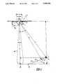
- FIG. 1illustrates the operation of the three dimensional synthetic aperture radar terrain mapping technique of this invention.
- Aircraft 10is illustrated as moving out of the plane of the illustration toward the viewer.
- Aircraft 10includes two synthetic aperture radar antennas 21 and 22.
- the two antennas 21 and 22are separated by a known distance B.
- These two antennas 21 and 22each have the major lobe of their radiation response directed across the path of aircraft 10.
- antennas 21 and 22have their response directed to substantially the same portion of terrain 12. Note that this response need not be directly perpendicular to the flight path of aircraft 10 but may be disposed at a forward-looking angle or a rearward-looking angle.
- Aircraft 10also includes a ranging altimeter 23.
- Ranging altimeter 23directs a radiant beam 24 downward toward nadir point 19. This radiant beam 24 has a beam width angle ⁇ , whose magnitude will be further discussed below.
- Ranging altimeter 23detects reflection of this radiant beam from terrain 12.
- Ranging altimeter 23determines the distance of aircraft 10 above terrain 12 by detecting the time for this reflection to return from nadir point 19.
- ranging altimeter 23may be a radar altimeter or a laser ranging instrument.
- antenna 21is active and periodically transmits a radar pulse, which is typically frequency modulated, having a center wavelength ⁇ . Both antennas 21 and 22 receive the return echoes from these transmissions.
- the signals received at the two antennas 21 and 22are separately processed in slant range and Doppler frequency according to the prior art. This yields a two dimensional image of terrain 12 indicating the slant range R and the cross track coordinate corresponding to the Doppler frequency for each antenna 21 and 22.
- ranging altimeter 23repeatedly detects the distance a from aircraft 10 to nadir point 19.
- FIG. 1illustrates the foreshortening of higher elevations in the prior art.
- Doppler frequency processing of the return responselocalizes points 13 and 14 of terrain 12 to the plane of the illustration.
- points 13 and 14can only be distinguished in slant range.
- Point 13lies on arc 15 and has a slant range R'.
- Point 14lies on arc 16 and has a slant range R.
- Point 14, which has a higher elevation than point 13appears closer to the flight path of aircraft 10 than would a point at the same elevation as point 13. This is because the slant range R is less because of the elevation of point 14.
- points along arc 16cannot be distinguished. This arc ambiguity also leads to distortion in determination of the ground range d to a particular point in terrain 12.
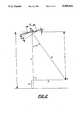
- FIG. 2illustrates the manner of using the two antennas 21 and 22 to detect slant angle ⁇ to a particular point P as proposed in Goldstein et al.
- Echo returns to the two antennas 21 and 22are processed as a plurality of resolution cells divided by slant range R and Doppler frequency. This processing into individual resolution cells permits identification of the respective echo returns at antennas 21 and 22 from the same point P to be located in three dimensions.
- the difference in received phase ⁇ between two echo returns for the same resolution cellenables determination of the slant angle ⁇ .
- ⁇is the phase difference between the echo returns for the two antennas 21 and 22; B is the known distance between antennas 21 and 22; ⁇ is the slant angle to point P; ⁇ is the roll angle of the interferometer baseline which is primarily due to roll of aircraft 10; and ⁇ is the average wavelength of the radar transmissions.
- Solving for the slant angle ⁇we find: ##EQU2##
- the difference in height h between aircraft 10 and point Pis given by:
- h'is the difference in height between aircraft 10 and point P; and R is the slant range to point P.
- the altitude a' of point Pis calculated from the known or measured altitude a of aircraft 10 relative to a fixed reference such as sea level as follows:
- This inventionemploys ranging altimeter 23 to provide additional data for a more accurate determination of the roll angle ⁇ .
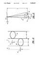
- An overlapping techniqueillustrated in FIG. 3, permits accurate determination of the roll angle ⁇ .
- Aircraft 10first flies on track 11. During this flight aircraft 10 operates antennas 21 and 22 to record synthetic aperture radar data. Each transmission covers an area 30 permitting reception of echo returns over this area. During the course of the flight on track 11, the areas 30 overlap to cover a strip of terrain 31.
- Ranging altimeter 23provides a substantially continuous measure of the altitude h above ground of aircraft 10 along the flight path 11.
- Aircraft 10then flies on path 11'. Flight path 11' is substantially parallel to flight path 11. The distance from flight path 11 to flight path 11' is selected to provide radar data from a strip 31' that is immediately adjacent to strip 31. It is important that the radar data from strip 31 cover flight path 11 of the prior flight. Aircraft 10 employs antennas 21 and 22 to take radar data of strip 31' during this flight.
- Equation (8)is corrected as: ##EQU6## Substituting the computed value of ⁇ into equation (2), in the case for equal height flights, and solving for ⁇ yields: ##EQU7##
- ⁇can be determined from known quantities ( ⁇ and B) and measured quantities (h', R and ⁇ ). This computed value of ⁇ can then be used in the manner taught in Goldstein et al to produce an accurate terrain map for other points in the cross track swath including point P.
- the synthetic radar datais corrected for ground height using the computed value of roll angle ⁇ for the swath of cross track resolution cells including the point P. This process is repeated for additional points P along the flight path 11. Interpolations of the computed roll angle ⁇ are used for points between the swaths of the successive points P. It should be understood that this computation can include corrections for differences in the altitude of aircraft 10 above a fixed reference between the two flights. Note that the altimeter measurement h may be averaged over an area small in relation to the periodicity of terrain elevation changes in order to smooth out noise in this measurement.
- the beam width angle ⁇ of the altimeter beam 24must be great enough to insure illumination of nadir point 19 for all expected roll angles ⁇ .
- FIG. 4illustrates in block diagram form apparatus 100 for practicing this invention.
- Apparatus 100includes transmitter 102.
- Transmitter 102periodically generates a radar transmission that is coupled to antenna 21 via transmit/receive switch 104.
- Apparatus 100includes two synthetic aperture receivers.
- Complex image formation receiver 106produces synthetic aperture complex image data for plural resolution cells in slant range and Doppler frequency for echo returns received by antenna 21 through transmit/receive switch 104.
- Complex image formation receiver 108produces similar synthetic aperture complex image data for plural resolution cells in slant range and Doppler frequency for echo returns received by antenna 22.
- phase difference between the synthetic aperture complex image data for corresponding resolutions cells of the echo returns to antennas 21 and 22is detected using complex conjugates. If A e j ⁇ is the complex radar amplitude cross section from a particular point P, then:
- phase difference ⁇for each resolution cell is computed from the product S of corresponding resolution cells of the synthetic aperture complex image data for the echo return signal at antenna 21 and the complex conjugate of the synthetic aperture complex image data for the echo return signal at antenna 22. This is given by: ##EQU8## Detecting the phase of the signal S or of the signal S/A, which has the same phase, determines the phase difference ⁇ .
- phase difference ⁇is performed by complex conjugate circuit 110, product circuit 112, and phase detector 114.
- Complex conjugate circuit 110computes the complex conjugate of the synthetic aperture complex image data for each resolution cell of the echo returns received by antenna 22.
- Product circuit 112forms the product of corresponding resolution cells of the synthetic aperture complex image received from antenna 21 with the conjugate of the synthetic aperture complex image data corresponding to the echo returns received from antenna 22.
- Phase detector 114detects the phase of this product signal for each resolution cell. The resulting signal corresponds to the phase difference between the echo return of antennas 21 and 22.
- Multichannel recorder 122is capable of recording in time synchronism several channels of data.
- Multichannel recorder 122receives the synthetic aperture complex image data for each resolution cell corresponding to the uncorrected terrain image generated from echo returns received by antenna 21, the phase difference data from phase detector 114 for each resolution cell, position data from position detector 116 and average altitude data from averager 120.
- Position detector 116is preferably the well known Global Positioning System (GPS) that uses satellite transmissions for position detection.
- Position detector 116may also include a ground based radio positioning system and/or an inertial guidance system. Naturally the accuracy of the terrain map formed by this system corresponds to the accuracy of determination of the position of aircraft 10 during the data gathering.
- GPSGlobal Positioning System
- the altitude data from ranging altimeter 118is averaged in averager 120.
- Averager 120forms a time average over a time that is small compared to the product of the rate of change of altitude with distance along the flight path 11 and the speed of aircraft 10. These data streams are preferably recorded as they are generated and permanently stored on magnetic tape at multichannel recorder 122.
- Off line system 130The data streams recorded by multichannel recorder 122 are supplied to off line system 130, which produces the desired terrain map. This data supply may be made by connection of multichannel recorder 122 to off line system 130 or by transfer of tapes recorded by multichannel recorder 122 to a compatible recorder connected to off line system 130.
- Off line system 130is preferably a ground system not mounted on aircraft 10. Separate recording of the data streams via multichannel recorder 122 and analysis via off line system 130 reduces the amount of computing equipment required aboard aircraft 10. This permits the use of a smaller aircraft to achieve the same terrain mapping task. In addition off line system 130 need not be constructed to the more stringent standards required for airborne systems.
- Off line system 130preferably includes a general purpose computer programmed to produce the terrain maps. This process takes place as follows. First, the complex image data and the phase difference data taken simultaneously are employed together with the aircraft position data to produce a terrain map uncorrected for roll angle ⁇ . The data taken simultaneously can be identified because it appears on corresponding points within the multichannel tape produced by multichannel recorder 122. Next, particular points where altitude data was taken on one flight are identified with the same points in the synthetic aperture radar data. The roll angle ⁇ is computed according to equation (8). This computed roll angle ⁇ permits correction of the terrain image for roll angle using equations (5) and (7) for a swath of cross track resolution cells including the particular point.
- an interpolation of the roll angle ⁇may be used in the terrain image correction. This process of correction for roll angle ⁇ is repeated throughout each strip 31 of the synthetic aperture radar data.
- the resulting terrain mapmay be translated into a contour map by interpolating from the measured elevations. This contour may be displayed via display 134, plotted via plotter 136 or stored via recorder 138.
- the accuracy of the terrain mapmay be improved by correlating the synthetic aperture radar data with ground survey data.
- a three dimensional ground surveyis made of a few points of terrain easy to identify in the synthetic aperture radar terrain map. These easy to identify points any be any sharp terrain features such as a land/water boundary.
- a radar corner reflectorcan be used to ensure a location in the synthetic aperture radar terrain map is easy to identify. The synthetic aperture radar terrain map is then conformed to the ground survey at these few points.
- FIG. 5illustrates the geometry for making a second order correction to the terrain map.
- the first return point for ranging altimeter 23need not be the nadir point 19.
- the first return point for ranging altimeter 23coincides with nadir point 19 only if terrain 12 is perfectly flat or if nadir point 19 is a local maximum in elevation.
- FIG. 5shows terrain 12 sloping upward to the right.
- the first return point 19'differs from the nadir point 19 because it is nearer to ranging altimeter 23.
- the measured altitude h'which is actually the slant range from ranging altimeter 23 to first return point 19', differs from the true height h". This difference creates errors in computed roll angle ⁇ and in the corrected elevation and ground range leading to an inaccurate terrain map.
- a first order corrected terrain mapis formed in the manner described above.
- the terrain mapincludes an indication of the elevation of terrain 12 in the vicinity of the track 11 of aircraft 10.
- the aircraft position data from that flightindicates the position of aircraft 10 for each computation of the roll angle ⁇ .
- This datapermits determination of position of point 19', which produces the first return in altimeter 23.
- this search for first return point 19'should be limited to points within the main lobe of the response of ranging altimeter 23. This should take into account the first order estimate of roll angle ⁇ .
- first return point 19'does not necessary fall exactly on the bore sight of beam 24 even when roll angle ⁇ is taken into account.
- first return point 19'may be in front of, behind or on either side of the track of aircraft 10 depending on the contour of terrain 12.
- the corrected height h"is computed. This may be computed directly from the first order corrected terrain map and position data or may be computed as:
- the second order corrected roll angle ⁇ 'is computed according to equation (10) employing the newly determined height h" in place of height h' as follows: ##EQU9##
- This second order corrected roll angle ⁇ 'permits correction of the terrain image in elevation according to equation (5) as follows: ##EQU10## where a" is the second order corrected elevation.
- the second order corrected ground range d'is computed and according to equation (7) as follows: ##EQU11## Note the fact that first return point 19' will wander ahead, behind or beside the flight track means that the reference points of these equations should be shifted accordingly. As shown in FIG. 5, first return point 19' is displaced to the right of nadir point 19 a distance of d'.
- roll angle ⁇is not continuously computed but computed only at discrete intervals.
- roll angle ⁇need only be computed at intervals which are short in relation to the quotient of the time rate of change of the roll angle ⁇ divided by the speed of aircraft 10. If this technique is used with the second order corrections, then an entire terrain map with first order corrections need not be computed. It will suffice to produce a terrain map with first order corrections for only those regions near the points of computation of roll angle ⁇ . These regions would include only those areas which may fall within the beam width of the ranging altimeter 23. This permits determination of the first return point 19' at each of these points enabling the second order correction.
- FIG. 6illustrates a block diagram of an alternative apparatus 200. For simplicity only the portion of the apparatus mounted on the aircraft is shown in FIG. 6. The off line system used with this alternative apparatus is the same as shown in FIG. 4.
- Alternative apparatus 200differs from apparatus 100 in the radar transmissions.
- Apparatus 200provides a manner for transmission via both antennas 21 and 22.
- Transmitter 102is coupled to antenna selection switch 202.
- Antenna selection switch 202supplies the radar transmission from transmitter 102 either to transmit/receive switch 104 or to transmit/receive switch 204. It is preferable to alternate transmission from antenna 21 and 22 by alternating coupling transmitter to transmit/receive switches 104 and 204.
- the complex image formation receiver 106 and 108may also be employed alternately.
- a radar pulseis transmitted by antenna 21 and the echo return received on antenna 21, and next a radar pulse is transmitted by antenna 22 and the echo return received on antenna 22. This technique has the advantage of enhancing the resolution of the measurement.
- the phase difference ⁇ between the echo returns for the two antennas 21 and 22is given by: ##EQU12## where the quantities are as defined above in conjunction with equation (1).
- the factor of 2 between the relationships of equation (1) and equation (14)is due to the doubled signal path in the two transmitter case. In the single transmitter case the only path length difference which can contribute to the phase difference ⁇ occurs during the echo return. In the two transmitter case path length differences occur in both the transmission path and in the echo return path. Note that equations (2), (5), (7) and (10) must be modified to include this factor of 2 if transmission are made from both antennas.
- interferometer baseline roll angle ⁇is given by: ##EQU13##
- corrected elevation a'is given by: ##EQU14##
- ground range dis calculated as follows: ##EQU15## This enhanced resolution permits production of better terrain maps from the same basic equipment or production of equal quality terrain maps form, less sophisticated equipment.
- the previously described apparatus 100contemplated a separate ranging altimeter.
- the required altitude measurementcould be made using the synthetic aperture radar transmitter and receiver.
- the ground immediately below aircraft 10is much closer to the antennas 21 and 22 than the points within the main response of these antennas.
- the echo return from the ground immediately below aircraft 10may be of greater signal strength than the desired echo return, even though the first ground return is from a side lobe of the transmission and is received on a side lobe of the antenna.
- the receiver in a downwardly looking synthetic aperture radarmust be gated off for an interval following each transmission. This prevents the nearby ground return from overloading the receiver. If the receiver gain is reduced then this first ground return can serve as the altimeter echo return.
- FIG. 5illustrates altimeter circuit 206.
- Altimeter circuit 206receives a signal from transmitter 102 indicating the time of transmission.
- Altimeter circuit 206also receives the received echo return signal from transmit/receive switch 104.
- Altimeter circuit 206employs these signals to generate an altitude signal in the same manner as previously described in conjunction with ranging altimeter 118.
- altimeter circuit 206is illustrated as separate from complex image formation receiver 106, those skilled in the art would realize that these circuits could employ common parts.
- the essential feature of this alternative embodimentis that the altimeter signal is determined from the primary synthetic aperture radar transmissions without requiring a separate ranging altimeter.
Landscapes
- Engineering & Computer Science (AREA)
- Remote Sensing (AREA)
- Radar, Positioning & Navigation (AREA)
- Physics & Mathematics (AREA)
- Computer Networks & Wireless Communication (AREA)
- General Physics & Mathematics (AREA)
- Electromagnetism (AREA)
- Radar Systems Or Details Thereof (AREA)
Abstract
Description
h'=R cos θ (3)
a'=a-h' (4)
d=R sin θ (6)
s.sub.a =A e.sup.jθ e.sup.jΔφ (11)
s.sub.b =A e.sup.jθ (12)
h"=h'cos β (14)
Claims (33)
Priority Applications (1)
| Application Number | Priority Date | Filing Date | Title |
|---|---|---|---|
| US07/762,923US5189424A (en) | 1991-09-19 | 1991-09-19 | Three dimensional interferometric synthetic aperture radar terrain mapping employing altitude measurement and second order correction |
Applications Claiming Priority (1)
| Application Number | Priority Date | Filing Date | Title |
|---|---|---|---|
| US07/762,923US5189424A (en) | 1991-09-19 | 1991-09-19 | Three dimensional interferometric synthetic aperture radar terrain mapping employing altitude measurement and second order correction |
Publications (1)
| Publication Number | Publication Date |
|---|---|
| US5189424Atrue US5189424A (en) | 1993-02-23 |
Family
ID=25066414
Family Applications (1)
| Application Number | Title | Priority Date | Filing Date |
|---|---|---|---|
| US07/762,923Expired - LifetimeUS5189424A (en) | 1991-09-19 | 1991-09-19 | Three dimensional interferometric synthetic aperture radar terrain mapping employing altitude measurement and second order correction |
Country Status (1)
| Country | Link |
|---|---|
| US (1) | US5189424A (en) |
Cited By (43)
| Publication number | Priority date | Publication date | Assignee | Title |
|---|---|---|---|---|
| EP0654681A1 (en)* | 1993-10-25 | 1995-05-24 | Hughes Aircraft Company | Hyper-precision SAR interferometry using a dual-antenna multi-pass SAR system |
| US5489907A (en)* | 1993-09-24 | 1996-02-06 | Deutsche Forschungsanstalt Fur Luft- Und Raumfahrt E.V. | Airborne SAR system for determining the topography of a terrain |
| US5608405A (en)* | 1995-10-06 | 1997-03-04 | Lockheed Martin Corporation | Method of generating visual representation of terrain height from SAR data employing multigrid analysis |
| WO1998002761A1 (en)* | 1996-07-11 | 1998-01-22 | Science Applications International Corporation | Terrain elevation measurement by interferometric synthetic aperture radar (ifsar) |
| US5736957A (en)* | 1995-06-30 | 1998-04-07 | The Johns Hopkins University | Delay compensated doppler radar altimeter |
| WO1998014799A1 (en)* | 1996-09-30 | 1998-04-09 | The Johns Hopkins University | Delay compensated doppler radar altimeter |
| EP0881505A1 (en)* | 1997-05-30 | 1998-12-02 | Thomson-Csf | Method of repeated position-finding for a mobile object using radar cartographie of uneven terrain |
| US5923278A (en)* | 1996-07-11 | 1999-07-13 | Science Applications International Corporation | Global phase unwrapping of interferograms |
| US5926581A (en)* | 1996-04-25 | 1999-07-20 | Lockheed Martin Corporation | System for topographic mapping from remotely sensed images |
| US6011505A (en)* | 1996-07-11 | 2000-01-04 | Science Applications International Corporation | Terrain elevation measurement by interferometric synthetic aperture radar (IFSAR) |
| US6046695A (en)* | 1996-07-11 | 2000-04-04 | Science Application International Corporation | Phase gradient auto-focus for SAR images |
| RU2150714C1 (en)* | 1999-05-17 | 2000-06-10 | Военный университет войсковой противовоздушной обороны Вооруженных Сил Российской Федерации | Method of measurement of cross-sectional dimensions of radar objects in real time |
| US6150972A (en)* | 1998-08-03 | 2000-11-21 | Sandia Corporation | Process for combining multiple passes of interferometric SAR data |
| US6266005B1 (en)* | 1998-01-17 | 2001-07-24 | Daimlerchysler Ag | Method for processing radar signals |
| WO2001031290A3 (en)* | 1999-10-28 | 2001-11-15 | Diware Oy | Method for determination of forest stand attributes and a computer program to perform the method |
| US20030154060A1 (en)* | 2003-03-25 | 2003-08-14 | Damron James J. | Fusion of data from differing mathematical models |
| WO2003096056A3 (en)* | 2002-05-13 | 2004-04-22 | Honeywell Int Inc | Method and apparatus to determine a target location |
| US20040252048A1 (en)* | 2003-06-11 | 2004-12-16 | Hager James R. | Radar altimeter with forward ranging capabilities |
| US6911932B1 (en)* | 2003-10-28 | 2005-06-28 | Sandia Corporation | Two antenna, two pass interferometric synthetic aperture radar |
| US20050212697A1 (en)* | 2004-03-26 | 2005-09-29 | Brabec Vernon J | Estimation and resolution of carrier wave ambiguities in a position navigation system |
| RU2267136C1 (en)* | 2004-03-19 | 2005-12-27 | Открытое акционерное общество "Научно-исследовательский институт измерительных приборов" (ОАО "НИИИП") | Mode of measuring of the diagram of reverse secondary radiation of an object and a radiolocation station for its realization |
| US7149147B1 (en) | 2004-09-02 | 2006-12-12 | The United States Of America As Represented By The Secretary Of The Army | System and method for sound detection and image using a rotocraft acoustic signature |
| EA007941B1 (en)* | 2005-07-19 | 2007-02-27 | Федеральное Государственное Унитарное Предприятие "Нижегородский Научно-Исследовательский Институт Радиотехники" | Mobile radar station of circular scan in meter band |
| US7239263B1 (en)* | 2006-08-10 | 2007-07-03 | Japan Agency For Marine-Earth Science And Technology | Platform shake compensation method in synthetic aperture processing system |
| US20070222667A1 (en)* | 2005-09-28 | 2007-09-27 | Honeywell International Inc. | Methods and systems for identifying high-quality phase angle measurements in an interferometric radar system |
| US7388538B1 (en)* | 2005-08-18 | 2008-06-17 | Th United States of America as represented by the Secretary of the Army | System and method for obtaining attitude from known sources of energy and angle measurements |
| US20080228458A1 (en)* | 2007-03-16 | 2008-09-18 | Kevin Smith | Radar altimeter model for simulator |
| US20100007547A1 (en)* | 2008-07-11 | 2010-01-14 | Agence Spatiale Europeenne | Altimetry method and system |
| US8040272B1 (en)* | 2007-04-20 | 2011-10-18 | Niitek Inc. | Leading and lagging aperture for linear ground penetrating radar array |
| US20110285577A1 (en)* | 2010-05-18 | 2011-11-24 | Agency For Defense Development | Forward-looking 3d imaging radar and method for acquiring 3d images using the same |
| CN102866393A (en)* | 2012-10-12 | 2013-01-09 | 中国测绘科学研究院 | Synthetic aperture radar (SAR) Doppler parameter estimation method based on POS and DEM data |
| US20130169472A1 (en)* | 2011-06-17 | 2013-07-04 | Thales | High-precision, compact altimetric measurement system |
| CN104515988A (en)* | 2014-12-16 | 2015-04-15 | 中国安全生产科学研究院 | Side slope safety monitoring and prewarning method based on ground-based synthetic aperture radar |
| CN104698457A (en)* | 2014-09-02 | 2015-06-10 | 电子科技大学 | InSAR imaging and altitude estimation method based on iterative surface prediction |
| CN105180852A (en)* | 2015-09-11 | 2015-12-23 | 电子科技大学 | GB-SAR deformation monitoring method based on triple stepping |
| RU2571957C1 (en)* | 2014-05-29 | 2015-12-27 | Федеральное государственное казенное военное образовательное учреждение высшего профессионального образования "Военная академия войсковой противовоздушной обороны Вооруженных Сил Российской Федерации имени Маршала Советского Союза А.М. Василевского" Министерства Обороны Российской Федерации | Method for experimental verification of information and identification capabilities of doppler portraits of aerial objects |
| US20160047657A1 (en)* | 2013-03-25 | 2016-02-18 | Raytheon Company | Autonomous range-only terrain aided navigation |
| RU2624736C2 (en)* | 2015-12-08 | 2017-07-06 | Закрытое акционерное общество Научно-исследовательский центр "РЕЗОНАНС" (ЗАО НИЦ "РЕЗОНАНС") | Radar station circular view "resonance" |
| RU2637817C1 (en)* | 2017-02-20 | 2017-12-07 | Российская Федерация, от имени которой выступает Государственная корпорация по атомной энергии "Росатом" | Method of determining distance to earth surface |
| US20180038950A1 (en)* | 2016-08-02 | 2018-02-08 | Thales | Method for measuring the height of a target relative to the ground using a moving radar, and radar implementing such a method |
| US10317519B2 (en)* | 2016-04-15 | 2019-06-11 | Huawei Technologies Co., Ltd. | Systems and methods for environment sensing using radar |
| US20200103530A1 (en)* | 2017-06-05 | 2020-04-02 | Chinese Academy Of Surveying And Mapping | Method for extracting elevation control point with assistance of satellite laser altimetry data |
| US20220308203A1 (en)* | 2021-03-24 | 2022-09-29 | R2 Space, LLC | Synthetic aperture radar simulation |
Citations (32)
| Publication number | Priority date | Publication date | Assignee | Title |
|---|---|---|---|---|
| US3121868A (en)* | 1953-11-20 | 1964-02-18 | Gen Electric | High resolution object location system |
| US3178711A (en)* | 1959-08-06 | 1965-04-13 | North American Aviation Inc | High resolution scanning radar |
| US3228028A (en)* | 1959-09-17 | 1966-01-04 | Goodyear Aerospace Corp | Simultaneous buildup doppler radar |
| US3603992A (en)* | 1969-11-13 | 1971-09-07 | Us Air Force | Dual harmonic frequency synthetic aperture radar |
| US3725915A (en)* | 1960-12-27 | 1973-04-03 | Hughes Aircraft Co | High resolution mapping system |
| US3768096A (en)* | 1968-09-30 | 1973-10-23 | North American Rockwell | Focusing control of synthetic aperture processing for sidelooking radar |
| US3838424A (en)* | 1973-02-20 | 1974-09-24 | Singer Co | Microwave interference pattern sensor |
| US3905031A (en)* | 1964-06-08 | 1975-09-09 | Hughes Aircraft Co | Data processor for a doppler radar mapping system using a synthesized antenna array |
| US4034370A (en)* | 1972-08-23 | 1977-07-05 | Westinghouse Electric Corporation | Second order motion compensator for high resolution radar |
| US4045795A (en)* | 1975-06-23 | 1977-08-30 | Nasa | Charge-coupled device data processor for an airborne imaging radar system |
| US4064510A (en)* | 1975-06-24 | 1977-12-20 | Thomson-Csf | High repetition frequency side-looking pulse radar system |
| US4084158A (en)* | 1977-01-03 | 1978-04-11 | Raytheon Company | Method of operating synthetic aperture radar |
| US4134113A (en)* | 1977-04-18 | 1979-01-09 | Westinghouse Electric Corporation | Monopulse motion compensation for a synthetic aperture radar |
| US4163231A (en)* | 1968-01-03 | 1979-07-31 | Raytheon Company | Radar mapping technique |
| US4184155A (en)* | 1978-09-22 | 1980-01-15 | The United States Of America As Represented By The Administrator Of The National Aeronautics And Space Administration | Radar target for remotely sensing hydrological phenomena |
| US4280127A (en)* | 1979-07-25 | 1981-07-21 | Westinghouse Electric Corp. | Range swath coverage method for synthetic aperture radar |
| US4321601A (en)* | 1971-04-23 | 1982-03-23 | United Technologies Corporation | Three dimensional, azimuth-correcting mapping radar |
| US4325065A (en)* | 1979-08-09 | 1982-04-13 | Eaton Corporation | Bistatic imaging radar processing for independent transmitter and receiver flightpaths |
| US4355311A (en)* | 1979-03-06 | 1982-10-19 | Nasa | Multibeam single frequency synthetic aperture radar processor for imaging separate range swaths |
| US4546354A (en)* | 1982-06-17 | 1985-10-08 | Grumman Aerospace Corporation | Range/azimuth ship imaging for ordnance control |
| US4546355A (en)* | 1982-06-17 | 1985-10-08 | Grumman Aerospace Corporation | Range/azimuth/elevation ship imaging for ordnance control |
| US4551724A (en)* | 1983-02-10 | 1985-11-05 | The United States Of America As Represented By The Administrator Of The National Aeronautics And Space Administration | Method and apparatus for contour mapping using synthetic aperture radar |
| US4563686A (en)* | 1982-06-17 | 1986-01-07 | Grumman Aerospace Corporation | Range/doppler ship imaging for ordnance control |
| US4611208A (en)* | 1983-10-04 | 1986-09-09 | The United States Of America As Represented By The Secretary Of The Air Force | Means for aligning elevation beam pattern along an isodop in synthetic aperture mapping radar |
| US4636719A (en)* | 1984-11-01 | 1987-01-13 | Environmental Research Institute Of Michigan | Apparatus for extended precision phase measurement |
| US4723124A (en)* | 1986-03-21 | 1988-02-02 | Grumman Aerospace Corporation | Extended SAR imaging capability for ship classification |
| US4727373A (en)* | 1986-03-31 | 1988-02-23 | Loral Corporation | Method and system for orbiting stereo imaging radar |
| US4815045A (en)* | 1985-05-07 | 1989-03-21 | Nec Corporation | Seabed surveying apparatus for superimposed mapping of topographic and contour-line data |
| US4866446A (en)* | 1984-11-28 | 1989-09-12 | Hellsten Hans O | Method for radar mapping an area and a radar equipment to carry out the method |
| US4922254A (en)* | 1987-04-09 | 1990-05-01 | Dornier System Gmbh | Topographic mapping |
| US4961075A (en)* | 1989-09-11 | 1990-10-02 | Raytheon Company | Two and one-half dimensional radar system |
| US4975704A (en)* | 1990-01-26 | 1990-12-04 | The United States Of America As Represented By The Administrator Of The National Aeronautics And Space Administration | Method for detecting surface motions and mapping small terrestrial or planetary surface deformations with synthetic aperture radar |
- 1991
- 1991-09-19USUS07/762,923patent/US5189424A/ennot_activeExpired - Lifetime
Patent Citations (32)
| Publication number | Priority date | Publication date | Assignee | Title |
|---|---|---|---|---|
| US3121868A (en)* | 1953-11-20 | 1964-02-18 | Gen Electric | High resolution object location system |
| US3178711A (en)* | 1959-08-06 | 1965-04-13 | North American Aviation Inc | High resolution scanning radar |
| US3228028A (en)* | 1959-09-17 | 1966-01-04 | Goodyear Aerospace Corp | Simultaneous buildup doppler radar |
| US3725915A (en)* | 1960-12-27 | 1973-04-03 | Hughes Aircraft Co | High resolution mapping system |
| US3905031A (en)* | 1964-06-08 | 1975-09-09 | Hughes Aircraft Co | Data processor for a doppler radar mapping system using a synthesized antenna array |
| US4163231A (en)* | 1968-01-03 | 1979-07-31 | Raytheon Company | Radar mapping technique |
| US3768096A (en)* | 1968-09-30 | 1973-10-23 | North American Rockwell | Focusing control of synthetic aperture processing for sidelooking radar |
| US3603992A (en)* | 1969-11-13 | 1971-09-07 | Us Air Force | Dual harmonic frequency synthetic aperture radar |
| US4321601A (en)* | 1971-04-23 | 1982-03-23 | United Technologies Corporation | Three dimensional, azimuth-correcting mapping radar |
| US4034370A (en)* | 1972-08-23 | 1977-07-05 | Westinghouse Electric Corporation | Second order motion compensator for high resolution radar |
| US3838424A (en)* | 1973-02-20 | 1974-09-24 | Singer Co | Microwave interference pattern sensor |
| US4045795A (en)* | 1975-06-23 | 1977-08-30 | Nasa | Charge-coupled device data processor for an airborne imaging radar system |
| US4064510A (en)* | 1975-06-24 | 1977-12-20 | Thomson-Csf | High repetition frequency side-looking pulse radar system |
| US4084158A (en)* | 1977-01-03 | 1978-04-11 | Raytheon Company | Method of operating synthetic aperture radar |
| US4134113A (en)* | 1977-04-18 | 1979-01-09 | Westinghouse Electric Corporation | Monopulse motion compensation for a synthetic aperture radar |
| US4184155A (en)* | 1978-09-22 | 1980-01-15 | The United States Of America As Represented By The Administrator Of The National Aeronautics And Space Administration | Radar target for remotely sensing hydrological phenomena |
| US4355311A (en)* | 1979-03-06 | 1982-10-19 | Nasa | Multibeam single frequency synthetic aperture radar processor for imaging separate range swaths |
| US4280127A (en)* | 1979-07-25 | 1981-07-21 | Westinghouse Electric Corp. | Range swath coverage method for synthetic aperture radar |
| US4325065A (en)* | 1979-08-09 | 1982-04-13 | Eaton Corporation | Bistatic imaging radar processing for independent transmitter and receiver flightpaths |
| US4546355A (en)* | 1982-06-17 | 1985-10-08 | Grumman Aerospace Corporation | Range/azimuth/elevation ship imaging for ordnance control |
| US4546354A (en)* | 1982-06-17 | 1985-10-08 | Grumman Aerospace Corporation | Range/azimuth ship imaging for ordnance control |
| US4563686A (en)* | 1982-06-17 | 1986-01-07 | Grumman Aerospace Corporation | Range/doppler ship imaging for ordnance control |
| US4551724A (en)* | 1983-02-10 | 1985-11-05 | The United States Of America As Represented By The Administrator Of The National Aeronautics And Space Administration | Method and apparatus for contour mapping using synthetic aperture radar |
| US4611208A (en)* | 1983-10-04 | 1986-09-09 | The United States Of America As Represented By The Secretary Of The Air Force | Means for aligning elevation beam pattern along an isodop in synthetic aperture mapping radar |
| US4636719A (en)* | 1984-11-01 | 1987-01-13 | Environmental Research Institute Of Michigan | Apparatus for extended precision phase measurement |
| US4866446A (en)* | 1984-11-28 | 1989-09-12 | Hellsten Hans O | Method for radar mapping an area and a radar equipment to carry out the method |
| US4815045A (en)* | 1985-05-07 | 1989-03-21 | Nec Corporation | Seabed surveying apparatus for superimposed mapping of topographic and contour-line data |
| US4723124A (en)* | 1986-03-21 | 1988-02-02 | Grumman Aerospace Corporation | Extended SAR imaging capability for ship classification |
| US4727373A (en)* | 1986-03-31 | 1988-02-23 | Loral Corporation | Method and system for orbiting stereo imaging radar |
| US4922254A (en)* | 1987-04-09 | 1990-05-01 | Dornier System Gmbh | Topographic mapping |
| US4961075A (en)* | 1989-09-11 | 1990-10-02 | Raytheon Company | Two and one-half dimensional radar system |
| US4975704A (en)* | 1990-01-26 | 1990-12-04 | The United States Of America As Represented By The Administrator Of The National Aeronautics And Space Administration | Method for detecting surface motions and mapping small terrestrial or planetary surface deformations with synthetic aperture radar |
Non-Patent Citations (2)
| Title |
|---|
| "Studies of Multi-Baseline Spaceborne, Interferometric Synthetic Aperture Radars, Li et al, Proceedings of IGARSS" '87 Symposium, May 18-21, 1987. |
| Studies of Multi Baseline Spaceborne, Interferometric Synthetic Aperture Radars, Li et al, Proceedings of IGARSS 87 Symposium, May 18 21, 1987.* |
Cited By (61)
| Publication number | Priority date | Publication date | Assignee | Title |
|---|---|---|---|---|
| US5489907A (en)* | 1993-09-24 | 1996-02-06 | Deutsche Forschungsanstalt Fur Luft- Und Raumfahrt E.V. | Airborne SAR system for determining the topography of a terrain |
| EP0654681A1 (en)* | 1993-10-25 | 1995-05-24 | Hughes Aircraft Company | Hyper-precision SAR interferometry using a dual-antenna multi-pass SAR system |
| US5463397A (en)* | 1993-10-25 | 1995-10-31 | Hughes Aircraft Company | Hyper-precision SAR interferometry using a dual-antenna multi-pass SAR system |
| US5736957A (en)* | 1995-06-30 | 1998-04-07 | The Johns Hopkins University | Delay compensated doppler radar altimeter |
| US5608405A (en)* | 1995-10-06 | 1997-03-04 | Lockheed Martin Corporation | Method of generating visual representation of terrain height from SAR data employing multigrid analysis |
| US5926581A (en)* | 1996-04-25 | 1999-07-20 | Lockheed Martin Corporation | System for topographic mapping from remotely sensed images |
| US5923278A (en)* | 1996-07-11 | 1999-07-13 | Science Applications International Corporation | Global phase unwrapping of interferograms |
| WO1998002761A1 (en)* | 1996-07-11 | 1998-01-22 | Science Applications International Corporation | Terrain elevation measurement by interferometric synthetic aperture radar (ifsar) |
| US6011505A (en)* | 1996-07-11 | 2000-01-04 | Science Applications International Corporation | Terrain elevation measurement by interferometric synthetic aperture radar (IFSAR) |
| US6046695A (en)* | 1996-07-11 | 2000-04-04 | Science Application International Corporation | Phase gradient auto-focus for SAR images |
| WO1998014799A1 (en)* | 1996-09-30 | 1998-04-09 | The Johns Hopkins University | Delay compensated doppler radar altimeter |
| EP0881505A1 (en)* | 1997-05-30 | 1998-12-02 | Thomson-Csf | Method of repeated position-finding for a mobile object using radar cartographie of uneven terrain |
| FR2764075A1 (en)* | 1997-05-30 | 1998-12-04 | Thomson Csf | METHOD FOR RECORDING THE NAVIGATION OF A MOBILE USING RADAR MAPPING OF HIGHER RELIEF FIELD AREAS |
| US6266005B1 (en)* | 1998-01-17 | 2001-07-24 | Daimlerchysler Ag | Method for processing radar signals |
| US6150972A (en)* | 1998-08-03 | 2000-11-21 | Sandia Corporation | Process for combining multiple passes of interferometric SAR data |
| RU2150714C1 (en)* | 1999-05-17 | 2000-06-10 | Военный университет войсковой противовоздушной обороны Вооруженных Сил Российской Федерации | Method of measurement of cross-sectional dimensions of radar objects in real time |
| WO2001031290A3 (en)* | 1999-10-28 | 2001-11-15 | Diware Oy | Method for determination of forest stand attributes and a computer program to perform the method |
| US6792684B1 (en)* | 1999-10-28 | 2004-09-21 | Diware Oy | Method for determination of stand attributes and a computer program to perform the method |
| WO2003096056A3 (en)* | 2002-05-13 | 2004-04-22 | Honeywell Int Inc | Method and apparatus to determine a target location |
| US20030154060A1 (en)* | 2003-03-25 | 2003-08-14 | Damron James J. | Fusion of data from differing mathematical models |
| US7194389B2 (en)* | 2003-03-25 | 2007-03-20 | The United States Of America As Represented By The Secretary Of The Army | Fusion of data from differing mathematical models |
| US20040252048A1 (en)* | 2003-06-11 | 2004-12-16 | Hager James R. | Radar altimeter with forward ranging capabilities |
| US6911932B1 (en)* | 2003-10-28 | 2005-06-28 | Sandia Corporation | Two antenna, two pass interferometric synthetic aperture radar |
| RU2267136C1 (en)* | 2004-03-19 | 2005-12-27 | Открытое акционерное общество "Научно-исследовательский институт измерительных приборов" (ОАО "НИИИП") | Mode of measuring of the diagram of reverse secondary radiation of an object and a radiolocation station for its realization |
| US20050264445A1 (en)* | 2004-03-26 | 2005-12-01 | Brabec Vernon J | Estimation and resolution of carrier wave ambiguities in a position navigation system |
| US7002513B2 (en)* | 2004-03-26 | 2006-02-21 | Topcon Gps, Llc | Estimation and resolution of carrier wave ambiguities in a position navigation system |
| US20050212697A1 (en)* | 2004-03-26 | 2005-09-29 | Brabec Vernon J | Estimation and resolution of carrier wave ambiguities in a position navigation system |
| US7221314B2 (en)* | 2004-03-26 | 2007-05-22 | Topcon Gps, Llc | Estimation and resolution of carrier wave ambiguities in a position navigation system |
| US7149147B1 (en) | 2004-09-02 | 2006-12-12 | The United States Of America As Represented By The Secretary Of The Army | System and method for sound detection and image using a rotocraft acoustic signature |
| EA007941B1 (en)* | 2005-07-19 | 2007-02-27 | Федеральное Государственное Унитарное Предприятие "Нижегородский Научно-Исследовательский Институт Радиотехники" | Mobile radar station of circular scan in meter band |
| US7388538B1 (en)* | 2005-08-18 | 2008-06-17 | Th United States of America as represented by the Secretary of the Army | System and method for obtaining attitude from known sources of energy and angle measurements |
| US20070222667A1 (en)* | 2005-09-28 | 2007-09-27 | Honeywell International Inc. | Methods and systems for identifying high-quality phase angle measurements in an interferometric radar system |
| US7295150B2 (en) | 2005-09-28 | 2007-11-13 | Honeywell International Inc. | Methods and systems for identifying high-quality phase angle measurements in an interferometric radar system |
| US7239263B1 (en)* | 2006-08-10 | 2007-07-03 | Japan Agency For Marine-Earth Science And Technology | Platform shake compensation method in synthetic aperture processing system |
| US20080228458A1 (en)* | 2007-03-16 | 2008-09-18 | Kevin Smith | Radar altimeter model for simulator |
| US8040272B1 (en)* | 2007-04-20 | 2011-10-18 | Niitek Inc. | Leading and lagging aperture for linear ground penetrating radar array |
| US20100007547A1 (en)* | 2008-07-11 | 2010-01-14 | Agence Spatiale Europeenne | Altimetry method and system |
| US8059025B2 (en)* | 2008-07-11 | 2011-11-15 | Agence Spatiale Europeenne | Altimetry method and system |
| US8471759B2 (en)* | 2010-05-18 | 2013-06-25 | Agency For Defense Development | Forward-looking 3D imaging radar and method for acquiring 3D images using the same |
| US20110285577A1 (en)* | 2010-05-18 | 2011-11-24 | Agency For Defense Development | Forward-looking 3d imaging radar and method for acquiring 3d images using the same |
| US20130169472A1 (en)* | 2011-06-17 | 2013-07-04 | Thales | High-precision, compact altimetric measurement system |
| US8952842B2 (en)* | 2011-06-17 | 2015-02-10 | Thales | High-precision, compact altimetric measurement system |
| CN102866393A (en)* | 2012-10-12 | 2013-01-09 | 中国测绘科学研究院 | Synthetic aperture radar (SAR) Doppler parameter estimation method based on POS and DEM data |
| CN102866393B (en)* | 2012-10-12 | 2014-10-01 | 中国测绘科学研究院 | A SAR Doppler Parameter Estimation Method Based on POS and DEM Data |
| US20160047657A1 (en)* | 2013-03-25 | 2016-02-18 | Raytheon Company | Autonomous range-only terrain aided navigation |
| US9404754B2 (en)* | 2013-03-25 | 2016-08-02 | Raytheon Company | Autonomous range-only terrain aided navigation |
| RU2571957C1 (en)* | 2014-05-29 | 2015-12-27 | Федеральное государственное казенное военное образовательное учреждение высшего профессионального образования "Военная академия войсковой противовоздушной обороны Вооруженных Сил Российской Федерации имени Маршала Советского Союза А.М. Василевского" Министерства Обороны Российской Федерации | Method for experimental verification of information and identification capabilities of doppler portraits of aerial objects |
| CN104698457A (en)* | 2014-09-02 | 2015-06-10 | 电子科技大学 | InSAR imaging and altitude estimation method based on iterative surface prediction |
| CN104698457B (en)* | 2014-09-02 | 2017-02-15 | 电子科技大学 | InSAR (interferometric synthetic aperture radar) imaging and altitude estimation method by iterative curved surface prediction |
| CN104515988B (en)* | 2014-12-16 | 2017-12-15 | 中国安全生产科学研究院 | A kind of safety monitoring slope method for early warning based on ground synthetic aperture radar |
| CN104515988A (en)* | 2014-12-16 | 2015-04-15 | 中国安全生产科学研究院 | Side slope safety monitoring and prewarning method based on ground-based synthetic aperture radar |
| CN105180852A (en)* | 2015-09-11 | 2015-12-23 | 电子科技大学 | GB-SAR deformation monitoring method based on triple stepping |
| CN105180852B (en)* | 2015-09-11 | 2017-12-15 | 电子科技大学 | GB SAR deformation monitoring methods based on triple steppings |
| RU2624736C2 (en)* | 2015-12-08 | 2017-07-06 | Закрытое акционерное общество Научно-исследовательский центр "РЕЗОНАНС" (ЗАО НИЦ "РЕЗОНАНС") | Radar station circular view "resonance" |
| US10317519B2 (en)* | 2016-04-15 | 2019-06-11 | Huawei Technologies Co., Ltd. | Systems and methods for environment sensing using radar |
| US20180038950A1 (en)* | 2016-08-02 | 2018-02-08 | Thales | Method for measuring the height of a target relative to the ground using a moving radar, and radar implementing such a method |
| US10585183B2 (en)* | 2016-08-02 | 2020-03-10 | Thales | Method for measuring the height of a target relative to the ground using a moving radar, and radar implementing such a method |
| RU2637817C1 (en)* | 2017-02-20 | 2017-12-07 | Российская Федерация, от имени которой выступает Государственная корпорация по атомной энергии "Росатом" | Method of determining distance to earth surface |
| US20200103530A1 (en)* | 2017-06-05 | 2020-04-02 | Chinese Academy Of Surveying And Mapping | Method for extracting elevation control point with assistance of satellite laser altimetry data |
| US20220308203A1 (en)* | 2021-03-24 | 2022-09-29 | R2 Space, LLC | Synthetic aperture radar simulation |
| US12050262B2 (en)* | 2021-03-24 | 2024-07-30 | R2 Space, LLC | Synthetic aperture radar simulation |
Similar Documents
| Publication | Publication Date | Title |
|---|---|---|
| US5189424A (en) | Three dimensional interferometric synthetic aperture radar terrain mapping employing altitude measurement and second order correction | |
| US5170171A (en) | Three dimensional interferometric synthetic aperture radar terrain mapping employing altitude measurement | |
| US5260708A (en) | Three dimensional interferometric synthetic aperture radar terrain mapping with unambiguous phase unwrapping employing subset bandwidth processing | |
| US5867119A (en) | Precision height measuring device | |
| US7218268B2 (en) | Self-calibrating interferometric synthetic aperture radar altimeter | |
| US4321601A (en) | Three dimensional, azimuth-correcting mapping radar | |
| US4551724A (en) | Method and apparatus for contour mapping using synthetic aperture radar | |
| US6025800A (en) | Interferomeric synthetic aperture radar altimeter | |
| US6219594B1 (en) | Landing area obstacle detection radar system | |
| US5659318A (en) | Interferometric SAR processor for elevation | |
| US5696514A (en) | Location and velocity measurement system using atomic clocks in moving objects and receivers | |
| US6114984A (en) | Interferometric doppler guidance system | |
| US4064510A (en) | High repetition frequency side-looking pulse radar system | |
| US7482970B2 (en) | Method for producing map images of surface sea current velocity vectors and altimetric radar system using the method | |
| JPH044557B2 (en) | ||
| US5539408A (en) | Method for the detection, localization and velocity determination of moving targets from raw radar data from a coherent, single- or multi-channel image system carried along in a vehicle | |
| US6741202B1 (en) | Techniques for 3-dimensional synthetic aperture radar | |
| US5160931A (en) | Interferometric synthetic aperture detection of sparse non-surface objects | |
| EP0763750B1 (en) | Radar system | |
| JP2003114275A (en) | Bistatic radar system | |
| JP2590689B2 (en) | Interferometric synthetic aperture radar system and terrain change observation method | |
| US9933519B2 (en) | Three dimensional radar system | |
| JP2699964B2 (en) | Forest tree height measuring device | |
| US20050128126A1 (en) | Method for interferometric radar measurement | |
| US6005509A (en) | Method of synchronizing navigation measurement data with S.A.R radar data, and device for executing this method |
Legal Events
| Date | Code | Title | Description |
|---|---|---|---|
| AS | Assignment | Owner name:ENVIRONMENTAL RESEARCH INSTITUTE OF MICHIGAN, MICH Free format text:ASSIGNMENT OF ASSIGNORS INTEREST.;ASSIGNOR:BROWN, WILLIAM M.;REEL/FRAME:005867/0525 Effective date:19910829 | |
| FEPP | Fee payment procedure | Free format text:PAYOR NUMBER ASSIGNED (ORIGINAL EVENT CODE: ASPN); ENTITY STATUS OF PATENT OWNER: LARGE ENTITY | |
| STCF | Information on status: patent grant | Free format text:PATENTED CASE | |
| FEPP | Fee payment procedure | Free format text:PAYER NUMBER DE-ASSIGNED (ORIGINAL EVENT CODE: RMPN); ENTITY STATUS OF PATENT OWNER: LARGE ENTITY Free format text:PAYOR NUMBER ASSIGNED (ORIGINAL EVENT CODE: ASPN); ENTITY STATUS OF PATENT OWNER: LARGE ENTITY | |
| FPAY | Fee payment | Year of fee payment:4 | |
| SULP | Surcharge for late payment | ||
| AS | Assignment | Owner name:ERIM INTERNATIONAL, INC., MICHIGAN Free format text:CONFIRMATORY ASSIGNMENT;ASSIGNOR:ENVIRONMENTAL RESEARCH INSTITUTE OF MICHIGAN;REEL/FRAME:010018/0259 Effective date:19990811 | |
| AS | Assignment | Owner name:FIRST UNION NATIONAL BANK, NORTH CAROLINA Free format text:GUARANTOR SECURITY AGREEMENT;ASSIGNOR:ERIM INTERNATIONAL, INC.;REEL/FRAME:010395/0907 Effective date:19990903 | |
| FEPP | Fee payment procedure | Free format text:PAT HLDR NO LONGER CLAIMS SMALL ENT STAT AS SMALL BUSINESS (ORIGINAL EVENT CODE: LSM2); ENTITY STATUS OF PATENT OWNER: LARGE ENTITY | |
| FPAY | Fee payment | Year of fee payment:8 | |
| AS | Assignment | Owner name:WACHOVIA BANK, NATIONAL, NORTH CAROLINA Free format text:ASSIGNMENT OF SECURITY INTEREST;ASSIGNOR:VERIDIAN SYSTEMS DIVISION, INC.;REEL/FRAME:012991/0435 Effective date:20020610 | |
| AS | Assignment | Owner name:VERIDIAN SYSTEMS DIVISION, INC., VIRGINIA Free format text:SATISFACTION OF COLLATERAL AGREEMENT/TERMINATION OF SECURITY INTEREST;ASSIGNOR:WACHOVIA BANK, NATIONAL ASSOCIATION;REEL/FRAME:014420/0009 Effective date:20030811 | |
| FPAY | Fee payment | Year of fee payment:12 | |
| AS | Assignment | Owner name:ERIM INTERNATIONAL, INC., MICHIGAN Free format text:SECURITY INTEREST;ASSIGNOR:WACHOVIA BANK, NATIONAL ASSOCIATION;REEL/FRAME:017105/0462 Effective date:20051019 |