US4754283A - Codeless GPS sonde - Google Patents
Codeless GPS sondeDownload PDFInfo
- Publication number
- US4754283A US4754283AUS06/875,102US87510286AUS4754283AUS 4754283 AUS4754283 AUS 4754283AUS 87510286 AUS87510286 AUS 87510286AUS 4754283 AUS4754283 AUS 4754283A
- Authority
- US
- United States
- Prior art keywords
- signal
- receiver
- gps
- signals
- sonde
- Prior art date
- Legal status (The legal status is an assumption and is not a legal conclusion. Google has not performed a legal analysis and makes no representation as to the accuracy of the status listed.)
- Expired - Lifetime
Links
Images


Classifications
- G—PHYSICS
- G01—MEASURING; TESTING
- G01S—RADIO DIRECTION-FINDING; RADIO NAVIGATION; DETERMINING DISTANCE OR VELOCITY BY USE OF RADIO WAVES; LOCATING OR PRESENCE-DETECTING BY USE OF THE REFLECTION OR RERADIATION OF RADIO WAVES; ANALOGOUS ARRANGEMENTS USING OTHER WAVES
- G01S11/00—Systems for determining distance or velocity not using reflection or reradiation
- G01S11/02—Systems for determining distance or velocity not using reflection or reradiation using radio waves
- G01S11/10—Systems for determining distance or velocity not using reflection or reradiation using radio waves using Doppler effect
- G—PHYSICS
- G01—MEASURING; TESTING
- G01S—RADIO DIRECTION-FINDING; RADIO NAVIGATION; DETERMINING DISTANCE OR VELOCITY BY USE OF RADIO WAVES; LOCATING OR PRESENCE-DETECTING BY USE OF THE REFLECTION OR RERADIATION OF RADIO WAVES; ANALOGOUS ARRANGEMENTS USING OTHER WAVES
- G01S19/00—Satellite radio beacon positioning systems; Determining position, velocity or attitude using signals transmitted by such systems
- G01S19/01—Satellite radio beacon positioning systems transmitting time-stamped messages, e.g. GPS [Global Positioning System], GLONASS [Global Orbiting Navigation Satellite System] or GALILEO
- G01S19/03—Cooperating elements; Interaction or communication between different cooperating elements or between cooperating elements and receivers
- G01S19/04—Cooperating elements; Interaction or communication between different cooperating elements or between cooperating elements and receivers providing carrier phase data
- G—PHYSICS
- G01—MEASURING; TESTING
- G01S—RADIO DIRECTION-FINDING; RADIO NAVIGATION; DETERMINING DISTANCE OR VELOCITY BY USE OF RADIO WAVES; LOCATING OR PRESENCE-DETECTING BY USE OF THE REFLECTION OR RERADIATION OF RADIO WAVES; ANALOGOUS ARRANGEMENTS USING OTHER WAVES
- G01S19/00—Satellite radio beacon positioning systems; Determining position, velocity or attitude using signals transmitted by such systems
- G01S19/01—Satellite radio beacon positioning systems transmitting time-stamped messages, e.g. GPS [Global Positioning System], GLONASS [Global Orbiting Navigation Satellite System] or GALILEO
- G01S19/03—Cooperating elements; Interaction or communication between different cooperating elements or between cooperating elements and receivers
- G01S19/10—Cooperating elements; Interaction or communication between different cooperating elements or between cooperating elements and receivers providing dedicated supplementary positioning signals
- G—PHYSICS
- G01—MEASURING; TESTING
- G01S—RADIO DIRECTION-FINDING; RADIO NAVIGATION; DETERMINING DISTANCE OR VELOCITY BY USE OF RADIO WAVES; LOCATING OR PRESENCE-DETECTING BY USE OF THE REFLECTION OR RERADIATION OF RADIO WAVES; ANALOGOUS ARRANGEMENTS USING OTHER WAVES
- G01S19/00—Satellite radio beacon positioning systems; Determining position, velocity or attitude using signals transmitted by such systems
- G01S19/38—Determining a navigation solution using signals transmitted by a satellite radio beacon positioning system
- G01S19/39—Determining a navigation solution using signals transmitted by a satellite radio beacon positioning system the satellite radio beacon positioning system transmitting time-stamped messages, e.g. GPS [Global Positioning System], GLONASS [Global Orbiting Navigation Satellite System] or GALILEO
- G01S19/42—Determining position
- G01S19/43—Determining position using carrier phase measurements, e.g. kinematic positioning; using long or short baseline interferometry
- G—PHYSICS
- G01—MEASURING; TESTING
- G01S—RADIO DIRECTION-FINDING; RADIO NAVIGATION; DETERMINING DISTANCE OR VELOCITY BY USE OF RADIO WAVES; LOCATING OR PRESENCE-DETECTING BY USE OF THE REFLECTION OR RERADIATION OF RADIO WAVES; ANALOGOUS ARRANGEMENTS USING OTHER WAVES
- G01S19/00—Satellite radio beacon positioning systems; Determining position, velocity or attitude using signals transmitted by such systems
- G01S19/38—Determining a navigation solution using signals transmitted by a satellite radio beacon positioning system
- G01S19/39—Determining a navigation solution using signals transmitted by a satellite radio beacon positioning system the satellite radio beacon positioning system transmitting time-stamped messages, e.g. GPS [Global Positioning System], GLONASS [Global Orbiting Navigation Satellite System] or GALILEO
- G01S19/52—Determining velocity
Definitions
- the present inventionrelates to systems for positioning and navigation based upon the reception of signals transmitted from satellites orbiting the earth. More particularly, the present invention relates to a system for recovering the carrier frequency from direct sequence spread spectrum satellite signals without knowledge of the said spread spectrum codes and using the carrier frequencies from several geometrically spaced signal sources provided by the Global Positioning System (hereinafter referred to as GPS) to compute the velocity of a balloon borne sonde.
- GPSGlobal Positioning System
- the GPSwill consist of eighteen or more satellites in 12 hour circular orbits at a range of approximately 11,000 nautical miles above the earth.
- the orbital positions of these satelliteshas been selected to maximize the probability that at least four satellites with suitable geometry for navigation will be in view at all times and positions on the earth.
- the signals emitted from these satellitesare of the same carrier frequency.
- Each satellitehas a different spread spectrum access code for both a clear acquisition (C/A) and a precision (P) code.
- the C/A codeis a pseudorandom string of ones and zeros applied to a device which controls the carrier phase in 180 degree increments. This technique is known as bi-phase direct sequence spread spectrum at a 1.023 MHz rate.
- the P codeis much longer in length and is applied at a 10.23 MHz rate. Details of the NAVSTAR/GPS are given in NAVIGATION: Journal of the Institution of Navigation, Vol. 25, No. 2, December 1978.
- the standard GPS navigation receivermust generate a replica of the transmitted code for control of an internal phase switch and synchronize the code in time with the code received at its antenna in order to recover the carrier frequency.
- the code time with respect to an internal clockis measured for four satellites and used for determining the position of the GPS receiver on the earth. See, for example, U.S. Pat. Nos. 4,457,006 and 4,114,155.
- the apparatus of the present inventionprovides a relatively low cost implementation of a GPS windfinding radiosonde.
- the apparatusincludes a codeless receiver which uses the GPS signal to debandspread itself.
- the GPS signalis received on an antenna, amplified and filtered to eliminate out-of-band interference.
- the resulting signalis then processed to remove the biphase code.
- a quadrature mixerFor processing the signal enters a quadrature mixer having four ports.
- a first portaccepts the input signal and splits it into two signal paths with equal phase.
- a second portaccepts a local oscillator signal and splits it into two paths with a 90° difference in phase.
- the four signalsare then paired and multiplied in a mixer.
- the result of this multiplicationis a frequency conversion with the difference in the frequencies of the paired signals appearing at the two output ports (i.e., third and forth ports).
- the two output signalsare 90° out of phase and remain so independent of the frequency of the output signals.
- the output signals of the quadrature conversionare passed through separate video amplifiers having sufficient bandwidth to pass the spread spectrum modulation components at baseband.
- the bandwidth required for the C/A codeis 1.023 MHz for baseband.
- the signals at the output of the video amplifiersare composed of noise and signal components.
- the signal componentsare 90° out-of-phase, but the noise components are noncorrelated. Thus, after multiplication, the noise can be filtered and will not have a DC (direct current) component.
- Multiplication of the video amplifier output signalsremoves the 180° spread spectrum code from the GPS carrier frequency.
- the signal at the output of the multipliercan now be filtered to a bandwidth which will pass two times the expected doppler frequency shift due to the satellite motion.
- the doppler shift from the satellitesis approximately ⁇ 5 KHz. This permits the bandwidth to be reduced to 20 KHz for transmission to the ground-based unit.
- the signalsare filtered and compared with the signals from a ground-based codeless receiver.
- the difference in the frequencies of the signals received by the two codeless receiversis primarily due to the difference in the velocities of the ground-based unit and the balloon borne receiver.
- the ground-based unitfurther includes a standard GPS receiver to permit location of the satellites.
- the unitfurther includes a computer for computation of the wind velocity and position information.
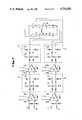
- FIG. 1is an overall block diagram of a windfinding system in accordance with the present invention
- FIG. 2is a block diagram of the codeless receiver used in the windfinding system
- FIG. 3is a block diagram of the quadrature mixer of the codeless receiver.
- FIG. 4is a schematic diagram of the video amplifiers and multiplier of the codeless receiver.
- FIG. 1there is diagrammed a wind-finding system in accordance with the present invention.
- the systemutilizes the signals emitted from satellites in the GPS system.
- a satellite 12is shown.
- at least four GPS satelliteswould be in view from any earth location at a given time. Accordingly, signals from at least four GPS satellites would be received by the system receivers.
- the windfinding systemincludes a balloon borne, remote sonde 14.
- An antenna 15receives the GPS satellite signals and applies them to a codeless receiver.
- the receiver signalsare processed and the doppler information applied to an FM transmitter of a telemetry link operating in the 403 MHz meteorology frequency band.
- an FM receiver 18obtains the telemetry link signals from the sonde via antenna 17.
- the doppler information DOP signalis applied to tracking filters 20.
- the DOP signal input to the tracking filterswill contain information concerning at least four satellite transmissions. Accordingly, there will be four tracking filters for the DOP signals obtained from the sonde.
- the ground-based unit 21will also include a local GPS receiver 22 having an antenna 23.
- Receiver 22includes both a standard GPS receiver and a codeless receiver.
- the standard GPS receiverprovides an output 24 of information concerning the offset doppler related to the change in position of the GPS satellites in view.
- the codeless receiverprovides output DOP signals indicative of the change in satellite position.
- the DOP signalsare applied to a separate set of four tracking filters.
- the standard GPS receivermay be one of the currently available commercial GPS receivers. A listing of some manufacturers having available standard GPS receivers may be found in the Apr. 19, 1986 issue of MICROWAVE JOURNAL. See also, U.S. Pat. Nos. 4,457,006 and 4,114,155.
- the ground-based unitfurther includes a computer 26 receiving the offset doppler signal 24 from the standard GPS receiver.
- the computerprovides a tuning input 28 to the tracking filters for the satellite DOP signals.
- the tracking filtersare a narrow bandwidth, e.g., 1 Hz, tunable filter.
- the center frequency setting of the tracking filtersis changed by computer tuning as the offset doppler signal 24 changes with satellite movement.
- the bandwidth of interest within which the tracking filters will be tunedis the 5-25 kilohertz band.
- the tracking filters for the remote sonde DOP signalare predictably tuned by the computer beginning from the time of release of the balloon borne sonde from the ground station location. Before release, the remote and local DOP signals will be tuned to the same center frequency. Thereafter, as the balloon sonde moves relative to the ground-based unit and as the GPS satellites move, the tracking filters are tuned to different frequencies.
- the offset in frequency of the remote DOP signal tracking filters from the local DOP signal tracking filtersallows determination of the velocity of the sonde.
- computer 26calculates the wind data output 32.
- This dataincludes a velocity vector and position for the remote sonde.
- the calculations for developing the wind dataare documented in specifications for the NAVSTAR/GPS SYSTEM. These computations are outlined in the publication NAVSTAR/GPS Space Segment/Navigation User Interfaces, ICD-GPS-200. This publication is available from the NAVSTAR GPS Joint Program Office, Airforce Space Division, P.0. Box 92960, Oldworld Postal Center, Los Angeles, Calif. 90009.
- Computer 26may be variously implemented.
- the computermay be a microcomputer system based upon any of the presently available devices.
- Such devicesinclude the Motorola 68000 microprocessor and associated memory chip set.
- the DOP signal tracking filtersmay be implemented in either analog or digital circuitry.
- digital signal processingmay be utilized to implement a tunable filter function.
- a tracking filtermay be implemented digitally by using, for example, devices such as the TMS320 single-chip processor available from Texas Instruments, Inc.
- Satellite signals at 1.57542 Gigahertzare obtained by antenna 15 and applied to a preamplifier 40.
- the amplifier outputis applied to a filter 42.
- the filtered signalis applied to quadmixer 44.
- the mixeralso receives an input 46 from frequency multiplier 48.
- Mixer 44performs a frequency conversion with the difference in the two applied signal frequencies appearing at the two output ports 50 and 52.
- the two outputsare 90° out of phase and independent of frequency.
- the outputs of the quadrature conversionare passed through separate video amplifier channels 54 and 56. These amplifiers have a sufficient bandwidth to pass spread spectrum modulation components at baseband.
- the bandwidth required for the C/A codeis 1.023 Megahertz.
- the signals at the output of the video amplifiersinclude noise and signal components. The signal components are 90° out of phase, but the noise components are noncorrelated.
- the video amplifier outputare multiplied by multiplier 58.
- the multiplicationremoves the spread spectrum code by implementing the trigonometric indenity:
- angle Ais being modulated in steps of 180° degrees by the spread spectrum code. If enough bandwidth is maintained on the multiplier to pass the modulation the modulation is removed at the output, because sine and cosine wave are being multiplied in the following way:
- multiplication of the video amplifier output signalsremoves the 180° spread spectrum code from the GPS carrier frequency.
- the signal at the output of the multiplieris bandpass filtered in filter 60.
- the bandwidth of the filterwill pass two times the expected doppler frequency shift due to the satellite motion.
- the doppler shift of satellite signalsis approximately +/-5 kilohertz. This permits the bandwidth to be reduced to 20 Kilohertz for transmission to the ground station unit.
- the output DOP signalmay be transmitted directly to the ground unit. However, it is believed advantageous to sum the DOP signal with a reference signal. Accordingly, a summer 62 is provided for summing the DOP signal from filter 60 and a reference signal.
- the reference signalis obtained by dividing down the output frequency of oscillator 49 by a divider circuit 64. As indicated, the oscillator frequency is 1.8191 Megahertz. This frequency is divided by 1024 to provide a 17.76 Kilohertz signal to be summed with the DOP signal.
- the reference signalprovides a means to directly measure the frequency errors caused by the 1.8191 MHz crystal oscillator. The measurement of this error on the around, allows the sonde oscillator to be a low cost unit.
- the output of summer 62is transmitted by the FM telemetry link to the ground unit.
- the bandwidth of the video amplifiers 54 and 56is 1 Kilohertz to 1 Megahertz.
- the frequency multiplier 48multiplies oscillator 49 output by 866 to provide the local oscillator signal 46 to quadmixer 44.
- the quadmixer 44may be implemented by a model IRM-55053, S/N992 available from Merrimac of West Caldwell, N.J.
- the oscillator and frequency multipliermay be implemented by a phase locked-loop circuit.
- preamp 40, filter 42, quadmixer 44 and frequency multiplier 48would be formed in an integrated circuit package rather than in discrete components.
- Adding the reference signalprovides information concerning offset error, which is a function of oscillator error. With the reference information, the ground unit can correct for offset caused by the oscillator.
- FIG. 3there is a general diagram of the quadrature mixer.
- the filtered satellite signalis applied to a splitter 70 which divides the signal into two signal paths 72 and 74. There is no phase difference between the signals.
- the local oscillator signal from frequency multiplier 48is applied to a 90° coupler 76 which provides signals over signal paths 78 and 80, which are 90° out of phase.
- the local oscillator signal on line 78is multiplied with the signal in path 72 by multiplier 82 to provide one of the quadmixer outputs.
- the local oscillator signal on signal path 80is multiplied with the signal on signal path 74 by multiplier 84 to provide the other quadmixer output.
- Video amplifier channel 54receives the quadmixer output over line 50.
- the video amplifier channel 54includes two stages of amplification provided by integrated circuit amplifiers 90 and 92. These devices may suitably be Signetics MC733CL devices. At the output of each amplification stage is a filter network. These filter works are indicated by the reference designations 94 and 96.
- Video amplifier channel 56 for output 52 of the quadmixeris implemented similarly to channel 54. Two stages of amplification 98 and 100 are utilized. Also, there are filter networks 102 and 104 in the signal channel. The outputs of the video amplifier channels are applied to a multiplier device which may suitably be implemented by an XR2208 multiplier device.
- the codeless receiver utilized in the local GPS receiver 22 of FIG. 1corresoonds to the structure of that described in connection with FIGS. 2-3.
- the codeless receiver utilized in the present inventionis advantageous because of its low cost. Further, the accuracy of the system employing the receiver is extremely good because of the high carrier frequency of the GPS satellite signals and the doppler frequency doubling in the codeless receivers. A one meter per second velocity difference will yield up to a 10 hertz difference frequency. While the codeless receiver is disclosed in connection with a windfinding system, it is to understood that the receiver may have beneficial application in diverse situations including ground-based, water-based and airborne operations involving surveying, vehicular tracking, navigation and position finding.
Landscapes
- Engineering & Computer Science (AREA)
- Radar, Positioning & Navigation (AREA)
- Remote Sensing (AREA)
- Physics & Mathematics (AREA)
- General Physics & Mathematics (AREA)
- Computer Networks & Wireless Communication (AREA)
- Position Fixing By Use Of Radio Waves (AREA)
Abstract
Description
sin A cos A=1/2sin 2A
______________________________________ Quadrant sine cosine result ______________________________________ 1 + × + + 2 + × - - 3 - × - + 4 - × + - ______________________________________
Claims (11)
Priority Applications (3)
| Application Number | Priority Date | Filing Date | Title |
|---|---|---|---|
| US06/875,102US4754283A (en) | 1986-06-17 | 1986-06-17 | Codeless GPS sonde |
| EP87305341AEP0250211A3 (en) | 1986-06-17 | 1987-06-16 | Codeless gps sonde |
| JP62151030AJPS633286A (en) | 1986-06-17 | 1987-06-17 | Spectral diffusion cordless receiver |
Applications Claiming Priority (1)
| Application Number | Priority Date | Filing Date | Title |
|---|---|---|---|
| US06/875,102US4754283A (en) | 1986-06-17 | 1986-06-17 | Codeless GPS sonde |
Publications (1)
| Publication Number | Publication Date |
|---|---|
| US4754283Atrue US4754283A (en) | 1988-06-28 |
Family
ID=25365209
Family Applications (1)
| Application Number | Title | Priority Date | Filing Date |
|---|---|---|---|
| US06/875,102Expired - LifetimeUS4754283A (en) | 1986-06-17 | 1986-06-17 | Codeless GPS sonde |
Country Status (3)
| Country | Link |
|---|---|
| US (1) | US4754283A (en) |
| EP (1) | EP0250211A3 (en) |
| JP (1) | JPS633286A (en) |
Cited By (40)
| Publication number | Priority date | Publication date | Assignee | Title |
|---|---|---|---|---|
| US4862178A (en)* | 1988-06-27 | 1989-08-29 | Litton Systems, Inc. | Digital system for codeless phase measurement |
| US5014066A (en)* | 1982-03-01 | 1991-05-07 | Western Atlas International, Inc. | System for simultaneously deriving position information from a plurality of satellite transmissions |
| US5055849A (en)* | 1989-10-26 | 1991-10-08 | Vaisala Oy | Method and device for measuring velocity of target by utilizing doppler shift of electromagnetic radiation |
| US5148179A (en)* | 1991-06-27 | 1992-09-15 | Trimble Navigation | Differential position determination using satellites |
| US5271034A (en)* | 1991-08-26 | 1993-12-14 | Avion Systems, Inc. | System and method for receiving and decoding global positioning satellite signals |
| US5365516A (en)* | 1991-08-16 | 1994-11-15 | Pinpoint Communications, Inc. | Communication system and method for determining the location of a transponder unit |
| US5379224A (en)* | 1991-11-29 | 1995-01-03 | Navsys Corporation | GPS tracking system |
| US5557284A (en)* | 1995-02-03 | 1996-09-17 | Honeywell Inc. | Spoofing detection system for a satellite positioning system |
| US5587715A (en)* | 1993-03-19 | 1996-12-24 | Gps Mobile, Inc. | Method and apparatus for tracking a moving object |
| US5793328A (en)* | 1996-04-01 | 1998-08-11 | The United States Of America As Represented By The Administrator Of The National Aeronautics And Space Administration | Method and apparatus for determining position using global positioning satellites |
| US5805200A (en)* | 1982-03-01 | 1998-09-08 | Western Atlas International, Inc. | System for determining position from pseudorandomly modulated radio signals |
| US5821898A (en)* | 1995-03-13 | 1998-10-13 | Vaisala Oy | Codeless GPS positioning method and apparatus for such codeless positioning |
| US5862501A (en)* | 1995-08-18 | 1999-01-19 | Trimble Navigation Limited | Guidance control system for movable machinery |
| KR20010040059A (en)* | 1999-10-15 | 2001-05-15 | 이데이 노부유끼 | GPS positioning method and GPS reception apparatus |
| US6288674B1 (en)* | 1999-12-21 | 2001-09-11 | Texas Instruments Incorporated | Wireless communication system utilizing doppler diversity |
| US6331835B1 (en)* | 1999-02-02 | 2001-12-18 | The Charles Stark Draper Laboratory, Inc. | Deeply-integrated adaptive GPS-based navigator with extended-range code tracking |
| US6353408B1 (en) | 1998-03-31 | 2002-03-05 | U.S. Philips Corporation | Electronic navigation apparatus |
| US6421010B1 (en) | 2001-02-16 | 2002-07-16 | The United States Of America As Represented By The Secretary Of Commerce | Atmospheric sondes and method for tracking |
| US6731237B2 (en) | 1999-11-09 | 2004-05-04 | The Charles Stark Draper Laboratory, Inc. | Deeply-integrated adaptive GPS-based navigator with extended-range code tracking |
| USH2155H1 (en) | 2002-01-28 | 2006-05-02 | The United States Of America As Represented By The Secretary Of The Air Force | Downconvert and average identification of biphase coded signal carrier |
| US20070257831A1 (en)* | 2006-04-28 | 2007-11-08 | Loctronix Corporation | System and method for positioning in configured environments |
| US7737841B2 (en) | 2006-07-14 | 2010-06-15 | Remotemdx | Alarm and alarm management system for remote tracking devices |
| US7804412B2 (en) | 2005-08-10 | 2010-09-28 | Securealert, Inc. | Remote tracking and communication device |
| US7936262B2 (en) | 2006-07-14 | 2011-05-03 | Securealert, Inc. | Remote tracking system with a dedicated monitoring center |
| US8232876B2 (en) | 2008-03-07 | 2012-07-31 | Securealert, Inc. | System and method for monitoring individuals using a beacon and intelligent remote tracking device |
| US8364136B2 (en) | 1999-02-01 | 2013-01-29 | Steven M Hoffberg | Mobile system, a method of operating mobile system and a non-transitory computer readable medium for a programmable control of a mobile system |
| US8369967B2 (en) | 1999-02-01 | 2013-02-05 | Hoffberg Steven M | Alarm system controller and a method for controlling an alarm system |
| US8514070B2 (en) | 2010-04-07 | 2013-08-20 | Securealert, Inc. | Tracking device incorporating enhanced security mounting strap |
| US8797210B2 (en) | 2006-07-14 | 2014-08-05 | Securealert, Inc. | Remote tracking device and a system and method for two-way voice communication between the device and a monitoring center |
| US8892495B2 (en) | 1991-12-23 | 2014-11-18 | Blanding Hovenweep, Llc | Adaptive pattern recognition based controller apparatus and method and human-interface therefore |
| US8988253B2 (en) | 2012-07-16 | 2015-03-24 | Google Inc. | Recovery of balloon materials |
| CN104503000A (en)* | 2014-12-15 | 2015-04-08 | 深圳航天东方红海特卫星有限公司 | Sonde wind measuring system and wind measuring method |
| US20150263434A1 (en) | 2013-03-15 | 2015-09-17 | SeeScan, Inc. | Dual antenna systems with variable polarization |
| US9151633B2 (en) | 1998-01-27 | 2015-10-06 | Steven M. Hoffberg | Mobile communication device for delivering targeted advertisements |
| WO2016009402A2 (en) | 2014-07-18 | 2016-01-21 | Altec S.P.A. | Image and/or radio signals capturing platform |
| US9455762B2 (en) | 2006-04-28 | 2016-09-27 | Telecommunication Systems, Inc. | System and method for positioning using hybrid spectral compression and cross correlation signal processing |
| US10361802B1 (en) | 1999-02-01 | 2019-07-23 | Blanding Hovenweep, Llc | Adaptive pattern recognition based control system and method |
| US10608348B2 (en) | 2012-03-31 | 2020-03-31 | SeeScan, Inc. | Dual antenna systems with variable polarization |
| US10943273B2 (en) | 2003-02-05 | 2021-03-09 | The Hoffberg Family Trust 2004-1 | System and method for determining contingent relevance |
| RU2820052C2 (en)* | 2022-06-06 | 2024-05-28 | Федеральное государственное автономное образовательное учреждение высшего образования "Уральский федеральный университет имени первого Президента России Б.Н. Ельцина" | Navigation aerological radiosonde |
Families Citing this family (5)
| Publication number | Priority date | Publication date | Assignee | Title |
|---|---|---|---|---|
| GB2213339A (en)* | 1987-12-02 | 1989-08-09 | Secr Defence | Relative position determination |
| US4928106A (en)* | 1988-07-14 | 1990-05-22 | Ashtech Telesis, Inc. | Global positioning system receiver with improved radio frequency and digital processing |
| GB2241623A (en)* | 1990-02-28 | 1991-09-04 | Philips Electronic Associated | Vehicle location system |
| AT403066B (en)* | 1991-07-12 | 1997-11-25 | Plasser Bahnbaumasch Franz | METHOD FOR DETERMINING THE DEVIATIONS OF THE ACTUAL LOCATION OF A TRACK SECTION |
| EP0704704A3 (en)* | 1994-09-16 | 1996-07-17 | Aircotec Ag | Device for locating and visualising thermal and dynamic vertical winds |
Citations (11)
| Publication number | Priority date | Publication date | Assignee | Title |
|---|---|---|---|---|
| US4114155A (en)* | 1976-07-30 | 1978-09-12 | Cincinnati Electronics Corporation | Position determining apparatus and method |
| US4170776A (en)* | 1977-12-21 | 1979-10-09 | Nasa | System for near real-time crustal deformation monitoring |
| US4215345A (en)* | 1978-08-31 | 1980-07-29 | Nasa | Interferometric locating system |
| US4426712A (en)* | 1981-05-22 | 1984-01-17 | Massachusetts Institute Of Technology | Correlation system for global position receiver |
| US4445120A (en)* | 1981-04-07 | 1984-04-24 | The United States Of America As Represented By The Secretary Of The Navy | Radiosonde |
| US4445118A (en)* | 1981-05-22 | 1984-04-24 | The United States Of America As Represented By The Administrator Of The National Aeronautics And Space Administration | Navigation system and method |
| US4453165A (en)* | 1983-01-03 | 1984-06-05 | Sperry Corporation | Differential Doppler receiver |
| US4457006A (en)* | 1981-11-16 | 1984-06-26 | Sperry Corporation | Global positioning system receiver |
| US4463357A (en)* | 1981-11-17 | 1984-07-31 | The United States Of America As Represented By The Administrator Of The National Aeronautics And Space Administration | Method and apparatus for calibrating the ionosphere and application to surveillance of geophysical events |
| US4468793A (en)* | 1980-12-01 | 1984-08-28 | Texas Instruments Incorporated | Global position system (GPS) multiplexed receiver |
| US4485383A (en)* | 1980-12-01 | 1984-11-27 | Texas Instruments Incorporated | Global position system (GPS) multiplexed receiver |
Family Cites Families (4)
| Publication number | Priority date | Publication date | Assignee | Title |
|---|---|---|---|---|
| US3900847A (en)* | 1972-01-21 | 1975-08-19 | Nasa | Satellite aided vehicle avoidance system |
| US4035802A (en)* | 1973-04-05 | 1977-07-12 | Ove Jagermalm | Method and apparatus for wind measurement |
| FR2438276A1 (en)* | 1978-10-02 | 1980-04-30 | Tracor | Wind speed measurement at distant point - is performed by radio sonde retransmitting signals whose rate of change of phase is measured |
| DE3479835D1 (en)* | 1984-06-08 | 1989-10-26 | Decca Ltd | Position fixing system |
- 1986
- 1986-06-17USUS06/875,102patent/US4754283A/ennot_activeExpired - Lifetime
- 1987
- 1987-06-16EPEP87305341Apatent/EP0250211A3/ennot_activeWithdrawn
- 1987-06-17JPJP62151030Apatent/JPS633286A/enactivePending
Patent Citations (11)
| Publication number | Priority date | Publication date | Assignee | Title |
|---|---|---|---|---|
| US4114155A (en)* | 1976-07-30 | 1978-09-12 | Cincinnati Electronics Corporation | Position determining apparatus and method |
| US4170776A (en)* | 1977-12-21 | 1979-10-09 | Nasa | System for near real-time crustal deformation monitoring |
| US4215345A (en)* | 1978-08-31 | 1980-07-29 | Nasa | Interferometric locating system |
| US4468793A (en)* | 1980-12-01 | 1984-08-28 | Texas Instruments Incorporated | Global position system (GPS) multiplexed receiver |
| US4485383A (en)* | 1980-12-01 | 1984-11-27 | Texas Instruments Incorporated | Global position system (GPS) multiplexed receiver |
| US4445120A (en)* | 1981-04-07 | 1984-04-24 | The United States Of America As Represented By The Secretary Of The Navy | Radiosonde |
| US4426712A (en)* | 1981-05-22 | 1984-01-17 | Massachusetts Institute Of Technology | Correlation system for global position receiver |
| US4445118A (en)* | 1981-05-22 | 1984-04-24 | The United States Of America As Represented By The Administrator Of The National Aeronautics And Space Administration | Navigation system and method |
| US4457006A (en)* | 1981-11-16 | 1984-06-26 | Sperry Corporation | Global positioning system receiver |
| US4463357A (en)* | 1981-11-17 | 1984-07-31 | The United States Of America As Represented By The Administrator Of The National Aeronautics And Space Administration | Method and apparatus for calibrating the ionosphere and application to surveillance of geophysical events |
| US4453165A (en)* | 1983-01-03 | 1984-06-05 | Sperry Corporation | Differential Doppler receiver |
Non-Patent Citations (6)
| Title |
|---|
| ISTAC Series Marine Positioning Sensor Technical Data Sheet, Istac, Inc. (Dec. 11, 1984).* |
| ISTAC-Series Marine Positioning Sensor Technical Data Sheet, Istac, Inc. (Dec. 11, 1984). |
| MacDoran et al., "Codeless GPS Positioning Offers Sub-Meter Accuracy," Sea Technology (Oct. 1984). |
| MacDoran et al., "Codeless GPS Systems for Positioning of Offshore Platforms and 3D Seismic Surveys," Navigation: Journal of the Institute of Navigation; vol. 31, No. 2 (Summer 1984). |
| MacDoran et al., Codeless GPS Positioning Offers Sub Meter Accuracy, Sea Technology (Oct. 1984).* |
| MacDoran et al., Codeless GPS Systems for Positioning of Offshore Platforms and 3D Seismic Surveys, Navigation : Journal of the Institute of Navigation; vol. 31, No. 2 (Summer 1984).* |
Cited By (56)
| Publication number | Priority date | Publication date | Assignee | Title |
|---|---|---|---|---|
| US5014066A (en)* | 1982-03-01 | 1991-05-07 | Western Atlas International, Inc. | System for simultaneously deriving position information from a plurality of satellite transmissions |
| US5805200A (en)* | 1982-03-01 | 1998-09-08 | Western Atlas International, Inc. | System for determining position from pseudorandomly modulated radio signals |
| US4862178A (en)* | 1988-06-27 | 1989-08-29 | Litton Systems, Inc. | Digital system for codeless phase measurement |
| US5055849A (en)* | 1989-10-26 | 1991-10-08 | Vaisala Oy | Method and device for measuring velocity of target by utilizing doppler shift of electromagnetic radiation |
| US5148179A (en)* | 1991-06-27 | 1992-09-15 | Trimble Navigation | Differential position determination using satellites |
| US5365516A (en)* | 1991-08-16 | 1994-11-15 | Pinpoint Communications, Inc. | Communication system and method for determining the location of a transponder unit |
| US5271034A (en)* | 1991-08-26 | 1993-12-14 | Avion Systems, Inc. | System and method for receiving and decoding global positioning satellite signals |
| US5379224A (en)* | 1991-11-29 | 1995-01-03 | Navsys Corporation | GPS tracking system |
| US8892495B2 (en) | 1991-12-23 | 2014-11-18 | Blanding Hovenweep, Llc | Adaptive pattern recognition based controller apparatus and method and human-interface therefore |
| US5587715A (en)* | 1993-03-19 | 1996-12-24 | Gps Mobile, Inc. | Method and apparatus for tracking a moving object |
| US5796365A (en)* | 1993-03-19 | 1998-08-18 | Lewis; Peter T. | Method and apparatus for tracking a moving object |
| US5557284A (en)* | 1995-02-03 | 1996-09-17 | Honeywell Inc. | Spoofing detection system for a satellite positioning system |
| CN1099039C (en)* | 1995-03-13 | 2003-01-15 | 威易拉有限公司 | Codeless GPS positioning method and apparatus for such codeless positioning |
| US5821898A (en)* | 1995-03-13 | 1998-10-13 | Vaisala Oy | Codeless GPS positioning method and apparatus for such codeless positioning |
| EP0732596A3 (en)* | 1995-03-13 | 1999-01-13 | Vaisala Oy | Codeless GPS positioning method and apparatus for such codeless positioning |
| AU704290B2 (en)* | 1995-03-13 | 1999-04-15 | Vaisala Oy | Codeless GPS positioning method and apparatus for such codeless positioning |
| US5862501A (en)* | 1995-08-18 | 1999-01-19 | Trimble Navigation Limited | Guidance control system for movable machinery |
| US5793328A (en)* | 1996-04-01 | 1998-08-11 | The United States Of America As Represented By The Administrator Of The National Aeronautics And Space Administration | Method and apparatus for determining position using global positioning satellites |
| US9151633B2 (en) | 1998-01-27 | 2015-10-06 | Steven M. Hoffberg | Mobile communication device for delivering targeted advertisements |
| US9551582B2 (en) | 1998-01-27 | 2017-01-24 | Blanding Hovenweep, Llc | Mobile communication device |
| US10127816B2 (en) | 1998-01-27 | 2018-11-13 | Blanding Hovenweep, Llc | Detection and alert of automobile braking event |
| US6353408B1 (en) | 1998-03-31 | 2002-03-05 | U.S. Philips Corporation | Electronic navigation apparatus |
| US10361802B1 (en) | 1999-02-01 | 2019-07-23 | Blanding Hovenweep, Llc | Adaptive pattern recognition based control system and method |
| US8369967B2 (en) | 1999-02-01 | 2013-02-05 | Hoffberg Steven M | Alarm system controller and a method for controlling an alarm system |
| US8364136B2 (en) | 1999-02-01 | 2013-01-29 | Steven M Hoffberg | Mobile system, a method of operating mobile system and a non-transitory computer readable medium for a programmable control of a mobile system |
| US9535563B2 (en) | 1999-02-01 | 2017-01-03 | Blanding Hovenweep, Llc | Internet appliance system and method |
| US6630904B2 (en) | 1999-02-02 | 2003-10-07 | The Charles Stark Draper Laboratory, Inc. | Deeply-integrated adaptive INS/GPS navigator with extended-range code tracking |
| US6331835B1 (en)* | 1999-02-02 | 2001-12-18 | The Charles Stark Draper Laboratory, Inc. | Deeply-integrated adaptive GPS-based navigator with extended-range code tracking |
| KR20010040059A (en)* | 1999-10-15 | 2001-05-15 | 이데이 노부유끼 | GPS positioning method and GPS reception apparatus |
| US6731237B2 (en) | 1999-11-09 | 2004-05-04 | The Charles Stark Draper Laboratory, Inc. | Deeply-integrated adaptive GPS-based navigator with extended-range code tracking |
| US6288674B1 (en)* | 1999-12-21 | 2001-09-11 | Texas Instruments Incorporated | Wireless communication system utilizing doppler diversity |
| US6421010B1 (en) | 2001-02-16 | 2002-07-16 | The United States Of America As Represented By The Secretary Of Commerce | Atmospheric sondes and method for tracking |
| USH2155H1 (en) | 2002-01-28 | 2006-05-02 | The United States Of America As Represented By The Secretary Of The Air Force | Downconvert and average identification of biphase coded signal carrier |
| US10943273B2 (en) | 2003-02-05 | 2021-03-09 | The Hoffberg Family Trust 2004-1 | System and method for determining contingent relevance |
| US11790413B2 (en) | 2003-02-05 | 2023-10-17 | Hoffberg Family Trust 2 | System and method for communication |
| US7804412B2 (en) | 2005-08-10 | 2010-09-28 | Securealert, Inc. | Remote tracking and communication device |
| US8031077B2 (en) | 2005-08-10 | 2011-10-04 | Securealert, Inc. | Remote tracking and communication device |
| US20090256750A1 (en)* | 2006-04-28 | 2009-10-15 | Loctronix Corporation | System and method for positioning in configured environments |
| US9455762B2 (en) | 2006-04-28 | 2016-09-27 | Telecommunication Systems, Inc. | System and method for positioning using hybrid spectral compression and cross correlation signal processing |
| US20070257831A1 (en)* | 2006-04-28 | 2007-11-08 | Loctronix Corporation | System and method for positioning in configured environments |
| US7511662B2 (en) | 2006-04-28 | 2009-03-31 | Loctronix Corporation | System and method for positioning in configured environments |
| US7916074B2 (en) | 2006-04-28 | 2011-03-29 | Loctronix Corporation | System and method for positioning in configured environments |
| US7737841B2 (en) | 2006-07-14 | 2010-06-15 | Remotemdx | Alarm and alarm management system for remote tracking devices |
| US8797210B2 (en) | 2006-07-14 | 2014-08-05 | Securealert, Inc. | Remote tracking device and a system and method for two-way voice communication between the device and a monitoring center |
| US8013736B2 (en) | 2006-07-14 | 2011-09-06 | Securealert, Inc. | Alarm and alarm management system for remote tracking devices |
| US7936262B2 (en) | 2006-07-14 | 2011-05-03 | Securealert, Inc. | Remote tracking system with a dedicated monitoring center |
| US8232876B2 (en) | 2008-03-07 | 2012-07-31 | Securealert, Inc. | System and method for monitoring individuals using a beacon and intelligent remote tracking device |
| US8514070B2 (en) | 2010-04-07 | 2013-08-20 | Securealert, Inc. | Tracking device incorporating enhanced security mounting strap |
| US9129504B2 (en) | 2010-04-07 | 2015-09-08 | Securealert, Inc. | Tracking device incorporating cuff with cut resistant materials |
| US10608348B2 (en) | 2012-03-31 | 2020-03-31 | SeeScan, Inc. | Dual antenna systems with variable polarization |
| US8988253B2 (en) | 2012-07-16 | 2015-03-24 | Google Inc. | Recovery of balloon materials |
| US10490908B2 (en) | 2013-03-15 | 2019-11-26 | SeeScan, Inc. | Dual antenna systems with variable polarization |
| US20150263434A1 (en) | 2013-03-15 | 2015-09-17 | SeeScan, Inc. | Dual antenna systems with variable polarization |
| WO2016009402A2 (en) | 2014-07-18 | 2016-01-21 | Altec S.P.A. | Image and/or radio signals capturing platform |
| CN104503000A (en)* | 2014-12-15 | 2015-04-08 | 深圳航天东方红海特卫星有限公司 | Sonde wind measuring system and wind measuring method |
| RU2820052C2 (en)* | 2022-06-06 | 2024-05-28 | Федеральное государственное автономное образовательное учреждение высшего образования "Уральский федеральный университет имени первого Президента России Б.Н. Ельцина" | Navigation aerological radiosonde |
Also Published As
| Publication number | Publication date |
|---|---|
| JPS633286A (en) | 1988-01-08 |
| EP0250211A3 (en) | 1989-01-18 |
| EP0250211A2 (en) | 1987-12-23 |
Similar Documents
| Publication | Publication Date | Title |
|---|---|---|
| US4754283A (en) | Codeless GPS sonde | |
| US5379224A (en) | GPS tracking system | |
| US5420592A (en) | Separated GPS sensor and processing system for remote GPS sensing and centralized ground station processing for remote mobile position and velocity determinations | |
| US4667203A (en) | Method and system for determining position using signals from satellites | |
| US5014066A (en) | System for simultaneously deriving position information from a plurality of satellite transmissions | |
| EP0198029B1 (en) | Enhanced global positioning system delta-range processing | |
| US5619212A (en) | System for determining position from suppressed carrier radio waves | |
| JP2919490B2 (en) | Global positioning system with improved radio frequency and digital processing. | |
| US5194871A (en) | System for simultaneously deriving position information from a plurality of satellite transmissions | |
| US3242494A (en) | Position determination system | |
| JPS5888676A (en) | Navigation receiver for global positioning system | |
| US4860018A (en) | Continuous wave interference rejection for reconstructed carrier receivers | |
| US5572427A (en) | Doppler position bearing angle locator | |
| JP3012857B2 (en) | Demodulation circuit for wide area positioning system receiver | |
| US6738713B2 (en) | Positioning apparatus and method | |
| US4453165A (en) | Differential Doppler receiver | |
| EP0283302A2 (en) | Techniques for determining orbital data | |
| US6336061B1 (en) | System and method for attitude determination in global positioning systems (GPS) | |
| EP0664008B1 (en) | Method and apparatus for tracking the position and velocity of airborne instrumentation | |
| Counselman III et al. | Lunar baselines and libration from differential VLBI observations of ALSEPs | |
| NO161021B (en) | DIFFERENTIAL RECEIVER. | |
| McGarry et al. | Potential LEO satellite augmentation for Rescue-21 in Alaska | |
| JPS636479A (en) | satellite navigation equipment | |
| Westerfield | Determination of position of a drifting buoy by means of the Navy navigation satellite system | |
| Schmid | The Conversion of Fundamental Tracking Data to Metric Form |
Legal Events
| Date | Code | Title | Description |
|---|---|---|---|
| AS | Assignment | Owner name:TRACOR AEROSPACE AUSTIN, INC., 6500 TRACOR LANE, A Free format text:ASSIGNMENT OF ASSIGNORS INTEREST.;ASSIGNOR:FOWLER, CLARENCE W.;REEL/FRAME:004580/0964 Effective date:19860603 Owner name:TRACOR AEROSPACE AUSTIN, INC.,TEXAS Free format text:ASSIGNMENT OF ASSIGNORS INTEREST;ASSIGNOR:FOWLER, CLARENCE W.;REEL/FRAME:004580/0964 Effective date:19860603 | |
| AS | Assignment | Owner name:TRACOR AEROSPACE, INC., A CORP. OF TX. Free format text:MERGER;ASSIGNORS:TRACOR AEROSPACE AUSTIN, INC. (CHANGED TO);TRACOR AEROSPACE, INC., A CORP. OF TX. (AND);TRACOR RADCON, INC., A CORP.OF TX. (MERGED INTO);AND OTHERS;REEL/FRAME:005224/0668 Effective date:19861210 | |
| AS | Assignment | Owner name:TRACOR AEROSPACE, INC., A CORP. OF TX. Free format text:ASSIGNMENT OF ASSIGNORS INTEREST. EFFECTIVE OCTOBER 24, 1989;ASSIGNOR:TRACOR, INC., A CORP. OF DE.;REEL/FRAME:005224/0687 Effective date:19891027 | |
| AS | Assignment | Owner name:BANK OF AMERICA NATIONAL TRUST AND SAVINGS ASSOCIA Free format text:SECURITY INTEREST;ASSIGNOR:TRACOR HOLDINGS, INC., TRACOR, INC., AND OTHERS INDICATED ON SCHEDULE SA;REEL/FRAME:005317/0726 Effective date:19891030 | |
| AS | Assignment | Owner name:TR NAVIGATION CORPORATION Free format text:ASSIGNMENT OF ASSIGNORS INTEREST.;ASSIGNOR:TRACOR AEROSPACE, INC.;REEL/FRAME:005311/0968 Effective date:19900501 | |
| FPAY | Fee payment | Year of fee payment:4 | |
| AS | Assignment | Owner name:TRACOR, INC. Free format text:RELEASED BY SECURED PARTY;ASSIGNOR:BANK OF AMERICA NATIONAL TRUST AND SAVINGS ASSOCIATION;REEL/FRAME:005953/0942 Effective date:19911227 | |
| AS | Assignment | Owner name:BANKERS TRUST COMPANY, NEW YORK Free format text:SECURITY INTEREST;ASSIGNOR:TRACOR AEROSPACE, INC.;REEL/FRAME:006674/0934 Effective date:19930825 | |
| FEPP | Fee payment procedure | Free format text:PETITION RELATED TO MAINTENANCE FEES FILED (ORIGINAL EVENT CODE: PMFP); ENTITY STATUS OF PATENT OWNER: LARGE ENTITY | |
| FEPP | Fee payment procedure | Free format text:PETITION RELATED TO MAINTENANCE FEES DENIED/DISMISSED (ORIGINAL EVENT CODE: PMFD); ENTITY STATUS OF PATENT OWNER: LARGE ENTITY | |
| FEPP | Fee payment procedure | Free format text:PAYOR NUMBER ASSIGNED (ORIGINAL EVENT CODE: ASPN); ENTITY STATUS OF PATENT OWNER: LARGE ENTITY | |
| REFU | Refund | Free format text:REFUND PROCESSED. MAINTENANCE FEE HAS ALREADY BEEN PAID (ORIGINAL EVENT CODE: R160); ENTITY STATUS OF PATENT OWNER: LARGE ENTITY | |
| FPAY | Fee payment | Year of fee payment:8 | |
| FPAY | Fee payment | Year of fee payment:12 | |
| AS | Assignment | Owner name:ABN AMRO BANK N.V., AS AGENT, ILLINOIS Free format text:SECURITY AGREEMENT;ASSIGNOR:TRIMBLE NAVIGATION LIMITED;REEL/FRAME:010996/0643 Effective date:20000714 | |
| STCF | Information on status: patent grant | Free format text:PATENTED CASE | |
| AS | Assignment | Owner name:TRIMBLE NAVIGATION LIMITED, CALIFORNIA Free format text:RELEASE OF SECURITY INTEREST;ASSIGNOR:ABN AMRO BANK N.V.;REEL/FRAME:016345/0177 Effective date:20050620 |