US20170242873A1 - Integrated centralized property database systems and methods - Google Patents
Integrated centralized property database systems and methodsDownload PDFInfo
- Publication number
- US20170242873A1 US20170242873A1US15/049,595US201615049595AUS2017242873A1US 20170242873 A1US20170242873 A1US 20170242873A1US 201615049595 AUS201615049595 AUS 201615049595AUS 2017242873 A1US2017242873 A1US 2017242873A1
- Authority
- US
- United States
- Prior art keywords
- data
- location
- information
- earth
- data items
- Prior art date
- Legal status (The legal status is an assumption and is not a legal conclusion. Google has not performed a legal analysis and makes no representation as to the accuracy of the status listed.)
- Granted
Links
Images


Classifications
- G—PHYSICS
- G06—COMPUTING OR CALCULATING; COUNTING
- G06F—ELECTRIC DIGITAL DATA PROCESSING
- G06F16/00—Information retrieval; Database structures therefor; File system structures therefor
- G06F16/20—Information retrieval; Database structures therefor; File system structures therefor of structured data, e.g. relational data
- G06F16/29—Geographical information databases
- G06F17/30241—
- G06F17/30551—
- G06F17/30554—
- G06F17/3087—
Definitions
- This disclosureis in the field of aggregating information associated with all geographic points on the earth, where the information is captured from distributed data sources and integrated into a centralized database that may be queried for a complete time history of any geographic point on the earth.
- Information about property and the attributes of propertyis usually publically available, but is stored by different entities in different locations using different formats. Some of the information is found by identifying an address or other number that identifies a real estate parcel and then contacting the record keeper of the type of information desired, such as a county records office, about the parcel number or address of the property. In some instances, information of interest may be more quickly found by using the Internet or an aggregator such as ZillowTM or Google MapsTM to access information about the property.
- this approach to collecting datahas a number of drawbacks.
- this datais tracked based on identifiers such as parcels, lots, townships, cities, ZIP Codes, school districts, and the like. These identifiers may have changed over time such that they represent different points on the earth at different times.
- identifierssuch as parcels, lots, townships, cities, ZIP Codes, school districts, and the like. These identifiers may have changed over time such that they represent different points on the earth at different times.
- the present disclosureprovides systems and methods to create and maintain an integrated centralized property database containing all information, including a full time history, associated with any given point on the earth.
- this pointmay be identified by latitude and longitude coordinates.
- the integrated centralized property databasereceives information from various data sources, which may include, for example, data sources accessible through the Internet, government databases relating to property, crime data, weather data and the like, as well as any other types of public or private data.
- the data sourcesmay be located by web crawlers, image crawlers, data feeds or the like, and may be updated periodically to ensure the data stored in the integrated centralized property database is current.
- the received data itemsmay be processed to determine relevant category information (e.g., weather data, crime data, demographic data, property sales or change of ownership or classification data, tax assessment data, and so on). Further, the data items may be processed to determine or extract geocoding information, such as latitude, longitude and/or Z-axis information (i.e., height above or depth below the surface of the earth). The category and/or geocoding information may be associated with the data items for storage in the integrated centralized property database. As such, the integrated centralized property database may store a variety of information of all types which is related to one or more geographic points on the earth. Further, the data items may include or be associated with particular date or time information, for example, indicating a time or range of times to which the information pertains.
- relevant category informatione.g., weather data, crime data, demographic data, property sales or change of ownership or classification data, tax assessment data, and so on.
- geocoding informationsuch as latitude, longitude and/or Z-axis information (i.e., height above or depth
- a user interfacewhich allows users to access the integrated centralized property database. Queries may be performed via the user interface and the integrated centralized property database will be searched for all relevant information associated with the query. For example, a user may input a specific latitude/longitude, and the system will retrieve, and output via the user interface, all relevant information associated with that particular latitude/longitude.
- the querymay further include a time or range of times, in which case, the system will retrieve all relevant information associated with both the input location information (e.g., a particular latitude/longitude, an area defined by an input polygon or the like) and the input time information.
- One benefit to the embodiments described hereinis that a user can input a query about a location on the earth and receive, from a single database and single server, all activities and information associated with that location, sorted by date and type of activity/information.
- One method to carry out one or more embodimentsmay be summarized as including: storing a plurality of data items in a data aggregation system, each of the plurality of data items being associated with one or more location identifiers indicating a particular point on the earth; receiving, by at least one processor, a query indicating a geographic location; retrieving, from the data aggregation system, data items having associated location identifiers matching the received geographic location; and outputting the retrieved data items.
- the one or more location identifiersmay include latitude and longitude coordinates of a geographic point on earth.
- the one or more location identifiersmay further include Z-axis coordinates that identifies a distance above or below the earth.
- the received geographic locationmay include a region on the earth.
- the region on the earthmay be identified by multiple geocoded locations, the multiple geocoded locations described in at least latitude and longitude coordinates.
- At least a portion of the plurality of data items stored in the data aggregation systemmay further be associated with one or more time identifiers, and the method may further include: receiving, by the at least one processor, a time identifier, wherein retrieving from the data aggregation system may further include retrieving data items having associated time identifiers matching the received time identifier.
- the time identifiermay include one or more time periods.
- the one or more location identifiersmay include content external to the data aggregation system.
- the stored data itemsmay include at least one of: tax data, building code data, weather data, insurance data, crime data, survey data, school data, demographic data and property data.
- One system that can carry out one or more embodimentsmay be summarized as including: a computer processor; a memory coupled to the processor; and an integrated centralized property database, the processor being configured to: receive from a user computer a query including a location identifier, the location identifier including one of a geocoded location and multiple geocoded locations identifying a polygon, receive from the user computer a time period identifier, retrieve from the integrated centralized property database location data, the location data including data associated with the location identifier and with the time period identifier, and provide the retrieved location data to the user computer via a graphical user interface.
- the processormay be further configured to: retrieve parcel information from the integrated centralized property database; compare the retrieved parcel information with the location data to determine parcels associated with the location identifier; and output the parcels associated with the location identifier.
- the processormay be further configured to: retrieve insurance policy information from the integrated centralized property database; compare the retrieved insurance policy information with the parcels associated with the location identifier to determine the insurance policies associated with the location identifier; and output the insurance policies associated with the location identifier.
- the systemcan be considered as having a means for storing a plurality of data items in a data aggregation system, each of the plurality of data items being associated with one or more location identifiers indicating a particular point on earth; means for receiving a query indicating a geographic location; means for retrieving data items having associated location identifiers matching the received geographic location; and means for outputting the retrieved data items.
- FIG. 1is a block diagram illustrating an embodiment of an environment in which an integrated centralized property database is used.
- FIG. 2is a diagram showing the components of a data item, in accordance with one or more embodiments.
- FIG. 3is a block diagram illustrating a process for adding geocoding information and category information to a data item, in accordance with one or more embodiments.
- FIG. 4is a flowchart illustrating a process for determining relevant geocoding information, in accordance with one or more embodiments.
- FIG. 5is a flowchart illustrating a process for associating one or more categories to a data item, in accordance with one or more embodiments.
- FIG. 6is a block diagram illustrating a computing system for managing and providing access to the integrated centralized property database, in accordance with one or more embodiments.
- An integrated centralized databasethat aggregates all information that is related to, or associated with, any geographic point on the earth, and includes any changes in information over time with respect to that point.
- a point on the earthis identified by geocoded coordinates, or latitude/longitude.
- This aggregated informationmay be related to parcels and buildings associated with that point, insurance claims data, weather data, crime data, demographic data, buildings on that point, reported activities and events, or other related data by time period.
- the systemconstantly scans for new information that can be categorized and associated with one or more points on the earth.
- the centralized databasecan then be queried to retrieve any and all data related to that point. For example, in one embodiment the simplest query may include providing only a latitude and longitude, and all information related to that point will be retrieved.
- the querymay include a request for data associated with locations within a certain proximity to the point.
- queries for information related to multiple pointsmay be performed.
- the multiple pointsmay be defined by a region, such as by a polygon with vertices identified by a series of geocoded coordinates that include all geographic locations within the polygon area.
- a regionmay be identified by a name or one or more features used to identify a geographic area.
- a region defining pointsmay be described as a combination of location description and a point in time. For example, the footprint of the residence building at property address 123 Dry Creek Road, Napa Valley, Calif., on Jul. 4, 1970, or city of Humptulips, Wash., as boundaries were defined on Jan. 31, 1989.
- One of the advantages of tracking data associated with a geographic point on the earthis the continuity of location description over time. For example, by using a lot number, a parcel identifier, a county, or city identifier to get information about a specific geographic location, a person is not guaranteed to identify the same geographic location over time.
- a parcel of land from the 1850smay be the result of the subdivision of a much larger block of land acquired earlier by the state. That parcel may have since been subdivided, and portions of the parcel converted to industrial use with industrial utilities installed and underground storage tanks added. Subsequently, some of the subdivided parcels may have been recombined into new larger parcel and converted into farm use.
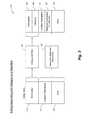
- FIG. 1is a block diagram 400 which describes an embodiment of an environment in which an integrated centralized property database 102 (which may be referred to at portions herein as “integrated database 102 ”) is used.
- the integrated database 102receives its data from a variety of different data sources 116 , which may include data accessible from the Internet, data accessible from a government, insurance company or any third-party database, and the like.
- Data provided from the data sources 116includes a variety of types of data that is, or can be, associated with a particular location or point on Earth.
- a wide range of datamay be associated with a particular geographic point on the earth, including but not limited to legal data, property characteristic data, transactional data, environmental data, demographic data, and event data.
- Examples of legal datainclude, but are not limited to, deeds or chains of title that include legal descriptions; boundary descriptions; subdivision information, including parcel changes; tax information on the associated parcel; and liens, mortgages, or other encumbrances ever placed or removed. It may also include government records from the city, county, state, or national levels, pertaining to any real or personal property associated with that point.
- legal datamay include transactional data such as purchase, sale, leasing and/or rental agreements including rental contracts, securitization, encumbrance, or other related legal documents, and other documented changes concerning the point that affects ownership or ownership rights.
- thismay include rights involving the point such as mineral rights, water rights, and other land-related rights, as well as transactions regarding buildings or other improvements associated with the point.
- the data associated with the pointcan be used to identify previous owners, previous tenants, and the terms and extent of their holdings.
- Legal datamay also include insurance contract data that describes, for a particular point, any policy ever written associated with that point, the current policies that are in force, the rates and terms of such policies, any claims made against the policies, and the final outcome of the claim.
- This datamay also include risk management analysis, performed by insurance carriers that did not result in the issuance of any policies.
- this informationmay include photos, tax records, other public records, and property value assessments.
- property characteristic datamay be divided into real property and improvements.
- Real property characteristic datamay include elevation, ground slope, soil conditions such as farmland, rocky, marsh, stream, lake, forest, meadow, undeveloped land, paved land, or other.
- Property characteristic datamay also include designations such as floodplain, high risk hail area, or tornado susceptible area.
- Improvements characteristic datamay include descriptions of one or more buildings on that point; utilities such as water, sewer, electricity or gas running under, though, or over that point; building permits issued or denied, blueprints, on-site photos, videos, inspections, and stop-work and other notices. It may include terrain information such as fill added. In addition, land information associated with the point, but not directly on the point, may include power pole locations, hydrant locations, high-voltage transmission line placement, erosion effects, and vegetation changes. Also, features associated below the point may also be included such as caves, water reserves, mineral deposits, oil reserves or natural gas reserves. Improvement characteristics data may also include analysis in condition data for structures related to the point.
- reports showing building conditionssuch as type of building, square footage, type of materials used in construction, current condition of aspects of the property such as exterior wall conditions, roof conditions and associated roof reports, the results of on-site inspections and analysis, etc.
- construction datessuch as type of building, square footage, type of materials used in construction
- construction datessuch as blueprints and utilities maps for the buildings.
- image, video, audio and other methods of capturing information associated with the pointmay also be stored.
- aerial images of the property and buildings on the propertymay be included that come from satellite images, overhead flights, or images captured by property owners, contractors, or service providers, or pictures from other sources, such as recreational photos, that can be associated with that point.
- Environmental datamay also be associated with the point.
- standard weather datasuch as temperature, pressure, precipitation, and the like may be included, along with meteorological data describing major weather events such as tornadoes, hailstorms, lightning, hurricanes, snowstorms, heat waves, and the like that have an impact on the value of the property associated with the point.
- This datamay also include forecasted data, officially reported data, and actual measured data describing the event and its effects.
- Other examples of eventsmay include earthquakes, floods, and fires that have occurred on the point, or near enough to affect the point.
- demographic information, or social datamay be associated with a particular point. For example, average income, education, number of children, crime rates, quality of life measures, school district ratings, unemployment data, weather data, political affiliation data and the like.
- consumer and/or business purchase datamay also be aggregated and associated with particular points on the earth. For example, the number and type of new car purchases associated with registered vehicle owners having an address listed for that point or within a particular radius of a point. More detailed events may be associated with the property, for example, the contents and date of filed police reports for property associated with the point, specific crime data for criminal record history of people within a region of the point, time and content of any 911 calls or other emergency contacts made from an area associated with the point, and so on.
- Additional informationis the particular type of license that was requested for that address.
- a particular addressmay have one, two, or dozens of people listing that as their address for a type of license or registration.
- multiple peoplemay list the same address for their driver's license, voter registration, boat registration, and the like. Knowing the number of people that have listed the same address for their voter registration or, similarly, an address associated with a geographic location that is within the same polygon as another address has particular benefits.
- Many private transactionsare also frequently associated with a particular address. This may include a request for a credit card; joining a private organization such as the Lion's Club, the Boy Scouts of America, the Girl Scouts of America; applying for a private service, such as a telephone installation, having a plumber come visit, having a visit from an electrician, the pumping of a septic tank, installation of a property improvement such as a hot tub, a swimming pool, cutting of trees, the buying or selling of livestock, or any one of a number of transactions which are private as between two individuals or an individual and a company, but in which one of the individuals provides an address that is associated with that particular transaction.
- a private servicesuch as a telephone installation, having a plumber come visit, having a visit from an electrician, the pumping of a septic tank, installation of a property improvement such as a hot tub, a swimming pool, cutting of trees, the buying or selling of livestock, or any one of a number of transactions which are private as between two individuals or an individual and a company
- This addressmay then be loaded into any one of a number of available databases, such as into the person's Facebook account, a log record of visits made by a plumbing company, an auctions house listing of the address of people who bought and sold goods, livestock or other items at the auction, or the like.
- databasessuch as into the person's Facebook account, a log record of visits made by a plumbing company, an auctions house listing of the address of people who bought and sold goods, livestock or other items at the auction, or the like.
- Other sources of information between private individualsmay include magazine subscription, mailing lists, donations to local causes, donations to charity, or other activities in which one of the parties provides the address at which they will be receiving goods being shipped by another party where the goods are being purchased from Amazon, Barnes & Noble, or any other many thousands of Internet shopping sites which are available.
- the datamay take a number of different forms including, but not limited to numbers, text, images, graphics, and audio and video.
- the datamay also be in a form readable by a computer or other device, such as a binary form or encrypted form, or in multiple forms that may be combined in one or more ways.
- the datamay contain references to locations of other data sources. This may include links, such as hypertext links to areas on the internet, or references to other systems, for example executable modules or other computer implemented algorithms, that return data related to the point on the earth.
- the data described aboverepresents a very small subset of all possible data that could be associated with a particular point on the earth.
- the data provided from data sources 116may include any such type of data that could be associated with a particular point on the earth, including the types described above, and may be provided from data sources 116 including those described above.
- Data related to a point on the earthis collected from data sources 116 in a variety of ways.
- web crawlers 108are used to search for data or updates to data in a systematic way throughout the Internet to search for data concerning regions that are associated with particular points on the earth. For example, given a particular point and a particular time, the web crawler 108 will identify and collect the information, such as described above, on the parcels, neighborhoods, cities, counties, and state with which the point is associated.
- image crawlers 110may be used to systematically examine images, accessible via the internet or other sources, and image metadata associated with each image. Metadata may include, for example, an image title, image description, or latitude/longitude at which the picture was taken. For example, the image crawler 110 may find an image taken at a wedding held in a field next to a property where the background of the image includes the property. The metadata in the picture may include the latitude and longitude of the camera location, the time the image was captured, and the cardinal direction the camera was pointing. From this information, the image crawler 110 can determine that the image is relevant to the point of the earth if, for example, the image shows part of a building at the point.
- the imagemay be relevant simply because it depicts a scene at the point of the earth at a particular point in time.
- the image crawler 110would then add this image and its metadata information (e.g., before or after further processing) to the integrated centralized property database 102 .
- Data feeds 112may include feeds of data from any type of data source 116 .
- data feeds 112may include subscription-based data (which may be provided for free, or for a charge) that is periodically updated and pushed to the integrated centralized property database 102 .
- data feeds 112may include, for example, a weather data feed that provides a continuous or periodic stream of data relating to weather conditions or forecasts.
- data feeds 112may include a police or other government service feed, which may provide a feed of data relating to criminal activity, civil complaints, road conditions and the like that may be associated with one or more geographic locations.
- Data feeds 112may further include feeds from emergency or alerting services, such as Amber Alerts, weather event warning systems (e.g., a data feed providing warnings for hurricanes, tsunamis, tornados, earthquakes, snowstorms, or the like).
- data feeds 112may include publicly- or privately-accessible social network data (e.g., Twitter, Facebook, Google+, Instagram, Picasa, etc.).
- social network datacommonly includes user-uploaded images, text, documents and the like which may be associated with a particular point on the earth.
- social network datamay contain relevant data which may be provided as part of a data feed, or alternatively, which may be discovered by a web crawler 108 and/or image crawler 110 .
- Data feeds 112may further include feeds of data relating to changes in status of property, such as, for example, data indicating a sale of a home, data indicating a rezoning or change in zoning for a particular geographic location or the like.
- informationmay be collected from a number of data sources 116 .
- data sources 116may include, for example, the public Internet, private/restricted Internet sites such as those requiring a subscription, and governmental sites.
- public and private data aggregation sourcesmay also be used as data sources 116 , for example those having real estate and demographic information such as Zillow, Trulia, Realtor.com, and others.
- datasuch as property characteristic data, can be purchased from other data sources 116 and included in systems using the integrated centralized property database 102 , either electronically or acquired in print and scanned in. Through these or other embodiments, data relating to any particular point of property on earth may be mined anywhere in the world.
- the collected datamay be aggregated, centralized, stored and accessed in a number of different ways in various embodiments. Processing of incoming data may be accomplished by a processor 106 .
- the integrated database 102may consist of one database with multiple data sets which may span multiple physical machines and physical disk drives, where all information collected about all points on the earth is replicated and stored. This way, all of the known and available information as of the most current time of receipt (e.g., from web crawler 108 , image crawler 110 and/or data feeds 112 ) may be immediately retrieved from the database and presented to the user.
- the integrated database 102may include a combination of both replicated information and reference links to data sources outside of the database, such as to a site on the Internet.
- each data item 410has at least three individual attributes: information 130 , location 132 and date 134 .
- Information 130includes of an actual data item and/or a reference to a data item stored at a location outside of the integrated database 102 where the information may be retrieved.
- the reference to datamay be a link or reference to a price at which a property associated with a particular point on the earth has ever been sold, all taxes ever levied on the property, all insurance policies underwritten for the property, and so on. It may also be the data itself, such as the type of license obtained, item purchased, etc.
- the location 132 attributerefers to the locations on the earth to which the information refers or is associated with.
- This location informationmay be represented as a geocoded location, for example latitude/longitude.
- the location 132may be a property street address, a parcel identifier, a ZIP code, a city, county, or state designation. In some cases, it may be a region identifier such as a climate zone, a marketing area, or a bounded area of a particular event such as a hailstorm or a fire.
- the location 132may correspond to a demographic or socio-economic region, such as a region within a state where the average number of people in a household is 2.5, or a region where there is at least one person within the household over the age of 65, or where average income is above $50,000.
- the location 132 attributein one embodiment, includes at least two fields: the first field indicates the location itself, as previously described, and the second field indicates the relationship of the location to the data.
- the location itselfmay be described and stored in multiple formats. For example, in addition to being a parcel identifier or a property street address, it can also include the longitude and latitude of the boundaries of a polygon which encloses that particular parcel or property address. There are a number of other overlapping ways in which a geographic point can be defined.
- the relationship to the data or eventwill provide an indication of how that particular location is related to the actual information 130 itself.
- the locationmay be indicated as where the event occurred or that the information is a description of that particular address, in which case, the location 132 field attribute would refer to itself.
- this field of the location 132 attributemay refer to the source of the data which is in the information 130 .
- this field of the location 132 attributemay refer to the source of the data which is in the information 130 .
- a 911 callis made this is a single event, a single information; however, two data records can be obtained, one having the location from which the call originated and the field for the location 132 would be marked as the source of the data, and a separate record having the same event information 130 but whose location 132 has the field attribute that the information applies to that particular location, namely to itself. It is, thus, possible that a single piece of information 130 , whether it is an event or data, may have multiple items stored because it is associated with multiple addresses or locations 132 .
- the same location 132may have multiple events associated with that address, as will be apparent since a single address will likely have a home owner's insurance policy, driver's license, voter registrations, mailing lists, etc., all having the same location 132 , but having different information 130 associated with that location 132 .
- the date 134 attributeidentifies the date and time at which the data item is or was relevant.
- the date 134 attributecan correspond to a specific point in time, to a specific range of time, or it could be associated with multiple time ranges.
- the tax records associated with a particular parcel of land, which contains a point on the earth of interestmay be associated with particular years, or a range of months between land assessment updates.
- the processor 106may generate the data items 410 based on data received from the data sources 116 .
- the processor 106may receive an image of a particular point on earth from an image crawler 110 .
- the processor 106may analyze metadata received with the image to determine location information (such as, for example, latitude and longitude) associated with the image, as well as to determine a date that the image was taken.
- the processor 106may then create a data item 410 , which may have a standard format or structure, including the information 130 (i.e., the image), location 132 and date 134 . This data item 410 may then be stored in the integrated centralized property database 102 .
- FIG. 3is a block diagram 420 illustrating a process for adding geocoding information and category information to a data item 410 , in accordance with one or more embodiments.
- additional attributesmay be associated with the data item 410 , and may be determined by examining other data item 410 attributes.
- the processor 106may receive information 130 and categorize 138 the information into one or more categories 146 for easier grouping.
- the category 146 informationmay be appended to or otherwise associated with the data item 410 and stored in the integrated centralized property database 102 .
- Example categories 146include, but are not limited to, insurance underwriting, insurance claims, tax information, property characteristics, crime, demographics, weather events, and so on.
- the data item 410may further be analyzed by the processor 106 to determine relevant geocoding 140 .
- the location 132 attribute and the date 134 attributemay be combined to produce one or more geocoded locations identified by latitude/longitude.
- information 130 associated with a named location 132 that represents different areas at different datescan be properly identified with specific points on the earth.
- tax information associated with the address 199 Dry Creek Road, Napa, Calif. 94558 in 1968may have referred to a 10-acre parcel of farm land, where the same address today may refer to a single family home that was subdivided from the 10 acres in 1989.
- an updated data item 410may include—in addition to information 130 , location identifier 132 and date 134 —a category 146 and one or more (e.g., a range of) geocoded coordinates 150 .
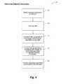
- FIG. 4is a flowchart illustrating a process 430 for determining relevant geocoding information.
- the processincludes receiving a location description 132 of a data item 410 .
- the location description 132 of the data item 410may be received by the processor 106 , and may be received from a web crawler 108 , image crawler 110 , data feeds 112 and/or update sources 114 , any of which may have retrieved the location description 132 from data sources 116 .
- the received location description 132may be a neighborhood, a parcel, a lot, an address, or other such non-geocoded location descriptions.
- the processor 106receives the date 134 associated with the location description 132 .
- the date 134may be received by the processor 106 from the same source (i.e., the web crawler 108 , image crawler 110 , data feeds 112 , and/or update sources 114 ) that provided the location description 132 .
- the date 134may be determined by the processor 106 , for example, by analyzing metadata, image analysis, text analysis, or the like.
- the processor 106determines the geographical boundaries of the location description 132 at the date 134 .
- the geographical boundariesin at least some retrieved data items, may be absent from the location description 132 itself (e.g., the location description 132 may identify a neighborhood, parcel, lot, address, or the like).
- the processor 106may determine the geographical boundaries of the location at the date received at 154 utilizing various techniques.
- One such techniquemay involve comparing the location information with location information which may be stored in the integrated database 102 , or in any other accessible database.
- the processor 106may reference a Seattle neighborhood database (which may be a publicly-accessible database) to determine the streets or blocks which define a boundary for that neighborhood at the date received at block 154 . Because property boundaries often change over time (e.g., neighborhoods, lots, census-defined areas, voting districts and the like), determining the geographical boundaries of the location description at the date, at block 156 , enables accurate associations between the location description 132 and the date 134 .
- a Seattle neighborhood databasewhich may be a publicly-accessible database
- the processor 106converts the geographical boundaries determined at block 156 into ranges of associated geocoded coordinates (i.e., latitude and longitude). This may be accomplished, in some embodiments, by referencing one or more maps containing geocoded coordinates. For example, a city map or a street map may be superimposed onto a geocoding map containing latitude and longitude coordinates, and the processor 106 may thus determine the geocoded coordinates which correspond to the boundaries (e.g., street boundaries, parcel boundaries, etc.) which were determined at block 156 .
- the boundariese.g., street boundaries, parcel boundaries, etc.
- FIG. 5is a flowchart illustrating a process 440 for associating one or more categories 146 to a data item 410 .
- the processincludes receiving a data item 410 .
- the data item 410may be received by the processor 106 , and may be received from a web crawler 108 , image crawler 110 , data feeds 112 and/or update sources 114 , any of which may have retrieved the data item 410 from data sources 116 .
- the processor 106analyzes the data item 410 to determine one or more applicable categories 146 to which the data item 410 pertains or should be associated with.
- the processor 106may employ various techniques for analyzing and determining applicable categories. For example, the processor 106 may analyze the information 130 and/or location description 132 included in the received data item 410 , which may include, for example, textual information describing the location.
- the processor 106may utilize any textual or other information processing techniques, including for example heuristic processes, to determine one or more categories 146 relevant to the data item 410 .
- the processor 106may access a categories database, which may be included in or otherwise accessible to the integrated database 102 , to determine one or more categories 146 relevant to the data item 410 .
- categoriesinclude, but are not limited to, insurance underwriting, insurance claims, tax information, property characteristics, crime, demographics, weather events, and so on.
- the applicable categories 146are added to the data item 410 .
- the updated data item 410may thus be stored in the integrated database 102 , along with the associated category 146 information.
- location informationrefers not only to a specific latitude and longitude, but additionally includes vertical or Z-axis information (e.g., indicating a height above or a depth below the surface of the earth).
- property information contained in the integrated database 102may be accessed by one or more users via a graphical user interface 120 .
- Integrated database 102includes data items having particular location information (as discussed above), such that each of the data items are associated with a particular point on the earth, effectively making up a “globe” 104 , or map of locations, with each information item being linked to one or more particular locations on the globe 104 or map.
- Queries 118may be received by the integrated database 102 from one or more user computer systems.
- the queries 118may be provided by users through the user interface 120 , and may be provided in a variety of forms.
- a query 118may be provided by inputting location information (e.g., latitude/longitude) and querying for all information associated with that particular point on the earth.
- location informatione.g., latitude/longitude
- the query 118may specify particular types of information associated with the particular point on the earth to be returned, such as, for example, only insurance-related information, property zoning information, weather-related information, and so on.
- the query 118may specify a property location of interest by directly inputting location information, or by selecting a particular point on a map provided by the user interface 120 (e.g., the “X” shown in FIG. 1 ), or by selecting an area within the map (e.g., the area shown within the dotted lines in FIG. 1 ). An area within the map may be selected by, for example, a drawing tool provided through the user interface 120 which allows a user to draw polygons or various other shapes. Further, queries 118 may include Z-axis information (i.e., location information in a vertical direction). For example, a user may provide a query 118 to the integrated database 102 that specifies a particular latitude and longitude, and further specifies a depth or height of 10 meters to 100 meters. In such a case, the integrated database 102 will display all matching information to the user via the user interface 120 .
- the geographic location of a particular pointcan be described a number of ways. Generally, a latitude and longitude are more than sufficient to specify the particular location of an item. Latitudes and longitudes can have a number of decimal points specified that provide information regarding degrees, minutes, seconds, and subparts of seconds, as well as decimal degrees with a number points. The number of decimal points or subparts of seconds that a latitude or longitude specifies will reduce the geographic area of the point under consideration. For example, a latitude that is specified exactly in degrees, minutes, and seconds will be a fairly large area of land. For example, one minute equals the width of somewhat less than a mile, approximately 0.91 miles and one second equals approximately a width of 80 feet.
- a measure of latitude and longitude in secondsthus covers a point on the earth that is about 640 square feet. If a more precise location is to be identified, which is frequently the case, the latitude and longitude can be specified in fractions of a second or in the decimal format which can specify locations of particular points in the range of one square foot, a quarter of a square foot, or smaller.
- latitudeis generally considered an X data point and longitude a Y data point.
- longitude and latitudeacting as an X and Y reference grid, respectively, any particular location on the surface of the earth can be defined with a high degree of accuracy.
- a plus Zrepresents a height above the surface of the earth and a minus Z represents a depth below the surface of the earth.
- the third floor of a buildingmay have the same X and Y coordinates as the second and first floors of that building, but would have a different Z reference.
- the option to include a Z axis heightprovides significant benefits and a further ability to define the exact location of a particular event or data. Some events may also be a negative Z, such as may occur in mine shafts, the bottom of a lake, or some other location which is below the local surface of the earth at that point.
- latitude and longituderefer to the surface of the earth at that particular geographic location.
- a longitude and latitude geographic location in with a high altitudesuch as Denver or Breckenridge, would not include within it a Z axis measure if it were referring to the land that was at the surface of the earth at that location.
- the Z axisis for including a reference to an event or data that is above or below the local surface of the geographic earth surface feature at that location which may be either a ground or water, such as a lake, river, stream, or ocean.
- the integrated database 102may provide the relevant data overlaid on a map in the user interface 120 .
- the datamay include, for example, any data items 410 stored in the integrated database 102 having a location corresponding to a location provided by the query 118 .
- the user interface 120may provide users an option to display only a particular type of data items 410 , based on category 146 or the like. For example, a user of the user interface 120 may select to display only crime data, demographic data, school data, insurance data or so on.
- the user interface 120may further include a time scale 122 , which allows a user to select (e.g., by moving a slider 122 a ) a particular time or range of times of interest.
- the time scale 122may allow users to query 118 the integrated database 102 for information associated with particular points on the earth at any time, including decades, years, months, weeks, etc.
- usersmay query the system by identifying one or more points on the earth to receive information associated with those points, or may query the system by identifying information parameters to receive points on the earth associated with that information.
- Example queriesinclude: do an address and a geolocation coordinate refer to the same parcel or spot? What demographics are associated with a point on the earth? What is the entire property history of a particular point? What is the current tax information for the parcel associated with this point? What building or construction permits have ever been issued for any parcel associated with this point of land? Who has ever held title to the land? Who has ever leased the land? In what areas of a county is the crime rate above 5%?
- the systemwould also be valuable for insurance carriers. For example, for underwriters, what is the insurance claim history for properties at this location? Is there evidence of a land depression filled up around this location? Have there ever been floods at this location? What is the grade of the earth at this point? Have oil tanks ever been buried close to this location, or have oil lines fed this location at any time in the past? Do structures near this location exhibit evidence of moss buildup or other evidence of lack of upkeep?
- the data aggregation systemmay be queried using a structured query language, or queries 118 may be generated through the graphical user interface 120 .
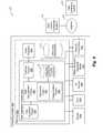
- FIG. 6is a block diagram 450 showing a computing system 600 for managing and providing access to the integrated centralized property database 102 , according to one or more embodiments.
- the computing system 600may include one or more distributed computing systems.
- each block shownmay represent one or more such blocks as appropriate to a specific embodiment, or may be combined with other blocks.
- the various components of a data aggregation system 614may physically reside on one or more machines, which use standard inter-process communication mechanisms (e.g., TCP/IP) to communicate with each other.
- the data aggregation system 614may be implemented in software, hardware, firmware, or in any combination thereof to achieve the capabilities described herein.
- the computing system 600includes a computer memory (“memory”) 602 , a display 604 , one or more Central Processing Units (“CPU”) 606 , Input/Output devices 608 (e.g., keyboard, mouse, joystick, track pad, CRT or LCD display, and the like), other computer-readable media 610 , and network connections 612 .
- a data aggregation system 614is shown residing in the memory 602 . In other embodiments, some portion of the contents or some or all of the components of the data aggregation system 614 may be stored on and/or transmitted over the other computer-readable media 610 .
- the components of the data aggregation system 614preferably execute on one or more CPUs 606 and generate data items 410 , determine relevant geocoding 140 , and categorize data 138 , as described herein.
- Other code or programs 616e.g., a Web server, a database management system, and the like
- data repository 618which may include, for example, a globe 104 or map including associated geocoding information
- All of the components in FIG. 6may not be required for each implementation.
- Some inputs to the data aggregation system 614may be automatically generated and/or provided (e.g., inputs from web crawlers 108 , image crawlers 110 , data feeds 112 , etc.), but other inputs may be entered manually to supplement data acquired through automated means.
- the data aggregation system 614may include a data acquisition engine 620 ; a data management engine 622 ; a geocoding engine 624 and categorization engine 626 within, or as part of, the data management engine 622 ; an interface engine 628 ; and an integrated centralized property database 102 .
- the data acquisition engine 620performs at least some of the functions described herein, with respect to the processes described herein.
- the data acquisition engine 620interacts with the data sources 116 to obtain data items 410 , or information associated with particular points on the earth, and provides such information to the data management engine 622 for further processing.
- the data management engine 622performs at least some of the functions described herein.
- the data management engine 622receives data items 410 obtained by the data acquisition engine 620 , adds category information to the data item 410 (e.g., as shown and described with respect to FIG. 3 , herein) by the categorization engine 626 , and determines and adds relevant geocoding (e.g., as shown and described with respect to FIG. 4 , herein) by the geocoding engine 624 .
- the data management engine 622after processing obtained data items 410 as described herein, provides the data items to the integrated centralized property database 102 for storage and retrieval in response to user queries 118 .
- the data aggregation system 614interacts via a communications network 632 with data source computing systems 634 and/or one or more user computing systems 638 .
- Communications network 632may utilize one or more protocols to communicate via one or more physical networks, including local area networks, wireless networks, dedicated lines, intranets, the Internet, and the like.
- User computing systems 638may be computer systems utilized by any user of the data aggregation system 614 , including, for example, insurance companies, real estate professionals, builders, parties interested in conducting property transactions, and so on.
- the data acquisition engine 620may obtain data items 410 , for example, through communication via communications network 632 with data source computing systems 634 . Users may utilize one or more user computing systems 638 to access the data aggregation system 614 and query the integrated centralized property database 102 , for example, via the user interface 120 .
Landscapes
- Engineering & Computer Science (AREA)
- Databases & Information Systems (AREA)
- Theoretical Computer Science (AREA)
- Remote Sensing (AREA)
- Data Mining & Analysis (AREA)
- Physics & Mathematics (AREA)
- General Engineering & Computer Science (AREA)
- General Physics & Mathematics (AREA)
- Financial Or Insurance-Related Operations Such As Payment And Settlement (AREA)
- Management, Administration, Business Operations System, And Electronic Commerce (AREA)
- Information Retrieval, Db Structures And Fs Structures Therefor (AREA)
Abstract
Description
- Technical Field
- This disclosure is in the field of aggregating information associated with all geographic points on the earth, where the information is captured from distributed data sources and integrated into a centralized database that may be queried for a complete time history of any geographic point on the earth.
- Description of the Related Art
- Information about property and the attributes of property, such as title information, geographic characteristics, insurance policies in force, and building and utility information, is usually publically available, but is stored by different entities in different locations using different formats. Some of the information is found by identifying an address or other number that identifies a real estate parcel and then contacting the record keeper of the type of information desired, such as a county records office, about the parcel number or address of the property. In some instances, information of interest may be more quickly found by using the Internet or an aggregator such as Zillow™ or Google Maps™ to access information about the property.
- However, this approach to collecting data has a number of drawbacks. First, this data is tracked based on identifiers such as parcels, lots, townships, cities, ZIP Codes, school districts, and the like. These identifiers may have changed over time such that they represent different points on the earth at different times. Second, in the case of parcels, information may be out of date, and information related to the parcel or point of land will be stored in many different locations. In addition, it may be nearly impossible to identify and locate all available information that may relate to that parcel, for example events concerning the parcel that may not be in official county tax base or other government records. Further, many events are stored in different places and different databases. These include events such as crime events, news articles, or private photographs of the location over its various histories.
- The present disclosure provides systems and methods to create and maintain an integrated centralized property database containing all information, including a full time history, associated with any given point on the earth. In some embodiments, this point may be identified by latitude and longitude coordinates.
- The integrated centralized property database receives information from various data sources, which may include, for example, data sources accessible through the Internet, government databases relating to property, crime data, weather data and the like, as well as any other types of public or private data. The data sources may be located by web crawlers, image crawlers, data feeds or the like, and may be updated periodically to ensure the data stored in the integrated centralized property database is current.
- The received data items may be processed to determine relevant category information (e.g., weather data, crime data, demographic data, property sales or change of ownership or classification data, tax assessment data, and so on). Further, the data items may be processed to determine or extract geocoding information, such as latitude, longitude and/or Z-axis information (i.e., height above or depth below the surface of the earth). The category and/or geocoding information may be associated with the data items for storage in the integrated centralized property database. As such, the integrated centralized property database may store a variety of information of all types which is related to one or more geographic points on the earth. Further, the data items may include or be associated with particular date or time information, for example, indicating a time or range of times to which the information pertains.
- A user interface is provided which allows users to access the integrated centralized property database. Queries may be performed via the user interface and the integrated centralized property database will be searched for all relevant information associated with the query. For example, a user may input a specific latitude/longitude, and the system will retrieve, and output via the user interface, all relevant information associated with that particular latitude/longitude. The query may further include a time or range of times, in which case, the system will retrieve all relevant information associated with both the input location information (e.g., a particular latitude/longitude, an area defined by an input polygon or the like) and the input time information.
- One benefit to the embodiments described herein is that a user can input a query about a location on the earth and receive, from a single database and single server, all activities and information associated with that location, sorted by date and type of activity/information.
- One method to carry out one or more embodiments may be summarized as including: storing a plurality of data items in a data aggregation system, each of the plurality of data items being associated with one or more location identifiers indicating a particular point on the earth; receiving, by at least one processor, a query indicating a geographic location; retrieving, from the data aggregation system, data items having associated location identifiers matching the received geographic location; and outputting the retrieved data items.
- The one or more location identifiers may include latitude and longitude coordinates of a geographic point on earth. The one or more location identifiers may further include Z-axis coordinates that identifies a distance above or below the earth.
- The received geographic location may include a region on the earth. The region on the earth may be identified by multiple geocoded locations, the multiple geocoded locations described in at least latitude and longitude coordinates. At least a portion of the plurality of data items stored in the data aggregation system may further be associated with one or more time identifiers, and the method may further include: receiving, by the at least one processor, a time identifier, wherein retrieving from the data aggregation system may further include retrieving data items having associated time identifiers matching the received time identifier. The time identifier may include one or more time periods. The one or more location identifiers may include content external to the data aggregation system. The stored data items may include at least one of: tax data, building code data, weather data, insurance data, crime data, survey data, school data, demographic data and property data.
- One system that can carry out one or more embodiments may be summarized as including: a computer processor; a memory coupled to the processor; and an integrated centralized property database, the processor being configured to: receive from a user computer a query including a location identifier, the location identifier including one of a geocoded location and multiple geocoded locations identifying a polygon, receive from the user computer a time period identifier, retrieve from the integrated centralized property database location data, the location data including data associated with the location identifier and with the time period identifier, and provide the retrieved location data to the user computer via a graphical user interface.
- The processor may be further configured to: retrieve parcel information from the integrated centralized property database; compare the retrieved parcel information with the location data to determine parcels associated with the location identifier; and output the parcels associated with the location identifier. The processor may be further configured to: retrieve insurance policy information from the integrated centralized property database; compare the retrieved insurance policy information with the parcels associated with the location identifier to determine the insurance policies associated with the location identifier; and output the insurance policies associated with the location identifier.
- The system can be considered as having a means for storing a plurality of data items in a data aggregation system, each of the plurality of data items being associated with one or more location identifiers indicating a particular point on earth; means for receiving a query indicating a geographic location; means for retrieving data items having associated location identifiers matching the received geographic location; and means for outputting the retrieved data items.
FIG. 1 is a block diagram illustrating an embodiment of an environment in which an integrated centralized property database is used.FIG. 2 is a diagram showing the components of a data item, in accordance with one or more embodiments.FIG. 3 is a block diagram illustrating a process for adding geocoding information and category information to a data item, in accordance with one or more embodiments.FIG. 4 is a flowchart illustrating a process for determining relevant geocoding information, in accordance with one or more embodiments.FIG. 5 is a flowchart illustrating a process for associating one or more categories to a data item, in accordance with one or more embodiments.FIG. 6 is a block diagram illustrating a computing system for managing and providing access to the integrated centralized property database, in accordance with one or more embodiments.- An integrated centralized database is disclosed that aggregates all information that is related to, or associated with, any geographic point on the earth, and includes any changes in information over time with respect to that point. A point on the earth is identified by geocoded coordinates, or latitude/longitude. This aggregated information may be related to parcels and buildings associated with that point, insurance claims data, weather data, crime data, demographic data, buildings on that point, reported activities and events, or other related data by time period. The system constantly scans for new information that can be categorized and associated with one or more points on the earth. The centralized database can then be queried to retrieve any and all data related to that point. For example, in one embodiment the simplest query may include providing only a latitude and longitude, and all information related to that point will be retrieved. In other examples, the query may include a request for data associated with locations within a certain proximity to the point. In addition to a single point, queries for information related to multiple points may be performed. In one or more embodiments, the multiple points may be defined by a region, such as by a polygon with vertices identified by a series of geocoded coordinates that include all geographic locations within the polygon area. In other embodiments, a region may be identified by a name or one or more features used to identify a geographic area. In another embodiment, a region defining points may be described as a combination of location description and a point in time. For example, the footprint of the residence building at property address 123 Dry Creek Road, Napa Valley, Calif., on Jul. 4, 1970, or city of Humptulips, Wash., as boundaries were defined on Jan. 31, 1989.
- One of the advantages of tracking data associated with a geographic point on the earth is the continuity of location description over time. For example, by using a lot number, a parcel identifier, a county, or city identifier to get information about a specific geographic location, a person is not guaranteed to identify the same geographic location over time. For example, a parcel of land from the 1850s may be the result of the subdivision of a much larger block of land acquired earlier by the state. That parcel may have since been subdivided, and portions of the parcel converted to industrial use with industrial utilities installed and underground storage tanks added. Subsequently, some of the subdivided parcels may have been recombined into new larger parcel and converted into farm use. Several decades later, the larger parcel may have been converted to residential use and subdivided for individual family homes. In this example, it would be difficult to research exactly what happened on the land over the last several hundred years because parcel descriptions of the land were constantly changing. However, each individual geographic point on the earth has a specific history of the parcel associated with it, for example its change of zoning status, which parcels it fell within, who owned it, any permitted improvement, insurance coverage and claims, to whom it was bought and sold, and so on. Therefore, by associating information with one or more geocoded locations on earth, information can be accurately obtained concerning a particular geographic area over any time period.
FIG. 1 is a block diagram400 which describes an embodiment of an environment in which an integrated centralized property database102 (which may be referred to at portions herein as “integrated database 102”) is used. Theintegrated database 102 receives its data from a variety ofdifferent data sources 116, which may include data accessible from the Internet, data accessible from a government, insurance company or any third-party database, and the like. Data provided from thedata sources 116 includes a variety of types of data that is, or can be, associated with a particular location or point on Earth.- A wide range of data may be associated with a particular geographic point on the earth, including but not limited to legal data, property characteristic data, transactional data, environmental data, demographic data, and event data.
- Examples of legal data include, but are not limited to, deeds or chains of title that include legal descriptions; boundary descriptions; subdivision information, including parcel changes; tax information on the associated parcel; and liens, mortgages, or other encumbrances ever placed or removed. It may also include government records from the city, county, state, or national levels, pertaining to any real or personal property associated with that point.
- In some embodiments, legal data may include transactional data such as purchase, sale, leasing and/or rental agreements including rental contracts, securitization, encumbrance, or other related legal documents, and other documented changes concerning the point that affects ownership or ownership rights. For example, this may include rights involving the point such as mineral rights, water rights, and other land-related rights, as well as transactions regarding buildings or other improvements associated with the point. In these embodiments, the data associated with the point can be used to identify previous owners, previous tenants, and the terms and extent of their holdings.
- Legal data may also include insurance contract data that describes, for a particular point, any policy ever written associated with that point, the current policies that are in force, the rates and terms of such policies, any claims made against the policies, and the final outcome of the claim. This data may also include risk management analysis, performed by insurance carriers that did not result in the issuance of any policies. In addition, this information may include photos, tax records, other public records, and property value assessments.
- In some embodiments, property characteristic data may be divided into real property and improvements. Real property characteristic data may include elevation, ground slope, soil conditions such as farmland, rocky, marsh, stream, lake, forest, meadow, undeveloped land, paved land, or other. Property characteristic data may also include designations such as floodplain, high risk hail area, or tornado susceptible area.
- Improvements characteristic data may include descriptions of one or more buildings on that point; utilities such as water, sewer, electricity or gas running under, though, or over that point; building permits issued or denied, blueprints, on-site photos, videos, inspections, and stop-work and other notices. It may include terrain information such as fill added. In addition, land information associated with the point, but not directly on the point, may include power pole locations, hydrant locations, high-voltage transmission line placement, erosion effects, and vegetation changes. Also, features associated below the point may also be included such as caves, water reserves, mineral deposits, oil reserves or natural gas reserves. Improvement characteristics data may also include analysis in condition data for structures related to the point. For example, reports showing building conditions, such as type of building, square footage, type of materials used in construction, current condition of aspects of the property such as exterior wall conditions, roof conditions and associated roof reports, the results of on-site inspections and analysis, etc. Also included may be construction dates, remodeled dates and demolition dates for buildings, including blueprints and utilities maps for the buildings. In addition to written information, image, video, audio and other methods of capturing information associated with the point may also be stored. For example, aerial images of the property and buildings on the property may be included that come from satellite images, overhead flights, or images captured by property owners, contractors, or service providers, or pictures from other sources, such as recreational photos, that can be associated with that point.
- Environmental data may also be associated with the point. For example, standard weather data such as temperature, pressure, precipitation, and the like may be included, along with meteorological data describing major weather events such as tornadoes, hailstorms, lightning, hurricanes, snowstorms, heat waves, and the like that have an impact on the value of the property associated with the point. This data may also include forecasted data, officially reported data, and actual measured data describing the event and its effects. Other examples of events may include earthquakes, floods, and fires that have occurred on the point, or near enough to affect the point.
- Other data regarding demographic information, or social data, may be associated with a particular point. For example, average income, education, number of children, crime rates, quality of life measures, school district ratings, unemployment data, weather data, political affiliation data and the like. In addition, consumer and/or business purchase data may also be aggregated and associated with particular points on the earth. For example, the number and type of new car purchases associated with registered vehicle owners having an address listed for that point or within a particular radius of a point. More detailed events may be associated with the property, for example, the contents and date of filed police reports for property associated with the point, specific crime data for criminal record history of people within a region of the point, time and content of any 911 calls or other emergency contacts made from an area associated with the point, and so on.
- There are many sources of data associated with a particular address of an activity, an individual, a license, a policy, or other issues. For example, when a person files for any type of license, whether driver's license, fishing license, marriage license, or any approval issued by a state, city, or county, they are frequently required to provide the address of their current residence. This address is a geographic location. At the time that the license is applied for, the address will be a geographic location of a polygon of a certain size. It may be a few thousand square feet, a few acres, or any one of a number of different sizes and shapes. At a different point in time, that same address may represent a different sized or shaped polygon. Accordingly, the address and the date for that address are interesting data points for storage. Additional information is the particular type of license that was requested for that address. For example, a particular address may have one, two, or dozens of people listing that as their address for a type of license or registration. For example, multiple people may list the same address for their driver's license, voter registration, boat registration, and the like. Knowing the number of people that have listed the same address for their voter registration or, similarly, an address associated with a geographic location that is within the same polygon as another address has particular benefits.
- Other events that may be of particular interest are whether the address was listed in any form for a purchase of a firearm, a person selling a firearm, or a person requesting a concealed carry permit for a firearm. The address of a person requesting to purchase certain materials, such as chemical compositions, garden fertilizer, and in what quantities and other data may also be of interest.
- Many private transactions, not associated with a government entity or license request, are also frequently associated with a particular address. This may include a request for a credit card; joining a private organization such as the Lion's Club, the Boy Scouts of America, the Girl Scouts of America; applying for a private service, such as a telephone installation, having a plumber come visit, having a visit from an electrician, the pumping of a septic tank, installation of a property improvement such as a hot tub, a swimming pool, cutting of trees, the buying or selling of livestock, or any one of a number of transactions which are private as between two individuals or an individual and a company, but in which one of the individuals provides an address that is associated with that particular transaction. This address may then be loaded into any one of a number of available databases, such as into the person's Facebook account, a log record of visits made by a plumbing company, an auctions house listing of the address of people who bought and sold goods, livestock or other items at the auction, or the like. These are instances in which the transactions were private between individuals and no record was made in any government database maintained at a city, county, state, or federal level. However, the database may have become available based on the voluntary listing by one or more of the people involved in the transaction, such as inputting to the business storage records and the then the business records being made available on the Internet, posting to a social media website, such as Facebook, Twitter, Linked In or the like.
- In addition, there are two types of data which may be associated with a particular address. One is an event originating from that address and another is an event about that address. For example, a neighbor may call in a complaint about a different property being an eyesore or violating local zoning laws. In that instance, there are two addresses associated with the particular event, the first address is the address of the person who issued the complaint and the second is the address about which the complaint was made. Thus, for a single event, namely a complaint regarding the maintaining of property, there will be two geographic locations associated with that event, one of which will be the geographic location where data originated and another the geographic location of where the event itself is taking place. Thus, for each event there may be multiple addresses associated with that event and each address will have a data field that indicates whether the event occurred at that address or whether the reporting of that event came from that address or some other particular way that the address is associated with the particular event.
- Other sources of information between private individuals may include magazine subscription, mailing lists, donations to local causes, donations to charity, or other activities in which one of the parties provides the address at which they will be receiving goods being shipped by another party where the goods are being purchased from Amazon, Barnes & Noble, or any other many thousands of Internet shopping sites which are available.
- The data may take a number of different forms including, but not limited to numbers, text, images, graphics, and audio and video. The data may also be in a form readable by a computer or other device, such as a binary form or encrypted form, or in multiple forms that may be combined in one or more ways. In addition, the data may contain references to locations of other data sources. This may include links, such as hypertext links to areas on the internet, or references to other systems, for example executable modules or other computer implemented algorithms, that return data related to the point on the earth.
- This data described above represents a very small subset of all possible data that could be associated with a particular point on the earth. The data provided from
data sources 116 may include any such type of data that could be associated with a particular point on the earth, including the types described above, and may be provided fromdata sources 116 including those described above. - Data related to a point on the earth is collected from
data sources 116 in a variety of ways. In some embodiments, web crawlers108 are used to search for data or updates to data in a systematic way throughout the Internet to search for data concerning regions that are associated with particular points on the earth. For example, given a particular point and a particular time, theweb crawler 108 will identify and collect the information, such as described above, on the parcels, neighborhoods, cities, counties, and state with which the point is associated. - In addition, image crawlers110 may be used to systematically examine images, accessible via the internet or other sources, and image metadata associated with each image. Metadata may include, for example, an image title, image description, or latitude/longitude at which the picture was taken. For example, the
image crawler 110 may find an image taken at a wedding held in a field next to a property where the background of the image includes the property. The metadata in the picture may include the latitude and longitude of the camera location, the time the image was captured, and the cardinal direction the camera was pointing. From this information, theimage crawler 110 can determine that the image is relevant to the point of the earth if, for example, the image shows part of a building at the point. Additionally, or alternatively, the image may be relevant simply because it depicts a scene at the point of the earth at a particular point in time. Theimage crawler 110 would then add this image and its metadata information (e.g., before or after further processing) to the integratedcentralized property database 102. - Further, data may be collected from
data sources 116 via data feeds112. Data feeds112 may include feeds of data from any type ofdata source 116. For example, data feeds112 may include subscription-based data (which may be provided for free, or for a charge) that is periodically updated and pushed to the integratedcentralized property database 102. Examples of data feeds112 may include, for example, a weather data feed that provides a continuous or periodic stream of data relating to weather conditions or forecasts. Similarly, data feeds112 may include a police or other government service feed, which may provide a feed of data relating to criminal activity, civil complaints, road conditions and the like that may be associated with one or more geographic locations. Data feeds112 may further include feeds from emergency or alerting services, such as Amber Alerts, weather event warning systems (e.g., a data feed providing warnings for hurricanes, tsunamis, tornados, earthquakes, snowstorms, or the like). - Additionally, data feeds112 may include publicly- or privately-accessible social network data (e.g., Twitter, Facebook, Google+, Instagram, Picasa, etc.). Such social network data commonly includes user-uploaded images, text, documents and the like which may be associated with a particular point on the earth. As such, social network data may contain relevant data which may be provided as part of a data feed, or alternatively, which may be discovered by a
web crawler 108 and/orimage crawler 110. - Data feeds112 may further include feeds of data relating to changes in status of property, such as, for example, data indicating a sale of a home, data indicating a rezoning or change in zoning for a particular geographic location or the like.
- As discussed above, information may be collected from a number of
data sources 116. These may include, for example, the public Internet, private/restricted Internet sites such as those requiring a subscription, and governmental sites. In addition, public and private data aggregation sources may also be used asdata sources 116, for example those having real estate and demographic information such as Zillow, Trulia, Realtor.com, and others. In some embodiments, data, such as property characteristic data, can be purchased fromother data sources 116 and included in systems using the integratedcentralized property database 102, either electronically or acquired in print and scanned in. Through these or other embodiments, data relating to any particular point of property on earth may be mined anywhere in the world. - The collected data may be aggregated, centralized, stored and accessed in a number of different ways in various embodiments. Processing of incoming data may be accomplished by a
processor 106. In one embodiment, theintegrated database 102 may consist of one database with multiple data sets which may span multiple physical machines and physical disk drives, where all information collected about all points on the earth is replicated and stored. This way, all of the known and available information as of the most current time of receipt (e.g., fromweb crawler 108,image crawler 110 and/or data feeds112) may be immediately retrieved from the database and presented to the user. - In another embodiment, the
integrated database 102 may include a combination of both replicated information and reference links to data sources outside of the database, such as to a site on the Internet. An advantage of this structure is that a cached version of the data will be immediately available from the integratedcentralized database 102, and reference links will point directly to the original data source to ensure that the latest version of the data is available. - Referring to
FIG. 2 , in one or more embodiments, eachdata item 410 has at least three individual attributes:information 130,location 132 anddate 134.Information 130 includes of an actual data item and/or a reference to a data item stored at a location outside of theintegrated database 102 where the information may be retrieved. For example, the reference to data may be a link or reference to a price at which a property associated with a particular point on the earth has ever been sold, all taxes ever levied on the property, all insurance policies underwritten for the property, and so on. It may also be the data itself, such as the type of license obtained, item purchased, etc. - The
location 132 attribute refers to the locations on the earth to which the information refers or is associated with. This location information may be represented as a geocoded location, for example latitude/longitude. However, thelocation 132 may be a property street address, a parcel identifier, a ZIP code, a city, county, or state designation. In some cases, it may be a region identifier such as a climate zone, a marketing area, or a bounded area of a particular event such as a hailstorm or a fire. In addition, thelocation 132 may correspond to a demographic or socio-economic region, such as a region within a state where the average number of people in a household is 2.5, or a region where there is at least one person within the household over the age of 65, or where average income is above $50,000. - The
location 132 attribute, in one embodiment, includes at least two fields: the first field indicates the location itself, as previously described, and the second field indicates the relationship of the location to the data. In the first field, the location itself may be described and stored in multiple formats. For example, in addition to being a parcel identifier or a property street address, it can also include the longitude and latitude of the boundaries of a polygon which encloses that particular parcel or property address. There are a number of other overlapping ways in which a geographic point can be defined. The relationship to the data or event will provide an indication of how that particular location is related to theactual information 130 itself. The location may be indicated as where the event occurred or that the information is a description of that particular address, in which case, thelocation 132 field attribute would refer to itself. Alternatively, this field of thelocation 132 attribute may refer to the source of the data which is in theinformation 130. For example, if a 911 call is made this is a single event, a single information; however, two data records can be obtained, one having the location from which the call originated and the field for thelocation 132 would be marked as the source of the data, and a separate record having thesame event information 130 but whoselocation 132 has the field attribute that the information applies to that particular location, namely to itself. It is, thus, possible that a single piece ofinformation 130, whether it is an event or data, may have multiple items stored because it is associated with multiple addresses orlocations 132. Of course, thesame location 132 may have multiple events associated with that address, as will be apparent since a single address will likely have a home owner's insurance policy, driver's license, voter registrations, mailing lists, etc., all having thesame location 132, but havingdifferent information 130 associated with thatlocation 132. - In some embodiments, the
date 134 attribute identifies the date and time at which the data item is or was relevant. Thedate 134 attribute can correspond to a specific point in time, to a specific range of time, or it could be associated with multiple time ranges. For example, the tax records associated with a particular parcel of land, which contains a point on the earth of interest, may be associated with particular years, or a range of months between land assessment updates. - The
processor 106 may generate thedata items 410 based on data received from the data sources116. For example, theprocessor 106 may receive an image of a particular point on earth from animage crawler 110. Theprocessor 106 may analyze metadata received with the image to determine location information (such as, for example, latitude and longitude) associated with the image, as well as to determine a date that the image was taken. Theprocessor 106 may then create adata item 410, which may have a standard format or structure, including the information130 (i.e., the image),location 132 anddate 134. Thisdata item 410 may then be stored in the integratedcentralized property database 102. FIG. 3 is a block diagram420 illustrating a process for adding geocoding information and category information to adata item 410, in accordance with one or more embodiments. As shown inFIG. 3 , additional attributes may be associated with thedata item 410, and may be determined by examiningother data item 410 attributes. For example, theprocessor 106 may receiveinformation 130 and categorize138 the information into one ormore categories 146 for easier grouping. Thecategory 146 information may be appended to or otherwise associated with thedata item 410 and stored in the integratedcentralized property database 102.Example categories 146 include, but are not limited to, insurance underwriting, insurance claims, tax information, property characteristics, crime, demographics, weather events, and so on.- The
data item 410 may further be analyzed by theprocessor 106 to determinerelevant geocoding 140. In some embodiments, thelocation 132 attribute and thedate 134 attribute may be combined to produce one or more geocoded locations identified by latitude/longitude. In this way,information 130 associated with a namedlocation 132 that represents different areas at different dates can be properly identified with specific points on the earth. For example, tax information associated with the address 199 Dry Creek Road, Napa, Calif. 94558 in 1968 may have referred to a 10-acre parcel of farm land, where the same address today may refer to a single family home that was subdivided from the 10 acres in 1989. In this example, the date1968 together with the address would identify a range of geocoded locations to which 1968 tax information would be relevant, which is different than the geocoded locations associated with any current tax information. Therefore, in these embodiments, an updateddata item 410 may include—in addition toinformation 130,location identifier 132 anddate 134—acategory 146 and one or more (e.g., a range of) geocoded coordinates150. FIG. 4 is a flowchart illustrating a process430 for determining relevant geocoding information. Atblock 152, the process includes receiving alocation description 132 of adata item 410. Thelocation description 132 of thedata item 410 may be received by theprocessor 106, and may be received from aweb crawler 108,image crawler 110, data feeds112 and/orupdate sources 114, any of which may have retrieved thelocation description 132 fromdata sources 116. As an example, the receivedlocation description 132 may be a neighborhood, a parcel, a lot, an address, or other such non-geocoded location descriptions.- At
block 154, theprocessor 106 receives thedate 134 associated with thelocation description 132. Thedate 134 may be received by theprocessor 106 from the same source (i.e., theweb crawler 108,image crawler 110, data feeds112, and/or update sources114) that provided thelocation description 132. Alternatively, thedate 134 may be determined by theprocessor 106, for example, by analyzing metadata, image analysis, text analysis, or the like. - At
block 156, theprocessor 106 determines the geographical boundaries of thelocation description 132 at thedate 134. The geographical boundaries, in at least some retrieved data items, may be absent from thelocation description 132 itself (e.g., thelocation description 132 may identify a neighborhood, parcel, lot, address, or the like). In such a case, theprocessor 106 may determine the geographical boundaries of the location at the date received at154 utilizing various techniques. One such technique, for example, may involve comparing the location information with location information which may be stored in theintegrated database 102, or in any other accessible database. For example, if the receivedlocation description 132 is a particular neighborhood in the city of Seattle, atblock 156, theprocessor 106 may reference a Seattle neighborhood database (which may be a publicly-accessible database) to determine the streets or blocks which define a boundary for that neighborhood at the date received atblock 154. Because property boundaries often change over time (e.g., neighborhoods, lots, census-defined areas, voting districts and the like), determining the geographical boundaries of the location description at the date, atblock 156, enables accurate associations between thelocation description 132 and thedate 134. - At
block 158, theprocessor 106 converts the geographical boundaries determined atblock 156 into ranges of associated geocoded coordinates (i.e., latitude and longitude). This may be accomplished, in some embodiments, by referencing one or more maps containing geocoded coordinates. For example, a city map or a street map may be superimposed onto a geocoding map containing latitude and longitude coordinates, and theprocessor 106 may thus determine the geocoded coordinates which correspond to the boundaries (e.g., street boundaries, parcel boundaries, etc.) which were determined atblock 156. - At
block 160, the determined geocoded coordinates associated with thelocation description 132 anddate 134 are added to thedata item 410. The updateddata item 410 may thus be stored in theintegrated database 102.FIG. 5 is a flowchart illustrating aprocess 440 for associating one ormore categories 146 to adata item 410. Atblock 170, the process includes receiving adata item 410. Thedata item 410 may be received by theprocessor 106, and may be received from aweb crawler 108,image crawler 110, data feeds112 and/orupdate sources 114, any of which may have retrieved thedata item 410 fromdata sources 116. - At
block 172, theprocessor 106 analyzes thedata item 410 to determine one or moreapplicable categories 146 to which thedata item 410 pertains or should be associated with. Theprocessor 106 may employ various techniques for analyzing and determining applicable categories. For example, theprocessor 106 may analyze theinformation 130 and/orlocation description 132 included in the receiveddata item 410, which may include, for example, textual information describing the location. Theprocessor 106 may utilize any textual or other information processing techniques, including for example heuristic processes, to determine one ormore categories 146 relevant to thedata item 410. - The
processor 106 may access a categories database, which may be included in or otherwise accessible to theintegrated database 102, to determine one ormore categories 146 relevant to thedata item 410. Examples of such categories include, but are not limited to, insurance underwriting, insurance claims, tax information, property characteristics, crime, demographics, weather events, and so on. - At
block 174, theapplicable categories 146 are added to thedata item 410. The updateddata item 410 may thus be stored in theintegrated database 102, along with the associatedcategory 146 information. - In some embodiments, “location information” refers not only to a specific latitude and longitude, but additionally includes vertical or Z-axis information (e.g., indicating a height above or a depth below the surface of the earth).
- Referring again to the block diagram400 of
FIG. 1 , property information contained in theintegrated database 102 may be accessed by one or more users via agraphical user interface 120. Integrated database 102 includes data items having particular location information (as discussed above), such that each of the data items are associated with a particular point on the earth, effectively making up a “globe”104, or map of locations, with each information item being linked to one or more particular locations on theglobe 104 or map.Queries 118 may be received by theintegrated database 102 from one or more user computer systems. Thequeries 118 may be provided by users through theuser interface 120, and may be provided in a variety of forms. For example, aquery 118 may be provided by inputting location information (e.g., latitude/longitude) and querying for all information associated with that particular point on the earth. Alternatively, thequery 118 may specify particular types of information associated with the particular point on the earth to be returned, such as, for example, only insurance-related information, property zoning information, weather-related information, and so on.- The
query 118 may specify a property location of interest by directly inputting location information, or by selecting a particular point on a map provided by the user interface120 (e.g., the “X” shown inFIG. 1 ), or by selecting an area within the map (e.g., the area shown within the dotted lines inFIG. 1 ). An area within the map may be selected by, for example, a drawing tool provided through theuser interface 120 which allows a user to draw polygons or various other shapes. Further, queries118 may include Z-axis information (i.e., location information in a vertical direction). For example, a user may provide aquery 118 to theintegrated database 102 that specifies a particular latitude and longitude, and further specifies a depth or height of 10 meters to 100 meters. In such a case, theintegrated database 102 will display all matching information to the user via theuser interface 120. - The geographic location of a particular point can be described a number of ways. Generally, a latitude and longitude are more than sufficient to specify the particular location of an item. Latitudes and longitudes can have a number of decimal points specified that provide information regarding degrees, minutes, seconds, and subparts of seconds, as well as decimal degrees with a number points. The number of decimal points or subparts of seconds that a latitude or longitude specifies will reduce the geographic area of the point under consideration. For example, a latitude that is specified exactly in degrees, minutes, and seconds will be a fairly large area of land. For example, one minute equals the width of somewhat less than a mile, approximately 0.91 miles and one second equals approximately a width of 80 feet. A measure of latitude and longitude in seconds thus covers a point on the earth that is about 640 square feet. If a more precise location is to be identified, which is frequently the case, the latitude and longitude can be specified in fractions of a second or in the decimal format which can specify locations of particular points in the range of one square foot, a quarter of a square foot, or smaller.
- In such a reference plane, latitude is generally considered an X data point and longitude a Y data point. Thus, with longitude and latitude acting as an X and Y reference grid, respectively, any particular location on the surface of the earth can be defined with a high degree of accuracy. For some locations, and some events, it may be desired to also provide a height or depth reference, which will be referred to herein as the Z axis. A plus Z represents a height above the surface of the earth and a minus Z represents a depth below the surface of the earth. Thus, the third floor of a building may have the same X and Y coordinates as the second and first floors of that building, but would have a different Z reference. Given the large number of apartment complexes, high-rise office buildings, and other events that may happen at various heights above the surface of the earth, the option to include a Z axis height provides significant benefits and a further ability to define the exact location of a particular event or data. Some events may also be a negative Z, such as may occur in mine shafts, the bottom of a lake, or some other location which is below the local surface of the earth at that point.
- The references as provided herein to latitude and longitude refer to the surface of the earth at that particular geographic location. Thus, a longitude and latitude geographic location in with a high altitude, such as Denver or Breckenridge, would not include within it a Z axis measure if it were referring to the land that was at the surface of the earth at that location. Rather, the Z axis is for including a reference to an event or data that is above or below the local surface of the geographic earth surface feature at that location which may be either a ground or water, such as a lake, river, stream, or ocean.
- In response to
queries 118, theintegrated database 102 may provide the relevant data overlaid on a map in theuser interface 120. The data may include, for example, anydata items 410 stored in theintegrated database 102 having a location corresponding to a location provided by thequery 118. Further, theuser interface 120 may provide users an option to display only a particular type ofdata items 410, based oncategory 146 or the like. For example, a user of theuser interface 120 may select to display only crime data, demographic data, school data, insurance data or so on. - The
user interface 120 may further include atime scale 122, which allows a user to select (e.g., by moving aslider 122a) a particular time or range of times of interest. Thetime scale 122 may allow users to query118 theintegrated database 102 for information associated with particular points on the earth at any time, including decades, years, months, weeks, etc. - In one or more embodiments, users may query the system by identifying one or more points on the earth to receive information associated with those points, or may query the system by identifying information parameters to receive points on the earth associated with that information. Example queries include: do an address and a geolocation coordinate refer to the same parcel or spot? What demographics are associated with a point on the earth? What is the entire property history of a particular point? What is the current tax information for the parcel associated with this point? What building or construction permits have ever been issued for any parcel associated with this point of land? Who has ever held title to the land? Who has ever leased the land? In what areas of a county is the crime rate above 5%?
- The system would also be valuable for insurance carriers. For example, for underwriters, what is the insurance claim history for properties at this location? Is there evidence of a land depression filled up around this location? Have there ever been floods at this location? What is the grade of the earth at this point? Have oil tanks ever been buried close to this location, or have oil lines fed this location at any time in the past? Do structures near this location exhibit evidence of moss buildup or other evidence of lack of upkeep?
- In one or more embodiments, the data aggregation system may be queried using a structured query language, or queries118 may be generated through the
graphical user interface 120. FIG. 6 is a block diagram450 showing acomputing system 600 for managing and providing access to the integratedcentralized property database 102, according to one or more embodiments.- The
computing system 600 may include one or more distributed computing systems. In addition, each block shown may represent one or more such blocks as appropriate to a specific embodiment, or may be combined with other blocks. Moreover, in one example embodiment, the various components of adata aggregation system 614 may physically reside on one or more machines, which use standard inter-process communication mechanisms (e.g., TCP/IP) to communicate with each other. Further, thedata aggregation system 614 may be implemented in software, hardware, firmware, or in any combination thereof to achieve the capabilities described herein. - In the embodiment shown, the
computing system 600 includes a computer memory (“memory”)602, adisplay 604, one or more Central Processing Units (“CPU”)606, Input/Output devices608 (e.g., keyboard, mouse, joystick, track pad, CRT or LCD display, and the like), other computer-readable media 610, andnetwork connections 612. Adata aggregation system 614 is shown residing in thememory 602. In other embodiments, some portion of the contents or some or all of the components of thedata aggregation system 614 may be stored on and/or transmitted over the other computer-readable media 610. The components of thedata aggregation system 614 preferably execute on one ormore CPUs 606 and generatedata items 410, determinerelevant geocoding 140, and categorizedata 138, as described herein. Other code or programs616 (e.g., a Web server, a database management system, and the like) and potentially other data repositories, such as data repository618 (which may include, for example, aglobe 104 or map including associated geocoding information), may also reside in thememory 602 or may otherwise be accessible to thedata aggregation system 614, and preferably execute on one ormore CPUs 606. All of the components inFIG. 6 may not be required for each implementation. Some inputs to thedata aggregation system 614 may be automatically generated and/or provided (e.g., inputs from web crawlers108, image crawlers110, data feeds112, etc.), but other inputs may be entered manually to supplement data acquired through automated means. - As shown in
FIG. 6 , thedata aggregation system 614 may include adata acquisition engine 620; adata management engine 622; ageocoding engine 624 andcategorization engine 626 within, or as part of, thedata management engine 622; aninterface engine 628; and an integratedcentralized property database 102. - The
data acquisition engine 620 performs at least some of the functions described herein, with respect to the processes described herein. In particular, thedata acquisition engine 620 interacts with thedata sources 116 to obtaindata items 410, or information associated with particular points on the earth, and provides such information to thedata management engine 622 for further processing. - The
data management engine 622 performs at least some of the functions described herein. In particular, thedata management engine 622 receivesdata items 410 obtained by thedata acquisition engine 620, adds category information to the data item410 (e.g., as shown and described with respect toFIG. 3 , herein) by thecategorization engine 626, and determines and adds relevant geocoding (e.g., as shown and described with respect toFIG. 4 , herein) by thegeocoding engine 624. - The
data management engine 622, after processing obtaineddata items 410 as described herein, provides the data items to the integratedcentralized property database 102 for storage and retrieval in response to user queries118. - In addition, the
data aggregation system 614 interacts via acommunications network 632 with data source computing systems634 and/or one or moreuser computing systems 638.Communications network 632 may utilize one or more protocols to communicate via one or more physical networks, including local area networks, wireless networks, dedicated lines, intranets, the Internet, and the like. User computing systems 638 may be computer systems utilized by any user of thedata aggregation system 614, including, for example, insurance companies, real estate professionals, builders, parties interested in conducting property transactions, and so on.- The
data acquisition engine 620 may obtaindata items 410, for example, through communication viacommunications network 632 with data source computing systems634. Users may utilize one or moreuser computing systems 638 to access thedata aggregation system 614 and query the integratedcentralized property database 102, for example, via theuser interface 120. - The various embodiments described above can be combined to provide further embodiments. These and other changes can be made to the embodiments in light of the above-detailed description. In general, in the following claims, the terms used should not be construed to limit the claims to the specific embodiments disclosed in the specification and the claims, but should be construed to include all possible embodiments along with the full scope of equivalents to which such claims are entitled. Accordingly, the claims are not limited by the disclosure.
Claims (21)
Priority Applications (2)
| Application Number | Priority Date | Filing Date | Title |
|---|---|---|---|
| US15/049,595US10671648B2 (en) | 2016-02-22 | 2016-02-22 | Integrated centralized property database systems and methods |
| US16/889,290US11468104B2 (en) | 2016-02-22 | 2020-06-01 | Integrated centralized property database systems and methods |
Applications Claiming Priority (1)
| Application Number | Priority Date | Filing Date | Title |
|---|---|---|---|
| US15/049,595US10671648B2 (en) | 2016-02-22 | 2016-02-22 | Integrated centralized property database systems and methods |
Related Child Applications (1)
| Application Number | Title | Priority Date | Filing Date |
|---|---|---|---|
| US16/889,290ContinuationUS11468104B2 (en) | 2016-02-22 | 2020-06-01 | Integrated centralized property database systems and methods |
Publications (2)
| Publication Number | Publication Date |
|---|---|
| US20170242873A1true US20170242873A1 (en) | 2017-08-24 |
| US10671648B2 US10671648B2 (en) | 2020-06-02 |
Family
ID=59631132
Family Applications (2)
| Application Number | Title | Priority Date | Filing Date |
|---|---|---|---|
| US15/049,595Active2037-05-23US10671648B2 (en) | 2016-02-22 | 2016-02-22 | Integrated centralized property database systems and methods |
| US16/889,290Active2036-09-09US11468104B2 (en) | 2016-02-22 | 2020-06-01 | Integrated centralized property database systems and methods |
Family Applications After (1)
| Application Number | Title | Priority Date | Filing Date |
|---|---|---|---|
| US16/889,290Active2036-09-09US11468104B2 (en) | 2016-02-22 | 2020-06-01 | Integrated centralized property database systems and methods |
Country Status (1)
| Country | Link |
|---|---|
| US (2) | US10671648B2 (en) |
Cited By (16)
| Publication number | Priority date | Publication date | Assignee | Title |
|---|---|---|---|---|
| US20170293635A1 (en)* | 2016-04-08 | 2017-10-12 | Perry R. Peterson | Methods and systems for selecting and analyzing geospatial data on a discrete global grid system |
| US20170337237A1 (en)* | 2016-05-17 | 2017-11-23 | Facebook, Inc. | Systems and methods for processing shape data based on serialization formatting |
| CN108182251A (en)* | 2017-12-29 | 2018-06-19 | 零空间(北京)科技有限公司 | Meteorological data rendering method and virtual reality device under reality environment |
| US10671633B2 (en)* | 2018-04-18 | 2020-06-02 | Data Vision Group, LLC | System and method for 3D geolocation to a building floor level in an urban environment |
| US20210088353A1 (en)* | 2019-09-24 | 2021-03-25 | BaseMap, Inc. | Markers describing the environment of a geographic location |
| US11107172B2 (en)* | 2009-08-31 | 2021-08-31 | Leigh W Budlong | Methods for transforming complex zoning codes and regulations to produce usable data |
| US11222464B2 (en) | 2019-08-22 | 2022-01-11 | The Travelers Indemnity Company | Intelligent imagery |
| US20220076491A1 (en)* | 2020-04-16 | 2022-03-10 | At&T Intellectual Property I, L.P. | Facilitation of augmented reality-based space assessment |
| US11461289B2 (en)* | 2013-03-15 | 2022-10-04 | Foursquare Labs, Inc. | Apparatus, systems, and methods for providing location information |
| WO2023192304A1 (en)* | 2022-03-30 | 2023-10-05 | Corelogic Solutions, Llc | Boundary-based property identifiers |
| US11810595B2 (en) | 2020-04-16 | 2023-11-07 | At&T Intellectual Property I, L.P. | Identification of life events for virtual reality data and content collection |
| US20240095839A1 (en)* | 2020-12-15 | 2024-03-21 | Jarrod Burns | Property Conditions Assessment and Analysis Through a Spatial Analysis Model |
| EP4133235A4 (en)* | 2020-04-10 | 2024-04-03 | Cape Analytics, Inc. | GEOCODING SYSTEM AND METHOD |
| US12079013B2 (en) | 2016-01-08 | 2024-09-03 | Pictometry International Corp. | Systems and methods for taking, processing, retrieving, and displaying images from unmanned aerial vehicles |
| US12087441B2 (en) | 2020-04-17 | 2024-09-10 | At&T Intellectual Property I, L.P. | Facilitation of conditional do not resuscitate orders |
| US12332660B2 (en) | 2018-11-21 | 2025-06-17 | Eagle View Technologies, Inc. | Navigating unmanned aircraft using pitch |
Families Citing this family (7)
| Publication number | Priority date | Publication date | Assignee | Title |
|---|---|---|---|---|
| US11200353B2 (en) | 2018-12-21 | 2021-12-14 | Geospan Corporation | Geographic information system for creating 3D structure models using perspective view drafting |
| US11838399B2 (en)* | 2020-05-12 | 2023-12-05 | Apple Inc. | Anonymous aggregation service for sensitive data |
| EP4427176B1 (en)* | 2021-11-05 | 2025-06-18 | Swiss Reinsurance Company Ltd. | Automated standardized location digital twin and location digital twin method factoring in dynamic data at different construction levels, and system thereof |
| US11625511B1 (en) | 2021-11-19 | 2023-04-11 | Bmic Llc | Methods for designing, manufacturing, installing, and/or maintenance of roofing accessories and systems of use thereof |
| US12360286B2 (en) | 2022-10-14 | 2025-07-15 | Zesty.Ai, Inc. | Hail predictions using artificial intelligence |
| US12360287B2 (en) | 2022-10-14 | 2025-07-15 | Zesty.Ai, Inc. | Hail frequency predictions using artificial intelligence |
| CN115858930B (en)* | 2022-12-09 | 2024-02-20 | 贝壳找房(北京)科技有限公司 | Code-based information query method, apparatus, medium, and computer program product |
Citations (1)
| Publication number | Priority date | Publication date | Assignee | Title |
|---|---|---|---|---|
| US20160210326A1 (en)* | 2015-01-19 | 2016-07-21 | Sas Institute Inc. | Techniques for query homogenization in cache operations |
Family Cites Families (168)
| Publication number | Priority date | Publication date | Assignee | Title |
|---|---|---|---|---|
| US2273876A (en) | 1940-02-12 | 1942-02-24 | Frederick W Lutz | Apparatus for indicating tilt of cameras |
| US3153784A (en) | 1959-12-24 | 1964-10-20 | Us Industries Inc | Photo radar ground contour mapping system |
| US5345086A (en) | 1962-11-28 | 1994-09-06 | Eaton Corporation | Automatic map compilation system |
| US3621326A (en) | 1968-09-30 | 1971-11-16 | Itek Corp | Transformation system |
| US3594556A (en) | 1969-01-08 | 1971-07-20 | Us Navy | Optical sight with electronic image stabilization |
| US3661061A (en) | 1969-05-05 | 1972-05-09 | Atomic Energy Commission | Picture position finder |
| US3614410A (en) | 1969-06-12 | 1971-10-19 | Knight V Bailey | Image rectifier |
| US3716669A (en) | 1971-05-14 | 1973-02-13 | Japan Eng Dev Co | Mapping rectifier for generating polarstereographic maps from satellite scan signals |
| US3725563A (en) | 1971-12-23 | 1973-04-03 | Singer Co | Method of perspective transformation in scanned raster visual display |
| US3864513A (en) | 1972-09-11 | 1975-02-04 | Grumman Aerospace Corp | Computerized polarimetric terrain mapping system |
| US4015080A (en) | 1973-04-30 | 1977-03-29 | Elliott Brothers (London) Limited | Display devices |
| JPS5223975Y2 (en) | 1973-05-29 | 1977-05-31 | ||
| US3877799A (en) | 1974-02-06 | 1975-04-15 | United Kingdom Government | Method of recording the first frame in a time index system |
| DE2510044A1 (en) | 1975-03-07 | 1976-09-16 | Siemens Ag | ARRANGEMENT FOR RECORDING CHARACTERS USING MOSAIC PENCILS |
| US4707698A (en) | 1976-03-04 | 1987-11-17 | Constant James N | Coordinate measurement and radar device using image scanner |
| US4240108A (en) | 1977-10-03 | 1980-12-16 | Grumman Aerospace Corporation | Vehicle controlled raster display system |
| JPS5637416Y2 (en) | 1977-10-14 | 1981-09-02 | ||
| IT1095061B (en) | 1978-05-19 | 1985-08-10 | Conte Raffaele | EQUIPMENT FOR MAGNETIC REGISTRATION OF CASUAL EVENTS RELATED TO MOBILE VEHICLES |
| US4396942A (en) | 1979-04-19 | 1983-08-02 | Jackson Gates | Video surveys |
| FR2461305B1 (en) | 1979-07-06 | 1985-12-06 | Thomson Csf | MAP INDICATOR SYSTEM MORE PARTICULARLY FOR AIR NAVIGATION |
| DE2939681A1 (en) | 1979-09-29 | 1981-04-30 | Agfa-Gevaert Ag, 5090 Leverkusen | METHOD AND DEVICE FOR MONITORING THE QUALITY IN THE PRODUCTION OF PHOTOGRAPHIC IMAGES |
| DE2940871C2 (en) | 1979-10-09 | 1983-11-10 | Messerschmitt-Bölkow-Blohm GmbH, 8012 Ottobrunn | Photogrammetric method for aircraft and spacecraft for digital terrain display |
| US4387056A (en) | 1981-04-16 | 1983-06-07 | E. I. Du Pont De Nemours And Company | Process for separating zero-valent nickel species from divalent nickel species |
| US4382678A (en) | 1981-06-29 | 1983-05-10 | The United States Of America As Represented By The Secretary Of The Army | Measuring of feature for photo interpretation |
| US4463380A (en) | 1981-09-25 | 1984-07-31 | Vought Corporation | Image processing system |
| US4495500A (en) | 1982-01-26 | 1985-01-22 | Sri International | Topographic data gathering method |
| US4490742A (en) | 1982-04-23 | 1984-12-25 | Vcs, Incorporated | Encoding apparatus for a closed circuit television system |
| US4586138A (en) | 1982-07-29 | 1986-04-29 | The United States Of America As Represented By The United States Department Of Energy | Route profile analysis system and method |
| US4491399A (en) | 1982-09-27 | 1985-01-01 | Coherent Communications, Inc. | Method and apparatus for recording a digital signal on motion picture film |
| US4527055A (en) | 1982-11-15 | 1985-07-02 | Honeywell Inc. | Apparatus for selectively viewing either of two scenes of interest |
| FR2536851B1 (en) | 1982-11-30 | 1985-06-14 | Aerospatiale | RECOGNITION SYSTEM COMPRISING AN AIR VEHICLE TURNING AROUND ITS LONGITUDINAL AXIS |
| US4489322A (en) | 1983-01-27 | 1984-12-18 | The United States Of America As Represented By The Secretary Of The Air Force | Radar calibration using direct measurement equipment and oblique photometry |
| US4635136A (en) | 1984-02-06 | 1987-01-06 | Rochester Institute Of Technology | Method and apparatus for storing a massive inventory of labeled images |
| US4814711A (en) | 1984-04-05 | 1989-03-21 | Deseret Research, Inc. | Survey system and method for real time collection and processing of geophysicals data using signals from a global positioning satellite network |
| US4686474A (en) | 1984-04-05 | 1987-08-11 | Deseret Research, Inc. | Survey system for collection and real time processing of geophysical data |
| US4673988A (en) | 1985-04-22 | 1987-06-16 | E.I. Du Pont De Nemours And Company | Electronic mosaic imaging process |
| US4653136A (en) | 1985-06-21 | 1987-03-31 | Denison James W | Wiper for rear view mirror |
| DE211623T1 (en) | 1985-08-01 | 1987-07-02 | British Aerospace Plc, London | IDENTIFICATION OF GROUND TARGETS IN THE REFLECTED SIGNALS OF AN AIRCRAFT MONITORING RADAR. |
| US4953227A (en) | 1986-01-31 | 1990-08-28 | Canon Kabushiki Kaisha | Image mosaic-processing method and apparatus |
| US4653316A (en) | 1986-03-14 | 1987-03-31 | Kabushiki Kaisha Komatsu Seisakusho | Apparatus mounted on vehicles for detecting road surface conditions |
| US4688092A (en) | 1986-05-06 | 1987-08-18 | Ford Aerospace & Communications Corporation | Satellite camera image navigation |
| US4956872A (en) | 1986-10-31 | 1990-09-11 | Canon Kabushiki Kaisha | Image processing apparatus capable of random mosaic and/or oil-painting-like processing |
| JPS63202182A (en) | 1987-02-18 | 1988-08-22 | Olympus Optical Co Ltd | Tilted dot pattern forming method |
| US4814896A (en) | 1987-03-06 | 1989-03-21 | Heitzman Edward F | Real time video data acquistion systems |
| US5164825A (en) | 1987-03-30 | 1992-11-17 | Canon Kabushiki Kaisha | Image processing method and apparatus for mosaic or similar processing therefor |
| US4807024A (en) | 1987-06-08 | 1989-02-21 | The University Of South Carolina | Three-dimensional display methods and apparatus |
| US4899296A (en) | 1987-11-13 | 1990-02-06 | Khattak Anwar S | Pavement distress survey system |
| US4843463A (en) | 1988-05-23 | 1989-06-27 | Michetti Joseph A | Land vehicle mounted audio-visual trip recorder |
| GB8826550D0 (en) | 1988-11-14 | 1989-05-17 | Smiths Industries Plc | Image processing apparatus and methods |
| US4906198A (en) | 1988-12-12 | 1990-03-06 | International Business Machines Corporation | Circuit board assembly and contact pin for use therein |
| JP2765022B2 (en) | 1989-03-24 | 1998-06-11 | キヤノン販売株式会社 | 3D image forming device |
| US5617224A (en) | 1989-05-08 | 1997-04-01 | Canon Kabushiki Kaisha | Imae processing apparatus having mosaic processing feature that decreases image resolution without changing image size or the number of pixels |
| US5086314A (en) | 1990-05-21 | 1992-02-04 | Nikon Corporation | Exposure control apparatus for camera |
| JPH0316377A (en) | 1989-06-14 | 1991-01-24 | Kokusai Denshin Denwa Co Ltd <Kdd> | Binary image reduction method and device |
| US5166789A (en) | 1989-08-25 | 1992-11-24 | Space Island Products & Services, Inc. | Geographical surveying using cameras in combination with flight computers to obtain images with overlaid geographical coordinates |
| JP3147358B2 (en) | 1990-02-23 | 2001-03-19 | ミノルタ株式会社 | Camera that can record location data |
| US5335072A (en) | 1990-05-30 | 1994-08-02 | Minolta Camera Kabushiki Kaisha | Photographic system capable of storing information on photographed image data |
| EP0464263A3 (en) | 1990-06-27 | 1992-06-10 | Siemens Aktiengesellschaft | Device for obstacle detection for pilots of low flying aircrafts |
| US5191174A (en) | 1990-08-01 | 1993-03-02 | International Business Machines Corporation | High density circuit board and method of making same |
| US5200793A (en) | 1990-10-24 | 1993-04-06 | Kaman Aerospace Corporation | Range finding array camera |
| US5155597A (en) | 1990-11-28 | 1992-10-13 | Recon/Optical, Inc. | Electro-optical imaging array with motion compensation |
| JPH04250436A (en) | 1991-01-11 | 1992-09-07 | Pioneer Electron Corp | Image pickup device |
| US5265173A (en) | 1991-03-20 | 1993-11-23 | Hughes Aircraft Company | Rectilinear object image matcher |
| US5369443A (en) | 1991-04-12 | 1994-11-29 | Abekas Video Systems, Inc. | Digital video effects generator |
| DE69204345T2 (en) | 1991-04-16 | 1996-04-25 | Nippon Electric Co | Satellite twin image acquisition for imaging and control. |
| US5555018A (en) | 1991-04-25 | 1996-09-10 | Von Braun; Heiko S. | Large-scale mapping of parameters of multi-dimensional structures in natural environments |
| US5231435A (en) | 1991-07-12 | 1993-07-27 | Blakely Bruce W | Aerial camera mounting apparatus |
| DE69123578T2 (en) | 1991-09-05 | 1997-04-03 | Nippon Electric Co | Image acquisition system that can generate correct image signals of an object zone |
| US5677515A (en) | 1991-10-18 | 1997-10-14 | Trw Inc. | Shielded multilayer printed wiring board, high frequency, high isolation |
| US5402170A (en) | 1991-12-11 | 1995-03-28 | Eastman Kodak Company | Hand-manipulated electronic camera tethered to a personal computer |
| US5247356A (en) | 1992-02-14 | 1993-09-21 | Ciampa John A | Method and apparatus for mapping and measuring land |
| US5251037A (en) | 1992-02-18 | 1993-10-05 | Hughes Training, Inc. | Method and apparatus for generating high resolution CCD camera images |
| US5270756A (en) | 1992-02-18 | 1993-12-14 | Hughes Training, Inc. | Method and apparatus for generating high resolution vidicon camera images |
| US5506644A (en) | 1992-08-18 | 1996-04-09 | Olympus Optical Co., Ltd. | Camera |
| US5481479A (en) | 1992-12-10 | 1996-01-02 | Loral Fairchild Corp. | Nonlinear scanning to optimize sector scan electro-optic reconnaissance system performance |
| US5342999A (en) | 1992-12-21 | 1994-08-30 | Motorola, Inc. | Apparatus for adapting semiconductor die pads and method therefor |
| US5414462A (en) | 1993-02-11 | 1995-05-09 | Veatch; John W. | Method and apparatus for generating a comprehensive survey map |
| US5508736A (en) | 1993-05-14 | 1996-04-16 | Cooper; Roger D. | Video signal processing apparatus for producing a composite signal for simultaneous display of data and video information |
| US5467271A (en) | 1993-12-17 | 1995-11-14 | Trw, Inc. | Mapping and analysis system for precision farming applications |
| AU690693B2 (en) | 1994-05-19 | 1998-04-30 | Geospan Corporation | Method for collecting and processing visual and spatial position information |
| RU2153700C2 (en) | 1995-04-17 | 2000-07-27 | Спейс Системз/Лорал, Инк. | Orientation and image shaping control system (design versions) |
| US5604534A (en) | 1995-05-24 | 1997-02-18 | Omni Solutions International, Ltd. | Direct digital airborne panoramic camera system and method |
| US5668593A (en) | 1995-06-07 | 1997-09-16 | Recon/Optical, Inc. | Method and camera system for step frame reconnaissance with motion compensation |
| US5963664A (en) | 1995-06-22 | 1999-10-05 | Sarnoff Corporation | Method and system for image combination using a parallax-based technique |
| US5794216A (en) | 1995-07-14 | 1998-08-11 | Brown; Timothy Robert | Methods and system for data acquisition in a multimedia real estate database |
| US5835133A (en) | 1996-01-23 | 1998-11-10 | Silicon Graphics, Inc. | Optical system for single camera stereo video |
| US5852810A (en) | 1996-01-29 | 1998-12-22 | Student Housing Network | Geographic specific information search system and method |
| US5894323A (en) | 1996-03-22 | 1999-04-13 | Tasc, Inc, | Airborne imaging system using global positioning system (GPS) and inertial measurement unit (IMU) data |
| US5844602A (en) | 1996-05-07 | 1998-12-01 | Recon/Optical, Inc. | Electro-optical imaging array and camera system with pitch rate image motion compensation which can be used in an airplane in a dive bomb maneuver |
| US5798786A (en) | 1996-05-07 | 1998-08-25 | Recon/Optical, Inc. | Electro-optical imaging detector array for a moving vehicle which includes two axis image motion compensation and transfers pixels in row directions and column directions |
| US5841574A (en) | 1996-06-28 | 1998-11-24 | Recon/Optical, Inc. | Multi-special decentered catadioptric optical system |
| DE69720758T2 (en) | 1996-11-05 | 2004-03-04 | Bae Systems Information And Electronic Systems Integration Inc. | DEVICE FOR ELECTRO-OPTICAL REMOTE SENSING WITH MOTION COMPENSATION |
| US6108032A (en) | 1996-11-05 | 2000-08-22 | Lockheed Martin Fairchild Systems | System and method for image motion compensation of a CCD image sensor |
| RU2127075C1 (en) | 1996-12-11 | 1999-03-10 | Корженевский Александр Владимирович | Method for producing tomographic image of body and electrical-impedance tomographic scanner |
| US6222583B1 (en) | 1997-03-27 | 2001-04-24 | Nippon Telegraph And Telephone Corporation | Device and system for labeling sight images |
| US6597818B2 (en) | 1997-05-09 | 2003-07-22 | Sarnoff Corporation | Method and apparatus for performing geo-spatial registration of imagery |
| US6097854A (en) | 1997-08-01 | 2000-08-01 | Microsoft Corporation | Image mosaic construction system and apparatus with patch-based alignment, global block adjustment and pair-wise motion-based local warping |
| US6157747A (en) | 1997-08-01 | 2000-12-05 | Microsoft Corporation | 3-dimensional image rotation method and apparatus for producing image mosaics |
| WO1999018732A1 (en) | 1997-10-06 | 1999-04-15 | Ciampa John A | Digital-image mapping |
| US5852753A (en) | 1997-11-10 | 1998-12-22 | Lo; Allen Kwok Wah | Dual-lens camera with shutters for taking dual or single images |
| US6434280B1 (en) | 1997-11-10 | 2002-08-13 | Gentech Corporation | System and method for generating super-resolution-enhanced mosaic images |
| US6037945A (en) | 1997-12-16 | 2000-03-14 | Xactware, Inc. | Graphical method for modeling and estimating construction costs |
| US6094215A (en) | 1998-01-06 | 2000-07-25 | Intel Corporation | Method of determining relative camera orientation position to create 3-D visual images |
| US6130705A (en) | 1998-07-10 | 2000-10-10 | Recon/Optical, Inc. | Autonomous electro-optical framing camera system with constant ground resolution, unmanned airborne vehicle therefor, and methods of use |
| JP4245699B2 (en) | 1998-09-16 | 2009-03-25 | オリンパス株式会社 | Imaging device |
| US6434265B1 (en) | 1998-09-25 | 2002-08-13 | Apple Computers, Inc. | Aligning rectilinear images in 3D through projective registration and calibration |
| DE19857667A1 (en) | 1998-12-15 | 2000-08-17 | Aerowest Photogrammetrie H Ben | Process for creating a three-dimensional object description |
| US6167300A (en) | 1999-03-08 | 2000-12-26 | Tci Incorporated | Electric mammograph |
| DE19922341C2 (en) | 1999-05-14 | 2002-08-29 | Zsp Geodaetische Sys Gmbh | Method and arrangement for determining the spatial coordinates of at least one object point |
| AUPQ056099A0 (en) | 1999-05-25 | 1999-06-17 | Silverbrook Research Pty Ltd | A method and apparatus (pprint01) |
| JP5210473B2 (en) | 1999-06-21 | 2013-06-12 | 株式会社半導体エネルギー研究所 | Display device |
| US6639596B1 (en) | 1999-09-20 | 2003-10-28 | Microsoft Corporation | Stereo reconstruction from multiperspective panoramas |
| EP1242966B1 (en) | 1999-12-29 | 2012-11-07 | Geospan Corporation | Spherical rectification of image pairs |
| US6829584B2 (en) | 1999-12-31 | 2004-12-07 | Xactware, Inc. | Virtual home data repository and directory |
| US6826539B2 (en) | 1999-12-31 | 2004-11-30 | Xactware, Inc. | Virtual structure data repository and directory |
| US6810383B1 (en) | 2000-01-21 | 2004-10-26 | Xactware, Inc. | Automated task management and evaluation |
| WO2001058129A2 (en) | 2000-02-03 | 2001-08-09 | Alst Technical Excellence Center | Image resolution improvement using a color mosaic sensor |
| CA2400975C (en) | 2000-03-16 | 2008-11-04 | The Johns Hopkins University | Light detection and ranging (lidar) mapping system |
| US20020041328A1 (en) | 2000-03-29 | 2002-04-11 | Astrovision International, Inc. | Direct broadcast imaging satellite system apparatus and method for providing real-time, continuous monitoring of earth from geostationary earth orbit and related services |
| US7184072B1 (en) | 2000-06-15 | 2007-02-27 | Power View Company, L.L.C. | Airborne inventory and inspection system and apparatus |
| US6834128B1 (en) | 2000-06-16 | 2004-12-21 | Hewlett-Packard Development Company, L.P. | Image mosaicing system and method adapted to mass-market hand-held digital cameras |
| US6484101B1 (en) | 2000-08-16 | 2002-11-19 | Imagelinks, Inc. | 3-dimensional interactive image modeling system |
| US7313289B2 (en) | 2000-08-30 | 2007-12-25 | Ricoh Company, Ltd. | Image processing method and apparatus and computer-readable storage medium using improved distortion correction |
| US6421610B1 (en) | 2000-09-15 | 2002-07-16 | Ernest A. Carroll | Method of preparing and disseminating digitized geospatial data |
| US6959120B1 (en) | 2000-10-27 | 2005-10-25 | Microsoft Corporation | Rebinning methods and arrangements for use in compressing image-based rendering (IBR) data |
| US7009638B2 (en) | 2001-05-04 | 2006-03-07 | Vexcel Imaging Gmbh | Self-calibrating, digital, large format camera with single or multiple detector arrays and single or multiple optical systems |
| US7046401B2 (en) | 2001-06-01 | 2006-05-16 | Hewlett-Packard Development Company, L.P. | Camera-based document scanning system using multiple-pass mosaicking |
| US7509241B2 (en) | 2001-07-06 | 2009-03-24 | Sarnoff Corporation | Method and apparatus for automatically generating a site model |
| US20030043824A1 (en) | 2001-08-31 | 2003-03-06 | Remboski Donald J. | Vehicle active network and device |
| US6747686B1 (en) | 2001-10-05 | 2004-06-08 | Recon/Optical, Inc. | High aspect stereoscopic mode camera and method |
| US7262790B2 (en) | 2002-01-09 | 2007-08-28 | Charles Adams Bakewell | Mobile enforcement platform with aimable violation identification and documentation system for multiple traffic violation types across all lanes in moving traffic, generating composite display images and data to support citation generation, homeland security, and monitoring |
| TW550521B (en) | 2002-02-07 | 2003-09-01 | Univ Nat Central | Method for re-building 3D model of house in a semi-automatic manner using edge segments of buildings |
| US6894809B2 (en) | 2002-03-01 | 2005-05-17 | Orasee Corp. | Multiple angle display produced from remote optical sensing devices |
| JP4184703B2 (en) | 2002-04-24 | 2008-11-19 | 大日本印刷株式会社 | Image correction method and system |
| US7725258B2 (en) | 2002-09-20 | 2010-05-25 | M7 Visual Intelligence, L.P. | Vehicle based data collection and processing system and imaging sensor system and methods thereof |
| EP1540937A4 (en) | 2002-09-20 | 2008-11-12 | M7 Visual Intelligence Lp | Vehicule based data collection and porcessing system |
| US7424133B2 (en) | 2002-11-08 | 2008-09-09 | Pictometry International Corporation | Method and apparatus for capturing, geolocating and measuring oblique images |
| EP1696204B1 (en) | 2002-11-08 | 2015-01-28 | Pictometry International Corp. | Method for capturing, geolocating and measuring oblique images |
| US7018050B2 (en) | 2003-09-08 | 2006-03-28 | Hewlett-Packard Development Company, L.P. | System and method for correcting luminance non-uniformity of obliquely projected images |
| JP2005151536A (en) | 2003-10-23 | 2005-06-09 | Nippon Dempa Kogyo Co Ltd | Crystal oscillator |
| US7916940B2 (en) | 2004-01-31 | 2011-03-29 | Hewlett-Packard Development Company | Processing of mosaic digital images |
| BRPI0508226A (en) | 2004-02-27 | 2007-07-17 | Intergraph Software Tech Co | forming a single image from overlay images |
| US9213461B2 (en) | 2004-06-16 | 2015-12-15 | Redfin Corporation | Web-based real estate mapping system |
| US20060028550A1 (en) | 2004-08-06 | 2006-02-09 | Palmer Robert G Jr | Surveillance system and method |
| WO2006121457A2 (en) | 2004-08-18 | 2006-11-16 | Sarnoff Corporation | Method and apparatus for performing three-dimensional computer modeling |
| US8078396B2 (en) | 2004-08-31 | 2011-12-13 | Meadow William D | Methods for and apparatus for generating a continuum of three dimensional image data |
| US7348895B2 (en) | 2004-11-03 | 2008-03-25 | Lagassey Paul J | Advanced automobile accident detection, data recordation and reporting system |
| US7142984B2 (en) | 2005-02-08 | 2006-11-28 | Harris Corporation | Method and apparatus for enhancing a digital elevation model (DEM) for topographical modeling |
| US7466244B2 (en) | 2005-04-21 | 2008-12-16 | Microsoft Corporation | Virtual earth rooftop overlay and bounding |
| US7554539B2 (en) | 2005-07-27 | 2009-06-30 | Balfour Technologies Llc | System for viewing a collection of oblique imagery in a three or four dimensional virtual scene |
| US7844499B2 (en) | 2005-12-23 | 2010-11-30 | Sharp Electronics Corporation | Integrated solar agent business model |
| US7778491B2 (en) | 2006-04-10 | 2010-08-17 | Microsoft Corporation | Oblique image stitching |
| WO2008002875A2 (en) | 2006-06-26 | 2008-01-03 | Lockheed Martin Corporation | Method and system for providing a perspective view image by intelligent fusion of a plurality of sensor data |
| US7873238B2 (en) | 2006-08-30 | 2011-01-18 | Pictometry International Corporation | Mosaic oblique images and methods of making and using same |
| US20080077458A1 (en) | 2006-09-19 | 2008-03-27 | Andersen Timothy J | Collecting and representing home attributes |
| DE102007030781A1 (en) | 2006-10-11 | 2008-04-17 | Gta Geoinformatik Gmbh | Method for texturing virtual three-dimensional objects |
| IL179344A (en) | 2006-11-16 | 2014-02-27 | Rafael Advanced Defense Sys | Method for tracking a moving platform |
| US7832267B2 (en) | 2007-04-25 | 2010-11-16 | Ecometriks, Llc | Method for determining temporal solar irradiance values |
| US20090177458A1 (en) | 2007-06-19 | 2009-07-09 | Ch2M Hill, Inc. | Systems and methods for solar mapping, determining a usable area for solar energy production and/or providing solar information |
| JP4926891B2 (en)* | 2007-08-30 | 2012-05-09 | 株式会社日立製作所 | Geographic information system and geographic information management method |
| US8417061B2 (en) | 2008-02-01 | 2013-04-09 | Sungevity Inc. | Methods and systems for provisioning energy systems |
| US8275194B2 (en) | 2008-02-15 | 2012-09-25 | Microsoft Corporation | Site modeling using image data fusion |
| JP4880069B2 (en) | 2008-04-23 | 2012-02-22 | 株式会社パスコ | Building roof contour recognition apparatus, building roof contour recognition method, and building roof contour recognition program |
| US8401222B2 (en) | 2009-05-22 | 2013-03-19 | Pictometry International Corp. | System and process for roof measurement using aerial imagery |
| EP2416267A1 (en)* | 2010-08-05 | 2012-02-08 | F. Hoffmann-La Roche AG | Method of aggregating task data objects and for providing an aggregated view |
| US8977520B2 (en) | 2010-10-21 | 2015-03-10 | Pictometry International Corp. | Computer system for automatically classifying roof elements |
| US9183538B2 (en) | 2012-03-19 | 2015-11-10 | Pictometry International Corp. | Method and system for quick square roof reporting |
| US9753950B2 (en) | 2013-03-15 | 2017-09-05 | Pictometry International Corp. | Virtual property reporting for automatic structure detection |
- 2016
- 2016-02-22USUS15/049,595patent/US10671648B2/enactiveActive
- 2020
- 2020-06-01USUS16/889,290patent/US11468104B2/enactiveActive
Patent Citations (1)
| Publication number | Priority date | Publication date | Assignee | Title |
|---|---|---|---|---|
| US20160210326A1 (en)* | 2015-01-19 | 2016-07-21 | Sas Institute Inc. | Techniques for query homogenization in cache operations |
Cited By (22)
| Publication number | Priority date | Publication date | Assignee | Title |
|---|---|---|---|---|
| US11107172B2 (en)* | 2009-08-31 | 2021-08-31 | Leigh W Budlong | Methods for transforming complex zoning codes and regulations to produce usable data |
| US12298969B2 (en) | 2013-03-15 | 2025-05-13 | Foursquare Labs, Inc. | Apparatus, systems, and methods for grouping data records |
| US11762818B2 (en) | 2013-03-15 | 2023-09-19 | Foursquare Labs, Inc. | Apparatus, systems, and methods for analyzing movements of target entities |
| US11468019B2 (en) | 2013-03-15 | 2022-10-11 | Foursquare Labs, Inc. | Apparatus, systems, and methods for analyzing characteristics of entities of interest |
| US11461289B2 (en)* | 2013-03-15 | 2022-10-04 | Foursquare Labs, Inc. | Apparatus, systems, and methods for providing location information |
| US12079013B2 (en) | 2016-01-08 | 2024-09-03 | Pictometry International Corp. | Systems and methods for taking, processing, retrieving, and displaying images from unmanned aerial vehicles |
| US10783173B2 (en)* | 2016-04-08 | 2020-09-22 | Global Grid Systems Inc. | Methods and systems for selecting and analyzing geospatial data on a discrete global grid system |
| US20170293635A1 (en)* | 2016-04-08 | 2017-10-12 | Perry R. Peterson | Methods and systems for selecting and analyzing geospatial data on a discrete global grid system |
| US10437876B2 (en)* | 2016-05-17 | 2019-10-08 | Facebook, Inc. | Systems and methods for processing shape data based on serialization formatting |
| US20170337237A1 (en)* | 2016-05-17 | 2017-11-23 | Facebook, Inc. | Systems and methods for processing shape data based on serialization formatting |
| CN108182251A (en)* | 2017-12-29 | 2018-06-19 | 零空间(北京)科技有限公司 | Meteorological data rendering method and virtual reality device under reality environment |
| US10671633B2 (en)* | 2018-04-18 | 2020-06-02 | Data Vision Group, LLC | System and method for 3D geolocation to a building floor level in an urban environment |
| US12332660B2 (en) | 2018-11-21 | 2025-06-17 | Eagle View Technologies, Inc. | Navigating unmanned aircraft using pitch |
| US11797725B2 (en) | 2019-08-22 | 2023-10-24 | The Travelers Indemnity Company | Intelligent imagery |
| US11222464B2 (en) | 2019-08-22 | 2022-01-11 | The Travelers Indemnity Company | Intelligent imagery |
| US20210088353A1 (en)* | 2019-09-24 | 2021-03-25 | BaseMap, Inc. | Markers describing the environment of a geographic location |
| EP4133235A4 (en)* | 2020-04-10 | 2024-04-03 | Cape Analytics, Inc. | GEOCODING SYSTEM AND METHOD |
| US20220076491A1 (en)* | 2020-04-16 | 2022-03-10 | At&T Intellectual Property I, L.P. | Facilitation of augmented reality-based space assessment |
| US11810595B2 (en) | 2020-04-16 | 2023-11-07 | At&T Intellectual Property I, L.P. | Identification of life events for virtual reality data and content collection |
| US12087441B2 (en) | 2020-04-17 | 2024-09-10 | At&T Intellectual Property I, L.P. | Facilitation of conditional do not resuscitate orders |
| US20240095839A1 (en)* | 2020-12-15 | 2024-03-21 | Jarrod Burns | Property Conditions Assessment and Analysis Through a Spatial Analysis Model |
| WO2023192304A1 (en)* | 2022-03-30 | 2023-10-05 | Corelogic Solutions, Llc | Boundary-based property identifiers |
Also Published As
| Publication number | Publication date |
|---|---|
| US20200387528A1 (en) | 2020-12-10 |
| US11468104B2 (en) | 2022-10-11 |
| US10671648B2 (en) | 2020-06-02 |
Similar Documents
| Publication | Publication Date | Title |
|---|---|---|
| US11468104B2 (en) | Integrated centralized property database systems and methods | |
| US11294552B2 (en) | Systems and methods for geospatial value subject analysis and management | |
| Martín et al. | Using geotagged tweets to track population movements to and from Puerto Rico after Hurricane Maria | |
| US11748817B2 (en) | Systems and methods for generating an assessment of safety parameters using sensors and sensor data | |
| US8280633B1 (en) | Weather risk estimation system and method | |
| Inostroza et al. | A heat vulnerability index: spatial patterns of exposure, sensitivity and adaptive capacity for Santiago de Chile | |
| US12361034B1 (en) | Systems and methods of establishing correlative relationships between geospatial data features in feature vectors representing property locations | |
| US20130262153A1 (en) | Systems and methods for certified location data collection, management, and utilization | |
| Horion et al. | JRC experience on the development of Drought Information Systems | |
| Klatko et al. | Addressing the local-road VMT estimation problem using spatial interpolation techniques | |
| US20180357720A1 (en) | Detection of Real Estate Development Construction Activity | |
| Yoo et al. | A review of the hedonic literatures in environmental amenities from open space: a traditional econometric vs. spatial econometric model | |
| Brenning et al. | Web scraping: a promising tool for geographic data acquisition | |
| CN115344657B (en) | Species distribution data aggregation method, system and storage medium | |
| Mete | Developing GeoAI Integrated Mass Valuation Model Based on LADM Valuation Information Great Britain Country Profile | |
| US20200311838A1 (en) | System and Method for the Collection of United States of America Nationwide Building Code for all Jurisdictions having Authority to Adopt and Enforce Building Code and for the Determination of the Jurisdiction with Authority for Building Code Adoption and Enforcement at the Location of Real Property and the Supplying of the Building Code for Real Property to the User | |
| US20150245172A1 (en) | Centralized database for infrastructure detection and incident reporting | |
| US20230316413A1 (en) | Determining geocoded region based rating systems for decisioning outputs | |
| KR20220110349A (en) | A system for providing location and commercial area analysis services for each type of real estate item | |
| Mondal et al. | GIS based Land Information System using Cadastral model: A case study of Tirat and Chalbalpur rural region of Raniganj in Barddhaman district | |
| US11741559B1 (en) | Customer relationship management with geospatial tools | |
| Binoy et al. | A critical review of the fair value of land in Kerala, India | |
| US11836332B1 (en) | Representation of remote assets system and method | |
| US20240013325A1 (en) | Methods and devices for integrating parcel information | |
| Li et al. | Mapping the Completeness and Positional Accuracy of OpenStreetMap Road Data at the County Level in the Contiguous United States |
Legal Events
| Date | Code | Title | Description |
|---|---|---|---|
| AS | Assignment | Owner name:EAGLE VIEW TECHNOLOGIES, INC., WASHINGTON Free format text:ASSIGNMENT OF ASSIGNORS INTEREST;ASSIGNORS:BARROW, CHRIS;PERSHING, CHRIS;KINSMAN, DAVID;SIGNING DATES FROM 20160211 TO 20160217;REEL/FRAME:037789/0227 | |
| AS | Assignment | Owner name:HPS INVESTMENT PARTNERS, LLC,, NEW YORK Free format text:SECOND LIEN PATENT SECURITY AGREEMENT;ASSIGNOR:EAGLE VIEW TECHNOLOGIES, INC.;REEL/FRAME:046824/0184 Effective date:20180814 | |
| AS | Assignment | Owner name:MORGAN STANLEY SENIOR FUNDING, INC., AS COLLATERAL AGENT, NEW YORK Free format text:FIRST LIEN PATENT SECURITY AGREEMENT;ASSIGNOR:EAGLE VIEW TECHNOLOGIES, INC.;REEL/FRAME:046919/0116 Effective date:20180814 Owner name:MORGAN STANLEY SENIOR FUNDING, INC., AS COLLATERAL Free format text:FIRST LIEN PATENT SECURITY AGREEMENT;ASSIGNOR:EAGLE VIEW TECHNOLOGIES, INC.;REEL/FRAME:046919/0116 Effective date:20180814 | |
| STPP | Information on status: patent application and granting procedure in general | Free format text:FINAL REJECTION MAILED | |
| STPP | Information on status: patent application and granting procedure in general | Free format text:NON FINAL ACTION MAILED | |
| STPP | Information on status: patent application and granting procedure in general | Free format text:RESPONSE TO NON-FINAL OFFICE ACTION ENTERED AND FORWARDED TO EXAMINER | |
| STPP | Information on status: patent application and granting procedure in general | Free format text:NOTICE OF ALLOWANCE MAILED -- APPLICATION RECEIVED IN OFFICE OF PUBLICATIONS | |
| STPP | Information on status: patent application and granting procedure in general | Free format text:PUBLICATIONS -- ISSUE FEE PAYMENT VERIFIED | |
| STCF | Information on status: patent grant | Free format text:PATENTED CASE | |
| MAFP | Maintenance fee payment | Free format text:PAYMENT OF MAINTENANCE FEE, 4TH YEAR, LARGE ENTITY (ORIGINAL EVENT CODE: M1551); ENTITY STATUS OF PATENT OWNER: LARGE ENTITY Year of fee payment:4 | |
| IPR | Aia trial proceeding filed before the patent and appeal board: inter partes review | Free format text:TRIAL NO: IPR2024-00716 Opponent name:NEARMAP US, INC., NEARMAP AUSTRALIA PTY. LTD., AND NEARMAP PTY. LTD. Effective date:20240323 | |
| AS | Assignment | Owner name:MORGAN STANLEY SENIOR FUNDING, INC., MARYLAND Free format text:FIRST LIEN SECURITY AGREEMENT;ASSIGNORS:EAGLE VIEW TECHNOLOGIES, INC.;PICTOMETRY INTERNATIONAL CORP.;REEL/FRAME:070671/0078 Effective date:20250327 | |
| RR | Request for reexamination filed | Effective date:20250208 | |
| AS | Assignment | Owner name:OMNIEARTH, INC., VIRGINIA Free format text:RELEASE OF FIRST LIEN SECURITY INTEREST IN PATENTS;ASSIGNOR:MORGAN STANLEY SENIOR FUNDING, INC.;REEL/FRAME:070786/0022 Effective date:20250407 Owner name:EAGLE VIEW TECHNOLOGIES, INC., WASHINGTON Free format text:RELEASE OF FIRST LIEN SECURITY INTEREST IN PATENTS;ASSIGNOR:MORGAN STANLEY SENIOR FUNDING, INC.;REEL/FRAME:070786/0022 Effective date:20250407 Owner name:PICTOMETRY INTERNATIONAL CORP., NEW YORK Free format text:RELEASE OF FIRST LIEN SECURITY INTEREST IN PATENTS;ASSIGNOR:MORGAN STANLEY SENIOR FUNDING, INC.;REEL/FRAME:070786/0022 Effective date:20250407 | |
| AS | Assignment | Owner name:EAGLE VIEW TECHNOLOGIES, INC., NEW YORK Free format text:RELEASE BY SECURED PARTY;ASSIGNOR:HPS INVESTMENT PARTNERS, LLC;REEL/FRAME:070828/0576 Effective date:20250411 |