US20120133550A1 - Method for Determining the Geographic Coordinates of Pixels in SAR Images - Google Patents
Method for Determining the Geographic Coordinates of Pixels in SAR ImagesDownload PDFInfo
- Publication number
- US20120133550A1 US20120133550A1US13/380,397US201013380397AUS2012133550A1US 20120133550 A1US20120133550 A1US 20120133550A1US 201013380397 AUS201013380397 AUS 201013380397AUS 2012133550 A1US2012133550 A1US 2012133550A1
- Authority
- US
- United States
- Prior art keywords
- sar
- images
- geographic coordinates
- coordinates
- target
- Prior art date
- Legal status (The legal status is an assumption and is not a legal conclusion. Google has not performed a legal analysis and makes no representation as to the accuracy of the status listed.)
- Granted
Links
Images


Classifications
- G—PHYSICS
- G01—MEASURING; TESTING
- G01S—RADIO DIRECTION-FINDING; RADIO NAVIGATION; DETERMINING DISTANCE OR VELOCITY BY USE OF RADIO WAVES; LOCATING OR PRESENCE-DETECTING BY USE OF THE REFLECTION OR RERADIATION OF RADIO WAVES; ANALOGOUS ARRANGEMENTS USING OTHER WAVES
- G01S13/00—Systems using the reflection or reradiation of radio waves, e.g. radar systems; Analogous systems using reflection or reradiation of waves whose nature or wavelength is irrelevant or unspecified
- G01S13/88—Radar or analogous systems specially adapted for specific applications
- G01S13/89—Radar or analogous systems specially adapted for specific applications for mapping or imaging
- G01S13/90—Radar or analogous systems specially adapted for specific applications for mapping or imaging using synthetic aperture techniques, e.g. synthetic aperture radar [SAR] techniques
- G—PHYSICS
- G01—MEASURING; TESTING
- G01S—RADIO DIRECTION-FINDING; RADIO NAVIGATION; DETERMINING DISTANCE OR VELOCITY BY USE OF RADIO WAVES; LOCATING OR PRESENCE-DETECTING BY USE OF THE REFLECTION OR RERADIATION OF RADIO WAVES; ANALOGOUS ARRANGEMENTS USING OTHER WAVES
- G01S7/00—Details of systems according to groups G01S13/00, G01S15/00, G01S17/00
- G01S7/02—Details of systems according to groups G01S13/00, G01S15/00, G01S17/00 of systems according to group G01S13/00
- G01S7/28—Details of pulse systems
- G01S7/285—Receivers
- G01S7/295—Means for transforming co-ordinates or for evaluating data, e.g. using computers
- G—PHYSICS
- G09—EDUCATION; CRYPTOGRAPHY; DISPLAY; ADVERTISING; SEALS
- G09B—EDUCATIONAL OR DEMONSTRATION APPLIANCES; APPLIANCES FOR TEACHING, OR COMMUNICATING WITH, THE BLIND, DEAF OR MUTE; MODELS; PLANETARIA; GLOBES; MAPS; DIAGRAMS
- G09B29/00—Maps; Plans; Charts; Diagrams, e.g. route diagram
- G09B29/10—Map spot or coordinate position indicators; Map reading aids
Definitions
- Exemplary embodiments of the present inventionare directed to a method for determining the geographic coordinates of pixels in SAR images.
- U.S. Pat. No. 5,659,318 Adiscloses an interferometric method in which images of a target region generated using two spatially separated SAR antennas are analyzed in terms of their phase difference, and the recording position of the SAR images is known.
- the World Geodetic System 1984(WGS 84) is a geodetic reference system forming the uniform foundation for positional information on the earth or near-earth space. It is composed of
- the systemis the geodetic foundation of the Global Positioning Systems (GPS) that enables appropriate satellites (NAVSTAR satellites) to survey the earth and provide orientation.
- GPSGlobal Positioning Systems
- NAVSTAR satellitesappropriate satellites
- FIGS. 1 a and 1 bThe key parameters in an SAR are defined in FIGS. 1 a and 1 b.
- a typical SAR configurationis illustrated in FIG. 1 a.
- the sensor platforme.g., an aircraft, is moving at altitude h above the ground at velocity v along the X axis.
- the radarilluminates sideways a region on the ground.
- the optimum viewing direction for an SARis 90° relative to the direction of velocity vector v. Viewing directions that deviate from the optimum viewing direction negatively affect the resolution and the cost/complexity of SAR image generation.
- the size of the radar antennacorresponds to the real aperture. This size is kept relatively small to allow the radar antenna to be carried on the sensor platform. However, the size of the antenna, or the aperture, determines the resolution.
- a large antennais generated artificially. This occurs by having the sensor platform fly along the aperture of an imaginary large antenna and collecting the reflected radar pulses at each section of the imaginary large antenna.
- the sensor platformmust in other words fly the length of a synthetic aperture in order to collect the data for an SAR image.
- the key SAR parametersare illustrated more precisely in FIG. 1 b.
- the term Sdenotes the position of the sensor platform, while the vector v denotes the associated velocity.
- the coordinate systemis chosen so that v points along positive axis X.
- Point Tis mapped to the center of the SAR image.
- the straight line LOS(line of sight) denotes the connecting line between position S of the sensor platform and point T.
- the length of straight-line LOScorresponds to the range gate R of the SAR.
- the projection of velocity vector onto straight line LOSyields the radial approach velocity v r of the sensor platform toward point T.
- the angle ⁇ between velocity vector v and straight line LOSis designated here as the squint angle.
- Projection of straight line LOS onto a plane that runs through point S and is parallel to the XY planeproduces the straight line HLOS (horizontal line of sight).
- the angle ⁇ between LOS and HLOSis called the elevation angle.
- the coordinate of the center of the SAR imageis determined first.
- the coordinate of a pixel on the SAR image that has been recognized as the targetis then computed.
- the SAR parameters introduced aboveare used to determine the coordinates of the image center.
- FIG. 2 aThe relevant parameters for the typical coordinate determination of a target from an SAR image are illustrated in FIG. 2 a .
- Sensor platform Sis located at altitude H above the WGS84 ellipsoid, which is represented here in a highly enlarged manner as a plane.
- velocity vector vdefines a cone.
- This conedetermines the SAR configuration.
- the geographic coordinate of the SAR image centeris located at the intersection between this circle and the surface of the earth. There are two points on the graph where the circle intersects the surface of the earth. Since, however, it is known in which direction the SAR sensor is looking, one intersection point can obviously be excluded.
- FIG. 2 boutlines the key parameters here.
- the local tangential vectors n r and n cr normalized to one on the WGS84 ellipsoidare calculated at point P 0 .
- the known resolutions ⁇ x and ⁇ ycan be used to calculate the displacement vector d from point P 0 to the point that corresponds to the pixel, as follows:
- Simple vector additioncan then be used to calculate the geographic coordinate of the target pixel from the geographic coordinates of image center P 0 and displacement vector d. Calculation of the geographic coordinates of the point that corresponds to the pixel is prior-art knowledge and is familiar to a person skilled in the art.
- the above-described conecontributes to determining the coordinates of the target.
- the position of this cone in spaceis determined relative to the velocity vector. If this velocity vector is not known precisely, then an error results in the coordinate determination. In typical SAR systems, this error can amount to up to 100 meters in the azimuth direction, the direction of the velocity vector.
- the assumptionis made based on the determination of the geographic coordinates of the image center that the target plane is flat.
- SARproduces typical effects such as foreshortening or layover, a displacement of the pixel corresponding to the target point, and this results in an additional error in the calculation of the displacement vector to the target.
- Exemplary embodiments of the present inventionprovide a method by which the error in the position determination can be reduced.
- the coordinates of the corresponding pixels in the SAR images and the corresponding range gatesare used to determine in each case the distance between a corresponding resolution cell on the ground and the respective recording position of the respective SAR image, and the determined distances and associated recording positions for the SAR images are used to determine the geographic coordinates of the corresponding pixels in the SAR images by employing an WGS84 ellipsoid.
- FIGS. 1 a and 1 bare schematic diagrams illustrating the principle of SAR
- FIGS. 2 a and 2 bare schematic diagrams illustrating the coordinate determination of a target from an SAR image as known in prior art
- FIG. 3is a schematic diagram illustrating the distance determination of a pixel from an SAR image
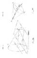
- FIG. 4is a schematic diagram illustrating the principle of coordinate determination of a target from two SAR images as set forth in the invention
- FIG. 5a schematic diagram illustrating the principle of coordinate determination of a target from three SAR images as set forth in the invention.
- the range gateis set for the generation of images. This range gate determines the distance between the SAR sensor and the resolution cell on the ground that corresponds to the center of the SAR slant range image. Hereafter this pixel is identified as the center pixel. Once a pixel has been determined as the target, the distance to the resolution cell on the ground corresponding to the pixel can be calculated. This is illustrated in FIG. 3 .
- the range gateis denoted in FIG. 3 as R 0 .
- the distance to the target pixelis denoted by R. If the pixel coordinates x and y of the target pixel are provided relative to the center pixel, the distance R to this pixel can be computed, as follows
- the parameters ⁇ x and ⁇ ydenote the resolution of the SAR slant range image in the azimuth direction or the resolution in the range direction.
- the following discussionis aimed at describing the coordinate determination of a target using two SAR images. If only two SAR images are available, it is possible to extract two distance measurements to the resolution cell on the ground from the SAR slant range images. However, two distance measurements are not sufficient by themselves to effect a determination of coordinates. With this method, the additional assumption must therefore be made that the target is located on the WGS84 ellipsoid.
- This principleis sketched in FIG. 5 . The distances to the target and the associated positions from which the distances have been measured are used to produce two spheres. The target has the property of being located on the surface of the two spheres and of the WGS84 ellipsoid. The problem thus consists in computing the intersection of the three surfaces.
- intersection of two spheresis generally a circular line in space.
- the intersection of this circular line with the WGS84 ellipsoidgenerally consists of two points.
- One pointcan be excluded from consideration for reasons of plausibility since the two points usually lie far apart. Since, however, the approximate viewing direction for recording the SAR image is known, one point can be rejected as a solution. If the mean altitude in the target region is known, this altitude can be utilized to correct the position of the resolution cell on the ground that corresponds to the target pixel.
- Equation 3thus describes the fact that the target is located on the WGS84 ellipsoid.
- the distance information to the target obtained from the SAR imagesis employed to compute the coordinates.
- the three distances to the target and the associated positions from which the distances were measuredare used to produce three spheres.
- the targethas the property of being located on the surface of the three spheres.
- the problemthus consists in computing the intersection of the three spheres.
- the intersection of two spheresis generally a circular line in space.
- the intersection of this circular line with the third spheregenerally consists of two points. One point can usually be excluded from consideration for reasons of plausibility.
- the geometry of the coordinate determinationdetermines the fact that one point lies on the surface of the earth while the second one is on the other hand located far above the earth's surface.
- the point located far above the earth's surfacecan be excluded as a solution since the target is located on the ground.
- x, y, and zrepresent the sought coordinates of the target.
- the same parameters with the subscripts by 1, 2, and 3denote the coordinates of the three SAR image recording positions.
- the three associated distances to the targetare denoted by R 1 , R 2 , and R 3 .
- the disclosed methodcan be performed by a processor.
Landscapes
- Engineering & Computer Science (AREA)
- Remote Sensing (AREA)
- Radar, Positioning & Navigation (AREA)
- Physics & Mathematics (AREA)
- General Physics & Mathematics (AREA)
- Computer Networks & Wireless Communication (AREA)
- Theoretical Computer Science (AREA)
- Electromagnetism (AREA)
- Mathematical Physics (AREA)
- Business, Economics & Management (AREA)
- Educational Administration (AREA)
- Educational Technology (AREA)
- Radar Systems Or Details Thereof (AREA)
Abstract
Description
- The present application claims priority under 35 U.S.C. §119 to German Patent Application No. 10 2009 030 672.2, filed Jun. 25, 2009, the entire disclosure of which is herein expressly incorporated by reference.
- Exemplary embodiments of the present invention are directed to a method for determining the geographic coordinates of pixels in SAR images.
- Using SAR image to determine the position of a target at great distances (20 km-100 km) is frequently imprecise due to the errors in the SAR images. The errors in the SAR images typically result from azimuth errors and distortion effects. (foreshortening, layover).
- U.S. Pat. No. 5,659,318 A discloses an interferometric method in which images of a target region generated using two spatially separated SAR antennas are analyzed in terms of their phase difference, and the recording position of the SAR images is known.
- The known approach to coordinate determination of a target from an SAR image will be explained first:
- The basis for this is what is called a WGS84 ellipsoid. The World Geodetic System 1984 (WGS 84) is a geodetic reference system forming the uniform foundation for positional information on the earth or near-earth space. It is composed of
- a simple three-dimensional reference surface, the reference ellipsoid that is roughly matched to the surface of the earth;
- a more detailed model for the shape of the earth that deviates from this idealized shape, the so-called geoid;
- twelve fundamental stations distributed across the earth, through which the relationship between these models and the earth's crust is defined by providing (time-dependent) coordinates (the so-called reference frame).
- The system is the geodetic foundation of the Global Positioning Systems (GPS) that enables appropriate satellites (NAVSTAR satellites) to survey the earth and provide orientation.
- The key parameters in an SAR are defined in
FIGS. 1 aand1b.A typical SAR configuration is illustrated inFIG. 1 a.The sensor platform, e.g., an aircraft, is moving at altitude h above the ground at velocity v along the X axis. The radar illuminates sideways a region on the ground. The optimum viewing direction for an SAR is 90° relative to the direction of velocity vector v. Viewing directions that deviate from the optimum viewing direction negatively affect the resolution and the cost/complexity of SAR image generation. The size of the radar antenna corresponds to the real aperture. This size is kept relatively small to allow the radar antenna to be carried on the sensor platform. However, the size of the antenna, or the aperture, determines the resolution. The larger the antenna, the better the resolution. In order to achieve high resolution despite the small antenna, a large antenna is generated artificially. This occurs by having the sensor platform fly along the aperture of an imaginary large antenna and collecting the reflected radar pulses at each section of the imaginary large antenna. The sensor platform must in other words fly the length of a synthetic aperture in order to collect the data for an SAR image. - The key SAR parameters are illustrated more precisely in
FIG. 1 b.The term S denotes the position of the sensor platform, while the vector v denotes the associated velocity. The coordinate system is chosen so that v points along positive axis X. Point T is mapped to the center of the SAR image. The straight line LOS (line of sight) denotes the connecting line between position S of the sensor platform and point T. The length of straight-line LOS corresponds to the range gate R of the SAR. The projection of velocity vector onto straight line LOS yields the radial approach velocity vrof the sensor platform toward point T. The angle Ψ between velocity vector v and straight line LOS is designated here as the squint angle. Projection of straight line LOS onto a plane that runs through point S and is parallel to the XY plane produces the straight line HLOS (horizontal line of sight). The angle ε between LOS and HLOS is called the elevation angle. - In order to effect a typical determination of coordinates for a target from an SAR image, the coordinate of the center of the SAR image is determined first. The coordinate of a pixel on the SAR image that has been recognized as the target is then computed. The SAR parameters introduced above are used to determine the coordinates of the image center.
- The relevant parameters for the typical coordinate determination of a target from an SAR image are illustrated in
FIG. 2 a. Sensor platform S is located at altitude H above the WGS84 ellipsoid, which is represented here in a highly enlarged manner as a plane. Together with the squint angle Ψ and the distance R (range gate) to the image center, velocity vector v defines a cone. This cone determines the SAR configuration. The base of the cone defines a circle of radius r=R sin(Ψ). The geographic coordinate of the SAR image center is located at the intersection between this circle and the surface of the earth. There are two points on the graph where the circle intersects the surface of the earth. Since, however, it is known in which direction the SAR sensor is looking, one intersection point can obviously be excluded. - Once the geographic coordinate P0of the SAR image center has been computed, the geographic coordinate of a pixel recognized as the target can be calculated on the SAR image.
FIG. 2 boutlines the key parameters here. To this end, the local tangential vectors nrand ncrnormalized to one on the WGS84 ellipsoid are calculated at point P0. Since the pixel coordinates pxand pyare known to the SAR image center, the known resolutions δxand δycan be used to calculate the displacement vector d from point P0to the point that corresponds to the pixel, as follows:
{right arrow over (d)}=δxpy{right arrow over (n)}y
- Simple vector addition can then be used to calculate the geographic coordinate of the target pixel from the geographic coordinates of image center P0and displacement vector d. Calculation of the geographic coordinates of the point that corresponds to the pixel is prior-art knowledge and is familiar to a person skilled in the art.
- In the determination of coordinates for a target from an SAR image using the approach familiar from prior art, the above-described cone contributes to determining the coordinates of the target. However, the position of this cone in space is determined relative to the velocity vector. If this velocity vector is not known precisely, then an error results in the coordinate determination. In typical SAR systems, this error can amount to up to 100 meters in the azimuth direction, the direction of the velocity vector. In addition, the assumption is made based on the determination of the geographic coordinates of the image center that the target plane is flat. However, SAR produces typical effects such as foreshortening or layover, a displacement of the pixel corresponding to the target point, and this results in an additional error in the calculation of the displacement vector to the target.
- Exemplary embodiments of the present invention provide a method by which the error in the position determination can be reduced.
- According to the invention, the coordinates of the corresponding pixels in the SAR images and the corresponding range gates are used to determine in each case the distance between a corresponding resolution cell on the ground and the respective recording position of the respective SAR image, and the determined distances and associated recording positions for the SAR images are used to determine the geographic coordinates of the corresponding pixels in the SAR images by employing an WGS84 ellipsoid.
- The invention as well as advantageous embodiments of the method according to the invention are described in more detail below based on the figures. Here:
FIGS. 1 aand1bare schematic diagrams illustrating the principle of SAR;FIGS. 2 aand2bare schematic diagrams illustrating the coordinate determination of a target from an SAR image as known in prior art;FIG. 3 is a schematic diagram illustrating the distance determination of a pixel from an SAR image;FIG. 4 is a schematic diagram illustrating the principle of coordinate determination of a target from two SAR images as set forth in the invention;FIG. 5 a schematic diagram illustrating the principle of coordinate determination of a target from three SAR images as set forth in the invention.- Obtaining distance information from an SAR image proceeds as follows. In an SAR system, the range gate is set for the generation of images. This range gate determines the distance between the SAR sensor and the resolution cell on the ground that corresponds to the center of the SAR slant range image. Hereafter this pixel is identified as the center pixel. Once a pixel has been determined as the target, the distance to the resolution cell on the ground corresponding to the pixel can be calculated. This is illustrated in
FIG. 3 . - The range gate is denoted in
FIG. 3 as R0. The distance to the target pixel is denoted by R. If the pixel coordinates x and y of the target pixel are provided relative to the center pixel, the distance R to this pixel can be computed, as follows
R=√{square root over ((δxx)2+(δyy+R0)2)}{square root over ((δxx)2+(δyy+R0)2)} (1)- The parameters δxand δydenote the resolution of the SAR slant range image in the azimuth direction or the resolution in the range direction.
- Coordinate determination using two SAR images
- The following discussion is aimed at describing the coordinate determination of a target using two SAR images. If only two SAR images are available, it is possible to extract two distance measurements to the resolution cell on the ground from the SAR slant range images. However, two distance measurements are not sufficient by themselves to effect a determination of coordinates. With this method, the additional assumption must therefore be made that the target is located on the WGS84 ellipsoid. This principle is sketched in
FIG. 5 . The distances to the target and the associated positions from which the distances have been measured are used to produce two spheres. The target has the property of being located on the surface of the two spheres and of the WGS84 ellipsoid. The problem thus consists in computing the intersection of the three surfaces. The intersection of two spheres is generally a circular line in space. The intersection of this circular line with the WGS84 ellipsoid generally consists of two points. One point can be excluded from consideration for reasons of plausibility since the two points usually lie far apart. Since, however, the approximate viewing direction for recording the SAR image is known, one point can be rejected as a solution. If the mean altitude in the target region is known, this altitude can be utilized to correct the position of the resolution cell on the ground that corresponds to the target pixel. - The problem is described by the following two equations 2 and 3. The terms x, y, and z denote the sought coordinates of the target. The same parameters with the subscripts 1 and 2 denote the coordinates of the two SAR image recording positions. The two associated distances to the target are denoted by R1and R2. The semi-axes of the WGS84 ellipsoid are denoted by a and b. Equation 3 thus describes the fact that the target is located on the WGS84 ellipsoid.
- Coordinate Determination Using Three SAR Images
- The following discussion now describes coordinate determination using three SAR images. In order to determine the coordinates of a target using three SAR images, the distance information to the target obtained from the SAR images is employed to compute the coordinates. The principle is illustrated in
FIG. 4 . The three distances to the target and the associated positions from which the distances were measured are used to produce three spheres. The target has the property of being located on the surface of the three spheres. The problem thus consists in computing the intersection of the three spheres. The intersection of two spheres is generally a circular line in space. The intersection of this circular line with the third sphere generally consists of two points. One point can usually be excluded from consideration for reasons of plausibility. The geometry of the coordinate determination determines the fact that one point lies on the surface of the earth while the second one is on the other hand located far above the earth's surface. The point located far above the earth's surface can be excluded as a solution since the target is located on the ground. - The problem is described by the following equation 4:
(x−x1)2+(y−y1)2+(z−z1)2=R12
(x−x2)2+(y−y2)2+(z−z2)2=R22
(x−x3)2+(y−y1)2+(z−z3)2=R32 (4)- The terms x, y, and z here represent the sought coordinates of the target. The same parameters with the subscripts by 1, 2, and 3 denote the coordinates of the three SAR image recording positions. The three associated distances to the target are denoted by R1, R2, and R3.
- The disclosed method can be performed by a processor.
- The foregoing disclosure has been set forth merely to illustrate the invention and is not intended to be limiting. Since modifications of the disclosed embodiments incorporating the spirit and substance of the invention may occur to persons skilled in the art, the invention should be construed to include everything within the scope of the appended claims and equivalents thereof.

Claims (5)
Applications Claiming Priority (4)
| Application Number | Priority Date | Filing Date | Title |
|---|---|---|---|
| DE102009030672ADE102009030672B3 (en) | 2009-06-25 | 2009-06-25 | Method for determining the geographic coordinates of pixels in SAR images |
| DE102009030672.2 | 2009-06-25 | ||
| DE102009030672 | 2009-06-25 | ||
| PCT/DE2010/000683WO2010149132A1 (en) | 2009-06-25 | 2010-06-16 | Method for determining the geographic coordinates of pixels in sar images |
Publications (2)
| Publication Number | Publication Date |
|---|---|
| US20120133550A1true US20120133550A1 (en) | 2012-05-31 |
| US9927513B2 US9927513B2 (en) | 2018-03-27 |
Family
ID=42338967
Family Applications (1)
| Application Number | Title | Priority Date | Filing Date |
|---|---|---|---|
| US13/380,397Active2035-01-14US9927513B2 (en) | 2009-06-25 | 2010-06-16 | Method for determining the geographic coordinates of pixels in SAR images |
Country Status (8)
| Country | Link |
|---|---|
| US (1) | US9927513B2 (en) |
| EP (1) | EP2446298B1 (en) |
| KR (1) | KR20130004227A (en) |
| BR (1) | BRPI1014762A2 (en) |
| DE (1) | DE102009030672B3 (en) |
| ES (1) | ES2530264T3 (en) |
| RU (1) | RU2531802C2 (en) |
| WO (1) | WO2010149132A1 (en) |
Cited By (15)
| Publication number | Priority date | Publication date | Assignee | Title |
|---|---|---|---|---|
| US20120319892A1 (en)* | 2011-06-15 | 2012-12-20 | Thales Alenia Space Italia S.P.A. Con Unico Socio | Acquisition of SAR images for computing a height or a digital elevation model by interferometric processing |
| US20140104112A1 (en)* | 2012-10-17 | 2014-04-17 | Ratheon Applied Signal Technology, Inc. | System and method for determining geo location of a target using locus of emitter positions (lep) |
| US9839855B2 (en) | 2014-05-21 | 2017-12-12 | Universal City Studios Llc | Amusement park element tracking system |
| US20170371022A1 (en)* | 2013-09-24 | 2017-12-28 | Raytheon Applied Signal Technology, Inc. | System and method for determining geo location of a target using a cone coordinate system |
| US10230925B2 (en) | 2014-06-13 | 2019-03-12 | Urthecast Corp. | Systems and methods for processing and providing terrestrial and/or space-based earth observation video |
| US10615513B2 (en) | 2015-06-16 | 2020-04-07 | Urthecast Corp | Efficient planar phased array antenna assembly |
| US10871561B2 (en) | 2015-03-25 | 2020-12-22 | Urthecast Corp. | Apparatus and methods for synthetic aperture radar with digital beamforming |
| US10955546B2 (en) | 2015-11-25 | 2021-03-23 | Urthecast Corp. | Synthetic aperture radar imaging apparatus and methods |
| CN113917418A (en)* | 2021-12-15 | 2022-01-11 | 中国科学院空天信息创新研究院 | Method for estimating two-dimensional resolution of squint spaceborne SAR ground plane |
| US20220179063A1 (en)* | 2019-03-28 | 2022-06-09 | Nec Corporation | Image processing device, image processing method, and image processing computer program |
| US11378682B2 (en) | 2017-05-23 | 2022-07-05 | Spacealpha Insights Corp. | Synthetic aperture radar imaging apparatus and methods for moving targets |
| US11506778B2 (en) | 2017-05-23 | 2022-11-22 | Spacealpha Insights Corp. | Synthetic aperture radar imaging apparatus and methods |
| US11525910B2 (en) | 2017-11-22 | 2022-12-13 | Spacealpha Insights Corp. | Synthetic aperture radar apparatus and methods |
| CN117741622A (en)* | 2024-01-19 | 2024-03-22 | 哈尔滨集睿谱光电技术有限公司 | Automatic adjusting method for Gm-APD laser radar range gate |
| CN119478028A (en)* | 2024-10-11 | 2025-02-18 | 西安道达天际信息技术有限公司 | A UAV target positioning system and positioning method |
Families Citing this family (12)
| Publication number | Priority date | Publication date | Assignee | Title |
|---|---|---|---|---|
| CN105093222A (en)* | 2015-07-28 | 2015-11-25 | 中国测绘科学研究院 | Automatic extraction method for block adjustment connection points of SAR image |
| KR102394240B1 (en)* | 2016-06-03 | 2022-05-04 | 도이췌스 첸트룸 퓌어 루프트-운트 라움파르트 에.파우. | A method for generating a ground observation image of an area using a radar having a composite aperture |
| US10661920B2 (en)* | 2018-02-23 | 2020-05-26 | ExoAnalytic Solutions, Inc. | Systems and visualization interfaces for display of space object imagery |
| US10467783B2 (en) | 2018-02-23 | 2019-11-05 | ExoAnalytic Solutions, Inc. | Visualization interfaces for real-time identification, tracking, and prediction of space objects |
| KR102028324B1 (en)* | 2019-02-26 | 2019-11-04 | 엘아이지넥스원 주식회사 | Synthetic Aperture Radar Image Enhancement Method and Calculating Coordinates Method |
| KR102028323B1 (en)* | 2019-02-26 | 2019-10-04 | 엘아이지넥스원 주식회사 | Synthetic Aperture Radar Image Enhancement Apparatus and System |
| CN110133653B (en)* | 2019-05-29 | 2020-12-08 | 中国空间技术研究院 | A fast indirect positioning method for spaceborne SAR images based on DSM data |
| GB2601678B (en) | 2019-07-25 | 2024-03-06 | Exoanalytic Solutions Inc | Systems and Visualization interfaces for orbital paths and path parameters of space objects |
| KR102381013B1 (en)* | 2020-08-20 | 2022-04-01 | 한국과학기술원 | Method, apparatus and computer program for multi-matching based realtime vision-aided navigation |
| KR102530834B1 (en)* | 2020-11-24 | 2023-05-10 | 주식회사 에코센싱 | Apparatus and method to estimate a geodetic coordinate of synthetic aperture radar image |
| CN112684449B (en)* | 2021-03-22 | 2021-07-16 | 北京东方至远科技股份有限公司 | Water area power line sag inversion method and device based on SAR technology |
| WO2024050163A2 (en) | 2022-07-29 | 2024-03-07 | ExoAnalytic Solutions, Inc. | Space object alert management and user interfaces |
Citations (4)
| Publication number | Priority date | Publication date | Assignee | Title |
|---|---|---|---|---|
| US5659318A (en)* | 1996-05-31 | 1997-08-19 | California Institute Of Technology | Interferometric SAR processor for elevation |
| US6011505A (en)* | 1996-07-11 | 2000-01-04 | Science Applications International Corporation | Terrain elevation measurement by interferometric synthetic aperture radar (IFSAR) |
| US20030154060A1 (en)* | 2003-03-25 | 2003-08-14 | Damron James J. | Fusion of data from differing mathematical models |
| US20110098986A1 (en)* | 2009-10-23 | 2011-04-28 | Fernandes Rodrigues Marco Alexandre | Method to generate airport obstruction charts based on a data fusion between interferometric data using synthetic aperture radars positioned in spaceborne platforms and other types of data acquired by remote sensors |
Family Cites Families (3)
| Publication number | Priority date | Publication date | Assignee | Title |
|---|---|---|---|---|
| US7315275B2 (en)* | 2003-07-03 | 2008-01-01 | Navcom Technology, Inc. | Positioning system with intentional multi-path signal |
| US7245250B1 (en)* | 2005-08-16 | 2007-07-17 | Itt Manufacturing Enterprises, Inc. | Synthetic aperture radar image compression |
| US7277042B1 (en)* | 2006-05-12 | 2007-10-02 | Raytheon Company | Compensation of flight path deviation for spotlight SAR |
- 2009
- 2009-06-25DEDE102009030672Apatent/DE102009030672B3/ennot_activeExpired - Fee Related
- 2010
- 2010-06-16KRKR1020127000209Apatent/KR20130004227A/ennot_activeCeased
- 2010-06-16USUS13/380,397patent/US9927513B2/enactiveActive
- 2010-06-16EPEP10736599.1Apatent/EP2446298B1/enactiveActive
- 2010-06-16RURU2012102304/07Apatent/RU2531802C2/ennot_activeIP Right Cessation
- 2010-06-16WOPCT/DE2010/000683patent/WO2010149132A1/enactiveApplication Filing
- 2010-06-16ESES10736599.1Tpatent/ES2530264T3/enactiveActive
- 2010-06-16BRBRPI1014762Apatent/BRPI1014762A2/ennot_activeIP Right Cessation
Patent Citations (4)
| Publication number | Priority date | Publication date | Assignee | Title |
|---|---|---|---|---|
| US5659318A (en)* | 1996-05-31 | 1997-08-19 | California Institute Of Technology | Interferometric SAR processor for elevation |
| US6011505A (en)* | 1996-07-11 | 2000-01-04 | Science Applications International Corporation | Terrain elevation measurement by interferometric synthetic aperture radar (IFSAR) |
| US20030154060A1 (en)* | 2003-03-25 | 2003-08-14 | Damron James J. | Fusion of data from differing mathematical models |
| US20110098986A1 (en)* | 2009-10-23 | 2011-04-28 | Fernandes Rodrigues Marco Alexandre | Method to generate airport obstruction charts based on a data fusion between interferometric data using synthetic aperture radars positioned in spaceborne platforms and other types of data acquired by remote sensors |
Cited By (21)
| Publication number | Priority date | Publication date | Assignee | Title |
|---|---|---|---|---|
| US9019144B2 (en)* | 2011-06-15 | 2015-04-28 | Thales Alenia Space Italia S.P.A. | Acquisition of SAR images for computing a height or a digital elevation model by interferometric processing |
| US20120319892A1 (en)* | 2011-06-15 | 2012-12-20 | Thales Alenia Space Italia S.P.A. Con Unico Socio | Acquisition of SAR images for computing a height or a digital elevation model by interferometric processing |
| US20140104112A1 (en)* | 2012-10-17 | 2014-04-17 | Ratheon Applied Signal Technology, Inc. | System and method for determining geo location of a target using locus of emitter positions (lep) |
| US9383429B2 (en)* | 2012-10-17 | 2016-07-05 | Raytheon Applied Signal Technology, Inc. | System and method for determining geo location of a target using locus of emitter positions (LEP) |
| US10670689B2 (en)* | 2013-09-24 | 2020-06-02 | Raytheon Applied Signal Technology, Inc. | System and method for determining geo location of a target using a cone coordinate system |
| US20170371022A1 (en)* | 2013-09-24 | 2017-12-28 | Raytheon Applied Signal Technology, Inc. | System and method for determining geo location of a target using a cone coordinate system |
| US9839855B2 (en) | 2014-05-21 | 2017-12-12 | Universal City Studios Llc | Amusement park element tracking system |
| US10661184B2 (en) | 2014-05-21 | 2020-05-26 | Universal City Studios Llc | Amusement park element tracking system |
| US10230925B2 (en) | 2014-06-13 | 2019-03-12 | Urthecast Corp. | Systems and methods for processing and providing terrestrial and/or space-based earth observation video |
| US10871561B2 (en) | 2015-03-25 | 2020-12-22 | Urthecast Corp. | Apparatus and methods for synthetic aperture radar with digital beamforming |
| US10615513B2 (en) | 2015-06-16 | 2020-04-07 | Urthecast Corp | Efficient planar phased array antenna assembly |
| US10955546B2 (en) | 2015-11-25 | 2021-03-23 | Urthecast Corp. | Synthetic aperture radar imaging apparatus and methods |
| US11754703B2 (en) | 2015-11-25 | 2023-09-12 | Spacealpha Insights Corp. | Synthetic aperture radar imaging apparatus and methods |
| US11378682B2 (en) | 2017-05-23 | 2022-07-05 | Spacealpha Insights Corp. | Synthetic aperture radar imaging apparatus and methods for moving targets |
| US11506778B2 (en) | 2017-05-23 | 2022-11-22 | Spacealpha Insights Corp. | Synthetic aperture radar imaging apparatus and methods |
| US11525910B2 (en) | 2017-11-22 | 2022-12-13 | Spacealpha Insights Corp. | Synthetic aperture radar apparatus and methods |
| US20220179063A1 (en)* | 2019-03-28 | 2022-06-09 | Nec Corporation | Image processing device, image processing method, and image processing computer program |
| US12085641B2 (en)* | 2019-03-28 | 2024-09-10 | Nec Corporation | Image processing device, image processing method, and image processing computer program |
| CN113917418A (en)* | 2021-12-15 | 2022-01-11 | 中国科学院空天信息创新研究院 | Method for estimating two-dimensional resolution of squint spaceborne SAR ground plane |
| CN117741622A (en)* | 2024-01-19 | 2024-03-22 | 哈尔滨集睿谱光电技术有限公司 | Automatic adjusting method for Gm-APD laser radar range gate |
| CN119478028A (en)* | 2024-10-11 | 2025-02-18 | 西安道达天际信息技术有限公司 | A UAV target positioning system and positioning method |
Also Published As
| Publication number | Publication date |
|---|---|
| BRPI1014762A2 (en) | 2016-04-19 |
| ES2530264T3 (en) | 2015-02-27 |
| EP2446298A1 (en) | 2012-05-02 |
| KR20130004227A (en) | 2013-01-09 |
| US9927513B2 (en) | 2018-03-27 |
| DE102009030672B3 (en) | 2010-08-19 |
| RU2012102304A (en) | 2013-07-27 |
| RU2531802C2 (en) | 2014-10-27 |
| EP2446298B1 (en) | 2014-12-03 |
| WO2010149132A1 (en) | 2010-12-29 |
Similar Documents
| Publication | Publication Date | Title |
|---|---|---|
| US9927513B2 (en) | Method for determining the geographic coordinates of pixels in SAR images | |
| CN102741706B (en) | The geographical method with reference to image-region | |
| CN107367716B (en) | A kind of high-precision satellite-borne SAR geometric calibration method | |
| US8610708B2 (en) | Method and apparatus for three-dimensional image reconstruction | |
| EP2353024B1 (en) | Method for geolocating an object by multitelemetry | |
| Blacknell et al. | Geometric accuracy in airborne SAR images | |
| CN101743453B (en) | Post-mission high accuracy position and orientation system | |
| GREJNER‐BRZEZINSKA | Direct exterior orientation of airborne imagery with GPS/INS system: Performance analysis | |
| CN112305510A (en) | DEM matching-based synthetic aperture radar image geometric calibration method | |
| KR102028324B1 (en) | Synthetic Aperture Radar Image Enhancement Method and Calculating Coordinates Method | |
| CN102323571B (en) | Distribution method of satellite-borne dual-antenna SAR (Synthetic Aperture Radar) interferometric calibrator with comprehensive overall parameter | |
| CN102866397A (en) | Combined positioning method for multisource heterogeneous remote sensing image | |
| KR102028323B1 (en) | Synthetic Aperture Radar Image Enhancement Apparatus and System | |
| CN102866393A (en) | Synthetic aperture radar (SAR) Doppler parameter estimation method based on POS and DEM data | |
| CN111856464B (en) | DEM extraction method of vehicle-mounted SAR (synthetic aperture radar) based on single control point information | |
| CN116559874B (en) | Two-dimensional ocean current inversion method and system based on multi-azimuth synthetic aperture radar | |
| CN107907881B (en) | A Terrain Estimation Method for Long Aperture Spaceborne SAR | |
| RU2406071C1 (en) | Method of mobile object navigation | |
| CN106371096B (en) | Airborne double-antenna InSAR three-dimensional configuration model construction method | |
| Chan | Feature-Based Boresight Self-Calibration of a Mobile Mapping System | |
| US20060028372A1 (en) | Mensuration for the conformal range migration algorithm | |
| Golubaev | Main parameters of meteoroid motion during the fall of the Chelyabinsk meteorite shower on February 15, 2013 | |
| EP3964863A1 (en) | Method and device for motion state estimation | |
| Salehi-Dorcheabedi et al. | Improving LiDAR height precision in urban environment: Low-cost GNSS ranging prototype for post-mission airborne laser scanning enhancement | |
| CN106123894A (en) | InSAR/INS Combinated navigation method based on interference fringe coupling |
Legal Events
| Date | Code | Title | Description |
|---|---|---|---|
| AS | Assignment | Owner name:EADS DEUTSCHLAND GMBH, GERMANY Free format text:ASSIGNMENT OF ASSIGNORS INTEREST;ASSIGNORS:BENNINGHOFEN, BENJAMIN;KOBAN, TAMER;STAHL, CHRISTOPH;REEL/FRAME:027593/0364 Effective date:20120111 | |
| AS | Assignment | Owner name:AIRBUS DEFENCE AND SPACE GMBH, GERMANY Free format text:CHANGE OF NAME;ASSIGNOR:EADS DEUTSCHLAND GMBH;REEL/FRAME:045291/0084 Effective date:20170124 | |
| STCF | Information on status: patent grant | Free format text:PATENTED CASE | |
| AS | Assignment | Owner name:AIRBUS DEFENCE AND SPACE GMBH, GERMANY Free format text:CHANGE OF NAME;ASSIGNOR:EADS DEUTSCHLAND GMBH;REEL/FRAME:048284/0694 Effective date:20140701 | |
| MAFP | Maintenance fee payment | Free format text:PAYMENT OF MAINTENANCE FEE, 4TH YEAR, LARGE ENTITY (ORIGINAL EVENT CODE: M1551); ENTITY STATUS OF PATENT OWNER: LARGE ENTITY Year of fee payment:4 | |
| MAFP | Maintenance fee payment | Free format text:PAYMENT OF MAINTENANCE FEE, 8TH YEAR, LARGE ENTITY (ORIGINAL EVENT CODE: M1552); ENTITY STATUS OF PATENT OWNER: LARGE ENTITY Year of fee payment:8 |