US20120020571A1 - Method and apparatus for capturing, geolocating and measuring oblique images - Google Patents
Method and apparatus for capturing, geolocating and measuring oblique imagesDownload PDFInfo
- Publication number
- US20120020571A1 US20120020571A1US13/217,885US201113217885AUS2012020571A1US 20120020571 A1US20120020571 A1US 20120020571A1US 201113217885 AUS201113217885 AUS 201113217885AUS 2012020571 A1US2012020571 A1US 2012020571A1
- Authority
- US
- United States
- Prior art keywords
- image
- captured
- oblique
- data
- capturing
- Prior art date
- Legal status (The legal status is an assumption and is not a legal conclusion. Google has not performed a legal analysis and makes no representation as to the accuracy of the status listed.)
- Granted
Links
Images


Classifications
- G—PHYSICS
- G01—MEASURING; TESTING
- G01C—MEASURING DISTANCES, LEVELS OR BEARINGS; SURVEYING; NAVIGATION; GYROSCOPIC INSTRUMENTS; PHOTOGRAMMETRY OR VIDEOGRAMMETRY
- G01C11/00—Photogrammetry or videogrammetry, e.g. stereogrammetry; Photographic surveying
- G01C11/02—Picture taking arrangements specially adapted for photogrammetry or photographic surveying, e.g. controlling overlapping of pictures
- G—PHYSICS
- G01—MEASURING; TESTING
- G01C—MEASURING DISTANCES, LEVELS OR BEARINGS; SURVEYING; NAVIGATION; GYROSCOPIC INSTRUMENTS; PHOTOGRAMMETRY OR VIDEOGRAMMETRY
- G01C11/00—Photogrammetry or videogrammetry, e.g. stereogrammetry; Photographic surveying
- G01C11/04—Interpretation of pictures
- G—PHYSICS
- G03—PHOTOGRAPHY; CINEMATOGRAPHY; ANALOGOUS TECHNIQUES USING WAVES OTHER THAN OPTICAL WAVES; ELECTROGRAPHY; HOLOGRAPHY
- G03B—APPARATUS OR ARRANGEMENTS FOR TAKING PHOTOGRAPHS OR FOR PROJECTING OR VIEWING THEM; APPARATUS OR ARRANGEMENTS EMPLOYING ANALOGOUS TECHNIQUES USING WAVES OTHER THAN OPTICAL WAVES; ACCESSORIES THEREFOR
- G03B15/00—Special procedures for taking photographs; Apparatus therefor
- G03B15/006—Apparatus mounted on flying objects
- G—PHYSICS
- G03—PHOTOGRAPHY; CINEMATOGRAPHY; ANALOGOUS TECHNIQUES USING WAVES OTHER THAN OPTICAL WAVES; ELECTROGRAPHY; HOLOGRAPHY
- G03B—APPARATUS OR ARRANGEMENTS FOR TAKING PHOTOGRAPHS OR FOR PROJECTING OR VIEWING THEM; APPARATUS OR ARRANGEMENTS EMPLOYING ANALOGOUS TECHNIQUES USING WAVES OTHER THAN OPTICAL WAVES; ACCESSORIES THEREFOR
- G03B37/00—Panoramic or wide-screen photography; Photographing extended surfaces, e.g. for surveying; Photographing internal surfaces, e.g. of pipe
- G03B37/02—Panoramic or wide-screen photography; Photographing extended surfaces, e.g. for surveying; Photographing internal surfaces, e.g. of pipe with scanning movement of lens or cameras
- G—PHYSICS
- G06—COMPUTING OR CALCULATING; COUNTING
- G06T—IMAGE DATA PROCESSING OR GENERATION, IN GENERAL
- G06T11/00—2D [Two Dimensional] image generation
- G06T11/20—Drawing from basic elements, e.g. lines or circles
- G06T11/203—Drawing of straight lines or curves
- G—PHYSICS
- G06—COMPUTING OR CALCULATING; COUNTING
- G06T—IMAGE DATA PROCESSING OR GENERATION, IN GENERAL
- G06T17/00—Three dimensional [3D] modelling, e.g. data description of 3D objects
- G06T17/05—Geographic models
- G—PHYSICS
- G06—COMPUTING OR CALCULATING; COUNTING
- G06T—IMAGE DATA PROCESSING OR GENERATION, IN GENERAL
- G06T3/00—Geometric image transformations in the plane of the image
- G06T3/40—Scaling of whole images or parts thereof, e.g. expanding or contracting
- G06T3/4038—Image mosaicing, e.g. composing plane images from plane sub-images
- G—PHYSICS
- G06—COMPUTING OR CALCULATING; COUNTING
- G06T—IMAGE DATA PROCESSING OR GENERATION, IN GENERAL
- G06T7/00—Image analysis
- G06T7/60—Analysis of geometric attributes
- G—PHYSICS
- G06—COMPUTING OR CALCULATING; COUNTING
- G06T—IMAGE DATA PROCESSING OR GENERATION, IN GENERAL
- G06T2207/00—Indexing scheme for image analysis or image enhancement
- G06T2207/10—Image acquisition modality
- G06T2207/10032—Satellite or aerial image; Remote sensing
- G—PHYSICS
- G06—COMPUTING OR CALCULATING; COUNTING
- G06T—IMAGE DATA PROCESSING OR GENERATION, IN GENERAL
- G06T2207/00—Indexing scheme for image analysis or image enhancement
- G06T2207/30—Subject of image; Context of image processing
- G06T2207/30204—Marker
Definitions
- the present inventionrelates to photogrammetry. More particularly, the present invention relates to a method and apparatus for capturing oblique images and for measuring the objects and distances between the objects depicted therein.
- Photogrammetryis the science of making measurements of and between objects depicted within photographs, especially aerial photographs.
- photogrammetryinvolves taking images of terrestrial features and deriving data therefrom, such as, for example, data indicating relative distances between and sizes of objects within the images.
- Photogrammetrymay also involve coupling the photographs with other data, such as data representative of latitude and longitude. In effect, the image is overlaid and conformed to a particular spatial coordinate system.
- the image-capturing devicesuch as a camera or sensor
- the vehicle or platformsuch as an airplane or satellite
- the point or pixel in the image that corresponds to the nadir pointis the only point/pixel that is truly orthogonal to the image-capturing device.
- All other points or pixels in the imageare actually oblique relative to the image-capturing device. As the points or pixels become increasingly distant from the nadir point they become increasingly oblique relative to the image-capturing device and the ground sample distance (i.e., the surface area corresponding to or covered by each pixel) also increases.
- Such obliqueness in an orthogonal imagecauses features in the image to be distorted, especially images relatively distant from the nadir point.
- Such distortionis removed, or compensated for, by the process of ortho-rectification which, in essence, removes the obliqueness from the orthogonal image by fitting or warping each pixel of an orthogonal image onto an orthometric grid or coordinate system.
- the process of ortho-rectificationcreates an image wherein all pixels have the same ground sample distance and are oriented to the north.
- any point on an ortho-rectified imagecan be located using an X, Y coordinate system and, so long as the image scale is known, the length and width of terrestrial features as well as the relative distance between those features can be calculated.
- ortho-rectificationcompensates to a degree for oblique distortions in an orthogonal image, it introduces other undesirable distortions and/or inaccuracies in the ortho-rectified orthogonal image.
- Objects depicted in ortho-rectified orthogonal imagesmay be difficult to recognize and/or identify since most observers are not accustomed to viewing objects, particularly terrestrial features, from above.
- an ortho-rectified imagehas a number of distortions. Roads that are actually straight appear curved and buildings may appear to tilt.
- ortho- rectified imagescontain substantially no information as to the height of terrestrial features.
- the interpretation and analysis of orthogonal and/or ortho-rectfified orthogonal imagesis typically performed by highly-trained analysts whom have undergone years of specialized training and experience in order to identify objects and terrestrial features in such images.
- orthogonal and ortho-rectified imagesare useful in photogrammetry, they lack information as to the height of features depicted therein and require highly-trained analysts to interpret detail from what the images depict.
- Oblique imagesare images that are captured with the image-capturing device aimed or pointed generally to the side of and downward from the platform that carries the image-capturing device.
- Oblique imagesunlike orthogonal images, display the sides of terrestrial features, such as houses, buildings and/or mountains, as well as the tops thereof.
- viewing an oblique imageis more natural and intuitive than viewing an orthogonal or ortho-rectified image, and even casual observers are able to recognize and interpret terrestrial features and other objects depicted in oblique images.
- Each pixel in the foreground of an oblique imagecorresponds to a relatively small area of the surface or object depicted (Le., each foreground pixel has a relatively small ground sample distance) whereas each pixel in the background corresponds to a relatively large area of the surface or object depicted (i.e., each background pixel has a relatively large ground sample distance).
- Oblique imagescapture a generally trapezoidal area or view of the subject surface or object, with the foreground of the trapezoid having a substantially smaller ground sample distance (i.e., a higher resolution) than the background of the trapezoid.
- Oblique imagesare considered to be of little or no use in photogrammetry.
- the conventional approach of forcing the variously-sized foreground and background pixels of an oblique image into a uniform size to thereby warp the image onto a coordinate systemdramatically distorts the oblique image and thereby renders identification of objects and the taking of measurements of objects depicted therein a laborious and inaccurate task.
- Correcting for terrain displacement within an oblique image by using an elevation modelfurther distorts the images thereby increasing the difficulty with which measurements can be made and reducing the accuracy of any such measurements.
- oblique imagesare considered as being of little or no use in photogrammetry, they are easily interpreted and contain information as to the height of features depicted therein. Therefore, what is needed in the art is a method and apparatus for photogrammetry that enable geo-location and accurate measurements within oblique images.
- the present inventionprovides a method and apparatus for capturing, displaying, and making measurements of objects and distances between objects depicted within oblique images.
- the present inventioncomprises, in one form thereof, a computerized system for displaying, geolocating, and taking measurements from captured oblique images.
- the systemincludes a data file accessible by the computer system.
- the data fileincludes a plurality of image files corresponding to a plurality of captured oblique images, and positional data corresponding to the images.
- Image display and analysis softwareis executed by the system for reading the data file and displaying at least a portion of the captured oblique images.
- the softwareretrieves the positional data for one or more user-selected points on the displayed image, and calculates a separation distance between any two or more selected points.
- the separation distance calculationis user-selectable to determine various parameters including linear distance between, area encompassed within, relative elevation of, and height difference between selected points.
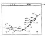
- FIG. 1illustrates one embodiment of a platform or vehicle carrying an image-capturing system of the present invention, and shows exemplary orthogonal and oblique images taken thereby;
- FIG. 2is a diagrammatic view of the image-capturing system of FIG. 1 ;
- FIG. 3is a block diagram of the image-capturing computer system of FIG. 2 ;
- FIG. 4is a representation of an exemplary output data file of the image-capturing system of FIG. 1 ;
- FIG. 5is a block diagram of one embodiment of an image display and measurement computer system of the present invention for displaying and taking measurements of and between objects depicted in the images captured by the image-capturing system of FIG. 1 ;
- FIG. 6depicts an exemplary image displayed on the system of FIG. 5 , and illustrates one embodiment of the method of the present invention for the measurement of and between objects depicted in such an image;
- FIGS. 7 and 8illustrate one embodiment of a method for capturing oblique images of the present invention
- FIGS. 9 and 10illustrate a second embodiment of a method for capturing oblique images of the resent invention.
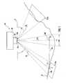
- Apparatus 10includes a platform or vehicle 20 that carries image-capturing and geolocating system 30 .
- Platform 20such as, for example, an airplane, space shuttle, rocket, satellite, or any other suitable vehicle, carries image-capturing system 30 over a predefined area of and at one or more predetermined altitudes above surface 31 , such as, for example, the earth's surface or any other surface of interest.
- platform 20is capable of controlled movement or flight, either manned or unmanned, along a predefined flight path or course through, for example, the earth's atmosphere or outer space.
- Image capturing platform 20includes a system for generating and regulating power (not shown) that includes, for example, one or more generators, fuel cells, solar panels, and/or batteries, for powering image-capturing system 30 .
- Image-capturing and geo-locating system 30includes image capturing devices 32 a and 32 b , a global positioning system (GPS) receiver 34 , an inertial navigation unit (INU) 36 , clock 38 , gyroscope 40 , compass 42 and altimeter 44 , each of which are interconnected with image-capturing computer system 46 .
- GPSglobal positioning system
- INUinertial navigation unit
- Image-capturing devices 32 a and 32 bsuch as, for example, conventional cameras, digital cameras, digital sensors, charge-coupled devices, or other suitable image-capturing devices, are capable of capturing images photographically or electronically.
- Image-capturing devices 32 a and 32 bhave known or determinable characteristics including focal length, sensor size and aspect ratio, radial and other distortion terms, principal point offset, pixel pitch, and alignment.
- Image-capturing devices 32 a and 32 bacquire images and issue image data signals (IDS) 48 a and 48 b , respectively, corresponding to the particular images or photographs taken and which are stored in image-capturing computer system 46 , as will be more particularly described hereinafter.
- IDSimage data signals
- image-capturing devices 32 a and 32 bhave respective central axes A 1 and A 2 , and are mounted to platform 20 such that axes A 1 and A 2 are each at an angle of declination ⁇ relative to a horizontal plane P.
- Declination angle ⁇is virtually any oblique angle, but is preferably from approximately 20° (twenty degrees) to approximately 60° (sixty degrees) and is most preferably from approximately 40° (forty degrees) to approximately 50° (fifty degrees).
- GPS receiver 34receives global positioning system signals 52 that are transmitted by one or more global positioning system satellites 54 .
- the GPS signals 52enable the precise location of platform 20 relative to surface 31 to be determined.
- GPS receiver 34decodes GPS signals 52 and issues location signals/data 56 , that are dependent at least in part upon GPS signals 52 and which are indicative of the precise location of platform 20 relative to surface 31 .
- Location signals/data 56 corresponding to each image captured by image-capturing devices 32 a and 32 bare received and stored by image-capturing computer system 46 .
- INU 36is a conventional inertial navigation unit that is coupled to and detects changes in the velocity, including translational and rotational velocity, of image-capturing devices 32 a and 32 b and/or platform 20 .
- INU 36issues velocity signals/data 58 indicative of such velocities and/or changes therein to image-capturing computer system 46 , which stores velocity signals/data 58 corresponding to each image captured by image-capturing devices 32 a and 32 b are received and stored by image-capturing computer system 46 .
- Clock 38keeps a precise time measurement (time of validity) that is used to synchronize events within image-capturing and geo-locating system 30 .
- Clock 38provides time data/clock signal 62 that is indicative of the precise time that an image is taken by image-capturing devices 32 a and 32 b .
- Time data 62is also provided to and stored by image-capturing computer system 46 .
- clock 38is integral with image-capturing computer system 46 , such as, for example, a clock software program.
- Gyroscope 40is a conventional gyroscope as commonly found on airplanes and/or within commercial navigation systems for airplanes. Gyroscope 40 provides signals including pitch signal 64 , roll signal 66 and yaw signal 68 , which are respectively indicative of pitch, roll and yaw of platform 20 . Pitch signal 64 , roll signal 66 and yaw signal 68 corresponding to each image captured by mage-capturing devices 32 a and 32 b are received and stored by image-capturing computer system 46 .
- Compass 42such as, for example, a conventional electronic compass, indicates the heading of platform 20 .
- Compass 42issues heading signal/data 72 that is indicative of the heading of platform 20 .
- Image-capturing computer system 46receives and stores the heading signals/data 72 that correspond to each image captured by image-capturing devices 32 a and 32 b.
- Altimeter 44indicates the altitude of platform 20 .
- Altimeter 44issues altitude signal/data 74
- image-capturing computer system 46receives and stores the altitude signal/data 74 that correspond to each image captured by image-capturing devices 32 a and 32 b.
- image-capturing computer system 46such as, for example, a conventional laptop personal computer, includes memory 82 , input devices 84 a and 84 b , display device 86 , and input and output (I/O) ports 88 .
- Image-capturing computer system 46executes image and data acquiring software 90 , which is stored in memory 82 .
- Memory 82also stores data used and/or calculated by image-capturing computer system 46 during the operation thereof, and includes, for example, non- volatile read-only memory, random access memory, hard disk memory, removable memory cards and/or other suitable memory storage devices and/or media.
- Input devices 84 a and 84 bsuch as, for example, a mouse, keyboard, joystick, or other such input devices, enable the input of data and interaction of a user with software being executed by image-capturing computer system 46 .
- Display device 86such as, for example, a liquid crystal display or cathode ray tube, displays information to the user of image-capturing computer system 46 .
- I/O ports 88such as, for example, serial and parallel data input and output ports, enable the input and/or output of data to and from image-capturing computer system 46 .
- image data signals 48are connected to image-capturing computer system 46 . More particularly, image data signals 48 , location signals 56 , velocity signals 58 , time data signal 62 , pitch, roll and yaw signals 64 , 66 and 68 , respectively, heading signal 72 and altitude signal 74 are received via I/O ports 88 by and stored within memory 82 of image-capturing computer system 46 .
- image-capturing computer system 46executes image and data acquiring software 90 , which, in general, controls the reading, manipulation, and storing of the above-described data signals. More particularly, image and data acquiring software 90 reads image data signals 48 a and 48 b and stores them within memory 82 . Each of the location signals 56 , velocity signals 58 , time data signal 62 , pitch, roll and yaw signals 64 , 66 and 68 , respectively, heading signal 72 and altitude signal 74 that represent the conditions existing at the instant an image is acquired or captured by image-capturing devices 32 a and 32 b and which correspond to the particular image data signals 48 a and 48 b representing the captured images are received by image-capturing computer system 46 via I/O ports 88 .
- Image-capturing computer system 46 executing image and data acquiring software 90issues image-capture signal 92 to image-capturing devices 32 a and 32 b to thereby cause those devices to acquire or capture an image at predetermined locations and/or at predetermined intervals which are dependent at least in part upon the velocity of platform 20 .
- Image and data acquiring software 90decodes as necessary and stores the aforementioned signals within memory 82 , and associates the data signals with the corresponding image signals 48 a and 48 b .
- the altitude, orientation in terms of roll, pitch, and yaw, and the location of image-capturing devices 32 a and 32 b relative to surface 31i.e., longitude and latitude, for every image captured by image-capturing devices 32 a and 32 b is known.
- Platform 20is piloted or otherwise guided through an image-capturing path that passes over a particular area of surface 31 , such as, for-example, a predefined area of the surface of the earth or of another planet.
- the image-capturing path of platform 20is at right angles to at least one of the boundaries of the area of interest.
- the number of times platform 20 and/or image-capturing devices 32 a , 32 b pass over the area of interestis dependent at least in part upon the size of the area and the amount of detail desired in the captured images. The particular details of the image-capturing path of platform 20 are described more particularly hereinafter.
- image-capturing devices 32 a and 32 bAs platform 20 passes over the area of interest a number of oblique images are captured by image-capturing devices 32 a and 32 b . As will be understood by those of ordinary skill in the art, images are captured or acquired by image-capturing devices 32 a and 32 b at predetermined image capture intervals which are dependent at least in part upon the velocity of platform 20 .
- Image data signals 48 a and 48 b corresponding to each image acquiredare received by and stored within memory 82 of image-capturing computer system 46 via I/O ports 88 .
- the data signalsi.e., image data signals 48 , location signals 56 , velocity signals 58 , time data signal 62 , pitch, roll and yaw signals 64 , 66 and 68 , respectively, heading signal 72 and altitude signal 74
- the location of image-capturing device 32 a and 32 b relative to surface 32 at the precise moment each image is capturedis recorded within memory 82 and associated with the corresponding captured image.
- the location of image-capturing devices 32 a and 32 b relative to the earthcorresponds to the nadir point N of orthogonal image 102 .
- the exact geo-location of the nadir point N of orthogonal image 102is indicated by location signals 56 , velocity signals 58 , time data signal 62 , pitch, roll and yaw signals 64 , 66 and 68 , respectively, heading signal 72 and altitude signal 74 .
- image-capturing devices 32 a and 32 bare capturing oblique images, such as oblique images 104 a and 104 b ( FIG. 1 )
- the location of image-capturing devices 32 a and 32 b relative to surface 31is similarly indicated by location signals 56 , velocity signals 58 , time data signal 62 , pitch, roll and yaw signals 64 , 66 and 68 , respectively, heading signal 72 , altitude signal 74 and the known angle of declination 0 of the primary axes A 1 and A 2 of image-capturing devices 32 a and 32 b , respectively.
- a calibration processenables image and data acquiring software 90 to incorporate correction factors and/or correct for any error inherent in or due to image-capturing device 32 , such as, for example, error due to calibrated focal length, sensor size, radial distortion, principal point offset, and alignment.
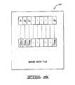
- Image and data acquiring software 90creates and stores in memory 82 one or more output image and data files 120 . More particularly, image and data acquiring software 90 converts image data signals 48 a , 48 b and the orientation data signals (i.e., image data signals 48 , location signals 56 , velocity signals 58 , time data signal 62 , pitch, roll and yaw signals 64 , 66 and 68 , respectively, heading signal 72 and altitude signal 74 ) into computer-readable output image and data files 120 . As best shown in FIG. 4 , output image and data file 120 contains a plurality of captured image files I 1 , I 2 , . . . , I n corresponding to captured oblique images, and the positional data C PD1 , C PD2 , . . . , C PDn corresponding thereto.
- orientation data signalsi.e., image data signals 48 , location signals 56 , velocity signals 58 , time data signal 62 , pitch, roll and
- Image files I 1 , I 2 , . . . , I n of the image and data file 120are stored in virtually any computer-readable image or graphics file format, such as, for example, JPEG, TIFF, GIF, BMP, or PDF file formats, and are cross-referenced with the positional data C PD1 , C PD2 , . . . , C PDn which is also stored as computer-readable data.
- positional data C PD1 , C PD2 , . . . , C PDnis embedded within the corresponding image files I 1 , I 2 , . . . , I n in known manner.
- Image data files 120are then processed, either by image and data acquiring software 90 or by post-processing, to correct for errors, such as, for example, errors due to flight path deviations and other errors known to one of ordinary skill in the art. Thereafter, image data files 120 are ready for use to display and make measurements of and between the objects depicted within the captured images, including measurements of the heights of such objects.
- image display and measurement computer system 130such as, for example, a conventional desktop personal computer or a mobile computer terminal in a police car, includes memory 132 , input devices 134 a and 134 b , display device 136 , and network connection 138 .
- Image-capturing computer system 130executes image display and analysis software 140 , which is stored in memory 132 .
- Memory 132includes, for example, non-volatile read-only memory, random access memory, hard disk memory, removable memory cards and/or other suitable memory storage devices and/or media.
- Input devices 134 a and 134 bsuch as, for example, a mouse, keyboard, joystick, or other such input devices, enable the input of data and interaction of a user with image display and analysis software 140 being executed by image display and measurement computer system 130 .
- Display device 136such as, for example, a liquid crystal display or cathode ray tube, displays information to the user of image display and measurement computer system 130 .
- Network connection 138connects image display and measurement computer system 130 to a network (not shown), such as, for example, a local-area network, wide-area network, the Internet and/or the World Wide Web.
- image display and measurement computer system 130executing image display and analysis software 140 accesses one or more 10 output image and data files 120 that have been read into memory 132 , such as, for example, via network connection 138 , a floppy disk drive, removable memory card or other suitable means.
- One or more of the captured images I 1 , I n , . . . , I n of output image and data files 120is thereafter displayed as displayed oblique image 142 under the control of image display and analysis software 140 .
- one or more data portions C PD1 , C PD2 , . . . , C PDn corresponding to displayed oblique image 142are read into a readily-accessible portion of memory 132 .
- displayed oblique image 142is displayed substantially as captured, i.e., displayed image 142 is not warped or fitted to any coordinate system nor is displayed image 142 ortho-rectified. Rather than warping displayed image 142 to a coordinate system in order to enable measurement of objects depicted therein, image display and analysis software 140 , in general, determines the geo-locations of selected pixels only as needed, or “on the fly”, by referencing data portions C PD1 , C PD2 , . . . , C PDn of output image and data files 120 and calculating the position and/or geo-location of those selected pixels using one or more projection equations as is more particularly described hereinafter.
- a user of display and measurement computer system 130takes measurements of and between objects depicted in displayed oblique image 142 by selecting one of several available measuring modes provided within image display and analysis software 140 .
- the userselects the desired measurement mode by accessing, for example, a series of pull-down menus or toolbars M, or via keyboard commands.
- the measuring modes provided by image display and analysis software 140include, for example, a distance mode that enables measurement of the distance between two or more selected points, an area mode that enables measurement of the area encompassed by several selected and interconnected points, a height mode that enables measurement of the height between two or more selected points, and an elevation mode that enables the measurement of the change in elevation of one selected point relative to one or more other selected points.
- image display and analysis software 140After selecting the desired measurement mode, the user of image display and analysis software 140 selects with one of input devices 134 a , 134 b a starting point or starting pixel 152 and an ending point or pixel 154 on displayed image 142 , and image display and analysis software 140 automatically calculates and displays the quantity sought, such as, for example, the distance between starting pixel 152 and ending pixel 154 .
- the geo-location of the point corresponding thereto on surface 31is calculated by image display and analysis software 140 which executes one or more projection equations using the data portions C PD1 , C PD2 , . . . , C PDn of output image and data files 120 that correspond to the particular image being displayed.
- the longitude and latitude of the point on surface 31 corresponding to pixel 152are then displayed by image display and analysis software 140 on display 136 , such as, for example, by superimposing the longitude and latitude on displayed image 142 adjacent the selected point/pixel or in pop-up display box elsewhere on display 136 .
- the same processis repeated by the user for the selection of the end pixel/point 154 , and by image display and analysis software 140 for the retrieval and display of the longitude and latitude information.
- the calculation of the distance between starting and ending points/pixels 152 , 154 , respectively,is accomplished by determining the geo-location of each selected pixel 152 , 154 “on the fly”.
- the data portions C PD1 , C PD2 , . . . , C PDn of output image and data file 120 corresponding to the displayed imageare retrieved, and the geo-location of the point on surface 31 corresponding to each selected pixel are then determined.
- the difference between the geo-locations corresponding to the selected pixelsdetermines the distance between the pixels.
- displayed image 142corresponds to orthogonal image 104 a ( FIG. 1 ).
- the user of image display and analysis software 140selects pixel 154 which, for simplicity, corresponds to center C ( FIG. 1 ) of oblique image 104 a .
- line 106extends along horizontal plane G from a point 108 thereon that is directly below image-capturing device 32 a to the center C of the near border or edge 108 of oblique image 104 a .
- An extension of primary axis A 1intersects with center C.
- Angle ⁇is the angle formed between line 106 the extension of primary axis A 1 .
- a triangle(not referenced) is formed having vertices at image-capturing device 32 a , point 108 and center C, and having sides 106 , the extension of primary axis A 1 and vertical (dashed) line 110 between point 108 and image-capturing device 32 a.
- Ground plane Gis a substantially horizontal, flat or non-sloping ground plane (and which typically will have an elevation that reflects the average elevation of the terrain), and therefore the above-described triangle includes a right angle between side/line 110 and sideline 106 . Since angle ⁇ and the altitude of image-capturing device 32 (i.e., the length of side 110 ) are known, the hypotenuse (i.e., the length of the extension of primary axis A 1 ) and remaining other side of the right triangle are calculated by simple geometry. Further, since the exact position of image-capturing device 32 a is known at the time the image corresponding to displayed image 142 was captured, the latitude and longitude of point 108 are also known.
- Knowing the length of side 106enables the exact geo-location of pixel 154 corresponding to center C of oblique image 104 a to be determined by image display and analysis software 140 .
- the geo-location of the point corresponding to pixel 154is known, the geo-location of any other pixel in displayed oblique image 142 is determinable using the known camera characteristics, such as, for example, focal length, sensor size and aspect ratio, radial and other distortion terms, etc.
- the distance between the two or more points corresponding to two or more selected pixels within displayed image 142is calculated by image display and analysis software 140 by determining the difference between the geo-locations of the selected pixels using known algorithms, such as, for example, the Gauss formula and/or the vanishing point formula, dependent upon the selected measuring mode.
- the measurement of objects depicted or appearing in displayed image 142is conducted by a substantially similar procedure to the procedure described above for measuring distances between selected pixels. For example, the lengths, widths and heights of objects, such as, for example, buildings, rivers, roads, and virtually any other geographic or man-made structure, appearing within displayed image 142 are measured by selecting the appropriate/desired measurement mode and selecting starting and ending pixels.
- the distance between the starting and ending points/pixels 152 , 154 , respectivelyis determinable along virtually any path, such as, for example, a “straight-line” path P 1 or a path P 2 that involves the selection of intermediate points/pixels and one or more “straight-line” segments interconnected therewith.
- the distance measuring mode of image display and analysis software 140determines the distance between selected pixels according to a “walk the earth” method.
- the “walk the earth method”creates a series of interconnected line segments, represented collectively by paths P 1 and P 2 , that extend between the selected pixels/points and which lie upon or conform to the planar faces of a series of interconnected facets that define a tessellated ground plane.
- the tessellated ground planeas will be more particularly described hereinafter, closely follows or recreates the terrain of surface 31 , and therefore paths P 1 and P 2 also closely follow the terrain of surface 31 .
- the “walk the earth” methodprovides for a more accurate and useful measurement of the distance between selected points than the conventional approach, which warps the image onto a flat earth or average elevation plane system and measures the distance between selected points along the flat earth or plane and substantially ignores variations in terrain between the points.
- a contractor preparing to bid on a contract for paving a roadway over uneven or hilly terraincan determine the approximate amount or area of roadway involved using image display and analysis software 140 and the “walk the earth” measurement method provided thereby.
- the contractorcan obtain the approximate amount or area of roadway from his or her own office without having to send a surveying crew to the site to obtain the measurements necessary.
- the “flat earth” or average elevation distance calculating approachesinclude inherent inaccuracies when measuring distances between points and/or objects disposed on uneven terrain and when measuring the sizes and/or heights of objects similarly disposed. Even a modest slope or grade in the surface being captured results in a difference in the elevation of the nadir point relative to virtually any other point of interest thereon.
- the triangle formed by line 106 , the extension of primary axis A 1 and the vertical (dashed) line 110 between point 108 and image-capturing device 32 amay not be a right triangle. If such is the case, any geometric calculations assuming that triangle to be a right triangle would contain errors, and such calculations would be reduced to approximations due to even a relatively slight gradient or slope between the points of interest.
- second line 110intersects surface 31 before the point at which such intersection would occur on a level or non-sloping surface 31 .
- center Cis fifteen feet higher than nadir point N and with a declination angle ⁇ equal to 40° (forty degrees), the calculated location of center C would be off by approximately 17.8 feet without correction for the change in elevation between the points.
- Tessellated ground plane 160includes a plurality of individual facets 162 a , 162 b , 162 c , etc., each of which are interconnected to each other and are defined by four vertices (not referenced, but shown as points) having respective elevations. Adjacent pairs of facets 162 a , 162 b , 162 c , etc., share two vertices.
- Tessellated ground plane 160is created based upon various data and resources, such as, for example, topographical maps, and/or digital raster graphics, survey data, and various other sources.
- the geo-location of a point of interest on displayed image 142is calculated by determining which of facets 162 a , 162 b , 162 c , etc., correspond to that point of interest.
- the location of the point of interestis calculated based on the characteristics, i.e., elevation, pitch and slope, of facets 162 a , 162 b , 162 c , etc., rather than based upon a flat or average-elevation ground plane. Error is introduced only in so far as the topography of surface 31 and the location of the point of interest thereon deviate from the planar surface of the facet 162 a , 162 b , 162 c , etc, within which the point of interest lies.
- That erroris reducible through a bilinear interpolation of the elevation of the point of interest within a particular one of facets 162 a , 162 b , 162 c , etc., and using that interpolated elevation in the location calculation performed by image display and analysis software 140 .
- image display and analysis software 140employs a modified ray-tracing algorithm to find the intersection of the ray projected from the image-capturing device 32 a or 32 b towards surface 31 and tessellated ground plane 160 .
- the algorithmdetermines not only which of facets 162 a , 162 b , 162 c , etc., is intersected by the ray, but also where within the facet the intersection occurs.
- bi-linear interpolationa fairly precise ground location can be determined.
- tessellated ground plane 160is used to find the ground elevation value for the input ground location also using bi-linear interpolation. The elevation and location are then used to project backwards through a model of the image-capturing device 32 a or 32 b to determine which of the pixels within displayed image 142 corresponds to the given location.
- image display and analysis software 140performs and/or calculates the geo-location of point 164 by superimposing and/or fitting tessellated ground plane 160 to at least a portion 166 , such as, for example, a hill, of surface 31 .
- tessellated ground plane 160 and facets 162 a , 162 b , 162 c , etc., thereofis shown along the profile of portion 166 of surface 31 .
- each of facets 162 a , 162 b , 162 c , etc.are defined by four vertices, each of which have respective elevations, and each of the facets have respective pitches and slopes.
- the specific position of point 164 upon the plane/surface of the facet 162 a , 162 b , 162 c , etc., within which point 164 (or its projection) liesis determined as described above.
- Tessellated ground plane 160is preferably created outside the operation of image display and measurement computer system 130 and image display and analysis software 140 . Rather, tessellated ground plane 160 takes the form of a relatively simple data table or look-up table 168 stored within memory 132 of and/or accessible to image display and measurement computer system 130 .
- the computing resources required to calculate the locations of all the vertices of the many facets of a typical ground planedo not necessarily have to reside within image display and measurement computer system 130 .
- image display and measurement computer system 130is compatible for use with and executable by a conventional personal computer without requiring additional computing resources.
- Calculating tessellated ground plane 160 outside of image display and measurement computer system 130enables virtually any level of detail to be incorporated into tessellated ground plane 160 , i.e., the size and/or area covered by or corresponding to each of facets 162 a , 162 b , 162 c , etc., can be as large or as small as desired, without significantly increasing the calculation time, slowing the operation of, nor significantly increasing the resources required by image display and measurement computer system 130 and/or image display and analysis software 140 .
- Display and measurement computer system 130can therefore be a relatively basic and uncomplicated computer system.
- the size of facets 162 a , 162 b , 162 c , etc.are uniform in size throughout a particular displayed image 142 .
- displayed image 142corresponds to an area that is approximately 750 feet wide in the foreground by approximately 900 feet deep, the image can be broken into facets that are approximately 50 square feet, thus yielding about 15 facets in width and 18 facets in depth.
- the size of facets 162 a , 162 b , 162 c , etc.are uniform in terms of the number of pixels contained therein, i.e., each facet is the same number of pixels wide and the same number of pixels deep.
- Facets in the foreground of displayed image 142would therefore be dimensionally smaller than facets in the background of displayed image 142 where pixel density is lowest. Since it is desirable to take most measurements in the foreground of a displayed image where pixel density is greatest, creating facets that are uniform in terms of the number of pixels they contain has the advantage of providing more accurate measurements in the foreground of displayed image 142 relative to facets that are dimensionally uniform.
- a useroperates image display and measurement computer system 130 to select a pixel within a given facet, image display and analysis software 140 looks up the data for the facet corresponding to the selected pixel, the elevation of the selected pixel is calculated as discussed above, and that elevation is used within the location calculation.
- the method of capturing oblique images of the present inventiondivides an area of interest, such as, for example, a county, into sectors of generally uniform size, such as, for example, sectors that are approximately one square mile in area. This is done to facilitate the creation of a flight plan to capture oblique images covering every inch of the area of interest, and to organize and name the sectors and/or images thereof for easy reference, storage and retrieval (a process known in the art as “sectorization”).
- the method of capturing oblique images of the present inventionprovides more sectors than there are square miles in the area of interest—how many more depends largely on the length of the county borders as well as how straight or jagged they are. Typically, you can expect one extra sector for every two to three miles of border. So if a county or other area of interest is roughly 20 miles by 35 miles, or 700 square miles, the area will be divided into approximately from 740 to 780 sectors.
- the method of capturing oblique images of the present inventionin general, captures the oblique images from at least two compass directions, and provides full coverage of the area of interest from at least those two compass directions.
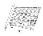
- FIGS. 7 and 8a first embodiment of a method for capturing oblique images of the present invention is shown.
- FIGS. 7 and 8is based on a system having only one image-capturing device. However, it is to be understood that two or more image-capturing devices can be used.
- the image-capturing devicecaptures one or more oblique images during each pass over area 200 .
- the image-capturing deviceas discussed above, is aimed at an angle over area 200 to capture oblique images thereof.
- Area 200is traversed in a back-and-forth pattern, similar to the way a lawn is mowed, by the image-carrying device and/or the platform to ensure double coverage of area 200 .
- area 200is traversed by image-carrying device 32 and/or platform 20 following a first path 202 to thereby capture oblique images of portions 202 a , 202 b , and 202 c of area 200 .
- Area 200is then traversed by image-carrying device 32 and/or platform 20 following a second path 204 that is parallel and spaced apart from, and in an opposite direction to, i.e., 180° (one-hundred and eighty degrees) from, first path 202 , to thereby capture oblique images of portions 204 a , 204 b , 204 c of area 200 .
- a portion 207FIG.
- area 200is covered by images 202 a - c captured from a first direction or perspective, and by images 204 a - c captured from a second direction or perspective.
- the middle portion of area 200is 100% (one-hundred percent) double covered.
- the above-described pattern of traversing or passing over area 200 along opposing paths that are parallel to paths 202 and 204is repeated until the entirety of area 200 is completely covered by at least one oblique image captured from paths that are parallel to, spaced apart from each other as dictated by the size of area 200 , and in the same direction as paths 202 and 204 to thereby one-hundred percent double cover area 200 from those perspectives/directions.
- area 200is covered by two additional opposing and parallel third and fourth paths 206 and 208 , respectively, that are perpendicular to paths 202 and 204 as shown in FIGS. 9 and 10 .
- Area 200is therefore traversed by image-carrying device 32 and/or platform 20 following third path 206 to capture oblique images of portions 206 a , 206 b and 206 c of area 200 , and is then traversed along fourth path 208 that is parallel, spaced apart from, and opposite to third path 206 to capture oblique images of portions 208 a , 208 b and 208 c of area 200 .
- This pattern of traversing or passing over area 200 along opposing paths that are parallel to paths 206 and 208is similarly repeated until the entirety of area 200 is completely covered by at least one oblique image captured from paths that are parallel to, spaced apart from as dictated by the size of area 200 , and in the same direction as paths 206 and 208 to thereby one-hundred percent double cover area 200 from those directions/perspectives.
- image-carrying device 32 and/or platform 20traverses or passes over area 200 along a predetermined path.
- image-carrying device and/or platform 20do not necessarily pass or traverse directly over area 200 but rather may pass or traverse an area adjacent, proximate to, or even somewhat removed from, area 200 in order to ensure that the portion of area 200 that is being imaged falls within the image-capture field of the image-capturing device.
- Path 202is such a path that does not pass directly over area 200 but yet captures oblique images thereof.
- the present inventionis capable of capturing images at various levels of resolution or ground sample distances.
- a first level of detailhereinafter referred to as a community level, has a ground sample distance of, for example, approximately two-feet per pixel.
- the ground sample distanceremains substantially constant throughout the image.
- Orthogonal community-level imagesare captured with sufficient overlap to provide stereo pair coverage.
- the ground sample distancevaries from, for example, approximately one-foot per pixel in the foreground of the image to approximately two-feet per pixel in the mid-ground of the image, and to approximately four-feet per pixel in the background of the image.
- Oblique community-level imagesare captured with sufficient overlap such that each area of interest is typically covered by at least two oblique images from each compass direction captured. Approximately ten oblique community-level images are captured per sector.
- a second level of detailhereinafter referred to as a neighborhood level, is significantly more detailed than the community-level images.
- Neighborhood-level imageshave a ground sample distance of, for example, approximately six-inches per pixel.
- the ground sample distanceremains substantially constant.
- Oblique neighborhood-level imageshave a ground sample distance of, for example, from approximately four-inches per pixel in the foreground of the image to approximately six-inches per pixel in the mid-ground of the image, and to approximately ten-inches per pixel in the background of the image.
- Oblique neighborhood-level imagesare captured with sufficient overlap such that each area of interest is typically covered by at least two oblique images from each compass direction captured, and such that opposing compass directions provide 100% overlap with each other. Approximately one hundred (100) oblique area images are captured per sector.
- capturing oblique community and/or neighborhood-level images from all four compass directionsensures that every point in the image will appear in the foreground or lower portion of at least one of the captured oblique images, where ground sample distance is lowest and image detail is greatest.
- image-capturing and geo-locating system 30includes a gyroscope, compass and altimeter.
- the image-capturing and geo-locating system of the present inventioncan be alternately configured, such as, for example, to derive and/or calculate altitude, pitch, roll and yaw, and compass heading from the GPS and INU signals/data, thereby rendering one or more of the gyroscope, compass and altimeter unnecessary.
- image-capturing devicesare at an equal angle of declination relative to a horizontal plane. However, it is to be understood that the declination angles of the image-capturing devices do not have to be equal.
- image-capturing computer systemexecutes image and data acquiring software' that issues a common or single image-capture signal to the image-capturing devices to thereby cause those devices to acquire or capture an image.
- image-capturing computer systemexecutes image and data acquiring software' that issues a common or single image-capture signal to the image-capturing devices to thereby cause those devices to acquire or capture an image.
- present inventioncan be alternately configured to separately cause the image-capturing devices to capture images at different instants and/or at different intervals.
- the method of the present inventioncaptures oblique images to provide double coverage of an area of interest from paths/perspectives that are substantially opposite to each other, i.e., 180° (one-hundred and eighty degrees) relative to each other.
- the method of the present inventioncan be alternately configured to provide double coverage from paths/perspectives that are generally and/or substantially perpendicular relative to each other.
Landscapes
- Physics & Mathematics (AREA)
- Engineering & Computer Science (AREA)
- General Physics & Mathematics (AREA)
- Remote Sensing (AREA)
- Theoretical Computer Science (AREA)
- Multimedia (AREA)
- Radar, Positioning & Navigation (AREA)
- Geometry (AREA)
- Software Systems (AREA)
- Computer Graphics (AREA)
- Computer Vision & Pattern Recognition (AREA)
- Image Processing (AREA)
- Length Measuring Devices By Optical Means (AREA)
- Magnetic Resonance Imaging Apparatus (AREA)
- Measurement Of Radiation (AREA)
- Optical Radar Systems And Details Thereof (AREA)
- Analysing Materials By The Use Of Radiation (AREA)
- Processing Or Creating Images (AREA)
- Investigating Or Analysing Materials By Optical Means (AREA)
- Measurement Of Optical Distance (AREA)
Abstract
Description
- This application is a continuation of U.S. Ser. No. 12/950,643, Filed Nov. 19, 2010, which is a continuation of U.S. Ser. No. 12/853,616, Filed Aug. 10, 2010, which is a continuation of U.S. Ser. No. 12/186,889, filed Aug. 6, 2008, which issued as U.S. Pat. No. 7,787,659, on Aug. 31, 2010, which is a continuation of U.S. Ser. No. 10/701,839, filed on Nov. 5, 2003, which issued as U.S. Pat. No. 7,424,133, on Sep. 9, 2004, which claims priority to the provisional patent application identified by U.S. Ser. No. 60/425,275, filed Nov. 8, 2002, of which the entire content of each is hereby expressly incorporated by reference.
- The present invention relates to photogrammetry. More particularly, the present invention relates to a method and apparatus for capturing oblique images and for measuring the objects and distances between the objects depicted therein.
- Photogrammetry is the science of making measurements of and between objects depicted within photographs, especially aerial photographs. Generally, photogrammetry involves taking images of terrestrial features and deriving data therefrom, such as, for example, data indicating relative distances between and sizes of objects within the images. Photogrammetry may also involve coupling the photographs with other data, such as data representative of latitude and longitude. In effect, the image is overlaid and conformed to a particular spatial coordinate system.
- Conventional photogrammetry involves the capture and/or acquisition of orthogonal images. The image-capturing device, such as a camera or sensor, is carried by a vehicle or platform, such as an airplane or satellite, and is aimed at a nadir point that is directly below and/or vertically downward from that platform. The point or pixel in the image that corresponds to the nadir point is the only point/pixel that is truly orthogonal to the image-capturing device. All other points or pixels in the image are actually oblique relative to the image-capturing device. As the points or pixels become increasingly distant from the nadir point they become increasingly oblique relative to the image-capturing device and the ground sample distance (i.e., the surface area corresponding to or covered by each pixel) also increases. Such obliqueness in an orthogonal image causes features in the image to be distorted, especially images relatively distant from the nadir point.
- Such distortion is removed, or compensated for, by the process of ortho-rectification which, in essence, removes the obliqueness from the orthogonal image by fitting or warping each pixel of an orthogonal image onto an orthometric grid or coordinate system. The process of ortho-rectification creates an image wherein all pixels have the same ground sample distance and are oriented to the north. Thus, any point on an ortho-rectified image can be located using an X, Y coordinate system and, so long as the image scale is known, the length and width of terrestrial features as well as the relative distance between those features can be calculated.
- Although the process of ortho-rectification compensates to a degree for oblique distortions in an orthogonal image, it introduces other undesirable distortions and/or inaccuracies in the ortho-rectified orthogonal image. Objects depicted in ortho-rectified orthogonal images may be difficult to recognize and/or identify since most observers are not accustomed to viewing objects, particularly terrestrial features, from above. To an untrained observer an ortho-rectified image has a number of distortions. Roads that are actually straight appear curved and buildings may appear to tilt. Further, ortho- rectified images contain substantially no information as to the height of terrestrial features. The interpretation and analysis of orthogonal and/or ortho-rectfified orthogonal images is typically performed by highly-trained analysts whom have undergone years of specialized training and experience in order to identify objects and terrestrial features in such images.
- Thus, although orthogonal and ortho-rectified images are useful in photogrammetry, they lack information as to the height of features depicted therein and require highly-trained analysts to interpret detail from what the images depict.
- Oblique images are images that are captured with the image-capturing device aimed or pointed generally to the side of and downward from the platform that carries the image-capturing device. Oblique images, unlike orthogonal images, display the sides of terrestrial features, such as houses, buildings and/or mountains, as well as the tops thereof. Thus, viewing an oblique image is more natural and intuitive than viewing an orthogonal or ortho-rectified image, and even casual observers are able to recognize and interpret terrestrial features and other objects depicted in oblique images. Each pixel in the foreground of an oblique image corresponds to a relatively small area of the surface or object depicted (Le., each foreground pixel has a relatively small ground sample distance) whereas each pixel in the background corresponds to a relatively large area of the surface or object depicted (i.e., each background pixel has a relatively large ground sample distance). Oblique images capture a generally trapezoidal area or view of the subject surface or object, with the foreground of the trapezoid having a substantially smaller ground sample distance (i.e., a higher resolution) than the background of the trapezoid.
- Oblique images are considered to be of little or no use in photogrammetry. The conventional approach of forcing the variously-sized foreground and background pixels of an oblique image into a uniform size to thereby warp the image onto a coordinate system dramatically distorts the oblique image and thereby renders identification of objects and the taking of measurements of objects depicted therein a laborious and inaccurate task. Correcting for terrain displacement within an oblique image by using an elevation model further distorts the images thereby increasing the difficulty with which measurements can be made and reducing the accuracy of any such measurements.
- Thus, although oblique images are considered as being of little or no use in photogrammetry, they are easily interpreted and contain information as to the height of features depicted therein. Therefore, what is needed in the art is a method and apparatus for photogrammetry that enable geo-location and accurate measurements within oblique images.
- Moreover, what is needed in the art is a method and apparatus for photogrammetry that enable the measurement of heights and relative heights of objects within an image. Furthermore, what is needed in the art is a method and apparatus for photogrammetry that utilizes more intuitive and natural images.
- The present invention provides a method and apparatus for capturing, displaying, and making measurements of objects and distances between objects depicted within oblique images. The present invention comprises, in one form thereof, a computerized system for displaying, geolocating, and taking measurements from captured oblique images. The system includes a data file accessible by the computer system. The data file includes a plurality of image files corresponding to a plurality of captured oblique images, and positional data corresponding to the images. Image display and analysis software is executed by the system for reading the data file and displaying at least a portion of the captured oblique images. The software retrieves the positional data for one or more user-selected points on the displayed image, and calculates a separation distance between any two or more selected points. The separation distance calculation is user-selectable to determine various parameters including linear distance between, area encompassed within, relative elevation of, and height difference between selected points.
- The above-mentioned and other features and advantages of this invention, and the manner of attaining them, will become apparent and be more completely understood by reference to the following description of one embodiment of the invention when read in conjunction with the accompanying drawings, wherein:
FIG. 1 illustrates one embodiment of a platform or vehicle carrying an image-capturing system of the present invention, and shows exemplary orthogonal and oblique images taken thereby;FIG. 2 is a diagrammatic view of the image-capturing system ofFIG. 1 ;FIG. 3 is a block diagram of the image-capturing computer system ofFIG. 2 ;FIG. 4 is a representation of an exemplary output data file of the image-capturing system ofFIG. 1 ;FIG. 5 is a block diagram of one embodiment of an image display and measurement computer system of the present invention for displaying and taking measurements of and between objects depicted in the images captured by the image-capturing system ofFIG. 1 ;FIG. 6 depicts an exemplary image displayed on the system ofFIG. 5 , and illustrates one embodiment of the method of the present invention for the measurement of and between objects depicted in such an image;FIGS. 7 and 8 illustrate one embodiment of a method for capturing oblique images of the present invention;FIGS. 9 and 10 illustrate a second embodiment of a method for capturing oblique images of the resent invention.- Corresponding reference characters indicate corresponding parts throughout the several views. The exemplifications set out herein illustrate one preferred embodiment of the invention, in one form, and such exemplifications are not to be construed as limiting the scope of the invention in any manner.
- Referring now to the drawings, and particularly to
FIG. 1 , one embodiment of an apparatus for capturing and geolocating oblique images of the present invention is shown.Apparatus 10 includes a platform orvehicle 20 that carries image-capturing andgeolocating system 30. Platform 20, such as, for example, an airplane, space shuttle, rocket, satellite, or any other suitable vehicle, carries image-capturingsystem 30 over a predefined area of and at one or more predetermined altitudes abovesurface 31, such as, for example, the earth's surface or any other surface of interest. As such,platform 20 is capable of controlled movement or flight, either manned or unmanned, along a predefined flight path or course through, for example, the earth's atmosphere or outer space.Image capturing platform 20 includes a system for generating and regulating power (not shown) that includes, for example, one or more generators, fuel cells, solar panels, and/or batteries, for powering image-capturingsystem 30.- Image-capturing and geo-locating
system 30, as best shown inFIG. 2 , includesimage capturing devices receiver 34, an inertial navigation unit (INU)36,clock 38,gyroscope 40,compass 42 and altimeter44, each of which are interconnected with image-capturingcomputer system 46. - Image-capturing
devices devices devices computer system 46, as will be more particularly described hereinafter. - As best shown in
FIG. 1 , image-capturingdevices platform 20 such that axes A1and A2are each at an angle of declination Ø relative to a horizontal plane P. Declination angle Ø is virtually any oblique angle, but is preferably from approximately 20° (twenty degrees) to approximately 60° (sixty degrees) and is most preferably from approximately 40° (forty degrees) to approximately 50° (fifty degrees). GPS receiver 34 receives global positioning system signals52 that are transmitted by one or more globalpositioning system satellites 54. The GPS signals52, in known fashion, enable the precise location ofplatform 20 relative to surface31 to be determined.GPS receiver 34 decodes GPS signals52 and issues location signals/data 56, that are dependent at least in part upon GPS signals52 and which are indicative of the precise location ofplatform 20 relative to surface31. Location signals/data 56 corresponding to each image captured by image-capturingdevices computer system 46.INU 36 is a conventional inertial navigation unit that is coupled to and detects changes in the velocity, including translational and rotational velocity, of image-capturingdevices platform 20.INU 36 issues velocity signals/data 58 indicative of such velocities and/or changes therein to image-capturingcomputer system 46, which stores velocity signals/data 58 corresponding to each image captured by image-capturingdevices computer system 46.Clock 38 keeps a precise time measurement (time of validity) that is used to synchronize events within image-capturing and geo-locatingsystem 30.Clock 38 provides time data/clock signal 62 that is indicative of the precise time that an image is taken by image-capturingdevices Time data 62 is also provided to and stored by image-capturingcomputer system 46. Alternatively,clock 38 is integral with image-capturingcomputer system 46, such as, for example, a clock software program.Gyroscope 40 is a conventional gyroscope as commonly found on airplanes and/or within commercial navigation systems for airplanes.Gyroscope 40 provides signals includingpitch signal 64,roll signal 66 andyaw signal 68, which are respectively indicative of pitch, roll and yaw ofplatform 20.Pitch signal 64,roll signal 66 andyaw signal 68 corresponding to each image captured by mage-capturingdevices computer system 46.Compass 42, such as, for example, a conventional electronic compass, indicates the heading ofplatform 20.Compass 42 issues heading signal/data 72 that is indicative of the heading ofplatform 20. Image-capturingcomputer system 46 receives and stores the heading signals/data 72 that correspond to each image captured by image-capturingdevices - Altimeter44 indicates the altitude of
platform 20. Altimeter44 issues altitude signal/data 74, and image-capturingcomputer system 46 receives and stores the altitude signal/data 74 that correspond to each image captured by image-capturingdevices - As best shown in
FIG. 3 , image-capturingcomputer system 46, such as, for example, a conventional laptop personal computer, includesmemory 82,input devices display device 86, and input and output (I/O)ports 88. Image-capturingcomputer system 46 executes image anddata acquiring software 90, which is stored inmemory 82.Memory 82 also stores data used and/or calculated by image-capturingcomputer system 46 during the operation thereof, and includes, for example, non- volatile read-only memory, random access memory, hard disk memory, removable memory cards and/or other suitable memory storage devices and/or media.Input devices computer system 46.Display device 86, such as, for example, a liquid crystal display or cathode ray tube, displays information to the user of image-capturingcomputer system 46. I/O ports 88, such as, for example, serial and parallel data input and output ports, enable the input and/or output of data to and from image-capturingcomputer system 46. - Each of the above-described data signals is connected to image-capturing
computer system 46. More particularly, image data signals48, location signals56, velocity signals58, time data signal62, pitch, roll and yaw signals64,66 and68, respectively, headingsignal 72 andaltitude signal 74 are received via I/O ports 88 by and stored withinmemory 82 of image-capturingcomputer system 46. - In use, image-capturing
computer system 46 executes image anddata acquiring software 90, which, in general, controls the reading, manipulation, and storing of the above-described data signals. More particularly, image anddata acquiring software 90 reads image data signals48aand48band stores them withinmemory 82. Each of the location signals56, velocity signals58, time data signal62, pitch, roll and yaw signals64,66 and68, respectively, headingsignal 72 andaltitude signal 74 that represent the conditions existing at the instant an image is acquired or captured by image-capturingdevices computer system 46 via I/O ports 88. Image-capturingcomputer system 46 executing image anddata acquiring software 90 issues image-capture signal 92 to image-capturingdevices platform 20. - Image and
data acquiring software 90 decodes as necessary and stores the aforementioned signals withinmemory 82, and associates the data signals with the corresponding image signals48aand48b. Thus, the altitude, orientation in terms of roll, pitch, and yaw, and the location of image-capturingdevices devices Platform 20 is piloted or otherwise guided through an image-capturing path that passes over a particular area ofsurface 31, such as, for-example, a predefined area of the surface of the earth or of another planet. Preferably, the image-capturing path ofplatform 20 is at right angles to at least one of the boundaries of the area of interest. The number oftimes platform 20 and/or image-capturingdevices platform 20 are described more particularly hereinafter.- As
platform 20 passes over the area of interest a number of oblique images are captured by image-capturingdevices devices platform 20. - Image data signals48aand48bcorresponding to each image acquired are received by and stored within
memory 82 of image-capturingcomputer system 46 via I/O ports 88. Similarly, the data signals (i.e., image data signals48, location signals56, velocity signals58, time data signal62, pitch, roll and yaw signals64,66 and68, respectively, headingsignal 72 and altitude signal74) corresponding to each captured image are received and stored withinmemory 82 of image-capturingcomputer system 46 via I/O ports 88. Thus, the location of image-capturingdevice memory 82 and associated with the corresponding captured image. - As best shown in
FIG. 1 , the location of image-capturingdevices orthogonal image 102. Thus, the exact geo-location of the nadir point N oforthogonal image 102 is indicated bylocation signals 56, velocity signals58, time data signal62, pitch, roll and yaw signals64,66 and68, respectively, headingsignal 72 andaltitude signal 74. Once the nadir point N oforthogonal image 102 is known, the geo-location of any other pixel or point withinimage 102 is determinable in known manner. - When image-capturing
devices oblique images 104aand104b(FIG. 1 ), the location of image-capturingdevices location signals 56, velocity signals58, time data signal62, pitch, roll and yaw signals64,66 and68, respectively, headingsignal 72,altitude signal 74 and the known angle of declination 0 of the primary axes A1and A2of image-capturingdevices - It should be particularly noted that a calibration process enables image and
data acquiring software 90 to incorporate correction factors and/or correct for any error inherent in or due to image-capturing device32, such as, for example, error due to calibrated focal length, sensor size, radial distortion, principal point offset, and alignment. - Image and
data acquiring software 90 creates and stores inmemory 82 one or more output image and data files120. More particularly, image anddata acquiring software 90 converts image data signals48a,48band the orientation data signals (i.e., image data signals48, location signals56, velocity signals58, time data signal62, pitch, roll and yaw signals64,66 and68, respectively, headingsignal 72 and altitude signal74) into computer-readable output image and data files120. As best shown inFIG. 4 , output image and data file120 contains a plurality of captured image files I1, I2, . . . , Incorresponding to captured oblique images, and the positional data CPD1, CPD2, . . . , CPDncorresponding thereto. - Image files I1, I2, . . . , Inof the image and data file120 are stored in virtually any computer-readable image or graphics file format, such as, for example, JPEG, TIFF, GIF, BMP, or PDF file formats, and are cross-referenced with the positional data CPD1, CPD2, . . . , CPDnwhich is also stored as computer-readable data. Alternatively, positional data CPD1, CPD2, . . . , CPDnis embedded within the corresponding image files I1, I2, . . . , Inin known manner. Image data files120 are then processed, either by image and
data acquiring software 90 or by post-processing, to correct for errors, such as, for example, errors due to flight path deviations and other errors known to one of ordinary skill in the art. Thereafter, image data files120 are ready for use to display and make measurements of and between the objects depicted within the captured images, including measurements of the heights of such objects. - Referring now to
FIG. 5 , image display andmeasurement computer system 130, such as, for example, a conventional desktop personal computer or a mobile computer terminal in a police car, includesmemory 132,input devices display device 136, andnetwork connection 138. Image-capturingcomputer system 130 executes image display andanalysis software 140, which is stored inmemory 132.Memory 132 includes, for example, non-volatile read-only memory, random access memory, hard disk memory, removable memory cards and/or other suitable memory storage devices and/or media.Input devices analysis software 140 being executed by image display andmeasurement computer system 130.Display device 136, such as, for example, a liquid crystal display or cathode ray tube, displays information to the user of image display andmeasurement computer system 130.Network connection 138 connects image display andmeasurement computer system 130 to a network (not shown), such as, for example, a local-area network, wide-area network, the Internet and/or the World Wide Web. - In use, and referring now to
FIG. 6 , image display andmeasurement computer system 130 executing image display andanalysis software 140 accesses one or more10 output image anddata files 120 that have been read intomemory 132, such as, for example, vianetwork connection 138, a floppy disk drive, removable memory card or other suitable means. One or more of the captured images I1, In, . . . , Inof output image and data files120 is thereafter displayed as displayedoblique image 142 under the control of image display andanalysis software 140. At approximately the same time, one or more data portions CPD1, CPD2, . . . , CPDncorresponding to displayedoblique image 142 are read into a readily-accessible portion ofmemory 132. - It should be particularly noted that displayed
oblique image 142 is displayed substantially as captured, i.e., displayedimage 142 is not warped or fitted to any coordinate system nor is displayedimage 142 ortho-rectified. Rather than warping displayedimage 142 to a coordinate system in order to enable measurement of objects depicted therein, image display andanalysis software 140, in general, determines the geo-locations of selected pixels only as needed, or “on the fly”, by referencing data portions CPD1, CPD2, . . . , CPDnof output image anddata files 120 and calculating the position and/or geo-location of those selected pixels using one or more projection equations as is more particularly described hereinafter. - Generally, a user of display and
measurement computer system 130 takes measurements of and between objects depicted in displayedoblique image 142 by selecting one of several available measuring modes provided within image display andanalysis software 140. The user selects the desired measurement mode by accessing, for example, a series of pull-down menus or toolbars M, or via keyboard commands. The measuring modes provided by image display andanalysis software 140 include, for example, a distance mode that enables measurement of the distance between two or more selected points, an area mode that enables measurement of the area encompassed by several selected and interconnected points, a height mode that enables measurement of the height between two or more selected points, and an elevation mode that enables the measurement of the change in elevation of one selected point relative to one or more other selected points. - After selecting the desired measurement mode, the user of image display and
analysis software 140 selects with one ofinput devices pixel 152 and an ending point orpixel 154 on displayedimage 142, and image display andanalysis software 140 automatically calculates and displays the quantity sought, such as, for example, the distance between startingpixel 152 and endingpixel 154. - When the user selects starting point/
pixel 152, the geo-location of the point corresponding thereto onsurface 31 is calculated by image display andanalysis software 140 which executes one or more projection equations using the data portions CPD1, CPD2, . . . , CPDnof output image anddata files 120 that correspond to the particular image being displayed. The longitude and latitude of the point onsurface 31 corresponding topixel 152 are then displayed by image display andanalysis software 140 ondisplay 136, such as, for example, by superimposing the longitude and latitude on displayedimage 142 adjacent the selected point/pixel or in pop-up display box elsewhere ondisplay 136. The same process is repeated by the user for the selection of the end pixel/point 154, and by image display andanalysis software 140 for the retrieval and display of the longitude and latitude information. - The calculation of the distance between starting and ending points/
pixels pixel surface 31 corresponding to each selected pixel are then determined. The difference between the geo-locations corresponding to the selected pixels determines the distance between the pixels. - As an example of how the geo-location of a given point or pixel within displayed
oblique image 142 is determined, we will assume that displayedimage 142 corresponds to orthogonal image104a(FIG. 1 ). The user of image display andanalysis software 140 selectspixel 154 which, for simplicity, corresponds to center C (FIG. 1 ) of oblique image104a. As shown inFIG. 1 ,line 106 extends along horizontal plane G from apoint 108 thereon that is directly below image-capturingdevice 32ato the center C of the near border or edge108 of oblique image104a. An extension of primary axis A1intersects with center C. Angle Ø is the angle formed betweenline 106 the extension of primary axis A1. Thus, a triangle (not referenced) is formed having vertices at image-capturingdevice 32a,point 108 and center C, and havingsides 106, the extension of primary axis A1and vertical (dashed) line110 betweenpoint 108 and image-capturingdevice 32a. - Ground plane G is a substantially horizontal, flat or non-sloping ground plane (and which typically will have an elevation that reflects the average elevation of the terrain), and therefore the above-described triangle includes a right angle between side/line110 and
sideline 106. Since angle Ø and the altitude of image-capturing device32 (i.e., the length of side110) are known, the hypotenuse (i.e., the length of the extension of primary axis A1) and remaining other side of the right triangle are calculated by simple geometry. Further, since the exact position of image-capturingdevice 32ais known at the time the image corresponding to displayedimage 142 was captured, the latitude and longitude ofpoint 108 are also known. Knowing the length ofside 106, calculated as described above, enables the exact geo-location ofpixel 154 corresponding to center C of oblique image104ato be determined by image display andanalysis software 140. Once the geo-location of the point corresponding topixel 154 is known, the geo-location of any other pixel in displayedoblique image 142 is determinable using the known camera characteristics, such as, for example, focal length, sensor size and aspect ratio, radial and other distortion terms, etc. The distance between the two or more points corresponding to two or more selected pixels within displayedimage 142 is calculated by image display andanalysis software 140 by determining the difference between the geo-locations of the selected pixels using known algorithms, such as, for example, the Gauss formula and/or the vanishing point formula, dependent upon the selected measuring mode. The measurement of objects depicted or appearing in displayedimage 142 is conducted by a substantially similar procedure to the procedure described above for measuring distances between selected pixels. For example, the lengths, widths and heights of objects, such as, for example, buildings, rivers, roads, and virtually any other geographic or man-made structure, appearing within displayedimage 142 are measured by selecting the appropriate/desired measurement mode and selecting starting and ending pixels. - It should be particularly noted that in the distance measuring mode of image display and
analysis software 140 the distance between the starting and ending points/pixels - It should also be particularly noted that the distance measuring mode of image display and
analysis software 140 determines the distance between selected pixels according to a “walk the earth” method. The “walk the earth method” creates a series of interconnected line segments, represented collectively by paths P1 and P2, that extend between the selected pixels/points and which lie upon or conform to the planar faces of a series of interconnected facets that define a tessellated ground plane. The tessellated ground plane, as will be more particularly described hereinafter, closely follows or recreates the terrain ofsurface 31, and therefore paths P1 and P2 also closely follow the terrain ofsurface 31. By measuring the distance along the terrain simulated by the tessellated ground plane, the “walk the earth” method provides for a more accurate and useful measurement of the distance between selected points than the conventional approach, which warps the image onto a flat earth or average elevation plane system and measures the distance between selected points along the flat earth or plane and substantially ignores variations in terrain between the points. - For example, a contractor preparing to bid on a contract for paving a roadway over uneven or hilly terrain can determine the approximate amount or area of roadway involved using image display and
analysis software 140 and the “walk the earth” measurement method provided thereby. The contractor can obtain the approximate amount or area of roadway from his or her own office without having to send a surveying crew to the site to obtain the measurements necessary. - In contrast to the “walk the earth” method provided by the present invention, the “flat earth” or average elevation distance calculating approaches include inherent inaccuracies when measuring distances between points and/or objects disposed on uneven terrain and when measuring the sizes and/or heights of objects similarly disposed. Even a modest slope or grade in the surface being captured results in a difference in the elevation of the nadir point relative to virtually any other point of interest thereon. Thus, referring again to
FIG. 1 , the triangle formed byline 106, the extension of primary axis A1and the vertical (dashed) line110 betweenpoint 108 and image-capturingdevice 32amay not be a right triangle. If such is the case, any geometric calculations assuming that triangle to be a right triangle would contain errors, and such calculations would be reduced to approximations due to even a relatively slight gradient or slope between the points of interest. - For example, if
surface 31 slopes upward between nadir point N and center C at the near orbottom edge 108 of oblique image104 then second line110 intersectssurface 31 before the point at which such intersection would occur on a level ornon-sloping surface 31. If center C is fifteen feet higher than nadir point N and with a declination angle Ø equal to 40° (forty degrees), the calculated location of center C would be off by approximately 17.8 feet without correction for the change in elevation between the points. - As generally discussed above, in order to compensate at least in part for changes in elevation and the resultant inaccuracies in the measurement of and between objects within
image 142, image display andanalysis software 140 references, as necessary, points within displayedimage 142 and onsurface 31 to a pre-calculated tessellated or faceted ground plane generally designated160 inFIG. 6 .Tessellated ground plane 160 includes a plurality ofindividual facets facets facet Tessellated ground plane 160 is created based upon various data and resources, such as, for example, topographical maps, and/or digital raster graphics, survey data, and various other sources. - Generally, the geo-location of a point of interest on displayed
image 142 is calculated by determining which offacets facets surface 31 and the location of the point of interest thereon deviate from the planar surface of thefacet facets analysis software 140. - To use
tessellated ground plane 160, image display andanalysis software 140 employs a modified ray-tracing algorithm to find the intersection of the ray projected from the image-capturingdevice surface 31 andtessellated ground plane 160. The algorithm determines not only which offacets ground plane 160 is used to find the ground elevation value for the input ground location also using bi-linear interpolation. The elevation and location are then used to project backwards through a model of the image-capturingdevice image 142 corresponds to the given location. - More particularly, and as an example, image display and
analysis software 140 performs and/or calculates the geo-location ofpoint 164 by superimposing and/or fittingtessellated ground plane 160 to at least aportion 166, such as, for example, a hill, ofsurface 31. It should be noted that only a small portion oftessellated ground plane 160 andfacets portion 166 ofsurface 31. As discussed above, each offacets point 164 upon the plane/surface of thefacet Tessellated ground plane 160 is preferably created outside the operation of image display andmeasurement computer system 130 and image display andanalysis software 140. Rather, tessellatedground plane 160 takes the form of a relatively simple data table or look-up table168 stored withinmemory 132 of and/or accessible to image display andmeasurement computer system 130. The computing resources required to calculate the locations of all the vertices of the many facets of a typical ground plane do not necessarily have to reside within image display andmeasurement computer system 130. Thus, image display andmeasurement computer system 130 is compatible for use with and executable by a conventional personal computer without requiring additional computing resources.- Calculating
tessellated ground plane 160 outside of image display andmeasurement computer system 130 enables virtually any level of detail to be incorporated into tessellatedground plane 160, i.e., the size and/or area covered by or corresponding to each offacets measurement computer system 130 and/or image display andanalysis software 140. Display andmeasurement computer system 130 can therefore be a relatively basic and uncomplicated computer system. - The size of
facets image 142. For example, if displayedimage 142 corresponds to an area that is approximately 750 feet wide in the foreground by approximately 900 feet deep, the image can be broken into facets that are approximately 50 square feet, thus yielding about 15 facets in width and18 facets in depth. Alternatively, the size offacets image 142, where the pixel density is greatest, would therefore be dimensionally smaller than facets in the background of displayedimage 142 where pixel density is lowest. Since it is desirable to take most measurements in the foreground of a displayed image where pixel density is greatest, creating facets that are uniform in terms of the number of pixels they contain has the advantage of providing more accurate measurements in the foreground of displayedimage 142 relative to facets that are dimensionally uniform. - Another advantage of using pixels as a basis for defining the dimensions of
facets measurement computer system 130 to select a pixel within a given facet, image display andanalysis software 140 looks up the data for the facet corresponding to the selected pixel, the elevation of the selected pixel is calculated as discussed above, and that elevation is used within the location calculation. - Generally, the method of capturing oblique images of the present invention divides an area of interest, such as, for example, a county, into sectors of generally uniform size, such as, for example, sectors that are approximately one square mile in area. This is done to facilitate the creation of a flight plan to capture oblique images covering every inch of the area of interest, and to organize and name the sectors and/or images thereof for easy reference, storage and retrieval (a process known in the art as “sectorization”). Because the edges of any geographic area of interest, such as a county, rarely falls on even square mile boundaries, the method of capturing oblique images of the present invention provides more sectors than there are square miles in the area of interest—how many more depends largely on the length of the county borders as well as how straight or jagged they are. Typically, you can expect one extra sector for every two to three miles of border. So if a county or other area of interest is roughly 20 miles by 35 miles, or 700 square miles, the area will be divided into approximately from 740 to 780 sectors.
- The method of capturing oblique images of the present invention, in general, captures the oblique images from at least two compass directions, and provides full coverage of the area of interest from at least those two compass directions. Referring now to
FIGS. 7 and 8 , a first embodiment of a method for capturing oblique images of the present invention is shown. For sake of clarity,FIGS. 7 and 8 is based on a system having only one image-capturing device. However, it is to be understood that two or more image-capturing devices can be used. - The image-capturing device captures one or more oblique images during each pass over
area 200. The image-capturing device, as discussed above, is aimed at an angle overarea 200 to capture oblique images thereof.Area 200 is traversed in a back-and-forth pattern, similar to the way a lawn is mowed, by the image-carrying device and/or the platform to ensure double coverage ofarea 200. - More particularly,
area 200 is traversed by image-carrying device32 and/orplatform 20 following afirst path 202 to thereby capture oblique images ofportions area 200.Area 200 is then traversed by image-carrying device32 and/orplatform 20 following asecond path 204 that is parallel and spaced apart from, and in an opposite direction to, i.e., 180° (one-hundred and eighty degrees) from,first path 202, to thereby capture oblique images ofportions area 200. By comparingFIGS. 7 and 8 , it is seen that a portion207 (FIG. 8 ) ofarea 200 is covered byimages 202a-ccaptured from a first direction or perspective, and byimages 204a-ccaptured from a second direction or perspective. As such, the middle portion ofarea 200 is 100% (one-hundred percent) double covered. The above-described pattern of traversing or passing overarea 200 along opposing paths that are parallel topaths area 200 is completely covered by at least one oblique image captured from paths that are parallel to, spaced apart from each other as dictated by the size ofarea 200, and in the same direction aspaths double cover area 200 from those perspectives/directions. - If desired, and for enhanced detail,
area 200 is covered by two additional opposing and parallel third andfourth paths paths FIGS. 9 and 10 .Area 200 is therefore traversed by image-carrying device32 and/orplatform 20 followingthird path 206 to capture oblique images ofportions area 200, and is then traversed alongfourth path 208 that is parallel, spaced apart from, and opposite tothird path 206 to capture oblique images ofportions area 200. This pattern of traversing or passing overarea 200 along opposing paths that are parallel topaths area 200 is completely covered by at least one oblique image captured from paths that are parallel to, spaced apart from as dictated by the size ofarea 200, and in the same direction aspaths double cover area 200 from those directions/perspectives. - As described above, image-carrying device32 and/or
platform 20, traverses or passes overarea 200 along a predetermined path. However, it is to be understood that image-carrying device and/orplatform 20 do not necessarily pass or traverse directly overarea 200 but rather may pass or traverse an area adjacent, proximate to, or even somewhat removed from,area 200 in order to ensure that the portion ofarea 200 that is being imaged falls within the image-capture field of the image-capturing device.Path 202, as shown inFIG. 7 , is such a path that does not pass directly overarea 200 but yet captures oblique images thereof. - The present invention is capable of capturing images at various levels of resolution or ground sample distances. A first level of detail, hereinafter referred to as a community level, has a ground sample distance of, for example, approximately two-feet per pixel. For orthogonal community-level images, the ground sample distance remains substantially constant throughout the image. Orthogonal community-level images are captured with sufficient overlap to provide stereo pair coverage. For oblique community-level images, the ground sample distance varies from, for example, approximately one-foot per pixel in the foreground of the image to approximately two-feet per pixel in the mid-ground of the image, and to approximately four-feet per pixel in the background of the image. Oblique community-level images are captured with sufficient overlap such that each area of interest is typically covered by at least two oblique images from each compass direction captured. Approximately ten oblique community-level images are captured per sector.
- A second level of detail, hereinafter referred to as a neighborhood level, is significantly more detailed than the community-level images. Neighborhood-level images have a ground sample distance of, for example, approximately six-inches per pixel. For orthogonal neighborhood-level images, the ground sample distance remains substantially constant. Oblique neighborhood-level images have a ground sample distance of, for example, from approximately four-inches per pixel in the foreground of the image to approximately six-inches per pixel in the mid-ground of the image, and to approximately ten-inches per pixel in the background of the image. Oblique neighborhood-level images are captured with sufficient overlap such that each area of interest is typically covered by at least two oblique images from each compass direction captured, and such that opposing compass directions provide 100% overlap with each other. Approximately one hundred (100) oblique area images are captured per sector.
- It should be particularly noted that capturing oblique community and/or neighborhood-level images from all four compass directions ensures that every point in the image will appear in the foreground or lower portion of at least one of the captured oblique images, where ground sample distance is lowest and image detail is greatest.
- In the embodiment shown, image-capturing and geo-locating
system 30 includes a gyroscope, compass and altimeter. However, it is to be understood that the image-capturing and geo-locating system of the present invention can be alternately configured, such as, for example, to derive and/or calculate altitude, pitch, roll and yaw, and compass heading from the GPS and INU signals/data, thereby rendering one or more of the gyroscope, compass and altimeter unnecessary. In fact, in the embodiment shown, image-capturing devices are at an equal angle of declination relative to a horizontal plane. However, it is to be understood that the declination angles of the image-capturing devices do not have to be equal. - In the embodiment shown, image-capturing computer system executes image and data acquiring software' that issues a common or single image-capture signal to the image-capturing devices to thereby cause those devices to acquire or capture an image. However, it is to be understood that the present invention can be alternately configured to separately cause the image-capturing devices to capture images at different instants and/or at different intervals.
- In the embodiment shown, the method of the present invention captures oblique images to provide double coverage of an area of interest from paths/perspectives that are substantially opposite to each other, i.e., 180° (one-hundred and eighty degrees) relative to each other. However, it is to be understood that the method of the present invention can be alternately configured to provide double coverage from paths/perspectives that are generally and/or substantially perpendicular relative to each other.
- While the present invention has been described as having a preferred design, the invention can be further modified within the spirit and scope of this disclosure. This disclosure is therefore intended to encompass any equivalents to the structures and elements disclosed herein. Further, this disclosure is intended to encompass any variations, uses, or adaptations of the present invention that use the general principles disclosed herein. Moreover, this disclosure is intended to encompass any departures from the subject matter disclosed that come within the known or customary practice in the pertinent art and which fall within the limits of the appended claims.
Claims (11)
Priority Applications (7)
| Application Number | Priority Date | Filing Date | Title |
|---|---|---|---|
| US13/217,885US8233666B2 (en) | 2002-11-08 | 2011-08-25 | Method and apparatus for capturing, geolocating and measuring oblique images |
| US13/534,907US8634594B2 (en) | 2002-11-08 | 2012-06-27 | Method and apparatus for capturing, geolocating and measuring oblique images |
| US13/791,032US9182657B2 (en) | 2002-11-08 | 2013-03-08 | Method and apparatus for capturing, geolocating and measuring oblique images |
| US13/793,110US9443305B2 (en) | 2002-11-08 | 2013-03-11 | Method and apparatus for capturing, geolocating and measuring oblique images |
| US15/246,038US9811922B2 (en) | 2002-11-08 | 2016-08-24 | Method and apparatus for capturing, geolocating and measuring oblique images |
| US15/802,173US10607357B2 (en) | 2002-11-08 | 2017-11-02 | Method and apparatus for capturing, geolocating and measuring oblique images |
| US16/834,325US11069077B2 (en) | 2002-11-08 | 2020-03-30 | Method and apparatus for capturing, geolocating and measuring oblique images |
Applications Claiming Priority (6)
| Application Number | Priority Date | Filing Date | Title |
|---|---|---|---|
| US42527502P | 2002-11-08 | 2002-11-08 | |
| US10/701,839US7424133B2 (en) | 2002-11-08 | 2003-11-05 | Method and apparatus for capturing, geolocating and measuring oblique images |
| US12/186,889US7787659B2 (en) | 2002-11-08 | 2008-08-06 | Method and apparatus for capturing, geolocating and measuring oblique images |
| US12/853,616US7995799B2 (en) | 2002-11-08 | 2010-08-10 | Method and apparatus for capturing geolocating and measuring oblique images |
| US12/950,643US8068643B2 (en) | 2002-11-08 | 2010-11-19 | Method and apparatus for capturing, geolocating and measuring oblique images |
| US13/217,885US8233666B2 (en) | 2002-11-08 | 2011-08-25 | Method and apparatus for capturing, geolocating and measuring oblique images |
Related Parent Applications (1)
| Application Number | Title | Priority Date | Filing Date |
|---|---|---|---|
| US12/950,643ContinuationUS8068643B2 (en) | 2002-11-08 | 2010-11-19 | Method and apparatus for capturing, geolocating and measuring oblique images |
Related Child Applications (1)
| Application Number | Title | Priority Date | Filing Date |
|---|---|---|---|
| US13/534,907ContinuationUS8634594B2 (en) | 2002-11-08 | 2012-06-27 | Method and apparatus for capturing, geolocating and measuring oblique images |
Publications (2)
| Publication Number | Publication Date |
|---|---|
| US20120020571A1true US20120020571A1 (en) | 2012-01-26 |
| US8233666B2 US8233666B2 (en) | 2012-07-31 |
Family
ID=32108178
Family Applications (12)
| Application Number | Title | Priority Date | Filing Date |
|---|---|---|---|
| US10/701,839Expired - LifetimeUS7424133B2 (en) | 2002-11-08 | 2003-11-05 | Method and apparatus for capturing, geolocating and measuring oblique images |
| US12/186,889Expired - LifetimeUS7787659B2 (en) | 2002-11-08 | 2008-08-06 | Method and apparatus for capturing, geolocating and measuring oblique images |
| US12/853,616Expired - Fee RelatedUS7995799B2 (en) | 2002-11-08 | 2010-08-10 | Method and apparatus for capturing geolocating and measuring oblique images |
| US12/950,643Expired - Fee RelatedUS8068643B2 (en) | 2002-11-08 | 2010-11-19 | Method and apparatus for capturing, geolocating and measuring oblique images |
| US12/950,653Expired - Fee RelatedUS8204341B2 (en) | 2002-11-08 | 2010-11-19 | Method and apparatus for capturing, geolocating and measuring oblique images |
| US13/217,885Expired - Fee RelatedUS8233666B2 (en) | 2002-11-08 | 2011-08-25 | Method and apparatus for capturing, geolocating and measuring oblique images |
| US13/534,907Expired - LifetimeUS8634594B2 (en) | 2002-11-08 | 2012-06-27 | Method and apparatus for capturing, geolocating and measuring oblique images |
| US13/791,032Expired - LifetimeUS9182657B2 (en) | 2002-11-08 | 2013-03-08 | Method and apparatus for capturing, geolocating and measuring oblique images |
| US13/793,110Expired - Fee RelatedUS9443305B2 (en) | 2002-11-08 | 2013-03-11 | Method and apparatus for capturing, geolocating and measuring oblique images |
| US15/246,038Expired - LifetimeUS9811922B2 (en) | 2002-11-08 | 2016-08-24 | Method and apparatus for capturing, geolocating and measuring oblique images |
| US15/802,173Expired - LifetimeUS10607357B2 (en) | 2002-11-08 | 2017-11-02 | Method and apparatus for capturing, geolocating and measuring oblique images |
| US16/834,325Expired - Fee RelatedUS11069077B2 (en) | 2002-11-08 | 2020-03-30 | Method and apparatus for capturing, geolocating and measuring oblique images |
Family Applications Before (5)
| Application Number | Title | Priority Date | Filing Date |
|---|---|---|---|
| US10/701,839Expired - LifetimeUS7424133B2 (en) | 2002-11-08 | 2003-11-05 | Method and apparatus for capturing, geolocating and measuring oblique images |
| US12/186,889Expired - LifetimeUS7787659B2 (en) | 2002-11-08 | 2008-08-06 | Method and apparatus for capturing, geolocating and measuring oblique images |
| US12/853,616Expired - Fee RelatedUS7995799B2 (en) | 2002-11-08 | 2010-08-10 | Method and apparatus for capturing geolocating and measuring oblique images |
| US12/950,643Expired - Fee RelatedUS8068643B2 (en) | 2002-11-08 | 2010-11-19 | Method and apparatus for capturing, geolocating and measuring oblique images |
| US12/950,653Expired - Fee RelatedUS8204341B2 (en) | 2002-11-08 | 2010-11-19 | Method and apparatus for capturing, geolocating and measuring oblique images |
Family Applications After (6)
| Application Number | Title | Priority Date | Filing Date |
|---|---|---|---|
| US13/534,907Expired - LifetimeUS8634594B2 (en) | 2002-11-08 | 2012-06-27 | Method and apparatus for capturing, geolocating and measuring oblique images |
| US13/791,032Expired - LifetimeUS9182657B2 (en) | 2002-11-08 | 2013-03-08 | Method and apparatus for capturing, geolocating and measuring oblique images |
| US13/793,110Expired - Fee RelatedUS9443305B2 (en) | 2002-11-08 | 2013-03-11 | Method and apparatus for capturing, geolocating and measuring oblique images |
| US15/246,038Expired - LifetimeUS9811922B2 (en) | 2002-11-08 | 2016-08-24 | Method and apparatus for capturing, geolocating and measuring oblique images |
| US15/802,173Expired - LifetimeUS10607357B2 (en) | 2002-11-08 | 2017-11-02 | Method and apparatus for capturing, geolocating and measuring oblique images |
| US16/834,325Expired - Fee RelatedUS11069077B2 (en) | 2002-11-08 | 2020-03-30 | Method and apparatus for capturing, geolocating and measuring oblique images |
Country Status (13)
| Country | Link |
|---|---|
| US (12) | US7424133B2 (en) |
| EP (2) | EP1418402B1 (en) |
| JP (2) | JP4901103B2 (en) |
| CN (2) | CN100585619C (en) |
| AT (1) | ATE331204T1 (en) |
| AU (1) | AU2003291364A1 (en) |
| BR (1) | BRPI0316110B1 (en) |
| CA (6) | CA2821605C (en) |
| DE (1) | DE60306301T2 (en) |
| DK (1) | DK1418402T3 (en) |
| ES (1) | ES2266704T3 (en) |
| MX (1) | MXPA05004987A (en) |
| WO (1) | WO2004044692A2 (en) |
Cited By (10)
| Publication number | Priority date | Publication date | Assignee | Title |
|---|---|---|---|---|
| US20090295924A1 (en)* | 2002-08-28 | 2009-12-03 | M7 Visual Intelligence, L.P. | Retinal concave array compound camera system |
| US20100235095A1 (en)* | 2002-09-20 | 2010-09-16 | M7 Visual Intelligence, L.P. | Self-calibrated, remote imaging and data processing system |
| US8994822B2 (en) | 2002-08-28 | 2015-03-31 | Visual Intelligence Lp | Infrastructure mapping system and method |
| WO2015077514A1 (en)* | 2013-11-20 | 2015-05-28 | Certusview Technologies, Llc | Systems, methods, and apparatus for tracking an object |
| US9124780B2 (en) | 2010-09-17 | 2015-09-01 | Certusview Technologies, Llc | Methods and apparatus for tracking motion and/or orientation of a marking device |
| US20160364884A1 (en)* | 2002-11-08 | 2016-12-15 | Pictometry International Corp. | Method and apparatus for capturing, geolocating and measuring oblique images |
| US10089766B2 (en) | 2014-03-28 | 2018-10-02 | Konica Minolta Laboratory U.S.A., Inc | Method and system of stitching aerial data using information from previous aerial images |
| US20190027370A1 (en)* | 2017-07-19 | 2019-01-24 | Globalfoundries Inc. | Shaped cavity for epitaxial semiconductor growth |
| US20190131432A1 (en)* | 2017-10-27 | 2019-05-02 | Globalfoundries Inc. | Single-curvature cavity for semiconductor epitaxy |
| USRE49105E1 (en) | 2002-09-20 | 2022-06-14 | Vi Technologies, Llc | Self-calibrated, remote imaging and data processing system |
Families Citing this family (183)
| Publication number | Priority date | Publication date | Assignee | Title |
|---|---|---|---|---|
| AU2002230389A1 (en)* | 2000-06-14 | 2002-04-29 | Vermeer Manufacturing Company | Utility mapping and data distribution system and method |
| US7315800B2 (en)* | 2003-07-08 | 2008-01-01 | Meiners Robert E | System and method of sub-surface system design and installation |
| US7308342B2 (en)* | 2004-01-23 | 2007-12-11 | Rafael Armament Development Authority Ltd. | Airborne reconnaissance system |
| US8207964B1 (en)* | 2008-02-22 | 2012-06-26 | Meadow William D | Methods and apparatus for generating three-dimensional image data models |
| EP1813113A2 (en)* | 2004-10-15 | 2007-08-01 | Ofek Aerial Photography Ltd. | Computational solution of an building of three dimensional virtual models from aerial photographs |
| US20060208943A1 (en)* | 2005-03-21 | 2006-09-21 | Sirf Technology, Inc. | Location tagging using post-processing |
| KR100668159B1 (en)* | 2005-07-01 | 2007-01-11 | 김문정 | Photorealistic Image-Based Landscape Design System and Method |
| US7554539B2 (en)* | 2005-07-27 | 2009-06-30 | Balfour Technologies Llc | System for viewing a collection of oblique imagery in a three or four dimensional virtual scene |
| US20070188610A1 (en)* | 2006-02-13 | 2007-08-16 | The Boeing Company | Synoptic broad-area remote-sensing via multiple telescopes |
| US8098295B2 (en)* | 2006-03-06 | 2012-01-17 | Given Imaging Ltd. | In-vivo imaging system device and method with image stream construction using a raw images |
| US8089390B2 (en)* | 2006-05-16 | 2012-01-03 | Underground Imaging Technologies, Inc. | Sensor cart positioning system and method |
| US9646415B2 (en)* | 2006-05-16 | 2017-05-09 | Underground Imaging Technologies, Inc. | System and method for visualizing multiple-sensor subsurface imaging data |
| US7873238B2 (en) | 2006-08-30 | 2011-01-18 | Pictometry International Corporation | Mosaic oblique images and methods of making and using same |
| US8593518B2 (en)* | 2007-02-01 | 2013-11-26 | Pictometry International Corp. | Computer system for continuous oblique panning |
| US8520079B2 (en)* | 2007-02-15 | 2013-08-27 | Pictometry International Corp. | Event multiplexer for managing the capture of images |
| DE102007009664B3 (en)* | 2007-02-22 | 2008-04-10 | Jena-Optronik Gmbh | Line camera calibrating device for e.g. remote sensing of ground from flight path, has calibration plate provided for repeatedly providing defined radiation intensity, which partially shades image beam path of one of image acquisition units |
| US8078436B2 (en) | 2007-04-17 | 2011-12-13 | Eagle View Technologies, Inc. | Aerial roof estimation systems and methods |
| US8145578B2 (en)* | 2007-04-17 | 2012-03-27 | Eagel View Technologies, Inc. | Aerial roof estimation system and method |
| WO2008133790A1 (en)* | 2007-04-27 | 2008-11-06 | Lpa Systems, Inc. | System and method for analysis and display of geo-referenced imagery |
| US8385672B2 (en)* | 2007-05-01 | 2013-02-26 | Pictometry International Corp. | System for detecting image abnormalities |
| US9262818B2 (en) | 2007-05-01 | 2016-02-16 | Pictometry International Corp. | System for detecting image abnormalities |
| US7990394B2 (en) | 2007-05-25 | 2011-08-02 | Google Inc. | Viewing and navigating within panoramic images, and applications thereof |
| US8515207B2 (en)* | 2007-05-25 | 2013-08-20 | Google Inc. | Annotations in panoramic images, and applications thereof |
| CN101637015A (en)* | 2007-08-03 | 2010-01-27 | 学校法人庆应义墪 | Composition analysis method, image device having composition analysis function, composition analysis program, and computer-readable recording medium |
| EP3056836A3 (en) | 2007-10-04 | 2016-09-14 | Sungevity | System and method for provisioning solar energy systems |
| US7991226B2 (en) | 2007-10-12 | 2011-08-02 | Pictometry International Corporation | System and process for color-balancing a series of oblique images |
| US8531472B2 (en) | 2007-12-03 | 2013-09-10 | Pictometry International Corp. | Systems and methods for rapid three-dimensional modeling with real façade texture |
| EP2076055B1 (en)* | 2007-12-27 | 2012-10-24 | Saab AB | Method for displaying a virtual image |
| JP5311143B2 (en)* | 2008-01-09 | 2013-10-09 | 株式会社ニコン | Measuring apparatus and method, and program |
| US8417061B2 (en)* | 2008-02-01 | 2013-04-09 | Sungevity Inc. | Methods and systems for provisioning energy systems |
| US8675068B2 (en) | 2008-04-11 | 2014-03-18 | Nearmap Australia Pty Ltd | Systems and methods of capturing large area images in detail including cascaded cameras and/or calibration features |
| US8497905B2 (en) | 2008-04-11 | 2013-07-30 | nearmap australia pty ltd. | Systems and methods of capturing large area images in detail including cascaded cameras and/or calibration features |
| JP5300870B2 (en)* | 2008-05-19 | 2013-09-25 | キヤノン株式会社 | Imaging system and lens device |
| US8155433B2 (en)* | 2008-07-10 | 2012-04-10 | Goodrich Corporation | Method of object location in airborne imagery using recursive quad space image processing |
| US8588547B2 (en) | 2008-08-05 | 2013-11-19 | Pictometry International Corp. | Cut-line steering methods for forming a mosaic image of a geographical area |
| US8477560B2 (en)* | 2008-09-19 | 2013-07-02 | Westerngeco L.L.C. | Determining a position of an object of a positioning network associated with a marine survey arrangement |
| US8209152B2 (en) | 2008-10-31 | 2012-06-26 | Eagleview Technologies, Inc. | Concurrent display systems and methods for aerial roof estimation |
| US8731234B1 (en) | 2008-10-31 | 2014-05-20 | Eagle View Technologies, Inc. | Automated roof identification systems and methods |
| US8170840B2 (en) | 2008-10-31 | 2012-05-01 | Eagle View Technologies, Inc. | Pitch determination systems and methods for aerial roof estimation |
| KR101609679B1 (en)* | 2009-03-31 | 2016-04-06 | 팅크웨어(주) | Apparatus for map matching of navigation using planar data of road and method thereof |
| US9477368B1 (en) | 2009-03-31 | 2016-10-25 | Google Inc. | System and method of indicating the distance or the surface of an image of a geographical object |
| WO2010134502A1 (en)* | 2009-05-18 | 2010-11-25 | 小平アソシエイツ株式会社 | Image information output method |
| US8401222B2 (en)* | 2009-05-22 | 2013-03-19 | Pictometry International Corp. | System and process for roof measurement using aerial imagery |
| JP5294995B2 (en)* | 2009-06-03 | 2013-09-18 | パナソニック株式会社 | Distance measuring device and distance measuring method |
| JP5375958B2 (en)* | 2009-06-18 | 2013-12-25 | 富士通株式会社 | Image processing apparatus and image processing method |
| JP5288482B2 (en)* | 2009-07-21 | 2013-09-11 | Nec東芝スペースシステム株式会社 | Imaging apparatus, imaging method, imaging circuit, and program |
| DE102009035755A1 (en)* | 2009-07-24 | 2011-01-27 | Pilz Gmbh & Co. Kg | Method and device for monitoring a room area |
| US9330494B2 (en) | 2009-10-26 | 2016-05-03 | Pictometry International Corp. | Method for the automatic material classification and texture simulation for 3D models |
| US8427536B2 (en)* | 2009-11-19 | 2013-04-23 | Qualcomm Incorporated | Orientation determination of a mobile station using side and top view images |
| US8542286B2 (en)* | 2009-11-24 | 2013-09-24 | Microsoft Corporation | Large format digital camera with multiple optical systems and detector arrays |
| US8665316B2 (en)* | 2009-11-24 | 2014-03-04 | Microsoft Corporation | Multi-resolution digital large format camera with multiple detector arrays |
| US8934008B2 (en)* | 2009-12-07 | 2015-01-13 | Cognitech, Inc. | System and method for determining geo-location(s) in images |
| FR2954520B1 (en)* | 2009-12-18 | 2012-09-21 | Thales Sa | METHOD FOR THE DESIGNATION OF A TARGET FOR A TERMINAL IMAGING GUIDED ARMING |
| US8963943B2 (en)* | 2009-12-18 | 2015-02-24 | Electronics And Telecommunications Research Institute | Three-dimensional urban modeling apparatus and method |
| US20120114229A1 (en)* | 2010-01-21 | 2012-05-10 | Guoqing Zhou | Orthorectification and mosaic of video flow |
| WO2011089477A1 (en)* | 2010-01-25 | 2011-07-28 | Tarik Ozkul | Autonomous decision system for selecting target in observation satellites |
| WO2011093752A1 (en) | 2010-01-26 | 2011-08-04 | Saab Ab | An automated three dimensional mapping method |
| AU2011210538B2 (en) | 2010-02-01 | 2015-03-26 | Eagle View Technologies, Inc. | Geometric correction of rough wireframe models derived from photographs |
| US9025810B1 (en) | 2010-04-05 | 2015-05-05 | Google Inc. | Interactive geo-referenced source imagery viewing system and method |
| US20120232717A1 (en)* | 2010-04-06 | 2012-09-13 | Honeywell International Inc. | Remote coordinate identifier system and method for aircraft |
| US8477190B2 (en) | 2010-07-07 | 2013-07-02 | Pictometry International Corp. | Real-time moving platform management system |
| US9041796B2 (en)* | 2010-08-01 | 2015-05-26 | Francis Ruben Malka | Method, tool, and device for determining the coordinates of points on a surface by means of an accelerometer and a camera |
| US8977520B2 (en)* | 2010-10-21 | 2015-03-10 | Pictometry International Corp. | Computer system for automatically classifying roof elements |
| US8823732B2 (en) | 2010-12-17 | 2014-09-02 | Pictometry International Corp. | Systems and methods for processing images with edge detection and snap-to feature |
| US9879993B2 (en) | 2010-12-23 | 2018-01-30 | Trimble Inc. | Enhanced bundle adjustment techniques |
| US9182229B2 (en) | 2010-12-23 | 2015-11-10 | Trimble Navigation Limited | Enhanced position measurement systems and methods |
| US10168153B2 (en) | 2010-12-23 | 2019-01-01 | Trimble Inc. | Enhanced position measurement systems and methods |
| US8363928B1 (en)* | 2010-12-24 | 2013-01-29 | Trimble Navigation Ltd. | General orientation positioning system |
| US8520080B2 (en) | 2011-01-31 | 2013-08-27 | Hand Held Products, Inc. | Apparatus, system, and method of use of imaging assembly on mobile terminal |
| US8505847B2 (en) | 2011-03-01 | 2013-08-13 | John Ciampa | Lighter-than-air systems, methods, and kits for obtaining aerial images |
| US10325350B2 (en) | 2011-06-10 | 2019-06-18 | Pictometry International Corp. | System and method for forming a video stream containing GIS data in real-time |
| US8687062B1 (en) | 2011-08-31 | 2014-04-01 | Google Inc. | Step-stare oblique aerial camera system |
| JP5787695B2 (en)* | 2011-09-28 | 2015-09-30 | 株式会社トプコン | Image acquisition device |
| EP2786290B1 (en) | 2011-11-29 | 2018-04-18 | Pictometry International Corp. | System for automatic structure footprint detection from oblique imagery |
| US12140419B2 (en) | 2012-02-03 | 2024-11-12 | Eagle View Technologies, Inc. | Systems and methods for estimation of building wall area and producing a wall estimation report |
| US8774525B2 (en) | 2012-02-03 | 2014-07-08 | Eagle View Technologies, Inc. | Systems and methods for estimation of building floor area |
| US10663294B2 (en) | 2012-02-03 | 2020-05-26 | Eagle View Technologies, Inc. | Systems and methods for estimation of building wall area and producing a wall estimation report |
| US10515414B2 (en) | 2012-02-03 | 2019-12-24 | Eagle View Technologies, Inc. | Systems and methods for performing a risk management assessment of a property |
| US9599466B2 (en) | 2012-02-03 | 2017-03-21 | Eagle View Technologies, Inc. | Systems and methods for estimation of building wall area |
| US9933257B2 (en) | 2012-02-03 | 2018-04-03 | Eagle View Technologies, Inc. | Systems and methods for estimation of building wall area |
| US9501700B2 (en) | 2012-02-15 | 2016-11-22 | Xactware Solutions, Inc. | System and method for construction estimation using aerial images |
| CN104335065B (en) | 2012-03-12 | 2017-08-25 | 弗米尔公司 | Deviation frequency homodyne GPR |
| US9183538B2 (en) | 2012-03-19 | 2015-11-10 | Pictometry International Corp. | Method and system for quick square roof reporting |
| US8788968B1 (en)* | 2012-06-04 | 2014-07-22 | Google Inc. | Transitioning an interface to a neighboring image |
| EP2918725B1 (en)* | 2012-11-08 | 2019-06-26 | Sumitomo Heavy Industries, Ltd. | Image generation device for paving machine and operation assistance system for paving device |
| US9235763B2 (en) | 2012-11-26 | 2016-01-12 | Trimble Navigation Limited | Integrated aerial photogrammetry surveys |
| DE102013200387A1 (en)* | 2013-01-14 | 2014-07-17 | Robert Bosch Gmbh | Creation of a obstacle map |
| US9891321B2 (en) | 2013-01-21 | 2018-02-13 | Vricon Systems Aktiebolag | Method and arrangement for developing a three dimensional model of an environment |
| US9372081B2 (en) | 2013-01-21 | 2016-06-21 | Vricon Systems Aktiebolag | Method and system for geo-referencing at least one sensor image |
| US9881163B2 (en) | 2013-03-12 | 2018-01-30 | Pictometry International Corp. | System and method for performing sensitive geo-spatial processing in non-sensitive operator environments |
| US9244272B2 (en) | 2013-03-12 | 2016-01-26 | Pictometry International Corp. | Lidar system producing multiple scan paths and method of making and using same |
| US9959581B2 (en) | 2013-03-15 | 2018-05-01 | Eagle View Technologies, Inc. | Property management on a smartphone |
| US9753950B2 (en) | 2013-03-15 | 2017-09-05 | Pictometry International Corp. | Virtual property reporting for automatic structure detection |
| US10909482B2 (en) | 2013-03-15 | 2021-02-02 | Pictometry International Corp. | Building materials estimation |
| US9275080B2 (en) | 2013-03-15 | 2016-03-01 | Pictometry International Corp. | System and method for early access to captured images |
| US9071732B2 (en)* | 2013-03-15 | 2015-06-30 | Tolo, Inc. | Distortion correcting sensors for diagonal collection of oblique imagery |
| US11587176B2 (en) | 2013-03-15 | 2023-02-21 | Eagle View Technologies, Inc. | Price estimation model |
| US9739133B2 (en) | 2013-03-15 | 2017-08-22 | Vermeer Corporation | Imaging underground objects using spatial sampling customization |
| EP2787319A1 (en)* | 2013-04-05 | 2014-10-08 | Leica Geosystems AG | Control of an image triggering system for taking aerial photographs in nadir alignment for an unmanned aircraft |
| US9185289B2 (en) | 2013-06-10 | 2015-11-10 | International Business Machines Corporation | Generating a composite field of view using a plurality of oblique panoramic images of a geographic area |
| US9247239B2 (en)* | 2013-06-20 | 2016-01-26 | Trimble Navigation Limited | Use of overlap areas to optimize bundle adjustment |
| EP3028464B1 (en) | 2013-08-02 | 2019-05-01 | Xactware Solutions Inc. | System and method for detecting features in aerial images using disparity mapping and segmentation techniques |
| CN103453880B (en)* | 2013-08-16 | 2016-03-30 | 北京百纳威尔科技有限公司 | Spatial parameter measurement method and user terminal |
| WO2015031593A1 (en) | 2013-08-29 | 2015-03-05 | Sungevity, Inc. | Improving designing and installation quoting for solar energy systems |
| US9046996B2 (en) | 2013-10-17 | 2015-06-02 | Google Inc. | Techniques for navigation among multiple images |
| EP3077879B1 (en) | 2013-12-06 | 2020-11-04 | BAE Systems PLC | Imaging method and apparatus |
| US10203691B2 (en)* | 2013-12-06 | 2019-02-12 | Bae Systems Plc | Imaging method and apparatus |
| CN103673996A (en)* | 2013-12-10 | 2014-03-26 | 苏州市峰之火数码科技有限公司 | Method for conveniently acquiring good aerial sound |
| CN103822617A (en)* | 2013-12-11 | 2014-05-28 | 苏州市峰之火数码科技有限公司 | Aerial photography sound effect enhancing method |
| AU2015204838B2 (en) | 2014-01-10 | 2020-01-02 | Pictometry International Corp. | Unmanned aircraft structure evaluation system and method |
| DE102014201238A1 (en)* | 2014-01-23 | 2015-07-23 | Siemens Aktiengesellschaft | Method and system for creating a vector map |
| US9292913B2 (en) | 2014-01-31 | 2016-03-22 | Pictometry International Corp. | Augmented three dimensional point collection of vertical structures |
| US9541387B2 (en)* | 2014-02-07 | 2017-01-10 | Goodrich Corporation | Passive altimeter |
| WO2015120188A1 (en) | 2014-02-08 | 2015-08-13 | Pictometry International Corp. | Method and system for displaying room interiors on a floor plan |
| US9734399B2 (en)* | 2014-04-08 | 2017-08-15 | The Boeing Company | Context-aware object detection in aerial photographs/videos using travel path metadata |
| US10378895B2 (en) | 2014-08-29 | 2019-08-13 | Spookfish Innovagtions PTY LTD | Aerial survey image capture system |
| US9460517B2 (en) | 2014-10-22 | 2016-10-04 | Pointivo, Inc | Photogrammetric methods and devices related thereto |
| GB201419356D0 (en)* | 2014-10-30 | 2014-12-17 | Isis Innovation | A method and apparatus for adjusting drag on a trailing air vehicle flying behind a leading air vehicle |
| US9965962B1 (en)* | 2014-11-11 | 2018-05-08 | Skyward IO, Inc. | Aerial robotics network management infrastructure |
| CN104463969B (en)* | 2014-12-09 | 2017-09-26 | 广西界围信息科技有限公司 | A kind of method for building up of the model of geographical photo to aviation tilt |
| US10613231B2 (en)* | 2014-12-18 | 2020-04-07 | Javad Gnss, Inc. | Portable GNSS survey system |
| US10223793B1 (en) | 2015-08-05 | 2019-03-05 | Al Incorporated | Laser distance measuring method and system |
| US9972098B1 (en) | 2015-08-23 | 2018-05-15 | AI Incorporated | Remote distance estimation system and method |
| US11069082B1 (en) | 2015-08-23 | 2021-07-20 | AI Incorporated | Remote distance estimation system and method |
| US11935256B1 (en) | 2015-08-23 | 2024-03-19 | AI Incorporated | Remote distance estimation system and method |
| US10408604B1 (en) | 2015-09-07 | 2019-09-10 | AI Incorporated | Remote distance estimation system and method |
| US10217283B2 (en) | 2015-12-17 | 2019-02-26 | Google Llc | Navigation through multidimensional images spaces |
| AU2017206097B2 (en) | 2016-01-08 | 2021-07-08 | Pictometry International Corp. | Systems and methods for taking, processing, retrieving, and displaying images from unmanned aerial vehicles |
| US10217207B2 (en) | 2016-01-20 | 2019-02-26 | Ez3D, Llc | System and method for structural inspection and construction estimation using an unmanned aerial vehicle |
| WO2017142788A1 (en) | 2016-02-15 | 2017-08-24 | Pictometry International Corp. | Automated system and methodology for feature extraction |
| US10671648B2 (en) | 2016-02-22 | 2020-06-02 | Eagle View Technologies, Inc. | Integrated centralized property database systems and methods |
| US10255296B2 (en) | 2016-02-25 | 2019-04-09 | Omniearth, Inc. | System and method for managing geodemographic data |
| US9544264B1 (en)* | 2016-03-22 | 2017-01-10 | International Business Machines Corporation | Augmenting location of social media posts based on proximity of other posts |
| US10628802B2 (en) | 2016-05-19 | 2020-04-21 | Lockheed Martin Corporation | Systems and methods for assessing damage to infrastructure assets |
| US10032267B2 (en) | 2016-06-09 | 2018-07-24 | Lockheed Martin Corporation | Automating the assessment of damage to infrastructure assets |
| JP6780315B2 (en)* | 2016-06-22 | 2020-11-04 | カシオ計算機株式会社 | Projection device, projection system, projection method and program |
| AU2017289948B2 (en) | 2016-06-27 | 2022-09-08 | Eagle View Technologies, Inc. | Systems and methods for utilizing property features from images |
| CN106292699B (en)* | 2016-08-03 | 2017-12-12 | 广州极飞科技有限公司 | The method, apparatus and unmanned plane that unmanned plane flies imitatively |
| US10346995B1 (en) | 2016-08-22 | 2019-07-09 | AI Incorporated | Remote distance estimation system and method |
| WO2018071979A1 (en)* | 2016-10-20 | 2018-04-26 | Spookfish Innovations Pty Ltd | An aerial camera boresight calibration system |
| CN106595597A (en)* | 2016-12-16 | 2017-04-26 | 亚坦能源科技(上海)有限公司 | Method and device for showing measurement information on shooting display screen |
| CN106840118A (en)* | 2017-02-06 | 2017-06-13 | 华东师范大学 | A kind of mountain region mima type microrelief gradient, the spatial measuring method of slope aspect |
| US20180231379A1 (en)* | 2017-02-14 | 2018-08-16 | Honeywell International Inc. | Image processing system |
| CN108151711B (en)* | 2017-03-01 | 2018-10-16 | 哈尔滨工业大学 | A kind of optical satellite ring sweeps ultra-wide imaging method |
| EP4424157A3 (en) | 2017-05-09 | 2024-12-04 | Blue River Technology Inc. | Automated plant detection using image data |
| EP3622436B1 (en) | 2017-05-09 | 2024-07-17 | Blue River Technology Inc. | Automatic camera parameter adjustment on a plant treatment system |
| CN107255469B (en)* | 2017-05-27 | 2020-08-14 | 中国一冶集团有限公司 | Vertical climbing image acquisition device for hot blast stove lining maintenance and live-action modeling method |
| CN107272049B (en)* | 2017-07-13 | 2019-01-08 | 成都理工大学 | Digital n- γ discriminating method based on pulse width |
| US10586349B2 (en) | 2017-08-24 | 2020-03-10 | Trimble Inc. | Excavator bucket positioning via mobile device |
| GB2566023B (en)* | 2017-08-30 | 2020-06-17 | Jaguar Land Rover Ltd | Controller for an unmanned aerial vehicle |
| WO2019046599A1 (en) | 2017-08-31 | 2019-03-07 | Omniearth, Inc. | Systems and methods for automatic estimation of object characteristics from digital images |
| US10503843B2 (en) | 2017-12-19 | 2019-12-10 | Eagle View Technologies, Inc. | Supervised automatic roof modeling |
| WO2019183393A1 (en)* | 2018-03-21 | 2019-09-26 | Lei Zhou | Controlling movement of an automated guided vehicle |
| EP3853532B1 (en) | 2018-09-21 | 2024-08-21 | Eagle View Technologies, Inc. | Method and system for determining solar access of a structure |
| WO2020106984A1 (en) | 2018-11-21 | 2020-05-28 | Eagle View Technologies, Inc. | Navigating unmanned aircraft using pitch |
| US10339646B1 (en) | 2019-01-14 | 2019-07-02 | Sourcewater, Inc. | Image processing of aerial imagery for energy infrastructure analysis using pre-processing image selection |
| US10460170B1 (en)* | 2019-01-14 | 2019-10-29 | Sourcewater, Inc. | Image processing of aerial imagery for energy infrastructure site status analysis |
| US10460169B1 (en) | 2019-01-14 | 2019-10-29 | Sourcewater, Inc. | Image processing of aerial imagery for energy infrastructure analysis using joint image identification |
| US10467473B1 (en) | 2019-01-14 | 2019-11-05 | Sourcewater, Inc. | Image processing of aerial imagery for energy infrastructure analysis |
| CN109840945B (en)* | 2019-01-18 | 2022-10-28 | 厦门美图之家科技有限公司 | Finite element preprocessing method and device |
| WO2020237288A1 (en)* | 2019-05-24 | 2020-12-03 | Aerometrex Pty Ltd | An aerial imaging system and method |
| US11443452B2 (en) | 2019-06-07 | 2022-09-13 | Pictometry International Corp. | Using spatial filter to reduce bundle adjustment block size |
| WO2020247513A1 (en) | 2019-06-07 | 2020-12-10 | Pictometry International Corp. | Systems and methods for automated detection of changes in extent of structures using imagery |
| US10635904B1 (en) | 2019-07-09 | 2020-04-28 | Sourcewater, Inc. | Identification and validation of roads using aerial imagery and mobile location information |
| US11776104B2 (en) | 2019-09-20 | 2023-10-03 | Pictometry International Corp. | Roof condition assessment using machine learning |
| CA3148162A1 (en) | 2019-09-25 | 2021-04-01 | Shadrian Strong | Systems and methods for creating automated faux-manual markings on digital images imitating manual inspection results |
| AU2020367806A1 (en) | 2019-10-18 | 2022-05-19 | Pictometry International Corp. | Systems for the classification of interior structure areas based on exterior images |
| US11694354B2 (en) | 2019-10-18 | 2023-07-04 | Pictometry International Corp. | Geospatial object geometry extraction from imagery |
| US10943360B1 (en) | 2019-10-24 | 2021-03-09 | Trimble Inc. | Photogrammetric machine measure up |
| WO2021081368A1 (en) | 2019-10-25 | 2021-04-29 | Pictometry International Corp. | System using image connectivity to reduce bundle size for bundle adjustment |
| US11094113B2 (en) | 2019-12-04 | 2021-08-17 | Geomni, Inc. | Systems and methods for modeling structures using point clouds derived from stereoscopic image pairs |
| JP2021117047A (en)* | 2020-01-23 | 2021-08-10 | 株式会社フジタ | Photogrammetry method using unmanned aircraft and photogrammetry system using unmanned aircraft |
| CN111415295B (en)* | 2020-03-17 | 2024-01-12 | 东南数字经济发展研究院 | A method for generating orthophotos of shooting resolution for oblique photography 3D models |
| US11184740B2 (en) | 2020-03-25 | 2021-11-23 | Sourcewater, Inc. | Location data based intelligence for supply chain information platforms |
| CA3175666A1 (en)* | 2020-04-17 | 2021-10-21 | Corey David Reed | Systems and methods for mobile aerial flight planning and image capturing based on structure footprints |
| CN111222586B (en)* | 2020-04-20 | 2020-09-18 | 广州都市圈网络科技有限公司 | Inclined image matching method and device based on three-dimensional inclined model visual angle |
| KR102398839B1 (en)* | 2020-12-01 | 2022-05-17 | 서울과학기술대학교 산학협력단 | Device for projecting video on surface of object |
| EP4308976A1 (en)* | 2021-03-19 | 2024-01-24 | Shenzhen Xpectvision Technology Co., Ltd. | Image sensor |
| JP7607488B2 (en)* | 2021-03-29 | 2024-12-27 | 株式会社パスコ | Apparatus and method for creating a 3D fold diagram of the earth's surface |
| CN113251995B (en)* | 2021-05-18 | 2023-03-21 | 中国科学院云南天文台 | Method for obtaining all-weather astronomical longitude and latitude indirect measurement value |
| CN113703438A (en)* | 2021-07-14 | 2021-11-26 | 深圳市水务工程检测有限公司 | AUV autonomous navigation path planning method for water delivery tunnel inspection |
| US11282268B1 (en)* | 2021-10-27 | 2022-03-22 | Flyreel, Inc. | Top-down view mapping of interior spaces |
| US12175592B2 (en)* | 2022-03-23 | 2024-12-24 | Saudi Arabian Oil Company | Length scale dimension in spatial coordinate systems |
Citations (1)
| Publication number | Priority date | Publication date | Assignee | Title |
|---|---|---|---|---|
| WO1999018732A1 (en)* | 1997-10-06 | 1999-04-15 | Ciampa John A | Digital-image mapping |
Family Cites Families (187)
| Publication number | Priority date | Publication date | Assignee | Title |
|---|---|---|---|---|
| US2273876A (en) | 1940-02-12 | 1942-02-24 | Frederick W Lutz | Apparatus for indicating tilt of cameras |
| US3153784A (en)* | 1959-12-24 | 1964-10-20 | Us Industries Inc | Photo radar ground contour mapping system |
| US5345086A (en) | 1962-11-28 | 1994-09-06 | Eaton Corporation | Automatic map compilation system |
| US3621326A (en) | 1968-09-30 | 1971-11-16 | Itek Corp | Transformation system |
| US3594556A (en) | 1969-01-08 | 1971-07-20 | Us Navy | Optical sight with electronic image stabilization |
| US3661061A (en) | 1969-05-05 | 1972-05-09 | Atomic Energy Commission | Picture position finder |
| US3614410A (en) | 1969-06-12 | 1971-10-19 | Knight V Bailey | Image rectifier |
| US3716669A (en) | 1971-05-14 | 1973-02-13 | Japan Eng Dev Co | Mapping rectifier for generating polarstereographic maps from satellite scan signals |
| US3725563A (en) | 1971-12-23 | 1973-04-03 | Singer Co | Method of perspective transformation in scanned raster visual display |
| US3864513A (en) | 1972-09-11 | 1975-02-04 | Grumman Aerospace Corp | Computerized polarimetric terrain mapping system |
| US4015080A (en) | 1973-04-30 | 1977-03-29 | Elliott Brothers (London) Limited | Display devices |
| JPS5223975Y2 (en) | 1973-05-29 | 1977-05-31 | ||
| US3877799A (en) | 1974-02-06 | 1975-04-15 | United Kingdom Government | Method of recording the first frame in a time index system |
| DE2510044A1 (en) | 1975-03-07 | 1976-09-16 | Siemens Ag | ARRANGEMENT FOR RECORDING CHARACTERS USING MOSAIC PENCILS |
| US4707698A (en) | 1976-03-04 | 1987-11-17 | Constant James N | Coordinate measurement and radar device using image scanner |
| US4240108A (en) | 1977-10-03 | 1980-12-16 | Grumman Aerospace Corporation | Vehicle controlled raster display system |
| JPS5637416Y2 (en) | 1977-10-14 | 1981-09-02 | ||
| IT1095061B (en) | 1978-05-19 | 1985-08-10 | Conte Raffaele | EQUIPMENT FOR MAGNETIC REGISTRATION OF CASUAL EVENTS RELATED TO MOBILE VEHICLES |
| US4396942A (en) | 1979-04-19 | 1983-08-02 | Jackson Gates | Video surveys |
| FR2461305B1 (en) | 1979-07-06 | 1985-12-06 | Thomson Csf | MAP INDICATOR SYSTEM MORE PARTICULARLY FOR AIR NAVIGATION |
| US4313678A (en)* | 1979-09-24 | 1982-02-02 | The United States Of America As Represented By The Secretary Of The Interior | Automated satellite mapping system (MAPSAT) |
| DE2939681A1 (en) | 1979-09-29 | 1981-04-30 | Agfa-Gevaert Ag, 5090 Leverkusen | METHOD AND DEVICE FOR MONITORING THE QUALITY IN THE PRODUCTION OF PHOTOGRAPHIC IMAGES |
| DE2940871C2 (en) | 1979-10-09 | 1983-11-10 | Messerschmitt-Bölkow-Blohm GmbH, 8012 Ottobrunn | Photogrammetric method for aircraft and spacecraft for digital terrain display |
| US4290694A (en)* | 1980-03-07 | 1981-09-22 | Kern Instruments, Inc. | Photogrammetric plotting apparatus |
| US4387056A (en) | 1981-04-16 | 1983-06-07 | E. I. Du Pont De Nemours And Company | Process for separating zero-valent nickel species from divalent nickel species |
| US4382678A (en) | 1981-06-29 | 1983-05-10 | The United States Of America As Represented By The Secretary Of The Army | Measuring of feature for photo interpretation |
| US4463380A (en) | 1981-09-25 | 1984-07-31 | Vought Corporation | Image processing system |
| US4495500A (en) | 1982-01-26 | 1985-01-22 | Sri International | Topographic data gathering method |
| US4490742A (en) | 1982-04-23 | 1984-12-25 | Vcs, Incorporated | Encoding apparatus for a closed circuit television system |
| US4586138A (en) | 1982-07-29 | 1986-04-29 | The United States Of America As Represented By The United States Department Of Energy | Route profile analysis system and method |
| US4491399A (en) | 1982-09-27 | 1985-01-01 | Coherent Communications, Inc. | Method and apparatus for recording a digital signal on motion picture film |
| US4527055A (en) | 1982-11-15 | 1985-07-02 | Honeywell Inc. | Apparatus for selectively viewing either of two scenes of interest |
| FR2536851B1 (en) | 1982-11-30 | 1985-06-14 | Aerospatiale | RECOGNITION SYSTEM COMPRISING AN AIR VEHICLE TURNING AROUND ITS LONGITUDINAL AXIS |
| US4489322A (en) | 1983-01-27 | 1984-12-18 | The United States Of America As Represented By The Secretary Of The Air Force | Radar calibration using direct measurement equipment and oblique photometry |
| US4635136A (en) | 1984-02-06 | 1987-01-06 | Rochester Institute Of Technology | Method and apparatus for storing a massive inventory of labeled images |
| US4686474A (en) | 1984-04-05 | 1987-08-11 | Deseret Research, Inc. | Survey system for collection and real time processing of geophysical data |
| US4814711A (en) | 1984-04-05 | 1989-03-21 | Deseret Research, Inc. | Survey system and method for real time collection and processing of geophysicals data using signals from a global positioning satellite network |
| US4673988A (en) | 1985-04-22 | 1987-06-16 | E.I. Du Pont De Nemours And Company | Electronic mosaic imaging process |
| US4653136A (en) | 1985-06-21 | 1987-03-31 | Denison James W | Wiper for rear view mirror |
| DE211623T1 (en)* | 1985-08-01 | 1987-07-02 | British Aerospace Plc, London | IDENTIFICATION OF GROUND TARGETS IN THE REFLECTED SIGNALS OF AN AIRCRAFT MONITORING RADAR. |
| US4953227A (en) | 1986-01-31 | 1990-08-28 | Canon Kabushiki Kaisha | Image mosaic-processing method and apparatus |
| US4653316A (en) | 1986-03-14 | 1987-03-31 | Kabushiki Kaisha Komatsu Seisakusho | Apparatus mounted on vehicles for detecting road surface conditions |
| US4688092A (en) | 1986-05-06 | 1987-08-18 | Ford Aerospace & Communications Corporation | Satellite camera image navigation |
| US4956872A (en) | 1986-10-31 | 1990-09-11 | Canon Kabushiki Kaisha | Image processing apparatus capable of random mosaic and/or oil-painting-like processing |
| JPS63202182A (en) | 1987-02-18 | 1988-08-22 | Olympus Optical Co Ltd | Tilted dot pattern forming method |
| US4814896A (en) | 1987-03-06 | 1989-03-21 | Heitzman Edward F | Real time video data acquistion systems |
| US5164825A (en) | 1987-03-30 | 1992-11-17 | Canon Kabushiki Kaisha | Image processing method and apparatus for mosaic or similar processing therefor |
| US4807024A (en) | 1987-06-08 | 1989-02-21 | The University Of South Carolina | Three-dimensional display methods and apparatus |
| US4899296A (en) | 1987-11-13 | 1990-02-06 | Khattak Anwar S | Pavement distress survey system |
| US4843463A (en) | 1988-05-23 | 1989-06-27 | Michetti Joseph A | Land vehicle mounted audio-visual trip recorder |
| GB8826550D0 (en) | 1988-11-14 | 1989-05-17 | Smiths Industries Plc | Image processing apparatus and methods |
| US4906198A (en) | 1988-12-12 | 1990-03-06 | International Business Machines Corporation | Circuit board assembly and contact pin for use therein |
| JP2765022B2 (en) | 1989-03-24 | 1998-06-11 | キヤノン販売株式会社 | 3D image forming device |
| US5617224A (en) | 1989-05-08 | 1997-04-01 | Canon Kabushiki Kaisha | Imae processing apparatus having mosaic processing feature that decreases image resolution without changing image size or the number of pixels |
| US5086314A (en) | 1990-05-21 | 1992-02-04 | Nikon Corporation | Exposure control apparatus for camera |
| JPH0316377A (en) | 1989-06-14 | 1991-01-24 | Kokusai Denshin Denwa Co Ltd <Kdd> | Binary image reduction method and device |
| US5166789A (en) | 1989-08-25 | 1992-11-24 | Space Island Products & Services, Inc. | Geographical surveying using cameras in combination with flight computers to obtain images with overlaid geographical coordinates |
| JP3147358B2 (en) | 1990-02-23 | 2001-03-19 | ミノルタ株式会社 | Camera that can record location data |
| US5335072A (en) | 1990-05-30 | 1994-08-02 | Minolta Camera Kabushiki Kaisha | Photographic system capable of storing information on photographed image data |
| EP0464263A3 (en) | 1990-06-27 | 1992-06-10 | Siemens Aktiengesellschaft | Device for obstacle detection for pilots of low flying aircrafts |
| US5191174A (en) | 1990-08-01 | 1993-03-02 | International Business Machines Corporation | High density circuit board and method of making same |
| US5200793A (en) | 1990-10-24 | 1993-04-06 | Kaman Aerospace Corporation | Range finding array camera |
| US5155597A (en) | 1990-11-28 | 1992-10-13 | Recon/Optical, Inc. | Electro-optical imaging array with motion compensation |
| JPH04250436A (en) | 1991-01-11 | 1992-09-07 | Pioneer Electron Corp | Image pickup device |
| US5265173A (en) | 1991-03-20 | 1993-11-23 | Hughes Aircraft Company | Rectilinear object image matcher |
| US5369443A (en) | 1991-04-12 | 1994-11-29 | Abekas Video Systems, Inc. | Digital video effects generator |
| DE69204345T2 (en) | 1991-04-16 | 1996-04-25 | Nippon Electric Co | Satellite twin image acquisition for imaging and control. |
| US5555018A (en) | 1991-04-25 | 1996-09-10 | Von Braun; Heiko S. | Large-scale mapping of parameters of multi-dimensional structures in natural environments |
| US5231435A (en) | 1991-07-12 | 1993-07-27 | Blakely Bruce W | Aerial camera mounting apparatus |
| DE69123578T2 (en) | 1991-09-05 | 1997-04-03 | Nippon Electric Co | Image acquisition system that can generate correct image signals of an object zone |
| US5677515A (en) | 1991-10-18 | 1997-10-14 | Trw Inc. | Shielded multilayer printed wiring board, high frequency, high isolation |
| US5402170A (en) | 1991-12-11 | 1995-03-28 | Eastman Kodak Company | Hand-manipulated electronic camera tethered to a personal computer |
| US5247356A (en)* | 1992-02-14 | 1993-09-21 | Ciampa John A | Method and apparatus for mapping and measuring land |
| US5251037A (en)* | 1992-02-18 | 1993-10-05 | Hughes Training, Inc. | Method and apparatus for generating high resolution CCD camera images |
| US5270756A (en) | 1992-02-18 | 1993-12-14 | Hughes Training, Inc. | Method and apparatus for generating high resolution vidicon camera images |
| US5506644A (en) | 1992-08-18 | 1996-04-09 | Olympus Optical Co., Ltd. | Camera |
| FR2696843B1 (en)* | 1992-10-14 | 1994-12-09 | Matra Sep Imagerie Inf | High resolution remote camera for aerial carrier. |
| US5481479A (en) | 1992-12-10 | 1996-01-02 | Loral Fairchild Corp. | Nonlinear scanning to optimize sector scan electro-optic reconnaissance system performance |
| US5342999A (en) | 1992-12-21 | 1994-08-30 | Motorola, Inc. | Apparatus for adapting semiconductor die pads and method therefor |
| US5414462A (en)* | 1993-02-11 | 1995-05-09 | Veatch; John W. | Method and apparatus for generating a comprehensive survey map |
| US5508736A (en) | 1993-05-14 | 1996-04-16 | Cooper; Roger D. | Video signal processing apparatus for producing a composite signal for simultaneous display of data and video information |
| US6542077B2 (en) | 1993-06-08 | 2003-04-01 | Raymond Anthony Joao | Monitoring apparatus for a vehicle and/or a premises |
| US5842473A (en)* | 1993-11-29 | 1998-12-01 | Life Imaging Systems | Three-dimensional imaging system |
| US5467271A (en)* | 1993-12-17 | 1995-11-14 | Trw, Inc. | Mapping and analysis system for precision farming applications |
| AU690693B2 (en) | 1994-05-19 | 1998-04-30 | Geospan Corporation | Method for collecting and processing visual and spatial position information |
| US5596494A (en) | 1994-11-14 | 1997-01-21 | Kuo; Shihjong | Method and apparatus for acquiring digital maps |
| RU2153700C2 (en) | 1995-04-17 | 2000-07-27 | Спейс Системз/Лорал, Инк. | Orientation and image shaping control system (design versions) |
| US5604534A (en) | 1995-05-24 | 1997-02-18 | Omni Solutions International, Ltd. | Direct digital airborne panoramic camera system and method |
| US5668593A (en) | 1995-06-07 | 1997-09-16 | Recon/Optical, Inc. | Method and camera system for step frame reconnaissance with motion compensation |
| US5963664A (en) | 1995-06-22 | 1999-10-05 | Sarnoff Corporation | Method and system for image combination using a parallax-based technique |
| US5835133A (en) | 1996-01-23 | 1998-11-10 | Silicon Graphics, Inc. | Optical system for single camera stereo video |
| US5894323A (en)* | 1996-03-22 | 1999-04-13 | Tasc, Inc, | Airborne imaging system using global positioning system (GPS) and inertial measurement unit (IMU) data |
| US5798786A (en)* | 1996-05-07 | 1998-08-25 | Recon/Optical, Inc. | Electro-optical imaging detector array for a moving vehicle which includes two axis image motion compensation and transfers pixels in row directions and column directions |
| US5844602A (en)* | 1996-05-07 | 1998-12-01 | Recon/Optical, Inc. | Electro-optical imaging array and camera system with pitch rate image motion compensation which can be used in an airplane in a dive bomb maneuver |
| US5841574A (en) | 1996-06-28 | 1998-11-24 | Recon/Optical, Inc. | Multi-special decentered catadioptric optical system |
| US6108032A (en)* | 1996-11-05 | 2000-08-22 | Lockheed Martin Fairchild Systems | System and method for image motion compensation of a CCD image sensor |
| DE69720758T2 (en)* | 1996-11-05 | 2004-03-04 | Bae Systems Information And Electronic Systems Integration Inc. | DEVICE FOR ELECTRO-OPTICAL REMOTE SENSING WITH MOTION COMPENSATION |
| RU2127075C1 (en) | 1996-12-11 | 1999-03-10 | Корженевский Александр Владимирович | Method for producing tomographic image of body and electrical-impedance tomographic scanner |
| US6222583B1 (en) | 1997-03-27 | 2001-04-24 | Nippon Telegraph And Telephone Corporation | Device and system for labeling sight images |
| US6597818B2 (en) | 1997-05-09 | 2003-07-22 | Sarnoff Corporation | Method and apparatus for performing geo-spatial registration of imagery |
| US5995681A (en)* | 1997-06-03 | 1999-11-30 | Harris Corporation | Adjustment of sensor geometry model parameters using digital imagery co-registration process to reduce errors in digital imagery geolocation data |
| US5805289A (en)* | 1997-07-07 | 1998-09-08 | General Electric Company | Portable measurement system using image and point measurement devices |
| US6157747A (en) | 1997-08-01 | 2000-12-05 | Microsoft Corporation | 3-dimensional image rotation method and apparatus for producing image mosaics |
| US6097854A (en) | 1997-08-01 | 2000-08-01 | Microsoft Corporation | Image mosaic construction system and apparatus with patch-based alignment, global block adjustment and pair-wise motion-based local warping |
| US5852753A (en) | 1997-11-10 | 1998-12-22 | Lo; Allen Kwok Wah | Dual-lens camera with shutters for taking dual or single images |
| US6434280B1 (en) | 1997-11-10 | 2002-08-13 | Gentech Corporation | System and method for generating super-resolution-enhanced mosaic images |
| US6037945A (en) | 1997-12-16 | 2000-03-14 | Xactware, Inc. | Graphical method for modeling and estimating construction costs |
| US6094215A (en) | 1998-01-06 | 2000-07-25 | Intel Corporation | Method of determining relative camera orientation position to create 3-D visual images |
| US6130705A (en)* | 1998-07-10 | 2000-10-10 | Recon/Optical, Inc. | Autonomous electro-optical framing camera system with constant ground resolution, unmanned airborne vehicle therefor, and methods of use |
| JP4245699B2 (en) | 1998-09-16 | 2009-03-25 | オリンパス株式会社 | Imaging device |
| US6434265B1 (en) | 1998-09-25 | 2002-08-13 | Apple Computers, Inc. | Aligning rectilinear images in 3D through projective registration and calibration |
| US6600553B1 (en)* | 1998-11-03 | 2003-07-29 | National Institute Of Science And Technology U.S. Dept Of Commerce | Three degree-of-freedom telescoping geometry scanner |
| DE19857667A1 (en) | 1998-12-15 | 2000-08-17 | Aerowest Photogrammetrie H Ben | Process for creating a three-dimensional object description |
| US6167300A (en) | 1999-03-08 | 2000-12-26 | Tci Incorporated | Electric mammograph |
| DE19922341C2 (en)* | 1999-05-14 | 2002-08-29 | Zsp Geodaetische Sys Gmbh | Method and arrangement for determining the spatial coordinates of at least one object point |
| AUPQ056099A0 (en) | 1999-05-25 | 1999-06-17 | Silverbrook Research Pty Ltd | A method and apparatus (pprint01) |
| JP5210473B2 (en) | 1999-06-21 | 2013-06-12 | 株式会社半導体エネルギー研究所 | Display device |
| US7015954B1 (en)* | 1999-08-09 | 2006-03-21 | Fuji Xerox Co., Ltd. | Automatic video system using multiple cameras |
| US6639596B1 (en) | 1999-09-20 | 2003-10-28 | Microsoft Corporation | Stereo reconstruction from multiperspective panoramas |
| EP1242966B1 (en) | 1999-12-29 | 2012-11-07 | Geospan Corporation | Spherical rectification of image pairs |
| US6826539B2 (en) | 1999-12-31 | 2004-11-30 | Xactware, Inc. | Virtual structure data repository and directory |
| US6829584B2 (en) | 1999-12-31 | 2004-12-07 | Xactware, Inc. | Virtual home data repository and directory |
| US6810383B1 (en) | 2000-01-21 | 2004-10-26 | Xactware, Inc. | Automated task management and evaluation |
| WO2001058129A2 (en) | 2000-02-03 | 2001-08-09 | Alst Technical Excellence Center | Image resolution improvement using a color mosaic sensor |
| CA2400975C (en) | 2000-03-16 | 2008-11-04 | The Johns Hopkins University | Light detection and ranging (lidar) mapping system |
| US20020041328A1 (en) | 2000-03-29 | 2002-04-11 | Astrovision International, Inc. | Direct broadcast imaging satellite system apparatus and method for providing real-time, continuous monitoring of earth from geostationary earth orbit and related services |
| US7019777B2 (en)* | 2000-04-21 | 2006-03-28 | Flight Landata, Inc. | Multispectral imaging system with spatial resolution enhancement |
| US6549683B1 (en)* | 2000-05-02 | 2003-04-15 | Institut National D'optique | Method and apparatus for evaluating a scale factor and a rotation angle in image processing |
| JP2001344597A (en)* | 2000-05-30 | 2001-12-14 | Fuji Heavy Ind Ltd | Fusion vision device |
| US7184072B1 (en)* | 2000-06-15 | 2007-02-27 | Power View Company, L.L.C. | Airborne inventory and inspection system and apparatus |
| US6834128B1 (en) | 2000-06-16 | 2004-12-21 | Hewlett-Packard Development Company, L.P. | Image mosaicing system and method adapted to mass-market hand-held digital cameras |
| US6484101B1 (en) | 2000-08-16 | 2002-11-19 | Imagelinks, Inc. | 3-dimensional interactive image modeling system |
| US7313289B2 (en) | 2000-08-30 | 2007-12-25 | Ricoh Company, Ltd. | Image processing method and apparatus and computer-readable storage medium using improved distortion correction |
| US6421610B1 (en) | 2000-09-15 | 2002-07-16 | Ernest A. Carroll | Method of preparing and disseminating digitized geospatial data |
| US6757445B1 (en)* | 2000-10-04 | 2004-06-29 | Pixxures, Inc. | Method and apparatus for producing digital orthophotos using sparse stereo configurations and external models |
| US6959120B1 (en) | 2000-10-27 | 2005-10-25 | Microsoft Corporation | Rebinning methods and arrangements for use in compressing image-based rendering (IBR) data |
| JP4298155B2 (en)* | 2000-11-17 | 2009-07-15 | 本田技研工業株式会社 | Distance measuring device and distance measuring method |
| US20020122969A1 (en)* | 2000-12-15 | 2002-09-05 | Manfred Herrmann | Pressure driven hermetically sealed pump for fuel cell system |
| JP4712202B2 (en)* | 2001-02-28 | 2011-06-29 | 株式会社 ジツタ | Survey drawing drawing system such as land parcel map |
| JP2003097946A (en)* | 2001-03-02 | 2003-04-03 | Kansai Electric Power Co Inc:The | Photogrammetry system and reference rod device using a mounting table type camera |
| US6952487B2 (en)* | 2001-04-06 | 2005-10-04 | Itt Manufacturing Enterprises, Inc. | Detecting the presence of failure(s) in existing man-made structures |
| US6735348B2 (en)* | 2001-05-01 | 2004-05-11 | Space Imaging, Llc | Apparatuses and methods for mapping image coordinates to ground coordinates |
| US7009638B2 (en)* | 2001-05-04 | 2006-03-07 | Vexcel Imaging Gmbh | Self-calibrating, digital, large format camera with single or multiple detector arrays and single or multiple optical systems |
| US7046401B2 (en) | 2001-06-01 | 2006-05-16 | Hewlett-Packard Development Company, L.P. | Camera-based document scanning system using multiple-pass mosaicking |
| US7509241B2 (en) | 2001-07-06 | 2009-03-24 | Sarnoff Corporation | Method and apparatus for automatically generating a site model |
| US20030043824A1 (en) | 2001-08-31 | 2003-03-06 | Remboski Donald J. | Vehicle active network and device |
| US6840480B2 (en)* | 2001-09-27 | 2005-01-11 | Ernest A. Carroll | Miniature, unmanned aircraft with interchangeable data module |
| US6747686B1 (en)* | 2001-10-05 | 2004-06-08 | Recon/Optical, Inc. | High aspect stereoscopic mode camera and method |
| US7262790B2 (en) | 2002-01-09 | 2007-08-28 | Charles Adams Bakewell | Mobile enforcement platform with aimable violation identification and documentation system for multiple traffic violation types across all lanes in moving traffic, generating composite display images and data to support citation generation, homeland security, and monitoring |
| TW550521B (en) | 2002-02-07 | 2003-09-01 | Univ Nat Central | Method for re-building 3D model of house in a semi-automatic manner using edge segments of buildings |
| US6894809B2 (en)* | 2002-03-01 | 2005-05-17 | Orasee Corp. | Multiple angle display produced from remote optical sensing devices |
| JP4184703B2 (en) | 2002-04-24 | 2008-11-19 | 大日本印刷株式会社 | Image correction method and system |
| US7725258B2 (en)* | 2002-09-20 | 2010-05-25 | M7 Visual Intelligence, L.P. | Vehicle based data collection and processing system and imaging sensor system and methods thereof |
| EP1540937A4 (en) | 2002-09-20 | 2008-11-12 | M7 Visual Intelligence Lp | Vehicule based data collection and porcessing system |
| EP1696204B1 (en) | 2002-11-08 | 2015-01-28 | Pictometry International Corp. | Method for capturing, geolocating and measuring oblique images |
| US7424133B2 (en)* | 2002-11-08 | 2008-09-09 | Pictometry International Corporation | Method and apparatus for capturing, geolocating and measuring oblique images |
| US7018050B2 (en) | 2003-09-08 | 2006-03-28 | Hewlett-Packard Development Company, L.P. | System and method for correcting luminance non-uniformity of obliquely projected images |
| JP2005151536A (en) | 2003-10-23 | 2005-06-09 | Nippon Dempa Kogyo Co Ltd | Crystal oscillator |
| CA2455359C (en)* | 2004-01-16 | 2013-01-08 | Geotango International Corp. | System, computer program and method for 3d object measurement, modeling and mapping from single imagery |
| US7916940B2 (en) | 2004-01-31 | 2011-03-29 | Hewlett-Packard Development Company | Processing of mosaic digital images |
| BRPI0508226A (en) | 2004-02-27 | 2007-07-17 | Intergraph Software Tech Co | forming a single image from overlay images |
| US7773799B2 (en)* | 2004-04-02 | 2010-08-10 | The Boeing Company | Method for automatic stereo measurement of a point of interest in a scene |
| US20060028550A1 (en) | 2004-08-06 | 2006-02-09 | Palmer Robert G Jr | Surveillance system and method |
| WO2006121457A2 (en) | 2004-08-18 | 2006-11-16 | Sarnoff Corporation | Method and apparatus for performing three-dimensional computer modeling |
| US8078396B2 (en) | 2004-08-31 | 2011-12-13 | Meadow William D | Methods for and apparatus for generating a continuum of three dimensional image data |
| US7348895B2 (en) | 2004-11-03 | 2008-03-25 | Lagassey Paul J | Advanced automobile accident detection, data recordation and reporting system |
| US7142984B2 (en) | 2005-02-08 | 2006-11-28 | Harris Corporation | Method and apparatus for enhancing a digital elevation model (DEM) for topographical modeling |
| US7466244B2 (en)* | 2005-04-21 | 2008-12-16 | Microsoft Corporation | Virtual earth rooftop overlay and bounding |
| US7554539B2 (en)* | 2005-07-27 | 2009-06-30 | Balfour Technologies Llc | System for viewing a collection of oblique imagery in a three or four dimensional virtual scene |
| US7844499B2 (en) | 2005-12-23 | 2010-11-30 | Sharp Electronics Corporation | Integrated solar agent business model |
| US7778491B2 (en) | 2006-04-10 | 2010-08-17 | Microsoft Corporation | Oblique image stitching |
| US7310606B2 (en)* | 2006-05-12 | 2007-12-18 | Harris Corporation | Method and system for generating an image-textured digital surface model (DSM) for a geographical area of interest |
| WO2008002875A2 (en) | 2006-06-26 | 2008-01-03 | Lockheed Martin Corporation | Method and system for providing a perspective view image by intelligent fusion of a plurality of sensor data |
| US7873238B2 (en) | 2006-08-30 | 2011-01-18 | Pictometry International Corporation | Mosaic oblique images and methods of making and using same |
| DE102007030781A1 (en) | 2006-10-11 | 2008-04-17 | Gta Geoinformatik Gmbh | Method for texturing virtual three-dimensional objects |
| IL179344A (en) | 2006-11-16 | 2014-02-27 | Rafael Advanced Defense Sys | Method for tracking a moving platform |
| US8520079B2 (en)* | 2007-02-15 | 2013-08-27 | Pictometry International Corp. | Event multiplexer for managing the capture of images |
| US7832267B2 (en) | 2007-04-25 | 2010-11-16 | Ecometriks, Llc | Method for determining temporal solar irradiance values |
| US20090177458A1 (en) | 2007-06-19 | 2009-07-09 | Ch2M Hill, Inc. | Systems and methods for solar mapping, determining a usable area for solar energy production and/or providing solar information |
| JP5110979B2 (en)* | 2007-06-26 | 2012-12-26 | キヤノン株式会社 | Illumination optical system and projection display device using the same |
| US8417061B2 (en) | 2008-02-01 | 2013-04-09 | Sungevity Inc. | Methods and systems for provisioning energy systems |
| US8275194B2 (en) | 2008-02-15 | 2012-09-25 | Microsoft Corporation | Site modeling using image data fusion |
| JP4880069B2 (en) | 2008-04-23 | 2012-02-22 | 株式会社パスコ | Building roof contour recognition apparatus, building roof contour recognition method, and building roof contour recognition program |
| US8401222B2 (en) | 2009-05-22 | 2013-03-19 | Pictometry International Corp. | System and process for roof measurement using aerial imagery |
| US8477190B2 (en)* | 2010-07-07 | 2013-07-02 | Pictometry International Corp. | Real-time moving platform management system |
| US9183538B2 (en) | 2012-03-19 | 2015-11-10 | Pictometry International Corp. | Method and system for quick square roof reporting |
| US9292913B2 (en)* | 2014-01-31 | 2016-03-22 | Pictometry International Corp. | Augmented three dimensional point collection of vertical structures |
- 2003
- 2003-11-05USUS10/701,839patent/US7424133B2/ennot_activeExpired - Lifetime
- 2003-11-07JPJP2004551862Apatent/JP4901103B2/ennot_activeExpired - Fee Related
- 2003-11-07EPEP03025702Apatent/EP1418402B1/ennot_activeExpired - Lifetime
- 2003-11-07CNCN200380108517Apatent/CN100585619C/ennot_activeExpired - Fee Related
- 2003-11-07MXMXPA05004987Apatent/MXPA05004987A/enactiveIP Right Grant
- 2003-11-07CACA2821605Apatent/CA2821605C/ennot_activeExpired - Lifetime
- 2003-11-07CACA2821759Apatent/CA2821759C/ennot_activeExpired - Lifetime
- 2003-11-07CACA2821780Apatent/CA2821780C/ennot_activeExpired - Lifetime
- 2003-11-07DEDE60306301Tpatent/DE60306301T2/ennot_activeExpired - Lifetime
- 2003-11-07CACA2821775Apatent/CA2821775C/ennot_activeExpired - Lifetime
- 2003-11-07BRBRPI0316110Apatent/BRPI0316110B1/ennot_activeIP Right Cessation
- 2003-11-07CNCN2009102251728Apatent/CN101793514B/ennot_activeExpired - Fee Related
- 2003-11-07CACA2821602Apatent/CA2821602C/ennot_activeExpired - Lifetime
- 2003-11-07DKDK03025702Tpatent/DK1418402T3/enactive
- 2003-11-07WOPCT/US2003/035528patent/WO2004044692A2/enactiveApplication Filing
- 2003-11-07ESES03025702Tpatent/ES2266704T3/ennot_activeExpired - Lifetime
- 2003-11-07EPEP10011757.1Apatent/EP2261600B1/ennot_activeExpired - Lifetime
- 2003-11-07CACA2505566Apatent/CA2505566C/ennot_activeExpired - Lifetime
- 2003-11-07AUAU2003291364Apatent/AU2003291364A1/ennot_activeAbandoned
- 2003-11-07ATAT03025702Tpatent/ATE331204T1/enactive
- 2008
- 2008-08-06USUS12/186,889patent/US7787659B2/ennot_activeExpired - Lifetime
- 2010
- 2010-01-08JPJP2010003317Apatent/JP2010112959A/enactivePending
- 2010-08-10USUS12/853,616patent/US7995799B2/ennot_activeExpired - Fee Related
- 2010-11-19USUS12/950,643patent/US8068643B2/ennot_activeExpired - Fee Related
- 2010-11-19USUS12/950,653patent/US8204341B2/ennot_activeExpired - Fee Related
- 2011
- 2011-08-25USUS13/217,885patent/US8233666B2/ennot_activeExpired - Fee Related
- 2012
- 2012-06-27USUS13/534,907patent/US8634594B2/ennot_activeExpired - Lifetime
- 2013
- 2013-03-08USUS13/791,032patent/US9182657B2/ennot_activeExpired - Lifetime
- 2013-03-11USUS13/793,110patent/US9443305B2/ennot_activeExpired - Fee Related
- 2016
- 2016-08-24USUS15/246,038patent/US9811922B2/ennot_activeExpired - Lifetime
- 2017
- 2017-11-02USUS15/802,173patent/US10607357B2/ennot_activeExpired - Lifetime
- 2020
- 2020-03-30USUS16/834,325patent/US11069077B2/ennot_activeExpired - Fee Related
Patent Citations (1)
| Publication number | Priority date | Publication date | Assignee | Title |
|---|---|---|---|---|
| WO1999018732A1 (en)* | 1997-10-06 | 1999-04-15 | Ciampa John A | Digital-image mapping |
Non-Patent Citations (1)
| Title |
|---|
| "Live Automatic Coordinates for Aerial Images", Advanced Imaging 12(6):51, June 1997.* |
Cited By (15)
| Publication number | Priority date | Publication date | Assignee | Title |
|---|---|---|---|---|
| US8896695B2 (en) | 2002-08-28 | 2014-11-25 | Visual Intelligence Lp | Retinal concave array compound camera system |
| US20090295924A1 (en)* | 2002-08-28 | 2009-12-03 | M7 Visual Intelligence, L.P. | Retinal concave array compound camera system |
| US8994822B2 (en) | 2002-08-28 | 2015-03-31 | Visual Intelligence Lp | Infrastructure mapping system and method |
| US9797980B2 (en) | 2002-09-20 | 2017-10-24 | Visual Intelligence Lp | Self-calibrated, remote imaging and data processing system |
| US8483960B2 (en) | 2002-09-20 | 2013-07-09 | Visual Intelligence, LP | Self-calibrated, remote imaging and data processing system |
| US9389298B2 (en) | 2002-09-20 | 2016-07-12 | Visual Intelligence Lp | Self-calibrated, remote imaging and data processing system |
| US20100235095A1 (en)* | 2002-09-20 | 2010-09-16 | M7 Visual Intelligence, L.P. | Self-calibrated, remote imaging and data processing system |
| USRE49105E1 (en) | 2002-09-20 | 2022-06-14 | Vi Technologies, Llc | Self-calibrated, remote imaging and data processing system |
| US20160364884A1 (en)* | 2002-11-08 | 2016-12-15 | Pictometry International Corp. | Method and apparatus for capturing, geolocating and measuring oblique images |
| US9811922B2 (en)* | 2002-11-08 | 2017-11-07 | Pictometry International Corp. | Method and apparatus for capturing, geolocating and measuring oblique images |
| US9124780B2 (en) | 2010-09-17 | 2015-09-01 | Certusview Technologies, Llc | Methods and apparatus for tracking motion and/or orientation of a marking device |
| WO2015077514A1 (en)* | 2013-11-20 | 2015-05-28 | Certusview Technologies, Llc | Systems, methods, and apparatus for tracking an object |
| US10089766B2 (en) | 2014-03-28 | 2018-10-02 | Konica Minolta Laboratory U.S.A., Inc | Method and system of stitching aerial data using information from previous aerial images |
| US20190027370A1 (en)* | 2017-07-19 | 2019-01-24 | Globalfoundries Inc. | Shaped cavity for epitaxial semiconductor growth |
| US20190131432A1 (en)* | 2017-10-27 | 2019-05-02 | Globalfoundries Inc. | Single-curvature cavity for semiconductor epitaxy |
Also Published As
Similar Documents
| Publication | Publication Date | Title |
|---|---|---|
| US11069077B2 (en) | Method and apparatus for capturing, geolocating and measuring oblique images | |
| EP1696204B1 (en) | Method for capturing, geolocating and measuring oblique images | |
| HK1095173A (en) | Method and apparatus for capturing, geolocating and measuring oblique images | |
| HK1088421B (en) | Oblique geolocation and measurement system |
Legal Events
| Date | Code | Title | Description |
|---|---|---|---|
| STCF | Information on status: patent grant | Free format text:PATENTED CASE | |
| AS | Assignment | Owner name:PICTOMETRY INTERNATIONAL CORP., NEW YORK Free format text:ASSIGNMENT OF ASSIGNORS INTEREST;ASSIGNORS:SCHULTZ, STEPHEN;GIUFFRIDA, FRANK D.;GRAY, ROBERT L.;AND OTHERS;SIGNING DATES FROM 20110126 TO 20111220;REEL/FRAME:031925/0535 | |
| AS | Assignment | Owner name:MORGAN STANLEY SENIOR FUNDING, INC., NEW YORK Free format text:FIRST LIEN PATENT SECURITY AGREEMENT;ASSIGNORS:PICTOMETRY INTERNATIONAL CORP.;EAGLE VIEW TECHNOLOGIES, INC.;REEL/FRAME:036130/0899 Effective date:20150715 Owner name:MORGAN STANLEY SENIOR FUNDING, INC., NEW YORK Free format text:SECOND LIEN PATENT SECURITY AGREEMENT;ASSIGNORS:PICTOMETRY INTERNATIONAL CORP.;EAGLE VIEW TECHNOLOGIES, INC.;REEL/FRAME:036130/0873 Effective date:20150715 | |
| REMI | Maintenance fee reminder mailed | ||
| FPAY | Fee payment | Year of fee payment:4 | |
| SULP | Surcharge for late payment | ||
| AS | Assignment | Owner name:EAGLE VIEW TECHNOLOGIES, INC., WASHINGTON Free format text:RELEASE OF SECOND LIEN SECURITY INTEREST;ASSIGNOR:MORGAN STANLEY SENIOR FUNDING, INC.;REEL/FRAME:043955/0128 Effective date:20170921 Owner name:OMNIEARTH, INC., VIRGINIA Free format text:RELEASE OF SECOND LIEN SECURITY INTEREST;ASSIGNOR:MORGAN STANLEY SENIOR FUNDING, INC.;REEL/FRAME:043955/0128 Effective date:20170921 Owner name:PICTOMETRY INTERNATIONAL CORP., NEW YORK Free format text:RELEASE OF SECOND LIEN SECURITY INTEREST;ASSIGNOR:MORGAN STANLEY SENIOR FUNDING, INC.;REEL/FRAME:043955/0128 Effective date:20170921 | |
| FEPP | Fee payment procedure | Free format text:ENTITY STATUS SET TO UNDISCOUNTED (ORIGINAL EVENT CODE: BIG.) | |
| AS | Assignment | Owner name:HPS INVESTMENT PARTNERS, LLC,, NEW YORK Free format text:SECOND LIEN PATENT SECURITY AGREEMENT;ASSIGNOR:PICTOMETRY INTERNATIONAL CORP.;REEL/FRAME:046823/0755 Effective date:20180814 | |
| AS | Assignment | Owner name:MORGAN STANLEY SENIOR FUNDING, INC., AS COLLATERAL AGENT, NEW YORK Free format text:FIRST LIEN PATENT SECURITY AGREEMENT;ASSIGNOR:PICTOMETRY INTERNATIONAL CORP.;REEL/FRAME:046919/0065 Effective date:20180814 Owner name:MORGAN STANLEY SENIOR FUNDING, INC., AS COLLATERAL Free format text:FIRST LIEN PATENT SECURITY AGREEMENT;ASSIGNOR:PICTOMETRY INTERNATIONAL CORP.;REEL/FRAME:046919/0065 Effective date:20180814 | |
| AS | Assignment | Owner name:PICTOMETRY INTERNATIONAL CORP., NEW YORK Free format text:RELEASE OF FIRST LIEN SECURITY INTEREST IN PATENTS;ASSIGNOR:MORGAN STANLEY SENIOR FUNDING, INC., AS COLLATERAL AGENT;REEL/FRAME:046970/0875 Effective date:20180814 Owner name:OMNIEARTH, INC., VIRGINIA Free format text:RELEASE OF FIRST LIEN SECURITY INTEREST IN PATENTS;ASSIGNOR:MORGAN STANLEY SENIOR FUNDING, INC., AS COLLATERAL AGENT;REEL/FRAME:046970/0875 Effective date:20180814 Owner name:EAGLE VIEW TECHNOLOGIES, INC., WASHINGTON Free format text:RELEASE OF FIRST LIEN SECURITY INTEREST IN PATENTS;ASSIGNOR:MORGAN STANLEY SENIOR FUNDING, INC., AS COLLATERAL AGENT;REEL/FRAME:046970/0875 Effective date:20180814 | |
| MAFP | Maintenance fee payment | Free format text:PAYMENT OF MAINTENANCE FEE, 8TH YEAR, LARGE ENTITY (ORIGINAL EVENT CODE: M1552); ENTITY STATUS OF PATENT OWNER: LARGE ENTITY Year of fee payment:8 | |
| FEPP | Fee payment procedure | Free format text:MAINTENANCE FEE REMINDER MAILED (ORIGINAL EVENT CODE: REM.); ENTITY STATUS OF PATENT OWNER: LARGE ENTITY | |
| LAPS | Lapse for failure to pay maintenance fees | Free format text:PATENT EXPIRED FOR FAILURE TO PAY MAINTENANCE FEES (ORIGINAL EVENT CODE: EXP.); ENTITY STATUS OF PATENT OWNER: LARGE ENTITY | |
| STCH | Information on status: patent discontinuation | Free format text:PATENT EXPIRED DUE TO NONPAYMENT OF MAINTENANCE FEES UNDER 37 CFR 1.362 | |
| FP | Lapsed due to failure to pay maintenance fee | Effective date:20240731 | |
| AS | Assignment | Owner name:OMNIEARTH, INC., VIRGINIA Free format text:RELEASE OF FIRST LIEN SECURITY INTEREST IN PATENTS;ASSIGNOR:MORGAN STANLEY SENIOR FUNDING, INC.;REEL/FRAME:070786/0022 Effective date:20250407 Owner name:EAGLE VIEW TECHNOLOGIES, INC., WASHINGTON Free format text:RELEASE OF FIRST LIEN SECURITY INTEREST IN PATENTS;ASSIGNOR:MORGAN STANLEY SENIOR FUNDING, INC.;REEL/FRAME:070786/0022 Effective date:20250407 Owner name:PICTOMETRY INTERNATIONAL CORP., NEW YORK Free format text:RELEASE OF FIRST LIEN SECURITY INTEREST IN PATENTS;ASSIGNOR:MORGAN STANLEY SENIOR FUNDING, INC.;REEL/FRAME:070786/0022 Effective date:20250407 | |
| AS | Assignment | Owner name:PICTOMETRY INTERNATIONAL CORP., NEW YORK Free format text:RELEASE BY SECURED PARTY;ASSIGNOR:HPS INVESTMENT PARTNERS, LLC;REEL/FRAME:070828/0266 Effective date:20250411 |