US20110225212A1 - Method and a device for flying safely at low altitude in an aircraft - Google Patents
Method and a device for flying safely at low altitude in an aircraftDownload PDFInfo
- Publication number
- US20110225212A1 US20110225212A1US13/043,900US201113043900AUS2011225212A1US 20110225212 A1US20110225212 A1US 20110225212A1US 201113043900 AUS201113043900 AUS 201113043900AUS 2011225212 A1US2011225212 A1US 2011225212A1
- Authority
- US
- United States
- Prior art keywords
- relief
- unsafe
- safe
- main volume
- database
- Prior art date
- Legal status (The legal status is an assumption and is not a legal conclusion. Google has not performed a legal analysis and makes no representation as to the accuracy of the status listed.)
- Granted
Links
- 238000000034methodMethods0.000titleclaimsabstractdescription20
- 230000002093peripheral effectEffects0.000claimsabstractdescription13
- 230000000284resting effectEffects0.000claimsabstractdescription6
- 238000004519manufacturing processMethods0.000claims1
- 230000005611electricityEffects0.000description4
- 238000005259measurementMethods0.000description4
- 238000010586diagramMethods0.000description3
- 238000002592echocardiographyMethods0.000description3
- 230000006870functionEffects0.000description3
- 230000005484gravityEffects0.000description3
- 230000008901benefitEffects0.000description2
- 238000010276constructionMethods0.000description2
- 238000001514detection methodMethods0.000description2
- 238000007796conventional methodMethods0.000description1
- 238000005516engineering processMethods0.000description1
- 238000000605extractionMethods0.000description1
- 230000010006flightEffects0.000description1
Images

Classifications
- G—PHYSICS
- G08—SIGNALLING
- G08G—TRAFFIC CONTROL SYSTEMS
- G08G5/00—Traffic control systems for aircraft
- G08G5/70—Arrangements for monitoring traffic-related situations or conditions
- G08G5/74—Arrangements for monitoring traffic-related situations or conditions for monitoring terrain
- G—PHYSICS
- G08—SIGNALLING
- G08G—TRAFFIC CONTROL SYSTEMS
- G08G5/00—Traffic control systems for aircraft
- G08G5/50—Navigation or guidance aids
- G08G5/55—Navigation or guidance aids for a single aircraft
- G—PHYSICS
- G08—SIGNALLING
- G08G—TRAFFIC CONTROL SYSTEMS
- G08G5/00—Traffic control systems for aircraft
- G08G5/50—Navigation or guidance aids
- G08G5/59—Navigation or guidance aids in accordance with predefined flight zones, e.g. to avoid prohibited zones
- G—PHYSICS
- G08—SIGNALLING
- G08G—TRAFFIC CONTROL SYSTEMS
- G08G5/00—Traffic control systems for aircraft
- G08G5/70—Arrangements for monitoring traffic-related situations or conditions
- G08G5/76—Arrangements for monitoring traffic-related situations or conditions for monitoring atmospheric conditions
Definitions
- the present inventionrelates in general to a method and a device for flying safely at low altitude in an aircraft in spite of wire and non-wire obstacles, by making use of detector means.
- the detector meansare of the radar or laser or stereoscopy telemeter type. It is recalled that remote detection by laser, known as light detection and ranging (lidar) makes use of laser light returned to the emitter.
- An objectis detected by measuring the time delay between emitting a signal and detecting the reflected signal, the signal being constituted by radio waves when using radar or by light rays when using lidar.
- the databaseincludes all of the relief and the obstacles.
- Patents FR 2 736 149 and U.S. Pat. No. 5,762,292already make proposals for a system that recognizes structures that present rectilinear portions in an image delivered by a sensor on board a flying machine, by making use of a parametric transform (Hough transform) of a portion of the image.
- a parametric transformHough transform
- the Hough transformserves to detect a set of aligned points in an image.
- U.S. Pat. No. 5,296,909proposes detecting the presence of cables by using a scanning laser telemeter (lidar) that delivers plots, where each plot corresponds to a point in three-dimensional space characterized by its three spatial coordinates, specifically spherical coordinates given as elevation, relative bearing, and range: the telemeter sends laser pulses that make it possible, by measuring their round-trip times, to obtain points that are positioned in three-dimensional (3D) space.
- the echoesare filtered.
- a set of parametersis determined by the Hough transform for all possible groups of filtered echoes. Clusters of points in parameter space are identified, and the position of a cable is determined by the inverse Hough transform.
- Proposalsare also made in U.S. Pat. No. 6,747,576 to detect the presence of electricity lines by forming a cloud of measurement points in a terrestrial frame of reference on the basis of data delivered by a remote detector sensor and data from a navigation system, with measurement points that represent the ground being eliminated therefrom.
- the methodthen includes a search for straight lines amongst the projections of the measurement points onto the horizontal plane, by using two successive Hough transforms: a “pure” transform using a delta function (or Dirac function), followed by a “fuzzy” transform in which the delta function is replaced by a Gaussian distribution. Thereafter, a search is made for catenaries in each vertical plane containing one of the straight lines found in that way, this search also making use of two successive Hough transforms.
- a two-dimensional Hough transformis calculated (in the b and c parameter space) for catenaries passing via that point.
- active sensors for detecting obstaclesare limited in particular by the technique used for detecting wire obstacles, since it is not capable of detecting wire obstacles from below a threshold angle of incidence for the emitted signal relative to the wire obstacle, where said angle of incidence is about 15° with radar and about 60° with lidar. As from that angle of incidence, reflection becomes specular and it is no longer possible to detect cables.
- An object of the present inventionis thus to propose a device enabling the above-mentioned limitations to be overcome.
- a method of preparing a safe database for flying safely at low altitude in an aircraftis remarkable in particular in that it comprises the following steps:
- said unsafe reliefa main volume that is defined between a main volume base placed on the unsafe relief and an envelope, so as to obtain safe relief for overflying that contains at least said unsafe relief and said main volume, said main volume base having an area defined by a closed peripheral curve resting on said unsafe relief, said envelope being generated using a moving segment of predetermined length extending from said high point to a second point that moves along said peripheral curve, said segment having a predetermined length.
- unsafe reliefrelates to the surface that represents the ground of the terrain.
- the reliefis said to be unsafe insofar as it makes no mention of wire or non-wire obstacles that might be struck by a flying aircraft.
- a main volumeis constructed between the unsafe relief and the high point.
- a main volumeis constructed from each high point.
- the main volumeis constructed using a generator line of the type comprising a segment between two end points, i.e. a first end point being fixed and situated at the selected high point, and a second end point being a moving second point for constructing an envelope.
- the second end pointis then moved along a peripheral curve following the unsafe relief and defining the base of the main volume.
- the main volumeis thus a cone, the base of the main volume in the form of a cone rests on the unsafe relief and thus possesses a shape that may be a complex three-dimensional shape.
- each high pointis potentially the top of an upright, e.g. an electricity pylon or post carrying electric cables.
- safe reliefmay be determined on the ground, or indeed in real time while in flight.
- the method of the inventionmay include additional characteristics.
- the predetermined lengthis equal to that maximum distance.
- the predetermined lengthmay be equal to 300 meters.
- At least two high pointsoverlie the relief, a link line connects together the two high points, the link line having a predetermined thickness and a link length that is shorter than the predetermined length, and a secondary volume is added to the unsafe relief, the secondary volume lying between the link line and an orthogonal projection of the link line onto the unsafe relief in order to optimize the safe relief.
- a previously-constructed primary databasei.e. an unsafe database that has already been constructed and that includes the obstacles.
- the primary databaseis itself prepared.
- the secondary databaseis enriched with obstacles as detected by obstacle detector means so as to obtain the primary database.
- obstacle detector means of the radar, lidar, or indeed sonar typeare used for detecting obstacles overlying the ground, i.e. the unsafe relief, and the obstacles and the unsafe relief are stored together on a memory in order to construct the primary database.
- the primary databasemay be constructed on the ground after performing one or more obstacle-search flights, or indeed it may be constructed in real time in flight.
- a protection volumeis added to the unsafe relief, the protection volume being determined and positioned by an operator in order to optimize said safe relief. For example, the pilot might decide to exclude a zone from flight manually either before or during flight, possibly in order to avoid a zone presenting difficult atmospheric conditions.
- said safe reliefis recorded in order to provide a reusable safe database of said terrain that includes wire and non-wire obstacles. This characteristic is particularly advantageous when the safe relief is established in real time while in flight. Storing this safe relief makes it possible in particular for it to be reused subsequently.
- the inventionalso provides a device for making a safe database in order to fly safely at low altitude in an aircraft, the device being suitable for implementing the method.
- the devicecomprises:
- a primary databasecomprising at least unsafe relief of terrain for overflying and an obstacle overlying said unsafe relief
- a primary computerfor adding at least one main volume to said unsafe relief, the main volume being defined between a main volume base placed on the unsafe relief and by an envelope, thereby obtaining safe relief for overflying containing at least said unsafe relief and said main volume, said main volume base having an area defined by a closed peripheral curve resting on said unsafe relief, said envelope being generated by using a moving segment of a predetermined length extending from a high point representing said obstacle to a second point that moves along said peripheral curve, said segment having a predetermined length.
- the primary computeris a processor or a microprocessor, possibly including a memory, or any other equivalent means.
- the devicemay be arranged at least in part in an aircraft or on the ground.
- the devicemay comprise:
- a secondary computerfor enriching said secondary database with obstacles detected by the obstacle detector means in order to obtain said primary database.
- the secondary computeris a processor or a microprocessor, optionally including a memory, or any other equivalent means.
- the obstacle detector meansmay be of the lidar, radar, or indeed sonar type.
- the obstacle detector meansmay also possess a detector as such, together with a possibly remote storage memory that stores obstacles that have been detected.
- the other elements of the devicemay be arranged in an aircraft or on the ground.
- the devicemay include interface means to enable an operator to add a protection volume to the unsafe relief, the protection volume being determined and positioned by said operator in order to optimize said safe relief.
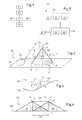
- FIG. 1is a diagram explaining the method of the invention
- FIG. 2is a diagram explaining the construction of a primary volume
- FIG. 3is a section showing the construction of a primary volume on rough terrain
- FIG. 4is a section explaining a variant of the invention.
- FIG. 5is a diagram explaining a device of the invention.
- FIG. 1shows the method of the invention.
- a first step P 1unsafe relief is determined.
- a second step P 2optionally performed in parallel to the first step P 1 , at least one high point is determined representing an obstacle overlying the ground and thus the unsafe relief.
- a primary databaseis used containing at least unsafe relief of the terrain for overflying and the obstacles overlying the unsafe relief.
- a primary databaseoptionally one that is commercially available.
- a primary databaseis established from a secondary database containing the unsafe relief of the terrain and enriched with obstacles that have been detected by obstacle detector means in order to obtain said primary database, the secondary database being commercially available or obtained by conventional methods.
- each high pointmight be connected to a wire obstacle.
- a main volumeis added to said unsafe relief in order to obtain safe relief that can be overflown without danger.
- This safe reliefthus contains at least one item of unsafe relief and all of the added main volumes.
- each main volume V 0is defined firstly by a base 2 of the main volume placed on the unsafe relief R 0 , and secondly by an envelope 1 .
- the base 2 of the main volumehas an area 2 ′ defined by a closed peripheral curve 3 resting on the unsafe relief R 0 .
- the envelope 2is generated using a moving segment S having two positions S 1 and S 2 shown in FIG. 2 , the moving segment having a predetermined length L. Furthermore, since each wire obstacle extending between a first upright and a second upright, such as first and second electricity poles, extends over a distance not exceeding a maximum distance defined by standards, the predetermined distance taken into consideration is equal to said maximum distance.
- a first end point of the segmentis placed on the high point 4 and the second end point 3 ′ of the segment is allowed to rest on the unsafe relief R 0 .
- the segmentis used as a generator line by causing the segment S to sweep over the unsafe relief R 0 around an axis AX extending in the gravity direction, while taking care to maintain the second end point 3 ′ on the unsafe relief R 0 .
- the second end point 3 ′is then a second moving point of the segment S and it travels around the peripheral curve 3 of the base 2 of the main volume.
- the base of the main volume V 0 in the form of a coneis circular and it presents circular symmetry.
- the base of the main volumemay have any other shape.
- a protection volumeis added to the unsafe relief.
- the protection volume V 4is determined and positioned by an operator.
- This protection volumemay serve to avoid a zone in which overflying is forbidden or indeed a zone that is subjected to very bad weather, for example.
- FIG. 4explains such a configuration.
- the safe relief R 1then comprises unsafe relief R 0 together with a first main volume V 1 that might contain a wire obstacle starting from a first high point of a first upright 4 ′, e.g. a pylon or a post. Furthermore, the safe relief R 1 comprises a second main volume V 2 that might contain a wire obstacle starting from the second high point 5 of a second upright 5 ′, in particular a pylon or a post.
- the link line connecting the first high point to the second high pointpresents a link length D 1 that is shorter than the predetermined length L of the generator line segments of the first and second main volumes V 1 and V 2 .
- the safe relief R 1has a secondary volume V 3 defined by:
- the link line 6which is given a predetermined thickness, e.g. one meter;
- a second side wallhaving said predetermined thickness and passing through the second high point, being directed in the gravity direction in order to represent the second upright 5 .
- FIG. 5represents a device for flying an aircraft at low altitude in safe manner and suitable for implementing the method of the invention.
- This deviceis provided with a primary database storing unsafe relief R 0 together with localized obstacles overlying the unsafe relief R 0 . It should be observed that the device may be arranged in an aircraft 100 .
- the deviceis provided with a primary computer 20 , having a microprocessor or a microcontroller 21 and a memory 22 , for example, in order to determine the safe relief by adding to the unsafe relief at least one main volume, or indeed at least one secondary volume.
- the devicemay be provided with interface means 30 enabling an operator to add at least one protection volume.
- the deviceincludes a secondary database 11 , obstacle detector means 12 , and a secondary computer 13 , such as a microcontroller or a microprocessor, for example.
- the secondary computerthen constructs the primary database 10 by enriching the secondary database with the obstacles as updated by the obstacle detector means.
- the present inventionmay be subjected to numerous variations as to its implementation. Although several implementations are described above, it will readily be understood that it is not conceivable to identify exhaustively all possible implementations. Naturally, it is possible to envisage replacing any of the means described by equivalent means without going beyond the ambit of the present invention.
Landscapes
- Engineering & Computer Science (AREA)
- Aviation & Aerospace Engineering (AREA)
- Physics & Mathematics (AREA)
- General Physics & Mathematics (AREA)
- Traffic Control Systems (AREA)
- Radar Systems Or Details Thereof (AREA)
Abstract
Description
- This application claims the benefit of
FR 10 01024 filed on Mar. 15, 2010, the disclosure of which is incorporated in its entirety by reference herein. - (1) Field of the Invention
- The present invention relates in general to a method and a device for flying safely at low altitude in an aircraft in spite of wire and non-wire obstacles, by making use of detector means.
- (2) Description of Related Art
- More particularly, and in non-limiting manner, the detector means are of the radar or laser or stereoscopy telemeter type. It is recalled that remote detection by laser, known as light detection and ranging (lidar) makes use of laser light returned to the emitter.
- An object is detected by measuring the time delay between emitting a signal and detecting the reflected signal, the signal being constituted by radio waves when using radar or by light rays when using lidar.
- From images delivered by detector means producing plots of individual echoes, it is known to obtain a terrain elevation database for the zone observed by the detector means. The database includes all of the relief and the obstacles.
- Nevertheless, it is observed that failure to detect cables or other suspended wire obstacles lies behind numerous flying accidents, and reduces the domain in which aircraft, and in particular helicopters, can fly safely when close to the ground.
Patents FR 2 736 149 and U.S. Pat. No. 5,762,292 already make proposals for a system that recognizes structures that present rectilinear portions in an image delivered by a sensor on board a flying machine, by making use of a parametric transform (Hough transform) of a portion of the image.- The Hough transform, described in U.S. Pat. No. 3,069,654, serves to detect a set of aligned points in an image.
- U.S. Pat. No. 5,296,909 proposes detecting the presence of cables by using a scanning laser telemeter (lidar) that delivers plots, where each plot corresponds to a point in three-dimensional space characterized by its three spatial coordinates, specifically spherical coordinates given as elevation, relative bearing, and range: the telemeter sends laser pulses that make it possible, by measuring their round-trip times, to obtain points that are positioned in three-dimensional (3D) space. The echoes are filtered. A set of parameters is determined by the Hough transform for all possible groups of filtered echoes. Clusters of points in parameter space are identified, and the position of a cable is determined by the inverse Hough transform.
- Proposals are also made in U.S. Pat. No. 6,747,576 to detect the presence of electricity lines by forming a cloud of measurement points in a terrestrial frame of reference on the basis of data delivered by a remote detector sensor and data from a navigation system, with measurement points that represent the ground being eliminated therefrom. The method then includes a search for straight lines amongst the projections of the measurement points onto the horizontal plane, by using two successive Hough transforms: a “pure” transform using a delta function (or Dirac function), followed by a “fuzzy” transform in which the delta function is replaced by a Gaussian distribution. Thereafter, a search is made for catenaries in each vertical plane containing one of the straight lines found in that way, this search also making use of two successive Hough transforms.
- In order to search for a catenary corresponding to the equation:
[z=a*cosh((λ−b)/a)+c]- for each measurement point of each vertical plane, and for each possible value of a catenary parameter a, a two-dimensional Hough transform is calculated (in the b and c parameter space) for catenaries passing via that point.
- The document “Automatic extraction of vertical obstruction information from interferometric SAR elevation data” by Donald Woods et al. (IEEE publication: IGARSS 2004 Congress) provides a method of calculating the height and the location of vertical obstacles from a digital terrain model enabling high points to be extracted.
- Those various devices are effective. Nevertheless, active sensors for detecting obstacles are limited in particular by the technique used for detecting wire obstacles, since it is not capable of detecting wire obstacles from below a threshold angle of incidence for the emitted signal relative to the wire obstacle, where said angle of incidence is about 15° with radar and about 60° with lidar. As from that angle of incidence, reflection becomes specular and it is no longer possible to detect cables.
- Present-day terrain elevation databases do not make it possible to fly any closer to the ground since there is no guarantee that wire obstacles will be detected. The pilot is thus obliged to fly higher above the ground so as to leave a safety margin.
- Systems using obstacle databases exist, but they are not complete, they are not guaranteed by their constructors, and they are provided for information purposes only.
- It should be observed that the state of the art also includes the following documents: US 2007/171094, US 2003/225489,
FR 2 895 098, US 2004/267413, and the article by M. Zhao et al.: “A method to identify flight obstacles on digital surface model” (Tsinghua Science and Technology, Tsinghua University Press, Beijing, China, Vol. 10, No. 3, Jun. 1, 2005). - An object of the present invention is thus to propose a device enabling the above-mentioned limitations to be overcome. According to the invention, a method of preparing a safe database for flying safely at low altitude in an aircraft is remarkable in particular in that it comprises the following steps:
- determining unsafe relief of said terrain and determining the position of at least one high point representing an obstacle overlying said unsafe relief, by making use of a primary database of said terrain containing said unsafe relief and said obstacle; and
- adding to said unsafe relief a main volume that is defined between a main volume base placed on the unsafe relief and an envelope, so as to obtain safe relief for overflying that contains at least said unsafe relief and said main volume, said main volume base having an area defined by a closed peripheral curve resting on said unsafe relief, said envelope being generated using a moving segment of predetermined length extending from said high point to a second point that moves along said peripheral curve, said segment having a predetermined length.
- Under such circumstances, flying is performed while making use of the safe database.
- It should be observed that the term “unsafe relief” relates to the surface that represents the ground of the terrain. The relief is said to be unsafe insofar as it makes no mention of wire or non-wire obstacles that might be struck by a flying aircraft.
- Thus, use is made initially of a primary database in order to extract the unsafe relief and the high points that represent obstacles overlying the ground and thus the unsafe relief.
- Thereafter, starting from at least one high point, a main volume is constructed between the unsafe relief and the high point. Preferably, but not necessarily, a main volume is constructed from each high point.
- The main volume is constructed using a generator line of the type comprising a segment between two end points, i.e. a first end point being fixed and situated at the selected high point, and a second end point being a moving second point for constructing an envelope. The second end point is then moved along a peripheral curve following the unsafe relief and defining the base of the main volume. The main volume is thus a cone, the base of the main volume in the form of a cone rests on the unsafe relief and thus possesses a shape that may be a complex three-dimensional shape.
- If the relief is plane, it will be understood that the base of the main volume is circular.
- The segment at the origin of each main volume then represents a cable that might extend from a high point. According to the invention, it is considered that each high point is potentially the top of an upright, e.g. an electricity pylon or post carrying electric cables.
- Under such circumstances, all of the main volume that might contain an electric cable is excluded from the flying domain. By constructing relief that is safe relative to wire and non-wire obstacles, low altitude flight is made safe.
- Consequently, safe relief is constructed as a result in particular of combining determined main volumes and the extracted unsafe relief.
- It should be observed that the safe relief may be determined on the ground, or indeed in real time while in flight.
- In other aspects, the method of the invention may include additional characteristics.
- For example, when there is a maximum distance that can exist between a first upright and a second upright connected to the first upright by a wire obstacle constituted by an electricity line, then the predetermined length is equal to that maximum distance. For example, the predetermined length may be equal to 300 meters.
- Optionally, at least two high points overlie the relief, a link line connects together the two high points, the link line having a predetermined thickness and a link length that is shorter than the predetermined length, and a secondary volume is added to the unsafe relief, the secondary volume lying between the link line and an orthogonal projection of the link line onto the unsafe relief in order to optimize the safe relief.
- Furthermore, in a first implementation, use is made of a previously-constructed primary database, i.e. an unsafe database that has already been constructed and that includes the obstacles.
- In a second implementation, the primary database is itself prepared. Thus, use is made of a secondary database containing solely the unsafe relief, and the secondary database is enriched with obstacles as detected by obstacle detector means so as to obtain the primary database.
- Consequently, obstacle detector means of the radar, lidar, or indeed sonar type are used for detecting obstacles overlying the ground, i.e. the unsafe relief, and the obstacles and the unsafe relief are stored together on a memory in order to construct the primary database.
- The primary database may be constructed on the ground after performing one or more obstacle-search flights, or indeed it may be constructed in real time in flight.
- In another aspect, a protection volume is added to the unsafe relief, the protection volume being determined and positioned by an operator in order to optimize said safe relief. For example, the pilot might decide to exclude a zone from flight manually either before or during flight, possibly in order to avoid a zone presenting difficult atmospheric conditions.
- In addition, said safe relief is recorded in order to provide a reusable safe database of said terrain that includes wire and non-wire obstacles. This characteristic is particularly advantageous when the safe relief is established in real time while in flight. Storing this safe relief makes it possible in particular for it to be reused subsequently.
- The invention also provides a device for making a safe database in order to fly safely at low altitude in an aircraft, the device being suitable for implementing the method. The device comprises:
- a primary database comprising at least unsafe relief of terrain for overflying and an obstacle overlying said unsafe relief; and
- a primary computer for adding at least one main volume to said unsafe relief, the main volume being defined between a main volume base placed on the unsafe relief and by an envelope, thereby obtaining safe relief for overflying containing at least said unsafe relief and said main volume, said main volume base having an area defined by a closed peripheral curve resting on said unsafe relief, said envelope being generated by using a moving segment of a predetermined length extending from a high point representing said obstacle to a second point that moves along said peripheral curve, said segment having a predetermined length.
- By way of example, the primary computer is a processor or a microprocessor, possibly including a memory, or any other equivalent means.
- The device may be arranged at least in part in an aircraft or on the ground.
- Furthermore, the device may comprise:
- a secondary database containing solely said unsafe relief;
- active obstacle detector means; and
- a secondary computer for enriching said secondary database with obstacles detected by the obstacle detector means in order to obtain said primary database.
- By way of example, the secondary computer is a processor or a microprocessor, optionally including a memory, or any other equivalent means. The obstacle detector means may be of the lidar, radar, or indeed sonar type.
- The obstacle detector means may also possess a detector as such, together with a possibly remote storage memory that stores obstacles that have been detected.
- The other elements of the device may be arranged in an aircraft or on the ground.
- Finally, the device may include interface means to enable an operator to add a protection volume to the unsafe relief, the protection volume being determined and positioned by said operator in order to optimize said safe relief.
- The invention and its advantages appear in greater detail from the following description of embodiments given by way of illustration with reference to the accompanying figures, in which:
FIG. 1 is a diagram explaining the method of the invention;FIG. 2 is a diagram explaining the construction of a primary volume;FIG. 3 is a section showing the construction of a primary volume on rough terrain;FIG. 4 is a section explaining a variant of the invention; andFIG. 5 is a diagram explaining a device of the invention.- Elements present in more than one of the figures are given the same references in each of them.
FIG. 1 shows the method of the invention.- In a first step P1, unsafe relief is determined.
- Furthermore, during a second step P2, optionally performed in parallel to the first step P1, at least one high point is determined representing an obstacle overlying the ground and thus the unsafe relief.
- In order to perform the first and second steps P1 and P2, a primary database is used containing at least unsafe relief of the terrain for overflying and the obstacles overlying the unsafe relief.
- In a first implementation, use is made of a primary database, optionally one that is commercially available.
- In a second implementation, a primary database is established from a secondary database containing the unsafe relief of the terrain and enriched with obstacles that have been detected by obstacle detector means in order to obtain said primary database, the secondary database being commercially available or obtained by conventional methods.
- In a third step P3, it is considered that each high point might be connected to a wire obstacle. Under such circumstances, a main volume is added to said unsafe relief in order to obtain safe relief that can be overflown without danger. This safe relief thus contains at least one item of unsafe relief and all of the added main volumes.
- With reference to
FIG. 2 , it should be observed that each main volume V0 is defined firstly by abase 2 of the main volume placed on the unsafe relief R0, and secondly by anenvelope 1. - The
base 2 of the main volume has anarea 2′ defined by a closedperipheral curve 3 resting on the unsafe relief R0. - In addition, the
envelope 2 is generated using a moving segment S having two positions S1 and S2 shown inFIG. 2 , the moving segment having a predetermined length L. Furthermore, since each wire obstacle extending between a first upright and a second upright, such as first and second electricity poles, extends over a distance not exceeding a maximum distance defined by standards, the predetermined distance taken into consideration is equal to said maximum distance. - In order to construct the main volume V0, a first end point of the segment is placed on the
high point 4 and thesecond end point 3′ of the segment is allowed to rest on the unsafe relief R0. The segment is used as a generator line by causing the segment S to sweep over the unsafe relief R0 around an axis AX extending in the gravity direction, while taking care to maintain thesecond end point 3′ on the unsafe relief R0. Thesecond end point 3′ is then a second moving point of the segment S and it travels around theperipheral curve 3 of thebase 2 of the main volume. - When the unsafe relief is flat, for example as shown in
FIG. 2 , the base of the main volume V0 in the form of a cone is circular and it presents circular symmetry. - Nevertheless, with reference to
FIG. 3 , when the unsafe relief is rough, e.g. over the side of a hill, the base of the main volume may have any other shape. - By adding each main volume V0 to the unsafe relief, safe relief R1 is obtained.
- With reference to
FIG. 1 , and in accordance with an optional step P5, a protection volume is added to the unsafe relief. - With reference to
FIG. 2 the protection volume V4 is determined and positioned by an operator. - This protection volume may serve to avoid a zone in which overflying is forbidden or indeed a zone that is subjected to very bad weather, for example.
- With reference to
FIG. 1 , when two high points overlie the unsafe relief, with a link line interconnecting these two high points presenting a link length that is shorter than the predetermined length, it is possible that the two high points are connected by a wire obstacle. Under such circumstances, during an optional step P6, a secondary volume is added to the unsafe relief in order to exclude such wire obstacles. FIG. 4 explains such a configuration.- The safe relief R1 then comprises unsafe relief R0 together with a first main volume V1 that might contain a wire obstacle starting from a first high point of a
first upright 4′, e.g. a pylon or a post. Furthermore, the safe relief R1 comprises a second main volume V2 that might contain a wire obstacle starting from the secondhigh point 5 of asecond upright 5′, in particular a pylon or a post. - In addition, the link line connecting the first high point to the second high point presents a link length D1 that is shorter than the predetermined length L of the generator line segments of the first and second main volumes V1 and V2. Under such circumstances, the safe relief R1 has a secondary volume V3 defined by:
- the
link line 6 which is given a predetermined thickness, e.g. one meter; - an
orthogonal projection 7 of thelink line 6 onto the unsafe relief, which is given said predetermined thickness; - a first side wall having said predetermined thickness and passing via the first high point, being directed in the gravity direction to represent the
first upright 4; and - a second side wall having said predetermined thickness and passing through the second high point, being directed in the gravity direction in order to represent the
second upright 5. - Finally, during a final step P4 shown in
FIG. 1 , it is possible to record the safe relief in order to obtain a reusable safe database. FIG. 5 represents a device for flying an aircraft at low altitude in safe manner and suitable for implementing the method of the invention.- This device is provided with a primary database storing unsafe relief R0 together with localized obstacles overlying the unsafe relief R0. It should be observed that the device may be arranged in an
aircraft 100. - Furthermore, the device is provided with a
primary computer 20, having a microprocessor or amicrocontroller 21 and amemory 22, for example, in order to determine the safe relief by adding to the unsafe relief at least one main volume, or indeed at least one secondary volume. In addition, the device may be provided with interface means30 enabling an operator to add at least one protection volume. - Furthermore, in an option, the device includes a
secondary database 11, obstacle detector means12, and asecondary computer 13, such as a microcontroller or a microprocessor, for example. - The secondary computer then constructs the
primary database 10 by enriching the secondary database with the obstacles as updated by the obstacle detector means. - Naturally, the present invention may be subjected to numerous variations as to its implementation. Although several implementations are described above, it will readily be understood that it is not conceivable to identify exhaustively all possible implementations. Naturally, it is possible to envisage replacing any of the means described by equivalent means without going beyond the ambit of the present invention.
Claims (9)
Applications Claiming Priority (2)
| Application Number | Priority Date | Filing Date | Title |
|---|---|---|---|
| FR1001024AFR2957447B1 (en) | 2010-03-15 | 2010-03-15 | METHOD AND APPARATUS FOR FLYING WITH LOW ALTITUDE AIRCRAFT IN A SECURE MANNER |
| FR1001024 | 2010-03-15 |
Publications (2)
| Publication Number | Publication Date |
|---|---|
| US20110225212A1true US20110225212A1 (en) | 2011-09-15 |
| US8392475B2 US8392475B2 (en) | 2013-03-05 |
Family
ID=43086892
Family Applications (1)
| Application Number | Title | Priority Date | Filing Date |
|---|---|---|---|
| US13/043,900Active2031-05-23US8392475B2 (en) | 2010-03-15 | 2011-03-09 | Method and a device for flying safely at low altitude in an aircraft |
Country Status (5)
| Country | Link |
|---|---|
| US (1) | US8392475B2 (en) |
| EP (1) | EP2367163B1 (en) |
| JP (1) | JP5143248B2 (en) |
| FR (1) | FR2957447B1 (en) |
| IL (1) | IL211550A (en) |
Cited By (5)
| Publication number | Priority date | Publication date | Assignee | Title |
|---|---|---|---|---|
| CN102590823A (en)* | 2012-01-06 | 2012-07-18 | 中国测绘科学研究院 | Rapid extraction and reconstruction method for data power line of airborne LIDAR |
| US8392475B2 (en)* | 2010-03-15 | 2013-03-05 | Eurocopter | Method and a device for flying safely at low altitude in an aircraft |
| US20160217696A1 (en)* | 2015-01-28 | 2016-07-28 | Airbus Helicopters | Aircraft system for signaling the presence of an obstacle, an aircraft equipped with this system, and method for the detection of an obstacle |
| US20180039834A1 (en)* | 2014-12-22 | 2018-02-08 | Kleon Prosjekt As | Method and device for detecting an overhead cable from an aerial vessel |
| US11520329B2 (en) | 2019-09-27 | 2022-12-06 | Airbus Helicopters | Method and a system for detecting wire or wire-like obstacles for an aircraft |
Citations (35)
| Publication number | Priority date | Publication date | Assignee | Title |
|---|---|---|---|---|
| US3069654A (en)* | 1960-03-25 | 1962-12-18 | Paul V C Hough | Method and means for recognizing complex patterns |
| US3273148A (en)* | 1959-12-14 | 1966-09-13 | United Aircraft Corp | Terrain-viewing system |
| US4247843A (en)* | 1978-08-23 | 1981-01-27 | Sperry Corporation | Aircraft flight instrument display system |
| US4646244A (en)* | 1984-02-02 | 1987-02-24 | Sundstrand Data Control, Inc. | Terrain advisory system |
| US4737788A (en)* | 1985-04-04 | 1988-04-12 | Motorola, Inc. | Helicopter obstacle detector |
| US4812990A (en)* | 1987-04-29 | 1989-03-14 | Merit Technology Incorporated | System and method for optimizing aircraft flight path |
| US5086396A (en)* | 1989-02-02 | 1992-02-04 | Honeywell Inc. | Apparatus and method for an aircraft navigation system having improved mission management and survivability capabilities |
| US5296909A (en)* | 1990-09-07 | 1994-03-22 | Alenia Aeritalia & Selenia S.P.A. | Detector of suspended cables for avionic applications |
| US5442556A (en)* | 1991-05-22 | 1995-08-15 | Gec-Marconi Limited | Aircraft terrain and obstacle avoidance systems |
| US5488563A (en)* | 1992-04-07 | 1996-01-30 | Dassault Electronique | Method and device for preventing collisions with the ground for an aircraft |
| US5526000A (en)* | 1984-07-13 | 1996-06-11 | Electronique Serge Dassault | Procedure and automatic control device for an airborne vehicle in low altitude overflight |
| US5762292A (en)* | 1988-09-08 | 1998-06-09 | Daimler-Benz Aerospace Ag | Apparatus for identification and tracking of objects |
| US5890079A (en)* | 1996-12-17 | 1999-03-30 | Levine; Seymour | Remote aircraft flight recorder and advisory system |
| US5892462A (en)* | 1995-06-20 | 1999-04-06 | Honeywell Inc. | Adaptive ground collision avoidance system |
| US6216065B1 (en)* | 1999-08-06 | 2001-04-10 | Bell Helicopter Textron Inc. | Method and system for creating an approach to a position on the ground from a location above the ground |
| US6243482B1 (en)* | 1996-02-13 | 2001-06-05 | Dornier Gmbh | Obstacle detection system for low-flying airborne craft |
| US20010023390A1 (en)* | 1999-06-28 | 2001-09-20 | Min-Chung Gia | Path planning, terrain avoidance and situation awareness system for general aviation |
| US20030046025A1 (en)* | 2001-09-04 | 2003-03-06 | Jamieson James R. | Wide field scanning laser obstacle awareness system |
| US20030043058A1 (en)* | 2001-09-04 | 2003-03-06 | Jamieson James R. | Distributed laser obstacle awareness system |
| US20030107499A1 (en)* | 2000-09-08 | 2003-06-12 | Gerard Lepere | Visual display of ground collision avoidance devices for aircraft |
| US20030225489A1 (en)* | 2002-05-31 | 2003-12-04 | Steven Tsao | Automated terrain awareness and avoidance system |
| US6747576B2 (en)* | 2000-11-09 | 2004-06-08 | Astrium Gmbh | Wire detection procedure for low-flying aircraft |
| US20040178943A1 (en)* | 2002-12-29 | 2004-09-16 | Haim Niv | Obstacle and terrain avoidance sensor |
| US20040225420A1 (en)* | 2003-03-07 | 2004-11-11 | Airbus France | Process and device for constructing a synthetic image of the environment of an aircraft and presenting it on a screen of said aircraft |
| US20040267413A1 (en)* | 2001-09-25 | 2004-12-30 | Werner Keber | Method and device for preventing unpermitted appoach of airplanes to objects on the ground which are to be protected |
| US20050258979A1 (en)* | 2004-05-18 | 2005-11-24 | Airbus France | Method and device for determining a safe altitude for an aircraft |
| US20050261811A1 (en)* | 2004-05-18 | 2005-11-24 | Franck Artini | Method and device for ensuring the safety of a low-altitude flight of an aircraft |
| US20050273223A1 (en)* | 2004-05-18 | 2005-12-08 | Airbus France | Method and device for ensuring the safety of a low-altitude flight of an aircraft |
| US20070171094A1 (en)* | 2006-01-20 | 2007-07-26 | Keith Alter | Real-time, three-dimensional synthetic vision display of sensor-validated terrain data |
| US7295134B2 (en)* | 2003-09-18 | 2007-11-13 | Airbus France | Terrain avoidance method and device for an aircraft |
| US20070265776A1 (en)* | 2005-12-20 | 2007-11-15 | Thales | Airborne system for preventing collisions of an aircraft with the terrain |
| US20080243383A1 (en)* | 2006-12-12 | 2008-10-02 | Ching-Fang Lin | Integrated collision avoidance enhanced GN&C system for air vehicle |
| US20080281522A1 (en)* | 2005-11-10 | 2008-11-13 | Thales | Method for Optimizng the Display of Data Relating to the Risks Presented by Obstacles |
| US7783394B2 (en)* | 2005-01-31 | 2010-08-24 | Airbus | Method and device for constructing a low-altitude flight plan to be followed by an aircraft |
| US20100305859A1 (en)* | 2009-05-29 | 2010-12-02 | The Commonwealth of Australia, Department of Defence | Portable environmental monitoring instrument |
Family Cites Families (5)
| Publication number | Priority date | Publication date | Assignee | Title |
|---|---|---|---|---|
| JPH01123711A (en) | 1987-11-09 | 1989-05-16 | Matsushita Electric Works Ltd | Manufacture of fluoroplastic laminated sheet |
| JPH01123712A (en) | 1987-11-10 | 1989-05-16 | Mazda Motor Corp | Mixing injection machine of reaction injection molding equipment |
| JP3038166B2 (en)* | 1997-07-02 | 2000-05-08 | 川崎重工業株式会社 | Obstacle detection system for aircraft |
| JP2983498B2 (en)* | 1997-07-02 | 1999-11-29 | 川崎重工業株式会社 | Aircraft obstacle detection method |
| FR2957447B1 (en)* | 2010-03-15 | 2012-10-26 | Eurocopter France | METHOD AND APPARATUS FOR FLYING WITH LOW ALTITUDE AIRCRAFT IN A SECURE MANNER |
- 2010
- 2010-03-15FRFR1001024Apatent/FR2957447B1/enactiveActive
- 2011
- 2011-03-01EPEP11001655.7Apatent/EP2367163B1/enactiveActive
- 2011-03-03ILIL211550Apatent/IL211550A/enactiveIP Right Grant
- 2011-03-03JPJP2011046032Apatent/JP5143248B2/ennot_activeExpired - Fee Related
- 2011-03-09USUS13/043,900patent/US8392475B2/enactiveActive
Patent Citations (38)
| Publication number | Priority date | Publication date | Assignee | Title |
|---|---|---|---|---|
| US3273148A (en)* | 1959-12-14 | 1966-09-13 | United Aircraft Corp | Terrain-viewing system |
| US3069654A (en)* | 1960-03-25 | 1962-12-18 | Paul V C Hough | Method and means for recognizing complex patterns |
| US4247843A (en)* | 1978-08-23 | 1981-01-27 | Sperry Corporation | Aircraft flight instrument display system |
| US4646244A (en)* | 1984-02-02 | 1987-02-24 | Sundstrand Data Control, Inc. | Terrain advisory system |
| US5526000A (en)* | 1984-07-13 | 1996-06-11 | Electronique Serge Dassault | Procedure and automatic control device for an airborne vehicle in low altitude overflight |
| US4737788A (en)* | 1985-04-04 | 1988-04-12 | Motorola, Inc. | Helicopter obstacle detector |
| US4812990A (en)* | 1987-04-29 | 1989-03-14 | Merit Technology Incorporated | System and method for optimizing aircraft flight path |
| US5762292A (en)* | 1988-09-08 | 1998-06-09 | Daimler-Benz Aerospace Ag | Apparatus for identification and tracking of objects |
| US5086396A (en)* | 1989-02-02 | 1992-02-04 | Honeywell Inc. | Apparatus and method for an aircraft navigation system having improved mission management and survivability capabilities |
| US5296909A (en)* | 1990-09-07 | 1994-03-22 | Alenia Aeritalia & Selenia S.P.A. | Detector of suspended cables for avionic applications |
| US5442556A (en)* | 1991-05-22 | 1995-08-15 | Gec-Marconi Limited | Aircraft terrain and obstacle avoidance systems |
| US5488563A (en)* | 1992-04-07 | 1996-01-30 | Dassault Electronique | Method and device for preventing collisions with the ground for an aircraft |
| US5638282A (en)* | 1992-04-07 | 1997-06-10 | Dassault Electronique | Method and device for preventing collisions with the ground for an aircraft |
| US5892462A (en)* | 1995-06-20 | 1999-04-06 | Honeywell Inc. | Adaptive ground collision avoidance system |
| US6243482B1 (en)* | 1996-02-13 | 2001-06-05 | Dornier Gmbh | Obstacle detection system for low-flying airborne craft |
| US5890079A (en)* | 1996-12-17 | 1999-03-30 | Levine; Seymour | Remote aircraft flight recorder and advisory system |
| US20010023390A1 (en)* | 1999-06-28 | 2001-09-20 | Min-Chung Gia | Path planning, terrain avoidance and situation awareness system for general aviation |
| US6216065B1 (en)* | 1999-08-06 | 2001-04-10 | Bell Helicopter Textron Inc. | Method and system for creating an approach to a position on the ground from a location above the ground |
| US20030107499A1 (en)* | 2000-09-08 | 2003-06-12 | Gerard Lepere | Visual display of ground collision avoidance devices for aircraft |
| US6747576B2 (en)* | 2000-11-09 | 2004-06-08 | Astrium Gmbh | Wire detection procedure for low-flying aircraft |
| US20030046025A1 (en)* | 2001-09-04 | 2003-03-06 | Jamieson James R. | Wide field scanning laser obstacle awareness system |
| US20030043058A1 (en)* | 2001-09-04 | 2003-03-06 | Jamieson James R. | Distributed laser obstacle awareness system |
| US20040267413A1 (en)* | 2001-09-25 | 2004-12-30 | Werner Keber | Method and device for preventing unpermitted appoach of airplanes to objects on the ground which are to be protected |
| US20030225489A1 (en)* | 2002-05-31 | 2003-12-04 | Steven Tsao | Automated terrain awareness and avoidance system |
| US20040178943A1 (en)* | 2002-12-29 | 2004-09-16 | Haim Niv | Obstacle and terrain avoidance sensor |
| US20040225420A1 (en)* | 2003-03-07 | 2004-11-11 | Airbus France | Process and device for constructing a synthetic image of the environment of an aircraft and presenting it on a screen of said aircraft |
| US7295134B2 (en)* | 2003-09-18 | 2007-11-13 | Airbus France | Terrain avoidance method and device for an aircraft |
| US20050261811A1 (en)* | 2004-05-18 | 2005-11-24 | Franck Artini | Method and device for ensuring the safety of a low-altitude flight of an aircraft |
| US20050273223A1 (en)* | 2004-05-18 | 2005-12-08 | Airbus France | Method and device for ensuring the safety of a low-altitude flight of an aircraft |
| US20050258979A1 (en)* | 2004-05-18 | 2005-11-24 | Airbus France | Method and device for determining a safe altitude for an aircraft |
| US7428451B2 (en)* | 2004-05-18 | 2008-09-23 | Airbus France | Method and device for ensuring the safety of a low-altitude flight of an aircraft |
| US7783394B2 (en)* | 2005-01-31 | 2010-08-24 | Airbus | Method and device for constructing a low-altitude flight plan to be followed by an aircraft |
| US20080281522A1 (en)* | 2005-11-10 | 2008-11-13 | Thales | Method for Optimizng the Display of Data Relating to the Risks Presented by Obstacles |
| US20070265776A1 (en)* | 2005-12-20 | 2007-11-15 | Thales | Airborne system for preventing collisions of an aircraft with the terrain |
| US7881866B2 (en)* | 2005-12-20 | 2011-02-01 | Thales | Airborne system for preventing collisions of an aircraft with the terrain |
| US20070171094A1 (en)* | 2006-01-20 | 2007-07-26 | Keith Alter | Real-time, three-dimensional synthetic vision display of sensor-validated terrain data |
| US20080243383A1 (en)* | 2006-12-12 | 2008-10-02 | Ching-Fang Lin | Integrated collision avoidance enhanced GN&C system for air vehicle |
| US20100305859A1 (en)* | 2009-05-29 | 2010-12-02 | The Commonwealth of Australia, Department of Defence | Portable environmental monitoring instrument |
Non-Patent Citations (2)
| Title |
|---|
| M. J. Dorsett and R. M. Wyskida - "A minimum-exposure, minimum-elevation military aircraft heuris tic route selection model" - Applied Math. Modelling, 1985, Vol. 9, April - pages 131-138* |
| Thomas Netter and Nicolas Franceschini - "A Robotic Aircraft that Follows Terrain Using a Neuromorphic Eye" - Prcceedings of tne 2002 IEEURSI International Conference on Intelligent Robots and Systems EPFL. LaJsanne. Switzerland * OctoDer 2002 - (pages 129 - 134)* |
Cited By (7)
| Publication number | Priority date | Publication date | Assignee | Title |
|---|---|---|---|---|
| US8392475B2 (en)* | 2010-03-15 | 2013-03-05 | Eurocopter | Method and a device for flying safely at low altitude in an aircraft |
| CN102590823A (en)* | 2012-01-06 | 2012-07-18 | 中国测绘科学研究院 | Rapid extraction and reconstruction method for data power line of airborne LIDAR |
| US20180039834A1 (en)* | 2014-12-22 | 2018-02-08 | Kleon Prosjekt As | Method and device for detecting an overhead cable from an aerial vessel |
| US10372986B2 (en)* | 2014-12-22 | 2019-08-06 | Kleon Prosjekt As | Method and device for detecting an overhead cable from an aerial vessel |
| US20160217696A1 (en)* | 2015-01-28 | 2016-07-28 | Airbus Helicopters | Aircraft system for signaling the presence of an obstacle, an aircraft equipped with this system, and method for the detection of an obstacle |
| US9583011B2 (en)* | 2015-01-28 | 2017-02-28 | Airbus Helicopters | Aircraft system for signaling the presence of an obstacle, an aircraft equipped with this system, and method for the detection of an obstacle |
| US11520329B2 (en) | 2019-09-27 | 2022-12-06 | Airbus Helicopters | Method and a system for detecting wire or wire-like obstacles for an aircraft |
Also Published As
| Publication number | Publication date |
|---|---|
| EP2367163B1 (en) | 2017-09-27 |
| JP5143248B2 (en) | 2013-02-13 |
| FR2957447B1 (en) | 2012-10-26 |
| JP2011189927A (en) | 2011-09-29 |
| IL211550A (en) | 2015-04-30 |
| FR2957447A1 (en) | 2011-09-16 |
| EP2367163A1 (en) | 2011-09-21 |
| US8392475B2 (en) | 2013-03-05 |
Similar Documents
| Publication | Publication Date | Title |
|---|---|---|
| US10962650B2 (en) | Polyhedral geofences | |
| CN108181635B (en) | Laser point cloud classification method for cross crossing analysis of power transmission line | |
| Lin et al. | Mini-UAV-borne LIDAR for fine-scale mapping | |
| Jaakkola et al. | A low-cost multi-sensoral mobile mapping system and its feasibility for tree measurements | |
| US8392475B2 (en) | Method and a device for flying safely at low altitude in an aircraft | |
| Zolkepli et al. | Application of unmanned aerial vehicle (UAV) for slope mapping at Pahang Matriculation College, Malaysia | |
| CN115127510B (en) | A three-dimensional unmanned multi-platform linkage landslide intelligent patrol system for land, water and air | |
| CN102023003A (en) | Unmanned helicopter three-dimensional positioning and mapping method based on laser detection and image recognition | |
| CN107273902B (en) | A Method for Automatic Tower Point Cloud Extraction from Airborne LiDAR Data | |
| KR20180131932A (en) | River topography information generation method using drone and geospatial information | |
| US20160299229A1 (en) | Method and system for detecting objects | |
| CN104849722A (en) | Light detection and ranging (LiDAR) waveform comprehensive feature-based individual tree identification method | |
| US9401093B2 (en) | Procedure for the detection and display of artificial obstacles for a rotary-wing aircraft | |
| JP2018036053A (en) | Laser measurement system and laser measurement method | |
| JP2015200615A (en) | Laser measurement result analysis system | |
| Gwenzi et al. | Prospects of photon counting lidar for savanna ecosystem structural studies | |
| JP5594681B2 (en) | Survey data classification method and survey data classification device | |
| US8527237B2 (en) | Method of using telemetry to detect at least one suspended threadlike object, the object lying in the detection field of a telemeter mounted on board a vehicle | |
| Ostrowski et al. | Comparison of the laser scanning solutions for the unmanned aerial vehicles | |
| US20210003698A1 (en) | Radar image processing device, radar image processing method, and storage medium | |
| Chen et al. | Power line extraction and analysis based on LiDAR | |
| EP3967974A1 (en) | Method and system for referencing aircraft-related position data to an earth-related coordinate system | |
| Vasić et al. | The importance of mobile laser scanning in the collection of road infrastructure data | |
| Xiang | 3D reconstruction of 138 KV power-lines from airborne LiDAR data | |
| López Rebollo et al. | Automatic Processing for Identification of Forest Fire Risk Areas along High-Voltage Power Lines Using Coarse-to-Fine LiDAR Data |
Legal Events
| Date | Code | Title | Description |
|---|---|---|---|
| AS | Assignment | Owner name:EUROCOPTER, FRANCE Free format text:ASSIGNMENT OF ASSIGNORS INTEREST;ASSIGNORS:PIRE, RICHARD;FILIAS, FRANCOIS-XAVIER;REEL/FRAME:025927/0239 Effective date:20110302 | |
| STCF | Information on status: patent grant | Free format text:PATENTED CASE | |
| AS | Assignment | Owner name:AIRBUS HELICOPTERS, FRANCE Free format text:CHANGE OF NAME;ASSIGNOR:EUROCOPTER;REEL/FRAME:032813/0001 Effective date:20140107 | |
| FEPP | Fee payment procedure | Free format text:PAYOR NUMBER ASSIGNED (ORIGINAL EVENT CODE: ASPN); ENTITY STATUS OF PATENT OWNER: LARGE ENTITY | |
| FPAY | Fee payment | Year of fee payment:4 | |
| MAFP | Maintenance fee payment | Free format text:PAYMENT OF MAINTENANCE FEE, 8TH YEAR, LARGE ENTITY (ORIGINAL EVENT CODE: M1552); ENTITY STATUS OF PATENT OWNER: LARGE ENTITY Year of fee payment:8 | |
| MAFP | Maintenance fee payment | Free format text:PAYMENT OF MAINTENANCE FEE, 12TH YEAR, LARGE ENTITY (ORIGINAL EVENT CODE: M1553); ENTITY STATUS OF PATENT OWNER: LARGE ENTITY Year of fee payment:12 |