US20110199257A1 - Method and system for updating altitude information for a location by using terrain model information to prime altitude sensors - Google Patents
Method and system for updating altitude information for a location by using terrain model information to prime altitude sensorsDownload PDFInfo
- Publication number
- US20110199257A1 US20110199257A1US12/732,847US73284710AUS2011199257A1US 20110199257 A1US20110199257 A1US 20110199257A1US 73284710 AUS73284710 AUS 73284710AUS 2011199257 A1US2011199257 A1US 2011199257A1
- Authority
- US
- United States
- Prior art keywords
- wireless device
- altitude
- location
- database
- operable
- Prior art date
- Legal status (The legal status is an assumption and is not a legal conclusion. Google has not performed a legal analysis and makes no representation as to the accuracy of the status listed.)
- Abandoned
Links
- 238000000034methodMethods0.000titleclaimsabstractdescription24
- 230000001413cellular effectEffects0.000claimsabstractdescription18
- 230000008859changeEffects0.000claimsabstractdescription8
- 238000004891communicationMethods0.000claimsdescription7
- 238000010586diagramMethods0.000description8
- 238000004590computer programMethods0.000description5
- 230000006870functionEffects0.000description3
- 230000008901benefitEffects0.000description2
- 238000012937correctionMethods0.000description2
- 238000005516engineering processMethods0.000description2
- 238000013459approachMethods0.000description1
- 238000006243chemical reactionMethods0.000description1
- 230000007123defenseEffects0.000description1
- 238000011161developmentMethods0.000description1
- 238000010348incorporationMethods0.000description1
- 230000010365information processingEffects0.000description1
- 230000010354integrationEffects0.000description1
- 238000005259measurementMethods0.000description1
- 238000012986modificationMethods0.000description1
- 230000004048modificationEffects0.000description1
- 238000012544monitoring processMethods0.000description1
- 229920001690polydopaminePolymers0.000description1
- 230000008569processEffects0.000description1
- 238000012545processingMethods0.000description1
- 238000011160researchMethods0.000description1
Images


Classifications
- G—PHYSICS
- G01—MEASURING; TESTING
- G01C—MEASURING DISTANCES, LEVELS OR BEARINGS; SURVEYING; NAVIGATION; GYROSCOPIC INSTRUMENTS; PHOTOGRAMMETRY OR VIDEOGRAMMETRY
- G01C5/00—Measuring height; Measuring distances transverse to line of sight; Levelling between separated points; Surveyors' levels
- G01C5/06—Measuring height; Measuring distances transverse to line of sight; Levelling between separated points; Surveyors' levels by using barometric means
- G—PHYSICS
- G01—MEASURING; TESTING
- G01C—MEASURING DISTANCES, LEVELS OR BEARINGS; SURVEYING; NAVIGATION; GYROSCOPIC INSTRUMENTS; PHOTOGRAMMETRY OR VIDEOGRAMMETRY
- G01C21/00—Navigation; Navigational instruments not provided for in groups G01C1/00 - G01C19/00
- G01C21/005—Navigation; Navigational instruments not provided for in groups G01C1/00 - G01C19/00 with correlation of navigation data from several sources, e.g. map or contour matching
- G—PHYSICS
- G01—MEASURING; TESTING
- G01C—MEASURING DISTANCES, LEVELS OR BEARINGS; SURVEYING; NAVIGATION; GYROSCOPIC INSTRUMENTS; PHOTOGRAMMETRY OR VIDEOGRAMMETRY
- G01C21/00—Navigation; Navigational instruments not provided for in groups G01C1/00 - G01C19/00
- G01C21/20—Instruments for performing navigational calculations
- G—PHYSICS
- G01—MEASURING; TESTING
- G01S—RADIO DIRECTION-FINDING; RADIO NAVIGATION; DETERMINING DISTANCE OR VELOCITY BY USE OF RADIO WAVES; LOCATING OR PRESENCE-DETECTING BY USE OF THE REFLECTION OR RERADIATION OF RADIO WAVES; ANALOGOUS ARRANGEMENTS USING OTHER WAVES
- G01S19/00—Satellite radio beacon positioning systems; Determining position, velocity or attitude using signals transmitted by such systems
- G01S19/38—Determining a navigation solution using signals transmitted by a satellite radio beacon positioning system
- G01S19/39—Determining a navigation solution using signals transmitted by a satellite radio beacon positioning system the satellite radio beacon positioning system transmitting time-stamped messages, e.g. GPS [Global Positioning System], GLONASS [Global Orbiting Navigation Satellite System] or GALILEO
- G01S19/42—Determining position
- G01S19/48—Determining position by combining or switching between position solutions derived from the satellite radio beacon positioning system and position solutions derived from a further system
- G—PHYSICS
- G01—MEASURING; TESTING
- G01S—RADIO DIRECTION-FINDING; RADIO NAVIGATION; DETERMINING DISTANCE OR VELOCITY BY USE OF RADIO WAVES; LOCATING OR PRESENCE-DETECTING BY USE OF THE REFLECTION OR RERADIATION OF RADIO WAVES; ANALOGOUS ARRANGEMENTS USING OTHER WAVES
- G01S5/00—Position-fixing by co-ordinating two or more direction or position line determinations; Position-fixing by co-ordinating two or more distance determinations
- G01S5/02—Position-fixing by co-ordinating two or more direction or position line determinations; Position-fixing by co-ordinating two or more distance determinations using radio waves
- G01S5/0257—Hybrid positioning
- G01S5/0263—Hybrid positioning by combining or switching between positions derived from two or more separate positioning systems
- G01S5/0264—Hybrid positioning by combining or switching between positions derived from two or more separate positioning systems at least one of the systems being a non-radio wave positioning system
Definitions
- Certain embodiments of the inventionrelate to wireless communication. More specifically, certain embodiments of the invention relate to a method and system for updating altitude information for a location by using terrain model information to prime altitude sensors.
- GNSS receiversmay normally determine their position by receiving satellite broadcast signals from a plurality of satellites. These satellites, for example 24 at any time for the Global Positioning System (GPS), may broadcast radio frequency signals that comprise information that may be exploited by the satellite receiver to determine its own position. By measuring the time the broadcast signals may travel from the satellites to the satellite receiver, and the known position of the transmitting satellite, the satellite receiver may be able to determine its own position by trilateration. In general, at least 3 satellite signals may need to be decoded at the satellite receiver in order to determine its position.
- GPSGlobal Positioning System
- a system and/or method for updating altitude information for a location by using terrain model information to prime altitude sensorssubstantially as shown in and/or described in connection with at least one of the figures, as set forth more completely in the claims.
- FIG. 1Ais a diagram illustrating an exemplary wireless device with altitude determining capability, in accordance with an embodiment of the invention.
- FIG. 1Bis a diagram illustrating an exemplary satellite navigation system in a two-dimensional setting, in accordance with an embodiment of the invention.
- FIG. 2is a diagram of an altitude-tracking wireless device, in accordance with an embodiment of the invention.
- FIG. 3is a block diagram illustrating exemplary steps for updating altitude information for a location by using terrain model information to prime altitude sensors, in accordance with an embodiment of the invention.
- Certain aspects of the inventionmay be found in a method and system for updating altitude information for a location by using terrain model information to prime altitude sensors.
- Exemplary aspects of the inventionmay comprise determining an altitude of a wireless device comprising one or more altimeters.
- the determination of the altitudemay comprise determining a location of the wireless device and receiving an altitude value for the location from an altitude database.
- a change in the altitude of the wireless devicemay be measured using the one or more altimeters.
- the altitude databasemay comprise a worldwide terrain database that may be stored on a remote device, which may comprise a server. At least a portion of the altitude database may be stored on the wireless device and may be updated as the wireless device moves from the determined location.
- the location of the wireless devicemay be measured utilizing a global navigation satellite system, which may comprise a global positioning satellite (GPS), GLONASS, and/or Galileo system.
- the location of the wireless devicemay be determined utilizing cellular service triangulation or by utilizing one or more access points with known locations.
- FIG. 1Ais a diagram illustrating an exemplary wireless device with altitude determining capability, in accordance with an embodiment of the invention.
- an altitude monitoring system 100comprising a wireless device 107 , access points 109 , servers 111 A and 111 B, the Internet 113 , cellular towers 117 , and satellites 110 .
- the wireless device 107may comprise a transmit/receive (TX/RX) module 104 , a processor 106 , a memory 108 , and altimeter module 115 .
- TX/RXtransmit/receive
- the TX/RX module 104may be communicatively coupled to one or more receiver antennas illustrated by the antenna 112 .
- the wireless device 107may comprise Global Navigation Satellite System (GNSS), cellular, WiFi, Zigbee, WiMax, 60 GHz and other wireless technology, for example.
- GNSSGlobal Navigation Satellite System
- WiFiWireless Fidelity
- ZigbeeWireless Fidelity
- WiMaxWireless Fidelity
- 60 GHzWireless Fidelity
- the satellites 110may comprise suitable logic, circuitry, interfaces, and/or code that may be operable to generate and broadcast suitable radio-frequency signals that may be received by a satellite receiver, for example the TX/RX 104 , to determine the wireless device 107 position.
- the wireless device 107may comprise any wireless device that may utilize GNSS technology, such as smart phones, PDAs, wireless access points, or cell phones, for example.
- the TX/RX 104may comprise suitable logic, circuitry, interfaces, and/or code that may be operable to receive signals broadcasted from a plurality of sources, such as the satellites 110 , the cellular towers 117 , and the access points 109 . The received signals may be processed in order to determine the position or location of the wireless device 107 .
- the TX/RX 104may be operable to receive wireless signals via the receiver antenna 112 and process the received signals in order to generate baseband signals. Signal processing may be performed on the baseband signals by the processor 106 .
- the memory 108may comprise suitable logic, circuitry, interfaces, and/or code that may enable storage and access to data and code suitable for the operations performed by the TX/RX 104 and the processor 106 .
- the server 111 A and 111 Bmay comprise one or more computer systems coupled to the Internet that may be operable to store and provide information to the wireless device 108 .
- the servers 111 A and 111 Bmay comprise a worldwide terrain database 119 that may comprise altitude data for points across the surface of the Earth.
- the worldwide terrain database 119may comprise altitude data for 10 9 latitude and longitude points. This data may be accessed by wireless devices via the Internet, for example.
- the altimeter module 115may comprise suitable logic, circuitry, interfaces, and/or code that may be operable to determine relative altitude changes.
- the altimeter module 115may comprise a barometric pressure altimeter, for example, that may be operable to accurately track the altitude of a device when calibrated to a known altitude.
- the altimeter 115may be calibrated to a known altitude, such as by knowing the altitude of a particular location, and may be operable to accurately measure any changes from that altitude.
- the altimeter module 115may comprise a MEMS module.
- FIG. 1Aan exemplary location-determining scenario may be illustrated, wherein the TX/RX 104 may receive a plurality of signals from which the processor 106 may be able to extract information that may enable the wireless device 107 to determine its position.
- the TX/RX 104 and the satellites 110may be operating in compliance with the Global Positioning System (GPS) developed and operated by the United States of America Department of Defense.
- GPSGlobal Positioning System
- the inventionmay not be limited to application in GPS and may be applied to other GNSS systems, for example GALILEO, GLONASS, IRNSS, and BEIDOU.
- the location of the wireless device 107may be determined by one or more methods. For example, triangulation may be utilized to determine location from two or more cellular towers, or GNSS location-determining capability may be enabled when signals are received from two or more of the satellites 110 . In another embodiment of the invention, the location of the wireless device 107 may be determined utilizing two or more cellular towers of the cellular towers 117 . The location of the wireless device 107 may thus be determined by triangulating the received signals.
- the location of the wireless device 107may be determined utilizing one or more access points 109 with a known position.
- the access points 109may have GNSS capability that periodically updates its known position. This information may be exchanged with wireless devices that utilize the access points 109 .
- the wireless device locationmay be determined from the worldwide terrain database 119 via the Internet and a wireless communication channel such as the cellular towers 117 and/or the access points 109 , for example.
- the wireless device 107may then monitor its altitude utilizing the altimeter module 115 , which may be operable to accurately track the change in altitude from the original altitude retrieved from the worldwide terrain database 119 .
- all or a localized portion of the worldwide terrain database 119may be stored on the wireless device in the memory 108 , for example.
- the data from the worldwide terrain database 119 stored locally on the wireless device 107may be periodically updated as the wireless device 107 moves.
- the localized portion of the database that may be stored on the wireless device 107may be updated as the wireless device moves from location to location.
- FIG. 1Bis a diagram illustrating an exemplary satellite navigation system in a two-dimensional setting, in accordance with an embodiment of the invention.
- a satellite navigation system 150comprising the wireless device 112 (illustrated by a small circle) at position p, satellites 160 a and 160 b , an earth surface 154 illustrated by a dotted circle, and an exemplary two-dimensional coordinate system 156 .
- a position of satellite 160 adenoted p( 160 a )
- a position of satellite 160 bdenoted p( 160 b )
- an intersection point qa range from satellite 160 a to the satellite receiver 102 r( 160 a ) and a range from satellite 160 b to the satellite receiver 102 r( 160 b ).
- the principle of determining the position p of the satellite receiver 102may be to measure the range from the wireless device 112 to a plurality of satellites, for example r( 160 a ) and r( 160 b ), based on the known positions of the satellites, for example p( 160 a ), and p( 160 b ).
- each satellitemay define a circle of positions that lie at a given range from the satellite, as illustrated in FIG. 1B .
- only pmay be close to the surface of the earth.
- only pmay be a feasible solution for the position of the wireless device 112 . Therefore, in the depicted two-dimensional scenario of FIG. 1B , two satellites may suffice in principle to determine the position p.
- the position pmay be given by one solution to the following relationships in the two-dimensional case:
- the circles around the satellitesmay become spheres and the intersection of two spheres may generate a circle of feasible solutions.
- the solutionmay require 1 more satellite to resolve the extra dimension and the position may be resolved from the following relationship, where each k may denote a different satellite:
- Each satellitemay broadcast a signal that may comprise information to determine the satellite's position.
- a satellite's positionmay be predictable. This predicted position of the satellites may generally be available in an almanac at the satellite receiver and may be stored, for example, in the memory 108 . Due to certain imperfections in computing the satellite's position, a GPS ground station may monitor the satellite's exact position. In order to correct for any deviations from the almanac position, the ground station may supply the satellite with data that may allow the satellite's position to be determined to a high degree of accuracy when received by a satellite receiver. This data may be valid for a limited time only and may be referred to as ephemeris data.
- Its ephemeris datamay be broadcast by each satellite, and may be received by the satellite receiver.
- the satellite position p(k,t) of satellite kmay be computed using the ephemeris data.
- the almanac position P(k,t)of a given satellite kmay hence be related to the position p(k,t) together with a correction term ⁇ (k,t) from the following relationship:
- variable tmay denote time and indicate that the position of the satellite may change as a function of time.
- the correction term ⁇ (k,t)may be available at a satellite receiver, for example the wireless device 112 , the exact position of the satellite k may be determined to a high degree of accuracy.
- the satellite navigation system 150may be utilized to determine a starting location of the wireless device 102 comprising a latitude and longitude point.
- the altitude determined from GNSSmay not be as accurate as a user desires, and may not precisely track changes in altitude of the wireless device 107 .
- GNSS servicemay not be available at all times that altitude measurement may be desired.
- the latitude and longitude datamay be utilized to determine a more accurate altitude value from the worldwide terrain database 119 , described with respect to FIG. 1A .
- the wireless device 107may track altitude utilizing an altimeter, as described with respect to FIG. 1A .
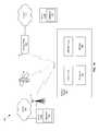
- FIG. 2is a diagram of an altitude-tracking wireless device, in accordance with an embodiment of the invention.
- cellular towers 201 A- 201 Cthere is shown cellular towers 201 A- 201 C, an access point 203 , and the wireless device 107 .
- the cellular towers 201 A- 201 C and the access point 203may be substantially similar to the cellular towers 117 and the access points 109 described with respect to FIGS. 1A and 1B .
- the wireless device 107may determine its location by one or more location techniques, such as GNSS positioning, cellular triangulation, or by its proximity to one or more communication devices such as the access point 107 .
- the latitude and longitude data of the determined locationmay be used to retrieve an altitude value from a database, such as the worldwide terrain database, described with respect to FIG. 1A .
- the wireless devicemay track the altitude of the device as it moves. For example, as the wireless devices moves down the slope as shown by the dashed line in FIG. 2 , an altimeter, such as the altimeter module 115 in the wireless device 107 , may accurately measure the change in altitude, AA. In this manner, the wireless device 107 may be operable to accurately determine its altitude without requiring an altimeter capable of absolute accuracy, as opposed to one capable of precision with respect to a known altitude, and without depending on GNSS which may not be available at all times, or have the desired accuracy.
- an altimetersuch as the altimeter module 115 in the wireless device 107 , may accurately measure the change in altitude, AA.
- the wireless device 107may be operable to accurately determine its altitude without requiring an altimeter capable of absolute accuracy, as opposed to one capable of precision with respect to a known altitude, and without depending on GNSS which may not be available at all times, or have the desired accuracy.
- FIG. 3is a block diagram illustrating exemplary steps for updating altitude information for a location by using terrain model information to prime altitude sensors, in accordance with an embodiment of the invention.
- the location of the wireless device 107may be determined using GNSS, cellular triangulation, or proximity to a wireless point with a known location.
- the determined locationmay be utilized to retrieve an altitude value from the worldwide terrain database 119 .
- the exemplary stepsmay proceed to step 309 where the altitude may be tracked by the altimeter module 115 before proceeding to step 311 .
- step 307the wireless device 107 may not be moving, the exemplary steps may proceed directly to step 311 .
- step 311in instances where the wireless device 107 is to be powered down, the exemplary steps may proceed to end step 313 .
- step 311in instances where the wireless device 107 is not to be powered down, the exemplary steps may proceed to step 303 to determine the location of the wireless device 107 using GNSS positioning, cellular triangulation, and/or proximity to one or more communication devices such as a base station, another wireless communication device, or a wireless access point with a known location.
- a method and systemare disclosed for determining an altitude of a wireless device 107 comprising one or more altimeters 115 .
- the determination of altitudemay comprise determining a location of the wireless device 107 and receiving an altitude value for the location from an altitude database 119 .
- a change in the altitude of the wireless device 107may be measured using the one or more altimeters 115 .
- the altitude database 119may comprise a worldwide terrain database that may be stored on a remote device, which may comprise a server 111 A and 111 B. At least a portion of the altitude database 119 may be stored on the wireless device 107 and may be updated as the wireless device 107 moves from the determined location.
- the location of the wireless device 107may be determined utilizing a global navigation satellite system, such as, for example, a global positioning satellite (GPS) system, GLONASS, and/or GALILLEO.
- the location of the wireless device 107may be determined utilizing cellular service triangulation or by utilizing one or more access points with known locations 109 .
- Another embodiment of the inventionmay provide a machine and/or computer readable storage and/or medium, having stored thereon, a machine code and/or a computer program having at least one code section executable by a machine and/or a computer, thereby causing the machine and/or computer to perform the steps as described herein for updating altitude information for a location by using terrain model information to prime altitude sensors.
- aspects of the inventionmay be realized in hardware, software, firmware or a combination thereof.
- the inventionmay be realized in a centralized fashion in at least one computer system or in a distributed fashion where different elements are spread across several interconnected computer systems. Any kind of computer system or other apparatus adapted for carrying out the methods described herein is suited.
- a typical combination of hardware, software and firmwaremay be a general-purpose computer system with a computer program that, when being loaded and executed, controls the computer system such that it carries out the methods described herein.
- One embodiment of the present inventionmay be implemented as a board level product, as a single chip, application specific integrated circuit (ASIC), or with varying levels integrated on a single chip with other portions of the system as separate components.
- the degree of integration of the systemwill primarily be determined by speed and cost considerations. Because of the sophisticated nature of modern processors, it is possible to utilize a commercially available processor, which may be implemented external to an ASIC implementation of the present system. Alternatively, if the processor is available as an ASIC core or logic block, then the commercially available processor may be implemented as part of an ASIC device with various functions implemented as firmware.
- the present inventionmay also be embedded in a computer program product, which comprises all the features enabling the implementation of the methods described herein, and which when loaded in a computer system is able to carry out these methods.
- Computer program in the present contextmay mean, for example, any expression, in any language, code or notation, of a set of instructions intended to cause a system having an information processing capability to perform a particular function either directly or after either or both of the following: a) conversion to another language, code or notation; b) reproduction in a different material form.
- other meanings of computer programwithin the understanding of those skilled in the art are also contemplated by the present invention.
Landscapes
- Engineering & Computer Science (AREA)
- Radar, Positioning & Navigation (AREA)
- Remote Sensing (AREA)
- Physics & Mathematics (AREA)
- General Physics & Mathematics (AREA)
- Automation & Control Theory (AREA)
- Position Fixing By Use Of Radio Waves (AREA)
Abstract
Description
- This application makes reference to, claims the benefit from, and claims priority to U.S. Provisional Application Ser. No. 61/305,758 filed on Feb. 18, 2010.
- This application also makes reference to:
- U.S. patent application Ser. No. ______ (Attorney Docket No. 20999U502) filed on even date herewith;
U.S. patent application Ser. No. ______ (Attorney Docket No. 21000U502) filed on even date herewith;
U.S. patent application Ser. No. 12/729,184 filed on Mar. 22, 2010;
U.S. patent application Ser. No. ______ (Attorney Docket No. 21004U502) filed on even date herewith;
U.S. patent application Ser. No. 12/729,197 filed on Mar. 22, 2010;
U.S. patent application Ser. No. ______ (Attorney Docket No. 21006U502) filed on even date herewith;
U.S. patent application Ser. No. ______ (Attorney Docket No. 21011U502) filed on even date herewith;
U.S. patent application Ser. No. ______ (Attorney Docket No. 21016U502) filed on even date herewith;
U.S. patent application Ser. No. ______ (Attorney Docket No. 21023U502) filed on even date herewith;
U.S. patent application Ser. No. ______ (Attorney Docket No. 21025U502) filed on even date herewith;
U.S. patent application Ser. No. 12/729,957 filed on Mar. 22, 2010;
U.S. Provisional Application Ser. No. 61/304,085 filed on Feb. 12, 2010;
U.S. Provisional Application Ser. No. 61/304,100 filed on Feb. 12, 2010;
U.S. Provisional Application Ser. No. 61/304,114 filed on Feb. 12, 2010;
U.S. Provisional Application Ser. No. 61/311,879 filed on Mar. 9, 2010;
U.S. Provisional Application Ser. No. 61/304,193 filed on Feb. 12, 2010;
U.S. Provisional Application Ser. No. 61/304,205 filed on Feb. 12, 2010;
U.S. Provisional Application Ser. No. 61/304,198 filed on Feb. 12, 2010;
U.S. Provisional Application Ser. No. 61/305,174 filed on Feb. 17, 2010;
U.S. Provisional Application Ser. No. 61/304,253 filed on Feb. 12, 2010;
U.S. Provisional Application Ser. No. 61/306,639 filed on Feb.22, 2010; and
U.S. Provisional Application Ser. No. 61/309,071 filed on Mar. 1, 2010. - Each of the above stated applications is hereby incorporated herein by reference in its entirety.
- [Not Applicable]
- [Not Applicable]
- Certain embodiments of the invention relate to wireless communication. More specifically, certain embodiments of the invention relate to a method and system for updating altitude information for a location by using terrain model information to prime altitude sensors.
- Global navigation satellite systems (GNSS) receivers may normally determine their position by receiving satellite broadcast signals from a plurality of satellites. These satellites, for example 24 at any time for the Global Positioning System (GPS), may broadcast radio frequency signals that comprise information that may be exploited by the satellite receiver to determine its own position. By measuring the time the broadcast signals may travel from the satellites to the satellite receiver, and the known position of the transmitting satellite, the satellite receiver may be able to determine its own position by trilateration. In general, at least 3 satellite signals may need to be decoded at the satellite receiver in order to determine its position.
- Further limitations and disadvantages of conventional and traditional approaches will become apparent to one of skill in the art, through comparison of such systems with the present invention as set forth in the remainder of the present application with reference to the drawings.
- A system and/or method for updating altitude information for a location by using terrain model information to prime altitude sensors, substantially as shown in and/or described in connection with at least one of the figures, as set forth more completely in the claims.
- Various advantages, aspects and novel features of the present invention, as well as details of an illustrated embodiment thereof, will be more fully understood from the following description and drawings.
FIG. 1A is a diagram illustrating an exemplary wireless device with altitude determining capability, in accordance with an embodiment of the invention.FIG. 1B is a diagram illustrating an exemplary satellite navigation system in a two-dimensional setting, in accordance with an embodiment of the invention.FIG. 2 is a diagram of an altitude-tracking wireless device, in accordance with an embodiment of the invention.FIG. 3 is a block diagram illustrating exemplary steps for updating altitude information for a location by using terrain model information to prime altitude sensors, in accordance with an embodiment of the invention.- Certain aspects of the invention may be found in a method and system for updating altitude information for a location by using terrain model information to prime altitude sensors. Exemplary aspects of the invention may comprise determining an altitude of a wireless device comprising one or more altimeters. The determination of the altitude may comprise determining a location of the wireless device and receiving an altitude value for the location from an altitude database. A change in the altitude of the wireless device may be measured using the one or more altimeters. The altitude database may comprise a worldwide terrain database that may be stored on a remote device, which may comprise a server. At least a portion of the altitude database may be stored on the wireless device and may be updated as the wireless device moves from the determined location. The location of the wireless device may be measured utilizing a global navigation satellite system, which may comprise a global positioning satellite (GPS), GLONASS, and/or Galileo system. The location of the wireless device may be determined utilizing cellular service triangulation or by utilizing one or more access points with known locations.
FIG. 1A is a diagram illustrating an exemplary wireless device with altitude determining capability, in accordance with an embodiment of the invention. Referring toFIG. 1A , there is shown analtitude monitoring system 100 comprising awireless device 107,access points 109,servers 111A and111B, theInternet 113,cellular towers 117, andsatellites 110. Thewireless device 107 may comprise a transmit/receive (TX/RX)module 104, aprocessor 106, amemory 108, andaltimeter module 115.- The TX/
RX module 104 may be communicatively coupled to one or more receiver antennas illustrated by theantenna 112. Thewireless device 107 may comprise Global Navigation Satellite System (GNSS), cellular, WiFi, Zigbee, WiMax, 60 GHz and other wireless technology, for example. - The
satellites 110 may comprise suitable logic, circuitry, interfaces, and/or code that may be operable to generate and broadcast suitable radio-frequency signals that may be received by a satellite receiver, for example the TX/RX 104, to determine thewireless device 107 position. Thewireless device 107 may comprise any wireless device that may utilize GNSS technology, such as smart phones, PDAs, wireless access points, or cell phones, for example. - The TX/
RX 104 may comprise suitable logic, circuitry, interfaces, and/or code that may be operable to receive signals broadcasted from a plurality of sources, such as thesatellites 110, thecellular towers 117, and the access points109. The received signals may be processed in order to determine the position or location of thewireless device 107. The TX/RX 104 may be operable to receive wireless signals via thereceiver antenna 112 and process the received signals in order to generate baseband signals. Signal processing may be performed on the baseband signals by theprocessor 106. - The
memory 108 may comprise suitable logic, circuitry, interfaces, and/or code that may enable storage and access to data and code suitable for the operations performed by the TX/RX 104 and theprocessor 106. - The
server 111A and111B may comprise one or more computer systems coupled to the Internet that may be operable to store and provide information to thewireless device 108. Theservers 111A and111B may comprise aworldwide terrain database 119 that may comprise altitude data for points across the surface of the Earth. For example, theworldwide terrain database 119 may comprise altitude data for 109latitude and longitude points. This data may be accessed by wireless devices via the Internet, for example. - The
altimeter module 115 may comprise suitable logic, circuitry, interfaces, and/or code that may be operable to determine relative altitude changes. Thealtimeter module 115 may comprise a barometric pressure altimeter, for example, that may be operable to accurately track the altitude of a device when calibrated to a known altitude. For example, thealtimeter 115 may be calibrated to a known altitude, such as by knowing the altitude of a particular location, and may be operable to accurately measure any changes from that altitude. In one embodiment of the invention, thealtimeter module 115 may comprise a MEMS module. - In
FIG. 1A , an exemplary location-determining scenario may be illustrated, wherein the TX/RX 104 may receive a plurality of signals from which theprocessor 106 may be able to extract information that may enable thewireless device 107 to determine its position. The TX/RX 104 and thesatellites 110, may be operating in compliance with the Global Positioning System (GPS) developed and operated by the United States of America Department of Defense. In accordance with various embodiments of the invention, the invention may not be limited to application in GPS and may be applied to other GNSS systems, for example GALILEO, GLONASS, IRNSS, and BEIDOU. - In operation, the location of the
wireless device 107 may be determined by one or more methods. For example, triangulation may be utilized to determine location from two or more cellular towers, or GNSS location-determining capability may be enabled when signals are received from two or more of thesatellites 110. In another embodiment of the invention, the location of thewireless device 107 may be determined utilizing two or more cellular towers of thecellular towers 117. The location of thewireless device 107 may thus be determined by triangulating the received signals. - In an exemplary embodiment of the invention, the location of the
wireless device 107 may be determined utilizing one ormore access points 109 with a known position. For example, theaccess points 109 may have GNSS capability that periodically updates its known position. This information may be exchanged with wireless devices that utilize the access points109. - Once the wireless device location has been determined, its altitude may be determined from the
worldwide terrain database 119 via the Internet and a wireless communication channel such as thecellular towers 117 and/or theaccess points 109, for example. Thewireless device 107 may then monitor its altitude utilizing thealtimeter module 115, which may be operable to accurately track the change in altitude from the original altitude retrieved from theworldwide terrain database 119. - In another embodiment of the invention, all or a localized portion of the
worldwide terrain database 119 may be stored on the wireless device in thememory 108, for example. The data from theworldwide terrain database 119 stored locally on thewireless device 107 may be periodically updated as thewireless device 107 moves. The localized portion of the database that may be stored on thewireless device 107 may be updated as the wireless device moves from location to location. FIG. 1B is a diagram illustrating an exemplary satellite navigation system in a two-dimensional setting, in accordance with an embodiment of the invention. Referring toFIG. 1B , there is shown asatellite navigation system 150, comprising the wireless device112 (illustrated by a small circle) at position p,satellites earth surface 154 illustrated by a dotted circle, and an exemplary two-dimensional coordinatesystem 156. There is also shown a position ofsatellite 160adenoted p(160a), a position ofsatellite 160bdenoted p(160b), an intersection point q, a range fromsatellite 160ato the satellite receiver102 r(160a) and a range fromsatellite 160bto the satellite receiver102 r(160b).- To illustrate the principles involved in determining a position of the
wireless device 112 from the satellites, for example thesatellites FIG. 1B . The three-dimensional case encountered in reality may be considered an extension to three dimensions of the principles demonstrated in the two-dimensional case. As illustrated inFIG. 1B , the principle of determining the position p of the satellite receiver102 may be to measure the range from thewireless device 112 to a plurality of satellites, for example r(160a) and r(160b), based on the known positions of the satellites, for example p(160a), and p(160b). Based on the measured ranges from thesatellites wireless device 112 and the known position of the satellites, each satellite may define a circle of positions that lie at a given range from the satellite, as illustrated inFIG. 1B . In the case of two satellites, there may be two intersection points: one may be the desired position p and the other may be the intersection q. As may be observed fromFIG. 1B , only p may be close to the surface of the earth. Hence, only p may be a feasible solution for the position of thewireless device 112. Therefore, in the depicted two-dimensional scenario ofFIG. 1B , two satellites may suffice in principle to determine the position p. The position p may be given by one solution to the following relationships in the two-dimensional case:
r(k)=||p(k)−p||, k=160a, 160b EQ. 1- In three dimensions, the circles around the satellites may become spheres and the intersection of two spheres may generate a circle of feasible solutions. By intersecting the circle with a further sphere, two possible positions will be found. Again, only one of the two solutions will be close to the surface of the earth. Therefore, in the three dimensional case, the solution may require 1 more satellite to resolve the extra dimension and the position may be resolved from the following relationship, where each k may denote a different satellite:
r(k)=||p(k)−p||, k=1,2,3 EQ. 2- Each satellite, for
example satellites memory 108. Due to certain imperfections in computing the satellite's position, a GPS ground station may monitor the satellite's exact position. In order to correct for any deviations from the almanac position, the ground station may supply the satellite with data that may allow the satellite's position to be determined to a high degree of accuracy when received by a satellite receiver. This data may be valid for a limited time only and may be referred to as ephemeris data. Its ephemeris data may be broadcast by each satellite, and may be received by the satellite receiver. The satellite position p(k,t) of satellite k, may be computed using the ephemeris data. The almanac position P(k,t)of a given satellite k may hence be related to the position p(k,t) together with a correction term Δ(k,t) from the following relationship:
p(k,t)=P(k,t)+Δ(k,t) EQ. 3- where the variable t may denote time and indicate that the position of the satellite may change as a function of time. In instances where the correction term Δ(k,t) may be available at a satellite receiver, for example the
wireless device 112, the exact position of the satellite k may be determined to a high degree of accuracy. - The
satellite navigation system 150 may be utilized to determine a starting location of the wireless device102 comprising a latitude and longitude point. The altitude determined from GNSS may not be as accurate as a user desires, and may not precisely track changes in altitude of thewireless device 107. In addition, GNSS service may not be available at all times that altitude measurement may be desired. Accordingly, the latitude and longitude data may be utilized to determine a more accurate altitude value from theworldwide terrain database 119, described with respect toFIG. 1A . Once the altitude has been retrieved, thewireless device 107 may track altitude utilizing an altimeter, as described with respect toFIG. 1A . FIG. 2 is a diagram of an altitude-tracking wireless device, in accordance with an embodiment of the invention. Referring toFIG. 2 there is showncellular towers 201A-201C, anaccess point 203, and thewireless device 107. Thecellular towers 201A-201C and theaccess point 203 may be substantially similar to thecellular towers 117 and theaccess points 109 described with respect toFIGS. 1A and 1B .- In operation, the
wireless device 107 may determine its location by one or more location techniques, such as GNSS positioning, cellular triangulation, or by its proximity to one or more communication devices such as theaccess point 107. The latitude and longitude data of the determined location may be used to retrieve an altitude value from a database, such as the worldwide terrain database, described with respect toFIG. 1A . - Once the latitude for a determined location is received, the wireless device may track the altitude of the device as it moves. For example, as the wireless devices moves down the slope as shown by the dashed line in
FIG. 2 , an altimeter, such as thealtimeter module 115 in thewireless device 107, may accurately measure the change in altitude, AA. In this manner, thewireless device 107 may be operable to accurately determine its altitude without requiring an altimeter capable of absolute accuracy, as opposed to one capable of precision with respect to a known altitude, and without depending on GNSS which may not be available at all times, or have the desired accuracy. FIG. 3 is a block diagram illustrating exemplary steps for updating altitude information for a location by using terrain model information to prime altitude sensors, in accordance with an embodiment of the invention. Referring toFIG. 3 , instep 303 afterstart step 301, the location of thewireless device 107 may be determined using GNSS, cellular triangulation, or proximity to a wireless point with a known location. Instep 305, the determined location may be utilized to retrieve an altitude value from theworldwide terrain database 119. Instep 307, in instances where thewireless device 107 may be moving, the exemplary steps may proceed to step309 where the altitude may be tracked by thealtimeter module 115 before proceeding to step311. If, instep 307, thewireless device 107 may not be moving, the exemplary steps may proceed directly to step311. Instep 311, in instances where thewireless device 107 is to be powered down, the exemplary steps may proceed to endstep 313. Instep 311, in instances where thewireless device 107 is not to be powered down, the exemplary steps may proceed to step303 to determine the location of thewireless device 107 using GNSS positioning, cellular triangulation, and/or proximity to one or more communication devices such as a base station, another wireless communication device, or a wireless access point with a known location.- In an embodiment of the invention, a method and system are disclosed for determining an altitude of a
wireless device 107 comprising one ormore altimeters 115. The determination of altitude may comprise determining a location of thewireless device 107 and receiving an altitude value for the location from analtitude database 119. A change in the altitude of thewireless device 107 may be measured using the one ormore altimeters 115. Thealtitude database 119 may comprise a worldwide terrain database that may be stored on a remote device, which may comprise aserver 111A and111B. At least a portion of thealtitude database 119 may be stored on thewireless device 107 and may be updated as thewireless device 107 moves from the determined location. The location of thewireless device 107 may be determined utilizing a global navigation satellite system, such as, for example, a global positioning satellite (GPS) system, GLONASS, and/or GALILLEO. The location of thewireless device 107 may be determined utilizing cellular service triangulation or by utilizing one or more access points with knownlocations 109. - Another embodiment of the invention may provide a machine and/or computer readable storage and/or medium, having stored thereon, a machine code and/or a computer program having at least one code section executable by a machine and/or a computer, thereby causing the machine and/or computer to perform the steps as described herein for updating altitude information for a location by using terrain model information to prime altitude sensors.
- Accordingly, aspects of the invention may be realized in hardware, software, firmware or a combination thereof. The invention may be realized in a centralized fashion in at least one computer system or in a distributed fashion where different elements are spread across several interconnected computer systems. Any kind of computer system or other apparatus adapted for carrying out the methods described herein is suited. A typical combination of hardware, software and firmware may be a general-purpose computer system with a computer program that, when being loaded and executed, controls the computer system such that it carries out the methods described herein.
- One embodiment of the present invention may be implemented as a board level product, as a single chip, application specific integrated circuit (ASIC), or with varying levels integrated on a single chip with other portions of the system as separate components. The degree of integration of the system will primarily be determined by speed and cost considerations. Because of the sophisticated nature of modern processors, it is possible to utilize a commercially available processor, which may be implemented external to an ASIC implementation of the present system. Alternatively, if the processor is available as an ASIC core or logic block, then the commercially available processor may be implemented as part of an ASIC device with various functions implemented as firmware.
- The present invention may also be embedded in a computer program product, which comprises all the features enabling the implementation of the methods described herein, and which when loaded in a computer system is able to carry out these methods. Computer program in the present context may mean, for example, any expression, in any language, code or notation, of a set of instructions intended to cause a system having an information processing capability to perform a particular function either directly or after either or both of the following: a) conversion to another language, code or notation; b) reproduction in a different material form. However, other meanings of computer program within the understanding of those skilled in the art are also contemplated by the present invention.
- While the invention has been described with reference to certain embodiments, it will be understood by those skilled in the art that various changes may be made and equivalents may be substituted without departing from the scope of the present invention. In addition, many modifications may be made to adapt a particular situation or material to the teachings of the present invention without departing from its scope. Therefore, it is intended that the present invention not be limited to the particular embodiments disclosed, but that the present invention will include all embodiments falling within the scope of the appended claims.
Claims (20)
Priority Applications (1)
| Application Number | Priority Date | Filing Date | Title |
|---|---|---|---|
| US12/732,847US20110199257A1 (en) | 2010-02-18 | 2010-03-26 | Method and system for updating altitude information for a location by using terrain model information to prime altitude sensors |
Applications Claiming Priority (2)
| Application Number | Priority Date | Filing Date | Title |
|---|---|---|---|
| US30575810P | 2010-02-18 | 2010-02-18 | |
| US12/732,847US20110199257A1 (en) | 2010-02-18 | 2010-03-26 | Method and system for updating altitude information for a location by using terrain model information to prime altitude sensors |
Publications (1)
| Publication Number | Publication Date |
|---|---|
| US20110199257A1true US20110199257A1 (en) | 2011-08-18 |
Family
ID=44369287
Family Applications (1)
| Application Number | Title | Priority Date | Filing Date |
|---|---|---|---|
| US12/732,847AbandonedUS20110199257A1 (en) | 2010-02-18 | 2010-03-26 | Method and system for updating altitude information for a location by using terrain model information to prime altitude sensors |
Country Status (1)
| Country | Link |
|---|---|
| US (1) | US20110199257A1 (en) |
Cited By (7)
| Publication number | Priority date | Publication date | Assignee | Title |
|---|---|---|---|---|
| US20110301834A1 (en)* | 2010-06-07 | 2011-12-08 | Foxconn Communication Technology Corp. | Device and method for vehicle navigation |
| US20130289871A1 (en)* | 2012-04-27 | 2013-10-31 | Hitachi Consumer Electronics Co., Ltd. | Positional information providing system, navigation system, and terminal device |
| CN106595574A (en)* | 2016-12-16 | 2017-04-26 | 鞍钢集团矿业有限公司 | Processing method of monitored elevation data of open mine pit slope based on measurement robot |
| US9952354B2 (en) | 2015-09-11 | 2018-04-24 | At&T Intellectual Property I, L.P. | User equipment local barometric calibration |
| WO2018153811A1 (en)* | 2017-02-24 | 2018-08-30 | Here Global B.V. | Precise altitude estimation for indoor positioning |
| US10088309B2 (en) | 2014-05-16 | 2018-10-02 | Qualcomm Incorporated | LAN-based barometric altimetry |
| WO2021012243A1 (en)* | 2019-07-25 | 2021-01-28 | Beijing Voyager Technology Co., Ltd. | Positioning systems and methods |
Citations (32)
| Publication number | Priority date | Publication date | Assignee | Title |
|---|---|---|---|---|
| US5210540A (en)* | 1991-06-18 | 1993-05-11 | Pioneer Electronic Corporation | Global positioning system |
| US5265025A (en)* | 1990-07-11 | 1993-11-23 | Mitsubishi Denki Kabushiki Kaisha | Navigation system using satellite signals |
| US6144336A (en)* | 1997-05-19 | 2000-11-07 | Integrated Data Communications, Inc. | System and method to communicate time stamped, 3-axis geo-position data within telecommunication networks |
| US6216064B1 (en)* | 1998-02-24 | 2001-04-10 | Alliedsignal Inc. | Method and apparatus for determining altitude |
| US20010023390A1 (en)* | 1999-06-28 | 2001-09-20 | Min-Chung Gia | Path planning, terrain avoidance and situation awareness system for general aviation |
| US20020050944A1 (en)* | 1998-07-02 | 2002-05-02 | Leonid Sheynblat | Method and apparatus for measurement processing of satellite positioning system (SPS) signals |
| US6429814B1 (en)* | 2000-11-17 | 2002-08-06 | Global Locate, Inc. | Method and apparatus for enhancing a global positioning system with terrain model |
| US6480789B2 (en)* | 2000-12-04 | 2002-11-12 | American Gnc Corporation | Positioning and proximity warning method and system thereof for vehicle |
| US20030225893A1 (en)* | 2002-03-01 | 2003-12-04 | Roese John J. | Locating devices in a data network |
| US6756938B2 (en)* | 2001-11-06 | 2004-06-29 | Motorola, Inc. | Satellite positioning system receivers and methods therefor |
| US6768449B1 (en)* | 2001-04-12 | 2004-07-27 | Garmin Ltd. | Device and method for calibrating and improving the accuracy of barometric altimeters with GPS-derived altitudes |
| US20040192352A1 (en)* | 2003-03-25 | 2004-09-30 | Nokia Corporation | Energy efficient object location reporting system |
| US6882308B2 (en)* | 2000-03-22 | 2005-04-19 | Asulab Sa | Portable device for determining horizontal and vertical positions and method for operating the same |
| US20050192741A1 (en)* | 2002-08-15 | 2005-09-01 | Mark Nichols | Method and system for controlling a valuable movable item |
| US20060119508A1 (en)* | 2004-11-19 | 2006-06-08 | Miller John D | Method and apparatus for conserving power on a mobile device through motion awareness |
| US20060238418A1 (en)* | 2003-08-01 | 2006-10-26 | Michel Monnerat | Determining mobile terminal positions using assistance data transmitted on request |
| US20070168124A1 (en)* | 2006-01-18 | 2007-07-19 | Dossas Vasilios D | Ubiquitous personal information device |
| US7262713B1 (en)* | 2004-09-30 | 2007-08-28 | Rockwell Collins, Inc. | System and method for a safe depiction of terrain, airport and other dimensional data on a perspective flight display with limited bandwidth of data presentation |
| US20080091350A1 (en)* | 2006-10-17 | 2008-04-17 | Smith Stephen F | Triply redundant integrated navigation and asset visibility system |
| US20080246758A1 (en)* | 2006-12-01 | 2008-10-09 | Marek Strassenburg-Kleciak | Terrain modeling based on curved surface area |
| US20090005068A1 (en)* | 2007-06-28 | 2009-01-01 | Apple Inc. | Location-Based Emergency Information |
| US20090024311A1 (en)* | 2007-07-16 | 2009-01-22 | Michael Dean Hess | Method and apparatus for displaying terrain elevation information |
| US20090066576A1 (en)* | 2006-03-21 | 2009-03-12 | Global Locate, Inc. | Method and apparatus for generating and using a regional-terrain model |
| US20090210156A1 (en)* | 2008-02-20 | 2009-08-20 | Qualcomm Incorporated | Efficient use of expected user altitude data to aid in determining a position of a mobile station |
| US20090278738A1 (en)* | 2008-05-12 | 2009-11-12 | Qualcomm Incorporated | Gps power savings using low power sensors |
| US20090309793A1 (en)* | 2008-06-11 | 2009-12-17 | Peter Van Wyck Loomis | Acceleration compensated inclinometer |
| US20090315775A1 (en)* | 2008-06-20 | 2009-12-24 | Microsoft Corporation | Mobile computing services based on devices with dynamic direction information |
| US20090322607A1 (en)* | 2007-04-23 | 2009-12-31 | Seiko Epson Corporation | Positioning method |
| US7675012B1 (en)* | 2004-10-01 | 2010-03-09 | The United States Of America As Represented By The Secretary Of The Navy | Apparatus and method for cooperative multi target tracking and interception |
| US20100176984A1 (en)* | 2008-05-30 | 2010-07-15 | Thales | Method of eliminating ground echoes for a meteorological radar |
| US7768963B2 (en)* | 2006-07-07 | 2010-08-03 | Skyhook Wireless, Inc. | System and method of improving sampling of WLAN packet information to improve estimates of Doppler frequency of a WLAN positioning device |
| US8188912B1 (en)* | 2009-09-29 | 2012-05-29 | Trimble Navigation Ltd. | Altitude constrained GPS |
- 2010
- 2010-03-26USUS12/732,847patent/US20110199257A1/ennot_activeAbandoned
Patent Citations (32)
| Publication number | Priority date | Publication date | Assignee | Title |
|---|---|---|---|---|
| US5265025A (en)* | 1990-07-11 | 1993-11-23 | Mitsubishi Denki Kabushiki Kaisha | Navigation system using satellite signals |
| US5210540A (en)* | 1991-06-18 | 1993-05-11 | Pioneer Electronic Corporation | Global positioning system |
| US6144336A (en)* | 1997-05-19 | 2000-11-07 | Integrated Data Communications, Inc. | System and method to communicate time stamped, 3-axis geo-position data within telecommunication networks |
| US6216064B1 (en)* | 1998-02-24 | 2001-04-10 | Alliedsignal Inc. | Method and apparatus for determining altitude |
| US20020050944A1 (en)* | 1998-07-02 | 2002-05-02 | Leonid Sheynblat | Method and apparatus for measurement processing of satellite positioning system (SPS) signals |
| US20010023390A1 (en)* | 1999-06-28 | 2001-09-20 | Min-Chung Gia | Path planning, terrain avoidance and situation awareness system for general aviation |
| US6882308B2 (en)* | 2000-03-22 | 2005-04-19 | Asulab Sa | Portable device for determining horizontal and vertical positions and method for operating the same |
| US6429814B1 (en)* | 2000-11-17 | 2002-08-06 | Global Locate, Inc. | Method and apparatus for enhancing a global positioning system with terrain model |
| US6480789B2 (en)* | 2000-12-04 | 2002-11-12 | American Gnc Corporation | Positioning and proximity warning method and system thereof for vehicle |
| US6768449B1 (en)* | 2001-04-12 | 2004-07-27 | Garmin Ltd. | Device and method for calibrating and improving the accuracy of barometric altimeters with GPS-derived altitudes |
| US6756938B2 (en)* | 2001-11-06 | 2004-06-29 | Motorola, Inc. | Satellite positioning system receivers and methods therefor |
| US20030225893A1 (en)* | 2002-03-01 | 2003-12-04 | Roese John J. | Locating devices in a data network |
| US20050192741A1 (en)* | 2002-08-15 | 2005-09-01 | Mark Nichols | Method and system for controlling a valuable movable item |
| US20040192352A1 (en)* | 2003-03-25 | 2004-09-30 | Nokia Corporation | Energy efficient object location reporting system |
| US20060238418A1 (en)* | 2003-08-01 | 2006-10-26 | Michel Monnerat | Determining mobile terminal positions using assistance data transmitted on request |
| US7262713B1 (en)* | 2004-09-30 | 2007-08-28 | Rockwell Collins, Inc. | System and method for a safe depiction of terrain, airport and other dimensional data on a perspective flight display with limited bandwidth of data presentation |
| US7675012B1 (en)* | 2004-10-01 | 2010-03-09 | The United States Of America As Represented By The Secretary Of The Navy | Apparatus and method for cooperative multi target tracking and interception |
| US20060119508A1 (en)* | 2004-11-19 | 2006-06-08 | Miller John D | Method and apparatus for conserving power on a mobile device through motion awareness |
| US20070168124A1 (en)* | 2006-01-18 | 2007-07-19 | Dossas Vasilios D | Ubiquitous personal information device |
| US20090066576A1 (en)* | 2006-03-21 | 2009-03-12 | Global Locate, Inc. | Method and apparatus for generating and using a regional-terrain model |
| US7768963B2 (en)* | 2006-07-07 | 2010-08-03 | Skyhook Wireless, Inc. | System and method of improving sampling of WLAN packet information to improve estimates of Doppler frequency of a WLAN positioning device |
| US20080091350A1 (en)* | 2006-10-17 | 2008-04-17 | Smith Stephen F | Triply redundant integrated navigation and asset visibility system |
| US20080246758A1 (en)* | 2006-12-01 | 2008-10-09 | Marek Strassenburg-Kleciak | Terrain modeling based on curved surface area |
| US20090322607A1 (en)* | 2007-04-23 | 2009-12-31 | Seiko Epson Corporation | Positioning method |
| US20090005068A1 (en)* | 2007-06-28 | 2009-01-01 | Apple Inc. | Location-Based Emergency Information |
| US20090024311A1 (en)* | 2007-07-16 | 2009-01-22 | Michael Dean Hess | Method and apparatus for displaying terrain elevation information |
| US20090210156A1 (en)* | 2008-02-20 | 2009-08-20 | Qualcomm Incorporated | Efficient use of expected user altitude data to aid in determining a position of a mobile station |
| US20090278738A1 (en)* | 2008-05-12 | 2009-11-12 | Qualcomm Incorporated | Gps power savings using low power sensors |
| US20100176984A1 (en)* | 2008-05-30 | 2010-07-15 | Thales | Method of eliminating ground echoes for a meteorological radar |
| US20090309793A1 (en)* | 2008-06-11 | 2009-12-17 | Peter Van Wyck Loomis | Acceleration compensated inclinometer |
| US20090315775A1 (en)* | 2008-06-20 | 2009-12-24 | Microsoft Corporation | Mobile computing services based on devices with dynamic direction information |
| US8188912B1 (en)* | 2009-09-29 | 2012-05-29 | Trimble Navigation Ltd. | Altitude constrained GPS |
Non-Patent Citations (1)
| Title |
|---|
| Altimeter. (2015). In The Columbia Encyclopedia. New York, NY: Columbia University Press. Retrieved from http://search.credoreference.com/content/entry/columency/altimeter/0* |
Cited By (14)
| Publication number | Priority date | Publication date | Assignee | Title |
|---|---|---|---|---|
| US20110301834A1 (en)* | 2010-06-07 | 2011-12-08 | Foxconn Communication Technology Corp. | Device and method for vehicle navigation |
| US20130289871A1 (en)* | 2012-04-27 | 2013-10-31 | Hitachi Consumer Electronics Co., Ltd. | Positional information providing system, navigation system, and terminal device |
| US9188458B2 (en)* | 2012-04-27 | 2015-11-17 | Hitachi Maxell, Ltd. | Positional information providing system, navigation system, and terminal device |
| US10088309B2 (en) | 2014-05-16 | 2018-10-02 | Qualcomm Incorporated | LAN-based barometric altimetry |
| US9952354B2 (en) | 2015-09-11 | 2018-04-24 | At&T Intellectual Property I, L.P. | User equipment local barometric calibration |
| US10365406B2 (en) | 2015-09-11 | 2019-07-30 | At&T Intellectual Property I, L.P. | User equipment local barometric calibration |
| CN106595574A (en)* | 2016-12-16 | 2017-04-26 | 鞍钢集团矿业有限公司 | Processing method of monitored elevation data of open mine pit slope based on measurement robot |
| WO2018153811A1 (en)* | 2017-02-24 | 2018-08-30 | Here Global B.V. | Precise altitude estimation for indoor positioning |
| CN110325819A (en)* | 2017-02-24 | 2019-10-11 | 赫尔环球有限公司 | Precise height for indoor positioning is estimated |
| JP2020508455A (en)* | 2017-02-24 | 2020-03-19 | ヘーレ グローバル ベスローテン フェンノートシャップ | Accurate altitude estimation for indoor positioning |
| US11248908B2 (en) | 2017-02-24 | 2022-02-15 | Here Global B.V. | Precise altitude estimation for indoor positioning |
| JP7157754B2 (en) | 2017-02-24 | 2022-10-20 | ヘーレ グローバル ベスローテン フェンノートシャップ | Accurate altitude estimation for indoor positioning |
| WO2021012243A1 (en)* | 2019-07-25 | 2021-01-28 | Beijing Voyager Technology Co., Ltd. | Positioning systems and methods |
| CN112384756A (en)* | 2019-07-25 | 2021-02-19 | 北京航迹科技有限公司 | Positioning system and method |
Similar Documents
| Publication | Publication Date | Title |
|---|---|---|
| US20230121848A1 (en) | Systems and methods for determining when an estimated altitude of a mobile device can be used for calibration or location determination | |
| EP2444822B1 (en) | Method and system for computing universal hybrid navigation information for a GNSS enabled device | |
| CN105353391B (en) | A kind of multi-internet integration for supporting polymorphic type positioning terminal positions enhancing system and method | |
| US8823585B2 (en) | Sensor-assisted location-aware mobile device | |
| US20160334515A1 (en) | Obtaining pseudorange information using a cellular device | |
| EP3309585A1 (en) | Positioning processing system, method, computer program, positioning processing device, and user terminal | |
| US9562976B2 (en) | Method and apparatus for distinguishing direct GNSS signals from reflections | |
| US20110199257A1 (en) | Method and system for updating altitude information for a location by using terrain model information to prime altitude sensors | |
| AU2015277932B2 (en) | Conversion device and program | |
| US10732295B2 (en) | Positioning and navigation receiver with a confidence index | |
| US20160313450A1 (en) | Automotive gnss real time kinematic dead reckoning receiver | |
| CN106255065A (en) | Smart mobile phone and the seamless alignment system of mobile terminal indoor and outdoor and method thereof | |
| EP2101186A1 (en) | Method and system for generating temporary ephemeris | |
| CN112505735B (en) | Method, device and storage medium for positioning terminal | |
| CN107462905A (en) | A kind of Big Dipper GPS dual-mode localization method, positioning terminal and alignment system | |
| US8638258B2 (en) | Method and system for a virtual wide area GNSS reference network | |
| US9921291B2 (en) | Multi-tiered distance travelled estimator | |
| WO2020008791A1 (en) | Positioning system, positioning device and center device | |
| US20120112960A1 (en) | Access point, mobile terminal, global navigation satellite system using the access point, and method of providing position information using the access point | |
| WO2020107434A1 (en) | Coordinate calibration method and device for rtk reference station, and storage medium | |
| CN115585807B (en) | GNSS/INS integrated navigation method based on machine learning | |
| US10677931B2 (en) | Positioning apparatus, positioning method, and recording medium | |
| KR20250101234A (en) | Satellite signal shaded area positioning system coupled with precision GNSS RTK smart antenna | |
| HK40040656A (en) | Method and apparatus for positioning terminal, and storage medium | |
| CN112526557A (en) | Method and device for acquiring positioning reliability and computer readable medium |
Legal Events
| Date | Code | Title | Description |
|---|---|---|---|
| AS | Assignment | Owner name:BROADCOM CORPORATION, CALIFORNIA Free format text:ASSIGNMENT OF ASSIGNORS INTEREST;ASSIGNORS:LUNDGREN, DAVE;ABRAHAM, CHARLES;BUER, MARK;AND OTHERS;SIGNING DATES FROM 20100322 TO 20100325;REEL/FRAME:024871/0448 | |
| AS | Assignment | Owner name:BANK OF AMERICA, N.A., AS COLLATERAL AGENT, NORTH CAROLINA Free format text:PATENT SECURITY AGREEMENT;ASSIGNOR:BROADCOM CORPORATION;REEL/FRAME:037806/0001 Effective date:20160201 Owner name:BANK OF AMERICA, N.A., AS COLLATERAL AGENT, NORTH Free format text:PATENT SECURITY AGREEMENT;ASSIGNOR:BROADCOM CORPORATION;REEL/FRAME:037806/0001 Effective date:20160201 | |
| STCB | Information on status: application discontinuation | Free format text:ABANDONED -- FAILURE TO RESPOND TO AN OFFICE ACTION | |
| AS | Assignment | Owner name:AVAGO TECHNOLOGIES GENERAL IP (SINGAPORE) PTE. LTD., SINGAPORE Free format text:ASSIGNMENT OF ASSIGNORS INTEREST;ASSIGNOR:BROADCOM CORPORATION;REEL/FRAME:041706/0001 Effective date:20170120 Owner name:AVAGO TECHNOLOGIES GENERAL IP (SINGAPORE) PTE. LTD Free format text:ASSIGNMENT OF ASSIGNORS INTEREST;ASSIGNOR:BROADCOM CORPORATION;REEL/FRAME:041706/0001 Effective date:20170120 | |
| AS | Assignment | Owner name:BROADCOM CORPORATION, CALIFORNIA Free format text:TERMINATION AND RELEASE OF SECURITY INTEREST IN PATENTS;ASSIGNOR:BANK OF AMERICA, N.A., AS COLLATERAL AGENT;REEL/FRAME:041712/0001 Effective date:20170119 |