US20100145979A1 - Geospatial data interaction - Google Patents
Geospatial data interactionDownload PDFInfo
- Publication number
- US20100145979A1 US20100145979A1US12/330,204US33020408AUS2010145979A1US 20100145979 A1US20100145979 A1US 20100145979A1US 33020408 AUS33020408 AUS 33020408AUS 2010145979 A1US2010145979 A1US 2010145979A1
- Authority
- US
- United States
- Prior art keywords
- data
- user
- result
- geospatial
- input
- Prior art date
- Legal status (The legal status is an assumption and is not a legal conclusion. Google has not performed a legal analysis and makes no representation as to the accuracy of the status listed.)
- Granted
Links
Images


Classifications
- G—PHYSICS
- G06—COMPUTING OR CALCULATING; COUNTING
- G06F—ELECTRIC DIGITAL DATA PROCESSING
- G06F16/00—Information retrieval; Database structures therefor; File system structures therefor
- G06F16/20—Information retrieval; Database structures therefor; File system structures therefor of structured data, e.g. relational data
- G06F16/29—Geographical information databases
Definitions
- This disclosurerelates generally to methods and systems for a high level interface allowing users to express geovisualization requests in an intuitive manner without requiring a user to rely on pre-programmed “static” predicates. More particularly, but not by way of limitation, this disclosure relates to a method and system for abstracting interface functions and allowing “dynamic predicates” when interacting with a set of one or more geospatial data storage facilities. Thereby a user is able to obtain results from ad-hoc queries as opposed to pre-defined and programmed user interface filtering functions.
- An important element of all data interrogationis the capability of filtering.
- a usercan cull the dataset based on selection criteria to focus on a subset of the available information with the geovisualization server hiding extraneous data during analysis.
- Each geovisualization applicationtypically has the capability to render data dynamically during a user session and apply filters against the dynamically changing data.
- the predicatesare static in the sense that the requirement to apply the filter must be identified before a user session begins and programmed into the interface before runtime.
- dynamic predicatesallow for redefining query structure and information without an end user requirement to initiate a new session or application process.
- GISgeographic information system
- Geospatial computer applicationssuch as Google Earth (available from Google incorporated), NASA World Wind (available from the National Aeronautics and Space Administration), and Microsoft Windows Live Maps (available from Microsoft incorporated), among others, allow for access to geovisualization of information by use of specific data interrogation techniques. While these data interrogation techniques provide for some flexibility, they are mostly limited in the realm of filtering because they use predefined predicates. However, iterative refinement of filtering during a session by means of dynamic predicates allows a more flexible and analytic potential because it allows for more flexible ad-hoc queries by a user. In general, dynamic predicates allow a user to invent new questions in the form of queries for information.
- a user interfacetypically has the restriction imposed on filtering by predefined static predicates. That is to say that a query takes the form “what are the flight paths of all the aircraft departing or arriving from cities AAA over the time period XXX to YYY?” Note that a user is therefore restricted to simply requesting information by filling in variables at pre-defined locations in the query.
- a dynamic predicateis not confined to a single prescribed form, but instead, may draw upon and combine properties from accessible data to form an ad hoc question. For example, if some of the properties of available data were “city,” “flight paths,” and “time” then an embodiment of a dynamic predicate would involve some logical arrangement of those properties in question form such as “what are the flight paths of all the aircraft departing or arriving from cities AAA over the time period XXX to YYY” or alternatively “what are the flight paths of all the aircraft departing or arriving from cities AAA not before XXX” or many other conceivable, but not predefined, forms.
- the Analytical Geoquery Language (AGL) described hereinprovides for dynamic predicates by defining the vocabulary, mechanisms for the creation of new vocabulary, and the grammatical rules that govern the structure of a “valid” sentence.
- Standardizing on a common high level interface for expressing queries with geospatially significant results intended for rendering in geovisualization systemsallows for abstracting away specific details of the visualization layer's data injection technique.
- a userneed not be bothered with the details of programming languages such as Keyhole Markup Language (KML) or Jscript (a programming language developed by Microsoft) when incorporating visualization capability, but instead may focus on the logical relationships within the data itself.
- KMLKeyhole Markup Language
- Jscripta programming language developed by Microsoft
- AGL inputis not tied to any specific geovisualization server or underlying programming language, a user is not bound to information residing in a particular data repository or a specific geovisualization implementation. In one embodiment a single input of an AGL query will produce a similar result in several different geovisualization software packages simultaneously.
- the querycan be accepted as a user input from a user interface configured to accept dynamic predicates.
- Dynamic predicatesdiffer from static predicates in that, among other things, they allow the user to refine the results in essence by defining filters on the fly.
- the request for geospatial informationis translated into an intermediate data format acceptable as input to one or more geoserver applications.
- external data sourcescan be further queried in concert with this translation thus providing a user access to multiple data sources concurrently.
- the applicable portioncan be sent to one or more geoservers to obtain the result of the user query.
- the geovisualization servermay directly provide the rendering of the result.
- the resultcan be returned to the translating adapter for further processing prior to rendering.
- FIG. 1shows an illustrative architecture to support a geospatial query.
- FIG. 2shows, in flowchart form, an illustrative process from user input to data representation.
- AGLAnalytical Geoquery Language
- AGL InterpreterA computer program that takes as input a valid AGL program and produces the (possibly geovisual) result of that program.
- AGL ProgramA syntactically and semantically correct set of statements to perform a function using AGL.
- GeovisualizationA visual representation of spatial information pertaining to Earth.
- GeospatialContaining properties related to spatial information relative to Earth.
- Spatial InformationData which is associated with any type of coordinate information or a coordinate itself.
- Visualization MachineAn computation entity used to define and describe the geovisual capabilities required to generate any geovisualization described by a valid AGL program.
- Visualization ProgramA program that takes data as input and renders the result in the form of pictures and other information rather than merely text.
- Visualization AdapterA program that purports to be a visualization machine and maps the required abstract capabilities onto the specific actual capabilities of real visualization programs.
- VisualizerA program or environment capable of creating visual representations of information.
- the instant disclosuredescribes various embodiments of methods and systems for interacting with one or more geospatial data servers.
- more than one geospatial data server and other external data sourcesmay be queried concurrently to present a geovisual representation in response to the single query.
- the embodiments belowdescribe coordinate space in the context of the planet Earth, it should be noted that the following disclosure is applicable to any theoretical space (e.g., another planet or a subset of Earth's real space, e.g., a city or a server room relative to a corporate computer network).
- an AGL interpretation layerprovides a capability within the data injection frameworks of one or more geovisualization applications for new predicates to be created and applied unpredictably at runtime thereby allowing a user to produce the desired view without having to restart a user session or re-enter the entire and possibly complex query.
- an AGL interpretercan simultaneously translate a user request for information into the proper data injection technique of more than one geovisualization application and render the result of a single request in both applications.
- the AGL interpretercan interact with other data processing capabilities such as, but not limited to, external web pages, web services, simulation engines, and database repositories.
- AGL interpretationprovides a “write once, render anywhere” capability.
- Translation engine ( 130 )performs the interpretation process 200 , described below, and possibly other processing.
- Translation Engine ( 130 )may reference internal data ( 131 ) or request other informational data (e.g., across a network) from an external data source ( 140 ).
- This external data sourcemay include informational data, such as, an FAA web page listing flight delays for a particular region or airport.
- the user queryis sent to one or more geospatial data servers ( 150 and 160 ) which return a visual result to the display of the user input and visualization station ( 120 ).
- each of the one or more geospatial data servers ( 150 and 160 )may require one or more particular visualization adapters ( 135 or 136 ) which act in an analogous manner to a plug-in for a web browser (i.e., they translate a common formatted input into the format required for a particular geospatial data server).
- the resultmay be displayed on a separate visualization device from where the user ( 121 ) input the request, as shown with display 125 .
- system 100may be used by a marketing team to investigate the performance of a particular advertisement and sales campaign.
- a marketing teammay be used by a marketing team to investigate the performance of a particular advertisement and sales campaign.
- a retail storewanting to determine if an expansion in a billboard advertisement program is required, and if so, the actual location to place more billboards.
- the cashierrequests the patron's phone number.
- the phone numbermay also be indexed against a reverse phone directory to determine the home address of each patron.
- the phone number, home address, and purchase data informationmay be stored in a data store such as a database (e.g., external data source 140 ).
- the AGL user 121may later query the system 100 and obtain a geovisual plot of all locations that generated a purchase and the locations of existing billboards.
- This geovisual plotmay provide much more intuitive information than a tabular representation of the same data. This is because the user will be able to visualize on the surface of the earth the actual locations of purchasing customers relative to existing billboards. Using dynamic predicates this user may then refine the geovisual plot with an analytical filter to display a pie chart for each zip code representing the percentage of purchases over a certain dollar amount.
- the usermay further refine the geovisual plot to display a median location based on both zip codes and dollar amounts to determine a preferred location for the next billboard or alternatively determine that some billboards are not generating any sales.
- the usermay restrict the data to exclude all purchases from a particular area to knowingly alter the median by changing a single set of input data while keeping all other available data in an unbiased manner.
- process 200a diagram of process ( 200 ) is shown to generally describe the acts performed by the “translation engine” when processing a user's query.
- Process 200is described based on an embodiment utilizing an interpretation technique for clarity. However, it should be understood that other techniques generally known to those of skill in the art (e.g., source to source compilation, cross compilation, etc. could also be used). Furthermore, these other techniques can also be considered a special case of the more general interpretation technique.
- Process 200is an iterative process. That is, for a single visualization result to be rendered for presentation to a user several iterations of process 200 may be required. The iterative nature is shown by the dotted line ( 270 ) connecting the termination point ( 260 ) to the starting point ( 210 ) of process 200 . The number of iterations may be dependent upon how a user structures the AGL program text ( 210 ). For a given visualization it may be possible for a user to describe the entire visualization in one “hunk” of AGL text represented at the start of the program or a user may elect to describe the visualization using several distinct “hunks” of program text that are fed sequentially to the translation engine to converge upon a visualization.
- Process 200begins with block 210 when the AGL text program (or program hunk) that is given to the translation engine as input from a user.
- Lexingis performed. Lexing is the process of carving the program text into individual words (called lexemes) and establishing each lexeme's roles within the text. Lexing is somewhat similar to diagramming a sentence from a natural language.
- flowcontinues to block 220 where parsing is performed. Parsing is the process of examining the lexemes and ensuring they conform to the grammar of the AGL language (formally, the context free grammar).
- flowcontinues to block 225 to generate an intermediary representation. This is the process of changing the input from a text oriented representation into a more data structure driven representation in order to make computational analysis and interpretation easier.
- a context sensitive analysisis performed at block 230 . This is the process of verifying that the semantics of the program are logical. For example, there are many grammatically valid English sentences that are nonsensical, e.g. “The dog bit his wing.” Grammatically valid, but illogical since dogs do not have wings.
- the goal of context sensitive analysis (CSA)is to detect similar types of errors in program text—for example invoking a three argument function but only passing two arguments.
- optimizationis the process of transforming the intermediary representation into a new semantically equivalent intermediary representation that is in some way more desirable than the former representation.
- Block 250represents “Adaptation” which is the process of outputting a visualization element to one of the “geospatial data servers.” In the example of NASA World Wind this could be the act of drawing a point or line on the screen, or in the case of Google Maps, adding a new line of JavaScript code to a file on disk.
- Block 255represents “Input/Output” which is the process of showing non visualization results, e.g. textual components, to a user or other types of interaction such as but not limited to, user interaction, web services requests, socket connections, etc. After interpretation is completed flow continues to block 260 where another iteration may be performed.
- AGLmay also be used to provide for persistent queries where the visualization is updated periodically either via a timer or based on changes in the underlying data.
- AGLmay further be used to provide delta visualization of data changes between different points in time.
- AGLmay still further be used to provide analytical capability such as rendering of a pie chart or histogram associated with the geospatial data being visualized, derived from geospatial data or data generated by the environment itself.
- illustrative interpretation process 200may perform the identified steps in an order different from that disclosed here. Alternatively, some embodiments may combine the activities described herein as being separate steps. Similarly, one or more of the described steps may be omitted, depending upon the specific operational environment the method is being implemented in.
- acts in accordance with FIGS. 1 and 2may be performed by a programmable control device executing instructions organized into one or more program modules.
- a programmable control devicemay be a single computer processor, a special purpose processor (e.g., a digital signal processor, “DSP”), a plurality of processors coupled by a communications link or a custom designed state machine.
- DSPdigital signal processor
- Custom designed state machinesmay be embodied in a hardware device such as an integrated circuit including, but not limited to, application specific integrated circuits (“ASICs”) or field programmable gate array (“FPGAs”).
- Storage devices for persistently storing informationinclude, but are not limited to: magnetic disks (fixed, floppy, and removable) and tape; optical media such as CD-ROMs and digital video disks (“DVDs”); and semiconductor memory devices such as Electrically Programmable Read-Only Memory (“EPROM”), Electrically Erasable Programmable Read-Only Memory (“EEPROM”), Programmable Gate Arrays and flash devices.
Landscapes
- Engineering & Computer Science (AREA)
- Databases & Information Systems (AREA)
- Theoretical Computer Science (AREA)
- Remote Sensing (AREA)
- Data Mining & Analysis (AREA)
- Physics & Mathematics (AREA)
- General Engineering & Computer Science (AREA)
- General Physics & Mathematics (AREA)
- User Interface Of Digital Computer (AREA)
Abstract
Description
- This disclosure relates generally to methods and systems for a high level interface allowing users to express geovisualization requests in an intuitive manner without requiring a user to rely on pre-programmed “static” predicates. More particularly, but not by way of limitation, this disclosure relates to a method and system for abstracting interface functions and allowing “dynamic predicates” when interacting with a set of one or more geospatial data storage facilities. Thereby a user is able to obtain results from ad-hoc queries as opposed to pre-defined and programmed user interface filtering functions.
- An important element of all data interrogation is the capability of filtering. A user can cull the dataset based on selection criteria to focus on a subset of the available information with the geovisualization server hiding extraneous data during analysis. Each geovisualization application typically has the capability to render data dynamically during a user session and apply filters against the dynamically changing data. However, in the prior art, the predicates are static in the sense that the requirement to apply the filter must be identified before a user session begins and programmed into the interface before runtime. Thus, dynamic predicates allow for redefining query structure and information without an end user requirement to initiate a new session or application process.
- Because it may not always be possible for users to predict what kinds of filtering criteria they may be interested in before a session begins, many iterations of programmer and user interaction may be required to produce a desired view of the data.
- Current user interfaces to geospatial storage facilities and databases in general utilize static predicates. The use of static predicates requires a programmer to pre-define filtering functions into a user interface and does not allow for the more flexible ad-hoc queries that may be achieved with dynamic predicates.
- Worldwide corporations, for example, airlines and freight carriers, typically collect and retain a variety of information with a geospatial context (e.g. aircraft location, truck location, package location, customer data and route information). A geographic information system (GIS) is a system for capturing, storing, analyzing and managing data and associated attributes which are spatially referenced to Earth. GIS technology can be used for many things including, scientific investigations, resource management, asset management, environmental impact assessment, urban planning, cartography, sales, marketing and logistics.
- Geospatial computer applications such as Google Earth (available from Google incorporated), NASA World Wind (available from the National Aeronautics and Space Administration), and Microsoft Windows Live Maps (available from Microsoft incorporated), among others, allow for access to geovisualization of information by use of specific data interrogation techniques. While these data interrogation techniques provide for some flexibility, they are mostly limited in the realm of filtering because they use predefined predicates. However, iterative refinement of filtering during a session by means of dynamic predicates allows a more flexible and analytic potential because it allows for more flexible ad-hoc queries by a user. In general, dynamic predicates allow a user to invent new questions in the form of queries for information.
- In the prior art, a user interface typically has the restriction imposed on filtering by predefined static predicates. That is to say that a query takes the form “what are the flight paths of all the aircraft departing or arriving from cities AAA over the time period XXX to YYY?” Note that a user is therefore restricted to simply requesting information by filling in variables at pre-defined locations in the query.
- In contrast to static predicates of the prior art, a dynamic predicate is not confined to a single prescribed form, but instead, may draw upon and combine properties from accessible data to form an ad hoc question. For example, if some of the properties of available data were “city,” “flight paths,” and “time” then an embodiment of a dynamic predicate would involve some logical arrangement of those properties in question form such as “what are the flight paths of all the aircraft departing or arriving from cities AAA over the time period XXX to YYY” or alternatively “what are the flight paths of all the aircraft departing or arriving from cities AAA not before XXX” or many other conceivable, but not predefined, forms. With dynamic predicates a user is able to alter the request in a more flexible manner without having to stop and start the session or re-enter the entire and possibly complex query A useful analogy for contrasting static and dynamic predicates would be as two differing strategies for the creation of poetry. In the case of static predicates, a strict “poem template” would be provided along with a series of specific choices to fill in gaps in the template. For example: “Roses are (red/crimson), violets are (blue/cobalt).” Here only four possible poems exist, all starting with the word “Roses.” Alternatively, a set of words could be provided {“roses”, “violets”, “are”, “is”, “red”, “crimson”, “blue”, “cobalt”} along with the restriction “construct only arrangements of the given words that form grammatically valid sentences.” As such, many differing poems could be constructed such as “Roses are crimson, violets are blue” or “Crimson is red, cobalt is blue,” among many others. Static predicates are analogous to the former strategy while dynamic predicates are similar to the latter.
- The Analytical Geoquery Language (AGL) described herein provides for dynamic predicates by defining the vocabulary, mechanisms for the creation of new vocabulary, and the grammatical rules that govern the structure of a “valid” sentence. Standardizing on a common high level interface for expressing queries with geospatially significant results intended for rendering in geovisualization systems allows for abstracting away specific details of the visualization layer's data injection technique. A user need not be bothered with the details of programming languages such as Keyhole Markup Language (KML) or Jscript (a programming language developed by Microsoft) when incorporating visualization capability, but instead may focus on the logical relationships within the data itself. Furthermore, because the AGL input is not tied to any specific geovisualization server or underlying programming language, a user is not bound to information residing in a particular data repository or a specific geovisualization implementation. In one embodiment a single input of an AGL query will produce a similar result in several different geovisualization software packages simultaneously.
- Disclosed herein are methods and systems for interpreting a geospatial query which results in a geovisualization of data as a result of the query. The query can be accepted as a user input from a user interface configured to accept dynamic predicates. Dynamic predicates differ from static predicates in that, among other things, they allow the user to refine the results in essence by defining filters on the fly. After the user input is accepted, the request for geospatial information is translated into an intermediate data format acceptable as input to one or more geoserver applications. In one embodiment external data sources can be further queried in concert with this translation thus providing a user access to multiple data sources concurrently. After the data is translated, the applicable portion can be sent to one or more geoservers to obtain the result of the user query. In one embodiment, the geovisualization server may directly provide the rendering of the result. In another, the result can be returned to the translating adapter for further processing prior to rendering.
FIG. 1 shows an illustrative architecture to support a geospatial query.FIG. 2 shows, in flowchart form, an illustrative process from user input to data representation.- To aid in the understanding of this disclosure the following definitions are provided:
- Analytical Geoquery Language (AGL): A language used to express a series of steps for creating a geovisualization, analysis, and or general computation.
- AGL Interpreter: A computer program that takes as input a valid AGL program and produces the (possibly geovisual) result of that program.
- AGL Program: A syntactically and semantically correct set of statements to perform a function using AGL.
- Geo: Earth
- Geovisualization: A visual representation of spatial information pertaining to Earth.
- Geospatial: Containing properties related to spatial information relative to Earth.
- Spatial Information: Data which is associated with any type of coordinate information or a coordinate itself.
- Visualization Machine: An computation entity used to define and describe the geovisual capabilities required to generate any geovisualization described by a valid AGL program.
- Visualization Program: A program that takes data as input and renders the result in the form of pictures and other information rather than merely text.
- Visualization Adapter: A program that purports to be a visualization machine and maps the required abstract capabilities onto the specific actual capabilities of real visualization programs.
- Visualizer: A program or environment capable of creating visual representations of information.
- The instant disclosure describes various embodiments of methods and systems for interacting with one or more geospatial data servers. In fact, more than one geospatial data server and other external data sources may be queried concurrently to present a geovisual representation in response to the single query. While the embodiments below describe coordinate space in the context of the planet Earth, it should be noted that the following disclosure is applicable to any theoretical space (e.g., another planet or a subset of Earth's real space, e.g., a city or a server room relative to a corporate computer network).
- In one embodiment, an AGL interpretation layer provides a capability within the data injection frameworks of one or more geovisualization applications for new predicates to be created and applied unpredictably at runtime thereby allowing a user to produce the desired view without having to restart a user session or re-enter the entire and possibly complex query. In another embodiment, an AGL interpreter can simultaneously translate a user request for information into the proper data injection technique of more than one geovisualization application and render the result of a single request in both applications. In yet another embodiment, the AGL interpreter can interact with other data processing capabilities such as, but not limited to, external web pages, web services, simulation engines, and database repositories.
- A single AGL expression could be deployed across each of the supported geovisualization environments simultaneously. Thus, AGL interpretation provides a “write once, render anywhere” capability.
- Referring now to
FIG. 1 , asystem 100 is shown in which an example AGL session may be implemented. Input from a user (121) at an input and visualization device (120) or a user initiated application (not shown) is received atblock 110. Translation engine (130) performs theinterpretation process 200, described below, and possibly other processing. Translation Engine (130) may reference internal data (131) or request other informational data (e.g., across a network) from an external data source (140). This external data source may include informational data, such as, an FAA web page listing flight delays for a particular region or airport. After translation, the user query is sent to one or more geospatial data servers (150 and160) which return a visual result to the display of the user input and visualization station (120). Note that each of the one or more geospatial data servers (150 and160) may require one or more particular visualization adapters (135 or136) which act in an analogous manner to a plug-in for a web browser (i.e., they translate a common formatted input into the format required for a particular geospatial data server). Also note that, the result may be displayed on a separate visualization device from where the user (121) input the request, as shown withdisplay 125. - Further, explaining by way of a non limiting example with example pseudo code for explanatory purposes,
system 100 may be used by a marketing team to investigate the performance of a particular advertisement and sales campaign. Consider a retail store wanting to determine if an expansion in a billboard advertisement program is required, and if so, the actual location to place more billboards. As each patron pays their bill, the cashier requests the patron's phone number. The phone number may also be indexed against a reverse phone directory to determine the home address of each patron. The phone number, home address, and purchase data information may be stored in a data store such as a database (e.g., external data source140). - The
AGL user 121 may later query thesystem 100 and obtain a geovisual plot of all locations that generated a purchase and the locations of existing billboards. - >import agl.lang;
- >import sales.salesDB;
- >import marketing.bboardDB;
- >var juneSalesTX=new SalesByRegionMonth(“Texas”, Months.JUNE);
- >var juneBillboardLocations=new BillboardPlacements(“Texas”, Months.JUNE);
- >SHOW customerHomeAddress FROM juneSalesTX WITH BLUE;
- >SHOW FROM juneBillboardLocations WITH RED;
- This geovisual plot may provide much more intuitive information than a tabular representation of the same data. This is because the user will be able to visualize on the surface of the earth the actual locations of purchasing customers relative to existing billboards. Using dynamic predicates this user may then refine the geovisual plot with an analytical filter to display a pie chart for each zip code representing the percentage of purchases over a certain dollar amount.
- >var customerZipsTXDistinct=new Set<Zip>(SELECT customerHomeAddress.ZipCode FROM juneSalesTX);
- >foreach(Zip z in customerZipsTXDistinct) Chart(COUNT FROM juneSalesTX WHERE customerHomeAddress.ZipCode=z AND invoiceAmount >50.00, COUNT FROM juneSalesTX WHERE customerHomeAddress.ZipCode=z, z);
- Next, the user may further refine the geovisual plot to display a median location based on both zip codes and dollar amounts to determine a preferred location for the next billboard or alternatively determine that some billboards are not generating any sales.
- >Set<Zip>zipsAboveFifty=new Set<Zip>(SELECT customerHomeAddress.ZipCode FROM juneSalesTX WHERE invoiceAmount >50.00);
- >PLOT MedianLocation(zipsAboveFifty) WITH GREEN;
- If the median location is determined to be too close to an existing billboard location the user may restrict the data to exclude all purchases from a particular area to knowingly alter the median by changing a single set of input data while keeping all other available data in an unbiased manner.
- >HIDE GREEN;
- >Set<Zip>zipsAboveFifty2=new Set<Zip>(SELECT customerHomeAddress.ZipCode FROM juneSalesTX WHERE invoiceAmmount >50.00 AND customerHomeAddress.ZipCode < >77030);
- >PLOT MedianLocation(zipsAboveFifty2) WITH ORANGE;
- Furthermore, all of these steps may be performed in a single user session utilizing dynamic predicates. The results are displayed to a user in a geospatial context. Thus, these results may be more intuitive regarding both refinement decisions and determining where the best potential location of a new billboard might be.
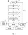
- Referring now to
FIG. 2 a diagram of process (200) is shown to generally describe the acts performed by the “translation engine” when processing a user's query.Process 200 is described based on an embodiment utilizing an interpretation technique for clarity. However, it should be understood that other techniques generally known to those of skill in the art (e.g., source to source compilation, cross compilation, etc. could also be used). Furthermore, these other techniques can also be considered a special case of the more general interpretation technique. Process 200 is an iterative process. That is, for a single visualization result to be rendered for presentation to a user several iterations ofprocess 200 may be required. The iterative nature is shown by the dotted line (270) connecting the termination point (260) to the starting point (210) ofprocess 200. The number of iterations may be dependent upon how a user structures the AGL program text (210). For a given visualization it may be possible for a user to describe the entire visualization in one “hunk” of AGL text represented at the start of the program or a user may elect to describe the visualization using several distinct “hunks” of program text that are fed sequentially to the translation engine to converge upon a visualization.Process 200 begins withblock 210 when the AGL text program (or program hunk) that is given to the translation engine as input from a user. Next, atblock 215, Lexing is performed. Lexing is the process of carving the program text into individual words (called lexemes) and establishing each lexeme's roles within the text. Lexing is somewhat similar to diagramming a sentence from a natural language. Next, flow continues to block220 where parsing is performed. Parsing is the process of examining the lexemes and ensuring they conform to the grammar of the AGL language (formally, the context free grammar). Next, flow continues to block225 to generate an intermediary representation. This is the process of changing the input from a text oriented representation into a more data structure driven representation in order to make computational analysis and interpretation easier.- After the intermediary representation has been generated, a context sensitive analysis is performed at
block 230. This is the process of verifying that the semantics of the program are logical. For example, there are many grammatically valid English sentences that are nonsensical, e.g. “The dog bit his wing.” Grammatically valid, but illogical since dogs do not have wings. The goal of context sensitive analysis (CSA) is to detect similar types of errors in program text—for example invoking a three argument function but only passing two arguments. - At
block 235 optimization may be performed. Optimization is the process of transforming the intermediary representation into a new semantically equivalent intermediary representation that is in some way more desirable than the former representation. - Interpretation is performed at
block 240 and is the process of examining the program in intermediary representation form and computing the result of that program. During interpretation, zero or more of the sub processes ofblocks Block 245 represents “Environmental Modification/Retrieval” which is the process of representing and retrieving the state of an ongoing program. This state may influence the result of the current program hunk or future program hunks. For example, if the AGL program hunk where “Num j=3;” this is the part of the system that tracks the assignment of j to three and also provides the value of j to future uses of j in the current or upcoming program hunks.Block 250 represents “Adaptation” which is the process of outputting a visualization element to one of the “geospatial data servers.” In the example of NASA World Wind this could be the act of drawing a point or line on the screen, or in the case of Google Maps, adding a new line of JavaScript code to a file on disk.Block 255 represents “Input/Output” which is the process of showing non visualization results, e.g. textual components, to a user or other types of interaction such as but not limited to, user interaction, web services requests, socket connections, etc. After interpretation is completed flow continues to block260 where another iteration may be performed. - AGL may also be used to provide for persistent queries where the visualization is updated periodically either via a timer or based on changes in the underlying data. AGL may further be used to provide delta visualization of data changes between different points in time. AGL may still further be used to provide analytical capability such as rendering of a pie chart or histogram associated with the geospatial data being visualized, derived from geospatial data or data generated by the environment itself.
- The description above is presented to enable any person skilled in the art to make and use the invention as claimed and is provided in the context of the particular examples discussed above, variations of which will be readily apparent to those skilled in the art. Accordingly, the claims appended hereto are not intended to be limited by the disclosed embodiments, but are to be accorded their widest scope consistent with the principles and features disclosed herein. Also, the foregoing examples have been presented in the context of a human generating the dynamic queries allowed within AGL. It is also possible for a computer program to utilize this same dynamic interface.
- One of skill in the art, given the benefit of this disclosure, will recognize that the inventive nature of this disclosure is not limited to the airline industry. Other examples of industries and uses include but are not limited to: marketing where AGL could study the effectiveness of advertising campaigns in different geographies; environmental impact monitoring where AGL could visualize which operational centers are impacted by a weather event; health monitoring where AGL could be used to visualize health impacts based on pollution reports or clinical diagnostic reports; travel by providing visualization of regional content (e.g., all gas stations within 15 miles with unleaded less than $3.90); realty where AGL could visualize house searching information based on purchase criteria; etc.
- Various changes in the details of the illustrated operational methods are possible without departing from the scope of the following claims. For instance,
illustrative interpretation process 200 may perform the identified steps in an order different from that disclosed here. Alternatively, some embodiments may combine the activities described herein as being separate steps. Similarly, one or more of the described steps may be omitted, depending upon the specific operational environment the method is being implemented in. In addition, acts in accordance withFIGS. 1 and 2 may be performed by a programmable control device executing instructions organized into one or more program modules. A programmable control device may be a single computer processor, a special purpose processor (e.g., a digital signal processor, “DSP”), a plurality of processors coupled by a communications link or a custom designed state machine. Custom designed state machines may be embodied in a hardware device such as an integrated circuit including, but not limited to, application specific integrated circuits (“ASICs”) or field programmable gate array (“FPGAs”). Storage devices for persistently storing information, sometimes referred to as computer readable medium, suitable for tangibly embodying program instructions include, but are not limited to: magnetic disks (fixed, floppy, and removable) and tape; optical media such as CD-ROMs and digital video disks (“DVDs”); and semiconductor memory devices such as Electrically Programmable Read-Only Memory (“EPROM”), Electrically Erasable Programmable Read-Only Memory (“EEPROM”), Programmable Gate Arrays and flash devices.
Claims (20)
Priority Applications (1)
| Application Number | Priority Date | Filing Date | Title |
|---|---|---|---|
| US12/330,204US8250052B2 (en) | 2008-12-08 | 2008-12-08 | Geospatial data interaction |
Applications Claiming Priority (1)
| Application Number | Priority Date | Filing Date | Title |
|---|---|---|---|
| US12/330,204US8250052B2 (en) | 2008-12-08 | 2008-12-08 | Geospatial data interaction |
Publications (2)
| Publication Number | Publication Date |
|---|---|
| US20100145979A1true US20100145979A1 (en) | 2010-06-10 |
| US8250052B2 US8250052B2 (en) | 2012-08-21 |
Family
ID=42232223
Family Applications (1)
| Application Number | Title | Priority Date | Filing Date |
|---|---|---|---|
| US12/330,204Expired - Fee RelatedUS8250052B2 (en) | 2008-12-08 | 2008-12-08 | Geospatial data interaction |
Country Status (1)
| Country | Link |
|---|---|
| US (1) | US8250052B2 (en) |
Cited By (11)
| Publication number | Priority date | Publication date | Assignee | Title |
|---|---|---|---|---|
| US20120013609A1 (en)* | 2009-12-11 | 2012-01-19 | Nokia Corporation | Method and apparatus for presenting a first person world view of content |
| US20120159459A1 (en)* | 2010-12-17 | 2012-06-21 | Cisco Technology, Inc. | Optimizing symbol manipulation language-based executable applications for distributed execution |
| US20120197880A1 (en)* | 2011-01-28 | 2012-08-02 | Raytheon Company | System, method, and logic for optimized geospatial data delivery |
| US20120331472A1 (en)* | 2011-06-27 | 2012-12-27 | Cisco Technology, Inc. | Ad hoc generation of work item entity for geospatial entity based on symbol manipulation language-based workflow item |
| US8380700B2 (en)* | 2011-04-13 | 2013-02-19 | Cisco Technology, Inc. | Ad hoc geospatial directory of users based on optimizing non-Turing complete executable application |
| US20140180688A1 (en)* | 2012-12-20 | 2014-06-26 | Samsung Electronics Co. Ltd. | Speech recognition device and speech recognition method, data base for speech recognition device and constructing method of database for speech recognition device |
| US9311334B2 (en) | 2010-08-25 | 2016-04-12 | International Business Machines Corporation | Geospatial database integration using business models |
| EP3279815A1 (en)* | 2016-08-03 | 2018-02-07 | Palantir Technologies Inc. | Geographic data management server |
| US10685228B2 (en)* | 2017-01-12 | 2020-06-16 | Sentera, Inc. | Multiple day mapping index aggregation and comparison |
| CN111814017A (en)* | 2020-05-22 | 2020-10-23 | 云南电网有限责任公司信息中心 | A method and computer program product for automatic data release in a unified coordinate system |
| US20210081451A1 (en)* | 2019-09-12 | 2021-03-18 | Business Objects Software Ltd. | Persisted queries and batch streaming |
Families Citing this family (3)
| Publication number | Priority date | Publication date | Assignee | Title |
|---|---|---|---|---|
| US9286720B2 (en)* | 2009-08-20 | 2016-03-15 | Northrop Grumman Systems Corporation | Locative video for situation awareness |
| US9424291B2 (en) | 2013-05-13 | 2016-08-23 | Microsoft Technology Licensing, Llc | Efficient multi-tenant spatial and relational indexing |
| US10083187B2 (en) | 2015-08-28 | 2018-09-25 | International Business Machines Corporation | Generating geographic borders |
Citations (24)
| Publication number | Priority date | Publication date | Assignee | Title |
|---|---|---|---|---|
| US20010014888A1 (en)* | 1993-01-20 | 2001-08-16 | Hitachi, Ltd. | Database management system and method for query process for the same |
| US20030212863A1 (en)* | 1998-12-23 | 2003-11-13 | Novell, Inc. | Predicate indexing of data stored in a computer with application to indexing cached data |
| US20040044469A1 (en)* | 2002-09-03 | 2004-03-04 | Thorsten Bender | Displaying road maps |
| US20040085318A1 (en)* | 2002-10-31 | 2004-05-06 | Philipp Hassler | Graphics generation and integration |
| US20040088346A1 (en)* | 2002-10-31 | 2004-05-06 | Philipp Hassler | Geo-server interface |
| US20040103117A1 (en)* | 2002-11-27 | 2004-05-27 | Michael Segler | Building a geographic database |
| US20060041599A1 (en)* | 1993-01-20 | 2006-02-23 | Masahi Tsuchida | Database management system and method for query process for the same |
| US20060047696A1 (en)* | 2004-08-24 | 2006-03-02 | Microsoft Corporation | Partially materialized views |
| US20060117299A1 (en)* | 2004-11-23 | 2006-06-01 | International Business Machines Corporation | Methods and apparatus for monitoring program execution |
| US20060190461A1 (en)* | 2005-02-18 | 2006-08-24 | Schaefer Brian M | Apparatus, system, and method for managing objects in a database according to a dynamic predicate representation of an explicit relationship between objects |
| US20060218129A1 (en)* | 2005-03-24 | 2006-09-28 | International Business Machines Corporation | Dynamic look ahead predicate generation |
| US20070050356A1 (en)* | 2005-08-23 | 2007-03-01 | Amadio William J | Query construction for semantic topic indexes derived by non-negative matrix factorization |
| US20070136291A1 (en)* | 2005-12-12 | 2007-06-14 | Bird Paul M | Access control for elements in a database object |
| US20070198586A1 (en)* | 2006-02-22 | 2007-08-23 | Hardy Mark D | Methods and apparatus for providing a configurable geospatial data provisioning framework |
| US7281000B2 (en)* | 2001-04-20 | 2007-10-09 | Microsoft Corporation | Method for efficient query execution using dynamic queries in database environments |
| US20070288526A1 (en)* | 2006-06-08 | 2007-12-13 | Emc Corporation | Method and apparatus for processing a database replica |
| US20080154866A1 (en)* | 2004-06-30 | 2008-06-26 | International Business Machines Corp. | System and method for creating dynamic folder hierarchies |
| US20080226195A1 (en)* | 2007-03-13 | 2008-09-18 | Maykel Martin | Generating an Amalgamated Image Including a Static Image and a Dynamic Image |
| US20090002367A1 (en)* | 2007-06-27 | 2009-01-01 | Sean Alexis | Method and system for a communications information interface |
| US20090088183A1 (en)* | 2007-10-02 | 2009-04-02 | Piersol Kurt W | Geographically self-labeling access points |
| US20090319521A1 (en)* | 2008-06-18 | 2009-12-24 | Microsoft Corporation | Name search using a ranking function |
| US20100100540A1 (en)* | 2008-10-16 | 2010-04-22 | Curators Of The University Of Missouri | Revising imagery search results based on user feedback |
| US20100185668A1 (en)* | 2007-04-20 | 2010-07-22 | Stephen Murphy | Apparatuses, Methods and Systems for a Multi-Modal Data Interfacing Platform |
| US7933929B1 (en)* | 2005-06-27 | 2011-04-26 | Google Inc. | Network link for providing dynamic data layer in a geographic information system |
- 2008
- 2008-12-08USUS12/330,204patent/US8250052B2/ennot_activeExpired - Fee Related
Patent Citations (28)
| Publication number | Priority date | Publication date | Assignee | Title |
|---|---|---|---|---|
| US20060041599A1 (en)* | 1993-01-20 | 2006-02-23 | Masahi Tsuchida | Database management system and method for query process for the same |
| US20010014888A1 (en)* | 1993-01-20 | 2001-08-16 | Hitachi, Ltd. | Database management system and method for query process for the same |
| US20030212863A1 (en)* | 1998-12-23 | 2003-11-13 | Novell, Inc. | Predicate indexing of data stored in a computer with application to indexing cached data |
| US7281000B2 (en)* | 2001-04-20 | 2007-10-09 | Microsoft Corporation | Method for efficient query execution using dynamic queries in database environments |
| US20040044469A1 (en)* | 2002-09-03 | 2004-03-04 | Thorsten Bender | Displaying road maps |
| US20040085318A1 (en)* | 2002-10-31 | 2004-05-06 | Philipp Hassler | Graphics generation and integration |
| US20040088346A1 (en)* | 2002-10-31 | 2004-05-06 | Philipp Hassler | Geo-server interface |
| US20040103117A1 (en)* | 2002-11-27 | 2004-05-27 | Michael Segler | Building a geographic database |
| US20080154866A1 (en)* | 2004-06-30 | 2008-06-26 | International Business Machines Corp. | System and method for creating dynamic folder hierarchies |
| US20060047696A1 (en)* | 2004-08-24 | 2006-03-02 | Microsoft Corporation | Partially materialized views |
| US20060117299A1 (en)* | 2004-11-23 | 2006-06-01 | International Business Machines Corporation | Methods and apparatus for monitoring program execution |
| US20060190461A1 (en)* | 2005-02-18 | 2006-08-24 | Schaefer Brian M | Apparatus, system, and method for managing objects in a database according to a dynamic predicate representation of an explicit relationship between objects |
| US20080052282A1 (en)* | 2005-03-24 | 2008-02-28 | International Business Machines Corporation | Dynamic look ahead predicate generation |
| US20060218129A1 (en)* | 2005-03-24 | 2006-09-28 | International Business Machines Corporation | Dynamic look ahead predicate generation |
| US7933929B1 (en)* | 2005-06-27 | 2011-04-26 | Google Inc. | Network link for providing dynamic data layer in a geographic information system |
| US20070050356A1 (en)* | 2005-08-23 | 2007-03-01 | Amadio William J | Query construction for semantic topic indexes derived by non-negative matrix factorization |
| US20070136291A1 (en)* | 2005-12-12 | 2007-06-14 | Bird Paul M | Access control for elements in a database object |
| US20080275880A1 (en)* | 2005-12-12 | 2008-11-06 | International Business Machines Corporation | Access control for elements in a database object |
| US20070198586A1 (en)* | 2006-02-22 | 2007-08-23 | Hardy Mark D | Methods and apparatus for providing a configurable geospatial data provisioning framework |
| US20070288526A1 (en)* | 2006-06-08 | 2007-12-13 | Emc Corporation | Method and apparatus for processing a database replica |
| US20080226195A1 (en)* | 2007-03-13 | 2008-09-18 | Maykel Martin | Generating an Amalgamated Image Including a Static Image and a Dynamic Image |
| US20100185668A1 (en)* | 2007-04-20 | 2010-07-22 | Stephen Murphy | Apparatuses, Methods and Systems for a Multi-Modal Data Interfacing Platform |
| US20090002367A1 (en)* | 2007-06-27 | 2009-01-01 | Sean Alexis | Method and system for a communications information interface |
| US20090088183A1 (en)* | 2007-10-02 | 2009-04-02 | Piersol Kurt W | Geographically self-labeling access points |
| US20090319521A1 (en)* | 2008-06-18 | 2009-12-24 | Microsoft Corporation | Name search using a ranking function |
| US20100100540A1 (en)* | 2008-10-16 | 2010-04-22 | Curators Of The University Of Missouri | Revising imagery search results based on user feedback |
| US20100100548A1 (en)* | 2008-10-16 | 2010-04-22 | Curators Of The University Of Missouri | Storing change features detected from high-resolution, remotely sensed imagery |
| US20100100835A1 (en)* | 2008-10-16 | 2010-04-22 | Curators Of The University Of Missouri | Visualizing geographic-area change detected from high-resolution, remotely sensed imagery |
Cited By (16)
| Publication number | Priority date | Publication date | Assignee | Title |
|---|---|---|---|---|
| US20120013609A1 (en)* | 2009-12-11 | 2012-01-19 | Nokia Corporation | Method and apparatus for presenting a first person world view of content |
| US8812990B2 (en)* | 2009-12-11 | 2014-08-19 | Nokia Corporation | Method and apparatus for presenting a first person world view of content |
| US9311334B2 (en) | 2010-08-25 | 2016-04-12 | International Business Machines Corporation | Geospatial database integration using business models |
| US20120159459A1 (en)* | 2010-12-17 | 2012-06-21 | Cisco Technology, Inc. | Optimizing symbol manipulation language-based executable applications for distributed execution |
| US8762964B2 (en)* | 2010-12-17 | 2014-06-24 | Cisco Technology, Inc. | Optimizing symbol manipulation language-based executable applications for distributed execution |
| US20120197880A1 (en)* | 2011-01-28 | 2012-08-02 | Raytheon Company | System, method, and logic for optimized geospatial data delivery |
| US8577905B2 (en)* | 2011-01-28 | 2013-11-05 | Raytheon Company | System, method, and logic for optimized geospatial data delivery |
| US8380700B2 (en)* | 2011-04-13 | 2013-02-19 | Cisco Technology, Inc. | Ad hoc geospatial directory of users based on optimizing non-Turing complete executable application |
| US20120331472A1 (en)* | 2011-06-27 | 2012-12-27 | Cisco Technology, Inc. | Ad hoc generation of work item entity for geospatial entity based on symbol manipulation language-based workflow item |
| US8612279B2 (en)* | 2011-06-27 | 2013-12-17 | Cisco Technology, Inc. | Ad hoc generation of work item entity for geospatial entity based on symbol manipulation language-based workflow item |
| US20140180688A1 (en)* | 2012-12-20 | 2014-06-26 | Samsung Electronics Co. Ltd. | Speech recognition device and speech recognition method, data base for speech recognition device and constructing method of database for speech recognition device |
| EP3279815A1 (en)* | 2016-08-03 | 2018-02-07 | Palantir Technologies Inc. | Geographic data management server |
| US10685228B2 (en)* | 2017-01-12 | 2020-06-16 | Sentera, Inc. | Multiple day mapping index aggregation and comparison |
| US20210081451A1 (en)* | 2019-09-12 | 2021-03-18 | Business Objects Software Ltd. | Persisted queries and batch streaming |
| US11790008B2 (en)* | 2019-09-12 | 2023-10-17 | Business Objects Software Ltd. | Persisted queries and batch streaming |
| CN111814017A (en)* | 2020-05-22 | 2020-10-23 | 云南电网有限责任公司信息中心 | A method and computer program product for automatic data release in a unified coordinate system |
Also Published As
| Publication number | Publication date |
|---|---|
| US8250052B2 (en) | 2012-08-21 |
Similar Documents
| Publication | Publication Date | Title |
|---|---|---|
| US8250052B2 (en) | Geospatial data interaction | |
| CN106547809B (en) | Representing compound relationships in a graph database | |
| US10698924B2 (en) | Generating partitioned hierarchical groups based on data sets for business intelligence data models | |
| Schwinger et al. | A survey on web modeling approaches for ubiquitous web applications | |
| Król et al. | Aggregated indices in website quality assessment | |
| US20150006432A1 (en) | Ontology-driven construction of semantic business intelligence models | |
| US7904491B2 (en) | Data mapping and import system | |
| US20150186808A1 (en) | Contextual data analysis using domain information | |
| US10936557B2 (en) | Relational database schema generation | |
| CN116594683A (en) | Code annotation information generation method, device, equipment and storage medium | |
| Lopez-Pellicer et al. | An ontology for the representation of spatiotemporal jurisdictional domains in information retrieval systems | |
| CN117453523A (en) | GIS test data generation device and method based on strategy configuration easy expansion | |
| Alvarado et al. | Developing web-based geographic information systems with a dsl: proposal and case study | |
| Figueiredo et al. | Moredata: A geospatial data enrichment framework | |
| Herbreteau et al. | GeoHealth and QuickOSM, two QGIS plugins for health applications | |
| Coruhlu et al. | Data model development for ‘buying and selling’transactions as a real estate acquisition method | |
| Rousseaux et al. | Rapid software prototyping using ajax and google map api | |
| Mohammed | Free and Open Source GIS: an overview on the recent evolution of projects, standards and communities | |
| Petrova-Antonova et al. | Conceptual architecture of GATE big data platform | |
| Keßler | Design and implementation of argumentation maps | |
| Migliaccio et al. | A prototype HGIS for managing earthquake data from historical documents | |
| Çağdaş et al. | Semantic Resources for the Geospatial Domain | |
| Glorio et al. | Using web-based personalization on spatial data warehouses | |
| US20200250275A1 (en) | Geographic location specific models for information extraction and knowledge discovery | |
| Harper et al. | From text to map: Combing named entity recognition and geographic information systems |
Legal Events
| Date | Code | Title | Description |
|---|---|---|---|
| AS | Assignment | Owner name:CONTINENTAL AIRLINES, INC.,TEXAS Free format text:ASSIGNMENT OF ASSIGNORS INTEREST;ASSIGNOR:BARNETT, ROBERT MATTHEW;REEL/FRAME:021940/0244 Effective date:20081117 Owner name:CONTINENTAL AIRLINES, INC., TEXAS Free format text:ASSIGNMENT OF ASSIGNORS INTEREST;ASSIGNOR:BARNETT, ROBERT MATTHEW;REEL/FRAME:021940/0244 Effective date:20081117 | |
| ZAAA | Notice of allowance and fees due | Free format text:ORIGINAL CODE: NOA | |
| ZAAB | Notice of allowance mailed | Free format text:ORIGINAL CODE: MN/=. | |
| STCF | Information on status: patent grant | Free format text:PATENTED CASE | |
| AS | Assignment | Owner name:UNITED AIRLINES, INC., ILLINOIS Free format text:MERGER AND CHANGE OF NAME;ASSIGNORS:UNITED AIR LINES, INC.;CONTINENTAL AIRLINES, INC.;REEL/FRAME:033670/0383 Effective date:20130328 | |
| FPAY | Fee payment | Year of fee payment:4 | |
| SULP | Surcharge for late payment | ||
| MAFP | Maintenance fee payment | Free format text:PAYMENT OF MAINTENANCE FEE, 8TH YEAR, LARGE ENTITY (ORIGINAL EVENT CODE: M1552); ENTITY STATUS OF PATENT OWNER: LARGE ENTITY Year of fee payment:8 | |
| FEPP | Fee payment procedure | Free format text:MAINTENANCE FEE REMINDER MAILED (ORIGINAL EVENT CODE: REM.); ENTITY STATUS OF PATENT OWNER: LARGE ENTITY | |
| LAPS | Lapse for failure to pay maintenance fees | Free format text:PATENT EXPIRED FOR FAILURE TO PAY MAINTENANCE FEES (ORIGINAL EVENT CODE: EXP.); ENTITY STATUS OF PATENT OWNER: LARGE ENTITY | |
| STCH | Information on status: patent discontinuation | Free format text:PATENT EXPIRED DUE TO NONPAYMENT OF MAINTENANCE FEES UNDER 37 CFR 1.362 | |
| FP | Lapsed due to failure to pay maintenance fee | Effective date:20240821 |