US20070176932A1 - Design of arbitrary linear and non-linear maps - Google Patents
Design of arbitrary linear and non-linear mapsDownload PDFInfo
- Publication number
- US20070176932A1 US20070176932A1US11/344,827US34482706AUS2007176932A1US 20070176932 A1US20070176932 A1US 20070176932A1US 34482706 AUS34482706 AUS 34482706AUS 2007176932 A1US2007176932 A1US 2007176932A1
- Authority
- US
- United States
- Prior art keywords
- map
- linear
- vertex
- map image
- triangles
- Prior art date
- Legal status (The legal status is an assumption and is not a legal conclusion. Google has not performed a legal analysis and makes no representation as to the accuracy of the status listed.)
- Granted
Links
Images


Classifications
- G—PHYSICS
- G06—COMPUTING OR CALCULATING; COUNTING
- G06T—IMAGE DATA PROCESSING OR GENERATION, IN GENERAL
- G06T3/00—Geometric image transformations in the plane of the image
- G06T3/14—Transformations for image registration, e.g. adjusting or mapping for alignment of images
- G06T3/153—Transformations for image registration, e.g. adjusting or mapping for alignment of images using elastic snapping
Definitions
- the present subject matterrelates to the field of computing, and more particularly, to software mapping.
- Maps that do not have a linear mapping to real world spaceare very common and useful, but can be difficult to use with generic software systems.
- Examples of such non-linear mapsinclude: subway maps, ski-maps, industrial diagrams and infrastructure diagrams (e.g. maps of power grids, telecommunications grids and wide area transportation maps).
- non-linear mapspresent an irregular representation of physical space, they are able to convey a great deal of useful information in a small display.
- it is difficult to display real world location data on top of non-linear mapsbecause the mapping from latitude, longitude, and altitude (or other physical world coordinate systems) to a position on such irregularly spaced maps is complex and irregular.
- At least two key difficultiesarise: (1) the ability to map real-world locations onto the irregularly spaced maps, (2) the ability to map points on the irregularly spaced maps into physical world coordinates.
- Certain techniquescan be used for extrapolating the location of map-points on top of non-linear, irregularly spaced maps. Typically these techniques work by attempting to extrapolate location data from nearby points, but this can be complex, time consuming, and error-prone—particularly in systems where the map's data is irregularly spaced. Thus, it would be advantageous to provide other techniques that allow users to make the design-time and run-time use of non-linear mapping techniques that are fast, simple, and accessible to moderately skilled programmers and other individuals who are not experts in map-design, complex math or cartography.
- a first map image and a second map imagemay be provided.
- a plurality of dual-trianglesmay be mapped onto the first map image and the second map image, where the plurality of dual-triangles have the same vertices in the second map image as in the first map image—yet these maps may be completely different.
- the first map imagemay be a linear street map and the second map image may be a non-linear subway map. Because any points that are converted from the first map image to the second map image (or vice versa) are converted symmetrically, such points will end up in the appropriate relation to the vertices of the dual-triangles.
- At least one of the plurality of dual-trianglescan be selected into a region to be converted from the first map image to the second map image.
- Such regionsmay help users and developers to hone in on best information-conveying maps (or portions thereof).
- such regionsmay also be used to exclude maps or portions thereof so that such regions are not be converted.
- the plurality of dual-trianglesmay also be subdivided into more sub-triangles or aggregated into more comprehensive triangles.
- FIG. 1illustrates the ability of the presently disclosed subject matter to switch back and forth between linear and non-linear maps
- FIG. 2illustrates that the spatial relationship between points mapped onto linear map may differ from the spatial relationship between points mapped onto a non-linear map
- FIG. 3illustrates that the spatial relationship between points mapped onto a linear map may at times be the same or similar as the spatial relationship between points mapped onto a non-linear map
- FIG. 4illustrates a portion of a representative non-linear map, where different parts of the non-linear map may have different transformations applied to them, making the non-liner map's representation significantly different from the “street map” of the same area;
- FIG. 5illustrates how a non-linear map can be annotated by mapping software to highlight regions to be transformed into a linear mapping, with the regions being defined by six exemplary triangles;
- FIG. 6illustrates how the same six triangles depicted in FIG. 5 would map onto a linear map, and how the shape of these triangles can differ from the shape of the same triangles that were mapped onto a non-linear map, thus suggesting how map space gets distorted in a non-linear context;
- FIG. 7Aillustrates a full set of triangles that have been mapped onto a non-linear map, with the six triangles discussed with reference to FIGS. 5 and 6 depicted along side this full set of triangles, where the full set of triangles forms a mapping of a non-linear space to a linear space;
- FIG. 7Billustrates how triangular regions configured for conversion may be subdivided at various levels of granularity to provide more accurate results
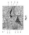
- FIG. 8illustrates the same mapping shown in FIG. 7 , but this time in the context of a linear map, thereby demonstrating how the full set of triangles and the accompanying six highlighted triangles change in a linear setting (vis-à-vis a non-linear setting);
- FIG. 9illustrates how a set of regions can be used to specify the boundaries of a mapping from a linear map to a non-linear map, and by analogy, vice versa;
- FIG. 10illustrates in a mathematical diagram (with included steps) how a conversion from a non-linear map to a linear map might occur, and thereby showing how the opposite conversion may occur—by following the illustrated steps in reverse;
- FIG. 11illustrates how a round trip conversion, from a non-linear map to a linear map and back to a non-linear map—or vice versa—produces no spatial distortion for plotted data, thereby showing the quality of various transformation algorithms that can be visually evaluated;
- FIG. 12Aillustrates, in contrast to FIG. 11 , how conversion distortions may occur for algorithms that are inferior to those illustrated in FIG. 10 and used in FIG. 11 ;
- FIG. 12Billustrates in detail the kind of distortions that are shown in FIG. 12A —distortions that the presently disclosed subject matter avoids by using algorithms such as those illustrated in FIG. 10 ;
- FIG. 13illustrates yet another way to depict conversion distortions, such as those illustrated in FIGS. 12A and 12B .
- FIG. 14illustrates the notion that some areas don't have to be (or have not been marked as) supporting conversion from a linear map to a non-linear map—or vice versa—by showing specific regions that are highlighted as not-supporting coordinate conversion;
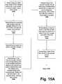
- FIG. 15Aillustrates an exemplary block diagram of a conversion process either from linear maps to non-linear maps, or vice versa;
- FIG. 15Bcontinues the illustration of FIG. 15A , illustrating an exemplary block diagram of a conversion process either from linear maps to non-linear maps, or vice versa;
- FIG. 16illustrates an exemplary application programming interface for various aspect of the presently disclosed subject matter.
- FIG. 1illustrates the ability of switching back and forth between linear and non-linear maps.
- FIG. 1depicts the desirability of users to switch between linear maps (e.g. street maps) and non-linear maps (e.g. subway or transport maps). By shifting between different maps, users can quickly determine the distance, direction, and mode of transport to arrive at a desired location, or to meet other individuals, or for still other purposes.
- linear mapse.g. street maps
- non-linear mapse.g. subway or transport maps
- a non-linear subway map 104may depict two people as points on the map 104 , the first point being “Bob” 110 and the second point being “Julie” 112 , where “Julie” 112 has a signpost pointing to her.
- “Bob” 110 and “Julie” 112may want to meet at some point, and the way to accomplish this may be by taking a subway or a “tube”. If “Bob” 110 wants to meet “Julie” 112 he can take the appropriate train by examining the non-linear subway map 104 . Once he's above ground, he may want to switch to a linear map 106 .
- a user of such a non-linear map 104may want to switch 100 to a linear map 106 depicting physical landmarks in linear proportionality to each other because such linear representation may be more intuitive in certain contexts.
- “Bob” 110 and “Julie” 112are again depicted, but this time their location is shown on a linear scale, as opposed to a non-linear scale in the previous map 104 .
- “Bob” 110may want to switch back to a non-linear map after a while—even if the non-linear map has changed over time.
- “Bob” 110can switch 102 from the linear map 106 discussed above to a new non-linear map 108 .
- “Julie” 112is depicted as a point and Bob 110 is depicted as a signpost. Now the relationship between “Bob” 110 and “Julie” 112 may be non-linear vis-à-vis any physical landmarks (where it might have been linear in the previous map 106 ).
- This type of switching back and forth between linear and non-linear mapscan be done indefinitely. And importantly, such switching may be done without any distortions as to the actual location of “Bob” 110 and “Julie” 112 on the linear and non-linear maps.
- the present aspect of the disclosed subject matterovercomes distortions of points placed on maps that result from the eventual aggregation of errors associated with each switch between a linear and non-linear map—and vice versa.
- FIG. 2illustrates that the spatial relationship between points mapped onto linear map may differ from the spatial relationship between points mapped onto a non-linear map.
- Bob 206on the linear “street map” 200 , Bob 206 (left side) appears below Julie 204 (right side), yet on the non-linear/irregular subway map 202 , Bob 206 appears above Julie 204 .
- Such kinds of shifts in relative display positionare common as one moves between linear and non-linear maps.
- the non-linear mapmay have various regions of its map stretched, rotated, compressed, and so on.
- Bob 206 and Julie 204may be at the exact same locations in the linear map 200 as the non-linear map 202 , their positions relative to each other and relative to the maps may differ. For instance, in FIG. 2 , Julie 204 is located near “Charing Cross” both in the linear map 200 and the non-linear map. Bob 206 , likewise, is located near “Green Park” on both maps 200 and 202 . Yet, their positions vis-à-vis each other, as mentioned above, change between the two maps 200 and 202 . Moreover, even if their positions don't change vis-à-vis each other, they can change in going from one map to the other (due to map distortion, especially in the non-linear case).
- the spatial relationship between points mapped onto a linear mapmay at times be the same or similar as the spatial relationship between points mapped onto a non-linear map.
- Bob 306has practically the same orientation vis-à-vis Julie 304 in the linear map 300 as the non-linear map 302 .
- the distance between Bob 306 and Julie 304is practically the same in both maps 300 and 302 .
- thismay be more of an exception than the rule, and in a substantial number of such conversions, orientations, distances, etc., between mapped points on different maps will differ—and hence the ability of the presently disclosed subject matter to cope with such situations.
- FIG. 4illustrates a portion of a representative non-linear map, where different parts of the non-linear map may have different transformations applied to them, making the non-liner map's representation significantly different from the “street map” of the same area.
- FIG. 4also servers as a basis for the discussion concerning a majority of the figures to follow, especially FIGS. 5-8 , and 11 - 16 ).
- This particular non-linear map 400shows the London Underground “Tube” map. To illustrate the non-linear nature of this map 400 , it is instructive to focus on a couple of stations illustrated therein. For example, “Oxford Circus” 402 is shown, as is “Tottenham Court Road” 404 , “Weston Street” 406 , and “Goodge Street” 408 —the first three of these four stations define a triangle between them. From FIG. 4 , it appears as if “Goodge Street” 408 is a lot closer to “Tottenham Court Road” 404 than it is to “Warren Street” 406 .
- FIG. 5illustrates how a non-linear map can be annotated by mapping software to highlight regions to be transformed into a linear mapping, with the regions being defined by six exemplary triangles.
- T 1 502has its vertices between “Russell Square,” “Holborn,” and “Chancery Lane.”
- T 2 504has its vertices between “Holborn,” “Chancery Lane,” and “Mansion House,” and so on.
- T 3 506is sharing a vertex with T 1 502 and T 2 504 , namely, “Holborn,” but it is not contiguous—as neither are T 4 508 , T 5 510 , and T 6 512 .
- These six exemplary trianglesdefine the regions that are to be converted from a non-linear map to a linear map (shown in FIG. 6 ). Their particular shapes will be contorted by the transformation, and hence, so will the data in those triangles.
- FIG. 6it illustrates how the same six triangles depicted in FIG. 5 would map onto a linear map, and how the shape of these triangles can differ from the shape of the same triangles that were mapped onto a non-linear map, thus suggesting how map space gets distorted in a non-linear context.
- This distortionis clear in terms of the shapes of triangles T 1 602 , T 2 604 , T 3 606 , T 4 608 , T 5 610 , and T 6 612 , shown in FIG. 6 , as compared to the same triangles T 1 502 , T 2 504 , T 3 506 , T 4 508 , T 5 510 , and T 6 512 , shown in FIG. 5 .
- triangle T 1 602 in FIG. 6may have the same three vertices as triangle T 1 502 in FIG. 5 —and the same may hold true for all the other remaining triangles in FIGS. 5 and 6 .
- FIG. 7Aillustrates a full set of triangles that have been mapped onto a non-linear map (where this map is shown without the triangles in FIG. 4 ).
- the six triangles discussed with reference to FIGS. 5 and 6are depicted along side this full set of triangles, where the full set of triangles forms a mapping of non-linear space to linear space.
- a typical non-linear map 700is divided into some set of triangles, as exemplified by triangles 714 , 716 , and 718 (referenced in “dashed” lines for readability purposes) and the now-familiar triangles T 1 702 , T 2 704 , T 3 706 , T 4 708 , T 5 710 , and T 6 712 , discussed with reference to FIGS. 5 and 6 .
- the set of mapping trianglesmay have their vertices set at known locations, such as a “Tube” stations of the London Underground.
- the level of granularity of the verticeswill be context and design dependent. For instance, triangles may be set every other tube stop or several vertices between any two tube stops may be used.
- the size and number of the triangles depicted in FIG. 7Ais merely exemplary and not limiting. Other kinds of triangles could be used, as those of skill in the art will readily appreciate.
- FIG. 7Billustrates how triangular regions configured for conversion may be subdivided at various levels of granularity to provide more accurate results.
- one triangle 724is defined between “Oxford Circus,” “Regent's Park,” and “Warren Street.”
- this triangle 724is twice subdivided: once into three triangles and then again into nine triangles.
- Triangles 726 and 728are representative of the nine triangles which are contained within the original triangle 724 . As mentioned, subdivision is only one option—the opposite can occur—that is, triangles may also be combined to define larger triangles.
- the triangular mapping considered so farcan be one from a Cartesian X/Y plane of the non-linear map onto any real-world coordinates such as latitude and longitude (including altitude, if a third coordinate Z is included in the Cartesian space).
- any real-world coordinatessuch as latitude and longitude (including altitude, if a third coordinate Z is included in the Cartesian space).
- GPSGlobal Positioning System
- FIG. 8illustrates the same mapping shown in FIG. 7 , but this time in the context of a linear map, thereby demonstrating how the full set of triangles and the accompanying six highlighted triangles change in a linear setting (vis-à-vis the non-linear setting of FIG. 7 ).
- the six highlighted triangles T 1 802 , T 2 804 , T 3 806 , T 4 808 , T 5 810 , and T 6 812alongside some of the non-highlighted triangles 814 , 816 , and 818 , have been distorted during the conversion to the linear map 800 .
- the vertices of the triangles in FIG. 7 and FIG. 8may remain the same.
- FIG. 9illustrates how a set of regions can be used to specify the boundaries of a mapping from a linear map to a non-linear map, and by analogy, vice versa.
- FIG. 9shows a set of coarse bounding regions that a user, developer or map-designer can specify that the non-liner or irregular subway/tube map of FIG. 4 should be applicable for.
- the developer or map-designeris given a good visual understanding of the geographic area covered by the non-linear map.
- these coarse bounding regionsneed not cover all the areas defined by triangles; the map's designer can choose only the areas best covered by the non-linear map.
- a developermay select several regions, R 1 914 , R 2 916 , R 3 918 , R 4 920 , R 5 922 , R 6 924 , and R 7 927 . These regions may together cover the relevant portion of the subway that the developer (or user) may want to focus on. As the regions are illustrated in FIG. 9 , they cover the highlighted triangles discussed in the previous figures: T 1 902 , T 2 904 , T 3 906 , T 4 908 , T 5 910 , and T 6 912 . These regions also cover other triangles that may represent areas of interest for the developer or the user of this subject matter.
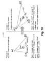
- FIG. 10displays in a mathematical diagram 1000 a technique for converting linear mapping to non-linear mapping—and vice versa.
- a triangle“Triangle 1 ” is drawn in a non-linear mapping domain.
- This trianglehas vertices A 1 , B 1 , and C 1 .
- These verticescan be the same in the non-linear domain as they are in the linear domain.
- a 1can be a subway stop, such as “Warren Street” in FIG.
- B 1can be another subway stop, such as “Oxford Circus”; and, C 1 can be a third subway stop, such as pulp Court Road.”
- Each of these subway stops, or in the context of triangles, vertices,can be exactly the same, whether the map is linear or non-linear.
- this vectoris computed, in a second step, it is extrapolated to a side opposite of the aforementioned vertex. Thus, another vector is computed: V′A 1 P 1 . This vector will then intersect the side of Triangle 1 between vertices C 1 and B 1 .
- a ratiois computed of the two vectors: VA 1 P 1 to V′A 1 P 1 .
- a proportion or percentageis computed of the length of side C 1 P′ to B 1 P′, where P′ is the point of intersection of the aforementioned side. This, then, provides enough information to map point P 1 into Triangle 2 , which, as mentioned, persists in a linear domain.
- step 5In order to place P 1 in the proper location vis-à-vis points A 2 , B 2 , and C 2 , which define Triangle 2 , the following steps may be taken: first, in step 5 (to continue the progression of steps 1 - 4 considered so far), the proportion of the computed length of sides C 1 P′ to B 1 P′ is used to compute P 2 ′, which now stands for the point of intersection between vertices B 2 and C 2 (this proportion was computed in step 4 ). Once P 2 ′ is computed, the results computed in step 3 , can be used in step 6 .
- step 6using the newly computed P 2 ′ and the ratio of VA 1 P 1 to V′A 1 P 1 , a newly computed vector VA 2 P 2 can be computed.
- step 7is the computation P 2 based on the results obtained from VA 2 P 2 and from the location of A 2 .
- P 2is found.
- this location of P 2 in Triangle 2represents where this point should be vis-à-vis vertices A 2 , B 2 , and C 2 .
- This processnaturally, can be used to go back to P 1 in Triangle 1 , based on where P 2 is located in Triangle 2 .
- this processworks not only for conversions from non-linear maps to linear maps, but also from linear maps to non-linear maps. Put another way, it is symmetric.
- FIGS. 11 and 12 A and 12 Billustrate this point.
- FIG. 11shows how a round trip conversion—in this case from a non-linear map to a linear map and back to a non-linear map—produces no spatial distortion for plotted data, thereby showing the quality of various transformation algorithms that can be visually evaluated.
- a symmetric transformationsuch as the one discussed with reference to FIG. 10 , produces 0 round-trip error (in contrast to FIGS. 12A and 12B ).
- X and Y coordinates on the non-linear mapare transformed to latitude and longitude coordinates, and then back to X and Y coordinates. Since the algorithm used in FIG.
- the original X and Y valuesare returned.
- the graphed lines 1102are simply horizontal lines—as opposed to the wavy lines in FIG. 11 , which are generated using a non-symmetric technique. In this way, the quality of various transformation algorithms can visually be evaluated.
- FIG. 12Aillustrates a non-linear map 1200 where the horizontal lines 1202 are wavy because the round-trip conversion produces an error, due to the non-symmetric nature of the conversion algorithm.
- FIG. 12Bin fact, represents a zoomed-in version of FIG. 12A , and shows in great detail the kind of round-trip error that is produced.
- the horizontal lines 1202are wavy.
- the X and Y coordinates at the “Start”are different from the X and Y coordinates at the “Result,” and this is an error—since the X and Y coordinates should be the same at the “Start” and at the “Result.”
- the conversion technique discussed with reference to FIG. 10avoids creating this error.
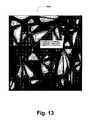
- FIG. 13provides another useful illustration showing an error-distortion map. This map allows a user to visually examine the transformation error present in all of the triangles they have defined, in order to then take corrective action. In the image 1300 , lighter errors indicate areas of greater error distortion. Black areas indicate areas of zero error, which corresponds to the lines of the defined triangles.
- a triangle ABCis defined in the image 1300 , with vertex A corresponding to “Oxford Circus” (as shown in FIG. 7A ), vertex B corresponding to “Regent's Park,” and vertex C corresponding to “Warren Street.” As can be seen, around the edges of triangle ABC, the error is zero because the edges are black; however, in the middle of triangle ABC, the error is greatest, given the white shading. These errors appear because the conversion technique depicted in the image 1300 is non-symmetrical. If a symmetrical technique were to be used, such as the one discussed with reference to FIG. 10 , the entire image 1300 would appear black—since no errors would be produced.
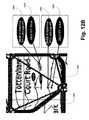
- FIG. 14illustrates the notion that some areas don't have to be (or haven't been) converted from a linear map to a non-linear map—or vice versa—by showing specific regions that are highlighted as non-converted.
- the map 1400 in FIG. 14gives a developer or map-designer visual feedback indicating which regions have not yet have triangles defined for them (and hence do not support X/Y to latitude, longitude, and altitude transformations). These yet to be defined areas are highlighted below using blue rectangles. Some of them may be areas that the developer or map-designer has forgotten 1402 to specify triangles for (e.g. middle/upper right, Russell Square), and some (lower right) specify areas that the developer or map-developer has decided will not be supported 1404 on this map.
- NonLinearMapInfocan be used to perform the following functionalities: (1) Use the coarse grained bounding areas described above to determine whether the non-liner map it represents is appropriate for the map-locations that need to be displayed; and (2) when appropriate, loads the “NonLinearMapView” class and points it to the dual-triangle data and the map image.
- the “NonLinearMapView” classmay provide the following functionalities: (1) contain a “LocationTriangleManager” class that manages all the triangles in the map; (2) contain the non-linear map image (or the capability of rendering one as needed).
- the above referred to class of “LocationTriangleManager”may perform the following functionalities: (1) maintain a (sorted) list of LocationTriangles for use in X/Y to Lat/Long/Alt coordinates; (2) select the correct LocationTriangle for a given X/Y or Lat/Long point; (3) provide the capability of performing X/Y ⁇ Lat/Long and Lat/Long ⁇ X/Y transformations; (4) provide the capability of computing the error-distortion in any given triangle (or any given point), where both average and maximum distortion are computed; (5) provide the capability of splitting triangles into sub-triangles using a variety of different heuristics; (6) provide the capability of loading and saving sets of “LocationTriangle” data.
- Such datamay be associated with a “LocationTriangle” class that: (1) holds data for two triangles: (1) a triangle on the surface of the X/Y image of the non-linear map, and a triangle in physical (real world) space, i.e. latitude, longitude, and altitude; (2) provides the capability of quickly determining if a point is contained in the either triangle; (3) provides the capability of translating points inside it between the non-linear map X/Y and real-world coordinate systems.
- this class and the three other classes discussed hereinare merely exemplary, and not limiting.
- FIGS. 15A and 15Ba block diagram illustrates one way of designing and using arbitrary maps, whether such maps are linear or non-linear.
- the blocks 1500 to 1520are self-explanatory, especially in light of FIG. 10 . They present a general implementation that could be used in any system, such as a computing system, or more specifically, a software mapping system.
- map imagescan apply and/or use them in the following manner: (1) import existing non-linear and irregularly spaced map images into the system; (2) quickly annotate the non-linear map's images with real-world physical location data (using, for instance, a combination of other maps to help guide their mapping process); (3) design a set of triangle shapes on map surfaces that connect known points and define boundary conditions inside which translations between real-world coordinates and points on the non-linear map can take place; (4) project these triangles and location points onto a variety of maps to audit the area covered by the non-linear map and its user annotations; (5) audit the non-linear map annotations to determine areas of unacceptable error distortions that need to be corrected; (6) guide and aid developers or map designers in correcting and minimizing these distortions; (7) allowing developers or map designers to view the areas covered by the defined triangles on a physical world map, and to choose coarse bounding regions that define the physical world areas well covered by the non
- any useful non-linear or irregularly shaped map imagecan be broken down into a series of dual-triangles.
- Each dual-trianglespecifies an X and Y area on the non-linear map, and a parallel real-world area having latitude and longitude coordinates (hence the name “dual-triangle”). Transformations or conversions with controllable error magnitudes can be done between linear and non-linear maps in both directions.
- a rich design surface, capable of showing the map data in several different projectionsmay be useful in doing this.
- an arbitrary number of sub trianglescan be defined to lower translation or conversion error as may be needed.
- Many heuristicsare possible for automating this triangle refinement process.
- the specification of coarse bounding areas for mapsmay allow for quick determination whether any individual map is suitable to display a set of map coordinate information.
- This system of dual-triangles and related pointscan be persisted in a text or binary file for use at run-time.
- a text representationsuch as XML may be useful.
- a binary representationmay be useful.
- specified classescan be used to efficiently manage the use of all these dual-triangles for coordinate mapping.
- this systemprovides a mechanism for non-experts to quickly and with predictable accuracy to annotate arbitrary non-linear and irregularly spaced maps, allowing for the projection of location based data onto these maps in software applications. This is useful for all kinds of software applications, and particularly useful for mobile devices used by individuals in real-world environments in need of these maps.
- a map design surface 1600such as the one illustrated in FIG. 16 , supported by an application programming interface (API) can be used to allow developers to easily work with a wide variety of linear and non-linear maps.
- Non-expert developersor other designers can be given any easy programming and graphical interface—not limited to the one illustrated in FIG. 16 —to define these dual-triangle systems and to use them to project location data onto map image(s).
- FIG. 16illustrates that users or developers can “Draw triangles,” “Plot empty areas,” “Label all triangle Points,” “Calculate error[s] in triangle[s],” and so on. These options are merely exemplary, and other aspects discussed herein can easily be incorporated into such design surfaces 1600 , as those of skill in the art will readily appreciate.
- a display surfacemay be provided that allows a non-expert developer or map designer to visually see, understand, and modify the sets of triangles that will govern the X/Y to latitude and longitude transformations or conversions for a given map.
- This design surfacemay allow for simultaneous display of the sets of mapping triangles on both the non-linear map and the other map representations, such as linear street maps. The result may be flexible and useful in allowing for the rapid use of non-linear maps in software applications by the mapping framework described herein.
- a systemmay be provided for the detection of error distortions and overlapping mapping triangles. Since a triangle set describes a bounded transformation or conversion between X/Y and latitude/longitude spaces, with its own internal distortions, having two sets of significantly overlapping triangles would potentially introduce conflicting X/Y to latitude/longitude mappings. It may be important to be able to detect this situation at design time when the triangles defining map transformations are being designated. Further, when an unacceptable magnitude of error exists in a transformation, this error should be detectable and fixable at design time by non-experts (the actual rate of acceptable error will vary from application to application). This system, then, may provide this detection.
- the developer or map designermay also be shown a visual representation of the distortions that exist inside map-triangles between X/Y to latitude/longitude transformations and latitude/longitude to X/Y mappings, thus allowing for the developer or map designer to take corrective action.
- Such corrective actionmay comprise of defining additional, more fine-grained mapping triangles, as may be required).
Landscapes
- Physics & Mathematics (AREA)
- General Physics & Mathematics (AREA)
- Engineering & Computer Science (AREA)
- Theoretical Computer Science (AREA)
- Processing Or Creating Images (AREA)
- Instructional Devices (AREA)
- Image Generation (AREA)
- Table Devices Or Equipment (AREA)
- Display Devices Of Pinball Game Machines (AREA)
- Navigation (AREA)
Abstract
Description
- The present application is related to application Ser. No. 11/217,638, filed Aug. 31, 2005, entitled “LOCATION SIGNPOSTING AND ORIENTATION,” and to application Ser. No. 10/998,081, filed Nov. 26, 2004, entitled “LOCATION AWARE MOBILE-DEVICE SOFTWARE DEVELOPMENT.”
- The present subject matter relates to the field of computing, and more particularly, to software mapping.
- Maps that do not have a linear mapping to real world space (latitude, longitude, and altitude, or other measurements in the physical world) are very common and useful, but can be difficult to use with generic software systems. Examples of such non-linear maps include: subway maps, ski-maps, industrial diagrams and infrastructure diagrams (e.g. maps of power grids, telecommunications grids and wide area transportation maps).
- On such irregularly spaced non-linear maps, spaces get compressed, stretched, rotated, and otherwise distorted. The nature of these distortions also often varies within the map itself, with different regions of the map being distorted in different ways. For instance, one region may be stretched, another may be compressed, and still another region may be rotated—or a combination thereof—and so on.
- Because these non-linear maps present an irregular representation of physical space, they are able to convey a great deal of useful information in a small display. However it is difficult to display real world location data on top of non-linear maps because the mapping from latitude, longitude, and altitude (or other physical world coordinate systems) to a position on such irregularly spaced maps is complex and irregular. At least two key difficulties arise: (1) the ability to map real-world locations onto the irregularly spaced maps, (2) the ability to map points on the irregularly spaced maps into physical world coordinates.
- Certain techniques can be used for extrapolating the location of map-points on top of non-linear, irregularly spaced maps. Typically these techniques work by attempting to extrapolate location data from nearby points, but this can be complex, time consuming, and error-prone—particularly in systems where the map's data is irregularly spaced. Thus, it would be advantageous to provide other techniques that allow users to make the design-time and run-time use of non-linear mapping techniques that are fast, simple, and accessible to moderately skilled programmers and other individuals who are not experts in map-design, complex math or cartography.
- Techniques are provided that allow for the designing and using of arbitrary maps, whether these maps may be linear or non-linear. By way of example and not limitation, a first map image and a second map image may be provided. In addition, a plurality of dual-triangles may be mapped onto the first map image and the second map image, where the plurality of dual-triangles have the same vertices in the second map image as in the first map image—yet these maps may be completely different. For instance, the first map image may be a linear street map and the second map image may be a non-linear subway map. Because any points that are converted from the first map image to the second map image (or vice versa) are converted symmetrically, such points will end up in the appropriate relation to the vertices of the dual-triangles.
- In another aspect, at least one of the plurality of dual-triangles can be selected into a region to be converted from the first map image to the second map image. Such regions may help users and developers to hone in on best information-conveying maps (or portions thereof). Alternatively, such regions may also be used to exclude maps or portions thereof so that such regions are not be converted. In yet another aspect, the plurality of dual-triangles may also be subdivided into more sub-triangles or aggregated into more comprehensive triangles. Various other aspects are disclosed herein.
- Thus, it should be noted, that this Summary is provided to introduce a selection of concepts in a simplified form that are further described below in the Detailed Description. This Summary is not intended to identify key features or essential features of the claimed subject matter, nor is it intended to be used as an aid in determining the scope of the claimed subject matter.
- The foregoing Summary, as well as the following Detailed Description, is better understood when read in conjunction with the appended drawings. In order to illustrate the present disclosure, various aspects of the disclosure are shown. However, the disclosure is not limited to the specific aspects discussed. The following figures are included:
FIG. 1 illustrates the ability of the presently disclosed subject matter to switch back and forth between linear and non-linear maps;FIG. 2 illustrates that the spatial relationship between points mapped onto linear map may differ from the spatial relationship between points mapped onto a non-linear map;FIG. 3 illustrates that the spatial relationship between points mapped onto a linear map may at times be the same or similar as the spatial relationship between points mapped onto a non-linear map;FIG. 4 illustrates a portion of a representative non-linear map, where different parts of the non-linear map may have different transformations applied to them, making the non-liner map's representation significantly different from the “street map” of the same area;FIG. 5 illustrates how a non-linear map can be annotated by mapping software to highlight regions to be transformed into a linear mapping, with the regions being defined by six exemplary triangles;FIG. 6 illustrates how the same six triangles depicted inFIG. 5 would map onto a linear map, and how the shape of these triangles can differ from the shape of the same triangles that were mapped onto a non-linear map, thus suggesting how map space gets distorted in a non-linear context;FIG. 7A illustrates a full set of triangles that have been mapped onto a non-linear map, with the six triangles discussed with reference toFIGS. 5 and 6 depicted along side this full set of triangles, where the full set of triangles forms a mapping of a non-linear space to a linear space;FIG. 7B illustrates how triangular regions configured for conversion may be subdivided at various levels of granularity to provide more accurate results;FIG. 8 illustrates the same mapping shown inFIG. 7 , but this time in the context of a linear map, thereby demonstrating how the full set of triangles and the accompanying six highlighted triangles change in a linear setting (vis-à-vis a non-linear setting);FIG. 9 illustrates how a set of regions can be used to specify the boundaries of a mapping from a linear map to a non-linear map, and by analogy, vice versa;FIG. 10 illustrates in a mathematical diagram (with included steps) how a conversion from a non-linear map to a linear map might occur, and thereby showing how the opposite conversion may occur—by following the illustrated steps in reverse;FIG. 11 illustrates how a round trip conversion, from a non-linear map to a linear map and back to a non-linear map—or vice versa—produces no spatial distortion for plotted data, thereby showing the quality of various transformation algorithms that can be visually evaluated;FIG. 12A illustrates, in contrast toFIG. 11 , how conversion distortions may occur for algorithms that are inferior to those illustrated inFIG. 10 and used inFIG. 11 ;FIG. 12B illustrates in detail the kind of distortions that are shown inFIG. 12A —distortions that the presently disclosed subject matter avoids by using algorithms such as those illustrated inFIG. 10 ;FIG. 13 illustrates yet another way to depict conversion distortions, such as those illustrated inFIGS. 12A and 12B .FIG. 14 illustrates the notion that some areas don't have to be (or have not been marked as) supporting conversion from a linear map to a non-linear map—or vice versa—by showing specific regions that are highlighted as not-supporting coordinate conversion;FIG. 15A illustrates an exemplary block diagram of a conversion process either from linear maps to non-linear maps, or vice versa;FIG. 15B continues the illustration ofFIG. 15A , illustrating an exemplary block diagram of a conversion process either from linear maps to non-linear maps, or vice versa; andFIG. 16 illustrates an exemplary application programming interface for various aspect of the presently disclosed subject matter.- Aspects of Linear and Non-Linear Mapping
- In one aspect of the presently disclosed subject matter,
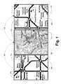
FIG. 1 illustrates the ability of switching back and forth between linear and non-linear maps.FIG. 1 depicts the desirability of users to switch between linear maps (e.g. street maps) and non-linear maps (e.g. subway or transport maps). By shifting between different maps, users can quickly determine the distance, direction, and mode of transport to arrive at a desired location, or to meet other individuals, or for still other purposes. - For example, a
non-linear subway map 104 may depict two people as points on themap 104, the first point being “Bob”110 and the second point being “Julie”112, where “Julie”112 has a signpost pointing to her. “Bob”110 and “Julie”112 may want to meet at some point, and the way to accomplish this may be by taking a subway or a “tube”. If “Bob”110 wants to meet “Julie”112 he can take the appropriate train by examining thenon-linear subway map 104. Once he's above ground, he may want to switch to alinear map 106. - In general terms, a user of such a
non-linear map 104 may want to switch100 to alinear map 106 depicting physical landmarks in linear proportionality to each other because such linear representation may be more intuitive in certain contexts. Thus, in thelinear map 106, “Bob”110 and “Julie”112 are again depicted, but this time their location is shown on a linear scale, as opposed to a non-linear scale in theprevious map 104. - Users, such as “Bob”110, may want to switch back to a non-linear map after a while—even if the non-linear map has changed over time. Thus, in
FIG. 1 , “Bob”110 can switch102 from thelinear map 106 discussed above to a newnon-linear map 108. In thisnon-linear map 108, “Julie”112 is depicted as a point andBob 110 is depicted as a signpost. Now the relationship between “Bob”110 and “Julie”112 may be non-linear vis-à-vis any physical landmarks (where it might have been linear in the previous map106). - This type of switching back and forth between linear and non-linear maps can be done indefinitely. And importantly, such switching may be done without any distortions as to the actual location of “Bob”110 and “Julie”112 on the linear and non-linear maps. As will be shown in more detail below, the present aspect of the disclosed subject matter overcomes distortions of points placed on maps that result from the eventual aggregation of errors associated with each switch between a linear and non-linear map—and vice versa.
- In another aspect disclosed herein,
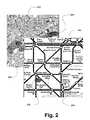
FIG. 2 illustrates that the spatial relationship between points mapped onto linear map may differ from the spatial relationship between points mapped onto a non-linear map. Specifically, inFIG. 2 , on the linear “street map”200, Bob206 (left side) appears below Julie204 (right side), yet on the non-linear/irregular subway map 202,Bob 206 appears aboveJulie 204. Such kinds of shifts in relative display position are common as one moves between linear and non-linear maps. One reason, as mentioned above already, is that the non-linear map may have various regions of its map stretched, rotated, compressed, and so on. - Thus, eventhough
Bob 206 andJulie 204 may be at the exact same locations in thelinear map 200 as thenon-linear map 202, their positions relative to each other and relative to the maps may differ. For instance, inFIG. 2 ,Julie 204 is located near “Charing Cross” both in thelinear map 200 and the non-linear map.Bob 206, likewise, is located near “Green Park” on bothmaps maps - Of course, as
FIG. 3 illustrates, the spatial relationship between points mapped onto a linear map may at times be the same or similar as the spatial relationship between points mapped onto a non-linear map. For example, inFIG. 3 ,Bob 306 has practically the same orientation vis-à-visJulie 304 in thelinear map 300 as thenon-linear map 302. Moreover, the distance betweenBob 306 andJulie 304 is practically the same in bothmaps linear map 300 to the non-linear map302 (or vice versa) caused practically no distortion. However, practically speaking, this may be more of an exception than the rule, and in a substantial number of such conversions, orientations, distances, etc., between mapped points on different maps will differ—and hence the ability of the presently disclosed subject matter to cope with such situations. FIG. 4 illustrates a portion of a representative non-linear map, where different parts of the non-linear map may have different transformations applied to them, making the non-liner map's representation significantly different from the “street map” of the same area. (FIG. 4 also servers as a basis for the discussion concerning a majority of the figures to follow, especiallyFIGS. 5-8 , and11-16).- This particular
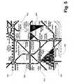
non-linear map 400 shows the London Underground “Tube” map. To illustrate the non-linear nature of thismap 400, it is instructive to focus on a couple of stations illustrated therein. For example, “Oxford Circus”402 is shown, as is “Tottenham Court Road”404, “Weston Street”406, and “Goodge Street”408—the first three of these four stations define a triangle between them. FromFIG. 4 , it appears as if “Goodge Street”408 is a lot closer to “Tottenham Court Road”404 than it is to “Warren Street”406. However, in a linear setting, such as a typical street map, “Goodge Street”408 is about half-way between “Tottenham Court Road”404 and “Warren Street”406. And this is merely a trivial and simple example, since other kinds of distortions could be involved between linear and non-linear maps (or between linear maps and other kinds of linear maps, or between non-linear maps and other kinds of non-linear maps)—as has been discussed already, above. Furthermore, those of skill in the art will readily appreciate the different kinds of distortions that can occur when mapping points or data from one map onto another map. FIG. 5 illustrates how a non-linear map can be annotated by mapping software to highlight regions to be transformed into a linear mapping, with the regions being defined by six exemplary triangles. The triangles depicted inFIG. 5 , T1, T2, T3, T4, T5, and T6, corresponding to figurenumbers non-linear map 500 to a linear map (shown inFIG. 6 ) is to first define one or more triangles (or a set of triangles) that have their vertices at known locations on themap 500.- For instance,
T1 502 has its vertices between “Russell Square,” “Holborn,” and “Chancery Lane.”T2 504 has its vertices between “Holborn,” “Chancery Lane,” and “Mansion House,” and so on. Also, it should be noted, that even thoughTI 502 andT2 504 happen to be contiguous, they don't have to be—as can be seen inFIG. 5 ,T3 506 is sharing a vertex withT1 502 andT2 504, namely, “Holborn,” but it is not contiguous—as neither areT4 508,T5 510, andT6 512. These six exemplary triangles define the regions that are to be converted from a non-linear map to a linear map (shown inFIG. 6 ). Their particular shapes will be contorted by the transformation, and hence, so will the data in those triangles. - Now, turning to
FIG. 6 , it illustrates how the same six triangles depicted inFIG. 5 would map onto a linear map, and how the shape of these triangles can differ from the shape of the same triangles that were mapped onto a non-linear map, thus suggesting how map space gets distorted in a non-linear context. This distortion is clear in terms of the shapes oftriangles T1 602,T2 604,T3 606,T4 608,T5 610, andT6 612, shown inFIG. 6 , as compared to thesame triangles T1 502,T2 504,T3 506,T4 508,T5 510, andT6 512, shown inFIG. 5 . Since these six triangles get distorted, so do the corresponding points and data within them. One of the many advantages of the presently disclosed subject matter is that it can appropriately map such points and data from one set of triangles in a non-linear map space to another corresponding set of triangles in a linear map space (and vice versa). - In a manner of speaking, these six triangles have a “dual” nature in that they can be mapped into a linear space and a non-linear space, even though their relative shape may differ in each space context. However, in one aspect of the presently disclosed subject matter, what remains the same in both contexts is the vertices of the triangles. Thus, as already mentioned,
triangle T1 602 inFIG. 6 may have the same three vertices astriangle T1 502 inFIG. 5 —and the same may hold true for all the other remaining triangles inFIGS. 5 and 6 . - Next,
FIG. 7A illustrates a full set of triangles that have been mapped onto a non-linear map (where this map is shown without the triangles inFIG. 4 ). The six triangles discussed with reference toFIGS. 5 and 6 are depicted along side this full set of triangles, where the full set of triangles forms a mapping of non-linear space to linear space. For instance, a typicalnon-linear map 700 is divided into some set of triangles, as exemplified bytriangles familiar triangles T1 702,T2 704,T3 706,T4 708,T5 710, andT6 712, discussed with reference toFIGS. 5 and 6 . - The set of mapping triangles, exemplified by
triangles FIG. 7A is merely exemplary and not limiting. Other kinds of triangles could be used, as those of skill in the art will readily appreciate. - For example,
FIG. 7B illustrates how triangular regions configured for conversion may be subdivided at various levels of granularity to provide more accurate results. In the non-linear map on the left720, onetriangle 724 is defined between “Oxford Circus,” “Regent's Park,” and “Warren Street.” In the non-linear map on the right722, thistriangle 724 is twice subdivided: once into three triangles and then again into nine triangles.Triangles original triangle 724. As mentioned, subdivision is only one option—the opposite can occur—that is, triangles may also be combined to define larger triangles. - The triangular mapping considered so far, in one aspect, can be one from a Cartesian X/Y plane of the non-linear map onto any real-world coordinates such as latitude and longitude (including altitude, if a third coordinate Z is included in the Cartesian space). For instance, if the conversion is from a linear map to a non-linear one, Global Positioning System (GPS) coordinates can be used to construct a non-linear map (either a two dimensional flat map, a three dimensional spatial map, a four dimensional spatial map with a temporal component dimension, and so on).
FIG. 8 illustrates the same mapping shown inFIG. 7 , but this time in the context of a linear map, thereby demonstrating how the full set of triangles and the accompanying six highlighted triangles change in a linear setting (vis-à-vis the non-linear setting ofFIG. 7 ). As expected, the six highlightedtriangles T1 802,T2 804,T3 806,T4 808,T5 810, andT6 812, alongside some of thenon-highlighted triangles linear map 800. However, the vertices of the triangles inFIG. 7 andFIG. 8 may remain the same.- Of course, various conversion techniques could be implemented here, where, for example, a set of linear-based triangles containing N triangles is converted to a non-linear setting, but where only half as many (N/2) triangles were mapped on the non-linear map. Or, vice versa, where twice as many triangles are mapped on the non-linear map, by using various interpolation techniques. The number of triangles used in
FIG. 7 happens to be the same as the number of triangles used inFIG. 8 , but this does not have to be the case. Using the same vertices in both linear and non-linear setting naturally leads to the same number of triangles, but this is merely one exemplary and non-limiting aspect. - In another interesting aspect of the presently disclosed subject matter,
FIG. 9 illustrates how a set of regions can be used to specify the boundaries of a mapping from a linear map to a non-linear map, and by analogy, vice versa. Specifically,FIG. 9 shows a set of coarse bounding regions that a user, developer or map-designer can specify that the non-liner or irregular subway/tube map ofFIG. 4 should be applicable for. By being able to represent these regions on a normal linear street map, the developer or map-designer is given a good visual understanding of the geographic area covered by the non-linear map. Notably, these coarse bounding regions need not cover all the areas defined by triangles; the map's designer can choose only the areas best covered by the non-linear map. - Thus, in
FIG. 9 , on thelinear map 900, a developer may select several regions,R1 914,R2 916,R3 918,R4 920,R5 922,R6 924, and R7927. These regions may together cover the relevant portion of the subway that the developer (or user) may want to focus on. As the regions are illustrated inFIG. 9 , they cover the highlighted triangles discussed in the previous figures:T1 902,T2 904,T3 906,T4 908,T5 910, andT6 912. These regions also cover other triangles that may represent areas of interest for the developer or the user of this subject matter. There is really no limit on the number of regions that may be used or the size of those regions. Moreover, although the regions as shown are contiguous, the don't have to be. The user or developer of this technology may simply select an area of interest to be converted into another map. Notably, inFIG. 9 , a linear map is shown with selected regions, because this kind of setup allows a person to have a more intuitive feel for what information is important. However, if users or developers are more familiar with a non-linear setup, alternative, similar regions can be selected on a non-linear map to be then converted into a linear map. For instance, one might imagine subway workers and employees using a subway map with selected relevant regions to then see how such a subway map corresponds to a real world linear street map. - Aspects of a Technique for Conversion of (a) Linear to Non-Linear Mapping and (b) Non-Linear to Linear Mapping
- Next,
FIG. 10 displays in a mathematical diagram1000 a technique for converting linear mapping to non-linear mapping—and vice versa. For example, inFIG. 10 , a triangle, “Triangle 1” is drawn in a non-linear mapping domain. This triangle has vertices A1, B1, and C1. These vertices can be the same in the non-linear domain as they are in the linear domain. For instance, A1 can be a subway stop, such as “Warren Street” inFIG. 2 ; B1 can be another subway stop, such as “Oxford Circus”; and, C1 can be a third subway stop, such as Tottenham Court Road.” Each of these subway stops, or in the context of triangles, vertices, can be exactly the same, whether the map is linear or non-linear. - In order to convert “
Triangle 1” to “Triangle 2,” which persists in a linear domain, with latitude, longitude, and altitude coordinates (as opposed to the X and Y coordinates designated for the non-linear domain), several steps may be taken. If, for example, a point, “P1” is to be mapped from a non-linear map to a linear map, inTriangle 2, a first step may be the drawing of a vector from some vertex ofTriangle 1 to P1 inTriangle 1. AsFIG. 10 illustrates, vector VA1P1 is drawn from A1 to P1. In the software context, vector VA1P1 is computed from A1 to P1. - Once this vector is computed, in a second step, it is extrapolated to a side opposite of the aforementioned vertex. Thus, another vector is computed: V′A1P1. This vector will then intersect the side of
Triangle 1 between vertices C1 and B1. Next, in a third step, a ratio is computed of the two vectors: VA1P1 to V′A1P1. Following this step, in a fourth step, a proportion or percentage is computed of the length of side C1P′ to B1P′, where P′ is the point of intersection of the aforementioned side. This, then, provides enough information to map point P1 intoTriangle 2, which, as mentioned, persists in a linear domain. - In order to place P1 in the proper location vis-à-vis points A2, B2, and C2, which define
Triangle 2, the following steps may be taken: first, in step5 (to continue the progression of steps1-4 considered so far), the proportion of the computed length of sides C1P′ to B1P′ is used to compute P2′, which now stands for the point of intersection between vertices B2 and C2 (this proportion was computed in step4). Once P2′ is computed, the results computed in step3, can be used in step6. - In step6, using the newly computed P2′ and the ratio of VA1P1 to V′A1P1, a newly computed vector VA2P2 can be computed. Once this vector is computed, all that is left to do, in step7, is the computation P2 based on the results obtained from VA2P2 and from the location of A2. After the computation in step7 is obtained, P2 is found. And this location of P2 in
Triangle 2 represents where this point should be vis-à-vis vertices A2, B2, and C2. This process, naturally, can be used to go back to P1 inTriangle 1, based on where P2 is located inTriangle 2. Thus, this process works not only for conversions from non-linear maps to linear maps, but also from linear maps to non-linear maps. Put another way, it is symmetric. - One major benefit of this kind of symmetry is that conversion between linear and non-linear maps can occur an infinite amount of times, without causing any distortion as to the location of points P1 and P2, which, as mentioned in above, was a major shortcoming of any previous mapping techniques.
FIGS. 11 and 12 A and12B illustrate this point. First,FIG. 11 shows how a round trip conversion—in this case from a non-linear map to a linear map and back to a non-linear map—produces no spatial distortion for plotted data, thereby showing the quality of various transformation algorithms that can be visually evaluated. Specifically, a symmetric transformation, such as the one discussed with reference toFIG. 10 , produces 0 round-trip error (in contrast toFIGS. 12A and 12B ). In thisnon-linear map 1100, X and Y coordinates on the non-linear map are transformed to latitude and longitude coordinates, and then back to X and Y coordinates. Since the algorithm used inFIG. 11 is symmetric, the original X and Y values are returned. Hence, the graphedlines 1102 are simply horizontal lines—as opposed to the wavy lines inFIG. 11 , which are generated using a non-symmetric technique. In this way, the quality of various transformation algorithms can visually be evaluated.- Thus, in contrast to
FIG. 11 ,FIG. 12A illustrates anon-linear map 1200 where thehorizontal lines 1202 are wavy because the round-trip conversion produces an error, due to the non-symmetric nature of the conversion algorithm.FIG. 12B , in fact, represents a zoomed-in version ofFIG. 12A , and shows in great detail the kind of round-trip error that is produced. Thus, again, thehorizontal lines 1202 are wavy. When the first leg of the round-trip conversion starts1206, there is some X and Y value for a particular point on thenon-linear map 1200. Upon theresult 1204 of the round-trip conversion, it can be clearly seen that the “Start” point is in a different place than the “Result” point. In other words, the X and Y coordinates at the “Start” are different from the X and Y coordinates at the “Result,” and this is an error—since the X and Y coordinates should be the same at the “Start” and at the “Result.” As mentioned, the conversion technique discussed with reference toFIG. 10 avoids creating this error. FIG. 13 provides another useful illustration showing an error-distortion map. This map allows a user to visually examine the transformation error present in all of the triangles they have defined, in order to then take corrective action. In theimage 1300, lighter errors indicate areas of greater error distortion. Black areas indicate areas of zero error, which corresponds to the lines of the defined triangles.- A triangle ABC is defined in the
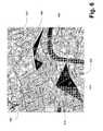
image 1300, with vertex A corresponding to “Oxford Circus” (as shown inFIG. 7A ), vertex B corresponding to “Regent's Park,” and vertex C corresponding to “Warren Street.” As can be seen, around the edges of triangle ABC, the error is zero because the edges are black; however, in the middle of triangle ABC, the error is greatest, given the white shading. These errors appear because the conversion technique depicted in theimage 1300 is non-symmetrical. If a symmetrical technique were to be used, such as the one discussed with reference toFIG. 10 , theentire image 1300 would appear black—since no errors would be produced. - Next,
FIG. 14 illustrates the notion that some areas don't have to be (or haven't been) converted from a linear map to a non-linear map—or vice versa—by showing specific regions that are highlighted as non-converted. For example, themap 1400 inFIG. 14 gives a developer or map-designer visual feedback indicating which regions have not yet have triangles defined for them (and hence do not support X/Y to latitude, longitude, and altitude transformations). These yet to be defined areas are highlighted below using blue rectangles. Some of them may be areas that the developer or map-designer has forgotten1402 to specify triangles for (e.g. middle/upper right, Russell Square), and some (lower right) specify areas that the developer or map-developer has decided will not be supported1404 on this map. - Aspects of Exemplary Classes
- Various classes can be used to implement the above-discussed aspects of the presently disclosed subject matter. For example, a “NonLinearMapInfo” class can be used to perform the following functionalities: (1) Use the coarse grained bounding areas described above to determine whether the non-liner map it represents is appropriate for the map-locations that need to be displayed; and (2) when appropriate, loads the “NonLinearMapView” class and points it to the dual-triangle data and the map image.
- The “NonLinearMapView” class, in turn, may provide the following functionalities: (1) contain a “LocationTriangleManager” class that manages all the triangles in the map; (2) contain the non-linear map image (or the capability of rendering one as needed). The above referred to class of “LocationTriangleManager” may perform the following functionalities: (1) maintain a (sorted) list of LocationTriangles for use in X/Y to Lat/Long/Alt coordinates; (2) select the correct LocationTriangle for a given X/Y or Lat/Long point; (3) provide the capability of performing X/Y→Lat/Long and Lat/Long→X/Y transformations; (4) provide the capability of computing the error-distortion in any given triangle (or any given point), where both average and maximum distortion are computed; (5) provide the capability of splitting triangles into sub-triangles using a variety of different heuristics; (6) provide the capability of loading and saving sets of “LocationTriangle” data.
- Such data may be associated with a “LocationTriangle” class that: (1) holds data for two triangles: (1) a triangle on the surface of the X/Y image of the non-linear map, and a triangle in physical (real world) space, i.e. latitude, longitude, and altitude; (2) provides the capability of quickly determining if a point is contained in the either triangle; (3) provides the capability of translating points inside it between the non-linear map X/Y and real-world coordinate systems. Of course, this class and the three other classes discussed herein are merely exemplary, and not limiting.
- Implementation Aspects of Linear and Non-Linear Mapping
- In one exemplary implementation, in
FIGS. 15A and 15B , consistent with the subject matter discussed with reference toFIG. 10 , a block diagram illustrates one way of designing and using arbitrary maps, whether such maps are linear or non-linear. Theblocks 1500 to1520 are self-explanatory, especially in light ofFIG. 10 . They present a general implementation that could be used in any system, such as a computing system, or more specifically, a software mapping system. - With this system, moderately skilled programmers and other non-experts, for example, working with map images can apply and/or use them in the following manner: (1) import existing non-linear and irregularly spaced map images into the system; (2) quickly annotate the non-linear map's images with real-world physical location data (using, for instance, a combination of other maps to help guide their mapping process); (3) design a set of triangle shapes on map surfaces that connect known points and define boundary conditions inside which translations between real-world coordinates and points on the non-linear map can take place; (4) project these triangles and location points onto a variety of maps to audit the area covered by the non-linear map and its user annotations; (5) audit the non-linear map annotations to determine areas of unacceptable error distortions that need to be corrected; (6) guide and aid developers or map designers in correcting and minimizing these distortions; (7) allowing developers or map designers to view the areas covered by the defined triangles on a physical world map, and to choose coarse bounding regions that define the physical world areas well covered by the non-linear map (alternatively, default bounding regions can be automatically chosen to assist the user in this process); (8) use these maps at run-time in arbitrary software applications that utilize the maps, simultaneously conveying to users map data on both linear (e.g. street maps) and non-linear surfaces (e.g. subway maps); and (9) construct these maps at design time (in contrast to run-time).
- Thus, per the discussion above, in one aspect of the presently disclosed subject matter, any useful non-linear or irregularly shaped map image can be broken down into a series of dual-triangles. Each dual-triangle specifies an X and Y area on the non-linear map, and a parallel real-world area having latitude and longitude coordinates (hence the name “dual-triangle”). Transformations or conversions with controllable error magnitudes can be done between linear and non-linear maps in both directions. A rich design surface, capable of showing the map data in several different projections may be useful in doing this.
- In this aspect, then, an arbitrary number of sub triangles can be defined to lower translation or conversion error as may be needed. Many heuristics are possible for automating this triangle refinement process. Moreover, the specification of coarse bounding areas for maps may allow for quick determination whether any individual map is suitable to display a set of map coordinate information.
- This system of dual-triangles and related points can be persisted in a text or binary file for use at run-time. For flexibility purposes, a text representation such as XML may be useful. Alternatively, for compactness and performance purposes, a binary representation may be useful. At both design-time and run-time, specified classes can be used to efficiently manage the use of all these dual-triangles for coordinate mapping. Thus, it is possible to a manager module to be optimized to allow for efficient access to commonly used triangles.
- Put in other words, this system provides a mechanism for non-experts to quickly and with predictable accuracy to annotate arbitrary non-linear and irregularly spaced maps, allowing for the projection of location based data onto these maps in software applications. This is useful for all kinds of software applications, and particularly useful for mobile devices used by individuals in real-world environments in need of these maps.
- To this end, a
map design surface 1600, such as the one illustrated inFIG. 16 , supported by an application programming interface (API) can be used to allow developers to easily work with a wide variety of linear and non-linear maps. Non-expert developers (or other designers) can be given any easy programming and graphical interface—not limited to the one illustrated inFIG. 16 —to define these dual-triangle systems and to use them to project location data onto map image(s).FIG. 16 illustrates that users or developers can “Draw triangles,” “Plot empty areas,” “Label all triangle Points,” “Calculate error[s] in triangle[s],” and so on. These options are merely exemplary, and other aspects discussed herein can easily be incorporated intosuch design surfaces 1600, as those of skill in the art will readily appreciate. - Notably, an important question when dealing with sets of maps (some linear, some irregular) is which is the best map to display to meet users' needs. Several maps may be applicable given some set of data. It may be important for an application to be able to choose the maps that can show the data most accurately and efficiently. Unlike linearly spaced maps, the region of effective display may not be defined by a simple rectangle or circle. For this, a high performance and flexible mechanism may be provided for designating the real-world regions for which a given irregularly or non-linearly spaced map is best suited for. The presently disclosed subject matter may provide both a design-time and run-time mechanisms for this.
- Thus, in another aspect, a display surface may be provided that allows a non-expert developer or map designer to visually see, understand, and modify the sets of triangles that will govern the X/Y to latitude and longitude transformations or conversions for a given map. This design surface may allow for simultaneous display of the sets of mapping triangles on both the non-linear map and the other map representations, such as linear street maps. The result may be flexible and useful in allowing for the rapid use of non-linear maps in software applications by the mapping framework described herein.
- Furthermore, a system may be provided for the detection of error distortions and overlapping mapping triangles. Since a triangle set describes a bounded transformation or conversion between X/Y and latitude/longitude spaces, with its own internal distortions, having two sets of significantly overlapping triangles would potentially introduce conflicting X/Y to latitude/longitude mappings. It may be important to be able to detect this situation at design time when the triangles defining map transformations are being designated. Further, when an unacceptable magnitude of error exists in a transformation, this error should be detectable and fixable at design time by non-experts (the actual rate of acceptable error will vary from application to application). This system, then, may provide this detection. The developer or map designer may also be shown a visual representation of the distortions that exist inside map-triangles between X/Y to latitude/longitude transformations and latitude/longitude to X/Y mappings, thus allowing for the developer or map designer to take corrective action. Such corrective action may comprise of defining additional, more fine-grained mapping triangles, as may be required).
- Lastly, while the present disclosure has been described in connection with the preferred aspects, as illustrated in the various figures, it is understood that other similar aspects may be used or modifications and additions may be made to the described aspects for performing the same function of the present disclosure without deviating therefrom. For example, in various aspects of the disclosure, a visual identity mechanism was disclosed. However, other equivalent mechanisms to these described aspects are also contemplated by the teachings herein. Therefore, the present disclosure should not be limited to any single aspect, but rather construed in breadth and scope in accordance with the appended claims.
Claims (20)
Priority Applications (9)
| Application Number | Priority Date | Filing Date | Title |
|---|---|---|---|
| US11/344,827US7649534B2 (en) | 2006-02-01 | 2006-02-01 | Design of arbitrary linear and non-linear maps |
| EP07762742AEP1984859B1 (en) | 2006-02-01 | 2007-01-30 | Design of arbitrary linear and non-linear maps |
| PL07762742TPL1984859T3 (en) | 2006-02-01 | 2007-01-30 | Design of arbitrary linear and non-linear maps |
| ES07762742TES2380247T3 (en) | 2006-02-01 | 2007-01-30 | Design of arbitrary linear and nonlinear maps |
| PCT/US2007/002668WO2007089856A2 (en) | 2006-02-01 | 2007-01-30 | Design of arbitrary linear and non-linear maps |
| KR1020087019084AKR101159395B1 (en) | 2006-02-01 | 2007-01-30 | Design of arbitrary linear and non-linear maps |
| PT07762742TPT1984859E (en) | 2006-02-01 | 2007-01-30 | Design of arbitrary linear and non-linear maps |
| AT07762742TATE547771T1 (en) | 2006-02-01 | 2007-01-30 | DESIGN OF ARBITRARY LINEAR AND NON-LINEAR MAPS |
| CN2007800040100ACN101379497B (en) | 2006-02-01 | 2007-01-30 | Design of arbitrary linear and non-linear maps |
Applications Claiming Priority (1)
| Application Number | Priority Date | Filing Date | Title |
|---|---|---|---|
| US11/344,827US7649534B2 (en) | 2006-02-01 | 2006-02-01 | Design of arbitrary linear and non-linear maps |
Publications (2)
| Publication Number | Publication Date |
|---|---|
| US20070176932A1true US20070176932A1 (en) | 2007-08-02 |
| US7649534B2 US7649534B2 (en) | 2010-01-19 |
Family
ID=38321621
Family Applications (1)
| Application Number | Title | Priority Date | Filing Date |
|---|---|---|---|
| US11/344,827Expired - Fee RelatedUS7649534B2 (en) | 2006-02-01 | 2006-02-01 | Design of arbitrary linear and non-linear maps |
Country Status (9)
| Country | Link |
|---|---|
| US (1) | US7649534B2 (en) |
| EP (1) | EP1984859B1 (en) |
| KR (1) | KR101159395B1 (en) |
| CN (1) | CN101379497B (en) |
| AT (1) | ATE547771T1 (en) |
| ES (1) | ES2380247T3 (en) |
| PL (1) | PL1984859T3 (en) |
| PT (1) | PT1984859E (en) |
| WO (1) | WO2007089856A2 (en) |
Cited By (13)
| Publication number | Priority date | Publication date | Assignee | Title |
|---|---|---|---|---|
| WO2009023165A1 (en) | 2007-08-11 | 2009-02-19 | Infogation Corporation | Method and apparatus for navigating on artistic maps |
| JP2011043788A (en)* | 2009-07-21 | 2011-03-03 | Advanced Telecommunication Research Institute International | Information processing device, information processing method, and program |
| JP2011154172A (en)* | 2010-01-27 | 2011-08-11 | Advanced Telecommunication Research Institute International | Map information system, terminal device, server device, and program |
| JP2011158518A (en)* | 2010-01-29 | 2011-08-18 | Advanced Telecommunication Research Institute International | Map information system, terminal device, server device, and program |
| JP2011232444A (en)* | 2010-04-26 | 2011-11-17 | Ntt Docomo Inc | Coordinate conversion device, coordinate conversion method and program |
| WO2012152982A1 (en)* | 2011-05-11 | 2012-11-15 | Nokia Corporation | Non-uniformly scaling a map for emphasizing areas of interest |
| NL2007013C2 (en)* | 2011-06-28 | 2013-01-03 | Hans Dam | Transforming geo-coordinates to a position on an electronic topological map. |
| WO2014101507A1 (en)* | 2012-12-26 | 2014-07-03 | 腾讯科技(深圳)有限公司 | On-line user distribution processing method, device and storage medium |
| US20150025924A1 (en)* | 2013-07-22 | 2015-01-22 | Palo Alto Investors | Methods of displaying information to a user, and systems and devices for use in practicing the same |
| EP3045866A3 (en)* | 2014-12-22 | 2016-09-21 | HERE Global B.V. | Method and apparatus for providing mapping of geo locations on schematic maps |
| US20180130238A1 (en)* | 2016-11-10 | 2018-05-10 | Tata Consultancy Services Limited | Customized map generation with real time messages and locations from concurrent users |
| US10936176B1 (en)* | 2017-11-17 | 2021-03-02 | United Services Automobile Association (Usaa) | Systems and methods for interactive maps |
| US11955113B1 (en) | 2016-10-24 | 2024-04-09 | United Services Automobile Association (Usaa) | Electronic signatures via voice for virtual assistants' interactions |
Families Citing this family (11)
| Publication number | Priority date | Publication date | Assignee | Title |
|---|---|---|---|---|
| CN101946265A (en)* | 2008-02-18 | 2011-01-12 | 三菱电机株式会社 | Map display device |
| US9075938B2 (en)* | 2009-02-27 | 2015-07-07 | Sri International | Method and apparatus for mapping of multiple-floor structures |
| US9892660B2 (en)* | 2010-06-03 | 2018-02-13 | Here Global B.V. | Navigable topological maps |
| TWI426236B (en)* | 2011-12-16 | 2014-02-11 | Univ Nat Chiao Tung | Visualization method of complicated metro maps in a limited displaying area |
| USD712421S1 (en)* | 2012-06-06 | 2014-09-02 | Apple Inc. | Display screen or portion thereof with graphical user interface |
| CN103324815B (en)* | 2013-07-15 | 2017-02-15 | 丁成波 | Reality testing method for design drawing |
| US9514714B2 (en) | 2013-11-25 | 2016-12-06 | Microsoft Technology Licensing, Llc | Kinetic mapping |
| US20180075415A1 (en)* | 2016-09-12 | 2018-03-15 | James A. Ray | Semi-automated job match system and method |
| CN110631595A (en)* | 2018-06-25 | 2019-12-31 | 北京嘀嘀无限科技发展有限公司 | Method and system for converting map data, computer device and readable storage medium |
| KR102136213B1 (en)* | 2019-02-27 | 2020-07-21 | 네이버 주식회사 | Method and system for associating maps having different attribute for provding different services |
| USD949159S1 (en) | 2019-06-02 | 2022-04-19 | Apple Inc. | Display screen or portion thereof with graphical user interface |
Citations (42)
| Publication number | Priority date | Publication date | Assignee | Title |
|---|---|---|---|---|
| US4937570A (en)* | 1987-02-26 | 1990-06-26 | Mitsubishi Denki Kabushiki Kaisha | Route guidance display device |
| US5631642A (en)* | 1993-03-12 | 1997-05-20 | Austec Electronic Systems Limited | Mobile object tracking systems |
| US5638523A (en)* | 1993-01-26 | 1997-06-10 | Sun Microsystems, Inc. | Method and apparatus for browsing information in a computer database |
| US5774829A (en)* | 1995-12-12 | 1998-06-30 | Pinterra Corporation | Navigation and positioning system and method using uncoordinated beacon signals in conjunction with an absolute positioning system |
| US5841443A (en)* | 1997-02-20 | 1998-11-24 | S3 Incorporated | Method for triangle subdivision in computer graphics texture mapping to eliminate artifacts in high perspective polygons |
| US5925091A (en)* | 1995-06-12 | 1999-07-20 | Alpine Electronics, Inc. | Method and apparatus for drawing a map for a navigation system |
| US6121972A (en)* | 1997-08-11 | 2000-09-19 | Nissan Motor Co., Ltd. | Navigation system, method for stereoscopically displaying topographic map for the navigation system, and recording medium recording the method |
| US6141013A (en)* | 1998-02-03 | 2000-10-31 | Sun Microsystems, Inc. | Rapid computation of local eye vectors in a fixed point lighting unit |
| US6178380B1 (en)* | 1998-10-22 | 2001-01-23 | Magellan, Dis, Inc. | Street identification for a map zoom of a navigation system |
| US6196516B1 (en)* | 1999-09-03 | 2001-03-06 | Mitac International Corp | Cushioning device for a computer component |
| US6222482B1 (en)* | 1999-01-29 | 2001-04-24 | International Business Machines Corporation | Hand-held device providing a closest feature location in a three-dimensional geometry database |
| US6233523B1 (en)* | 1997-10-02 | 2001-05-15 | Ibs Integrierte Business Systeme Gmbh | Method of collection and linking of positional data from satellite localization and other data |
| US6252544B1 (en)* | 1998-01-27 | 2001-06-26 | Steven M. Hoffberg | Mobile communication device |
| US20010038718A1 (en)* | 1997-05-09 | 2001-11-08 | Rakesh Kumar | Method and apparatus for performing geo-spatial registration of imagery |
| US6321158B1 (en)* | 1994-06-24 | 2001-11-20 | Delorme Publishing Company | Integrated routing/mapping information |
| US20020049533A1 (en)* | 2000-08-16 | 2002-04-25 | Manabu Kusano | Navigation device |
| US6442483B1 (en)* | 2001-08-21 | 2002-08-27 | Arthur George Doglione | System and method for defining and creating surrogate addresses for township and range quarter sections |
| US20020118118A1 (en)* | 2001-02-26 | 2002-08-29 | International Business Machines Corporation | Wireless communication system and method to provide geo-spatial related event data |
| US6526178B1 (en)* | 1997-05-30 | 2003-02-25 | Sony Corporation | Picture mapping apparatus and picture mapping method, and picture generation apparatus and picture generation method |
| US20030052896A1 (en)* | 2000-03-29 | 2003-03-20 | Higgins Darin Wayne | System and method for synchronizing map images |
| US6615134B2 (en)* | 2000-05-25 | 2003-09-02 | Sony Corporation | Data communication system and method, and mobile body apparatus |
| US6710774B1 (en)* | 1999-05-12 | 2004-03-23 | Denso Corporation | Map display device |
| US20040073356A1 (en)* | 2002-10-09 | 2004-04-15 | Craine Dean A. | Personal traffic congestion avoidance system |
| US20040153238A1 (en)* | 2003-01-22 | 2004-08-05 | Increment P Corporation | Data structure of feature guidance information, recording medium storing feature guidance information, navigation device, navigation system, navigation method, navigation program and recording medium storing the navigation program |
| US20040220726A1 (en)* | 2001-01-24 | 2004-11-04 | Televigation, Inc. | Real-time navigation system for mobile environment |
| US20040243307A1 (en)* | 2003-06-02 | 2004-12-02 | Pieter Geelen | Personal GPS navigation device |
| US20050064243A1 (en)* | 2003-09-18 | 2005-03-24 | Fuji Photo Film Co., Ltd. | Magnetic recording medium |
| US20050117215A1 (en)* | 2003-09-30 | 2005-06-02 | Lange Eric B. | Stereoscopic imaging |
| US20050131660A1 (en)* | 2002-09-06 | 2005-06-16 | Joseph Yadegar | Method for content driven image compression |
| US20050149251A1 (en)* | 2000-07-18 | 2005-07-07 | University Of Minnesota | Real time high accuracy geospatial database for onboard intelligent vehicle applications |
| US6956590B1 (en)* | 2001-02-28 | 2005-10-18 | Navteq North America, Llc | Method of providing visual continuity when panning and zooming with a map display |
| US7038681B2 (en)* | 2000-03-29 | 2006-05-02 | Sourceprose Corporation | System and method for georeferencing maps |
| US20060132482A1 (en)* | 2004-11-12 | 2006-06-22 | Oh Byong M | Method for inter-scene transitions |
| US7126616B2 (en)* | 2001-06-12 | 2006-10-24 | Silicon Optix Inc. | Method and system for processing a non-linear two dimensional spatial transformation |
| US20070014488A1 (en)* | 2004-07-09 | 2007-01-18 | Ching-Chien Chen | Automatically and accurately conflating road vector data, street maps, and orthoimagery |
| US20070050129A1 (en)* | 2005-08-31 | 2007-03-01 | Microsoft Corporation | Location signposting and orientation |
| US20070185651A1 (en)* | 2006-02-07 | 2007-08-09 | Masaki Motoyama | Navigation system utilizing XML/SVG map data converted from geographic map data and layered structure of XML/SVG map data based on administrative regions |
| US20070203643A1 (en)* | 2006-02-27 | 2007-08-30 | Xanavi Informatics Corporation | Vehicle navigation system and method for displaying waypoint information |
| US20070203646A1 (en)* | 2005-12-31 | 2007-08-30 | Diaz Melvin B | Image correction method and apparatus for navigation system with portable navigation unit |
| US20070203641A1 (en)* | 2005-12-31 | 2007-08-30 | Diaz Melvin B | In-vehicle navigation system with removable navigation unit |
| US20070233367A1 (en)* | 2006-03-31 | 2007-10-04 | Geospot, Inc. | Methods for Interaction, Sharing, and Exploration over Geographical Locations |
| US7519470B2 (en)* | 2006-03-15 | 2009-04-14 | Microsoft Corporation | Location-based caching for mobile devices |
Family Cites Families (29)
| Publication number | Priority date | Publication date | Assignee | Title |
|---|---|---|---|---|
| FR2343300A1 (en) | 1976-03-01 | 1977-09-30 | Decaux Paris J C | Sign post incorporating street maps - has vertical support post and outer curved sleeve on which maps are displayed |
| DE3512000A1 (en) | 1985-04-02 | 1986-10-02 | Alwin 7500 Karlsruhe Traub | Information display guide |
| JPS63222215A (en) | 1987-03-11 | 1988-09-16 | Nissan Motor Co Ltd | Position detector for vehicle |
| JPH04366991A (en) | 1991-06-14 | 1992-12-18 | Fujitsu Ten Ltd | Navigation device for automatic display of vehicle position or the like |
| JP3136798B2 (en) | 1992-10-05 | 2001-02-19 | 松下電器産業株式会社 | Map terminal and drawing method |
| JP3154251B2 (en) | 1995-02-06 | 2001-04-09 | 三和プラスチック株式会社 | Display fixing structure |
| SE520822C2 (en) | 1999-02-17 | 2003-09-02 | Telia Ab | System for presenting user-adapted position-dependent information on terminal equipment |
| AU1292001A (en) | 1999-11-05 | 2001-05-14 | Netstar (Proprietary) Limited | A mobile object monitoring system |
| JPWO2002023128A1 (en) | 2000-09-11 | 2004-01-22 | 松下電器産業株式会社 | Route guidance system |
| US6857016B1 (en) | 2000-09-25 | 2005-02-15 | Ricoh Company Limited | Method and system of data collection and mapping from a remote position reporting device |
| US6513721B1 (en) | 2000-11-27 | 2003-02-04 | Microsoft Corporation | Methods and arrangements for configuring portable security token features and contents |
| JP4740462B2 (en) | 2001-01-11 | 2011-08-03 | クラリオン株式会社 | Map display control device, map information update device, map information update system, and control program |
| GB2374763B (en) | 2001-04-18 | 2003-03-19 | E Lead Electronic Co Ltd | Remote-end route-calculating navigation system |
| US7127261B2 (en) | 2002-02-22 | 2006-10-24 | Julian Van Erlach | Enhanced telecommunication services |
| EP1349363B1 (en) | 2002-03-29 | 2014-01-08 | FUJIFILM Corporation | Digital camera connected to a navigation device and to an external storage information system |
| US6697734B1 (en) | 2002-04-17 | 2004-02-24 | Nokia Corporation | System and method for displaying a map having two scales |
| US7084809B2 (en) | 2002-07-15 | 2006-08-01 | Qualcomm, Incorporated | Apparatus and method of position determination using shared information |
| JP2004085779A (en) | 2002-08-26 | 2004-03-18 | Keiko Nakayama | Method and computer program for drawing spatial information on digital map |
| JP4181372B2 (en) | 2002-09-27 | 2008-11-12 | 富士フイルム株式会社 | Display device, image information management terminal, image information management system, and image display method |
| US20040073361A1 (en) | 2002-10-15 | 2004-04-15 | Assimakis Tzamaloukas | Enhanced mobile communication device, and transportation application thereof |
| EP1435600B1 (en) | 2002-12-30 | 2007-07-18 | Motorola, Inc. | Method and apparatus for determining the location of a wireless device |
| JP2004310717A (en) | 2003-04-07 | 2004-11-04 | Toshiyuki Nishimitsu | Current location information retrieval system |
| US20040255718A1 (en) | 2003-06-18 | 2004-12-23 | Steers Jerome Andrew | Turbine powered flywheel |
| JP4102324B2 (en)* | 2004-03-29 | 2008-06-18 | 株式会社トプコン | Surveying data processing system, surveying data processing program, and electronic map display device |
| CN1700219A (en)* | 2004-05-21 | 2005-11-23 | 深圳市海之力科技实业有限公司 | Method for providing road traffic conditions |
| JP2006017537A (en) | 2004-06-30 | 2006-01-19 | Pioneer Electronic Corp | Output control device, method thereof, program thereof, and recording medium recording the program |
| CN1664884A (en)* | 2005-03-02 | 2005-09-07 | 西安四维航测遥感中心 | Method for making metropolitan area three-dimensional visible and measurable hypsometric maps |
| AU2007231862A1 (en) | 2006-11-07 | 2008-05-22 | Sun, Ronald Mr | Process and methods of improved navigation and advertising systems |
| CN201000710Y (en) | 2007-01-08 | 2008-01-02 | 白晓斌 | Solar energy electronic guidepost for bus station |
- 2006
- 2006-02-01USUS11/344,827patent/US7649534B2/ennot_activeExpired - Fee Related
- 2007
- 2007-01-30CNCN2007800040100Apatent/CN101379497B/ennot_activeExpired - Fee Related
- 2007-01-30ESES07762742Tpatent/ES2380247T3/enactiveActive
- 2007-01-30ATAT07762742Tpatent/ATE547771T1/enactive
- 2007-01-30WOPCT/US2007/002668patent/WO2007089856A2/enactiveApplication Filing
- 2007-01-30PTPT07762742Tpatent/PT1984859E/enunknown
- 2007-01-30EPEP07762742Apatent/EP1984859B1/ennot_activeNot-in-force
- 2007-01-30KRKR1020087019084Apatent/KR101159395B1/ennot_activeExpired - Fee Related
- 2007-01-30PLPL07762742Tpatent/PL1984859T3/enunknown
Patent Citations (44)
| Publication number | Priority date | Publication date | Assignee | Title |
|---|---|---|---|---|
| US4937570A (en)* | 1987-02-26 | 1990-06-26 | Mitsubishi Denki Kabushiki Kaisha | Route guidance display device |
| US5638523A (en)* | 1993-01-26 | 1997-06-10 | Sun Microsystems, Inc. | Method and apparatus for browsing information in a computer database |
| US5631642A (en)* | 1993-03-12 | 1997-05-20 | Austec Electronic Systems Limited | Mobile object tracking systems |
| US6321158B1 (en)* | 1994-06-24 | 2001-11-20 | Delorme Publishing Company | Integrated routing/mapping information |
| US5925091A (en)* | 1995-06-12 | 1999-07-20 | Alpine Electronics, Inc. | Method and apparatus for drawing a map for a navigation system |
| US5774829A (en)* | 1995-12-12 | 1998-06-30 | Pinterra Corporation | Navigation and positioning system and method using uncoordinated beacon signals in conjunction with an absolute positioning system |
| US5841443A (en)* | 1997-02-20 | 1998-11-24 | S3 Incorporated | Method for triangle subdivision in computer graphics texture mapping to eliminate artifacts in high perspective polygons |
| US20010038718A1 (en)* | 1997-05-09 | 2001-11-08 | Rakesh Kumar | Method and apparatus for performing geo-spatial registration of imagery |
| US6526178B1 (en)* | 1997-05-30 | 2003-02-25 | Sony Corporation | Picture mapping apparatus and picture mapping method, and picture generation apparatus and picture generation method |
| US6121972A (en)* | 1997-08-11 | 2000-09-19 | Nissan Motor Co., Ltd. | Navigation system, method for stereoscopically displaying topographic map for the navigation system, and recording medium recording the method |
| US6233523B1 (en)* | 1997-10-02 | 2001-05-15 | Ibs Integrierte Business Systeme Gmbh | Method of collection and linking of positional data from satellite localization and other data |
| US6252544B1 (en)* | 1998-01-27 | 2001-06-26 | Steven M. Hoffberg | Mobile communication device |
| US6429812B1 (en)* | 1998-01-27 | 2002-08-06 | Steven M. Hoffberg | Mobile communication device |
| US6141013A (en)* | 1998-02-03 | 2000-10-31 | Sun Microsystems, Inc. | Rapid computation of local eye vectors in a fixed point lighting unit |
| US6178380B1 (en)* | 1998-10-22 | 2001-01-23 | Magellan, Dis, Inc. | Street identification for a map zoom of a navigation system |
| US6222482B1 (en)* | 1999-01-29 | 2001-04-24 | International Business Machines Corporation | Hand-held device providing a closest feature location in a three-dimensional geometry database |
| US6710774B1 (en)* | 1999-05-12 | 2004-03-23 | Denso Corporation | Map display device |
| US6196516B1 (en)* | 1999-09-03 | 2001-03-06 | Mitac International Corp | Cushioning device for a computer component |
| US20030052896A1 (en)* | 2000-03-29 | 2003-03-20 | Higgins Darin Wayne | System and method for synchronizing map images |
| US7038681B2 (en)* | 2000-03-29 | 2006-05-02 | Sourceprose Corporation | System and method for georeferencing maps |
| US6615134B2 (en)* | 2000-05-25 | 2003-09-02 | Sony Corporation | Data communication system and method, and mobile body apparatus |
| US20050149251A1 (en)* | 2000-07-18 | 2005-07-07 | University Of Minnesota | Real time high accuracy geospatial database for onboard intelligent vehicle applications |
| US20020049533A1 (en)* | 2000-08-16 | 2002-04-25 | Manabu Kusano | Navigation device |
| US20040220726A1 (en)* | 2001-01-24 | 2004-11-04 | Televigation, Inc. | Real-time navigation system for mobile environment |
| US20020118118A1 (en)* | 2001-02-26 | 2002-08-29 | International Business Machines Corporation | Wireless communication system and method to provide geo-spatial related event data |
| US6956590B1 (en)* | 2001-02-28 | 2005-10-18 | Navteq North America, Llc | Method of providing visual continuity when panning and zooming with a map display |
| US7126616B2 (en)* | 2001-06-12 | 2006-10-24 | Silicon Optix Inc. | Method and system for processing a non-linear two dimensional spatial transformation |
| US6442483B1 (en)* | 2001-08-21 | 2002-08-27 | Arthur George Doglione | System and method for defining and creating surrogate addresses for township and range quarter sections |
| US20050131660A1 (en)* | 2002-09-06 | 2005-06-16 | Joseph Yadegar | Method for content driven image compression |
| US20040073356A1 (en)* | 2002-10-09 | 2004-04-15 | Craine Dean A. | Personal traffic congestion avoidance system |
| US20040153238A1 (en)* | 2003-01-22 | 2004-08-05 | Increment P Corporation | Data structure of feature guidance information, recording medium storing feature guidance information, navigation device, navigation system, navigation method, navigation program and recording medium storing the navigation program |
| US20070027628A1 (en)* | 2003-06-02 | 2007-02-01 | Palmtop Software B.V. | A personal gps navigation device |
| US20040243307A1 (en)* | 2003-06-02 | 2004-12-02 | Pieter Geelen | Personal GPS navigation device |
| US20050064243A1 (en)* | 2003-09-18 | 2005-03-24 | Fuji Photo Film Co., Ltd. | Magnetic recording medium |
| US20050117215A1 (en)* | 2003-09-30 | 2005-06-02 | Lange Eric B. | Stereoscopic imaging |
| US20070014488A1 (en)* | 2004-07-09 | 2007-01-18 | Ching-Chien Chen | Automatically and accurately conflating road vector data, street maps, and orthoimagery |
| US20060132482A1 (en)* | 2004-11-12 | 2006-06-22 | Oh Byong M | Method for inter-scene transitions |
| US20070050129A1 (en)* | 2005-08-31 | 2007-03-01 | Microsoft Corporation | Location signposting and orientation |
| US20070203646A1 (en)* | 2005-12-31 | 2007-08-30 | Diaz Melvin B | Image correction method and apparatus for navigation system with portable navigation unit |
| US20070203641A1 (en)* | 2005-12-31 | 2007-08-30 | Diaz Melvin B | In-vehicle navigation system with removable navigation unit |
| US20070185651A1 (en)* | 2006-02-07 | 2007-08-09 | Masaki Motoyama | Navigation system utilizing XML/SVG map data converted from geographic map data and layered structure of XML/SVG map data based on administrative regions |
| US20070203643A1 (en)* | 2006-02-27 | 2007-08-30 | Xanavi Informatics Corporation | Vehicle navigation system and method for displaying waypoint information |
| US7519470B2 (en)* | 2006-03-15 | 2009-04-14 | Microsoft Corporation | Location-based caching for mobile devices |
| US20070233367A1 (en)* | 2006-03-31 | 2007-10-04 | Geospot, Inc. | Methods for Interaction, Sharing, and Exploration over Geographical Locations |
Cited By (20)
| Publication number | Priority date | Publication date | Assignee | Title |
|---|---|---|---|---|
| US10107628B2 (en)* | 2007-08-11 | 2018-10-23 | Infogation Corporation | Method and apparatus for navigating on artistic maps |
| US20110130955A1 (en)* | 2007-08-11 | 2011-06-02 | Kent Qing Pu | Method and apparatus for navigating on artistic maps |
| CN102648393A (en)* | 2007-08-11 | 2012-08-22 | 英菲科迅公司 | Method and apparatus for navigating on artistic maps |
| WO2009023165A1 (en) | 2007-08-11 | 2009-02-19 | Infogation Corporation | Method and apparatus for navigating on artistic maps |
| JP2011043788A (en)* | 2009-07-21 | 2011-03-03 | Advanced Telecommunication Research Institute International | Information processing device, information processing method, and program |
| JP2011154172A (en)* | 2010-01-27 | 2011-08-11 | Advanced Telecommunication Research Institute International | Map information system, terminal device, server device, and program |
| JP2011158518A (en)* | 2010-01-29 | 2011-08-18 | Advanced Telecommunication Research Institute International | Map information system, terminal device, server device, and program |
| JP2011232444A (en)* | 2010-04-26 | 2011-11-17 | Ntt Docomo Inc | Coordinate conversion device, coordinate conversion method and program |
| WO2012152982A1 (en)* | 2011-05-11 | 2012-11-15 | Nokia Corporation | Non-uniformly scaling a map for emphasizing areas of interest |
| NL2007013C2 (en)* | 2011-06-28 | 2013-01-03 | Hans Dam | Transforming geo-coordinates to a position on an electronic topological map. |
| US10803129B2 (en) | 2012-12-26 | 2020-10-13 | Tencent Technology (Shenzhen) Company Limited | Method and apparatus for processing online user distribution |
| WO2014101507A1 (en)* | 2012-12-26 | 2014-07-03 | 腾讯科技(深圳)有限公司 | On-line user distribution processing method, device and storage medium |
| US20150025924A1 (en)* | 2013-07-22 | 2015-01-22 | Palo Alto Investors | Methods of displaying information to a user, and systems and devices for use in practicing the same |
| EP3045866A3 (en)* | 2014-12-22 | 2016-09-21 | HERE Global B.V. | Method and apparatus for providing mapping of geo locations on schematic maps |
| US9747663B2 (en) | 2014-12-22 | 2017-08-29 | Here Global B.V. | Method and apparatus for providing mapping of geo locations on schematic maps |
| US11955113B1 (en) | 2016-10-24 | 2024-04-09 | United Services Automobile Association (Usaa) | Electronic signatures via voice for virtual assistants' interactions |
| US20180130238A1 (en)* | 2016-11-10 | 2018-05-10 | Tata Consultancy Services Limited | Customized map generation with real time messages and locations from concurrent users |
| US10936176B1 (en)* | 2017-11-17 | 2021-03-02 | United Services Automobile Association (Usaa) | Systems and methods for interactive maps |
| US11334232B1 (en) | 2017-11-17 | 2022-05-17 | United Services Automobile Association (Usaa) | Systems and methods for interactive maps |
| US20220269397A1 (en)* | 2017-11-17 | 2022-08-25 | Uipco, Llc | Systems and methods for interactive maps |
Also Published As
| Publication number | Publication date |
|---|---|
| WO2007089856A2 (en) | 2007-08-09 |
| PT1984859E (en) | 2012-05-11 |
| CN101379497A (en) | 2009-03-04 |
| PL1984859T3 (en) | 2012-07-31 |
| EP1984859A2 (en) | 2008-10-29 |
| WO2007089856A3 (en) | 2007-11-01 |
| EP1984859A4 (en) | 2010-10-13 |
| KR101159395B1 (en) | 2012-06-28 |
| US7649534B2 (en) | 2010-01-19 |
| CN101379497B (en) | 2012-07-11 |
| KR20080089627A (en) | 2008-10-07 |
| EP1984859B1 (en) | 2012-02-29 |
| ATE547771T1 (en) | 2012-03-15 |
| ES2380247T3 (en) | 2012-05-09 |
Similar Documents
| Publication | Publication Date | Title |
|---|---|---|
| US7649534B2 (en) | Design of arbitrary linear and non-linear maps | |
| AU2010257305B2 (en) | Techniques for density mapping | |
| US8368695B2 (en) | Transforming offline maps into interactive online maps | |
| Wang et al. | Focus+ context metro maps | |
| US6847888B2 (en) | Method and apparatus for geographic shape preservation for identification | |
| US8760473B2 (en) | Map display method | |
| US7283909B1 (en) | Overlaying orthorectified aerial images with map information tied to a state plane coordinate system | |
| CN107481195A (en) | Method and device based on more sight spot region intelligence sectional drawings generation electronic map | |
| US10721585B2 (en) | Method of generating a georeferenced plan of a building complex based on transformation between cartesian projection spaces | |
| US8907954B2 (en) | Method for visualizing a complicated metro map in a limited displaying area | |
| US8669983B2 (en) | Buffer construction with geodetic circular arcs | |
| Raposo et al. | A virtual globe using a discrete global grid system to illustrate the modifiable areal unit problem | |
| US20220221975A1 (en) | Systems And Methods Of Using A Digital Twin For Interacting With A City Model | |
| CN115409959A (en) | Three-dimensional construction method based on illusion engine, electronic device and storage medium | |
| CN115409961A (en) | Thermodynamic diagram construction method based on illusion engine, electronic equipment and storage medium | |
| CN115409958A (en) | Plane construction method based on illusion engine, electronic device and storage medium | |
| CN115409962A (en) | Method for constructing coordinate system in illusion engine, electronic equipment and storage medium | |
| Toomanian et al. | Automatic symbolisation methods for geoportals | |
| Coletti et al. | The GeoMason Cookbook | |
| Liu et al. | An effective spherical panoramic LoD model for a mobile street view service | |
| CN111457937A (en) | User positioning method, device, equipment and storage medium | |
| Girin | Development of a multi-projection approach for global web map visualization | |
| Zhao et al. | Visualizing Distant Objects on Mobile Phones: Choice of Resizable Icons | |
| WO2005092072A2 (en) | Orthorectified aerial images overlayed with spcs map information | |
| Prasher | Perfect line simplification for visualization in digital cartography |
Legal Events
| Date | Code | Title | Description |
|---|---|---|---|
| AS | Assignment | Owner name:MICROSOFT CORPORATION, WASHINGTON Free format text:ASSIGNMENT OF ASSIGNORS INTEREST;ASSIGNOR:SALMRE, IVO WILLIAM;REEL/FRAME:017356/0314 Effective date:20060201 | |
| STCF | Information on status: patent grant | Free format text:PATENTED CASE | |
| FEPP | Fee payment procedure | Free format text:PAYOR NUMBER ASSIGNED (ORIGINAL EVENT CODE: ASPN); ENTITY STATUS OF PATENT OWNER: LARGE ENTITY | |
| FPAY | Fee payment | Year of fee payment:4 | |
| AS | Assignment | Owner name:MICROSOFT TECHNOLOGY LICENSING, LLC, WASHINGTON Free format text:ASSIGNMENT OF ASSIGNORS INTEREST;ASSIGNOR:MICROSOFT CORPORATION;REEL/FRAME:034543/0001 Effective date:20141014 | |
| FPAY | Fee payment | Year of fee payment:8 | |
| FEPP | Fee payment procedure | Free format text:MAINTENANCE FEE REMINDER MAILED (ORIGINAL EVENT CODE: REM.); ENTITY STATUS OF PATENT OWNER: LARGE ENTITY | |
| LAPS | Lapse for failure to pay maintenance fees | Free format text:PATENT EXPIRED FOR FAILURE TO PAY MAINTENANCE FEES (ORIGINAL EVENT CODE: EXP.); ENTITY STATUS OF PATENT OWNER: LARGE ENTITY | |
| STCH | Information on status: patent discontinuation | Free format text:PATENT EXPIRED DUE TO NONPAYMENT OF MAINTENANCE FEES UNDER 37 CFR 1.362 | |
| FP | Lapsed due to failure to pay maintenance fee | Effective date:20220119 |