US20050192752A1 - Soil and topography surveying - Google Patents
Soil and topography surveyingDownload PDFInfo
- Publication number
- US20050192752A1 US20050192752A1US11/102,030US10203005AUS2005192752A1US 20050192752 A1US20050192752 A1US 20050192752A1US 10203005 AUS10203005 AUS 10203005AUS 2005192752 A1US2005192752 A1US 2005192752A1
- Authority
- US
- United States
- Prior art keywords
- soil
- subsurface
- depth
- characteristic
- subsurface material
- Prior art date
- Legal status (The legal status is an assumption and is not a legal conclusion. Google has not performed a legal analysis and makes no representation as to the accuracy of the status listed.)
- Granted
Links
- 239000002689soilSubstances0.000titleclaimsabstractdescription256
- 238000012876topographyMethods0.000titledescription5
- 239000000463materialSubstances0.000claimsabstractdescription84
- 238000000034methodMethods0.000claimsabstractdescription69
- 238000012360testing methodMethods0.000claimsdescription80
- 238000005259measurementMethods0.000claimsdescription8
- 238000011065in-situ storageMethods0.000claimsdescription5
- 230000000149penetrating effectEffects0.000claimsdescription5
- 238000012545processingMethods0.000claimsdescription4
- 239000010410layerSubstances0.000description40
- 239000000523sampleSubstances0.000description19
- 238000013101initial testMethods0.000description17
- 239000004927claySubstances0.000description13
- 238000013507mappingMethods0.000description13
- 238000005070samplingMethods0.000description11
- 230000000875corresponding effectEffects0.000description10
- 238000013459approachMethods0.000description8
- 230000008569processEffects0.000description8
- 230000010354integrationEffects0.000description7
- XLYOFNOQVPJJNP-UHFFFAOYSA-NwaterSubstancesOXLYOFNOQVPJJNP-UHFFFAOYSA-N0.000description7
- 238000004458analytical methodMethods0.000description6
- 238000013480data collectionMethods0.000description6
- 230000007935neutral effectEffects0.000description5
- 238000012546transferMethods0.000description5
- 230000008901benefitEffects0.000description3
- 238000010276constructionMethods0.000description3
- 238000007405data analysisMethods0.000description3
- 239000005416organic matterSubstances0.000description3
- 230000004044responseEffects0.000description3
- 230000002596correlated effectEffects0.000description2
- 230000007423decreaseEffects0.000description2
- 238000013461designMethods0.000description2
- 230000000694effectsEffects0.000description2
- 230000007613environmental effectEffects0.000description2
- 238000011156evaluationMethods0.000description2
- 238000012423maintenanceMethods0.000description2
- 238000007726management methodMethods0.000description2
- 208000031968CadaverDiseases0.000description1
- OKTJSMMVPCPJKN-UHFFFAOYSA-NCarbonChemical compound[C]OKTJSMMVPCPJKN-UHFFFAOYSA-N0.000description1
- 230000005540biological transmissionEffects0.000description1
- 238000011088calibration curveMethods0.000description1
- 229910052799carbonInorganic materials0.000description1
- 238000012512characterization methodMethods0.000description1
- 238000004891communicationMethods0.000description1
- 238000005056compactionMethods0.000description1
- 238000012790confirmationMethods0.000description1
- 238000013500data storageMethods0.000description1
- 238000009795derivationMethods0.000description1
- 238000011439discrete element methodMethods0.000description1
- 238000005516engineering processMethods0.000description1
- 239000003337fertilizerSubstances0.000description1
- 238000003384imaging methodMethods0.000description1
- 230000006872improvementEffects0.000description1
- 239000011229interlayerSubstances0.000description1
- 230000001788irregularEffects0.000description1
- 238000012986modificationMethods0.000description1
- 230000004048modificationEffects0.000description1
- 238000012544monitoring processMethods0.000description1
- 239000000618nitrogen fertilizerSubstances0.000description1
- 235000015097nutrientsNutrition0.000description1
- 230000035699permeabilityEffects0.000description1
- -1permeabilitySubstances0.000description1
- 230000000704physical effectEffects0.000description1
- 239000011148porous materialSubstances0.000description1
- 238000002360preparation methodMethods0.000description1
- 238000007670refiningMethods0.000description1
- 230000035945sensitivityEffects0.000description1
- 230000001953sensory effectEffects0.000description1
- 238000005527soil samplingMethods0.000description1
- 238000003860storageMethods0.000description1
- 239000000126substanceSubstances0.000description1
- 230000001502supplementing effectEffects0.000description1
- 239000002344surface layerSubstances0.000description1
- 238000012549trainingMethods0.000description1
- 230000009466transformationEffects0.000description1
- 230000007704transitionEffects0.000description1
- 238000013519translationMethods0.000description1
- 230000017105transpositionEffects0.000description1
Images


Classifications
- G—PHYSICS
- G01—MEASURING; TESTING
- G01V—GEOPHYSICS; GRAVITATIONAL MEASUREMENTS; DETECTING MASSES OR OBJECTS; TAGS
- G01V11/00—Prospecting or detecting by methods combining techniques covered by two or more of main groups G01V1/00 - G01V9/00
- A—HUMAN NECESSITIES
- A01—AGRICULTURE; FORESTRY; ANIMAL HUSBANDRY; HUNTING; TRAPPING; FISHING
- A01C—PLANTING; SOWING; FERTILISING
- A01C21/00—Methods of fertilising, sowing or planting
- A01C21/007—Determining fertilization requirements
Definitions
- This inventionrelates to methods of soil and topography surveying and mapping, and more particularly to guiding the location of soil sampling and sensor testing in areas for which pre-existing survey data of various types are available.
- Soil informationis publicly available in the United States as air photos overlaid with closed boundaries or polygons each enclosing a geographic region or “soil map unit” labeled with a number corresponding to a specific subsurface material characteristic reference profile identified in a United States Department of Agriculture—Natural Resource Conservation Service (USDA-NRCS) Soil Survey as a soil series description.
- Such soil surveysare presently available for over ninety percent of the geographic area of the United States, and other types of soil characterization maps are also available, both for the United States and other geographic regions.
- the number of the soil map unitcorresponds to a particular characteristic soil type and profile
- many soil map units in a particular areamay have identical labels.
- a tableis used in the survey to link each number to a soil series name, and for each soil series name, the Soil Survey contains a text description of a representative soil profile. For example, the listing for the “Drummer Series” corresponding to soil map unit “152” is as follows:
- the Drummer seriesconsists of deep, nearly level, poorly drained soils. These soils are in drainageways and in broad, flat areas on uplands. They formed in silty material and in the underlying stratified loamy material.
- the surface layeris black and very dark gray silty clay loam about 18 inches thick.
- the subsoilabout 32 inches thick, is olive-gray and gray to light-gray silty clay loam mottled with strong brown.
- the underlying materialis gray and strong-brown sandy clay loam and silt loam.
- soilsare moderately permeable and have high available water capacity. Surface drainage and internal drainage are very slow, and when wet, the soils have low stability. The soils are subject to frequent water-logging and flooding or ponding during periods of run-off. Seasonally the water table is at a depth of less than 2 feet.
- the A horizonranges from 8 to 20 inches in thickness.
- the B horizonranges from 15 to 40 inches in thickness and from silty clay loam to clay loam in texture in the lower part. It is neutral to mildly alkaline.
- the C horizonranges from loam to silt loam to sandy clay loam.
- Drummer soilsare associated with Peotone and Flanagan soils. They have a thinner A horizon than Peotone soils and are more poorly drained than Flanagan soils.
- This text-based description of the soil seriesincludes textual soil log information from a representative profile located somewhere in the United States. This soil type and profile information is useful to estimate the soil characteristics of any soil map unit of that soil series (in this case, the Drummer Series number 152) located anywhere in the United States or elsewhere.
- the USDA-NRCS polygonsare available currently in digital format for about sixty percent of the United States.
- the soil map unit boundaries and their landscape positioncan be downloaded from a database accessible through the Internet, or from a CD-Rom or other data storage device.
- the air photois also available in digital format.
- the text descriptions of the soil seriesare currently only available in text format that can be read and viewed by an individual, but not readily compared digitally to sample or sensor data. Also, as the description associated with a particular soil series is almost always from a representative soil log taken at a location far from the actual field polygon that is being mapped, various inaccuracies can develop.
- the USDA-NRCSis responsible for mapping soils in the United States at a scale referred to as a Second Order Survey. This is typically in a scale range from 1:24,000 to 1:60,000. It is generally understood that such rough scales are not particularly useful for high precision applications, such as agriculture, wetland mapping, construction, watershed, golf course design maintenance, archaeological mapping, environmental site assessments, and such. Methods are needed for more accurately characterizing subsurface conditions in geographic regions previously associated as a whole with a specific subsurface material characteristic reference profile in a USDA-NRCS survey or the like, to make such database information more useful for such precision applications.
- the depth and thickness of soil horizons and their propertiescan vary enormous within a landscape, and even within a given field. If a critical soil property, such as nutrient and water holding capacity or carbon content, is to be assessed within a given field or area, then it is critical that the vertical and horizontal distribution of such properties be determined accurately.
- a critical soil propertysuch as nutrient and water holding capacity or carbon content
- the number of sections analyzed in the samplelimits the vertical resolution of the soil property assessment at that location. This is due primarily to the high cost and time expenditure associated with soil sample collection, preparation, analysis, and recording procedures.
- only a few locations across a landscapeare chosen for core sampling, and only a few sample sections are removed from each core for analysis. This limited vertical soil information results in errors when attempting to model the spatial distribution and volume of soil properties across a landscape.
- a methodfor characterizing subsurface conditions in a selected geographic region previously associated as a whole with a specific subsurface material characteristic reference profile.
- the methodincludes deploying a sensing tool at a selected position within the geographic region, with the tool constructed to be responsive to a selected subsurface material attribute, and determining, from a signal received from the deployed tool, a depth-referenced subsurface material characteristic at the selected position.
- the determined subsurface material characteristicis compared to the subsurface material characteristic reference profile associated with the geographic region to determine a correlation between the subsurface material characteristic reference profile and the depth-referenced subsurface material characteristic as determined from the signal received from the deployed tool.
- the methodalso includes deciding whether to deploy the tool at another position within said geographic region by considering the correlation determined from said selected position.
- the geographic regioncorresponds to one bounded area of a patchwork of such bounded areas on a map, each bounded area having an associated subsurface material characteristic reference profile.
- the geographic regioncomprises an individual Soil Map Unit as outlined on an USDA-NRCS Soil Survey map and referenced to the subsurface material characteristic reference profile by the USDA-NRCS Soil Survey map.
- the depth-referenced subsurface material characteristiccomprises a digital log of a soil property as a function of depth.
- comparing the determined subsurface material characteristic to the subsurface material reference characteristic profile associated with the geographic regionmay include comparing a soil layer boundary depth, as determined from the soil property log, with a reference layer boundary depth as determined from the subsurface material reference characteristic profile.
- the subsurface material reference characteristic profilecomprises a digital reference profile log containing at least about 10 discrete, depth-referenced data points, with the correlation comprising a computed numerical value indicative of degree of similarity between the digital soil property log and the digital reference profile log.
- Comparing the determined subsurface material characteristic to the subsurface material reference characteristic profile associated with the geographic regionincludes, in some cases, comparing soil texture at a selected depth, as determined from the determined subsurface material characteristic, with a reference texture as determined from the subsurface material reference characteristic profile.
- deploying the toolincludes penetrating soil with the tool to a depth of at least 6 inches, preferably at least 24 inches.
- the methodpreferably includes geo-referencing the selected position to a coordinate system with a Global Positioning System, such as with a GPS transceiver associated with a tool deployment system.
- a Global Positioning Systemsuch as with a GPS transceiver associated with a tool deployment system.
- the depth-referenced subsurface material characteristiccomprises a log of data taken at multiple depths at the selected position.
- the toolin some cases, is responsive to light reflected from adjacent subsurface material in situ.
- determining the depth-referenced subsurface material characteristicpreferably includes generating a depth-referenced, rastered image of the subsurface material.
- a series of images of adjacent subsurface materialsmay be collected and digitally processed as the tool is forced through the subsurface materials, for example.
- the methodalso includes traversing the geographic region while obtaining landscape position and elevation measurements; combining the position and elevation measurements to form a digital elevation model; adjusting a depth reference of the subsurface material characteristic determined at each of several test locations in accordance with the digital elevation model; and then combining the depth reference-adjusted subsurface material characteristics to form a three-dimensional subsurface model of the material characteristic.
- the depth-referenced subsurface material characteristiccomprises multiple, discrete data points obtained at selected depths at the selected position.
- the selected depthsmay be chosen to correspond to soil layers identified in the subsurface material characteristic reference profile associated with the geographic region, for example.
- the discrete data pointsare, in some cases, spaced apart in elevation according to soil layer thickness included in the subsurface material characteristic reference profile.
- the methodincludes selecting a next tool deployment location within the selected geographic region on a basis of the correlation between the subsurface material characteristic reference profile and the depth-referenced subsurface material characteristic.
- the methodalso includes, in some embodiments, deploying a subsurface tool at the next tool deployment location; determining, from a signal received from the deployed subsurface tool, a second depth-referenced soil characteristic; comparing the second depth-referenced soil characteristic to the subsurface soil characteristic profile associated with the geographic region to determine another correlation, between the soil characteristic reference profile and the second depth-referenced soil characteristic; and then selecting a third tool deployment location within the selected geographic region on a basis of both determined correlations.
- the soil attribute sensing toolis deployed in at least three initial positions within the geographic region, to determine a depth-referenced soil characteristic at each of the initial positions.
- the determined soil characteristicsare then compared to each other and to the subsurface soil characteristic reference profile associated with the geographic region to determine a correlation between the depth-referenced soil characteristics at the initial positions, and between the depth-referenced soil characteristics and the soil characteristic reference profile.
- the next tool deployment location within the selected geographic regionis selected on a basis of the correlation between the depth-referenced soil characteristics at the initial positions.
- the methodincludes, in some cases, generating a three-dimensional model of the soil characteristic from depth-referenced soil characteristics obtained at multiple positions within the geographic region.
- this modelis updated throughout the data collection process as data is generated at additional locations within the geographic region, with the model and/or a confidence value or error estimate associated with the model serving as a basis for determining additional test requirements.
- Th three-dimensional modelmay be created digitally using punctual Kriging estimation techniques, for example.
- Another aspect of the inventionfeatures a method of characterizing subsurface conditions in a selected geographic region previously surveyed to identify discrete zones within the region corresponding to a reference soil series having an associated description of soil layers corresponding to the soil series and soil properties common to each layer.
- the methodincludes selecting a test position in each identified zone; deploying a sensing tool at the selected position within the geographic region, with the tool constructed to be responsive to a selected subsurface material attribute; and then determining, from a signal received from the deployed tool, a subsurface material characteristic at multiple, discrete depths corresponding to layer positions described in the reference soil series description.
- the methodincludes, in some applications, comparing the determined subsurface material characteristic to soil layer properties listed in the reference soil series description.
- the soil zonescorrespond to individual Soil Map Units as outlined on an USDA-NRCS Soil Survey map.
- a method of generating first order survey information in an individual Soil Map Unitas outlined in a map of a USDA-NRCS Soil Survey that establishes an SMU Inclusion Percentage associated with the Soil Map Unit, is provided.
- the methodincludes selecting an initial number of positions for tool deployment within the Soil Map Unit, the initial number of selected surface positions being determined as a function of the associated SMU Inclusion Percentage; deploying a subsurface attribute sensing tool to generate subsurface characteristic logs, based on signals received from the deployed tool, at the selected surface positions; identifying a soil boundary layer feature common to the generated subsurface characteristic logs; and calculating an expected depth of the soil boundary layer feature at further surface positions within the bounded area as a function of depth of the soil boundary layer feature in the three selected surface positions and a spatial relationship between the selected surface positions and each further surface position.
- the methodalso includes, in some instances, determining, from a signal received from the deployed subsurface tool, a depth-referenced soil characteristic at each of the selected positions; comparing the determined soil characteristics to a subsurface soil characteristic reference profile associated with the Soil Map Unit to determine an overall correlation between the soil characteristic reference profile and the depth-referenced soil characteristics of the selected positions; and deciding whether to deploy a subsurface tool to determine depth-referenced soil characteristics at another position within the Soil Map Unit by considering the overall correlation.
- the initial number of positions selected for tool deploymentis also determined as a function of known Soil Map Unit topographical information, land use information, past agricultural yield information, or other available data.
- the initial number of positionsmay be selected automatically, such as by the data acquisition system, and yet modified by user input before tool deployment.
- Another aspect of the inventionfeatures a method of characterizing subsurface properties of a field.
- the methodincludes moving a test platform to the field, the test platform having a tool deployment ram for advancing a probe into topsoil of the field at selected locations while receiving signals back from the probe indicating a subsurface material characteristic; moving the test platform to multiple points along a boundary of the field to define a field perimeter; connecting the test platform to a remote network server over a wireless data link; uploading a reference map segment data request from the test platform to the remote network server, the request including a representation of the defined field perimeter; receiving a reference map segment data packet from the remote network server over the wireless data link, the data packet including a segmented portion of a reference map database covering a geographic area containing the field, with the segmented portion being of extent and location as selected at the remote network server in response to the map segment data request uploaded from the test platform; advancing the probe into the topsoil at a first selected location within the field; recording subsurface material characteristic data received from the advancing
- the reference map segment data requestalso includes an indication of an intended use of data obtained by characterizing the subsurface properties. Based on this indication, the remote network server may filter the information to be included in the reference map segment data packet.
- the wireless data linkincludes an intermediate server disposed outside the field.
- the intermediate serverreceives and interprets the reference map segment data request; selects, in response to the request, among particular network map data servers; downloads from each selected server a segmented portion of an associated reference map database; generates the reference map segment data packet; and then downloads the reference map segment data packet to the test platform.
- the methodincludes, after recording subsurface material characteristic data received from the advancing probe, determining further test activity to be performed within the field as a function of the received data at the first selected location.
- aspects of the inventionfeature systems, apparatus and computing systems configured to perform the above methods, data analysis, integration and transfer.
- Various aspects of the inventioncan greatly improve in-field subsurface surveying efficiency over present methods. By building directly upon pre-existing subsurface and other survey data, for example, in-field testing time can be reduced. Further, such techniques offer particular advantage when test planning, reference data integration, sensor data collection and analysis are performed on-the-fly while the test platform is on site, in many cases in the course of a single day. In the United States these methods can take particular advantage of readily available USDA-NRCS Soil Surveys as part of the initial reference data for test planning. Standard computing platforms may be programmed to perform many aspects of these methods in semi-automated fashion, with overall test planning and coordination provided remotely by a trained scientist, and all in-field testing performed by a field operator following simple directions, making better use of human resources.
- the useris also able to integrate real-time sensor data with pre-existing data for a chosen site, thus increasing sampling strategy flexibility as the site is characterized.
- An on-the-fly material sampling routinecan be advantageously integrated with the data acquisition methods described herein.
- Various aspects of the inventionare particularly useful for precision applications, economically producing the survey information needed for precision agriculture, wetland mapping, construction, watershed evaluation, golf course design maintenance, etc.
- FIG. 1is an air photo overlaid with USDA-NRCS soil map unit polygons.
- FIG. 2illustrates field data acquisition with a mobile test vehicle.
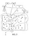
- FIG. 3schematically illustrates the acquisition of available data for a particular field.
- FIG. 4illustrates integration and transfer of pre-existing data to the test platform from a remote data facility.
- FIG. 5shows a representative on-board display of the field, showing the location of the test vehicle and initial test locations within each identified soil map unit.
- FIG. 6shows partial log results from three initial test locations within a soil map unit, along with a partial reference log derived from the USDA soil survey.
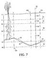
- FIG. 7is a cross-sectional subsurface view, taken along line 7 - 7 in FIG. 6 .
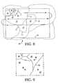
- FIG. 8illustrates the traversal of the field with non-invasive sensors to map more refined soil zones.
- FIG. 9is an enlarged view of area 9 of FIG. 8 , showing initial test locations for each soil zone.
- soil topology informationis shown in air photo 10 overlaid with closed boundaries or polygons 12 each enclosing a geographic region 14 or “soil map unit” labeled with a number corresponding to a specific subsurface material characteristic reference profile identified in a USDA-NRCS Soil Survey as a soil series description.
- soil map unitlabeled with a number corresponding to a specific subsurface material characteristic reference profile identified in a USDA-NRCS Soil Survey as a soil series description.
- the numeric label 15 of the soil map unitcorresponds to a particular characteristic soil type and profile, many soil map units in this field have identical labels.
- the polygonsare of irregular shape as determined by local topology and rough sampling at the time of the survey.
- FIG. 2illustrates a test vehicle 16 adapted to collect in-field subsurface and available data for the site.
- Vehicle 16includes a push system for pushing cone penetrometer (CPT) probes 17 or other invasive sensors into the soil along a selected path, either vertical or angled.
- CPTcone penetrometer
- These probescontain sensors 18 , known in the art, that are responsive to various soil properties.
- a typical CPT probe configured for geotechnical surveysmay contain a tip force load cell 18 b and a sleeve friction load cell 18 a, for example, along with a pore pressure sensor. In many cases, signals from such sensors are relayed electrically or wirelessly up to the push vehicle 16 for logging and analysis.
- Penetrometer sensorscan be used to measure or derive soil compaction, grain size, color, organic matter content, moisture, temperature and resistivity, as well as other chemical and physical properties. Some such sensors are available from Environmental Sensors, Inc. of Vancouver, British Columbia.
- vehicle 16is equipped with non-invasive sensors 20 for obtaining real-time subsurface images without disturbing the soil.
- Sensors 20may include electromagnetic and ground penetrating radar sensors, for example, capable of detecting subsurface structures such as clay lenses 21 and inter-layer boundaries.
- a data acquisition system 19 on-board vehicle 16collects data from deployed sensors 18 and 20 , with data from in-ground sensors correlated with depth as determined from a depth gage 22 , and all data correlated with geographic position as determined by an on-board global positioning system (GPS) 24 .
- GPSglobal positioning system
- the on-board data acquisition systemis also capable of integrating data collected from sensors with pre-existing data for the site, and/or relaying raw or processed data off-site via mobile telecommunications link.
- vehicle 16is deployed in a field 26 to be accurately mapped with respect to subsurface characteristics.
- the illustrated field boundary 28encloses portions of several different soil map units 14 identified on a related soil survey, with each soil map unit having a numeric label (only label “152” for soil map unit 14 ′ shown) that identifies the soil map unit as corresponding to a particular soil series.
- test vehicle 16Upon first arriving at field 26 , the field operator responsible for mapping the site will preferably already have access to any data that exists for the site, including USDA-NRCS soil surveys and previously acquired data.
- This datacan be stored in an on-board computer on test vehicle 16 , stored just outside the field boundary such as on a support vehicle 30 and sent to test vehicle 16 as needed via wireless communication 31 , or downloaded from a remote computer 32 using an Internet link 34 or radio transmission, for example.
- test vehicle 16has an on-board wireless modem or satellite transceiver for establishing a direct telecommunications link between the test vehicle data acquisition system and the remote databases 36 , such as via the Internet.
- remote computer 32requests pre-existing field data from various established databases 36 .
- This datacan include, for example, NRCS Soil Surveys or other soil maps, crop yield, digital elevation models, satellite images, air photos, orthorectified air photos, geology surveys, soil and water test information, land use records and history, and field and property boundaries.
- the field boundary 28is initially determined on-site by initially driving test vehicle 16 around the area to be mapped while recording boundary marks with the GPS system. The available data is then compiled using software contained either on test vehicle 16 , field support vehicle 30 , or from remote computer 32 , to form an integrated database reflecting the known information with respect to field 26 .
- test vehicle 16is deployed in a field at a given time to promote testing and sampling efficiency.
- the test vehiclesmay all perform the same types of tasks, or may each be equipped to perform a specialized task, with all preferably coordinated from a single remote vehicle 30 or computer 32 .
- the test vehiclemay be a wheeled or tracked mobile platform, in some cases it comprises a set of instrumentation and sensors carried about in a backpack or pushed about on a cart or sled by a test operator.
- a significant part of an efficient process of refining or improving the soil map of field 26is collecting and integrating the pre-existing data from various accessible sources. Because such data is represented in different formats, with different coordinate systems, the integration of such data requires precise translation and overlay.
- One of the functions of the remote computer 32(or in some cases, the computers on the test vehicle 26 or field support vehicle 30 ) is to translate all of the data from the different databases (located, for example, on government and private servers all around the country) into a preferred coordinate system of the field.
- the USDA soil survey polygonswere originally referenced to each state's coordinate reference system. Therefore, polygon locations are ideally shifted during integration to account for transformation from the original aerial maps to GPS geo-referenced digital polygon maps.
- USDA soil surveys and other database informationtends to be stored in massive files that are cumbersome to download repeatedly to the field. Therefore, it is preferred that the field boundary be employed to crop the available database information down to only that portion corresponding to the field in question, prior to transfer of such data to the field operator.
- This “clip and ship” approachrequires either the involvement of a remote coordination facility with sufficient computer resources to perform such data cropping remotely, or a database interface that permits precise boundary limitations in the transfer request. Either way, this approach enables huge amounts of data, some of which is in the form of images, to be more easily transferred to the field.
- the field operator in the test vehicle 16transmits field boundary and needed data type information to remote computer facility 32 , which crops data already downloaded from various web servers for the general area, integrates such data with reference to a field-specific coordinate system, and then forwards the cropped, integrated data packet 35 to the field operator in a manner of minutes or while the field operator is busily setting up the subsurface data acquisition equipment for a first push.
- the central processing facilityreceives pre-existing data, such as USDA soil polygon maps and digital elevation models, from several sources 37 , shifts 39 the coordinate references as necessary to enable overlay, crops 41 the portion of the pre-existing data files corresponding to the test area, and then overlays all of the processed, pre-existing data files to create a single database 35 limited to only that information necessary to the instant project. Only two remote data providers are shown for purposes of illustration, but any given project may require integration of many more sources of site-specific information, such as crop yield maps, orthophotos, property line boundaries, buried utility maps, available precision agriculture landscape models, etc.
- pre-existing datasuch as USDA soil polygon maps and digital elevation models
- This processcan greatly reduce the amount of forward planning necessary to begin testing, as an operator may just proceed to a field, drive around the field to establish a digital boundary, and electronically request the compilation and transfer of a relevant data package for that location.
- many earlier approachesrequire a sampling plan to be made several days in advance if prior digital information layers are to be used, so that the data from all the different databases can be obtained and integrated.
- the types of data to be integratedis preferably selected in response to an indication of the type of survey to be conducted, reducing the level of training and scientific knowledge necessary for in-field operators, particularly when a remote data analysis facility is employed.
- the field operator in test vehicle 16will immediately proceed to collect in situ subsurface data at selected locations within each soil map unit identified within the integrated data packet containing the USDA-NRCS polygons.
- An on-board display 50 of the USDA-NRCS polygon map of the fieldmay be continuously updated with an icon 51 displaying the precise location of the test vehicle 16 as an aid to positioning the vehicle for data collection.
- Initial test locations 44 for each soil map unit 14are also preferably shown on the display. For 3-D data manipulation, three initial test locations 44 are automatically generated for each soil map unit. The suggested position of each initial test location 44 is established geometrically to span the general area of the soil map unit, modified as needed to provide reasonable distance between initial test locations 44 in neighboring soil map units.
- the in-field operatoris given authority to move any initial test location, such as by “clicking and dragging” the location icon 44 with a cursor control device, due to in-field accessibility, terrain variations, or subjective considerations.
- FIG. 6shows representative acquired and derived soil properties over relevant depth spans across a soil layer boundary at each of three initial test locations 44 a, 44 b and 44 c in a soil map unit, along with soil texture and color data 53 derived directly from the representative soil horizon and content information contained within the USDA-NRCS soil survey for the soil series corresponding to that soil map unit.
- this reference datacorresponds to the Drummer Series USDA-NRCS log information reproduced above.
- the data shown in this figuremay also be represented graphically as logs of any particular property as a function of depth.
- each testconcurs with the USDA-NRCS representative log with respect to the existence of both a silty/loam layer and a sandy/loam layer within this general depth, but indicate that the actual depth of the transition between these layers varies between 44 inches at point 44 a and 58 inches at point 44 b.
- the predicted boundaries 54 between soil layers predicted by the USDA-NRCS reference datacan only be represented as parallel, horizontal lines as the entire soil map unit is characterized with but a single representative log.
- the actual location of the boundary 56 between the E and F horizons, predicted by the pre-existing data to be at an average depth of 50 inches,is shown to vary across the soil map unit. This variance is significant in this agricultural example, as this layer boundary establishes a sharp delineation between the moisture-carrying, organically rich silt layer above and the dry, sandy layer below. Given this variability in depth for a particularly important feature, additional testing may very well be required before the confidence level in the surmised location of this feature is acceptable.
- the test algorithmwill suggest moving on to the next soil map unit and will create a preliminary 3-D model of the boundaries between these layers across the soil map unit. With no edge constraints imposed from neighboring soil map units, such a model will be planar with only three data points. However, as data is collected at points in neighboring soil map units, the model will be adjusted with proper higher order curvature, such as through punctual, three-dimensional Kriging methods, to best match the known data, and the mathematical confidence level will increase as the standard error of the Kriging estimation procedure decreases.
- the algorithmwill recommend a fourth initial test location before moving on to other soil map units.
- Known sampling routine algorithmscan be employed to determine a geo-statistically efficient location for each successive data collection point 44 .
- Optimal Kriging weightsthose that produce a minimum estimation variance, are obtained by solving a set of simultaneous equations as known in the art.
- the suggested location of the fourth test locationwill be determined mathematically, based on the locations of the first three test locations and the degree of variability between each combination of two of the first three test locations. Additional test locations will be established within the soil map unit until the desired level of confidence is obtained with respect to mapping the layer boundaries.
- a representative, smooth approximation 58 of the location of actual boundary 56 generated through three-dimensional Kriging with sufficient data pointsis shown in dashed outline to illustrate the substantial improvement in accuracy derived from this technique that builds upon the initial USDA-NRCS reference data. For purpose of illustration, the actual locations of other soil layer boundaries are omitted from this view.
- the number of initial test locations established by the algorithmis a function of the standard soil map unit (SMU) inclusion percentage (an estimate of non-homogeneity) established by the USDA. For example, only three initial tests will be suggested when the inclusion percentage is reported as less than 10. An inclusion percentage of between 10 and 20 will prompt four initial test locations, with five initial test locations for 20-30, six for 30-40, and seven for any inclusion percentage greater than 40. As with the above example, additional test locations may be requested as a function of data correlation during testing.
- SMUsoil map unit
- test vehiclebegins traversing the field in a predetermined pattern as shown by arrows in FIG. 8 , in order to obtain a high-resolution Digital Elevation Model (DEM).
- DEMDigital Elevation Model
- the DEMis created by obtaining landscape position and elevation as discrete GPS measurements as the vehicle moves across field 26 .
- the precise DEMis compared to a macro DEM from the United States Geographical Service (USGS) included in the downloaded data packet, with any gross variations prompting confirmation.
- USGSUnited States Geographical Service
- test vehiclecarries sensors that non-invasively detect changes in soil properties as the test vehicle moves across the field, such as electromagnetic or ground penetrating radar.
- non-invasive sensorscan often detect more detailed changes in soil properties than those delineated in typical USDA-NRCS soil survey maps, enabling the real-time derivation of more precise soil zones 40 with their own set of boundaries 42 , within a given soil map unit 14 and even extending across soil map unit boundaries 12 .
- This processcan precede, or occur during, the remote acquisition and integration of pre-existing data described above.
- Initial test locationsmay then be established in each soil zone 40 , rather than in each USDA-NRCS soil map unit, as described above.
- the establishment of such soil zones 40 as a result of broad, non-intrusive testingcan enable the selection of only a single intrusive test location 44 per soil zone 40 as shown in FIG. 9 , for many applications, with reasonable confidence that the data from that test location will be sufficiently representative of the entire soil zone.
- the precise DEMenables proper transposition of subsurface data depth references to a common reference plane, such that fully three-dimensional subsurface models may be generated and sectioned for viewing.
- a rough DEM as available from the USGSmay be sufficient for this purpose, but for many precision applications a more exact depth reference will be desired.
- Standard cone penetrometersof about 1.5 to 2.0 inch diameter, will be useful for some applications while obtaining standard geotechnical measurements of tip force and sleeve friction, but many sensors have been sufficiently miniaturized to fit within a much smaller probe, such as of about one inch or less in diameter.
- These sensorscan include, among others, a miniature light source and receiver that together operate as a video camera to provide digital images of the soil surrounding the probe as it is advanced at a constant rate of 0.5 centimeters per second, for example.
- Such digital imagescan be particularly useful for subjective evaluation by skilled geologists thousands of miles from the test site, even before the probe is removed from the ground. It is also recommended that a full in situ video log be taken in each critical soil management zone at the end of the mapping sequence, for future reference. Such logs may eventually be cataloged and publicly accessible through NRCS, for example. In situ camera and video services are available commercially from Earth Information Technologies of Madison, Wis., among others.
- the process of mapping individual soil zones 40 with penetrometer sensorscan begin once the non-invasive sensors and any pre-existing data define zone boundaries 42 , with data acquisition proceeding concurrently in multiple soil zones within the same field.
- a 100-acre siteis mapped to assess the extent of a known wetland before construction can begin on a planned shopping mall.
- the Army Corps of Engineerspresently requires that in order for a location to be considered a wetland, it must contain a hydric soil.
- the soil properties that are relevant to a hydric soilare: depth to water, permeability, soil layer depth, soil color, soil structure, soil texture, and redoximorphic features.
- a test vehicleis mobilized to the site and immediately begins delineating the boundaries of the site by traversing the periphery.
- any other features significant to the sitee.g., trees, boulders, ponds, marshes, concrete
- any other features significant to the sitee.g., trees, boulders, ponds, marshes, concrete
- a requestis sent by the field data acquisition system to either an on-board database or a data server via a telecommunications link, requesting all available pertinent information (soil maps, DEMs, air photos, satellite images, water or soil sample data, or other maps and features) for that site.
- pertinent informationsoil maps, DEMs, air photos, satellite images, water or soil sample data, or other maps and features
- the portions of the compiled data that are specifically relevant to the site boundariesare clipped out of the compiled data. If the data clipping is performed at a remote location or otherwise away from the field test vehicle, then the clipped data is shipped to the field data acquisition system.
- the test vehicleis robotically or manually driven across the site to obtain high-resolution positional data as well as an assessment of soil zones defined between locations where significant subsurface property changes occur (i.e., at zone boundaries).
- the field data acquisition systemcombines the real-time DEM and soil data collected with the previously available data to create a map on which many specific zones are depicted.
- a decisionis made by the user as to the sensitivity of the instrumentation output analysis so as to not “over delineate” the site. This decision is made in terms of the specifics of the site as well as the intended use for the newly created soil and topography map.
- Geometric and/or statistical sampling algorithmsare applied to the newly created map to determine the most efficient and effective location for point sample collection or sensor testing. For example, if six unique zones are delineated, then three locations within each can be digitally flagged in such a way that they are all equidistant from one another and spaced with the most possible area of soil zone surrounding them. These digital flag locations are investigated either through sampling and/or sensor testing. The test vehicle is moved to each flagged location, where it obtains subsurface data to a depth of two meters. Each point profile of soil properties relevant to wetland delineation is taken and compared to the other tests conducted in the soil zone, as well as to the predicted soil properties from the non-invasive sensor testing and any pre-existing data for the site.
- Variability tolerancescan be set by the user or statistically determined with respect to the need to take additional sample or test points within the particular soil zone.
- a three-dimensional soil and topography mapis created for each of the soil properties specifically estimated.
- a digital soil video logis collected for each with a soil imaging penetrometer. These images can be sent off-site through a telecommunications link for viewing or processing and/or storage. The digital soil and topography map is exported to the user.
- the test vehicleis positioned in a central location 62 within the soil map unit and the test operator proceeds to take soil samples and/or soil property data at discrete locations 64 selected to lie generally at a midpoint of each soil layer identified in the USDA-NRCS soil series description, or in other pre-existing surveys.
- This approachenables very rapid site assessment at some cost of accuracy. For example, as can be seen from the location of the lowermost sampling location 64 shown, variation in depth of the soil strata across the zone can result in some sampling missing its intended layer altogether.
- Data collection depthsare either predetermined, such as at each expected layer midpoint, or are established by monitoring signals as probe sensor measure soil properties, but with only the data at two depths actually recorded.
- boundary depthsare also of interest, only the actual determined location of layer boundary depths, and single point or average property data within each layer, are recorded for analysis. Such limited information is sufficient for some modeling approaches that assume homogenous layer properties.
- a digital library of SMU datamay be developed and continually updated with additional information as it becomes available from recognized service providers.
- the initial databasewould include a representative digital profile for each USDA-NRCS soil series, including a unique, associated digital sensory signature.
- the signature database profilesare preferably collected at least twice under different conditions (e.g., different moisture and temperature) with the same type of sensors, thus enabling the creation of calibration curves and the transferability of results collected using different tools by different operators.
- a list of potential signaturesis downloaded for the mapping procedure as determined by the SMU designations in the area of the USDA-NRCS soil survey associated with the field. Other locally occurring signatures could also be used for the mapping procedure.
Landscapes
- Physics & Mathematics (AREA)
- Life Sciences & Earth Sciences (AREA)
- General Life Sciences & Earth Sciences (AREA)
- General Physics & Mathematics (AREA)
- Geophysics (AREA)
- Management, Administration, Business Operations System, And Electronic Commerce (AREA)
- Position Fixing By Use Of Radio Waves (AREA)
- Geophysics And Detection Of Objects (AREA)
- Processing Of Solid Wastes (AREA)
- Soil Conditioners And Soil-Stabilizing Materials (AREA)
- Testing Or Calibration Of Command Recording Devices (AREA)
- Treatment Of Sludge (AREA)
- Analysing Materials By The Use Of Radiation (AREA)
- Investigation Of Foundation Soil And Reinforcement Of Foundation Soil By Compacting Or Drainage (AREA)
Abstract
Description
- This invention relates to methods of soil and topography surveying and mapping, and more particularly to guiding the location of soil sampling and sensor testing in areas for which pre-existing survey data of various types are available.
- Soil information is publicly available in the United States as air photos overlaid with closed boundaries or polygons each enclosing a geographic region or “soil map unit” labeled with a number corresponding to a specific subsurface material characteristic reference profile identified in a United States Department of Agriculture—Natural Resource Conservation Service (USDA-NRCS) Soil Survey as a soil series description. Such soil surveys are presently available for over ninety percent of the geographic area of the United States, and other types of soil characterization maps are also available, both for the United States and other geographic regions. In any given field there may be several polygons, each of which bounds a numbered soil map unit. On average, there may be about 5.5 polygons per any 100 acre area. As the number of the soil map unit corresponds to a particular characteristic soil type and profile, many soil map units in a particular area may have identical labels. A table is used in the survey to link each number to a soil series name, and for each soil series name, the Soil Survey contains a text description of a representative soil profile. For example, the listing for the “Drummer Series” corresponding to soil map unit “152” is as follows:
- The Drummer series consists of deep, nearly level, poorly drained soils. These soils are in drainageways and in broad, flat areas on uplands. They formed in silty material and in the underlying stratified loamy material.
- In a representative profile the surface layer is black and very dark gray silty clay loam about 18 inches thick. The subsoil, about 32 inches thick, is olive-gray and gray to light-gray silty clay loam mottled with strong brown. The underlying material is gray and strong-brown sandy clay loam and silt loam.
- These soils are moderately permeable and have high available water capacity. Surface drainage and internal drainage are very slow, and when wet, the soils have low stability. The soils are subject to frequent water-logging and flooding or ponding during periods of run-off. Seasonally the water table is at a depth of less than 2 feet.
- These soils are well suited to row crops if they are adequately tile drained. Frequent waterlogging and potential for flooding or ponding are sever limitations for most other uses.
- Representative profile of Drummer silty clay loam, 480 feet south and 75 feet west of the N.E. corner of SE¼ sec. 24, T. 39 N., R. 3 E.
- A11—0 to 11 inches, black (10 YR 2/1) silty clay loam; moderate, fine and very fine, granular structure; friable; neutral; gradual, smooth boundary.
- A12—11 to 18 inches, black (10 YR 2/1) and very dark gray (10
YR 3/1) silty clay loam; weak, fine, subangular blocky structure parting to moderate, fine, granular; friable; neutral; gradual, smooth boundary. - B21g—18 to 29 inches, olive-gray (5 Y 5/2) silty clay loam; few, fine, faint, strong-brown (7.5 YR 5/6) mottles; moderate, fine, prismatic structure parting to moderate, fine, subangular blocky; firm; neutral; gradual, smooth boundary.
- B22g—29 to 50 inches, gray to light-gray (5 Y 6/1) and strong-brown (7.5 YR 5/6) silty clay loam; moderate, medium, prismatic structure; firm; neutral; abrupt, smooth boundary.
- HC1g—50 to 60 inches, strong-brown (7.5 YR 5/8) and gray to light-gray (5 Y 6/1) sandy clay loam; massive; friable; mildly alkaline; abrupt, smooth boundary.
- HC2g—60 to 78 inches, gray to light-gray (5 Y 6/1) and some pinkish-gray (5 YR 6/2), brown to dark-brown (7.5 YR 4/4) and gray to light-gray (7.5 YR 6/0) silt loam; massive; friable; moderately alkaline.
- The A horizon ranges from 8 to 20 inches in thickness. The B horizon ranges from 15 to 40 inches in thickness and from silty clay loam to clay loam in texture in the lower part. It is neutral to mildly alkaline. The C horizon ranges from loam to silt loam to sandy clay loam.
- Drummer soils are associated with Peotone and Flanagan soils. They have a thinner A horizon than Peotone soils and are more poorly drained than Flanagan soils.
- This text-based description of the soil series includes textual soil log information from a representative profile located somewhere in the United States. This soil type and profile information is useful to estimate the soil characteristics of any soil map unit of that soil series (in this case, the Drummer Series number 152) located anywhere in the United States or elsewhere.
- These representative profile descriptions typically range from the surface down to about 60 to 80 inches and contain descriptions of horizons or soil layers. Information on horizon depth and thickness and soil attributes is given for each typical soil horizon. This data is at best a representation of what that particular type of soil might look like on average in a typical situation. Thus, at any given location there will be differences between this characteristic information and actual boundary layer depth and thickness, and to some extent the soil content and type within each boundary or horizon. In order to better classify soils for precision management applications, it is sometimes necessary to characterize the actual depth, thickness and content of a particular soil map unit within a field, and all other soil map units contained within that field.
- The USDA-NRCS polygons are available currently in digital format for about sixty percent of the United States. In these cases, the soil map unit boundaries and their landscape position can be downloaded from a database accessible through the Internet, or from a CD-Rom or other data storage device. In some cases, the air photo is also available in digital format. However, the text descriptions of the soil series are currently only available in text format that can be read and viewed by an individual, but not readily compared digitally to sample or sensor data. Also, as the description associated with a particular soil series is almost always from a representative soil log taken at a location far from the actual field polygon that is being mapped, various inaccuracies can develop.
- The USDA-NRCS is responsible for mapping soils in the United States at a scale referred to as a Second Order Survey. This is typically in a scale range from 1:24,000 to 1:60,000. It is generally understood that such rough scales are not particularly useful for high precision applications, such as agriculture, wetland mapping, construction, watershed, golf course design maintenance, archaeological mapping, environmental site assessments, and such. Methods are needed for more accurately characterizing subsurface conditions in geographic regions previously associated as a whole with a specific subsurface material characteristic reference profile in a USDA-NRCS survey or the like, to make such database information more useful for such precision applications.
- The depth and thickness of soil horizons and their properties can vary immensely within a landscape, and even within a given field. If a critical soil property, such as nutrient and water holding capacity or carbon content, is to be assessed within a given field or area, then it is critical that the vertical and horizontal distribution of such properties be determined accurately. When a soil core is collected, the number of sections analyzed in the sample limits the vertical resolution of the soil property assessment at that location. This is due primarily to the high cost and time expenditure associated with soil sample collection, preparation, analysis, and recording procedures. Typically, only a few locations across a landscape are chosen for core sampling, and only a few sample sections are removed from each core for analysis. This limited vertical soil information results in errors when attempting to model the spatial distribution and volume of soil properties across a landscape.
- According to one aspect of the invention, a method is provided for characterizing subsurface conditions in a selected geographic region previously associated as a whole with a specific subsurface material characteristic reference profile. The method includes deploying a sensing tool at a selected position within the geographic region, with the tool constructed to be responsive to a selected subsurface material attribute, and determining, from a signal received from the deployed tool, a depth-referenced subsurface material characteristic at the selected position. The determined subsurface material characteristic is compared to the subsurface material characteristic reference profile associated with the geographic region to determine a correlation between the subsurface material characteristic reference profile and the depth-referenced subsurface material characteristic as determined from the signal received from the deployed tool.
- In one approach, the method also includes deciding whether to deploy the tool at another position within said geographic region by considering the correlation determined from said selected position.
- In some embodiments, the geographic region corresponds to one bounded area of a patchwork of such bounded areas on a map, each bounded area having an associated subsurface material characteristic reference profile. For example, in a particularly useful method for surveying areas in the United States, the geographic region comprises an individual Soil Map Unit as outlined on an USDA-NRCS Soil Survey map and referenced to the subsurface material characteristic reference profile by the USDA-NRCS Soil Survey map.
- In some cases, the depth-referenced subsurface material characteristic comprises a digital log of a soil property as a function of depth. In some such cases, comparing the determined subsurface material characteristic to the subsurface material reference characteristic profile associated with the geographic region may include comparing a soil layer boundary depth, as determined from the soil property log, with a reference layer boundary depth as determined from the subsurface material reference characteristic profile.
- For some applications, the subsurface material reference characteristic profile comprises a digital reference profile log containing at least about 10 discrete, depth-referenced data points, with the correlation comprising a computed numerical value indicative of degree of similarity between the digital soil property log and the digital reference profile log.
- Comparing the determined subsurface material characteristic to the subsurface material reference characteristic profile associated with the geographic region includes, in some cases, comparing soil texture at a selected depth, as determined from the determined subsurface material characteristic, with a reference texture as determined from the subsurface material reference characteristic profile.
- For many particularly important applications, deploying the tool includes penetrating soil with the tool to a depth of at least 6 inches, preferably at least 24 inches.
- The method preferably includes geo-referencing the selected position to a coordinate system with a Global Positioning System, such as with a GPS transceiver associated with a tool deployment system.
- In some embodiments, the depth-referenced subsurface material characteristic comprises a log of data taken at multiple depths at the selected position.
- The tool, in some cases, is responsive to light reflected from adjacent subsurface material in situ. In such cases, determining the depth-referenced subsurface material characteristic preferably includes generating a depth-referenced, rastered image of the subsurface material. A series of images of adjacent subsurface materials may be collected and digitally processed as the tool is forced through the subsurface materials, for example.
- In some applications, the method also includes traversing the geographic region while obtaining landscape position and elevation measurements; combining the position and elevation measurements to form a digital elevation model; adjusting a depth reference of the subsurface material characteristic determined at each of several test locations in accordance with the digital elevation model; and then combining the depth reference-adjusted subsurface material characteristics to form a three-dimensional subsurface model of the material characteristic.
- In some scenarios, the depth-referenced subsurface material characteristic comprises multiple, discrete data points obtained at selected depths at the selected position. The selected depths may be chosen to correspond to soil layers identified in the subsurface material characteristic reference profile associated with the geographic region, for example. The discrete data points are, in some cases, spaced apart in elevation according to soil layer thickness included in the subsurface material characteristic reference profile.
- In some cases, the method includes selecting a next tool deployment location within the selected geographic region on a basis of the correlation between the subsurface material characteristic reference profile and the depth-referenced subsurface material characteristic.
- The method also includes, in some embodiments, deploying a subsurface tool at the next tool deployment location; determining, from a signal received from the deployed subsurface tool, a second depth-referenced soil characteristic; comparing the second depth-referenced soil characteristic to the subsurface soil characteristic profile associated with the geographic region to determine another correlation, between the soil characteristic reference profile and the second depth-referenced soil characteristic; and then selecting a third tool deployment location within the selected geographic region on a basis of both determined correlations.
- In some embodiments, the soil attribute sensing tool is deployed in at least three initial positions within the geographic region, to determine a depth-referenced soil characteristic at each of the initial positions. The determined soil characteristics are then compared to each other and to the subsurface soil characteristic reference profile associated with the geographic region to determine a correlation between the depth-referenced soil characteristics at the initial positions, and between the depth-referenced soil characteristics and the soil characteristic reference profile. Preferably, the next tool deployment location within the selected geographic region is selected on a basis of the correlation between the depth-referenced soil characteristics at the initial positions.
- The method includes, in some cases, generating a three-dimensional model of the soil characteristic from depth-referenced soil characteristics obtained at multiple positions within the geographic region. Preferably, this model is updated throughout the data collection process as data is generated at additional locations within the geographic region, with the model and/or a confidence value or error estimate associated with the model serving as a basis for determining additional test requirements. Th three-dimensional model may be created digitally using punctual Kriging estimation techniques, for example.
- Another aspect of the invention features a method of characterizing subsurface conditions in a selected geographic region previously surveyed to identify discrete zones within the region corresponding to a reference soil series having an associated description of soil layers corresponding to the soil series and soil properties common to each layer. The method includes selecting a test position in each identified zone; deploying a sensing tool at the selected position within the geographic region, with the tool constructed to be responsive to a selected subsurface material attribute; and then determining, from a signal received from the deployed tool, a subsurface material characteristic at multiple, discrete depths corresponding to layer positions described in the reference soil series description.
- The method includes, in some applications, comparing the determined subsurface material characteristic to soil layer properties listed in the reference soil series description.
- In some particularly useful embodiments, the soil zones correspond to individual Soil Map Units as outlined on an USDA-NRCS Soil Survey map.
- According to yet another aspect of the invention, a method of generating first order survey information in an individual Soil Map Unit, as outlined in a map of a USDA-NRCS Soil Survey that establishes an SMU Inclusion Percentage associated with the Soil Map Unit, is provided. The method includes selecting an initial number of positions for tool deployment within the Soil Map Unit, the initial number of selected surface positions being determined as a function of the associated SMU Inclusion Percentage; deploying a subsurface attribute sensing tool to generate subsurface characteristic logs, based on signals received from the deployed tool, at the selected surface positions; identifying a soil boundary layer feature common to the generated subsurface characteristic logs; and calculating an expected depth of the soil boundary layer feature at further surface positions within the bounded area as a function of depth of the soil boundary layer feature in the three selected surface positions and a spatial relationship between the selected surface positions and each further surface position.
- The method also includes, in some instances, determining, from a signal received from the deployed subsurface tool, a depth-referenced soil characteristic at each of the selected positions; comparing the determined soil characteristics to a subsurface soil characteristic reference profile associated with the Soil Map Unit to determine an overall correlation between the soil characteristic reference profile and the depth-referenced soil characteristics of the selected positions; and deciding whether to deploy a subsurface tool to determine depth-referenced soil characteristics at another position within the Soil Map Unit by considering the overall correlation.
- In some embodiments, the initial number of positions selected for tool deployment is also determined as a function of known Soil Map Unit topographical information, land use information, past agricultural yield information, or other available data. The initial number of positions may be selected automatically, such as by the data acquisition system, and yet modified by user input before tool deployment.
- Another aspect of the invention features a method of characterizing subsurface properties of a field. The method includes moving a test platform to the field, the test platform having a tool deployment ram for advancing a probe into topsoil of the field at selected locations while receiving signals back from the probe indicating a subsurface material characteristic; moving the test platform to multiple points along a boundary of the field to define a field perimeter; connecting the test platform to a remote network server over a wireless data link; uploading a reference map segment data request from the test platform to the remote network server, the request including a representation of the defined field perimeter; receiving a reference map segment data packet from the remote network server over the wireless data link, the data packet including a segmented portion of a reference map database covering a geographic area containing the field, with the segmented portion being of extent and location as selected at the remote network server in response to the map segment data request uploaded from the test platform; advancing the probe into the topsoil at a first selected location within the field; recording subsurface material characteristic data received from the advancing probe; and evaluating the recorded material characteristic data by comparing the recorded subsurface material characteristic data with data from the reference map segment data packet.
- In some embodiments, the reference map segment data request also includes an indication of an intended use of data obtained by characterizing the subsurface properties. Based on this indication, the remote network server may filter the information to be included in the reference map segment data packet.
- In some cases, the wireless data link includes an intermediate server disposed outside the field. In such cases, the intermediate server receives and interprets the reference map segment data request; selects, in response to the request, among particular network map data servers; downloads from each selected server a segmented portion of an associated reference map database; generates the reference map segment data packet; and then downloads the reference map segment data packet to the test platform.
- In some embodiments the method includes, after recording subsurface material characteristic data received from the advancing probe, determining further test activity to be performed within the field as a function of the received data at the first selected location.
- Other aspects of the invention feature systems, apparatus and computing systems configured to perform the above methods, data analysis, integration and transfer.
- Various aspects of the invention can greatly improve in-field subsurface surveying efficiency over present methods. By building directly upon pre-existing subsurface and other survey data, for example, in-field testing time can be reduced. Further, such techniques offer particular advantage when test planning, reference data integration, sensor data collection and analysis are performed on-the-fly while the test platform is on site, in many cases in the course of a single day. In the United States these methods can take particular advantage of readily available USDA-NRCS Soil Surveys as part of the initial reference data for test planning. Standard computing platforms may be programmed to perform many aspects of these methods in semi-automated fashion, with overall test planning and coordination provided remotely by a trained scientist, and all in-field testing performed by a field operator following simple directions, making better use of human resources. The user is also able to integrate real-time sensor data with pre-existing data for a chosen site, thus increasing sampling strategy flexibility as the site is characterized. An on-the-fly material sampling routine can be advantageously integrated with the data acquisition methods described herein. Various aspects of the invention are particularly useful for precision applications, economically producing the survey information needed for precision agriculture, wetland mapping, construction, watershed evaluation, golf course design maintenance, etc.
- The details of one or more embodiments of the invention are set forth in the accompanying drawings and the description below. Other features, objects, and advantages of the invention will be apparent from the description and drawings, and from the claims.
FIG. 1 is an air photo overlaid with USDA-NRCS soil map unit polygons.FIG. 2 illustrates field data acquisition with a mobile test vehicle.FIG. 3 schematically illustrates the acquisition of available data for a particular field.FIG. 4 illustrates integration and transfer of pre-existing data to the test platform from a remote data facility.FIG. 5 shows a representative on-board display of the field, showing the location of the test vehicle and initial test locations within each identified soil map unit.FIG. 6 shows partial log results from three initial test locations within a soil map unit, along with a partial reference log derived from the USDA soil survey.FIG. 7 is a cross-sectional subsurface view, taken along line7-7 inFIG. 6 .FIG. 8 illustrates the traversal of the field with non-invasive sensors to map more refined soil zones.FIG. 9 is an enlarged view ofarea 9 ofFIG. 8 , showing initial test locations for each soil zone.- Like reference symbols in the various drawings indicate like elements.
- Referring first to
FIG. 1 , soil topology information is shown inair photo 10 overlaid with closed boundaries orpolygons 12 each enclosing ageographic region 14 or “soil map unit” labeled with a number corresponding to a specific subsurface material characteristic reference profile identified in a USDA-NRCS Soil Survey as a soil series description. In this illustrated example covering approximately 1000 acres, there areseveral polygons 12, each of which bounds a numberedsoil map unit 14. As thenumeric label 15 of the soil map unit corresponds to a particular characteristic soil type and profile, many soil map units in this field have identical labels. As shown, the polygons are of irregular shape as determined by local topology and rough sampling at the time of the survey. FIG. 2 illustrates atest vehicle 16 adapted to collect in-field subsurface and available data for the site.Vehicle 16 includes a push system for pushing cone penetrometer (CPT) probes17 or other invasive sensors into the soil along a selected path, either vertical or angled. These probes containsensors 18, known in the art, that are responsive to various soil properties. A typical CPT probe configured for geotechnical surveys may contain a tipforce load cell 18band a sleevefriction load cell 18a,for example, along with a pore pressure sensor. In many cases, signals from such sensors are relayed electrically or wirelessly up to thepush vehicle 16 for logging and analysis. Penetrometer sensors can be used to measure or derive soil compaction, grain size, color, organic matter content, moisture, temperature and resistivity, as well as other chemical and physical properties. Some such sensors are available from Environmental Sensors, Inc. of Vancouver, British Columbia. In addition to these subsurface-deployed sensors,vehicle 16 is equipped withnon-invasive sensors 20 for obtaining real-time subsurface images without disturbing the soil.Sensors 20 may include electromagnetic and ground penetrating radar sensors, for example, capable of detecting subsurface structures such asclay lenses 21 and inter-layer boundaries. Adata acquisition system 19 on-board vehicle 16 collects data from deployedsensors depth gage 22, and all data correlated with geographic position as determined by an on-board global positioning system (GPS)24. The on-board data acquisition system is also capable of integrating data collected from sensors with pre-existing data for the site, and/or relaying raw or processed data off-site via mobile telecommunications link.- Referring to
FIG. 3 ,vehicle 16 is deployed in afield 26 to be accurately mapped with respect to subsurface characteristics. The illustratedfield boundary 28 encloses portions of several differentsoil map units 14 identified on a related soil survey, with each soil map unit having a numeric label (only label “152” forsoil map unit 14′ shown) that identifies the soil map unit as corresponding to a particular soil series. - Upon first arriving at
field 26, the field operator responsible for mapping the site will preferably already have access to any data that exists for the site, including USDA-NRCS soil surveys and previously acquired data. This data can be stored in an on-board computer ontest vehicle 16, stored just outside the field boundary such as on asupport vehicle 30 and sent to testvehicle 16 as needed viawireless communication 31, or downloaded from aremote computer 32 using anInternet link 34 or radio transmission, for example. In some cases,test vehicle 16 has an on-board wireless modem or satellite transceiver for establishing a direct telecommunications link between the test vehicle data acquisition system and theremote databases 36, such as via the Internet. Relaying the geographic position oftest vehicle 16 as determined by the GPS device located on or near the test vehicle that determines its location using a series ofglobal positioning satellites 38 in orbit about the earth,remote computer 32 requests pre-existing field data from various establisheddatabases 36. This data can include, for example, NRCS Soil Surveys or other soil maps, crop yield, digital elevation models, satellite images, air photos, orthorectified air photos, geology surveys, soil and water test information, land use records and history, and field and property boundaries. In some cases thefield boundary 28 is initially determined on-site by initially drivingtest vehicle 16 around the area to be mapped while recording boundary marks with the GPS system. The available data is then compiled using software contained either ontest vehicle 16,field support vehicle 30, or fromremote computer 32, to form an integrated database reflecting the known information with respect tofield 26. - In some cases, more than one
test vehicle 16 is deployed in a field at a given time to promote testing and sampling efficiency. The test vehicles may all perform the same types of tasks, or may each be equipped to perform a specialized task, with all preferably coordinated from a singleremote vehicle 30 orcomputer 32. While the test vehicle may be a wheeled or tracked mobile platform, in some cases it comprises a set of instrumentation and sensors carried about in a backpack or pushed about on a cart or sled by a test operator. - Referring to
FIG. 4 , a significant part of an efficient process of refining or improving the soil map offield 26 is collecting and integrating the pre-existing data from various accessible sources. Because such data is represented in different formats, with different coordinate systems, the integration of such data requires precise translation and overlay. One of the functions of the remote computer32 (or in some cases, the computers on thetest vehicle 26 or field support vehicle30) is to translate all of the data from the different databases (located, for example, on government and private servers all around the country) into a preferred coordinate system of the field. The USDA soil survey polygons were originally referenced to each state's coordinate reference system. Therefore, polygon locations are ideally shifted during integration to account for transformation from the original aerial maps to GPS geo-referenced digital polygon maps. - USDA soil surveys and other database information tends to be stored in massive files that are cumbersome to download repeatedly to the field. Therefore, it is preferred that the field boundary be employed to crop the available database information down to only that portion corresponding to the field in question, prior to transfer of such data to the field operator. This “clip and ship” approach requires either the involvement of a remote coordination facility with sufficient computer resources to perform such data cropping remotely, or a database interface that permits precise boundary limitations in the transfer request. Either way, this approach enables huge amounts of data, some of which is in the form of images, to be more easily transferred to the field. In one example application, the field operator in the
test vehicle 16 transmits field boundary and needed data type information toremote computer facility 32, which crops data already downloaded from various web servers for the general area, integrates such data with reference to a field-specific coordinate system, and then forwards the cropped,integrated data packet 35 to the field operator in a manner of minutes or while the field operator is busily setting up the subsurface data acquisition equipment for a first push. In the process as illustrated, the central processing facility receives pre-existing data, such as USDA soil polygon maps and digital elevation models, fromseveral sources 37, shifts39 the coordinate references as necessary to enable overlay, crops41 the portion of the pre-existing data files corresponding to the test area, and then overlays all of the processed, pre-existing data files to create asingle database 35 limited to only that information necessary to the instant project. Only two remote data providers are shown for purposes of illustration, but any given project may require integration of many more sources of site-specific information, such as crop yield maps, orthophotos, property line boundaries, buried utility maps, available precision agriculture landscape models, etc. This process can greatly reduce the amount of forward planning necessary to begin testing, as an operator may just proceed to a field, drive around the field to establish a digital boundary, and electronically request the compilation and transfer of a relevant data package for that location. In contrast, many earlier approaches require a sampling plan to be made several days in advance if prior digital information layers are to be used, so that the data from all the different databases can be obtained and integrated. The types of data to be integrated is preferably selected in response to an indication of the type of survey to be conducted, reducing the level of training and scientific knowledge necessary for in-field operators, particularly when a remote data analysis facility is employed. - In one example field data acquisition method, the field operator in
test vehicle 16 will immediately proceed to collect in situ subsurface data at selected locations within each soil map unit identified within the integrated data packet containing the USDA-NRCS polygons. An on-board display 50 of the USDA-NRCS polygon map of the field (FIG. 5 ) may be continuously updated with anicon 51 displaying the precise location of thetest vehicle 16 as an aid to positioning the vehicle for data collection.Initial test locations 44 for eachsoil map unit 14 are also preferably shown on the display. For 3-D data manipulation, threeinitial test locations 44 are automatically generated for each soil map unit. The suggested position of eachinitial test location 44 is established geometrically to span the general area of the soil map unit, modified as needed to provide reasonable distance betweeninitial test locations 44 in neighboring soil map units. If desired, the in-field operator is given authority to move any initial test location, such as by “clicking and dragging” thelocation icon 44 with a cursor control device, due to in-field accessibility, terrain variations, or subjective considerations. - In general, data should be collected at all three
initial test locations 44 for a givensoil map unit 14 before moving on to another soil map unit.FIG. 6 shows representative acquired and derived soil properties over relevant depth spans across a soil layer boundary at each of threeinitial test locations color data 53 derived directly from the representative soil horizon and content information contained within the USDA-NRCS soil survey for the soil series corresponding to that soil map unit. For purposes of illustration, this reference data corresponds to the Drummer Series USDA-NRCS log information reproduced above. The data shown in this figure may also be represented graphically as logs of any particular property as a function of depth. As can be seen in this instance, each test concurs with the USDA-NRCS representative log with respect to the existence of both a silty/loam layer and a sandy/loam layer within this general depth, but indicate that the actual depth of the transition between these layers varies between 44 inches atpoint point 44b. - This variation can better be visualized in the laterally compressed subsurface cross-section of
FIG. 7 . The predictedboundaries 54 between soil layers predicted by the USDA-NRCS reference data can only be represented as parallel, horizontal lines as the entire soil map unit is characterized with but a single representative log. The actual location of theboundary 56 between the E and F horizons, predicted by the pre-existing data to be at an average depth of 50 inches, is shown to vary across the soil map unit. This variance is significant in this agricultural example, as this layer boundary establishes a sharp delineation between the moisture-carrying, organically rich silt layer above and the dry, sandy layer below. Given this variability in depth for a particularly important feature, additional testing may very well be required before the confidence level in the surmised location of this feature is acceptable. - If the corroboration between the soil characteristics determined at each of these three data collection locations exceeds the necessary confidence threshold, the test algorithm will suggest moving on to the next soil map unit and will create a preliminary 3-D model of the boundaries between these layers across the soil map unit. With no edge constraints imposed from neighboring soil map units, such a model will be planar with only three data points. However, as data is collected at points in neighboring soil map units, the model will be adjusted with proper higher order curvature, such as through punctual, three-dimensional Kriging methods, to best match the known data, and the mathematical confidence level will increase as the standard error of the Kriging estimation procedure decreases. If there is low soil data correlation between the three initial test locations (e.g., if the Kriging estimation variance is above a predetermined acceptability level), the algorithm will recommend a fourth initial test location before moving on to other soil map units. Known sampling routine algorithms can be employed to determine a geo-statistically efficient location for each successive
data collection point 44. Optimal Kriging weights, those that produce a minimum estimation variance, are obtained by solving a set of simultaneous equations as known in the art. The suggested location of the fourth test location will be determined mathematically, based on the locations of the first three test locations and the degree of variability between each combination of two of the first three test locations. Additional test locations will be established within the soil map unit until the desired level of confidence is obtained with respect to mapping the layer boundaries. A representative,smooth approximation 58 of the location ofactual boundary 56 generated through three-dimensional Kriging with sufficient data points is shown in dashed outline to illustrate the substantial improvement in accuracy derived from this technique that builds upon the initial USDA-NRCS reference data. For purpose of illustration, the actual locations of other soil layer boundaries are omitted from this view. - In one preferred approach the number of initial test locations established by the algorithm is a function of the standard soil map unit (SMU) inclusion percentage (an estimate of non-homogeneity) established by the USDA. For example, only three initial tests will be suggested when the inclusion percentage is reported as less than 10. An inclusion percentage of between 10 and 20 will prompt four initial test locations, with five initial test locations for 20-30, six for 30-40, and seven for any inclusion percentage greater than 40. As with the above example, additional test locations may be requested as a function of data correlation during testing.
- As seen from the representative data of
FIG. 6 , not only are soil color data produced and soil texture data derived in the field for direct comparison with USDA-NRCS representative soil log data, but soil density, temperature, moisture and organic matter content are measured or derived. As would be expected, both the moisture and organic matter (O.M.) content decrease significantly in the sandy/loam layer, the beginning of which is also indicated by the shift in soil color and density. Thus, not only may the on-board algorithm or remote data processing service now provide a good three-dimensional model of soil layer boundaries, it may also provide information as to the capacity of the soil to retain or accept water and fertilizers, thus enabling very precise application of each for agricultural or other uses, or precise crop planning and planting. Available software products for performing general geostatistical and graphical analysis of subsurface data include EnviroStats, available from Scientific Software Group of Washington, D.C. - In another mapping scenario, once the
field boundary 28 is defined, the test vehicle begins traversing the field in a predetermined pattern as shown by arrows inFIG. 8 , in order to obtain a high-resolution Digital Elevation Model (DEM). The DEM is created by obtaining landscape position and elevation as discrete GPS measurements as the vehicle moves acrossfield 26. The precise DEM is compared to a macro DEM from the United States Geographical Service (USGS) included in the downloaded data packet, with any gross variations prompting confirmation. In addition, test vehicle carries sensors that non-invasively detect changes in soil properties as the test vehicle moves across the field, such as electromagnetic or ground penetrating radar. These non-invasive sensors can often detect more detailed changes in soil properties than those delineated in typical USDA-NRCS soil survey maps, enabling the real-time derivation of moreprecise soil zones 40 with their own set ofboundaries 42, within a givensoil map unit 14 and even extending across soilmap unit boundaries 12. This process can precede, or occur during, the remote acquisition and integration of pre-existing data described above. Initial test locations may then be established in eachsoil zone 40, rather than in each USDA-NRCS soil map unit, as described above. However, the establishment ofsuch soil zones 40 as a result of broad, non-intrusive testing can enable the selection of only a singleintrusive test location 44 persoil zone 40 as shown inFIG. 9 , for many applications, with reasonable confidence that the data from that test location will be sufficiently representative of the entire soil zone. - The precise DEM enables proper transposition of subsurface data depth references to a common reference plane, such that fully three-dimensional subsurface models may be generated and sectioned for viewing. For some applications, a rough DEM as available from the USGS may be sufficient for this purpose, but for many precision applications a more exact depth reference will be desired. In some cases, it will be sufficient to simply reference the depth index of each subsurface log to a discrete GPS elevation measurement taken at the respective test location.
- There are a variety of invasive sensors that can be pushed through the upper layers of soil with a relatively light-weight push platform without extended damage to sensitive topsoils. Standard cone penetrometers, of about 1.5 to 2.0 inch diameter, will be useful for some applications while obtaining standard geotechnical measurements of tip force and sleeve friction, but many sensors have been sufficiently miniaturized to fit within a much smaller probe, such as of about one inch or less in diameter. These sensors can include, among others, a miniature light source and receiver that together operate as a video camera to provide digital images of the soil surrounding the probe as it is advanced at a constant rate of 0.5 centimeters per second, for example. Such digital images can be particularly useful for subjective evaluation by skilled geologists thousands of miles from the test site, even before the probe is removed from the ground. It is also recommended that a full in situ video log be taken in each critical soil management zone at the end of the mapping sequence, for future reference. Such logs may eventually be cataloged and publicly accessible through NRCS, for example. In situ camera and video services are available commercially from Earth Information Technologies of Madison, Wis., among others.
- If there is more than one
test vehicle 16 at the site, the process of mappingindividual soil zones 40 with penetrometer sensors can begin once the non-invasive sensors and any pre-existing data definezone boundaries 42, with data acquisition proceeding concurrently in multiple soil zones within the same field. In such cases, it is preferred to have such concurrent activity coordinated from a single chief test platform, or from a remote vehicle or facility, with data from the various acquisition platforms forwarded after each test location in order to update the overall subsurface model and determine the next test location for each rig. - In another example, a 100-acre site is mapped to assess the extent of a known wetland before construction can begin on a planned shopping mall. The Army Corps of Engineers presently requires that in order for a location to be considered a wetland, it must contain a hydric soil. The soil properties that are relevant to a hydric soil are: depth to water, permeability, soil layer depth, soil color, soil structure, soil texture, and redoximorphic features. A test vehicle is mobilized to the site and immediately begins delineating the boundaries of the site by traversing the periphery. In addition, any other features significant to the site (e.g., trees, boulders, ponds, marshes, concrete) also have their boundaries delineated. During the boundary mapping process a request is sent by the field data acquisition system to either an on-board database or a data server via a telecommunications link, requesting all available pertinent information (soil maps, DEMs, air photos, satellite images, water or soil sample data, or other maps and features) for that site. Once all relevant data is compiled and the boundaries delineated, the portions of the compiled data that are specifically relevant to the site boundaries are clipped out of the compiled data. If the data clipping is performed at a remote location or otherwise away from the field test vehicle, then the clipped data is shipped to the field data acquisition system.
- Once all site-specific and relevant data is acquired, the test vehicle is robotically or manually driven across the site to obtain high-resolution positional data as well as an assessment of soil zones defined between locations where significant subsurface property changes occur (i.e., at zone boundaries). During or after the “clip and ship” process the field data acquisition system combines the real-time DEM and soil data collected with the previously available data to create a map on which many specific zones are depicted. A decision is made by the user as to the sensitivity of the instrumentation output analysis so as to not “over delineate” the site. This decision is made in terms of the specifics of the site as well as the intended use for the newly created soil and topography map.
- Geometric and/or statistical sampling algorithms are applied to the newly created map to determine the most efficient and effective location for point sample collection or sensor testing. For example, if six unique zones are delineated, then three locations within each can be digitally flagged in such a way that they are all equidistant from one another and spaced with the most possible area of soil zone surrounding them. These digital flag locations are investigated either through sampling and/or sensor testing. The test vehicle is moved to each flagged location, where it obtains subsurface data to a depth of two meters. Each point profile of soil properties relevant to wetland delineation is taken and compared to the other tests conducted in the soil zone, as well as to the predicted soil properties from the non-invasive sensor testing and any pre-existing data for the site. Variability tolerances can be set by the user or statistically determined with respect to the need to take additional sample or test points within the particular soil zone. Once the soil properties are determined for the specific zone, as well as adjacent zones, a three-dimensional soil and topography map is created for each of the soil properties specifically estimated. Once each zone is established, a digital soil video log is collected for each with a soil imaging penetrometer. These images can be sent off-site through a telecommunications link for viewing or processing and/or storage. The digital soil and topography map is exported to the user.
- Referring back to
FIG. 7 , for another application not requiring delineation of soil layer boundaries but only needing precise determination of soil properties within known soil layers, the test vehicle is positioned in acentral location 62 within the soil map unit and the test operator proceeds to take soil samples and/or soil property data atdiscrete locations 64 selected to lie generally at a midpoint of each soil layer identified in the USDA-NRCS soil series description, or in other pre-existing surveys. This approach enables very rapid site assessment at some cost of accuracy. For example, as can be seen from the location of thelowermost sampling location 64 shown, variation in depth of the soil strata across the zone can result in some sampling missing its intended layer altogether. However, for many applications, and in sites generally having very coarse layer thickness, such an approach can provide much needed information for supplementing pre-existing data. For example, it might be known from the available USDA-NRCS survey that three specific soil types are predicted to exist at the site having relevance to a particular variable rate Nitrogen fertilizer application, separated generally by boundaries at 12 and 48 inches. It may be known that these two soil types differ measurably in texture and color. In this application it might only be necessary, and economically much more efficient, to only characterize these two properties, and only at one point per predicted soil layer in each soil map unit. The landscape surface position of the one test location might be selected near a central region of the soil map unit, or using methodologies such as where greater vertical resolution is required. Once the measurement location is determined, it may only be necessary to determine color and texture at a selected depth within each layer. Data collection depths are either predetermined, such as at each expected layer midpoint, or are established by monitoring signals as probe sensor measure soil properties, but with only the data at two depths actually recorded. In another scenario where the boundary depths are also of interest, only the actual determined location of layer boundary depths, and single point or average property data within each layer, are recorded for analysis. Such limited information is sufficient for some modeling approaches that assume homogenous layer properties. - Given the methods described above, a digital library of SMU data may be developed and continually updated with additional information as it becomes available from recognized service providers. The initial database would include a representative digital profile for each USDA-NRCS soil series, including a unique, associated digital sensory signature. The signature database profiles are preferably collected at least twice under different conditions (e.g., different moisture and temperature) with the same type of sensors, thus enabling the creation of calibration curves and the transferability of results collected using different tools by different operators. When a field boundary is later delineated, a list of potential signatures is downloaded for the mapping procedure as determined by the SMU designations in the area of the USDA-NRCS soil survey associated with the field. Other locally occurring signatures could also be used for the mapping procedure.
- Each time a test is performed by the test vehicle, the landscape position is recorded. At the conclusion of the test the coordinates are used to determine from which SMU the data were collected. The signature for the test location is compared to the digital SMU library. In most cases, the newly acquired signature will not exactly match a signature from the library. Therefore, fuzzy logic methods can be employed to determine which SMU signature is most like the newly acquired signature. This type of classification is sometimes referred to as a “fuzzy” map and is often very representative of natural landscapes and can help to better define the boundaries between soil types.
- A number of embodiments of the invention have been described. Nevertheless, it will be understood that various modifications may be made without departing from the spirit and scope of the invention. Accordingly, other embodiments are within the scope of the following claims.
Claims (21)
Priority Applications (1)
| Application Number | Priority Date | Filing Date | Title |
|---|---|---|---|
| US11/102,030US7254485B2 (en) | 2001-11-01 | 2005-04-07 | Soil and topography surveying |
Applications Claiming Priority (3)
| Application Number | Priority Date | Filing Date | Title |
|---|---|---|---|
| US09/998,863US6597992B2 (en) | 2001-11-01 | 2001-11-01 | Soil and topography surveying |
| US10/436,615US6959245B2 (en) | 2001-11-01 | 2003-05-13 | Soil and topography surveying |
| US11/102,030US7254485B2 (en) | 2001-11-01 | 2005-04-07 | Soil and topography surveying |
Related Parent Applications (1)
| Application Number | Title | Priority Date | Filing Date |
|---|---|---|---|
| US10/436,615ContinuationUS6959245B2 (en) | 2001-11-01 | 2003-05-13 | Soil and topography surveying |
Publications (2)
| Publication Number | Publication Date |
|---|---|
| US20050192752A1true US20050192752A1 (en) | 2005-09-01 |
| US7254485B2 US7254485B2 (en) | 2007-08-07 |
Family
ID=25545629
Family Applications (3)
| Application Number | Title | Priority Date | Filing Date |
|---|---|---|---|
| US09/998,863Expired - LifetimeUS6597992B2 (en) | 2001-11-01 | 2001-11-01 | Soil and topography surveying |
| US10/436,615Expired - LifetimeUS6959245B2 (en) | 2001-11-01 | 2003-05-13 | Soil and topography surveying |
| US11/102,030Expired - LifetimeUS7254485B2 (en) | 2001-11-01 | 2005-04-07 | Soil and topography surveying |
Family Applications Before (2)
| Application Number | Title | Priority Date | Filing Date |
|---|---|---|---|
| US09/998,863Expired - LifetimeUS6597992B2 (en) | 2001-11-01 | 2001-11-01 | Soil and topography surveying |
| US10/436,615Expired - LifetimeUS6959245B2 (en) | 2001-11-01 | 2003-05-13 | Soil and topography surveying |
Country Status (12)
| Country | Link |
|---|---|
| US (3) | US6597992B2 (en) |
| EP (1) | EP1451752B1 (en) |
| CN (1) | CN100468424C (en) |
| AT (1) | ATE547762T1 (en) |
| BR (1) | BR0206259A (en) |
| CA (1) | CA2465537A1 (en) |
| EA (1) | EA006531B1 (en) |
| IL (2) | IL161629A0 (en) |
| PL (1) | PL373474A1 (en) |
| UA (1) | UA78725C2 (en) |
| WO (1) | WO2003038730A1 (en) |
| ZA (1) | ZA200403210B (en) |
Cited By (34)
| Publication number | Priority date | Publication date | Assignee | Title |
|---|---|---|---|---|
| US20060006620A1 (en)* | 2004-07-07 | 2006-01-12 | Leggatt Charles D | Apparatus for transporting a sensor |
| US20070188318A1 (en)* | 2006-02-15 | 2007-08-16 | International Business Machines Corporation | Dynamic boundary mapping using position-determination systems |
| US20080079723A1 (en)* | 2006-05-16 | 2008-04-03 | David Hanson | System and method for visualizing multiple-sensor subsurface imaging data |
| US20080180319A1 (en)* | 2007-01-26 | 2008-07-31 | Mohammad Mojahedul Islam | Wireless utility asset mapping device and method |
| US20080180322A1 (en)* | 2007-01-26 | 2008-07-31 | Mohammad Mojahedul Islam | Method and system for wireless tracking of utility assets |
| US20090204614A1 (en)* | 2008-02-12 | 2009-08-13 | Nielsen Steven E | Searchable electronic records of underground facility locate marking operations |
| US20100057683A1 (en)* | 2008-08-29 | 2010-03-04 | Gene Fein | Topographical analysis system |
| US20110235923A1 (en)* | 2009-09-14 | 2011-09-29 | Weisenburger Shawn D | Accurate digitization of a georeferenced image |
| WO2011150351A3 (en)* | 2010-05-28 | 2012-02-02 | Gvm, Inc. | System and method for collecting and processing agricultural field data |
| US20120101796A1 (en)* | 2010-10-25 | 2012-04-26 | Lindores Robert J | Water erosion management incorporating topography, soil type, and weather statistics |
| US8265344B2 (en) | 2008-02-12 | 2012-09-11 | Certusview Technologies, Llc | Electronic manifest of underground facility locate operation |
| US8361543B2 (en) | 2008-10-02 | 2013-01-29 | Certusview Technologies, Llc | Methods and apparatus for displaying an electronic rendering of a marking operation based on an electronic record of marking information |
| US8572193B2 (en) | 2009-02-10 | 2013-10-29 | Certusview Technologies, Llc | Methods, apparatus, and systems for providing an enhanced positive response in underground facility locate and marking operations |
| US8583372B2 (en) | 2009-12-07 | 2013-11-12 | Certusview Technologies, Llc | Methods, apparatus, and systems for facilitating compliance with marking specifications for dispensing marking material |
| US8671741B2 (en) | 2011-06-29 | 2014-03-18 | Trimble Navigation Limited | Extendable moisture content sensing system |
| US8830265B2 (en) | 2009-07-07 | 2014-09-09 | Certusview Technologies, Llc | Methods, apparatus and systems for generating searchable electronic records of underground facility marking operations and assessing aspects of same |
| US8855937B2 (en) | 2010-10-25 | 2014-10-07 | Trimble Navigation Limited | Crop characteristic estimation |
| WO2014186810A1 (en)* | 2013-05-17 | 2014-11-20 | Precision Planting Llc | System for soil moisture monitoring |
| US8902251B2 (en) | 2009-02-10 | 2014-12-02 | Certusview Technologies, Llc | Methods, apparatus and systems for generating limited access files for searchable electronic records of underground facility locate and/or marking operations |
| US8977558B2 (en) | 2010-08-11 | 2015-03-10 | Certusview Technologies, Llc | Methods, apparatus and systems for facilitating generation and assessment of engineering plans |
| US9058633B2 (en) | 2010-10-25 | 2015-06-16 | Trimble Navigation Limited | Wide-area agricultural monitoring and prediction |
| US9082155B2 (en) | 2009-03-03 | 2015-07-14 | Empire Technology Development Llc | Real estate analysis system |
| US9213905B2 (en) | 2010-10-25 | 2015-12-15 | Trimble Navigation Limited | Automatic obstacle location mapping |
| US9280269B2 (en) | 2008-02-12 | 2016-03-08 | Certusview Technologies, Llc | Electronic manifest of underground facility locate marks |
| WO2016053126A1 (en)* | 2014-10-02 | 2016-04-07 | Introsys - Integration For Robotic Systems - Integração De Sistemas Robóticos, S.A. | Mobile service robot capable of collecting biological and soil samples for environmental monitoring |
| US9408342B2 (en) | 2010-10-25 | 2016-08-09 | Trimble Navigation Limited | Crop treatment compatibility |
| US9471986B2 (en) | 2009-09-14 | 2016-10-18 | Trimble Navigation Limited | Image-based georeferencing |
| WO2016182906A1 (en)* | 2015-05-08 | 2016-11-17 | Precison Planting Llc | Work layer imaging and analysis for implement monitoring, control and operator feedback |
| US20170042081A1 (en)* | 2015-08-10 | 2017-02-16 | 360 Yield Center, Llc | Systems, methods and apparatuses associated with soil sampling |
| US9846848B2 (en) | 2010-10-25 | 2017-12-19 | Trimble Inc. | Exchanging water allocation credits |
| US10115158B2 (en) | 2010-10-25 | 2018-10-30 | Trimble Inc. | Generating a crop recommendation |
| CN110130302A (en)* | 2019-05-21 | 2019-08-16 | 温岭市南光地质仪器有限公司 | Static sounding inclination measurement system and tilt measurement |
| US10768331B2 (en) | 2016-11-07 | 2020-09-08 | The Climate Corporation | Work layer imaging and analysis for implement monitoring, control and operator feedback |
| US20220406011A1 (en)* | 2019-06-28 | 2022-12-22 | Doosan Infracore Co., Ltd. | Soil distribution planning system considering useful soil and spoil bank information |
Families Citing this family (93)
| Publication number | Priority date | Publication date | Assignee | Title |
|---|---|---|---|---|
| AU5849000A (en)* | 1999-07-08 | 2001-01-30 | Omron Corporation | Soil measuring instrument, soil measurement assisting device and method, recorded medium on which program is recorded, recorded medium on which data is recorded, application amount controller, application amount determining device, method for them, and farm working |
| US6904160B2 (en)* | 2000-10-18 | 2005-06-07 | Red Hen Systems, Inc. | Method for matching geographic information with recorded images |
| FR2834797B1 (en)* | 2002-01-14 | 2004-10-08 | Geophysique Cie Gle | METHOD FOR FILTERING DATA, IN PARTICULAR OF SEISMIC TYPES, BY A RIGGING ANALYSIS |
| WO2004027677A1 (en)* | 2002-09-23 | 2004-04-01 | Columbia Technologies, Llc | System, method and computer program product for subsurface contamination detection and analysis |
| US7457758B2 (en)* | 2003-02-10 | 2008-11-25 | South Dakota School Of Mines And Technology | Method and apparatus for generating standardized carbon emission reduction credits |
| US7415418B2 (en)* | 2003-02-10 | 2008-08-19 | South Dakota School Of Mines And Technology | Method and apparatus for generating standardized environmental benefit credits |
| WO2004083531A2 (en)* | 2003-03-13 | 2004-09-30 | Burton James D | Soil sampler apparatus and method |
| US7827873B2 (en)* | 2003-03-13 | 2010-11-09 | Burton James D | Soil sampling apparatus and method |
| US8634993B2 (en) | 2003-03-20 | 2014-01-21 | Agjunction Llc | GNSS based control for dispensing material from vehicle |
| US9002565B2 (en) | 2003-03-20 | 2015-04-07 | Agjunction Llc | GNSS and optical guidance and machine control |
| US8639416B2 (en) | 2003-03-20 | 2014-01-28 | Agjunction Llc | GNSS guidance and machine control |
| US7066276B1 (en)* | 2003-10-14 | 2006-06-27 | Wilcox Alan R | Method and apparatus for excavating earth to a desired depth |
| US7231298B2 (en)* | 2004-01-22 | 2007-06-12 | Janiece R Hnilica-Maxwell | Environment detection system |
| US20060025969A1 (en)* | 2004-07-30 | 2006-02-02 | Conocophillips Company | Method for converting a geologic panel into a simulator format |
| US20060030990A1 (en) | 2004-08-06 | 2006-02-09 | Anderson Noel W | Method and system for estimating an agricultural management parameter |
| WO2006031563A2 (en)* | 2004-09-10 | 2006-03-23 | E.I. Dupont De Nemours And Company | Method for detecting an interface between first and second strata of materials |
| US20080297159A1 (en)* | 2004-09-10 | 2008-12-04 | Mehrdad Mehdizadeh | Sensing Apparatus for Detecting an Interface Between First and Second Strata of Materials |
| WO2006031565A1 (en)* | 2004-09-10 | 2006-03-23 | E.I. Dupont De Nemours And Company | System for detecting an interface between first and second strata of materials |
| US20060191319A1 (en)* | 2004-12-17 | 2006-08-31 | Kurup Pradeep U | Electronic nose for chemical sensing |
| US10036249B2 (en)* | 2005-05-31 | 2018-07-31 | Caterpillar Inc. | Machine having boundary tracking system |
| US20060282467A1 (en)* | 2005-06-10 | 2006-12-14 | Pioneer Hi-Bred International, Inc. | Field and crop information gathering system |
| US8046280B2 (en)* | 2005-06-10 | 2011-10-25 | Pioneer Hi-Bred International, Inc. | Method for using environmental classification to assist in financial management and services |
| US20070005451A1 (en)* | 2005-06-10 | 2007-01-04 | Pioneer Hi-Bred International, Inc. | Crop value chain optimization |
| US20070039745A1 (en)* | 2005-08-18 | 2007-02-22 | Deere & Company, A Delaware Corporation | Wireless subsoil sensor network |
| ES2369229T3 (en)* | 2005-10-07 | 2011-11-28 | Saab Ab | PROCEDURE AND APPLIANCE TO GENERATE A ROUTE. |
| US8089390B2 (en) | 2006-05-16 | 2012-01-03 | Underground Imaging Technologies, Inc. | Sensor cart positioning system and method |
| US20080125942A1 (en)* | 2006-06-30 | 2008-05-29 | Page Tucker | System and method for digging navigation |
| US20080086340A1 (en)* | 2006-10-04 | 2008-04-10 | Pioneer Hi-Bred International, Inc. | Crop quality insurance |
| US7628059B1 (en)* | 2006-11-22 | 2009-12-08 | The Toro Company | Mobile turf instrument apparatus having driven, periodically insertable, ground penetrating probe assembly |
| FR2910634B1 (en)* | 2006-12-26 | 2009-02-13 | Veolia Proprete Sa | AUTONOMOUS AUTOMOTIVE PROCESS AND ROBOT FOR MONITORING DIFFUSED GAS EMISSIONS EMITTING FROM AN EMISSIVE SITE |
| US8417534B2 (en)* | 2006-12-29 | 2013-04-09 | Pioneer Hi-Bred International, Inc. | Automated location-based information recall |
| EP2153249A1 (en)* | 2007-05-24 | 2010-02-17 | Geco Technology B.V. | Near surface layer modeling |
| US8319165B2 (en)* | 2007-07-03 | 2012-11-27 | Holland Kyle H | Variable rate chemical management for agricultural landscapes |
| US8120362B2 (en)* | 2008-07-05 | 2012-02-21 | Westerngeco L.L.C. | Surveying a subterranean structure using electromagnetic measurements and microorganism content data |
| US8615362B2 (en)* | 2008-10-10 | 2013-12-24 | Westerngeco L.L.C. | Near-surface geomorphological characterization based on remote sensing data |
| US9356925B2 (en)* | 2008-10-31 | 2016-05-31 | GM Global Technology Operations LLC | Apparatus and method for providing location based security for communication with a remote device |
| US8477151B2 (en)* | 2008-11-18 | 2013-07-02 | At&T Intellectual Property I, L.P. | Boundary delineation system |
| US20110010213A1 (en)* | 2009-07-09 | 2011-01-13 | Pioneer Hi-Bred International, Inc. | Method for capturing and reporting relevant crop genotype-specific performance information to scientists for continued crop genetic improvement |
| US8760966B2 (en)* | 2009-10-08 | 2014-06-24 | Westerngeco L.L.C. | Joint interpretation of Rayleigh waves and remote sensing for near-surface geology |
| US9173337B2 (en) | 2009-10-19 | 2015-11-03 | Efc Systems, Inc. | GNSS optimized control system and method |
| DK2503867T3 (en) | 2009-11-25 | 2018-07-23 | Univ Aarhus | SOIL COMPACT REDUCTION SYSTEM |
| CN101901244B (en)* | 2010-01-07 | 2013-07-17 | 深圳市勘察测绘院有限公司 | Geological geographic information system processing method |
| AU2011235120B2 (en)* | 2010-03-31 | 2014-11-06 | Earthtec Solutions Llc | Environmental monitoring |
| US20120284264A1 (en) | 2010-03-31 | 2012-11-08 | David Lankford | Methods and Systems for Monitoring Crop Management and Transport |
| US8955401B1 (en) | 2010-04-06 | 2015-02-17 | James D. Burton | Vehicle-mounted soil sampling apparatus |
| US8594897B2 (en)* | 2010-09-30 | 2013-11-26 | The Curators Of The University Of Missouri | Variable product agrochemicals application management |
| AU2011353515B2 (en)* | 2011-01-04 | 2015-11-05 | Climate Llc | Methods for generating soil maps and application prescriptions |
| US8473227B2 (en)* | 2011-03-02 | 2013-06-25 | Genscape Intangible Holding, Inc. | Method and system for determining an amount of a liquid energy commodity in storage in an underground cavern |
| US10512226B2 (en) | 2011-07-15 | 2019-12-24 | Earthtec Solutions Llc | Crop-specific automated irrigation and nutrient management |
| US8573074B1 (en)* | 2011-09-22 | 2013-11-05 | Ronald Marker | Vehicle mounted soil sampler |
| US20130155102A1 (en)* | 2011-12-20 | 2013-06-20 | Honeywell International Inc. | Systems and methods of accuracy mapping in a location tracking system |
| US8827001B2 (en) | 2012-01-17 | 2014-09-09 | Cnh Industrial America Llc | Soil monitoring system |
| CA2770216C (en)* | 2012-03-02 | 2016-10-18 | Phantom Ag Ltd. | Method and system for identifying management zones for variable-rate crop inputs |
| US9585301B1 (en)* | 2013-04-15 | 2017-03-07 | Veris Technologies, Inc. | Agricultural planter with automatic depth and seeding rate control |
| US11185009B2 (en) | 2013-04-15 | 2021-11-30 | Veris Technologies, Inc. | System and method for on-the-go measurements of temperature and dielectric properties of soil and other semi-solid materials |
| KR20140131090A (en)* | 2013-05-03 | 2014-11-12 | 한국전자통신연구원 | Method of managing reflecting plate for fruit tree and method using the same |
| US8849523B1 (en) | 2013-05-20 | 2014-09-30 | Elwha Llc | Systems and methods for detecting soil characteristics |
| CN103400405B (en)* | 2013-08-01 | 2014-06-11 | 国家海洋局第二海洋研究所 | Multi-beam bathymetric chart construction method based on seabed digital depth model feature extraction |
| CN103438869B (en)* | 2013-08-28 | 2015-08-12 | 中国水利水电科学研究院 | A kind of large scale vegetation coverage aviation Dynamic Acquisition system |
| US11073448B1 (en) | 2013-09-13 | 2021-07-27 | Soil Analytics | Soil sampling assembly |
| US9534464B1 (en) | 2013-09-13 | 2017-01-03 | Soil Analytics, LLC | Soil sampling assembly |
| US10866227B2 (en) | 2014-02-03 | 2020-12-15 | Goldin-Rudahl Systems, Inc. | Early warning system for road, runway, and railway failures |
| US9988845B2 (en)* | 2014-04-09 | 2018-06-05 | Jack D. Pierce | Vibrating soil probe |
| US20150305226A1 (en)* | 2014-04-25 | 2015-10-29 | Cnh Industrial America Llc | System and method for sensor-based crop management |
| US10311531B2 (en)* | 2014-06-18 | 2019-06-04 | Craig Frendling | Process for real property surveys |
| US10402835B2 (en)* | 2014-07-16 | 2019-09-03 | Raytheon Company | Agricultural situational awareness tool |
| CN104406582B (en)* | 2014-11-28 | 2017-02-22 | 中国石油天然气集团公司 | Planar well position navigation system built based on well log information and method |
| US9904747B2 (en) | 2015-03-19 | 2018-02-27 | Trimble Inc. | Agricultural terrain forming based on soil modeling |
| US10013509B2 (en) | 2015-03-19 | 2018-07-03 | Trimble Inc. | Agricultural drainage design based on soil modeling |
| DE102015206404A1 (en) | 2015-04-10 | 2016-10-13 | Robert Bosch Gmbh | Floor sensor arrangement and corresponding soil profile determination method |
| US11067560B2 (en) | 2015-09-09 | 2021-07-20 | Veris Technologies, Inc. | System for measuring multiple soil properties using narrow profile sensor configuration |
| US20170286574A1 (en)* | 2016-03-31 | 2017-10-05 | United States Of America As Represented By The Secretary Of The Army | Predictive soil analysis |
| CN107300913B (en)* | 2016-04-15 | 2021-01-05 | 苏州宝时得电动工具有限公司 | Navigation device, equipment and self-moving robot |
| FR3054313B1 (en) | 2016-07-21 | 2020-09-25 | Renault Trucks Defense | ROUTE CALCULATION METHOD FOR AN ALL-TERRAIN MACHINE |
| US11544296B1 (en)* | 2016-09-15 | 2023-01-03 | Winfield Solutions, Llc | Systems and methods for spatially-indexing agricultural content |
| US10729052B1 (en) | 2017-01-11 | 2020-08-04 | Veris Technologies, Inc. | System and method for measuring soil conductivity using existing farm implements |
| US10914054B2 (en) | 2017-11-07 | 2021-02-09 | ModernAg, Inc. | System and method for measurement and abatement of compaction and erosion of soil covering buried pipelines |
| US10853377B2 (en)* | 2017-11-15 | 2020-12-01 | The Climate Corporation | Sequential data assimilation to improve agricultural modeling |
| CN109343125B (en)* | 2018-09-03 | 2020-04-24 | 中国科学院南京土壤研究所 | Red soil key zone underground structure space prediction method based on ground penetrating radar |
| EP3873187A4 (en)* | 2018-10-31 | 2022-08-31 | Climate LLC | Automated sample collection and tracking system |
| CA3123622A1 (en) | 2018-12-18 | 2020-06-25 | Technological Resources Pty. Limited | Automated updating of geological model boundaries for improved ore extraction |
| DE102019206222A1 (en)* | 2019-04-30 | 2020-11-05 | Siemens Aktiengesellschaft | Steering a ship |
| US11470763B2 (en) | 2019-11-07 | 2022-10-18 | Cnh Industrial Canada, Ltd. | System and method for determining subsurface soil layer characteristics based on RADAR and load data |
| TWI706123B (en)* | 2019-12-19 | 2020-10-01 | 台灣電力股份有限公司 | A method for measuring water depth of large-scale habitat points of waterbirds |
| US12016257B2 (en) | 2020-02-19 | 2024-06-25 | Sabanto, Inc. | Methods for detecting and clearing debris from planter gauge wheels, closing wheels and seed tubes |
| CN112731381A (en)* | 2020-12-16 | 2021-04-30 | 华南农业大学 | Method for intelligently detecting hard foreign matters in soil by utilizing android debugging bridge and vehicle-mounted radar |
| US11849662B2 (en) | 2021-03-16 | 2023-12-26 | Cnh Industrial Canada, Ltd. | System and method for identifying soil layers within an agricultural field |
| US12092625B2 (en)* | 2021-03-31 | 2024-09-17 | Landscan Llc | Precision site characterization using digital twin |
| CN113189672B (en)* | 2021-04-20 | 2023-04-07 | 山东大学 | Tunnel advance geological forecast method based on multi-attribute inversion |
| GB2609515B (en)* | 2022-01-14 | 2024-09-25 | E Nano Ltd | Apparatus for collecting data from a sports field |
| CN114971234B (en)* | 2022-05-11 | 2023-04-07 | 北京中色测绘院有限公司 | Soil general survey technical method |
| GB2617646B (en)* | 2022-09-14 | 2024-05-22 | Enableiot Ltd | Soil analysis system and method |
| CN116310177B (en)* | 2023-03-22 | 2023-09-12 | 速度科技股份有限公司 | Soil map collaborative drawing method under three-dimensional geological landform scanning information |
Citations (92)
| Publication number | Priority date | Publication date | Assignee | Title |
|---|---|---|---|---|
| US4219776A (en)* | 1978-08-25 | 1980-08-26 | The Regents Of The University Of California | Method and apparatus for measuring in situ density and fabric of soils |
| US4403312A (en)* | 1980-12-30 | 1983-09-06 | Mobil Oil Corporation | Three-dimensional seismic data gathering method |
| US4722220A (en)* | 1984-09-28 | 1988-02-02 | Schlumberger Technology Corp. | Quantitative determination by elemental logging of subsurface formation properties |
| US4806153A (en)* | 1981-01-22 | 1989-02-21 | Kisojiban Consultants Co., Ltd. | Method and apparatus for investigating subsurface conditions |
| US4809790A (en)* | 1987-09-04 | 1989-03-07 | Manchak Frank | Device for sampling soils and retaining volatiles therein and method of using same |
| US4930110A (en)* | 1988-07-13 | 1990-05-29 | Atlantic Richfield Company | Method for conducting three-dimensional subsurface seismic surveys |
| US4973970A (en)* | 1989-07-14 | 1990-11-27 | General Atomics | Integrated automated system for waste site characterization |
| US4996421A (en)* | 1988-10-31 | 1991-02-26 | Amoco Corporation | Method an system of geophysical exploration |
| US5010776A (en)* | 1989-05-04 | 1991-04-30 | Iit Research Institute | Environmental contamination detection and analyzing system and method |
| US5063519A (en)* | 1989-09-18 | 1991-11-05 | Pacific Energy | Landfill gas production testing and extraction method |
| US5151870A (en)* | 1989-11-17 | 1992-09-29 | Illinois Tool Works Inc. | Apparatus and method for determining a center and measuring with reference thereto |
| US5150622A (en)* | 1991-02-19 | 1992-09-29 | Vollweiler Arthur R | Vapor probe for soil gas vapor sampler |
| US5246862A (en)* | 1993-03-24 | 1993-09-21 | The United States Of America As Represented By The Secretary Of The Army | Method and apparatus for in-situ detection and determination of soil contaminants |
| US5282389A (en)* | 1992-09-16 | 1994-02-01 | Dawn Equipment Company | Apparatus for measuring agricultural yield |
| US5316950A (en)* | 1993-01-21 | 1994-05-31 | The United States Of America As Represented By The Secretary Of The Navy | Method for quantitative calibration of in situ optical chemical measurements in soils using soil class and characteristics |
| US5351532A (en)* | 1992-10-08 | 1994-10-04 | Paradigm Technologies | Methods and apparatus for making chemical concentration measurements in a sub-surface exploration probe |
| US5355815A (en)* | 1993-03-19 | 1994-10-18 | Ag-Chem Equipment Co., Inc. | Closed-loop variable rate applicator |
| US5359511A (en)* | 1992-04-03 | 1994-10-25 | Foster-Miller, Inc. | Method and apparatus for obtaining coordinates describing three-dimensional objects of complex and unique geometry using a sampling probe |
| US5383114A (en)* | 1992-10-05 | 1995-01-17 | Western Atlas International, Inc. | Method for displaying a volume of seismic data |
| US5408182A (en)* | 1992-11-13 | 1995-04-18 | Rim Tech, Inc. | Facility and method for the detection and monitoring of plumes below a waste containment site with radiowave tomography scattering methods |
| US5410252A (en)* | 1992-05-27 | 1995-04-25 | Michael E. Potter | Magnetic survey technique for determining subsurface environmental contamination |
| US5416321A (en)* | 1993-04-08 | 1995-05-16 | Coleman Research Corporation | Integrated apparatus for mapping and characterizing the chemical composition of surfaces |
| US5435399A (en)* | 1994-07-05 | 1995-07-25 | Concord, Inc. | Soil sampler |
| US5435176A (en)* | 1993-11-01 | 1995-07-25 | Terranalysis Corporation | Hazardous waste characterizer and remediation method and system |
| US5461229A (en)* | 1994-06-06 | 1995-10-24 | Unisys Corporation | On-the-go optical spectroscopy soil analyzer |
| US5467271A (en)* | 1993-12-17 | 1995-11-14 | Trw, Inc. | Mapping and analysis system for precision farming applications |
| US5493494A (en)* | 1993-12-08 | 1996-02-20 | Caterpillar, Inc. | Method and apparatus for operating compacting machinery relative to a work site |
| US5497091A (en)* | 1994-09-01 | 1996-03-05 | Applied Research Associates, Inc. | Surface mounted pH sensor for cone penetration testing |
| US5519609A (en)* | 1993-06-30 | 1996-05-21 | Black & Veatch | Biosolids tracking system |
| US5539704A (en)* | 1995-06-23 | 1996-07-23 | Western Atlas International, Inc. | Bayesian sequential Gaussian simulation of lithology with non-linear data |
| US5553407A (en)* | 1995-06-19 | 1996-09-10 | Vermeer Manufacturing Company | Excavator data acquisition and control system and method of use |
| US5563949A (en)* | 1994-12-12 | 1996-10-08 | Amoco Corporation | Method of seismic signal processing and exploration |
| US5631658A (en)* | 1993-12-08 | 1997-05-20 | Caterpillar Inc. | Method and apparatus for operating geography-altering machinery relative to a work site |
| US5646844A (en)* | 1994-04-18 | 1997-07-08 | Caterpillar Inc. | Method and apparatus for real-time monitoring and coordination of multiple geography altering machines on a work site |
| US5652519A (en)* | 1994-01-13 | 1997-07-29 | Jesse G. Robison | Method and apparatus for measuring pollutants contaminating earth formation |
| US5668719A (en)* | 1994-08-05 | 1997-09-16 | Tyler Limited Partnership | Method of fertilizer application and field treatment |
| US5673050A (en)* | 1996-06-14 | 1997-09-30 | Moussally; George | Three-dimensional underground imaging radar system |
| US5681982A (en)* | 1995-11-01 | 1997-10-28 | The Trustees Of Columbia University In The City Of New York | Probe for evaluating seafloor geoacoustic and geotechnical properties |
| US5684476A (en)* | 1993-12-30 | 1997-11-04 | Concord, Inc. | Field navigation system |
| US5687093A (en)* | 1995-02-17 | 1997-11-11 | Lockheed Martin Energy Systems, Inc. | Integrated system for gathering, processing, and reporting data relating to site contamination |
| US5721679A (en)* | 1995-12-18 | 1998-02-24 | Ag-Chem Equipment Co., Inc. | Heads-up display apparatus for computer-controlled agricultural product application equipment |
| US5751576A (en)* | 1995-12-18 | 1998-05-12 | Ag-Chem Equipment Co., Inc. | Animated map display method for computer-controlled agricultural product application equipment |
| US5754137A (en)* | 1993-07-17 | 1998-05-19 | Duerrstein; Georg | Process for taking action on productive lands |
| US5771169A (en)* | 1996-08-29 | 1998-06-23 | Case Corporation | Site-specific harvest statistics analyzer |
| US5798940A (en)* | 1996-07-05 | 1998-08-25 | Bratton; Wes | In situ oxidation reduction potential measurement of soils and ground water |
| US5809440A (en)* | 1997-02-27 | 1998-09-15 | Patchen, Inc. | Agricultural implement having multiple agents for mapping fields |
| US5813798A (en)* | 1997-03-28 | 1998-09-29 | Whiffen; Greg | Piecewise continuous control of groundwater remediation |
| US5835883A (en)* | 1997-01-31 | 1998-11-10 | Phillips Petroleum Company | Method for determining distribution of reservoir permeability, porosity and pseudo relative permeability |
| US5838634A (en)* | 1996-04-04 | 1998-11-17 | Exxon Production Research Company | Method of generating 3-D geologic models incorporating geologic and geophysical constraints |
| US5841282A (en)* | 1997-02-10 | 1998-11-24 | Christy; Colin | Device for measuring soil conductivity |
| US5862512A (en)* | 1996-11-27 | 1999-01-19 | Colorado School Of Mines | Method and apparatus for processing geochemical survey data |
| US5870689A (en)* | 1996-11-22 | 1999-02-09 | Case Corporation | Scouting system for an agricultural field |
| US5878371A (en)* | 1996-11-22 | 1999-03-02 | Case Corporation | Method and apparatus for synthesizing site-specific farming data |
| US5884224A (en)* | 1997-03-07 | 1999-03-16 | J.R. Simplot Company | Mobile mounted remote sensing/application apparatus for interacting with selected areas of interest within a field |
| US5887491A (en)* | 1997-05-14 | 1999-03-30 | Ag-Chem Equipment, Co., Inc. | Soil analysis assembly and system |
| US5892732A (en)* | 1996-04-12 | 1999-04-06 | Amoco Corporation | Method and apparatus for seismic signal processing and exploration |
| US5892362A (en)* | 1994-01-13 | 1999-04-06 | Jesse G. Robison | Method and apparatus for spacially continuous two-dimensional imaging of subsurface conditions through surface induction techniques |
| US5902343A (en)* | 1996-11-22 | 1999-05-11 | Case Corporation | Automatic scaling of GPS field maps |
| US5907111A (en)* | 1997-04-08 | 1999-05-25 | Lockheed Martin Idaho Technologies Company | Remotely controlled sensor apparatus for use in dig-face characterization system |
| US5919242A (en)* | 1992-05-14 | 1999-07-06 | Agri-Line Innovations, Inc. | Method and apparatus for prescription application of products to an agricultural field |
| US5923270A (en)* | 1994-05-13 | 1999-07-13 | Modulaire Oy | Automatic steering system for an unmanned vehicle |
| US5930730A (en)* | 1994-12-12 | 1999-07-27 | Amoco Corporation | Method and apparatus for seismic signal processing and exploration |
| US5938709A (en)* | 1996-11-22 | 1999-08-17 | Case Corporation | Panning display of GPS field maps |
| US5961573A (en)* | 1996-11-22 | 1999-10-05 | Case Corporation | Height control of an agricultural tool in a site-specific farming system |
| US5978723A (en)* | 1996-11-22 | 1999-11-02 | Case Corporation | Automatic identification of field boundaries in a site-specific farming system |
| US5987383A (en)* | 1997-04-28 | 1999-11-16 | Trimble Navigation | Form line following guidance system |
| US5991687A (en)* | 1997-07-02 | 1999-11-23 | Case Corporation | System and method for communicating information related to a geographical area |
| US6016713A (en)* | 1998-07-29 | 2000-01-25 | Case Corporation | Soil sampling "on the fly" |
| US6018909A (en)* | 1996-05-28 | 2000-02-01 | Potts; David A | Subsurface soil conditioning |
| US6029106A (en)* | 1996-11-22 | 2000-02-22 | Case Corporation | Global position correction for the electronic display of field maps |
| US6044324A (en)* | 1997-12-03 | 2000-03-28 | Rockwell Collins, Inc. | System approach to stand-alone soil sampling |
| US6041582A (en)* | 1998-02-20 | 2000-03-28 | Case Corporation | System for recording soil conditions |
| US6044316A (en)* | 1994-12-30 | 2000-03-28 | Mullins; Donald B. | Method and apparatus for navigating a remotely guided brush cutting, chipping and clearing apparatus |
| US6047227A (en)* | 1996-11-19 | 2000-04-04 | Caterpillar Inc. | Method and apparatus for operating geography altering machinery relative to a work site |
| US6085135A (en)* | 1997-02-20 | 2000-07-04 | Claas Kgaa | Method for agricultural map image display |
| US6092026A (en)* | 1998-01-22 | 2000-07-18 | Bp Amoco Corporation | Seismic signal processing and exploration |
| US6119069A (en)* | 1999-03-01 | 2000-09-12 | Case Corporation | System and method for deriving field boundaries using alpha shapes |
| US6119531A (en)* | 1999-08-03 | 2000-09-19 | Case Corporation | Crop sampling system |
| US6131069A (en)* | 1997-09-26 | 2000-10-10 | Claas Selbstfahrende Erntemaschinen Gmbh | Method for computer-aided mapping |
| US6141614A (en)* | 1998-07-16 | 2000-10-31 | Caterpillar Inc. | Computer-aided farming system and method |
| US6191732B1 (en)* | 1999-05-25 | 2001-02-20 | Carlson Software | Real-time surveying/earth moving system |
| US6195604B1 (en)* | 1996-09-09 | 2001-02-27 | Agco Limited | Tractor with monitoring system |
| US6199000B1 (en)* | 1998-07-15 | 2001-03-06 | Trimble Navigation Limited | Methods and apparatus for precision agriculture operations utilizing real time kinematic global positioning system systems |
| US6236924B1 (en)* | 1999-06-21 | 2001-05-22 | Caterpillar Inc. | System and method for planning the operations of an agricultural machine in a field |
| US6236907B1 (en)* | 1995-05-30 | 2001-05-22 | Ag-Chem Equipment Co., Inc. | System and method for creating agricultural decision and application maps for automated agricultural machines |
| US6249746B1 (en)* | 1999-11-04 | 2001-06-19 | Phillips Petroleum Company | Automated seismic isochron analysis |
| US6266595B1 (en)* | 1999-08-12 | 2001-07-24 | Martin W. Greatline | Method and apparatus for prescription application of products to an agricultural field |
| US6349775B1 (en)* | 1997-11-07 | 2002-02-26 | Maasland, N..V. | Means for controlling a driven soil working machine on the basis of information derived from a map |
| US6356830B1 (en)* | 1998-08-11 | 2002-03-12 | Purdue Research Foundation | System and method for automated measurement of soil pH |
| US20020035431A1 (en)* | 2000-06-05 | 2002-03-21 | Todd Ell | System and method for creating application maps for site-specific farming |
| US6570999B1 (en)* | 1998-08-17 | 2003-05-27 | Ag-Chem Equipment Co., Inc. | Soil particle and soil analysis system |
| US20040158403A1 (en)* | 2001-02-07 | 2004-08-12 | Michel Dabas | Method for processing georefrenced electrical resistivity measurements for the real-time electrical mapping of soil |
Family Cites Families (12)
| Publication number | Priority date | Publication date | Assignee | Title |
|---|---|---|---|---|
| US4712424A (en) | 1984-01-26 | 1987-12-15 | Schlumberger Technology Corp. | Quantitative determination by elemental logging of subsurface formation properties |
| US5128882A (en) | 1990-08-22 | 1992-07-07 | The United States Of America As Represented By The Secretary Of The Army | Device for measuring reflectance and fluorescence of in-situ soil |
| US5375663A (en) | 1993-04-01 | 1994-12-27 | Spectra-Physics Laserplane, Inc. | Earthmoving apparatus and method for grading land providing continuous resurveying |
| US6003365A (en) | 1995-01-23 | 1999-12-21 | Board Of Regents, The University Of Texas System | Characterization of organic contaminants and assessment of remediation performance in subsurface formations |
| AUPN385195A0 (en) | 1995-06-29 | 1995-07-20 | Hall, David John | A system for monitoring a movement of a vehicle tool |
| JPH109903A (en)* | 1996-06-19 | 1998-01-16 | Chubu Electric Power Co Inc | Estimation method of stratum boundary level |
| SE508317C2 (en) | 1997-01-22 | 1998-09-21 | Roy Eriksson | Forest rejuvenation method and apparatus wherein the area is scanned and appropriate planting sowing sites are evaluated |
| US5995894A (en) | 1997-05-27 | 1999-11-30 | Case Corporation | System for analyzing spatially-variable harvest data by pass |
| US5995895A (en) | 1997-07-15 | 1999-11-30 | Case Corporation | Control of vehicular systems in response to anticipated conditions predicted using predetermined geo-referenced maps |
| US5995906A (en) | 1997-10-03 | 1999-11-30 | Western Atlas International, Inc. | Method for reconciling data at seismic and well-log scales in 3-D earth modeling |
| US6529615B2 (en) | 1997-10-10 | 2003-03-04 | Case Corporation | Method of determining and treating the health of a crop |
| US6160902A (en) | 1997-10-10 | 2000-12-12 | Case Corporation | Method for monitoring nitrogen status using a multi-spectral imaging system |
- 2001
- 2001-11-01USUS09/998,863patent/US6597992B2/ennot_activeExpired - Lifetime
- 2002
- 2002-10-24BRBR0206259-3Apatent/BR0206259A/ennot_activeIP Right Cessation
- 2002-10-24CACA002465537Apatent/CA2465537A1/ennot_activeAbandoned
- 2002-10-24WOPCT/US2002/034049patent/WO2003038730A1/ennot_activeApplication Discontinuation
- 2002-10-24EAEA200400619Apatent/EA006531B1/ennot_activeIP Right Cessation
- 2002-10-24PLPL02373474Apatent/PL373474A1/ennot_activeApplication Discontinuation
- 2002-10-24UAUA20040504049Apatent/UA78725C2/enunknown
- 2002-10-24EPEP02782222Apatent/EP1451752B1/ennot_activeExpired - Lifetime
- 2002-10-24ILIL16162902Apatent/IL161629A0/enunknown
- 2002-10-24CNCNB028251849Apatent/CN100468424C/ennot_activeExpired - Fee Related
- 2002-10-24ATAT02782222Tpatent/ATE547762T1/enactive
- 2003
- 2003-05-13USUS10/436,615patent/US6959245B2/ennot_activeExpired - Lifetime
- 2004
- 2004-04-26ILIL161629Apatent/IL161629A/ennot_activeIP Right Cessation
- 2004-04-28ZAZA200403210Apatent/ZA200403210B/enunknown
- 2005
- 2005-04-07USUS11/102,030patent/US7254485B2/ennot_activeExpired - Lifetime
Patent Citations (100)
| Publication number | Priority date | Publication date | Assignee | Title |
|---|---|---|---|---|
| US4219776A (en)* | 1978-08-25 | 1980-08-26 | The Regents Of The University Of California | Method and apparatus for measuring in situ density and fabric of soils |
| US4403312A (en)* | 1980-12-30 | 1983-09-06 | Mobil Oil Corporation | Three-dimensional seismic data gathering method |
| US4806153A (en)* | 1981-01-22 | 1989-02-21 | Kisojiban Consultants Co., Ltd. | Method and apparatus for investigating subsurface conditions |
| US4722220A (en)* | 1984-09-28 | 1988-02-02 | Schlumberger Technology Corp. | Quantitative determination by elemental logging of subsurface formation properties |
| US4809790A (en)* | 1987-09-04 | 1989-03-07 | Manchak Frank | Device for sampling soils and retaining volatiles therein and method of using same |
| US4930110A (en)* | 1988-07-13 | 1990-05-29 | Atlantic Richfield Company | Method for conducting three-dimensional subsurface seismic surveys |
| US4996421A (en)* | 1988-10-31 | 1991-02-26 | Amoco Corporation | Method an system of geophysical exploration |
| US5010776A (en)* | 1989-05-04 | 1991-04-30 | Iit Research Institute | Environmental contamination detection and analyzing system and method |
| US4973970A (en)* | 1989-07-14 | 1990-11-27 | General Atomics | Integrated automated system for waste site characterization |
| US5063519A (en)* | 1989-09-18 | 1991-11-05 | Pacific Energy | Landfill gas production testing and extraction method |
| US5151870A (en)* | 1989-11-17 | 1992-09-29 | Illinois Tool Works Inc. | Apparatus and method for determining a center and measuring with reference thereto |
| US5150622A (en)* | 1991-02-19 | 1992-09-29 | Vollweiler Arthur R | Vapor probe for soil gas vapor sampler |
| US5359511A (en)* | 1992-04-03 | 1994-10-25 | Foster-Miller, Inc. | Method and apparatus for obtaining coordinates describing three-dimensional objects of complex and unique geometry using a sampling probe |
| US5919242A (en)* | 1992-05-14 | 1999-07-06 | Agri-Line Innovations, Inc. | Method and apparatus for prescription application of products to an agricultural field |
| US5410252A (en)* | 1992-05-27 | 1995-04-25 | Michael E. Potter | Magnetic survey technique for determining subsurface environmental contamination |
| US5282389A (en)* | 1992-09-16 | 1994-02-01 | Dawn Equipment Company | Apparatus for measuring agricultural yield |
| US5383114A (en)* | 1992-10-05 | 1995-01-17 | Western Atlas International, Inc. | Method for displaying a volume of seismic data |
| US5351532A (en)* | 1992-10-08 | 1994-10-04 | Paradigm Technologies | Methods and apparatus for making chemical concentration measurements in a sub-surface exploration probe |
| US5408182A (en)* | 1992-11-13 | 1995-04-18 | Rim Tech, Inc. | Facility and method for the detection and monitoring of plumes below a waste containment site with radiowave tomography scattering methods |
| US5316950A (en)* | 1993-01-21 | 1994-05-31 | The United States Of America As Represented By The Secretary Of The Navy | Method for quantitative calibration of in situ optical chemical measurements in soils using soil class and characteristics |
| US5355815A (en)* | 1993-03-19 | 1994-10-18 | Ag-Chem Equipment Co., Inc. | Closed-loop variable rate applicator |
| US5246862A (en)* | 1993-03-24 | 1993-09-21 | The United States Of America As Represented By The Secretary Of The Army | Method and apparatus for in-situ detection and determination of soil contaminants |
| US5416321A (en)* | 1993-04-08 | 1995-05-16 | Coleman Research Corporation | Integrated apparatus for mapping and characterizing the chemical composition of surfaces |
| US5519609A (en)* | 1993-06-30 | 1996-05-21 | Black & Veatch | Biosolids tracking system |
| US5754137A (en)* | 1993-07-17 | 1998-05-19 | Duerrstein; Georg | Process for taking action on productive lands |
| US5435176A (en)* | 1993-11-01 | 1995-07-25 | Terranalysis Corporation | Hazardous waste characterizer and remediation method and system |
| US5493494A (en)* | 1993-12-08 | 1996-02-20 | Caterpillar, Inc. | Method and apparatus for operating compacting machinery relative to a work site |
| US5631658A (en)* | 1993-12-08 | 1997-05-20 | Caterpillar Inc. | Method and apparatus for operating geography-altering machinery relative to a work site |
| US5467271A (en)* | 1993-12-17 | 1995-11-14 | Trw, Inc. | Mapping and analysis system for precision farming applications |
| US5955973A (en)* | 1993-12-30 | 1999-09-21 | Concord, Inc. | Field navigation system |
| US5684476A (en)* | 1993-12-30 | 1997-11-04 | Concord, Inc. | Field navigation system |
| US5892362A (en)* | 1994-01-13 | 1999-04-06 | Jesse G. Robison | Method and apparatus for spacially continuous two-dimensional imaging of subsurface conditions through surface induction techniques |
| US5652519A (en)* | 1994-01-13 | 1997-07-29 | Jesse G. Robison | Method and apparatus for measuring pollutants contaminating earth formation |
| US5646844A (en)* | 1994-04-18 | 1997-07-08 | Caterpillar Inc. | Method and apparatus for real-time monitoring and coordination of multiple geography altering machines on a work site |
| US5923270A (en)* | 1994-05-13 | 1999-07-13 | Modulaire Oy | Automatic steering system for an unmanned vehicle |
| US5461229A (en)* | 1994-06-06 | 1995-10-24 | Unisys Corporation | On-the-go optical spectroscopy soil analyzer |
| US5435399A (en)* | 1994-07-05 | 1995-07-25 | Concord, Inc. | Soil sampler |
| US5668719A (en)* | 1994-08-05 | 1997-09-16 | Tyler Limited Partnership | Method of fertilizer application and field treatment |
| US5497091A (en)* | 1994-09-01 | 1996-03-05 | Applied Research Associates, Inc. | Surface mounted pH sensor for cone penetration testing |
| US5838564A (en)* | 1994-12-12 | 1998-11-17 | Amoco Corporation | Apparatus for seismic signal processing and exploration |
| US5930730A (en)* | 1994-12-12 | 1999-07-27 | Amoco Corporation | Method and apparatus for seismic signal processing and exploration |
| US5563949A (en)* | 1994-12-12 | 1996-10-08 | Amoco Corporation | Method of seismic signal processing and exploration |
| US6044316A (en)* | 1994-12-30 | 2000-03-28 | Mullins; Donald B. | Method and apparatus for navigating a remotely guided brush cutting, chipping and clearing apparatus |
| US5687093A (en)* | 1995-02-17 | 1997-11-11 | Lockheed Martin Energy Systems, Inc. | Integrated system for gathering, processing, and reporting data relating to site contamination |
| US6236907B1 (en)* | 1995-05-30 | 2001-05-22 | Ag-Chem Equipment Co., Inc. | System and method for creating agricultural decision and application maps for automated agricultural machines |
| US5659985A (en)* | 1995-06-19 | 1997-08-26 | Vermeer Manufacturing Company | Excavator data acquisition and control system and process |
| US6119376A (en)* | 1995-06-19 | 2000-09-19 | Vermeer Manufacturing Company | Excavator data acquisition and control system and process |
| US6195922B1 (en)* | 1995-06-19 | 2001-03-06 | Vermeer Manufacturing Company | Excavator data acquisition and control system and process |
| US5704142A (en)* | 1995-06-19 | 1998-01-06 | Vermeer Manufacturing Company | Excavator data acquisition and control system and process |
| US5553407A (en)* | 1995-06-19 | 1996-09-10 | Vermeer Manufacturing Company | Excavator data acquisition and control system and method of use |
| US5539704A (en)* | 1995-06-23 | 1996-07-23 | Western Atlas International, Inc. | Bayesian sequential Gaussian simulation of lithology with non-linear data |
| US5681982A (en)* | 1995-11-01 | 1997-10-28 | The Trustees Of Columbia University In The City Of New York | Probe for evaluating seafloor geoacoustic and geotechnical properties |
| US5751576A (en)* | 1995-12-18 | 1998-05-12 | Ag-Chem Equipment Co., Inc. | Animated map display method for computer-controlled agricultural product application equipment |
| US5721679A (en)* | 1995-12-18 | 1998-02-24 | Ag-Chem Equipment Co., Inc. | Heads-up display apparatus for computer-controlled agricultural product application equipment |
| US5838634A (en)* | 1996-04-04 | 1998-11-17 | Exxon Production Research Company | Method of generating 3-D geologic models incorporating geologic and geophysical constraints |
| US5892732A (en)* | 1996-04-12 | 1999-04-06 | Amoco Corporation | Method and apparatus for seismic signal processing and exploration |
| US6018909A (en)* | 1996-05-28 | 2000-02-01 | Potts; David A | Subsurface soil conditioning |
| US5673050A (en)* | 1996-06-14 | 1997-09-30 | Moussally; George | Three-dimensional underground imaging radar system |
| US5798940A (en)* | 1996-07-05 | 1998-08-25 | Bratton; Wes | In situ oxidation reduction potential measurement of soils and ground water |
| US5771169A (en)* | 1996-08-29 | 1998-06-23 | Case Corporation | Site-specific harvest statistics analyzer |
| US6195604B1 (en)* | 1996-09-09 | 2001-02-27 | Agco Limited | Tractor with monitoring system |
| US6047227A (en)* | 1996-11-19 | 2000-04-04 | Caterpillar Inc. | Method and apparatus for operating geography altering machinery relative to a work site |
| US5878371A (en)* | 1996-11-22 | 1999-03-02 | Case Corporation | Method and apparatus for synthesizing site-specific farming data |
| US6029106A (en)* | 1996-11-22 | 2000-02-22 | Case Corporation | Global position correction for the electronic display of field maps |
| US5902343A (en)* | 1996-11-22 | 1999-05-11 | Case Corporation | Automatic scaling of GPS field maps |
| US5938709A (en)* | 1996-11-22 | 1999-08-17 | Case Corporation | Panning display of GPS field maps |
| US6061618A (en)* | 1996-11-22 | 2000-05-09 | Case Corporation | Panning display of GPS field maps |
| US5961573A (en)* | 1996-11-22 | 1999-10-05 | Case Corporation | Height control of an agricultural tool in a site-specific farming system |
| US5978723A (en)* | 1996-11-22 | 1999-11-02 | Case Corporation | Automatic identification of field boundaries in a site-specific farming system |
| US5870689A (en)* | 1996-11-22 | 1999-02-09 | Case Corporation | Scouting system for an agricultural field |
| US5862512A (en)* | 1996-11-27 | 1999-01-19 | Colorado School Of Mines | Method and apparatus for processing geochemical survey data |
| US5835883A (en)* | 1997-01-31 | 1998-11-10 | Phillips Petroleum Company | Method for determining distribution of reservoir permeability, porosity and pseudo relative permeability |
| US5841282A (en)* | 1997-02-10 | 1998-11-24 | Christy; Colin | Device for measuring soil conductivity |
| US6085135A (en)* | 1997-02-20 | 2000-07-04 | Claas Kgaa | Method for agricultural map image display |
| US5809440A (en)* | 1997-02-27 | 1998-09-15 | Patchen, Inc. | Agricultural implement having multiple agents for mapping fields |
| US5884224A (en)* | 1997-03-07 | 1999-03-16 | J.R. Simplot Company | Mobile mounted remote sensing/application apparatus for interacting with selected areas of interest within a field |
| US5813798A (en)* | 1997-03-28 | 1998-09-29 | Whiffen; Greg | Piecewise continuous control of groundwater remediation |
| US5907111A (en)* | 1997-04-08 | 1999-05-25 | Lockheed Martin Idaho Technologies Company | Remotely controlled sensor apparatus for use in dig-face characterization system |
| US5987383C1 (en)* | 1997-04-28 | 2006-06-13 | Trimble Navigation Ltd | Form line following guidance system |
| US5987383A (en)* | 1997-04-28 | 1999-11-16 | Trimble Navigation | Form line following guidance system |
| US5887491A (en)* | 1997-05-14 | 1999-03-30 | Ag-Chem Equipment, Co., Inc. | Soil analysis assembly and system |
| US5991687A (en)* | 1997-07-02 | 1999-11-23 | Case Corporation | System and method for communicating information related to a geographical area |
| US6131069A (en)* | 1997-09-26 | 2000-10-10 | Claas Selbstfahrende Erntemaschinen Gmbh | Method for computer-aided mapping |
| US6349775B1 (en)* | 1997-11-07 | 2002-02-26 | Maasland, N..V. | Means for controlling a driven soil working machine on the basis of information derived from a map |
| US6044324A (en)* | 1997-12-03 | 2000-03-28 | Rockwell Collins, Inc. | System approach to stand-alone soil sampling |
| US6092026A (en)* | 1998-01-22 | 2000-07-18 | Bp Amoco Corporation | Seismic signal processing and exploration |
| US6041582A (en)* | 1998-02-20 | 2000-03-28 | Case Corporation | System for recording soil conditions |
| US6199000B1 (en)* | 1998-07-15 | 2001-03-06 | Trimble Navigation Limited | Methods and apparatus for precision agriculture operations utilizing real time kinematic global positioning system systems |
| US6141614A (en)* | 1998-07-16 | 2000-10-31 | Caterpillar Inc. | Computer-aided farming system and method |
| US6016713A (en)* | 1998-07-29 | 2000-01-25 | Case Corporation | Soil sampling "on the fly" |
| US6356830B1 (en)* | 1998-08-11 | 2002-03-12 | Purdue Research Foundation | System and method for automated measurement of soil pH |
| US6570999B1 (en)* | 1998-08-17 | 2003-05-27 | Ag-Chem Equipment Co., Inc. | Soil particle and soil analysis system |
| US6119069A (en)* | 1999-03-01 | 2000-09-12 | Case Corporation | System and method for deriving field boundaries using alpha shapes |
| US6191732B1 (en)* | 1999-05-25 | 2001-02-20 | Carlson Software | Real-time surveying/earth moving system |
| US6236924B1 (en)* | 1999-06-21 | 2001-05-22 | Caterpillar Inc. | System and method for planning the operations of an agricultural machine in a field |
| US6119531A (en)* | 1999-08-03 | 2000-09-19 | Case Corporation | Crop sampling system |
| US6266595B1 (en)* | 1999-08-12 | 2001-07-24 | Martin W. Greatline | Method and apparatus for prescription application of products to an agricultural field |
| US6249746B1 (en)* | 1999-11-04 | 2001-06-19 | Phillips Petroleum Company | Automated seismic isochron analysis |
| US20020035431A1 (en)* | 2000-06-05 | 2002-03-21 | Todd Ell | System and method for creating application maps for site-specific farming |
| US20040158403A1 (en)* | 2001-02-07 | 2004-08-12 | Michel Dabas | Method for processing georefrenced electrical resistivity measurements for the real-time electrical mapping of soil |
Cited By (74)
| Publication number | Priority date | Publication date | Assignee | Title |
|---|---|---|---|---|
| US7467810B2 (en)* | 2004-07-07 | 2008-12-23 | Sensors & Software Inc. | Apparatus for transporting a sensor |
| US20060006620A1 (en)* | 2004-07-07 | 2006-01-12 | Leggatt Charles D | Apparatus for transporting a sensor |
| US20070188318A1 (en)* | 2006-02-15 | 2007-08-16 | International Business Machines Corporation | Dynamic boundary mapping using position-determination systems |
| US7443298B2 (en) | 2006-02-15 | 2008-10-28 | International Business Machines Corporation | Dynamic boundary mapping using position-determination systems |
| US20080079723A1 (en)* | 2006-05-16 | 2008-04-03 | David Hanson | System and method for visualizing multiple-sensor subsurface imaging data |
| US9646415B2 (en)* | 2006-05-16 | 2017-05-09 | Underground Imaging Technologies, Inc. | System and method for visualizing multiple-sensor subsurface imaging data |
| US7889124B2 (en)* | 2007-01-26 | 2011-02-15 | Mohammad Mojahedul Islam | Handheld wireless utility asset mapping device |
| US20080180319A1 (en)* | 2007-01-26 | 2008-07-31 | Mohammad Mojahedul Islam | Wireless utility asset mapping device and method |
| US20080180322A1 (en)* | 2007-01-26 | 2008-07-31 | Mohammad Mojahedul Islam | Method and system for wireless tracking of utility assets |
| US20100207816A1 (en)* | 2007-01-26 | 2010-08-19 | Mohammad Mojahedul Islam | Wireless utility asset mapping device method |
| US9256964B2 (en) | 2008-02-12 | 2016-02-09 | Certusview Technologies, Llc | Electronically documenting locate operations for underground utilities |
| US8532342B2 (en) | 2008-02-12 | 2013-09-10 | Certusview Technologies, Llc | Electronic manifest of underground facility locate marks |
| US9471835B2 (en) | 2008-02-12 | 2016-10-18 | Certusview Technologies, Llc | Electronic manifest of underground facility locate marks |
| US9280269B2 (en) | 2008-02-12 | 2016-03-08 | Certusview Technologies, Llc | Electronic manifest of underground facility locate marks |
| US8907978B2 (en) | 2008-02-12 | 2014-12-09 | Certusview Technologies, Llc | Methods, apparatus and systems for generating searchable electronic records of underground facility locate and/or marking operations |
| US8265344B2 (en) | 2008-02-12 | 2012-09-11 | Certusview Technologies, Llc | Electronic manifest of underground facility locate operation |
| US8270666B2 (en)* | 2008-02-12 | 2012-09-18 | Certusview Technologies, Llc | Searchable electronic records of underground facility locate marking operations |
| US8290204B2 (en) | 2008-02-12 | 2012-10-16 | Certusview Technologies, Llc | Searchable electronic records of underground facility locate marking operations |
| US8340359B2 (en) | 2008-02-12 | 2012-12-25 | Certusview Technologies, Llc | Electronic manifest of underground facility locate marks |
| US8630463B2 (en) | 2008-02-12 | 2014-01-14 | Certusview Technologies, Llc | Searchable electronic records of underground facility locate marking operations |
| US8416995B2 (en) | 2008-02-12 | 2013-04-09 | Certusview Technologies, Llc | Electronic manifest of underground facility locate marks |
| US20090204614A1 (en)* | 2008-02-12 | 2009-08-13 | Nielsen Steven E | Searchable electronic records of underground facility locate marking operations |
| US8532341B2 (en) | 2008-02-12 | 2013-09-10 | Certusview Technologies, Llc | Electronically documenting locate operations for underground utilities |
| US8994749B2 (en) | 2008-02-12 | 2015-03-31 | Certusview Technologies, Llc | Methods, apparatus and systems for generating searchable electronic records of underground facility locate and/or marking operations |
| US8543937B2 (en) | 2008-02-12 | 2013-09-24 | Certusview Technologies, Llc | Methods and apparatus employing a reference grid for generating electronic manifests of underground facility marking operations |
| US9183646B2 (en) | 2008-02-12 | 2015-11-10 | Certusview Technologies, Llc | Apparatus, systems and methods to generate electronic records of underground facility marking operations performed with GPS-enabled marking devices |
| US20100057683A1 (en)* | 2008-08-29 | 2010-03-04 | Gene Fein | Topographical analysis system |
| US8195682B2 (en)* | 2008-08-29 | 2012-06-05 | Empire Technology Development Llc. | Topographical analysis system |
| US8361543B2 (en) | 2008-10-02 | 2013-01-29 | Certusview Technologies, Llc | Methods and apparatus for displaying an electronic rendering of a marking operation based on an electronic record of marking information |
| US8902251B2 (en) | 2009-02-10 | 2014-12-02 | Certusview Technologies, Llc | Methods, apparatus and systems for generating limited access files for searchable electronic records of underground facility locate and/or marking operations |
| US9235821B2 (en) | 2009-02-10 | 2016-01-12 | Certusview Technologies, Llc | Methods, apparatus, and systems for providing an enhanced positive response for underground facility locate and marking operations based on an electronic manifest documenting physical locate marks on ground, pavement or other surface |
| US9773217B2 (en) | 2009-02-10 | 2017-09-26 | Certusview Technologies, Llc | Methods, apparatus, and systems for acquiring an enhanced positive response for underground facility locate and marking operations |
| US8572193B2 (en) | 2009-02-10 | 2013-10-29 | Certusview Technologies, Llc | Methods, apparatus, and systems for providing an enhanced positive response in underground facility locate and marking operations |
| US9177280B2 (en) | 2009-02-10 | 2015-11-03 | Certusview Technologies, Llc | Methods, apparatus, and systems for acquiring an enhanced positive response for underground facility locate and marking operations based on an electronic manifest documenting physical locate marks on ground, pavement, or other surface |
| US9082155B2 (en) | 2009-03-03 | 2015-07-14 | Empire Technology Development Llc | Real estate analysis system |
| US8917288B2 (en) | 2009-07-07 | 2014-12-23 | Certusview Technologies, Llc | Methods, apparatus and systems for generating accuracy-annotated searchable electronic records of underground facility locate and/or marking operations |
| US8907980B2 (en) | 2009-07-07 | 2014-12-09 | Certus View Technologies, LLC | Methods, apparatus and systems for generating searchable electronic records of underground facility locate and/or marking operations |
| US8928693B2 (en) | 2009-07-07 | 2015-01-06 | Certusview Technologies, Llc | Methods, apparatus and systems for generating image-processed searchable electronic records of underground facility locate and/or marking operations |
| US9189821B2 (en) | 2009-07-07 | 2015-11-17 | Certusview Technologies, Llc | Methods, apparatus and systems for generating digital-media-enhanced searchable electronic records of underground facility locate and/or marking operations |
| US8830265B2 (en) | 2009-07-07 | 2014-09-09 | Certusview Technologies, Llc | Methods, apparatus and systems for generating searchable electronic records of underground facility marking operations and assessing aspects of same |
| US9159107B2 (en) | 2009-07-07 | 2015-10-13 | Certusview Technologies, Llc | Methods, apparatus and systems for generating location-corrected searchable electronic records of underground facility locate and/or marking operations |
| US9165331B2 (en) | 2009-07-07 | 2015-10-20 | Certusview Technologies, Llc | Methods, apparatus and systems for generating searchable electronic records of underground facility locate and/or marking operations and assessing aspects of same |
| US9471986B2 (en) | 2009-09-14 | 2016-10-18 | Trimble Navigation Limited | Image-based georeferencing |
| US8897541B2 (en) | 2009-09-14 | 2014-11-25 | Trimble Navigation Limited | Accurate digitization of a georeferenced image |
| US20110235923A1 (en)* | 2009-09-14 | 2011-09-29 | Weisenburger Shawn D | Accurate digitization of a georeferenced image |
| US8583372B2 (en) | 2009-12-07 | 2013-11-12 | Certusview Technologies, Llc | Methods, apparatus, and systems for facilitating compliance with marking specifications for dispensing marking material |
| US8676620B2 (en) | 2010-05-28 | 2014-03-18 | Agjunction Llc | System and method for workorder management |
| WO2011150351A3 (en)* | 2010-05-28 | 2012-02-02 | Gvm, Inc. | System and method for collecting and processing agricultural field data |
| US8521372B2 (en) | 2010-05-28 | 2013-08-27 | Agjunction Llc | System and method for collecting and processing agricultural field data |
| US8977558B2 (en) | 2010-08-11 | 2015-03-10 | Certusview Technologies, Llc | Methods, apparatus and systems for facilitating generation and assessment of engineering plans |
| US20120101796A1 (en)* | 2010-10-25 | 2012-04-26 | Lindores Robert J | Water erosion management incorporating topography, soil type, and weather statistics |
| US8855937B2 (en) | 2010-10-25 | 2014-10-07 | Trimble Navigation Limited | Crop characteristic estimation |
| US8768667B2 (en)* | 2010-10-25 | 2014-07-01 | Trimble Navigation Limited | Water erosion management incorporating topography, soil type, and weather statistics |
| US10115158B2 (en) | 2010-10-25 | 2018-10-30 | Trimble Inc. | Generating a crop recommendation |
| US9408342B2 (en) | 2010-10-25 | 2016-08-09 | Trimble Navigation Limited | Crop treatment compatibility |
| US9058633B2 (en) | 2010-10-25 | 2015-06-16 | Trimble Navigation Limited | Wide-area agricultural monitoring and prediction |
| US9213905B2 (en) | 2010-10-25 | 2015-12-15 | Trimble Navigation Limited | Automatic obstacle location mapping |
| US9846848B2 (en) | 2010-10-25 | 2017-12-19 | Trimble Inc. | Exchanging water allocation credits |
| US8671741B2 (en) | 2011-06-29 | 2014-03-18 | Trimble Navigation Limited | Extendable moisture content sensing system |
| US9864094B2 (en) | 2013-05-17 | 2018-01-09 | The Climate Corporation | System for soil moisture monitoring |
| WO2014186810A1 (en)* | 2013-05-17 | 2014-11-20 | Precision Planting Llc | System for soil moisture monitoring |
| WO2016053126A1 (en)* | 2014-10-02 | 2016-04-07 | Introsys - Integration For Robotic Systems - Integração De Sistemas Robóticos, S.A. | Mobile service robot capable of collecting biological and soil samples for environmental monitoring |
| US20190244339A1 (en)* | 2015-05-08 | 2019-08-08 | The Climate Corporation | Work layer imaging and analysis for implement monitoring, control and operator feedback |
| WO2016182906A1 (en)* | 2015-05-08 | 2016-11-17 | Precison Planting Llc | Work layer imaging and analysis for implement monitoring, control and operator feedback |
| US10262413B2 (en) | 2015-05-08 | 2019-04-16 | The Climate Corporation | Work layer imaging and analysis for implement monitoring, control and operator feedback |
| US10679341B2 (en) | 2015-05-08 | 2020-06-09 | The Climate Corporation | Work layer imaging and analysis for implement monitoring, control and operator feedback |
| AU2016261331B2 (en)* | 2015-05-08 | 2021-03-25 | Climate Llc | Work layer imaging and analysis for implement monitoring, control and operator feedback |
| US11170497B2 (en) | 2015-05-08 | 2021-11-09 | The Climate Corporation | Work layer imaging and analysis for implement monitoring, control and operator feedback |
| US11615525B2 (en) | 2015-05-08 | 2023-03-28 | Climate Llc | Work layer imaging and analysis for implement monitoring, control and operator feedback |
| US20170042081A1 (en)* | 2015-08-10 | 2017-02-16 | 360 Yield Center, Llc | Systems, methods and apparatuses associated with soil sampling |
| US10768331B2 (en) | 2016-11-07 | 2020-09-08 | The Climate Corporation | Work layer imaging and analysis for implement monitoring, control and operator feedback |
| CN110130302A (en)* | 2019-05-21 | 2019-08-16 | 温岭市南光地质仪器有限公司 | Static sounding inclination measurement system and tilt measurement |
| US20220406011A1 (en)* | 2019-06-28 | 2022-12-22 | Doosan Infracore Co., Ltd. | Soil distribution planning system considering useful soil and spoil bank information |
| US11954796B2 (en)* | 2019-06-28 | 2024-04-09 | Hd Hyundai Infracore Co., Ltd. | Soil distribution planning system considering useful soil and spoil bank information |
Also Published As
| Publication number | Publication date |
|---|---|
| EP1451752A1 (en) | 2004-09-01 |
| US20030083819A1 (en) | 2003-05-01 |
| US6597992B2 (en) | 2003-07-22 |
| CN100468424C (en) | 2009-03-11 |
| WO2003038730A1 (en) | 2003-05-08 |
| ZA200403210B (en) | 2005-05-18 |
| CA2465537A1 (en) | 2003-05-08 |
| EA006531B1 (en) | 2006-02-24 |
| ATE547762T1 (en) | 2012-03-15 |
| EP1451752B1 (en) | 2012-02-29 |
| IL161629A0 (en) | 2004-09-27 |
| US6959245B2 (en) | 2005-10-25 |
| US20030200028A1 (en) | 2003-10-23 |
| EA200400619A1 (en) | 2004-12-30 |
| US7254485B2 (en) | 2007-08-07 |
| PL373474A1 (en) | 2005-09-05 |
| CN1605083A (en) | 2005-04-06 |
| EP1451752A4 (en) | 2010-09-01 |
| IL161629A (en) | 2009-07-20 |
| BR0206259A (en) | 2003-12-23 |
| UA78725C2 (en) | 2007-04-25 |
Similar Documents
| Publication | Publication Date | Title |
|---|---|---|
| US7254485B2 (en) | Soil and topography surveying | |
| McCreight et al. | Snow depth, density, and SWE estimates derived from GPS reflection data: Validation in the western US | |
| Schmidt et al. | EAC Guidelines for the use of Geophysics in Archaeology: Questions to Ask and Points to Consider. | |
| Dai et al. | Characterization of rainfall-induced landslides | |
| Douglas et al. | Degrading permafrost mapped with electrical resistivity tomography, airborne imagery and LiDAR, and seasonal thaw measurements | |
| Gish et al. | Evaluating use of ground‐penetrating radar for identifying subsurface flow pathways | |
| Yoder et al. | Mapping agricultural fields with GPR and EMI to identify offsite movement of agrochemicals | |
| Anders et al. | Multitemporal terrestrial laser scanning point clouds for thaw subsidence observation at Arctic permafrost monitoring sites | |
| Rouyet et al. | Environmental controls of InSAR‐based periglacial ground dynamics in a sub‐arctic landscape | |
| Yildiz et al. | Quantifying snow water equivalent using terrestrial ground penetrating radar and unmanned aerial vehicle photogrammetry | |
| Schmidt et al. | EAC Guidelines for the Use of Geophysics in Archaeology | |
| El-Ashmawy | Vertical Accuracy of Google Earth Data | |
| Kükenbrink et al. | Evaluating the potential of handheld mobile laser scanning for an operational inclusion in a national forest inventory–A Swiss case study | |
| Wee et al. | Characterizing ground ice content and origin to better understand the seasonal surface dynamics of the Gruben rock glacier and the adjacent Gruben debris-covered glacier (southern Swiss Alps) | |
| Khitrov | The development of detailed soil maps on the basis of interpolation of data on soil properties | |
| Tyndale-Biscoe et al. | A system for collecting spatially variable terrain data | |
| AU2002348400A1 (en) | Soil and topography surveying | |
| Curry et al. | Terrestrial lidar and GPR investigations into the third line of battle at Guilford Courthouse National Military Park, Guilford County, North Carolina | |
| Meehan et al. | Scanners, satellites, smart compactors, and drones: Emerging technologies for assessing compacted soil lift thickness | |
| MXPA04004195A (en) | Soil and topography surveying. | |
| Tyurin et al. | Improvement of field methods for engineering geocryological surveying | |
| Hambly | Mapping and characterisation of palaeochannels: a comparison of field and remote sensing-based approaches | |
| Rooney et al. | The soil information system | |
| Scheib et al. | Multidisciplinary characterisation and modelling of a small upland catchment in Scotland | |
| Hewitt et al. | Qualitative survey |
Legal Events
| Date | Code | Title | Description |
|---|---|---|---|
| AS | Assignment | Owner name:EARTH INFORMATION TECHNOLOGY, CORP., WISCONSIN Free format text:ASSIGNMENT OF ASSIGNORS INTEREST;ASSIGNORS:ROONEY, DANIEL JAMES;DUDKA, MAREK;CHEYNE, MARK ANDREW;REEL/FRAME:016209/0582 Effective date:20020108 Owner name:SOIL AND TOPOGRAPHY INFORMATION, LLC, WISCONSIN Free format text:ASSIGNMENT OF ASSIGNORS INTEREST;ASSIGNOR:EARTH INFORMATION TECHNOLOGIES, CORP.;REEL/FRAME:016209/0561 Effective date:20021007 | |
| STCF | Information on status: patent grant | Free format text:PATENTED CASE | |
| FEPP | Fee payment procedure | Free format text:PAYER NUMBER DE-ASSIGNED (ORIGINAL EVENT CODE: RMPN); ENTITY STATUS OF PATENT OWNER: LARGE ENTITY Free format text:PAYOR NUMBER ASSIGNED (ORIGINAL EVENT CODE: ASPN); ENTITY STATUS OF PATENT OWNER: LARGE ENTITY | |
| AS | Assignment | Owner name:PIVOTAL INVESTMENT PARTNERS I, L.P.,OREGON Free format text:SECURITY AGREEMENT;ASSIGNOR:SOIL AND TOPOGRAPHY INFORMATION, LLC;REEL/FRAME:024066/0363 Effective date:20100219 | |
| FPAY | Fee payment | Year of fee payment:4 | |
| AS | Assignment | Owner name:PIVOTAL INVESTMENT PARTNERS I, L.P., OREGON Free format text:ASSIGNMENT OF ASSIGNORS INTEREST;ASSIGNOR:SOIL AND TOPOGRAPHY INFORMATION, LLC;REEL/FRAME:029092/0121 Effective date:20100222 | |
| FEPP | Fee payment procedure | Free format text:PAYOR NUMBER ASSIGNED (ORIGINAL EVENT CODE: ASPN); ENTITY STATUS OF PATENT OWNER: LARGE ENTITY Free format text:PAYER NUMBER DE-ASSIGNED (ORIGINAL EVENT CODE: RMPN); ENTITY STATUS OF PATENT OWNER: LARGE ENTITY | |
| AS | Assignment | Owner name:C3 CONSULTING LLC, CALIFORNIA Free format text:ASSIGNMENT OF ASSIGNORS INTEREST;ASSIGNOR:PIVOTAL INVESTMENT PARTNERS I, L.P.;REEL/FRAME:031823/0968 Effective date:20131123 Owner name:SOIL AND TOPOGRAPHY INFORMATION, LLC, WISCONSIN Free format text:RELEASE BY SECURED PARTY;ASSIGNOR:PIVOTAL INVESTMENT PARTNERS I, L.P.;REEL/FRAME:031823/0916 Effective date:20131114 Owner name:TRIMBLE NAVIGATION LIMITED, CALIFORNIA Free format text:ASSIGNMENT OF ASSIGNORS INTEREST;ASSIGNOR:C3 CONSULTING LLC;REEL/FRAME:031824/0234 Effective date:20131126 | |
| FEPP | Fee payment procedure | Free format text:PAT HOLDER NO LONGER CLAIMS SMALL ENTITY STATUS, ENTITY STATUS SET TO UNDISCOUNTED (ORIGINAL EVENT CODE: STOL); ENTITY STATUS OF PATENT OWNER: LARGE ENTITY | |
| REFU | Refund | Free format text:REFUND - PAYMENT OF MAINTENANCE FEE, 8TH YR, SMALL ENTITY (ORIGINAL EVENT CODE: R2552); ENTITY STATUS OF PATENT OWNER: LARGE ENTITY | |
| FEPP | Fee payment procedure | Free format text:PAYOR NUMBER ASSIGNED (ORIGINAL EVENT CODE: ASPN); ENTITY STATUS OF PATENT OWNER: LARGE ENTITY Free format text:PAYER NUMBER DE-ASSIGNED (ORIGINAL EVENT CODE: RMPN); ENTITY STATUS OF PATENT OWNER: LARGE ENTITY | |
| FPAY | Fee payment | Year of fee payment:8 | |
| MAFP | Maintenance fee payment | Free format text:PAYMENT OF MAINTENANCE FEE, 12TH YEAR, LARGE ENTITY (ORIGINAL EVENT CODE: M1553); ENTITY STATUS OF PATENT OWNER: LARGE ENTITY Year of fee payment:12 |