US20040186661A1 - Method and system for obtaining user feedback regarding geographic data - Google Patents
Method and system for obtaining user feedback regarding geographic dataDownload PDFInfo
- Publication number
- US20040186661A1 US20040186661A1US10/768,349US76834904AUS2004186661A1US 20040186661 A1US20040186661 A1US 20040186661A1US 76834904 AUS76834904 AUS 76834904AUS 2004186661 A1US2004186661 A1US 2004186661A1
- Authority
- US
- United States
- Prior art keywords
- end user
- geographic
- reporting program
- report
- program
- Prior art date
- Legal status (The legal status is an assumption and is not a legal conclusion. Google has not performed a legal analysis and makes no representation as to the accuracy of the status listed.)
- Granted
Links
- 238000000034methodMethods0.000titleclaimsdescription29
- 238000012937correctionMethods0.000description4
- 230000004397blinkingEffects0.000description1
- 238000010276constructionMethods0.000description1
- 238000010586diagramMethods0.000description1
- 238000004091panningMethods0.000description1
- 239000002699waste materialSubstances0.000description1
Images


Classifications
- G—PHYSICS
- G08—SIGNALLING
- G08G—TRAFFIC CONTROL SYSTEMS
- G08G1/00—Traffic control systems for road vehicles
- G08G1/09—Arrangements for giving variable traffic instructions
- G08G1/0962—Arrangements for giving variable traffic instructions having an indicator mounted inside the vehicle, e.g. giving voice messages
- G08G1/0968—Systems involving transmission of navigation instructions to the vehicle
- G08G1/0969—Systems involving transmission of navigation instructions to the vehicle having a display in the form of a map
- G—PHYSICS
- G01—MEASURING; TESTING
- G01C—MEASURING DISTANCES, LEVELS OR BEARINGS; SURVEYING; NAVIGATION; GYROSCOPIC INSTRUMENTS; PHOTOGRAMMETRY OR VIDEOGRAMMETRY
- G01C21/00—Navigation; Navigational instruments not provided for in groups G01C1/00 - G01C19/00
- G01C21/38—Electronic maps specially adapted for navigation; Updating thereof
- G01C21/3804—Creation or updating of map data
- G01C21/3833—Creation or updating of map data characterised by the source of data
- G01C21/3856—Data obtained from user input
Definitions
- the present inventionrelates to geographic data used in navigation systems and more particularly the present invention relates to a method and system to obtain end user input regarding perceived errors or inaccuracies in the geographic data used in navigation systems or used by on-line sites that provide navigation-related or map-related services.
- Navigation systemsprovide useful features, such as calculating a route to a desired destination and providing guidance for following the route.
- navigation systemsuse geographic data that include information about the locations of roads and intersections, estimated travel times along road segments, the speed limits along roads, etc.
- programming included in a navigation systemcan find an optimal (e.g., fastest or shortest) route to a specified destination.
- One useful way to collect geographic datais to obtain feedback from end users who have navigation systems. End users who have navigation systems may discover that certain geographic data used in their navigation systems are not correct or are inaccurate. When this occurs, it would be useful to provide a means by which the end user can report the error or inaccuracy to the geographic database developer. Using such reports from end users, the geographic database developer can make corrections to a master copy of the geographic database, which is then used to make new, updated versions of geographic databases for use in navigation systems.
- End userscan also obtain navigation-related and map-related services from on-line providers. For example, routing instructions and maps can be obtained from certain Internet sites. These on-line providers may use the same or similar geographic data that are used in vehicle navigation systems. End users who use on-line provider sites to obtain navigation-related and map-related services may also encounter errors or inaccuracies in the geographic data. Accordingly, it would also be useful to obtain feedback from the end users that use on-line provider sites to obtain navigation-related and map-related services about perceived errors in the geographic data.
- the present inventioncomprises a reporting program and system whereby end users of navigation systems, or other computing platforms that use geographic data to obtain navigation-related or map-related services, can make reports about the geographic data.
- the reporting programcan be used by end users to report perceived errors or inaccuracies in the geographic data.
- the end userscan use their own personal computers, or other computing devices, to access the reporting program over a network, such as the Internet.
- the reporting programprovides a graphical map image to the end user on the end user's computing platform.
- the reporting programallows the end user to zoom and pan the graphical map image in order to display an image of the area about which the end user wishes to make a report.
- the reporting programWhen the area about which the end user wishes to make a report is displayed on the end user's display screen, the reporting program allows the end user to mark up the graphical map image to illustrate a change.
- the reporting programalso allows the end user to include text to describe a change.
- the reporting programcaptures the end user's graphical and text input as a report that is used to update or check the geographic database, as appropriate.
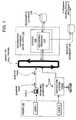
- FIG. 1is a block diagram of a system for collecting end user feedback regarding a geographic database.
- FIG. 2is a flow chart of steps performed by the reporting program of FIG. 1.
- FIG. 3illustrates an end user's computer display screen at one step of the process shown in FIG. 2.
- FIG. 4illustrates use of the drawing tools to report a perceived geographic data error according to the reporting program of FIG. 1.
- FIG. 5illustrates another use of the drawing tools to report a perceived geographic data error according to the reporting program of FIG. 1.
- FIG. 6illustrates still another use of the drawing tools to report a perceived geographic data error according to the reporting program of FIG. 1.
- FIG. 7is a flow chart of steps performed to update a geographic database using the reporting program of FIG. 2.
- a database developer 100operates a reporting program 110 .
- the reporting program 110is located on a server 120 that is connected to a network 130 , such as the Internet.
- End users 150operate computing platforms 140 to access the reporting program 110 .
- the computing platforms 140 used by the end users 150can be any type of device or system that is able to access the server 120 over the network 130 .
- the computing platforms 140include personal computers 140 ( 1 ) and vehicle navigation systems 140 ( 2 ).
- the computing platforms 140may also include other types of computing devices or systems, such as personal digital assistants.
- the computing platforms used by end usersinclude appropriate software to access the server 120 over the network 130 . If an end user uses a personal computer to access the server 120 , the reporting program 110 may be accessed using an Internet browser. Other communications software may also be used.
- the end users 150access the reporting program 110 in order to make reports about geographic data.
- the reporting program 110may be used by the geographic database developer 100 to obtain reports from the end users 150 about perceived errors or inaccuracies in the geographic data used in the navigation systems of the end users or by on-line provider sites that are used by the end users to obtain navigation-related and map-related services.
- the perceived errors or inaccuraciescan be of any type and may be encountered in various different ways.
- One of the ways that end users can encounter perceived errors or inaccuraciesis during operation of in-vehicle navigation systems. For example, while being guided to follow a route to a destination, a navigation system may provide the end user with incorrect, inaccurate or confusing guidance.
- the navigation systemmay advise the end user to ‘TURN LEFT AT THE NEXT INTERSECTION” but the next intersection has a sign that prohibits left turns.
- the navigation systemmay identify a street by a wrong name.
- a navigation systemmay provide incorrect, inaccurate or confusing guidance to an end user.
- One possible causeis that the geographic data used by the navigation system may be incorrect.
- the geographic datamay be incorrect because of an error made when the data were being collected.
- the geographic data used by the navigation systemmay be incorrect because the physical feature represented by the geographic data changed since the time the geographic data used by the end user's system was prepared.
- Another possible cause for an end user receiving incorrect, inaccurate or confusing guidance from a navigation systemcan be an error in the software programming in the navigation system.
- the geographic datamay be correct but the end user receives incorrect, inaccurate or confusing guidance because the software programming the navigation system does not use the geographic data properly.
- the navigation system softwaredetermines a vehicle's position incorrectly, a wrong street name may be provided thereby giving the end user the impression that the geographic data are incorrect when in fact the navigation programming caused the error.
- a navigation systemmay provide incorrect or confusing guidance is that the geographic data used by the navigation system may not include the attributes that are necessary to provide better instructions. For instance, the data representing roads located in some geographic areas may not contain one-way information because one-way street information has not yet been collected for those areas. Alternatively, the software programming in the navigation system may not consider one-way streets when providing driving directions.
- navigation-related and map-related servicescan also be obtained from on-line providers.
- End usersmay access on-line provider sites from their own personal computers or other platforms or appliances to obtain navigation-related and map-related services.
- An end user using an on-line provider site to obtain navigation-related and map-related servicesmay also encounter incorrect, inaccurate or confusing information.
- On-line providers of navigation-related or map-related servicesmay use the same or similar geographic data and software programming that are used in vehicle navigation systems. Therefore, on-line provider sites may give incorrect, inaccurate or confusing navigation-related or map-related information for the same reasons as explained above in connection with vehicle navigation systems.
- the reporting program 110provides a means by which a report about the perceived error can be obtained from an end user.
- the end users 150operate computing platforms 140 to access the reporting program 110 .
- the computing platform 140 used by an end user to access the reporting program 110may not necessarily be the same computing platform that the end user was using when the navigation-related or map-related information containing the perceived error was obtained.
- an end usermay perceive an error with the geographic data used by his/her vehicle navigation system while driving in his/her vehicle, but then accesses the reporting program later at home using his/her personal computer with Internet access.
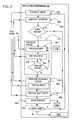
- the reporting program 110presents the user with a menu of options (Step 200 ). One of the options presented on the menu is to make a report about a geographic database.
- the reporting program 110requests the end user to identify the version of the geographic database to which the report pertains (Step 204 ).
- the reporting program 110presents the end user with the option of viewing a map image of the area about which the end user desires to make a report (Step 208 ).
- the reporting program 110presents the user with a means to provide a text input (described below in connection with Step 240 ).
- the reporting program 110presents the end user with a means to select an area (Step 212 ).
- the reporting program 110When the reporting program 110 presents a map image to the end user, the reporting program accesses a geographic database 216 .
- the geographic database 216may be a copy of, or similar or identical to, the geographic database used by the end user's navigation system.
- the geographic database 216 used by the reporting program 110is preferably up-to-date, i.e., it includes all the changes reflecting all the most recent updating efforts.
- the geographic database 216 used by the reporting program 110may be more up-to-date than the geographic database that was used by the end user's navigation system when the perceived error arose.
- the reporting program 110presents the end user with a means to select an area.
- the reporting program 110allows the end user to select the area about which to make a report.
- One wayis by panning and zooming.
- the end useris first presented with an image of a large scale map, e.g., the entire United States (Step 220 ).
- the reporting program 110allows the end user to select an area of the map, e.g., by pointing-and-clicking on a location on the map image (Steps 224 and 228 ).
- FIG. 3illustrates the display of the end user's computer 140 with a graphical map image displayed thereon. As shown in FIG. 3, a cursor 230 can be moved over the map image to a position in order to select the area indicated by the cursor.
- the reporting program 110captures the end user's input and uses the input to present the end user with another map image of the area selected by the end user. Depending upon the end user's input, this new map image may be at a smaller scale or may be panned relative to the previous map image. By successive selections, the end user is able to operate the reporting program 110 to present a map image of the individual street segments about which the end user desires to make a report.
- the reporting program 110can allow the end user to select an image of an area about which to make a report.
- these other waysinclude allowing an end user to identify the area by administrative area name (e.g., Des Plaines, Ill.), by address, by point of interest name (e.g., O'Hare Airport), by street name, by zip code, or by intersection.
- administrative area namee.g., Des Plaines, Ill.
- point of interest namee.g., O'Hare Airport
- street namee.g., by zip code, or by intersection.
- the reporting program 110allows the end user to pan and zoom the map image, as described above, to obtain a map image of the area about which to make a report, at the appropriate scale.
- the reporting program 110provides the end user with drawing tools (Step 232 ).
- the drawing toolsinclude features commonly used by computer-assisted drawing programs for marking or editing images.
- the drawing toolsinclude a feature that allows the end user to select one or more individual road segments. For example, by pointing-and-clicking on a road segment, the end user can select the road segment.
- the road segmentmay be highlighted by changing color, blinking, etc.
- FIG. 4illustrates the display of the end user's computer 140 with a graphical map image of individual road segments displayed thereon. As shown in FIG. 4, the end user has selected a road segment (which is shown in a different color at 233 ) to indicate the feature to which the report pertains.
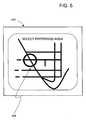
- the drawing toolsalso include a feature that allows the end user to select an area. According to this feature, the end user can draw a box or circle on the map image to define an area.
- FIG. 5illustrates the display of the end user's computer 140 with a graphical map image of individual road segments displayed thereon. As shown in FIG. 5, the end user has drawn a circle 234 over a location on the map image in order to indicate the area to which the report pertains.
- the drawing toolsalso include a feature that allows the end user to mark the image. For example, by choosing this feature, the end user is able to draw lines on the map image. This allows the end user to graphically illustrate a correction to the map image.
- the end userwishes to report that two road segments, which are represented on the map image as meeting at an intersection, do not actually meet.
- the end usercan select one of the road segments by clicking on it and then use the line draw feature to cross out a portion of the road segment where it meets with the other road segment to illustrate that the two road segments do not actually meet.
- the end userwishes to report that the map image omits a road segment.
- the end useruses the line drawing feature of the reporting program to draw in the missing road segment on the map image.
- the end userwishes to report that a road segment, which is represented as permitting vehicular traffic in two directions, is in fact a one-way street.
- the end userselects the road segment by clicking on it and then uses the line draw feature to draw an arrow in the single direction of permitted traffic flow.
- the end userwishes to report that he/she was given guidance to follow a route that was not optimal. Using a line drawing feature, the end user can trace a better route along the road segments shown on the graphical map image provided by the reporting program.
- the end useris able to graphically illustrate an error or a correction to the geographic data.
- the reporting program 110captures the end user's graphical input (Step 236 ).
- the reporting program 110also provides a feature that allows the end user to submit text comments (Step 240 ).
- the reporting program 110may provide the end user with a text box.
- the text boxcan be opened by clicking on a menu item or link provided on the page being presented on the end user's display screen.
- FIG. 6illustrates the display of the end user's computer 140 with a text box 242 that the end user can use to provide comments about a perceived error in the geographic database.
- the text boxmay be used as a substitute for or in addition to providing comments graphically.
- the reporting program 110allows an end user to describe an error with the geographic data using words.
- the reporting program 110captures the end user's text input.
- the reporting program 110saves the end user's graphical and text input in a report file 248 (Step 244 ). Then, the end user may use the reporting program again to make a report about another perceived error (Step 252 ) or alternatively, the end user may log off the reporting program 110 . At this point, the end user may be sent a message thanking him/her for submitting the report.
- the data in the reports database 248are used in a geographic database updating process 300 .
- the geographic database updating process 300may be performed by the geographic database developer ( 100 in FIG. 1).
- the geographic database updating process 300receives the data from the reports database 248 (Step 310 ).
- Each of the reports in the reports database 248is analyzed and confirmed (Step 320 ).
- the reportmay be confirmed by examining an aerial photograph, by traveling out to the location represented by the data, or by other means.
- the correct informationis added to the geographic database, thereby forming an updated version 216 (updated) (Step 330 ).
- the end user who submitted the report concerning the errormay be sent a message (e.g., by email) informing him/her that the master copy of the geographic database has been corrected and updated.
- a messagee.g., by email
- derived database products reflecting the updated dataare made and distributed to the end users (Step 340 ).
- the end usersmay be provided with an opportunity to obtain or purchase copies of the updated database.
- the graphical map image provided by the reporting programmay help an end user remember details about a perceived error.
- the reporting programmay be accessed by an end user from a different computing platform than the platform that was being used by the end user to obtain the navigation-related or map-related services. For example, the end user may perceive an error while driving and using his/her navigation system, but then access the reporting program later from home using a personal computer with Internet access. When the end user accesses the reporting program later from his/her home, he/she may not remember details about the perceived error.
- the graphical map image provided by the reporting programmay help the end user recall details about the perceived error thereby making the reporting of the error easier and more meaningful.
- the reporting programuses a geographic database to provide map images to end users so that the end users can use these map images to make reports about perceived errors in the geographic database.
- the geographic database used by the reporting programis preferably up-to-date and reflects the most recent changes and corrections. Therefore, the geographic database used by the reporting program may be more up-to-date than the geographic database used by the end user making the report.
- the perceived errormay already have been corrected If the end user notices that the error that he/she was going to report has already been corrected when viewing the map image provided by the reporting program, the end user can exit the reporting program and not waste any time reporting an error that has already been corrected.
- Another advantage of the disclosed systemis that it can be used to improve the software used by navigation systems.
- an error perceived by an end usermay be caused by the software used by the navigation system and not the geographic data.
- the reports provided by end usersmay be used to improve or correct the software in navigation systems to avoid or minimize these types of errors.
- Another advantage of the disclosed systemis that the end user is provided with an opportunity to be involved in the updating process. This involvement may help develop good will between the end user and the geographic database developer.
Landscapes
- Engineering & Computer Science (AREA)
- Radar, Positioning & Navigation (AREA)
- Remote Sensing (AREA)
- Physics & Mathematics (AREA)
- General Physics & Mathematics (AREA)
- Automation & Control Theory (AREA)
- Navigation (AREA)
- Instructional Devices (AREA)
- Apparatus For Radiation Diagnosis (AREA)
- Traffic Control Systems (AREA)
Abstract
Description
- The present invention relates to geographic data used in navigation systems and more particularly the present invention relates to a method and system to obtain end user input regarding perceived errors or inaccuracies in the geographic data used in navigation systems or used by on-line sites that provide navigation-related or map-related services.[0001]
- Navigation systems provide useful features, such as calculating a route to a desired destination and providing guidance for following the route. In order to provide these features, navigation systems use geographic data that include information about the locations of roads and intersections, estimated travel times along road segments, the speed limits along roads, etc. Using these kinds of geographic data, programming included in a navigation system can find an optimal (e.g., fastest or shortest) route to a specified destination.[0002]
- Although navigation systems provide useful features, there still exists room for improvement. One area in which there is room for improvement relates to the collection of geographic data. The collection of geographic data for use in navigation systems is a significant undertaking. The initial collection of data about the roads in a geographic area is a significant task. Beyond the effort involved in collecting data for use in navigation systems, there is a continuing need to update and check the geographic data. Just like conventional printed maps, geographic data used in navigation systems becomes out-of-date. For example, new roads are built, businesses change locations, road construction closes roads, detours are established, museum and restaurant hours change, etc. Thus, the collection of geographic data for navigation systems is a continuing effort.[0003]
- One useful way to collect geographic data is to obtain feedback from end users who have navigation systems. End users who have navigation systems may discover that certain geographic data used in their navigation systems are not correct or are inaccurate. When this occurs, it would be useful to provide a means by which the end user can report the error or inaccuracy to the geographic database developer. Using such reports from end users, the geographic database developer can make corrections to a master copy of the geographic database, which is then used to make new, updated versions of geographic databases for use in navigation systems.[0004]
- End users can also obtain navigation-related and map-related services from on-line providers. For example, routing instructions and maps can be obtained from certain Internet sites. These on-line providers may use the same or similar geographic data that are used in vehicle navigation systems. End users who use on-line provider sites to obtain navigation-related and map-related services may also encounter errors or inaccuracies in the geographic data. Accordingly, it would also be useful to obtain feedback from the end users that use on-line provider sites to obtain navigation-related and map-related services about perceived errors in the geographic data.[0005]
- Accordingly, there exists a need to obtain end user feedback about perceived errors in geographic data used in navigation systems or by on-line sites that provide navigation-related and map-related services.[0006]
- To address these and other objectives, the present invention comprises a reporting program and system whereby end users of navigation systems, or other computing platforms that use geographic data to obtain navigation-related or map-related services, can make reports about the geographic data. The reporting program can be used by end users to report perceived errors or inaccuracies in the geographic data. The end users can use their own personal computers, or other computing devices, to access the reporting program over a network, such as the Internet. When an end user accesses the reporting program, the reporting program provides a graphical map image to the end user on the end user's computing platform. The reporting program allows the end user to zoom and pan the graphical map image in order to display an image of the area about which the end user wishes to make a report. When the area about which the end user wishes to make a report is displayed on the end user's display screen, the reporting program allows the end user to mark up the graphical map image to illustrate a change. The reporting program also allows the end user to include text to describe a change. The reporting program captures the end user's graphical and text input as a report that is used to update or check the geographic database, as appropriate.[0007]
- FIG. 1 is a block diagram of a system for collecting end user feedback regarding a geographic database.[0008]
- FIG. 2 is a flow chart of steps performed by the reporting program of FIG. 1.[0009]
- FIG. 3 illustrates an end user's computer display screen at one step of the process shown in FIG. 2.[0010]
- FIG. 4 illustrates use of the drawing tools to report a perceived geographic data error according to the reporting program of FIG. 1.[0011]
- FIG. 5 illustrates another use of the drawing tools to report a perceived geographic data error according to the reporting program of FIG. 1.[0012]
- FIG. 6 illustrates still another use of the drawing tools to report a perceived geographic data error according to the reporting program of FIG. 1.[0013]
- FIG. 7 is a flow chart of steps performed to update a geographic database using the reporting program of FIG. 2.[0014]
- Referring to FIG. 1, a database developer[0015]100 operates a
reporting program 110. Thereporting program 110 is located on aserver 120 that is connected to anetwork 130, such as the Internet. End users150 operatecomputing platforms 140 to access thereporting program 110. Thecomputing platforms 140 used by the end users150 can be any type of device or system that is able to access theserver 120 over thenetwork 130. For example, thecomputing platforms 140 include personal computers140(1) and vehicle navigation systems140(2). Thecomputing platforms 140 may also include other types of computing devices or systems, such as personal digital assistants. - The computing platforms used by end users include appropriate software to access the[0016]
server 120 over thenetwork 130. If an end user uses a personal computer to access theserver 120, thereporting program 110 may be accessed using an Internet browser. Other communications software may also be used. - The end users[0017]150 access the
reporting program 110 in order to make reports about geographic data. In particular, thereporting program 110 may be used by the geographic database developer100 to obtain reports from the end users150 about perceived errors or inaccuracies in the geographic data used in the navigation systems of the end users or by on-line provider sites that are used by the end users to obtain navigation-related and map-related services. The perceived errors or inaccuracies can be of any type and may be encountered in various different ways. One of the ways that end users can encounter perceived errors or inaccuracies is during operation of in-vehicle navigation systems. For example, while being guided to follow a route to a destination, a navigation system may provide the end user with incorrect, inaccurate or confusing guidance. According to this example, the navigation system may advise the end user to ‘TURN LEFT AT THE NEXT INTERSECTION” but the next intersection has a sign that prohibits left turns. According to another example, the navigation system may identify a street by a wrong name. - There are various reasons why a navigation system may provide incorrect, inaccurate or confusing guidance to an end user. One possible cause is that the geographic data used by the navigation system may be incorrect. The geographic data may be incorrect because of an error made when the data were being collected. Alternatively, the geographic data used by the navigation system may be incorrect because the physical feature represented by the geographic data changed since the time the geographic data used by the end user's system was prepared.[0018]
- Another possible cause for an end user receiving incorrect, inaccurate or confusing guidance from a navigation system can be an error in the software programming in the navigation system. In this case, the geographic data may be correct but the end user receives incorrect, inaccurate or confusing guidance because the software programming the navigation system does not use the geographic data properly. For example, if the navigation system software determines a vehicle's position incorrectly, a wrong street name may be provided thereby giving the end user the impression that the geographic data are incorrect when in fact the navigation programming caused the error.[0019]
- Another reason why a navigation system may provide incorrect or confusing guidance is that the geographic data used by the navigation system may not include the attributes that are necessary to provide better instructions. For instance, the data representing roads located in some geographic areas may not contain one-way information because one-way street information has not yet been collected for those areas. Alternatively, the software programming in the navigation system may not consider one-way streets when providing driving directions.[0020]
- As mentioned above, navigation-related and map-related services can also be obtained from on-line providers. End users may access on-line provider sites from their own personal computers or other platforms or appliances to obtain navigation-related and map-related services. An end user using an on-line provider site to obtain navigation-related and map-related services may also encounter incorrect, inaccurate or confusing information. On-line providers of navigation-related or map-related services may use the same or similar geographic data and software programming that are used in vehicle navigation systems. Therefore, on-line provider sites may give incorrect, inaccurate or confusing navigation-related or map-related information for the same reasons as explained above in connection with vehicle navigation systems.[0021]
- Regardless of the cause of a perceived error, the[0022]
reporting program 110 provides a means by which a report about the perceived error can be obtained from an end user. As stated above, the end users150 operatecomputing platforms 140 to access thereporting program 110. Thecomputing platform 140 used by an end user to access thereporting program 110 may not necessarily be the same computing platform that the end user was using when the navigation-related or map-related information containing the perceived error was obtained. For example, an end user may perceive an error with the geographic data used by his/her vehicle navigation system while driving in his/her vehicle, but then accesses the reporting program later at home using his/her personal computer with Internet access. - Some of the steps performed by the[0023]
reporting program 110 are shown in FIG. 2. When the end user accesses thereporting program 110, thereporting program 110 presents the user with a menu of options (Step200). One of the options presented on the menu is to make a report about a geographic database. When the user chooses the option of making a report, thereporting program 110 requests the end user to identify the version of the geographic database to which the report pertains (Step204). After the end user supplies information identifying the version of the database, thereporting program 110 presents the end user with the option of viewing a map image of the area about which the end user desires to make a report (Step208). If the user chooses not to view an image of the map area, thereporting program 110 presents the user with a means to provide a text input (described below in connection with Step240). Alternatively, if the end user chooses to view an image of the map area, thereporting program 110 presents the end user with a means to select an area (Step212). - When the[0024]
reporting program 110 presents a map image to the end user, the reporting program accesses ageographic database 216. Thegeographic database 216 may be a copy of, or similar or identical to, the geographic database used by the end user's navigation system. Thegeographic database 216 used by thereporting program 110 is preferably up-to-date, i.e., it includes all the changes reflecting all the most recent updating efforts. Thus, thegeographic database 216 used by thereporting program 110 may be more up-to-date than the geographic database that was used by the end user's navigation system when the perceived error arose. - As stated above, if the end user chooses to view an image of the map area, the[0025]
reporting program 110 presents the end user with a means to select an area. There are various ways that thereporting program 110 allows the end user to select the area about which to make a report. One way is by panning and zooming. According to one method, the end user is first presented with an image of a large scale map, e.g., the entire United States (Step220). When the end user is provided with a map, thereporting program 110 allows the end user to select an area of the map, e.g., by pointing-and-clicking on a location on the map image (Steps 224 and228). - FIG. 3 illustrates the display of the end user's[0026]
computer 140 with a graphical map image displayed thereon. As shown in FIG. 3, acursor 230 can be moved over the map image to a position in order to select the area indicated by the cursor. - Referring again to FIG. 2, when the end user selects an area of the large scale map, the[0027]
reporting program 110 captures the end user's input and uses the input to present the end user with another map image of the area selected by the end user. Depending upon the end user's input, this new map image may be at a smaller scale or may be panned relative to the previous map image. By successive selections, the end user is able to operate thereporting program 110 to present a map image of the individual street segments about which the end user desires to make a report. - As stated above, there are various ways that the[0028]
reporting program 110 can allow the end user to select an image of an area about which to make a report. These other ways include allowing an end user to identify the area by administrative area name (e.g., Des Plaines, Ill.), by address, by point of interest name (e.g., O'Hare Airport), by street name, by zip code, or by intersection. When the end user chooses any of these ways to select an area about which to make a report, a graphical map image of the selected area is presented to the end user on the display screen of the end user's computing platform. Thereporting program 110 allows the end user to pan and zoom the map image, as described above, to obtain a map image of the area about which to make a report, at the appropriate scale. - When the end user has a map image of the area about which he/she desires to make a report on the display screen of his/her computer, the[0029]
reporting program 110 provides the end user with drawing tools (Step232). The drawing tools include features commonly used by computer-assisted drawing programs for marking or editing images. The drawing tools include a feature that allows the end user to select one or more individual road segments. For example, by pointing-and-clicking on a road segment, the end user can select the road segment. When the end user uses thereporting program 110 to select a road segment, the road segment may be highlighted by changing color, blinking, etc. FIG. 4 illustrates the display of the end user'scomputer 140 with a graphical map image of individual road segments displayed thereon. As shown in FIG. 4, the end user has selected a road segment (which is shown in a different color at233) to indicate the feature to which the report pertains. - The drawing tools also include a feature that allows the end user to select an area. According to this feature, the end user can draw a box or circle on the map image to define an area. FIG. 5 illustrates the display of the end user's[0030]
computer 140 with a graphical map image of individual road segments displayed thereon. As shown in FIG. 5, the end user has drawn acircle 234 over a location on the map image in order to indicate the area to which the report pertains. - The drawing tools also include a feature that allows the end user to mark the image. For example, by choosing this feature, the end user is able to draw lines on the map image. This allows the end user to graphically illustrate a correction to the map image.[0031]
- The following examples illustrate several ways that an end user can use the drawing tools of the[0032]
reporting program 110 to make reports about perceived errors in the geographic data. - The end user wishes to report that two road segments, which are represented on the map image as meeting at an intersection, do not actually meet. The end user can select one of the road segments by clicking on it and then use the line draw feature to cross out a portion of the road segment where it meets with the other road segment to illustrate that the two road segments do not actually meet.[0033]
- The end user wishes to report that the map image omits a road segment. The end user uses the line drawing feature of the reporting program to draw in the missing road segment on the map image.[0034]
- The end user wishes to report that a road segment, which is represented as permitting vehicular traffic in two directions, is in fact a one-way street. The end user selects the road segment by clicking on it and then uses the line draw feature to draw an arrow in the single direction of permitted traffic flow.[0035]
- The end user wishes to report that he/she was given guidance to follow a route that was not optimal. Using a line drawing feature, the end user can trace a better route along the road segments shown on the graphical map image provided by the reporting program.[0036]
- Using these drawing tools, the end user is able to graphically illustrate an error or a correction to the geographic data. Referring again to FIG. 2, the[0037]
reporting program 110 captures the end user's graphical input (Step236). - When the end user uses any of these graphical drawing features to illustrate a change to the geographic database for a report, the[0038]
reporting program 110 also provides a feature that allows the end user to submit text comments (Step240). According to this feature, thereporting program 110 may provide the end user with a text box. The text box can be opened by clicking on a menu item or link provided on the page being presented on the end user's display screen. FIG. 6 illustrates the display of the end user'scomputer 140 with atext box 242 that the end user can use to provide comments about a perceived error in the geographic database. The text box may be used as a substitute for or in addition to providing comments graphically. Some of the types of changes that an end user may wish to report may not be possible to express graphically. Furthermore, some end users may not know how to use the drawing tools features to clearly express the change they wish to report. Accordingly, by providing a text box, thereporting program 110 allows an end user to describe an error with the geographic data using words. Thereporting program 110 captures the end user's text input. - After the end user has submitted text comments, the[0039]
reporting program 110 saves the end user's graphical and text input in a report file248 (Step244). Then, the end user may use the reporting program again to make a report about another perceived error (Step252) or alternatively, the end user may log off thereporting program 110. At this point, the end user may be sent a message thanking him/her for submitting the report. - Referring to FIG. 7, the data in the[0040]
reports database 248 are used in a geographicdatabase updating process 300. The geographicdatabase updating process 300 may be performed by the geographic database developer (100 in FIG. 1). According to one embodiment, the geographicdatabase updating process 300 receives the data from the reports database248 (Step310). Each of the reports in thereports database 248 is analyzed and confirmed (Step320). The report may be confirmed by examining an aerial photograph, by traveling out to the location represented by the data, or by other means. When the error is confirmed, the correct information is added to the geographic database, thereby forming an updated version216 (updated) (Step330). At this point, the end user who submitted the report concerning the error may be sent a message (e.g., by email) informing him/her that the master copy of the geographic database has been corrected and updated. When thedatabase 216 has been updated, derived database products reflecting the updated data are made and distributed to the end users (Step340). The end users may be provided with an opportunity to obtain or purchase copies of the updated database. - Advantages[0041]
- One advantage of the disclosed system is that the graphical map image provided by the reporting program may help an end user remember details about a perceived error. As mentioned above, the reporting program may be accessed by an end user from a different computing platform than the platform that was being used by the end user to obtain the navigation-related or map-related services. For example, the end user may perceive an error while driving and using his/her navigation system, but then access the reporting program later from home using a personal computer with Internet access. When the end user accesses the reporting program later from his/her home, he/she may not remember details about the perceived error. The graphical map image provided by the reporting program may help the end user recall details about the perceived error thereby making the reporting of the error easier and more meaningful.[0042]
- Another advantage of the disclosed system is that it allows an end user to know whether the perceived error has already been reported or corrected. As stated above, the reporting program uses a geographic database to provide map images to end users so that the end users can use these map images to make reports about perceived errors in the geographic database. As mentioned above, the geographic database used by the reporting program is preferably up-to-date and reflects the most recent changes and corrections. Therefore, the geographic database used by the reporting program may be more up-to-date than the geographic database used by the end user making the report. Thus, it is possible that the perceived error may already have been corrected If the end user notices that the error that he/she was going to report has already been corrected when viewing the map image provided by the reporting program, the end user can exit the reporting program and not waste any time reporting an error that has already been corrected.[0043]
- Another advantage of the disclosed system is that it can be used to improve the software used by navigation systems. As stated above, an error perceived by an end user may be caused by the software used by the navigation system and not the geographic data. The reports provided by end users may be used to improve or correct the software in navigation systems to avoid or minimize these types of errors.[0044]
- Another advantage of the disclosed system is that the end user is provided with an opportunity to be involved in the updating process. This involvement may help develop good will between the end user and the geographic database developer.[0045]
- It is intended that the foregoing detailed description be regarded as illustrative rather than limiting and that it is understood that the following claims including all equivalents are intended to define the scope of the invention.[0046]
Claims (20)
Priority Applications (2)
| Application Number | Priority Date | Filing Date | Title |
|---|---|---|---|
| US10/768,349US6853905B2 (en) | 2000-06-08 | 2004-01-30 | Method and system for obtaining user feedback regarding geographic data |
| US11/488,256US20070170201A1 (en) | 2003-01-30 | 2006-07-18 | Propane tank vending machine assembly |
Applications Claiming Priority (2)
| Application Number | Priority Date | Filing Date | Title |
|---|---|---|---|
| US09/590,213US6718258B1 (en) | 2000-06-08 | 2000-06-08 | Method and system for obtaining user feedback regarding geographic data |
| US10/768,349US6853905B2 (en) | 2000-06-08 | 2004-01-30 | Method and system for obtaining user feedback regarding geographic data |
Related Parent Applications (1)
| Application Number | Title | Priority Date | Filing Date |
|---|---|---|---|
| US09/590,213ContinuationUS6718258B1 (en) | 2000-06-08 | 2000-06-08 | Method and system for obtaining user feedback regarding geographic data |
Related Child Applications (1)
| Application Number | Title | Priority Date | Filing Date |
|---|---|---|---|
| US11/488,256Continuation-In-PartUS20070170201A1 (en) | 2003-01-30 | 2006-07-18 | Propane tank vending machine assembly |
Publications (2)
| Publication Number | Publication Date |
|---|---|
| US20040186661A1true US20040186661A1 (en) | 2004-09-23 |
| US6853905B2 US6853905B2 (en) | 2005-02-08 |
Family
ID=24361310
Family Applications (2)
| Application Number | Title | Priority Date | Filing Date |
|---|---|---|---|
| US09/590,213Expired - LifetimeUS6718258B1 (en) | 2000-06-08 | 2000-06-08 | Method and system for obtaining user feedback regarding geographic data |
| US10/768,349Expired - LifetimeUS6853905B2 (en) | 2000-06-08 | 2004-01-30 | Method and system for obtaining user feedback regarding geographic data |
Family Applications Before (1)
| Application Number | Title | Priority Date | Filing Date |
|---|---|---|---|
| US09/590,213Expired - LifetimeUS6718258B1 (en) | 2000-06-08 | 2000-06-08 | Method and system for obtaining user feedback regarding geographic data |
Country Status (5)
| Country | Link |
|---|---|
| US (2) | US6718258B1 (en) |
| EP (2) | EP1162433B8 (en) |
| AT (2) | ATE467818T1 (en) |
| DE (2) | DE60142134D1 (en) |
| ES (2) | ES2343922T3 (en) |
Cited By (22)
| Publication number | Priority date | Publication date | Assignee | Title |
|---|---|---|---|---|
| US20020004701A1 (en)* | 2000-07-06 | 2002-01-10 | Pioneer Corporation And Increment P Corporation | Server, method and program for updating road information in map information providing system, and recording medium with program recording |
| US20060247844A1 (en)* | 2005-04-27 | 2006-11-02 | Irving Wang | Intelligent traffic monitoring and guidance system |
| US20080005734A1 (en)* | 2006-03-08 | 2008-01-03 | Shay Poristoin | Navigation device and method of updating information on a navigation device |
| US20080059055A1 (en)* | 2006-08-15 | 2008-03-06 | Pieter Geelen | Method of generating improved map data for use in navigation devices |
| US20080082225A1 (en)* | 2006-08-15 | 2008-04-03 | Tomtom International B.V. | A method of reporting errors in map data used by navigation devices |
| US20090024273A1 (en)* | 2007-07-17 | 2009-01-22 | Todd Follmer | System and Method for Providing a User Interface for Vehicle Monitoring System Users and Insurers |
| US20090265436A1 (en)* | 2008-04-18 | 2009-10-22 | Bravery Andrew J F | Data Through Community Feedback |
| US20100153348A1 (en)* | 2008-12-16 | 2010-06-17 | David Perczynski | Report Generation for a Navigation-Related Database |
| US20100207751A1 (en)* | 2009-02-13 | 2010-08-19 | Follmer Todd W | System and method for viewing and correcting data in a street mapping database |
| WO2011053338A1 (en)* | 2009-10-29 | 2011-05-05 | Tele Atlas North America | Method for assisted road extrapolation from imagery |
| US20110112762A1 (en)* | 2008-10-07 | 2011-05-12 | Paulus Gruijters | Validating map data corrections |
| US8126786B1 (en)* | 2006-12-18 | 2012-02-28 | Intuit Inc. | Notification and correction of E-filing rejections |
| US8577598B2 (en) | 2006-04-14 | 2013-11-05 | Scenera Technologies, Llc | System and method for presenting a computed route |
| US8589064B2 (en) | 2005-09-23 | 2013-11-19 | Scenera Technologies, Llc | System and method for selecting and presenting a route to a user |
| US8620532B2 (en) | 2009-03-25 | 2013-12-31 | Waldeck Technology, Llc | Passive crowd-sourced map updates and alternate route recommendations |
| US20140035957A1 (en)* | 2005-12-22 | 2014-02-06 | Hewlett-Packard Development Company, L.P. | Techniques to improve location accuracy for a map |
| US8890717B2 (en) | 2006-05-22 | 2014-11-18 | Inthinc Technology Solutions, Inc. | System and method for monitoring and updating speed-by-street data |
| US9067565B2 (en) | 2006-05-22 | 2015-06-30 | Inthinc Technology Solutions, Inc. | System and method for evaluating driver behavior |
| US9117246B2 (en) | 2007-07-17 | 2015-08-25 | Inthinc Technology Solutions, Inc. | System and method for providing a user interface for vehicle mentoring system users and insurers |
| US9129460B2 (en) | 2007-06-25 | 2015-09-08 | Inthinc Technology Solutions, Inc. | System and method for monitoring and improving driver behavior |
| US20150344038A1 (en)* | 2014-05-30 | 2015-12-03 | Here Global B.V. | Dangerous Driving Event Reporting |
| US10678776B1 (en)* | 2010-10-06 | 2020-06-09 | Google Llc | Automated identification of anomalous map data |
Families Citing this family (63)
| Publication number | Priority date | Publication date | Assignee | Title |
|---|---|---|---|---|
| US6718258B1 (en)* | 2000-06-08 | 2004-04-06 | Navigation Technologies Corp | Method and system for obtaining user feedback regarding geographic data |
| US6873998B1 (en)* | 2000-10-18 | 2005-03-29 | Navteq North America, Llc | System and method for updating a geographic database using satellite imagery |
| JP4391037B2 (en)* | 2001-04-27 | 2009-12-24 | パイオニア株式会社 | Navigation device, navigation method, and navigation program |
| US20060109145A1 (en)* | 2001-07-13 | 2006-05-25 | Taiwan Online Co., Ltd. | Electronic map and method for rapidly finding a geographic location of a landmark in the electronic map |
| JP3903479B2 (en)* | 2002-04-18 | 2007-04-11 | 日本電気株式会社 | Information provision system |
| JP4380151B2 (en)* | 2002-12-20 | 2009-12-09 | 株式会社デンソー | Map evaluation system and map evaluation device |
| JP2005165045A (en)* | 2003-12-03 | 2005-06-23 | Denso Corp | Electronic apparatus with map display function and program |
| US7831387B2 (en)* | 2004-03-23 | 2010-11-09 | Google Inc. | Visually-oriented driving directions in digital mapping system |
| US7373244B2 (en)* | 2004-04-20 | 2008-05-13 | Keith Kreft | Information mapping approaches |
| US20050278386A1 (en)* | 2004-06-15 | 2005-12-15 | Geographic Data Technology, Inc. | Geospatial information system and method for updating same |
| US7363151B2 (en)* | 2004-06-21 | 2008-04-22 | Matsushita Electric Industrial Co., Ltd. | Map error information obtaining system and map error information obtaining method |
| US7403851B2 (en)* | 2004-09-30 | 2008-07-22 | Navteq North America, Llc | Method of operating a navigation system to report effects of updated portions of a geographic database |
| US20060271552A1 (en)* | 2005-05-26 | 2006-11-30 | Venture Capital & Consulting Group, Llc. | Targeted delivery of content |
| US7706971B2 (en)* | 2005-07-21 | 2010-04-27 | The Boeing Company | System and method for data mapping and map discrepancy reporting |
| JP4812415B2 (en)* | 2005-11-30 | 2011-11-09 | 富士通株式会社 | Map information update system, central device, map information update method, and computer program |
| AU2007269159A1 (en)* | 2006-06-30 | 2008-01-10 | Tele Atlas North America, Inc. | Method and system for collecting user update requests regarding geographic data to support automated analysis, processing and geographic data updates |
| US7640105B2 (en) | 2007-03-13 | 2009-12-29 | Certus View Technologies, LLC | Marking system and method with location and/or time tracking |
| US8060304B2 (en)* | 2007-04-04 | 2011-11-15 | Certusview Technologies, Llc | Marking system and method |
| US8176055B1 (en) | 2007-03-27 | 2012-05-08 | Google Inc. | Content entity management |
| US8478515B1 (en)* | 2007-05-23 | 2013-07-02 | Google Inc. | Collaborative driving directions |
| US9612848B2 (en)* | 2007-06-25 | 2017-04-04 | OutSystems—Software em Rede S.A. | Systems and methods for gathering and processing user feedback |
| EP2034272A1 (en)* | 2007-09-07 | 2009-03-11 | Jentro Technologies GmbH | Computer-implemented method, system and computer program product for transmission of feedback information |
| US8521430B2 (en) | 2007-12-28 | 2013-08-27 | Navteq B.V. | Managing differences between geographic database versions |
| DE102008008502B4 (en)* | 2008-02-11 | 2014-08-14 | Siemens Aktiengesellschaft | Arrangement for controlling an antenna arrangement in a magnetic resonance apparatus |
| US8249306B2 (en)* | 2008-03-18 | 2012-08-21 | Certusview Technologies, Llc | Virtual white lines for delimiting planned excavation sites |
| US8532342B2 (en)* | 2008-02-12 | 2013-09-10 | Certusview Technologies, Llc | Electronic manifest of underground facility locate marks |
| CA2707246C (en) | 2009-07-07 | 2015-12-29 | Certusview Technologies, Llc | Automatic assessment of a productivity and/or a competence of a locate technician with respect to a locate and marking operation |
| US8672225B2 (en) | 2012-01-31 | 2014-03-18 | Ncr Corporation | Convertible barcode reader |
| US8280117B2 (en) | 2008-03-18 | 2012-10-02 | Certusview Technologies, Llc | Virtual white lines for indicating planned excavation sites on electronic images |
| US8290204B2 (en) | 2008-02-12 | 2012-10-16 | Certusview Technologies, Llc | Searchable electronic records of underground facility locate marking operations |
| US8095302B2 (en)* | 2008-03-04 | 2012-01-10 | The Boeing Company | Discrepancy reporting in electronic map applications |
| US20100332119A1 (en)* | 2008-03-14 | 2010-12-30 | Tom Tom International B.V. | Navigation device and method |
| EP2159777A3 (en) | 2008-05-30 | 2016-05-04 | HERE Global B.V. | Data mining to identify locations of potentially hazardous conditions for vehicle operation and use thereof |
| US8280631B2 (en)* | 2008-10-02 | 2012-10-02 | Certusview Technologies, Llc | Methods and apparatus for generating an electronic record of a marking operation based on marking device actuations |
| US8620587B2 (en)* | 2008-10-02 | 2013-12-31 | Certusview Technologies, Llc | Methods, apparatus, and systems for generating electronic records of locate and marking operations, and combined locate and marking apparatus for same |
| GB2497028B (en) | 2008-10-02 | 2013-07-03 | Certusview Technologies Llc | Methods and apparatus for generating electronic records of locate operations |
| US8442766B2 (en) | 2008-10-02 | 2013-05-14 | Certusview Technologies, Llc | Marking apparatus having enhanced features for underground facility marking operations, and associated methods and systems |
| CN104764456B (en)* | 2008-10-07 | 2018-02-16 | 通腾科技股份有限公司 | Validating map data corrections |
| US8572193B2 (en) | 2009-02-10 | 2013-10-29 | Certusview Technologies, Llc | Methods, apparatus, and systems for providing an enhanced positive response in underground facility locate and marking operations |
| US20100201690A1 (en)* | 2009-02-11 | 2010-08-12 | Certusview Technologies, Llc | Virtual white lines (vwl) application for indicating a planned excavation or locate path |
| US8832565B2 (en)* | 2009-02-11 | 2014-09-09 | Certusview Technologies, Llc | Methods and apparatus for controlling access to a virtual white line (VWL) image for an excavation project |
| CA2691780C (en) | 2009-02-11 | 2015-09-22 | Certusview Technologies, Llc | Management system, and associated methods and apparatus, for providing automatic assesment of a locate operation |
| CA2710269C (en)* | 2009-08-11 | 2012-05-22 | Certusview Technologies, Llc | Locating equipment communicatively coupled to or equipped with a mobile/portable device |
| CA2809013A1 (en)* | 2009-08-20 | 2011-02-24 | Certusview Technologies, Llc | Methods and marking devices with mechanisms for indicating and/or detecting marking material color |
| CA2710189C (en)* | 2009-08-20 | 2012-05-08 | Certusview Technologies, Llc | Methods and apparatus for assessing marking operations based on acceleration information |
| CA2713282C (en)* | 2009-08-20 | 2013-03-19 | Certusview Technologies, Llc | Marking device with transmitter for triangulating location during marking operations |
| US8364398B2 (en) | 2009-08-28 | 2013-01-29 | Navteq B.V. | Method of operating a navigation system to provide route guidance |
| WO2011071872A1 (en)* | 2009-12-07 | 2011-06-16 | Certusview Technologies, Llc | Methods, apparatus, and systems for facilitating compliance with marking specifications for dispensing marking material |
| US20110313779A1 (en)* | 2010-06-17 | 2011-12-22 | Microsoft Corporation | Augmentation and correction of location based data through user feedback |
| CA2815998C (en) | 2010-08-11 | 2016-09-13 | Certusview Technologies, Llc | Methods, apparatus and systems for facilitating generation and assessment of engineering plans |
| US8467810B2 (en) | 2010-11-29 | 2013-06-18 | Navteq B.V. | Method and system for reporting errors in a geographic database |
| US8483959B2 (en) | 2011-01-06 | 2013-07-09 | Telenav, Inc. | Navigation system with location adaptation and method of operation thereof |
| US9257056B2 (en)* | 2011-10-31 | 2016-02-09 | Google Inc. | Proactive user-based content correction and enrichment for geo data |
| US8938653B2 (en)* | 2011-12-14 | 2015-01-20 | Microsoft Corporation | Increasing the accuracy of information returned for context signals |
| US8832116B1 (en) | 2012-01-11 | 2014-09-09 | Google Inc. | Using mobile application logs to measure and maintain accuracy of business information |
| USD750663S1 (en) | 2013-03-12 | 2016-03-01 | Google Inc. | Display screen or a portion thereof with graphical user interface |
| US8676431B1 (en) | 2013-03-12 | 2014-03-18 | Google Inc. | User interface for displaying object-based indications in an autonomous driving system |
| USD754189S1 (en)* | 2013-03-13 | 2016-04-19 | Google Inc. | Display screen or portion thereof with graphical user interface |
| USD754190S1 (en)* | 2013-03-13 | 2016-04-19 | Google Inc. | Display screen or portion thereof with graphical user interface |
| CN103699725A (en)* | 2013-12-12 | 2014-04-02 | 福州市勘测院 | Electronic mapping implementation method based on handheld terminal |
| US10216765B2 (en) | 2014-10-28 | 2019-02-26 | Here Global B.V. | Image based routing and confirmation |
| US20170329347A1 (en)* | 2016-05-11 | 2017-11-16 | Brain Corporation | Systems and methods for training a robot to autonomously travel a route |
| CN112988788B (en)* | 2021-05-20 | 2021-07-27 | 四川省林业和草原调查规划院 | Spatial data mutation detection method, application system and cloud platform for land spatial planning |
Citations (7)
| Publication number | Priority date | Publication date | Assignee | Title |
|---|---|---|---|---|
| US5732383A (en)* | 1995-09-14 | 1998-03-24 | At&T Corp | Traffic information estimation and reporting system |
| US5867110A (en)* | 1995-08-11 | 1999-02-02 | Hitachi, Ltd. | Information reporting system |
| US5893113A (en)* | 1996-04-25 | 1999-04-06 | Navigation Technologies Corporation | Update transactions and method and programming for use thereof for incrementally updating a geographic database |
| US5919246A (en)* | 1994-10-07 | 1999-07-06 | Mannesmann Aktiengesellschaft | Target input for navigation system |
| US5999878A (en)* | 1997-04-11 | 1999-12-07 | Navigation Technologies Corp. | System and method for acquiring geographic data for forming a digital database of road geometry in a geographic region |
| US6240294B1 (en)* | 1997-05-30 | 2001-05-29 | Itt Manufacturing Enterprises, Inc. | Mobile radio device having adaptive position transmitting capabilities |
| US6718258B1 (en)* | 2000-06-08 | 2004-04-06 | Navigation Technologies Corp | Method and system for obtaining user feedback regarding geographic data |
Family Cites Families (4)
| Publication number | Priority date | Publication date | Assignee | Title |
|---|---|---|---|---|
| JPH03203770A (en)* | 1989-12-29 | 1991-09-05 | Alpine Electron Inc | Map depicting method for navigation |
| JP3122983B2 (en) | 1996-11-29 | 2001-01-09 | 株式会社山武 | Throttle flow meter |
| JPH11351895A (en)* | 1998-06-09 | 1999-12-24 | Harness Syst Tech Res Ltd | Car navigation system |
| US6712451B2 (en) | 2002-03-05 | 2004-03-30 | Eastman Kodak Company | Printhead assembly with shift register stages facilitating cleaning of printhead nozzles |
- 2000
- 2000-06-08USUS09/590,213patent/US6718258B1/ennot_activeExpired - Lifetime
- 2001
- 2001-05-24ESES08020422Tpatent/ES2343922T3/ennot_activeExpired - Lifetime
- 2001-05-24EPEP01304609Apatent/EP1162433B8/ennot_activeExpired - Lifetime
- 2001-05-24EPEP08020422Apatent/EP2040038B1/ennot_activeExpired - Lifetime
- 2001-05-24DEDE60142134Tpatent/DE60142134D1/ennot_activeExpired - Lifetime
- 2001-05-24DEDE60137168Tpatent/DE60137168D1/ennot_activeExpired - Lifetime
- 2001-05-24ESES01304609Tpatent/ES2317875T3/ennot_activeExpired - Lifetime
- 2001-05-24ATAT08020422Tpatent/ATE467818T1/ennot_activeIP Right Cessation
- 2001-05-24ATAT01304609Tpatent/ATE419511T1/ennot_activeIP Right Cessation
- 2004
- 2004-01-30USUS10/768,349patent/US6853905B2/ennot_activeExpired - Lifetime
Patent Citations (8)
| Publication number | Priority date | Publication date | Assignee | Title |
|---|---|---|---|---|
| US5919246A (en)* | 1994-10-07 | 1999-07-06 | Mannesmann Aktiengesellschaft | Target input for navigation system |
| US5867110A (en)* | 1995-08-11 | 1999-02-02 | Hitachi, Ltd. | Information reporting system |
| US5732383A (en)* | 1995-09-14 | 1998-03-24 | At&T Corp | Traffic information estimation and reporting system |
| US5893113A (en)* | 1996-04-25 | 1999-04-06 | Navigation Technologies Corporation | Update transactions and method and programming for use thereof for incrementally updating a geographic database |
| US6038568A (en)* | 1996-04-25 | 2000-03-14 | Navigation Technologies Corporation | Transaction method and programming for incrementally updating a geographic database |
| US5999878A (en)* | 1997-04-11 | 1999-12-07 | Navigation Technologies Corp. | System and method for acquiring geographic data for forming a digital database of road geometry in a geographic region |
| US6240294B1 (en)* | 1997-05-30 | 2001-05-29 | Itt Manufacturing Enterprises, Inc. | Mobile radio device having adaptive position transmitting capabilities |
| US6718258B1 (en)* | 2000-06-08 | 2004-04-06 | Navigation Technologies Corp | Method and system for obtaining user feedback regarding geographic data |
Cited By (49)
| Publication number | Priority date | Publication date | Assignee | Title |
|---|---|---|---|---|
| US20020004701A1 (en)* | 2000-07-06 | 2002-01-10 | Pioneer Corporation And Increment P Corporation | Server, method and program for updating road information in map information providing system, and recording medium with program recording |
| US20060247844A1 (en)* | 2005-04-27 | 2006-11-02 | Irving Wang | Intelligent traffic monitoring and guidance system |
| US8589064B2 (en) | 2005-09-23 | 2013-11-19 | Scenera Technologies, Llc | System and method for selecting and presenting a route to a user |
| US9366542B2 (en) | 2005-09-23 | 2016-06-14 | Scenera Technologies, Llc | System and method for selecting and presenting a route to a user |
| US20140035957A1 (en)* | 2005-12-22 | 2014-02-06 | Hewlett-Packard Development Company, L.P. | Techniques to improve location accuracy for a map |
| US20080005734A1 (en)* | 2006-03-08 | 2008-01-03 | Shay Poristoin | Navigation device and method of updating information on a navigation device |
| US8577598B2 (en) | 2006-04-14 | 2013-11-05 | Scenera Technologies, Llc | System and method for presenting a computed route |
| US9228850B2 (en) | 2006-04-14 | 2016-01-05 | Scenera Technologies, Llc | System and method for presenting a computed route |
| US10522033B2 (en) | 2006-05-22 | 2019-12-31 | Inthinc LLC | Vehicle monitoring devices and methods for managing man down signals |
| US9847021B2 (en) | 2006-05-22 | 2017-12-19 | Inthinc LLC | System and method for monitoring and updating speed-by-street data |
| US9067565B2 (en) | 2006-05-22 | 2015-06-30 | Inthinc Technology Solutions, Inc. | System and method for evaluating driver behavior |
| US8890717B2 (en) | 2006-05-22 | 2014-11-18 | Inthinc Technology Solutions, Inc. | System and method for monitoring and updating speed-by-street data |
| US20080082225A1 (en)* | 2006-08-15 | 2008-04-03 | Tomtom International B.V. | A method of reporting errors in map data used by navigation devices |
| US20100131186A1 (en)* | 2006-08-15 | 2010-05-27 | Pieter Geelen | Method of generating improved map data for use in navigation devices, map data and navigation device therefor |
| US8972188B2 (en) | 2006-08-15 | 2015-03-03 | Tomtom International B.V. | Method of creating map alterations for use in a navigation device |
| US8407003B2 (en)* | 2006-08-15 | 2013-03-26 | Tomtom International B.V. | Method of generating improved map data for use in navigation devices, map data and navigation device therefor |
| US20080177469A1 (en)* | 2006-08-15 | 2008-07-24 | Pieter Geelen | Method of generating improved map data for use in navigation devices |
| US20080065325A1 (en)* | 2006-08-15 | 2008-03-13 | Pieter Geelen | Method of generating improved map data for use in navigation devices |
| US20080059055A1 (en)* | 2006-08-15 | 2008-03-06 | Pieter Geelen | Method of generating improved map data for use in navigation devices |
| US10156448B2 (en) | 2006-08-15 | 2018-12-18 | Tomtom Navigation B.V. | Method of creating map corrections for use in a navigation device |
| US8635017B2 (en) | 2006-08-15 | 2014-01-21 | Tomtom International B.V. | Method of generating improved map data for use in navigation devices |
| US8126786B1 (en)* | 2006-12-18 | 2012-02-28 | Intuit Inc. | Notification and correction of E-filing rejections |
| US9129460B2 (en) | 2007-06-25 | 2015-09-08 | Inthinc Technology Solutions, Inc. | System and method for monitoring and improving driver behavior |
| US20090024273A1 (en)* | 2007-07-17 | 2009-01-22 | Todd Follmer | System and Method for Providing a User Interface for Vehicle Monitoring System Users and Insurers |
| US8818618B2 (en)* | 2007-07-17 | 2014-08-26 | Inthinc Technology Solutions, Inc. | System and method for providing a user interface for vehicle monitoring system users and insurers |
| US9117246B2 (en) | 2007-07-17 | 2015-08-25 | Inthinc Technology Solutions, Inc. | System and method for providing a user interface for vehicle mentoring system users and insurers |
| US8341465B2 (en)* | 2008-04-18 | 2012-12-25 | International Business Machines Corporation | Data through community feedback |
| US20090265436A1 (en)* | 2008-04-18 | 2009-10-22 | Bravery Andrew J F | Data Through Community Feedback |
| US8543335B2 (en) | 2008-10-07 | 2013-09-24 | Tomtom International B.V. | Validating map data corrections |
| US9057613B2 (en) | 2008-10-07 | 2015-06-16 | Tomtom International B.V. | Validating map data corrections |
| US20110112762A1 (en)* | 2008-10-07 | 2011-05-12 | Paulus Gruijters | Validating map data corrections |
| US9541414B2 (en) | 2008-10-07 | 2017-01-10 | Tomtom International B.V. | Validating map data corrections |
| US20150058300A1 (en)* | 2008-12-16 | 2015-02-26 | Here Global B.V. | Report Generation for a Navigation-Related Database |
| US8880568B2 (en)* | 2008-12-16 | 2014-11-04 | Here Global B.V. | Report generation for a navigation-related database |
| AU2009233628B2 (en)* | 2008-12-16 | 2015-08-20 | Here Global B.V. | Report generation for a navigation-related database |
| EP2199745A3 (en)* | 2008-12-16 | 2012-01-04 | Navteq North America, LLC | Report generation for a navigation-related database |
| US20100153348A1 (en)* | 2008-12-16 | 2010-06-17 | David Perczynski | Report Generation for a Navigation-Related Database |
| US8963702B2 (en)* | 2009-02-13 | 2015-02-24 | Inthinc Technology Solutions, Inc. | System and method for viewing and correcting data in a street mapping database |
| US20100207751A1 (en)* | 2009-02-13 | 2010-08-19 | Follmer Todd W | System and method for viewing and correcting data in a street mapping database |
| US9140566B1 (en) | 2009-03-25 | 2015-09-22 | Waldeck Technology, Llc | Passive crowd-sourced map updates and alternative route recommendations |
| US9410814B2 (en) | 2009-03-25 | 2016-08-09 | Waldeck Technology, Llc | Passive crowd-sourced map updates and alternate route recommendations |
| US9082077B2 (en) | 2009-03-25 | 2015-07-14 | Waldeck Technology, Llc | Mobile private assisted location tracking |
| US8620532B2 (en) | 2009-03-25 | 2013-12-31 | Waldeck Technology, Llc | Passive crowd-sourced map updates and alternate route recommendations |
| WO2011053338A1 (en)* | 2009-10-29 | 2011-05-05 | Tele Atlas North America | Method for assisted road extrapolation from imagery |
| US10678776B1 (en)* | 2010-10-06 | 2020-06-09 | Google Llc | Automated identification of anomalous map data |
| US20150344038A1 (en)* | 2014-05-30 | 2015-12-03 | Here Global B.V. | Dangerous Driving Event Reporting |
| US10759442B2 (en)* | 2014-05-30 | 2020-09-01 | Here Global B.V. | Dangerous driving event reporting |
| US20200353938A1 (en)* | 2014-05-30 | 2020-11-12 | Here Global B.V. | Dangerous driving event reporting |
| US11572075B2 (en)* | 2014-05-30 | 2023-02-07 | Here Global B.V. | Dangerous driving event reporting |
Also Published As
| Publication number | Publication date |
|---|---|
| DE60142134D1 (en) | 2010-06-24 |
| EP2040038A1 (en) | 2009-03-25 |
| EP1162433B8 (en) | 2009-03-18 |
| ES2317875T3 (en) | 2009-05-01 |
| EP1162433B1 (en) | 2008-12-31 |
| EP2040038B1 (en) | 2010-05-12 |
| ES2343922T3 (en) | 2010-08-12 |
| EP1162433A1 (en) | 2001-12-12 |
| US6853905B2 (en) | 2005-02-08 |
| ATE419511T1 (en) | 2009-01-15 |
| US6718258B1 (en) | 2004-04-06 |
| ATE467818T1 (en) | 2010-05-15 |
| DE60137168D1 (en) | 2009-02-12 |
Similar Documents
| Publication | Publication Date | Title |
|---|---|---|
| US6718258B1 (en) | Method and system for obtaining user feedback regarding geographic data | |
| US6873998B1 (en) | System and method for updating a geographic database using satellite imagery | |
| EP2463627B1 (en) | Navigation system using corridor maps | |
| EP1167924B1 (en) | Navigation system with feature for reporting errors | |
| US7639162B2 (en) | Map interface with removable path locations | |
| US20050278386A1 (en) | Geospatial information system and method for updating same | |
| US20110184638A1 (en) | Map interface with a movable marker | |
| WO2008005952A2 (en) | Method and system for collecting user update requests regarding geographic data to support automated analysis, processing and geographic data updates | |
| US20100121917A1 (en) | Map interface with directional navigation | |
| EP1300655B1 (en) | Navigation system that supports multiple languages and formats | |
| JP3312117B2 (en) | Map display device for route search | |
| JPH1115839A (en) | Map information processing system and server computer | |
| JP2019191183A (en) | Information providing device | |
| Lee et al. | A web-based bus information system | |
| JP2018005245A (en) | Information provision device, information provision method, information provision program, terminal device, information display method, and information display program | |
| JPH09138642A (en) | Electronic map display method and device |
Legal Events
| Date | Code | Title | Description |
|---|---|---|---|
| AS | Assignment | Owner name:NAVTEQ CORPORATION, ILLINOIS Free format text:ASSIGNMENT OF ASSIGNORS INTEREST;ASSIGNOR:NAVIGATION TECHNOLOGIES CORPORATION;REEL/FRAME:015293/0400 Effective date:20040203 Owner name:NAVTEQ NORTH AMERICA LLC, ILLINOIS Free format text:ASSIGNMENT OF ASSIGNORS INTEREST;ASSIGNOR:NAVTEQ CORPORATION;REEL/FRAME:015286/0504 Effective date:20040510 Owner name:NAVTEQ NORTH AMERICA LLC,ILLINOIS Free format text:ASSIGNMENT OF ASSIGNORS INTEREST;ASSIGNOR:NAVTEQ CORPORATION;REEL/FRAME:015286/0504 Effective date:20040510 Owner name:NAVTEQ CORPORATION,ILLINOIS Free format text:ASSIGNMENT OF ASSIGNORS INTEREST;ASSIGNOR:NAVIGATION TECHNOLOGIES CORPORATION;REEL/FRAME:015293/0400 Effective date:20040203 | |
| STCF | Information on status: patent grant | Free format text:PATENTED CASE | |
| FPAY | Fee payment | Year of fee payment:4 | |
| FPAY | Fee payment | Year of fee payment:8 | |
| AS | Assignment | Owner name:HERE NORTH AMERICA, LLC, ILLINOIS Free format text:CHANGE OF NAME;ASSIGNOR:NAVTEQ NORTH AMERICA, LLC;REEL/FRAME:033747/0279 Effective date:20130418 Owner name:HERE GLOBAL B.V., NETHERLANDS Free format text:ASSIGNMENT OF ASSIGNORS INTEREST;ASSIGNOR:HERE NORTH AMERICA, LLC;REEL/FRAME:033747/0598 Effective date:20140916 | |
| FPAY | Fee payment | Year of fee payment:12 |